|
Georges River Council – Local Planning Panel Thursday, 29 October 2020 |
Page 2 |
REPORT TO GEORGES RIVER COUNCIL
LPP MEETING OF Thursday, 29 October 2020
|
LPP Report No |
LPP055-20 |
Application No |
PP2020/0002 |
|
Site Address |
Planning Proposal 2021 - Amendment to Georges River Local Environmental Plan 2020 |
||
|
Proposed Development |
Planning Proposal 2021 - Amendment to Georges River Local Environmental Plan 2020 |
||
|
Owners |
N/A |
||
|
Applicant |
Georges River Council |
||
|
Planner/Architect |
N/A |
||
|
Date Of Lodgement |
N/A |
||
|
Submissions |
N/A |
||
|
Cost of Works |
N/A |
||
|
Local Planning Panel Criteria |
Direction from the Minister for Planning under Section 9.1 of the Environmental Planning and Assessment Act 1979 and the Charter of the Georges River Council Local Planning Panel 2018 both specify that the Planning Proposal is to be referred to the Local Planning Panel before it is forwarded for Gateway Determination (approval). |
||
|
List of all relevant s.4.15 matters (formerly s79C(1)(a)) |
N/A – Planning Proposal
|
||
|
List all documents submitted with this report for the Panel’s consideration |
Note: Refer to Council’s Website – Plannning Proposal Webpage – for all Attachments
Attachment 1 - Letter from GSC dated 4 March 2020 - Support for LSPS 2040; Attachment 2 - Local Housing Strategy; Attachment 3 - Gateway Determination for GRLEP 2020 dated 10 March 2020; Attachment 4 - Draft Georges River LEP 2020 Written Instrument sent to DPIE for plan-making – for reference only; Attachment 5 - Preliminary Traffic Report prepared by TTPA; Attachment 6 - Planning Proposal Report; Attachment 7 - Planning Proposal Report Appendix 1 – Amendments to Draft Instrument for Manor Houses and Terraces; Attachment 8 - Planning Proposal Report Appendix 2 – Proposed LEP Mapping; Attachment 9 - Planning Proposal Report Appendix 3 – Consistency with State Environmental Planning Policies (SEPPs); Attachment 10 - Planning Proposal Report Appendix 4 – Consistency with S9.1 Ministerial Directions
|
||
|
Report prepared by |
Strategic Planner/Urban Designer and Senior Strategic Planner |
||
|
Executive Summary
1. In accordance with the Ministerial Direction for planning proposals, this report seeks the LPP’s advice and recommendation before Council considers whether or not to forward it to the Minister or Greater Sydney Commission for a Gateway Determination under section 3.34 of the Environmental Planning and Assessment Act 1979.
2. On 7 September 2018, Council received $2,500,000 funding from the NSW Government’s Accelerated LEP Program for an accelerated review of Council’s existing LEPs and the preparation of a new LEP that aligns with the priorities outlined in the South District Plan.
3. In accordance with the statutory agreement, the revised Planning Proposal for the Georges River Local Environmental Plan 2020 (“LEP 2020”) was endorsed by the Georges River Local Planning Panel (“LPP”) at its meeting in June 2020 and was submitted to the Department of Planning, Industry and Environment (“DPIE”) for final legal drafting on 30 June 2020. Approximately $750,000 of the grant funding has not yet been utilised.
4. The draft LEP 2020 sought to harmonise and replace the existing Hurstville Local Environmental Plan 2012 (“HLEP 2012”) and Kogarah Local Environmental Plan 2012 (“KLEP 2012”). It is the first stage of a four stage approach to preparing the Georges River LEP. The staged approach was developed to enable detailed investigations to be conducted to support the full suite of actions and changes proposed by Council’s Local Strategic Planning Statement 2040 (“LSPS 2040”).
5. LEP 2021 is the next stage within the Georges River LEP staged approach and was endorsed by Council at its meetings in 23 April 2019 and October 2019 to focus on housing choice through the promotion of inclusive and affordable housing and the investigation of mechanisms such as big house conversions and build to rent to provide more housing choice across the local government area (“LGA”).
6. However before the preparation of LEP 2021 could be commenced, Council was advised by the DPIE in June 2020 that there is a shortfall of housing delivery in the LGA. Accordingly, Council must create capacity for additional dwellings to meet the Greater Sydney Commission’s 6-10 year housing target of 3,450 - 4,250 dwellings (for the period from 2021 to 2026).
7. The DPIE also advised that the surplus grant funding of approximately $750,000 would be made available to enable the expedited preparation of a planning proposal to address this shortfall in housing delivery, subject to the submission of this planning proposal for finalisation by 31 March 2021.
8. The DPIE, on the review of the Local Housing Strategy, which was adopted by Council at its meeting dated 24 August 2020, considers that the LGA will struggle to meet its 0-5 year target of 4,800 additional dwellings as specified by the South District Plan. The shortfall has been identified to be approximately 700 dwellings.
9. Given that 2020 marks the end of the 0-5 year period, further work will need to be conducted to accommodate the shortfall of dwellings in the 0-5 year period and create flexibility for additional take up in the 6-10 year and 10-20 year dwelling targets. This will ensure Council delivers an additional 14,000 dwellings, as required, by 2036.
10. In response, Council, at its meeting held 24 August 2020, resolved to prepare a Planning Proposal to amend the HLEP 2012 and KLEP 2012 (or if gazetted, Georges River LEP 2020) to promote housing choice and create capacity for additional dwellings to meet the Greater Sydney Commission’s 6-10 year housing target (3,450 - 4,250 additional dwellings) for the period from 2021/22 to 2025/26.
11. The Planning Proposal, known as LEP21, is the subject of this report (Attachment 6). The primary objective of this Planning Proposal is to identify additional housing opportunities in the LGA to meet the short term targets imposed by the State Government. In addition, this Planning Proposal also seeks to address a number of considerations unresolved by LEP 2020.
12. In summary, the following amendments to the HLEP 2012 and KLEP 2012 (or if gazetted, the Georges River LEP 2020) are proposed by this Planning Proposal:
· Identify additional housing opportunities in the LGA through a review of future housing growth areas nominated by the Local Strategic Planning Statement 2040 (“LSPS 2040”);
· Contribute to the supply and diversity of housing within the LGA by creating capacity for an additional 310 dwellings through the rezoning of one of the six future housing growth areas identified by the LSPS 2040;
· Introduce the land uses of “manor houses” and “multi dwelling housing (terraces)” and the associated minimum lot size and lot width controls in response to the commencement of the Low Rise Housing Diversity Code in the State Environmental Planning Policy (Exempt and Complying Development Codes) 2008;
· Resolve mapping anomalies that were not included in LEP 2020 on the following sites:
o 199 Rocky Point Road, Ramsgate, and
o 33 Dora Street, Hurstville;
· Amend provisions relating to the Foreshore Scenic Protection Area (FSPA) resulting from the review of the Foreshore Scenic Character Review and the LGA-wide Biodiversity Study.
13. In respect of the final dot point above, Council has commenced the preparation of a Foreshore Scenic Character Review and a LGA-wide Biodiversity Study utilising the DPIE grant funding with the intent of further investigating the role, mapped extent and zoning of the Foreshore Scenic Protection Area (“FSPA”) in accordance with the following resolution made by the LPP at its meeting dated 25 and 26 June 2020:
2. The Panel recommends that Council as part of the preparation of the draft Local Environmental Plan in 2021/2022, further define the role, mapped extent and zoning of the FSPA, in both the former Hurstville and Kogarah Local Government Areas, having regard to those properties and ridge lines visible to and from the Georges River and its tributaries, and associated environmental protection applying to those areas in order to better reflect the objectives of Clause 6.7 of the Georges River Local Environmental Plan 2020. This may include the consideration of additional environmental protection zones or modifications of the FSPA.
14. Once the two studies are completed and depending on timing, consideration will be given to preparing an Alteration to Gateway to amend the Planning Proposal for LEP21 to reflect an updated policy position on the FSPA, based on the outcomes of the Review and the Biodiversity Study.
15. The remainder of the LEP grant funding has been committed to the preparation of a masterplan for the Mortdale Local Centre and Council’s Affordable Housing Policy. These projects are currently underway and will be integrated in future amendments to the LEP subject to Council’s endorsement.
16. In accordance with Ministerial Direction for planning proposals, this Report seeks the LPP’s recommendation to forward this Planning Proposal to the DPIE for a Gateway Determination.
Report in Full
Background
Local Strategic Planning Statement 2040
17. Council’s Local Strategic Planning Statement (“LSPS 2040”) was endorsed by the Greater Sydney Commission (“GSC”) on 10 March 2020. It sets out the land use vision for the next 20 years to strengthen the character of the LGA’s suburbs and builds upon the social, environmental and economic values of the Georges River community. It is also a key resource in highlighting the changes which will shape the LGA’s future. It includes actions that both Council and the State Government will take to create a future City which is desirable to its community, visitors and investors.
18. The LSPS 2040 builds on the community’s aspirations and expectations expressed in Council’s Community Strategic Plan 2018-2028 (“CSP”). Extensive community consultation was undertaken as part of the two-staged consultation program for the LSPS to gather community input on the draft vision, local planning priority outcomes and the criteria for strategic planning, including identifying location for future housing investigation.
19. The LSPS 2040 identifies a staged program of investigation to deliver additional housing. The following housing targets have been nominated, equating to an additional 14,000 dwellings by 2036:
· 2016 to 2020 inclusive (0-5 year target): +4,800 dwellings as specified by the South District Plan
· 2021 to 2026 (6-10 year target): +3,450 dwellings
· 2026 to 2036 (11-20 year target): +5,750 dwellings
20. To plan for the provision of new housing, the LSPS 2040 Structure Plan (refer Figure 1 below) nominates several locations to be investigated. The areas hatched in yellow on the Structure Plan have been included in LEP 2020 as Housing Investigation Areas which will contribute to the 6-10 year housing target. The five Housing Investigation Areas will enable the provision of approximately 650 dwellings in total (hatched in yellow). The areas hatched in purple are Future Housing Investigation Areas which will be discussed further in this report.
Figure 1 – LSPS 2040 Structure Plan
LEP Staged Program
21. At its meeting dated 26 February 2018, Council resolved to prepare a principal Local Environmental Plan (“LEP”) for the Georges River local government area (“LGA”) which gives effect to the South District Plan and harmonises the following existing LEPs:
· Kogarah Local Environmental Plan 2012 (“KLEP 2012”);
· Hurstville Local Environmental Plan 2012 (“HLEP 2012”); and
· Hurstville Local Environmental Plan 1994 (“HLEP 1994”).
22. On 7 September 2018, Council received funding from the NSW Government of $2,500,000 for an accelerated review of Council’s existing LEPs and the preparation of a new LEP that aligns with the priorities outlined in the South District Plan. The grant funding also enabled Council to prepare the Local Housing Strategy and Inclusive Housing Strategy to inform the new LEP and a local strategic planning statement for the LGA.
23. The Planning Proposal for the Georges River Local Environmental Plan 2020 (“LEP 2020”) was revised with consideration of the public exhibition outcomes and was reported to the Georges River Local Planning Panel (“LPP”) in June 2020 seeking endorsement to submit the revised Planning Proposal to the Department of Planning, Industry and Environment (“DPIE”) for final legal drafting. Approximately $750,000 of the grant funding has not yet been utilised.
24. At this meeting, the LPP resolved to endorse a number of revisions to the exhibited Planning Proposal for LEP 2020, including the retention of the existing Foreshore Scenic Protection Area (“FSPA”) as identified by the HLEP 2012 Foreshore Scenic Protection Area Map with the addition of the proposed Foreshore Scenic Protection Area as exhibited which includes the foreshore localities in the former Kogarah LGA to allow Council the opportunity to further define the role, mapped extent and zoning of FSPA across the LGA as part of the preparation of LEP 2021/2022.
25. The LEP 2020 was the first stage of a four-stage approach to preparing the principal Georges River LEP. The staged approach was developed to enable detailed investigations to be conducted to support the full suite of actions and changes proposed by Council’s Local Strategic Planning Statement 2040 (“LSPS 2040”).
26. The LSPS 2040 provides a ‘line of sight’ between the South District Plan and strategic planning and delivery at the local level through the Georges River LEP. It sets out the land use vision for the next 20 years to strengthen the character of the LGA’s suburbs and builds upon the social, environmental and economic values of the Georges River community.
27. The following staged approach to preparing the Georges River LEP is outlined in the LSPS 2040, and was endorsed by Council at its meetings in April 2019 and October 2019:
Stage 1: Housing and Harmonisation (LEP 2020 – submitted for plan making on 30 June 2020)
o Harmonise the existing LEPs
o Seek to achieve housing targets and housing choice through upzoning certain areas
Stage 2: Housing Choice (scheduled for 2021)
o Seek to promote inclusive and affordable housing
o Investigate mechanisms such as big house conversions and build to rent to provide more housing choice across the LGA
Stage 3: Jobs and Activation (scheduled for 2022)
o Review development standards in centres
o Infrastructure delivery mechanisms
o Review and implement the outcomes of the Hurstville City Centre and Beverly Hills Local Centre masterplans
Stage 4: Housing and Future Growth (scheduled for 2025 and beyond)
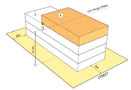
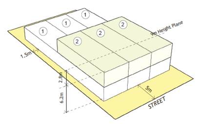
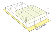
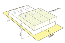
o Focus on land use changes beyond the next 5 years
28. LEP 2021 is the next stage within the Georges River LEP staged approach and was endorsed by Council at its meetings in 23 April 2019 and October 2019 to focus on housing choice through the promotion of inclusive and affordable housing and the investigation of mechanisms such as big house conversions and build to rent to provide more housing choice across the local government area (“LGA”).
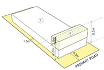
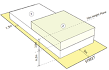
29. However, before the preparation of LEP 2021 could be commenced, in June 2020 Council received advice from DPIE providing additional time to utilise the surplus grant funds subject to the following conditions:
· That the Local Housing Strategy is submitted to the DPIE by 30 September 2020; and
· That an additional LEP is submitted for plan making by 31 March 2021 to address the shortage of housing supply as compared to the Greater Sydney Commission’s 6-10 year housing targets and the current housing pipeline of supply and completions.
30. The Greater Sydney Commission’s 6-10 year housing targets for the LGA is specified within its Letter of Support for Council’s LSPS 2040 dated 4 March 2020 (refer Attachment 1). This letter requires Council to show how the 6-10 year housing target of 3,450 - 4,250 dwellings can be met as part of its Local Housing Strategy.
Local Housing Strategy and shortfall in housing delivery
31. The GSC’s South District Plan sets a five-year (2016 to 2021) housing target of 4,800 additional dwellings for the Georges River LGA. However, the Plan provides Council with the opportunity to develop the 6-10 year housing targets by demonstrating capacity for steady housing supply into the medium term.
32. The South District Plan also emphasises the need to plan for the 20-year strategic housing target. An additional 13,400 dwellings is prescribed by the State Government as the 2036 housing target for the Georges River LGA.
33. Council’s Local Housing Strategy (Attachment 2), which has been adopted by Council at its meeting dated 24 August 2020, was submitted to DPIE on 3 September 2020. The Strategy sets a clear plan for the provision of housing in the Georges River LGA over the next 10 and 20 years. It provides the link between GRC’s visions for housing and the Actions of the South District Plan by presenting Council’s response to how the housing target will be delivered locally.
34. The Local Housing Strategy analyses the DPIE’s Greater Sydney Region Local Government Area dwellings data with the intent of understanding the shortage of housing supply in meeting the 6-10 year housing target.
35. The analysis of DPIE’s dwellings data reveals that within the 4 year period from January 2016 to March 2020, there have been over 3,300 dwellings completed across the LGA which equates to an average of around 800 dwellings per year. There are also a significant number of dwellings in the pipeline which are yet to be constructed.
36. Historic approvals and completions trends indicate that there is typically a two to three year delay/offset in the completions date as compared to the approvals date. Therefore, the majority of dwellings in the pipeline could be completed in 2021 and beyond, however due to the COVID-19 pandemic there is no guarantee that the usual development cycles will continue.
37. The average completion rate of 800 dwellings per year from January 2016 to March 2020 indicates that it will be challenging for the LGA to meet the South District Plan target of 4,800 dwellings for the 0-5 years’ timeframe (2016-2020 inclusive), and there will be a shortfall of approximately 700 dwellings when compared to the specified dwelling target.
38. To ensure Council delivers an additional 14,000 dwellings as required by 2036, further work will need to be conducted in this LEP and future LEPs to accommodate the shortfall of completions in the 0-5 year period and create flexibility for additional take up in the 6-10 year and 10-20 year dwelling targets.
39. The DPIE also advised that the surplus grant funding of approximately $750,000 would be made available to enable the expedited preparation of a planning proposal to address this shortfall in housing delivery. However, the NSW Government funding requires this Planning Proposal to be forwarded to the Department of Planning, Industry and Environment (DPIE) for plan-making by 31 March 2021.
40. In response, Council, at its meeting held 24 August 2020, resolved to prepare a Planning Proposal to amend the HLEP 2012 and KLEP 2012 (or if gazetted, Georges River LEP 2020) to promote housing choice and create capacity for additional dwellings to meet the Greater Sydney Commission’s 6-10 year housing target (3,450 - 4,250 additional dwellings) for the period from 2021/22 to 2025/26.
Amended LEP Program
41. As outlined above, LEP 2021 (Stage 2 of the LEP Program) was endorsed by Council to focus on the provision of housing choice across the LGA with specific emphasis on the promotion of inclusive and affordable housing and the investigation of mechanisms such as big house conversions and build-to-rent. It was anticipated that the preparation of these tasks would be undertaken during 2020/2021.
42. However, DPIE’s request for Council to prepare this expedited Planning Proposal to address the existing shortfall in housing delivery has significantly altered the deliverables of LEP 2021.
43. Preparation of Council’s Affordable Housing Policy is currently underway which includes considerations of build-to-rent provisions and inclusionary zoning to promote inclusive and affordable housing. The draft status of this investigation is unable to provide a robust evidence base to inform this Planning Proposal.
44. Preliminary investigation had also commenced for the adaptive re-use of existing large family homes through big house conversions. The intent of this investigation is to create a new development typology in the R2 Low Density Residential zone which will enable existing, under-utilised family homes to be converted into multiple smaller dwellings while retaining the existing local character. This will allow housing choice in areas with limited capacity for growth.
45. However, DPIE verbally advised Council that the big house conversion development typology must be implemented within the existing legal framework established by the Standard Instrument LEP and the creation of a new land use term will not be supported.
46. Furthermore, additional consideration is also required due to the complexities associated with the conversion of existing dwellings, including compliant fire separation, the types of dwelling suitable for conversion and the economic feasibility of adapting an existing house.
47. The complexities of this housing type in relation to establishing a workable legal land use framework and understanding the construction / built form requirements has meant that this land use cannot be included in LEP 2021, mainly due to the time constraints associated with the finalisation of this Planning Proposal by 31 March 2021.
48. Council officers will continue with the above investigations in accordance with the Council-endorsed staged LEP program to deliver additional housing choice in the next LEP amendment.
Concurrent Studies and Strategies
49. The remainder of the LEP grant funding has been committed to the preparation of a masterplan for the Mortdale Local Centre, which is currently underway and will be integrated in future amendments to the LEP subject to Council’s endorsement.
Planning Proposal Overview
50. The primary objective of this Planning Proposal is to identify additional housing opportunities in the LGA to meet the short-term targets imposed by the State Government. In addition, this Planning Proposal also seeks to address a number of considerations unresolved by draft LEP 2020.
51. In summary, the following amendments to draft LEP 2020 are proposed by this Planning Proposal:
· Identify additional housing opportunities in the LGA through a review of future housing growth areas nominated by the Local Strategic Planning Statement 2040 (“LSPS 2040”);
· Contribute to the supply and diversity of housing within the LGA by creating capacity for an additional 310 dwellings through the rezoning of one of the six future housing growth areas identified by the LSPS 2040;
· Introduce the land uses of “manor houses” and “multi dwelling housing (terraces)” and the associated minimum lot size and lot width controls in response to the commencement of the Low Rise Housing Diversity Code in the State Environmental Planning Policy (Exempt and Complying Development Codes) 2008;
· Resolve mapping anomalies that were not included in LEP 2020 on the following sites:
o 199 Rocky Point Road, Ramsgate, and
o 33 Dora Street, Hurstville;
· Amend provisions relating to the Foreshore Scenic Protection Area (FSPA) resulting from the review of the Foreshore Scenic Character Review and the LGA-wide Biodiversity Study.
52. In respect of the final dot point above, Council has commenced the preparation of a Foreshore Scenic Character Review and a LGA-wide Biodiversity Study utilising the DPIE grant funding with the intent of further investigating the role, mapped extent and zoning of the Foreshore Scenic Protection Area (“FSPA”) in accordance with the following resolution made by the LPP at its meeting dated 25 and 26 June 2020:
2. The Panel recommends that Council as part of the preparation of the draft Local Environmental Plan in 2021/2022, further define the role, mapped extent and zoning of the FSPA, in both the former Hurstville and Kogarah Local Government Areas, having regard to those properties and ridge lines visible to and from the Georges River and its tributaries, and associated environmental protection applying to those areas in order to better reflect the objectives of Clause 6.7 of the Georges River Local Environmental Plan 2020. This may include the consideration of additional environmental protection zones or modifications of the FSPA.
53. Once the two studies are completed and depending on timing, consideration will be given to preparing an Alteration to Gateway to amend the Planning Proposal for LEP21 to reflect an updated policy position on the FSPA, based on the outcomes of the Review and the Biodiversity Study. Further information is provided under the heading of “FSPA Review” later in this report.
Housing Investigation Area (HIA)
HIA selection
54. To plan for the provision of new housing, the LSPS 2040 Structure Plan (refer Figure 1 above) nominates several locations to be investigated. The areas hatched in yellow on the Structure Plan have been included in LEP 2020 as Housing Investigation Areas which will contribute to the 6-10 year housing target. The five Housing Investigation Areas (hatched in yellow) will enable the provision of approximately 650 dwellings in total.
55. A total of 6 future housing growth areas (scheduled for 2025 and beyond) were identified in the LSPS in the following locations (also refer Figure 2 – hatched in purple):
1. Narwee
2. Lily Street (Hurstville)
3. Kingsgrove
4. Mortdale / Penshurst
5. Oatley West
6. South Hurstville
Figure 2 – Extract from LSPS Housing Structure Plan
56. The above future housing areas have been investigated as part of LEP 2021 to ascertain whether they are required to achieve the 10 year housing target set by the Greater Sydney Commission.
57. With consideration of the LSPS Criteria to Guide Growth, the following set of guiding principles was developed to inform the selection of the Housing Investigation Area (HIA) to be included in LEP 2021:
Public transport
58. Housing around transport nodes provides the community with convenience and accessibility, as well as improves connectivity to jobs, services and recreation. Maintaining and improving connectivity is important as the LGA grows. Areas along existing and committed transport links should be investigated for housing growth as a guiding principle for the selection of HIAs.
Shops and services
59. Commercial centres in the LGA play a vital role in providing a mix of amenities, essential and specialist services and retail outlets including supermarkets, local grocer, restaurants and cafes to cater to the demands for day to day goods and services close to where people live. Centres also have an important role in providing access to local employment, especially when many local centres in the LGA are co-located with transport interchanges. With improved transport connections, there will be opportunities for centres to evolve into mixed-use, walkable neighbourhoods that provide ongoing employment growth. Housing should be located in close proximity to existing centres to leverage off the amenities, services and social meeting spaces provided in these centres. Access to centres is one of the guiding principles for the selection of HIAs.
Educational establishments
60. Educational establishments, such as schools and tertiary institutions, form an important part of the Georges River community. Housing in close proximity to educational establishments offer residents greater choice, accessibility and convenience, as well as the ability to access school sport and recreational facilities readily and participate in local social activities. Proximity to existing educational establishments is one of the guiding principles for the selection of HIAs.
Community facilities
61. Community facilities in close proximity to housing can enhance social cohesion, build community links, increase connectivity between residents and improve community wellbeing. The LGA has a range of community facilities comprising of libraries, aquatic facilities, an entertainment centre, sports stadium, community centres and halls, and hireable community spaces. Social infrastructure needs to be available in different sizes and for different uses as the population grows and diversifies. Proximity to existing community facilities is one of the guiding principles for the selection of HIAs.
Open space
62. Open space is a form of green infrastructure that enhances the character of the LGA’s neighbourhoods, supports healthy and active lifestyles, and brings communities together. Housing that is connected to a wide network of open space increases liveability and health outcomes for individuals and communities, as well as improves community building by encouraging social participation and interaction. People in urban neighbourhoods should be able to walk to local open space. Nearly all residents in the LGA currently live within 400m of open space. However, there are a number of smaller local parks that lack facilities, visibility and general functionality. The provision of open space is a key consideration when planning for growth. Locating HIAs within 400m of good quality public open spaces is a guiding principle.
Environmental constraints
63. The LGA has a number of environmental constraints that could limit development potential in some locations. These constraints include flood prone land, bushfire prone land, acid sulfate soils, coastal hazard, riparian lands and watercourses and foreshore protection areas. Placing development in hazardous areas or increasing the density of development in areas with limited evacuation options increases risk to people and property. Accordingly, as a guiding principle, HIAs should be located in areas with minimal environmental constraints and risks managed through preventative and protective measures.
Heritage and strata buildings
64. Heritage is an important part of the built environment and contributes to a sense of identity and history in the LGA. Council’s aim is to conserve and protect the LGA’s heritage so it can be enjoyed by current and future generations. However, balancing housing growth with heritage conservation and protection objectives can be challenging. Development proposals will need to ensure any increase in density appropriately responds to the existing heritage significance of the item or heritage conservation area. Hence, in principle, the bulk and scale of developments in HIAs must be responsive and sympathetic to the existing heritage significance of housing areas.
Transition in density and built form
65. The Local Housing Strategy acknowledges that a harmonised hierarchy of residential zones is required to regulate the built form, typology and transition between the low and high density zones. To ensure a diverse range of housing is created in appropriate locations, medium density developments under a ‘true’ medium density zone should be investigated in accessible locations to act as a buffer around high density zones. As a principle, the existing maximum height of building control of 9 metres will apply to medium density housing to encourage appropriate built forms and typologies within the proposed R3 Medium Density Residential zone and a maximum building height of 12 metres in the R4 High Density Residential zone.
66. Table 1 below outlines the findings of the preliminary assessment undertaken for the 6 housing growth areas. In summary, the Narwee future housing area has been selected to be accelerated as a Housing Investigation Area in this Planning Proposal to provide capacity for additional dwellings and greater housing choice.
Table 1 – Housing Investigation Area Selection for LEP 2021
|
No. |
Map |
Explanation |
|
1 |
Narwee
|
This area is well serviced in relation to public transport by the existing Narwee Railway Station (within walking distance) and related bus services. The area benefits from road access to the M5 and the M8 Motorways. There are no existing issues in the local road system known to Council.
The area is currently zoned R2 Low Density Residential. Most of the building stock are detached dwelling houses in a garden setting and are of varying ages and styles. The lots are rectangular, and the local road system is a lineal grid.
There is also an area of land zoned R4 High Density Residential, closer to the Railway Station and Narwee village.
The area is immediately south of the Narwee village, that is zoned B2 Local Centre. This would provide future residents with very good access to goods and services. Note: The majority of this village is in the adjacent LGA of Canterbury-Bankstown.
The area has good, existing, accessible local recreational resources, including Rasdall Park, Narwee Park and Progress Park. It also has access to existing primary and secondary educational facilities.
The area has no heritage items or heritage conservation areas (HCAs). It has a very limited number of strata titles, which is positive. This is because strata title properties often act as a constraint to redevelopment, when areas are rezoned and/ or uplifted.
Parts of the area are identified as being flood affected by the Hurstville Overland Flow Study. The Narwee area is affected by the Moomba to Sydney Ethane (MSE) Pipeline – it is within the Notification Zone of the MSE Pipeline that runs through the northern portion of the LGA. A hazard analysis will be required to support any increase in residential density to identify the potential risk impacts.
The Narwee area represents a very good opportunity for Council to revitalise and improve an established, relatively unconstrained part of the LGA.
The preliminary traffic assessment indicates that the existing local road network can support the proposed uplift. |
|
2 |
Lily Street
|
The Lily Street area is well serviced in relation to public transport by Allawah Rail Station (within walking distance).
The area is currently zoned R2 Low Density Residential. The lots are rectangular on a lineal grid street pattern. Immediately east of the area is the Bayside LGA. The area is well serviced by the Hurstville City Centre (zoned B4 Mixed Use and to the west) and the Forest Road village centre (zoned B2 Local Centre and to the north).
The area provides an interface opportunity to transition from the large scale/high density City Centre environment e.g. East Quarter, Landmark Square and Bing Lee.
The area has access to existing educational facilities and to the locally significant open space of Kempt Field which offers both active and passive recreation opportunities as well as an adventure playground.
The area has a limited number of heritage items and strata-titled properties and it is not located within a HCA.
Parts of the area are identified as being flood affected by the Hurstville Overland Flow Study. Measures such as free boarding above the flood level will need to be implemented in future developments.
However this area has been ruled out for immediate rezoning/ uplift in the LEP 2021 because of the known existing local road issues that require resolution. This is supported by preliminary traffic data that the Council has commissioned. The proposed developments at the surrounding areas including Landmark Square, Bing Lee and East Quarter will be accompanied by improvement works for local roads. This will improve the traffic network within this precinct; however the work is not scheduled to be completed for another 4 to 5 years.
In addition, the future rezoning/ uplifting potential for this area will be better known once planning investigations have been completed for the two adjacent commercial centres - Hurstville City Centre and Forest Road village. The review of centres is schedule in Stage 3 of the Georges River LEP staged approach. |
|
3 |
Kingsgrove
|
This area is well serviced by Kingsgrove Rail Station. The station has the potential to be included in the Kogarah to Parramatta metro line in the future. This, and the possibility of the station to be part of a future transport hub, is not known at this time and any uplift should be supported by a masterplanning process with State and Local Government involvment as well as community stakeholders.
The area is south of Kingsgrove Local Centre (which is zoned B2 Local Centre and shared with Bayside LGA) and Kingsgrove Industrial Centre (which is zoned IN1 and shared with Canterbury Bankstown LGA). It is currently zoned R2 Low Density Residential.
Parts of the area are identified as being flood affected by the Hurstville Overland Flow Study. The area is also affected by the MSE Pipeline as it is within the Notification Zone.
There are no heritage items, HCAs and only a limited number of strata titles in the area.
The area has been ruled out of immediate rezoning/ uplifting because of the known deficiency of open space in this locality.
Further, Kingsgrove is also identified as a Local Centre which will undergo a similar masterplanning process to the Mortdale Local Centre. Housing growth will be investigated in the future as part of a masterplan. The review of centres is scheduled for Stage 3 of the Georges River LEP staged approach. |
|
4 |
Penshurst / Mortdale
|
This area is serviced by both Penshurst and Mortdale Centres, and is adjacent to both these Rail Stations. It is adjacent to 2 existing R4 High Density Residential areas, to its north east and south west.
It has good access to existing educational facilities i.e. schools, and some access to recreational facilities i.e. open space.
There are several heritage items and one Heritage Conservation Area within this precinct.
Parts of the area are identified as being flood affected by the Hurstville Overland Flow Study. Measures such as free boarding above the flood level will need to be implemented in future developments.
The area is being investigated as part of the Mortdale Local Centre Masterplan. Work on this Masterplan has commenced and the outcomes of the Masterplan may inform a future amendment to the Georges River LEP. |
|
5 |
Oatley West
|
The Oatley West area is serviced by Oatley Rail Station, as well as Oatley Local Centre (zoned B1) and Oatley village (zoned B1). The area has good access to recreation resources i.e. local parks.
The area has a limited number of heritage items, not located within a HCA.
Parts of the area are identified as being flood affected by the Hurstville Overland Flow Study. Measures such as free boarding above the flood level will need to be implemented in future developments.
This area was not considered for immediate rezoning/ uplifting in LEP 2021 because it is partially sited within the existing FSPA. A review of the extent of the FSPA is currently underway, and is discussed separately in this report.
Further, Oatley West is also identified as a Local Centre which will undergo a similar masterplanning process to the Mortdale Local Centre. Housing growth in the area will be investigated in the future as part of a masterplan, after the completion of the FSPA review. |
|
6 |
South Hurstville
|
Unlike the other 5 areas, the South Hurstville area is not supported by rail infrastructure. It has reasonable access to the existing South Hurstville Local Centre (Zoned B2), and limited access to educational facilities i.e. schools. Access to the local centre is to the east, via land zoned R3 Medium Density Residential.
The area has good access to recreational opportunities i.e. local open space. The area is zoned R2 Low Density Residential. It has a rectangular lot configuration, and a lineal street grid; which is similar to the other areas.
The area was not selected for immediate rezoing/uplift because of known land use conflicts, and resultant amenity impacts (reported by residents), caused by the adjoining Halstead Light Industrial Precinct.
The draft LEP 2020 introduces a creative industries local provision within the IN2 zone which seeks to incentivise uses such as filmmakers, architects, graphic designers, etc to occupy the Industrial Precinct and bring in office premise-type land uses. This may alleviate the traffic and amenity impacts caused by the current light industry uses. Over time, the nature of the industrial area may change, and potentially reduce the existing amenity impacts; but this will be dependent on many factors, including market forces. Housing growth will be investigated in the future, but would only be considered when the existing amenity impacts have been appropriately managed. |

67. In summary, the Narwee housing growth area has been selected as the preferred option for investigation as a Housing Investigation Area (“HIA”) to be accelerated in this LEP because of its existing access to a good level of infrastructure i.e. public transport, school education facilities, local open space opportunities, and commercial facilities. The preliminary traffic assessment that has been undertaken indicates no major transport issues to the uplift.
68. It should be noted that this area is located within the Notification Zone of the MSE Pipeline that runs through the northern portion of the LGA. However a hazard analysis is under preparation and will be submitted to DPIE with the request for a Gateway Determination.
69. The remaining 5 future housing growth areas will be reviewed as part of LEP 2025 and beyond in accordance with the LSPS 2040 Structure Plan.
Existing Context
70. Narwee precinct (refer Figures 3 and 4) has an approximate area of 6.5 hectares. It is located in the northern part of the LGA, approximately 350 metres south of the Narwee Rail Station and Public School (across Broadarrow Road).
71. The area is conveniently located between Narwee Primary School, Narwee Pre School, Rasdall Park, Narwee Park and Beverly Hills Girls High School. It is immediately south of the Narwee Local Centre. It adjoins R4 High Density Residential land to the north east. There is good access to other local parks nearby.
72. Rezoning for additional housing in this area in the future would provide the opportunity to create diversity in dwelling types, within walking distance to existing infrastructure.
Figure 3 – Existing aerial map
Figure 4 – Existing zoning map (draft LEP 2020) with adjoining Canterbury-Bankstown LEP
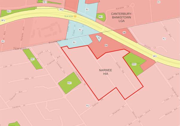
Table 2 – Narwee HIA Existing Precinct Information
|
Approximate site area |
62,500sqm |
|
Number of existing dwellings |
109 dwellings |
|
Existing zoning (under GRLEP 2020) |
R2 Low Density Residential |
|
Adjoining zonings |
R2 Low Density Residential R3 Medium Density Residential (Canterbury-Bankstown LGA) B2 Local Centre RE1 Public Recreation |
|
Street network |
Despite being local streets, Mercury Street and Chamberlain Street are wide and are able to accommodate on-street parking on both sides of the street as well as two-way carriageways. Berrille Road, however, is narrower with only one lane of carriageway and on-street parking on both sides of the street. Berrille Road also takes on a cul-de-sac character due to its U-shaped layout. |
|
Subdivision Pattern |
Fairly consistent with two main types –
Mercury Street / Chamberlain Street street block: Average lot width – 13m to 15m Average lot size – 630sqm to 810sqm
Berrille Road area: Average lot width – less than 13m Average lot size – 420sqm |
|
Current built form |
A mix of single and double storey brick and weatherboard dwelling houses. Generally older dwelling stock, with only a few new developments scattered in the area. |
|
Surrounding land uses and built form |
The Narwee HIA is adjoined to the north by an existing area of high density residential area on Bryant Street comprising of predominately red brick walk-ups (three to four storeys). The Narwee village (zoned B2, shared with Canterbury-Bankstown Council) is also located to the north of the HIA. Rasdall Park and a series of existing villa developments border the HIA to the east. The low density areas to the south feature a mix of single brick and weatherboard dwellings. The former Narwee High School redevelopment is located to the west of the HIA. This area is characterised by two storey dwellings that visually appear as townhouses and terraces due to the medium density of these developments. Narwee Park is also located to the west of the HIA. |
|
Ownership patterns |
Predominately private ownership. There are 2 sites owned by public authorities: · 80 Mercury Street · 5 Bryant Street |
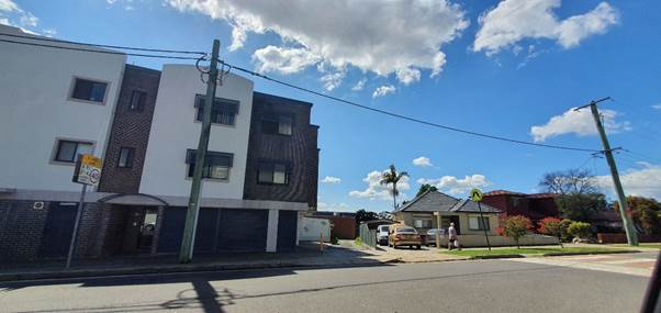
73. The photos in Figures 5 – 8 below exemplify the generally low scale, low density established residential character of the area.
Figure 5 – Typical older style dwelling houses on Balfour Road
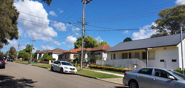
Figure 6 - View from Mercury Street
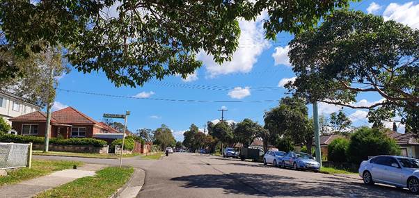
Figure 7 - View of Chamberlain Street
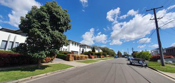
Figure 8 - View of B2 Local Centre zone interface on Chamberlain Street
74. With consideration of the guiding principles outlined above, the detailed selection rationale for the Narwee HIA is provided in Table 3 below.
Table 3 – Narwee HIA Selection Rationale
|
Public Transport |
Narwee train station is within 350m of the precinct on the T8 line, with train services to and from the city (Central station) via the Airport every 15 minutes. Buses depart from Narwee to Hurstville, Bankstown, and other local suburbs, including Roselands Shopping Centre.
Beverly Hills train station is within 850m of the precinct also serviced by the T8 line. Buses depart from Beverly Hills to Strathfield, Hurstville, Rockdale and other local suburbs, including Roselands Shopping Centre. |
|
Shops and Services |
Narwee local centre adjoins this precinct. The centre offers a broad range of retail and commercial services for the local community and visitors. The centre extends across both northern and southern sides of the station. Broad Arrow Road forms the boundary with Canterbury Bankstown Council, with the southern side of the road being within the Georges River LGA. The northern part of the centre is located within the Canterbury Bankstown LGA.
Riverwood local centre and Roselands Shopping Centre are both located approximately 1500m from the precinct. |
|
Educational Establishments |
Seven schools located within a kilometre: Narwee Public School, Beverly Hills Girls High School and Intensive English School, Regina Coeli Catholic Primary School, Beverly Hills Public School, Beverly Hills North Public School and Peakhurst Public School and Hannans Road Public School. |
|
Community Facilities |
Eight childcare centres are located within a kilometre. Riverwood Library and Knowledge Centre and Riverwood Early Childhood Health located within 1600 metres of the precinct. |
|
Open Space |
Rasdall Park and Narwee Park adjoin the precinct. Ten parks are located within a kilometre including Olds Park on Forest road. |
|
Environmental Constraints |
The eastern side of Berrille Road is identified as being flood affected by the Hurstville Overland Flow Study. Measures such as freeboarding above the flood level will need to be implemented in future developments.
There are no other known environmental constraints affecting the precinct. However, the precinct is located within the buffer zone of the Moomba to Sydney Ethane (MSE) Pipeline that runs through the northern portion of the LGA. A Hazard Analysis Report is being prepared to identify the potential risk impacts from the future proposed development with an upper limit of 400 additional dwellings as well as recommendations for proposed mitigation measures that may be required to mitigate the impacts of development. |
|
Heritage |
There are no heritage items or heritage conservation areas within or adjacent to the precinct. |
|
Transition |
The proposed zones of R3 and R4 zone with maximum heights of 9m and 12 m, respectively, will provide a transition down to the adjoining R2 low density residential areas. |
Proposed Zoning and Controls
Table 4 – Narwee HIA Proposed Precinct Information
|
Estimated potential yield |
420 dwellings (109 existing and an additional 311 dwellings) |
|
Existing zoning and controls (under GRLEP 2020) |
R2 Low Density Residential Height – 9m FSR – 0.55:1 |
|
Proposed zoning and controls |
R3 Medium Density Residential Height – 9m FSR – 0.7:1 R4 High Density Residential Height – 12m FSR – 1:1 |
|
Proposed built form |
R3 Medium Density Residential – One and two storey dual occupancies, manor houses, terraces, villas and townhouses.
R4 High Density Residential – Small apartment blocks of a maximum of four storeys. |
75. The proposed LEP maps are provided below in Figures 9 - 11:
Figure 9 – Proposed Zoning Map
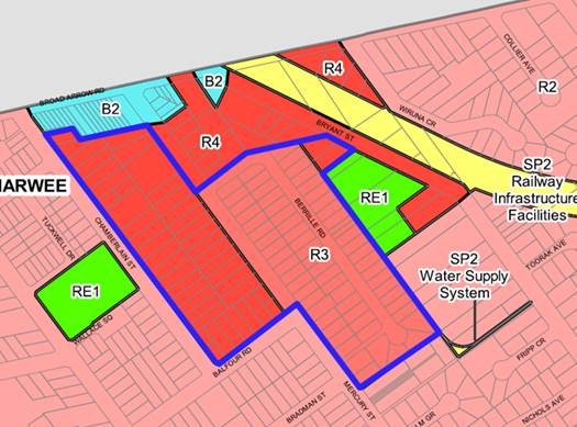
Figure 10 – Proposed Height of Buildings Map
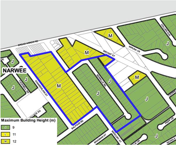
Figure 11 – Proposed Floor Space Ratio Map
Proposed built form
76. The street block bounded by Chamberlain Street, Mercury Street and Balfour Road as well as No.5 and 7 Bryant Street are proposed to be rezoned to the R4 High Density Residential zone. Residential flat buildings are the prevailing development typology in the R4 zone.
77. Accordingly, a maximum building height of 12m and FSR of 1:1 is proposed to be applied to the precinct to enable residential flat building developments of three to four storeys. These development standards have been developed to ensure consistency with the existing R4 zoned area located at the street block bounded by Bryant Street, Mercury Street and Berrille Road.
78. Furthermore, to ensure consistency with all proposed R4 zones across the LGA, a 1,000sqm minimum lot size will apply to this precinct for the purpose of preventing the fragmentation of land to ensure large parcels of land are available for development outcomes that are compatible with the high density zone.
79. The existing subdivision pattern in the proposed R4 zoned areas features an average lot size of approx. 650sqm. Redevelopment is considered to be feasible as only two allotments are required for amalgamation to meet the 1,000sqm minimum lot size control.
80. The proposed development standards for the R4 zone are summarised in Table 5 below:
Table 5 - Proposed development standards in the proposed R4 zone
|
Development Standard |
Proposed Control |
|
Zone |
R4 High Density Residential |
|
Height |
12m |
|
FSR |
1:1 |
|
Minimum lot size |
1,000sqm |
81. Built form analysis (refer Figure 12) prepared for Council demonstrates the feasibility of the proposed development standards for this precinct. Apartment Design Guide controls such as building height, building setback development controls have been applied to assist in the visualisation of the potential development outcome.
Figure 12 - 3D visualisation of potential built form in the proposed R4 zone
82. The remainder of the HIA is proposed to be rezoned to the R3 Medium Density Residential zone to facilitate the provision of greater housing choice and diversity in the LGA through the creation of ‘true’ medium density zoned areas. Developments such as multi dwelling housing, terraces and manor houses are the prevailing development typologies in the R3 zone.
83. Medium density developments are considered to be a more appropriate response in the areas fronting Berrille Road to ensure any potential conflict between vehicles and pedestrians are minimised in light of the narrow, cul-de-sac nature of Berrille Road.
84. A consistent set of development controls have been developed for all R3 zones across the LGA The proposed development standards for the R3 zone are summarised in Table 6 below:
Table 6 - Proposed development standards in the proposed R3 zone
|
Development Standard |
Proposed Control |
|
Zone |
R3 Medium Density Residential |
|
Height |
9m |
|
FSR |
0.7:1 |
|
Minimum lot size |
800sqm |
85. The existing subdivision pattern in the proposed R3 zoned areas features an average lot size of approx. 420sqm. Redevelopment is considered to be feasible as only two allotments are required for amalgamation to meet the 800sqm minimum lot size control.
86. Built form analysis prepared for Council demonstrates the indicative building envelope of these medium density developments. Existing DCP controls such as building setback distances have been applied as parameters to assist with visualisation (refer Figures 13 to 15).
Figure 13 - 3D visualisation of potential multi dwelling housing built form in the R3 zone
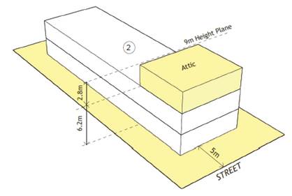
Figure 14 - 3D visualisation of potential manor house built form in the R3 zone
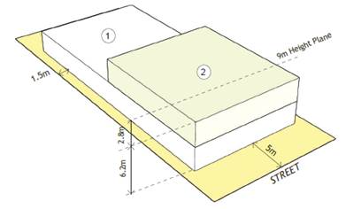
Figure 15 - 3D visualisation of potential terrace built form in the R3 zone
Traffic Findings
87. The proposed upzoning of the Narwee HIA will be supported by a Traffic Report for the purposes of:
· Establishing the existing traffic capacity in the local road network of each HIA
· Identifying existing traffic issues and capacity constraints within the local road network
· Identifying the additional traffic generation resulting from the proposed rezoning
· Assessing any potential traffic impacts resulting from the additional traffic
· Recommending mitigation measures to alleviate the potential traffic impacts.
88. A preliminary traffic analysis (refer Attachment 5) was conducted for the precinct to determine the post-development traffic impacts using an exaggerated take up of 400 additional dwellings.
89. Overall, the preliminary analysis identifies that the Narwee HIA benefits from proximity to the M5 Motorway, which interconnects with M8 Motorway. This enables notable alleviation of traffic from the local road network.
90. Furthermore, the proposed upzoning can be accommodated with no undue difficulty as the post-development traffic modelling demonstrates an acceptable level of service can be maintained at the nearby intersections. A minor intervention to the existing local road network is recommended as follows:
Narwee precinct will only require one treatment, being a no right turn restriction (sign) from Mercury Street to Stoney Creek Road in the PM peak period.
91. A final Traffic Report is currently being prepared with the inclusion of a number of additional intersections (including those located in the Canterbury-Bankstown LGA) as follows to enable a comprehensive review of the potential traffic impacts:
· Broadarrow Road / King Georges Road (Canterbury-Bankstown LGA)
· Broadarrow Road / Bryan Street under the railway bridge
· Edgbaston Road / Mercury Street
· Edgbaston Road / Penshurst Street
· Stoney Creek Road / King Georges Road
92. The full Traffic Report will be publicly exhibited with this Planning Proposal following the receipt of a Gateway Determination.
Manor Houses and Multi Dwelling Housing (Terraces)
Background - Low Rise Medium Density Housing Code
93. In the original Planning Proposal for the draft LEP 2020 which was submitted to DPIE requesting a Gateway Determination, Council proposed to introduce the land use terms of ‘manor houses’ and ‘multi dwelling housing (terraces)’ into the comprehensive LEP in preparation for the commencement of the Low Rise Medium Density Housing Code (LRMDHC).
94. Under the LRMDHC, manor houses will become permissible as complying development where multi dwelling housing or residential flat buildings (or both) are permitted. Similarly, terraces will become permissible as complying development where multi dwelling housing developments are permitted.
95. The complying development process allows development to be approved with minimal neighbour notification and no requirement for objections to be considered.
96. At the time of the LRMDHC’s announcement, multi dwelling housing was a permitted land use under the Hurstville LEP 2012 in all R2 Low Density Residential zones while multi dwelling housing was prohibited in the R2 zones under the Kogarah LEP 2012. The permissibility of multi dwelling housing in the R2 zones of the former Hurstville LGA threatened the neighbourhood amenity and character of these low density suburbs due to the imminent introduction of the LRMDHC across the LGA.
97. At its meeting on 28 May 2018, Council acknowledged the serious concern that the LRMDHC will generate for the neighbourhood amenity and character of these R2 areas and resolved to remove the permissibility of multi dwelling housing from the R2 zones as part of a planning proposal known as the LRMDHC Planning Proposal.
98. On 6 December 2019, the Minister for Planning and Public Spaces made the plan and the following amendments proposed by the LRMDHC Planning Proposal came into effect through the Georges River Local Environmental Plan Amendment (Miscellaneous) 2019:
Hurstville LEP 2012
· Prohibit multi dwelling housing in the R2 Low Density Residential zone
· Increase the minimum lot size for dual occupancies under Area G from 630sqm to 650sqm
Kogarah LEP 2012
· Repeal Items 17 and 18 of Schedule 1 Additional Permitted Uses
99. In the DPIE’s endorsement of the LRMDHC Planning Proposal, it was specified that Council’s Local Housing Strategy is required to outline the approach for the delivery of a sufficient number of dwellings to meet housing demand while ensuring a supply of a range of housing styles to promote choice and diversity.
100. To support the removal of medium density housing from the low density residential zones as result of the LRMDHC Planning Proposal, Council has committed to the following as part of the Local Housing Strategy:
· Review of all residential zoned land in the LGA to determine the areas that have merit on strategic planning grounds to accommodate medium density housing; and
· Develop planning controls and development standards for medium density housing that are responsive to the local character of the LGA.
Background - GRLEP 2020
101. The draft LEP 2020 sought to develop a clear hierarchy of residential density to ensure development typologies reflect the objectives and name of the respective zone:
· Low density: dwelling houses and dual occupancies
· Medium density: attached dwellings, multi dwelling housing, terraces and manor houses
· High density: residential flat buildings
102. To further strength the hierarchy of residential zones, the draft LEP 2020 also sought to introduce minimum lot size and minimum lot width development standards for all medium density typologies with the intent of reinforcing a consistent desired future character across the LGA’s medium density zones. The proposed controls are outlined in Table 7 below:
Table 7 – Existing and proposed controls for medium density residential developments
|
Development Standard |
HLEP 2012 |
KLEP 2012 |
GRLEP 2020 |
|
Minimum lot size |
945sqm (multi dwelling housing) (Hurstville DCP No.1) |
800sqm (multi dwelling housing) |
800sqm |
|
Minimum lot width -attached dwellings |
15m (Hurstville DCP No.1) |
20m (Kogarah DCP) |
21m |
|
Minimum lot width - manor houses |
N/A |
N/A |
18m |
|
Minimum lot width - multi dwelling housing |
15m (Hurstville DCP No.1) |
20m (Kogarah DCP) |
18m |
|
Minimum lot width - multi dwelling housing (terraces) |
N/A |
N/A |
21m |
|
Height of buildings |
9m |
9m |
9m |
|
Floor space ratio |
0.6:1 |
0.7:1 |
0.7:1 |
103. The draft LEP 2020 sought to adopt the 800sqm minimum lot size for all medium density developments as there has been no recorded Clause 4.6 variation to this development standard under KLEP 2012 since the implementation of this control in 2017 which demonstrates the viability and feasibility of this requirement. It is anticipated that the implementation of this control, as opposed to adopting the 945sqm requirement under the Hurstville DCP No.1, will facilitate the delivery of more medium density housing across the LGA which will in turn assist in providing more housing choice and diversity.
104. With regards to the minimum lot width requirement, design analysis conducted as part of the draft LEP 2020 identified that a 15m wide lot is too narrow to accommodate a driveway along one side boundary and private open space for the multi dwelling units along the opposite side boundary. Therefore, an 18m lot width requirement is proposed to provide a desirable development outcome.
105. To ensure flexibility is provided for the community and the development industry to deliver various medium density residential typologies based on market demand and the local context, the 18m minimum lot width was also proposed to be applied to manor houses.
106. A greater minimum lot width of 21m was proposed for attached dwellings and multi dwelling housing (terraces) due to the requirement for these typologies to have all dwellings facing the street. A 21m lot width provides for 3 dwellings of 6m wide each as well as 1.5m side setbacks along both side boundaries.
107. The above controls tabulated in Table 7 were supported by the LPP as the planning proposal authority at its meeting dated 6 February 2020.
108. However, as part of the Gateway Determination issued by DPIE on 10 March 2020 (refer Attachment 3), Council was instructed to remove all references and proposed provisions, including development standards, relating to the LRMDHC land uses of ‘manor houses’ and ‘terraces’ from the draft LEP 2020. Accordingly, the draft LEP 2020 was submitted to the DPIE for finalisation on 30 June 2020 without any references to the LRMDHC land uses.
Background - Codes SEPP
109. On 1 July 2020, the LRMDHC came into effect in the LGA under the revised name of the Low Rise Housing Diversity Code (“LRHDC”), which allows dual occupancies, manor houses and multi dwelling housing (terraces) to be carried out as complying developments.
110. In addition to its permissibility as a form of complying development, manor houses are also granted the additional under the relevant LEP afforded by Clause 3B.1A of the State Environmental Planning Policy (Exempt and Complying Development Codes) 2008 (“Codes SEPP”):
State Environmental Planning Policy (Exempt and Complying Development Codes) 2008 - Division 1A Manor houses permitted in certain land use zones
Clause 3B.1A Development for the purposes of manor houses
Manor houses are, despite any other environmental planning instrument, permitted with consent on land in any of the following land use zones if multi dwelling housing or residential flat buildings (or both) are permitted in the zone—
(a) Zone RU5 Village,
(b) Zone R1 General Residential,
(c) Zone R2 Low Density Residential,
(d) Zone R3 Medium Density Residential.
111. Given that ‘multi dwelling housing’ is a permissible land use within the R3 Medium Density Residential zone within the existing LEPs and the draft LEP 2020, development applications can be lodged for manor house developments utilising the development standards stipulated by the LEP.
112. However, the same LEP permissibility has not been afforded to multi dwelling housing (terraces). This specific development typology must be carried out as complying development under the provisions of the Codes SEPP.
Proposed LEP2021 Amendments
113. The inconsistencies of the recently introduced LRHDC are likely to result in uncertainty for both the community and the development sector due to the variations between the Codes SEPP and the LEP with regards to maximum building height, floor space ratio (“FSR”) and minimum lot size.
114. The absence of development standards to regulate manor houses and the impermissibility of multi dwelling housing (terraces) within the LEP requires urgent rectification.
115. Furthermore, the application of the minimum 600sqm lot size for manor houses and terraces as prescribed by the Codes SEPP is likely to result in a density which is incongruent with the existing density and character of the LGA’s medium density zones. This is considered to be inconsistent with the aspirations of the Georges River community.
116. Accordingly, this Planning Proposal seeks to promote the delivery of housing choice across the LGA by re-introducing the following amendments:
· Permit ‘manor houses’ and ‘multi dwelling housing (terraces)’ across all R3 Medium Density Residential and R4 High Density Residential zones;
· Implement minimum lot size of 800sqm and lot width of 18m for manor houses to ensure consistency with multi dwelling housing for flexible market up-take; and
· Implement minimum lot size of 800sqm and lot width of 21m for multi dwelling housing (terraces) to enable appropriate subdivision patterns and viable development outcomes.
117. It should be noted that although manor houses are permissible in the LEP under Clause 3B.1A of the Codes SEPP, the community and the development industry would greatly benefit from the certainty and clarity enabled by the explicit nomination of manor houses in the LEP’s Land Use Table.
118. This amendment is considered to be consistent with Council’s existing approach of nominating the permissibility of ‘secondary dwellings’ within the LGA’s residential zones within the draft LEP 2020, despite the provisions of Clause 20 under the State Environmental Planning Policy (Affordable Rental Housing) 2009 which permits secondary dwellings in LEPs where dwelling houses are permissible:
State Environmental Planning Policy (Affordable Rental Housing) 2009 - Division 2 Secondary dwellings
Clause 20 Land to which Division applies
This Division applies to land within any of the following land use zones or within a land use zone that is equivalent to any of those zones, but only if development for the purposes of a dwelling house is permissible on the land—
(a) Zone R1 General Residential,
(b) Zone R2 Low Density Residential,
(c) Zone R3 Medium Density Residential,
(d) Zone R4 High Density Residential,
(e) Zone R5 Large Lot Residential.
119. Currently, the KLEP 2012 currently relies on the provisions of the above clause to enable the permissibility of secondary dwellings in the residential zones. However, Council has received many complaints from both the industry professionals and property owners regarding the confusion caused by the absence of ‘secondary dwellings’ from the KLEP 2012 Land Use Tables.
120. In addition to the certainty that will be enabled by this Planning Proposal’s inclusion of manor houses and terraces into the LEP land use table, LEP21 also provides increased development potential as demonstrated by the comparison of proposed LEP controls against the Codes SEPP controls in Table 8 below:
Table 8 – Proposed LEP21 controls vs Codes SEPP controls
|
|
Codes SEPP |
Draft LEP 2021 |
|
Manor houses |
||
|
Permissibility |
Zone R3 - multi dwelling housing or residential flat buildings (or both) are permitted. |
Zone R3 and Zone R4 |
|
Minimum lot size |
Whichever is greater – 600sqm or the minimum lot area specified for manor houses in the respective LEP (800sqm) |
800sqm |
|
Minimum lot width |
15m |
18m |
|
Maximum building height |
8.5m |
9m |
|
Maximum FSR |
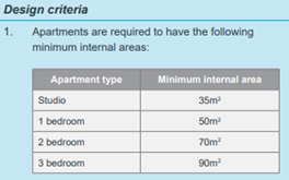
Maximum GFA is 25% of the lot area plus 150sqm, to a maximum of 400sqm.
For example on 800sqm site, the resulting FSR is 0.42:1 (350sqm GFA). |
Zone R3 – 0.7:1 FSR For example of 800sqm site, the resulting GFA is 560sqm (210sqm greater than the Codes SEPP). |
|
Sample built form |
|
|
|
Multi dwelling housing (terraces) |
||
|
Permissibility |
In Zone R3 as complying development only. |
Zone R3 and Zone R4 |
|
Minimum lot size |
Whichever is greater – 600sqm or the minimum lot area specified for terraces in the respective LEP (800sqm) |
800sqm |
|
Minimum lot width |
21m |
21m |
|
Maximum building height |
9m |
9m |
|
Maximum FSR |
0.8:1 FSR
|
0.7:1 FSR |
|
Built form |
|
|
121. As demonstrated by Table 8 above, this Planning Proposal will enable the delivery of ‘true’ medium density dwellings across the LGA by increasing development yield for manor house developments under the LEP while formalising terraces as development applications.
122. It should be noted that the dwelling size of manor house units specified by the Codes SEPP (refer Figure 16) are identical to the apartment sizes nominated by the Apartment Design Guide (refer Figure 17). Despite the LRHDC’s permissibility of manor houses as a form of low to medium density typology through complying development, the combination of the restrictive GFA and the dwelling sizes is likely to result in apartment products with reduced amenity in areas that are less accessible than the high density zones.
Figure 16 – Extract from Low Rise Housing Diversity Design Guide – Manor House
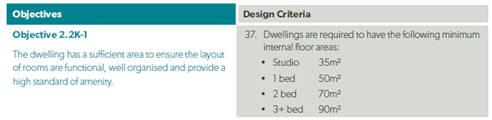
Figure 17 – Extract from Apartment Design Guide – 4D Apartment Size and Layout
123. Accordingly, the additional GFA provided through LEP controls for manor house developments will promote the provision of true’ medium density dwellings. For example on a 800sqm site, a manor house with 4 dwellings of 140sqm each can be provided through the application of LEP controls while the Codes SEPP can only provide 4 dwellings of 87.5sqm each.
124. It is evident that the LEP provides almost double the development capacity provided by the Codes SEPP, which will more adequately respond to the community’s housing demands for more medium density housing options as identified by the Local Housing Strategy.
125. Furthermore, the proposed introduction of the multi dwelling housing (terraces) land use creates opportunities to provide a diverse choice of high quality housing across the LGA as the permissibility of this dwelling typology will no longer be restricted to only complying developments.
126. The proposed 800sqm minimum lot size requirement for manor houses and terraces is consistent with the development standard applied to the other medium density typologies of multi dwelling housing and attached dwellings under the draft GRLEP 2020. This will ensure the clear hierarchy of residential zones is upheld across the LGA as follows:
· Low density – minimum 650sqm lot size for dual occupancies
· Medium density – minimum 800sqm lot size for multi dwelling housing, terraces, manor houses and attached dwellings
· High density – minimum 1,000sqm lot size for residential flat buildings
Analysis of Development Potential
127. Consideration has also been given towards the feasibility of manor house developments in light of the increased minimum lot size of 800sqm and lot width of 18m proposed by this Planning Proposal as compared to the Codes SEPP controls of 600sqm and 15m respectively.
128. There are a total of 15 R3 zoned precincts across the LGA, including the proposed rezoning of the Narwee HIA. A desktop analysis has been conducted for each precinct with considerations of the existing lot size and lot width of the properties that are likely to be redeveloped for medium density developments and in particular, feasibility for manor houses utilising the proposed LEP21 controls. The findings of the analysis are provided in Table 9 below:
Table 9 – Feasibility of LEP21 manor house controls
|
Precinct |
Analysis |
|
1. North and West of Peakhurst Park – Peakhurst
|
This precinct is proposed to be rezoned from R2 to R3 by the draft GRLEP 2020 and has a limited number of existing strata-titled properties.
There are two prevailing types of subdivision pattern – · 760sqm lot size with 13.5m lot width · 590sqm lot size with 15m lot width
Site amalgamation is required to be eligible for manor house developments under the Codes SEPP. There will be no loss of development potential under the proposed LEP controls. |
|
2. Apsley Estate – Penshurst
|
This precinct is proposed to be rezoned from R2 to R3 by the draft GRLEP 2020 and only contains one existing strata-titled property.
Despite the variation in lot size, there is a consistent subdivision pattern featuring a 12.5m lot width.
Site amalgamation is required to be eligible for manor house developments under the Codes SEPP. There will be no loss of development potential under the proposed LEP controls. |
|
3. Ada Street / Rosa Street – Oatley
|
This precinct is proposed to remain as an R3 zone under draft GRLEP 2020 and has a limited number of existing strata-titled properties.
There is a lack of prevailing subdivision pattern but the following relationships can be observed: · Lots with areas of >650sqm have lot widths of 18m or greater · Lots with areas of <650sqm have lot widths of less than 14m
Site amalgamation is required for the smaller sites to be eligible for manor house developments under the Codes SEPP. There will be no loss of development potential under the proposed LEP21 controls. |
|
4. King Georges Road – South Hurstville
|
This precinct is proposed to remain as an R3 zone under draft GRLEP 2020 and has a limited number of existing strata-titled properties.
There are two prevailing types of subdivision pattern – · Lots fronting King Georges Road has 12m lot width and lot sizes of 300sqm to 700sqm · Lots fronting the perpendicular streets have consistent lot widths of 15m with 690sqm lot size
Site amalgamation is required for the smaller sites to be eligible for manor house developments under the Codes SEPP. Although lots fronting the perpendicular streets may be eligible for manor house developments under the Codes SEPP, recent development activity in the South Hurstville area demonstrates a preference for multi dwelling housing developments on larger lots. The existing development potential is unlikely to be reduced under the proposed LEP controls. |
|
5. Culwulla Street – South Hurstville
|
This precinct is proposed to be rezoned from R2 to R3 by the draft GRLEP 2020 and has no existing strata-titled properties.
There is a prevailing subdivision pattern of 650sqm lot size and 15m lot width.
Although most of the allotments within this precinct may be eligible for manor house developments under the Codes SEPP, recent development activity in the South Hurstville area demonstrates a preference for multi dwelling housing developments on larger lots. The existing development potential is unlikely to be reduced under the proposed LEP controls. |
|
6. Rickard Road / Connells Point Road – South Hurstville
|
This precinct is proposed to remain as an R3 zone under draft GRLEP 2020 and the majority of properties are already strata-titled townhouses and villas.
Due to the developed status of this precinct, there will be no loss of development potential under the proposed LEP controls. |
|
7. Rowe Street – South Hurstville
|
This precinct is proposed to be rezoned from R2 to R3 by the draft GRLEP 2020 and only contains one existing strata-titled property.
There is a lack of prevailing subdivision pattern but the following relationships can be observed: · The smaller lots have site areas of less than 600sqm and have 12m lot widths · The larger lots are 1,000sqm in site area and have lot widths of 20m
Site amalgamation is required for the smaller sites to be eligible for manor house developments under the Codes SEPP. There will be no loss of development potential under the proposed LEP controls.
|
|
8. Morshead Drive – South Hurstville
|
This precinct is proposed to remain as an R3 zone under draft GRLEP 2020 and the majority of properties are already strata-titled townhouses and villas.
Due to the developed status of this precinct, there will be no loss of development potential under the proposed LEP controls.
|
|
9. The Mall – South Hurstville
|
This precinct is proposed to remain as an R3 zone under draft GRLEP 2020 and the majority of properties are already strata-titled townhouses and villas.
Due to the developed status of this precinct, there will be no loss of development potential under the proposed LEP controls. |
|
10. Blakesley Road – South Hurstville
|
This precinct is proposed to remain as an R3 zone under draft GRLEP 2020 and half of properties are already strata-titled townhouses and villas.
The remaining sites have a consistent subdivision pattern with site area of less than 500sqm and lot widths of 10m.
Site amalgamation is required to be eligible for manor house developments under the Codes SEPP. There will be no loss of development potential under the proposed LEP controls. |
|
11. Cooleen / Walton Street – Blakehurst
|
This precinct is proposed to remain as an R3 zone under draft GRLEP 2020 and the majority of properties are already strata-titled townhouses and villas.
Due to the developed status of this precinct, there will be no loss of development potential under the proposed LEP controls. |
|
12. Betts Avenue – Blakehurst
|
This precinct is proposed to remain as an R3 zone under draft GRLEP 2020 and the majority of properties are already strata-titled townhouses and villas.
Due to the developed status of this precinct, there will be no loss of development potential under the proposed LEP controls.
|
|
13. St Georges Parade / George Street – Allawah / South Hurstville
|
This precinct is proposed to remain as an R3 zone under draft GRLEP 2020 and the majority of properties are already strata-titled townhouses and villas.
Due to the developed status of this precinct, there will be no loss of development potential under the proposed LEP controls. |
|
14. Rocky Point Road – Sans Souci
|
This precinct is proposed to remain as an R3 zone under draft GRLEP 2020 and the majority of properties are already strata-titled townhouses and villas.
Due to the developed status of this precinct, there will be no loss of development potential under the proposed LEP controls. |
|
15. Berrille Road – Narwee
|
This precinct is proposed to be rezoned from R2 to R3 and R4 by this Planning Proposal as part of the Narwee HIA and does not contain any strata-titled properties.
The existing subdivision pattern in the proposed R3 zoned areas features an average lot size of approx. 420sqm with 13m lot widths.
Site amalgamation is required to be eligible for manor house developments under the Codes SEPP. There will be no loss of development potential under the proposed LEP controls. |
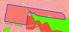
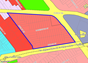

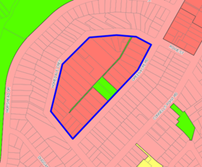
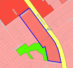
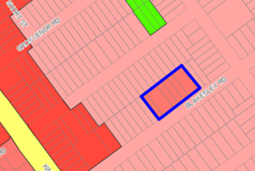
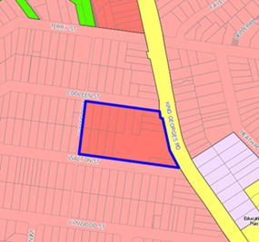
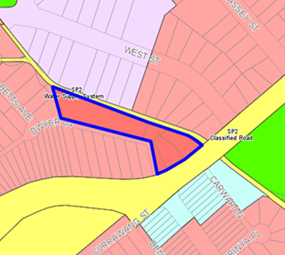
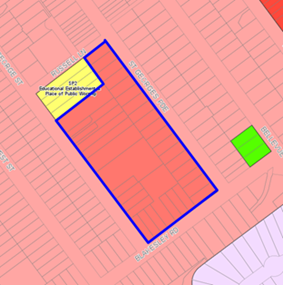
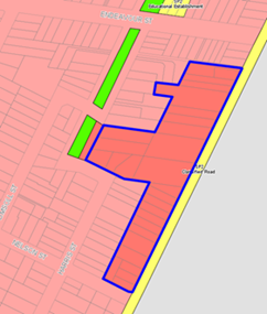
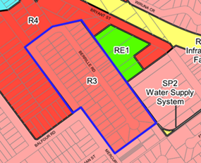
DCP Controls
129. It should be noted that a draft Georges River Development Control Plan (“DCP”) 2020 has been prepared to support the draft LEP 2020. At its meeting dated 17 September 2020, the LPP resolved to place the draft DCP 2020 on public exhibition. The draft DCP will be on exhibition until 27 November 2020.
130. Part 6.2 of the draft DCP 2020 contains all the relevant controls pertaining to medium density development including multi dwelling housing, multi dwelling housing (terraces) and manor houses.
131. The introduction of manor houses and multi dwelling housing (terraces) into the Georges River LEP will be supported by the proposed draft DCP 2020 controls.
Monaro Avenue Open Space
Background
132. The Planning Proposal for draft LEP 2020 had originally proposed to include the acquisition of 6 properties located at 11-21 Monaro Avenue, Kingsgrove in response to the LSPS 2040 vision to deliver additional open space across the LGA.
133. The subject properties make up half of the eastern street block surrounding Peter Low Reserve (refer Figure 18 below).
Figure 18 – Location of 11-21 Monaro Avenue, Kingsgrove
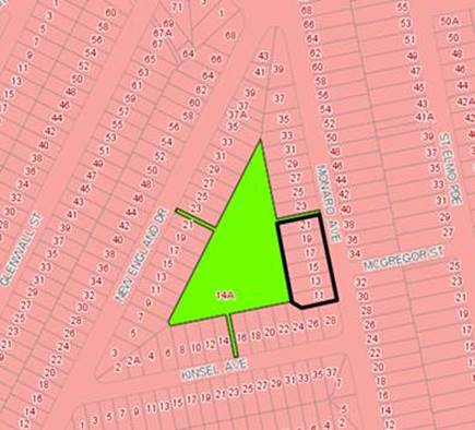
134. The acquisition of these properties would have enabled an expansion of the Peter Lowe Reserve, which is currently affected by a number of physical limitations including:
· Landlocked by residential dwellings on all three sides;
· Poor visibility to the general public;
· Reduced accessibility to the general public as result of poor visibility;
· Accessed via three narrow laneways on Monaro Avenue, New England Drive and Kinsel Avenue;
· Narrow laneways limits usage by the broader community;
· Experiences little to no passive surveillance from public streets; and
· Relies on active surveillance from the rear of 36 houses.
135. Peter Lowe Reserve is located in the suburb of Kingsgrove, which is located in the northern portion of the LGA. Council’s Open Space, Recreation and Community Facilities Strategy 2019 – 2036 identifies a 76,000sqm (or 7.6ha) shortage of active open space in the LGA, particularly in the north of the LGA in suburbs like Beverly Hills, Kingsgrove, Narwee and Riverwood.
136. Based on a desktop analysis of the total amount of open space in each Ward (refer Table 10 below), the Hurstville Ward located at the north-eastern corner of the LGA, which comprises of the suburbs of Beverly Hills, Hurstville (north of the railway line) and Kingsgrove, has the least amount of open space available to its residents, which is closely followed by the Mortdale Ward comprising of the suburbs of Mortdale, Narwee and Penshurst.
Table 10 – Breakdown of Open Space by Ward
|
Ward |
Blakehurst |
Hurstville |
Kogarah Bay |
Mortdale |
Peakhurst |
|
Area of Open Space (ha) |
124.93 |
26.14 |
57.76 |
29.99 |
235.37 |
|
Approx. Number of Dwellings |
9,778 |
11,819 |
13,553 |
10,287 |
9,355 |
|
Open Space per Dwelling (sqm) |
127.77 |
22.12 |
42.62 |
29.15 |
251.60 |
|
% of Total Open Space |
26.3% |
5.5% |
12.2% |
6.3% |
49.6% |
137. The Hurstville Ward is also the Ward with the smallest amount of open space available per dwelling with only 22.12sqm of open space available compared to the average open space provision rate of approximately 76.68sqm per dwelling across the LGA. Furthermore, only 5.5% of the total amount of open space in the LGA is accommodated within this Ward.
138. Accordingly, the expansion of Peter Lowe Reserve would enable the creation of additional open space in an area of the LGA with a significant shortage of both active and passive recreation areas.
139. However, during the public exhibition of the draft LEP 2020 from 1 April to 31 May 2020 (inclusive), a total of 163 submissions were received objecting to the acquisition of 11-21 Monaro Avenue due to concerns regarding the compulsory acquisition process and the amenity impacts associated with more users for this park. The key issues raised in these objections are summarised as follows:
· Acquisition for open space is not justified as the Reserve is not near existing or proposed high density areas;
· It is a poor investment of Council funds;
· Places stress on owners of properties proposed for acquisition;
· Will result in increased traffic and crime rates as more people will visit the Reserve; and
· There are no plans for the park to indicate how the park will be used.
140. To address the concerns raised by the submissions in relation to the FSPA, the LPP at its meeting dated 25 and 26 June 2020 made the amendments to remove the land reservation acquisition of 11-21 Monaro Avenue from the draft LEP 2020.
141. However, further investigation was requested by the LPP in its recommendation:
3. The Panel notes the existing need for additional open space in the northern portion of the Local Government Area and encourages the Council to continue to pursue and investigate all opportunities to provide such open space including the provision of additional land in the vicinity of Peter Lowe Reserve as part of the preparation of the draft Local Environmental Plan in 2021/2022.
Negotiated Purchase of Properties
142. Table 10 above indicates a deficiency of available open space in the northern portion of the LGA particularly in the Hurstville Ward. The key principle of achieving equity across the LGA requires Council to further pursue and investigate opportunities to provide additional open space in this locality.
143. In accordance with the LPP’s recommendation, Council staff sought expressions of interest from the landowners in the immediate vicinity of Peter Lowe Reserve regarding the opportunity for Council to purchase their property for the purpose of expanding the Reserve.
144. Council staff have had some success in negotiating the purchase of properties surrounding Peter Lowe Reserve. However, at the time of this report securing the purchase of any property by Council had not been finalised. Once these sales are finalised, a further report will be submitted to Council regarding the rezoning of the sites from R2 Low Density Residential to RE1 Public Recreation and the removal of associated development standards e.g. height and FSR.
Mapping Anomalies
145. Following a review of the maps for the finalisation of draft LEP 2020, two mapping errors have been identified in the Height of Buildings Map and Floor Space Ratio Map. These two errors were previously considered by LPP during the finalisation of the draft LEP 2020.
33 Dora Street, Hurstville
146. This site is zoned B4 – Mixed Use and is located at the edge of Hurstville Centre adjoining Waratah Private Hospital. The site contains a semi-detached Victorian terrace that forms part of a group heritage listing for a row of Victorian Terraces being Nos.33-47 Dora St, Hurstville (under draft GRLEP2020). This group of terraces and the adjoining site at No.49 Dora Street have a maximum floor space ratio of 3:1.
147. The Height of Buildings Map in draft LEP 2020 indicates a maximum permissible height of 30m for 33 Dora Street, Hurstville as shown in Figure 19 below.
Figure 19 – Extract of the draft GRLEP 2020 Height of Buildings Map for 33 Dora Street, Hurstville (outlined in red)
148. This mapping anomaly was identified during the preparation of LEP 2020. The height was corrected from 30m to 15m and included in the exhibition version of the draft Height of Buildings Map. However this correction was not explicitly stated and the property owner did not receive a targeted letter. During the finalisation of the LEP 2020, the LPP resolved that the existing height for 33 Dora Street be re-instated to 30 metres prior to being forwarded to the DPIE for gazettal.
149. The Height of Buildings Map is proposed to be amended for the 33 Dora Street, Hurstville from 30m to 15m to rectify an existing anomaly, to correspond with the adjoining sites at Nos.35-49 Dora Street being 15m.
199 Rocky Point Road, Ramsgate
150. This site contains a split zoning of B2 – Local Centre and R4 – High Density Residential and is located within Ramsgate Centre, as shown in Figure 20 below. The site contains a two-storey shop top housing with vehicular access from Rocky Point Road.
Figure 20 – Extract of the draft GRLEP2020 Land Use Zoning Map for 199 Rocky Point Road, Ramsgate (outlined in white)
151. The Height of Buildings Map in draft GRLEP2020 indicates a maximum permissible height of 21 metres for across the entire site as shown in Figure 21 below.
Figure 21 – Extract of the draft GRLEP 2020 Height of Buildings Map for 199 Rocky Point Road, Ramsgate (outlined in white)
152. The Floor Space Ratio Map in draft GRLEP2020 indicates a maximum permissible floor space ratio of 2.5:1 for across the entire site as shown in Figure 22 below.
Figure 22 – Extract of the draft GRLEP 2020 Floor Space Ratio Map for 199 Rocky Point Road, Ramsgate (outlined in white)
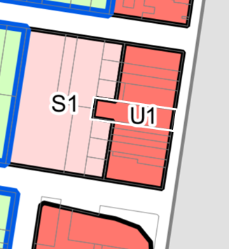
153. This mapping anomaly was identified during the preparation of LEP 2020. The height and FSR were corrected to be split on the site to correspond with the remainder of the street block in the exhibited draft LEP 2020 maps. However this correction was not explicitly stated and the property owner did not receive a targeted letter. During the finalisation of the draft LEP 2020, the LPP resolved that the existing height and floor space ratio for 199 Rocky Point Road be re-instated to 30m prior to being forwarded to the DPIE for gazettal.
154. To rectify this mapping anomaly, the following amendments are proposed for 199 Rocky Point Road, Ramsgate:
· The Height of Buildings Map to be amended from 21m to 15m and 21m; and
· The Floor Space Ratio Map to be amended from 2.5:1 to 1.5:1 and 2.5:1.
FSPA Review
155. The draft LEP 2020 had originally proposed to reduce the extent of the existing Foreshore Scenic Protection Area (“FSPA”) in the former Hurstville LGA to exclude areas with lower sensitivities to change, as identified by the Foreshore Strategic Directions Paper (“the Paper”). The removal of these properties from the existing FSPA would have enabled increased development potential (i.e. eligible for dual occupancies) for 742 sites. This proposal was endorsed by the DPIE through the Gateway Determination.
156. The Planning Proposal for the draft LEP 2020 was publicly exhibited from 1 April to 31 May 2020 (inclusive) and a total of 1,153 community submissions were received. The content of the submissions were categorised into 14 topic areas.
157. A total of 510 submissions were received in relation to the FSPA with over 400 submissions objecting to the removal of properties within the FSPA due to impacts associated with overdevelopment as result of the increased dual occupancy development potential and the loss of vegetation and biodiversity through overdevelopment. The key issues raised in these objections are summarized as follows:
· Increase in housing density will impact flora and fauna in the area; many included references to specific trees, parks, gardens and fauna.
· Held the ‘green and leafy’ character in high regard, and expressed concern that reducing the extent of the existing FSPA would erode this character.
· All trees visible from the foreshore must be protected.
· Concerns about pollution, in particular water pollution from increased density and the potential impacts from run off into the Georges River.
· Objects to more development (i.e. more dual occupancies) and the associated amenity impacts such as traffic, on street parking, safety, privacy, and increase in demand for schools.
· Council should undertake a full biodiversity assessment of the LGA to inform the development of the new LEP.
158. To address the concerns raised by the submissions in relation to the FSPA, the LPP made the following amendments to the draft LEP 2020:
· Increase the minimum landscaped area requirements for dual occupancies (non-FSPA) to 25% and dual occupancies (FSPA) to 30% and to ensure new developments are accompanied by increased planting and vegetation;
· Insert a new local provision to protect trees in the R2 and R3 zones; and
· Retain the existing extent of the FSPA in the Hurstville LEP while expanding the FSPA to the former Kogarah LGA in accordance with the as-exhibited version.
159. However, further investigation was requested by the LPP in its recommendation:
2. The Panel recommends that Council as part of the preparation of the draft Local Environmental Plan in 2021/2022, further define the role, mapped extent and zoning of the FSPA, in both the former Hurstville and Kogarah Local Government Areas, having regard to those properties and ridge lines visible to and from the Georges River and its tributaries, and associated environmental protection applying to those areas in order to better reflect the objectives of Clause 6.7 of the Georges River Local Environmental Plan 2020. This may include the consideration of additional environmental protection zones or modifications of the FSPA.
160. In response to the concerns outlined by the LPP in its recommendation above, Council has commenced the preparation of two technical studies, being the Foreshore Scenic Character Review and the LGA-wide Biodiversity Study, utilising the DPIE grant funding with the intent of further investigating the role, mapped extent and zoning of the FSPA.
161. The purpose of Foreshore Scenic Character Review (‘the Review’) to undertake a further review of the scenic character of the foreshore localities in the Georges River local government area (“LGA”) for the purpose of updating and refining the character analysis prepared by the Paper.
162. The Review will build upon the existing evidence base provided by the Paper to further clarify the character typologies present in the visual catchment to and from the Georges River. The character analysis will include assessments of the existing scenic amenity and the environmental, social and character values of the foreshore for the purpose of reviewing the role, mapped extent and zoning of the foreshore scenic protection area (“FSPA”).
163. The Review’s objectives are to:
· Determine the role and function of the existing FSPA;
· Assess the impact of the FSPA on development potential;
· Evaluate the effectiveness and relevance of the existing FSPA as a means of:
o Protecting the landscaped character of the foreshore environment; and
o Enforcing a homogenous neighbourhood character;
· Identify the extent of the visual catchment to and from the Georges River and its tributaries within the Study Area;
· Identify areas with high environmental values and sight lines to the foreshore;
· Develop a revised set of Character Typologies for properties located within the visual catchment;
· Enable an enhanced understanding of the foreshore locality and its local character by integrating the findings with the Biodiversity Study;
· Inform future amendments to the LEP 2020 and DCP 2020; and
· Consider alternative controls and provisions to better protect and enhance the scenic amenity and the environmental, social and character values of the foreshore.
164. The proposed outcomes of the Review include the following:
· Provide recommendations for an alternative approaches to protecting the scenic amenity and the environmental, social and character values of the foreshore.
· Construct view planes to preserve and protect the significant view corridors, especially from public open spaces like parks and reserves;
· Develop draft criteria for applicants to use when preparing view analysis studies for development applications;
· Recommend LEP and DCP controls that:
o Provide additional environmental protection to respond to presence of biodiversity (as identified by the Biodiversity Study);
o Review the role, extent and zoning of the FPSA;
o Maintain and enhance the neighbourhood character and the landscape character;
o Require development to respond positively to view corridors and encourage view sharing;
o Protect areas with high scenic values; and
o Provide heads of consideration when assessing a development application for development that may have an impact on scenic landscapes and view corridors;
165. Council does not yet possess a comprehensive study of its total biodiversity, nor does it possess a Biodiversity Strategy. The purpose of this initial LGA-wide Biodiversity Study will be to investigate and report on the current biodiversity condition, location and protection measures through desktop analysis and field surveys.
166. The objectives of the Biodiversity Study are to:
· Review all current biodiversity information for the LGA to establish what native flora and fauna species are occurring or likely to occur and establish baseline condition of biodiversity throughout the LGA.
· Identify any data gaps, as part of a review of background information to inform the biodiversity study and field work requirements
· Identify field survey requirements designed to confirm the presence of native flora and fauna species.
· Undertake targeted field surveys to identify flora and fauna species and endangered communities, as well as fauna habitat present in the LGA focusing on rare and threatened species as identified in the Biodiversity Conservation Act 2016 (NSW), associated Biodiversity Regulation 2017 and the Environment Protection and Biodiversity Conservation Act 1999 (Commonwealth).
· Validate areas of outstanding biodiversity value as seen on the NSW Biodiversity Values Map
· Undertake mapping of flora and fauna species, vegetation communities and localised biodiversity values including habitat corridors and linkages produced in GIS shape-files suitable for Council’s IntraMaps platform.
· Recommend the most appropriate courses of action to preserve and conserve biodiversity and to monitor change over time including indicators that are easily measured.
· Recommend planning controls (i.e. Local Environmental Plan and Development Control Plan controls) in collaboration with consultant planners to enable better protection of the LGA’s biodiversity within the development process
167. The scope of the Biodiversity Study includes an implementation framework to be developed in collaboration with the team preparing the Foreshore Scenic Character Review for the purpose of recommending planning controls which will enable developments to appropriately respond to the presence of biodiversity. The framework is to:
· Review the effectiveness of the existing LEP controls relating to biodiversity;
· Introduce alternative and/or new LEP controls to protect areas with high conservation value;
· Review the appropriateness of the existing zoning of land;
· Develop detailed Development Control Plan (DCP) controls to further strengthen the LEP controls.
168. The Biodiversity Study developed under this brief will form the foundation for a future Biodiversity Strategy which will incorporate annual implementation planning that identifies specific tasks, timelines, responsibilities and priorities relating to biodiversity within the LGA.
169. Once the two studies are completed, and depending on timing consideration will be given to preparing an Alteration to Gateway to amend the Planning Proposal for LEP21 to reflect an updated policy position on the FSPA, based on the outcomes of the Review and the Biodiversity Study.
Alignment with Strategic Framework
170. The future vision for Greater Sydney to 2056 is clearly established in the Greater Sydney Region Plan – A Metropolis of Three Cities (“Region Plan”) and the supporting district plans released in March 2018. These plans are framed around 10 Directions relating to the four themes of infrastructure and collaboration, liveability, productivity and sustainability. The South District Plan is the applicable district plan for the Georges River LGA.
171. To provide an alignment between the district and local levels of strategic planning, the State Government introduced legislation in early 2018 requiring councils to prepare a local strategic planning statement for the LGA. The Georges River LSPS 2040 was endorsed by the GSC on 4 March 2020 and is framed around the following 5 themes, each supported by Planning Priorities:
· Access and Movement
· Infrastructure and Community
· Housing and Neighbourhoods
· Economy and Centres
· Environment and Open Space
172. The LSPS builds on the community’s aspirations and expectations expressed in Council’s Community Strategic Plan 2018 - 2028. It is also aligned with the Greater Sydney Region Plan and South District Plan; and other State Government planning priorities.
173. A summary of the alignment between this Planning Proposal and the relevant South District Plan and LSPS Planning Priorities is categorised by the themes of infrastructure and collaboration, liveability and sustainability in Table 11 below:
Note: this Table will be amended as part of the Alterations for Gateway to reflect considerations provided in relation to the FSPA Review.
Table 11 – Summary of Alignment with Planning Priorities
|
South District Plan Planning Priority |
LSPS Planning Priority |
Comment |
|
Infrastructure and collaboration |
||
|
S1. Planning for a city supported by infrastructure
|
P1. We have a range of frequent, efficient transport options to connect people, goods, services, businesses and educational facilities
P10. Homes are supported by safe, accessible, green, clean, creative and diverse facilities, services and spaces |
The proposed rezoning of the Narwee HIA to accommodate new housing and encourage housing diversity is located within walking distance to public transport infrastructure (i.e Narwee Railway Station and bus stops with frequent bus services) and the existing Narwee village commercial centre. The Narwee HIA also has excellent access to existing open spaces with children’s playgrounds and picnic/BBQ facilities. |
|
Liveability |
||
|
S4. Fostering healthy, creative, culturally rich and socially connected communities
S5. Providing housing supply, choice and affordability with access to jobs, services and public transport
S6. Creating and renewing great places and local centres, and respecting the District’s heritage
|
P9. A mix of well-designed housing for all life stages caters for a range of lifestyle needs and incomes
P10. Homes are supported by safe, accessible, green, clean, creative and diverse facilities, services and spaces
P19. Everyone has access to quality, clean, useable, passive and active, open and green spaces and recreation places |
This Planning Proposal provides additional housing through the up-zoning of an existing low density residential area in a highly accessible area serviced by shops, schools, and open space and community facilities. The creation of additional housing in the Narwee HIA will greatly assist with revitalising the existing Narwee village.
The combination of medium and high density developments proposed in the Narwee HIA allows a range of housing typologies to be delivered in response to the Georges River community’s need for more housing choice.
Furthermore, the formalisation of manor houses and terraces within the LEP will enable the provision of a diverse selection of medium density housing products to contribute to the LGA’s housing supply. |
Consistency with SEPPs
174. The Planning Proposal is consistent with the following relevant State Environmental Planning Policies (SEPPs) as assessed below in Table 12:
Note: this Table will be amended as part of the Alterations for Gateway to reflect considerations provided in relation to the FSPA Review.
Table 12 – Consistency of Planning Proposal with SEPPs
|
State Environmental Planning Policy |
Consistency |
Comment |
|
State Environmental Planning Policy No 19 – Bushland in Urban Areas |
Yes |
The proposed area of residential intensification in Narwee is not located in existing bushland. Accordingly, the Planning Proposal is consistent with this SEPP. |
|
State Environmental Planning Policy No 21 – Caravan Parks |
N/A |
Not applicable |
|
State Environmental Planning Policy No 33 – Hazardous and Offensive Development |
Yes |
The proposed R3 Medium Density Residential and R4 High Density Residential zoning prohibit hazardous and offensive development. |
|
State Environmental Planning Policy No 36 – Manufactured Home Estates |
N/A |
Not applicable |
|
State Environmental Planning Policy No 44 – Koala Habitat Protection |
N/A |
Not applicable |
|
State Environmental Planning Policy No 47 – Moore Park Showground |
N/A |
Not applicable |
|
State Environmental Planning Policy No 50 – Canal Estate Development |
N/A |
Not applicable |
|
State Environmental Planning Policy No 55 – Remediation of Land |
N/A |
The land that is proposed to be rezoned and uplifted under the Planning Proposal at Narwee is currently zoned residential; and is long established, urban land with historical residential use. Therefore, the areas proposed for rezoning is unlikely to be contaminated.
Accordingly, the Planning Proposal is consistent with this SEPP. |
|
State Environmental Planning Policy No 64 – Advertising and Signage |
Yes |
The Planning Proposal does not contain provisions that contradict or hinder the application of this SEPP. |
|
State Environmental Planning Policy No 65 – Design Quality of Residential Apartment Development |
Yes |
Any future development application on the site for residential development will be required to address the provisions of the SEPP and the Apartment Design Guide. Accordingly, the Planning Proposal does not contain provisions that contradict or hinder the application of this SEPP. |
|
State Environmental Planning Policy No 70 – Affordable Housing (Revised Schemes) |
Yes |
The Planning Proposal does not propose the implementation of delivery mechanisms for affordable housing. This will occur in the future following the completion of an Affordable Housing Policy. Accordingly, the Planning Proposal does not contain provisions that contradict or hinder the application of this SEPP. |
|
State Environmental Planning Policy (Aboriginal Land) 2019 |
N/A |
Not applicable |
|
State Environmental Planning Policy (Affordable Rental Housing) 2009 |
N/A |
As stated above, this Planning Proposal does not propose the implementation of delivery mechanisms for affordable housing. These will be implemented in the future. Accordingly, the Planning Proposal does not contain provisions that contradict or hinder the application of this SEPP. |
|
State Environmental Planning Policy (Building Sustainability Index: BASIX) 2004 |
Yes |
The Planning Proposal does not contain provisions that contradict or hinder the application of this SEPP.
|
|
State Environmental Planning Policy (Coastal Management) 2018 |
N/A |
The Planning Proposal does not contain provisions that contradict, hinder or duplicate the application of this SEPP. |
|
State Environmental Planning Policy (Concurrences) 2018 |
Yes |
The Planning Proposal does not contain provisions that contradict or hinder the application of this SEPP. |
|
State Environmental Planning Policy (Educational Establishments and Child Care Facilities) 2017 |
Yes |
The proposed R3 Medium Density Residential and R4 High Density Residential zones permit ‘centre-based child care facilities’ with consent. Any future development application on the site for centre-based child care facilities will be required to address the provisions of the SEPP. |
|
State Environmental Planning Policy (Exempt and Complying Development Codes) 2008 |
Yes |
The introduction of the permissibility of ‘manor houses’ and ‘multi dwelling housing (terraces)’ and the associated lot size and lot width development standards seek to formalise these developments in the LEP. Accordingly, the Planning Proposal does not contain provisions that contradict or hinder the application of this SEPP. |
|
State Environmental Planning Policy (Housing for Seniors or People with a Disability) 2004 |
Yes |
The proposed R3 Medium Density Residential and R4 High Density Residential zones permit ‘seniors housing’ with consent. Any future development application on the site for seniors housing will be required to address the provisions of the SEPP. |
|
State Environmental Planning Policy (Gosford City Centre) |
N/A |
Not applicable |
|
State Environmental Planning Policy (Infrastructure) 2007 |
Yes |
The Planning Proposal does not contain provisions that contradict or hinder the application of this SEPP. |
|
State Environmental Planning Policy (Kosciuszko National Park – Alpine Resorts) 2007 |
N/A |
Not applicable |
|
State Environmental Planning Policy (Kurnell Peninsula) 1989 |
N/A |
Not applicable |
|
State Environmental Planning Policy (Mining, Petroleum Production & Extractive Industries) 2007 |
Yes |
The Planning Proposal does not contain provisions that contradict or hinder the application of this SEPP. |
|
State Environmental Planning Policy (Miscellaneous Consent Provisions) 2007 |
Yes |
The Planning Proposal does not contain provisions that contradict or hinder the application of this SEPP. |
|
State Environmental Planning Policy (Penrith Lakes Scheme) 1989 |
N/A |
Not applicable |
|
State Environmental Planning Policy (Primary Production and Rural Development) 2019 |
N/A |
Not applicable |
|
State Environmental Planning Policy (State and Regional Development) 2011 |
N/A |
Not applicable |
|
State Environmental Planning Policy (State Significant Precincts) 2005 |
N/A |
Not applicable |
|
State Environmental Planning Policy (Sydney Drinking Water Catchment) 2011 |
N/A |
Not applicable |
|
State Environmental Planning Policy (Sydney Region Growth Centres) 2006 |
N/A |
Not applicable |
|
State Environmental Planning Policy (Three Ports) 2013 |
N/A |
Not applicable |
|
State Environmental Planning Policy (Urban Renewal) 2010 |
N/A |
Not applicable |
|
State Environmental Planning Policy (Vegetation in Non Rural Areas) 2017 |
Yes |
The proposed area of residential intensification in Narwee does not contain any endangered ecological communities or sites identified under the biodiversity offsets scheme. Accordingly, the Planning Proposal is consistent with this SEPP. |
|
State Environmental Planning Policy (Western Sydney Employment Area) 2009 |
N/A |
Not applicable |
|
State Environmental Planning Policy (Western Sydney Parklands) 2009 |
N/A |
Not applicable |
|
Sydney Regional Environmental Plan (Sydney Harbour Catchment) 2005 |
N/A |
Not applicable |
|
Greater Metropolitan Regional Environmental Plan No 2—Georges River Catchment |
N/A |
The Planning Proposal does not contain provisions that contradict, hinder or duplicate the application of this deemed SEPP. |
Consistency with S9.1 Ministerial Directions
175. Ministerial Directions under Section 9.1 of the Environmental Planning and Assessment Act 1979 set out a range of matters to be considered when preparing an amendment to a Local Environmental Plan.
176. The Planning Proposal is consistent with the following relevant Ministerial Directions as assessed in Table 13 below:
Note: this Table will be amended as part of the Alterations for Gateway to reflect considerations provided in relation to the FSPA Review.
Table 13 - Consistency with S9.1 Ministerial Directions
|
S9.1 Direction |
Assessment |
|
2.1 Environment Protection Zones Objective: To protect and conserve environmentally sensitive areas. |
The proposed rezoning/ uplift (Narwee HIA) that will result in residential intensification under this Planning Proposal is located in existing urban areas and are not located in environmentally sensitive areas. The Planning Proposal is consistent with this direction. |
|
2.2 Coastal Management Objective: To protect and manage coastal areas of NSW. |
The Planning Proposal does not include any provisions that affect coastal areas. The Planning Proposal is consistent with this direction. |
|
2.3 Heritage Conservation Objective: To conserve items, areas, objects and places of environmental heritage significance and indigenous heritage significance. |
The Planning Proposal seeks to reduce the maximum building height applied to 33 Dora Street, Hurstville, which contains a semi-detached Victorian terrace that forms part of a group heritage listing for a row of Victorian terraces being Nos.33-47 Dora St, Hurstville. The remainder of the terrace group at Nos. 35-47 all have a consistent 15m height applied. The reduction of the maximum height at No.33 is intended to ensure a consistent 15m height is applied across the entire group of terraces to better conserve their heritage significance. Accordingly, the Planning Proposal is consistent with this direction. |
|
3.1 Residential Zones Objectives: (a) To encourage a variety and choice of housing types to provide for existing and future housing needs (b) To make efficient use of existing infrastructure and services and ensure that new housing has appropriate access to infrastructure and services (c) To minimise the impact of residential development on environment and resource lands. |
The Planning Proposal seeks to provide capacity for approx. 310 additional dwellings through the up-zoning of existing low density residential areas to medium density and high density in the Narwee HIA, which is a highly accessible area, serviced by shops, schools, open space, infrastructure, services and community facilities. It is within walking distance to transport infrastructure, such as train stations and frequent bus services.
Furthermore, the introduction of manor houses and multi dwelling housing (terraces) into the LEP will enable additional choice by providing more housing types.
Accordingly, the Planning Proposal is consistent with this direction. |
|
3.4 Integrating Land Use and Transport Objective: To ensure that urban structures, building forms, land use locations, development designs, subdivision and street layouts achieve the following planning objectives: (a) Improving access to housing, jobs and services by walking, cycling and public transport (b) Increasing the choice of available transport and reducing dependence on cars (c) Reducing travel demand including the number of trips generated by development and the distances travelled, especially by car (d) Supporting the efficient and viable operation of public transport services (e) Providing for the efficient movement of freight. |
This Planning Proposal provides additional housing through the rezoning and uplifting of an existing low density residential area, in a highly accessible area; located within walking distance to commercial centres and transport infrastructure, such as train stations and frequent bus services. The locations of these rezoned/ uplifted areas have been chosen to provide existing and future residents the opportunity to access jobs and services by walking, cycling and public transport, reducing travel demand and dependence on cars. The Planning Proposal is consistent with this direction.
|
|
3.5 Development Near Regulated Airports and Defence Airfields Objectives: (a) to ensure the effective and safe operation of regulated airports and defence airfields; (b) to ensure that their operation is not compromised by development that constitutes an obstruction, hazard or potential hazard to aircraft flying in the vicinity; and (c) to ensure development, if situated on noise sensitive land, incorporates appropriate mitigation measures so that the development is not adversely affected by aircraft noise. |
Pre-exhibition discussions with Sydney Airport, the Commonwealth Department of Infrastructure, Transport, Cities and Regional Development (DITCRD), and the Civil Aviation Safety Authority (CASA) will be conducted regarding the proposed height increases at the Narwee HIA in accordance with this direction. The Planning Proposal is consistent with this direction.
Note: The Defence Regulations 2016 identifies twelve declared Defence Aviation Areas (DAA) across Australia. The Nowra Airfield Defence Aviation Area is the only declared DDA in NSW. Consultation with the Department of Defence is not required for this Planning Proposal as the Georges River LGA is not located within or near the Nowra Airfield. |
|
4.1 Acid Sulfate Soils Objective: To avoid significant adverse environmental impacts from the use of land that has a probability of containing acid sulfate soils. |
The proposed area of rezoning/ uplift that will result in residential intensification under this Planning Proposal is not affected by the presence of acid sulfate soils. The Planning Proposal is consistent with this direction. |
|
4.3 Flood Prone Land Objectives (1) The objectives of this direction are: (a) to ensure that development of flood prone land is consistent with the NSW Government’s Flood Prone Land Policy and the principles of the Floodplain Development Manual 2005, and (b) to ensure that the provisions of an LEP on flood prone land is commensurate with flood hazard and includes consideration of the potential flood impacts both on and off the subject land. |
This Planning Proposal does not seek to amend the flood planning model clause adopted by the draft LEP 2020. Measures such as freeboarding above the flood level will need to be implemented in future developments in accordance with the flood planning clause. The Planning Proposal is consistent with this direction. |
|
4.4 Planning for Bushfire Protection Objectives (1) The objectives of this direction are: (a) to protect life, property and the environment from bush fire hazards, by discouraging the establishment of incompatible land uses in bush fire prone areas, and (b) to encourage sound management of bush fire prone areas. |
The proposed rezoning/ uplift that will result in residential intensification under this Planning Proposal is located in existing urban areas and are not located in areas known to be bushfire affected.
The introduction of manor houses and multi dwelling housing (terraces) will not result in an intensification of the existing development potential in the R3 and R4 zoned areas across the LGA.
Accordingly, the Planning Proposal is consistent with this direction. |
|
7.1 Implementation of A Plan for Growing Sydney Objective: To give legal effect to the planning principles, directions and priorities for subregions, strategic centres and transport gateways contained in A Plan for Growing Sydney. |
A Plan for Growing Sydney has been replaced by the Greater Sydney Commission’s Greater Sydney Region Plan – A Metropolis of Three Cities. The Planning Proposal is consistent with the Objectives of A Metropolis of Three Cities, as detailed in this report. |
Community Consultation
177. Should the Planning Proposal be supported, it will be forwarded to the Minister for Planning and Public Spaces requesting a Gateway Determination.
178. If a Gateway Determination (Approval) is issued for the Planning Proposal, it is anticipated public exhibition will be conducted in accordance with the provisions of the Environmental Planning and Assessment Act 1979 and its Regulation 2000, relevant COVID-19 Planning Orders and any requirements of the Gateway Determination.
179. In accordance with the NSW Government’s Best Practice Guideline for LEPs and Council Land (dated January 1997), this Planning Proposal will be exhibited with a register of all council-owned land which outlines the following:
· The nature of Council’s interest in the land (e.g. Council has a 30 year lease over the site);
· When Council first acquired an interest in the land;
· Why Council acquired an interest in the land (e.g. for an extension to the adjoining park);
· How Council acquired its interest in the land (e.g. the land was purchased); and
· For land previously owned or controlled by Council, whether any aspect of the LEP formed part of the agreement to dispose of the land, and the terms of any such agreement.
180. The following material will be available during the exhibition period:
Planning Proposal;
· Relevant maps;
· Plain English explanatory information;
· Fact sheets; and
· Description of the objectives and intended outcomes.
181. All information will be on Council’s website in accordance with Section 10.18 of the EP&A Act which requires all NSW councils to make public exhibition materials available digitally on Council’s websites. Hard copies will be made available at Council offices subject to compliance with the NSW Government’s Public Health Orders in relation to COVID-19.
182. Notification of the public exhibition will be through:
· Newspaper advertisement in The Leader;
· Exhibition notice on Council’s website;
· Community engagement project on Council’s YourSay website;
· Notices in Council offices and libraries (subject to compliance with the Public Health Orders in relation to COVID-19);
· Letters to all landowners and occupiers in the areas where change to planning provisions and controls is proposed as well as surrounding areas;
· Letters to State and Commonwealth Government agencies identified in the Gateway Determination; and
· Webinars will be held where face-to-face meetings cannot be achieved.
Next steps
183. The anticipated project timeline for completion of the Planning Proposal is shown below in Table 14:
Table 14 – Anticipated project timeline
|
Task |
Anticipated Timeframe |
|
Report to Georges River LPP on Planning Proposal |
29 October 2020 (this report) |
|
Report to Environment and Planning Committee on Planning Proposal |
November 2020 |
|
Report to Council on Planning Proposal |
November 2020 |
|
Planning Proposal to be forwarded to the DPIE for a Gateway Determination |
December 2020 |
|
Anticipated commencement date (date of Gateway Determination) |
December 2020 |
|
Timeframe for public exhibition (including both government agency and community consultation as required by Gateway Determination) |
January to February 2021 |
|
Dates for public hearing (if required) |
N/A |
|
Timeframe for consideration of submissions |
February 2021 |
|
Reporting to LPP/ Council on community consultation and finalisation |
March 2021 |
|
Submission to the Department to finalise the LEP |
March 2021 |
|
Anticipated date for notification |
April 2021 |
184. It is noted that the project timeline will be assessed by the DPIE and may be amended by the Gateway Determination.