AGENDA - IHAP
|
Meeting:
|
Georges River Independent
Hearing Assessment Panel (IHAP)
|
|
Date:
|
Thursday, 15 June 2017
|
|
Time:
|
4.00pm
|
|
Venue:
|
Marana Auditioriunm, Civic
Centre, Hurstville
|
|
Participants:
|
Paul
Vergotis (Chairperson)
Gabrielle Morrish (Panel
Member)
Juliet Grant (Panel Member)
George Vardas (Community
Member)
|
|
Additional Invitees:
|
Meryl
Bishop (Director – Environment and Planning)
Tina Christy (Manager –
Development and Building)
Cathy Mercer (Admin
Assistant)
Monica Wernej (Admin
Assistant)
|
|
1. On Site Inspections - 1.00pm – 3.30pm
a) 45 Princes
Highway Kogarah
b) 56 Llewellyn
Street Oatley
c) 76 Scott
Street Mortdale
|
|
Break - 3.30pm
|
|
2. Public Meeting
– Consideration of Items 4.00pm – 6.00pm
|
|
Public Meeting Session Closed - 6.00pm
(Break – 6.00pm)
|
|
3. Reports and IHAP Deliberations in Closed
Session - 6.30pm
|
|
Item:
|
DA No:
|
Address:
|
Description:
|
|
3.1
|
DA2016/0090
|
76 Scott Street Mortdale
|
Demolition of existing structures and construction of a
child care centre for 40 children
|
|
3.2
|
DA2016/0183
|
45 Princes Highway Kogarah
|
Demolition of existing buildings and construction of a ten
(10) storey mixed use development consisting of ground floor tenancy and
fifty five (55) residential apartments with basement car parking
|
|
3.3
|
DA2016/0280
|
56 Llewellyn Street Oatley
|
Demolition of existing dwelling and construction of a
three storey split level dwelling with swimming pool to rear
|
|
4. Confirmation of Minutes by Chair
|
|
Georges
River Council – Independent Hearing and Assessment Panel Thursday, 15
June 2017
|
Page 3
|
REPORT TO
GEORGES RIVER COUNCIL
IHAP MEETING OF Thursday, 15 June 2017
|
IHAP Report No
|
3.1
|
Application No
|
DA2016/0090
|
|
Site Address & Ward Locality
|
76 Scott Street Mortdale
Mortdale Ward
|
|
Proposal
|
Demolition of existing structures
and construction of a child care centre for 40 children
|
|
Report Author/s
|
Senior Development Assessment
Officer, Paula Bizimis
|
|
Owners
|
Y Zhang and C Li
|
|
Applicant
|
C Li and Y Zhang c/- Archizen
Architects
|
|
Zoning
|
Zone R2 - Low Density Residential
|
|
Date Of Lodgement
|
19/04/2016
|
|
Submissions
|
Eight (8) submissions including a
petition with fourteen (14) signatures
|
|
Cost of Works
|
$950,000.00
|
|
Reason for Referral to IHAP
|
Submissions received
|
|
Recommendation
|
THAT the application be approved in accordance with the
conditions included in the report
|
|
|
Site Plan
|
Executive Summary
1. Development consent is sought for the demolition of
existing structures and construction of a part 1/part 2 storey child care
centre for forty (40) children.
2. The application has been assessed against the relevant
planning instruments and Development Control Plan and complies.
3. The application was notified to nineteen (19)
residents/owners in accordance with the requirements of Hurstville Development
Control Plan No 1 and eight (8) submissions including a petition with fourteen
(14) signatures were received in reply. The issues raised in the submissions
are detailed in the report. The applicant has amended the application to
address the issues raised in the submissions.
Report in Full
DESCRIPTION OF PROPOSAL
1. The
application seeks approval for the demolition of existing structures and
construction of a part 1/part 2 storey child care centre for forty (40)
children. Details of the proposed child care centre are as follows:-
Number
of children: Forty (40)
children comprising fourteen (14) children 0-2 years old, six (6) children 2-3
years old, twenty (20) children 3-6 years old.
Hours
of operation: 7.30am to 6.00pm
Monday to Friday
Number
of staff: Eight
(8) staff
Fences: 1.8m
high combination of metal slat fence with polycarbonate sheets or 1.8m clear
acoustic barrier on the Scott Street frontage. Breakwell Street frontage will
have 1.8m high security gate and fence. Common boundary fencing will be 2.1m
high fence as recommended by Acoustic report.
Lower
ground floor: Eleven (11) car
spaces including four (4) car spaces for staff, seven (7) car spaces for
parents (pick-up/drop off), including one (1) accessible car space, lobby and
lift area, stairs to upper ground floor, store room, garbage room, plant room.
Upper ground floor
plan: Entry
foyer/reception, office, staff room, laundry, kitchen, accessible toilet, lift
and stairs to the lower ground floor, playrooms 1, 2 and 3 with associated
toilets, storerooms, cot rooms. Outdoor play areas are located adjoining the
front and part of the side (north) boundaries. A covered outdoor balcony will
also be provided adjoining the Breakwell Street frontage.
Plan of management: A plan of
management has been submitted with the application which provides details of
the operation and management of the child care centre.
DESCRIPTION OF SITE AND LOCALITY
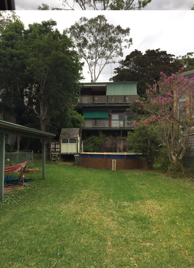
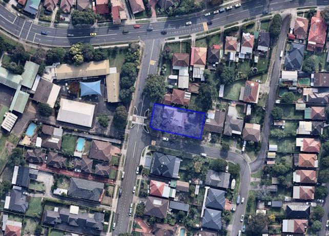
2. The subject site is located on the eastern side of Scott Street at the
corner of Breakwell Street Mortdale. The site comprises one (1) lot known as 76
Scott St and has a frontage of 20.77m frontage to Scott Street (including the
splay at the corner) and 19.505m width along the rear boundary and a site area
of 798sqm. The site has a slope from the front of the site to the rear of the
site of approximately 3.5m.
Existing on the site is a single storey dwelling with
outbuildings. The site also contains several trees primarily along the
boundaries and a street tree at the front of the site on Breakwell Street.
Adjoining the site on the northern boundary on Scott
Street is a two (2) storey dwelling house and adjoining the site on the eastern
boundary on Breakwell Street is a single storey dwelling. On the opposite side
of Scott Street is Penshurst West Public School. The area surrounding the
subject site is characterised by dwelling houses, dual occupancies and multiple
dwelling developments.
HISTORY
3. 19
Apr 16 Development Application lodged.
22
Aug 16 Request for information sent to applicant.
10
Apr 17 Amended plans and information
received. The amended plans and information include changes to the design of
the development to relocate a play area away from the adjoining residential
development, amending the front and side boundary fences to incorporate polycarbonate
sheeting, amending the acoustic report to reflect the amended plans, amending
the traffic report to correct an error relating to the date of the traffic
counts.
COMPLIANCE AND
ASSESSMENT
4. The
development has been inspected and assessed under the relevant Section 79C(1)
"Matters for Consideration" of the Environmental Planning and
Assessment Act 1979.
Environmental
Planning Instruments
HURSTVILLE LOCAL ENVIRONMENTAL
PLAN 2012
5. The
subject site is zoned R2 – Low Density Residential and the proposed
development, being the construction of a Child Care Centre is permissible in
the zone with the consent of Council. The relevant clauses of the Local
Environmental Plan which apply to the proposed development are detailed below.
|
Clause
|
Standard
|
Proposal
|
Complies
|
|
1.2 – Aims of the Plan
|
In accordance with Clause 1.2 (2)
|
Consistent with the aims of the
plan
|
Yes
|
|
1.4 - Definitions
|
“Child Care Centre”
|
The proposed development is defined
as a Child Care Centre
|
Yes
|
|
2.3 - Zone objectives and Land Use
Table
|
Meets objectives of R2 Low Density
Residential Zone
Development must be permissible
with consent
|
Meets objectives and is a
permissible development with consent
|
Yes
|
|
2.7 - Demolition
|
Demolition is permissible with
consent
|
The proposed demolition can be
supported with standard demolition conditions of consent
|
Yes
|
|
4.3 – Height of Buildings
|
9m as identified on Height of
Buildings Map
|
8.5m maximum
|
Yes
|
|
4.4 – Floor Space Ratio
|
0.6:1 as identified on Floor Space
Ratio Map
|
FSR = 0.35:1
(0.41:1 if additional 4 car spaces
proposed is included in the floor area)
|
Yes
|
|
4.5 – Calculation of floor
space ratio and site area
|
FSR and site area calculated in
accordance with Cl.4.5
|
In accordance with Cl. 4.5
|
Yes
|
|
5.9 – Preservation of Trees
or Vegetation
|
Trees to be removed are specified
in DCP1
|
The site contains several trees
that will be removed to accommodate the proposed development. The application
is supported by an arborist’s report which identifies that the trees
are not significant species. Seven (7) trees including one (1) street tree
will be retained. This is discussed further in the report below.
|
Yes
|
|
6.7 – Essential Services
|
The following services that are
essential for the development shall be available or that adequate
arrangements must be made available when required:
* Supply of water,
electricity and disposal and management of sewerage
* Stormwater drainage or
on-site conservation
* Suitable vehicular
access
|
Adequate facilities for the supply
of water and for the removal of sewage and drainage are available to this
land.
The proposed development can drain
to the street. Council’s Development Engineer has raised no objection,
subject to conditions of consent.
One (1) new driveway crossing from
Breakwell Street (standard conditions for the submission of separate
vehicular crossing applications and driveway design).
|
Yes
|
STATE
ENVIRONMENTAL PLANNING INSTRUMENTS
6. Compliance
with the relevant state environmental planning policies is detailed in the
table below.
|
State
Environmental Planning Policy
|
Complies
|
|
Greater
Metropolitan Regional Environmental Plan No 2 – Georges River Catchment
|
Yes
|
|
State
Environmental Planning Policy 55 – Remediation of Land
|
Yes
|
|
State
Environmental Planning Policy (Building Sustainability Index BASIX) 2004
|
N/A
|
Draft
Environmental Planning Instruments
7. No
Draft Environmental Planning instruments affect the proposed development.
Any other
matters prescribed by the Regulations
The Regulations
prescribe the following matters for consideration for development in the
Hurstville Council area:
Demolition
Safety standards
for demolition and compliance with AS 2601 - 2001 apply to the demolition of
any buildings affected by the proposal.
Development
Control Plans
8. The
provisions of development Control Plan No 1 applies to the proposed development
with the relevant sections.
DEVELOPMENT
CONTROL PLAN NO 1 – LGA WIDE – SECTION 3.1 CAR PARKING
9. The
application is accompanied by a report entitled Traffic and Parking Impact
Assessment (prepared by Hemanote Consultants, dated 29 December 2015). The
report identifies that the proposed car parking area complies with the relevant
Australian Standards in terms of car space size and manoeuvring areas for pick
up and drop off movements. The development has also been assessed in terms of
traffic generation and found that it would not result in unacceptable peak hour
traffic generation. The proposed development complies with the car parking
provisions of Section 3.1 as follows.
|
Section
3.1
|
Requirements
|
Proposed
|
Complies
|
|
3.1.2.1 (table) – Child care
centres
|
1 space per 2 staff (8 staff) = 4
car spaces
Short term drop off and pick up
spaces at 1 space per 15 children (separate entry and exit possible as aisle
width allows separate movements)
(40 children) = 3 car spaces
Total required = 7 car spaces
|
Staff = 4 car spaces
Parents = 7 car spaces
Total provided = 11 car spaces
|
Yes
|
The proposed
development provides four (4) additional parent spaces above that required by
Development Control Plan No 1. This will assist in reducing any on street
parking. The Traffic and Parking Impact Assessment was examined the Council
Manager – Infrastructure Planning who has advised that the traffic and
parking related impacts from the proposed development are acceptable and no
objection is raised to the proposed childcare centre.
DEVELOPMENT CONTROL PLAN NO 1 – LGA WIDE - SECTION 3.3 ACCESS
AND MOBILITY
10. The
proposed development complies with the provisions of section 3.3 as follows.
|
Section 3.3
|
Requirements
|
Proposed
|
Complies
|
|
Access
requirements
|
Access for all persons through the
principal entrance and access to appropriate sanitary facilities in
accordance with the BCA and relevant Australian Standards
|
Access provided to all areas of the
child care centre and sanitary facilities provided
|
Yes
|
|
Accessible car
spaces
|
1 space per 20 spaces or part
thereof, where parking areas have more than 20 spaces but less than 50 spaces
(11 spaces provided) = No spaces required as less than 20 provided
|
1 accessible space is provided
|
Yes
|
DEVELOPMENT
CONTROL PLAN NO 1 – LGA WIDE – SECTION 3.4 CRIME PREVENTION THROUGH
ENVIRONMENTAL DESIGN
11.
|
Section
3.4
|
Requirements
|
Proposed
|
Complies
|
|
Fencing
|
Allows natural surveillance to
street
|
Fencing proposed is appropriate and
provides appropriate surveillance to the street whilst reducing acoustic
impact on adjoining developments
|
Yes
|
|
Blind Corners
|
To be avoided
|
No blind corners evident
|
Yes
|
|
Communal Areas
|
Provide opportunities for natural
surveillance
|
Windows of the indoor play areas and
staff areas provide surveillance
|
Yes
|
|
Entrances
|
Clearly visible and not confusing
|
The entry to the child care centre
is clearly defined
|
Yes
|
|
Site and Building Layout
|
- Provide
surveillance opportunities
- Building
addresses street
- Offset
windows
|
Surveillance opportunities
provided.
The building addresses the street
frontage.
Windows facing adjoining properties
are minimised and offset.
|
Yes
|
|
Lighting
|
- Diffused/movement
sensitive lighting provided externally
- Access/egress
points illuminated
- No
light spill towards neighbours
- Hiding
places illuminated
- Lighting
is energy efficient
|
These requirements can be
conditions of consent, should the application be approved
|
Yes
|
|
Landscaping
|
- Avoid
dense medium height shrubs
- Allow
spacing for low growing dense vegetation
- Low
ground cover or high canopy trees around car parks and pathways
|
The landscape plan submitted with
the application has been prepared by a landscape architect and provides
appropriate planting to the site
|
Yes
|
|
Building Identification
|
- Clearly
numbered buildings
- Entrances
numbered
- Unit
numbers provided at entry
|
These requirements can form
conditions of consent, should the application be approved
|
Yes
|
|
Security
|
Provide an appropriate level of
security
|
Sufficient level
of security provided
|
Yes
|
|
Ownership
|
Use of fencing, landscaping, colour
and finishes to imply ownership
|
Fencing, landscaping, entry area
and driveways indicate ownership
|
Yes
|
DEVELOPMENT
CONTROL PLAN NO 1 – LGA WIDE - SECTION 3.5 ENERGY EFFICIENCY
12. The
provisions of Section 3.5 relating to solar access to adjoining developments
apply to the proposed development. The proposed development complies with the
requirements of Development Control Plan No 1 in that adjoining developments
will receive minimum 3 hours solar access between 9am and 3pm on 21 June to the
private open space area.
DEVELOPMENT
CONTROL PLAN NO 1 – LGA WIDE – SECTION 3.7 DRAINAGE AND ON SITE
DETENTION
13. The
proposed development can drain to the street via gravity. Council’s
Development Engineer has raised no objection to the application, subject to
conditions of consent being attached to any consent granted.
DEVELOPMENT CONTROL PLAN NO 1
– LGA WIDE – SECTION 3.8 FENCES ADJACENT TO PUBLIC
ROADS
14. The
proposed development includes a 1.8m high fence on the Scott Street and
Breakwell Street frontages and a 2.1m high acoustic fence on the side and rear
boundaries. The proposed fencing is appropriate and consistent with the
provisions of Development Control Plan No 1. The proposed fencing is discussed
further in the report under ‘Referrals, Submissions and the Public
Interest’.
DEVELOPMENT
CONTROL PLAN NO 1 – LGA WIDE – SECTION 3.9 WASTE MANAGEMENT
15. A
waste management plan has been provided which satisfies the requirements of
Section 3.9. The proposed development can provide appropriate waste facilities
on site.
DEVELOPMENT
CONTROL PLAN NO 1 – LGA WIDE – SECTION 3.11 PRESERVATION OF TREES
AND VEGETATION
16. The
subject site contains several trees. An Arboricultural Assessment Report has
been submitted with the application (prepared by Tree and Landscape
Consultants, dated 5 April 2016). The report identifies that most trees on the
site (except two (2) trees) can be removed as they are small species or are
located within the footprint of the development.
The landscape plan
submitted with the application nominates the retention of seven (7) onsite
trees and one (1) street tree and incorporates them into the landscape plan.
One (1), tree being a palm tree, has been requested to be removed by the
neighbour, and no objection is raised to this. As such six (6) onsite trees and
one (1) street tree will be retained. The landscape plan provides appropriate
planting to the child care centre and perimeter planting on the boundaries
which will screen the development from the adjoining residential developments.
DEVELOPMENT
CONTROL PLAN NO 1 – LGA WIDE - SECTION 5.4 CHILD CARE CENTRES
17. The
proposed child care centre has been assessed against the requirements of
section 5.4 as shown below.
|
Section 5.4
|
Standard
|
Proposed
|
Complies
|
|
5.4.5.1 Locational Criteria
|
Should be located close to
community focal points
|
The site is located in the vicinity
of Penshurst West Public School
|
Yes
|
|
Minimum site area of 500sqm
|
798sqm
|
Yes
|
|
Minimum frontage
of 18m where separate entry and exit one way drive-through access is
proposed.
|
20.77m frontage to
Scott Street (including splay at the corner) and 19.505m width along the rear
boundary
|
Yes
|
|
Sites must not have a property
boundary to a state road
|
The site does not adjoin a state
road
|
Yes
|
|
Site must be at least 300m away
from telecommunications towers, large over-head power wires, any other
inappropriate area
|
The subject site is not within 300m
of telecommunications towers, power lines, or other inappropriate structures
or uses
|
Yes
|
|
Approval will not be given to sites
which are less than 55m from an LPG above ground gas tank or tanker unloading
position
|
The site is not located near an LPG
tank or tanker unloading position
|
Yes
|
|
Analysis of existing and/or
potential site contamination
|
As the previous use of the site was
for residential purposes, no significant contamination is likely to be
present on the site
|
Yes
|
|
Approval will not be given to sites
located within cul-de-sacs or closed roads
|
The site is not located within a
cul-de-sac or closed road
|
Yes
|
|
Child care centres are not to be
located on bushfire or flood prone land, or located adjoining drug clinics or
other inappropriate land uses
|
The site is not on bushfire or
flood prone land
|
Yes
|
|
Proposals must be accompanied by a
Traffic Impact Statement provided by a qualified Consultant
|
A Traffic and Parking Impact
Assessment report has been provided as detailed in the report above
|
Yes
|
|
5.4.6 Cumulative Impacts from
Centres within Residential Areas
|
Only one child care centre is
permitted at an intersection
|
No other child care centre located
at this intersection
|
Yes
|
|
Child care centres will not be
permitted on land adjoining any other existing or approved child care centre
|
The site does not adjoin any other
existing or approved child care centres
|
Yes
|
|
Only one child care centre is
permitted per street block
|
No other child care centre is
located on the same block
|
Yes
|
|
5.4.8 Size of Centres and Child Age
Groups
|
Maximum 40 children within the R2 -
Low Density Residential
|
Maximum 40 proposed
|
Yes
|
|
Minimum number of places within the
0-2 year age group is to be the same as the % of 0-2 year olds in the under 5
years population at most recent census (which is 35% from the 2011
census) = 14 children
|
14 children = 35%
|
Yes
|
|
5.4.9.1 Building Form and
Appearance
|
Height – Single storey in the
R2 Low Density Residential Zone
Note:
Where a child care centre is within a dwelling house the maximum height is 2
storeys (with the child care centre component a maximum of 1 storey
|
The child care centre component of
the development is located within a single storey. Part of the development is
two (2) storeys as the car parking area is located within a lower ground
floor. This is a result of the topography of the site which has a slope to
the rear of the site. A lower ground floor area has been provided to the rear
of the site to allow access from Breakwell Street. The car park is open on
its perimeter and does not result in additional walls or structures beyond
the common boundary fencing.
This design is an appropriate
response to the topography of the site and does not result in unacceptable
bulk and scale.
|
Acceptable
|
|
5.4.9.2 Setbacks
|
Front Setback:
5.5m to primary frontage
|
10.365m (6.265m to covered
transition area)
|
Yes
|
|
Side Setback: 0.9m
|
1.5m – 5.24m
|
Yes
|
|
Rear Setback: 3m
|
6m
|
Yes
|
|
5.4.9.3 Relationships to Adjoining
Properties
|
Impacts of the following to be
considered:
-Play areas – indoor and
outdoor
-Windows and doors (particularly
those associated with indoor play areas)
-Verandahs
-Point of entry
-Pick-up and drop-off points
-Any plant equipment which may be
required within the context of the centre
-Openings such as windows and doors
should not correspond with existing opening on adjoining properties
|
-The play areas will not result in
any unreasonable impacts on adjoining properties subject to the adoption of
the recommendations of the acoustic report. One of the play areas originally
proposed adjoining the north elevation has been relocated to adjoin the
Breakwell Street frontage.
-Windows to the indoor play areas
are located facing away from the adjoining properties and primarily face the
street frontages.
-The location of the verandah,
points of entry and pick up and drop off points would not result in any
significant impacts and have been located away from the adjoining residential
developments where possible.
-Details of mechanical plant
equipment have been provided which have been acoustically treated to reduce
noise impacts on adjoining developments by being located in the lower ground
floor level. The acoustic report contains recommendations to ensure it
complies with relevant acoustic levels which will be required as a condition
of consent.
-New openings do not correspond
with adjoining properties
|
Yes
|
|
5.4.9.4 Solar Design and Energy
Efficiency
|
A minimum of 3 hours sunlight
between 9am and 3pm is to be maintained to adjoining private open space,
habitable rooms and solar collectors
|
Complies
|
Yes
|
|
5.4.9.5 Building Detail
|
The design of the centre must
provide strong visual links between indoor and outdoor spaces
|
Satisfactory
|
Yes
|
|
5.4.9.6 Building Colours
|
No bright colours are permitted. A
schedule of colours and materials is to be submitted.
|
Satisfactory
|
Yes
|
|
5.4.10.1 Parking and Driveway
|
1 space for every 2 staff members =
4 spaces
1 space per 15 children = 3 spaces
Total = 7 spaces
|
Staff = 4 spaces
Parent = 7 spaces
Total = 11 spaces
|
Yes
|
|
Vehicles must be able to enter and
leave the site in a forward direction
|
Vehicles can enter and exit in a
forward direction
|
Yes
|
|
Bike racks must be provided on
site.
1 required
|
Bike area provided
|
Yes
|
|
Driveway crossing on corner
allotments must not be located closer than 9m to the property alignment at
the intersection
|
Driveway is more than 9m from
intersection
|
Yes
|
|
Landscaping and paving design
associated with driveways must achieve the following:
-Pedestrian safety and visibility
-Level, hard surface from vehicles
to entry point
-Satisfactory manoeuvrability for
disabled persons and/or prams
-Clear delineation between driveway
and yard areas
|
Satisfactory
|
Yes
|
|
A “Neighbourhood Parking
Policy” and a “Motor Vehicle and Pedestrian Risk Assessment
Report” must be submitted for Council’s consideration
|
The submitted Traffic and Parking
Impact Assessment report considers pedestrian safety and on street parking.
The report was reviewed by Council’s Manager - Infrastructure Planning
and found to be acceptable.
|
Yes
|
|
Physical demarcation is required to
be provided between pedestrians and vehicular access ways to ensure
pedestrian safety
|
Provided
|
Yes
|
|
5.4.10.2 Traffic Considerations
|
Council to consider traffic and
safety impacts
|
The submitted Traffic and Parking
Impact Assessment report considers pedestrian safety and on street parking.
The report was reviewed by Council’s Manager - Infrastructure Planning
and found to be acceptable.
|
Yes
|
|
Consideration of traffic impacts
between 7.30am-9am and 3.30pm-6pm.
|
The submitted traffic report
includes traffic counts conducted for peak periods and concludes that no
significant traffic impact would arise. Council’s Manager -
Infrastructure Planning has found this to be acceptable.
|
Yes
|
|
5.4.10.3 Access for Persons with
Limited Mobility
|
-Disabled access is to be provided
from the street to the main entrance
-Disabled access ramp is to be
provided to the playground areas
|
-Ramp provided to the entrance and
lift provided from the car parking area
-Level access is provided to the
playground areas
|
Yes
|
|
5.4.11.1 Tree Preservation and
Planting
|
A 1m wide landscaped area is
required to be provided along the front setback
|
Minimum 1m landscaped area (screen
planting) is provided along the Scott Street and most of the Breakwell Street
frontage
|
Yes
|
|
Screen planting is to be provided
along the side boundaries
|
Screen planting is proposed along
the side and rear boundaries of the site
|
Yes
|
|
5.4.11.3 Drainage
|
Play areas must be capable of rapid
clearance of surface water
|
Acceptable
|
Yes
|
|
5.4.12.1 Indoor Spaces
|
Area for administration, private
consultation and staff respite
|
An office and staff room is
provided
|
Yes
|
|
3.5sqm unencumbered space per child
(40 children proposed) = 140sqm required
3.25sqm required under NSW
licensing requirements = 130sqm
|
Room 1 = 46sqm
Room 2 = 20sqm
Room 3 = 65sqm
Total = 131sqm provided which
complies with the NSW licensing requirements
|
Yes
|
|
5.4.12.2 Outdoor Spaces
|
7sqm per child (40 children
proposed) = 280sqm required
|
280sqm provided (including the
verandah as it is more than 2m wide)
|
Yes
|
|
Must receive 2 hours sunlight
during operating hours
|
Minimum 2 hours sunlight achieved
|
Yes
|
|
Play area must not include areas
with a width of less than 2.5m
|
All areas more than 2.5m in width
|
Yes
|
|
Min 15m long lawn space
|
Satisfactory
|
Yes
|
|
Should generally include the
following:
-Open area of 1/3 – 1/2 of
the playground area
-Quiet area of 1/4 – 1/3 of
the playground area
-Active area of 1/3 of the
playground area
|
Complies
|
Yes
|
|
2.5sqm per child to be covered (40
children proposed) = 100sqm
|
Shade structures provide
appropriate shading
|
Yes
|
|
Sandpits to be designed to meet
controls
|
Sandpit complies with controls
subject to a condition requiring compliance with regulations
|
Yes
|
|
5.4.12.3 Verandahs
|
Verandahs are to be equal to
1.25sqm per child and covered = 50sqm
|
>50sqm and covered
|
Yes
|
|
Should have a width of 2.5m but 2m
will be considered as a minimum
|
>2.5m
|
Yes
|
|
5.4.12.4 Signage
|
Signage to complement the
streetscape and not be intrusive
|
Signage not proposed as part of
application
|
N/A
|
|
5.4.12.5 Entry and Security
Requirements
|
Legible entry points to be located
within the view of the main office
|
Complies
|
Yes
|
|
Playground to be fenced
|
2.1m high fencing proposed as
recommended in the acoustic report
|
Yes
|
|
Gates or opening devices to be
fitted with a childproof latch or self-locking device
|
Satisfactory
|
Yes
|
|
5.4.13.1 through to 5.4.13.12
relate to facilities within the centre
|
This facilities are subject to the
relevant legislation and licensing requirements for child care centres
|
Council’s Manager
Children’s Services has examined the application and has advised that
the child care centre provides appropriate facilities and is consistent with
child care regulations
|
Yes
|
|
5.4.13.13 Hours of Operation
|
Max. 7am – 6.30pm
|
7.30am to 6.00pm Monday to Friday
|
Yes
|
|
5.4.14.1 Visual Privacy
|
Minimise overlooking through
screening etc
|
2.1m high fencing is proposed to be
constructed along the side and rear boundaries which adjoin residential
developments in accordance with the recommendations of the acoustic report
submitted with the application.
The ground floor level of the
development is higher than the floor level of adjoining developments due to
the topography of the site.
The rear elevation of the
development contains a high sill window only and the northern (side)
elevation has been amended to relocate noise generating activities away from
the boundary. The windows on this elevation are located minimum 4.04m from
the side boundary and the covered transition area is provided with a privacy
screen to minimise overlooking of the adjoining development.
The pedestrian and vehicle entry to
the development is off Breakwell Street. The car parking area has a finished
floor level that is the same or lower than the adjoining developments and has
perimeter screen planting along the boundaries which reduces privacy impacts.
|
Yes
|
|
Play equipment to be setback 3m
from boundaries adjoining residential
|
Play equipment not specifically
shown on plans but can be located 3m from adjoining residential boundaries.
This is also subject to condition of consent.
|
Yes,
subject to condition of consent
|
|
5.4.14.2 Acoustic Amenity
|
Acoustic Report by a suitably
qualified consultant to be provided
|
An Acoustic Assessment has been
prepared by Koikas Acoustics (ref 2797R20170330mfcv4, dated 30 March 2017).
The report was revised to include details of the amended development. The
revised report was examined by Council’s Environmental Health Officer
who has raised no objection and provided conditions of consent to any consent
granted.
|
Yes
|
|
5.4.14.3 Fencing
|
At least 1.2m high
Where it is essential that side
street boundaries be fully fences, they are to be designed to allow
landscaping along the boundary.
|
1.8m high fence proposed along the
Scott Street frontage which comprises metal slats and polycarbonate sheets.
The fence to Breakwell Street will be 1.8m high security gate and fence. The
remainder of the site is to be fenced with 2.1m high acoustic fence.
Landscaping is provided along the
boundaries which includes screen planting.
|
Yes
|
|
Stormwater Assessment
|
|
|
Existing Stormwater System
|
Gravity
to street
|
|
Proposed Stormwater System
|
Gravity
to street
|
|
Stormwater objectives for
development type met?
|
Yes
|
|
Slope to rear (measured centreline
of site)
|
Yes
|
|
Gravity to street (from property
boundary to street kerb)?
|
Yes,
along the Breakwell Street frontage
|
|
Discharge into same catchment?
|
Yes
|
|
Easement required?
|
No
|
|
OSD required?
|
Yes
|
Impacts
Natural
Environment
18. The
proposal requires no significant excavation and can drain by gravity to the
street. There are several trees located on the site which are proposed to be
removed to accommodate the development. The removal of these trees is supported
by an arborist’s report. Several other trees which are primarily located
within the front setback area will be retained and proposed landscaping to the
site and perimeter planting will enhance the current site conditions. As such
the proposed development is unlikely to have an adverse impact on the natural
environment.
Built
Environment
19. The
proposed development is unlikely to have an adverse impact on the built
environment. The proposed development complies with the relevant requirements.
The proposed development does not result in any adverse impacts to adjoining
developments in terms of privacy and solar access. Conditions of consent will
require that the development adopt the recommendations of the acoustic report
submitted with the application to ensure noise levels do not result in
unreasonable impacts on adjoining developments. The development has also been
assessed in terms of parking and traffic generation and found to be acceptable.
Social
Impact
20. It
is considered that the proposed child care centre will provide a service that
is in demand in the Georges River LGA and benefit the community. The applicant
has submitted traffic and acoustic reports which support the proposal subject
to specific recommendations being adopted in the development. The issues raised
by residents in the submissions received to the application are detailed in the
report and have been addressed through amended plans.
Economic
Impact
21. The
proposal will provide employment opportunities within the area which will in
turn encourage economic growth. The proposed child care centre will provide an
in-demand facility to the area and as such the proposal is unlikely to have a
detrimental impact on the local economy.
Suitability
of the Site
22. The
subject site has no impediments that preclude it being developed for a child
care centre. Subject to conditions of consent, the site is considered suitable
for the proposed development.
REFERRALS,
SUBMISSIONS AND THE PUBLIC INTEREST
Resident
23. The
application was notified to nineteen (19) residents/owners in accordance with
the requirements of Hurstville Development Control Plan No 1 and eight (8)
submissions including a petition with fourteen (14) signatures were received in
reply. The issues raised in the submissions are summarised as follows.
Asbestos
24. Safety standards for asbestos removal should be implemented on the site
during demolition.
Comment: Asbestos removal is regulated by the NSW Government and
requires asbestos to be removed by licensed contractors only. This is required
as a condition of consent on all consents granted which include demolition.
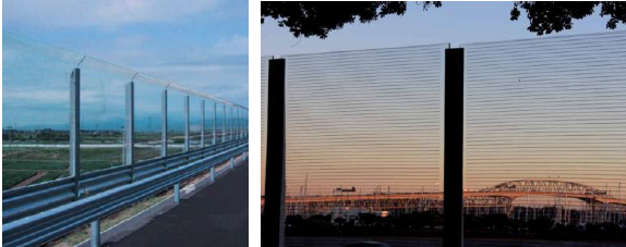
Fencing
25. The proposed 2.1m high
acoustic fence on the northern boundary adjoining 78 Scott Street will impede
sight lines to and from the driveway of this property. This has to be
addressed. The proposed fencing to the front boundary of the site reduces the
“kerb appeal” of the site and adjoining developments and impacts
the streetscape. The fence should be located 3m from the front boundary with
landscaping provided at the front of the fence.
Comment:
The applicant has sought advice from an acoustic consultant and has amended the
fence to provide polycarbonate sheeting to a length of approximately 6.2m of
the side boundary fence adjoining the driveway of 78 Scott Street. This will
allow appropriate sight lines to the road.
The applicant has
also amended the fence on the front boundary of Scott Street so that it is a
combination of metal slats and polycarbonate sheeting or clear acoustic fence.
Located immediately behind the perimeter of the fence will be landscaping. The
changes to the fence and the provision of landscaping behind the fence will
improve the view of the site from the street.
Privacy and
noise impacts
26. The proposed child care
centre is likely to result in privacy impacts and noise impacts to adjoining
developments. This should be addressed through the provision of appropriate
fencing, privacy screens to verandahs, and through the relocation of the staff
room, nappy change, cot room to where the covered transition area (adjoining
play area 2) is located and vice-versa. As a result of this, the transition
area will be located away from the adjoining boundary and dwelling located at
78 Scott Street.
Comment:
The applicant has amended the development and has relocated play area 1 and
covered outdoor balcony 1 so that it now adjoins the Breakwell Street frontage.
This results in the side elevation of the child care centre that adjoins 78
Scott Street having only one (1) access point (covered transition area 2) which
leads to the outdoor play area. A privacy screen has been provided immediately
adjoining the transition area to reduce any overlooking of the adjoining
development.
Council’s
Environmental Health Officer has undertaken an assessment of the application
including the acoustic report submitted with the application. The acoustic
report was amended to reflect the changes made to the design of the
development. Following the submission of this information, Council’s
Environmental Health Officer raised no objection subject to conditions of
consent being attached to any consent granted.
View and
outlook
27. There will be a loss of view
and outlook from adjoining developments due to the removal of vegetation from
the site and the provision of fencing around the site. The visual bulk of the
fencing can be addressed by allowing adjoining owners to have input into the
colour of the boundary fence and through the provision of landscaping to the
perimeter of adjoining properties.
Comment:
Six (6) onsite trees and one (1) street tree will be retained and incorporated
into the landscaping of the site. The trees to be retained are primarily
located along the front boundaries of the site which will retain the existing
view of the site from the street. Landscaping of the site will also include
screen planting to its perimeter which will soften the boundaries of the site
and reduce overlooking of adjoining developments.
As discussed in
the report above, the fencing to the site has been amended to incorporate
acoustic polycarbonate sheeting to the front boundary and open metal fencing to
the car park area. This provides an appropriate interface with the street and
is an improvement to the original fencing which comprised all solid material.
The applicant has also advised that there is no objection in negotiating the
colour of the fence with the adjoining owners.
Examples have been
provided in the acoustic report submitted with the application of the acoustic
fence proposed on the front boundary and on the side boundary where sight lines
are required to be maintained. The fence is clear but is acoustically treated.
Too many
child care centres
28. There are too many child
care centres located in the vicinity of the subject site.
Comment:
Child care centres are permissible in the R2 Low Density Residential Zone. The
proposed child care centre meets the criteria identified in Development Control
Plan No 1 regarding its proximity to other child care centres.
Parking
29. The proposed development
will result in increased traffic pressure and lack of parking for residents.
There are already issues with traffic and parking related to Penshurst West
Public School. Traffic measures should be implemented in Breakwell Street to
reduce access to Scott Street.
Comment: Council’s
Manager Infrastructure Planning has assessed the application, including the
submitted Traffic and Parking Impact Assessment, and has advised that the
proposed development will not result in unacceptable traffic impacts and
provides onsite parking in excess of the requirements of Development Control
Plan No 1 by providing seven (7) parent spaces rather than the three (3)
required. This will assist in reducing potential on street parking.
It is noted that the Traffic and Parking Impact Assessment has been
amended from that originally submitted as there was an error in the date of the
traffic counts undertaken. This has been corrected in the amended report.
Council
Referrals
Manager
Infrastructure Planning
30. Council’s
Manager Infrastructure Planning has assessed the proposed development including
the Traffic and Parking Impact Assessment submitted with the application and
raised no objection to the application.
Manager
Children’s Services
31. The
application was referred to Council’s Manager Children’s Services
who has advised that the child care centre has been appropriately designed and
is consistent with the relevant requirements and legislation.
Environmental
Health Officer
32. Council’s
Environmental Health Officer has raised no objection to the development subject
to conditions of consent. This assessment included consideration of the
acoustic report and conditions of consent requiring adoption of its
recommendations.
Development
Engineer
33. Council’s
Development Engineer has assessed the proposed development and raised no
objections subject to conditions of consent.
External
referrals
34. No
external referrals were required for this application.
CONCLUSION
35. The
application seeks approval for the demolition of existing structures and
construction of a child care centre for forty (40) children. The application
has been assessed against the relevant requirements and complies.
The application
was notified in accordance with the requirements of Hurstville Development Control
Plan No 1 and eight (8) submissions including a petition with fourteen (14)
signatures were received in reply. The issues raised in the submissions have
been addressed in the report and through amended plans submitted by the
applicant. Accordingly, it is recommended that development consent be
granted subject to conditions of consent.
DETERMINATION
36. THAT
pursuant to Section 80(2) of the Environmental Planning and Assessment Act,
1979, as amended, the Council, grants development consent to Development
Application DA2016/0090 for demolition of existing structures and construction
of a child care centre for forty (40) children on Lot 2 DP 229867 and known as
76 Scott Street Mortdale subject to the following conditions:
Schedule
A – Site Specific Conditions
GENERAL
CONDITIONS
These conditions
have been imposed to ensure that the development is carried out in accordance
with the approved plans and to ensure that the appropriate fees and bonds are
paid in relation to the development.
1. GEN1001
- Approved Plans - The development must be implemented in accordance
with the approved plans and supporting documentation listed below which have
been endorsed by Council’s approved stamp, except where marked up on the
plans and/or amended by conditions of this consent:
|
Reference
No.
|
Date
|
Description
|
Revision
|
Prepared by
|
|
Project No
1461A
DA-01
|
16 Dec 16
|
Cover sheet
|
B2
|
Archizen
Architects
|
|
DA-02
|
16 Dec 16
|
Site and
analysis plan
|
B2
|
Archizen
Architects
|
|
DA-03
|
16 Dec 16
|
Lower ground
floor
|
B2
|
Archizen
Architects
|
|
DA-04
|
16 Dec 16
|
Upper ground
floor plan
|
B2
|
Archizen
Architects
|
|
DA-05
|
16 Dec 16
|
West elevation
|
B2
|
Archizen
Architects
|
|
DA-06
|
16 Dec 16
|
East elevation
|
B2
|
Archizen
Architects
|
|
DA-07
|
16 Dec 16
|
North elevation
|
B2
|
Archizen
Architects
|
|
DA-08
|
16 Dec 16
|
South elevation
|
B2
|
Archizen
Architects
|
|
DA-09
|
16 Dec 16
|
Section A
|
B2
|
Archizen
Architects
|
|
DA-10
|
16 Dec 16
|
Section B
|
B2
|
Archizen
Architects
|
|
DA-11
|
16 Dec 16
|
Construction
and erosion control management
|
B2
|
Archizen
Architects
|
|
-
|
28 Jan 16
|
Recycling and
waste management plan
|
A
|
Archizen
Architects
|
|
Page1/2 and 2/2
|
28 Jan 16
|
External
finishes schedule
|
A
|
Archizen
Architects
|
|
Drawing 1/4,
2/4, 3/4 and 4/4 (as amended by the revised upper ground floor plan)
|
27 Nov 15
|
Tree plan,
Playspace/landscape plan-plants, Playspace/landscape plan-surfacing,
Details
|
-
|
Tessa Rose
Playspace and Landscape Design
|
|
File Ref:
2797R20170330mfc76ScottStMortdalev4
|
30 Mar 17
|
Acoustic
assessment
|
4
|
Koikas Acoustics Pty Ltd
|
|
3801 (as
amended by the condition of consent relating to tree retention)
|
5 Apr 16
|
Arboricultural
Assessment Report
|
-
|
Tree and Landscape Consultants
|
2. GEN1002
- Fees to be paid to Council - The fees
listed in the table below must be paid in accordance with the conditions of
this consent and Council’s adopted Fees and Charges applicable at
the time of payment.
Payments must be made prior to the
issue of the Construction Certificate or prior to the commencement of work (if
there is no associated Construction Certificate).
Please contact Council prior to the
payment of Section 94 Contributions to determine whether the amounts have
been indexed from that indicated below in this consent and the form of payment
that will be accepted by Council.
Form of payment for transactions
$500,000 or over - Council will only accept Bank Cheque or Electronic Funds
Transfer (EFT) for transaction values of $500,000 or over. Council must be
contacted prior to payment to determine correct total amount to be paid and bank
account details (if applicable)
(a) Fees
to be paid:
Fee types, bonds and contributions
|
Fee Type
|
|
Long Service
Levy (to Long Service Corporation)
|
|
Builders Damage
Deposit
|
|
Inspection Fee
for Refund of Damage Deposit
|
|
Section 94(A)
|
The following fees apply where you appoint Council as your Principal
Certifying Authority (PCA). (If you appoint a private PCA, separate fees will
apply)
|
PCA Services
Fee
|
$2,135.00
|
|
Construction
Certificate Application Fee
|
$2,135.00
|
|
Construction
Certificate Imaging Fee
|
$177.00
|
Fees and charges above are subject to
change and are as set out in the version of Council's Schedule of Fees and
Charges or as required by other Government Authorities, applicable at the time
of payment.
3. GEN1014
- Long Service Levy - Submit evidence of payment of the Building and
Construction Industry Long Service Leave Levy to the Principal Certifying
Authority. Note this amount is based on the cost quoted in the Development
Application, and same may increase with any variation to estimated cost which
arises with the Construction Certificate application. To find out the amount
payable go to www.lspc.nsw.gov.au or
call 131441. Evidence of the payment of this levy must be submitted with the
Construction Certificate application.
4. GEN1015
- Damage Deposit - Minor Works - In order to insure against damage to
Council property the following is required:
(a) Payment to Council of a damage deposit for the cost of
making good any damage caused to any Council property as a result of the development:
$1,900.00.
(b) Payment to Council of a non-refundable inspection fee
to enable assessment of any damage and repairs where required: $145.00.
(c) At the completion of work Council will inspect
the public works, and the damage deposit will be refunded in full upon
completion of work where no damage occurs. Otherwise the amount will be either
forfeited or partly refunded according to the amount of damage.
(d) Prior to the commencement of work a photographic
record of the condition of the Council nature strip, footpath and driveway
crossing, or any area likely to be affected by the proposal, shall be submitted
to Council
(e) Payments pursuant to this condition are required to be
made to Council before the issue of the Construction Certificate.
(f) Fees
and charges above are subject to change and are as set out in the version of
Council's Schedule of Fees and Charges or as required by other Government
Authorities, applicable at the time of payment.
5. GEN1023
- Section 94A Contributions - As at the date of Development Consent a
contribution of $9,500.00 has been levied on the subject development
pursuant to Section 94A Contributions Plan. The amount to be paid is to be
adjusted at the time of the actual payment, in accordance with the provisions
of the Section 94A Development Contributions Plan.
The
contribution must be paid prior to the release of a Construction Certificate as
specified in the development consent
Please contact Council prior to payment to determine
whether the contribution amounts have been indexed from that indicated above in
this consent and the form of payment that will be accepted by Council.
Form of payment for transactions $500,000 or over -
Council will only accept Bank Cheque or Electronic Funds Transfer (EFT) for
transaction values of $500,000 or over. Council must be contacted prior to
payment to determine correct total amount to be paid and bank account details
(if applicable).
Contributions must
be receipted by Council before a Construction Certificate is issued.
The Section 94A
Contributions Plan may be inspected at Council’s Customer Service Centres
or online at www.georgesriver.nsw.gov.au.
SEPARATE
APPROVALS UNDER OTHER LEGISLATION
These conditions
have been imposed to ensure that the applicant is aware of any separate
approvals required under other legislation, for example: approvals required
under the Local Government Act 1993 or the Roads Act 1993.
6. APR6001
- Engineering - Section 138 Roads Act and Section 68 Local Government Act
1993
Unless otherwise specified by a condition of this consent, this
Development Consent does not give any approval to undertake works on
public infrastructure.
A separate approval is required to be lodged and approved
under Section 138 of the Roads Act 1993 and/or Section 68 of
the Local Government Act 1993 for any of the following
activities carried out in, on or over a public road (including the footpath):
(a) Placing or storing materials or equipment;
(b) Placing or storing waste containers or skip bins;
(c) Erecting a structure or carrying out work
(d) Swinging or hoisting goods over any part of a public
road by means of a lift, crane or the like;
(e) Pumping concrete from a public road;
(f) Pumping water from the site into the public road;
(g) Constructing a vehicular crossing or footpath;
(h) Establishing a “works zone”;
(i) Digging up or disturbing the surface of a
public road (e.g. Opening the road for the purpose of connections to utility
providers);
(j) Stormwater and ancillary works in the road reserve; and
(k) Stormwater and ancillary to public infrastructure on private
land
(l) If any excavation is to be supported by the use
of below ground (cable) anchors that are constructed under Council’s
roadways/footways.
These separate activity approvals must be obtained and evidence of the
approval provided to the Certifying Authority prior to the issue of the Construction
Certificate.
The relevant Application Forms for these activities can be downloaded
from Georges River Council’s website at: www.georgesriver.nsw.gov.au
For further information, please contact Council’s Customer Service
Centre on (02) 9330 6400.
7. APR6005
- Engineering - Council’s stormwater drainage system shall be
extended along Breakwell Street, with a 375mm (min.) diameter pipeline, to the
proposed stormwater kerb inlet pit to be located directly in front of the
subject development site - all drainage works are at full cost to the
developer.
A separate application under Section 138 of the Roads Act is
required to be approved by Council for such works prior to the issue of the Construction
Certificate.
REQUIREMENTS OF
OTHER GOVERNMENT AGENCIES
These conditions
have been imposed by other NSW Government agencies either through their role as
referral bodies, concurrence authorities or by issuing General Terms of
Approval under the Integrated provisions of the Environmental Planning and
Assessment Act 1979.
8. GOV1008
- Sydney Water - Section 73 Certificate - A Section 73 Compliance
Certificate under the Sydney Water Act 1994 must be obtained from Sydney Water
Corporation. Application must be made through an authorised Water Servicing
Coordinator. Please refer to the Plumbing, Building and Developing section of
Sydney Water’s website to locate a Water Servicing Coordinator in your
area. Visit: www.sydneywater.com.au
A "Notice of Requirements" will advise of water and sewer
infrastructure to be built and charges to be paid. Please make early contact
with the Coordinator, as it can take some time to build water/sewer pipes and
this may impact on other services and building, driveway or landscape design.
The “Notice of Requirements” must be submitted prior to the
commencement of work.
9. GOV1009
- Sydney Water - Section 73 Compliance Certificate - A Section 73
Compliance Certificate under the Sydney Water Act must be submitted to the
Principal Certifying Authority prior to the issue of the
Occupation/Subdivision or Strata Certificate.
10. GOV1006 - Sydney
Water - Trade Waste Agreements - A Trade Waste Agreement with Sydney Water
may be required. Details of any work required to comply with the agreement must
be detailed on the plans lodged with the Construction Certificate. If no trade
waste agreement or grease trap is required, a letter from Sydney Water to this
effect must be submitted with the application for the Construction
Certificate.
PRIOR TO THE
ISSUE OF THE CONSTRUCTION CERTIFICATE
These conditions
either require modification to the development proposal or further
investigation/information prior to the issue of the Construction Certificate to
ensure that there is no adverse impact.
11. CC4019 - Health
- Food Premises - Plans and Specifications - Details of the construction
and fit out of food premises must be submitted to Council’s Environmental
Health Officer. The plans and specifications must demonstrate compliance
with the:
· Food
Act 2003 (as amended);
· Food
Regulation 2010 (as amended);
· Food
Standards Code as published by Food Standards Australia;
· New
Zealand and Australian Standard AS4674:2004 Design, Construction and fit out
of food premises (as amended);
· Sydney
Water - Trade Waste Section.
Council’s Environmental Health Officers’ must advise in
writing that the plans and specification are considered satisfactory prior to
the issue of any Construction Certificate.
12. CC4022 - Health
- Food Premises - Waste Facility - Details of the construction and fit out
of the waste facility of the food premises must be submitted to Council’s
Environmental Health Officers for approval. Such details must demonstrate
compliance with the Food Act 2003 (as amended), Food
Regulation 2010 (as amended), the Food Standards Code as
published by Food Standards Australia and New Zealand and Australian Standard
AS 4674:2004 Design, construction and fit out of food premises (as amended.)
and must be:
(a) provided with a hose tap connected to the water
supply;
(b) paved with impervious floor materials;
(c) coved at the intersection of the floor and the
walls;
(d) graded and drained to a waste disposal system in
accordance with the requirements of the relevant regulatory authority (Sydney
Water);
(e) adequately ventilated (mechanically or naturally) so
that odour emissions do not cause offensive odour as defined by the Protection
of the Environment Operations Act 1997;
(f) fitted with appropriate interventions to
meet fire safety standards in accordance with the Building Code of Australia.
Council’s Environmental Health Officers’ must advise in
writing that the plans and specification are considered satisfactory prior to
the issue of any Construction Certificate.
13. CC4024 - Health
- Colour of finishes - All walls, floor and ceiling in all food
preparation, food storage and waste storage areas shall be finished with a
light colour. No black or dark colour surface finish is permitted in
these areas.
Details of colour of finishes in the mentioned area must be submitted
with the plans for satisfactory approval prior to the issue of any Construction
Certificate.
14. CC4025 - Health
- Acoustic Certification
- All recommendations outlined in the Acoustic Report Reference
2797R20170330mfc76ScottStMortdalev4 dated 30 March 2017, prepared by Koikas
Acoustics Pty Ltd are to be complied with. Details are to be submitted with the
Construction Certificate to the Principle Certifying Authority.
15. CC7001 - Council
as PCA - Plans required to demonstrate compliance with BCA - Should the
Council be appointed as the Principal Certifying Authority, the Construction
Certificate application must be accompanied by the following details, with
plans prepared and certified by an appropriately qualified person demonstrating compliance with the BCA:
(a) Access and Egress provisions in accordance with
Part D.
(b) Internal linings, materials and assemblies in
accordance with C1.10
(c) Fire resisting construction in accordance
with Specification C1.1
(d) The protection of openings in accordance with
Part C3
(e) Provisions for escape and construction of exits
in accordance with Part D
(f) Access and sanitary facilities for
persons with disabilities in accordance with Part D3
(g) Energy efficiency report
(h) Mechanical ventilation and exhaust systems
for the basement motor vehicle parking and kitchen areas in accordance with
AS1668.1
(i) Fire services and equipment
including hydrant, emergency lights, exit signs and portable fire
extinguishers, etc. in accordance with Part E
(j) Smoke hazard management system and
associated alarm system in accordance with Specification E2.2
(k) Provision of natural light and ventilation
in accordance with Part F
16. CC7002 - Building
- Fire Safety Measures prior to Construction Certificate - Prior to the
issue of a Construction Certificate a list of the essential fire safety
measures that are to be provided in relation to the land and any building on
the land as a consequence of the building work must accompany an application
for a construction certificate, which is required to be submitted to either
Council or a Certifying Authority. Such list must also specify the minimum
standard of performance for each essential fire safety measure included in the
list. The Council or Certifying Authority will then issue a Fire Safety
Schedule for the building.
17. CC7004 - Building
- Structural details - Structural plans, specifications and design
statement prepared and endorsed by a suitably qualified practising structural
engineer who holds the applicable Certificate of Accreditation as required
under the Building Professionals Act 2005 shall be submitted along with the
Construction Certificate application to the Certifying Authority for any of the
following, as required by the building design:
(a) piers
(b) footings
(c) slabs
(d) columns
(e) structural steel
(f) reinforced building elements
(g) swimming pool design
(h) retaining walls
(i) stabilising works
(j) structural framework
18. CC7008 - Building
- Access for Persons with a Disability - Access and/or sanitary facilities
for persons with disabilities must be provided to the premises/building in
accordance with the requirements of the Premises Standards, the Building Code
of Australia, and AS 1428.1. Details must be submitted with the Construction
Certificate application.
19. CC7011
- Building - Slip Resistance - Commercial, Retail and Residential
Developments - All pedestrian surfaces in areas such as foyers, public
corridors/hallways, stairs and ramps as well as floor surfaces in the wet rooms
in any commercial/retail/residential units must have slip resistance
classifications, as determined using test methods in either wet or dry
conditions, appropriate to their gradient and exposure to wetting. The
classifications of the new pedestrian surface materials, in wet or dry
conditions, must comply with AS/NZS4586:2004 - Slip Resistance Classifications
of New Pedestrian Materials and must be detailed on the plans lodged with the
application for the Construction Certificate.
20. CC8007 - Waste
- Waste Storage Containers - Child Care Centre - All waste and recycling
containers shall be stored in an approved waste storage area, located in an
area of the site that is satisfactory for these purposes. Facilities are to be
provided in accordance with any requirements of NSW Family and Community
Services.
Details of the Waste Storage Area must be illustrated on the plans
submitted with the application for the Construction Certificate.
21. CC2001 - Development
Assessment - Erosion and Sedimentation Control - Erosion and sediment
controls must be provided to ensure:
(a) Compliance with the approved Erosion and Sediment Control Plan
(b) Removal or disturbance of vegetation and top soil is
confined to within 3m of the approved building area (no trees to be removed
without approval)
(c) all clean water run-off is diverted around
cleared or exposed areas
(d) silt fences, stabilised entry/exit points or other
devices are installed to prevent sediment from entering drainage systems or
waterways
(e) all erosion and sediment controls are fully maintained
for the duration of demolition, excavation and/or development works
(f) controls are put into place to prevent
tracking of sediment by vehicles onto adjoining roadway
(g) all disturbed areas are rendered erosion-resistant by
turfing, mulching, paving or similar
(h) Compliance with Managing Urban Stormwater -
Soils and Construction (Blue Book) produced by Landcom 2004.
These measures are to be implemented before the commencement of work
(including demolition and excavation) and must remain until the issue of the
Occupation Certificate.
22. CC2002 - Development
Assessment - Site Management Plan - Minor Development - A Site Works
Plan detailing all weather access control points, sedimentation controls,
fencing, builder’s site sheds office, amenities, materials storage and
unloading arrangements must be submitted with the application for the
Construction Certificate.
23. CC2003 - Development
Assessment - Construction Site Management Plan - Major Development -
A Site Management Plan must be submitted with the application for the
Construction Certificate, and must include the following measures:
· location
of protective site fencing;
· location
of site storage areas/sheds/equipment;
· location
of building materials for construction, e.g. stockpiles
· provisions
for public safety;
· dust
control measures;
· method
used to provide site access location and materials used;
· details
of methods of disposal of demolition materials;
· method
used to provide protective measures for tree preservation;
· provisions
for temporary sanitary facilities;
· location
and size of waste containers/skip bins;
· details
of proposed sediment and erosion control measures;
· method
used to provide construction noise and vibration management;
· construction
traffic management details.
The site management measures are to be implemented prior to the
commencement of any works including demolition and excavation. The site
management measures are to be maintained throughout the works, to maintain
reasonable levels of public health, safety and amenity. A copy of the
Site Management Plan must be retained on site and is to be made available upon
request.
24. CC2004 - Development
Assessment - Design Change - The following design changes are required and
are to be incorporated into the plans to be lodged with the Construction
Certificate application.
(a) The submitted concept hydraulic plan shall be amended
to show the proposed extension of Council’s drainage system in Breakwell
Street to the proposed kerb inlet pit directly in front of the subject
development site. These design changes are to be incorporated into the Detailed
Hydraulic Plans submitted for approval with the Construction Certificate
Application.
(b) The recommendations of the Acoustic Assessment
prepared by Koikas Acoustics Pty Ltd (reference number File Ref:
2797R20170330mfc76ScottStMortdalev4, dated 17 November 2016, revision 3 and
amended details provided in the report entitled Acoustic Responses reference
TJ425-01F03 dated 30 March 2017) are to be adopted in the development. If this
results in design changes to the development they are to be shown in the plans
with the construction certificate. Where the recommendations relate to common
boundary fencing the colour of the fence is to be determined in consultation
with the owners of the relevant adjoining sites. In particular the
recommendations detailed in the report are:
10.1
Selection of Building Materials
10.
1. 1 Ceiling/Roof System
The following
materials will be satisfactory for the pitched tile roof of the proposed CCC:
· pitched
tile roof over;
· a
layer of 100 mm thick 14 kg/m3 insulation batts fitted tightly between the
ceiling joists, and
· one
layers of 13 mm thick plasterboard screw fixed beneath the ceiling joists.
10.1.2
External Walls
The proposed
110 mm brick wall system with 90 mm timber stud, and 13 mm plasterboard will be
satisfactory for the external walls of the CCC building.
10.1.3
Windows/Sliding Doors
Standard 4 mm
glazing will be satisfactory for all windows/sliding doors of the proposed CCC.
The following is to be noted:
· All
open-able windows and glazed door systems should be air tight when closed and
should be built into a solid frame.
· Q-Ion
type seals should be fitted along the perimeter of all glazing
systems to minimise air gaps. This is not required if the windows seals
properly. If the windows/doors are not designed to be air-tight when closed,
the total noise attenuation performance of the walls and ceiling-roof system
will be reduced.
· Acoustic
windows/doors do not normally get tested with "weep holes".
"Weep holes" will reduce the acoustic attenuation of single glazed
systems and to a lesser extent double glazed systems. However, for double
glazed windows, weep holes will not significantly reduce the acoustic
performance.
It is noted
that the building materials shown above are the minimum requirement for
achieving the nominated acoustic performance. These materials may be inadequate
for safety, fire, thermal or any other specific requirements. Specifications
for these requirements are to be provided by other specialist consultants.
10.2
Noise Barrier
To achieve
compliance with the nominated noise criteria at the adjoining residential
premises (noise model Scenario 2 & 3) noise barriers are required. The
noise barriers are required to be a minimum of 1.8 - 2.1 metres in height. The
following construction materials will be adequate for the proposed noise
barrier:
· Double
lapped 15mm thick timber fence palings offset so that there are no air gaps.
This equates to a total barrier thickness of 30 mm; OR
· 15mm
compressed fibre cement panels with no air gaps at the joins; OR
· 6mm
compressed fibre cement panels either side of a 50mm steel frame with
fibreglass insulation batts (14kg/m3) to the cavity;
It
is to be noted that gaps between the panels and the posts or the ground will
significantly reduce the effectiveness of the noise barrier and may lead to
non-compliant noise levels at the adjoining premises. Therefore, all gaps
should be minimised. Alternative noise barriers could be considered provided
that the height and mass of the barriers produce similar acoustic performance.
A
2.1 metres high and minimum of 15 mm thick solid Plexiglas Soundstop could be
used for the noise barrier along the front northern boundary adjacent to the
driveway of No. 78 Scott Street, Mortdale. Additional information can be
obtained from the web link below:
https://www.plastral.com.au/product/plexiglas-soundstop-noise-barriers/
25. CC2008 - Development
Assessment - Landscape Plan – The landscape plan referenced in
condition GEN1001 is to be amended to reflect the approved upper ground floor
plan.
26. CC5002 - Trees
- Tree Protection and Retention - The following trees shall be retained and
protected:
(a) The trees identified as numbers 1, 2, 6, 11, 14, 15,
and 13 (street tree) in the Arboricultural Assessment Report prepared by Tree
and Landscape Consultants, (reference 3801, dated 5 April 2016).
All trees to be retained shall be protected and maintained during
demolition, excavation and construction of the site. The tree protection
measures must be in undertaken in accordance AS4970-2009 Protection of trees
on development sites. Details of the tree protection measures to be
implemented must be provided with the application for a Construction
Certificate by a suitably qualified Arborist (AQF Level 4 or above in
Arboriculture) and must be retained thorough all stages of construction.
27. CC5003 - Trees
- Tree Removal and Replacement - Private Land - Permission is granted for
the removal of the following trees:
(a) All other trees not identified in the above condition.
Eight (8) trees selected from the list of suitable species in the Georges
River Council’s Tree Removal and Pruning Guidelines must be
replanted within the insert front/rear yard of the subject site. Trees are to
be replanted a minimum of 3m away from any driveway, building or structure.
The selected trees shall have a minimum pot size of 25 litres. A copy of
Georges River Council’s Tree Removal and Pruning Guidelines, can
be downloaded from Council’s website www.georgesriver.nsw.gov.au.
28. CC3001 - Development
Engineering - Stormwater System
|
Reference No.
|
Date
|
Description
|
Revision
|
Prepared by
|
|
Dwg. 6041-PH01 of 1
|
10/12/15
|
Stormwater Plan and Details
|
1
|
Rooney & Bye
|
The above submitted stormwater plan has been assessed as a concept plan
only and no detailed assessment of the design has been undertaken.
All stormwater shall drain by gravity to the upper level of
Council’s proposed kerb inlet pit to be constructed directly opposite the
subject development site in Breakwell Street in accordance with the
Australian/New Zealand Standard AS/NZS 3500.3: 2003 (as amended).
The design of this proposed drainage system must be prepared by a
qualified practising hydraulics engineer (with details of qualifications being
provided) and be submitted for approval with the Construction Certificate
application.
29. CC3004 - Development
Engineering - Stormwater Drainage Plans (By Engineer Referral Only)
|
Reference No.
|
Date
|
Description
|
Revision
|
Prepared by
|
|
Dwg. 6041-PH01 of 1
|
10/12/15
|
Stormwater Plan and Details
|
1
|
Rooney & Bye
|
The above
submitted stormwater plan has been assessed as a concept plan only and no
detailed assessment of the design has been undertaken.
Stormwater drainage plans including pipe sizes, type, grade, length,
invert levels, dimensions and types of drainage pits prepared by a qualified
practising hydraulics engineer (with details of qualifications being provided)
in accordance with the Australian Institute of Engineers Australian Rainfall
and Runoff (1987) and Council's Stormwater Drainage Guidelines, shall
accompany the application for the Construction Certificate.
30. CC3005 - Development
Engineering - On Site Detention
|
Reference No.
|
Date
|
Description
|
Revision
|
Prepared by
|
|
Dwg. 6041-PH01 of 1
|
10/12/15
|
Stormwater Plan and Details
|
1
|
Rooney & Bye
|
The above submitted stormwater plan has been assessed as a concept plan
only and no detailed assessment of the design has been undertaken.
An on-site detention (OSD) facility designed by a professional
hydrological/hydraulic engineer, shall be installed. The design must
include the computations of the inlet and outlet hydrographs and stage/storage
relationships of the proposed OSD using the following design parameters:
(a) Peak flow rates from the site are to be restricted to
a permissible site discharge (PSD) equivalent to the discharge when assuming
the site contained a single dwelling, garage, lawn and garden, at Annual
Recurrence Intervals of 2 years and 100 years.
Refer to Flow Controls in Council's Draft/Adopted Stormwater Drainage
Policy.
(b) The OSD facility shall be designed to meet all
legislated safety requirements and childproof safety fencing around the
facility must be provided where the OSD facility is open or above ground when
the design peak storage depth is greater than 300mm. A durable metal plate or
similar sign is to be placed at the OSD facility and must bear the words:
"This is an on-site detention basin/tank and is subject
to possible surface overflow during heavy storms."
Full details shall accompany the application for the Construction
Certificate
31. CC6004 - Engineering
- Traffic Management - Compliance with AS2890 - All driveways, access
ramps, vehicular crossings and car parking spaces shall be designed and constructed
in accordance with the current version of Australian Standards, AS 2890.1 (for
car parking facilities) and AS 2890.2 (for commercial vehicle facilities).
32. CC8001 - Waste
- Waste Management Plan - A Waste Management Plan incorporating all
requirements in respect of the provision of waste storage facilities, removal
of all materials from the site that are the result of site, clearing,
extraction, and, or demolition works and the designated Waste Management
Facility shall be submitted to the Principal Certifying Authority and copy
provided to the Manager - Environmental Services, Georges River Council prior
to the issue of any Construction Certificate.
33. CC7010 - Building
- Geotechnical Reports - The applicant must submit a Geotechnical Report,
prepared by a suitably qualified Geotechnical Engineer who holds the relevant
Certificate of accreditation as required under the Building Professionals Act
2005 in relation to dilapidation reports, all site works and
construction. This is to be submitted before the issue of the
Construction Certificate and is to include:
(a) Investigations
certifying the stability of the site and specifying the design constraints to
be placed on the foundation, any earthworks/stabilization works and any
excavations.
(b) Dilapidation
Reports on the adjoining properties including, but not limited to properties
with a common boundary to the subject site prior to any excavation of site
works. The Dilapidation Report is to include assessments on, but not
limited to, the dwellings at those addresses and any external paths, grounds
etc. This must be submitted to the Certifying Authority and the adjoining
residents as part of the application for the Construction Certificate.
Adjoining residents are to be provided with the report five (5) working days
prior to any works on the site.
(c) On-site guidance
by a vibration specialist during the early part of excavation.
(d) Rock breaking
techniques. Rock excavation is to be carried out with tools such as rock
saws which reduce vibration to adjoining buildings and associated structures.
(e) Sides of the
excavation are to be piered prior to any excavation occurring to reinforce the
walls of the excavation to prevent any subsidence to the required setbacks and
neighbouring sites.
PRIOR TO THE
COMMENCEMENT OF WORK (INCLUDING DEMOLITION AND EXCAVATION)
These conditions
have been imposed to ensure that all pre-commencement matters are dealt with
and finalised prior to the commencement of work.
34. PREC2001 - Building
regulation - Site sign - Soil and Erosion Control Measures - Prior
to the commencement of works (including demolition and excavation), the durable
site sign issued by Georges River Council in conjunction with this consent must
be erected in a prominent location on site. The site sign warns of the
penalties which apply to pollution, storing materials on road or footpath and
breaches of the conditions relating to erosion and sediment controls. The
sign must remain in a prominent location on site up until the completion of all
site and building works.
35. PREC2002 - Development
Assessment - Demolition and Asbestos - The demolition work shall comply
with the provisions of Australian Standard AS2601:2011 - Demolition of
Structures, NSW Work Health and Safety Act 2011 and the NSW Work Health and
Safety Regulation 2011. The work plans required by AS2601-2001 shall be
accompanied by a written statement by a suitably qualified person that the
proposals contained in the work plan comply with the safety requirements of the
Standard. The work plans and the safety statement shall be submitted to the
Principal Certifying Authority prior to the commencement of works.
For demolition work which involves the removal of asbestos, the asbestos
removal work must be carried out by a licensed asbestos removalist who is
licensed to carry out the work in accordance with the NSW Work Health and
Safety Act 2011 and the NSW Work Health and Safety Regulation 2011 unless
specified in the Act and/or Regulation that a license is not required.
The asbestos removal work shall also be undertaken in accordance with the
How to Safely Remove Asbestos: Code of Practice published by Work Cover NSW.
Copies of the Act, Regulation and Code of Practice can be downloaded free
of charge from the Work Cover NSW website: www.workcover.nsw.gov.au
36. PREC2008 - Development
Assessment - Demolition Notification Requirements - The following
notification requirements apply to this consent:
a) The developer /builder must notify
adjoining residents five (5) working days prior to demolition. Such
notification is to be a clearly written note giving the date demolition will
commence, contact details of the developer/builder, licensed asbestos
demolisher and the appropriate regulatory authority. Notification is to be
placed in the letterbox of every premises (including every residential flat or
unit, if any) either side and immediately at the rear of the demolition site.
b) Five (5) working days prior to demolition,
the developer/builder is to provide written notification to Georges River
Council advising of the demolition date, details of the WorkCover licensed
asbestos demolisher and the list of residents advised of the demolition.
c) On demolition sites where buildings to be
demolished contain asbestos, a standard commercially manufactured sign
containing the words “DANGER ASBESTOS REMOVAL IN PROGRESS”
measuring not less than 400mm x 300mm is to be erected in a prominent visible
position (from street frontage) on the site. The sign is to be erected prior to
demolition work commencing and is to remain in place until such time as all
asbestos material has been removed from the site to an approved waste facility.
37. PREC2009 - Development
Assessment - Demolition work involving asbestos removal - Work
involving bonded asbestos removal work (of an area of more than 10 square
metres) or friable asbestos removal work must be undertaken by a person who
carries on a business of such removal work in accordance with a licence under
clause 458 of the Work Health and Safety Regulation 2011.
38. PREC6001 - Engineering
- Dial before your dig - The applicant shall contact “Dial Before You
Dig on 1100” to obtain a Service Diagram prior to the issuing of the
Construction Certificate. The sequence number obtained from “Dial
Before You Dig” shall be forwarded to Council’s Engineers for their
records.
39. PREC7001 - Building
- Registered Surveyor’s Report - During Development Work - A report
must be submitted to the Principal Certifying Authority at each of the
following applicable stages of construction:
(a) Set out
before commencing excavation.
(b) Floor slabs
or foundation wall, before formwork or commencing brickwork.
(c) Completion
of Foundation Walls - Before any construction of flooring, detailing the
location of the structure relative to adjacent boundaries and floor levels
relative to the datum shown on the approved plans.
(d) Completion
of Floor Slab Formwork - Before pouring of concrete/walls construction,
detailing the location of the structure relative to adjacent boundaries and
floor levels relative to the datum shown on the approved plans. In
multi-storey buildings a further survey must be provided at each subsequent
storey.
(e) Completion
of any Pool Formwork - Before concreting of pool shell, detailing the location
of the pool relative to the adjacent boundaries and its height relative to the
datum shown on the approved plans.
(f) Completion
of any Roof Framing - Before roof covered detailing eaves/gutter setback from
boundaries.
(g) Completion
of all Work - Detailing the location of the structure (including eaves/gutters)
relative to adjacent boundaries and its height relative to the datum shown on
the approved plans. A final Check Survey must indicate the reduced level
of the main ridge.
(h) Other.
Work must not proceed
beyond each stage until the Principal Certifying Authority is satisfied that
the height and location of the building is proceeding in accordance with the
approved plans.
40. PREC7002 - Building
- Utility Arrangements - Arrangements are to be made with utility
authorities in respect to the services supplied by those authorities to the
development. The cost associated with the provision or adjustment of services
within the road and footway areas is to be at the developer’s expense.
DURING WORK
These conditions
have been imposed to ensure that there is minimal impact on the adjoining
development and surrounding locality during the construction phase of the development.
41. CON2001 - Development
Assessment - Hours of construction, demolition and building related work - Any
work activity or activity associated with the development consent that requires
the use of any tools (including hand tools) or any power operated plant and
machinery that creates noise on or adjacent to the site shall not be performed,
or permitted to be performed, except between the hours of 7.00 am to 5.00 pm,
Monday to Saturday inclusive. No work or ancillary activity shall be permitted to
be performed on any Sunday, Good Friday, Christmas Day or any Public Holiday. A
penalty infringement notice may be issued for any offence.
In addition to the foregoing requirements, construction work on all
buildings (except that on single dwelling houses and associated structures on
the site of a single dwelling house) shall be prohibited on Saturdays and
Sundays on weekends adjacent to a public holiday.
42. CON2002 - Development
Assessment - Ground levels and retaining walls - The ground levels of the
site shall not be excavated, raised or filled, or retaining walls constructed
on the allotment boundary, except where indicated on approved plans or approved
separately by Council.
43. CON3001 - Development
Engineering - Physical connection of stormwater to site - No work is
permitted to proceed above the ground floor slab level of the building until
there is physical connection of the approved stormwater drainage system from
the land the subject of this consent to Council's proposed kerb inlet pit in Breakwell
Street.
44. CON6002 - Engineering
- Obstruction of Road or Footpath - The use of the road or footpath for the
storage of any building materials, waste materials, temporary toilets, waste or
skip bins, or any other matter is not permitted unless separately approved by
Council under Section 138 of the Roads Act and/or under Section 68 of the Local
Government Act 1993. Penalty Infringement Notices may be issued for any
offences and severe penalties apply.
45. CON7001 - Building
- Structural Engineer’s Certification during construction - The
proposed structure/building must be constructed in accordance with details
designed and certified by the practising qualified structural engineer. All
structural works associated with the foundations, piers, footings and slabs for
the proposed building must be inspected and structurally certified for
compliance by an independent practising geotechnical and structural engineer.
In addition a Compliance or Structural Certificate, to the effect that the
building works have been carried in accordance with the structural design, must
be submitted to the Principal Certifying Authority at each stage of
construction or prior issue of the Occupation Certificate.
46. CON8001 - Waste
- Waste Management Facility - All materials removed from the site as a
result of demolition, site clearing, site preparation and, or excavation shall
be disposed of at a suitable Waste Management Facility. No vegetation, article,
building material, waste or the like shall be ignited or burnt whatsoever or in
association with the work on site. Copies of all receipts for the disposal, or
processing of all such materials shall be submitted to the Principal Certifying
Authority and a copy provided to the Manager Environmental Services, Georges
River Council.
PRIOR TO THE
ISSUE OF THE OCCUPATION CERTIFICATE
These conditions
have been imposed to ensure that all works have been completed in accordance
with the Development Consent prior to the issue of the Occupation Certificate.
47. OCC3001 - Development
Engineering - Positive Covenant for On-site Detention Facility - A Positive
Covenant is to be created over any on-site detention facility. This covenant is
to be worded as follows:
"It is the responsibility of the lots burdened to keep the
"On-Site Detention "facilities, including any ancillary pumps, pipes,
pits etc, clean at all times and maintained in an efficient working condition.
The "On-Site Detention" facilities are not to be modified in any way
without the prior approval of Council."
Georges River Council is to be nominated as the Authority to release,
vary or modify this Covenant.
The Positive Covenant shall be registered at the NSW Department of Lands
prior to the issue of a Final Occupation Certificate.
48. OCC3002 - Development
Engineering - Works as Executed and Certification of Stormwater works - Prior to the issue of an Occupation Certificate, the Principal Certifying Authority must ensure that the stormwater drainage system has
been constructed in
accordance with
the
approved
design and
relevant Australian
Standards.
A works-as-executed drainage plan and certification must be forwarded to
the Principal Certifying Authority and Georges River Council, from a suitably
qualified and experienced Hydraulic Consultant/Engineer.
This Plan and Certification shall confirm that the design and
construction of the stormwater drainage system satisfies the conditions of
development consent and the Construction Certificate stormwater design details
approved by the Certifying Authority.
The works-as-executed drainage plan must prepared by a suitably qualified
and experienced Hydraulic Engineer in conjunction with a Registered Surveyor
and the works-as-executed plan must include the following details (as
applicable):
(a) The location of any detention
basin/s with finished surface levels;
(b) Finished site contours at 0.2
metre intervals (if applicable)
(c) Volume of storage available in
any detention areas;
(d) The location, diameter,
gradient and material (i.e. PVC, RC etc) of all stormwater pipes;
(e) The orifice size/s (if
applicable).
49. OCC4013 - Health
- Food Premises - Inspection and Registration - Prior to the issue of any
Occupation Certificate or occupation or use of any food premises:
(a) An inspection of the fit out of the Food Premises must
be arranged with Council's Environmental Health Officer;
(b) a satisfactory final inspection must have been
undertaken by Council's Environmental Health Officer; and
(c) the Food Premises must notify and register with
Georges River Council of its business details.
50. OCC4015 - Health
- Prior to Occupation Certificate being issued, submit to Council for
approval documentation from suitably qualified and experienced acoustic
consultant certifying, that the noise control measures as recommended in the
acoustic report submitted with the Construction Certificate have been
completed.
51. OCC2007 - Development
Assessment - Allocation of car parking spaces - Car parking associated with
the development is to be allocated as follows:
(a) Staff: Four (4) spaces as shown on the approved
plans
(b) Parents: Seven (11) spaces as shown on the
approved plan
(c) Accessible:
One (1) space as shown on the approved plan
(d) Bicycle
spaces: minimum of one (1) space
52. OCC7001 - Building
- Fire Safety Certificate before Occupation or Use - In accordance with
Clause 153 of the Environmental Planning and Assessment Regulation 2000 (the
Regulation), on completion of building works and prior to the issue of an
Occupation Certificate, the owner must cause the issue of a Final Fire Safety
Certificate in accordance with Clause 170 of the Regulation. The Fire Safety
Certificate must be in the form required by Clause 174 of the Regulation. In
addition, each essential fire or other safety measure implemented in the
building or on the land on which the building is situated, such a Certificate
must state:
(a) That the measure has been assessed by a person (chosen
by the owner of the building) who is properly qualified to do so.
(b) That as at the date of the assessment the measure was
found to be capable of functioning at a standard not less than that required by
the attached Schedule.
A
copy of the certificate is to be given (by the owner) to the Commissioner
of Fire and Rescue NSW and a further copy is to be displayed in a frame
and fixed to a wall inside the building's main entrance.
53. OCC2005 - Development
Assessment - Completion of Landscape Works - All landscape works must be
completed before the issue of the Final Occupation Certificate.
54. OCC6001 - Engineering
- Vehicular crossing - Minor development - The vehicular crossing and/or
footpath works shall be constructed by a private contractor at the expense of
the beneficiary of this consent, in accordance with the Vehicular Crossing
Approval issued by Council’s Engineering Services Division and in
accordance with Council’s Specification for Vehicular
Crossings and Associated Works and the issued.
Any existing vehicular crossing and/or laybacks which are redundant must
be removed. The kerb and gutter, any other footpath and turf areas shall be
restored at the expense of the beneficiary of this consent and in accordance
with Council’s Specification for Vehicular Crossings and Associated
Works.
Please Note: No stencilled or coloured concrete may be used
outside the boundary of the property.
The work must be completed before the issue of an Occupation
Certificate.
ONGOING
CONDITIONS
These conditions
have been imposed to ensure that the use or operation of the development does
not adversely impact on the amenity of the neighbourhood or environment.
55. ONG2002 - Development
Assessment - Hours of operation - The approved hours of operation shall be
restricted to 7.00am to 6.30pm Monday to Friday only.
56. ONG2009 - Development
Assessment - The child care centre is approved to a maximum
occupancy of forty (40) children and eight (8) staff members during the
approved hours of operation.
57. ONG2010 - Development
Assessment - The development is to operate at all times in
accordance with the Operational Plan of Management dated 16 December 2016. No
change is to be made to the Operational Management Plan without the prior
written approval of the Council.
58. ONG7005 - Child
Care Centre Use - The proposal must adequately satisfy all legislative and
industry requirements relating to the child care use at all times.
59. ONG4002 - Health
- Final Acoustic Report - Verification of Noise report - Within three (3)
months from the issue of an Occupation Certificate, an acoustical assessment is
to be carried out by an appropriately qualified person, in accordance with the
EPA's Industrial Noise Policy and submitted to Council for consideration. This
report should include but not be limited to, details verifying that the noise
control measures as recommended in the acoustic report submitted with the
application are effective in attenuating noise to an acceptable noise level and
that the use of the does not give rise to “offensive noise” as
defined under the provision of the Protection of the Environment Operation Act
1997 (as amended).
60. ONG4011 - Health
- Noise Control - The use of the premises must not give rise to the
transmission of ‘offensive noise’ to any place of different
occupancy. ‘Offensive noise’ is defined in the Protection of the
Environment Operations Act 1997 (as amended).
61. ONG4017 - Health
- Lighting - General Nuisance - Any lighting on the site shall be designed
so as not to cause a nuisance to other residences in the area or to motorists
on nearby roads and to ensure no adverse impact on the amenity of the
surrounding area by light overspill.
62. ONG4019 - Health
- Storage of goods outside buildings - There shall be no storage of any
goods external to the building with the exception of waste receptacles.
63. ONG4043 - Health
- Food premises - Maintenance of food premises - The food premises must be
maintained in accordance with the Food Act 2003 (as amended), Food Regulation
2010 (as amended); the Food Standards Code as published by Food Standards
Australia and New Zealand and Australian Standard AS 4674-2004 - Construction
and fit out of food premises (as amended).
64. ONG4046 - Health
- Food premises - Garbage Odour - A waste contractor shall be engaged to
remove all waste from the garbage storage area on a regular basis so that no
overflow of rubbish will occur. Practical measures are also to be taken to
ensure that odour emission from the garbage storage area does not cause
offensive odour as defined under the provision of the Protection of the
Environment Operations Act, 1997 (as amended).
65. ONG4050 - Health
- Restricted use - No amplified equipment or live bands permitted in
the outdoor play area at any time.
66. ONG4051 - Health
- Acoustic report - Noise control measures must be adopted and
maintained in accordance with the Acoustic report and the operational plan of
management submitted with the application.
67. ONG6003 - Engineering
- Entering and Exiting of vehicles - All vehicles shall enter and exit the
premises in a forward direction.
68. ONG4018 - Health
- Amenity of the neighbourhood - The implementation of this development
shall not adversely affect the amenity of the neighbourhood or interfere
unreasonably with the comfort or repose of a person who is outside the premises
by reason of the emission or discharge of noise, fumes, vapour, odour, steam,
soot, dust, waste water, waste products, grit, oil or other harmful products.
No vegetation, article, building material, waste or the like shall be
ignited or burnt whatsoever or in association with the work on site.
69. ONG7002 - Building
- Annual Fire Safety Statement - In accordance with Clause 177 of the
Environmental Planning and Assessment Regulation, 2000 the owner of the
building premises must cause the Council to be given an annual fire safety
statement in relation to each essential fire safety measure implemented in the
building. The annual fire safety statement must be given:
(a) Within twelve (12)
months after the date on which the fire safety certificate was received.
(b) Subsequent annual
fire safety statements are to be given within twelve (12) months after the last
such statement was given.
(c) An annual
fire safety statement is to be given in or to the effect of Clause 181 of the
Environmental Planning and Assessment Regulation, 2000.
(d) A copy of the
statement is to be given to the Commissioner of Fire and Rescue NSW, and a
further copy is to be prominently displayed in the building.
70. ONG2003 - Development
Assessment - Maintenance of Landscaping - All trees and plants forming part
of the landscaping must be maintained on an ongoing basis. Maintenance includes
watering, weeding, removal of rubbish from tree bases, fertilizing, pest and
disease control and any other operations required to maintain healthy trees,
plants and turfed areas.
ADVICE
This advice has
been included to provide additional information and where available direct the
applicant to additional sources of information based on the development type.
71. ADV4003 - Health
- Acoustical Engineer Contacts and Reference Material - Further information
including lists of Acoustic Engineers can be obtained from:
· Australian
Acoustical Society - professional society of noise-related
professionals: www.acoustics.asn.au
· Association
of Australian Acoustical Consultants - professional society of noise
related professionals: www.aaac.org.au
· NSW
Industrial Noise Policy - Office of Environment & Heritage: www.environment.nsw.gov.au
72. ADV4005 - Health
- Food Premises - Advice -
Copies of food related documents and Standards:
· Copies
of the Australian Standards can be obtained from Standards Australia
Customer Service on telephone 02 92376000 or by visiting the website: www.standards.com.au
· Copies
of the Food Safety Standards Code (Australia) may be obtained by contacting the
Food Standards Australia New Zealand Authority on Telephone: (02) 6271-2222,
e-mail: info@foodstandards.gov.au or by
visiting the website: www.foodstandards.gov.au Copies of the NSW Stands for
Construction & Hygienic Operation of Retail Meat Premises may be obtained
by contacting the NSW Food Authority on 1300 552 406, e-mail: contact@foodauthority.nsw.gov.au or by visiting
the website www.foodauthority.nsw.gov.au
Notification
of Food Business
Section 100 of
the Food Act 2003 requires:
100 Notification
of conduct of food business
“(1) The proprietor of a food business must not conduct
the food business unless the proprietor has given written notice, in the
approved form, of the information specified in the Food Safety Standards that
is to be notified to the appropriate enforcement agency before the business is
conducted. Maximum penalty: 500 penalty units in the case of an individual and
2,500 penalty units in the case of a corporation”
Notification
can be done on-line at www.georgesriver.nsw.gov.au
The provisions of the Food Act 2003 may change over time and irrespective
of the conditions of consent, compliance with this Act, regulations,
food standards and other standards adopted under the Food Act (as amended) are
mandatory. The Food Act and applicable regulations can be accessed
free of charge at www.legislation.nsw.gov.au
73. ADV4006 - Health
- Noise - Advice
Noise related
conditions
Council will generally enforce noise related conditions in accordance
with the Noise Guide for Local Government (www.environment.nsw.gov.au/noise/nglg.htm)
and the Industrial Noise Guidelines (www.environment.nsw.gov.au/noise/industrial.htm)
publish by the Department of Environment and Conservation. Other state
government authorities also regulate the Protection of the Environment
Operations Act 1997.
Useful links
relating to Noise:
· Community
Justice Centres - free mediation service provided by the NSW
Government (www.cjc.nsw.gov.au).
· Department
of Environment and Conservation NSW, Noise Policy Section web page (www.environment.nsw.gov.au/noise).
· New
South Wales Government Legislation home page for access to all NSW
legislation, including the Protection of the Environment Operations Act 1997
and the Protection of Environment Operations Act 1997 and The Protection
of the Environment Noise Control Regulation 2008.
· Australian
Acoustical Society - professional society of noise-related
professionals (www.acoustics.asn.au /index.php).
· Association
of Australian Acoustical Consultants - professional society of noise
related professionals (www.aaac.org.au
<http://www.aaac.org.au>).
· Liquor
& Gaming NSW Website - Department of Justice -www.liquorandgaming.justice.nsw.gov.au
74. ADV2002 - Development
Assessment - Site Safety Fencing - Site fencing must be erected in
accordance with WorkCover Guidelines, to exclude public access to the site
throughout the demolition and/or construction work, except in the case of
alterations to an occupied dwelling. The fencing must be erected before
the commencement of any work and maintained throughout any demolition and
construction work.
For more
information visit www.workcover.nsw.gov.au
75. ADV2009 - Development
Assessment - Security deposit administration & compliance fee - Under
Section 97(5) of the Local Government Act 1993, a security deposit (or
part) if repaid to the person who provided it is to be repaid with any interest
accrued on the deposit (or part) as a consequence of its investment.
Council must cover administration and other costs incurred in the
investment of these monies. The current charge is $50.00 plus 2% of the bond
amount per annum.
Interest rate applied to bonds is set at Council's business banking
facility rate as at 1 July each year. Council will accept a bank guarantee in
lieu of a deposit.
All interest earned on security deposits will be used to offset the
Security Deposit Administration and Compliance fee. Where interest earned on a
deposit is not sufficient to meet the fee, it will be accepted in full
satisfaction of the fee.
Schedule
B – Prescribed Conditions
Prescribed
conditions are those which are mandated under Division 8A of the Environmental
Planning and Assessment Regulation 2000 and given weight by Section 80A
(11) of the Environmental Planning and Assessment Act 1979.
Detailed below is
a summary of all the prescribed conditions which apply to
development in New South Wales. Please refer to the full details of the
prescribed conditions as in force, at www.legislation.nsw.gov.au.
It is the
responsibility of the beneficiary of this consent to determine which prescribed
conditions apply.
76. PRES1001 - Clause
97A – BASIX Commitments - This Clause requires the fulfilment of all
BASIX Commitments as detailed in the BASIX Certificate to which the development
relates.
77. PRES1002 - Clause
98 – Building Code of Australia & Home Building Act 1989 -
Requires all building work to be carried out in accordance with the Building
Code of Australia. In the case of residential building work to which the
Home Building Act 1989 relates, there is a requirement for a contract of
insurance to be in force before any work commences.
78. PRES1003 - Clause
98A – Erection of Signs - Requires the erection of signs on site and
outlines the details which are to be included on the sign. The sign must
be displayed in a prominent position on site and include the name and contact
details of the Principal Certifying Authority and the Principal Contractor.
79. PRES1004 - Clause
98B – Home Building Act 1989 - If the development involves
residential building work under the Home Building Act 1989, no work is
permitted to commence unless certain details are provided in writing to
Council. The name and licence/permit number of the Principal Contractor
or Owner Builder and the name of the Insurer by which work is insured under
Part 6 of the Home Building Act 1989.
80. PRES1007 - Clause
98E – Protection & support of adjoining premises - If the
development involves excavation that extends below the level of the base of the
footings of a building on adjoining land, this prescribed condition requires
the person who benefits from the development consent to protect and support the
adjoining premises and where necessary underpin the adjoining premises to
prevent any damage.
Schedule C – Operational & Statutory
Conditions
These conditions
comprise the operational and statutory conditions which must be satisfied under
the Environmental Planning and Assessment Act 1979 and the Environmental
Planning & Assessment Regulation 2000. Please refer to the full details of
the Act and Regulations as in force, at www.legislation.nsw.gov.au.
It is the
responsibility of the beneficiary of this consent to determine which
operational and statutory conditions apply.
81. OPER1001 - Requirement
for a Construction Certificate - The erection of a building must not
commence until a Construction Certificate has been issued by the consent
authority, the Council (if the Council is not the consent authority) or an
accredited certifier.
An application
form for a Construction Certificate is attached for your
convenience.
82. OPER1002 - Appointment
of a Principal Certifying Authority - The erection of a building must not
commence until the beneficiary of the development consent has:
(a) appointed a Principal Certifying Authority (PCA) for the building
work; and
(b) if relevant, advised the PCA that the work will be undertaken as
an Owner-Builder.
If the work is not
going to be undertaken by an Owner-Builder, then the beneficiary of the consent
must:
(a) appoint a Principal Contractor to undertake the building work. If
residential building work (within the meaning of the Home Building Act 1989) is
to be undertaken, the Principal Contractor must be a holder of a contractor
licence; and
(b) notify the PCA of the details of any such appointment; and
(c) notify the Principal Contractor of any critical stage
inspections or other inspections that are required to be carried out in respect
of the building work.
An Information
Pack is attached for your convenience should you wish to appoint
Georges River Council as the Principal Certifying Authority for your
development.
83. OPER1003 - Notification
of Critical Stage Inspections - No later than two (2) days before the
building work commences, the PCA must notify:
(a) the consent authority and the Council (if not the consent
authority) of his or her appointment; and
(b) the beneficiary of the development consent of the critical stage
inspections and other inspections that are to be carried out with respect to
the building work.
84. OPER1004 - Notice
of Commencement - The beneficiary of the development consent must give at
least two (2) days notice to the Council and the PCA of their intention to
commence the erection of a building.
A Notice of
Commencement Form is attached for your convenience.
85. OPER1007 - Critical
Stage Inspections - The last critical stage inspection must be undertaken
by the Principal Certifying Authority. The critical stage inspections
required to be carried out vary according to Building Class under the Building
Code of Australia and are listed in Clause 162A of the Environmental Planning
and Assessment Regulation 2000.
86. OPER1008 - Notice
to be given prior to critical stage inspections - The principal contractor
for a building site, or the owner-builder, must notify the principal certifying
authority at least 48 hours before each required inspection needs to be carried
out.
Where Georges
River Council has been appointed PCA, forty eight (48) hours notice in writing,
or alternatively twenty four (24) hours notice by facsimile or telephone, must
be given to when specified work requiring inspection has been completed.
87. OPER1009 - Occupation
Certificate - A person must not commence occupation or use of the whole or
any part of a new building unless an Occupation Certificate has been issued in
relation to the building or part.
Only the
Principal Certifying Authority appointed for the building work can issue the
Occupation Certificate.
An Occupation
Certificate Application Form is attached for your convenience.
If you need more information, please
contact the Senior Development Assessment Officer, below on 9330-6400 during
normal office hours.
ATTACHMENTS
|
Attachment View1
|
Amended Site and Site Analysis Plan - 76 Scott St Mortdale
|
|
Attachment View2
|
Amended Lower Ground Floor Plan - 76 Scott St Mortdale
|
|
Attachment View3
|
Amended Upper Ground Floor Plan - 76 Scott St Mortdale
|
|
Attachment View4
|
Amended West Elevation - 76 Scott St Mortdale
|
|
Attachment View5
|
Amended East Elevation - 76 Scott St Mortdale
|
|
Attachment View6
|
Amended North Elevation - 76 Scott St Mortdale
|
|
Attachment View7
|
Amended South Elevation - 76 Scott St Mortdale
|
|
Attachment View8
|
Landscape Plan (subject to changes) - 76 Scott St Mortdale
|
|
Georges
River Council - Georges River Independent Hearing Assessment Panel (IHAP) -
Thursday, 15 June 2017
3.1 76 Scott Street Mortdale
[Appendix
1] Amended Site and
Site Analysis Plan - 76 Scott St Mortdale
|
Page 43
|
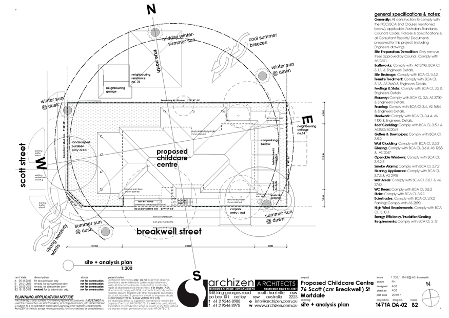
|
Georges River Council - Georges River Independent
Hearing Assessment Panel (IHAP) - Thursday, 15 June 2017
3.1 76 Scott Street Mortdale
[Appendix
2] Amended Lower Ground
Floor Plan - 76 Scott St Mortdale
|
Page 44
|
|
Georges River Council - Georges River Independent
Hearing Assessment Panel (IHAP) - Thursday, 15 June 2017
3.1 76 Scott Street Mortdale
[Appendix
3] Amended Upper Ground
Floor Plan - 76 Scott St Mortdale
|
Page 45
|
|
Georges River Council - Georges River Independent
Hearing Assessment Panel (IHAP) - Thursday, 15 June 2017
3.1 76 Scott Street Mortdale
[Appendix
4] Amended West
Elevation - 76 Scott St Mortdale
|
Page 46
|
|
Georges River Council - Georges River Independent
Hearing Assessment Panel (IHAP) - Thursday, 15 June 2017
3.1 76 Scott Street Mortdale
[Appendix
5] Amended East
Elevation - 76 Scott St Mortdale
|
Page 47
|
|
Georges River Council - Georges River Independent
Hearing Assessment Panel (IHAP) - Thursday, 15 June 2017
3.1 76 Scott Street Mortdale
[Appendix
6] Amended North Elevation
- 76 Scott St Mortdale
|
Page 48
|
|
Georges River Council - Georges River Independent
Hearing Assessment Panel (IHAP) - Thursday, 15 June 2017
3.1 76 Scott Street Mortdale
[Appendix
7] Amended South
Elevation - 76 Scott St Mortdale
|
Page 49
|
|
Georges River Council - Georges River Independent
Hearing Assessment Panel (IHAP) - Thursday, 15 June 2017
3.1 76 Scott Street Mortdale
[Appendix
8] Landscape Plan
(subject to changes) - 76 Scott St Mortdale
|
Page 50
|
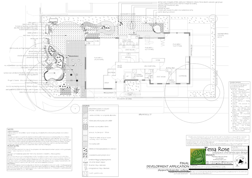
|
Georges River Council – Independent Hearing and
Assessment Panel Thursday, 15 June 2017
|
Page 51
|
REPORT TO GEORGES RIVER COUNCIL
IHAP MEETING OF Thursday, 15 June 2017
|
IHAP Report No
|
3.2
|
Application No
|
DA2016/0183
|
|
Site Address & Ward Locality
|
45 Princes Highway Kogarah
Kogarah Bay Ward
|
|
Proposal
|
Demolition of existing buildings
and construction of a ten (10) storey mixed use development consisting of
ground floor tenancy and fifty five (55) residential apartments with basement
car parking
|
|
Report Author/s
|
Senior Development Assessment
Officer, Ben Latta
|
|
Owners
|
GCK Investments Pty Ltd
|
|
Applicant
|
GCK Investments Pty Ltd
|
|
Zoning
|
Zone B2 - Local Centre
|
|
Date Of Lodgement
|
6/09/2016
|
|
Submissions
|
No submissions received
|
|
Cost of Works
|
$16,709,153.00
|
|
Reason for Referral to IHAP
|
Height does not comply with
33m limit under KLEP 2012 (<5%) and building separation does not comply
with Apartment Design Guide
|
|
Recommendation
|
That the application be approved in accordance with the
conditions included in the report.
|
|
|
Site Plan
|
Executive Summary
Officer’s
Recommendation:
Development Approval
1. That
Council as the Consent Authority pursuant to Section 80(1)(a) Environmental
Planning and Assessment Act 1979, grant consent to Development Application No
183/2016 for demolition of existing buildings and construction of a ten (10)
storey mixed use development consisting of ground floor commercial tenancy and
fifty five (55) residential apartments with basement car parking at 45 Princes
Highway and 99 Regent Street, Kogarah, subject to conditions.
Proposal
2. Council
is in receipt of an application for the demolition of existing buildings and
construction of a ten (10) storey mixed use development consisting of ground
floor commercial tenancy and fifty five (55) residential apartments with
basement car parking on the subject site.
Site and
Locality
3. The
site is a rectangular shaped group of four allotments located on the
southwestern corner of Princes Highway and Regent Street, Kogarah, which forms
the major northern entry to the Kogarah Town Centre CBD. The site is 1060
square metres in total area. The land has a gradual fall to the east (Princes
Highway).
Zoning and KLEP
2012 Compliance
4. The
site is zoned B2 Neighbourhood Centre under KLEP 2012 and the proposal is a
permissible form of development with Council’s consent. The
proposed development satisfies all relevant clauses contained within KLEP 2012.
New City Plan
– Amendment No.2 to KLEP 2012
5. Amendment
No.2 to Kogarah LEP 2012 was gazetted on 26 May 2017
6. The
New City Plan includes changes to zoning and the introduction of development
standards in parts of the City to deliver a range of new housing options.
7. Specifically,
the New City Plan converted the B1 zoning to B2 - Local Centre.
8. The
New City Plan introduced height and FSR standards of 33m and 4:1 respectively.
The proposal complies with the FSR controls but does not comply with the height
limit for a maximum variation of 1m in the north-eastern corner of the parapet
due to the slope of the land.
9. The
proposal has regard to recently prepared a Kogarah North Precinct: Draft Urban
Design Strategy that aims to guide new development anticipated in the Kogarah
North Precinct, in lieu of any DCP.
The
Administrator moved and declared carried:
(a) That
the draft Kogarah North Urban Design Strategy be publicly exhibited for a
minimum period of 28 days.
(b) That
Option 3 and the urban design principles contained within the draft Kogarah
North Urban Design Strategy be adopted by Council as an interim set of planning
controls from the date of the gazettal of Amendment No.2 to Kogarah Local
Environmental Plan.
(c) That
Council advise applicants and landowners that any application within the
Kogarah North Precinct will be assessed against Option 3 and the urban design
principles contained within the draft Kogarah North Urban Design Strategy.
(d) That
Council prepare an amendment to Kogarah Development Control Plan 2013 by
including as a specific chapter Option 3 and the urban design principles
contained within the draft Kogarah North Urban Design Strategy.
(e) That
the amended Kogarah Development Control Plan be placed on public exhibition in
accordance with the Environmental Planning and Assessment Act 1979 and its
Regulation 2000 at the same time as the draft Kogarah North Urban Design
Strategy.
(f) That a further report be presented
to Council following the public exhibition of the draft Kogarah North Urban Design
Strategy and amended Kogarah Development Control Plan.
Kogarah
Development Control Plan 2013 (KDCP 2013)
10. The
proposed development is not compatible with the provisions of the part D1 and
D2 of KDCP 2013 as the proposal seeks approval under the provisions of the New
City Plan in terms of height and floor space ratio.
Submissions
11. No
submissions were received.
Conclusion
12. Having
regard to the Heads of Consideration under Section 79C (1) of the Environmental
Planning and Assessment Act 1979 and following a detailed assessment of the
proposal Development Application No. 183/2016 should be approved subject to
conditions.
Report in Full
Proposal
13. Council
is in receipt of an application for the demolition of existing buildings and
construction of a ten (10) storey mixed use development consisting of ground
floor commercial tenancy and fifty five (55) residential apartments with
basement car parking on the subject site.
14. Specially,
the proposal comprises the following:
· Three levels of
basement car parking
· Ground floor level
containing 204m² commercial tenancy, residential lobby, vehicular entry
and loading and plant/ancillary areas.
· Levels 1-9
containing 55 residential apartments and communal open space on levels 1 and 9.
15. The
proposal comprises the following residential unit breakdown:
· 11 x Studio
apartments
· 18 x one-bedroom apartments
· 23 x two-bedroom
apartments
· 3 x three-bedroom
apartments
The Site and
Locality
16. The
site is a rectangular shaped group of four allotments located on the south
western corner of Princes Highway and Regent Street, Kogarah, which forms the major
northern entry to the Kogarah Town Centre CBD. The site is 1060 square metres
in total area. The land has a gradual fall to the east (Princes Highway)
17. Currently
existing on the site is a two-storey rendered residential flat building at
No.99 Regent Street on the corner, and a group of three shops to the south on
the three (3) lots known as 45 Princes Highway.
18. The
local context is mixed, with Kogarah Public School located to the south of the
site on Princes Highway and heritage listed Church to its south. Development in
Regent Street is characterised by older dwellings

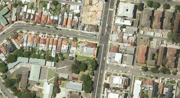
Background
19. On
6 September 2016 the Development Application subject of this report was lodged
with Council.
20. From
21 September to 10 October 2016 the application was placed on neighbour
notification.
21. On
15 November 2016 the applicant was sent a letter identifying a number of issues
with the proposal to be addressed, including:
· Non-compliance
with 33m height limit under the provisions of the New City Plan
· Non-compliance
with 4:1 Floor Space Ratio
· Issues with
satisfying the provisions of SEPP 65 and the Apartment Design Guide; in
particular, building separation requirements, blank wall treatments, cross-ventilation
requirements.
· Issues with the
deemed to satisfy provision of the Building Code of Australia
· Insufficient bin
storage rooms.
22. On
24 November 2016 the applicant submitted amended plans that did not address the
above issues.
23. The
applicant was required to submit further amendments, which were lodged on 13
April 2017. The amendments alter unit composition to increase the number of
units from fifty one (51) to fifty five (55), but increases the number of one
(1) bedroom units in the development. The height has been lowered, increased
building separation has been incorporated and other design issues have been
addressed.
24. The
amended plans address all of the issues raised and are relied upon for
assessment in this report.
Section 79C
Assessment
25. The
following is an assessment of the application with regard to Section 79C(1) of
the Environmental Planning and Assessment Act 1979.
(1) Matters
for consideration – general
In
determining an application, a consent authority is to take into consideration
such of the following matters as are of relevance to the development the
subject of the development application:
(a) the
provision of:
(i) any
environmental planning instrument,
Kogarah
Local Environmental Plan 2012 (KLEP 2012)
Part 2 –
Permitted or Prohibited Development
Clause 2.1
– Land Use Zones
26. Amendment
No 2 to Kogarah LEP 2012 was gazetted on 26 May 2017
27. The
New City Plan includes changes to zoning and the introduction of development
standards in parts of the City to deliver a range of new housing options.
28. Specifically,
the New City Plan converted the B1 zoning to B2 - Local Centre.
29. The
subject site is zoned B2 Local Centre and the proposal is a permissible form of
development with Council’s consent. The proposed development satisfies
the objectives of the zone, which are:
· To provide a range of retail, business,
entertainment and community uses that serve the needs of people who live in,
work in and visit the local area.
· To encourage employment opportunities in accessible
locations.
· To maximise public transport patronage and
encourage walking and cycling.
Clause 4.3
Height of buildings
30. The
objectives of this clause are as follows:
(a) to establish the maximum height for
buildings,
(b) to minimise the impact of
overshadowing, visual impact and loss of privacy on adjoining properties and
open space areas,
(c) to provide appropriate scale and
intensity of development through height controls.
(2) The height of a building on
any land is not to exceed the maximum height shown for the land on the Height
of Buildings Map.
31. The
proposal does not comply with the draft 33m height limit adopting a maximum
overall height of 34m to the top of the parapet at the south eastern corner of
the site (corner of Princes Highway and Regent Street. (refer to Figures 1 and
2).
32. The
1m variation is minor in nature resulting from the fall in the site. The merits
of presenting a strong corner element outweighs a minor numerical variation
where the building fits the general desired scale of 10 storeys. The 3%
non-compliance only extends to the parapet element that presents to the corner
and does not result in any overshadowing impacts to adjoining properties.
No habitable areas breach the height plane.
33. The
application is accompanied by a Clause 4.6 request for variation which is
discussed in detail below.
Clause 4.4
– Floor Space Ratio
34. The
objectives of this clause are as follows:
(a) to ensure the
intensity of development is compatible with the desired future character and
zone objectives for the land,
(b) to limit the bulk
and scale of development.
35. The
proposal complies with the applicable floor space ratio of 4:1, proposing an
FSR of 3.99:1 and thereby satisfying the provisions of Clause 4.4. of KLEP
2012.
Clause 4.6
– Variation to Development standards
36. The
objectives of this clause are as follows:
(a) to
provide an appropriate degree of flexibility in applying certain development
standards to particular development,
(b) to
achieve better outcomes for and from development by allowing flexibility in
particular circumstances.
37. Clause
4.6(2) states that development consent may, subject to this clause, be granted
for development even though the development would contravene a development
standard imposed by this or any other environmental planning instrument.
However, this clause does not apply to a development standard that is expressly
excluded from the operation of this clause.
38. The
application is accompanied by a request to vary the 33m height limit under
Clause 4.3 of KLEP 2012 (GSA Planning, 2/6/2017)
Applicant comment:
39. The
proposed building has a height ranging between 13m and 34m, partially exceeding
the maximum height limit by up to 1m. The small area of non-compliance relates
to a roof parapet at the corner of the Princes Highway and Regent Street and is
a function of the site’s sloping topography (see Figures 1 and 2 below).
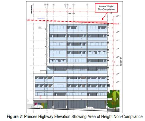
40. Clause
4.6(3) states that development consent must not be granted for development that
contravenes a development standard unless the consent authority has considered
a written request from the applicant that seeks to justify the contravention of
the development standard by demonstrating:
(a) that
compliance with the development standard is unreasonable or unnecessary in the
circumstances of the case, and
(b) that there are
sufficient environmental planning grounds to justify contravening the
development standard.
41. The
Land and Environment Court in its recent decisions in Four2Five vs Ashfield
Council has ruled that a clause 4.6 variation must do more than demonstrate
that the development meets the objectives of the development standard and the
zone. The clause 4.6 objection must also demonstrate some other environmental
planning grounds that justify contravening the development standard, preferably
some that are specific to the site, although that is not essential according to
the Court of Appeal decision in Four2Five vs Ashfield Council.
42. The
applicant has provided the following response to Clause 4.6(3)(a):
Clause 4.3 Height of Buildings –
Objectives
(a) To establish the maximum height for
buildings
With the exception of the small parapet
area, the proposed building complies with the height development standard.
Given the site’s prominent location on a corner site, additional height
is an appropriate design response to strengthen corners. The extent of
non-compliance is so minor that it is unlikely to be readily discernible. In
our opinion, the development satisfies the objective.
(b) To minimise the impact of
overshadowing, visual impact and loss of privacy on adjoining properties and
open space areas,
The area of non-compliance will not result
in adverse impacts in terms of overshadowing, visual impact or loss of privacy.
The roof parapet that is the subject of this
variation is located on the north eastern side of the building. The southern
interface is fully compliant with the height limit and incorporates significant
setbacks at the upper levels. Accordingly, the area of non-compliance will not
result in additional overshadowing to neighbouring properties at either 9am or
12pm. It would result in an extremely minor increase in shadowing at 3pm,
however in the context of the development and the locality this is not
considered substantive or significantly different to the impact from a
compliant scheme.
In terms of visual impact and privacy, the
non-compliance is a concrete roof parapet, not any form of habitable floor
space. There are no window openings or trafficable areas above the height
limit. Accordingly, there is no impact on visual privacy as a result of the
non-compliance.
(c) To provide appropriate scale and
intensity of development through height controls.
As outlined in our response to Objective
(a), the building is predominately compliant with the height and is a good
example of urban renewal in the locality. The scheme complies with the FSR and
the considerations of the ADG. The scale and intensity of the development is
anticipated by Council’s controls and is appropriate in the locality.
Importantly, requiring compliance with the height limit would not alter the
proposed intensity of the development in any way, it would simply serve to
compromise the integrity of the architecture. The proposal is appropriate in
its current form and is consistent with this objective
Test 2 - The underlying objective or
purpose of the standard is not relevant to the development and therefore
compliance is unnecessary.
As a function of the recent gazettal of the
New City Plan, the character and context of the area will transform to
incorporate greater development density and increased building heights. In our
opinion, the underlying purpose of the development standard is to present a
building that is compatible with the emerging height, context and character of
the locality whilst preserving the amenity of adjoining properties.
The roof parapet is critical to the
building’s architecture and will assist the compatibility of the building
with the emerging built form. Requiring a reduction in height in the localised
area would result in an inconsistent overall building height and a poor urban
design response to the corner. This would be inconsistent with the underlying
intent of the standard to provide buildings in context.
Test 3 - The underlying objective or
purpose would be defeated or thwarted if compliance was required and therefore
compliance is unreasonable;
As indicated, if the purpose of the standard
is to present a development that is compatible in the locality, compliance with
the height standard is unreasonable. The non-compliance is the result of the
sloping topography which renders compliance difficult to achieve.
43. With
respect to Clause 4.6(3)(b), the applicant provides the following justification
on environmental planning grounds:
The proposal is permissible within the B2 Local
Centre Zone and is consistent with the zone objectives, which are to provide a
range of retail, business, entertainment and community uses that serve the
needs of people who live in, work in and visit the local area; to encourage
employment opportunities in accessible locations and to maximise public
transport patronage and encourage walking and cycling.
It is our opinion that the proposal is
consistent with the relevant zone objectives and satisfies a number of the
‘unreasonable and unnecessary’ tests established by the Court in Wehbe.
In addition, it is our opinion that the area of non-compliance (and the
proposal generally) is unlikely to result in adverse amenity impacts in terms
of privacy, overshadowing or view loss. These are considered in detail in the
submitted SEE. For these reasons, it is considered that the minor height
non-compliance of the parapet is unlikely to have adverse impacts and the
proposal is in the public interest.
For these reasons outlined above, it is our opinion that
there are sufficient environmental planning grounds to justify contravening the
development standard in the particular circumstances of the case.
44. Clause
4.6(4) states that Development consent must not be granted for development that
contravenes a development standard unless:
(a) the consent authority
is satisfied that:
(i) the
applicant’s written request has adequately addressed the matters required
to be demonstrated by subclause (3), and
(ii) the
proposed development will be in the public interest because it is consistent
with the objectives of the particular standard and the objectives for
development within the zone in which the development is proposed to be carried
out, and
(b) the
concurrence of the Secretary has been obtained.
45. The
applicant provides the following response to Clause 4.6(4):
The applicant submits that the consent
authority can and should be satisfied of each of these requirements of Clause
4.6(4), for all of the reasons set out in this request, and also having regard
to the context of this particular site, in this particular locality; and having
regard to compliance with the height development standard with the exception of
the parapet.
As indicated, it is our opinion that the
proposal is in the public interest. In accordance with Tests 1, 2 and 3 in Wehbe
and Clause 4.6(4)(a)(ii) an assessment of the proposal against both the
objectives of the standard and the zone has been undertaken. The consideration
of the objectives of the standard is set out in this submission and in our
opinion, the proposal is consistent.
A detailed assessment of the proposal against
the objectives of the zone is undertaken in the submitted Statement of
Environmental Effects. From this, it is our opinion that the proposal is
consistent with the zone objectives and should be supported.
For these reasons it is our opinion that the variation is
appropriate, consistent with the intent of Clause 4.6 and should be supported
Officer
Comment:
46. The
submitted Clause 4.6 variation to the height standard in Clause 4.3 of KLEP
2012 prepared by GSA Planning and the justification set out therein is
supported, satisfies the relevant provisions of the clause and satisfies the
relevant tests set out in Four2Five vs Ashfield Council.
Part 5 –
Miscellaneous Provisions
Clause 5.6
– Architectural Roof Features
47. The
objectives of this clause are as follows:
(a) to create
variety in the Kogarah skyline and urban environment,
(b) to encourage
quality roof designs that contribute to the aesthetic and environmental design
and performance of the building,
(c) to
encourage integration of the design of the roof into the overall facade,
building composition and desired contextual response,
(d) to promote
architectural design excellence.
(2) Development
that includes an architectural roof feature that exceeds, or causes a building
to exceed, the height limits set by clause 4.3 may be carried out, but only
with development consent.
(3) Development
consent must not be granted to any such development unless the consent
authority is satisfied that:
(a) the
architectural roof feature:
(i) comprises
a decorative element on the uppermost portion of a building, and
(ii) is not an
advertising structure, and
(iii) does not include
floor space area and is not reasonably capable of modification to include floor
space area, and
(iv) will cause minimal
overshadowing, and
(b) any building
identification signage or equipment for servicing the building (such as plant,
lift motor rooms, fire stairs and the like) contained in or supported by the
roof feature is fully integrated into the design of the roof feature.
48. The
proposal results in a non-compliance with the 33m height limit involving a
projection of the corner parapet only, by up to a maximum of 1m. The protruding
parapet element satisfies the provisions of Clause 5.6 and is considered an
architectural roof feature.
Clause 5.9
– Preservation of Trees or Vegetation
49. The
proposed development does not involve the removal of any tree or vegetation
subject to the provisions of this clause.
50. The
application was referred to Council’s Parks and Recreation Coordinator
who recommended that three (3) street trees be planted along the Regent Street
frontage and that the species be selected from Council’s Street Tree
Management and Strategy. The landscape plans show the tree locations though not
the species.
51. In
addition, consideration has been given to the provisions of Section B2 –
Tree Management and Greenweb of KDCP 2013 and the proposed development
satisfies the relevant controls for tree and greenweb
management.
Clause 5.10
– Heritage Conservation
52. The
subject site is not listed as a heritage item in Schedule 5, nor is it within a
Heritage Conservation Area.
53. The
site is located to the north of St Pauls Anglican Church .The church is a free
standing building designed in the Victorian Free Gothic style and is separated
from the site by the Kogarah Public School Playground and church hall. In the
aerial photo below the Church is marked with a red star and the subject site
marked with a green star.
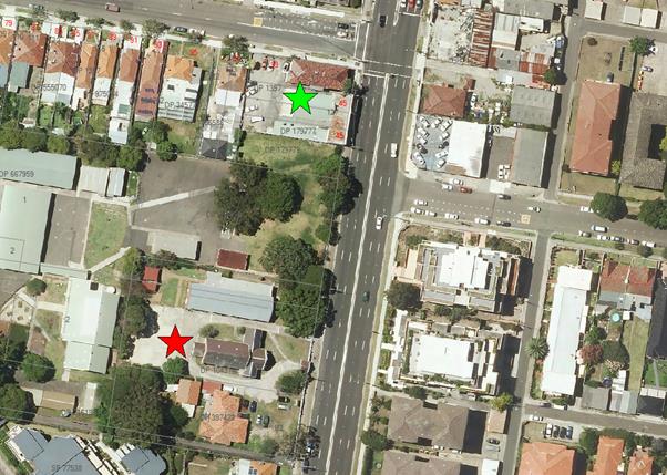
54. The
application is accompanied by a Heritage Impact Statement (Ruth Daniell, dated
August 2016) which concludes the following:
The proposal does not impact on the retention of the heritage item,
its form and significant fabric. The proposal does not affect the legal lot
curtilage of the heritage item, its landscaped elements and the open space
around the heritage listed church and hall. The heritage listed St Paul’s
Anglican Church and the hall does not have visual prominence in the streetscape
due to the deep setback from the Princes Highway frontage and high solid fence.
The heritage item is obscured in views form the north by a building on
the site of the Kogarah Public School.
This results in the views and vistas to the heritage item being
limited to views in front of its site and at a small angle on approach to this
position. The significant views and vistas to the heritage items will be
retained.
The proposed mixed use development is designed in a contemporary idiom
and has high standard of architectural design.
As the subject site is separated from the heritage item by the Kogarah
Public School site which is more than two times the width of the development
site. It is considered that the proposed development will have an acceptable
impact on the visual setting of the heritage item.
It is acknowledged that the proposed development is taller and larger
in scale than the heritage item, but this is mitigated by the distance the
subject site is separated from the heritage item, and by the articulation and
stepping in the design as the height increases. The proposed development
responds to the Sydney Metropolitan Strategy, which encourages higher density
living around retail amenity within town centres and in the context recent
development has increased in height and scale to respond to the planning
controls on nearby sites. The colour scheme and the proposed materials are
neutral. There are no disruptive visual contrasts.
55. The
application was not referred to Council’s Heritage Consultant due to the
distance between the site and the significant item, though has been considered
in this assessment. The above comments are concurred with and the proposal
satisfies the provisions of Clause 5.10 of KLEP 2012.
Part 6 –
Additional Local Provisions
Clause 6.1
– Acid Sulfate Soils
56. The
subject site is not shown as being affected by acid sulfate soils as identified
on the Acid Sulfate Soil Map.
Clause 6.2
– Earthworks
57. The
proposed earthworks involve excavation of the entire site over three (3) levels
of basement parking. The extent of excavation is considered acceptable having
regard to the type of development envisaged for the site and the provisions of
this clause. The works are not likely to have a detrimental impact on
environmental functions and processes, neighbouring uses, cultural or heritage
items or features of the surrounding land.
Clause 6.3
– Flood Planning
58. The
subject site has not been identified as a flood planning area on the Flood
Planning Maps.
59. In
addition, consideration has been given to the provisions of Section B6 –
Water Management of KDCP 2013 and the proposed development satisfies the
relevant controls related to flooding and drainage.
Clause 6.5
– Airspace Operations
60. The
application was referred to Sydney Airports Corporation Ltd (SACL) on 28
October 2016 as proposal is higher than 15.24m within an area requires
referral.
61. The
following response was given:
CASA has assessed the proposed building at
45 Princes Highway, Kogarah, NSW. The height of the proposed building at this
site, including antennas and other equipment, is 51.37 m AHD or approximately
34m Above Ground Level (AGL). At this height the proposed building will
infringe the inner horizontal surface by 0.37 m.
As there are other buildings of similar
height along the Princes Highway to the north and south in the vicinity of the
proposed development, CASA is not recommending obstacle marking or lighting in
this instance.
Any future addition to the building' height
will increase the penetration of the OLS (including the installation of
additional antennas) and a separate assessment will be required.
This assessment does not include any crane activity required during
construction. Any such crane activity that exceeds a height of 51 m AHD will
require a separate assessment.
62. Cranes
to construct the building may penetrate the OLS which will require the consent
of SACL.
State
Environmental Planning Policy (Building Sustainability Index: BASIX) 2004
63. A
BASIX Certificate has been issued for the proposed development and the
commitments required by the BASIX Certificate have been satisfied.
State
Environmental Planning Policy (Infrastructure) 2007
Development
likely to affect an electricity transmission or distribution network
64. Clause
45 of the ISEPP requires the consent authority to refer a Development
Application to the electricity supply authority as the development to be
carried out is within 5m of an exposed overhead electricity power line.
65. The
application has been referred to Ausgrid on 6 October 2016. No response has
been received to date and concurrence is assumed.
Development with Frontage to a Classified Road
66. Clause
101 of the ISEPP states that the consent authority must not grant consent to
development on land that has a frontage to a classified road unless it is
satisfied that:
(a) where
practicable, vehicular access to the land is provided by a road other than the
classified road, and
(b) the
safety, efficiency and ongoing operation of the classified road will not be
adversely affected by the development as a result of:
(i) the
design of the vehicular access to the land, or
(ii) the
emission of smoke or dust from the development, or
(iii) the
nature, volume or frequency of vehicles using the classified road to gain
access to the land, and
(c) the
development is of a type that is not sensitive to traffic noise or vehicle
emissions, or is appropriately located and designed, or includes measures, to
ameliorate potential traffic noise or vehicle emissions within the site of the
development arising from the adjacent classified road.
67. The
proposal satisfies the provisions of Clause 101 of the ISEPP.
Impact of road
noise or vibration on non-road development
68. The
proposal is situated on Princes Highway, a classified road that carries in
excess of 40,000 vehicles daily and is therefore subject to the provisions of
Clause 102 of the ISEPP.
69. Clause
102(3) requires that:
If the development is for the purposes of a
building for residential use, the consent authority must not grant consent to
the development unless it is satisfied that appropriate measures will be taken
to ensure that the following LAeq levels are not exceeded:
(a) in any bedroom in the
building—35 dB(A) at any time between 10 pm and 7 am,
(b) anywhere
else in the building (other than a garage, kitchen, bathroom or
hallway)—40 dB(A) at any time.
70. The
application is accompanied by an Acoustic Assessment (Acoustic Logic, dated
25/08/2016) and was referred to Council’s Environmental Health Officer
who raised no objection to the proposal subject to the imposition of suitable
conditions.
71. The
proposal satisfies the provisions of Clause 102 of the ISEPP.
Traffic
Generating Development
72. The
proposed development is not a ‘traffic generating’ development in
schedule 3 of the Infrastructure SEPP.
State Environmental Planning Policy No 65 – Design Quality of
Residential Flat Development (SEPP No 65)
73. The
proposed development is subject to the provisions of SEPP No 65, which aims to
improve the quality of residential flat design in NSW.
74. The
application has been accompanied by a design verification from a qualified
designer that verifies that:
a) He
or she designed or directed the design of the modification, and
b) The
modifications achieve the design quality principles as set out in Part 2 of
SEPP No 65, and
c) The
modifications do not diminish or detract from the design quality, or compromise
the design intent of the approved development.
75. The
application was referred to the St George Design Review Panel for consideration
at their meeting of 6 October 2016). The following comments were provided
with respect to the design quality principles set out in the Policy. After each
Panel comment in italics, an officer comment is given as to how the amended
plans respond to those comments.
Context
The context is characterised by the scale and
transition of buildings occurring along Princes Highway which in this location
is zoned B1 Neighbourhood Centre (B2 Local Centre in the current Planning
Proposal). However the subject site abuts an R4 zone to the west (which will
change over time) and a school to the south which is unlikely to change. The
approach taken in the design and site layout relies primarily on the controls
applying to the subject site alone and gives little regard to the existing and
likely future forms of development on the adjoining sites. In particular no
thought appears to be given to the form of development that might occur on the
R4 zoned adjacent site subject to ADG and Council’s controls. It would be
expected that the adjacent development would have a setback from the eastern
boundary. This site will be severely constrained by the decision to have a zero
setback on the subject site. The applicant assumes an adjacent development
would be built to its east boundary which is convenient for the applicant but
not for an applicant next door.
The inadequate site analysis demonstrates lack
of proper consideration of the context
The large areas of blank wall and zero setback
up to Level 3 facing the school create a very poor interface. There are
opportunities for windows above Level 3 and landscaping along the site boundary
and at Level 1 rooftop and Level 3 rooftop to provide relief to dominating
built form.
The Princes Highway is regarded as the
commercial centre. Therefore the retail/commercial space at the ground floor
should be easily accessible from the Highway footpath.
Officer Comment: The amended plans have been prepared in
response to the desired future context of the Kogarah North Precinct and in
consultation with Council in consideration of the draft Interim Design and
Development Guidelines for the precinct. The proposal adopts a zero lot
boundary alignment on the lower four floors, with upper floors setback 5m to
the southern boundary and 9m to the western boundary. This allows future
development of the site to the west, an appropriate street wall height and
transitional scale and solar access to the school to the south.
Blank walls have been either, treated, fenestrated or setback that
address the Panel’s comments.
The amendments have had regard to the Panel’s comments on
the accessibility of the commercial tenancy from the highway.
Built Form and Scale
As noted above the built form requires
modification to respond to the issues above, particularly the inclusion of a
side setback of 6m along the western boundary to provide a solar access
corridor to the school yard and adequate space for tree planting in deep soil.
The current design has a poor interface to the
Princes Highway. The upper portion of the building steps towards the street and
is visually top heavy from a pedestrian view point. The lower levels could be
aligned with the upper façade to eliminate this perception while
retaining the slot and the 4 storey datum line along the street. This would
also be in keeping with the architect’s design vision.
The blade walls at Level 3 on Regent Street
are not as successful at defining a lower scale datum and scale transition as
the datum and slot along the Princes Highway frontage. It is recommended to cap
the top of the blades between balconies to reinforce this datum and to provide
additional benefit of shade cover to the balconies.
Ground level interface to the Princes Highway
shows no access and should be more permeable for pedestrians to access the
retail.
The fire hydrant boosters need to be relocated
to a less conspicuous location (perpendicular to the street).
Officer Comment: The built form has been amended in
response to Council’s consideration of draft Guidelines for the Precinct.
The amended plans do not setback to the western boundary as
recommended by the Panel as already discussed.
The amended plans maintain what the Panel describes as a
‘top heavy’ presentation to the Princes Highway on the upper
levels. It is considered that this element presents strongly to the corner as a
clear entry to the Kogarah Town Centre, though it has been ‘lightened’
by incorporating louvered screens to the southern walls and glazing
differentiation. The high proportion of glazing and reduced bulk overall, make
the proposal an appropriate form for the commercial corner to the Kogarah North
Precinct.
The blade walls have been effectively diminished to Regent Street
as recommended by the Panel, and the four storey datum set clearly with a
parapet.
Density
Does not comply. The attempt to maximise
density to the benefit of the subject development would be to the detriment of
the amenity of adjoining properties and will severely constrain the ability to
achieve a reasonable design outcome on the property to the west. Furthermore,
this density has impacts on amenity within the subject site and limits capacity
to provide deep soil. As recommended above, the design should be amended to
provide reasonable deep soil setbacks on the south and
west. In this instance it may be acceptable to relocate floor space lost on the
south and west sides of the site by an additional two (2) floors north of the
lift and stair core facing Regent Street and, possibly by a not excessive
increase in the height limit breach at the corner of Princes Highway and Regent
Street, subject to testing that the benefits of providing a better boundary
interfaces and a solar access corridor to the school outweigh the additional
shadow from a higher corner element and impact on the streetscape. Floor space
could also be increased by reducing balcony/winter garden depths to the east
side units.
There are contentions about what constitutes
GFA and what does not. The Panel is of the opinion that the east to west
‘breezeways’ and most of the north to south
‘breezeways’ are actually corridors that meet the definition of
gross floor area and should be counted in the FSR calculation.
While the Panel understands that winter
gardens strictly meet the definition of GFA, if the applicant chose to change
them to balconies these areas would be excluded from GFA. The acoustic benefits
of winter gardens facing the Highway and amenity benefits during inclement
weather are acknowledged by the Panel and warrant flexibility in applying the
standard subject to a well-founded Clause 4.6 submission.
Officer Comment: Density has been amended
to comply and the Panel’s comments taken into consideration.
Breezeways have been amended to use a fixed open
form metal louver or mesh screen, rather than the enclosable glass louvered
walls in the original scheme.
The Panel’s advice has been noted and
adhered to in consideration of maintaining ‘winter gardens’ to most
highway-facing balconies. These have been excluded from GFA calculations as
they have fully openable double bi-fold glazed elements above the balustrades.
This is an appropriate flexible solution to the north-eastern highway frontage.
Deep soil landscape is not provided as
recommended by the Panel as the proposal is amended in response to the draft
Guidelines for the Precinct, which specifies a podium level that occupies the
site. Instead, the proposal provides landscape treatment at podium level
that greens the building, breaks up its massing and provides soft intrusions
into the built form. This is considered an acceptable outcome.
The ADG states that “achieving the
design criteria (for deep soil zones) may not be possible where:
- The location and building typology
have limited or no space for deep soil at ground level (eg central business
district, constrained sites, high density areas, or in centres)
- There is 100% site coverage or
non-residential uses at ground floor level.”
The proposal meets the above criteria to justify an exemption for
deep soil zones. The proposal also meets suitable stormwater detention
requirements to compensate for the lack of deep soil zones and satisfies the
ADG.
Sustainability
The Panel does not believe that the open slots
along the breezeway provided on the west side of the units facing the Highway
are an acceptable or effective means of providing daylight or natural
ventilation to the units facing the Highway. Furthermore, the Panel is of the
opinion that the resulting amenity of the bedrooms facing these slots would be
very poor.
The Panel’s assessment is that less than
50% of units will have adequate natural ventilation and that no more than 60%
of units will receive at least 3 hours (or 2 hours) of direct sunlight between
9am and 3pm at mid-winter. The deeply recessed balconies and blade walls
contribute to the shortfall.
Otherwise subject to BASIX.
Officer Comment: The amended plans widen the breezeways,
but close off the voids between breezeway bridges to the units facing the
highway. The former voids have been converted to storage spaces outside the
units with a 1.8m high wall surrounding each. This further decreases
access to light and ventilation and is not supported.
To resolve the issue, it is recommended that a condition be
imposed that:
The storage areas between the bedrooms and breezeways to Units
U208, U209, U308, U309, U405, U309, U505, U605, U705 U805 and U903 are to be
deleted and voids inserted to improve access to light and ventilation to those
units with windows facing that breezeway. A void above storage space U309ST is
to be created corresponding to the required voids below by inserting a void in
the landscape planter. Solid walls surrounding the voids are to be replaced
with frosted glass balustrades with a height of 1.6m.
Solar access has been improved through reduction of the balcony
depths to Princes Highway.
Landscape
Landscape proposals are very limited for
development of this scale with landscape proposals only shown for a communal
roof terrace on Level 7.
The proposal shows no deep soil and no
landscape at ground level. A 6m deep soil setback along the western boundary as
noted above would provide capacity for deciduous trees to be planted along the
length of the boundary, and mitigate visual impact on neighbouring properties.
The proposed interface to the adjoining school is dominated by walls and blank
facades with no landscape. The basement and ground level building floorplate
should be reconfigured to provide a deep soil setback along the school boundary
to provide capacity for tree and shrub planting. Planting should be provided on
the first floor level roof top to soften this edge.
The communal roof space on Level 7 includes a
pergola and blade walls on the northern boundary which creates a confined
space. This pergola should be relocated to allow for expanded planting zones
and provide views and outlook for users.
Communal open space volume should be provided
in accordance with the ADG. This may require provision of additional communal
roof top spaces.
Streetscape improvements such as additional
street planting on Regent Street and improvised paving should be provided.
Officer Comment: The amendments replan the communal open
space areas into two areas, one on Level 1 at the southern side of the building
and one on Level 9 at the north-west corner. Both areas are unconfined,
highly usable spaces.
The proposal provides 28% of the site area as usable communal open
space over two open space areas that comply with the minimum ADG requirement of
25%.
Amenity
In their review of the application the Panel
identified the following amenity issues:
- Poor natural ventilation due to the number
of single aspect units
- Direct solar access does not meet ADG
guidelines
- Inadequate in unit storage - the application
should be accompanied by a schedule demonstrating compliance
with ADG guidelines (the Panel notes that basement storage is good)
- Kitchens in the studio units are badly
located in the front door entry passage and provide limited bench space
Provision of windows in the south wall of end
units above Level 4 would improve their amenity (and relieve the appearance of
a large area of blank wall)
Officer Comment: As already discussed, improved access to
light and ventilation is facilitated by way of imposition of a condition to
create voids through the breezeway.
Balconies facing Princes Highway have been reduced in depth by 1m
thereby increasing solar access to living areas and adequately addressing the
issue, particularly as the balconies are north-east facing.
Kitchens in the studio apartments have been moved further from the
front door as recommended.
Safety
The deeply recessed entrance off Regent Street
provides a potential place of concealment. If it is not possible to move the
entry doors closer to the street, 24 hour lighting and CCTV should be
installed.
Officer Comment: The issue has been addressed, with the
amended plans pushing the entry doors and lobby towards the Regent Street
frontage.
Housing Diversity and Social Interaction
Satisfactory.
Officer Comment: Noted.
Aesthetics
Large areas of blank wall presenting to the
streetscape and adjoining properties are unacceptable. The overhang of the east
elevation above Level 4 produces a top heavy form, which could be remedied by
bringing the units below Level 4 to the street boundary.
Officer Comment: Blank walls have been either, treated,
fenestrated or setback that address the Panel’s comments.
As discussed the top heavy corner presentation is considered
acceptable for the site and the nature of the development. Corners,
particularly in a commercial, town centre entry, should present strongly.
76. The
proposal as amended is considered to satisfy the provisions of SEPP 65 subject
to the imposition of suitable conditions.
Deemed State Environmental
Planning Policy – Georges River Catchment
77. All
stormwater from the proposed development can be treated in accordance with
Council’s Water Management Policy and would satisfy the relevant
provisions of the Deemed State Environmental Planning Policy – Georges
River Catchment
(ii) any
draft environmental planning instrument that is or has been placed on public
exhibition and details of which have been notified to the consent authority,
and
78. There
are no draft environmental planning instruments relevant to the subject
application. However, due to the recent gazettal of the New City Plan, draft
Kogarah North Urban Design Strategy has been prepared and exhibited to provide
guidance to new developments being proposed in the Kogarah North Precinct.
Draft Kogarah
North Urban Design Strategy
79. At
the Council meeting of 1 May 2017, the Administrator moved and declared
carried:
(a) That
the draft Kogarah North Urban Design Strategy be publicly exhibited for a
minimum period of 28 days.
(b) That
Option 3 and the urban design principles contained within the draft Kogarah
North Urban Design Strategy be adopted by Council as an interim set of planning
controls from the date of the gazettal of Amendment No.2 to Kogarah Local
Environmental Plan.
(c) That
Council advise applicants and landowners that any application within the
Kogarah North Precinct will be assessed against Option 3 and the urban design
principles contained within the draft Kogarah North Urban Design Strategy.
(d) That
Council prepare an amendment to Kogarah Development Control Plan 2013 by
including as a specific chapter Option 3 and the urban design principles
contained within the draft Kogarah North Urban Design Strategy.
(e) That
the amended Kogarah Development Control Plan be placed on public exhibition in
accordance with the Environmental Planning and Assessment Act 1979 and its
Regulation 2000 at the same time as the draft Kogarah North Urban Design
Strategy.
(f) That a further report be presented to Council following the public
exhibition of the draft Kogarah North Urban Design Strategy and amended Kogarah
Development Control Plan.
80. The
subject application has been prepared and lodged in absence of an overarching
strategic vision for the Precinct, which is currently being prepared.
Assessment of the subject application has been undertaken in consideration of
the principles set out in this document to ensure that the proposal sets a
standard of design and massing that will set the tone for future applications
submitted after gazettal of the LEP.
The purpose of
these interim design and development principles is to ameliorate the risk that
early development applications may undermine the implementation of a coherent
vision for the Precinct. These interim design and development principles have
been prepared to assist Council in their determination of early DAs with some
degree of transparency and consistency.
81. The
Draft Interim Guidelines are set out according to the principles similar to
those set out in SEPP 65 and include: context and neighbourhood character,
built form and scale, urban structure, density, sustainability, landscape
amenity safety, housing diversity and social interaction, and aesthetics.
82. The
objectives and strategies for each principle are discussed below with
commentary on how the proposal achieves each.
Context and Neighbourhood Character
Objectives
· To recognise that the precinct character will undergo a
radical transformation as development intensifies in coming years
· To acknowledge and strengthen the key character elements
that will remain including the primary urban structure, heritage items and institutional
land uses
· To retain all heritage buildings across the Precinct and
encourage their preservation
Strategies
· Step-down building scale adjacent to heritage items
· Provide adequate curtilage and setbacks to heritage items
· Maintain solar access to existing apartment buildings and
public open space
· Protect the large established avenue trees, particularly in
Victoria Street and Palmerston Street
· Follow the Australia ICOMOS Charter for Places of Cultural
Significance, The Burra Charter for development to heritage items.
83. The
proposed development is the first to be lodged and assessed in the Precinct
under the provisions of the New City Plan, though there is a nearby ten (10)
storey residential flat building at 21 Princes Highway to the north of the
site, which anticipates the desired scale under the New City Plan.
84. Above
level 4 the proposal provides a setback to allow a step down in scale to the
south and setbacks to the western boundary to provide solar access to the
school.
Built Form and Scale
Objectives
· To ensure a comfortable human scale, avoiding the
appearance of deep and unbroken canyons and tempering the scale of the
street-edge buildings
· To create buildings that define the streets and parks, with
a consistent pattern of massing while fostering architectural diversity within
this framework, thereby encouraging different streets to have a distinct and
recognisable character
· To encourage heritage conservation
· To ensure that development does not result in the creation
of isolated sites
· To encourage site consolidation for efficiency and improved
public domain interface
Strategies
· Amalgamation of allotments will be required in the circumstance
where an isolated allotment would otherwise be created
· Encourage lot consolidation to create a 60m street frontage
length to optimise yield and public domain amenity
· Predominant streetscape of four storeys in the foreground
(suggest 5m front setback), with taller elements set behind this (8m upper
setback)
· Consider the possibility for smaller or zero street
setbacks on super-block corners and corners with neighbourhood shop ground
floor uses
· Secondary corners with neighbourhood shops at ground floor
are to provide a 2m setback to the street wall, while residential use at the
ground floor will require a 5m setback to the street wall
· The maximum length of a building above the four storey podium
is 40 metres
· Zero side setbacks are permitted up to four storeys if the
building is compliant with the ADG and if the building maintains neighbouring
sites’ redevelopment potential. Zero side setbacks are not permitted if
the building is adjacent to a heritage item
· Neighbourhood shops to the ground floor are to extend for a
maximum of 20m past the corner
· Taller building elements to be separated with breaks in
massing to allow views beyond, sky and sunlight
· No ground floor apartments are to be below the adjacent
footpath level
· Avoid ziggurat building form (prefer one step not two above
podium level)
· Minimise ‘dead’ frontage to streets and
maximise the use of active frontages
· Provide adequate curtilage and side setbacks from heritage
sites and a transition in height from the heritage items
· Council may consider the use of a transferable Heritage
Floor Space Scheme
· Buildings to the south of St Paul’s Anglican Church
to have a 15-metre setback from the church site
· Princes Highway frontage setback to be similar to the
adjacent frontage along the highway
· Investigate mechanisms for subsequent integration of
isolated sites such as shared basement connections and servicing
85. The
proposal meets the above objectives and strategies. The site has no direct
adjoining neighbours on Princes Highway. The proposal minimises setbacks to the
Princes Highway / Regent Street corner to maximise setbacks to the south and
west.
Urban Structure
Objectives
· To recognise that as the function of the precinct changes,
its structure should be adapted and modified to respond to the new set of uses.
As density increases, the urban block structure should become finer,
permeability should increase and intersection density should increase
· To support the predominance of walking as the way of moving
through the neighbourhood.
· To provide a set of new open spaces in the neighbourhood to
serve a variety of recreational and social functions
· To create a clear hierarchy to the streets and laneways,
while providing a consistent character throughout the Precinct.
· To provide pedestrian linkages and access routes though the
Precinct to offer residents and visitors greater choice of movement, as well as
a safer and more enjoyable walking or cycling experience
Strategies
· Create new links and laneways to increase permeability of
movement within the precinct and to increase pedestrian intersection density
through the neighbourhood
· Ensure open spaces are easily reachable with connections to
the surroundings
· Design open spaces that contribute to the positive effects
of being within Sydney’s green grid and a green infrastructure network
· Ensure that urban structure and open spaces respond to the
objectives for Water Sensitive Urban Design Spaces and stormwater management,
through elements such as drainage swales and detention ponds
· Create a new shared zone to Railway Lane running north
south
· Create
a new shared zone on Victor Street as an Extension to the Town Common
· Create a new through site link from Railway Lane to
Palmerston Street (suggest through 11 Palmerston Street)
· Create a new laneway north south through Block 2 as a
continuation of Regent Lane
· Create a new through site link from Stanley Lane to
Victoria Street (suggest through 22 Victoria Street)
· Widen existing through site link south of St Paul’s
Anglican Church to 10m
· Investigate creating a small-scale carpark under part of
the Town Common to house car parking for Kogarah High School and the public
· Investigate the use of Kogarah High School’s primary
open space to become a shared space – Town Common
· Consider opportunities to encourage a change in land use to
adaptively reuse 12 and 14 Victor Street for a community facility
86. The
proposal is a corner entry to the site and is not the subject of the above
strategies.
Density
Objectives
· To ensure that development maximises density while
balancing external impacts including: impacts on the amenity and development
potential of adjacent development sites; amenity in the public domain; the need
for improvements in infrastructure
· To moderate density on constrained sites and permit greater
density on sites that have greater capacity and minimal external impacts
Strategies
· Permit reduced setbacks at major and some secondary corners
for greater yield
· Permit zero side boundary setbacks up to 4 storeys to sites
along the Princes Highway. Other sites within the Precinct could be considered
dependant on amalgamation patterns, compliance with SEPP 65 solar access and
cross ventilation, and demonstration that there would be no additional impacts
to the adjacent properties
· Encourage consolidation to create sites over 60m length to
optimise yield
· Consider schematic design for redevelopment of neighbouring
sites to protect Precinct-wide yield density while meeting the provisions
set out in the Apartment Design Guide
87. The
proposal achieves the objectives and strategies where applicable. Setbacks are
discussed in more detail later in this report.
88. The
proposal has been amended to provide suitable setbacks to satisfy the ADG
building separation provisions and still protecting yield density in accordance
with the draft height and FSR set out in the New City Plan.
Sustainability
Objectives
· To encourage design for sustainable environmental, social
and economic outcomes by encouraging designs that minimise usage of power and
water and allow flexibly in design so that places and facilities may have
multiple uses over time; applying the principle of “long-life loose-fit”.
· No increase in stormwater beyond the existing output..
Strategies
· Protect existing trees and plan for street trees to improve
micro-climate
· Increase tree canopy cover from current 21% of land area to
35% of land area over the entire Precinct area
· Encourage green roofs and green walls to improve amenity
for residents and provide urban markers within the Precinct
· The encouraged minimum green roof cover per site is 50% and
is to be considered as communal open space. Where possible, green cover is to be
located on lower level roofs to improve outlook
· Integrate Green Infrastructure in to the streetscape where
appropriate
· Incorporate a system of Water Sensitive Urban Design, tree
canopy cover, living architecture objectives and urban food initiatives
· Provide significant tree planting in deep soil for urban
canopy objectives and to provide urban ecological habitats
· Design for a link between green spaces to improve
biodiversity across the precinct and connect to external Green Grid links
· Design for pedestrian priority throughout the Precinct by
encouraging walking and public transport usage
· All waste collection and service vehicles to be provided
for on site
· Integrate WSUD including on-site reuse and recycling into
the design of the public open spaces with collection, retention and filtration
of the rain water
89. The
proposal incorporates new street trees along Regent Street and reinforces the
ground floor and fourth floor setbacks with landscaping treatment to provide
green spaces in the building as it rises in storeys.
Landscape
Objectives
· To adopt an integrated approach towards landscape in the
public and private domain to develop a positive image and contextual fit of
well-designed developments
· To recognise that streets serve a far wider set of social
and practical needs than previously, because people will be living at higher
densities in apartments without yards or large living rooms
Strategies
· To create liveable street designs that are accessible to
all and are envisioned as ‘shared spaces’ for both vehicular,
pedestrian and cyclist uses, that are all safe, well connected and activated to
promote social activities
· Generate a clear hierarchy of high quality streets for ease
of legibility and use
· Provide a variety of scale and type of public open space
· Design visually attractive streetscapes, to foster social
well-being and create a comfortable micro-climate
· To maintain all significant existing street trees
· Provide additional street tree planting in all streets
· Create and utilise a detailed material palette of ground
surface treatments, public domain furniture and signage strategy for the whole
public domain of the precinct
· Seek opportunities for rear lanes to be configured as
shared zones and for adjacent development sites to include community gardens
and community facilities
· Utilise ‘Living Architecture’ controls
particularly for taller buildings that will have immediate regional views for
urban greenery and building performance
· Create a good mix between constant resident related
functions and temporary alternative functions of evenings and weekends
· Development which is adjacent to open spaces is to enhance
its quality by creating compatible activating uses
· Development which is adjacent to open spaces is to avoid
adverse impacts on open spaces such as overshadowing
90. The
proposal provides street trees on Regent Street and the mixed development
provides a mix of resident related functions and commercial functions to
provide vitality. The other above strategies do not apply as the site is a
relatively small, corner site on the edge of the Precinct, without a rear lane
or public open space area adjacent.
Amenity
Objectives
· Encourage
social and community interaction in a distinctive and attractive neighbourhood
with excellent amenities in public domain
· Preserve
significant elements that give the existing amenity such as large trees and
some heritage buildings
· Create a
pleasant leafy environment with a comfortable microclimate shade and sunlight
throughout the year
· Create a
convenient and pleasant walking environment through the neighbourhood
Strategies
· Increase the
effective amount of public open space in the precinct by improving the school
playing fields and making them available to the wider community outside of
school hours
· Seek to establish
a community centre with a variety of community functions and possibly including
a café at Victor Street and the proposed Town Common
· At Victor
Street and the proposed Town Common, provide public amenities such as toilets,
cafes and community hubs relating to proposed outdoor activities.
· Create and
protect solar access plane to Victor Street to minimise overshadowing to
Kogarah High School’s primary open space
· Provide a lower built form to Railway Parade to minimise
overshadowing to St George Girls High School’s primary open space.
Provide solar access to at least 60% of the playing field at 3pm on June 21st.
Demonstrate how the remaining sites along Railway Parade can be development to
a similar density while achieving the solar access requirements
· Maintain solar
access to existing apartment buildings and public open space
· Maintain a
minimum of two hours of solar access to 70% of neighbouring apartments’
private open space and habitable rooms between 9am-3pm on 21 June
· Create three distinct public open spaces throughout the
Precinct that are varied in scale, use and character and are linked by a
pedestrian landscaped spine. These three types of public open spaces are
defined as:
▪ Precinct Park. Activities such as;
open green, picnic spots, active sports, formal sports, informal play, larger
group gatherings, habitat and toilets
▪ Potential Community Hub Park. School
uses and activities such as; school open space, formal play, table tennis/youth
play, informal sport, activated edges with seating etc., facilities and cafe
and temporary markets
▪ Pocket Park. Activities such as;
informal performance, community gardens, summer seating/ gardening rooms and
informal play
91. The
site is a small site on the corner of the Precinct with no development sites or
residences adjoining to the south, making the above strategies generally
unviable or irrelevant. The exception is overshadowing to the school to the
south, which is discussed in this report and found acceptable.
Safety
Objectives
· To create a comfortable and safe environment for current
and future residents, especially for the young people attending the three
schools in the precinct.
· To encourage good design that optimises safety and security
within the development and the public domain.
Strategies
· Adopt the principles of Crime Prevention Through
Environmental Design (CEPTED)
· Capture opportunities to maximise passive surveillance of
public and communal areas promote safety.
· Ensure high quality materials, finishes and construction
details throughout the public domain and adjacent private domain
· Create opportunities for street activation through retail
of various scales including outdoor dining areas
· Neighbourhood shops are to be provided on the ground floor
of all Princes Highway frontages and are to be provided strategically within
the Precinct.
· Local streets and lanes are to prioritise pedestrian
activities such as seating, informal play and community activities.
· Design for a varied human scale and a streetscape
stimulation at eye level
· Articulate living room windows and kitchen windows to face
streets to improve casual surveillance of streets and make habitation recognisable
from streets
· Provide clear crossing points and raised crossing points
which prioritise pedestrian movements and are suitable for traffic calming
92. The
application was referred to Kogarah Local Area Command for a CPTED assessment
on 29 September 2016. However, no response has been received to date. The
proposal satisfies the above strategies.
Housing Diversity and Social Interaction
Objectives
· To optimise Kogarah North’s close proximity to major
transport and major health and education institutions by increasing key worker
housing and opportunities for ageing in place
· To create an extensive range of living options for a wide
range of household types and income levels
· To encourage design of streets that are accessible to all
and are envisioned as ‘shared spaces’ with both vehicular,
pedestrian and cyclist uses that are all safe, well connected and activated
promoting social activities.
Strategies
· Provide a diverse mix of housing types and sizes suitable
for all ages
· Provide for a variety of settings for formal and informal
social interactions
· Design for appropriate street widths for human comfort and
scale that provides suitable dimensions for footpath widths with access for all
and opportunities for places to stop, stay and inhabit
· Create adaptable streets and public domain spaces which
accommodate a range of uses and activities
· Provide all weather protection in the form of awnings where
suitable, to encourage outside activities
· Provide a range of public domain furniture
· Utilise appropriate non-slip paving materials
· Design to Australian Disability Discrimination Act
standards to allow for usage of public spaces for all abilities and ages
· Provide a public domain of spaces that encourage a range
opportunities such as; active and passive recreation, informal and formal
seating, children’s formal and informal play, exercise stations and sport
activities, temporary markets and overlays, formal gathering space, community
gardens, picnic facilities and performances.
93. The
proposal satisfies the above strategy and objectives by providing a mixed
residential commercial development containing an appropriate mix of studio,
one, two and three bedroom apartments. The proposal provides variation to unit
layouts and two communal open space areas.
Aesthetics
Objectives
· Achieve variety
with order. Architectural diversity within a regular and consistent built-form
framework.
· Material
selection also has an important role in aesthetic quality, it has an important
role to play in creating a cohesive and distinct visual environment.
· Overarching
built form should reflect consistently applied strategies, while permitting
diversity in detail and ‘personal touches’ in the presentation of
homes and community facilities.
Strategies
· Limited pallete
of predominant material either rendered masonry of face brick
· Streets of
familiar design reflective the distinct usage and role of each street
· To all streets,
except along the Princes Highway, Railway Parade North and major and secondary
corners, provide five metre front building setbacks that incorporates
landscaping to the street to create useable front courtyards and allow for
individualised landscaping of the space between the street and the building
· Provide a
2-metre front building setback along Princes Highway and Railway Parade to
strengthen their highly urban character
· Encourage
street activation through individual pedestrian access to ground floor
apartments from the street with personalised elements such as planter boxes and
‘front porch’ furniture
· Moderate
apparent height of ‘street wall’, by establishing a four-storey
high built form, with upper levels setback by 3m
· Taller tower
forms to be generally located on corner of super-blocks to emphasise urban
structure and mark urban thresholds
· Throughout the
plan area introduce parallel parking bays and footpath widening. At
intersections introduce blisters to reduce crossing widths and calm vehicular
traffic
· New development
adjacent to heritage items are to be appropriate in scale
94. The
subject application was submitted in September 2016 and amended in April 2017,
prior to the preparation and exhibition of the Draft Urban Strategy. The
proposal therefore did not anticipate and does not meet the draft setback
control of 2m for a secondary corner and 3m for levels above the fourth storey.
The proposal achieves the other objectives and strategies where applicable. The
proposed street setbacks have been assessed on merit considering that the site
has highway frontage on one of the secondary corners in the block hierarchy and
it is appropriate to for the commercial zoning to incorporate partial zero
boundary setbacks on the site up to 4 storeys as proposed. Setbacks are
discussed in more detail later in this report.
95. The
proposal satisfies the above objectives and strategies where relevant.
Kogarah North
Built Form Studies
Similar to Option two this scheme places an
emphasis on creating a built form that generally complies with the ADG controls
such as building separation, solar access, cross ventilation and assumes a
minimum of two cores per building. This option defines a four storey street
wall character to the Precinct. This scheme places further emphasis on
transitioning between the scale of the heritage items and the new built form
with reduced heights and increased setbacks adjacent to the heritage items.
This scheme retains the existing heritage items
along Victoria Street. The 10 storey towers are all setback to create a
consistent four storey street wall height. The height of the buildings to the
north of Kogarah Girls High and the new Common, along Victor Street, are
reduced to minimise any overshadowing to the open spaces. This scheme has the
lowest FSR of the options at 2.52:1.

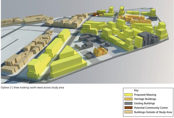
Officer
Comment:
96. The
proposal is generally consistent with the massing model under Option 2,
providing suitable setbacks to the south and west on levels 4 and above, but
providing a strong corner element to accentuate the entry to Kogarah Town
Centre and ‘bookend’ Regent Street rather than the stepped back
tower shown in Option 3.
97. The
proposal allows for future development in Regent Street to be designed with any
of the above 3 options without compromise and provides suitable solar access to
the school to the south. The proposal is considered an acceptable design
outcome for the site as an entry to the Precinct.
(iii) any
development control plan,
Kogarah
Development Control Plan 2013 (KDCP 2013)
98. The
proposed development is subject to the provisions of the Kogarah Development
Control Plan 2013 (KDCP2013). The following comments are made with respect to
the proposal satisfying the objectives and controls contained within the DCP.
Commercial
Localities - Kogarah North B
99. The
site comprises the amalgamated allotments known as the Kogarah North B group of
commercially zoned lots on the corner of Regent Street and Princes Highway.
Height
100. The
maximum number of levels specified in the locality is 6 + mezzanine (7 levels
in total), with the objectives providing for a four (4) storey street wall
height along the Princes Highway frontage. The maximum overall height (to the
uppermost habitable part of the building) is 22.5m.
101. The
proposal does not comply with the existing height requirements, having been
lodged with a view to assessment under the provisions of the New City Plan. The
proposal is directly south of the 10 storey residential flat building opposite
Regent Street from the site (21 Princes Highway) and generally compliant with
the New City Plan height provisions. Given the draft height provisions, corner
location, and the site’s function as a gateway to the Kogarah Town
Centre. The proposed height and massing is acceptable on merit and in line with
the recently amended KLEP 2012.
Preferred Land
Uses
102. The
proposal provides a commercial or retail ground floor tenancy and residential
on the upper levels, satisfying the preferred land uses for the locality.
Amalgamations
103. The
proposal satisfies the requirement that all lots are to be amalgamated in
accordance with the following diagram.
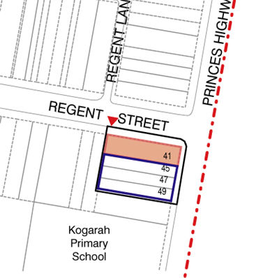
Setbacks
104. The
following setbacks apply to Princes Highway:
· Ground
floor - Build to Boundary
· First
floor - if commercial build to boundary or Residential – minimum 3m.
However buildings should be massed up to the full two storey height at
the street frontage.
· Second
and Third floor - Residential and/or Commercial – minimum 3m. The 3m may
include balconies, which should appear as a solid element.
· Fourth
floor - Minimum 4m, which may include balconies
· Fifth
floor + mezzanine - 4m. This setback may include balconies on the fifth floor
but not at the Mezzanine.
105. To
Princes Highway the proposal provides a 1m setback on the ground floor to
provide pedestrian access to the commercial tenancy at both Highway and Regent
Street frontages whilst dealing with the level changes. Levels 1-4 above are
setback 1.28m with levels 5-9 being aligned to the boundary. Whilst not
satisfying the setbacks numerically, the proposal provides a meritorious design
approach with a view to the provisions of the New City Plan and strategies of
the Interim Design Guidelines that strongly demarcates the entry to the
northern end of the Kogarah Town Centre.
106. To
97 Regent Street (west) the following setbacks apply:
· Ground
floor – minimum 7m, providing for either open space or vehicular access
to the development.
· First
Floor – minimum 6m.
· Second
to fourth floors – 9m but this area may include balconies that are
designed to minimise overlooking.
· Fifth
floor + mezzanine – minimum 11m with no balconies to the mezzanine.
107. The
proposal does not satisfy DCP requirements to the western boundary. Instead the
proposal has been designed in consultation with Council having regard to the
Kogarah North Precinct: (Draft) Interim Design and Development Guidelines and
built form studies. The proposal provides a suitable 4 storey podium level to
the boundary with the remaining upper floors setback 9m which comply with the
ADG to up to level 10, which the ADG recommends a setback of 12m. A 12m
setback to level 10 is not considered necessary as it creates an extra step in
the building, detracting from its form and proportions. There is no significant
benefit such as solar access that would result from implementing an additional
3m setback to the top floor.
108. The
following setbacks to Regent Street apply:
· Ground
floor - Build to Boundary
· First
floor level - Residential - minimum 3m. This setback may include balconies.
Buildings should be massed up to the full two storey height at the street
corner to provide a consistent street wall edge and continuous corner.
· Second
and third floors – minimum 1m, with punctuations in the façade to
provide variation.
· Fourth
floor – minimum 3m. This setback may include balconies.
· Fifth
floor + mezzanine – minimum 4m.
109. The
proposal does not satisfy setback requirements in the DCP to Regent Street. The
proposal adopts a ground floor setback of 0 - 2.5m, with floors 1-3 aligned to
the street boundary at the balconies and façade. Levels above are street
boundary aligned 15m from the corner, setback 0.9m for a length of 3.8m and
setback 2m for the remaining 10m length. The proposed setbacks are consistent
with the desired form set out in the Kogarah North Precinct: (Draft) Interim
Design and Development Guidelines and Built Form Studies. The proposed
presentation to Regent Street is considered an acceptable setback outcome.
110. No
numerical setbacks are specified to the southern boundary (adjoining Kogarah
Public School) with the exception of a 3m/6.3m/4m setback shown in the
following diagram for setbacks to levels 2 and 3.
111. To
the south, the proposed development is boundary aligned only partially for the
lower 4 levels, with upper levels setback 5.08m for a length of 14.8m from the
Princes Highway boundary and 7.9m for the remainder of the building (comprising
the fire stair).
112. As
illustrated in the diagram below on the Princes Highway 3D perspective, the
area outlined in red shows the nonconforming element of the southern elevation.
The green line approximates the 9m ADG setback. As the mass is pushed forward
onto the highway, there is minimal impact on adjoining properties in terms of
visual or overshadowing impacts. If the building was setback to adopt the ADG
guideline there may be a minor reduction in building bulk as seen from the
Princes Highway approach to the site, though this is not considered significant
to warrant further modification or refusal in this instance. The proposal
adopts a building mass and form that is generally consistent with the Kogarah
North Precinct: (Draft) Interim Design and Development Guidelines and Built
Form Studies and is supported. In terms of aesthetics, the proposal as designed
is better balanced, proportionately, than cutting off the side to satisfy a
numerical guideline, resulting in a building that is ‘off-balance’
in appearance. Its location adjoining the front part of the school playground
confers some leniency in the application of the separation guideline, given the
school extends over a large site area and acceptable solar access is provided
thereto.
Density
113. There
are no density requirements in the locality controls apart from fitting in the
required setbacks. Instead the proposal has been designed in consultation with
Council having regard to the Kogarah North Precinct: (Draft) Interim Design and
Development Guidelines and built form studies.
114. The
proposal has been designed to meet the setbacks of the ADG, draft Planning
Principles for Kogarah North and the FSR in the New City Plan. The proposal is
considered to respond appropriately to the desired form in terms of bulk and
massing for the site and context.
Open Space
115. The
general requirements for open space and landscaping in Part D1 of KDCP 2013
include the following controls:
· Retain
existing, and incorporate new indigenous trees, shrubs and ground cover where
appropriate.
· Maximise
deep soil zones to provide for substantial landscaping and mature trees.
· Submit
a landscape plan prepared by a qualified landscape architect.
· Where
development is proposed adjacent to low density residential development, an
appropriate landscape buffer is to be planted to provide separation and
screening between the proposed development and the existing low density
development (Refer to Locality Controls).
· These
areas should be deep soil areas so as to allow for the planting of large/medium
trees.
116. The
proposal provides 28% of the site area as usable communal open space over two
open space areas that comply with the minimum ADG requirement of 25%.
117. The
communal area on Level 1 is on the southern side of the building, receiving
little solar access, though the communal area on Level 8 is on the top of the
building and north and west facing, receiving full sun.
Vehicular
access, Parking and Circulation
118. The
proposal complies with the requirement that vehicular access is provided off
Regent Street.
119. Based
on the amended plans comprising 203m² of commercial floor space, 11 x
studios and 18 x one bedroom apartments, 23 x two bedroom apartments and 3 x
four bedroom apartments KDCP 2013 requires the proposal to provide the
following parking:
· Five (5)
commercial spaces
· Seventy three (73)
residential spaces
· Eleven (11)
visitor spaces
120. The
proposal provides a total of sixty four (64) spaces, comprising six (6)
commercial spaces, fifty (50) residential spaces and eight (8) visitor spaces.
121. However,
it is noted that part B4 of KDCP 2013 does not provide parking rates for
studios and whilst these have been considered as part of the one bedroom units
in the above calculation of resident parking requirements, it is reasonable to
provide parking at a rate of no parking or parking for only a proportion of
studios. In any case, the provisions of Part 3J of the Apartment Design Guide
apply as discussed below.
122. Under
Part 3J of The Apartment Design Guide, the proposal may rely on the lesser parking
provisions in RMS “Guide to Traffic Generating Developments”
as site is within 800m of a railway station and is within 400m of land zoned
B4.
123. Council’s
Traffic Engineer provided the comments in response to the originally submitted
plans, with respect to traffic and parking issues. The development statistics
contained in the comments related to the original proposal:
In regards to
the proposed mixed use building at the
above location, I make the following comments in
relation to the “Traffic and Parking Assessment Report” by
Terraffic Pty Ltd dated 1 September 2016:
· The development
proposes the demolition of the existing premises and construction of a new
mixed use building containing 217m² of commercial floor space on the
ground level and 51 residential units on the upper levels (15 x studios, 4 x 1
bedroom units, 29 x 2 bedroom units and 3 x 3 bedroom
units).
· The site is
located approximately 500m walking distance to Kogarah Train Station and bus interchange
124. Whilst
the total number of units has increased in the amended plans from 51 to 55
units, the number and proportion of studio and one-bedroom apartments have
increased from 19 to 29 and the development was in surplus. By way of
clarification, the site is approximately 450m to Kogarah Station, not 500m.
Parking
Assessment
· The Apartment
Design Guide 2015, Objective 3J-1, states that the minimum requirements for
residents and visitors is set out in the “Guide to Traffic Generating
Developments”, or the car parking requirement prescribed by the relevant
Council, whichever is less.
· As Kogarah is
classified as a Strategic Centre, it falls under the RMS category as a
Metropolitan regional centre (CBD). The RMS “Guide to Traffic Generating
Developments” document calculates the parking requirement for a High
Density Residential Flat building in the CBD as 39 spaces
(0.4x19+0.7x29+1.2x3+7).
· Therefore the
residential component requires 32 units spaces and 7 visitor spaces as this is
the lesser requirement. The development has proposed 51 residential
spaces and 10 visitor spaces and is deemed acceptable. There are 6
commercial spaces proposed in accordance with the DCP and a loading bay for a
SRV which is also acceptable. Out of business hours the 6 commercial spaces
could be used by visitors.
Traffic
Generation:
· Based on the
RMS “Guide to Traffic Generating Developments”, the site is
classified as a High Density Residential Flat building and will generate a
residential traffic rate of 0.19 AM peak hour vehicle trips per unit and 0.15
PM peak hour vehicle trips per unit. The office blocks will generate a
traffic rate of 1.6 AM vehicle trips per 100m² and 1.2 PM vehicle trips
per 100m².
· Therefore the
residential component of the development is projected to generate 10 (51 x
0.19) vtph in the AM and 8 (51 x 0.15) vtph in the PM.
· The commercial
component of the development is projected to generate 4 (1.6 x 2.17) vtph in
the AM and 3 (1.2 x 2.17) vtph in the PM.
· The total
overall traffic generation of the development is projected to generate 14 (10 +
4) vtph in the AM and 11 (8 + 3) vtph in the PM.
· As the existing
site currently generates 3 vtph in the AM and 7 vtph in the PM, overall the
proposal will generate an additional 11 (14 – 3) vtph in the AM and 4 (11
– 7) vtph in the PM which is an acceptable increase to the surrounding
street network and will not have a significant impact.
Summary
· The Traffic Section can APPROVE the DA based on the
acceptable parking allocation numbers and projected traffic generation.
Notes
· As the
development has proposed a commercial component as part of the mixed use on the
site, the parking numbers and traffic generations rates are a lot less than if
it was proposed as retail. It is for this reason that the change of use from
commercial to retail within this development is not supported as there will be
a spill-over of parking onto the street network and there will be considerably
more traffic movements in the AM and PM peak periods.
· The change of
use from commercial to retail would also result in the Loading Zone not being
compliant with the design requirements of “AS/NZS
2890.2:2002 - Off Street Commercial Vehicle Facilities”.
125. Council’s
Traffic Engineer has provided parking requirements per the provisions of the
RMS “Guide to Traffic Generating Developments” given above, with
which the proposal complies.
126. The
proposed development satisfies Council and ADG requirements for traffic and
parking and is supported.
Privacy
127. No
issues are raised with respect to privacy as the proposal orients blank walls
to the adjoining residential property at 97 Regent Street.
128. The
proposal generally mitigates overlooking from the playground of Kogarah Public
School to the south. The studio apartments (U201 and 301) on the second and
third floors overlook the north eastern corner of the school playground.
Solar Access
129. The
proposal as amended overshadows the playground of Kogarah Public school, with
minimal overshadowing of the adjoining property at 97 Regent St at 9am.
Overshadowing of Kogarah Public school is most significant at 9am as indicated
in the diagram below, with the shadow moving throughout the day on June 21 to
the eastern frontage of the school and away from the main playground area. At
3pm the majority of shadow is cast over Princes Highway.
130. The
proposed development complies with the requirement that adjoining neighbours
receive at least 3 hours of direct sunlight per day to principal open space
between 9am and 3pm on June 21.
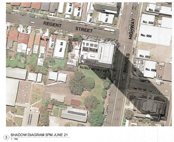
Views and View
Sharing
131. No
issues are raised with respect to views.
Kogarah
Development Control Plan 2013 Compliance Table
132. The
following table outlines the proposals compliance with the primary controls
contained within KDCP 2013.
|
Design Outcome
|
Control
|
Proposed
|
Complies
|
|
KLEP 2012
|
|
Density (FSR)
|
4:1 (4240m²)
|
3.99:1 (4237m²)
|
Yes
|
|
Height
|
33m
|
34m
|
No
|
|
KDCP 2013
|
|
Parking
Resident
Visitor
Commercial
(total)
|
73
11
5
|
50
8
6
|
Yes (complies with Part 3J of ADG
|
|
Loading Bay
|
One bay
required if retail use specified.
Not required if
commercial (with floor area <1000m²)
3.5m x 9.5m
|
Commercial
floor space. One (1) provided with dimensions 7.5m x 3m
|
Yes
|
|
Setbacks
Princes Highway
Regent Street
West (97 Regent St)
South (school)
|
0 - 4m
0 – 4m
7 – 11m
3 – 6.3m
|
0m
0 – 2m
0 – 9m
0 – 7.9m
|
No
No
No
No
|
|
Apartment Design Guide
|
|
Side Separation (west)
Blank Party
Walls
(levels 1-3)
Habitable Rooms
(levels 4-9)
Habitable Rooms
(level 10)
|
0m
9m
12m
|
0m
9m
9m
|
Yes
Yes
No
|
|
Side Separation (south)
Blank Party
Walls
(levels 1-4)
Habitable Rooms
(levels 4-9)
Habitable Rooms
(level 10)
|
0m
9m
12m
|
0m
5.08 – 7.9m
5.08 – 7.9m
|
Yes
No
No
|
|
Min. Apartment Sizes
Studio
1 br
2 br
3 br
|
35m²
50m²
75m² (incl. ensuite)
90m²
|
40m²
50m²
>85m²
92m²
|
Yes
Yes
Yes
Yes
|
|
Min Living Area Width
Studio /1 br
2 br / 3 br
|
3.6m
4m
|
3.8m
>4m
|
Yes
Yes
|
|
Balcony size
|
10m² for 2-bedroom
8m² for 1-bedroom
4m² for studios
|
>10m
8m²
4m²
|
Yes
Yes
Yes
|
|
Communal Open Space
|
25% of site area (256m²)
|
28%
(286.8m²)
|
Yes
|
Section 94 Contributions
133. The
proposed development requires payment of $670,838.19 in Section 94
contributions based on the provisions of Kogarah Section 94 Contributions Plan
No.1 – Road and Traffic Management, Kogarah Section 94 Contributions Plan
No.8 – Kogarah Town Centre, and Section 94 Contributions Plan No.9
– Kogarah Libraries.
134. The
contribution amount is based on 29 x 1 bedroom units, 23 x 2-bedroom units and
3 x 3 bedroom units.
135. Concession
is given for existing development on the site as follows:
Residential -
43-47 Princes Highway
2 x 2 Bedroom
Flats
Residential - 41
Princes Highway
4 x 2 Bedroom
Units
Commercial
– 43-47 Princes Highway, 3 x Retail Shops
Cakes Come True
– Shop is 20 sqm
Everest Tandoori
– Shop is 187.95 sqm
A2Z Communications
- Shop is 130 sqm
(iv) any
matters prescribed by the regulations, that apply to the land to which the
development application relates,
136. Not
applicable.
(b)
the likely impacts of that development, including environmental impacts
on both the natural and built environments, and social and economic impacts in
the locality,
137. The
proposed development is of a scale and character that is in keeping with other
dwellings being constructed in the locality. Accordingly, the proposal is not
considered to have a significant impact on the natural and built environment of
the locality.
(c) the
suitability of the site for the development,
138. It
is considered that the proposed development is of a scale and design that is
suitable for the site having regard to its size and shape, its topography,
vegetation and relationship to adjoining developments.
(d) any
submissions made in accordance with this Act or the regulations,
139. In
accordance with the provisions of Section A2 – Public Notification of
KDCP 2013 application was placed on neighbour notification for a period of
fourteen (14) days adjoining property owners were notified in writing of the
proposal and invited to comment. No submissions were received.
(e) the
public interest.
140. The
proposed development is of a scale and character that does not conflict with
the public interest.
Conclusion
141. The
application has been assessed having regard to the Heads of Consideration under
Section 79C of the Environmental Planning and Assessment Act 1979, the
provisions of KLEP 2012 and KDCP 2013.
142. Following
detailed assessment it is considered that Development Application No 183/2016
should be approved subject to conditions.
DETERMINATION
That Council as
the Consent Authority pursuant to Section 80(1)(a) Environmental
Planning and Assessment Act 1979, grant consent to Development Application No
183/2016 for the Demolition of existing buildings and construction of a ten
(10) storey mixed use development consisting of ground floor commercial tenancy
and fifty one (51) residential apartments with basement car parking at No 45
Princes Highway Kogarah subject to conditions:
SPECIFIC
DEVELOPMENT CONDITIONS
SECTION A - General Conditions
The conditions
that follow in this Section A of the Notice of Determination are general
conditions which are imposed to ensure that the development is carried out in
accordance with the development consent.
(1) Approved
Plans of Consent
The development
must be implemented in accordance with the approved plans, specifications and
details listed below and any supporting information submitted with the
Development Application except as amended by any conditions attached to the
Development Consent:
(i) Architectural
plans – prepared by Michael Kitmiridis Architect, Project No. 141101,
Drawing nos. DA100, DA101, DA102, DA103, DA104, DA105, DA106, DA107, DA108,
DA109, DA110, DA111, DA117 Issue D, dated April 2017.
(ii) Landscape
plans – prepared by RFA Landscape Architects, Drawing No. L-01/2, L-02/2,
Issue B, dated 06/04/17.
(iii) Stormwater
plans – prepared by John Romanous & Associates Pty Ltd, Drawing No.
1741 – S1/5, S2/5, S3/5 S4/5, S5/5, Rev.B, dated 05/09/2016.
SECTION B –Prior to the Issue of a
Construction Certificate or Demolition Conditions
The conditions
that follow in this Section B of the Notice of Determination relate to the
payment of fees, amendments being made to the proposal, further investigation
being undertaken or the preparation of documentation that must be complied with
prior to the issue of a Construction Certificate or Demolition.
Note: A
copy of the Construction Certificate shall be forwarded to Council prior to
commencement of construction where Council is not the certifier who issued the
Construction Certificate.
(2) Asset &
Building Fees
Payment of the
following amounts as detailed below:
· Restoration
Deposit of $30,240.00
· *Builders
Long Service Levy of $58,482.00
· Driveway and
Restoration Works Design Inspection Fee of $
800.00
· Asset
Inspection Fee of $
110.00
*Note: The
Builders Long Service Levy quoted is based on the market value of the proposed
building works and the Levy Rate applicable at the time of assessing the
Development Application and may be subject to change prior to payment.
(3) Restoration
Deposit
A
deposit of $30,240.00 shall be lodged with Council to ensure the
construction of the following works to be completed at the applicant's expense:
§ Construction of a new concrete kerb and gutter across the full
street frontage in Regent Street.
§ Installation
of turf as required across the full street frontage in Regent Street.
§ All
associated road pavement restorations.
These
works are to be in accordance with plans and specifications to be issued by
Council.
(4) Section 94
Index
Section 94
Contributions are to be paid as detailed below in the following condition, and
until paid all contributions will be indexed four (4) times a year (on the
following dates) to allow for the cost increases: 31 January, 30 April, 31 July
and 31 October.
(5) Section 94
Contributions
As at the date of
Development Consent the following contributions have been levied on the subject
development under Section 94 of the Environmental Planning and Assessment Act,
1979 and the nominated Section 94 Contributions Plans:
|
No.1 –
Roads and Traffic Management – Residential
|
$
2,086.66
|
|
No.5 –
Open Space 2007
|
$627,337.93
|
|
No.8 –
Kogarah Town Centre – Traffic Facilities
|
$
12,449.47
|
|
No.8 –
Kogarah Town Centre – Community Facilities
|
$
11,203.89
|
|
No.9 –
Kogarah Libraries – Buildings
|
$
10,367.77
|
|
No.9 –
Kogarah Libraries – Books
|
$
7,392.47
|
|
TOTAL
|
$670,838.19
|
Any of the above
Section 94 Contributions Plans may be inspected at the Georges River Council
Customer Service Centres.
(6) Dilapidation
Report
Prior to issue of
any construction certificate or commencement of any demolition or earth works
on site, the applicant shall submit, for acceptance by the Principal Certifying
Authority (PCA), with a copy forwarded to Council where Council is not the PCA,
a full dilapidation report on the visible and structural condition of the
following properties;
(i) All
neighbouring buildings likely to be affected by the excavation as determined by
the consulting engineer.
The report must be
completed by a suitably qualified consulting structural/ geotechnical engineer
as determined necessary by that professional based on the excavations for the
proposal, the subsoil conditions and any recommendations of a geotechnical
report for the site. The report shall have regard to protecting the applicant
from spurious claims for structural damage and shall be verified by all
stakeholders as far as practicable.”
Reports relating
to properties that refuse access to carry out inspections to complete the dilapidation
report, after being given reasonable written notice to request access (at least
14 days) at a reasonable time (8.00am-6.00pm), are not to hold up the release
of the Construction Certificate.
(7) Soil and
Water Management
A Soil and Water
Management Control Plan, incorporating contour levels and prepared in
accordance with Environmental Site Management Policy shall be submitted to
Council detailing all measures to control soil erosion and sedimentation runoff
from the site during excavation and construction activities.
(8) SEPP No 65
Certification
A design verification statement from a qualified designer shall be
submitted that verifying that the plans and specifications achieve the design
quality of the development for which consent was granted having regard to the
design quality principles of State Environmental Planning Policy No. 65.
(9) Adaptable
Housing Compliance
The proposed development including the four (4) nominated adaptable units
shall comply with the adaptable housing provisions of AS4299 – Adaptable
Housing and AS1498 – Access and Mobility (Parts 1 and 2). The Adaptable
Housing checklist and circulation diagram demonstrating compliance shall be
submitted.
(10) Ausgrid Sub Station
The applicant is
to confer with Ausgrid to determine if an electricity distribution substation
is required. If so, shall be incorporated within the Construction Certificate
and it will be necessary for the final film survey plan to be endorsed with an
area having dimensions 5m x 4m over the location of the proposed electricity
distribution substation to be dedicated to Council as public roadway, or as
otherwise agreed with Ausgrid. Ausgrid’s requirements are to be met prior
to release of the occupation certificate.
(11) Clearances to Overhead
Mains
If any part of the
proposed structure, within 5m of a street frontage, is higher than 3m above
footway level, the applicant is to confer with Ausgrid to determine if
satisfactory clearances to any existing overhead mains will be affected. If so,
the applicant is to make arrangements with Ausgrid for any necessary
modification to the electrical network in question.
These works to be
at the applicant’s expense and Ausgrid’s requirements are to be met
prior to actual construction commencing on site or as agreed with Ausgrid.
(12) Sydney Water (DA Only)
The approved plans
must be processed through Sydney Water to determine whether the development
will affect any Sydney Water asset’s (sewer and water mains, stormwater
drains and/or easements) and if any further requirements need to be met.
An approval receipt will be issued by Sydney Water which is to be submitted to
Council or the Principal Certifying Authority.
Please refer to
the web site www.sydneywater.com.au
for;
· Sydney Water Tap
in – see Plumbing, building and developing and then Sydney Water Tap in;
and
· Building
over/adjacent to a Sydney Water Asset - see Plumbing, building and developing,
building then Building Approvals or telephone 13 20 92.
(13) Vehicular and
Pedestrian Management Plan - Demolition and Construction
Prior to the issue
of any construction certificate, any demolition or earthworks on the site, the
applicant shall submit to Council for approval a “Management
Plan” detailing the following to safely manage vehicular and pedestrian
traffic during the works at the site:
§ Traffic Control Plans and details
of how the company proposes to place, erect, dismantle and/or undertake the
works at the site.
§ All works on the road or road
related areas are to be clearly delineated and designed in accordance with the
relevant standards, refer to “AS 1742.3 – 2009” and the Roads
and Maritime Services “Traffic Control at Worksites (TCAWS) Manual,
Version 4.0, 2010”
§ The Traffic Control Plans and the works
must be prepared/undertaken by RMS accredited (ticketed) personnel.
§ Where heavy vehicles associated
with the site will be parked whilst waiting to enter the site.
§ Location of loading and unloading
areas for trucks.
§ The route of all trucks conveying
materials to and from the site.
Demonstration that
pedestrian access past the site is maintained during demolition and
construction works.
(14) Creation of Voids to
Circulation Areas
The storage areas
between the bedrooms and breezeways to Units U208, U209, U308, U309, U405,
U309, U505, U605, U705 U805 and U903 are to be deleted and voids inserted to
improve access to light and ventilation to those units with windows facing that
breezeway. A void above storage space U309ST is to be created corresponding to
the required voids below by inserting a void in the landscape planter. Solid
walls surrounding the voids are to be replaced with frosted glass balustrades
with a height of 1.6m.
(15) Certification of
Detailed Plan
The detailed
stormwater plan is to be certified by a Chartered Professional Engineer.
A statement, that the stormwater system has been designed in accordance with
Council’s Water Management Policy and satisfies the provisions and
objectives of that policy, must be included in the Stormwater Detailed Plan.
(16) On-Site Detention
A 32.3m3
On-Site Detention system with a Maximum Site Discharge of 17.9 Litres per
Second is to be provided in accordance with the Stormwater Concept Plan and
associated Design Assessment Report. The overflow is to be directed to the site
drainage system.
(17) Detailed Stormwater
Plan
The submitted
stormwater plan has been assessed and approved as a concept plan only. No
detailed assessment of the design has been undertaken. A Detailed Stormwater
Plan and supporting information of the proposed on-site stormwater management
system is to be submitted. The required details in this Plan and the relevant
checklist are presented in Council’s Water Management Policy.
The design
parameters and the general concept of the proposed on-site stormwater
management system are to be the same as documented in the approved Concept
Stormwater Plan for the proposed development. Any conceptual variations to the
stormwater design will require written approval from Council and will require
to be justified and supported by appropriate details, calculations and information
to allow for proper assessment.
The Detailed
Stormwater Plan is to address the following issue(s):
a) The amended stormwater plan will need to
include a longitudinal section of the proposed connection pipe from the
property boundary to the proposed connection to the stormwater pit on The
Princes Highway. This section is to include accurate locations, depths and
sizes of all underground services in the vicinity to ensure that connection by
gravity fall to the stormwater system can be made.
A suitably
qualified engineer is to certify that appropriate design measures have been
taken to ensure that the basement and ground floor levels are protected from
flooding in the case of the On-site Detention system malfunctioning.
SECTION C – Prior to Commencement of Construction
Conditions
The conditions
that follow in this Section C of the Notice of Determination are specific to
the proposed development and must be complied with prior to the commencement of
construction on the site.
(18) Geotechnical Report
Excavation of the
site is to extend only to that area required for building works depicted upon
the approved plans. All excess excavated material shall be removed from the
site. In this regard, all excavated waste materials shall be disposed of
at an approved Waste Depot.
No rock breaking
or other machinery for the excavation, drilling, cutting or removal of rock
shall be used on the site prior to the acceptance by the principal certifying
authority of the following documentation:
(i) A
report by a geotechnical engineer detailing the measures recommended in
undertaking the works so as to prevent damage to any adjoining or nearby
buildings.
(ii) The
type and size of machinery proposed.
(iii) The
routes of all trucks to convey material to and from the site.
(19) Certification by
Mechanical Engineer
To ensure that
adequate provision is made for ventilation of the building, mechanical and /or
natural ventilation shall be provided. These systems shall be designed in
accordance with the provisions of:-
a) The
Building Code of Australia;
b) Australian
Standard AS 1668 Part 1 - 1998;
c) Australian
Standard AS 1668 Part 2 - 2002;
d) The
Public Health Act 2010;
e) The
Public Health Regulation 2012;
f) Australian
Standard 3666.1 - 2002;
g) Australian
Standard 3666.2 - 2002;
h) Australian
Standard 3666.3 - 2000.
Details of all
mechanical and /or natural ventilation systems, along with specific
certification, provided by an appropriately qualified person, verifying
compliance with the abovementioned requirements.
(20) Structural
Engineer’s Details
Engineer's details
prepared by a practising Structural Engineer being used to construct all
reinforced concrete work, structural beams, columns & other structural
members. The details are to be submitted to the Principal Certifying
Authority for approval prior to construction of the specified works.
A copy shall be
forwarded to Council where Council is not the PCA.
(21) Protection of Site
– Hoarding
A hoarding or
fence must be erected between the work site and the public place if:
· the work involved
in the erection or demolition of a building is likely to cause obstruction or
inconvenience to pedestrian or vehicular traffic in a public place; or
· if it involves the
enclosure of a public place.
If necessary an
awning is to be erected which is sufficient to prevent any substance from or in
connection with the work from falling into a public place.
Any such hoarding,
fence or awning is to be removed when the work has been completed.
If the work site
is likely to be hazardous to persons in a public place, it must be kept lit
between sunset and sunrise.
(22) Ground Anchors
Should the
proposed development require the installation of ground anchors to a road
reserve the following must be complied with:
· The appropriate
Roads Act 1993 approvals shall be obtained.
· The anchoring is
to be de-stressed once no longer required.
· The work is to be
clear of all services contained within the public roadway and the required dial
before you dig investigations are to be undertaken in relation to any services
that may be in the proposed anchor locations.
· Public liability
insurances being held by the builder/ developer with a copy being submitted to
Council.
· A
works-as-executed plan showing the exact location of all anchoring points being
submitted to Council upon their installation.
It
is to be noted that if anchoring into adjacent private properties is required
any such approval would need to be obtained from the owners of this property.
(23) Driveway
In
respect to vehicular access to the proposed development the gutter crossing and
driveway are to be reconstructed between the kerb and street alignment to
Council’s specifications.
In
this regard a separate driveway application is to be lodged with Council for works
outside the property boundary. Furthermore the design boundary level is
to be received from Council prior to construction of the internal driveway.
(24) Council Infrastructure
Inspection
Prior
to the commencement of any works an authorised representative of the applicant
is to organise and attend a meeting on site with Council’s Infrastructure
Compliance Co-ordinator to discuss protection of Council’s
infrastructure. To organise this meeting contact Council’s Customer
Service Centre on 9330 6400.
(25) Public Liability
Insurance
All nominated
contractors / applicants carrying out driveway and/or restoration works on
Council property must carry public liability insurance with a minimum cover of
twenty million dollars ($20,000,000.00). In this regard, prior to commencement
of works, the principal contractor is to lodge an “Application for the
Construction of Work by Private Contractor” to Council, which includes
submitting evidence of their current insurance. The principal contractor must
ensure that sub-contractors are also adequately insured.
(26) Soil Erosion Controls
Prior to
commencement of any site works, erosion and sediment controls are to be
installed in accordance with Environmental Site Management Policy and any
approved Soil & Water Management Plan and shall incorporate:
· Measures to
prevent sediment and other debris escaping from the cleared or disturbed areas
into drainage systems or waterways;
· Controls to
prevent tracking of sand, soil, aggregates, etc, by vehicles onto adjoining
roadways.
(10) Roads and Maritime
Services Approval - Discharge Stormwater to Princes Highway
The proposal is
designed to discharge to the stormwater network on The Princes Highway. Prior
to development consent the applicant is required to gain approval from the
Roads and Maritime Services with regard to this drainage and connection works
and comply with all their requirements. This approval and all related plans and
correspondence are to be forwarded to Council.
SECTION D – Construction and Operational
Conditions
The conditions
that follow in this Section D of the Notice of Determination are imposed to
ensure the development is constructed and operates having regard to relevant
legislation and does not unreasonably impact on the amenity of the locality or
environment during the construction phase or the operation of the use.
(27) Inspections -Multi Unit
The following
lists of inspections are the MANDATORY CRITICAL STAGE
INSPECTIONS that MUST be carried out by the Principal Certifying
Authority (PCA).
(a) at
the commencement of building works
(b) prior to covering
waterproofing in any wet areas, for a minimum of 10% of rooms with wet areas
within a building, and
(c) prior
to covering any stormwater drainage connections, and
(d) after the building work has
been completed and prior to any occupation certificate being issued in relation
to the building.
Certificates
from your engineer or subcontractor are NOT acceptable in the first
instance for the above inspections. Failure to have your PCA carry out
these inspections could result in a delay or refusal to issue an Occupation
Certificate.
In
addition to the above, it is recommended that the following inspections be
carried out for the subject development;
Ž Erosion Control
Ž Earthworks/Excavation
Ž Building setout
Ž Concrete reinforcement
Ž Timber and/or steel framework
Ž Mechanical/Hydraulic work
Ž Driveways
Ž Landscaping
Ž External Finishes
(28) Storage of materials on
Public Road
All building
materials or waste containers must be stored within the confines of the
site. The storage of such building materials, waste containers or
equipment associated with the project upon the public roadway, including the
pedestrian footway or unpaved verge, is prohibited.
(29) Use of Crane on Public
Road
Prior approval
must be obtained from Council a minimum of 24 hours before the use on any site
of a crane, hoist or similar machinery that will be used to transfer materials
across Council’s footpath. This includes cranes that are situated
on roadways, footpaths and road reserves.
Any application
for approval must be accompanied by the following information:-
· Site sketch
indicating the proposed location of the crane, pedestrian controls and traffic
controls;
· A copy of current
public liability insurance with minimum cover of twenty million dollars
($20,000,000) indemnifying Council in the event of an incident;
· A copy of an RMS
accredited traffic control plan;
· Proof that the
local area command of the NSW Police have been advised of the proposal.
The use of a
crane, hoist or similar machinery on any site without prior approval is
prohibited.
(30) Building Height -
Surveyors Certificate
The proposed
building is not to be erected at a height greater than that indicated on the
approved plan. A certificate from a Registered Surveyor verifying the
correct Reduced Level of the ground floor slab and boundary clearances shall be
submitted prior to inspection of the steel reinforcement.
(31) Excavation of Site
Excavation of the
site is to extend only to that area required for building works depicted upon
the approved plans. All excess excavated material shall be removed from
the site. In this regard, all excavated waste materials shall be disposed
of at an approved Waste Depot (details are available from Council).
All excavations
and backfilling associated with the erection or demolition of a building must
be executed safely and in accordance with appropriate professional standards.
All excavations
associated with the erection or demolition of a building must be properly
guarded and protected to prevent them from being dangerous to life or property.
If the soil
conditions require it, retaining walls associated with the erection or demolition
of a building or other approved methods of preventing movement of the soil
shall be provided and adequate provision shall be made for drainage.
(32) Stormwater to Kerb
Any
stormwater connections to the kerb and gutter are to be in accordance with Council's
'Specification for Construction by Private Contractors'.
(33) Redundant Driveway
All existing
vehicular crossings adjacent to the subject premises that have become redundant
shall be removed and the footway and kerb and gutter reinstated at the developer/applicants
expense.
(34) Work within Road
Reserve
A Development
Consent or any related Construction Certificate does not allow for the erection
of a structure or to carry out work in, on or over a public road. Should
a structure or work be required a separate approval under S138 of the Road Act
1993 must be granted by Council prior to the commencement of any works within
the road reserve. Applications may be made at Council’s Customer Service
Centre.
(35) Damage within Road
Reserve & Council Assets
The owner shall
bear the cost of restoring any footpath, roadway and any other Council assets
damaged due to works at, near or associated with the site. This may
include works by Public Utility Authorities in the course of providing services
to the site.
(36) Public Utility &
Telecommunication Assets
The owner shall
bear the cost of any relocation or modification required to any Public Utility
Authority assets including telecommunication lines & cables and restoring
any footpath, roadway and any other Council assets damaged due to works at,
near or associated with the site.
(37) Stormwater Drainage
All roof water and
surface water from paved or concreted areas being disposed of to the street
gutter by means of a sealed pipeline constructed in accordance with AS/NZS
3500.3.2. The line must pass through a silt arrestor pit, a standard
design is available within Council’s Water Management Policy.
(38) Garbage Room
The proposed
garbage room being provided with the following:-
a) A
smooth concrete floor graded and drained to a floor waste connected to the
sewer of the Water Board.
b) The
walls being cement rendered with the intersection of the walls and floor being
coved to a radius of not less than 25mm.
c) The
door being close fitting to prevent the access of rats and mice.
d) A
cold water hose cock being provided for the cleaning of containers and the room
itself.
e) Ventilation
being provided by means of direct connection to the outside air to the
satisfaction of Council.
f) A
sign, minimum size 600mm x 600mm, directing residents not to place recyclables
in garbage carts and encouraging residents to recycle. Details of an
acceptable wording for the sign are available from Council.
(39) Hours of Construction
Construction may
only be carried out between 7.00 am and 5.00 pm on Monday to Saturday and no
construction is to be carried out at any time on a Sunday or a public holiday.
(40) Restriction on Hours of
Excavation (other than single residential dwelling)
Despite the
general hours of construction above,
a) The
hours where rock breaking, cutting, hammering and drilling occur shall be
limited to 9:00am – 4:00pm on weekdays only.
b) A
noise management plan for the above works, prepared by a suitably qualified
acoustical practitioner in accordance with the Interim Noise Construction
Guidelines prepared by the Department of Environment & Climate Change NSW,
must be submitted to Council prior to commencement of any excavation works.
(41) Provision of Amenities
Toilet facilities
are to be provided, at or in the vicinity of the work site on which work
involved in the erection or demolition of a building is being carried out, at
the rate of one toilet for every 20 persons or part of 20 persons employed at
the site or as specified by Workcover requirements .
· each toilet
provided must be a standard flushing toilet and must be connected:
· to a public sewer;
or
· if connection to a
public sewer is not practicable, to an accredited sewage management facility
approved by the Council; or
· if connection to a
public sewer or an accredited sewage management facility is not practicable, to
some other sewage management facility approved by the Council.
The provision of
toilet facilities must be completed before any other work is commenced.
(42) Letter Boxes
Suitable letter
box facilities (including Owner's Corporation in the case of strata units)
shall be provided in accordance with Australia Post specifications.
(43) Oil/Silt Separator
An oil/silt separator sized to the catchment area must be specified on
the Stormwater Detailed Plans and located downstream of the proposed basement
car park and prior to discharge to councils stormwater system.
(44) Car Wash
To ensure that waste water is treated in an acceptable manner the car
wash bay shall be designed and constructed to ensure that waste water is
discharged to the sewer in accordance with the requirements of Sydney Water.
Evidence of a permit issued by Sydney Water shall be submitted.
(45) Basix Certificate
Details – DA Only
Construction of
building works given Development Consent must be carried out in accordance with
a valid and current BASIX certificate and all required commitments must be
satisfied.
(46) Air Conditioning /
Offensive Noise
Air conditioning
plant and equipment shall be installed and operated so as to not create an
offensive noise as defined under the Protection of the Environment Operations
Act 1997 and Protection of the Environment Operations (Noise Control)
Regulation 2008.
(47) Building Finishes
The building
finishes are to be constructed in accordance with the colour board and
perspective submitted with the Development Application.
(48) Allocation of Car
Parking Spaces
A minimum of off
street car parking spaces shall be constructed, drained, marked and maintained at
all times in accordance with the approved plans. These spaces shall be
allocated as follows:
a) Fifty
(50) residential spaces are to be allocated to the residential units.
b) Eight
(8) visitor spaces are to be allocated as visitor parking spaces.
c) Six
(6) commercial spaces are to be allocated to the retail/commercial units.
(49) Residential Car Parking
Spaces
A minimum of one
(1) unrestricted car parking space shall be allocated to each residential unit.
Where a three (3) or more bedroom residential unit is provided within the
development it is to be allocated two parking spaces in the first instance.
(50) Commercial/Retail
Parking Spaces
The required
commercial/retail car parking spaces shall be allocated evenly amongst the
commercial/retail units based on the gross floor area of each unit.
(51) Visitor Parking
A directional sign
shall be provided at the front of the site indicating the availability of
visitor and/or customer parking on site. Those visitor and/or customer
spaces shall be marked or signposted.
(52) Sydney Airports
Any temporary structure or construction equipment that exceeds the
approved height of the development may require approval from Sydney Airports
Corporation in accordance with the Civil Aviation (Buildings Control) Regulations
Statutory Rules 1988 No.161.
Note: Construction cranes may be required to operate at a height
significantly higher than that of the proposed control activity and
consequently, may not be approved under the Airports (Protection of Airspace)
Regulations.
(53) Loading/Unloading
Operations
Loading and
unloading operations shall be confined within the property and within any
defined loading areas indicated on the approved plans.
(54) Separate DA Consents
for Usage
Separate
Development Consents shall be obtained for the usage of each commercial tenancy
prior to occupation, where the use was not nominated as part of this
Development Application.
(55) Disposal of Stormwater
All roof water and
surface water from paved or concreted areas are to be disposed of in accordance
with the Stormwater Plan by means of a sealed pipeline constructed in
accordance with AS/NZS 3500.3:2015. The line must pass through a silt arrestor
pit.
(56) Street Tree Planting
The three (3)
street trees proposed along Regent Street shall be Cupaniopsis anacardioides
and be planted in accordance with Council requirements. The details for
tree species, size of tree and planting specification are in Council’s Street
Tree Management Strategy & Masterplan which can be found on
Council’s website.
(57) Approval from Traffic
Advisory Committee for Works Zone
The installation
of a "Works Zone" for the site will require the approval from the
Traffic Advisory Committee. As a result, the applicant shall provide a formal
request to Council's Traffic Section with the duration and exact location of
the required "Works Zone" at least 6 weeks prior to its required
installation date. All costs associated with the installation of a
“Works Zone” will be at the applicants expense.
(58) Road Closure
Application
A Road Closure
Application form and associated documents shall be submitted to Council for
approval at least 5 business days prior to any proposed lane usage for concrete
pours, cranes or other activities involved in the demolition, excavation and
construction on the site.
(59) A Road Occupancy Permit
– Roads and Maritime Services
A
Road Occupancy Permit / License shall be obtained from the Roads and Maritime
Services Transport Management Centre for any works that may impact on traffic
flow on the Princes Highway during demolition and construction at the site.
(60) Noise from road
To minimise the
impact of noise from the adjoining major road corridor on the occupants, the
construction certificate plans shall incorporate and the building be
constructed in accordance with the recommendations of the acoustic report
reference number 20161242.1/2508A/RO/EC by Acoustic Logic dated 25 August 2016
submitted as part of the development application.
(61) Avoid Annoyance from
lighting
Any lighting of
the premises shall be installed in accordance with Australian Standard AS
4282-1997: Control of the Obtrusive Effects of Outdoor Lighting so as to avoid
annoyance to the occupants of adjoining premises or glare to motorists on
nearby roads. Flashing, moving or intermittent lights or signs are prohibited.
The intensity, colour or hours of illumination of the lights shall be varied at
Council’s discretion if Council considers there to be adverse effects on
the amenity of the area.
(62) General Amenity
There shall be no
emissions or any other forms of pollutants from the premises, which will give
rise to an offence under the Protection of the Environment Operations Act
1997 and associated regulations.
(63) Car Wash Bay
To ensure that
waste water is treated in an acceptable manner the car wash bay shall be
designed and constructed to prevent water pollution, be discharged to the sewer
and must comply with any Sydney Water deemed process and/or trade wastewater
requirements.
(64) Air Conditioning /
Offensive Noise
Air conditioning
plant and equipment shall be installed and operated so as to not create an
offensive noise as defined under the Protection of the Environment
Operations Act 1997 and associated regulations.
SECTION E – Prior to Occupation or Subdivision Certificate
Conditions
The conditions
that follow in this Section E of the Notice of Determination relate to
conditions that ensure that the development is completed in accordance with the
requirements of the Development Consent prior to the issue of either an
Occupation Certificate or a Subdivision Certificate.
(65) Adaptable Housing
Certification
Certification
shall be provided by a person suitably accredited by the Association of
Consultants in Access Australia, verifying that the development has been
constructed in accordance with the requirements of AS4299 - Adaptable
Housing and AS1428 - Design for Access and Mobility and in
accordance with the report and checklist submitted with the Construction
Certificate.
(66) SEPP No 65
Certification
A design verification statement from a qualified designer shall be
submitted verifying that the development achieves the design quality of the
development as shown in the plans and specifications in respect of which the
construction certificate was issued, having regard to the design quality
principals of State Environmental Planning Policy No. 65.
(67) Completion of
Landscaping
Certification shall be provided from a suitably qualified and experienced
Landscape Designer or Landscape Architect. This Certification shall
verify that the landscape works have been completed in accordance with the
approved detailed landscape plan and relevant conditions of this consent.
Note: A
Landscape Designer is a person eligible for membership of the Australian
Institute of Landscape Designers and Managers and a Landscape Architect is a
person eligible for membership of the Australian Institute of Landscape
Architects as a Registered Landscape Architect.
(68) Consolidation of Lots
The lots covered
by this development consent shall be consolidated into one lot and proof of
registration of the consolidation shall be submitted to Council.
(69) Section 73 Compliance
Certificate
A Section 73
Compliance Certificate under the Sydney Water Act, 1994 must be obtained from
Sydney Water Corporation.
Application must
be made through an authorised Water Servicing Coordinator. Please refer
to the Building Developing and Plumbing section of the web site www.sydneywater.com.au
then refer to “Water Servicing Coordinator” under “Developing
Your Land” or telephone 13 20 92 for assistance.
Following
application a “Notice of Requirements” will advise of water and
sewer infrastructure to be built and charges to be paid. Please make
early contact with the Coordinator, since building of water / sewer
infrastructure can be time consuming and may impact on other services and
building, driveway or landscape design.
The Section 73
Certificate must be submitted to the Principal Certifying Authority.
(70) Stormwater Compliance
Certificate
A Stormwater
Compliance Certificate is to be obtained for the constructed on-site stormwater
management systems in conjunction with the works-as-executed drawings and the
final inspection. This Certificate is to be signed by an accredited hydraulic
engineer (preferably be the original design consultant) and submitted to the
Principal Certifying Authority. Copy of the standard Stormwater Compliance
Certificate is shown in Council’s Water Management Policy.
If the proposed
works involve Council owned stormwater infrastructure (or infrastructure to be
owned by Council), then the applicant should organise inspection with Council
and pay Council the appropriate inspection fee. Inspection is to be carried out
at the following specified stages:
· Prior to
backfilling of pipelines trenches.
· Prior to
backfilling of drainage connection to pipeline or channels.
· Prior
to casting pits and other concrete structures including kerb and gutter,
aprons, pathways, vehicular crossings, dish crossings and pathway steps.
(71) Positive Covenant
A Restriction on
Use of the land and Positive Covenant shall be created and registered on the
title of the property, which places the responsibility for the maintenance of
the on-site stormwater management system on the owner of the land. The terms of
the instrument are to be generally in accordance with the Council’s
standard terms and conditions for Restriction on Use of the land and Positive
Covenant shown in Council’s Water Management Policy.
(72) Maintenance Schedule
A Maintenance
Schedule for the proposed on-site stormwater management measures is to be
prepared and submitted. The Maintenance Schedule shall outline the required
maintenance works, how and when these will be done and who will be carrying out
these maintenance works.
(73) Fire Safety Schedule
Certain items of
equipment or forms of construction shall be nominated as "fire safety
measures" within the building.
Upon completion of
works, and before occupation of the building, each of the fire safety measures
is required to be certified by an appropriately competent person (chosen by the
owner of the building). The certificate is to state that the measure was
inspected and found to be designed, installed and capable of operating to a
standard not less than that required by the relevant regulations.
Further, it is the
responsibility of the owner of the building that each fire safety measure is
again inspected and certified as to its condition every twelve (12) months
following the submission to Council of the original certification.
(74) BASIX Completion
Receipt
In accordance with
clause 154C of the Environmental Planning and Assessment Regulation 2000, prior
to issuing a final occupation certificate the certifying authority must apply
to the Director-General for a BASIX completion receipt.
(75) Acoustic Validation
– Infrastructure SEPP
Prior to
interim/final occupation certification an acoustic validation report prepared
by a suitably qualified and experienced acoustic consultant shall be submitted
to the Principal Certifying Authority (PCA) certifying that the development
complies with the requirements of development consent and recommendations of
the acoustic report reference number 20161242.1/2508A/RO/EC by Acoustic Logic
dated 25 August 2016. The report shall include post construction
validation assessment results to ensure that the development complies with the Protection
of Environment Operations Act 1997, Protection of Environment Operations
(Noise Control) Regulation 2008, NSW EPA’s Industrial Noise Policy,
State Environmental Planning Policy (Infrastructure) 2007, and relevant state
and local policies and guidelines.
SECTION F
– Prescribed Conditions
The following are prescribed conditions of development consent pursuant
to s.80A(11) of the Environmental Planning and Assessment Act 1979 and cl.98 of
the Environmental Planning and Assessment Regulation 2000.
(76) Compliance with the
Building Code of Australia
The development must be carried out in accordance with the provisions of
the Building Code of Australia.
(77) Insurance Requirements
under Home Building Act 1989
The builder or person who does the residential building work must comply
with the applicable requirements of Part 6 of the Home Building Act,
1989. This means that a contract of insurance must be in force in
accordance with Part 6 of that Act before any building work authorised to be
carried out by the consent commences.
It is the
responsibility of the builder or person who is to do the work to satisfy
Council that they have complied with the applicable requirements of Part 6 of
the Home Building Act, 1989.
If Council is the
Principal Certifying Authority it will not carry out any inspections until a
copy of the insurance certificate is received.
(78) Erection of Signs
A sign must be
erected in a prominent position on any site on which building work, subdivision
work or demolition work is being carried out:
(a) showing
the name, address and telephone number of the principal certifying authority
for the work, and
(b) showing
the name of the principal contractor (if any) for any building work and a
telephone number on which that person may be contacted outside working hours,
and
(c) stating
that unauthorised entry to the work site is prohibited.
The sign is to be
maintained while the building work, subdivision work or demolition work is
being carried out, but must be removed when the work has been completed.
(79) Notification of Home
Building Act 1989 Requirements
Residential
building work within the meaning of the Home Building Act 1989
must not be carried out unless the principal certifying authority for the
development to which the work relates (not being the council) has given the
council written notice of the following information:
(a) in
the case of work for which a principal contractor is required to be appointed:
(i) the
name and licence number of the principal contractor, and
(ii) the
name of the insurer by which the work is insured under Part 6 of that Act,
(b) in
the case of work to be done by an owner-builder:
(i) the
name of the owner-builder, and
(ii) if
the owner-builder is required to hold an owner-builder permit under that Act,
the number of the owner-builder permit.
If arrangements
for doing the residential building work are changed while the work is in
progress so that the information notified above becomes out of date, further
work must not be carried out unless the principal certifying authority for the
development to which the work relates (not being the council) has given the
council written notice of the updated information.
(80) Shoring and Adequacy of
Adjoining Property
If the development
involves an excavation that extends below the level of the base of the footings
of a building on adjoining land, the person having the benefit of the
development consent must, at the person’s own expense:
(a) protect
and support the adjoining premises from possible damage from the excavation,
and
(b) where
necessary, underpin the adjoining premises to prevent any such damage.
The above
condition does not apply if the person having the benefit of the development
consent owns the adjoining land or the owner of the adjoining land has given
consent in writing to that condition not applying.
(81) Council Notification of
Construction
The erection of a
building which is the subject of a Development Consent must not be commenced
until:
a) Detailed
plans and specifications of the building have been endorsed with a construction
certificate by Council or an accredited certifier.
b) the
person having the benefit of the development consent has:
· appointed a
Principal Certifying Authority (PCA),and
· notified Council
(if Council is not the PCA) in writing of the appointment, and
· given at least 2
days notice to Council of their intention to commence the erection of the
building. The notice may be in writing or by phone.
SECTION G
– Demolition Conditions
The following
conditions are imposed to ensure the demolition associated with the proposed
development is carried out having regard to relevant legislation and does not
unreasonably impact on the amenity of the locality or environment.
nil
END CONDITIONS
Advisory Notes
(i) Worksite Safety
It is usually the owner/applicant’s responsibility to ensure that
the development site is a safe working environment. This may be by the
engagement of an appropriately competent principal contractor. There are
various legislative and WorkCover requirements with respect to maintaining a
safe work-site. Details of these requirements and legislation, as well
as, guidance and advisory material, can be found on the WorkCover Website www.workcover.nsw.gov.au.
(ii) Worksite Safety
Scaffolding
Council is
committed to worksite safety and requiring that all scaffolding is installed by
competent and qualified professionals with the relative appropriate
standards. The applicable Australian Standards for the scaffolding is
AS/NZS1576 in respect of the design of the scaffolding and AS/NZS4576 with
respect to the erection of the scaffolding. Also, you should ensure that
those erecting scaffolding are appropriately qualified and have the appropriate
qualifications to erect scaffolding. For further information regarding
this please see www.workcover.nsw.gov.au.
(iii) Kid Safe NSW
Kidsafe NSW has
produced Safer Homes for Children Design and Construction Guidelines for
builders, renovators and home owners. The guidelines identify common
hazards for children and recommended practical design applications to improve
child safety for all areas of the home. Free copies of the Guidelines are
available from Council’s Customer Service Centre, or contact Kidsafe on
(02) 9845 0890 or their website http://www.kidsafensw.org/homesafety/index.htm
for more information.
(iv) Dial Before You Dig
Underground pipes
and cables may exist in the area. In your own interest and for safety,
telephone 1100 before excavation or erection of structures. Information
on the location of underground pipes and cables can also be obtained by fax on
1300 652 077 or through the following website www.dialbeforeyoudig.com.au.
(v) Disability Discrimination
Act
This authorisation
does not imply that the proposal complies with Disability Discrimination Act
1992. The Proponent is responsible to ensure compliance with this and
other anti-discrimination legislation. The Disability Discrimination
Act 1992 covers disabilities not catered for in the minimum standards
called up in the Building Code of Australia which references AS 1428.1 –
Design for Access and Mobility. AS1428 Parts 2, 3 & 4 provides the
most comprehensive technical guidance under The Disability Discrimination
Act 1992.
(vi) Demolition Waste
Sorting your
construction and demolition waste will save you money. For pricing and
disposal options for sorted loads of tiles, bricks, timber concrete or asphalt
call Waste Service NSW on 1300 651 116.
(vii) Property Address
Property addresses shall be allocated by Council in accordance with the
Addressing Standard AS/NZS 4819:2011.
ATTACHMENTS
|
Attachment View1
|
41-47 Princes Hwy Kogarah - DA110, ELEVATIONS
|
|
Attachment View2
|
41-47 Princes Hwy Kogarah - DA110, ELEVATIONS No 2
|
|
Attachment View3
|
41-47 Princes Hwy Kogarah - DA109, ELEVATIONS
|
|
Attachment View4
|
41-47 Princes Hwy Kogarah - DA108, ROOF PLAN
|
|
Georges
River Council - Georges River Independent Hearing Assessment Panel (IHAP) -
Thursday, 15 June 2017
3.2 45 Princes Highway Kogarah
[Appendix
1] 41-47 Princes Hwy
Kogarah - DA110, ELEVATIONS
|
Page 109
|
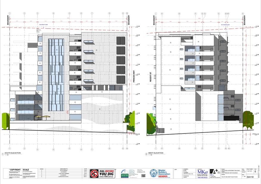
|
Georges River Council - Georges River Independent
Hearing Assessment Panel (IHAP) - Thursday, 15 June 2017
3.2 45 Princes Highway Kogarah
[Appendix
2] 41-47 Princes Hwy
Kogarah - DA110, ELEVATIONS No 2
|
Page 110
|
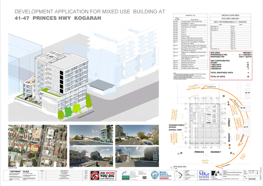
|
Georges River Council - Georges River Independent
Hearing Assessment Panel (IHAP) - Thursday, 15 June 2017
3.2 45 Princes Highway Kogarah
[Appendix
3] 41-47 Princes Hwy Kogarah
- DA109, ELEVATIONS
|
Page 111
|
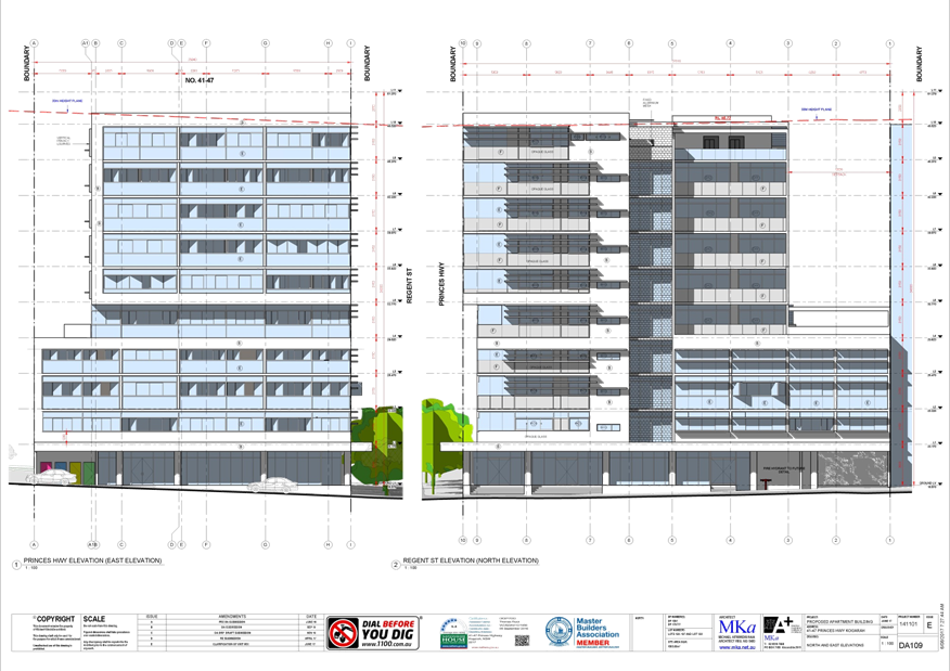
|
Georges River Council - Georges River Independent
Hearing Assessment Panel (IHAP) - Thursday, 15 June 2017
3.2 45 Princes Highway Kogarah
[Appendix
4] 41-47 Princes Hwy
Kogarah - DA108, ROOF PLAN
|
Page 112
|
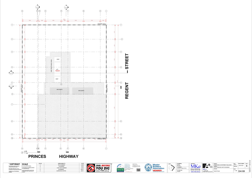
|
Georges River Council – Independent Hearing and
Assessment Panel Thursday, 15 June 2017
|
Page 113
|
REPORT TO GEORGES RIVER COUNCIL
IHAP MEETING OF Thursday, 15 June 2017
|
IHAP Report No
|
3.3
|
Application No
|
DA2016/0280
|
|
Site Address & Ward Locality
|
56 Llewellyn Street Oatley
Peakhurst Ward
|
|
Proposal
|
Demolition of existing dwelling and
construction of a three storey split level dwelling with swimming pool to
rear
|
|
Report Author/s
|
Senior Development Assessment
Officer, Teresa Gizzi
|
|
Owners
|
Mr Sam Speros
|
|
Applicant
|
Robert Ursino Design Pty Ltd
|
|
Zoning
|
Zone R2 - Low Density
Residential
|
|
Date Of Lodgement
|
13/10/2016
|
|
Submissions
|
Three (3)
|
|
Cost of Works
|
$1,200,000.00
|
|
Reason for Referral to IHAP
|
Variations to HLEP 2012
(Height) and DCP No 1
|
|
Recommendation
|
That the application be approved in accordance with the
conditions included in the report
|
|
|
Site Plan
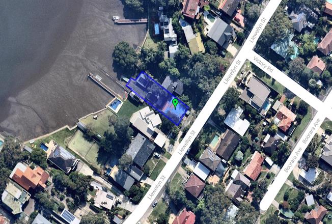
|
Executive Summary
1. Development
consent is sought for the demolition of the existing dwelling and construction
of a three (3) storey dwelling house and swimming pool.
2. The
proposed development has been assessed against the requirements of the relevant
planning instruments and Development Control Plans. The application
proposes a variation to building height and also a number of variations to the
Development Control Plan controls. The variations arise as a result of
the topography of the land and are found to be acceptable.
3. The
application was notified in accordance with Development Control Plan No 1.
Three (3) submissions were received. The issues raised are discussed throughout
this report, and are not considered to warrant refusal of the application.
4. The
application is recommended for approval subject to conditions of consent.
Report In Full
DESCRIPTION
OF THE PROPOSAL
1. Development
consent is sought for the demolition of the existing dwelling and construction
of a three (3) storey dwelling house and swimming pool.
The dwelling and garage are actually split over four (4)
levels, however due to the stepping of the building, the proposal would not
exceed three (3) storeys at any one point.
The development requires the removal of four (4) trees from
the rear of the property.
HISTORY
2. 13 Oct
16 Application lodged
21 Oct 16 Application
notified for 14 days
14 Feb 17 Additional
information requested
28 Mar 17 Additional information
received
DESCRIPTION
OF THE SITE AND LOCALITY
3. The site
is a regular shaped allotment located on the north western side of Llewellyn
Street. The site has a frontage of 13.41m and an area of 607sqm. The site falls
steeply to the rear dropping 12.3m from the front boundary to the mean high
water mark. Up to 10m of this fall occurs in the front half (20m) of the
site. It is also noted that the front boundary of the site is 3.3m below
road level.
The site is adjoined by three (3) storey dwelling houses on
both sides and also across the road. To the rear of the site is Georges
River.
COMPLIANCE
AND ASSESSMENT
4. The
development has been inspected and assessed under the relevant Section 79C(1)
"Matters for Consideration" of the Environmental Planning and
Assessment Act 1979.
Environmental
Planning Instruments
HURSTVILLE
LOCAL ENVIRONMENTAL PLAN 2012
|
Clause
|
Standard
|
Proposal
|
Complies
|
|
1.2 – Aims of the Plan
|
In accordance with Clause 1.2 (2)
|
Consistent with the aims of the
plan
|
Yes
|
|
1.4 - Definitions
|
Dwelling House
|
The proposed development is defined
as a single dwelling house
|
Yes
|
|
2.3 - Zone objectives and Land Use
Table
|
Meets objectives of R2 Low Density
Residential Zone
Development must be permissible
with consent
|
Meets objectives and is a
permissible development with consent
|
Yes
|
|
2.7 - Demolition
|
Demolition is permissible with
consent
|
Consent for demolition is sought
|
Yes
|
|
4.3 – Height of Buildings
|
9m as identified on Height of
Buildings Map
|
Max 11.39m
|
No
|
|
4.4 – Floor Space Ratio
|
0.6:1 as identified on Floor Space
Ratio Map
|
0.55:1 (including existing shed)
|
Yes
|
|
4.5 – Calculation of floor
space ratio and site area
|
FSR and site area calculated in
accordance with Cl.4.5
|
FSR and site area calculated as per
requirements
|
Yes
|
|
4.6 –Exceptions to
development standards
|
A written request to vary a
development standard must be submitted by the applicant
|
A request for a variation has been
submitted in accordance with Clause 4.6
|
Yes
|
|
5.9 – Preservation of Trees
or Vegetation
|
Trees to be removed are specified
in DCP1
|
Tree removal is proposed and found
to be acceptable by Council’s Tree Management Officer
|
Yes
|
|
5.10 – Heritage conservation
|
Heritage impact statement required
if site involves heritage item
|
Site does not involve a heritage
item
|
N/A
|
|
6.1 – Acid Sulfate Soils
|
Acid Sulfate Soils Management Plan
must be prepared
|
Site not affected by acid sulphate
soils
|
N/A
|
|
6.3
– Limited Development on Foreshore Area
|
Development
in the foreshore area will not impact on natural foreshore processes or
affect the significance and amenity of the area.
|
The site
is subject to a foreshore building line. Only a small section of the proposed
swimming pool encroaches into the foreshore area which is permissible under
this clause.
The
development will not compromise the visual quality or use of the foreshore
area. Nor would the development negatively impact on any natural features of
the site or result in any environmental harm. The development has been
considered against the requirements of this clause and is acceptable.
|
Yes
|
|
6.4
– Foreshore Scenic Protection Area
|
Council
cannot grant consent to the carrying out of development on land within a
Foreshore Scenic Protection Area unless consideration has been made of the
following:
(3)(a)
affect the natural environment, including topography, rock formations, canopy
vegetation or other significant vegetation, and
(b)
affect the visual environment, including the views to and from the Georges
River, foreshore reserves, residential areas and public places, and
(c)
affect the environmental heritage of Hurstville, and
(d)
contribute to the scenic qualities of the residential areas and the Georges
River by maintaining the dominance of landscape over built form.
|
The
proposal would not negative impact on the natural environment or affect the
environmental heritage of Hurstville.
The
development will have a minor impact on views enjoyed by properties opposite
the site, however the view impact is negligible. This is discussed in detail
later in this report. All other views to and from the Georges River will be
preserved.
The
proposal is consistent with recent developments along the foreshore and will
maintain the scenic quality of the residential area and the Georges River.
|
Yes
|
|
6.5 Gross Floor Area of a
Dwelling House
|
For site area ≤ 630sqm Max. FSR
= 0.55:1
|
Site = 607sqm
FSR = 0.55:1
|
Yes
|
|
6.7 – Essential Services
|
Development consent must not be
granted to development unless services that are essential for the development
are available
|
Essential services are available to
the development
|
Yes
|
Detailed
Assessment of Variation to Clause 4.3 - Height of Buildings Development
Standard
5. Clause
4.3 of Hurstville Local Environmental Plan 2012 limits the maximum height of
buildings on this site to 9m. The proposed dwelling has a maximum height of 11.39m.
All three (3) sections of the roof exceed the height limit at some point.
The roof of the
garage floor level proposes a maximum height of 11.39m. The worst point of the
variation at this level is along the rear section of garage roof, although
almost half of this element is non compliant.
The upper floor
roof has a maximum height of 11.15m which is again located along the rear of
this level. Approximately half of this roof level does not comply.
The roof of the
upper floor level balcony is slightly less than that of the upper floor,
however it still exceeds the height limit with a maximum proposed height of
10.25m.
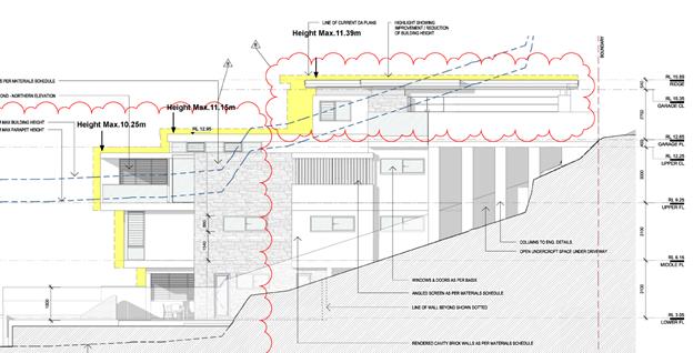
Image: Approximate
Maximum Height
To support the non
compliance the applicant has provided a request for a variation to a
development standard in accordance with Clause 4.6 of Hurstville Local
Environmental Plan 2012. The request for a variation is attached to this
report.
The proposal must
satisfy the objectives of Clause 4.3 – Height of Buildings, the
underlying objectives of the particular zone, and the objectives of Clause 4.6
- Exceptions to Development Standards under the Hurstville Local Environmental
Plan 2012. The assessment is detailed as follows.
Is the
planning control in question a development standard?
5. Comment:
The prescribed Height of Buildings limitation pursuant to Clause 4.3 of the
Hurstville Local Environmental Plan 2012 is a development standard.
What are the
underlying objectives of the development standard?
6. Comment:
The underlying objectives of the standard, pursuant to ‘Clause 4.3
– Height of Buildings’ of the Hurstville Local Environmental Plan
2012 are:
a) to ensure that buildings are compatible with the
height, bulk and scale of the existing and desired future character of the
locality,
b) to minimise visual impact, disruption of views, loss
of privacy and loss of solar access to existing development and to public areas
and public domain, including parks, streets and lanes,
c) to minimise the adverse impact of development on
heritage items,
d) to nominate heights that will provide a transition
in built form and land use intensity.”
The development is
found to be consistent with the underlying objectives of the standard for the
following reasons:
· The
bulk and scale of the development is consistent with existing and approved
buildings in the area. The dwelling located at 54 Llewellyn Street Oatley which
adjoins the site to the north has a height of 11.7m and the dwelling at 58
Llewellyn Street Oatley has a maximum height of 10.45m. The development is
compatible with the character of the locality.
· The
development exceeds the height limit due to the topography of the site.
Attempts have been made to follow the topography of the site with accommodation
spread out across the four (4) levels.
· From
the street, the development presents as a single storey dwelling of a
contemporary appearance that is compatible with the adjoining dwellings.
· The
height does not result in any unreasonable impacts on solar access or privacy.
· In
terms of views, all adjoining properties have views of the Georges River
directly over their rear boundaries. As such, the proposed dwelling would not
affect any significant views.
· There
would be a minor impact on views from properties opposite the site on the south
eastern side of Llewellyn Street, however the view loss is found to be
negligible and is not a direct result of the building height.
· The
development does not affect any heritage items.
· The
subject site is not located in a transitional zone and the intensity of land
use is compatible with the locality.
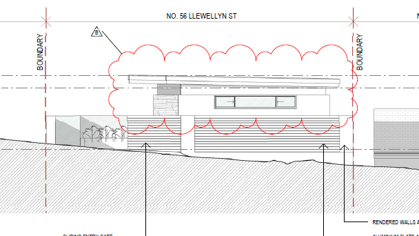
Image: Front
Elevation
Image: Rear
Elevation
What are the
underlying objectives of the zone?
7. Comment:
In assessing the development’s non compliance, consideration must be
given to its consistency with the underlying objectives of the R2 Low Density
Residential zone which are as follows:
· To
provide for the housing needs of the community within a low density residential
environment.
· To
enable other land uses that provide facilities or services to meet the day to
day needs of residents.
· To
encourage development of sites for a range of housing types, where such
development does not compromise the amenity of the surrounding area, or the
natural or cultural heritage of the area.
· To
ensure that a high level of residential amenity is achieved and maintained.
· To
encourage greater visual amenity through maintaining and enhancing landscaping
as a major element in the residential environment.
· To
provide for a range of home business activities where such activities are not
likely to adversely affect the surrounding residential amenity.
The development
is considered consistent with the objectives of the R2 Low Density Residential
zone for the following reasons:
· The
proposal will provide a new dwelling providing for the changing needs of the
locality in a form that is consistent with the low density residential
character of the area. The dwelling will achieve a high level of amenity.
· The
development does not compromise the amenity of the adjoining properties in
terms of visual impact, solar access and privacy.
· The
dwelling provides good amenity for future occupiers.
· The
development requires the removal of four (4) trees from the rear of the
property. Conditions are recommended requiring replacement planting of eight
(8) trees to ensure the landscape is enhanced by the development.
Is the
variation to the development standard consistent with Clause 4.6 of the HLEP
2012?
(1) The
objectives of Clause 4.6 are as follows:
(a) to provide an appropriate degree of
flexibility in applying certain development standards to particular
development,
(b) to achieve better outcomes for and from
development by allowing flexibility in particular circumstances.”
8. Comment:
To allow for reasonable redevelopment of the subject site, it is acknowledged
that some flexibility is required in the application of the building height
development standard due to the steep topography of the land.
The variation
would not cause any unreasonable visual impacts on adjoining properties and it
is not considered it would cause the development to appear excessive or over
dominant in the streetscape.
In this instance,
it is considered that the variation to the development standard is acceptable.
(2) Development
consent may, subject to this clause, be granted for development even though the
development would contravene a development standard imposed by this or any
other environmental planning instrument. However, this clause does not apply to
a development standard that is expressly excluded from the operation of this
clause.
9. Comment:
The site is not excluded from the operation of this clause.
(3) Development
consent must not be granted for development that contravenes a development
standard unless the consent authority has considered a written request from the
applicant that seeks to justify the contravention of the development standard
by demonstrating:
(a) that compliance with the development
standard is unreasonable or unnecessary in the circumstances of the case, and
(b) that there are sufficient environmental
planning grounds to justify contravening the development standard.
10. Comment:
The applicant’s justification for the variation is supported (see
attachment). Given that the site is significantly constrained by the topography
of the land, the strict application of the development standard is unreasonable
in this instance.
The proposed
variation allows for appropriate re-development of the subject site without
unreasonable impacts on the adjoining properties. In this regard, there are
sufficient planning grounds to justify the height of the development.
(4) Development
consent must not be granted for development that contravenes a development
standard unless:
(a) the
consent authority is satisfied that:
(i) the
applicant’s written request has adequately addressed the matters required
to be demonstrated by subclause (3), and”
11. Comment:
A written request for the variation prepared by Planning Ingenuity was
submitted with the application which provides justification to address
subclause (3). The extent of the variation is found to be consistent with
subclause (3) and Clause 4.6 overall and the submitted justification is
supported.
(ii) the proposed
development will be in the public interest because it is consistent with the
objectives of the particular standard and the objectives for development within
the zone in which the development is proposed to be carried out, and
12. Comment:
For the reasons detailed above, the proposal is considered to be consistent
with the objectives of Clause 4.3 Height of Buildings and the objectives of the
R2 Low Density Residential Zone under Hurstville Local Environmental Plan 2012.
Therefore the development is considered to be in the public interest.
(b) the
concurrence of the Director-General has been obtained.
13. Comment:
Planning Circular PS 08-003 dated 9 May 2008, as issued by the NSW Department
of Planning, advises that the concurrence of the Director-General may be
assumed for exceptions to development standards under environmental planning
instruments that adopt Clause 4.6 of the Standard Instrument. In this regard,
if the variation is found to be consistent with the objectives of the zone, the
concurrence of the Director-General for the variation to the building height
Development Standard can be assumed.
STATE ENVIRONMENTAL
PLANNING INSTRUMENTS
14. Compliance
with the relevant state environmental planning policies is detailed and
discussed in the table below.
|
State
Environmental Planning Policy
|
Complies
|
|
Greater Metropolitan Regional
Environmental Plan No 2 – Georges River Catchment
|
Yes
|
|
State Environmental Planning Policy
55 – Remediation of Land
|
Yes
|
|
State Environmental Planning Policy
(Building Sustainability Index BASIX) 2004
|
Yes
|
Draft
Environmental Planning Instruments
15. There
are no draft environmental planning instruments that apply to the development
application.
Any
other matters prescribed by the Regulations
The Regulations prescribe the following matters for
consideration for development in the Hurstville Council area:
Demolition
16. Safety standards
for demolition and compliance with AS 2601 - 2001 apply to the demolition of
any buildings affected by the proposal.
Development
Control Plans
HURSTVILLE DEVELOPMENT CONTROL PLAN NO 1 - LGA WIDE
17. The
proposal has been assessed against the following sections of Development Control Plan No 1.
DEVELOPMENT CONTROL PLAN NO 1 - LGA WIDE - SECTION 4.4
DWELLING HOUSES ON STANDARD LOTS
|
Performance
Criteria
|
Design
solution
|
Proposed
|
Complies
|
|
PC1
Neighbourhood character
|
DS1.1 -
The development application is supported by a Statement of Environmental
Effects
|
A
statement of environmental effects has been submitted
|
Yes
|
|
PC2 -
Building Height
|
DS2.1 -
Max. ridge height as per LEP – 9m
DS2.2 -
Max. ceiling height to external wall = 7.2m
DS2.4 -
For steep or sloping sites, the building is sited and designed to be
staggered or stepped into the natural slope of the land
|
11.39m
10.85m
The dwelling has been stepped to
follow the slope of the site.
|
No
See
justification under HLEP 2012 earlier in this report.
No
Yes
|
|
PC3 -
Setback Controls
Front
Setback (Building Line):
|
DS3.1 -
4.5m
(to front
wall of dwelling)
5.5m to
garage/carport or on-site parking space
|
> 7m
1.5m
|
Yes
No
|
|
Side Boundary Setbacks:
|
900mm – ground floor level
1.5m – first floor level
|
1.5m to all floor levels except
garage which is 1m.
In this instance, as no one floor
can be considered as ground floor level, it is not unreasonable to apply the
ground floor level setback requirement to the garage given that it is ground
level when viewed from the street.
On this basis the side setbacks are
considered compliant.
|
Yes
|
|
Rear Setback:
|
Ground floor level – 3m
First floor level – 6m
|
>6m
|
Yes
|
|
PC4 -
Façade Articulation
|
DS4.1 -
Dwellings must have a front door or window to a habitable room facing the
primary street frontage.
DS4.2 -
Must have two building elements of
- Entry feature / portico
- Awning / feature over window
- Eaves and sun shading
- Window planter box
- Bay windows or similar features
- Wall offsets, balconies, verandas,
pergolas
DS4.3 -
Garage doors not wider than 6m
|
Due to the topography of the site,
the side of the garage which contains a window addresses the street. A
minimalist roof form is also proposed along detailed stone panelling to
improve the appearance of the front elevation.
It is noted that due to the front
boundary of the site being well below street level, this would not result in
any unreasonable impacts on the visual quality of the streetscape. As such,
the front façade of the development is acceptable in this
instance.
|
Acceptable
|
|
PC5 -
Views
|
DS5.1 -
Development is sited and designed to facilitate view sharing while not
restricting the reasonable development of the site. Each development
application will be assessed on its individual merits.
|
See view impact assessment below
this table
|
Yes
|
|
PC6 -
Solar Design
|
DS6.1 -
Development allows for at least 3 hours of sunlight on the windows of main
living areas and adjoining principal private open space of adjacent dwellings
between 9.00 am and 3.00 pm on 22 June.
DS6.2 -
Development complies with the Energy Efficiency section in Appendix 1 of this
DCP and BASIX requirements.
DS6.3 -
Buildings are encouraged to incorporate window shading devices where
necessary to minimise exposure to direct summer sun. Alternatively, windows
may be shaded by the planting of large trees, including deciduous species.
|
Although the proposed development
significantly overshadows the north eastern elevation of the property to the
south at 58 Llewellyn Street, due to the layout of that dwelling, solar
access to the main living areas is unaffected by the proposal. Three hours of
sunlight is also maintained to the private open space.
A BASIX certificate has been
submitted.
Windows in the development have
been designed in accordance with BASIX requirements.
|
Yes
Yes
Yes
|
|
PC7 -
Visual Privacy
|
DS7.1 -
Windows to be offset by 1m. Neighbouring principal private open space is not
overlooked by proposed living areas.
DS7.1
– Primary living rooms are not to overlook adjoining site’s PPOS
DS7.3 -
Survey plan to (AHD) detailing neighbouring floor and window location and
RL’s
|
Windows are offset, screen or
opaque glass to prevent overlooking of adjoining properties.
No overlooking impacts from the
living room of the adjoining sites’ POS.
A survey plan to AHD has been
received.
|
Yes
Yes
Yes
|
|
PC8 - Noise
|
DS8.1 - Noise generators such as
plant and machinery including air conditioning units and pool pumps are located
away from windows or other openings of habitable rooms and are screened to
reduce noise or acoustically enclosed.
DS8.2 - For sites in proximity to a
busy road or railway line, development is to comply with the provisions of
SEPP
|
Complies subject to standard
conditions of consent will be included in the consent.
Not applicable.
|
Yes
N/A
|
|
PC9 - Car
Parking
|
DS9.1 - 1
& 2 Bedrooms / 1 space - 3 or more bedrooms/ 2 spaces
DS9.2 -
New dwellings, at least 1 car space behind the front building setback
DS9.3 -
Enclosed or roofed car accommodation, including garages and carports, are
located at least 1m behind the main setback
DS9.4 -
The maximum width of a garage opening is 6m
DS9.5 -
Hard stand car spaces within the front setback must not have a slope / grade
greater than 1:10
DS9.6 -
Vehicle crossing width at the front property boundary 2.7m – 4.5m
DS9.7 -
Fences are splayed where a driveway is taken off the secondary setback
DS9.8 -
Driveways on State/Regional roads
Must enter
& exit in a forward direction where Council considers it necessary
DS9.9 -
Driveway gradients must be constructed in accordance with Australian Standard
2890.1(2004).
|
Double garage proposed.
Garage is located forward of the
front building line due to the topography of the site. The variation is
acceptable in this instance.
<6m
Parking provided within garage
Driveway width = 5.5m
The increased width is required due
to the location and siting of the private driveway access.
Not applicable.
Not applicable.
Standard conditions of consent.
|
Yes
Acceptable
Yes
Yes
Acceptable
N/A
N/A
Yes
|
|
PC10 -
Landscaped areas and private open space
|
DS10.1 -
25% of Site Area (FSPA)
DS10.3 -
Minimum dimension of landscaped open space is 2m in any direction
DS10.4 -
15sqm of landscaped area to be provided in the front yard
DS10.5 -
An area of Principal Private Open Space is to be
provided
which:
a. has
a minimum area of 30sqm
b. has
a minimum dimension of 5m
c. is
located at ground level and behind the front wall of the dwelling
d. is
directly accessible from a main living area
|
25%
Complies
Not provided. The slope of the site
dictates that the driveway and garage must be located at the front of the
property, limiting opportunities for landscaping. Although not ideal, due to
the site being located below street level, there would be no detrimental
impact on the visual quality of the streetscape.
>30sqm with minimum dimension of
5m
Located at ground level in the rear
yard
Directly accessible from rumpus
|
Yes
Yes
Acceptable
Yes
Yes
Yes
|
|
PC11
-Stormwater
|
DS15.1
Stormwater management is in accordance with the provisions contained in
Section 4.4 Dwelling houses on standard lots.
DS11.1
Diversion of flows from one drainage sub catchment to another is not
encouraged
DS11.2
– Stormwater drainage is to occur by:
a. Gravity to the street
b. Easement allowing gravity drainage to the street
c. Charged system
d. Absorption/infiltration (refer to DCP appendix 2)
DS11.3
– Gravity drainage must not cause ponding/backwater effects on upstream
properties
DS11.5
– On-site retention using rainwater tanks or detention tanks are
encouraged. Overflow from retention must be in accordance with DS11.2.
DS11.6
– Pump-outs only permitted for driveways and basements to a drainage
system on the property and only where DS11.2 cannot be achieved.
DS11.7
– Development is not to concentrate overland flow of stormwater onto an
adjoining property.
DS11.8
– A stormwater management plan is to be lodged with all applications
|
Relevant conditions on stormwater
will be included in the consent.
The site is not subject to any
flooding.
The development drains to the
Georges River by gravity.
Not applicable.
Water tanks are proposed
Not proposed
The site is not flood prone land
Standard engineering conditions
will be included in the consent
|
Yes
Yes
Yes
N/A
Yes
Yes
Yes
Yes
|
|
PC14 -
Balconies
and terraces
|
DS14.1 -
Direct access from a habitable room at the same floor level
DS14.2 -
Balconies & terraces include fixed planter boxes and or privacy
screens
DS14.4
– Privacy Screens are between 1.5m and 1.8m high
DS14.5 -
Terraces must not be visible from the street
DS14.6 -
Roof top terraces are not provided
DS14.7 -
Must provide sight line diagrams that demonstrate how privacy issues to
neighbouring properties are to be addressed
|
The access to the rear patio is
from the rumpus and to the rear balcony is from the living and dining space.
Privacy screens proposed.
Complies
Complies
No roof top terraces proposed.
The balconies will have no
potential privacy and overlooking impacts on the adjoining dwellings.
|
Yes
Yes
Yes
Yes
N/A
Yes
|
DS2.2 -
Maximum ceiling height to external wall
18. Due to the overall
height of the building and topography of the land, the external wall height of
the development also does not comply. Both the side and rear elevations of the
development do not comply, however the extent of the non compliance is varied as
the building traverses the site.
Despite the extent of non compliance, the variation does
not result in any significant impacts on adjoining properties and is consistent
with other developments in the locality. For the same reasons that the overall
height of the building is acceptable, the variation to the external wall height
is also supported.
DS3.1 – Garage Front Setback
19. The garage is
proposed to be setback 1.5m from the boundary rather than the 5.5m required by
the Development Control Plan. This is a result of the topography of the
site and the existing layout of the driveway access into the property.
Due to the steep fall of the land adjoining the front
boundary, to achieve appropriate levels for vehicular access, the garage is
required to be located at the very front of the site. As the garage floor level
and driveway level is 2m below the street level and due to the setback of the
building from the roadway due to the unusual vehicular access into the site,
there would be no significant detrimental visual impact on the streetscape
resulting from the development. Further, there are other examples of garages in
similar locations along Llewellyn Street and other steep foreshore sites in the
locality.
The reduced front setback is acceptable in this instance
and refusal of the application on this basis is not warranted.
PC5 – View Sharing
20. A submission has
been received from the property at 45 Llewellyn Street Oatley which is located
opposite the site in relation to loss of views. To assess the view impact, site
visits were made to both 45 and 43 Llewellyn Street Oatley.
In determining the impact of the view loss it's important
to refer to the Land and Environment Court Principle on Views and view sharing
as discussed in Tenacity Consulting v Warringah Council [2004] NSWLEC140
The first step is the assessment of views to be affected.
Water views are valued more highly than land views. Iconic views (eg of the
Opera House, the Harbour Bridge or North Head) are valued more highly than
views without icons. Whole views are valued more highly than partial views, eg
a water view in which the interface between land and water is visible is more
valuable than one in which it is obscured.
Comment: The view from
43 and 45 Llewellyn Street is of high value as it comprises the Georges River
and its interface with the opposite shoreline.
The second step is to consider from what part of the
property the views are obtained. For example the protection of views across
side boundaries is more difficult than the protection of views from front and
rear boundaries. In addition, whether the view is enjoyed from a standing or
sitting position may also be relevant. Sitting views are more difficult to
protect than standing views. The expectation to retain side views and sitting
views is often unrealistic.
Comment: The views in
question are obtained over the front boundary, across Llewellyn Street and over
the rooftops of the dwellings on the north western side of the street.
From 45 Llewellyn Street, the views are enjoyed from both a
sitting and standing position, from all levels of the home. From 43
Llewellyn Street, views over the subject site from within the dwelling are
obscured due to vegetation, however views can be seen from the front porch of
the dwelling in both a sitting and standing position.
The third step is to assess the extent of the impact. This
should be done for the whole of the property, not just for the view that is
affected. The impact on views from living areas is more significant than from bedrooms
or service areas (though views from kitchens are highly valued because people
spend so much time in them). The impact may be assessed quantitatively, but in
many cases this can be meaningless. For example, it is unhelpful to say that
the view loss is 20% if it includes one of the sails of the Opera House. It is
usually more useful to assess the view loss qualitatively as negligible, minor,
moderate, severe or devastating.
Comment: From 45
Llewellyn Street, the views are obtained from almost every room with a window
in the front elevation. From 43 Llewellyn Street, the views are mostly
obtained from the front porch.
As the dwellings on the south eastern side of Llewellyn
Street are elevated above street level, and due to the sunken nature of subject
site at 56 Llewellyn Street, the loss of view will comprise only a small area
of the Georges River being water only. A broader view of the river will be
maintained, as will the interface with the opposite facing bank. As such,
the view impact is considered negligible.
The fourth step is to assess the reasonableness of the
proposal that is causing the impact. A development that complies with all
planning controls would be considered more reasonable than one that breaches
them. Where an impact on views arises as a result of non-compliance with one or
more planning controls, even a moderate impact may be considered unreasonable.
With a complying proposal, the question should be asked whether a more skilful
design could provide the applicant with the same development potential and
amenity and reduce the impact on the views of neighbours. If the answer to that
question is no, then the view impact of a complying development would probably
be considered acceptable and the view sharing reasonable.
Comment: Although the
proposal exceeds the height limit, only the roof of the garage/lobby is
actually visible from the complainant’s property and the ridge height of
this building element is less than 2m above street level. Lowering of this
building element would prevent parking from being accommodated on the site and
therefore the development is considered reasonable. Therefore, the
proposal is considered to be acceptable and reasonable in respect of view
sharing as the impact is considered negligible.
DEVELOPMENT CONTROL PLAN NO 1 - LGA WIDE - SECTION 5.6
SWIMMING POOLS AND SPAS
|
Performance
Criteria
|
Design
Solution
|
Proposed
|
Complies
|
|
PC1
Ensure
swimming pools do not adversely affect the amenity of the locality
Swimming
pools are located such that cut and fill is minimised and the visual impact
on the surrounding area is reduced
|
DS1.1
– The top of the pool is as close to existing ground level as possible
DS1.2
– If one side of the pool is at or below natural ground level the high
side of the pool is permitted to be 500mm above natural ground level
DS1.3
– For pools with a height in excess of 500mm above natural ground
level, landscaping treatment must be completed prior to filling the pool with
water
DS1.4
– On steeply sloping sites Council may permit one side of the pool to
be up to 1000mm above natural ground level if the exposed face of the pool is
treated to reduce impact
DS1.5
– Fill is not permitted between the swimming pool and the property
boundary
DS1.6
– Pool drainage/spill water is not to impact on adjoining properties
DS1.7
– Swimming pools are to be designed so the top of the bond beam is as
close as possible to existing natural ground level
DS1.8
– Spas/swimming pools proposed between the dwelling and the street will
be considered where neighbour amenity is not affected and all other DCP
requirements are met
DS1.9
– Swimming pools are permitted on land affected by a foreshore building
line subject to the design complimenting the surrounding area and minimising
visual impact from the waterways
DS1.10
– Swimming pool edge to be a minimum of 1.5m from side and rear
property boundaries
DS1.11
– Pool location is to take into account neighbour acoustic amenity
DS1.12
– Mechanical equipment may be required to be acoustically treated to
negate any potential amenity issue
DS1.13
– The construction, location and use of the swimming pool is to be such
that neighbours are not impacted by way of noise, drainage, illumination or
any other reason
DS1.14
– Heated swimming pools must source power from renewable sources.
Swimming pool covers are to be used when the pool is not in use
|
The
proposed swimming pool complies with these requirements.
Although
the pool is partially below the foreshore building line, it would not result
in any significant detrimental impacts on the visual quality of the
foreshore.
Standard
conditions of consent are recommended to mitigate noise impacts from pool
equipment.
|
Yes
|
|
PC2
To retain
existing trees
To ensure
swimming pool areas are landscaped in accordance with Council’s
landscaping guidelines
Landscaping
enhances and is integrated with the design of the swimming pool
|
DS2.1
– Tree and shrub screen planting along property boundary is to be
provided to achieve a reasonable level of privacy
DS2.2 -
Paved and impervious areas are to be minimised and designed to provide
swimming pool and stormwater infiltration
DS2.3
– Swimming pools are to be designed to retain existing trees
DS2.4
– Where pools are located adjacent to trees, elevated decks to the
swimming pool coping is preferred in order to avoid root damage
DS2.5
– Swimming pool water discharges must not in any circumstances be
directed through bushland areas on private or public land
DS2.6
– Council does not approve tree removal on the basis of leaf drop or
lack of solar access to a swimming pool
|
Satisfactory.
One (1)
tree is proposed to be removed to accommodate the proposed swimming pool
however Council’s Tree Management Officer has raised no objections
subject to conditions of consent.
|
Yes
|
Impacts
Natural
Environment
21. To
facilitate the development, four (4) significant trees are required to be
removed from the site, however conditions are recommended for replacement
planting of eight (8) trees on the property to mitigate any detrimental impacts
on the natural environment.
Built Environment
22. As
has been discussed throughout this report, the application seeks a number of
variations to the controls, including the height and front setback. However the
site is highly constrained by its topography and the variations are acceptable.
The bulk and scale
of the development is comparable to the adjoining properties and other recent
developments in the locality. Further, the development does not result in any
detrimental impacts on the amenity of the neighbours.
As such, the
development is not considered to have any detrimental impacts on the built
environment and will maintain the character and appearance of the locality.
Social Impact
23. The
development is for a residential purpose and would not result in any social
impacts.
Economic
Impact
24. The
development is for a residential purpose and would not result in any economic
impacts.
Suitability
of the Site
25. As
discussed throughout this report, the site is considered suitable for the
development.
REFERRALS, SUBMISSIONS AND THE PUBLIC INTEREST
Resident
26. Adjoining residents
were notified by letter and given fourteen (14) days in which to view the plans
and submit any comments on the proposal. Three (3) submissions were
received. Two (2) of the submissions were in objection to the development and
the third submission, received from 58 Llewellyn Street, raised no objections
to the development but raised concerns about excavation measures to be used.
Damage
· Damage
to neighbouring properties as a result of excavation.
· Concerns
of cracking of overhanging rock shelf on neighbouring property
· Geotechnical
report should be provided.
27. Comment: A
Geotechnical Report has been submitted with the application and conditions are
recommended requiring a geotechnical engineer to guide excavation measure.
Dilapidation reports on neighbouring properties will also be required by
condition.
Height
· Breaches
height limit
· The
adjoining properties at 58 and 54 Llewellyn Street comply
· The
development will set a precedent
· Application
advertised as three (3) storeys but actually four (4) storeys due to garage on
top
· Where
is natural ground level taken from for the garage? From the road or the
driveway.
28. Comment: The
proposed development does breach the height limit, however as discussed earlier
in this report the breach is considered acceptable. Both the adjoining
properties also exceed the height limit to the topography of the land in this
location. It is not considered that the proposed variations set an unreasonable
precedent for over height development as it is justified by the site
constraints.
The proposed dwelling is spread across four (4) levels,
however as it is a maximum of three (3) storeys at any one point, hence the
description of the development.
Natural ground level is taken as existing ground level in
accordance with the definition in Hurstville Local Environmental Plan
2012. The height of the development has been calculated in accordance
with this definition.
Certification
· Will
Council be the certifier or will it be a private certifier? If private,
how will Council police this?
29. Comment: It
is up to the applicant to choose a certifier for the site whether it be Council
or a private certifier. It is up to the certifier to ensure the development is
built in accordance with the approved development.
Views
· View loss from 45 Llewellyn Street.
30. Comment: See
view loss assessment earlier in this report.
Council
Referrals
Tree
Management Officer
31. Council’s
Tree Management Officer has raised no objections to the loss of four (4) trees
from the site subject to replacement planting of eight (8) trees required by
conditions of consent.
Development
Engineer
32. Council’s
Development Engineer has assessed the application and raised no objections
subject to conditions.
CONCLUSION
33. Development consent
is sought for the demolition of the existing dwelling and construction of a
three (3) storey dwelling house and swimming pool.
The proposed
development has been assessed against the requirements of the relevant planning
instruments and Development Control Plans. The application proposes a variation
to building height and also a number of variations to the Development Control
Plan controls. The variations arise as a result of the topography of the land
and are found to be acceptable.
The
application was notified in accordance with Development Control Plan No 1.
Three (3) submissions were received. The issues raised are discussed throughout
this report, and are not considered to warrant refusal of the application.
The
application is recommended for approval.
DETERMINATION
34. THAT pursuant to
Section 80(1)(a) of the Environmental Planning and Assessment Act, 1979, as
amended, the Council, grants development consent to Development Application
DA2016/0280 for the demolition of existing dwelling and construction of a three
storey split level dwelling with elevated swimming pool to rear on Lot A, DP
344480 and known as 56 Llewellyn Street, Oatley, subject to the attached
conditions:
Schedule A – Site Specific Conditions
GENERAL CONDITIONS
These conditions have been imposed to ensure that the
development is carried out in accordance with the approved plans and to ensure
that the appropriate fees and bonds are paid in relation to the development.
1. GEN1001 - Approved Plans - The development
must be implemented in accordance with the approved plans and supporting
documentation listed below which have been endorsed by Council’s approved
stamp, except where marked up on the plans and/or amended by conditions of this
consent:
|
Reference
No.
|
Date
|
Description
|
Revision
|
Prepared by
|
|
DA201
|
16.09.2017
|
Site Analysis
|
A
|
Robert Ursino
Design
|
|
DA202
|
24.03.2017
|
Site Plan
|
B
|
Robert Ursino
Design
|
|
DA301
|
24.03.2017
|
Lower Floor
Plan
|
B
|
Robert Ursino
Design
|
|
DA302
|
24.03.2017
|
Middle Floor
Plan
|
B
|
Robert Ursino
Design
|
|
DA303
|
24.03.2017
|
Upper Floor
Plan
|
B
|
Robert Ursino
Design
|
|
DA304
|
24.03.2017
|
Garage Floor
Plan
|
B
|
Robert Ursino
Design
|
|
DA305
|
24.03.2017
|
Roof Plan
|
B
|
Robert Ursino
Design
|
|
DA306
|
24.03.2017
|
Pool/Yard Plan
|
B
|
Robert Ursino
Design
|
|
DA307
|
24.03.2017
|
Driveway/Turning
Circle
|
B
|
Robert Ursino
Design
|
|
DA401
|
24.03.2017
|
Sections 1
|
B
|
Robert Ursino
Design
|
|
DA402
|
24.03.2017
|
Sections 2
|
B
|
Robert Ursino
Design
|
|
DA501
|
24.03.2017
|
North Elevation
|
B
|
Robert Ursino
Design
|
|
DA502
|
24.03.2017
|
South Elevation
|
B
|
Robert Ursino
Design
|
|
DA503
|
24.03.2017
|
East Elevation
|
B
|
Robert Ursino
Design
|
|
DA504
|
24.03.2017
|
West Elevation
|
B
|
Robert Ursino
Design
|
|
DA701
|
24.03.2017
|
Calculations
|
B
|
Robert Ursino
Design
|
|
DA702
|
16.09.2017
|
Construction
Management Plan
|
A
|
Robert Ursino
Design
|
|
DA708
|
24.03.2017
|
Landscape Plan
|
B
|
Robert Ursino
Design
|
|
DA901
|
24.03.2017
|
Materials/Window
Schedules
|
B
|
Robert Ursino
Design
|
2. GEN1002 - Fees to be paid to Council - The fees listed in the table below must be paid
in accordance with the conditions of this consent and Council’s adopted
Fees and Charges applicable at the time of payment.
Payments must be made prior to the
issue of the Construction Certificate or prior to the commencement of work (if
there is no associated Construction Certificate).
Please contact Council prior to the
payment of Section 94 Contributions to determine whether the amounts have
been indexed from that indicated below in this consent and the form of payment
that will be accepted by Council.
Form of payment for transactions
$500,000 or over - Council will only accept Bank Cheque or Electronic Funds
Transfer (EFT) for transaction values of $500,000 or over. Council must be
contacted prior to payment to determine correct total amount to be paid and
bank account details (if applicable)
(a) Fees to
be paid:
Fee types, bonds and contributions
|
Fee Type
|
|
Long Service
Levy (to Long Service Corporation)
|
|
Builders Damage
Deposit
|
|
Inspection Fee
for Refund of Damage Deposit
|
|
Section 94(A)
|
The following fees apply where you appoint Council as your Principal
Certifying Authority (PCA). (If you appoint a private PCA, separate fees will
apply)
|
PCA Services
Fee
|
$2,300.00
|
|
Construction
Certificate Application Fee
|
$2,300.00
|
|
Construction
Certificate Imaging Fee
|
$236.00
|
Fees and charges above are subject to
change and are as set out in the version of Council's Schedule of Fees and
Charges or as required by other Government Authorities, applicable at the time
of payment.
3. GEN1014 - Long Service Levy - Submit evidence
of payment of the Building and Construction Industry Long Service Leave Levy to
the Principal Certifying Authority. Note this amount is based on the cost
quoted in the Development Application, and same may increase with any variation
to estimated cost which arises with the Construction Certificate application.
To find out the amount payable go to www.lspc.nsw.gov.au
or call 131441. Evidence of the payment of this levy must be submitted with
the Construction Certificate application.
4. GEN1015 - Damage Deposit - Minor Works - In
order to insure against damage to Council property the following is required:
(a) Payment to Council of a damage deposit for the cost of making
good any damage caused to any Council property as a result of the development: $1,900.00.
(b) Payment to Council of a non refundable inspection fee to enable
assessment of any damage and repairs where required: $145.00.
(c) At the completion of work Council will inspect the public
works, and the damage deposit will be refunded in full upon completion of work
where no damage occurs. Otherwise the amount will be either forfeited or partly
refunded according to the amount of damage.
(d) Prior to the commencement of work a photographic record of the
condition of the Council nature strip, footpath and driveway crossing, or any
area likely to be affected by the proposal, shall be submitted to Council
(e) Payments pursuant to this condition are required to be made to
Council before the issue of the Construction Certificate.
(f) Fees and
charges above are subject to change and are as set out in the version of
Council's Schedule of Fees and Charges or as required by other Government
Authorities, applicable at the time of payment.
5. GEN1023 - Section 94A Contributions - As at
the date of Development Consent a contribution of $12,000.00 has been
levied on the subject development pursuant to Section 94A Contributions Plan.
The amount to be paid is to be adjusted at the time of the actual payment, in
accordance with the provisions of the Section 94A Development Contributions
Plan.
The contribution must be paid prior to the release of a
Construction Certificate as specified in the development consent
Please contact Council prior to payment
to determine whether the contribution amounts have been indexed from that
indicated above in this consent and the form of payment that will be accepted
by Council.
Form of payment for transactions $500,000
or over - Council will only accept Bank Cheque or Electronic Funds Transfer
(EFT) for transaction values of $500,000 or over. Council must be contacted
prior to payment to determine correct total amount to be paid and bank account
details (if applicable).
Contributions must be receipted by Council before a
Construction Certificate is issued.
The Section 94A Contributions Plan may be inspected at
Council’s Customer Service Centres or online at www.georgesriver.nsw.gov.au.
SEPARATE APPROVALS UNDER OTHER LEGISLATION
These conditions have been imposed to ensure that the
applicant is aware of any separate approvals required under other legislation,
for example: approvals required under the Local Government Act 1993 or the
Roads Act 1993.
6. APR6001
- Engineering - Section 138 Roads Act and Section 68 Local Government Act
1993
Unless otherwise specified by a condition of this consent, this
Development Consent does not give any approval to undertake works on
public infrastructure.
A separate approval is required to be lodged and approved
under Section 138 of the Roads Act 1993 and/or Section 68 of
the Local Government Act 1993 for any of the following
activities carried out in, on or over a public road (including the footpath):
(a) Placing
or storing materials or equipment;
(b) Placing
or storing waste containers or skip bins;
(c) Erecting
a structure or carrying out work
(d) Swinging or hoisting goods over any part of a public road by
means of a lift, crane or the like;
(e) Pumping
concrete from a public road;
(f) Pumping
water from the site into the public road;
(g) Constructing
a vehicular crossing or footpath;
(h) Establishing
a “works zone”;
(i) Digging up or disturbing the surface of a public
road (e.g. Opening the road for the purpose of connections to utility
providers);
(j) Stormwater
and ancillary works in the road reserve; and
(k) Stormwater
and ancillary to public infrastructure on private land
(l) If any excavation is to be supported by the use of below
ground (cable) anchors that are constructed under Council’s
roadways/footways.
These separate activity approvals must be obtained and evidence of the
approval provided to the Certifying Authority prior to the issue of the Construction
Certificate.
The relevant Application Forms for these activities can be downloaded
from Georges River Council’s website at: www.georgesriver.nsw.gov.au
For further information, please contact Council’s Customer Service
Centre on (02) 9330 6400.
7. APR6002 - Engineering - Vehicular Crossing - Minor
Development - Constructing a vehicular crossing and/or footpath
requires a separate approval under Section 138 of the Roads Act 1993 prior
to the issue of the Construction Certificate.
To apply for approval, complete the Driveway Crossing on Council Road
Reserve Application Form which can be downloaded from Georges River
Council’s Website: www.georgesriver.nsw.gov.au
Lodge the application form, together with the associated fees at
Council’s Customer Service Centre, during business hours. Refer to
Section P1 and P2, in Council’s adopted Fees and Charges for the
administrative and inspection charges associated with Vehicular Crossing
applications.
Please note, that an approval for a new or modified vehicular crossing
will contain the approved access and/or alignment levels which will be required
to construct the crossing and/or footpath. Once approved, all work shall be
carried out by a private contractor in accordance with Council’s
Specification for Vehicular Crossings and Associated Works prior to the
issue of the Occupation Certificate.
8. APR6004 - Engineering - Road Opening Permit - A
Road Opening Permit must be obtained from Council, in the case of local or
regional roads, or from the Roads and Maritime Services, in the case of State
roads, for every opening of a public road reserve to access services including
sewer, stormwater drains, water mains, gas mains, and telecommunications before
the commencement of work in the road.
REQUIREMENTS OF OTHER GOVERNMENT AGENCIES
These conditions have been imposed by other NSW Government
agencies either through their role as referral bodies, concurrence authorities
or by issuing General Terms of Approval under the Integrated provisions of the
Environmental Planning and Assessment Act 1979.
9. GOV1007 - Sydney Water - Quick Check - The
approved plans must be submitted to a Sydney Water Quick Check agent or
Customer Care Centre to determine whether the development application will
affect Sydney Water’s sewer and water mains, storm water drains and/or
easements, and if further requirements need to be met. The approved plans
will be appropriately stamped. For Quick Check agent details please refer
to Sydney Water’s website: www.sydneywater.com.au
PRIOR TO THE ISSUE OF THE CONSTRUCTION CERTIFICATE
These conditions either require modification to the
development proposal or further investigation/information prior to the issue of
the Construction Certificate to ensure that there is no adverse impact.
10. CC2004 - Development Assessment - Design Change - The
following design changes are required and are to be incorporated into the plans
to be lodged with the Construction Certificate application.
The submitted concept hydraulic plan shall be amended to:
(a) indicate all stormwater pipelines draining surface inlet
pits/grated trench drains to be 150mm (min.) diameter;
(b) contain the proposed stormwater drainage system to the subject
development site.
These design changes are to be incorporated into the Detailed Hydraulic
Plans submitted for approval with the Construction Certificate Application.
11. CC2001 - Development Assessment - Erosion and
Sedimentation Control - Erosion and sediment controls must be
provided to ensure:
(a) Compliance
with the approved Erosion and Sediment Control Plan
(b) Removal or disturbance of vegetation and top soil is confined
to within 3m of the approved building area (no trees to be removed without
approval)
(c) all clean water run-off is diverted around cleared or
exposed areas
(d) silt fences, stabilised entry/exit points or other devices are
installed to prevent sediment from entering drainage systems or waterways
(e) all erosion and sediment controls are fully maintained for the
duration of demolition, excavation and/or development works
(f) controls are put into place to prevent tracking of
sediment by vehicles onto adjoining roadway
(g) all disturbed areas are rendered erosion-resistant by turfing,
mulching, paving or similar
(h) Compliance with Managing Urban Stormwater - Soils and
Construction (Blue Book) produced by Landcom 2004.
These measures are to be implemented before the commencement of work
(including demolition and excavation) and must remain until the issue of the
Occupation Certificate.
12. CC2002 - Development Assessment - Site Management Plan
- Minor Development - A Site Works Plan detailing all weather
access control points, sedimentation controls, fencing, builder’s site
sheds office, amenities, materials storage and unloading arrangements must be
submitted with the application for the Construction Certificate.
13. CC2008 - Development Assessment - Landscape Plan - A detailed landscape plan, drawn to scale, by a qualified landscape
architect or landscape designer, must be submitted prior to the issue of the
Construction Certificate. The plan must include:
(i) Location of existing and proposed
structures on the site including existing trees (if applicable);
(ii) Details of earthworks including mounding
and retaining walls and planter boxes (if applicable);
(iii) Location, numbers and type of plant species;
(iv) Details of planting procedure and
maintenance;
(v) Details of drainage and watering
systems.
14. CC2011 - Development
Assessment - BASIX Commitments - All energy efficiency measures as detailed
in the BASIX Certificate No 749815S dated 19 September 2016, approved with the
Development Consent DA2016/0280, must be implemented on the plans lodged with
the application for the Construction Certificate.
15. CC2033 - Development Assessment - Compliance with the
Swimming Pool Act 1992 - The alterations and additions to the dwelling
house and/or the construction of the new dwelling house subject of this consent
must not generate any non-compliances with the Swimming Pools Act 1992,
Swimming Pool Regulation 2008, Building Code of Australia and/or AS 1926.1-2007
- Swimming Pool Safety. Details of compliance to be illustrated on the
plans lodged with the application for the Construction Certificate.
16. CC3001 - Development
Engineering - Stormwater System
|
Reference No.
|
Date
|
Description
|
Revision
|
Prepared by
|
|
Job No. 16.175 Dwg. SW1
|
30/8/16
|
Stormwater Drainage Plan
|
-
|
ML Civil and Structural Design
|
The above submitted stormwater plan has been assessed as a concept plan
only and no detailed assessment of the design has been undertaken.
(a) All stormwater
shall drain by gravity to Gungah Bay waterway utilising ‘best
practice’ stormwater treatment measures:
· to
maximise on-site pollutant retention and removal, and
·
minimising stormwater discharge rates and preventing localised erosion.
(b) All roof and
pavement runoff is to be collected in a system of pipes and pits - all
fully contained within the development site - in accordance with the
Australian/New Zealand Standard AS/NZS 3500.3: 2003 (as amended) and
directed to the waterway at the rear of the property with discharge:
· via
a silt/litter arrestor pit with Maximesh type screen;
· through
a spreader/dissipater at a controlled velocity not exceeding 2m/s, and
· away
from neighbouring private property via a single outlet.
The design of this proposed drainage system must be prepared by a
qualified practising hydraulics engineer (with details of qualifications being
provided) and be submitted for approval with the Construction Certificate
application.
17. CC3004 - Development Engineering - Stormwater Drainage Plans
(By Engineer Referral Only)
|
Reference No.
|
Date
|
Description
|
Revision
|
Prepared by
|
|
Job No. 16.175 Dwg. SW1
|
30/8/16
|
Stormwater Drainage Plan
|
-
|
ML Civil and Structural Design
|
The above submitted stormwater plan has
been assessed as a concept plan only and no detailed assessment of the design
has been undertaken.
Stormwater drainage plans including pipe sizes, type, grade, length,
invert levels, dimensions and types of drainage pits prepared by a qualified
practising hydraulics engineer (with details of qualifications being provided) in accordance with the Australian
Institute of Engineers Australian Rainfall and Runoff (1987) and Council's
Stormwater Drainage Guidelines, shall accompany the application for the
Construction Certificate.
18. CC5002 - Trees - Tree Protection and Retention - The
following trees shall be retained and protected:
(a) Tree 1 Corymbia citriodora, is a street tree located in
the nature strip
(b) Tree 3 Radermachera sinica, located on the common
boundary with the northern neighbours
(c) Tree 4 Stenocarpus sinuatus, located on the common
boundary with the northern neighbours
(d) Tree 5 Glochidion ferdinandi, located in the
neighbour’s property.
All trees to be retained shall be protected and maintained during
demolition, excavation and construction of the site. The tree protection
measures must be undertaken in accordance AS4970-2009 Protection of trees on
development sites. Details of the tree protection measures to be
implemented must be provided with the application for a Construction
Certificate by a suitably qualified Arborist (AQF Level 4 or above in
Arboriculture) and must be retained thorough all stages of construction.
19. CC5003 - Trees - Tree Removal and Replacement - Private
Land - Permission is granted for the removal of the following trees:
(a) Tree 2 Glochidion
ferdinandi, located in the rear of the property.
(b) Tree 6 Stenocarpus
sinuatus, located in the rear of the property.
(c) Tree
7 Glochidion ferdinandi, located in the rear of the property.
(d) Tree 8 Eucalyptus
“Summer Red”, located in the rear of the property.
Eight (8) trees selected from the list of suitable species in the Georges
River Council’s Tree Removal and Pruning Guidelines must be
replanted within the front/rear yard of the subject site. Trees are to be
replanted a minimum of 3m away from any driveway, building or structure.
The selected trees shall have a minimum pot size of 25 litres. A copy of
Georges River Council’s Tree Removal and Pruning Guidelines, can
be downloaded from Council’s website www.georgesriver.nsw.gov.au.
20. CC7004 - Building - Structural details - Structural
plans, specifications and design statement prepared and endorsed by a suitably
qualified practising structural engineer who holds the applicable Certificate
of Accreditation as required under the Building Professionals Act 2005 shall be
submitted along with the Construction Certificate application to the Certifying
Authority for any of the following, as required by the building design:
(a) piers
(b) footings
(c) slabs
(d) columns
(e) structural steel
(f) reinforced building elements
(g) swimming pool design
(h) retaining walls
(i) stabilizing works
(j) structural framework
21. CC7010 - Building - Geotechnical Reports -
The applicant must submit a Geotechnical Report, prepared by a suitably
qualified Geotechnical Engineer who holds the relevant Certificate of
accreditation as required under the Building Professionals Act 2005 in relation
to dilapidation reports, all site works and construction. This is to be
submitted before the issue of the Construction Certificate and is to
include:
(a) Investigations certifying the stability of the site and
specifying the design constraints to be placed on the foundation, any earthworks/stabilization
works and any excavations.
(b) Dilapidation Reports on all properties with a common
boundary to the subject site prior to any excavation of site works.
The Dilapidation Report is to include assessments on, but not limited to, the
dwellings at those addresses and any external paths, grounds etc. This
must be submitted to the Certifying Authority and the adjoining residents as
part of the application for the Construction Certificate. Adjoining
residents are to be provided with the report five (5) working days prior to any
works on the site.
(c) On-site guidance by a vibration specialist during the
early part of excavation.
(d) Rock breaking techniques. Rock excavation is to be
carried out with tools such as rock saws which reduce vibration to adjoining
buildings and associated structures.
(e) Sides of the excavation are to be piered prior to any
excavation occurring to reinforce the walls of the excavation to prevent any
subsidence to the required setbacks and neighbouring sites.
PRIOR TO THE COMMENCEMENT OF WORK (INCLUDING DEMOLITION AND
EXCAVATION)
These conditions have been imposed to ensure that all
pre-commencement matters are dealt with and finalised prior to the commencement
of work.
22. PREC2001 - Building regulation - Site sign - Soil and
Erosion Control Measures - Prior to the commencement of works
(including demolition and excavation), the durable site sign issued by Georges
River Council in conjunction with this consent must be erected in a prominent
location on site. The site sign warns of the penalties which apply to
pollution, storing materials on road or footpath and breaches of the conditions
relating to erosion and sediment controls. The sign must remain in a
prominent location on site up until the completion of all site and building
works.
23. PREC2002 - Development Assessment - Demolition and
Asbestos - The demolition work shall comply with the provisions of
Australian Standard AS2601:2011 - Demolition of Structures, NSW Work Health and
Safety Act 2011 and the NSW Work Health and Safety Regulation 2011. The work
plans required by AS2601-2001 shall be accompanied by a written statement by a
suitably qualified person that the proposals contained in the work plan comply
with the safety requirements of the Standard. The work plans and the safety
statement shall be submitted to the Principal Certifying Authority prior to the
commencement of works.
For demolition work which involves the removal of asbestos, the asbestos
removal work must be carried out by a licensed asbestos removalist who is
licensed to carry out the work in accordance with the NSW Work Health and
Safety Act 2011 and the NSW Work Health and Safety Regulation 2011 unless
specified in the Act and/or Regulation that a license is not required.
The asbestos removal work shall also be undertaken in accordance with the
How to Safely Remove Asbestos: Code of Practice published by Work Cover NSW.
Copies of the Act, Regulation and Code of Practice can be downloaded free
of charge from the Work Cover NSW website: www.workcover.nsw.gov.au
24. PREC2008
- Development Assessment - Demolition Notification Requirements -
The following notification requirements apply to this
consent:
a) The developer /builder must notify adjoining
residents five (5) working days prior to demolition. Such notification is
to be a clearly written note giving the date demolition will commence, contact
details of the developer/builder, licensed asbestos demolisher and the
appropriate regulatory authority. Notification is to be placed in the letterbox
of every premises (including every residential flat or unit, if any) either
side and immediately at the rear of the demolition site.
b) Five (5) working days prior to demolition, the
developer/builder is to provide written notification to Georges River Council
advising of the demolition date, details of the WorkCover licensed asbestos
demolisher and the list of residents advised of the demolition.
c) On demolition sites where buildings to be demolished
contain asbestos, a standard commercially manufactured sign containing the
words “DANGER ASBESTOS REMOVAL IN PROGRESS” measuring not less than
400mm x 300mm is to be erected in a prominent visible position (from street
frontage) on the site. The sign is to be erected prior to demolition work
commencing and is to remain in place until such time as all asbestos material
has been removed from the site to an approved waste facility.
25. PREC2009 - Development
Assessment - Demolition work involving asbestos removal - Work
involving bonded asbestos removal work (of an area of more than 10 square
metres) or friable asbestos removal work must be undertaken by a person who
carries on a business of such removal work in accordance with a licence under
clause 458 of the Work Health and Safety Regulation 2011.
26. PREC6001 - Engineering - Dial before your dig - The
applicant shall contact “Dial Before You Dig on 1100” to obtain a
Service Diagram prior to the issuing of the Construction Certificate. The
sequence number obtained from “Dial Before You Dig” shall be
forwarded to Council’s Engineers for their records.
27. PREC7001 - Building - Registered Surveyor’s Report
- During Development Work - A report must be submitted to the
Principal Certifying Authority at each of the following applicable stages of
construction:
(a) Set out before commencing excavation.
(b) Floor slabs or foundation wall, before formwork or commencing
brickwork.
(c) Completion of Foundation Walls - Before any construction
of flooring, detailing the location of the structure relative to adjacent
boundaries and floor levels relative to the datum shown on the approved plans.
(d) Completion of Floor Slab Formwork - Before pouring of
concrete/walls construction, detailing the location of the structure relative
to adjacent boundaries and floor levels relative to the datum shown on the
approved plans. In multi-storey buildings a further survey must be
provided at each subsequent storey.
(e) Completion of any Pool Formwork - Before concreting of pool
shell, detailing the location of the pool relative to the adjacent boundaries
and its height relative to the datum shown on the approved plans.
(f) Completion of any Roof Framing - Before roof
covered detailing eaves/gutter setback from boundaries.
(g) Completion of all Work - Detailing the location of the
structure (including eaves/gutters) relative to adjacent boundaries and its
height relative to the datum shown on the approved plans. A final Check
Survey must indicate the reduced level of the main ridge.
(h) Other.
Work must not proceed beyond each stage until the Principal Certifying
Authority is satisfied that the height and location of the building is
proceeding in accordance with the approved plans.
DURING WORK
These conditions have been imposed to ensure that there is
minimal impact on the adjoining development and surrounding locality during the
construction phase of the development.
28. CON2001 - Development Assessment - Hours of
construction, demolition and building related work - Any work
activity or activity associated with the development consent that requires the
use of any tools (including hand tools) or any power operated plant and machinery that creates noise on or adjacent to the
site shall not be performed, or permitted to be performed, except between the
hours of 7.00 am to 5.00 pm, Monday to Saturday inclusive. No work or ancillary
activity shall be permitted to be performed on any Sunday, Good Friday,
Christmas Day or any Public Holiday. A penalty infringement notice may be issued
for any offence.
In addition to the foregoing requirements, construction work on all
buildings (except that on single dwelling houses and associated structures on
the site of a single dwelling house) shall be prohibited on Saturdays and
Sundays on weekends adjacent to a public holiday.
29. CON2002 - Development Assessment - Ground levels and
retaining walls - The ground levels of the site shall not be
excavated, raised or filled, or retaining walls constructed on the allotment
boundary, except where indicated on approved plans or approved separately by
Council.
30. CON2009 - Development
Assessment - Removal and Filling of Swimming Pools
(a) The site of the swimming pool must be filled (if necessary) so
as to restore the site to the ground level (existing) adjacent to the pool,
taking into account any sloping of the site, and
(b) The swimming pool must not be filled with building demolition
waste of any kind and if constructed as a concrete shell must be demolished so
as to allow ground water to escape or drain to groundwater and
(c) The fill must be certified clean imported soil or virgin
excavated material (VENM) and compacted, and
(d) Any piping or similar material must be removed from the site
before the site is filled.
31. CON3001
- Development Engineering - Physical connection of stormwater to site -
No work is permitted to proceed above the ground floor slab level of the
building until there is physical connection of the approved stormwater drainage
system from the land the subject of this consent to Gungah Bay waterway.
32. CON6002 - Engineering - Obstruction of Road or Footpath
- The use of the road or footpath for the storage of any building
materials, waste materials, temporary toilets, waste or skip bins, or any other
matter is not permitted unless separately approved by Council under Section 138
of the Roads Act and/or under Section 68 of the Local Government Act 1993.
Penalty Infringement Notices may be issued for any offences and severe
penalties apply.
33. CON8001 - Waste - Waste Management Facility - All
materials removed from the site as a result of demolition, site clearing, site
preparation and, or excavation shall be disposed of at a suitable Waste
Management Facility. No vegetation, article, building material, waste or the like
shall be ignited or burnt whatsoever or in association with the work on site.
Copies of all receipts for the disposal, or processing of all such materials
shall be submitted to the Principal Certifying Authority and a copy provided to
the Manager Environmental Services, Georges River Council.
PRIOR TO THE ISSUE OF THE OCCUPATION CERTIFICATE
These conditions have been imposed to ensure that all works
have been completed in accordance with the Development Consent prior to the
issue of the Occupation Certificate.
34. OCC3012
- Development Engineering - Prior to the issue of an Occupation Certificate, the Principal Certifying Authority must ensure that the stormwater
drainage
system has been constructed
in accordance with the
approved
design and relevant Australian
Standards.
A works-as-executed drainage plan and
certification must be forwarded to the Principal Certifying Authority and
Georges River Council, from a suitably qualified and experienced Hydraulic
Consultant/Engineer.
This Plan and Certification shall confirm that
the design and construction of the stormwater drainage system satisfies the
conditions of development consent and the Construction Certificate stormwater
design details approved by the Certifying Authority.
The works-as-executed drainage plan must be
prepared by a suitably qualified and experienced Hydraulic Engineer in
conjunction with a Registered Surveyor and the works-as-executed plan must
include the following details:
(a) The location, pipe and pit invert and
surface levels to Australian Height Datum, and the diameter, gradient and
material (i.e. PVC, RC etc) of all stormwater infrastructure.
(b) Compliance with
conditions of development consent relating to stormwater;
(c) Contours indicating the direction
in which water will flow over land should the capacity of the underground
drainage system be exceeded in a storm event exceeding design limits.
35. OCC2004 - Development Assessment - BASIX Compliance
Certificate - A Compliance Certificate must be provided to the
Principal Certifying Authority regarding the implementation of all energy
efficiency measures as detailed in the BASIX Certificate No 749815S dated 19
September 2016, and in the plans approved with the Development Consent/
Construction Certificate, before issue of the Occupation Certificate.
36. OCC2005 - Development Assessment - Completion of
Landscape Works - All landscape works must be completed before the
issue of the Final Occupation Certificate.
37. OCC6001 - Engineering - Vehicular crossing - Minor
development - The vehicular crossing and/or footpath works shall be
constructed by a private contractor at the expense of the beneficiary of this
consent, in accordance with the Vehicular Crossing Approval issued by
Council’s Engineering Services Division and in accordance with Council’s
Specification for Vehicular Crossings and Associated Works and the issued.
Any existing vehicular crossing and/or laybacks which are redundant must
be removed. The kerb and gutter, any other footpath and turf areas shall be
restored at the expense of the beneficiary of this consent and in accordance
with Council’s Specification for Vehicular Crossings and Associated
Works.
Please Note: No stencilled or coloured concrete may be used
outside the boundary of the property.
The work must be completed before the issue of an Occupation
Certificate.
38. OCC6009 - Engineering - Stormwater drainage works -
Works As Executed - Prior to the issue of the Occupation
Certificate, stormwater drainage works are to be certified by a qualified
stormwater engineer, with Works-As-Executed drawings supplied to Council
detailing:
(a) Compliance with conditions of development consent relating to
stormwater;
(b) The structural adequacy of the On-Site Detention system (OSD);
(c) That the works have been constructed in accordance with
the approved design and will provide the detention storage volume and
attenuation in accordance with the submitted calculations;
(d) Pipe invert levels and surface levels to Australian Height
Datum;
(e) Contours indicating the direction in which water will flow over
land should the capacity of the pit be exceeded in a storm event exceeding
design limits.
(f) Evidence that a positive covenant pursuant to
Section 88E of the Conveyancing Act 1919 has been created on the title of the
subject property, providing for the indemnification of Council from any claims
or actions and for the on-going maintenance of the on-site-detention system
and/ (including any pumps and sumps incorporated in the development).
Council’s Engineering Services section must advise in writing that
they are satisfied with the Works-As-Executed prior to the issue of the
Occupation Certificate.
ONGOING CONDITIONS
These conditions have been imposed to ensure that the use
or operation of the development does not adversely impact on the amenity of the
neighbourhood or environment.
39. ONG2003 - Development Assessment - Maintenance of
Landscaping - All trees and plants forming part of the landscaping
must be maintained on an ongoing basis. Maintenance includes watering, weeding,
removal of rubbish from tree bases, fertilizing, pest and disease control and
any other operations required to maintain healthy trees, plants and turfed
areas.
40. ONG4018 - Health - Amenity of the neighbourhood - The
implementation of this development shall not adversely affect the amenity of
the neighbourhood or interfere unreasonably with the comfort or repose of a
person who is outside the premises by reason of the emission or discharge of
noise, fumes, vapour, odour, steam, soot, dust, waste water, waste products,
grit, oil or other harmful products.
No vegetation, article, building material, waste or the like shall be
ignited or burnt whatsoever or in association with the work on site.
ADVICE
This advice has been included to provide additional
information and where available direct the applicant to additional sources of
information based on the development type.
41. ADV2002 - Development Assessment - Site
Safety Fencing - Site fencing must be erected in accordance with WorkCover
Guidelines, to exclude public access to the site throughout the demolition
and/or construction work, except in the case of alterations to an occupied
dwelling. The fencing must be erected before the commencement of any work
and maintained throughout any demolition and construction work.
For more information visit www.workcover.nsw.gov.au
42. ADV2008 - Development Assessment - Register your
swimming pool - Have you registered your Swimming Pool? All swimming
pools in NSW are required to be registered. Fines apply for pools that are not
registered. To register please visit: www.swimmingpoolregister.nsw.gov.au/inspection.
43. ADV2009 - Development
Assessment - Security deposit administration & compliance fee - Under
Section 97(5) of the Local Government Act 1993, a security deposit (or
part) if repaid to the person who provided it is to be repaid with any interest
accrued on the deposit (or part) as a consequence of its investment.
Council must cover administration and other costs incurred in the
investment of these monies. The current charge is $50.00 plus 2% of the bond
amount per annum.
Interest rate applied to bonds is set at Council's business banking
facility rate as at 1 July each year. Council will accept a bank guarantee in
lieu of a deposit.
All interest earned on security deposits will be used to offset the
Security Deposit Administration and Compliance fee. Where interest earned on a
deposit is not sufficient to meet the fee, it will be accepted in full
satisfaction of the fee.
Schedule B – Prescribed Conditions
Prescribed conditions are those which are mandated under
Division 8A of the Environmental Planning and Assessment Regulation 2000
and given weight by Section 80A (11) of the Environmental Planning and
Assessment Act 1979.
Detailed below is a summary of all the
prescribed conditions which apply to development in New South Wales. Please
refer to the full details of the prescribed conditions as in force, at www.legislation.nsw.gov.au.
It is the responsibility of the beneficiary of this consent
to determine which prescribed conditions apply.
44. PRES1001 - Clause
97A – BASIX Commitments - This Clause requires the fulfilment of all
BASIX Commitments as detailed in the BASIX Certificate to which the development
relates.
45. PRES1002 - Clause
98 – Building Code of Australia & Home Building Act 1989 -
Requires all building work to be carried out in accordance with the Building
Code of Australia. In the case of residential building work to which the
Home Building Act 1989 relates, there is a requirement for a contract of
insurance to be in force before any work commences.
46. PRES1003 - Clause
98A – Erection of Signs - Requires the erection of signs on site and
outlines the details which are to be included on the sign. The sign must
be displayed in a prominent position on site and include the name and contact
details of the Principal Certifying Authority and the Principal Contractor.
47. PRES1004 - Clause
98B – Home Building Act 1989 - If the development involves
residential building work under the Home Building Act 1989, no work is
permitted to commence unless certain details are provided in writing to
Council. The name and licence/permit number of the Principal Contractor
or Owner Builder and the name of the Insurer by which work is insured under
Part 6 of the Home Building Act 1989.
48. PRES1007 - Clause
98E – Protection & support of adjoining premises - If the
development involves excavation that extends below the level of the base of the
footings of a building on adjoining land, this prescribed condition requires
the person who benefits from the development consent to protect and support the
adjoining premises and where necessary underpin the adjoining premises to
prevent any damage.
Schedule
C – Operational & Statutory Conditions
These conditions comprise the operational and statutory
conditions which must be satisfied under the Environmental Planning and
Assessment Act 1979 and the Environmental Planning & Assessment Regulation
2000. Please refer to the full details of the Act and Regulations as in force,
at www.legislation.nsw.gov.au.
It is the responsibility of the beneficiary of this consent
to determine which operational and statutory conditions apply.
49. OPER1001 - Requirement
for a Construction Certificate - The erection of a building must not
commence until a Construction Certificate has been issued by the consent
authority, the Council (if the Council is not the consent authority) or an
accredited certifier.
An application form for a Construction Certificate
is attached for your convenience.
50. OPER1002 - Appointment
of a Principal Certifying Authority - The erection of a building must not
commence until the beneficiary of the development consent has:
(a) appointed a Principal Certifying Authority (PCA) for the building
work; and
(b) if relevant, advised the PCA that the work will be undertaken as
an Owner-Builder.
If the work is not going to be undertaken by an
Owner-Builder, then the beneficiary of the consent must:
(a) appoint a Principal Contractor to undertake the building work. If
residential building work (within the meaning of the Home Building Act 1989) is
to be undertaken, the Principal Contractor must be a holder of a contractor
licence; and
(b) notify the PCA of the details of any such appointment; and
(c) notify the Principal Contractor of any critical stage
inspections or other inspections that are required to be carried out in respect
of the building work.
An Information Pack is attached for your
convenience should you wish to appoint Georges River Council as the Principal
Certifying Authority for your development.
51. OPER1003 - Notification
of Critical Stage Inspections - No later than two (2) days before the
building work commences, the PCA must notify:
(a) the consent authority and the Council (if not the consent
authority) of his or her appointment; and
(b) the beneficiary of the development consent of the critical stage
inspections and other inspections that are to be carried out with respect to
the building work.
52. OPER1004 - Notice
of Commencement - The beneficiary of the development consent must give at
least two (2) days notice to the Council and the PCA of their intention to
commence the erection of a building.
A Notice of Commencement Form is attached for
your convenience.
53. OPER1007 - Critical
Stage Inspections - The last critical stage inspection must be undertaken
by the Principal Certifying Authority. The critical stage inspections
required to be carried out vary according to Building Class under the Building
Code of Australia and are listed in Clause 162A of the Environmental Planning
and Assessment Regulation 2000.
54. OPER1008 - Notice
to be given prior to critical stage inspections - The principal contractor
for a building site, or the owner-builder, must notify the principal certifying
authority at least 48 hours before each required inspection needs to be carried
out.
Where Georges
River Council has been appointed PCA, forty eight (48) hours notice in writing,
or alternatively twenty four (24) hours notice by facsimile or telephone, must
be given to when specified work requiring inspection has been completed.
55. OPER1009 - Occupation
Certificate - A person must not commence occupation or use of the whole or
any part of a new building unless an Occupation Certificate has been issued in
relation to the building or part.
Only the Principal Certifying Authority appointed for the
building work can issue the Occupation Certificate.
An Occupation Certificate Application Form is
attached for your convenience.
If you need more
information, please contact the Senior Development Assessment Officer, below on
9330-6169 during normal office hours.
ATTACHMENTS
|
Attachment View1
|
Amended Site Plan - 56 Llewellyn St Oatley
|
|
Attachment View2
|
Amended East Elevation - 56 Llewellyn St Oatley
|
|
Attachment View3
|
Amended West Elevation - 56 Llewellyn St Oatley
|
|
Attachment View4
|
Amended South Elevation - 56 Llewellyn St Oatley
|
|
Attachment View5
|
Amended North Elevation - 56 Llewellyn St Oatley
|
|
Attachment View6
|
Amended Shadow Diagrams June - 56 Llewellyn St Oatley
|
|
Attachment View7
|
Clause 4.6 Variation - 56 Llewellyn Street Oatley
|
|
Attachment View8
|
Site photo from street level - 56 Llewellyn Street Oatley
|
|
Attachment View9
|
Site as viewed from 45 Llewellyn Street opposite the site -
56 Llewellyn Street Oatley
|
|
Attachment View10
|
Site photo from the rear - 56 Llewellyn Street Oatley
|
|
Georges
River Council - Georges River Independent Hearing Assessment Panel (IHAP) -
Thursday, 15 June 2017
3.3 56 Llewellyn Street Oatley
[Appendix
1] Amended Site Plan -
56 Llewellyn St Oatley
|
Page 149
|
|
Georges River Council - Georges River Independent
Hearing Assessment Panel (IHAP) - Thursday, 15 June 2017
3.3 56 Llewellyn Street Oatley
[Appendix
2] Amended East
Elevation - 56 Llewellyn St Oatley
|
Page 150
|
|
Georges River Council - Georges River Independent
Hearing Assessment Panel (IHAP) - Thursday, 15 June 2017
3.3 56 Llewellyn Street Oatley
[Appendix
3] Amended West
Elevation - 56 Llewellyn St Oatley
|
Page 151
|
|
Georges River Council - Georges River Independent
Hearing Assessment Panel (IHAP) - Thursday, 15 June 2017
3.3 56 Llewellyn Street Oatley
[Appendix
4] Amended South
Elevation - 56 Llewellyn St Oatley
|
Page 152
|
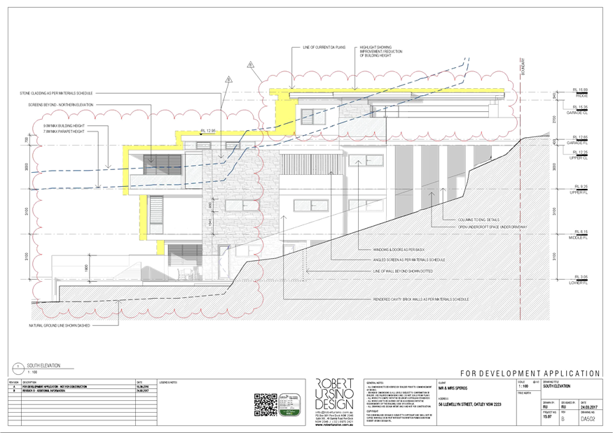
|
Georges River Council - Georges River Independent
Hearing Assessment Panel (IHAP) - Thursday, 15 June 2017
3.3 56 Llewellyn Street Oatley
[Appendix
5] Amended North
Elevation - 56 Llewellyn St Oatley
|
Page 153
|
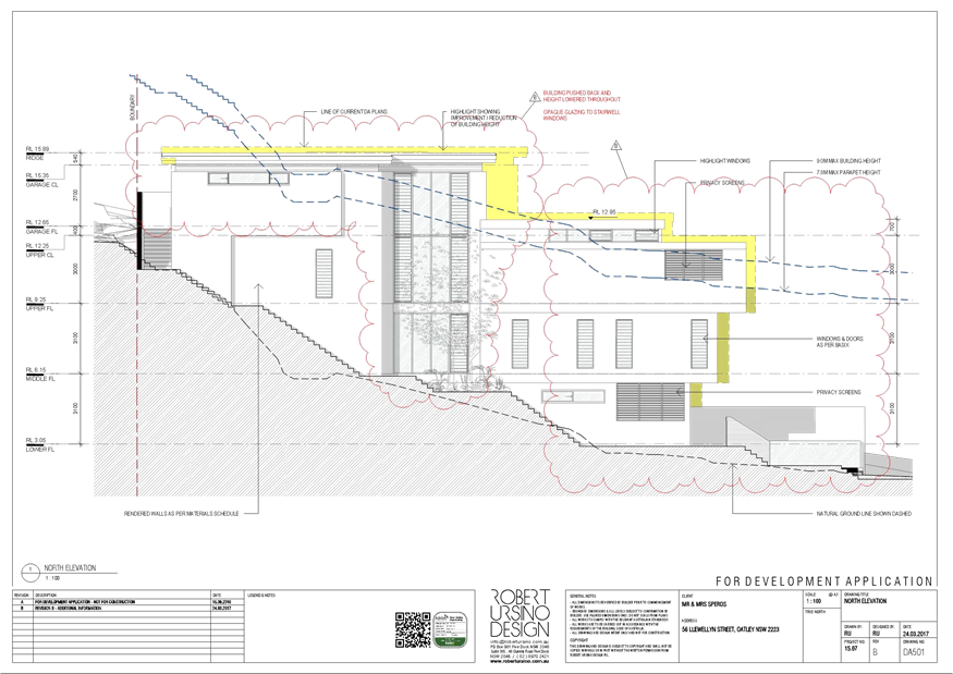
|
Georges River Council - Georges River Independent
Hearing Assessment Panel (IHAP) - Thursday, 15 June 2017
3.3 56 Llewellyn Street Oatley
[Appendix
6] Amended Shadow
Diagrams June - 56 Llewellyn St Oatley
|
Page 154
|
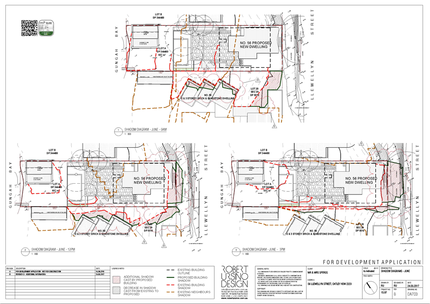
|
Georges River Council - Georges River Independent
Hearing Assessment Panel (IHAP) - Thursday, 15 June 2017
3.3 56 Llewellyn Street Oatley
[Appendix
7] Clause 4.6 Variation
- 56 Llewellyn Street Oatley
|
Page 155
|

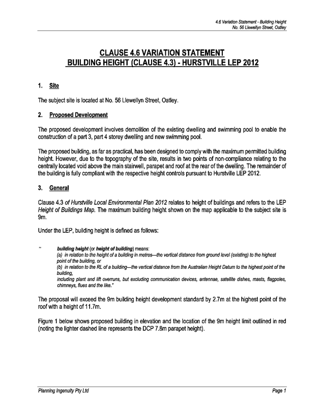
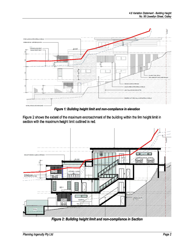
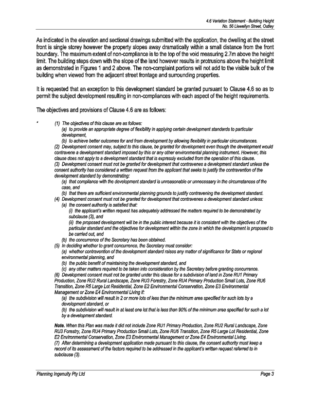

|
Georges River Council - Georges River Independent
Hearing Assessment Panel (IHAP) - Thursday, 15 June 2017
3.3 56 Llewellyn Street Oatley
[Appendix
8] Site photo from
street level - 56 Llewellyn Street Oatley
|
Page 165
|
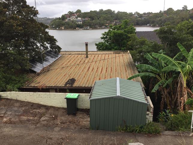
|
Georges River Council - Georges River Independent
Hearing Assessment Panel (IHAP) - Thursday, 15 June 2017
3.3 56 Llewellyn Street Oatley
[Appendix
9] Site as viewed from
45 Llewellyn Street opposite the site - 56 Llewellyn Street Oatley
|
Page 166
|