AGENDA - IHAP
|
Meeting:
|
Georges River Independent
Hearing Assessment Panel (IHAP)
|
|
Date:
|
Tuesday, 19 December 2017
|
|
Time:
|
4.00pm
|
|
Venue:
|
Dragon Room, Georges River
Civic Centre, corner MacMahon and Dora Streets, Hurstville
|
|
Participants:
|
Paul
Vergotis (Chairperson)
Juliet Grant (Panel Member)
Cameron Jones (Community
Representative)
|
|
Additional Invitees:
|
Meryl
Bishop (Director Environment and Planning)
Tina Christy (Manager
Development and Building)
Cathy Mercer (Team Leader
Administration)
Monica Wernej (Admin
Assistant)
|
|
1. On Site Inspections - 1.00pm – 3.30pm
a) 27-29
Cairns Street and 28-30 Eldon Street Riverwood
b) 815 Forest Road
Peakhurst
c) 27-33 Nielsen
Avenue Carlton
|
|
Break - 3.30pm
|
|
2. Public Meeting
– Consideration of Items - 4.00pm – 6.00pm
|
|
Public Meeting Session Closed - 6.00pm
(Break – Light Supper served to Panel
Members)
|
|
3. Reports and IHAP Deliberations in Closed
Session - 6.30pm
|
|
Item:
|
DA No:
|
Address:
|
Description:
|
|
3.1
|
DA2015/0278
|
815 Forest Road Peakhurst
|
Use of Church Site as a Monthly Market on Friday Evenings
|
|
3.2
|
DA 212/2016
|
27-33 Nielsen Avenue Carlton
|
Demolition of exisitng dwellings and the construction of a
five (5) storey residential flat building comprising of forty one (41) units
and basment parking
|
|
3.3
|
DA2017/0022
|
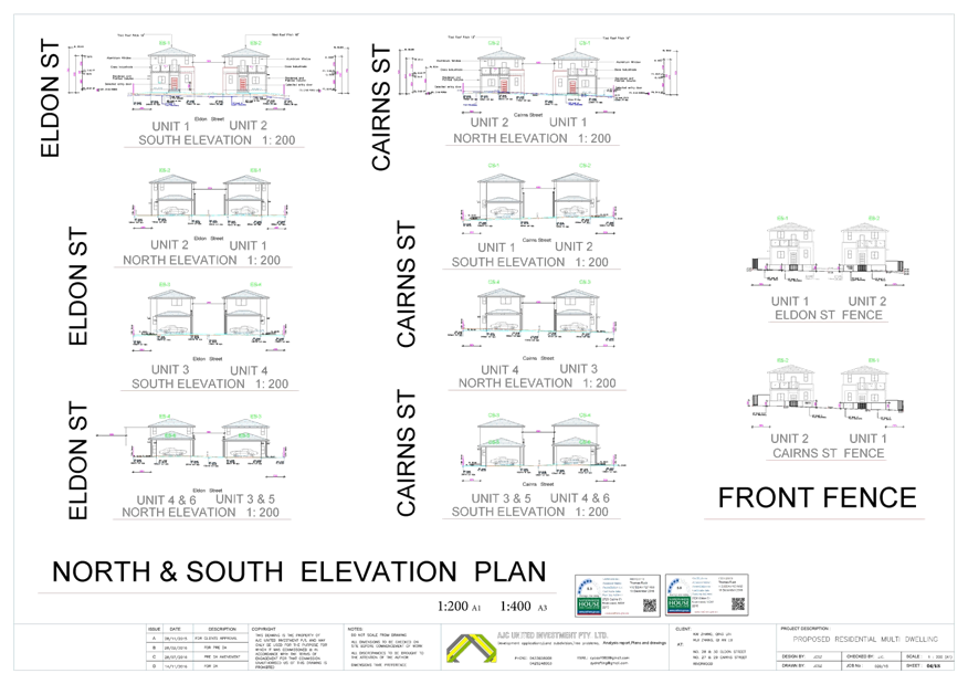
27-29 Cairns Street and 28-30 Eldon Street Riverwood
|
Demolition of existing structures and construction of a
multi dwelling development containing twelve (12) dwellings including four
(4) dwellings proposed as Affordable Rental Housing
|
|
4. Confirmation of Minutes by Chair
|
|
Georges
River Council – Independent Hearing and Assessment Panel Tuesday, 19
December 2017
|
Page 3
|
REPORT TO
GEORGES RIVER COUNCIL
IHAP MEETING OF Tuesday, 19 December 2017
|
IHAP Report No
|
3.1
|
Application No
|
DA2015/0278
|
|
Site Address & Ward Locality
|
815 Forest Road Peakhurst
Peakhurst Ward
|
|
Proposal
|
Use of Church Site as a Monthly
Market on Friday Evenings
|
|
Report Author/s
|
Coordinator Development Assessment
|
|
Owners
|
Sydney Catholic Achdiosese
|
|
Applicant
|
Kisari Farmers Market
|
|
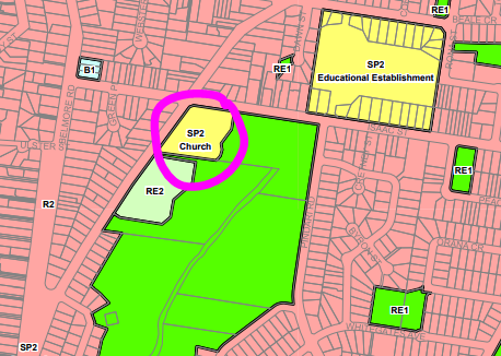
Zoning
|
Zone SP2 - Infrastructure
|
|
Date Of Lodgement
|
4/08/2015
|
|
Submissions
|
One hundred and ten (110)
submissions
|
|
Cost of Works
|
N/A – temporary use
|
|
Reason for Referral to IHAP
|
Number of submissions
|
|
Recommendation
|
That the application be approved in accordance with the
conditions included in the report for a twelve (12) month trial period.
|
|
|
Site Plan
|
Executive Summary
Proposal
1. Council
is in receipt of an application for the operation of a market containing fifty
six (56) stalls and proposing to operate on a weekly basis on the subject site.
When the application was originally submitted it was proposed to run the market
on a weekly basis. This was later revised to monthly based on the outcomes of
the notification process.
Site and
Locality
2. The
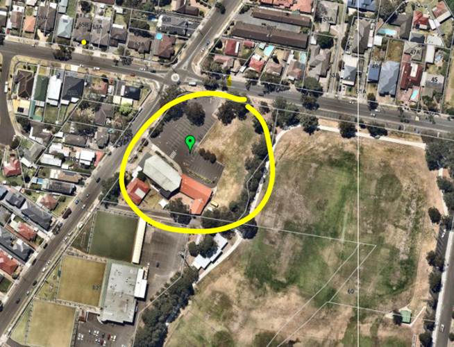
site is located on the south eastern corner of Forest Road and Isaac Street,
Peakhurst. The site is currently used as a place of worship – Our Lady of
Fatima Catholic Church. The market is carried out on the existing bitumen
covered car parking area.
Zoning and
Permissibility
3. The
site is zoned SP2 – Infrastructure (Church) under Hurstville Local
Environmental Plan 2012 and the proposal is not listed as permissible form of
development. The development is only permissible through the provisions of
Clause 2.8 – Temporary Use of Land of the LEP.
Submissions
4. Eighty
five (85) submissions against the development were received raising the
following concerns:
· Traffic and
parking
· Objection to
frequency being weekly (as originally proposed)
· Noise
· Zone objectives
Twenty five (25)
submissions were received in favour of the proposal. The points raised in
support include:
· Vibrant community
event
· Good chance to
engage with local community
· Opportunity to but
produce not available in local area
Conclusion
5. Having
regard to the Heads of Consideration under Section 79C(1) of the Environmental
Planning and Assessment Act 1979 and following a detailed assessment of the
proposal Development Application No. DA2015/0278 should be approved subject to
the conditions of this report including twelve (12) month approval to allow elements
of the Plan of Management to be monitored and issues addressed at that time.
Further conditions imposed regarding hours of operation, acoustic requirements,
lighting, restricted number of stalls, etc.; and an updated Plan of Management.
Report in Full
Proposal
6. Council is in receipt of an application for the operation of a market
containing fifty six (56) stalls and proposing to operate on a monthly basis on
the subject site. The original application proposed a weekly market, however
the applicant has agreed to a monthly market.
The application proposes:
- A
market (general food, fresh produce and a range of organic products), to
operate on a temporary basis – the applicant has proposed a market once
per month on Fridays – typically the last Friday of the month
- The hours of the market are proposed to be from 3.00pm to 9.00pm
with set up from 1.00pm – 3.00pm and take down from 9.00pm to 11.00pm
- Fifty
six (56) stalls are proposed. The stalls are proposed to sell fresh foods (eg
fruit, vegetables) and stalls for food for immediate consumption (eg hot foods,
ice cream etc)
- The
application does propose stalls that will include the preparation and cooking
of food on site
- Temporary lighting for the market is in the form of string lights
and power is proposed through some portable generators
- There are toilet facilities available in the existing church hall
for the use of the customers of the market (further toilet facilities are
recommended)
- Vehicular access to the market by the stall holders during the set
up time (1.00pm-3.00pm) is available via Forest Road and Isaac Street
- There is no parking for the general public on the site
- The market is accessed by pedestrians from both Forest Road and
Isaac Streets
- It is estimated that the capacity of the market is 3,500 to 5,000
over a six (6) hour period
The market has
been operating on the last Friday of the month since June 2015 without Council
consent.

Photograph of the market in operation
as taken by Council staff

Photo of the market from the
Peakhurst Foodies and Farmers Market Facebook Page
The Site and Locality
6. The
site is located on the south eastern corner of Forest Road and Isaac Street,
Peakhurst. The site is currently used as a place of worship – Our Lady of
Fatima Catholic Church.
The entire church
site has a frontage of approximately 80m to Forest Road and a frontage of
approximately 110m to Isaac Street to the west. The southern, rear boundary, is
approximately 116m in length and the boundary to the east is irregular.
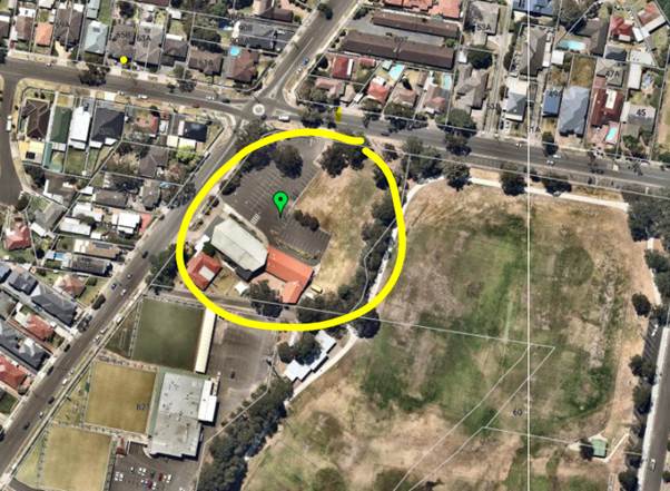
Aerial photograph
with the site circled in yellow
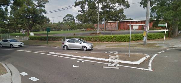
The site as viewed
from north eastern corner of Forest Road and Isaac Street.
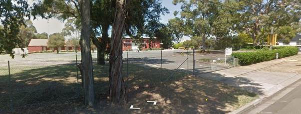
The site viewed
from the opposite side of Isaac Street
Immediately to the
east of the subject site is the northern part is Gannons Park, a Council owned
park zoned RE2 – Public Recreation. Gannons Park is a significant open
space used for sporting activities and passive recreation.
Immediately to the
south of the subject site at 821 Forest Road is Grandview’s Bowling Club.
This site is occupied by a registered bowling club comprising of three bowling
greens, a single level club building and associated car parking, access and
landscaping.
To the west and the
north of the site on Forest Road and Isaac Streets is low density residential
development comprising mainly single dwellings, with some multiple dwelling
developments.
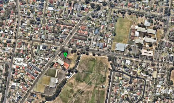
Aerial photo
showing the broader context of the site and the locality.
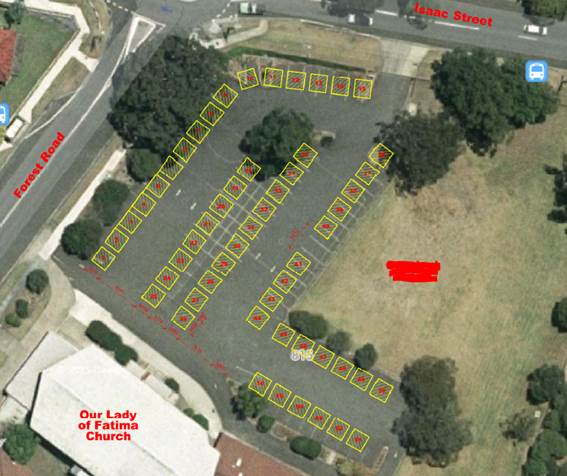
The portion of the
site that the market is proposed to operate on is the bitumen car park at the
“front” of the site. The diagram below shows the indicative layout
of the market stalls.
Background
7. On
22 July 2015 Council issued a Notice of Intention to Serve an Order against the
operation of the market because they were operating without development
consent.
On 4 August 2015
the Development Application for a food market was lodged with Council. A Plan
of Management was submitted upon request of Council. This outlined operational
matters such as setting up and packing up of stalls, and ensuring appropriate
staffing are on hand.
On 11 August 2015
Council Officers requested additional information from the applicant in terms
of layout of stalls and more comprehensive traffic information.
27 October to 13
November 2015 notification and advertising was undertaken.
On 10 March 2016
additional information was received relating to the Plan of Management for the
market.
November 2017
Council received additional information relating to the operation of the market
including patron numbers etc.
The market has
been operating without development consent. Since the neighbour notification
period, Council has received minimal complaints regarding the operation. These
have been relayed to the Market Organisers who have made changes to rectify
those issues where possible.
HURSTVILLE
LOCAL ENVIRONMENTAL PLAN 2012
8.
Part 2 –
Permitted or Prohibited Development
Clause 2.1
– Land Use Zones
The
property is zoned SP2 – Infrastructure pursuant to the Hurstville Local
Environmental Plan 2012.
Pursuant
to the Hurstville Local Environmental Plan the objectives of the SP2 –
Infrastructure Zone are as follows:
· To provide for infrastructure and related uses
· To prevent development that is not compatible with or may detract
from the provision of infrastructure.
The
uses that are permissible without consent in the SP2 zone are nil.
Uses
that are permitted with consent are relevantly, the purpose shown on the land
zoning map (infrastructure) including any development that is ordinarily
incidental or ancillary to development for that purpose. Any other
development is prohibited.
The
proposed use is defined as a market. According to the Hurstville Local
Environmental Plan 2012 a market is defined as follows: “an
open-air area, or an existing building, that is used for the purpose of
selling, exposing or offering goods, merchandise or materials for sale by independent
stall holders, and includes temporary structures and existing permanent
structures used for that purpose on an intermittent or occasional basis”
Market
is not listed as a permissible use in the zone its own right.
The
use that is shown on the land zoning map is a church. Accordingly, in
order for the market use to be permitted it must be shown that it is ordinarily
incidental and/or ancillary to use of the premises as a church.
The
markets do not have any connection to the church, except that it is proposed
that they operate from the property. It is considered that the proposed use of
the site for the purposes of a market cannot properly be categorised as incidental or ancillary to the use as a church. If the
market was run by the Church sporadically (eg annual fete; spring fair;
fundraiser etc.) it could be classified as incidental or ancillary to a regular
church function.
Further
to this, whilst there are examples of markets on other SP2 zoned sites around
Sydney, these uses are not the ‘norm’ and therefore cannot be
classed as “normally incidental” to the SP2 uses.
In
its current form the market is considered to be a separate use.
Given the above,
the only way that consent can be granted to the use is via Clause 2.8 Temporary
Use of Land of the LEP.
The
following provides an assessment of the proposal under Clause 2.8:
2.8 Temporary use of land
(1) The objective of this clause is to provide for the
temporary use of land if the use does not compromise future development of the
land, or have detrimental economic, social, amenity or environmental effects on
the land.
Comment: The use is temporary in nature
in that all stalls and associated structures etc. are removed at the conclusion
of every market event. The markets do not compromise the future development of
the land for church purposes as allowed by the zoning.
(2) Despite any other provision of this Plan, development
consent may be granted for development on land in any zone for a temporary use
for a maximum period of 28 days (whether or not consecutive days) in any period
of 12 months.
Comment: It is proposed that the market
be limited to 12 days in every 12 months – i.e. once per month
only.
(3) Development consent must not be granted unless the consent
authority is satisfied that:
(a) the temporary use will not prejudice the subsequent
carrying out of development on the land in accordance with this Plan and any
other applicable environmental planning instrument, and
Comment: the use will not prejudice the
carrying out of any subsequent development on the land as it does not require
any alteration to the existing building or site.
(b) the temporary use will not adversely impact on any
adjoining land or the amenity of the neighbourhood, and
Comment: The application has been
reviewed in terms of traffic impact and this is discussed in further detail in
a subsequent part of this report.
The
application has been accompanied by a Plan of Management that aims to minimise any potential amenity impact on
the neighbourhood. Further to this, conditions of
consent have been recommended by Council’s Environmental Health Officer
and Coordinator Environmental Sustainability and Waste to ensure that there
will be no adverse impact.
(c) the temporary use and location of any structures related
to the use will not adversely impact on environmental attributes or features of
the land, or increase the risk of natural hazards that may affect the land, and
Comment: The temporary structures are
located on existing bitumen area and will not have any impacts in terms of
natural hazards or environmental features. No trees or vegetation are affected
by the temporary nature of the development.
(d) at the end of the temporary use period the land will, as far as
is practicable, be restored to the condition in which it was before the
commencement of the use”.
All temporary
structures including stalls, cooking equipment, information stands, waste bins
etc are removed at the conclusion of every market event.
It is recommended
that the markets will operate to a plan of management to ensure that the site
is left in a tidy condition and free of rubbish.
Part 4 –
Principal Development Standards
There are no
development standards that apply to the site.
Part 6 –
Additional Local Provisions
Clause 6.1
– Acid Sulfate Soils
The subject site is
not shown as being affected by acid sulfate soils as identified on the Acid
Sulfate Soil Map.
STATE POLICIES
STATE
ENVIRONMENTAL PLANNING POLICY NO 55
9. The
application does not propose the disturbance of any land or any permanent works
to be carried out. Notwithstanding this, the site has been used as a church
since 1967 and was used as residential use prior to that. Given the uses of the
land it is unlikely that the site is contaminated.
DRAFT
ENVIRONMENTAL PLANNING INSTRUMENTS
10. There
are no draft planning instruments that are applicable to this site.
DEVELOPMENT
CONTROL PLANS
11. There
are no controls that relate to this form of development in Hurstville
Development Control Plan No 1.
ENVIRONMENTAL,
SOCIAL AND ECONOMIC IMPACTS
12.
Vehicular
access, Parking and Circulation
Parking
When the
development application was originally submitted to Council it was accompanied
by a traffic report. Upon review of that report the applicant was advised that
the report needed to be amended for as the report did not make an adequate
assessment of the distribution of where the traffic is expected to come from
and the impact of traffic on the nearby intersections. The report also failed
to properly consider the on-street availability of car parking during the peak
times for the market.
A further
supplementary traffic report submitted as part of the application contained a
survey of all available unrestricted parking spaces. Council’s Engineers
suggested a catchment area of parking spaces that should be surveyed. The
following diagram shows the extent of the area surveyed for on-street
parking. In total it was determined there are 783 on-street public car
parking spaces.
A parking survey of
the area was conducted by the applicant’s traffic engineer during a
market event (25 September 2015). The peak occupancy level was recorded at 6pm
– where 270 spaces were occupied. The peak occupancy period indicates a
35% occupancy level.
The report from the
applicant concludes that the peak parking demand anticipated to be generated
from the subject proposal is unlikely to exhaust the overall car parking
availability in the site vicinity or impose any adverse impacts on existing
parking conditions.
Council’s
Traffic Engineers also conducted their own independent review of the parking impacts
of the development. The review was undertaken on a Friday one (1) week prior to
a market day and also on a market day. The dates for the survey were 21 August
2015 and 28 August 2015.
On market days,
Council’s traffic engineers had observed that in the streets close to the
market the parking was at nearly 100% capacity, although turnover of car
parking spaces was frequent.
During and
following the notification period Council received some complaints about
vehicles being parked too close to driveways and intersections. It is
recommended that on market nights that a traffic controller, employed by the
market operator undertake regular foot patrols of the surrounding streets to
ensure that cars parked to not impede residential driveways. A condition of
consent has been recommended to this effect.
It is also
recommended that Council rangers undertake regular patrols of the area during
market events.
Traffic impacts
Both the
Council’s assessment of traffic impacts and the applicant’s traffic
report identify that there is an increase in traffic and some queuing at the
roundabout at the intersection of Forest Road and Isaac Street. Both reports
conclude that the other intersections within the vicinity of the market were
not greatly affected.
The applicant’s
traffic engineer concludes “it is evident that the food market
operations do not impose any adverse impacts on existing traffic conditions
(i.e. vehicle queuing and delays) in the site vicinity.”
Council’s
Traffic Engineer reviewed the applicant’s report and stated that it
reflected Council’s own observations.
Support from
Council’s Engineer was given for the development to run once per month
only and on the proviso that no increase in the number of stalls should be
considered.
Neighbourhood
Amenity
The application has
been amended a number of times in an effort to reduce any impacts on the
amenity of the surrounding area. The amendments to the application include:
- Reducing
market frequency from weekly to once per month
- Deleting
the proposal for rides at the markets
- Deleting
live music
- The
applicants have stated that there will be no alcohol for sale for consumption
on the premises
- A
Plan of Management for the operation of the market
A Plan of
Management was submitted upon request of Council. This outlined operational
matters such as setting up and packing up of stalls, and ensuring appropriate
staffing are on hand. However, a condition of consent is recommended that the
following additional information be included in the Plan of Management:
- Staff
member to make regular patrols of Forest Rd and Isaac Streets to monitor
parking, and
- Any
discarded rubbish in this section of Forest Rd and Isaac Street is to be
collected.
Further to this,
Council Officers have recommended strict operational controls in terms of hours
of operation, the requirement for an acoustic report and limitations on the
number of stalls to be present at any one time.
Submissions
13. In
accordance with the provisions of Council’s notification requirements, the
application was placed on neighbour notification for a period of fourteen (14)
days where adjoining property owners were notified in writing of the proposal
and invited to comment. There were a total of twenty five (25) submission
received in support of the development and eighty five (85) submissions against
the development. Of the eighty five (85) submissions against the development
21% stated that they have no objection to markets once per month.
Of the eighty
five (85) submissions received against the development the following concerns
were raised.
Traffic and
parking – concerns about the increase in traffic and traffic delays
and the lack of off-street car parking spaces. Residents also raised concerns
about illegal parking and the obstruction of driveway access to residential
properties (56% of submissions raised this concern).
Comment: A
full assessment of the traffic and parking impacts of the development can be
found in an earlier section of this report.
A condition of
consent is imposed for traffic controllers/monitors to patrol the adjoining
streets to insure that patrons of the market park appropriately.
Rides
– there is objection to the provision of rides or ‘carnival
games’ at the market due to noise issues and the fact that rides are not
normally associated with “foodies” markets (13% of submissions).
Comment:
Following concerns raised by the residents and council the applicant has stated
that there will no longer be rides offered at the market. A condition of
consent will be imposed to this effect.
Food handling
- Markets are not subject to the same regulations as other food businesses
in terms of food handling, sanitation etc (16% of submissions).
Comment:
The markets are subject to the requirements of the Food Act and relevant standards.
Council’s Health Officers have reviewed the proposal and have recommended
stringent conditions relating to food safety.
Definition - The
markets are not really a “farmers’ market” – they are a
commercial venture (20% of submissions).
Comment:
The applicant has stated that the markets sell fresh and cooked food. This
report assessed the markets as a retail use (markets) and has considered the
impacts as such.
Pedestrian
Safety – there is a concern for pedestrian safety. There is a lack of
places to safely cross the road and inadequate street lighting (14% of
submissions).
Comment: A
condition is recommended for a traffic control officer to ensure that people
are parked appropriately and do not obscure the line of vision for vehicles by
ensuring distances from corners etc.
Hours of
operation – concern about the proposed hours (3% of submissions).
Comment:
The finishing time of 9pm is not considered inappropriate on a Friday night. A
condition is recommended ensuring compliance with the Plan of Management to
minimise any impacts.
Permissibility
– concern that the use is not permissible in the SP2 zone (18% of
submissions).
Comment:
See assessment above. The use is not considered permissible in the zone,
however the use can be considered under Clause 2.8 of the LEP.
Toilets - Inadequate
toilet facilities are provided (10% of submissions).
Comment:
There are six (6) x toilets provided in the existing church buildings. A
further condition is recommended for an additional accessible toilet and six
(6) x portable toilets to be provided. These may be provided in the main market
area. There is no standard for the amount toilets to be provided, however City
of Sydney’s Public Toilet Strategy has been used as a guide.
Rubbish - Concern
about litter and rubbish after a market event (19% of submissions).
Comment:
Council’s Coordinator Environmental Sustainability and Waste has reviewed
the proposal and recommended conditions relating to rubbish removal. Further to
this an additional condition is recommended to update the plan of management
submitted so that the market operators do a check of the local area to collect
rubbish.
Anti-social
behaviour - There should be no sale of alcohol for consumption at the
market. Residents were concerned about anti-social activities concerned (34% of
submissions).
Comment:
the applicant has specified that there will be no sale of alcohol during the
markets. A condition of development consent is recommended to ensure this.
Noise
– concerns mainly raised in relation to amplified music and proposed
rides (20% of submissions).
Comment: The
applicant has stated that there will be no amplified music or PA system and the
proposal has been amended so that rides no longer form part of the proposal. A
condition of consent is recommended to ensure this.
Security
– concerns raised over the lack of security for the markets. There are
concerns that there is inadequate crowd control and this could lead to
antisocial activities (18% of submissions).
Comment:
The Plan of Management (PoM) submitted with the application states that security
will be present. A condition is recommended to adhere to the PoM.
Impact on
local businesses – submissions were concerned that the weekly market
would have an adverse impact on other small businesses in the area in terms of
potential loss of customers (22% of submissions from residents; 6% of
submissions from other local businesses).
Comment:
Many of the stalls operating at the market provide foods that are not readily
available from the local area. Notwithstanding this, as the market is only
being held once a month the market is unlikely to have an ongoing negative
economic impact.
Of the letters of
support received the issues raised were:
- The
market is a vibrant event
- It
is good for the community
- It
provides something to do in the area
- It
is an opportunity to buy and try produce and new things not currently available
in the local area
Internal
Referrals
14.
Coordinator
Environmental Sustainability and Waste
“As the venue is private property the owner is responsible for
removal of all waste from the property after each Market event.
The stall holders must remove all waste generated by them and the
owners must provide sufficient bins for any additional waste generated.
Visitors to the markets are not to use neighbours bins to dispose of their waste.”
A further
condition is recommended for the Plan of Management to be amended to ensure
that the market organisers collect any rubbish left in the nearby streets from
the patrons of the market.
Coordinator
Environmental Health
Objection to the
market being held more than once per month, however, the Coordinator has
imposed operational conditions relating to food safety, noise and mandatory
inspections based on a monthly market and where new stalls are open.
Senior Traffic
Engineer
As discussed
above, Council’s Senior Traffic Engineer has raised no objection to the
market being held once per month.
CONCLUSION
15. The
application has been assessed having regard to the Heads of Consideration under
Section 79C of the Environmental Planning and Assessment Act 1979, the
provisions of the relative State Environmental Planning Policies and Local
Environmental Plan. The temporary use of the site for a market once a month is
considered to be acceptable.
A condition
of consent is recommended that the following additional information be included
in the Plan of Management:
- Staff
member to make regular patrols of Forest Road and Isaac Street to monitor
parking, and
- Any
discarded rubbish in this section of Forest Road and Isaac Street is to be
collected.
Also, specific
conditions have been imposed regarding hours of operation, acoustic
requirements, lighting, restricted number of stalls, etc.
Following
detailed assessment it is considered that Development Application No DA2015/0278
should be approved for a twelve (12) month trial period subject to the
following conditions. This will allow Council the ability to monitor the
operation with the restrictions imposed.
1. Duration
of Consent - The duration of this consent is limited to a trial period of
twelve (12) months from the date of this Determination Notice. In this
regard, a separate application shall be lodged before the expiration date for
Council’s consideration should the continuation of the use be proposed.
If no application is
lodged to modify this condition and extend/delete the trial period, this
consent shall lapse at the end of the trial period.
2. Plan
of Management - Prior to the commencement of this consent the Site Management
Plan – Organic Foodies Market dated 9 March 2016 submitted with the
development application must be amended in the following manner:
- A
provision shall be made for a staff member to make regular patrols of Forest
Road and Isaac Street to monitor patrons car parking to ensure that driveways
are not obstructed
- At
the conclusion of each event a staff member must undertake a
‘patrol’ of Forest Road and Isaac Street and collect any rubbish
that has been discarded from market patrons
3. Hours
of Operation/Frequency - The market shall operate a maximum of one (1)
Friday per month. Set up of the market may commence from 1.00pm. The hours of
operation of the market open to the public is limited from 3.00pm to 9.00pm.
All stalls shall be disassembled and the site vacated and left in a tidy manner
free of waste by 11.00pm
4. Acoustic
Requirements - The proposed use of the premises and the operation of all
plant and equipment shall not give rise to an ‘offensive noise’ as
defined in the Protection of the Environment Operations Act 1997
(as amended) and Regulations.
Within three (3)
months of the date of this consent an Acoustic Report muts be submitted to
Council. This report shall be prepared by a suitably qualified acoustic
consultant demonstrating that the operation of the premises and plant equipment
does not give rise to a sound pressure level at any affected premises that
exceeds the background LA90, 15 min noise level, measured in the absence of the
noise sources under consideration by more than 5dB. The source noise level
shall be assessed as a LAeq, 15 min in accordance with the NSW Environment
Protection Authority’s NSW Noise Policy for Industry (2017).
5. Ongoing
Plan of Management - All market events shall be conducted in accordance
with Site Management Plan – Organic Foodies Market dated 9 March 2016 as
amended.
6. Noise
Control - The use of the premises must not give rise to the transmission of
offensive noise to any place of different occupancy. Offensive noise is defined
in the Protection of the Environment Operations Act 1997
(as amended).
7. Lighting
– General Nuisance - Any lighting on the site shall be designed so as
not to cause a nuisance to other residences in the area or to motorists on
nearby roads and to ensure no adverse impact on the amenity of the surrounding
area by light overspill or glare. Flashing, moving or intermittent lights or
signs are prohibited.
8. Amenity
of the neighbourhood - The implementation of this development shall not
adversely affect the amenity of the neighbourhood or interfere unreasonably
with the comfort or repose of a person who is outside the premises by reason of
the emission or discharge of noise, fumes, vapour, odour, steam, soot, dust,
waste water, waste products, grit, oil or other harmful products.
9. Amplified
sound equipment and musical instruments including live bands - There shall be no live bands, musical instruments and amplified
sound equipment permitted to be used in the proposed development at any time
except in an emergency where the situation poses an immediate risk to public
safety.
10. Temporary
stalls – Restricted Numbers - There shall be no more than fifty six
(56) stalls (including mobile vehicles) permitted at any one market
event. Of the fifty six (56) stalls (including mobile vehicles), there
shall be no more than forty (40) stalls or mobile vehicles permitted to sell
food at any one market event. The definition of ‘Food’ and
‘Sell’ is defined under the Food Act 2003. There shall be no
‘rides’ or amusement games operating at any time
11. Restriction
on Alcohol - There shall be no alcohol available for immediate consumption
on the site
12. Temporary
food stalls and mobile food vehicles information - A list of temporary food
stalls and mobile food vehicles attending the market event must be submitted to
Council at least ten (10) days before each market event. The list must
include the following information:
(a) Temporary
Food Stalls:
I. Company
or sole trader’s name – If stall is run by a Trust, director/s of
the trust is to be provided,
II. Australian
Business Number (ABN) / Australian Company Numbers (CAN),
III. Address
of company or sole trader – Exclude PO Box address
IV. Trading
name,
V. Type
of food sold,
VI. Contact
name,
VII. Contact
number,
VIII. Contact
e-mail address, and
IX. Food
Safety Supervisor (FSS) number (FSS is only required if food sold is ready to
eat, potentially hazardous and not sold and served in the supplier’s
original package)
(b) Mobile
Food Vehicles:
a. Company
or sole trader’s name – If stall is run by a Trust, director/s of
the trust is to be provided,
b. Australian
Business Number (ABN) / Australian Company Numbers (CAN),
c. Address
of company or sole trader – Exclude PO Box address,
d. Trading
name,
e. Type
of food sold,
f. Contact
name,
g. Contact
number,
h. Contact
e-mail address,
i. Food
Safety Supervisor (FSS) number (FSS is only required if food sold is ready to
eat, potentially hazardous and not sold and served in the supplier’s
original package), and
j. Vehicle
registration number.
13. Registration
of Temporary Food Stalls and Mobile Food Vehicles - All temporary food
stalls and mobile food vehicles must register their business with Georges River
Council at least ten (10) days prior to trading at the market event.
Temporary stalls
and mobile food vehicles who registered with Georges River Council within
twelve (12) months of attending the market event do not require re-registering.
14. Temporary
Food Stalls and Mobile Food Vehicles - Set up and operation - The set up
and operation of temporary food stalls and mobile food vehicles shall be in
accordance with the:
· Food Act 2003 (as
amended),
· Food Regulation
2010 (as amended),
· “Guidelines
for Food businesses at Temporary Events” (as amended) published by
the NSW Department of Primary Industries – Food Authority, and
· “Guidelines
for Mobile Food Vending Vehicles” (as amended) published by the NSW
Department of Primary Industries – Food Authority
15. Water
– use and store - Potable water must be used for the washing and
preparation of food. Potable water must be stored in containers that are
food grade rated.
16. Waste
- All waste generated from temporary food stalls and mobile food vehicles
shall be removed from site at the end of each trade and disposed of lawfully.
Bins must be available at all times on the site for the disposal of rubbish
from the patrons of the markets.
17. Liquid
waste – Polluted Waters - All liquid waste and polluted waters
generated by temporary food stalls and mobile food vehicles must be disposed of
into Sydney Water sewer system.
18. Toilets
- The existing toilets at the rear of the church and the church hall are to
be available at all times that the market is operating. In addition to this,
six (6) x portable toilets and a portable accessible toilet must be provided
for each market event. The portable toilets must be located on a level and
accessible part of the site near the market stalls.
19. Use
of electricity and gas appliances - The use of gas and electric appliance
in the market must comply with the following:
(a) All
electrical work should be carried out by a licensed electrician and confirm to
Australian Standard AS3002-1985 “Electric Installation – Shows
and Carnival”.
(b) Gas
should be installed by a licensed gasfitter and comply with the appropriate
provisions of Australian Standard AS1596.7997 and AS5601-2000. A current
compliance plate should be attached to the vehicle for new installations or for
any changes made to existing gas appliances.
(c) Gas-fired
appliances used in the open should not have a gas bottle greater than 9kg
capacity and the bottle should be secured so that it cannot be tipped over.
The above measures
are to be taken to satisfy the requirements of SafeWork NSW to protect the
health, safety and welfare of employees and visitors at the event.
20. Food
Stalls and mobile food vehicle – Inspections and fees and charges - Food
Stalls and mobile food vehicles will be subject to annual inspection by Council’s
Environmental Health Officers. Non-compliance will result in Council conducting
re-inspections on separate occasions.
Cost applies for
the above inspections in accordance with Georges River Council’s Fees and
Charges and will be changed to the event organiser.
ATTACHMENTS
|
Attachment View1
|
Site plan - 815 Forest Rd Peakhurst
|
|
Attachment View2
|
Proposed stall map - 815 Forest Road Peakhurst
|
|
Georges
River Council - Georges River Independent Hearing Assessment Panel (IHAP) -
Tuesday, 19 December 2017
3.1 815 Forest Road Peakhurst
[Appendix
1] Site plan -
815 Forest Rd Peakhurst
|
Page 21
|
|
Georges River Council - Georges River Independent
Hearing Assessment Panel (IHAP) - Tuesday, 19 December 2017
3.1 815 Forest Road Peakhurst
[Appendix
2] Proposed stall
map - 815 Forest Road Peakhurst
|
Page 22
|
|
Georges River Council – Independent Hearing and
Assessment Panel Tuesday, 19 December 2017
|
Page 23
|
REPORT TO GEORGES RIVER COUNCIL
IHAP MEETING OF Tuesday, 19 December 2017
|
IHAP Report No
|
3.2
|
Application No
|
DA 212/2016
|
|
Site Address & Ward Locality
|
27-33 Nielsen Avenue Carlton
Kogarah Bay Ward
|
|
Proposal
|
Demolition of exisitng dwellings
and the construction of a five (5) storey residential flat building
comprising of forty one (41) units and basment parking
|
|
Report Author/s
|
Development Assessment Officer
|
|
Owners
|
Nielson Avenue Carlton Pty Ltd
|
|
Applicant
|
Architecure and Building Works
|
|
Zoning
|
Zone R3 - Medium Density
Residential
|
|
Date Of Lodgement
|
11/10/2016
|
|
Submissions
|
Two (2)
|
|
Cost of Works
|
$10,778.669
|
|
Reason for Referral to IHAP
|
Height non-compliance and
unresolved submissions
|
|
Recommendation
|
That the application be approved
in accordance with the conditions included in the report.
|
|
|
Site Plan

|
Executive Summary
Proposal
1. Council
is in receipt of an application for the demolition of the existing dwellings
and the construction of a five (5) storey residential flat building comprising
of forty one (41) units and basement parking on the subject site.
Site and
Locality
2. The
subject site is identified as 27-33 Nielsen Avenue, Carlton and consists of
four (4) lots having a legal description of lots 23, 24, 25 and 26 DP 5452. The
site is a regular shaped parcel of land located on the north-western side of
Nielsen Avenue between Jubilee Avenue and Anglo Square.
The site has an area of 2054.4m2, a street frontage to Nielsen
Avenue of 73.1m and depth of 28m.
Zoning and KLEP
2012 Compliance
3. The
site is zoned R3-Medium Density Residential under KLEP 2012 and the proposal is
a permissible form of development with Council’s consent. The
proposed development satisfies all relevant clauses contained within KLEP 2012
apart from Clause 4.3-Height of Buildings where a minor height exceedance is
presented. A Clause 4.6 variation to this development standard has been sought
which is detailed in the later stages of this report.
Kogarah
Development Control Plan 2013 (KDCP 2013)
4. The proposed development generally satisfies the provisions of
Council’s DCP. This is discussed in more detail in the body of this
report.
Submissions
5. Two
(2) submissions were received raising concerns related to insufficient time
available for comment, construction impacts, visual impact, shadowing, privacy,
noise and traffic and parking impacts.
Conclusion
6. Having
regard to the Heads of Consideration under Section 79C(1) of the Environmental
Planning and Assessment Act 1979 and following a detailed assessment of the
proposal Development Application No. 212/2016 should
be approved subject to conditions.
Report in Full
Proposal
7. Council
is in receipt of an application for the demolition of the existing dwellings
and the construction of a five (5) storey residential flat building comprising
forty one (41) units and basement parking on the subject site.
The Site and
Locality
8. The
subject site is identified as 27-33 Nielsen Avenue, Carlton and consists of
four (4) lots having a legal description of lots 23, 24, 25 and 26 DP 5452. The
site is a regular shaped parcel of land located on the north western side of
Nielsen Avenue between Jubilee Avenue and Anglo Square. The site has an
area of 2054.4m2, a street frontage to Nielsen Avenue of 73.1m and depth
of 28m.
The site falls approximately 3.3m across the site towards the eastern
corner of the site along the street frontage. There are a number of substantial
trees within the site and along the street and a number of these trees will be
removed as a result of the development. Currently the property is occupied by
four (4) single storey detached dwellings and outbuildings. Immediately to the
south west of the site there is a substantial two (2) storey dual occupancy
development that has been strata subdivided.
To the north east and on the opposite side of Nielsen Avenue there are
single storey detached dwellings whereas to the north west of the site, there
are residential flat buildings that range is scale from three (3) to four (4)
storeys.
Figure
1- Site Aerial
Background
9. The
application was submitted with Council on 11 October 2016 and was neighbour
notified from 7 November to 24 November 2016 where two submissions were
received.
The application was reviewed by the St George Design Review Panel on 1 December
2016 where a number of design changes were recommended. These changes were
primarily related to the built form and scale of the development which the
Panel felt was inconsistent with the streetscape
character and resulted in a building form that was unduly assertive in its
expression. The applicant was forwarded
the Panels comments in an email dated 8 December 2016.
Correspondence was sent to the applicant on 15 February
2017 that detailed a number of concerns Council had with the application. This
letter included issues related to building height, front setback, building
separation, deep soil planting and vehicular access and car parking.
Architectural plan amendments were undertaken and were
resubmitted with Council on 10 August 2017. The amended plans were neighbour
notified from 17 August to 31 August 2017 where two submissions were received.
To improve the building appearance further, additional architectural plan
amendments were made to this resubmission and revised details were submitted
with Council on 23 August 2017. These plan amendments did not require
renotification as they resulted in a reduction in the overall bulk of the
building and improved the level of separation between this building and
neighbouring developments.
The plans submitted with Council on 23 August 2017 were
reviewed by the Design Review Panel during the meeting held on 7 September
2017. The Panel supported the application subject to a
number of minor issues being resolved. The applicant was made aware of these
required changes in an email sent on 13 September 2017.
· Further architectural and landscape changes were
made and these details were submitted with Council on 3 October 2017. On 31
November 2017 additional design changes were again made which included:
· Re-layout
of both units 05 and 06 to create a more notable separation that further
accentuates the visual break in the building’s facade. (From Ground Level
to Third Level). This design outcome further accentuates the vertical elements
of the building reducing its bulk.
· Lobby
entries relocated as a result of re-layout the units.
· Building
entrances, seating area, letter boxes relocated accordingly.
· Pathway
extended due to the relocation of building entry.
· Front
landscape amended due to the changes with additional planting provided between
Unit 05 and 06.
These
plans suitably responded to both the Panel comments and Council’s
initially raised concerns. These plans and details are relied upon for the
preparation of this report.
Section 79C
Assessment
10. The
following is an assessment of the application with regard to Section 79C(1) of
the Environmental Planning and Assessment Act 1979.
(1) Matters
for consideration – general
In
determining an application, a consent authority is to take into consideration
such of the following matters as are of relevance to the development the
subject of the development application:
(a) the
provision of:
(i) any
environmental planning instrument,
Kogarah
Local Environmental Plan 2012 (KLEP 2012)
Part 2 –
Permitted or Prohibited Development
Clause 2.1
– Land Use Zones
11. The
site is zoned R3-Medium Density Residential under KLEP 2012 and the proposal is
a permissible form of development with Council’s consent. The site
retains its R3-Medium Density Residential Zoning and was not rezoned under the
recent KLEP 2012 amendments (New City Plan).
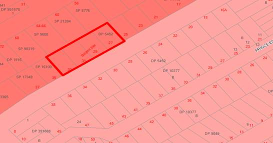
Figure 2- Zoning Map
Part 4 – Principal
Development Standards
|
Applicable LEP Clause
|
Development Standards
|
Development Proposal
|
Compliance/
Comment
|
|
4.1 Minimum
subdivision Lot size
|
1000m2
|
2054.4m2
|
Yes
|
|
4.3 Height of Buildings
|
15m
|
16.9m
|
No (See discussions under Clause
4.6 below)
|
|
4.4 Floor
Space Ratio
|
1.5:1 (3081m2)
|
1.49:1 (3,078m2)
|
Yes
|
Under the KLEP 2012 amendments, the
subject site received an FSR and Height uplift to the noted standards as
outlined above. As such, it is considered that any undeveloped sites located
both within the immediate and local context will present a notable
transformation to reflect these FSR and height increases.
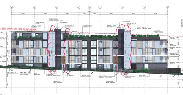
Figure 3- Areas of Height
Non-Compliance
12. Clause 4.6
– Exceptions to development standards
(1) The objectives of this clause are as follows:
(a) to provide an appropriate degree of
flexibility in applying certain development standards to particular
development,
(b) to achieve better outcomes for and from
development by allowing flexibility in particular circumstances.
(2) Development consent may, subject to this clause,
be granted for development even though the development would contravene a
development standard imposed by this or any other environmental planning
instrument. However, this clause does not apply to a development standard that
is expressly excluded from the operation of this clause.
The "height of buildings map" associated with this clause
specifies that the site has a maximum proposed height of 15m. Both lift
overruns have a top RL of 39.4 which results in heights of 15.9m and 16.9m and
the feature wall of the north eastern firestairs has an RL 38.4 which
represents a height of 15.9m. A small portion of the parapet (RL38.4) of the
4th residential level that is adjacent to the rooftop communal open space has a
height of 15.15m.
The applicant has
submitted a Clause 4.6 seeking a variation of the maximum
height of building standard as specified in clause 4.3 of KLEP 2012. The
following reasoning as to why the standard should be varied was provided and is
as follows:
a) The proposed variation to the height
standard is minor and does not relate to the entire building only parts of the
building generally associated with the lift overruns that provide access to the
rooftop communal open space area. The resultant non-compliance allows access to
the substantial communal open space are that enhances the amenity for residents
and visitors within the development without detracting from the amenity of
surrounding properties
b) The south western side of the building
has been cut into the site ensuring compliance with the height standard.
However, the required flood planning levels for the north eastern side of the
property has resulted in the development being raised and this has created a
greater level of non-compliance for the lift overrun serving this part of the
building.
c) The proposed development is a high
quality residential building that is well articulated using architectural
elements, varied setbacks, materials and substantial perimeter landscaping to
ensure that the development contributes positively to the streetscape and when
viewed from surrounding lands and the public domain.
d) That portion of the development
associated with the rooftop communal open space area (lift overrun and
stairwell) that are non-compliant are relatively minor elements that while
visible from the street have been architecturally treated in a fashion that
does not contribute adversely to the bulk and scale of the development.
e) The parts of the building that are
non-compliant are located along the street frontage and given the separation
distances to residential properties to the south on the opposite side of
Nielsen Ave it is considered that these elements do not result in any increase
in adverse amenity impacts on these properties in terms of privacy,
overshadowing, view loss or visual intrusion.
It
was also outlined that there are sufficient environmental planning grounds to
justify contravening the development standard which are as follows:
a) The site is within 800m of Carlton
Railway Station is located on the Illawarra Railway Line which has been
identified for investigation as a potential Urban Renewal Corridor by the
Department of Planning & Environment as part of the Plan for Growing Sydney
and is capable of supporting increased population within its catchment area.
The proposed development is of a form and scale that is consistent with the
future planning strategy for the Urban Renewal Corridor and is sustainable
given its proximity to public transport (both train and buses) and the
facilities and services available in both Carlton Shopping Centre and Kogarah
Town Centre.
b) As the site is a large parcel of land
(2054sqm) and it has the capacity to accommodate a minor increase in height
without having an adverse impact on the streetscape or amenity of adjoining
properties. The height proposed allows for an appropriate and sustainable
density to be achieved with a building footprint that allows the provision of
substantial deep soil area and landscaping around the perimeter that allows the
development to satisfactorily integrate with the streetscape and adjoining
properties.
c) The proposed height variation generally
applies to the lift overruns with the eastern most providing access to the
rooftop communal open space area. This high quality communal open space area
will represent a green oasis and focal point for the development. It has an
area of over 500sqm and promotes social interaction amongst residents &
visitors. The space is easily accessible and its size allows for the provision
of a BBQ area, children’s play area, seating, lawn areas and landscaping
that enables all residents the opportunity to enjoy the space without
detracting from the amenity of the apartments. The proposal seeks to enhance
the amenity of the development by providing equitable access to the communal
rooftop open space for all residents and visitors which makes it a better
development and represents a good planning outcome.
d) The parts of the building that are
non-compliant are located along the street frontage and given the separation
distances to residential properties to the south on the opposite side of
Nielsen Ave it is considered that these elements do not result in any increase
in adverse amenity impacts on these properties in terms of privacy,
overshadowing, view loss or visual intrusion.
Officer Comment: In respect to the lift overruns, while they are a prominent feature
of the building when viewed from the street, the sites layout promotes a long
relatively narrow expansive presentation to Nielsen Avenue making it difficult
to entirely obscure them.
The
building has been designed taking into account the required side and rear
setbacks on a relatively long narrow site. To try and reduce any visual impact,
the lift shafts have been incorporated of the front façade and help
create the impression of vertical elements that assist in breaking up the long
front elevation.
Further,
both lift shafts are located behind the primary face of the building and
together present a width of 4m that equates to only 7.5 % of the overall
building façade.
It
is agreed that the impacts resulting from the minor height non-compliance do
not result in any adverse visual increase to the scale of the building nor will
it result in any unfavorable amenity impacts to neighbouring properties. It is
considered that compliance with the maximum height standard as specified in
clause 4.3 KLEP 2012 is both unreasonable and unnecessary and in this
particular case, it has been demonstrated that there are sufficient
environmental grounds to justify contravening the standard.
Part 5 –
Miscellaneous Provisions
Clause 5.10
– Heritage Conservation
13. The
subject site is not listed as a heritage item in Schedule 5, is not within a
Heritage Conservation Area, nor are there any heritage items that could
potentially be impacted up the proposal.
Part 6 –
Additional Local Provisions
Clause 6.1
– Acid Sulfate Soils
14. The
subject site is not shown as being affected by acid sulfate soils as identified
on the Acid Sulfate Soil Map.
Clause 6.2
– Earthworks
15. The
proposed development will require significant excavation works in order to
accommodate the basement car park. The proposed excavation is the minimum
necessary to achieve a basement and it has been designed to allow for
substantial deep planting areas around the perimeter of the building.
It is considered
that the proposed earthworks are considered acceptable having regard to the
provisions of this clause as the works are not likely to have a detrimental
impact on environmental functions and processes, neighbouring uses, cultural or
heritage items or features of the surrounding land.
Clause 6.3 – Flood Planning
16. Parts of site are
identified on the Flood Planning Maps as being affected by 1/100 year flooding.
The lots identified as affected
by the 1/100 year flooding are 27 and 29 Nielsen Avenue. 31 and 33
Nielsen Avenue are not noted as being affected. Giving consideration to the
Beverley Park Overland Flow Risk Management Study and Plan 2007, the flood
levels for each affected lot are 27 Nielsen: RL23.11m and 29 Nielsen: RL
23.84m.
The applicant has
lodged a Flood Level Summary report prepared by Cardno’ dated 9 June
2017. This report determines a revised FPL of RL 23.10m (AHD) for both lots.
This revision was reviewed by Council’s Stormwater Engineer who raised no
objection to the revised levels.
The development
proposal has been designed to reflect the revised Flood Planning Levels. Overall, it is considered that the proposed development
satisfies the provisions of this clause in terms of compatibility, affect on
flood behaviour, risk to life, impact on the environment and social and
economic costs. In addition, consideration has been given to the provisions of
Section B6 – Water Management of KDCP 2013 and the proposed development
satisfies the relevant controls related to flooding and drainage.
State
Environmental Planning Policy (Building Sustainability Index: BASIX) 2004
17. A
BASIX Certificate has been issued for the proposed development and the
commitments required by the BASIX Certificate have been satisfied.
State Environmental Planning Policy (Vegetation in
Non-Rural Areas) 2017
18. The State Environmental Planning Policy (Vegetation in
Non-Rural Areas) 2017 replaces the repealed Clause 5.9 of KLEP 2012
(Preservation of Trees and Vegetation). The intent of this SEPP is consistent
with the objectives of the repealed Standard where the primary aims/objectives
are related to the protection of the biodiversity values of trees and other
vegetation on the site. In this instance, a number of visually significant
trees are being retained which have been identified in the Tree Protection Plan
in Figure 4 below. The proposal was referred to Council’s Tree
Management Officer who outlined specific conditions to be imposed with any
development consent in order to ensure the protection of these trees. Further,
no objection was raised to the removal of a number of trees on the site subject
to replacement planting. Relevant consent conditions will be imposed.
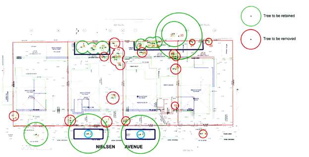
Figure 4- Tree retention Plan
State Environmental Planning Policy No 55
– Remediation of Land
19. SEPP
55 applies to the land and pursuant to Section 79C is a relevant consideration.
Based on the history of the site and records indicating it
was used for vehicle repair, a detailed Site Investigation was prepared by
eiaAustralia dated 24 January 2017.
This Investigation identified that local contamination was
identified on the site that will require remediation. The report also concluded that the site can be made
suitable for the proposed use subject to the remediation work taking place.
This report was forwarded to Council’s Environmental
Health Unit for review who raised no objection to the findings of this report
subject to the imposition of conditions requiring the provision of a
Remediation Action Plan and a Validation Report prepared by a suitably qualified person. These details are
to be submitted to the Principle Certifying Authority upon completion of the
remedial works.
Consent conditions
will be imposed reflecting these requirements.
State Environmental Planning Policy No 65 – Design Quality of
Residential Flat Development (SEPP No 65)
20. The
proposed development is subject to the provisions of SEPP No 65, which aims to
improve the quality of residential flat design in NSW.
The application has been accompanied by a design verification from a
qualified designer that verifies that:
a) He
or she designed or directed the design of the modification, and
b) The
modifications achieve the design quality principles as set out in Part 2 of
SEPP No 65, and
c) The
modifications do not diminish or detract from the design quality, or compromise
the design intent of the approved development.
The application
was referred to the St George Design Review Panel for consideration at their meeting
on 1 December 2016. A number of design amendments were made and the proposal
was again reviewed by the Panel during its meeting held on 7 September
2017. The following response details both the Panels initial and
supplementary comments.
Context
21. Comment:
1 December 2016 (original plans)
The site is an amalgamation of four individual dwelling houses.
To the north of the site are four-storey apartment buildings and to the south across Nielsen Avenue are existing cottages within an R2 zone.
Nielsen Avenue has retained
its traditional suburban character but this will inevitable change
given the R3 zoning on the north side. The northern
side of the street has established large and mature street trees which make a major contribution to the street character.
The site itself contains
many large established trees particularly on the rear boundary. These
include established gums, paper barks and
palms. These plantings contribute significantly to overall neighbourhood amenity and provide outlook for the three adjacent
residential apartment
buildings on the northern
boundary. The proposal removes most of these trees particularly landmark specimens including the lemon scented
gums: the applicant proposes to retain the palms, a spotted
gum and cheese tree.
The latter are probably the least significant trees on site.
A major challenge will be to ensure that development on the subject
site and adjoining sites on the north side of Nielsen
Avenue will be sensitively designed to complement and retain the positive
elements in the streetscape and the neighbourhood character – low scale, built form and substantial landscape.
The property
is flood affected
and the applicant has been advised
to adhere to the flood
planning levels for the lots (Lot 23:23.1mAHD and Lot 24, 23.84mAHD). This creates significant issues in relation to ground
floor levels and streetscape frontage as well as the landscape treatment to the rear.
Comment:
7 September 2017 (Amended Plans)
The Panel
encourages the proponent to fully explore methods to reduce the impacts of
Council’s Flood controls on streetscape, urban design, landscape and
amenity.
Applicant Comment: The
applicant sought additional flood advice in order to reduce the floor level of
the building below the levels initially specified by Council and the
development has been designed to these levels. Accordingly, the amended design
more closely responds to the natural fall of the street and allows for the
height of the building to be lowered improving the streetscape. The extent of
ramps and stairs providing access to the development has been reduced and
additional deep soil landscaping has been provided along the street frontage.
The lowering of the floor levels has also allowed a better relationship to the
ground floor private open space areas that facilitates tree retention and a
better amenity for residents and adjoining properties.
Officer Comment:
Discussions were held with Council’s Stormwater Engineer in relation to
the Flood Controls and how the building floor levels could potentially be
reduced in order to reduce the scale of the building when viewed from the
street. It was advised that there could be no further reduction to the floor
levels of the building beyond that already proposed with the amended plans.
Considering this, a number of positive design changes were made to the design
as detailed in the applicants comments above that will result in a vastly
improved streetscape presentation and overall building amenity.
Built Form and
Scale
22. Comment:
1 December 2016 (Original Plans)
Whilst the overall
height and boundary setbacks
are acceptable in principle, the building
form proposed raises concerns in relation
to:
· Inconsistency with the streetscape character in that the building is unduly assertive
in its expression.
· The overall length of the building without sufficient articulation.
· The resolution of the internal levels to the streetscape frontage which has resulted in a primarily hard scape treatment dominated by ramps, blank walls, planter boxes and stairs.
· The inadequate protection of the significant trees along the rear boundary
and the limited capacity to plant new trees
due to the treatment of the deep soil zone.
It is recommended that the overall
street façade be expressed as four
(4) separate building
forms/volumes, reinforced by the landscape and tree planting.
The light coloured horizontal elements should be far less visually
prominent. The colours of materials should
be sympathetic to and related to the traditional palette in the streetscape.
The rear setback
needs to be 6 metres clear deep soil and rear terraces need to be designed
as light-weight platforms/decks with minimal
footings and structure
to maximise soil volume. This entire rear frontage
should be treated
as a tree planting
and garden zone, with as many as possible
of the existing
trees retained and significant
allowance for new replacement trees of a similar
scale. This should
replace, at a minimum
the total number of trees to be removed
across the entire site. Stairs,
walls, structure, subsurface, pipe work should all be removed from this zone. Lawn should be removed from this area and it should be primarily tree and ground
cover planting. Some definition between the spaces adjoining each unit could be provided by way of planting design and perhaps a handrail
raised well above ground so as not to impact
on the overland
flow path.
The frontage
needs a complete
re-design to rationalize and reduce the extent of blank walls. This may include
re-orientating the stairs and/or lobbies, reducing or removing
terraces and re-designing ramp access.
This zone should
primarily be tree and shrub planting to the maximum possible extent.
The materials
resolution of those access
stair walls should be carefully
considered, potentially by introducing sandstone, brick etc.
Comment:
7 September 2017 (Amended Plans)
The majority of
issues have been resolved apart from the following:
· The definition between the public and private space at the street
frontage would be inadequately addressed as proposed. There should be
fencing/hedging, additional planting, etc, as discussed.
· The ramp should
be incorporated into the landscape and relocated to the uphill side thus
reducing its length or removal altogether and replacement with an external
access lift or with a connective internal corridor from western
’at-grade’ entry.
Applicants Comment:
A 1.0m high fence consisting of a 500mm high face brick wall with a 500mm high
metal palisade style fence above and appropriate landscaping have been
incorporated along the street boundary to define the public/private domain. The
access ramp to the north east entry has been deleted and replaced with a graded
pathway that links the south west entry to the north east entry. Landscaping
has been incorporated on either side of the pathway.
Officer Comment: The revisions are
consistent with the DRP comments and are satisfactory. It should also be noted
that further design changes were carried out that have resulted in the street façade now being expressed as four (4) separate building forms/volumes. This is made more clearly evident in Figure 5 below.
Figure 5- Building façade depicting various individual
forms
Density
23. Comment: 1 December 2016 (Original Plans)
Complying and acceptable.
Response to a number
of detailed issues mentioned below in relation to lobbies,
communal space etc., would marginally increase density,
but this is not an issue of concern.
Comment:
7 September 2017 (Amended Plans)
No
further comment
Applicants Comment: The development
remains compliant with Council’s Density controls.
Sustainability
24. Comment: 1 December 2016 (Original Plans)
Generally acceptable, however, response to recommendations in relation to planting
and landscaping would contribute to additional positive outcomes.
Comment
7 September 2017 (Amended Plans)
No further comment. Subject to BASIX
Applicant
Comment: Noted
Landscape
25. Comment: 1 December 2016 (Original Plans)
The landscape
proposal requires
significant revision in order to address
issues raised above under Built Form.
The landscape approach
should prioritise gardens
and tree planting
to the front and rear setback for outlook and screening. This should incorporate more new trees within
an emphasis on native species to provide
a greener outlook
and screening to adjacent
properties. It is critical that existing levels are retained around the trees to be protected, and this needs to be clearly
annotated on all drawings
including engineering drawings. Retaining walls and structures should be kept to a minimum. Lawn spaces should be removed from these front and rear gardens.
The communal
roof top design requires further
review. The proposed arbor covers a large area of the roof and may unduly
impact on neighbouring
properties. The design should
include more tree shade with provision of shade structures over high intensity
areas such as the children’s play
area. The design proposes three
(3) major spaces
and while it might be appropriate to have one large gathering area, it is recommended that the other two (2) spaces be redesigned to incorporate smaller, more intimate gathering spaces.
A small fully enclosed
communal room should
be included for use in all kinds of weather.
New street trees should
be provided to complement the existing planting on Nielsen
Avenue. Tree planting should also be provided
in the front setback and side setbacks
also. Three (3) large trees are recommended in the front setback zone.
OSD basin should be relocated under hard stand areas such as under the basement carpark or driveway. Stormwater pipework needs to be relocated
clear of existing tree roots and deep soil zones.
Comment: 7 September 2017 (Amended Plans)
It is noted that this has been included in the landscape plan and
named as a ‘kitchen’. This is supported as indicated, however the
architectural plans show a different layout which should be adjusted to be
consistent with the plans shown on the landscape plan. In the previous DRP
review of the landscape drawings it was recommended to minimise the lawn areas.
The eastern deep soil zone still shows a large area of lawn. This needs to be
supplemented with understory planting.
See above under ‘Built Form’ comments regarding
reconfiguration of access ramp to the front entry. The comment above regarding
the OSD basin has not been resolved and cannot be located on the drawings
provided to the Panel. Street trees should be planted to Council specification.
Applicant Comment: The kitchen area on the rooftop communal open space
area is unenclosed as indicated on the architectural drawings. Enclosing this
area would result in an increase to the bulk of the building and was therefore
not adopted as part of the design amendments. The eastern deep soil zone is for
OSD and the lawn within this area deleted and replaced with appropriate
landscaping including understorey planting.
The landscape plan has been amended and is enclosed. The
relocation of the OSD to under the basement or within the driveway has been
investigated. It is not reasonable as the pipe would need to be connected to
the system some 150m down the street which would be an unreasonable cost given
that the OSD system proposed is acceptable.
Officer Comment: The proposed modifications are
satisfactory. In regards to the relocation of the OSD, this was flagged with
Council’s Stormwater Engineer who agreed that the costs associated with
this relocation far outweigh any benefit that would be achieved. The revised
landscape plan depicts the planting of a number of street trees while the
development provides deep soil areas that substantially exceed ADG
requirements. The extent of landscape area provided is detailed in the KDCP
2013 discussions.
Amenity
26. Comment: 1 December 2017 (Original Plans)
The amenity would be of generally good standard. The following should be addressed:
· The main entrance doors should be relocated
closer to the street so that doors do not open directly into corridors.
· Provide
small bay seating areas on each level adjacent to the lifts.
· Where
snorkel bedrooms are proposed extend rooms into the recessed areas to provide a
small seating bay.
· Provide
top light/ventilation to internal service rooms on top floor.
· Include
dining room furniture layout on floor plans.
· Provide
adjustable screens to all terrace/balcony areas to enhance their amenity and
usability.
· The
functional justification of screens
on the southern elevation to bedrooms is questioned.
Comment:
7 September 2017 (Amended Plans)
These issues have been resolved.
Applicant
Comment: Noted
Safety
27. Comment: 1 December 2016 (Original Plans)
Satisfactory
Comment:
7 September 2017 (Amended Plans)
No further comment
Applicant
Comment: Noted
Housing Diversity and Social Interaction
28. Comment: 1 December 2016 (Original Plans)
See comments made above regarding the enclosing of a room within the
communal area
Comment:
7 September 2017 (Amended Plans)
See comments made under Landscape.
Applicant Comment: No comment
Officer Comment: These issues have been appropriately addressed under
Landscape. They included the
Aesthetics
29. Comment: 1 December 2016 (Original Plans)
Refer to “Built Form” above. Reconsideration of the building
form, materials and finishes is required.
Comment:
7 September 2017 (Amended Plans)
Now satisfactory
Applicant
Comment: Noted
Officer Comment: As discussed under the
Built Form Provisions, the proposed development now presents as four (4) separate building forms/volumes and introduces a number of varied materials/finishes
to ensure visual interest will be provide when viewed towards the building from
Nielsen Avenue.
Deemed State
Environmental Planning Policy – Georges River Catchment
30. All
stormwater from the proposed development can be treated in accordance with
Council’s Water Management Policy and
would satisfy the relevant provisions of the Deemed State Environmental
Planning Policy – Georges River Catchment
(ii) any
draft environmental planning instrument that is or has been placed on public
exhibition and details of which have been notified to the consent authority,
and
31. There
are no other draft planning instruments that are applicable to this site.
(iii) any
development control plan,
Kogarah
Development Control Plan 2013 (KDCP 2013)
32. The
proposed development is subject to the provisions of the Kogarah Development
Control Plan 2013 (KDCP2013). The following comments are made with respect to
the proposal satisfying the objectives and controls contained within the DCP.
Frontage
Council’s
DCP outlines that a 20m frontage is required for residential flat building. In
this case, an overall frontage of 73.15m is provided complying with Council DCP
controls.
Setbacks
Front
The DCP requires a front setback of 5m to 7m for residential flat
buildings. A maximum of 75% of the width of the building must be a minimum 5.0m
with the remaining 25% setback a minimum of 7.0m. The proposed development
provides a staggered front setback where 65% of the front wall is setback 5m
with the remainder setback 7 or more metres. The external perimeter wall of the
internal access stairs are setback 4.4m from the street boundary protruding
beyond the 5m setback line. These stairs make up only 10% of the buildings
overall façade where they are not anticipated to result in any
perceivable increase to the bulk of the building when viewed from the street.
Additionally, the building facade is articulated and varied through the use of
balconies, different materials and colours which reduce the scale and bulk of
the building.
Side/Rear
In respect to side
and rear setbacks, the proposal far exceeds the minimum setbacks as outlined in
the DCP which stipulates the provision of 3m plus ¼ the amount that the
wall height exceeds 3m. If applying the DCP, the building would require
setbacks ranging from 3m to 6m. The proposed setbacks are compliant and in most
instances exceed Council DCP controls. In this case, setbacks have been
proposed having regard to the separation requirements outlined in the ADG. The
proposal complies with these requirements.
Site Coverage
A maximum site
coverage of 45% is applicable to residential flat buildings equating to 924m2
in this instance. The proposal provides 893.5m2 of site coverage or
43.5% complying with Council controls.
Impervious Area
Council’s DCP requires 1129m2 impervious area whereas
1500sqm (73%) of the proposed development could be considered impervious. However,
the proposal provides 703m² (34.2%) of deep soil zones around the
perimeter of the site which significantly exceeds the ADG requirement of
143.8sqm (7%) and facilitates the planting of canopy trees and water
infiltration.
Common Open
Space
Common open space
for residential flat building developments shall be provided at a rate of 30m2
per dwelling for those units that have balconies as their only form of private
open space. Therefore, a minimum of 960m2 is required.
The proposed
development incorporates 530m² of common open space area which it provides
on the roof area of the development. The non-compliance should be supported as
the amount of area provided exceeds the ADG requirements (513m²), is an
area that will offer high amenity and will receive ample solar access.
Private Open
Space
Where provided, courtyards for ground floor units must be a minimum of
35m2/ dwelling, with a minimum dimension of 3m. Otherwise all dwellings must be
provided with a
balcony 12m2 in area with a minimum dimension of 3m.
In accordance with clause 6A of SEPP No 65 the provisions within a DCP
that relate to "private open space and balconies" have no effect and
the provisions of the ADG are applicable. In this instance, all units meet the
minimum requirements apart from Units 4.01 and 4.02 being the three (3) bedroom
units on the uppermost level. The primary balcony areas of these units are 10m2
in lieu of the required 12m2. Considering that both units have
secondary balconies and are conveniently located adjacent to the rooftop
communal open space, the shortfall is considered acceptable.
Other
Requirements
Solar Access
33 The
DCP states that at least 50% of the primary open space area of the proposed
development should have access to a minimum of 4 hour hours of sunlight between
9am and 3pm on 21 June. All units will receive the required amount of solar
access. In addition, the DCP requires at least 50% of the neighbouring existing
principal open space or windows to main living areas must receive a minimum of
3 hours of sunlight between 9am and 3pm on 21 June.
The expected shadow of the proposal generally falls over the street which
is to the south of the site and the front yards of properties on the opposite
side of the Nielsen Ave from 1.00pm (approx.). The property to the south-west
(No 35 Nielson Ave) is overshadowed in the morning but the open space area at
the rear is unaffected and by 12noon the shadow cast is limited to the front of
the site.
The proposal
satisfies this requirement.
Privacy
34. The
proposed development complies with the setback requirements contained within
KDCP 2013 but in any case, has been designed having regard to the separation
requirements of Part 3F - Visual Privacy within the ADG. The development makes
provisions for sliding privacy screens on balconies while providing a generous
landscape buffer around the perimeter of the site enabling reasonable levels of
external and internal privacy to be maintained by neighbouring development.
Traffic and Parking
35. In accordance with
Council DCP controls a total of 59 residential and 8 visitor spaces are required to be provided. Currently, the proposal provides 45
residential and 9 visitor spaces resulting in a non-compliance with Council
controls.
While a parking shortfall is presented, the
"Apartment Design Guide" can be used in conjunction with the State
Environmental Planning Policy No 65 - Design Quality of Residential Flat
Development (SEPP 65). Objective 3J-l of the Design Guide states that sites
within 800m of a railway station are to satisfy the minimum parking
requirements specified in the RMS "Guide to Traffic Generating
Developments" (October 2002). This development is located 450m from the
entry to Carlton Railway Station so the provisions can be applied.
The RMS Guidelines nominate that a high density
residential flat building refers to a building containing 20 or more dwellings.
As the proposed development contains 41 dwellings, the following parking
requirements for high density residential flat buildings in Metropolitan
Sub-Regional Centres have been adopted:
1 bedroom units 0.6
space per dwelling
2 bedroom units 0.9
spaces per dwelling
3 bedroom units 1.4
spaces per dwelling
Visitor parking 1
space per 5 dwellings
Application of those requirements to the
proposed development yields a parking requirement of thirty nine (39)
residential and five (5) visitor car parking spaces. The proposal provides
forty five (45) residential spaces and nine (9) visitor spaces complying with
these requirements.
Additionally, as per the traffic
impact assessment for 27-33 Nielsen Avenue, Carlton prepared by Varga Traffic
Planning Pty Ltd the net traffic impact of this development is;
o An increase of 4.2 vehicle trips per
hour during AM Peak
o An increase of 2.3 vehicle trips per
hour during PM Peak
Council’s Traffic Engineers have
reviewed the potential impacts and advised they are considered minor on
the local road network. The extent of additional generation is consistent with
the expectations of the zone.
Adaptable and
Accessible Housing
36. The
proposal includes five (5) complying with Council controls.
Section 94
Contributions
37. The
proposed development requires payment of $353,869.68 Section
94 contributions based on the provisions of Council’s Section 94 Plan
applicable to Precinct two (2).
(iv) any
matters prescribed by the regulations, that apply to the land to which the
development application relates,
38. Not
applicable.
(b)
the likely impacts of that
development, including environmental impacts on both the natural and built
environments, and social and economic impacts in the locality,
39. The
proposed development is of a scale and character that is in keeping with other
dwellings being constructed in the locality. Accordingly, the proposal is not
considered to have a significant impact on the natural and built environment of
the locality.
(c) the
suitability of the site for the development,
40. It
is considered that the proposed development is of a scale and design that is
suitable for the site having regard to its size and shape, its topography,
vegetation and relationship to adjoining developments.
(d) any
submissions made in accordance with this Act or the regulations,
41. In
accordance with the provisions of Section A2 – Public Notification of
KDCP 2013 application was placed on neighbour notification from 7 November to 24 November 2016 where two (2)
submissions were received. Plan amendments were made and the application was
re-notified from 17 to 31 August 2017 where two (2) submissions were received
raising the following concerns.
1. Plans
not originally notified to all affected residents.
Comment: This
claim is correct. The plans originally submitted with Council were not notified
to all potentially affected properties. This is more accurately depicted in the
notification map images identified as Figures 4 and 5 below. The amended plans
submitted with Council on 10 August 2017 were notified to all potentially
impacted properties. The submissions were received during this notification
period have been considered and are further discussed below. It should be noted
that additional architectural amendments were made after this notification
period; however, these amendments were minor and resulted in the overall scale
of the building being reduced and the level of separation between neighbouring
properties increased. Further notification was not required.
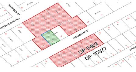
Figure 6- Original Notification 7
November to 24 November 2016
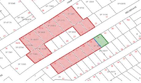
Figure 7- Amended Plan notification
17 to 31 August 2017
2. Damage
during construction/Sewer Operation
Comment:
Consent conditions will be imposed requiring the provision of a dilapidation
report for potentially affected properties (To be determined by structural
engineer) and a geotechnical report. In regards to the ongoing operation of the
sewer to neighbouring properties, this is the sole responsibility of the
parties undertaking the building works on the site where all works need to be
carried out in accordance with Sydney Water requirements.
3. Noise
during construction
Comment:
Any noise impacts outside of those generally anticipated during construction
will be investigated independent of this approval. A consent condition will be
imposed outlining that works can only be carried out between the hours of
7.00am and 5.00pm Monday to Saturday.
4. Overshadowing
Comment: As
discussed in the body of this report, the expected shadow of the proposal
generally falls over the street which is to the south of the site and the front
yards of properties on the opposite side of the Nielsen Ave from 1.00pm
(approx.). The property to the south west (35 Nielson Ave) is overshadowed in
the morning but the open space area at the rear is unaffected and by 12noon the
shadow cast is limited to the front of the site. This is diagrammatically
detailed in Figures 6 to 8 below.
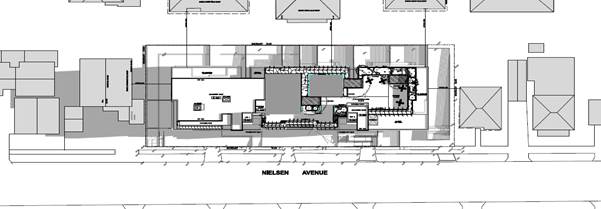
Figure 8- Proposed June shadow 9am
cast by the development
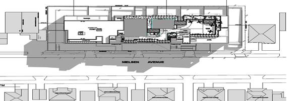
Figure 9- Proposed June shadow
12pm cast by the development
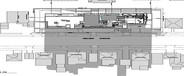
Figure 10- Proposed June shadow
3pm cast by the development
5. Overall
amenity
Comment: The proposed building is generously separated from the
neighbouring development. The introduction of appropriate window placement and screening devices will
ensure that privacy impacts potentially posed by this development will be
minimised. Further, at least 50% of
the neighbouring existing principal open space or windows to main living areas
must receive a minimum of 3 hours of sunlight between 9am and 3pm on 21 June.
6. Scale of Development
Comment The
proposal complies with Council’s FSR controls and only marginally exceeds
the height standards. Further architectural design changes submitted with
Council on 31 November 2017 assisted in breaking up the visual dominance of the
front façade by creating the appearance of four smaller buildings. The
development is of an anticipated scale envisaged by KLEP 2012 as amended.
7. Traffic
and Parking
Comment: As discussed in the body of this report, the development
provides in excess of the minimum parking requirements as outlined within 3J-l
of the Design Guide which stipulates that that sites within 800m of a railway
station are to satisfy the minimum parking requirements specified in the RMS
"Guide to Traffic Generating Developments" (October 2002).
The proposal was
referred to Council’s Traffic Engineer for comment who raised no objection
to the proposal on Traffic or Parking grounds. It was outlined that access to
the site and manoeuvrability within the site are considered acceptable for the
scale of the development in the R3 Zone.
(e) the
public interest.
42. The
proposed development is of a scale and character that does not conflict with
the public interest.
Council
Referrals (Where not discussed in the body of this report)
Waste Officer
The application was referred to
Council’s Waste Officer for comment who raised no objection to the
development subject to conditions of consent being attached to any consent
granted.
Building Officer
The application was referred to
Council’s Building Officer for comment who advised that a more
comprehensive assessment would be carried out upon submission of specific
details at CC stage. A number of BCA Advisory Notes were provided that will be
included with this consent.
Conclusion
43. The
application has been assessed having regard to the Heads of Consideration under
Section 79C of the Environmental Planning and Assessment Act 1979, the
provisions of KLEP 2012 and KDCP 2013.
Following detailed assessment it is considered that Development
Application No 212/2016 should be approved subject to conditions.
SPECIFIC
DEVELOPMENT CONDITIONS
SECTION A - General
Conditions
The conditions that follow in this Section A of the Notice
of Determination are general conditions which are imposed to ensure that the
development is carried out in accordance with the development consent.
1. Approved
Plans of Consent
The development must be implemented
in accordance with the approved plans, specifications and details listed below
and any supporting information submitted with the Development Application
except as amended by any conditions attached to the Development Consent:
(i) Architectural
plans- Prepared by Architecture and Building Works Project No PN-16005 Drawing
numbers DA-0800 (J), DA-0900 (J), DA-1000 (M), DA-1100 (G), DA-1200 (G),
DA-1300 (F), DA-1400 (H), DA-1500 (H), DA-2000 (F), DA-2100 (F), DA-2200 (F),
DA-3000 (F), DA-3100 (D), DA-3200 (E) and DA-3300 (D) received by Council on 31
November 2017.
(ii) Landscape
plans- Prepared by Isthmus- Drawing numbers ISO213DA1 and DA2 Issue D dated 10
October 2017
(iii) Stormwater
plans- Australian Consulting Engineers- Job No 1606380 Drawing numbers D00 (A),
D01 (C), D02 (C), D03 (E), D05 (C), D06 (A), D07 (A),
SECTION B
–Prior to the Issue of a Construction Certificate or
Demolition Conditions
The conditions that follow in this
Section B of the Notice of Determination relate to the payment of fees,
amendments being made to the proposal, further investigation being undertaken
or the preparation of documentation that must be complied with prior to the
issue of a Construction Certificate or Demolition.
Note: A
copy of the Construction Certificate shall be forwarded to Council prior to
commencement of construction where Council is not the certifier who issued the
Construction Certificate.
2. Asset
& Building Fees
Payment of the following amounts as
detailed below:
· *Builders Long
Service Levy of $107,786.69
· Driveway Design
and Inspection Fee (Dwelling) of $
1,000.00
· Driveway and
Restoration Works Design
Inspection Fee of $
36,400.00
· Asset Inspection
Fee of $
110.00
*Note: The
Builders Long Service Levy quoted is based on the market value of the proposed
building works and the Levy Rate applicable at the time of assessing the
Development Application and may be subject to change prior to payment.
3. Restoration
Deposit
A deposit of
$36,400.00 shall be lodged with Council to ensure the completion of the
following works to be completed at the applicant's expense
*.......... Construction
of 1.2 meter wide concrete footpath along Nielsen Avenue.
* All
associated road pavement restorations.
* Installation
of turf as required across full street frontage along Nielsen Avenue.
These works are
to be in accordance with plans and specifications to be issued by Council.
4. Section 94 Index
Section 94 Contributions are to be
paid as detailed below in the following condition, and until paid all
contributions will be indexed four (4) times a year (on the following dates) to
allow for the cost increases: 31 January, 30 April, 31 July and 31 October.
5. Section 94
Contributions
As at the date of Development Consent
the following contributions have been levied on the subject development under
Section 94 of the Environmental Planning and Assessment Act, 1979 and the
nominated Section 94 Contributions Plans:
|
No.1 – Roads and Traffic
Management – Residential
|
$ 5,201.33
|
|
No.5 – Open Space 2007
|
$335,837.28
|
|
No.9 – Kogarah Libraries
– Buildings
|
$ 7,490.49
|
|
No.9 – Kogarah Libraries
– Books
|
$ 5,340.58
|
|
Ramsgate Commercial Centre
Contributions Plan
|
|
|
TOTAL
|
$353,869.69
|
Any of the above Section 94
Contributions Plans may be inspected at the Georges River Council Customer
Service Centres.
6. Dilapidation
Report
Prior to issue of any construction
certificate or commencement of any demolition or earth works on site, the
applicant shall submit, for acceptance by the Principal Certifying Authority
(PCA), with a copy forwarded to Council where Council is not the PCA, a full
dilapidation report on the visible and structural condition of the following
properties;
(i) All
neighbouring buildings likely to be affected by the excavation as determined by
the consulting engineer.
The report must be
completed by a suitably qualified consulting structural/ geotechnical engineer
as determined necessary by that professional based on the excavations for the
proposal, the subsoil conditions and any recommendations of a geotechnical
report for the site. The report shall have regard to protecting the applicant
from spurious claims for structural damage and shall be verified by all
stakeholders as far as practicable.”
Reports relating
to properties that refuse access to carry out inspections to complete the
dilapidation report, after being given reasonable written notice to request
access (at least 14 days) at a reasonable time (8.00am-6.00pm), are not to hold
up the release of the Construction Certificate.
7. Soil and Water
Management
A Soil and Water Management Control
Plan, incorporating contour levels and prepared in accordance with
Environmental Site Management Policy shall be submitted to Council detailing
all measures to control soil erosion and sedimentation runoff from the site
during excavation and construction activities.
8. SEPP No 65
Certification
A design
verification statement from a qualified designer shall be submitted that
verifying that the plans and specifications achieve the design quality of the
development for which consent was granted having regard to the design quality
principles of State Environmental Planning Policy No. 65.
9. Adaptable Housing
Compliance
The proposed development
including the nominated adaptable units shall comply with the adaptable housing
provisions of AS4299 – Adaptable Housing and AS1498 – Access and
Mobility (Parts 1 and 2). The Adaptable Housing checklist and circulation
diagram demonstrating compliance shall be submitted.
10. Ausgrid Sub Station
The applicant is to confer with
Ausgrid to determine if an electricity distribution substation is required. If
so, shall be incorporated within the Construction Certificate and it will be
necessary for the final film survey plan to be endorsed with an area having
dimensions 5m x 4m over the location of the proposed electricity distribution
substation to be dedicated to Council as public roadway, or as otherwise agreed
with Ausgrid. Ausgrid’s requirements are to be met prior to release of
the occupation certificate.
11. Clearances to Overhead Mains
If any part of the
proposed structure, within 5m of a street frontage, is higher than 3m above
footway level, the applicant is to confer with Ausgrid to determine if
satisfactory clearances to any existing overhead mains will be affected. If so,
the applicant is to make arrangements with Ausgrid for any necessary
modification to the electrical network in question.
These works to be at the
applicant’s expense and Ausgrid’s requirements are to be met prior
to actual construction commencing on site or as agreed with Ausgrid.
12. Sydney Water (DA Only)
The approved plans must be processed
through Sydney Water to determine whether the development will affect any Sydney
Water asset’s (sewer and water mains, stormwater drains and/or easements)
and if any further requirements need to be met. An approval receipt will
be issued by Sydney Water which is to be submitted to Council or the Principal
Certifying Authority.
Please refer to the web site www.sydneywater.com.au for;
· Sydney Water Tap
in – see Plumbing, building and developing and then Sydney Water Tap in;
and
· Building
over/adjacent to a Sydney Water Asset - see Plumbing, building and developing,
building then Building Approvals or telephone 13 20 92.
13. Certification of Detailed
Plan
The detailed stormwater plan is to be
certified by a Chartered Professional Engineer. A statement, that the
stormwater system has been designed in accordance with Council’s Water
Management Policy and satisfies the provisions and objectives of that policy,
must be included in the Stormwater Detailed Plan.
14. Stormwater
Plan
The
submitted stormwater plan has been assessed and approved as a concept plan
only. No detailed assessment of the design has been undertaken. A Detailed
Stormwater Plan and supporting information of the proposed on-site stormwater
management system is to be submitted. The required details in this Plan and the
relevant checklist are presented in the document ‘Water Management
Policy. Kogarah Council. August 2006’
The design
parameters and the general concept of the proposed on-site stormwater
management system are to be the same as documented in the approved Concept
Stormwater Plan for the proposed development. Any conceptual variations to the
stormwater design will require written approval from Council and will require
to be justified and supported by appropriate details, calculations and
information to allow for proper assessment.
The
Detailed Stormwater Plan is to address the following issue(s):
a) A suitably qualified engineer is to
certify that appropriate design measures have been taken to ensure that the
upper and lower basements have been protected from flooding in the case of the
On-site Detention system malfunctioning or reaching capacity.
15. Ingress Points
All possible ingress points such as vehicle
entrances and exits, ventilation ducts, windows, light wells, lift shaft
openings, risers and stairwells to the basement car
parking levels are to be built at or protected up to the 1 in 100 year flood
levels. The applicant will need to liaise with the flood consultant with
respect to the required levels at each possible ingress location.
SECTION C
– Prior to Commencement of Construction Conditions
The conditions that follow in this
Section C of the Notice of Determination are specific to the proposed
development and must be complied with prior to the commencement of construction
on the site.
16. Geotechnical Report
Excavation of the site is to extend
only to that area required for building works depicted upon the approved plans.
All excess excavated material shall be removed from the site. In this
regard, all excavated waste materials shall be disposed of at an approved Waste
Depot.
No rock breaking or other machinery
for the excavation, drilling, cutting or removal of rock shall be used on the
site prior to the acceptance by the principal certifying authority of the
following documentation:
(i) A
report by a geotechnical engineer detailing the measures recommended in
undertaking the works so as to prevent damage to any adjoining or nearby buildings.
(ii) The
type and size of machinery proposed.
(iii) The
routes of all trucks to convey material to and from the site.
17. On-Site Detention
A 49.6m3 On-Site Detention
system with a Maximum Site Discharge of 25 Litres per Second is to be provided
in accordance with the Stormwater Concept Plan and associated Design Assessment
Report. The overflow is to be directed to the site drainage system.
18. Certification by Mechanical
Engineer
To ensure that
adequate provision is made for ventilation of the building, mechanical and /or
natural ventilation shall be provided. These systems shall be designed in
accordance with the provisions of:-
a) The
Building Code of Australia;
b) Australian
Standard AS 1668 Part 1 - 1998;
c) Australian
Standard AS 1668 Part 2 - 2002;
d) The
Public Health Act 2010;
e) The
Public Health Regulation 2012;
f) Australian
Standard 3666.1 - 2002;
g) Australian
Standard 3666.2 - 2002;
h) Australian
Standard 3666.3 - 2000.
Details of all mechanical and /or
natural ventilation systems, along with specific certification, provided by an
appropriately qualified person, verifying compliance with the abovementioned
requirements.
19. Structural Engineer’s
Details
Engineer's details
prepared by a practising Structural Engineer being used to construct all
reinforced concrete work, structural beams, columns & other structural
members. The details are to be submitted to the Principal Certifying
Authority for approval prior to construction of the specified works.
A copy shall be forwarded to Council
where Council is not the PCA.
20. Tree Protection
Prior to the commencement of
any works on the site the tree protection measures required for the established
Tree Protection Zone (TPZ) of the trees to be retained shall be installed in
accordance with Section 4 - Australian Standard AS 4970-2009 - Protection of
trees on development sites.
Unless otherwise specified in AS
4970-2009 a protective fence consisting of 1.8m high fully supported chainmesh
shall be erected around the base of the tree. The distance of the fence from
the base of each tree is to be in accordance with the TPZ listed below. A layer
of organic mulch 100 millimetres thick shall be placed over the protected area
and no soil or fill should be placed within the protection area.
There shall be no services installed
within the drip line TPZ of the tree. This fence shall be kept in place
during demolition, construction and also have a sign displaying “Tree
Protection Zone” attached to the fence, this must also include the name
and contact details of the Project Arborist.
21. Tree Retention –
Arborist Report
The
trees identified for retention in the Arboricultural Development Assessment
Report dated September 2016 by Paul Vegzoff of Moore Trees listed below shall
be protected in accordance with the above report and the requirements of
Section 4 - Australian Standard AS 4970-2009 - Protection of trees on
development sites.
|
Tree
Numbers
|
Location on site
|
TPZ
|
|
1,2,3, 9 -11 26 – 29, 30, 31
|
27 – 33 Nielsen Avenue,
Carlton
|
Refer to Arborist report
|
22. Protection of Site –
Hoarding
A hoarding or fence must be erected
between the work site and the public place if:
· the work involved
in the erection or demolition of a building is likely to cause obstruction or
inconvenience to pedestrian or vehicular traffic in a public place; or
· if it involves the
enclosure of a public place.
If necessary an awning is to be
erected which is sufficient to prevent any substance from or in connection with
the work from falling into a public place.
Any such hoarding, fence or awning is
to be removed when the work has been completed.
If the work site is likely to be
hazardous to persons in a public place, it must be kept lit between sunset and
sunrise.
23. Ground Anchors
Should the proposed development
require the installation of ground anchors to a road reserve the following must
be complied with:
· The appropriate
Roads Act 1993 approvals shall be obtained.
· The anchoring is
to be de-stressed once no longer required.
· The work is to be
clear of all services contained within the public roadway and the required dial
before you dig investigations are to be undertaken in relation to any services
that may be in the proposed anchor locations.
· Public liability
insurances being held by the builder/ developer with a copy being submitted to
Council.
· A works-as-executed
plan showing the exact location of all anchoring points being submitted to
Council upon their installation.
It
is to be noted that if anchoring into adjacent private properties is required
any such approval would need to be obtained from the owners of this property.
24. Driveway
In respect to
vehicular access to the proposed development the gutter crossing and driveway
are to be reconstructed between the kerb and street alignment to
Council’s specifications.
In this regard a
separate driveway application is to be lodged with Council for works outside
the property boundary. Furthermore the design boundary level is to be
received from Council prior to construction of the internal driveway.
25. Council Infrastructure
Inspection
Prior to the
commencement of any works an authorised representative of the applicant is to
organise and attend a meeting on site with Council’s Infrastructure
Compliance Co-ordinator to discuss protection of Council’s
infrastructure. To organise this meeting contact Council’s Customer
Service Centre on 9330 6400.
26. Public Liability Insurance
All nominated contractors /
applicants carrying out driveway and/or restoration works on Council property
must carry public liability insurance with a minimum cover of twenty million
dollars ($20,000,000.00). In this regard, prior to commencement of works, the
principal contractor is to lodge an “Application for the Construction of
Work by Private Contractor” to Council, which includes submitting
evidence of their current insurance. The principal contractor must ensure that
sub-contractors are also adequately insured.
27. Soil Erosion Controls
Prior to commencement of any site
works, erosion and sediment controls are to be installed in accordance with
Environmental Site Management Policy and any approved Soil & Water
Management Plan and shall incorporate:
· Measures to
prevent sediment and other debris escaping from the cleared or disturbed areas
into drainage systems or waterways;
· Controls to
prevent tracking of sand, soil, aggregates, etc, by vehicles onto adjoining
roadways.
SECTION D
– Construction and Operational Conditions
The conditions that follow in this
Section D of the Notice of Determination are imposed to ensure the development
is constructed and operates having regard to relevant legislation and does not
unreasonably impact on the amenity of the locality or environment during the
construction phase or the operation of the use.
28. Inspections -Multi Unit
The following lists of inspections
are the MANDATORY CRITICAL STAGE INSPECTIONS that MUST
be carried out by the Principal Certifying Authority (PCA).
(a) at the
commencement of building works
(b) prior
to covering waterproofing in any wet areas, for a minimum of 10% of rooms with
wet areas within a building, and
(c) prior
to covering any stormwater drainage connections, and
(d) after
the building work has been completed and prior to any occupation certificate
being issued in relation to the building.
Certificates from
your engineer or subcontractor are NOT acceptable in the first instance
for the above inspections. Failure to have your PCA carry out these
inspections could result in a delay or refusal to issue an Occupation
Certificate.
In addition to the
above, it is recommended that the following inspections be carried out for the
subject development;
Ž Erosion Control
Ž Earthworks/Excavation
Ž Building setout
Ž Concrete reinforcement
Ž Timber and/or steel framework
Ž Mechanical/Hydraulic work
Ž Driveways
Ž Landscaping
Ž External Finishes
29. Storage of materials on
Public Road
All building materials or waste
containers must be stored within the confines of the site. The storage of
such building materials, waste containers or equipment associated with the project
upon the public roadway, including the pedestrian footway or unpaved verge, is
prohibited.
30. Use of Crane on Public Road
Prior approval must be obtained from
Council a minimum of 24 hours before the use on any site of a crane, hoist or
similar machinery that will be used to transfer materials across
Council’s footpath. This includes cranes that are situated on
roadways, footpaths and road reserves.
Any application for approval must be
accompanied by the following information:-
· Site sketch indicating
the proposed location of the crane, pedestrian controls and traffic controls;
· A copy of current
public liability insurance with minimum cover of twenty million dollars
($20,000,000) indemnifying Council in the event of an incident;
· A copy of an RMS
accredited traffic control plan;
· Proof that the
local area command of the NSW Police have been advised of the proposal.
The use of a crane, hoist or similar
machinery on any site without prior approval is prohibited.
31. Building Height - Surveyors
Certificate
The proposed building is not to be
erected at a height greater than that indicated on the approved plan. A
certificate from a Registered Surveyor verifying the correct Reduced Level of
the ground floor slab and boundary clearances shall be submitted prior to
inspection of the steel reinforcement.
32. Excavation of Site
Excavation of the site is to extend
only to that area required for building works depicted upon the approved
plans. All excess excavated material shall be removed from the
site. In this regard, all excavated waste materials shall be disposed of
at an approved Waste Depot (details are available from Council).
All excavations and backfilling
associated with the erection or demolition of a building must be executed
safely and in accordance with appropriate professional standards.
All excavations associated with the
erection or demolition of a building must be properly guarded and protected to
prevent them from being dangerous to life or property.
If the soil conditions require it,
retaining walls associated with the erection or demolition of a building or
other approved methods of preventing movement of the soil shall be provided and
adequate provision shall be made for drainage.
33. Stormwater to Kerb
Any
stormwater connections to the kerb and gutter are to be in accordance with
Council's 'Specification for Construction by Private Contractors'.
34. Redundant Driveway
All existing vehicular crossings
adjacent to the subject premises that have become redundant shall be removed
and the footway and kerb and gutter reinstated at the developer/applicants
expense.
35. Work within Road Reserve
A Development Consent or any related
Construction Certificate does not allow for the erection of a structure or to
carry out work in, on or over a public road. Should a structure or work
be required a separate approval under S138 of the Road Act 1993 must be granted
by Council prior to the commencement of any works within the road reserve.
Applications may be made at Council’s Customer Service Centre.
36. Damage within Road Reserve
& Council Assets
The owner shall bear the cost of
restoring any footpath, roadway and any other Council assets damaged due to
works at, near or associated with the site. This may include works by
Public Utility Authorities in the course of providing services to the site.
37. Public Utility &
Telecommunication Assets
The owner shall bear the cost of any
relocation or modification required to any Public Utility Authority assets
including telecommunication lines & cables and restoring any footpath,
roadway and any other Council assets damaged due to works at, near or
associated with the site.
38. Stormwater Drainage
All roof water and surface water from
paved or concreted areas being disposed of to the street gutter by means of a
sealed pipeline constructed in accordance with AS/NZS 3500.3.2. The line
must pass through a silt arrestor pit, a standard design is available within
Council’s Water Management Policy.
39. Garbage Room
The proposed garbage room being
provided with the following:-
a) A
smooth concrete floor graded and drained to a floor waste connected to the
sewer of the Water Board.
b) The
walls being cement rendered with the intersection of the walls and floor being
coved to a radius of not less than 25mm.
c) The
door being close fitting to prevent the access of rats and mice.
d) A
cold water hose cock being provided for the cleaning of containers and the room
itself.
e) Ventilation
being provided by means of direct connection to the outside air to the
satisfaction of Council.
f) A
sign, minimum size 600mm x 600mm, directing residents not to place recyclables
in garbage carts and encouraging residents to recycle. Details of an
acceptable wording for the sign are available from Council.
40. Hours of Construction
Construction may only be carried out
between 7.00 am and 5.00 pm on Monday to Saturday and no construction is to be
carried out at any time on a Sunday or a public holiday.
41. Restriction on Hours of Excavation
(other than single residential dwelling)
Despite the general hours of
construction above,
a) The
hours where rock breaking, cutting, hammering and drilling occur shall be
limited to 9:00am – 4:00pm on weekdays only.
b) A
noise management plan for the above works, prepared by a suitably qualified
acoustical practitioner in accordance with the Interim Noise Construction
Guidelines prepared by the Department of Environment & Climate Change NSW,
must be submitted to Council prior to commencement of any excavation works.
42. Provision of Amenities
Toilet facilities are to be provided,
at or in the vicinity of the work site on which work involved in the erection
or demolition of a building is being carried out, at the rate of one toilet for
every 20 persons or part of 20 persons employed at the site or as specified by
Workcover requirements .
· each toilet
provided must be a standard flushing toilet and must be connected:
· to a public sewer;
or
· if connection to a
public sewer is not practicable, to an accredited sewage management facility
approved by the Council; or
· if connection to a
public sewer or an accredited sewage management facility is not practicable, to
some other sewage management facility approved by the Council.
The provision of toilet facilities
must be completed before any other work is commenced.
43. Letter Boxes
Suitable letter box facilities
(including Owner's Corporation in the case of strata units) shall be provided
in accordance with Australia Post specifications.
44. Oil/Silt Separator
An oil/silt separator sized to the catchment area must be
specified on the Stormwater Detailed Plans and located downstream of the
proposed basement car park and prior to discharge to councils stormwater
system.
45. Car Wash
To ensure that
waste water is treated in an acceptable manner the car wash bay shall be
designed and constructed to ensure that waste water is discharged to the sewer
in accordance with the requirements of Sydney Water. Evidence of a permit
issued by Sydney Water shall be submitted.
46. Basix Certificate Details
– DA Only
Construction of building works given
Development Consent must be carried out in accordance with a valid and current
BASIX certificate and all required commitments must be satisfied.
47. Air
Conditioning / Offensive Noise
Air conditioning plant and equipment
shall be installed and operated so as to not create an offensive noise as
defined under the Protection of the Environment Operations Act 1997 and
Protection of the Environment Operations (Noise Control) Regulation 2008.
48. Building Finishes
The building finishes are to be
constructed in accordance with the colour board and perspective submitted with
the Development Application.
49. Allocation of Car Parking
Spaces
A minimum of 54 off street car
parking spaces shall be constructed, drained, marked and maintained at all
times in accordance with the approved plans. These spaces shall be
allocated as follows:
a) 45
are to be allocated to the residential units.
b) 9
are to be allocated as visitor parking spaces.
50. Residential Car Parking Spaces
A minimum of one (1) unrestricted car
parking space shall be allocated to each residential unit.
51. OSD Markers
All on-site stormwater storages that
experience permanent or temporary ponding shall be indicated on the site by
fixing a marker plate.
52. Visitor Parking
A directional sign
shall be provided at the front of the site indicating the availability of
visitor and/or customer parking on site. Those visitor and/or customer
spaces shall be marked or signposted.
53. Planting or Walls
Planting or walls adjacent the
driveway near the boundary shall comply with the requirements of “AS/NZS
2890.1:2004 - Off Street Car Parking, Section 3.2.4(b)”.
54. Works Zone
The installation of a "Works
Zone" for the site will require the approval from the Traffic Advisory
Committee. As a result, the applicant shall provide a formal request to
Council's Traffic Section with the duration and exact location of the required
"Works Zone" at least 6 weeks prior to its required installation
date. All costs associated with the installation of a “Works Zone”
will be at the applicants expense.
55. Road Closure Application
A Road
Closure Application form and associated documents shall be submitted to Council
for approval at least 5 business days prior to any proposed lane usage for
concrete pours, cranes or other activities involved in the demolition,
excavation and construction on the site.
56. Tree Protection - Excavation
Excavations
around the trees to be retained on site or the adjoining properties shall be
supervised by the Project Arborist to ensure that the root system will not
adversely be affected.
Where
the Tree Protection Zone (TPZ) of trees on site or adjoining sites become
compromised by any excavation works, the Project Arborist shall be consulted to
establish the position of any major roots and determine the necessary measures
to protect these roots. The recommendations of the Arborist shall be submitted
to Council prior to any further demolition or construction works taking place.
Tree
Protection Zone (TPZ) around the trees to be retained are not to have soil
level changes or services installed in this area. Any structures proposed to be
built in this area of the trees are to utilise pier and beam or cantilevered
slab construction.
SECTION E
– Prior to Occupation or Subdivision Certificate Conditions
The conditions that follow in this
Section E of the Notice of Determination relate to conditions that ensure that
the development is completed in accordance with the requirements of the
Development Consent prior to the issue of either an Occupation Certificate or a
Subdivision Certificate.
57. Adaptable Housing
Certification
Certification shall be provided by a
person suitably accredited by the Association of Consultants in Access
Australia, verifying that the development has been constructed in accordance
with the requirements of AS4299 - Adaptable Housing and AS1428 - Design
for Access and Mobility and in accordance with the report and checklist
submitted with the Construction Certificate.
58. SEPP No 65 Certification
A design
verification statement from a qualified designer shall be submitted verifying
that the development achieves the design quality of the development as shown in
the plans and specifications in respect of which the construction certificate
was issued, having regard to the design quality principals of State
Environmental Planning Policy No. 65.
59. Completion of Landscaping
Certification shall
be provided from a suitably qualified and experienced Landscape Designer or
Landscape Architect. This Certification shall verify that the landscape
works have been completed in accordance with the approved detailed landscape
plan and relevant conditions of this consent.
Note: A
Landscape Designer is a person eligible for membership of the Australian
Institute of Landscape Designers and Managers and a Landscape Architect is a
person eligible for membership of the Australian Institute of Landscape Architects
as a Registered Landscape Architect.
60. Consolidation of Lots
The lots covered by this development
consent shall be consolidated into one lot and proof of registration of the
consolidation shall be submitted to Council.
61. Section 73 Compliance
Certificate
A Section 73 Compliance Certificate
under the Sydney Water Act, 1994 must be obtained from Sydney Water
Corporation.
Application must be made through an
authorised Water Servicing Coordinator. Please refer to the Building
Developing and Plumbing section of the web site www.sydneywater.com.au then refer to
“Water Servicing Coordinator” under “Developing Your
Land” or telephone 13 20 92 for assistance.
Following application a “Notice
of Requirements” will advise of water and sewer infrastructure to be
built and charges to be paid. Please make early contact with the
Coordinator, since building of water / sewer infrastructure can be time
consuming and may impact on other services and building, driveway or landscape
design.
The Section 73 Certificate must be
submitted to the Principal Certifying Authority.
62. Stormwater Compliance
Certificate
A Stormwater Compliance Certificate
is to be obtained for the constructed on-site stormwater management systems in
conjunction with the works-as-executed drawings and the final inspection. This
Certificate is to be signed by an accredited hydraulic engineer (preferably be
the original design consultant) and submitted to the Principal Certifying Authority.
Copy of the standard Stormwater Compliance Certificate is shown in
Council’s Water Management Policy.
If the proposed works involve Council
owned stormwater infrastructure (or infrastructure to be owned by Council),
then the applicant should organise inspection with Council and pay Council the
appropriate inspection fee. Inspection is to be carried out at the following
specified stages:
· Prior
to backfilling of pipelines trenches.
· Prior
to backfilling of drainage connection to pipeline or channels.
· Prior
to casting pits and other concrete structures including kerb and gutter,
aprons, pathways, vehicular crossings, dish crossings and pathway steps.
63. Positive Covenant
A Restriction on Use of the land and
Positive Covenant shall be created and registered on the title of the property,
which places the responsibility for the maintenance of the on-site stormwater
management system on the owner of the land. The terms of the instrument are to
be generally in accordance with the Council’s standard terms and
conditions for Restriction on Use of the land and Positive Covenant shown in
Council’s Water Management Policy.
64. Maintenance Schedule
A Maintenance Schedule for the
proposed on-site stormwater management measures is to be prepared and
submitted. The Maintenance Schedule shall outline the required maintenance
works, how and when these will be done and who will be carrying out these
maintenance works.
65. Verification of Levels
For flood affected properties, a
registered surveyor shall verify the levels of the design overland runoff path
and finished floor levels to AHD and according the approved plans.
66. Fire Safety Schedule
Certain items of equipment or forms
of construction shall be nominated as "fire safety measures"
within the building.
Upon completion of
works, and before occupation of the building, each of the fire safety measures
is required to be certified by an appropriately competent person (chosen by the
owner of the building). The certificate is to state that the measure was
inspected and found to be designed, installed and capable of operating to a
standard not less than that required by the relevant regulations.
Further, it is the responsibility of
the owner of the building that each fire safety measure is again inspected and
certified as to its condition every twelve (12) months following the submission
to Council of the original certification.
67. BASIX Completion Receipt
In accordance with clause 154C of the
Environmental Planning and Assessment Regulation 2000, prior to issuing a final
occupation certificate the certifying authority must apply to the
Director-General for a BASIX completion receipt.
SECTION F – Prescribed Conditions
The following are
prescribed conditions of development consent pursuant to s.80A(11) of the
Environmental Planning and Assessment Act 1979 and cl.98 of the Environmental
Planning and Assessment Regulation 2000.
68. Compliance with the Building
Code of Australia
The development
must be carried out in accordance with the provisions of the Building Code of
Australia.
69. Insurance Requirements under
Home Building Act 1989
The builder or
person who does the residential building work must comply with the applicable
requirements of Part 6 of the Home Building Act, 1989. This means that a
contract of insurance must be in force in accordance with Part 6 of that Act
before any building work authorised to be carried out by the consent commences.
It is the responsibility of the
builder or person who is to do the work to satisfy Council that they have
complied with the applicable requirements of Part 6 of the Home Building Act,
1989.
If Council is the Principal
Certifying Authority it will not carry out any inspections until a copy of the
insurance certificate is received.
70. Erection of Signs
A sign must be erected in a prominent
position on any site on which building work, subdivision work or demolition
work is being carried out:
(a) showing
the name, address and telephone number of the principal certifying authority
for the work, and
(b) showing
the name of the principal contractor (if any) for any building work and a
telephone number on which that person may be contacted outside working hours,
and
(c) stating
that unauthorised entry to the work site is prohibited.
The sign is to be maintained while
the building work, subdivision work or demolition work is being carried out,
but must be removed when the work has been completed.
71. Notification of Home Building
Act 1989 Requirements
Residential building work within the
meaning of the Home Building Act 1989
must not be carried out unless the principal certifying authority for the
development to which the work relates (not being the council) has given the
council written notice of the following information:
(a) in
the case of work for which a principal contractor is required to be appointed:
(i) the
name and licence number of the principal contractor, and
(ii) the
name of the insurer by which the work is insured under Part 6 of that Act,
(b) in
the case of work to be done by an owner-builder:
(i) the
name of the owner-builder, and
(ii) if
the owner-builder is required to hold an owner-builder permit under that Act,
the number of the owner-builder permit.
If arrangements for doing the
residential building work are changed while the work is in progress so that the
information notified above becomes out of date, further work must not be
carried out unless the principal certifying authority for the development to
which the work relates (not being the council) has given the council written
notice of the updated information.
72. Shoring and Adequacy of
Adjoining Property
If the development involves an
excavation that extends below the level of the base of the footings of a
building on adjoining land, the person having the benefit of the development
consent must, at the person’s own expense:
(a) protect
and support the adjoining premises from possible damage from the excavation,
and
(b) where
necessary, underpin the adjoining premises to prevent any such damage.
The above condition does not apply if
the person having the benefit of the development consent owns the adjoining
land or the owner of the adjoining land has given consent in writing to that
condition not applying.
73. Council Notification of
Construction
The erection of a building which is
the subject of a Development Consent must not be commenced until:
a) Detailed
plans and specifications of the building have been endorsed with a construction
certificate by Council or an accredited certifier.
b) the person
having the benefit of the development consent has:
· appointed a
Principal Certifying Authority (PCA),and
· notified Council
(if Council is not the PCA) in writing of the appointment, and
· given at least 2
days notice to Council of their intention to commence the erection of the
building. The notice may be in writing or by phone.
SECTION G – Demolition
Conditions
The following conditions are imposed
to ensure the demolition associated with the proposed development is carried
out having regard to relevant legislation and does not unreasonably impact on
the amenity of the locality or environment.
74. Demolition Conditions-Asbestos
(a) Demolition
of buildings where asbestos is determined to be present should only occur 7am
– 5pm Monday to Saturdays, and must not occur on Sundays or Public
Holidays, to ensure that the persons carrying out the work have access to WorkCover
professionals if required.
(b) All
asbestos removal shall be undertaken in accordance with the requirements of
WorkCover’s ‘How to Safely Remove Asbestos’ Code of Practice
and Council’s Asbestos Policy.
(c) Written
notice must be provided to Georges River Council five (5) working days
(excluding public holidays) prior to commencement of any works.
Written notice is
to include the following details:
· Date the
demolition will commence
· Name, address,
contact details (including after hours) and licence number of the demolisher
and asbestos removalist (if different)
Work must not
commence prior to the nominated demolition date.
Note: it is the responsibility
of the persons undertaking demolition work to obtain the relevant WorkCover
licences and permits.
(d) The
owner is to notify all owners and occupiers of premises on either side,
opposite and at the rear of the development site five (5) working days prior to
demolition. Such notification is to be clearly written on A4 size paper
stating the date the demolition will commence and is to be placed in the
letterbox of every premises (including every residential flat or unit, if any).
The demolition must not commence prior to the date and time stated in the
notification.
(e) A
demolition or asbestos removal contractor licensed under the Work Health and
Safety Regulations 2011 must undertake removal of more than 10m2
of bonded asbestos (or otherwise specified by WorkCover or relevant
legislation).
Removal of friable
asbestos material must only be undertaken by a contractor that holds a current
AS1 Friable Asbestos Removal Licence.
(f) Demolition
sites that involve the removal of asbestos must display a standard commercially
manufactured sign containing the words ‘DANGER ASBESTOS REMOVAL IN
PROGRESS’ measuring not less than 400mm x 300mm is to be erected in a
prominent visible position on the site to the satisfaction of Council’s
officers. The sign is to be erected prior to demolition work commencing and is
to remain in place until such time as all asbestos has been removed from the
site to an approved waste facility.
(g) All
asbestos waste must be stored, transported and disposed of in compliance with
the Protection of the Environment Operations (Waste) Regulation 2005. All
receipts detailing method and location of disposal must be submitted to Council
as evidence of correct disposal.
(h) A
Clearance Certificate or Statement, prepared by a suitably qualified
occupational hygienist must be provided to Council upon completion of
demolition and asbestos related works, which confirms that the relevant
legislative requirements in relation to safe removal and disposal have been
satisfied.
(i) A
Work Cover Licensed Demolisher is to be engaged to carry out any demolition
works using mechanical equipment where the structure is over 4 metres in height
or to carry out any manual demolition works on a structure over 10 metres in
height.
(j) The
provision of temporary fences and footpath crossing pads prior to commencement
of demolition operations. Further, no waste materials or bins are to be
placed on Council's roadways or footpaths.
(k) No
waste materials are to be burnt on site.
(l) No
trees as defined by Council's Tree Preservation Order being removed or damaged
on the site without the prior written approval of Council.
(m) Compliance
with the provisions of Australian Standard AS 2601-1991:"The Demolition of
Structures", which requires notification of demolition to be submitted at
least seven (7) days prior to demolition to the NSW Workcover Authority.
(n) Effective
erosion and sediment control measures are to be undertaken during the course of
demolition and building works in accordance with Council’s
‘Environmental Site Management Policy’. Failure to implement
appropriate measures may result in a $750 Penalty Infringement Notice
(individual) and/or $1,500 (corporation) being issued and/or the incurring of a
maximum penalty of $250,000 (corporation) or $120,000 (individual) through the
Land and Environment Court.
(o) Appropriate
measures are to be implemented on site to control dust and other air borne
matter and demolition material is to be stored and stacked in a manner so as to
minimise the risk of damage or nuisance to neighbouring properties.
(p) Council
being notified upon completion of the demolition works so that an inspection
can be made of the roadway and footpath.
(q) All
non-recyclable demolition material being disposed of at an approved waste
disposal depot. Details as to the method and location of disposal of demolition
materials (weight dockets, receipts, etc.) should be kept as evidence of
approved method of disposal.
(r) A sign must be erected in
a prominent position on any site on which building work, subdivision work or
demolition work is being carried out:
(a) showing
the name, address and telephone number of the principal certifying authority
for the work, and
(b) showing
the name of the principal contractor (if any) for any building work and a
telephone number on which that person may be contacted outside working hours,
and
(c) stating
that unauthorised entry to the work site is prohibited.
The sign is to be maintained while
the building work, subdivision work or demolition work is being carried out,
but must be removed when the work has been completed
END CONDITIONS
1. Review of Determination
Section 82A of the
Environmental Planning and Assessment Act confers on an applicant who is
dissatisfied with the determination of the application the right to lodge an
application with Council for a review of such determination. Any such
review must however be completed within 6 months from its determination.
Should a review be contemplated sufficient time should be allowed for Council
to undertake public notification and other processes involved in the review of
the determination.
Note: review
provisions do not apply to Complying Development, Designated Development, State
Significant Development, Integrated Development or any application determined
by the Sydney South Planning Panel or the Land & Environment Court.
2. Appeal Rights
Division 8 (Appeals
and Related matters) Part 4 of the Environmental Planning and Assessment Act
1979 confers on an applicant who is dissatisfied with the determination of the
application a right of appeal to the Land and Environment Court of New South
Wales.
3. Lapsing of Consent
This consent will
lapse unless the development is physically commenced within 5 years from the
Date of Operation of this consent, in accordance with Section 95 of the
Environmental Planning and Assessment Act 1979 as amended.
4. Worksite Safety
It is usually the
owner/applicant’s responsibility to ensure that the development site is a
safe working environment. This may be by the engagement of an
appropriately competent principal contractor. There are various
legislative and WorkCover requirements with respect to maintaining a safe
work-site. Details of these requirements and legislation, as well as,
guidance and advisory material, can be found on the WorkCover Website www.workcover.nsw.gov.au.
5. Worksite Safety
Scaffolding
Council is committed
to worksite safety and requiring that all scaffolding is installed by competent
and qualified professionals with the relative appropriate standards. The
applicable Australian Standards for the scaffolding is AS/NZS1576 in respect of
the design of the scaffolding and AS/NZS4576 with respect to the erection of
the scaffolding. Also, you should ensure that those erecting scaffolding
are appropriately qualified and have the appropriate qualifications to erect
scaffolding. For further information regarding this please see
www.workcover.nsw.gov.au.
6. Kid Safe NSW
Kidsafe NSW has produced Safer Homes
for Children Design and Construction Guidelines for builders, renovators and
home owners. The guidelines identify common hazards for children and
recommended practical design applications to improve child safety for all areas
of the home. Free copies of the Guidelines are available from
Council’s Customer Service Centre, or contact Kidsafe on (02) 9845 0890
or their website http://www.kidsafensw.org/homesafety/index.htm for more
information.
7. Dial Before You Dig
Underground pipes and cables may
exist in the area. In your own interest and for safety, telephone 1100
before excavation or erection of structures. Information on the location
of underground pipes and cables can also be obtained by fax on 1300 652 077 or
through the following website www.dialbeforeyoudig.com.au.
8. Disability
Discrimination Act
This authorisation does not imply
that the proposal complies with Disability Discrimination Act 1992.
The Proponent is responsible to ensure compliance with this and other
anti-discrimination legislation. The Disability Discrimination Act
1992 covers disabilities not catered for in the minimum standards called up
in the Building Code of Australia which references AS 1428.1 – Design for
Access and Mobility. AS1428 Parts 2, 3 & 4 provides the most
comprehensive technical guidance under The Disability Discrimination Act
1992.
9. Demolition Waste
Sorting your construction and
demolition waste will save you money. For pricing and disposal options
for sorted loads of tiles, bricks, timber concrete or asphalt call Waste
Service NSW on 1300 651 116.
10. Property Address
Property addresses shall be allocated by Council in
accordance with the Addressing Standard AS/NZS 4819:2011.
11. Stormwater
The Flood
Planning Level (FPL) of Lot 23 of DP5452 is identified at RL 23.11m (AHD). The
Flood Planning Level (FPL) of Lot 24 of DP5452 is identified at RL 23.84m
(AHD). Lots 25 and 26 of DP5452 are affected by the Probable Maximum Flood
(PMF) but not the 1 in 100 year flood. The development has been approved with a
Finished Floor Level upon submission and review of the document 27-33
Nielsen Avenue – Flood Level Summary by Cardno dated 9 June 2017.
ATTACHMENTS
|
Attachment View1
|
Site Plan - 27-33 Nielsen Ave, Carlton
|
|
Attachment View2
|
Elevations -27-33 Nielsen Ave, Carlton
|
|
Attachment View3
|
Shadow Drawing - 27-33 Nielsen Ave, Carlton
|
|
Attachment View4
|
3D View - 27-33 Nielsen Ave, Carlton
|
|
Attachment View5
|
3D View 2 - 27-33 Nielsen Ave, Carlton
|
|
Georges
River Council - Georges River Independent Hearing Assessment Panel (IHAP) -
Tuesday, 19 December 2017
3.2 27-33 Nielsen Avenue Carlton
[Appendix
1] Site Plan -
27-33 Nielsen Ave, Carlton
|
Page 64
|
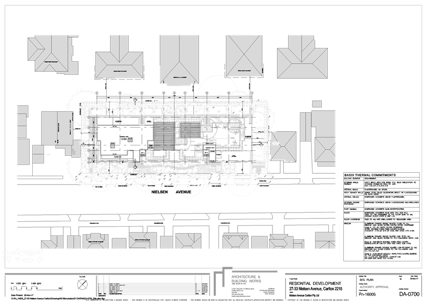
|
Georges River Council - Georges River Independent
Hearing Assessment Panel (IHAP) - Tuesday, 19 December 2017
3.2 27-33 Nielsen Avenue Carlton
[Appendix
2] Elevations
-27-33 Nielsen Ave, Carlton
|
Page 65
|
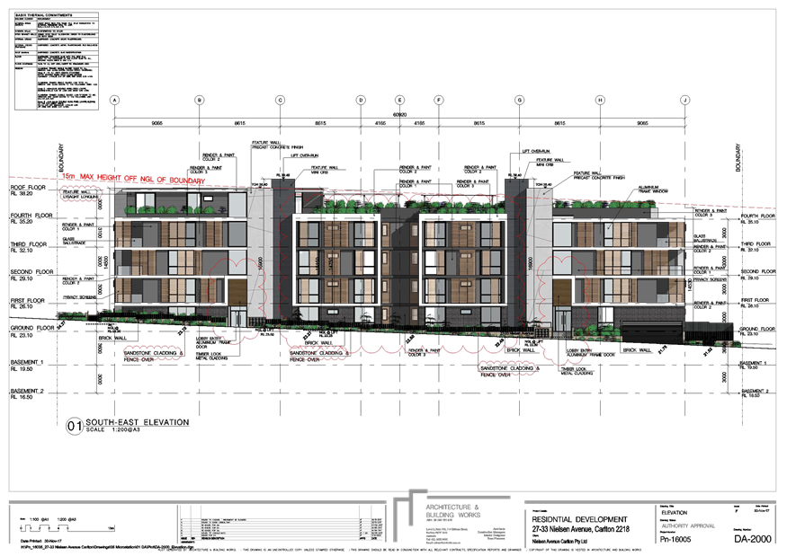
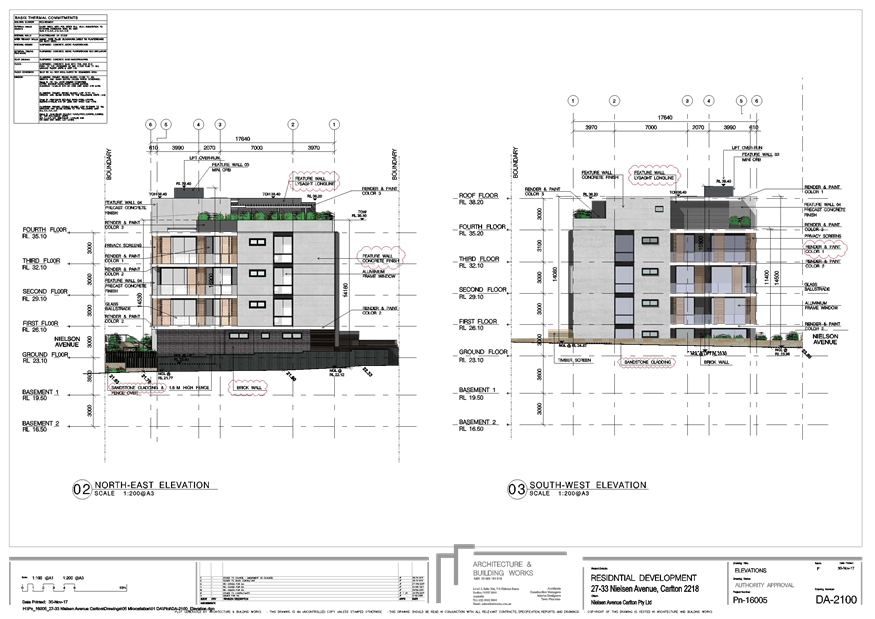
|
Georges River Council - Georges River Independent
Hearing Assessment Panel (IHAP) - Tuesday, 19 December 2017
3.2 27-33 Nielsen Avenue Carlton
[Appendix
3] Shadow Drawing
- 27-33 Nielsen Ave, Carlton
|
Page 68
|
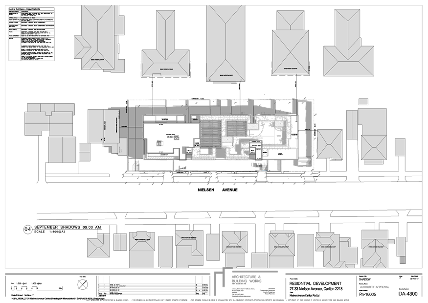
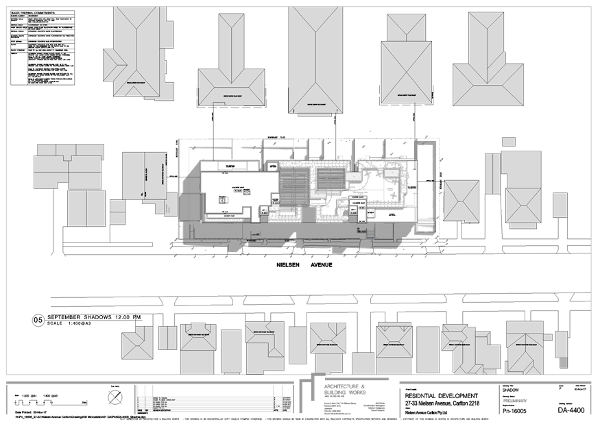
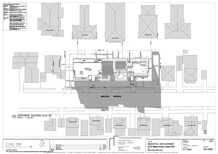
|
Georges River Council - Georges River Independent
Hearing Assessment Panel (IHAP) - Tuesday, 19 December 2017
3.2 27-33 Nielsen Avenue Carlton
[Appendix
4] 3D View -
27-33 Nielsen Ave, Carlton
|
Page 74
|
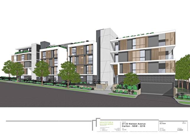
|
Georges River Council - Georges River Independent
Hearing Assessment Panel (IHAP) - Tuesday, 19 December 2017
3.2 27-33 Nielsen Avenue Carlton
[Appendix
5] 3D View 2 -
27-33 Nielsen Ave, Carlton
|
Page 75
|
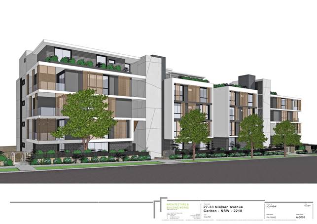
|
Georges River Council – Independent Hearing and
Assessment Panel Tuesday, 19 December 2017
|
Page 76
|
REPORT TO GEORGES RIVER COUNCIL
IHAP MEETING OF Tuesday, 19 December 2017
|
IHAP Report No
|
3.3
|
Application No
|
DA2017/0022
|
|
Site Address & Ward Locality
|
27-29 Cairns Street and 28-30 Eldon
Street Riverwood
Peakhurst Ward
|
|
Proposal
|
Demolition of existing structures
and construction of a multi dwelling development containing twelve (12)
dwellings including four (4) dwellings proposed as Affordable Rental Housing
|
|
Report Author/s
|
Senior Development Assessment
Officer
|
|
Owners
|
H Zhang, X Y Chen, Q Lin, L J Shen,
Q A Lu, and K Zhang
|
|
Applicant
|
AJC Limited Investment Pty Ltd
|
|
Zoning
|
Zone R2 - Low Density Residential
zone
|
|
Date Of Lodgement
|
3/02/2017
|
|
Submissions
|
14 submissions including petition
containing 26 signatures
|
|
Cost of Works
|
$2,800,00.00
|
|
Reason for Referral to IHAP
|
More than 10 submissions received
to the application
|
DA
|
Recommendation
|
THAT the application be
approved in accordance with the conditions included in the report.
|
|
|
Site Plan
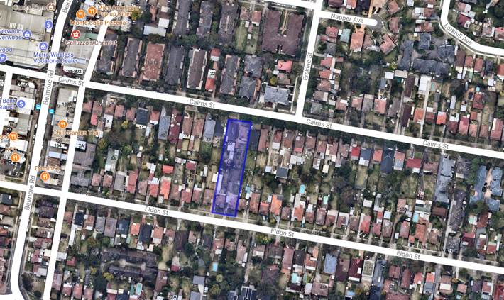
|
Executive Summary
Proposal
1. The
application seeks approval for the construction of a multiple dwelling
development comprising twelve (12) x dwellings with four (4) dwellings being
affordable housing under the provisions of State Environment Planning Policy
(Affordable Rental Housing) 2009.
Site and Locality
2. The
subject site is known as 27 and 29 Cairns Street and 28 and 30 Eldon Street, Riverwood
and comprises four (4) lots. The combined width of the site is 26.21m and the
site area is 2908sqm. The site has a slight fall from the north (Cairns Street
boundary) to south (Eldon Street boundary) with the difference in level being
3.95m. There is one (1) small tree on the site at the Eldon Street frontage and
a significant street tree at the front of the site on Cairns Street.
The area
surrounding the subject site is characterised by one (1) and two (2) storey
dwelling houses and several multiple dwelling developments and residential flat
buildings on Cairns Street, and one (1) and two (2) storey dwelling houses on
Eldon Street. At the end of the street to the west is the commercial centre of
Riverwood on Belmore Road.
Zoning and Permissibility
3. The
subject site is zone R2 Low Density Residential and the proposed development is
permissible in the zone with the consent of Council.
Submissions
4. The
application was notified to seventy five (75) residents/owners in accordance
with Council’s requirements and fourteen (14) submissions including one
petition with twenty six (26) signatures were received in reply. The issues
raised in the submissions are detailed in the report.
Conclusion
5. The
application has been assessed against the requirements of the relevant planning
instruments and development control plans and is consistent with those
requirements. The submissions received to the application have been addressed
in the report and through amended plans. Conditions of consent have also been
provided in the recommendation regarding the provision of high sill windows to
the first floor side elevations of the dwellings to reduce any potential privacy
impacts on adjoining developments. Accordingly, the application is recommended
for approval subject to conditions of consent.
Report in Full
DESCRIPTION OF
THE PROPOSAL
6. The
application seeks approval for the construction of a multi dwelling development
comprising twelve (12) x dwellings with four (4) dwellings being affordable
housing under the provisions of State Environment Planning Policy (Affordable
Rental Housing) 2009. The site contains four (4) lots with two (2) lots facing
Cairns Street and two (2) lots facing Eldon Street. Details of the proposed
development are as follows:
Units 1 and 2 facing Cairns St and Units 1 and 2 facing Eldon St
Each dwelling is two (2) storeys with direct access off the street. On
the ground floor, each dwelling will contain a double garage, a family/dining
area, kitchen, laundry, wc, and bedroom with ensuite. A ground floor private
open space area with access off the family area is provided adjoining the side
boundary. The first floor contains three (3) bedrooms, one with ensuite,
separate bathroom, living area, study nook and balcony facing the front
elevation. These units have been identified as being able to be adaptable
housing.
Units 3 and 4
Cairns St and Units 3 and 4 Eldon St
Each dwelling is two (2) storeys. On the ground floor, each dwelling will
contain a double garage, a family/dining area, kitchen, laundry with wc, and
bedroom with ensuite. A ground floor private open space area with access off
the family area is provided adjoining the side boundary. The first floor
contains three (3) bedrooms, one with ensuite, separate bathroom, and study
area.
Units 5 and 6
Cairns St and Units 5 and 6 Eldon St
These dwellings are single storey and contain living/dining area,
kitchen, two (2) bedrooms, with ensuite and walk-in-robe to one bedroom,
separate bathroom, laundry, and single garage. A ground floor private open
space area with access off the family area is provided adjoining the side
boundary. These four (4) dwellings will be designated as affordable rental
housing under the provisions of State Environmental Planning Policy (Affordable
Rental Housing) 2009.
Visitor parking
Four (4) visitor car spaces are provided to the development which are
located central to the site.
DESCRIPTION OF
THE SITE AND LOCALITY
7. The
subject site is known as 27 and 29 Cairns Street and 28 and 30 Eldon Street,
Riverwood and comprises four (4) lots. The combined width of the site is 26.21m
and the site area is 2908sqm. The site has a slight fall from the north (Cairns
Street boundary) to south (Eldon Street boundary) with the difference in level
being 3.95m. There is one (1) small tree on the site at the Eldon Street
frontage and a significant street tree at the front of the site on Cairns Street.
Existing on the site are single storey dwellings houses with
outbuildings. Adjoining the site on the Cairns Street frontage is a single
storey dwelling house and a two (2) storey dwelling house and adjoining the
site on the Eldon Street frontage are single storey dwelling houses.
The area surrounding the subject site is characterised by one (1) and two
(2) storey dwelling houses and several multiple dwelling developments and
residential flat buildings on Cairns Street, and one (1) and two (2) storey dwelling
houses on Eldon Street. At the end of the street to the west is the commercial
centre of Riverwood on Belmore Road.
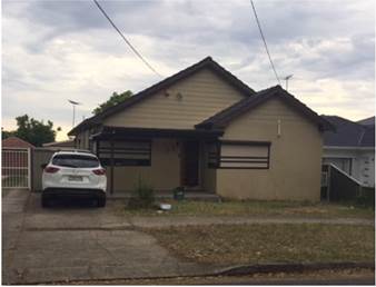
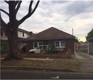
27
and 29 Cains Street Riverwood
28
and 30 Eldon Street Riverwood
Residential
flat buildings located opposite the site on Cairns Street Riverwood
COMPLIANCE AND
ASSESSMENT
8. The
development has been inspected and assessed under the relevant Section 79C(1)
"Matters for Consideration" of the Environmental Planning and
Assessment Act 1979.
Environmental
Planning Instruments
HURSTVILLE
LOCAL ENVIRONMENTAL PLAN 2012
9. The
provisions of Hurstville Local Environmental Plan 2012 apply to the proposed
development with the relevant clauses being as follows.
|
Clause
|
Standard
|
Assessment Under HLEP 2012
|
|
Part 2 – Permitted or
Prohibited Development
|
R2 Low Density Zone
Objectives of the zone
|
The proposal is permissible within
the R2 – Low Density Residential zone
The proposal complies with the
objectives of the zone
|
|
2.7 – Demolition requires Development
Consent
|
The demolition of a building or
work may be carried out only with development consent
|
Demolition is not sought with this
application but will be required prior to development of the site.
|
|
4.3 – Height of Buildings
|
9m as identified on Height of
Buildings Map
|
7.72m
|
|
4.4 – Floor Space Ratio
|
0.6:1 as identified on Floor Space
Ratio Map
0.63:1 under the provisions of
State Environmental Planning Policy (Affordable Rental Housing) 2009
|
0.48:1
|
|
4.5 – Calculation of floor
space ratio and site area
|
FSR and site area calculated in
accordance with Cl.4.5
|
In accordance with Cl. 4.5
|
|
4.6 – Exception to
Development Standards
|
Development consent must not be
granted for development that contravenes a development standard unless the
consent authority has considered a written request from the applicant that
seeks to justify the contravention of the development standard (Cl 4.6
variation)
|
No variation requested
|
|
5.9 – Preservation of trees
or vegetation
|
Trees to be removed are specified
in DCP No.1
|
One (1) street tree is located at
the front of the site which is considered part of significant street
planting. This tree will be retained and protected during construction.
Council’s Tree Management Officer has provided appropriate conditions of
consent.
|
|
6.7 – Essential Services
|
The following services that are
essential for the development shall be available or that adequate
arrangements must be made available when required:
* Supply of water, electricity and
disposal and management of sewerage
* Stormwater drainage or on-site
conservation
* Suitable vehicular access
|
Adequate facilities for the supply
of water and for the removal of sewage and drainage are available to this
land.
The site will drain to Eldon St via
gravity.
New driveway crossings to Cairns St
and Eldon St for the development (standard conditions for the submission of
separate vehicular crossing applications and driveway design)
|
STATE
ENVIRONMENTAL PLANNING INSTRUMENTS
10. Compliance
with the relevant state environmental planning policies is detailed in the
table below.
|
State Environmental Planning
Policy
|
Complies
|
|
Greater Metropolitan Regional
Environmental Plan No 2 – Georges River Catchment
|
Yes
|
|
State Environmental Planning Policy
55 – Remediation of Land
|
Yes
|
|
State Environmental Planning Policy
(Building Sustainability Index BASIX) 2004
|
Yes
|
|
State Environmental Planning Policy
– Affordable Rental Housing 2009
|
Yes, see assessment below
|
STATE
ENVIRONMENTAL PLANNING POLICY (AFFORDABLE RENTAL HOUSING) 2009
11. The
proposed development includes the provision of four (4) dwellings to be used as
affordable rental housing under the provisions of this SEPP. The dwellings
nominated are the four (4) single storey dwellings.
Division 1 - Development to which this
Division applies
The application has been submitted as
infill development under Division 1 of State Environmental Planning Policy
(Affordable Rental Housing) 2009.
The extent to
which the proposed development achieves the locational and numerical standards
of the State Environmental Planning Policy (Affordable Rental Housing) 2009 is
discussed in the following series of tables:
|
Clause
|
Standards
|
Proposal
|
Complies
|
|
Clause 10(1) - Land to which
Division applies for the purpose of infill development with consent
|
-R1 General Residential,
-R2 Low Density Residential
-R3 Medium Density Residential
-R4 High Density Residential,
-B1 Neighbourhood Centre
-B2 Local Centre
-B4 Mixed Use
|
Site is zoned R2 Low Density
Residential and the proposed infill development being four multi dwellings
within the development, is permissible in the zone
|
Yes
|
|
Clause 10(2) – Development to
which this Division applies
|
-Land must be within an accessible
area (*)
|
The subject site is within 550m
walking distance to Riverwood Railway Station
|
Yes
|
|
Clause 13 – Floor space
ratios
|
-Percentage of
gross floor
area that is to
be used for affordable housing is at least 20% of the development.
-The existing maximum floor space ratio for any form
of residential accommodation permitted on the land on which the development
is to occur, plus:
If the existing
maximum floor space ratio is 2.5:1 or less:
Y:1—if
the percentage of the gross floor area of the development that is used for
affordable housing is less than 50 per cent, where:
AH is
the percentage of the gross floor area of the development that is used for
affordable housing: Y = AH ÷ 100
(0.3 = 30÷ 100 - maximum FSR
for the development is:0.3:1 plus 0.6:1 (LEP) = 0.63:1
|
The proposal
utilises 419.6sqm (30% – 4 Units) of the gross floor area for
affordable housing.
-The floor space ratio of the
entire development is 0.48:1
|
Yes
|
|
Clause 14- Standards that cannot be
used to refuse consent
|
Refer to table
below
|
Refer to table
below
|
Yes
|
|
Clause 15– Design
requirements
|
The
consent authority must not consent to development to which this Division
applies unless it has taken into consideration the provisions of the Seniors
Living Policy: Urban Design Guidelines for Infill Development published
by the Department of Infrastructure, Planning and Natural Resources in March
2004, to the extent that those provisions are consistent with this Policy.
|
The development has been assessed
against these requirements and is consistent with the provisions of the Seniors Living Policy: Urban Design Guidelines for
Infill Development.
|
Yes
|
|
Clause 16A
– Character of local area
|
Refer
to discussion below
|
Refer to discussion below
|
Yes
|
|
Clause 17- Must be used for
affordable housing for 10 years
|
Conditions
are to be imposed on the consent requiring the nominated dwellings to be used
as affordable housing
|
A condition can be imposed on any
consent granted
|
Yes
|
|
Clause 18- Subdivision
|
Land
on which development has been carried out under this Division may be
subdivided with the consent of the consent authority.
|
Subdivision is not requested with
this application
|
N/A
|
(*) Accessible
area means land that is within:
(a) 800 metres walking distance
of a public entrance to a railway station or a wharf from which a Sydney
Ferries ferry service operates, or
(b) 400 metres walking distance
of a public entrance to a light rail station or, in the case of a light rail station
with no entrance, 400 metres walking distance of a platform of the light rail
station, or
(c) 400 metres walking
distance of a bus stop used by a regular bus service (within the meaning of the
Passenger Transport Act 1990)
that has at least one bus per hour servicing the bus stop between 06.00 and
21.00 each day from Monday to Friday (both days inclusive) and between 08.00
and 18.00 on each Saturday and Sunday.
Clause 14 - Standards that cannot
be used to refuse consent
Council cannot
refuse a development application for infill development State Environmental
Planning Policy (Affordable Rental Housing) 2009 for any of the following
grounds.
|
Clause 14
|
Standards
|
Proposal
|
Complies
|
|
Site area
|
450sqm minimum
|
2908sqm
|
Yes
|
|
Landscape Area
|
At least 30% of the site area to be
landscaped
|
30%
|
Yes
|
|
Deep soil zones
|
-15% of the site area
-minimum 3m dimensions
-if practicable, at least
two-thirds of the deep soil zone is located at the rear of the site area
|
25%, located within the front
setback area and adjoining the side setback areas which is appropriate for
the development
|
Yes
|
|
Solar Access
|
Living rooms and private open
spaces for minimum 70% of the dwellings receive minimum of 3 hours direct
sunlight between 9am and 3pm in mid-winter
|
Shadow diagrams submitted with the
application show that 70% of the dwellings will receive at least 3 hours
between 9am and 3pm in mid-winter
|
Yes
|
|
Parking
|
1 parking space
provided for each dwelling containing 2 bedrooms and at least 1.5 parking
spaces are provided for each dwelling containing 3+ bedrooms = at least 1 car
space required per dwelling as all dwellings are 2 bedrooms
(no visitor
parking required under the SEPP)
|
Each dwelling has a single garage
(1 space)
|
Yes
|
|
Dwelling size
|
70sqm for a dwelling having 2
bedrooms
|
The affordable housing dwellings
are 84sqm
|
Yes
|
Clause 16A
– Character of local area
Clause
16A states that a consent authority must not
consent to development to which this Division applies unless it has taken into
consideration whether the design of the development is compatible with the
character of the local area. The applicant’s planning consultant
Chapman Planning Pty Ltd has submitted the following statement in reply to this
requirement:
The
proposed in-fill housing development is consistent with the design, form and
scale of development in Cairns Street and Eldon Street and planned for the
locality based on the following assessment.
i. The
form and scale of the building, 2 storeys, the landscape presentation to the
street, and articulated facades ensures the development proposal is compatible
with the form and scale of the existing residential flat building development
and multi-dwelling housing within the visual catchment of the subject site.
ii. The
development has a front setback that aligns with the adjoining buildings
creating a landscaped front setback contributing to the residential character
and landscape setting of Cairns Street and Eldon Street. The proposal includes
deep soil landscape areas within the side and front setbacks creating
separation to the adjoining properties.
iii. The
subject site is zoned R2 – Low Density Residential under the Hurstville
LEP 2012 and multi-dwelling housing development is a permissible land use. The
planning controls allow a 9m high development on the site. The building form
complies with the building height standard.
iv. The side
and rear setbacks are consistent with the objectives of the setback controls
for multi-dwelling housing contained in Hurstville DCP achieving landscape
corridors on the side of the building and rear boundaries of the adjoining
properties.
In
my opinion the proposed built form is compatible with the scale of residential
flat building development in the visual catchment of the subject site and meets
the character test required under clause 16A of SEPP – ARH and allows
Council to consent to the development.
The
planning principle in Project Venture Developments Pty Ltd v Pittwater Council can
be used as a reference in determining the compatibility of the proposal against
the character of the local area. The building form and character of the development
is compatible with development under the R2 – Low Density Residential
zone. In the Project Venture matter it was accepted that buildings can exist
together in harmony without having the same density, scale or appearance.
Comment: The
proposed development is considered to be compatible with the character of the
local area for the following reasons:
§ The subject site is located within
a R2 Low Density Residential zone which has existing residential developments
of one, two and three storeys. In this context, the proposed development is
consistent with the existing streetscape and built form. The proposed
development has been designed with front and side setbacks that are consistent
with the requirements for multi dwelling developments. Although the development
contains affordable rental housing, the entire development maintains a floor
space ratio below the maximum of 0.6:1. When viewed from the street the
apparent bulk and scale of the development is consistent with that of multi
dwelling developments. The development will function as a multi dwelling
development irrespective of the affordable rental housing component located on
site.
§ The development is consistent with
the relevant requirements and represents a bulk and scale consistent with the
planning controls.
§ The proposed development results in
negligible shadow impacts on adjoining developments and has been designed to
minimise privacy impacts with the location of balconies and primary windows on
the front elevations and within the development.
§ In its context the proposed
development is consistent with the surrounding area which contains residential
flat buildings on the opposite side of Cairns Street and multi dwelling
developments to the east of the site. The multi dwelling developments existing
to the east of the site, within the R2 Low Density Residential zone have
established an existing character to the street similar to that being proposed.
The design of the proposed development is also similar to these developments in
terms of site coverage, setbacks, and location of landscape open space areas.
Draft
Environmental Planning Instruments
12. There
are no draft environmental planning instruments that apply to the proposed
development.
Development
Control Plans
13. The
provisions of Hurstville Development Control Plan No 1 (DCP 1) apply to the
proposed development with the relevant sections being as follows.
DEVELOPMENT
CONTROL PLAN NO 1 - LGA WIDE – SECTION 3.1 VEHICLE ACCESS, PARKING AND
MANOEUVRING
14. The
extent to which the proposed development complies with the car parking
provisions is outlined in the table below.
|
Development
|
Requirements
|
Proposed
|
Complies
|
|
3.1.4.2(a) – Layout
|
AS2890.1 – Minimum dimensions
for 2 car spaces and for single car space
|
Two car spaces provided for each
townhouse and single garage for each villa.
Dimensions are appropriate.
|
Yes
|
|
3.1.2.1(4) – Ramps,
transitions and driveways
|
AS2890.1 – Maximum driveway
gradient = 1 in 4 (25%)
Minimum headroom at a grade change
(driveway and underside of the front balcony) = 2.2m
|
Compliance with the relevant
Australian Standard is achieved.
|
Yes
|
DEVELOPMENT
CONTROL PLAN NO 1 - LGA WIDE – SECTION 3.3 ACCESS AND MOBILITY
15. The
extent to which the proposed development complies with the access and mobility
provisions is outlined in the table below.
|
Section 3.3 – Access and
Mobility
|
Requirements
|
Proposal
|
Complies
|
|
Adaptable dwellings for multi
dwelling developments
|
In developments
containing 5 or
more
dwellings, a
minimum of 1 adaptable dwelling, designed in accordance with AS 4299, shall
be provided. Adaptable
housing
dwellings shall be provided thereafter at the rate of 1 per 5 dwellings or
part thereof (12 dwellings) = 3 adaptable units required
|
3 adaptable dwellings can be
provided subject to standard conditions
|
Yes
|
|
Access requirements
|
Access to required adaptable
dwellings and relevant parking spaces. Appropriate access for all persons
through the principal entrance of the building and access to any common
facilities shall be provided
|
Appropriate access can be
achieved
|
Yes
|
|
Accessible car space
|
1 space per adaptable dwelling.
Layout complies with Australian Standard
|
1 space per adaptable dwelling can
be provided subject to conditions of consent
|
Yes
|
DEVELOPMENT
CONTROL PLAN NO 1 - LGA WIDE – SECTION 3.4 CRIME PREVENTION THROUGH
ENVIRONMENTAL DESIGN
16. The
extent to which the proposal complies with the requirements of this section of
Development Control Plan No 1 is outlined in the table below.
|
CPTED
|
Requirement
|
Proposed
|
Complies
|
|
3.4.1.1 – Fencing
|
Front fence: preferred height of 1m
|
A front fence will be provided on
the front boundary which will be maximum 1.1m high
|
Yes
|
|
3.4.1.4 – Entrances
|
Clearly visible and not confusing
|
Entrance is clearly visible
|
Yes
|
|
3.4.1.5 – Site and building
layout
|
-Provide surveillance opportunities
-Dwelling addresses street
-Habitable rooms are directed
towards the front of the building
|
Dwellings comply with these
requirements
|
Yes
|
|
3.4.1.6 – Landscaping
|
Avoid medium height vegetation with
concentrated top to bottom foliage
|
Landscape plan prepared by
landscape architect and is appropriate.
|
Yes
|
|
3.4.1.8 – Building
identification
|
Dwellings to be clearly numbered
|
Yes, can be provided
|
Yes
|
DEVELOPMENT
CONTROL PLAN NO 1 - LGA WIDE – SECTION 3.7 STORMWATER
17. It
is proposed to drain the development by gravity to Eldon Street. Appropriate
conditions of consent have been attached to the recommendation, should consent
be granted.
|
Stormwater Assessment
|
|
|
Existing Stormwater System
|
On site disposal or gravity
|
|
Proposed Stormwater System
|
Gravity to Eldon Street
|
|
Stormwater objectives for
development type met?
|
Consistent
|
|
Slope to rear (measured centreline
of site)
|
Yes, but rear of site has frontage
to Eldon Street
|
|
Gravity to street (from property
boundary to street kerb)?
|
Yes
|
|
Discharge into same catchment?
|
Yes
|
|
Easement required?
|
No
|
|
OSD required
|
Yes
|
DEVELOPMENT
CONTROL PLAN NO 1 - LGA WIDE – SECTION 3.5 LANDSCAPING
18. The
subject site contains one street tree at the front of the site on Cains Street
and one (1) tree within the site. It was proposed to retain the street tree and
remove the one site tree. The application has been reviewed by Council’s
Tree Management Officer who has advised that the street tree is part of
significant street tree planting and is to be retained in accordance with
conditions of consent to be attached to any consent granted. There is no
objection to the removal of the site tree.
A landscape plan
has been submitted with the application that has been prepared by a landscape
architect. The plan shows that new planting will be introduced to the site
including large trees in lieu of the one to be removed.
DEVELOPMENT
CONTROL PLAN NO 1 - LGA WIDE – SECTION 4.2 MULTI DWELLING HOUSING
19. The
proposed development complies with the requirements of section 4.2 as follows.
|
Section 4.2 -
Multi Dwelling Housing
|
Design solution
|
Proposed
|
Complies
|
|
PC1
Neighbourhood Character
|
Application to be supported by a
SEE that:
-includes a satisfactory
neighbourhood & site description, including the ID of key features
-shows how the siting & design
responds to the key features identified in the neighbourhood & site
description
-shows the development satisfies
objectives of the zone in the LEP
|
Development is appropriate for the
neighbourhood character as discussed in the report above.
|
Yes
|
|
PC2
Site Frontage
|
The minimum street frontage is 15m
|
26.21m
|
Yes
|
|
PC3
Dwelling Density
|
R2 zone 315sqm
FSPA 500sqm
|
315sqm x 8 = 2520sqm
plus
4 x dwellings under the provisions
of the SEPP (Affordable Rental Housing ) 2009
Site area = 2908sqm
|
Yes
(1)
|
|
PC4
Building Height
|
R2 zone - 2 Storeys
R3 zone - 3 Storeys
In the R2 zone, the maximum number
of storeys for the rear dwelling is 1
The minimum floor to ceiling height
is 2.7m
|
2 storey at the front
1 storey at the rear (which in the
case of this development is the area at the middle of the site.
Floor to ceiling height = 2.7m
minimum
|
Yes
|
|
PC5
Excavation
|
The natural ground level is not
excavated more than 0.5m for the finished ground floor level
The maximum excavation for any
building’s finished ground floor level facing a public street is 0.5m
below natural ground level
|
Any excavation proposed is less than
0.5m
|
Yes
|
|
PC6
Setbacks
|
Minimum side setback 3m (for one
and two storey)
Min primary street setback 4.5m
To enable stacked parking the
minimum front setback to a garage, carport or other roofed car parking space
is 5.5m
An articulation zone allowing for
lightweight elements such as eaves, sun-hoods etc may intrude up to 1m within
a road boundary setback for a maximum of 25% of the horizontal distance of
the total façade
The minimum setback to a secondary
street is 4m
The minimum separation distance
between balconies and/or windows of different buildings located on the same
site is 5m
Minimum rear setback 6m
|
Side setback for all dwellings on
ground floor = 3m
Side setbacks for all garages on
ground floor = 4.11m
Side setback for first floor of
dwellings = 3 –4.11m
Front setback = 4.5m
N/A, no stacked parking proposed
Articulation zone to dwellings 1
and 2 on both street frontages = <25%
N/A
There are no windows or balconies
within 5m
The development does not have a
“rear setback” due to the development being located across four
sites with two street frontages. The middle of the site, where the existing
rear boundary of the sites is located contains a single garage and two hard
paved car spaces adjoining each side boundary. The area immediately adjoining
the side boundary is landscaped and forms part of the private open space of
the villas.
|
Yes
|
|
PC7
Vehicle access & parking
|
For studio, one or 2 bedrooms = 1
car parking space (4 x 2 bedrooms proposed) = 4 car spaces required
3 or more bedrooms =
2 car parking spaces (8 x 3+
bedrooms proposed) = 16 car spaces required
For developments of 4 dwellings or
more, or part thereof, 1 visitor space (12 dwellings proposed) = 3 visitor
spaces required
Car parking is located behind the
building and is not visually prominent when viewed from the street
Vehicle access & manoeuvring
does not occupy more than
-40% of the frontage where the
total site frontage to the street is 20m or less
-33% of the frontage where the
total site frontage to street is greater than 20m
Garages & carports do not
visually dominate the street façade & are compatible with the
building design
The maximum height of a basement
above natural ground is 1m
|
20 car spaces provided in
accordance with requirements
4 visitor spaces provided (2 can be
used as accessible spaces, however condition of consent will require
accessible spaces to be provided within the garage of each adaptable
dwelling)
No garages on frontage and do not
dominate the street
One driveway 5.5m wide provided on
each street frontage which is 21% of the frontage
Garages and carport do not dominate
the facade
N/A, no basement proposed
|
Yes
|
|
PC8
Landscape Open Space
|
Minimum open space is
20% of the site area or
25% where in the FSPA
Minimum dimension of open space is
2m in any direction
Landscaping between the front of
buildings and the street reduces the visual impact
Landscape plan provided addressing
design solutions and communal open space
|
Open space = 25%
2m dimension
Landscaping between front setback
and front of building which is common open space
Landscape plan provided for the
site.
|
Yes
|
|
PC9
Private Open Space
|
Less than 3 bedrooms
-Minimum area of 50sqm
-Minimum dimension of 3m
-Contains at least one
area of PPOS with min dimension of 6m x 4m and not steeper than 1 in 20 and
accessible from the main living room
More than 3 bedrooms
-Minimum area of 60sqm
-Minimum dimension of 3m
-Contains at least one area
of PPOS with min dimension of 6m x 4m not steeper than 1 in 20 and accessible
from the main living room
The PPOS is not to be
located forward of the front setback
|
All 2 bedroom dwellings have
minimum 66sqm of private open space
All 3+ bedroom dwellings have more
than 60sqm of private open space
The private open space complies
with all other requirements
|
Yes
|
|
PC10
Solar Access
|
Development allows for at least 3
hours of sunlight on the windows of main living areas & adjoining private
open space of adjacent dwellings between 9.00am & 3.00pm on 22 June
Exemptions will be considered for
east-west orientation
Development complies with
“Energy Efficiency” & BASIX
Window shading devices to minimise
exposure to direct summer sun or deciduous trees
|
Development allows for more than 3
hours sunlight to adjoining developments
BASIX Certificate submitted and is
appropriate
|
|
|
PC11
Visual Privacy
|
Habitable room windows with a
direct outlook within 9m of the habitable room windows of an adjacent
dwelling must be:
-offset by a min of 1m from the
edge of the opposite window or
-screened or oriented to ensure
visual privacy
|
No windows are proposed with a
direct outlook to adjoining windows. However, the first floor bedroom windows
adjoining the side elevations should be high sill windows to reduce
overlooking of adjoining developments, particularly the rear yards/private open
space area of the adjoining sites. A condition to this effect has been
provided, should consent be granted.
|
Yes
|
|
PC12
Noise
|
Windows of adjacent dwellings are
separated by a distance of at least 3m (this can be achieved by an offset)
Site layout separates active
recreational areas, parking areas, vehicle access-ways and service equipment
areas from bedroom areas
Dwellings are designed so that the
internal noise level from outside sources does not exceed the parameters set
by the EPA
Habitable rooms located within 60m
of a railway or facing a major road, comply with the criteria of NSW Govt.
Where development is likely to be
subject to noise from a railway line, arterial or state road or Sydney
airport flight path. Council may require an acoustic report from a qualified
engineer
|
Development complies with
these requirements
|
Yes
|
|
PC13
Streetscape
|
Development on corner sites
addresses both street frontages
Note: large expanses of blank,
unarticulated walls on any street frontage are not supported
In more urban streetscapes,
development emphasizes corners by increased scale or massing treatments
compared to the remainder of the buildings
Note: compliance with maximum
building height under the LEP must be achieved in these situations
Roofs:
-have a pitch up to 35deg, or up to
45deg where an attic is involved
-are encouraged to have a
varied shape with hips, gables or other forms
-mark the entrance to a building by
the use of a porch, portico or similar element
The maximum internal width of
dormer windows is 2m
The max wall length in one plane is
6m at the street frontage
|
The development complies with these
requirements
|
Yes
|
|
PC14
Fencing
|
Solid fences & walls fronting
public space no more than 1m high
Where POS has a common boundary to
a street, the max height is 1.8m with a min 50% transparent
Where fronting a major road or
railway line
-the max height is 1.8m
-must not exceed 10m in length or
75% of the frontage whichever is less
-must provide variation or
detailing
Fencing at street frontages is
constructed from height quality durable materials
(rendered concrete, stone or
treated & painted timber)
Galvanised or aluminium sheeting or
profiled fibro are not permitted
|
Front fence is maximum 1.1m high
with appropriate materials
|
Yes
|
|
PC15
Site Facilities
|
Electricity and phone lines must be
underground, except where direct connection to a pole is available
Mail & garbage collection areas
are integrated into the overall design
Provide space for the storage of
recyclable goods, either in the curtilage of each dwelling or in a central
storage area
A master TV antenna is provided for
any development of more than 2 dwellings
A minimum area of 6m³ per
dwelling is provided for storage & is located as either an extension of a
carport or garage or part of an attic
Communal outdoor clothes drying
facilities must be visually screened from the street
|
Development complies with these
requirements.
The plans do not show the provision
of minimum 6m³ of storage area but this can be accommodated within each
dwelling. A condition of consent will require this.
|
Yes
|
1) Density
The
proposed development includes the provision of four dwellings to be used as
affordable rental housing under the provisions of State Environmental Planning
Policy (Affordable Rental Housing) 2009. The provision of affordable housing to
the site is determined by the maximum floor space ratio that applies under the
SEPP and not the density provisions of the Development Control Plan. As such
the provision of affordable housing to the site can be considered in
conjunction with the multi dwelling development proposed on the site.
Notwithstanding this, the maximum floor space ratio for R2 Low Density
Residential zone is 0.6:1 and the proposed development has a floor space ratio
of 0.48:1 which is below the maximum permitted. As such the provision of
affordable housing to the multi dwelling development does not compromise the
floor space ratio of the development.
DEVELOPMENT
CONTROL PLAN NO 1 - LGA WIDE - APPENDIX 1 - SECTION 7 WASTE MANAGEMENT
20. A
waste management plan has been submitted with the application that is
consistent with the provisions of Development Control Plan No 1.
DEVELOPMENT
CONTROL PLAN NO 1 - LGA WIDE - APPENDIX 1 - SECTION 8 ENERGY EFFICIENCY
21. The
proposal has achieved a BASIX Certificate and therefore complies with the
objectives of Section 3.5 of Development Control Plan No 1. In terms of
overshadowing the proposed development complies with the solar access
requirements of Development Control Plan No 1 in that adjoining developments
will receive at least 3 hours solar access to the principal private open space
area and to windows on the side elevations between 9am and 3pm on 21 June.
DEVELOPMENT
CONTROL PLAN NO 1 - LGA WIDE - APPENDIX 1 - SECTION 9 PRESERVATION OF TREES AND
VEGETATION
22. This
has been discussed in the report above under the heading Section 3.5
Landscaping.
IMPACTS
Natural
Environment
23. The
proposed development is unlikely to result in adverse impacts to the natural
environment. The subject site contains one street tree at the front of the site
on Cains Street and one (1) tree within the site. It is proposed to retain the
street tree and remove the one (1) site tree. The application has been reviewed
by Council’s Tree Management Officer who has advised that the street tree
is part of significant street tree planting and is to be retained in accordance
with conditions of consent to be attached to any consent granted. There is no
objection to the removal of the site tree.
A landscape plan
has been submitted with the application that has been prepared by a landscape
architect. The plan shows that new planting will be introduced to the site
including large trees in lieu of the one to be removed.
Built
Environment
24. The
proposed development is unlikely to have an adverse impact on the built
environment. The proposed development complies with the relevant requirements
and achieves a built form that is consistent with the expectations of the
planning requirements. The provision of four dwellings to be used as affordable
rental housing is permissible in the zone and falls under the provisions of the
State Environmental Planning Policy (Affordable Rental Housing) 2009.
Social
Impact
25. The
proposed development has no apparent adverse social impact. The proposed
development includes the provision of four dwellings to be used as affordable
rental housing. Under the provisions of State Environmental Planning Policy
(Affordable Rental Housing) 2009, these dwellings will be managed by a
registered community housing provider. The provision of affordable housing is
considered to be of social benefit as it provides an additional form of
accommodation within the development.
Economic
Impact
26. The
proposed development has no apparent adverse economic impact.
Suitability
of the Site
27. The
subject site has no impediments that preclude it from being development for the
proposed development.
REFERRALS,
SUBMISSIONS AND THE PUBLIC INTEREST
Resident
28. The
application was notified to seventy five (75) residents/owners in accordance
with Council’s requirements and fourteen (14) submissions including one
(1) petition with twenty six (26) signatures were received in reply. The issues
raised in the submissions are summarised as follows with a comment provided by
the applicant’s planning consultant and the Development Assessment
Officer (DAO).
Car Parking & Traffic
- Additional
traffic generation
- Road
congestion issues already present within the surrounding road network.
- Existing road
width of Cairns and Eldon Street is not wide enough to accommodate parking on
both sides of the road and two-way road access.
- Traffic
queuing on Talbot Street to turn into Eldon and Cairns Street.
- Concerns the
general public may cut through the driveway.
- Inadequate
street parking available on Cairns and Eldon Street.
- Existing
traffic issues exist on Cairns and Eldon Street due to traffic generated from
the local shops, train station and St Joseph’s primary school.
Applicant’s
comment: The development proposal provides 24 onsite car parking spaces
being 8 spaces in excess of the car parking requirement contained in clause
14(a)(ii) of SEPP – ARH 2009. The proposal provides 2 parking spaces for
the 4 bedrooms dwellings and 1 space for the 2 bedrooms dwellings, and 4
visitor parking spaces being adequate on-site parking for the proposed 12 dwellings.
The proposed 12 dwellings will not result in unreasonable traffic generation.
As addressed in the Statement of Environmental Effects dated 22 December 2016
based on the RMS guidelines the additional traffic generation will be 3.8 peak
hour trips. This traffic generation will not have unacceptable impacts on the
road network capacity. The central driveway between Cairns and Eldon Street was
discussed and accepted by Council at pre-development application discussions
and the driveway will be access controlled. The straight driveway ensures there
are adequate sight lines within the development.
DAO’s
comment: The proposed development provides onsite parking in accordance
with the relevant requirements which includes the provision of four visitor
spaces. The floor space ratio of the development is less than the maximum
requirement and in this regard the intensity of the site, including the vehicle
movements generated from the site, is consistent with the expectations of the
planning requirements. The traffic generation for this development is minor and
intermittent and is considered acceptable for this type of development in the
R2 zone.
Acoustic Impacts
- Noise
generated from the development.
Applicant’s
comment: The proposed development is for 12 dwellings being 1 – 2
storeys (medium density development) and the residential use will not generate
unreasonable acoustic impacts.
DAO’s
comment: The proposed development is for a residential development which
meets the relevant requirements. Any acoustic impacts of the development will
be consistent with that expected of residential developments and unlikely to
result in adverse impacts to adjoining developments.
Building Design
- Impact of
development on streetscape
- Density of
development
- Street to
street gun barrel driveway poor design outcome
- Develop Eldon
and Cairns Street as separate developments retaining rear fence line
- Safety of both
pedestrians and cars using driveway
- Location of
first floor level windows
Applicant’s
comment: Multi-dwelling housing is a permissible land use on the subject
site under the Hurstville LEP 2012 and SEPP – ARH 2009. The development
proposal has been designed as 1 – 2 storey buildings with the 2 storey
form being compatible with residential flat building and multi-dwelling housing
development within the visual catchment of the subject site.
The design requirements contained in clause 15 and character test at
clause 16A are addressed at Part 4.3 of the Statement of Environmental Effects.
Further, the proposal has a 4.5m setback to Cairns Street and Eldon Street with
landscape area forward of the dwellings. The design of the driveway is
addressed noting the central driveway between Cairns and Eldon Street was
discussed and accepted by Council at pre-development application discussions
and the driveway will be access controlled. The straight driveway ensures there
are adequate sight lines within the development with each dwelling having a
defined pedestrian entry. The upper level contains bedroom and bathroom windows
being less intensely used rooms compared to the ground floor living rooms. The
potential privacy impacts are addressed below.
DAO’s
comment: As detailed in the report, the proposed development is consistent
with the relevant requirements and whilst it includes four dwellings to be used
as affordable rental housing, these dwellings have been integrated into the design
and meet the requirements relating to multi dwellings in terms of car parking
and private open space. The design of the development is consistent with that
of multi dwelling developments and provides an appropriate streetscape outcome
in terms of front setbacks and common landscaped open space in the front
setback area.
Privacy Impacts
- Privacy impact
from first floor windows, highlight and frosted windows at first floor level to
reduce privacy impacts.
- First floor
level window sill heights should be raised.
- High fence
line to run along the side boundaries to maintain privacy.
Applicant’s
comment: As addressed above the first floor level contains bedroom and
bathroom windows. A number of the bedroom windows on the side elevations are
designed as highlight windows. The highlight windows are opposite backyard
zones – private open space of the adjoining properties mitigating
potential privacy impacts. If required the other bedroom windows on the site
elevations could be designed with translucent glazing to 1.5m from the floor
level. This could be addressed by condition. The fence height on the boundary
to 26 and 30 Eldon Street will be 1.8m and the fence will screen the open space
area and living rooms at the ground floor level of the proposed dwellings.
DAO’s
comment: The first floor windows on the side elevations are from bedrooms
and bathrooms. Some windows are provided as high sill windows and some windows
are full windows. As discussed in the report above, it is considered that the
windows of bedrooms that adjoin development on Cairns St and Eldon St should be
provided as high sill windows with a minimum sill height of 1.6m. A condition
to this effect has been provided in the recommendation, should consent be
granted.
Landscaping
- Front
setback is dominated by hardstand surface driveway and includes minimal
landscaping.
- Existing
trees located at the sites rear boundaries should be retained to preserve
existing possum and wildlife habitats.
- Planting
of Indian Hawthorn unsuitable – considered an environmental weed in NSW
& QLD.
- Increased
selection of shade trees should be provided in POS.
- Better
selection of fast growing screen planting along the side boundaries.
Applicant’s
comment: The front setback areas includes deep soil landscape area, and
the landscape plan submitted with the development application includes the
planting of canopy trees. If required, the selection of tree species and shrubs
can be addressed by condition. The landscape plan includes the planting of
Sweet Viburnum on the side boundary, having a maturity height of 2.5m creating
a landscape screen on the boundary.
DAO’s
comment: The proposed development provides landscaped open space and
private open space which complies or is in excess of the requirements. The
driveway proposed for the development is centrally located which is the more
efficient design in reducing hard surface to the site. The entry to the
driveway represents 21% of the frontage of the site which is below the maximum
33% identified in the requirements. The remaining front setback area will be
common landscaped area.
The application is
accompanied by a landscape plan prepared by a landscape architect. The planting
to the site includes trees, shrubs and hedging, including species on the side
boundaries that will grow to 2.5m. The Indian Hawthorn species has been
identified as a “weed” in remnant bushlands, but is considered to
be an appropriate hearty shrub in urban landscapes. Notwithstanding this, a
condition of consent will require this species to be replaced with a suitable
native species. The application has been examined by Council’s Tree
Management Officer who has raised no objection to the removal of the one site
tree and the retention of the street tree located in Cairns St.
Private Open Space
- Insufficient
private open space for 3 + bedroom dwellings.
Applicant’s
comment: The ground floor plan has been amended to ensure all dwellings
have a minimum 60sqm of private open space and this is shown on plan No. 1 and
2. The private open space areas range from 60.80sqm to 66.41sqm.
DAO’s
comment: The design of the dwellings has been amended from that originally
submitted so that all dwellings comply with the private open space requirements
of Development Control Plan No 1.
Overshadowing
- Reduced solar
access to neighbouring backyards
- All proposed
buildings should be single storey to preserve solar access to neighbouring site
Applicant’s
comment: The shadow diagrams and overshadowing is addressed at Section
6.3 of the Statement of Environmental Effects. The shadow diagrams confirm that
the windows of main living areas and principal open space of the adjoining
properties retain 3 hours of solar access at mid-winter meeting the design
requirements contained in Part 4.2 – PC 10 of the DCP.
DAO’s
comment: The shadow diagrams submitted with the application show that the
proposed development will result in the adjoining developments receiving at
least 3 hours solar access to the principle private open space and to the
windows on the side elevation (adjoining the subject site) between 9am and 3pm
on 21 June. This is consistent with the solar access requirements of State
Environmental Planning Policy (Affordable Rental Housing) 2009 and Development
Control Plan No 1.
Stormwater/Flooding
- Large
concrete driveway will contribute to existing flooding which occurs during
heavy rain
- Capability
of OSD tank to avoid excess flooding
Applicant’s
comment: The development application is supported by stormwater plans
with OSD prepared by KHH Consulting Engineers Pty Ltd.
DAO’s
comment: The stormwater disposal plan submitted with the application has
been reviewed by Council’s Team Leader – Subdivision and
Development who has raised no objection subject to conditions of consent being
attached to any consent granted. The proposed stormwater disposal is consistent
with Council’s requirements.
Affordable Housing
- Concerns
regarding affordable housing development and the potential social impact
Applicant’s
comment: The development proposal includes 4 affordable dwelling of the
proposed 12 dwellings. The 4 affordable dwellings are integrated with the
multi-dwelling housing development ensuring the affordable dwellings are
managed as part of the town house development.
DAO’s
comment: Affordable rental housing is permitted on the site under the
provisions of State Environmental Planning Policy (Affordable Rental Housing)
2009 and will be managed by a registered community housing provider. The four
dwellings proposed as affordable rental housing are integrated into the multi
dwelling development. The proposed development complies with the provisions of
the relevant requirements and although the provisions for affordable rental
housing allow for additional floor space ratio, the applicant has not taken
advantage of this and the floor space ratio for the entire development is
0.48:1 which is less than the maximum 0.63:1 permitted.
Council Referrals
29. Team
Leader Subdivision and Development
The application
was referred to Council’s Team Leader – Subdivision and Development
for comment who raised no objection to the development subject to conditions of
consent being attached to any consent granted.
Tree Management
Officer
The application was
referred to Council’s Tree Management Officer who raised no objection to
the development subject to conditions of consent being attached to any consent
granted.
External
referrals
30. No
external referrals were required for this application.
CONCLUSION
31. This
application seeks approval for the construction of a multiple dwelling
development comprising twelve (12) x dwellings with four (4) dwellings being
affordable housing under the provisions of State Environment Planning Policy
(Affordable Rental Housing) 2009. The application has been assessed against the
requirements of the relevant planning instruments and development control plans
and is consistent with these requirements. The submissions received to the
application have been addressed in the report and through amended plans.
Conditions of consent have also been provided in the recommendation regarding
the provision of high sill windows to the first floor side elevations of the
development to reduce any potential privacy impacts on adjoining developments. Accordingly,
the application is recommended for approval subject to conditions of consent.
DETERMINATION
32. THAT
pursuant to Section 80(1)(a) of the Environmental Planning and
Assessment Act, 1979, as amended, the Council, grants development consent to
Development Application No DA2017/0022 for the construction of a multiple
dwelling development comprising 12 x dwellings with 4 dwellings being
affordable rental housing under the provisions of State Environment Planning
Policy (Affordable Rental Housing) 2009 on Lots 32, 33, 62 and 63 DP 16032 and
known as 27 and 29 Cairns Street and 28 and 30 Eldon Street Riverwood subject
to the attached conditions:
Schedule
A – Site Specific Conditions
GENERAL
CONDITIONS
These conditions
have been imposed to ensure that the development is carried out in accordance
with the approved plans and to ensure that the appropriate fees and bonds are
paid in relation to the development.
1. GEN1001
- Approved Plans - The development must be implemented in accordance with
the approved plans and supporting documentation listed below which have been
endorsed by Council’s approved stamp, except where marked up on the plans
and/or amended by conditions of this consent:
|
Reference
No.
|
Date
|
Description
|
Revision
|
Prepared by
|
|
Job No 028/15,
Sheet 01/18
|
14 Nov 16
|
Site Plan
|
D
|
AJC United
Investments Pty Ltd
|
|
02/18
|
14 Nov 16
|
Ground floor
plan and first floor plan
|
D
|
AJC United
Investments Pty Ltd
|
|
03/18
|
14 Nov 16
|
East and west
elevations
|
D
|
AJC United
Investments Pty Ltd
|
|
04/18
|
14 Nov 16
|
North and south
elevations
|
D
|
AJC United
Investments Pty Ltd
|
|
05/18
|
14 Nov 16
|
Cairns Street
section plan
|
D
|
AJC United
Investments Pty Ltd
|
|
06/18
|
14 Nov 16
|
Eldon Street
section plan
|
D
|
AJC United
Investments Pty Ltd
|
|
14/18
|
14 Nov 16
|
Siltation and
sedimentation control plan
|
D
|
AJC United
Investments Pty Ltd
|
|
15/18
|
14 Nov 16
|
Materials and
finishes
|
D
|
AJC United
Investments Pty Ltd
|
|
-
|
Received 3 Feb
17
|
Waste
management plan
|
-
|
-
|
|
LDA-01 and
LDA-02
|
14 Dec 16
|
Landscape site
plan and Elevation and Landscape details
|
01
|
Stone Rose
Landscapes
|
2. GEN1002
- Fees to be paid to Council - The fees
listed in the table below must be paid in accordance with the conditions of
this consent and Council’s adopted Fees and Charges applicable at
the time of payment.
Payments must be made prior to the
issue of the Construction Certificate or prior to the commencement of work (if
there is no associated Construction Certificate).
Please contact Council prior to the
payment of Section 94 Contributions to determine whether the amounts have
been indexed from that indicated below in this consent and the form of payment
that will be accepted by Council.
Form of payment for transactions
$500,000 or over - Council will only accept Bank Cheque or Electronic Funds
Transfer (EFT) for transaction values of $500,000 or over. Council must be
contacted prior to payment to determine correct total amount to be paid and
bank account details (if applicable)
(a) Fees
to be paid:
Fee types, bonds and contributions
|
Fee Type
|
|
Long Service
Levy (to Long Service Corporation)
|
|
Builders Damage
Deposit
|
|
Inspection Fee
for Refund of Damage Deposit
|
|
S94 Residential
(Community Facilities)
|
|
S94 Residential
(Open Space, Recreation, Public Domain)
|
The following fees apply where you appoint Council as your Principal
Certifying Authority (PCA). (If you appoint a private PCA, separate fees will
apply)
|
PCA Services
Fee
|
$3,300.00
|
|
Construction
Certificate Application Fee
|
$3,300.00
|
|
Construction
Certificate Imaging Fee
|
$243.10
|
Fees and charges above are subject to
change and are as set out in the version of Council's Schedule of Fees and
Charges or as required by other Government Authorities, applicable at the time
of payment.
3. GEN1003
- Section 94 Contributions - Residential Development (Community
Facilities and Open Space, Recreation, Public Domain)
a. Amount of
Contribution
Pursuant to Section 94 of the Environmental Planning and Assessment
Act, 1979 (as amended) and Hurstville Section 94 Development
Contributions Plan 2012 the following contributions towards the cost of
providing facilities shall be paid to Council:
Contribution Category Amount
Community Facilities $9,912.00
Open Space, Recreation and Public Domain Facilities $70,088.00
Total: $80,000.00
This condition and contribution is imposed to ensure that the development
makes adequate provision for the demand it generates for public amenities and
public services within the area.
b. Indexing
The above contributions will be adjusted at the time of payment to
reflect changes in the Consumer Price Index (All Groups Index) for Sydney, in
accordance with the provisions of the Hurstville Section 94 Development
Contributions Plan 2012.
c. Timing and Method of Payment
The contribution must be paid prior to the release of a Construction
Certificate as specified in the development consent.
Please contact Council prior to
payment to determine whether the contribution amounts have been indexed from
that indicated above in this consent and the form of payment that will be
accepted by Council.
Form of payment for transactions
$500,000 or over - Council will only accept Bank Cheque or Electronic Funds
Transfer (EFT) for transaction values of $500,000 or over. Council must be
contacted prior to payment to determine correct total amount to be paid and
bank account details (if applicable).
Contributions must be receipted by Council before a Construction
Certificate is issued.
A copy of the Hurstville Section 94 Development Contributions Plan
2012 may be inspected or a copy purchased at Council’s offices (Civic
Centre, MacMahon Street, Hurstville NSW 2220) or viewed on Council’s
website www.georgesriver.nsw.gov.au.
4. GEN1014
- Long Service Levy - Submit evidence of payment of the Building and
Construction Industry Long Service Leave Levy to the Principal Certifying
Authority. Note this amount is based on the cost quoted in the Development
Application, and same may increase with any variation to estimated cost which
arises with the Construction Certificate application. To find out the amount
payable go to www.lspc.nsw.gov.au or
call 131441. Evidence of the payment of this levy must be submitted with the
Construction Certificate application.
5. GEN1016
- Damage Deposit - Major Works - In order to insure against damage to
Council property the following is required:
(a) Payment to Council of a damage deposit for the cost of
making good any damage caused to any Council property as a result of the
development: $32,395.56.
(b) Payment to Council of a non refundable inspection fee
to enable assessment of any damage and repairs where required: $300.00.
(c) At the completion of work Council will:
(i) review
the dilapidation report prepared prior to the commencement works;
(ii) review the
dilapidation report prepared after the completion of works;
(iii) Review the
Works-As-Executed Drawings (if applicable); and
(iv) inspect the
public works.
The damage deposit will be refunded in full upon completion of work where
no damage occurs and where Council is satisfied with the completion of works.
Alternatively, the damage deposit will be forfeited or partly refunded based on
the damage incurred.
(d) Payments pursuant to this condition are required to be
made to Council before the issue of the Construction Certificate.
(e) Fees and charges
above are subject to change and are as set out in the version of Council's
Schedule of Fees and Charges or as required by other Government Authorities,
applicable at the time of payment.
SEPARATE
APPROVALS UNDER OTHER LEGISLATION
These conditions
have been imposed to ensure that the applicant is aware of any separate
approvals required under other legislation, for example: approvals required
under the Local Government Act 1993 or the Roads Act 1993.
6. DEV7.2
- Engineering - Section 138 Roads Act and Section 68 Local Government Act
1993 - Unless otherwise specified by a condition of this consent, this
Development Consent does not give any approval to undertake works on public infrastructure.
A separate approval is required to be lodged and approved under Section
138 of the Roads Act 1993 and/or Section 68 of the Local Government Act 1993
for any of the following activities carried out in, on or over a public
road (including the footpath):
(a) Placing or storing materials or equipment;
(b) Placing or storing waste containers or skip bins;
(c) Erecting a structure or carrying out work
(d) Swinging or
hoisting goods over any part of a public road by means of a lift, crane or the like;
(e) Pumping concrete from a public road;
(f) Pumping water from the site into the public road;
(g) Constructing a vehicular crossing or footpath;
(h) Establishing a “works zone”;
(i) Digging
up or disturbing the surface of a public road (e.g. Opening the road for the
purpose of connections to utility providers);
(j) Stormwater and ancillary works in the road reserve;
and
(k) Stormwater and ancillary to public infrastructure on
private land
These separate activity approvals must be obtained and evidence of the
approval provided to the Certifying Authority prior to the issue of the
Construction Certificate.
The relevant Application Forms for these activities can be downloaded
from Georges River Council’s website at: www.georgesriver.nsw.gov.au
For further information, please contact Council’s Customer Service
Centre on (02) 9330 6400.
7. DEV7.4
- Engineering - Vehicular Crossing - Major Development - The following
vehicular crossing and road frontage works will be required to facilitate
access to and from the proposed development site:
(a) Construct a
footpath for the full length of the frontage of the site in in accordance with
Council’s Specifications applying at the time construction approval is
sought.
(b) The
thickness and design of the driveway shall be in accordance with
Council’s Specifications applying at the time construction approval is
sought.
(c) Construct a
new 150mm high concrete kerb with 450mm wide gutter for the full frontage(s) of
the site in in accordance with Council’s Specifications for kerb and
guttering.
(d) Any existing
vehicular crossing and/or laybacks which are redundant must be removed. The
kerb and gutter, any other footpath and turf areas shall be restored at the
expense of the beneficiary of this consent and in accordance with
Council’s Specification for Vehicular Crossings and Associated
Works. The work shall be carried out by a private contractor, subject to
Council approval.
Constructing a vehicular crossing and/or footpath requires
separate approval under Section 138 of the Roads Act 1993, prior to the
commencement of those works.
8. DEV7.5
- Engineering - Road Opening Permit - A Road Opening Permit must be
obtained from Council, in the case of local or regional roads, or from the
Roads and Maritime Services, in the case of State roads, for every opening of a
public road reserve to access services including sewer, stormwater drains,
water mains, gas mains, and telecommunications before the commencement of work
in the road.
REQUIREMENTS OF
OTHER GOVERNMENT AGENCIES
These conditions
have been imposed by other NSW Government agencies either through their role as
referral bodies, concurrence authorities or by issuing General Terms of
Approval under the Integrated provisions of the Environmental Planning and
Assessment Act 1979.
9. GOV1008
- Sydney Water - Section 73 Certificate - A Section 73 Compliance
Certificate under the Sydney Water Act 1994 must be obtained from Sydney Water
Corporation. Application must be made through an authorised Water Servicing
Coordinator. Please refer to the Plumbing, Building and Developing section of
Sydney Water’s website to locate a Water Servicing Coordinator in your
area. Visit: www.sydneywater.com.au
A "Notice of Requirements" will advise of water and sewer
infrastructure to be built and charges to be paid. Please make early contact
with the Coordinator, as it can take some time to build water/sewer pipes and
this may impact on other services and building, driveway or landscape design.
The “Notice of Requirements” must be submitted prior to the
commencement of work.
10. GOV1009 - Sydney
Water - Section 73 Compliance Certificate - A Section 73 Compliance
Certificate under the Sydney Water Act must be submitted to the Principal
Certifying Authority prior to the issue of the Occupation/Subdivision or
Strata Certificate.
PRIOR TO THE
ISSUE OF THE CONSTRUCTION CERTIFICATE
These conditions
either require modification to the development proposal or further
investigation/information prior to the issue of the Construction Certificate to
ensure that there is no adverse impact.
11. CC2004 - Development
Assessment - Design Change - The following design changes are required and
are to be incorporated into the plans to be lodged with the Construction
Certificate application.
(a) All bathroom, ensuite and stairwell windows to contain
translucent glazing.
(b) Three adaptable dwellings are to be provided in
accordance with the provisions of Hurstville development Control Plan No 1. The
“accessible” car spaces located adjoining the visitor spaces shown
on the approved site plan are to be deleted and be allocated as visitor spaces
only. The accessible spaces required for the three adaptable dwellings are to
be provided within the garage of each dwelling.
(c) The bedroom windows located on the first floor
west elevation (adjoining 26 Eldon St and 25 Cairns Street) and east elevation
(adjoining 32 Eldon Street and 31 Cairns Street) are to be constructed as high
sill windows with a minimum sill height of 1.6m from the finished floor level
of the bedroom.
(d) A storage area with a minimum area of 6 cubic metres
is to be provided within each dwelling in accordance with the requirements of
Hurstville Development Control Plan No 1.
(e) The Indian Hawthorn species identified on the
landscape plan is to be replaced with an appropriate native species from the
list provided on the Georges River Council website.
12. CC2001 - Development
Assessment - Erosion and Sedimentation Control - Erosion and sediment
controls must be provided to ensure:
(a) Compliance with the approved Erosion and Sediment Control Plan
(b) Removal or disturbance of vegetation and top soil is
confined to within 3m of the approved building area (no trees to be removed
without approval)
(c) all clean water run-off is diverted around
cleared or exposed areas
(d) silt fences, stabilised entry/exit points or other
devices are installed to prevent sediment from entering drainage systems or
waterways
(e) all erosion and sediment controls are fully maintained
for the duration of demolition, excavation and/or development works
(f) controls are put into place to prevent
tracking of sediment by vehicles onto adjoining roadway
(g) all disturbed areas are rendered erosion-resistant by
turfing, mulching, paving or similar
(h) Compliance with Managing Urban Stormwater -
Soils and Construction (Blue Book) produced by Landcom 2004.
These measures are to be implemented before the commencement of work
(including demolition and excavation) and must remain until the issue of the
Occupation Certificate.
13. CC2003 - Development
Assessment - Construction Site Management Plan - Major Development -
A Site Management Plan must be submitted with the application for the
Construction Certificate, and must include the following measures:
· location
of protective site fencing;
· location
of site storage areas/sheds/equipment;
· location
of building materials for construction, e.g. stockpiles
· provisions
for public safety;
· dust
control measures;
· method
used to provide site access location and materials used;
· details
of methods of disposal of demolition materials;
· method
used to provide protective measures for tree preservation;
· provisions
for temporary sanitary facilities;
· location
and size of waste containers/skip bins;
· details
of proposed sediment and erosion control measures;
· method
used to provide construction noise and vibration management;
· construction
traffic management details.
The site management measures are to be implemented prior to the
commencement of any works including demolition and excavation. The site
management measures are to be maintained throughout the works, to maintain
reasonable levels of public health, safety and amenity. A copy of the
Site Management Plan must be retained on site and is to be made available upon
request.
14. CC2011 - Development
Assessment - BASIX Commitments - All energy efficiency measures as detailed
in the BASIX Certificate No. 786370M dated 19 December 2016 and 786384M dated
19 December 2016, approved with the Development Consent No. DA2017/0022, must
be implemented on the plans lodged with the application for the Construction
Certificate.
15. CC3001 - Development
Engineering - Stormwater System
|
Reference
No.
|
Date
|
Description
|
Revision
|
Prepared by
|
|
16077
|
20 Dec 16
|
Concept
Stormwater Drainage Plan
|
0
|
KHH Consulting Engineers
|
The above submitted stormwater plan has been assessed as a concept plan
only and no detailed assessment of the design has been undertaken.
All stormwater shall drain by gravity to the upper level of
Council’s kerb inlet pit /stormwater pipe located in Eldon Street in
accordance with the Australian/New Zealand Standard AS/NZS 3500.3: 2003 (as
amended).
16. CC3005
- Development Engineering - On Site Detention
|
Reference No.
|
Date
|
Description
|
Revision
|
Prepared by
|
|
16077
|
20 Dec 16
|
Concept Stormwater Drainage Plan
|
0
|
KHH Consulting Engineers
|
The above submitted stormwater plan has been assessed as a concept plan
only and no detailed assessment of the design has been undertaken.
An on-site detention (OSD) facility designed by a professional
hydrological/hydraulic engineer, shall be installed. The design must
include the computations of the inlet and outlet hydrographs and stage/storage
relationships of the proposed OSD using the following design parameters:
(a) Peak flow rates from the site are to be restricted to
a permissible site discharge (PSD) equivalent to the discharge when assuming
the site contained a single dwelling, garage, lawn and garden, at Annual
Recurrence Intervals of 2 years and 100 years.
Refer to Flow Controls in Council's Draft/Adopted Stormwater Drainage
Policy.
(b) The OSD facility shall be designed to meet all
legislated safety requirements and childproof safety fencing around the
facility must be provided where the OSD facility is open or above ground when
the design peak storage depth is greater than 300mm. A durable metal plate or
similar sign is to be placed at the OSD facility and must bear the words:
"This is an on-site detention basin/tank and is
subject to possible surface overflow during heavy storms."
Full details shall accompany the application for the Construction
Certificate.
17. CC5002 - Trees
- Tree Protection and Retention - The following trees shall be retained and
protected:
(a) The Eucalyptus microcorys (Tallowwood) street tree located at
the front of the site on the public nature strip at the front of 29 Cairns
Street.
The tree shall be
protected and maintained during demolition, excavation and construction of the
site. A protective fence is to be installed at least 1.5m high and surround the
tree 3.0m from the centre of the trunk. The temporary, protective fence is to
be constructed of chain wire mesh panels held in place by concrete feet. Only
manual excavation allowed in TPZ under the supervision of the project arborist
who will advise, if any root pruning or tree sensitive design and construction
measures should be undertaken. No storage of building materials, waste or any
equipment in TPZ.
The tree
protection measures must be in undertaken in accordance AS4970-2009 Protection
of trees on development sites. Details of the tree protection measures to be
implemented must be provided with the application for a Construction
Certificate by a suitably qualified Arborist (AQF Level 4 in Arboriculture) and
must be retained thorough all stages of construction.
18. CC5003 - Trees
- Tree Removal and Replacement - Private Land - Permission is granted for
the removal of the following trees:
(a) Any trees or vegetation on the subject site.
Four (4) trees selected from the list of suitable species in the Georges
River Council’s Tree Removal and Pruning Guidelines must be
replanted within the front yard of the subject site. Trees are to be replanted
a minimum of 3m away from any driveway, building or structure.
The selected trees shall have a minimum pot size of 75 litres. A copy of
Georges River Council’s Tree Removal and Pruning Guidelines, can
be downloaded from Council’s website www.georgesriver.nsw.gov.au.
19. CC6004 - Engineering
- Traffic Management - Compliance with AS2890 - All driveways, access
ramps, vehicular crossings and car parking spaces shall be designed and constructed
in accordance with the current version of Australian Standards, AS 2890.1 (for
car parking facilities) and AS 2890.2 (for commercial vehicle facilities).
20. CC7004 - Building
- Structural details - Structural plans, specifications and design
statement prepared and endorsed by a suitably qualified practising structural
engineer who holds the applicable Certificate of Accreditation as required
under the Building Professionals Act 2005 shall be submitted along with the
Construction Certificate application to the Certifying Authority for any of the
following, as required by the building design:
(a) piers
(b) footings
(c) slabs
(d) columns
(e) structural steel
(f) reinforced building elements
(g) swimming pool design
(h) retaining walls
(i) stabilizing works
(j) structural framework
21. CC8001 - Waste
- Waste Management Plan - A Waste Management Plan incorporating all
requirements in respect of the provision of waste storage facilities, removal
of all materials from the site that are the result of site, clearing,
extraction, and, or demolition works and the designated Waste Management
Facility shall be submitted to the Principal Certifying Authority and copy
provided to the Manager - Environmental Services, Georges River Council prior
to the issue of any Construction Certificate.
22. CC12.24 - Consolidation
of Site - The site shall be consolidated into one allotment and by a Plan
of Consolidation being prepared by a Registered Surveyor. This Plan shall be
registered at the NSW Land and Property Information prior to the issue of a
final occupation certificate.
23. CC9.90 - Allocation
of street addresses - In order to comply with AS/NZS 4819:2011 Rural and
Urban Addressing & the NSW Addressing User Manual (Geographical Names Board
of NSW) and Georges River Council’s requirements, the street addresses
for the subject development must be allocated as advised by Georges River
Council.
Details indicating compliance with this condition must be shown on the
plans lodged with any Construction Certificate for approval.
PRIOR TO THE
COMMENCEMENT OF WORK (INCLUDING DEMOLITION AND EXCAVATION)
These conditions
have been imposed to ensure that all pre-commencement matters are dealt with
and finalised prior to the commencement of work.
24. PREC2001 - Building
regulation - Site sign - Soil and Erosion Control Measures - Prior
to the commencement of works (including demolition and excavation), the durable
site sign issued by Georges River Council in conjunction with this consent must
be erected in a prominent location on site. The site sign warns of the
penalties which apply to pollution, storing materials on road or footpath and
breaches of the conditions relating to erosion and sediment controls. The
sign must remain in a prominent location on site up until the completion of all
site and building works.
25. PREC6001 - Engineering
- Dial before your dig - The applicant shall contact “Dial Before You
Dig on 1100” to obtain a Service Diagram prior to the issuing of the
Construction Certificate. The sequence number obtained from “Dial
Before You Dig” shall be forwarded to Council’s Engineers for their
records.
26. PREC7001 - Building
- Registered Surveyor’s Report - During Development Work - A report
must be submitted to the Principal Certifying Authority at each of the
following applicable stages of construction:
(a) Set out
before commencing excavation.
(b) Floor slabs
or foundation wall, before formwork or commencing brickwork.
(c) Completion
of Foundation Walls - Before any construction of flooring, detailing the
location of the structure relative to adjacent boundaries and floor levels
relative to the datum shown on the approved plans.
(d) Completion
of Floor Slab Formwork - Before pouring of concrete/walls construction,
detailing the location of the structure relative to adjacent boundaries and
floor levels relative to the datum shown on the approved plans. In
multi-storey buildings a further survey must be provided at each subsequent
storey.
(e) Completion
of any Pool Formwork - Before concreting of pool shell, detailing the location
of the pool relative to the adjacent boundaries and its height relative to the
datum shown on the approved plans.
(f) Completion
of any Roof Framing - Before roof covered detailing eaves/gutter setback from
boundaries.
(g) Completion
of all Work - Detailing the location of the structure (including eaves/gutters)
relative to adjacent boundaries and its height relative to the datum shown on
the approved plans. A final Check Survey must indicate the reduced level
of the main ridge.
(h) Other.
Work must not proceed
beyond each stage until the Principal Certifying Authority is satisfied that
the height and location of the building is proceeding in accordance with the
approved plans.
DURING WORK
These conditions
have been imposed to ensure that there is minimal impact on the adjoining development
and surrounding locality during the construction phase of the development.
27. CON2001 - Development
Assessment - Hours of construction, demolition and building related work - Any
work activity or activity associated with the development consent that requires
the use of any tools (including hand tools) or any power operated plant and
machinery that creates noise on or adjacent to the site shall not be performed,
or permitted to be performed, except between the hours of 7.00 am to 5.00 pm,
Monday to Saturday inclusive. No work or ancillary activity shall be permitted
to be performed on any Sunday, Good Friday, Christmas Day or any Public
Holiday. A penalty infringement notice may be issued for any offence.
In addition to the foregoing requirements, construction work on all
buildings (except that on single dwelling houses and associated structures on
the site of a single dwelling house) shall be prohibited on Saturdays and
Sundays on weekends adjacent to a public holiday.
28. CON2002 - Development
Assessment - Ground levels and retaining walls - The ground levels of the
site shall not be excavated, raised or filled, or retaining walls constructed
on the allotment boundary, except where indicated on approved plans or approved
separately by Council.
29. CON3001 - Development
Engineering - Physical connection of stormwater to site -
No work is permitted to proceed above the ground floor slab level of the
building until there is physical connection of the approved stormwater drainage
system from the land the subject of this consent to Council's stormwater
pipeline in Belmore Road.
30. CON5001 - Trees
- Tree Removal on Private Land - The trees identified as ‘to be
removed/pruned’ on the approved plans or by conditions of this consent
shall be removed in accordance with AS4373 -2007 Pruning of Amenity Trees and
the Trees Work Industry Code of Practice (WorkCover NSW, 1998).
31. CON6002 - Engineering
- Obstruction of Road or Footpath - The use of the road or footpath for the
storage of any building materials, waste materials, temporary toilets, waste or
skip bins, or any other matter is not permitted unless separately approved by
Council under Section 138 of the Roads Act and/or under Section 68 of the Local
Government Act 1993. Penalty Infringement Notices may be issued for any
offences and severe penalties apply.
32. CON8001 - Waste
- Waste Management Facility - All materials removed from the site as a
result of demolition, site clearing, site preparation and, or excavation shall
be disposed of at a suitable Waste Management Facility. No vegetation, article,
building material, waste or the like shall be ignited or burnt whatsoever or in
association with the work on site. Copies of all receipts for the disposal, or
processing of all such materials shall be submitted to the Principal Certifying
Authority and a copy provided to the Manager Environmental Services, Georges
River Council.
PRIOR TO THE
ISSUE OF THE OCCUPATION CERTIFICATE
These conditions
have been imposed to ensure that all works have been completed in accordance
with the Development Consent prior to the issue of the Occupation Certificate.
33. OCC12.2 - Restriction
on use of land - Clause 38(1) SEPP (Affordable Rental Housing) – Multi
Dwelling Developments - Social Housing Providers - For 10 years from the
date of the issue of the Occupation Certificate:
(a) At least four dwellings (the single storey dwellings)
of the accommodation to which the Development Application relates will be used
for the purpose of affordable rental housing, and
(b) All accommodation that is used for affordable housing
will be managed by a registered community housing provider.
A Restriction of Use of the Land is to be created using Section 88E of
the Conveyancing Act 1919 over the subject property on which this development
is to be carried out. This Restriction shall ensure that the requirements
of Clause 38(1) of State Environmental Planning Policy (Affordable Rental
Housing) 2009 are met and shall be worded as follows:
For a continuous period of 10 years from the date of issue of any
occupation certificate (being an Interim or Final Occupation Certificate) the
following Restrictions on the Use of the Land will apply:
i. At least four dwellings (the single storey dwellings)
of the accommodation to which the development application relates will be used
for the purpose of affordable rental housing, and
ii. All accommodation that is used for affordable housing will be managed
by a registered community housing provider.
This Restriction shall benefit Council and Council is to be nominated as
the Authority to release, vary or modify this Restriction.
This Restriction on Use of Land shall be registered on the title of the
land, prior to of the issue of any Occupation Certificate for the development
(Interim or Final Occupation Certificate).
Documentary evidence of the registration of this Restriction on title is
to be supplied to the PCA prior to the issue of any Occupation Certificate. A
copy of the Restriction on Use of Land and details of the community housing provider
are to be submitted to Georges River Council for its records.
34. OCC2004 - Development
Assessment - BASIX Compliance Certificate - A Compliance Certificate must
be provided to the Principal Certifying Authority regarding the implementation
of all energy efficiency measures as detailed in the BASIX Certificate No.
786370M dated 19 December 2016 and 786384M dated 19 December 2016, and in the
plans approved with the Development Consent/ Construction Certificate, before
issue of the Occupation Certificate.
35. OCC2005 - Development
Assessment - Completion of Landscape Works - All landscape works must be
completed before the issue of the Final Occupation Certificate.
36. OCC2007 - Development
Assessment - Allocation of car parking spaces - Car parking associated with
the development is to be allocated as follows:
(a) Residential dwellings: 2 car spaces per townhouse (in the double garage)
and 1 car space for the villa (in the single garage).
(b) Adaptable dwellings: One accessible car space per adaptable dwelling
(within the garage of the dwelling)
(b) Residential visitor spaces: 4 car spaces (which will remain as common
property)
(c) Car wash bay: 1 space (which can be a visitor’s space)
37. OCC3002 - Development
Engineering - Works as Executed and Certification of Stormwater works - Prior to the issue of an Occupation Certificate, the Principal Certifying Authority must ensure that the stormwater drainage system
has been
constructed
in accordance
with the approved
design and relevant
Australian
Standards.
A works-as-executed drainage plan and certification must be forwarded to
the Principal Certifying Authority and Georges River Council, from a suitably
qualified and experienced Hydraulic Consultant/Engineer.
This Plan and Certification shall confirm that the design and
construction of the stormwater drainage system satisfies the conditions of
development consent and the Construction Certificate stormwater design details
approved by the Certifying Authority.
The works-as-executed drainage plan must be prepared by a suitably
qualified and experienced Hydraulic Engineer in conjunction with a Registered
Surveyor and the works-as-executed plan must include the following details:
(a) The location of any detention
basin/s with finished surface levels;
(b) Finished site contours at 0.2
metre intervals;
(c) Volume of storage available in
any detention areas;
(d) The location, diameter,
gradient and material (i.e. PVC, RC etc) of all stormwater pipes;
(e) The orifice size/s;
(f) Details of any pumping
systems installed (including wet well volumes).
38. OCC6009 - Engineering
- Stormwater drainage works - Works As Executed - Prior to the issue of the
Occupation Certificate, storm water drainage works are to be certified by a
qualified storm water engineer, with Works-As-Executed drawings supplied to
Council detailing:
(a) Compliance with conditions of development consent relating
to stormwater;
(b) The structural adequacy of the On-Site Detention
system (OSD);
(c) That the works have been constructed in
accordance with the approved design and will provide the detention storage
volume and attenuation in accordance with the submitted calculations;
(d) Pipe invert levels and surface levels to Australian
Height Datum;
(e) Contours indicating the direction in which water will
flow over land should the capacity of the pit be exceeded in a storm event
exceeding design limits.
Council’s Engineering Services section must advise in writing that
they are satisfied with the Works-As-Executed prior to the issue of the
Occupation Certificate.
39. OCC12.28 - Vehicular
crossing & Frontage work - Major development - The following road frontage
works shall be constructed in accordance with Council's Specification for
Vehicular Crossings and Associated Works together with the Vehicular Crossing
Approval issued by Council’s Engineering Services Division:
(a) Construct a footpath for the full length of the
frontage of the site in in accordance with Council’s Specifications for
footpaths.
(b) Construct the vehicular crossing in accordance with
Council’s Specifications for vehicular crossings.
(c) Construct a new 150mm high concrete kerb with 450mm
wide gutter for the full frontage(s) of the site in in accordance with
Council’s Specifications for kerb and guttering.
(d) Any existing vehicular crossing and/or laybacks which
are redundant must be removed. The kerb and gutter, any other footpath and turf
areas shall be restored at the expense of the applicant and in accordance with
Council’s Specification for Vehicular Crossings and Associated Works.
A private contractor shall carry out the above work, at the expense of
the applicant and in accordance with Council’s Specification for
Vehicular Crossings and Associated Works.
The driveway and road frontage works are to be completed before the issue
of the Occupation Certificate.
ONGOING
CONDITIONS
These conditions
have been imposed to ensure that the use or operation of the development does
not adversely impact on the amenity of the neighbourhood or environment.
40. CC8002 - Waste
- Waste Storage Containers - Home Units (Residential Flat Development) - The
following waste and recycling facilities will be required:-
Domestic Waste:- 6 x 240 litre Mobile Garbage Bins
(MGB’s);
Domestic Recycling:- 6 x 240 litre MGB’s.
All waste and recycling containers shall be stored in an approved waste
storage area that is large enough to store the required number of bins.
The location of the proposed Waste Storage Area as shown on the submitted
plan is not easily accessible for Council’s Waste Contractor to service
the bins. Accordingly, it will be the responsibility of the Owners Corporation
to present the MGB’s for collection and return them to the storage area
after they have been emptied.
41. ONG2003 - Development
Assessment - Maintenance of Landscaping - All trees and plants forming part
of the landscaping must be maintained on an ongoing basis. Maintenance includes
watering, weeding, removal of rubbish from tree bases, fertilizing, pest and
disease control and any other operations required to maintain healthy trees,
plants and turfed areas.
42. ONG3002 - Development
Engineering - Notification of Unit Numbers - On the issue of any Strata
Certificate the Accredited Strata Certifier shall submit to Council a list of
the unit numbers and there corresponding lot numbers as allocated by Council.
43. ONG3004 - Development
Engineering - Conditions relating to future Strata Subdivision of Buildings
No approval is expressed or implied for the subdivision of the subject
building(s). For any future Strata subdivision, a separate Development
Application or Complying Development Certificate shall be approved by Council
or an Accredited Certifier.
Prior to the issue of any Strata Certificate of the subject
building(s) the following conditions shall be satisfied:
(a) Unit Numbering
Apartment type numbers shall be installed adjacent or to the front door
of each unit. The unit number shall coincide with the strata plan lot
numbering.
(b) Car Parking Space Marking
and Numbering
Each basement car space shall be line marked with paint and numbered in
accordance with the strata plan lot numbering. “Visitor Parking" signs
shall be installed adjacent to any and all visitor car spaces prior to the
issue of any Strata Certificate.
(c) Designation of Visitor Car Spaces on any
Strata Plan
Any Visitor car spaces shall be designated on the final strata plan as
"Visitor Parking - Common Property".
(d) Allocation of Car Parking
Spaces, Storage Areas and Common Property on any Strata Plan
i. All car parking spaces shall
be created as a part lot of the individual strata’s unit lot in any
Strata Plan of the subject building.
ii. All storage areas shall be created as a part lot of
the individual strata’s unit lot or a separate Utility Lot (if practical)
in any Strata Plan of the subject building.
iii. The minimum number of parking spaces required to be
allocated as a part lot to each individual strata’s unit lot shall be in
accordance with the car parking requirements of Council's Development Control
Plan and as required by the relative development consent for the building
construction.
iv. No parking spaces shall be created as an individual
strata allotment on any Strata Plan of the subject building unless these spaces
are surplus to the minimum number of parking spaces required.
If preferred the surplus car spaces shall be permitted to be created as
separate Utility Lots, (instead as a part lot of the individual strata’s
unit lot), in accordance with Section 39 of the Strata Schemes (Freehold
Development) Act 1973.
The above requirements regarding car parking spaces and storage areas
may only be varied with the conditions of a separate Development Application
Approval for Strata Subdivision of the Building(s).
(e) On Site Detention Requirements
The location any on-site detention facility shall be shown on the strata
plan and suitably denoted.
(f) Creation of Positive Covenant
A Positive Covenant shall be created over any on-site detention facility
by an Instrument pursuant to Section 88B of the Conveyancing Act 1919, with the
covenant including the following wording:
"It is the responsibility of the Owner's Corporation to keep the
on-site detention facilities, together with any ancillary pumps, pipes, pits
etc, clean at all times and maintained in an efficient working condition. The
on-site detention facilities shall not be modified in any way without the prior
approval of Georges River Council."
Georges River Council is to be nominated as the Authority to release,
vary or modify this Covenant.
44. ONG3005 - Development
Engineering - Additional requirements for the issue of a Strata Certificate
- In addition to the statutory requirements of the Strata Schemes (Freehold
Development) Act 1973 a Strata Certificate must not be issued which would have
the effect of:
(a) The removal of any areas of common property shown upon
the approved Development Application plans and allocated to any one or more
strata lots,
(b) The removal of any visitor parking spaces from the
strata scheme and allocated to any one or more strata lots , or
(c) Any unit’s parking space or storage area
is not strata subdivided as separate strata lot.
(d) Under no circumstances shall any future Strata By-Laws
be created to grant exclusive use of nominated Visitors Parking spaces to
occupants/owners of units or tenancies within the building.
Note: This condition has been imposed to ensure
that: (a) common property is not alienated from the strata scheme and assigned
to any one or more strata lots, (b) visitor parking is not alienated from the
strata scheme and assigned to any one or more strata lots such that visitors
would be restricted from lawful access and use of required visitor parking, (c)
parking spaces and storage areas are not strata subdivided as separate strata
lots which may be sold with full strata title rights as a parking space or
storage area lot, reducing available parking and storage to strata lots and
visitors required to reduce demand for on-street public parking.
45. ONG3006 - Development
Engineering - Ongoing maintenance of the on-site detention system - The
Owner(s) must in accordance with this condition and any positive covenant:
(a) Permit stormwater to be temporarily detained by the
system;
(b) Keep the system clean and free of silt rubbish and
debris;
(c) Maintain renew and repair as reasonably required
from time to time the whole or part of the system so that it functions in a
safe and efficient manner and in doing so complete the same within the time and
in the manner reasonably specified in written notice issued by the Council;
(d) Carry out the matters referred to in paragraphs (b)
and (c) at the Owners expense;
(e) Not make any alterations to the system or elements
thereof without prior consent in writing of the Council and not interfere with
the system or by its act or omission cause it to be interfered with so that it
does not function or operate properly;
(f) Permit the Council or its authorised
agents from time to time upon giving reasonable notice (but at any time and
without notice in the case of an emergency) to enter and inspect the land with
regard to compliance with the requirements of this covenant;
(g) Comply with the terms of any written notice issued by
Council in respect to the requirements of this clause within the time
reasonably stated in the notice;
(h) Where the Owner fails to comply with the
Owner’s obligations under this covenant, permit the Council or its agents
at all times and on reasonable notice at the Owner’s cost to enter the
land with equipment, machinery or otherwise to carry out the works required by
those obligations;
(i) Indemnify the Council against all claims
or actions and costs arising from those claims or actions which Council may
suffer or incur in respect of the system and caused by an act or omission by
the Owners in respect of the Owner’s obligations under this condition.
46. ONG4018 - Health
- Amenity of the neighbourhood - The implementation of this development
shall not adversely affect the amenity of the neighbourhood or interfere
unreasonably with the comfort or repose of a person who is outside the premises
by reason of the emission or discharge of noise, fumes, vapour, odour, steam,
soot, dust, waste water, waste products, grit, oil or other harmful products.
No vegetation, article, building material, waste or the like shall be
ignited or burnt whatsoever or in association with the work on site.
ADVICE
This advice has
been included to provide additional information and where available direct the
applicant to additional sources of information based on the development type.
47. ADV2002 - Development
Assessment - Site Safety Fencing - Site fencing must be erected in accordance
with WorkCover Guidelines, to exclude public access to the site throughout the
demolition and/or construction work, except in the case of alterations to an
occupied dwelling. The fencing must be erected before the commencement of
any work and maintained throughout any demolition and construction work.
For more
information visit www.workcover.nsw.gov.au
48. ADV2009 - Development
Assessment - Security deposit administration & compliance fee - Under
Section 97(5) of the Local Government Act 1993, a security deposit (or
part) if repaid to the person who provided it is to be repaid with any interest
accrued on the deposit (or part) as a consequence of its investment.
Council must cover administration and other costs incurred in the
investment of these monies. The current charge is $50.00 plus 2% of the bond
amount per annum.
Interest rate applied to bonds is set at Council's business banking
facility rate as at 1 July each year. Council will accept a bank guarantee in
lieu of a deposit.
All interest earned on security deposits will be used to offset the
Security Deposit Administration and Compliance fee. Where interest earned on a
deposit is not sufficient to meet the fee, it will be accepted in full
satisfaction of the fee.
Schedule
B – Prescribed Conditions
Prescribed
conditions are those which are mandated under Division 8A of the Environmental
Planning and Assessment Regulation 2000 and given weight by Section 80A
(11) of the Environmental Planning and Assessment Act 1979.
Detailed below is
a summary of all the prescribed conditions which apply to
development in New South Wales. Please refer to the full details of the
prescribed conditions as in force, at www.legislation.nsw.gov.au.
It is the
responsibility of the beneficiary of this consent to determine which prescribed
conditions apply.
49. PRES1001 - Clause
97A – BASIX Commitments - This Clause requires the fulfilment of all
BASIX Commitments as detailed in the BASIX Certificate to which the development
relates.
50. PRES1002 - Clause
98 – Building Code of Australia & Home Building Act 1989 -
Requires all building work to be carried out in accordance with the Building
Code of Australia. In the case of residential building work to which the
Home Building Act 1989 relates, there is a requirement for a contract of
insurance to be in force before any work commences.
51. PRES1003 - Clause
98A – Erection of Signs - Requires the erection of signs on site and
outlines the details which are to be included on the sign. The sign must
be displayed in a prominent position on site and include the name and contact
details of the Principal Certifying Authority and the Principal Contractor.
52. PRES1004 - Clause
98B – Home Building Act 1989 - If the development involves
residential building work under the Home Building Act 1989, no work is
permitted to commence unless certain details are provided in writing to
Council. The name and licence/permit number of the Principal Contractor
or Owner Builder and the name of the Insurer by which work is insured under
Part 6 of the Home Building Act 1989.
53. PRES1007 - Clause
98E – Protection & support of adjoining premises - If the
development involves excavation that extends below the level of the base of the
footings of a building on adjoining land, this prescribed condition requires
the person who benefits from the development consent to protect and support the
adjoining premises and where necessary underpin the adjoining premises to
prevent any damage.
Schedule C – Operational & Statutory
Conditions
These conditions
comprise the operational and statutory conditions which must be satisfied under
the Environmental Planning and Assessment Act 1979 and the Environmental
Planning & Assessment Regulation 2000. Please refer to the full details of
the Act and Regulations as in force, at www.legislation.nsw.gov.au.
It is the
responsibility of the beneficiary of this consent to determine which
operational and statutory conditions apply.
54. OPER1001 - Requirement
for a Construction Certificate - The erection of a building must not
commence until a Construction Certificate has been issued by the consent
authority, the Council (if the Council is not the consent authority) or an
accredited certifier.
An application
form for a Construction Certificate is attached for your
convenience.
55. OPER1002 - Appointment
of a Principal Certifying Authority - The erection of a building must not
commence until the beneficiary of the development consent has:
(a) appointed
a Principal Certifying Authority (PCA) for the building work; and
(b) if
relevant, advised the PCA that the work will be undertaken as an Owner-Builder.
If the work is not
going to be undertaken by an Owner-Builder, then the beneficiary of the consent
must:
(a) appoint
a Principal Contractor to undertake the building work. If residential building
work (within the meaning of the Home Building Act 1989) is to be undertaken,
the Principal Contractor must be a holder of a contractor licence; and
(b) notify
the PCA of the details of any such appointment; and
(c) notify
the Principal Contractor of any critical stage inspections or other inspections
that are required to be carried out in respect of the building work.
An Information
Pack is attached for your convenience should you wish to appoint
Georges River Council as the Principal Certifying Authority for your
development.
56. OPER1003 - Notification
of Critical Stage Inspections - No later than two (2) days before the
building work commences, the PCA must notify:
(a) the
consent authority and the Council (if not the consent authority) of his or her
appointment; and
(b) the
beneficiary of the development consent of the critical stage inspections and
other inspections that are to be carried out with respect to the building work.
57. OPER1004 - Notice
of Commencement - The beneficiary of the development consent must give at
least two (2) days notice to the Council and the PCA of their intention to
commence the erection of a building.
A Notice of
Commencement Form is attached for your convenience.
58. OPER1007 - Critical
Stage Inspections - The last critical stage inspection must be undertaken
by the Principal Certifying Authority. The critical stage inspections
required to be carried out vary according to Building Class under the Building
Code of Australia and are listed in Clause 162A of the Environmental Planning
and Assessment Regulation 2000.
59. OPER1008 - Notice
to be given prior to critical stage inspections - The principal contractor
for a building site, or the owner-builder, must notify the principal certifying
authority at least 48 hours before each required inspection needs to be carried
out.
Where Georges
River Council has been appointed PCA, forty eight (48) hours notice in writing,
or alternatively twenty four (24) hours notice by facsimile or telephone, must
be given to when specified work requiring inspection has been completed.
60. OPER1009 - Occupation
Certificate - A person must not commence occupation or use of the whole or
any part of a new building unless an Occupation Certificate has been issued in
relation to the building or part.
Only the
Principal Certifying Authority appointed for the building work can issue the
Occupation Certificate.
An Occupation
Certificate Application Form is attached for your convenience.
If you need more information, please
contact the Senior Development Assessment Officer, below on 9330-6400 during
normal office hours.
ATTACHMENTS
|
Attachment View1
|
Amended site plan
|
|
Attachment View2
|
Landscape Plan 1
|
|
Attachment View3
|
East and West Elevations
|
|
Attachment View4
|
North and South Elevations
|
|
Georges
River Council - Georges River Independent Hearing Assessment Panel (IHAP) -
Tuesday, 19 December 2017
3.3 27-29 Cairns Street and 28-30 Eldon Street
Riverwood
[Appendix
1] Amended site
plan
|
Page 118
|
|
Georges River Council - Georges River Independent
Hearing Assessment Panel (IHAP) - Tuesday, 19 December 2017
3.3 27-29 Cairns Street and 28-30 Eldon Street
Riverwood
[Appendix
2] Landscape Plan
1
|
Page 119
|
|
Georges River Council - Georges River Independent
Hearing Assessment Panel (IHAP) - Tuesday, 19 December 2017
3.3 27-29 Cairns Street and 28-30 Eldon Street
Riverwood
[Appendix
3] East and West
Elevations
|
Page 120
|
|
Georges River Council - Georges River Independent
Hearing Assessment Panel (IHAP) - Tuesday, 19 December 2017
3.3 27-29 Cairns Street and 28-30 Eldon Street
Riverwood
[Appendix
4] North and
South Elevations
|
Page 121
|