Traffic Committee
Notice
of Meeting
Tuesday, 03 April 2018
A Traffic Committee Meeting will be
held at 10.00am on Tuesday, 3 April 2018, in the River Room, Level 1, Georges
river Civic Centre, Corner MacMahon and Dora Streets for the consideration of
the business available on Council’s website at http://www.georgesriver.nsw.gov.au.au/Council/Council-Meetings
BUSINESS
1. Apologies
2. Confirmation
of Minutes of Previous Meeting
3. Matters
Arising from Previous Meeting
4. Disclosures
of Interest
5. Agenda Items
6. General
Business
Traffic
Advisory Committee Meeting
Summary of Items
Tuesday,
03 April 2018
Previous
Minutes
MINUTES:
Traffic Advisory Committee Meeting - 06 March 2018
Agenda
Items
TAC053-18 Kyle Parade,
Kyle Bay - Request to Formalise Existing Bus Stop
(Report by
Trainee Assets Engineer)......................................................................... 2
TAC054-18 William Road,
Riverwood - Proposed "No Parking, Motorcycles Excepted" zone
(Report by
Trainee Assets Engineer)......................................................................... 5
TAC055-18 Oatley
Parade, Oatley - Proposed "No Stopping" zones
(Report by
Trainee Assets Engineer)......................................................................... 7
TAC056-18 Johnston
Avenue, Kogarah Bay - Proposed "No Parking" zone
(Report by
Trainee Assets Engineer)....................................................................... 10
TAC057-18 Rosa Street,
Oatley - Proposed "Park In Bays Only" signs
(Report by
Traffic Engineer)....................................................................................... 12
TAC058-18 Lower West
Street, Carlton - Proposed "1P" zone
(Report by
Trainee Assets Engineer)....................................................................... 16
TAC059-18 Roberts
Avenue, Mortdale - Proposed Concrete Island, Line Marking and Signage
(Report by
Traffic Engineer)....................................................................................... 18
TAC060-18 Georges River
Local Government Area - ANZAC Marches
(Report by
Traffic Engineer)....................................................................................... 21
TAC061-18 Joseph
Street, Blakehurst - Proposed Line Marking
(Report by
Traffic Engineer)....................................................................................... 26
TAC062-18 Regent
Street, Kogarah - Proposed "Do Not Queue Across Intersection" signage
(Report by
Trainee Assets Engineer)....................................................................... 28
TAC063-18 Edgbaston
Road, Beverly Hills - Proposed Signage Changes in Carpark
(Report by
Trainee Assets Engineer)....................................................................... 30
TAC064-18 Morgan
Street, Kingsgrove - Request to Formalise Existing Bus Stops
(Report by
Trainee Assets Engineer)....................................................................... 32
TAC065-18 Railway
Parade, Kogarah - Proposed "P5 Minute" zone
(Report by
Traffic Engineer)....................................................................................... 37
TAC066-18 Derby Street,
Kogarah - Proposed "Works Zone" at number 11
(Report by
Assistant Traffic Engineer)..................................................................... 40
TAC067-18 Heath Road,
Blakehurst - Proposed "Works Zone" at number 21
(Report by
Assistant Traffic Engineer)..................................................................... 42
TAC068-18 Park Road and
The Avenue Hurstville - Danebank Autumn Fair 2018
(Report by
Senior Traffic Engineer).......................................................................... 44
TAC069-18 Balfour
Street, Allawah - Proposed "Works Zone" at the side of 27A Andover
Street
(Report by
Assistant Traffic Engineer)..................................................................... 46
TAC070-18 Woniora Road,
Blakehurst - Proposed changes to "No Parking" zone
(Report by
Assistant Traffic Engineer)..................................................................... 48
TAC071-18 Bryant and
Penshurst Street Penshurst - Road Safety Concerns
(Report by
Senior Traffic Engineer).......................................................................... 51
TAC072-18 Terry Street,
Connells Point - Proposed "No Parking" zone
(Report by
Traffic Engineer)....................................................................................... 53
TAC073-18 Lily Street
Hurstville - Install 10 minutes Parking Restriction
(Report by
Senior Traffic Engineer).......................................................................... 55
TAC074-18 Delegated
Authority to Director of Assets and Infrastructure to approve "Works
Zone" applications.
(Report by
Senior Traffic Engineer).......................................................................... 58
TAC075-18 Ethel Lane,
Carlton - Proposed One-Way
(Report by
Traffic Engineer)....................................................................................... 59
TAC076-18 Implementation
of Improvements to the Parramatta to Hurstville Bus Corridor M91
(Report by
Traffic Engineer)....................................................................................... 62
Georges River Council – Traffic Advisory
Committee Meeting - Tuesday, 3 April 2018 Page 3
5. Agenda
Items
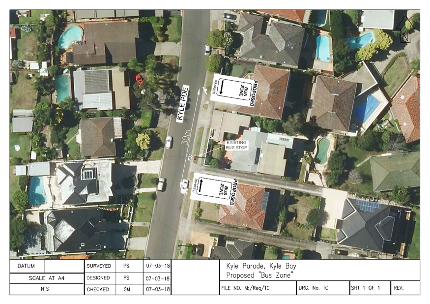
Item: TAC053-18 Kyle
Parade, Kyle Bay - Request to Formalise Existing Bus Stop
Author: Trainee
Assets Engineer
Directorate: Assets
and Infrastructure
Matter Type: Agenda Items
|
Recommendation
That a 30m “Bus Zone” be installed on the
eastern side of Kyle Parade, Kyle Bay, adjacent to number 53, as shown on
plan TC1704 attached to the report.
|
Executive
Summary
1. This
report seeks the Committee’s consideration of the proposed installation
of a “Bus Zone” in Kyle Parade, Kyle Bay.
Background
2. Council
received representation to investigate the existing Bus Stop located on the
eastern side of Kyle Parade, Kyle Bay adjacent to number 53.
3. Following
investigations by Council officers it was observed that vehicles are parking
within the designated distance for the Bus Stop and this has resulted in buses
being unable to safely stop parallel to the kerb, causing a dangerous situation
for drivers and commuters.
Proposal
4. As
a result of this investigation, it is proposed to install a 30m “Bus
Zone” on the eastern side of Kyle Parade to prevent cars parking this
area and improve safety for the bus stop.
Financial
Implications
5. Within
budget allocation – RMS Traffic Facility Grant – approximately
$400.
Community
Engagement
6. Residents
in the vicinity have been notified by letter of the proposed installation of
the “Bus Zone”. The closing date for submissions was 22nd
March 2018. No objections were received.
File Reference
D18/42395
ATTACHMENTS
|
Attachment ⇩1
|
Plan TC1704 - Kyle Pde, Kyle Bay
|
|
Georges River Council - Traffic Advisory Committee Meeting - Tuesday,
3 April 2018
TAC053-18 Kyle Parade, Kyle Bay - Request to Formalise
Existing Bus Stop
[Appendix 1] Plan
TC1704 - Kyle Pde, Kyle Bay
|
Page 5
|
Georges
River Council – Traffic Advisory Committee Meeting - Tuesday, 3
April 2018 Page 6
Item: TAC054-18 William
Road, Riverwood - Proposed "No Parking, Motorcycles Excepted" zone
Author: Trainee
Assets Engineer
Directorate: Assets
and Infrastructure
Matter Type: Agenda Items
|
Recommendation
That a 4m “No Parking, Motorcycles Excepted”
zone be installed on the southern side of William Road, Riverwood, adjacent
to number 7a-9a, as shown as plan TC1696 attached to the report.
|
Executive
Summary
1. This
report seeks the Committee’s consideration of the proposed “No
Parking, Motorcycles Excepted” zone in William Road, Riverwood adjacent
to number 7a-9a.
Background
2. A
request was received by Council from a local resident to consider implementing
signage to prevent vehicles obstructing the driveways adjacent to number 7a-9a
William Road, Riverwood.
Proposal
3. Following
investigations by Council officers, it was found that vehicles were obstructing
the driveways adjacent to 7a-9a William Road, Riverwood. It is proposed to
install a “No Parking, Motorcycles Excepted” zone to indicate that
vehicles cannot park in this location and improve vehicle access to the
properties.
Financial
Implications
4. Within
budget allocation – RMS Traffic Facility Grant – approximately
$400.
Community
Engagement
5. Residents
in the vicinity have been notifies by letter of the proposed installation of
the “No Parking”. The closing date for submission was 16th
March 2018. No objections were received.
File Reference
D18/43223
ATTACHMENTS
|
Attachment ⇩1
|
Plan TC1696 - William Road, Riverwood
|
|
Georges River Council - Traffic Advisory Committee Meeting - Tuesday,
3 April 2018
TAC054-18 William Road, Riverwood - Proposed "No
Parking, Motorcycles Excepted" zone
[Appendix 1] Plan
TC1696 - William Road, Riverwood
|
Page 7
|

Georges
River Council – Traffic Advisory Committee Meeting - Tuesday, 3
April 2018 Page 8
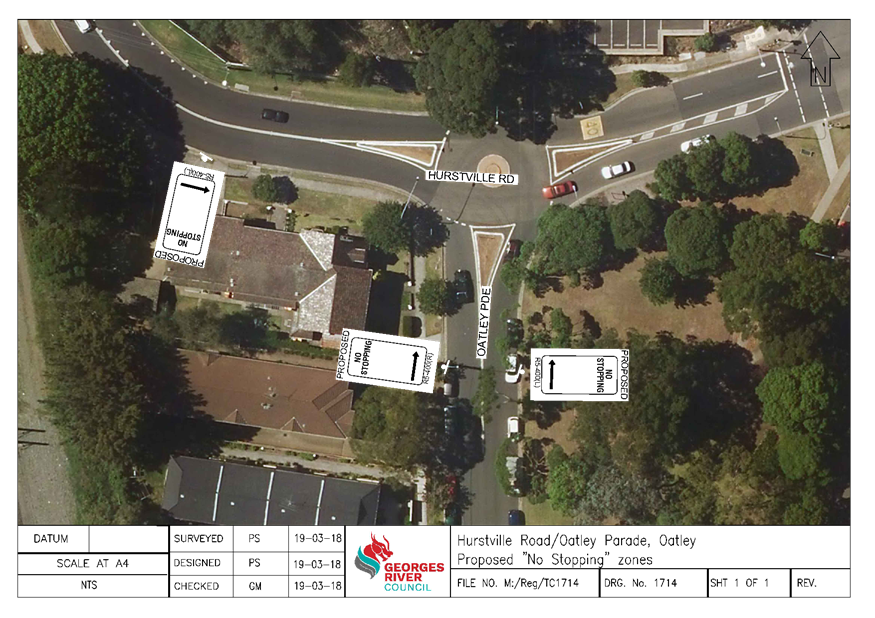
Item: TAC055-18 Oatley
Parade, Oatley - Proposed "No Stopping" zones
Author: Trainee
Assets Engineer
Directorate: Assets
and Infrastructure
Matter Type: Agenda Items
|
Recommendation
(a) That
a 21m “No Stopping” zone be installed on the eastern departure of
the roundabout on Oatley Parade, Oatley, at the intersection of Hurstville
Road.
(b) That
a 61m “No Stopping” zone be installed on the south-western corner
of the roundabout on Oatley Parade Oatley, at the intersection of Hurstville
Road, as show on plan TC1714 attached to the report.
|
Executive
Summary
1. This
report seeks the Committee’s consideration for the proposed “No
Stopping” zones on Oatley Parade, Oatley, near the intersection with
Hurstville Road.
Background
2. A
request was received by Council from a local resident to investigate the
parking conditions on Hurstville Road and Oatley Parade, Oatley, in particular
highlighting vehicles parking too close to the roundabout at the subject
intersection.
3. Vehicles
parking on the southern side of Hurstville Road, Oatley, on the departure of
the roundabout obstructs sight distance for vehicles utilising the driveway at
No. 2 Oatley Parade.
Proposal
4. Following
investigations by Council officers, it was found that vehicles were parking
close to the approach and departure of the roundabout narrowing the
carriageway. It is proposed to install a 21m “No Stopping” zone on
the eastern side of Oatley Parade and a 61m “No Stopping” zone on
the western side, to indicate that vehicles cannot park in this location,
improve sight distance for vehicles utilising the driveway on Hurstville Road,
adjacent to No. 2 Oatley Parade and increase safety in this area.
Financial
Implications
5. Within
budget allocation – RMS Traffic Facility Grant – approximately
$400.
Community
Engagement
6. The
residents in this vicinity have been notifies by letter of the proposed
“No Stopping” zone on both the western and eastern sides of Oatley
Parade, Oatley, intersection of Hurstville Road. The closing date for
submission was 23rd March 2018. Council feedback from 4 residents, 3
in favour and 1 objected to losing on-street parking on Hurstville Road,
adjacent to No. 2 Oatley Parade.
7. The
loss of parking is deemed acceptable to improve the sight distance and
accessibility at the properties driveways and also improve the traffic
movements near the roundabout.
File Reference
D18/43286
ATTACHMENTS
|
Attachment ⇩1
|
Plan TC1714 - Oatley Parade, Oatley
|
|
Georges River Council - Traffic Advisory Committee Meeting - Tuesday,
3 April 2018
TAC055-18 Oatley Parade, Oatley - Proposed "No
Stopping" zones
[Appendix 1] Plan
TC1714 - Oatley Parade, Oatley
|
Page 10
|
Georges
River Council – Traffic Advisory Committee Meeting - Tuesday, 3
April 2018 Page 11
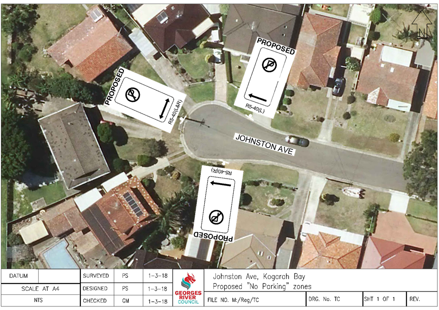
Item: TAC056-18 Johnston
Avenue, Kogarah Bay - Proposed "No Parking" zone
Author: Trainee
Assets Engineer
Directorate: Assets
and Infrastructure
Matter Type: Agenda Items
|
Recommendation
That a 33m “No Parking” zone be installed at
the cul-de-sac of Johnston Avenue, Kogarah Bay, as shown on plan TC1703
attached to the report.
|
Executive
Summary
1. This
report seeks the Committee’s consideration for the proposed installation
of a “No Parking” zone at the cul-de-sac end of Johnston Avenue,
Kogarah Bay.
Background
2. A
request was received by Council from a local resident to consider implementing
signage to prevent vehicles parking at the cul-de-sac of Johnson Avenue,
Kogarah Bay.
Proposal
3. Following
investigations by Council officers, it was found that vehicles were parking at
the cul-de-sac of Johnston Avenue, Kogarah Bay, restricting vehicle movements
utilising the turning circle. It is proposed to install a 33m “No
Parking” zone to indicate that vehicles cannot park in this location and
improve vehicle movements in this area, in particular garbage trucks, emergency
services and other utility vehicles.
Financial
Implications
4. Within
budget allocation – RMS Traffic Facility Grant – approximately
$400.
Community
Engagement
5. Residents
in this vicinity have been notified by letter of the proposed 33m “No
Parking” zone at the cul-de-sac of Johnston Avenue. The closing date for
submission was 19th March 2018. Council received one phone call in
support of the proposal and no objections.
File Reference
D18/43461
ATTACHMENTS
|
Attachment ⇩1
|
Plan TC1703 - Johnston Avenue, Kogarah Bay
|
|
Georges River Council - Traffic Advisory Committee Meeting - Tuesday,
3 April 2018
TAC056-18 Johnston Avenue, Kogarah Bay - Proposed
"No Parking" zone
[Appendix 1] Plan
TC1703 - Johnston Avenue, Kogarah Bay
|
Page 12
|
Georges
River Council – Traffic Advisory Committee Meeting - Tuesday, 3
April 2018 Page 13
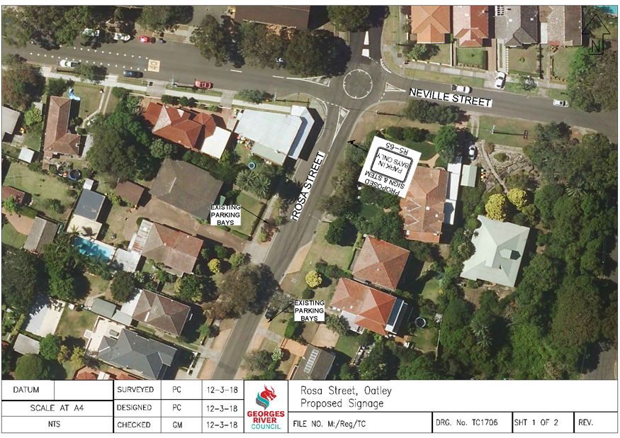
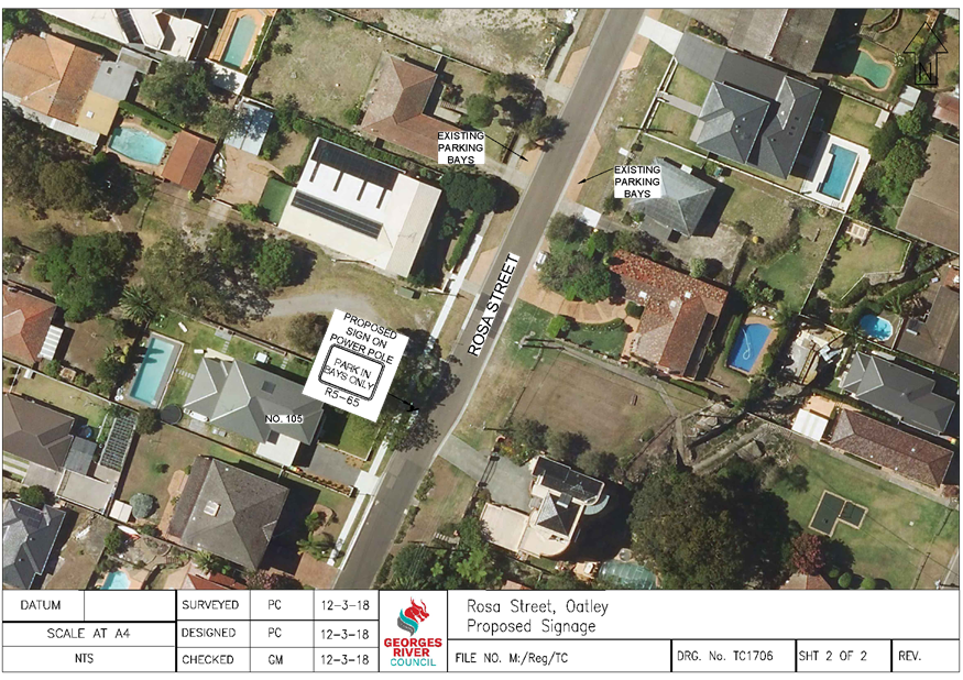
Item: TAC057-18 Rosa
Street, Oatley - Proposed "Park In Bays Only" signs
Author: Traffic
Engineer
Directorate: Assets
and Infrastructure
Matter Type: Agenda Items
|
Recommendation
That a “Park In Bays Only” sign be installed
on the eastern side of Rosa Street, south of Neville Street and another on
the western side of Rosa Street, adjacent to number 105, as shown on plan
TC1706, Sheet 1 and 2 attached to the report.
|
Executive Summary
1. This
report seeks the Committee’s consideration of the installation of parking
control signs in Rosa Street, Oatley.
Background
2. Council
has received a request from a local resident to investigate the parking
situation in Rosa Street, between Neville Street and Herbert Street.
3. This
section of Rosa Street has indented raised brick parking areas for drivers to
park due to the narrow width of the roadway. However Council has been
advised that drivers are parking on the roadway adjacent to, and in between,
the parking bays. This is resulting in reduced travel lanes widths and
the potential for a crash to occur.
Proposal
4. Upon
investigation of this request, it is proposed to install a “Park In Bays
Only” sign on the eastern side of Rosa Street, south of Neville Street
and another sign on the western side of Rosa Street, adjacent to number
105. This is the area of Rosa Street that has the parking bays installed.
5. This
sign can be enforced under “NSW Road Rule 211 – Parking in Parking
Bays” that states:
a) “This
rule applies to a driver who parks on a length of road, or in an area, that has
parking bays (whether or not a park in bays only sign applies to the length of
road or area).
b)
The driver must position the driver’s vehicle completely within a single
parking bay, unless the vehicle is too wide or long to fit completely within
the bay.
c) If
the vehicle is too wide or long to fit completely within a single parking bay,
the driver must park the driver’s vehicle within the minimum number of
parking bays needed to park the vehicle.”
Financial
Implications
6. Within
budget allocation – RMS Traffic Facility Grant – approximately
$300.
File Reference
D18/46407
ATTACHMENTS
|
Attachment ⇩1
|
Plan TC1706 - Rosa Street, Oatley
|
|
Georges River Council - Traffic Advisory Committee Meeting - Tuesday,
3 April 2018
TAC057-18 Rosa Street, Oatley - Proposed "Park In
Bays Only" signs
[Appendix 1] Plan
TC1706 - Rosa Street, Oatley
|
Page 15
|
Georges
River Council – Traffic Advisory Committee Meeting - Tuesday, 3
April 2018 Page 17
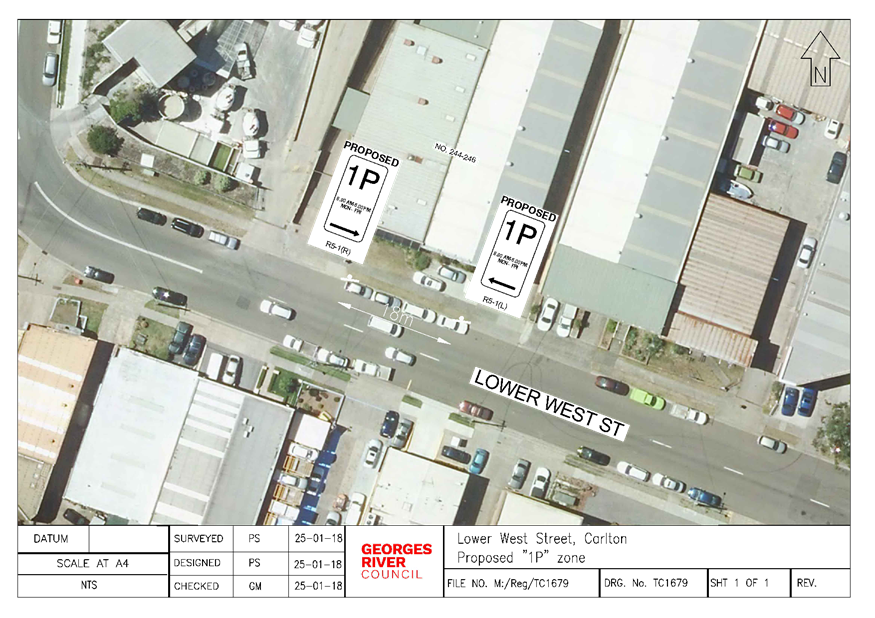
Item: TAC058-18 Lower
West Street, Carlton - Proposed "1P" zone
Author: Trainee
Assets Engineer
Directorate: Assets
and Infrastructure
Matter Type: Agenda Items
|
Recommendation
That an 18m “1P, 8.30am – 6pm” zone be
installed on the northern side of Lower West Street, Carlton adjacent to
number 244, as shown on plan TC1679 attached to the report.
|
Executive
Summary
1. This
report seeks the Committee’s consideration for the proposed installation
of parking restrictions on the northern side of Lower West Street, Carlton.
Background
2. Council
has received a request from a local business owner to investigate the
possibility of converting the currently unrestricted parking spaces on the
northern side of Lower West Street to a timed parking zone to increase the
parking turnover near the businesses and improve the parking availability for
customers.
Proposal
3. Following
investigations by Council officers, it is proposed to convert 18 metres of unrestricted
on-street parking spaces on the northern side of Lower West Street, adjacent
No. 244-246, to a “1P, 8:30am - 6:00pm, Mon – Fri” zone to
assist nearby businesses with an increase in vehicle turnover in this location
during these times.
Financial
Implications
4. Within
budget allocation – RMS Traffic Facility Grant – approximately
$400.
Community
Engagement
5. The
businesses in this vicinity have been notified by letter of the proposed
conversion of the unrestricted area to a “1P” zone. The closing
date for submissions was 22nd March 2018. No objections were
received.
File Reference
D18/47228
ATTACHMENTS
|
Attachment ⇩1
|
Plan TC1679 - Lower West St, Carlton
|
|
Georges River Council - Traffic Advisory Committee Meeting - Tuesday,
3 April 2018
TAC058-18 Lower West Street, Carlton - Proposed
"1P" zone
[Appendix 1] Plan
TC1679 - Lower West St, Carlton
|
Page 18
|
Georges
River Council – Traffic Advisory Committee Meeting - Tuesday, 3
April 2018 Page 19
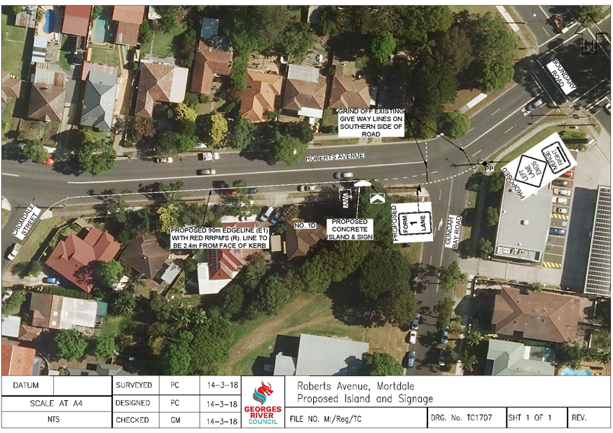
Item: TAC059-18 Roberts
Avenue, Mortdale - Proposed Concrete Island, Line Marking and Signage
Author: Traffic
Engineer
Directorate: Assets
and Infrastructure
Matter Type: Agenda Items
|
Recommendation
(a) That
a concrete island with associated signage be installed on the southern side
of Roberts Avenue, west of Gungah Bay Road.
(b) That
a 90m edge line with red raised reflective pavement markers be installed 2.4m
from the face of the southern kerb in Roberts Avenue, between Gungah Bay Road
and Cromdale Street.
(c) That
part of the existing Give Way line marking on the southern side of Roberts
Avenue at the intersection with Gungah Bay Road be removed.
(d) That
a “Left Lane Ends, Merge Right” and a “Form 1 Lane”
sign be installed on the southern side of Roberts Avenue near the
intersection with Gungah Bay Road, as shown on plan TC1707 attached to the
report.
(e) That
a detailed design be submitted to the RMS for approval prior to construction.
|
Executive
Summary
1. This
report seeks the Committee’s consideration of proposed changes in Roberts
Avenue near Gungah Bay Road, Mortdale.
Background
2. Council
received a request from Mr Mark Coure MP, Member for Oatley, on behalf of the
resident at No. 1D Roberts Avenue, to investigate the traffic issues outside
their property.
3. As
a result of this request, a site meeting was conducted on 22 January 2018 with
Mr Coure, the resident and Council’s Coordinator of Traffic and Transport
to discuss the issues.
4. Council
was advised that there has been a number of crashes occur in Roberts Avenue in
the section between Boundary Road and Cromdale Street, with the most recent
occurring in late 2017 where a vehicle crashed through the front fence of No.
1D.
5. The
RMS Crash Data for the 5 year period between 2012 to 2016 indicates that there
have been 5 recorded crashes in this section of Roberts Avenue with the
majority being RUM Code 71 (Off Road Left into Object).
6. Council
organised the installation of a traffic counter in Roberts Avenue outside No.
1D to ascertain the speed and volume of vehicles in this location. The
results of the counter are shown in the table below:
|
Date:
|
9
February – 15 February 2018
|
|
Average
Annual Daily Traffic (AADT):
|
15,186
vehicles
|
|
85th
percentile speed eastbound:
|
47 km/h
|
|
85th
percentile speed westbound:
|
47 km/h
|
7. It
can be seen in the table above that the 85th percentile speed (the
speed at or below which 85% of all vehicles are observed to travel) was
measured at being 47km/h in both the east and westbound direction. It is
noted that this street is sign posted as a 50km/h speed limit. As a
result, the traffic counts indicate that the installation of speed control
devices, such as chicanes or speed humps is not warranted.
Proposal
8. The
site inspection revealed that there are confusing line markings at the
intersection of Roberts Avenue and Gungah Bay Road and Council is proposing
that the Give Way lines on the southern side of Roberts Avenue be removed to
standardise the intersection for drivers travelling westbound on Roberts
Avenue.
9. As
there are two lanes westbound on Roberts Avenue from Universal Street, no
signage currently exists to advise drivers that the kerb lane ends and it is
proposed to install a “Left Lane Ends, Merge Right” and a
“Form 1 Lane” sign on the southern side of Roberts Avenue near the
intersection with Gungah Bay Road to advise drivers.
10. To
lead to an improvement in safety for drivers reversing from the driveway at No.
1D Roberts Avenue and to assist in reducing speed for merging drivers, the
construction of a concrete island with associated line marking is proposed on
the southern side of Roberts Avenue, west of Gungah Bay Road.
11. To
further improve traffic movements and the safety for drivers parking on the
southern side of Roberts Avenue, it is proposed to install a 90m edge line with
red raised reflective pavement markers 2.4m from the face of the southern kerb.
12. The
detailed design of the concrete island will be submitted to the RMS for
approval prior to its construction and no parking is expected to be removed as
a result of this proposal.
Financial
Implications
13. Within
budget allocation – RMS Traffic Facility Grant – approximately
$12,000.
File Reference
D18/47915
ATTACHMENTS
|
Attachment ⇩1
|
Plan TC1708 - Roberts Avenue, Mortdale
|
|
Georges River Council - Traffic Advisory Committee Meeting - Tuesday,
3 April 2018
TAC059-18 Roberts Avenue, Mortdale - Proposed Concrete
Island, Line Marking and Signage
[Appendix 1] Plan
TC1708 - Roberts Avenue, Mortdale
|
Page 21
|
Georges
River Council – Traffic Advisory Committee Meeting - Tuesday, 3
April 2018 Page 22
Item: TAC060-18 Georges
River Local Government Area - ANZAC Marches
Author: Traffic
Engineer
Directorate: Assets
and Infrastructure
Matter Type: Agenda Items
|
Recommendation
(a) That approval be granted to
temporarily close streets on the Penshurst RSL Sub-Branch ANZAC march route
from 1pm to 3pm on Sunday 22 April 2018, in accordance with the details outlined
in paragraphs 4 and 5 of the report and as shown on the Safeway Traffic
Control Plan attached to the report.
(b) That approval be granted to
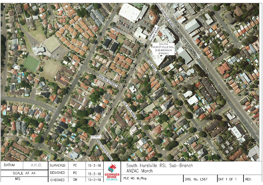
temporarily close streets on the South Hurstville RSL Sub-Branch ANZAC march
route from 5:30am on Wednesday 25 April 2018, in accordance with the details
outlined in paragraph 6 of the report and as shown on plan L567 attached to
the report.
(c) That approval be granted to
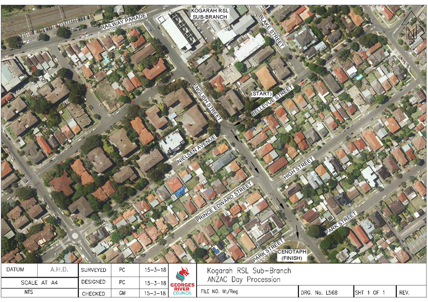
temporarily close streets on the Kogarah RSL Sub-Branch ANZAC march route
from 7:15am on Wednesday 25 April 2018, in accordance with the details
outlined in paragraph 7 of the report and as shown on plan L568 attached to
the report.
(d) That the Sub-Branches be advised of
Council’s decision.
|
Executive Summary
1. This
report seeks the Committee’s consideration of the temporary closure of
various roads in the Georges River Local Government Area (LGA) for ANZAC
Marches.
Background
2. Requests
have been received from representatives of Penshurst RSL Sub-Branch, South
Hurstville RSL Sub-Branch and Kogarah RSL Sub-Branch for approval to
temporarily close various roads near the Clubs in order to hold their ANZAC
marches during April 2018.
3. The
Sub-Branches have provided Council with the commencement times and proposed
routes of their respective marches and these are detailed in paragraphs 4 - 7
below.
Penshurst RSL Sub-Branch March
4. At
approximately 1:40pm on Sunday 22 April 2018, Penshurst RSL Sub-Branch will be
conducting a march commencing at the rear of the Club on Connelly Street and a
Service will held at the Memorial on Bridge Street, finishing at 2:30pm.
This event requires road closures at the following locations and in accordance
with the submitted Traffic Control Plan:
· Forest
Road and Connelly Street;
· Apsley
Street and Bridge Street; and
· Penshurst
Street and Bridge Street.
5. The
RSL Club and Traffic Control Company have notified affected residents, St
George Police Area Command and Punchbowl Bus Company of the proposed road
closures.
South Hurstville RSL Sub-Branch March
6. At
approximately 5:30am on Wednesday 25 April 2018, South Hurstville RSL
Sub-Branch will be conducting a march commencing in Resthaven Road, South
Hurstville and then proceeding along Connells Point Road to the South
Hurstville RSL Club. The march is expected to take thirty minutes and the
ceremony will be held within the Club’s off-street car park.
Kogarah RSL Sub-Branch March
7. At
approximately 7:15am on Wednesday 25 April 2018, Kogarah RSL Sub-Branch will be
conducting a march commencing in Bellevue Street, between Blake Street and
English Street. The marchers will turn left into English Street and
proceed to the Cenotaph on the corner of Park Street and English Street.
A thirty minute service will be conducted at this location and the event will
conclude as the Kogarah RSL Club is under renovation.
Comments
8. South
Hurstville and Kogarah RSL Clubs have requested the assistance of St George
Police Area Command to be present to oversee their marches.
9. These
events would be classified as a Class 3 Event according to the “Guide to
Traffic and Transport Management for Special Events”, and as such a
Traffic Management Plan would not be required to be submitted to the Roads and
Maritime Services (RMS) for approval prior to the events.
Financial
Implications
10. No
budget impact for this report.
File
Reference
D18/48196
ATTACHMENTS
|
Attachment ⇩1
|
Safeway TCP - Connolly Street, Penshurst
|
|
Attachment ⇩2
|
Plan L567 - Connells Point Road, South Hurstville
|
|
Attachment ⇩3
|
Plan L568 - English Street, Kogarah
|
|
Georges River Council - Traffic Advisory Committee Meeting - Tuesday, 3
April 2018
TAC060-18 Georges River Local Government Area - ANZAC
Marches
[Appendix 1] Safeway
TCP - Connolly Street, Penshurst
|
Page 24
|
|
Georges River Council - Traffic Advisory
Committee Meeting - Tuesday, 3 April 2018
TAC060-18 Georges River Local Government Area - ANZAC
Marches
[Appendix 2] Plan
L567 - Connells Point Road, South Hurstville
|
Page 25
|
|
Georges River Council - Traffic Advisory
Committee Meeting - Tuesday, 3 April 2018
TAC060-18 Georges River Local Government Area - ANZAC
Marches
[Appendix 3] Plan
L568 - English Street, Kogarah
|
Page 26
|
Georges
River Council – Traffic Advisory Committee Meeting - Tuesday, 3
April 2018 Page 27
Item: TAC061-18 Joseph
Street, Blakehurst - Proposed Line Marking
Author: Traffic
Engineer
Directorate: Assets
and Infrastructure
Matter Type: Agenda Items
|
Recommendation
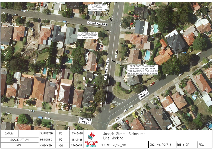
That an 80m dividing barrier line be installed in Joseph
Street, between Phillip Street and Lorna Avenue and a Give Way holding line
be installed at the intersection of Joseph Street and Lorna Avenue, as shown
on plan TC1712 attached to the report.
|
Executive Summary
1. This
report seeks the Committee’s consideration for the proposed line marking
in Joseph Street, Blakehurst.
Background
2. Council
has been requested by a local resident to investigate the traffic issues at the
intersection of Joseph Street and Phillip Street, Blakehurst.
3. The
resident has advised Council that drivers have been observed turning right from
Joseph Street into Phillip Street on the northern side of the landscaped
island, contrary to the existing chevron line marking in this location.
Proposal
4. As
a result of this request, Council is proposing to paint an 80m dividing barrier
line in Joseph Street, between Phillip Street and Lorna Avenue, to lead to an
improvement in turning movements at the intersection and provide advice to
drivers that they are unable to turn right north of the concrete island into
Phillip Street.
5. It
is also proposed to paint a Give Way line at the intersection of Lorna Avenue
and Joseph Street to improve the turning movements in this location.
Financial
Implications
6. Within
budget allocation – RMS Traffic Facility Grant – approximately
$2,000.
File Reference
D18/48545
ATTACHMENTS
|
Attachment ⇩1
|
Plan TC1712 - Joseph Street, Blakehurst
|
|
Georges River Council - Traffic Advisory Committee Meeting - Tuesday,
3 April 2018
TAC061-18 Joseph Street, Blakehurst - Proposed Line Marking
[Appendix 1] Plan
TC1712 - Joseph Street, Blakehurst
|
Page 28
|
Georges
River Council – Traffic Advisory Committee Meeting - Tuesday, 3
April 2018 Page 29
Item: TAC062-18 Regent
Street, Kogarah - Proposed "Do Not Queue Across Intersection"
signage
Author: Trainee
Assets Engineer
Directorate: Assets
and Infrastructure
Matter Type: Agenda Items
|
Recommendation
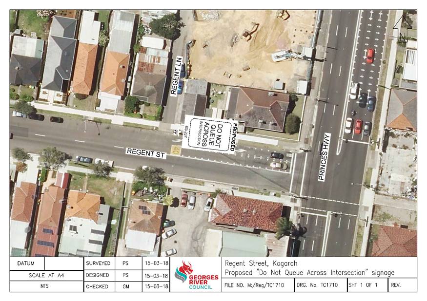
That a “Do Not Queue Across Intersection” sign
be installed on the northern side of Regent Street, Kogarah at the
intersection of Regent Lane as shown on plan TC1710 attached to the report.
|
Executive
Summary
1. This
report seeks the Committee’s consideration of the proposed “Do Not
Queue Across Intersection” signage in Regent Street at the intersection
of Regent Lane, Kogarah.
Background
2. A
request was received by Council from a local resident to consider implementing
measures to prevent vehicles blocking the intersection of Regent Street and
Regent Lane.
Proposal
3. Following
investigations by Council officers, it was found that vehicles were queuing
back from the intersection of Princes Highway and Regent Street thus
obstructing the intersection at Regent Street and Regent Lane. It is proposed
to install a “Do Not Queue Across Intersection” sign to prevent
vehicles obstructing the intersection and improve vehicle movement in this
location.
Financial
Implications
4. Within
budget allocation – RMS Traffic Facility Grant – approximately
$300.
File Reference
D18/48559
ATTACHMENTS
|
Attachment ⇩1
|
Plan TC1710 - Regent Street, Kogarah
|
|
Georges River Council - Traffic Advisory Committee Meeting - Tuesday,
3 April 2018
TAC062-18 Regent Street, Kogarah - Proposed "Do
Not Queue Across Intersection" signage
[Appendix 1] Plan
TC1710 - Regent Street, Kogarah
|
Page 30
|
Georges
River Council – Traffic Advisory Committee Meeting - Tuesday, 3
April 2018 Page 31
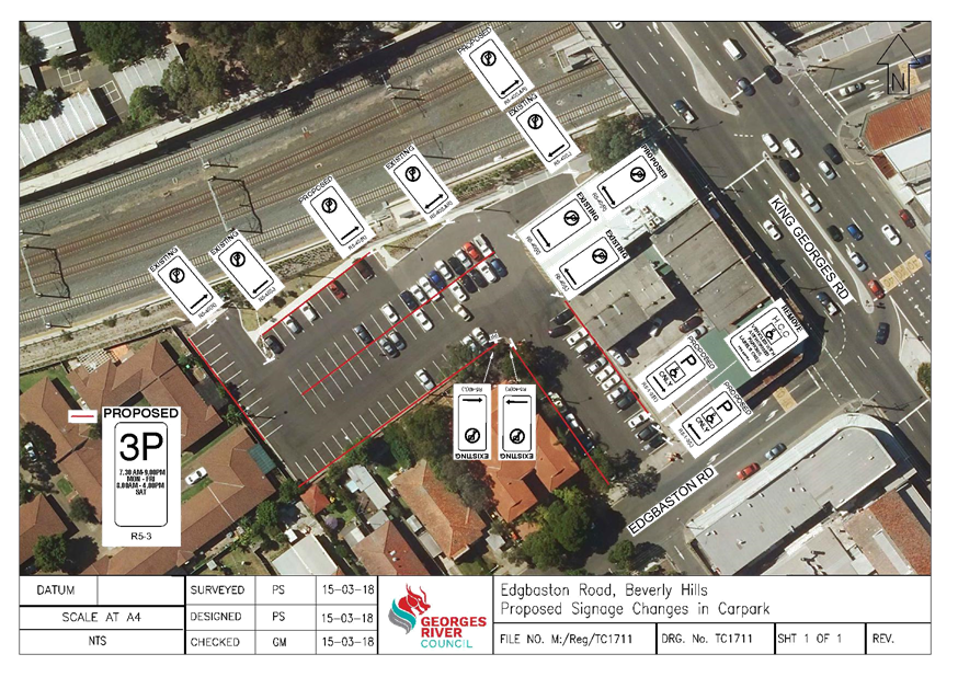
Item: TAC063-18 Edgbaston
Road, Beverly Hills - Proposed Signage Changes in Carpark
Author: Trainee
Assets Engineer
Directorate: Assets
and Infrastructure
Matter Type: Agenda Items
|
Recommendation
That a “3P, 7.30am – 9pm, Mon – Fri, 8am
– 4.00pm, Sat” with accompanying “No Parking” and
“Disabled Only” zones be installed in the Council Carpark on
Edgbaston Road, Beverly Hills, as shown on plan TC1711 attached to the
report.
|
Executive
Summary
1. This
report seeks the Committee’s consideration for the proposed signage
changes in the Council Carpark on Edgbaston Road, Beverly Hills.
Background
2. Council
has received a request from a local resident to investigate the current signage
located in the Council Carpark on Edgbaston Road, Beverly Hills.
3. Currently
the carpark is signposted as “3hr Limit per day, 7.30am – 9pm,
Monday – Friday, 8.00am – 4.00pm, Saturday” enforced under
Local Government Act 1993.
Proposal
4. It
is proposed to install “3P, “3P, 7.30am – 9.00pm, Mon –
Fri, 8.00am – 4.00pm, Sat” with accompanying “No
Parking” and “Disabled Only Parking” zones allowing
enforcement under NSW Legislation, Road Rules 2014.
Financial
Implications
5. Within
budget allocation – RMS Traffic Facility Grant – approximately
$3,500.
File Reference
D18/48856
ATTACHMENTS
|
Attachment ⇩1
|
Plan TC1711 - Carpark, Edgbaston Road, Beverly Hills
|
|
Georges River Council - Traffic Advisory Committee Meeting - Tuesday,
3 April 2018
TAC063-18 Edgbaston Road, Beverly Hills - Proposed
Signage Changes in Carpark
[Appendix 1] Plan
TC1711 - Carpark, Edgbaston Road, Beverly Hills
|
Page 32
|
Georges
River Council – Traffic Advisory Committee Meeting - Tuesday, 3
April 2018 Page 33
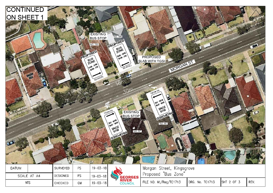
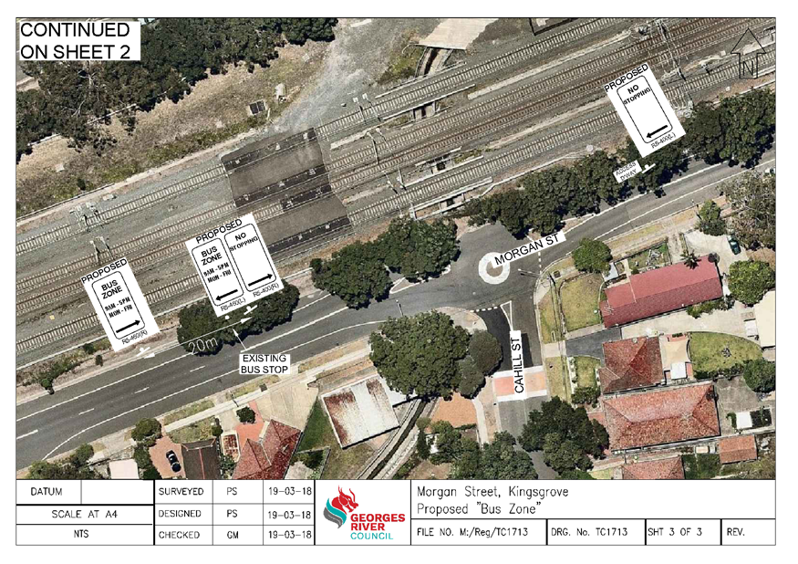
Item: TAC064-18 Morgan
Street, Kingsgrove - Request to Formalise Existing Bus Stops
Author: Trainee
Assets Engineer
Directorate: Assets
and Infrastructure
Matter Type: Agenda Items
|
Recommendation
(a) That
a 30m “Bus Zone” with associated DDA standard slab be installed
adjacent to No. 53 Morgan Street, Kingsgrove, to formalise the existing Bus
Stop.
(b) That
a 16m “Bus Zone, 9am – 5pm, Mon - Fri” with associated DDA
standard slab be installed adjacent to No. 148-150 Morgan Street, Kingsgrove,
to formalise the existing Bus Stop.
(c) That
a 30m “Bus Zone, 9am – 5pm, Mon - Fri” be installed
adjacent to No. 95-97 Morgan Street, Kingsgrove, to formalise the existing
Bus Stop.
(d) That
an 85m “No Stopping” zone following a 20m “Bus Zone, 9am
– 5pm, Mon - Fri” be installed in Morgan Street, Kingsgrove,
corner of Cahill Street, to formalise the existing Bus Stop.
(e) That the adjacent residents be
notified of the Traffic Committee’s decision prior to installation of
works.
|
Executive
Summary
1. This
report seeks the Traffic Committee’s approval to formalise the existing
Bus Stops in Morgan Street, Kingsgrove.
Background
2. Council
has received representation requesting Council to formalise the existing Bus
Stops located in Morgan Street, Kingsgrove, by signposting them as “Bus
Zones”.
3. Formalising
the “Bus Zone” will enable busses to pull in and out of the Bus
Stop without being hindered by parked cars and allow for easier enforcement.
4. According
to the current standards, a Bus Zone should be at least 30m long (20m on the
approach side and 10m on the departure side). The 10m on the departure side can
be accommodated within an area restricted for parking (such as “No
Parking” or “No Stopping” zones).
Proposal
5. Upon
investigation of these requests, Council is proposing the formalisation of the
existing Bus Stops by installation “Bus Zones” in Morgan Street,
Kingsgrove, which would assist the bus movements in these locations.
6. Bus
Stops operated solely by State Transit Authority of NSW, will be zoned
“9am – 5pm, Mon – Fri”, unrestricted parking outside
these hours.
7. Some
of these “Bus Zones” will also require the construction of concrete
slabs with Tactile Ground Surface Indicators (TGSI) to comply with DDA
standards.
Financial
Implications
8. Within
budget allocation – RMS Traffic Facility Grant – approximately
$3,500
Community
Engagement
9. Community
engagement will be conducted including: a letter drop outlining Traffic
Advisory Committee’s recommendations of the proposed changes to the
affected residents.
File Reference
D18/51892
ATTACHMENTS
|
Attachment ⇩1
|
Plan TC1713 - Various Locations, Morgan Street, Kingsgrove
|
|
Georges River Council - Traffic Advisory Committee Meeting - Tuesday,
3 April 2018
TAC064-18 Morgan Street, Kingsgrove - Request to
Formalise Existing Bus Stops
[Appendix 1] Plan
TC1713 - Various Locations, Morgan Street, Kingsgrove
|
Page 35
|
Georges
River Council – Traffic Advisory Committee Meeting - Tuesday, 3
April 2018 Page 38
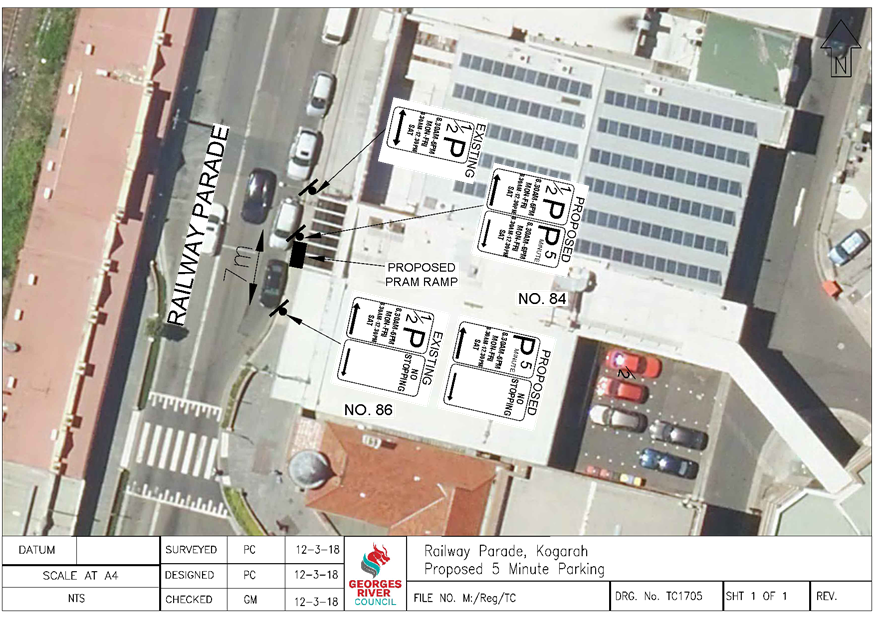
Item: TAC065-18 Railway
Parade, Kogarah - Proposed "P5 Minute" zone
Author: Traffic
Engineer
Directorate: Assets
and Infrastructure
Matter Type: Agenda Items
|
Recommendation
That 7m of the existing “1/2P, 8.30am – 6pm
Mon – Fri, 8.30am – 12.30pm Sat” zone adjacent to number 86
Railway Parade, be converted to a “P5 Minute, 8.30am – 6pm Mon
– Fri, 8.30am – 12.30pm Sat” zone with a pram ramp, as
shown on plan TC1705 attached to the report.
|
Executive
Summary
1. This
report seeks the Committee’s consideration of the proposed changes to the
parking zone in Railway Parade, Kogarah.
Background
2. Council
has received correspondence in relation to investigating the possibility of
installing short term parking on the eastern side of Railway Parade, north of
Belgrave Street. As this area is signposted as “1/2P”, the
request is to allow for higher parking turnover for customers and provide an
area for people to be picked up and dropped off near the businesses.
Proposal
3. Upon
investigation of this request, Council is proposing to convert 7m of the
“1/2P, 8.30am – 6pm Mon – Fri, 8.30am – 12.30pm
Sat” zone adjacent to number 86 Railway Parade, to a “P5 Minute,
8.30am – 6pm Mon – Fri, 8.30am – 12.30pm Sat”
zone. This would assist businesses in this area with an increase in
vehicle turnover during the day.
4. It
is also proposed to construct a pedestrian ramp adjacent to the “P5
Minute” space to assist people accessing the footpath area from the
roadway.
5. Businesses
in this vicinity have been notified by letter of the proposed changes to the
parking and pram ramp. The closing date for submissions was 22 March
2018. No objections were received.
Financial
Implications
6. Within
budget allocation – RMS Traffic Facility Grant – approximately
$1,200.
File
Reference
D18/53227
ATTACHMENTS
|
Attachment ⇩1
|
Plan TC1705 - Railway Parade, Kogarah
|
|
Georges River Council - Traffic Advisory Committee Meeting - Tuesday,
3 April 2018
TAC065-18 Railway Parade, Kogarah - Proposed "P5
Minute" zone
[Appendix 1] Plan
TC1705 - Railway Parade, Kogarah
|
Page 40
|
Georges
River Council – Traffic Advisory Committee Meeting - Tuesday, 3
April 2018 Page 41
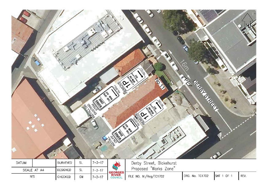
Item: TAC066-18 Derby
Street, Kogarah - Proposed "Works Zone" at number 11
Author: Assistant
Traffic Engineer
Directorate: Assets
and Infrastructure
Matter Type: Agenda Items
|
Recommendation
(a) That
a 16m “Works Zone, 7am-5pm, Mon-Sat” be installed on the western
side of Derby Street, Kogarah adjacent to No. 11, for a period of 24 weeks commencing
on 5th March 2018, as shown on plan TC1702 attached to the report.
(b) That
the parking be returned to its current status at the completion of the
“Works Zone” period.
|
Executive
Summary
1. This
report seeks the Committee’s consideration for a “Works Zone”
to be installed adjacent to 11 Derby Street, Kogarah
Background
2. The
builder for a Council approved mixed use commercial/residential development
over existing multi-level basement car park at 13 Derby Street, has requested
the installation of a “Works Zone” adjacent to the site to provide
an area where mobile concrete pumps and vehicles associated with the
construction can park.
3. Currently
there is “1P, 8.30am-6pm, Mon-Fri, 8.30am-12.30pm, Sat” parking in
this location.
4. Following
consultation with No. 11 Derby Street, there was no objections to the
installation of the proposed “Works Zone” for this duration.
Financial
Implications
5. No
budget impact for this report.
File Reference
D18/53334
ATTACHMENTS
|
Attachment ⇩1
|
TC1702_Derby Street Work Zone
|
|
Georges River Council - Traffic Advisory Committee Meeting - Tuesday,
3 April 2018
TAC066-18 Derby Street, Kogarah - Proposed "Works
Zone" at number 11
[Appendix 1] TC1702_Derby
Street Work Zone
|
Page 42
|
Georges
River Council – Traffic Advisory Committee Meeting - Tuesday, 3
April 2018 Page 43
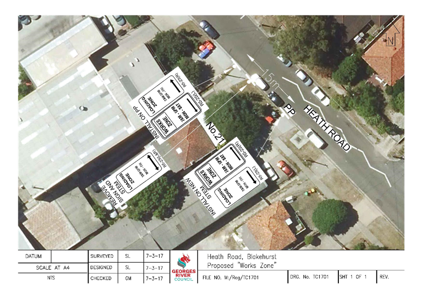
Item: TAC067-18 Heath
Road, Blakehurst - Proposed "Works Zone" at number 21
Author: Assistant
Traffic Engineer
Directorate: Assets
and Infrastructure
Matter Type: Agenda Items
|
Recommendation
(a) That
a 15m “Works Zone, 7am-5pm, Mon-Sat” be installed on the western
side of Heath Road, adjacent to 21 Heath Road, Blakehurst, for a period of 50
weeks commencing on 1st March 2018, as shown on plan TC1701
attached to the report.
(b) That
the parking be returned to its current status at the completion of the
“Works Zone” period.
|
Executive
Summary
1. This
report seeks the Committee’s consideration for a “Works Zone”
to be installed adjacent to No. 21 Heath Road, Blakehurst
Background
2. The
builder for a Council approved demolition of existing dwelling and new
industrial building and lot consolidation at No. 21 Heath Road, Blakehurst, has
requested the installation of a “Works Zone” adjacent to the site
to provide an area where mobile concrete pumps and vehicles associated with the
construction can park.
3. Currently
there is a “Loading Zone” on the western side of Heath Road
adjacent to this site.
Proposal
4. Upon
investigations of this request, it is proposed to install a 15m “Works
Zone, 7am-5pm, Mon-Sat” adjacent to 21 Heath Road, Blakehurst for a
period of 50 weeks. This will provide an area where the vehicles involved in
the construction of the new premises can park in close proximity to the
worksite.
Financial
Implications
5. No
budget impact for this report.
File Reference
D18/53437
ATTACHMENTS
|
Attachment ⇩1
|
TC1701_Heath Road Work Zone
|
|
Georges River Council - Traffic Advisory Committee Meeting - Tuesday,
3 April 2018
TAC067-18 Heath Road, Blakehurst - Proposed
"Works Zone" at number 21
[Appendix 1] TC1701_Heath
Road Work Zone
|
Page 44
|
Georges
River Council – Traffic Advisory Committee Meeting - Tuesday, 3
April 2018 Page 45
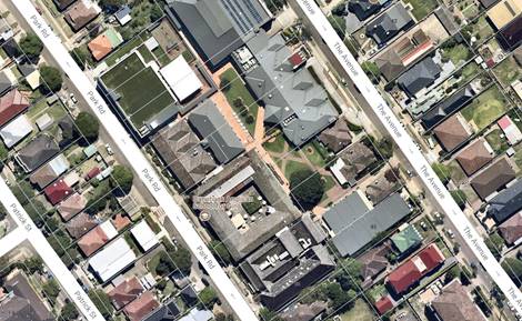
Item: TAC068-18 Park
Road and The Avenue Hurstville - Danebank Autumn Fair 2018
Author: Senior
Traffic Engineer
Directorate: Assets
and Infrastructure
Matter Type: Agenda Items
|
Recommendation
THAT the request to change the
on-street parking along Park Road and The Avenue, Hurstville adjoining
Danebank School to 90 degree angle parking on Saturday, 12 May 2018 to
facilitate the Danebank School’s Autumn Fair be approved.
|
Executive Summary
1. This
report seeks the committee’s consideration for Danebank School to change
the parking orientation in Park Road and The Avenue, Hurstville to 90 degree
angle parking along the school’s frontage on Saturday 12th
May, 2018 for their annual Spring Fair to help cater for the increased parking
demand associated with the event.
Background
2. Danebank School’s Open Day and Autumn Fair is an
annual event. This year the school is planning to hold this event on Saturday,
12 May 2018.
3. As per previous years, the school has requested Council
approval to introduce temporary angle parking zones in The Avenue and Park
Road, Hurstville along the frontages of Danebank School, to increase
availability of on-street parking for the visitors and participants of the event.
4. The Avenue and Park Road are 12m wide, one way streets
and can accommodate the angIed parking while still maintaining enough
carriageway for through traffic.
5. Council in previous years has approved the
school’s request to introduce temporary angle parking zones in The Avenue
and Park Road, Hurstville to facilitate this event.
6. The proposed angle parking arrangement would improve
the parking supply and will reduce the width of the carriageway, which
consequently acts as a traffic calming measure reducing vehicle speeds along
both frontage streets during the event.
7. This event has been held in the past few years with no
reported incidents or objections.
Financial
Implications
8. No
budget impact for this report.
File Reference
D18/53465
Georges River Council – Traffic Advisory
Committee Meeting - Tuesday, 3 April 2018 Page 47
Item: TAC069-18 Balfour
Street, Allawah - Proposed "Works Zone" at the side of 27A Andover
Street
Author: Assistant
Traffic Engineer
Directorate: Assets
and Infrastructure
Matter Type: Agenda Items
|
Recommendation
(a) That
a 30m “Works Zone, 7am-5pm, Mon-Sat” be installed on the southern
side of Balfour Street, adjacent to No. 27A Andover Street, Allawah, for a
period of 16 weeks commencing on 9th April 2018, as shown on plan
TC1715 attached to the report.
(b) That
the parking be returned to its current status at the completion of the
“Works Zone” period.
|
Executive
Summary
1. This
report seeks the Committee’s consideration for a “Works Zone”
to be installed in Balfour Street, adjacent to No. 27A Andover Street, Allawah.
Background
2. The
builder for a Council approved development involving the demolition of existing
structures and construction of new residential flat building at No.’s
27-29 Andover Street, Allawah has requested the installation of a “Works
Zone” adjacent to the site to provide an area where mobile concrete pumps
and vehicles associated with the construction can park.
3. Currently
there is unrestricted parking on both sides of Balfour Street.
Proposal
4. Upon
investigation of this request, it is proposed to install a 30m “Works
Zone, 7am-5pm, Mon-Sat” on Balfour Street adjacent to No. 27A Andover
Street, Allawah for a period of 16 weeks. This would provide an area where the
vehicles involved in the construction of the new residential flat building can
park in close proximity to the worksite.
Financial
Implications
5. No
budget impact for this report.
File Reference
D18/53721
ATTACHMENTS
|
Attachment ⇩1
|
TC1715_Balfour Street Work Zone
|
|
Georges River Council - Traffic Advisory Committee Meeting - Tuesday,
3 April 2018
TAC069-18 Balfour Street, Allawah - Proposed
"Works Zone" at the side of 27A Andover Street
[Appendix 1] TC1715_Balfour
Street Work Zone
|
Page 48
|

Georges
River Council – Traffic Advisory Committee Meeting - Tuesday, 3
April 2018 Page 49
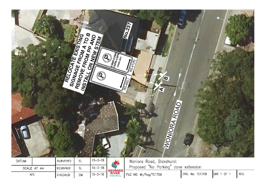
Item: TAC070-18 Woniora
Road, Blakehurst - Proposed changes to "No Parking" zone
Author: Assistant
Traffic Engineer
Directorate: Assets
and Infrastructure
Matter Type: Agenda Items
|
Recommendation
That the existing “No Parking” zone adjacent
to No. 237 Woniora Road, Blakehurst, be extended by 3m, as shown on the plan
TC1709 attached to the report.
|
Executive
Summary
1. This
report seeks the Committee’s consideration for the extension of the
existing “No Parking” zone by 3m, adjacent to No. 237 Woniora Road,
Blakehurst.
Background
2. Council
received a request from a resident to investigate the parking conditions on the
western side of Woniora Road. In particular highlighting that vehicle’s
often encroach on the existing “No Parking” zone and obstruct
driveway access.
3. There
is currently a 22m “No Parking, 8am-9.30am, 3pm-4pm, School Days”
zone followed by a 52m “No Parking” zone on the western side of
Woniora Road.
Comments
4. Upon
investigations of this request, Council has found that the length of kerb
between the two driveways at 237 Woniora Road, is less than 5m in length. It
was also noted that the allowable parking space outside of the “No
Parking, 8am-9.30am, 3pm-4pm, School Days” zone restriction is
approximately 3.2m. It is therefore proposed to relocate the existing signage
in this location, extending the existing “No Parking” zone by 3m to
prevent vehicles parking in this location.
Financial
Implications
5. Within
budget allocation – RMS Traffic Facilities Grant – Approximately
$150.
Community
Engagement
6. The
residents in this vicinity have been notified of the proposed changes to the
“No Parking” zone on the western side of Woniora Road, Blakehurst.
No objections were received.
File Reference
D18/53961
ATTACHMENTS
|
Attachment ⇩1
|
TC1709_Woniora Road No Parking
|
|
Georges River Council - Traffic Advisory Committee Meeting - Tuesday, 3
April 2018
TAC070-18 Woniora Road, Blakehurst - Proposed changes
to "No Parking" zone
[Appendix 1] TC1709_Woniora
Road No Parking
|
Page 51
|
Georges
River Council – Traffic Advisory Committee Meeting - Tuesday, 3
April 2018 Page 52
Item: TAC071-18 Bryant
and Penshurst Street Penshurst - Road Safety Concerns
Author: Senior
Traffic Engineer
Directorate: Assets
and Infrastructure
Matter Type: Agenda Items
|
Recommendation
(a) To
be determined by the Committee after consideration of the content of the
report.
|
Executive Summary
1. This report seeks the
Traffic Committee’s review and advise in regards to road safety concerns
with the existing speed cushions In Bryant/Penshurst Street Penshurst.
Background
2. Council installed speed
cushions at the approaches to the bend at the intersection of Penshurst Street
and Bryant Street, Narwee.
3. The
speed cushions were installed due to road safety concerns with motorists
speeding around the bend and on many occasions causing accidents as they lose
control of their vehicle.
4. The
speed cushions were installed at two different locations. One location
was before the bend for traffic travelling southbound and the other speed
cushion was installed before the bend for traffic travelling north bound.
The speed cushions were installed to only cover the two lanes of travel along
each direction (please see below)
5. Shortly after the installation of the speed cushions,
Council received complaints from residents advising that motorists are choosing
to break road rules and cross the double centre lines, driving along the wrong
side of the road to avoid the speed cushions along their direction of travel.
6. Accordingly residents are requesting that Council
consider extending the rubber cushions to cover the whole road length of
Bryant/Penshurst Street at both locations. This will result in extra costs and
noise to residents, with no additional benefit except to discourage motorists
who should be adhering to road rules and not cross the double centre lines or drive
on the wrong side of the road.
Financial
Implications
No budget impact for this report.
File Reference
D18/54740
Georges River Council – Traffic Advisory
Committee Meeting - Tuesday, 3 April 2018 Page 54
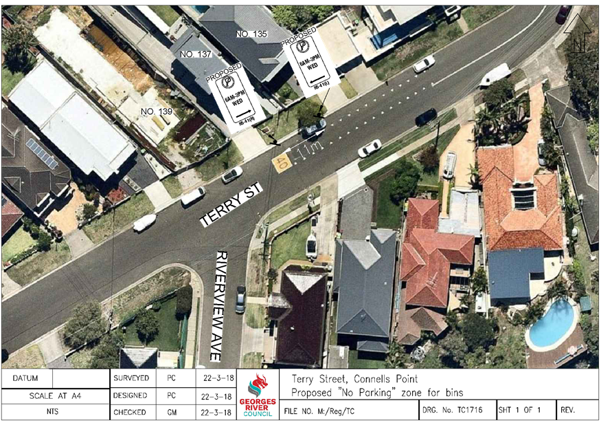
Item: TAC072-18 Terry
Street, Connells Point - Proposed "No Parking" zone
Author: Traffic
Engineer
Directorate: Assets
and Infrastructure
Matter Type: Agenda Items
|
Recommendation
(a) That
an 11m “No Parking, 6am – 3pm Wed” zone be installed on the
northern side of Terry Street, adjacent to No.’s 135-137, as shown on
plan TC1716 attached to the report.
(b) That the residents and Strata
of No.’s 135-137 be advised of Council’s decision.
|
Executive Summary
1. This
report seeks the Committee’s consideration of the installation of a
“No Parking” zone in Terry Street, Connells Point.
Background
2. Council
has been contacted by the Strata Compnay on behalf of the residents of the
townhouses at No.’s 135-137 Terry Street, Connells Point, to consider the
installation of parking restriction signs adjacent to their property to assist
with waste collection.
3. As
the street is currently unrestricted for parking, vehicles have been parking
outside the property causing issues with the bin collections each week.
Proposal
4. As
a result of this request and following investigation, it is proposed to install
an 11m “No Parking, 6am – 3pm Wed” zone on the northern side
of Terry Street adjacent to the townhouses at No.’s 135-137 so as to
provide an area on the street where the waste bins can be placed for
collection.
Financial
Implications
5. Within
budget allocation – RMS Traffic Facility Grant – approximately
$300.
File Reference
D18/56016
ATTACHMENTS
|
Attachment ⇩1
|
Plan TC1716 - Terry Street, Connells Point
|
|
Georges River Council - Traffic Advisory Committee Meeting - Tuesday,
3 April 2018
TAC072-18 Terry Street, Connells Point - Proposed
"No Parking" zone
[Appendix 1] Plan
TC1716 - Terry Street, Connells Point
|
Page 55
|
Georges
River Council – Traffic Advisory Committee Meeting - Tuesday, 3
April 2018 Page 56
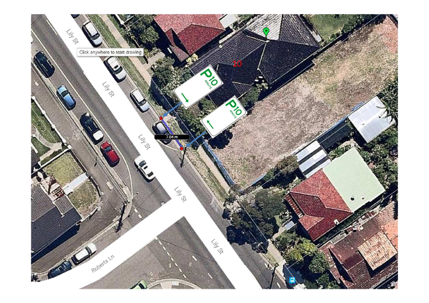
Item: TAC073-18 Lily
Street Hurstville - Install 10 minutes Parking Restriction
Author: Senior
Traffic Engineer
Directorate: Assets
and Infrastructure
Matter Type: Agenda Items
|
Recommendation
THAT 7 metres of 10 minutes
(“P10min”) parking restriction be installed outside number 10
Lily Street Allawah.
|
Executive Summary
1. This
report seeks the Traffic Committee’s consideration to install 10 minutes
parking restriction outside number 10 Lily Street Allawah.
Background
2. Council received representation from the
residents living at 10 Lily Street Allawah in regards to the difficulty they
face in the provision of short term parking outside the front of their home for
taxi pickups and drop offs and medical appointments.
3. The residents advised that they are disability
pensioners with health issues that require a nurse to come regularly to take
blood tests, and that parking for these services is hardly available outside
their home.
4. Due to Lily Street’s close proximity
to Allawah Railway Station, on-street parking is in very high demand in Lily
Street.
5. Furthermore most properties on Lily Street
have their off street parking facilitated from the rear of their premises,
(being Lily Lane), due to a significant difference between the road level and
the entrance to most of the resident’s properties. In the case of 10
Lilly Street, access to road level is facilitated by means of
stairways.
6. Accordingly the residents rely on on-street
parking on Lily Street for pick up and drop off and medical visits.
7. The
installation of a “P10min” parking restriction measuring 7 metres
in length outside the resident’s home would help facilitate quick
turnover of parking for the resident’s medical appointment needs
8. Furthermore,
as the resident’s home is across the road form Allawah Train Station, the
“P10 min” will also provide a location to be safely utilised for
members of the community who wish to drop off and/or pick up passengers to
access Allawah Railway Station.
Financial
Implications
9. Within
budget allocation. RMS Traffic Facility Grant – approximately $500
File Reference
D18/56285
ATTACHMENTS
|
Attachment ⇩1
|
10 Lily Street - 10 minutes parking
|
|
Georges River Council - Traffic Advisory Committee Meeting - Tuesday,
3 April 2018
TAC073-18 Lily Street Hurstville - Install 10 minutes
Parking Restriction
[Appendix 1] 10
Lily Street - 10 minutes parking
|
Page 58
|
Georges
River Council – Traffic Advisory Committee Meeting - Tuesday, 3
April 2018 Page 59
Item: TAC074-18 Delegated
Authority to Director of Assets and Infrastructure to approve "Works
Zone" applications.
Author: Senior
Traffic Engineer
Directorate: Assets
and Infrastructure
Matter Type: Agenda Items
|
Recommendation
THAT Delegated Authority be granted to the Director of
Assets and Infrastructure to approve “Works Zone” applications
within Georges River Council Local Roads, without the need to go through the
Traffic Advisory Committee.
|
Executive Summary
1. This
report seeks the Committee’s approval to delegate authority to the
Director of Assets and Infrastructure to approve “Works Zone”
applications within Georges River Council’s Local Roads, without the need
to go through the Traffic Advisory Committee.
Background
2. Council’s traffic
section receives numerous applications for “Works Zone” in Georges
River Council Local Roads.
3. While Council clearly
indicates on the “Works Zone” application that a minimum of 6 weeks
process time is required for the application to be approved; applicants do not
adhere by the time frame and expect applications to be prioritised as a matter
of urgency.
4. The Traffic Advisory
Committee only meets once a month, which prolongs the “Works Zone”
application approval time.
5. To
help speed up the approval process it is recommended that “Works
Zone” applications in Local Roads, where there are no safety concerns
with the provision of the “Works Zone” be referred to the Director
of Assets and Infrastructure to approve under Delegated Authority from
the Traffic Advisory Committee.
Financial
Implications
6. No
budget impact for this report.
File Reference
D18/57231
Georges River Council – Traffic Advisory
Committee Meeting - Tuesday, 3 April 2018 Page 60
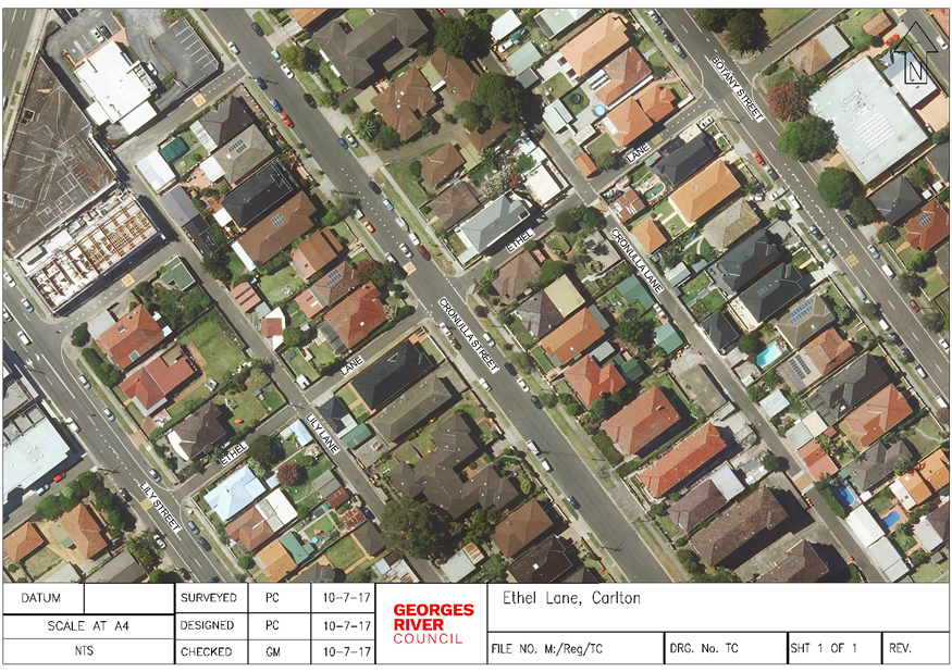
Item: TAC075-18 Ethel
Lane, Carlton - Proposed One-Way
Author: Traffic
Engineer
Directorate: Assets
and Infrastructure
Matter Type: Agenda Items
|
Recommendation
(a) That
the request for Ethel Lane, Carlton, between Botany Street and Lily Street,
to be converted to one-way westbound be approved in principal.
(b) That
the residents and businesses in this vicinity be consulted on the proposal.
(c) That
the results of the consultation be submitted to a future Traffic Committee
meeting for consideration.
|
Executive
Summary
1. This
report seeks the Committee’s consideration of the conversion of Ethel
Lane, Carlton to one-way westbound.
Background
2. Council
has received correspondence from a resident in Botany Street, Carlton raising
road safety concerns in Ethel Lane.
3. A
report on this issue was presented at the 4 December 2014 meeting of the
Traffic Advisory Committee which included a Road Safety Audit, traffic surveys
and a parking survey in Botany Street and Ethel Lane.
4. To
address the road safety concerns, Council engaged an accredited Road Safety
Auditor to identify all pedestrian and traffic related road safety issues in Ethel
Lane and Botany Street. The Audit was conducted in accordance with the
“RMS Guidelines for Road Safety Audit Practice” and the
“Austroads Guide to Road Safety – Part 6” documents.
5. On
site observations by the Auditors showed Ethel lane to be used by low volumes
of vehicles and moderate volumes of pedestrians, most of which are generated by
the nearby schools (Sydney Technical High, Hurstville Primary and Hurstville
High).
6. Another
report was presented to the 15 August 2017 meeting of the Traffic Advisory
Committee, where the following recommendations were approved:
a. That
Council organise a site meeting in Ethel Lane with the resident to discuss the
concerns;
b. That
Council investigate additional traffic calming measures in Ethel Lane;
c. That
Council Officers undertake an inspection to check the visibility of signage in
this area and organise tree trimming or adjustment if required.
7. In
December 2017 Council conducted a site meeting with the resident and traffic
data collected indicated that there was no warrant for speed calming
devices. Council has completed the trimming of the trees to improve the
sign visibility in Ethel Lane and Cronulla Lane.
8. The
RMS Crash Data for the 5 year period between 2012 to 2016 indicates that there
has been one recorded crash at the intersection of Ethel Lane and Botany Street
(RUM 10 – Cross Traffic) that involved a moderate injury. The
resident has advised that there have been many other near misses at this
intersection due to the narrowness of the lane and turning vehicles.
9. Ethel
Lane is currently two-way and measures 4.9m between kerbs in the section
between Botany Street and Cronulla Street. It narrows to a width of 4.1m
in the section between Cronulla Street and Lily Street.
Proposal
10. Council
is proposing to convert Ethel Lane, between Botany Street and Lily Street, to
one-way westbound to assist in improving traffic movements and safety.
This proposal is subject to consultation with residents in this area and a
further report being presented to a future Traffic Advisory Committee meeting.
11. As
there are STOP signs and lines along Ethel Lane, at each intersection, spaced
at approximately 40m, the conversion of the lane to one-way is not expected to
lead to a significant increase in the speed of vehicles in this area.
Financial
Implications
12. No
budget impact for this report.
File Reference
D18/57438
ATTACHMENTS
|
Attachment ⇩1
|
Ethel Lane Aerial
|
|
Georges River Council - Traffic Advisory Committee Meeting - Tuesday,
3 April 2018
TAC075-18 Ethel Lane, Carlton - Proposed One-Way
[Appendix 1] Ethel
Lane Aerial
|
Page 62
|
Georges
River Council – Traffic Advisory Committee Meeting - Tuesday, 3
April 2018 Page 63
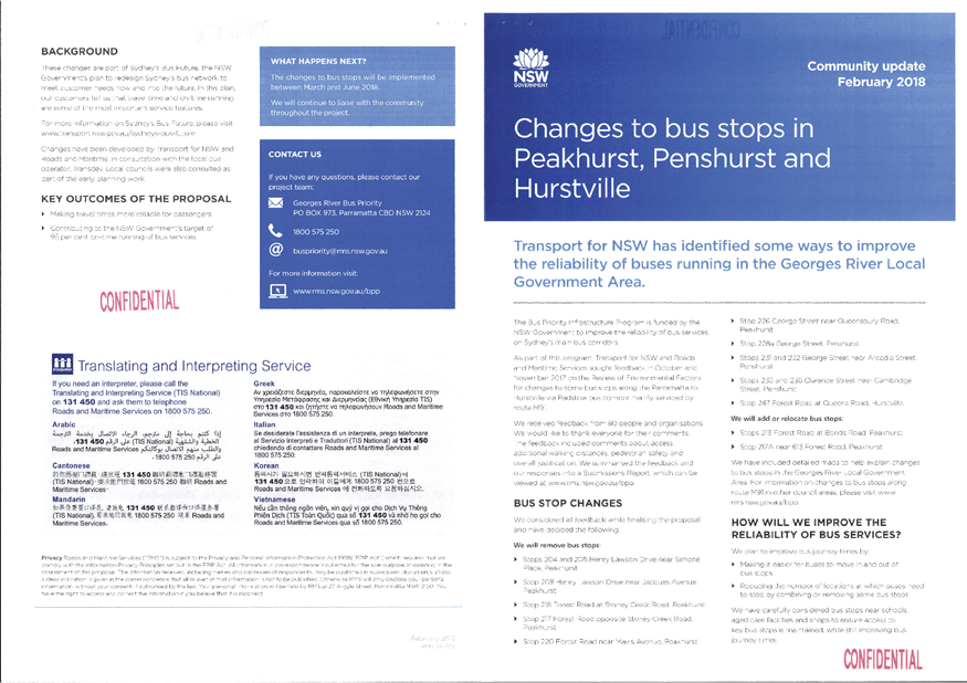
Item: TAC076-18 Implementation
of Improvements to the Parramatta to Hurstville Bus Corridor M91
Author: Traffic
Engineer
Directorate: Assets
and Infrastructure
Matter Type: Agenda Items
|
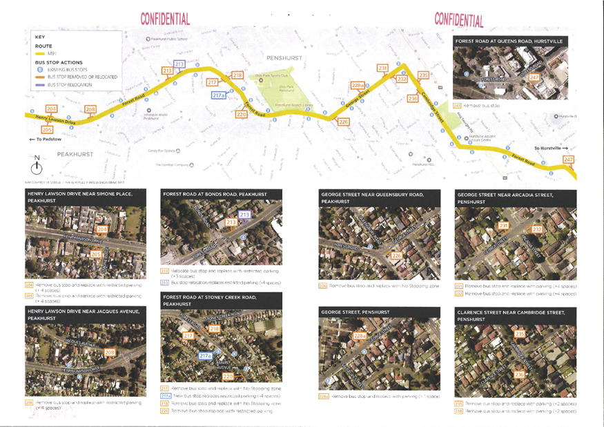
Recommendation
(a) That
the existing “Bus Zone” on the southern side of George Street,
Peakhurst, east of Forest Road, be removed and replaced with “No
Stopping”.
(b) That
the existing Bus Stop on the northern side of George Street, Peakhurst,
adjacent to No. 54, be removed.
(c) That
the existing Bus Stop on the northern side of George Street, Penshurst,
adjacent to No. 26, be removed.
(d) That
the existing Bus Stop on the southern side of George Street, Penshurst,
adjacent to No. 27, be removed.
(e) That
the existing “Bus Zone” on the eastern side of Cambridge Street,
Penshurst, north of Clarence Street, be removed.
(f) That
the existing “Bus Zone” on the western side of Cambridge Street,
Penshurst, south of Clarence Street, be removed.
(g) That
the existing “Bus Zone” on the northern side of Forest Road,
Hurstville, east of Queens Road, be removed.
(h) That
the “Bus Zone” changes on the State Roads of Henry Lawson Drive
and Forest Road be noted.
|
Executive
Summary
1. This
report seeks the Committee’s consideration of the proposed “Bus
Zone” changes as part of the Parramatta to Hurstville Bus Corridor.
Background
2. The
NSW Government has fully funded the Bus Priority Infrastructure Program that
aims to improve the reliability of bus services on Sydney’s main bus
corridors. The program is consistent with and, recognises and progresses
NSW Government policies and Plans, including the NSW Premier Priorities and
Sydney’s Bus Future.
3. The
Program supports targeted improvements for bus on-time running through a range
of initiatives carried out by RMS in partnership with Transport for NSW.
These include:
· Combining or
removing some bus stops where they are spaced close together
· Extending some bus
stops to accommodate larger articulated buses
· Making it easier
for buses to move in and out of bus stops by removing or relocating on-street
parking
· Reducing potential
delays for buses at traffic signals by moving stops to the departure side of
the intersection.
4. The
bus corridor identified from Parramatta to Hurstville, mainly serviced by route
M91, was reviewed as part of the on-time running program. RMS sought
feedback in October 2017 on a proposal to improve the reliability of buses on
this corridor and a comprehensive environmental assessment was carried out.
5. The
RMS received 80 submissions from people and organisations, with feedback about
the proposed bus stop changes. The issues raised by the community and
stakeholders on the proposals have been considered and some changes to the
original proposal have been made in response to the feedback.
6. The
final scheme to be implemented has been approved by Transport for NSW and a
detailed Review of Environmental Factors (REF) has been prepared which
summarises the feedback and the RMS responses. The REF can be viewed at http://www.rms.nsw.gov.au/projects/sydney-south/parramatta-hurstville-m91-bus-corridor/index.html
7. The
details of the final changes are indicated in the Community Update Document
attached to this report.
Financial
Implications
8. No
budget impact for this report.
File Reference
D18/58276
ATTACHMENTS
|
Attachment ⇩1
|
Community Update Document
|
|
Georges River Council - Traffic Advisory Committee Meeting - Tuesday,
3 April 2018
TAC076-18 Implementation of Improvements to the
Parramatta to Hurstville Bus Corridor M91
[Appendix 1] Community
Update Document
|
Page 65
|
Georges River Council – Traffic Advisory
Committee Meeting - Tuesday, 3 April 2018 Page 67