|
Georges
River Council – Local Planning Panel Monday, 18 June 2018
|
Page 2
|
|
3. Reports and LPP Deliberations in Closed
Session - 6.30pm
|
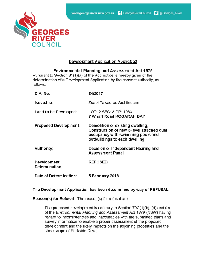
LPP018-18 7 Wharf
Road Kogarah Bay – REV2018/0004
(Report by
Development Assessment Officer)
LPP019-18 29-31
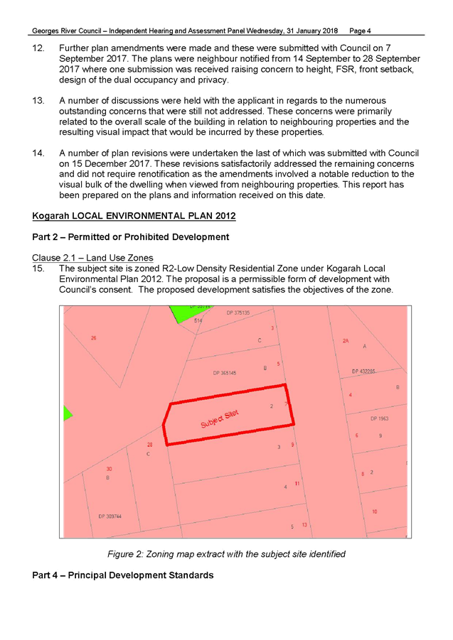
Dora Street Hurstville - MOD2017/0090
(Report by
Development Assessment Planner)
|
4. Confirmation of Minutes by Chair
|
REPORT TO GEORGES RIVER COUNCIL
LPP MEETING OF Monday, 18 June 2018
|
LPP Report No
|
LPP018-18
|
Development Application No
|
REV2018/0004
|
|
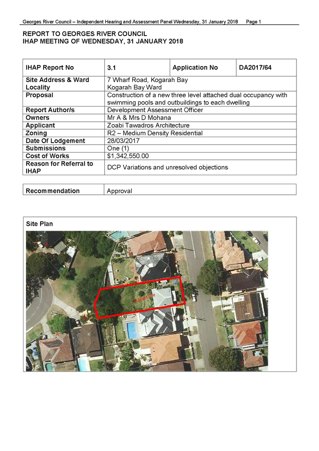
Site Address & Ward Locality
|
7 Wharf Road Kogarah Bay
Kogarah Bay Ward
|
|
Proposed Development
|
Section 8.2 Review of Determination
- Construction of three sotery attached dual occupacy, swimming pools and
outbuildings to each dwelling
|
|
Owners
|
Mr A and Mrs D Mohana
|
|
Applicant
|
ZTA Group
|
|
Planner/Architect
|
N/A (Planner), Mr R Zoabi
(Architect)
|
|
Date Of Lodgement
|
16/03/2018
|
|
Submissions
|
Four (4) submissions received
from two (2) adjoining properties – against
|
|
Cost of Works
|
$1,342,550.00
|
|
Local Planning Panel Criteria
|
Section 8.2 Review of Determination
previous application determined by the Local Planning Panel (formally known
as the Independent Hearing and Assessment Panel) at the time of the
determination
|
|
List of all relevant s.4.15
matters (formerly s79C(1)(a))
|
State Environmental Planning Policy
- No 55 Remediation of Land, State Environmental Planning Policy BASIX 2004,
State Environmental Planning Policy
(Vegetation in non-rural areas) 2017, Greater Metropolitan Regional Environmental
Plan No 2 – Georges River Catchment,
Kogarah Local Environmental Plan
2012, Kogarah Development Control Plan 2013
|
|
List all documents submitted
with this report for the Panel’s consideration
|
Survey, Architectural Plans,
Concept Stormwater Plan,
Landscape Plan, Statement of
Environmental Efffects,
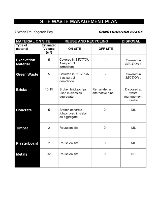
Waste Management Plans, DA2017/64
IHAP Report,
DA2017/64 Notice of Determination
|
|
Report prepared by
|
Development Assessment Officer
|
Mar
|
Recommendation
|
That the application be refused in accordance with the
reasons included in this report.
|
|
|
Summary of matters for
consideration under Section 4.15
Have all recommendations in relation
to relevant s4.15 matters been summarised in the Executive Summary of the
assessment report?
|
Yes
|
|
Legislative clauses requiring
consent authority satisfaction
Have relevant clauses in all
applicable environmental planning instruments where the consent authority
must be satisfied about a particular matter been listed, and relevant
recommendations summarised, in the Executive Summary of the assessment
report?
|
Yes
|
|
Clause 4.6 Exceptions to
development standards
If a written request for a
contravention to a development standard (clause 4.6 of the LEP) has been
received, has it been attached to the assessment report?
|
No,
Clause 4.6 Variation provided for exceedance in FSR to Clause 4.4A
|
|
Special Infrastructure
Contributions
Does the DA require Special
Infrastructure Contributions conditions (under s7.24)?
|
Not
Applicable
|
|
Conditions
Have draft conditions been provided
to the applicant for comment?
|
No
|
|
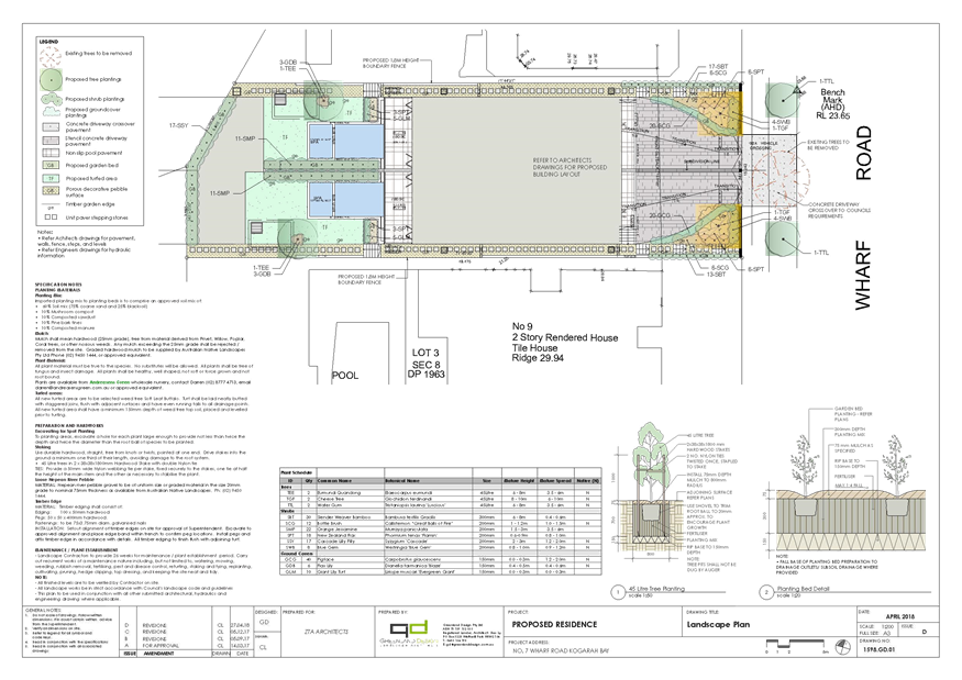
Site Plan

Figure 1: Aerial extract of subject site (Source:
Nearmap, 2018)
|
EXECUTIVE SUMMARY
1. The Section 8.2
Review of Determination application seeks development consent for the
construction of a three (3) storey attached dual occupancy, swimming pools and
outbuildings on land known as 7 Wharf Road, Kogarah Bay. The application was
notified and renotified of which four (4) submissions from two (2) adjoining
properties have been received raising concerns relating to; inadequacy and
accuracy of information, cut and fill, amenity, bulk and scale, trees, solar
access and privacy. The application seeks variations to the Kogarah Local
Environmental Plan 2012 and Kogarah Development Control Plan 2013. Furthermore,
inadequate and inconsistent information has been provided which has not enabled
Council to undertake an informed decision regarding impacts. Based on the
information submitted, the application cannot be supported in its current form
and is recommended for refusal.
DESCRIPTION OF
THE PROPOSAL
2. For the purposes of
this report DA2017/64 sought development consent for a three (3) storey
attached dual occupancy, swimming pools and outbuildings for each on land known
as 7 Wharf Road, Kogarah. Design amendments have been made to the original
design which forms this Section 8.2 Review of Determination.
Council is in
receipt of a Section 8.2 Review of Determination for construction of an
attached dual occupancy, swimming pools and outbuildings on land known as 7
Wharf Road, Kogarah.
In detail the submitted
proposal comprised of the following;
· Construction
of three (3) storey attached dual occupancy (for the purposes of this report is
DW1 referenced as the northern dwelling and DW2 referenced as the southern
dwelling);
o Lower ground floor - terrace
with outdoor shower, internal stairs;
o Ground floor - double
garage, storage, kitchen, bathroom, laundry, dining, living;
o First floor - lounge,
three (3) bedrooms, two (2) bathrooms, rear balcony and front patio;
o Upper floor - bedroom
and front balcony;
· Inground
swimming pool and spa (for each occupancy);
· Outbuilding
(gazebo) located at rear including bathroom (for each occupancy);
· Centrally
located driveway;
· Removal
of one (1) tree within the Council reserve on Wharf Road and two (2) trees
within the rear western setback;
· Associated,
building, engineering, driveway, landscaping and retaining wall works;
· Torrens
Title Subdivision.
It is noted that a
separate application is required for Torrens Title subdivision after the issue
of a Construction Certificate.
An amended proposal was received on 1
May 2018. The proposal sought minor changes which included;
· Internal garage
changes resulting in the reduction of one (1) car space;
· Additional
landscaping along the northern and southern side boundaries;
· Revised
landscape plan.
An assessment was undertaken based on the submitted information provided
by the applicant. It is noted that during the course of the assessment, the
application demonstrated the following inadequacies and inconsistent
information;
· Survey
plan identifies an incorrect Lot and DP number which do not relate to 7 Wharf
Road, Kogarah Bay;
· Inconsistent
and inadequate details shown on elevations, floor plans and landscape plan,
RL’s;
· Extent
of cut and fill are incorrectly shown on architectural plans which are
inconsistent with submitted levels;
· Concept
stormwater plan is not consistent with revised architectural plans;
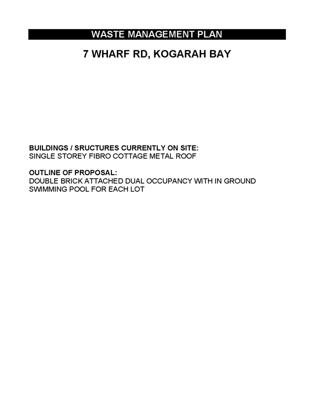
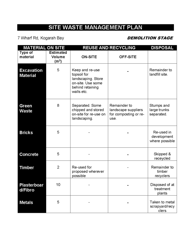
· Waste
management plan makes reference to “demolition stage” waste however
existing dwelling has been demolished;
HISTORY
3.
5
Feb 18 Development
Application DA2017/64 was refused for 7 Wharf Road, Kogarah Bay, at the
Independent Hearing and Assessment Panel (IHAP) for the following reasons:
The proposed
development is contrary to Section 79C(1)(b), (d) and (e) of the Environmental
Planning and Assessment Act 1979 (NSW) having regard to inconsistencies and
inaccuracies with the submitted plans and survey information to enable a proper
assessment of the proposed development and the likely impacts on the adjoining
properties and the streetscape of Parkside Drive.
16 Mar 18 Section
82A Review of Determination application lodged (REV2018/0004)
22 Mar –
9 Apr 18 Notification period
9 Apr 18 Initial
Site inspection
24 Apr 18 Meeting
with applicant
1 May 18 Additional
information provided by applicant
10 – 24
May 18 Re-notification period
30 May 18 Second
site inspection
DESCRIPTION OF
THE SITE AND LOCALITY
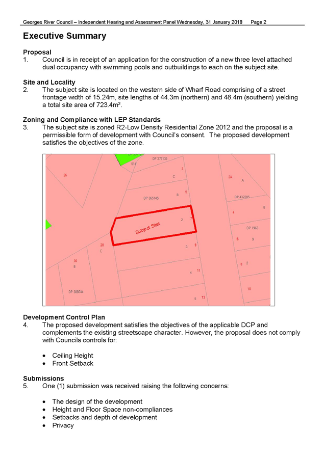
4. The subject is
legally described as Lot 2, Section 8 in DP 1963 and is known as 7 Wharf Road,
Kogarah Bay, NSW 2217. The site forms an irregular shaped rectangular allotment
and is described as follows; 15.24m along the eastern frontage to Wharf Road,
44.30m along the northern side boundary, 8.36m along the north west rear splay,
7.98m along the rear western boundary, 48.94m along the southern side boundary
with a total site area of 723.4sqm. The site slopes from front to rear with a
maximum fall of approximately 7.66m. The subject site is zoned R2 Low Density
Residential under the Kogarah Local Environmental Plan 2012. The site is
currently vacant with the previous dwelling house being demolished June –
August 2017 (approximately). A sewer line traverses diagonally across the rear
western portion of the site. Two (2) trees are located within the rear setback.
One (1) tree is located within the Council reserve.
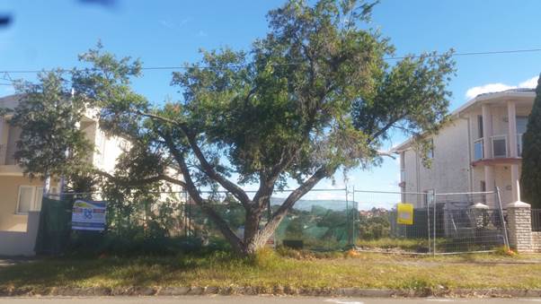
Figure 2: Site Photo - Subject
site, 7 Wharf Road, Kogarah Bay (Source: Author)
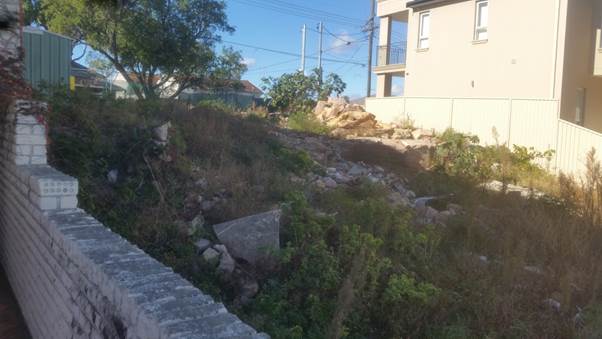
Figure 3: Site Photo –
Subject site, (Front) 7 Wharf Road, Kogarah Bay viewed from 5 Wharf Road,
Kogarah Bay (Source: Author)
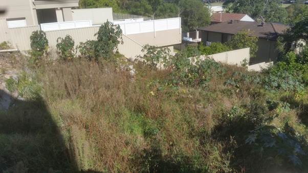
Figure 4: Site Photo –
Subject site, (Middle) 7 Wharf Road, Kogarah Bay viewed from 5 Wharf Road,
Kogarah Bay (Source: Author)
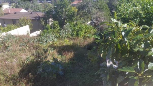
Figure 5: Site Photo –
Subject site, (Rear) 7 Wharf Road, Kogarah Bay viewed from 5 Wharf Road,
Kogarah Bay (Source: Author)
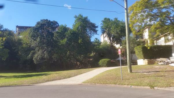
Figure 6: Site Photo –
Subject site, 7 Wharf Road, Kogarah Bay viewed from Parkside Drive located to
the rear (Source: Author)
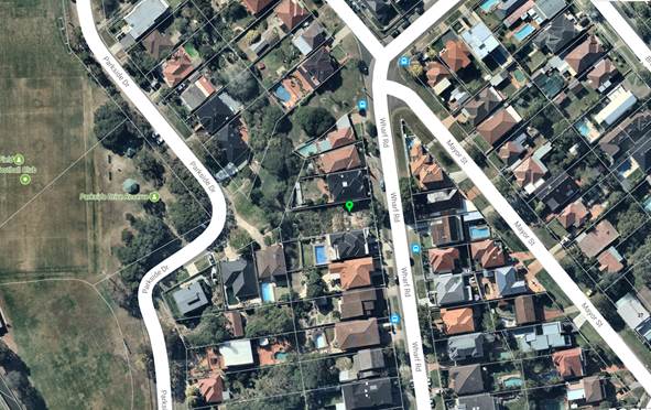
Figure 7: Aerial Photo –
Subject Site, 7 Wharf Road, Kogarah Bay (Source: Nearmap 2018).
The immediate
surrounding area is characterised as comprising generally two (2) storey
dwelling houses of varying architectural styles and designs. Parkside Drive and
Parkside Drive Reserve a located further to the west. Kogarah Bay is located
further to the south.
ZONING
5. The
subject site is zoned R2 Low Density Residential in accordance with the Kogarah
Local Environmental Plan 2012. Refer to zoning map extract below.
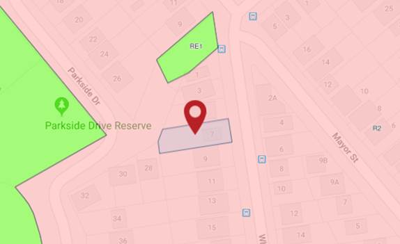
Figure 8: Zoning map extract
(Source: Department of Planning, 2018)
APPLICABLE
PLANNING CONTROLS
· State Environmental
Planning Policy No 55 - Remediation of Land
· State Environmental
Planning Policy: BASIX 2004
· State Environmental
Planning Policy (Vegetation in non-rural areas) 2017
· Greater Metropolitan
Regional Environmental Plan No 2 – Georges River Catchment
· Kogarah Local
Environmental Plan 2013
· Kogarah Development
Control Plan 2013
PLANNING
ASSESSMENT
6. The
site has been inspected and the proposed development has been assessed under
the relevant Section 4.15(1) "Matters for Consideration" and Section
8.2 “Reviews” of the Environmental Planning and Assessment Act
1979.
SECTION 8.2 REVIEW OF DETERMINATION
7. DA2017/64
was refused on 31 January 2018 by the Independent Hearing and Assessment Panel
(IHAP). A Section 8.2 Review of Determination was lodged on 16 March 18. The
Section 8.2 Review of Determination is considered to be substantially the same
as the as the original application as this comprises of a dual occupancy,
swimming pools and gazebo within the rear setback. In this regard, the proposal
meets the statutory requirements for consideration under the provisions of this
subsection.
Environmental Planning
Instruments
Kogarah Local
Environmental Plan 2012
8. The
proposal has been assessed in consideration with the relevant controls of the
Kogarah Local Environmental Plan 2012 within the table below.
|
Clause
|
Standard
|
Proposed
|
Complies
|
|
Part 1 Preliminary 1.2 Aims of Plan
|
(d) to protect and
enhance Kogarah’s natural environment, foreshores and waterways,
|
The proposal as assessed results in
excessive cut and fill which is not considered to protect and enhance
Kogarah’s natural environment.
|
No
|
|
Part 2 – Permitted or
Prohibited Development
|
R2 Low Density
Residential
|
The proposal is defined as a
“dual occupancy” with associated residential ancillary works. A
dual occupancy forms a permissible use.
|
Yes
|
|
Land use Table
|
Objectives of the Zone
|
The proposal is not considered to
adequately satisfy the objectives of the zone as the proposal is not
considered to provide the house needs of the community by virtue of the
design and short fall in car parking.
|
No
|
|
2.6 - Subdivision
|
Development Consent required.
|
A concept subdivision plan was
submitted however a separate application for subdivision must be lodged after
issue of Occupation Certificate
|
N/A
|
|
2.7 – Demolition requires
development consent
|
Development Consent required
|
The application has made reference
to the demolition of the vegetation at the rear western portion of the site.
|
Yes
|
|
4.1B – Minimum Lot Size of
Dual Occupancies
|
O = 650sqm
|
723.4sqm
|
Yes
|
|
4.3 – Height of Building
|
J = 9.0m
|
8.1m = RL 30.22
|
Yes
|
|
4.4A – Exceptions to Floor
Space Ratio for residential accommodation in Zone R2
|
|
less than 800sqm but not less
than 650sqm
|
[(lot area − 650) ×
0.3 + 357.5] ÷ lot area:1
|
0.524:1 (379.52sqm)
|
0.57:1 (412.73sqm)
In addition, it is noted that due
to the excavation adjacent to the terraces along the northern and southern
side boundaries. This does not result in a basement level and maybe
technically included in floor space. The ground floor terraces stair cases
are not enclosed, given the design the terrace is open along the rear western
elevation which can be easily enclosed resulting in additional floor space.
|
No
|
|
4.6 Exception to Floor Space Area
|
Clause 4.6 Exception to Development
Standard for exceedance in floor space
|
No Clause 4.6 Variation –
Exception to Development Standard has been provided in support of the
exceedance in proposed floor space
|
No
|
|
6.1 – Acid Sulfate Soils
|
Objective to ensure development
does not disturb or expose drain acid sulfate soils and cause environmental
damage.
|
The subject site is classified as
part Class 5 Acid Sulfate Soils at the western and middle sections of the
site.
|
Yes
|
|
6.2 Earthworks
|
Earthworks not to have a
detrimental impact on environmental functions and processes, cultural or
heritage items or features of the surrounding land
|
The proposal seeks significant cut
and fill along the northern and southern side boundary setbacks and rear
western setback which is considered to have an adverse impact on the existing
sloping topography of the site.
|
No
|
|
6.7 – Essential Services
|
The following services that are
essential for the development shall be available or that adequate
arrangements must be made available when required:
* Supply of water, electricity and
disposal and management of sewerage
* Stormwater drainage or on-site conservation
* Suitable vehicular access
|
Essential services can be made
available
to the development
Inadequate concept stormwater plan
provided which is not reflective of the current architectural design
Suitable vehicular access can be made
available to the site.
|
Yes
No
Yes
|
STATE
ENVIRONMENTAL PLANNING POLICIES
9. Compliance
with the relevant state environmental planning policies is detailed and
discussed below.
State
Environmental Planning Policy No 55 – Remediation of Land
10. The
subject site is zoned R2 Low Density Residential under the Kogarah Local
Environmental Plan 2012. Council records indicate that the subject site has
been historically used for residential purposes. It is noted that the
previously standing dwelling house was demolished, Council’s site
inspection appears to indicate that movement of soil on site has likely to have
occurred after the demolition of the dwelling. It is unclear if soil has been
brought onto site. The onus is on the applicant to demonstrate that the subject
site is suitable for this purpose. A contamination report/clearance certificate
has not accompanied this application. In this regard, the proposal has not
reasonably satisfied the intent of the SEPP.
State Environmental Planning
Policy (Building Sustainability Index: BASIX) 2004
11. An
invalid and outdated BASIX Certificate has been provided which is not
reflective of the current proposal. The required DA BASIX requirements of this
certificate have not been notated on the plans such as the hot water system and
skylight. In this regard, the proposal has not adequately satisfied the
requirements of the SEPP.
State Environmental Planning
Policy (Vegetation in Non-Rural Areas) 2017
12. The
proposal seeks the removal one (1) Bottle brush street tree which is located
within the Council reserve and two (2) trees within the rear setback being; Glochidian
ferdinandi and Ficus macrocarpa. Council’s Tree Preservation
Officer has previously commented that the two (2) trees within the rear setback
are to be retained due to their arboricultural significance.
In this regard the
proposed gazebos within the rear setback are not supported to ensure that these
trees can be protected. Given that the proposal seeks the removal of these two
(2) trees, the proposal is not considered to satisfy the intent of the SEPP.
Greater
Metropolitan Regional Environmental Plan No 2 – Georges River Catchment
13. The
site is within the area affected by the Greater Metropolitan Regional
Environmental Plan No 2 – Georges River Catchment. The proposal has
provided a concept stormwater plan which is inconsistent with the architectural
plans. In this regard, insufficient and inadequate information has been provided
in relation to satisfying the considerations of the SEPP.
Draft
Environmental Planning Instruments
14. No
Draft Environmental Planning instruments affect the proposed development.
Development
Control Plans
15. The
proposed development is subject to the provisions of the Kogarah Development
Control Plan 2013. The following comments are made with respect to the proposal
satisfying the objectives and key controls contained within the DCP.
|
Applicable DCP Controls
|
DCP Provisions
|
Proposal
|
Complies
|
|
Character:
Design
|
Side by side
|
Side by side
|
Yes
|
|
Setbacks:
Frontage
Front setback
Ground Side wall height up to 3.5m:
First Floor Side wall height more
than 3.5m:
Ground Rear:
First floor:
|
18m
Average 5.57m
5 Wharf Road (N)
9 Wharf Road (S)
900mm
1200mm
7.5m
60% site max depth =26.52m -29.82m
60% site max, depth = 29.82m
Dual Occupancy should not protrude
more than 5m beyond the other
|
15.24m
10.5m (solid wall), 7.16m (veranda)
1200mm (N), (S)
1200mm (N), (S)
21.86m (Dwelling 1) measured to
solid wall
25.59m (Dwelling 2) measured to
solid wall
28.77m (Dwelling 1)
28.77m (Dwelling 2)
Dual occupancies do not extend past
5m beyond the other. No privacy impact
|
No (1) – refer to discussion
Yes
Yes
Yes
Yes
Yes
No (2) – refer to discussion
Yes
Yes
|
|
Number of Storeys/Levels
|
3 storeys
(sloping site)
|
3 storey
|
Yes
|
|
Maximum ceiling height
Top of parapet (flat roof)
|
7.2m
7.8m
|
7.49m
7.6m
|
No (3) – refer to discussion
Yes
|
|
No. of Parking Spaces
|
1.5 spaces
Note: Three (3) car spaces
required for total development
|
1 garage space per dwelling however
this results in a shortfall of one (1) car space.
|
No (4) – refer to subsection
“Vehicular access, parking and circulation”
|
|
Landscaping
|
15% (108.51sqm)
|
18.8% (136sqm) landscaped area
primary located within the rear setback between the swimming pool and
outbuilding
|
Yes
|
|
Stormwater Disposal
|
Stormwater provisions to be
satisfied
|
Unsatisfactory – not
supported by Council’s Development Engineer
|
No (5) – Inadequate
information provided
|
(1) Frontage
16. Council’s controls prescribe a minimum frontage width of 18m for an
attached dual occupancy. The subject site contains a frontage and width of
15.24m for the most part of the site and splays at the rear north west
corner. The variation in allotment width is supported on planning merit
given that the proposal generally presents as a compatible built form in
relation to the existing two (2) storey dwelling character of the immediate
vicinity when viewed from Wharf Road.
However the proposal is not supported for other reasons
contained within this report.
(2) First floor rear setback
17. Council’s
controls prescribe a maximum 60% first floor depth. The proposal seeks a minor
variation due to the north west rear splay of the site resulting in a minor
encroachment for DW1 of a range up to
approximately 2.25m. This is considered to be insignificant and inconsequential
given that no unreasonable overshadowing or privacy impact arise from the
extent of this variation.
(3) Maximum Ceiling Height
18. Council’s
controls prescribe a maximum ceiling height of 7.2m which is measured from the
existing ground level. The proposal seeks a variation to this control by
seeking a maximum ceiling height of 7.49m at the rear of the dual occupancy due
to the fall of the site. The extent of the wall height variation is considered
to be minor and not visibly apparent when viewed from Wharf Road. No material
solar access shadow impacts are generated by this variation. In this regard,
the extent of the variation is supported however the application is not
supported for other reasons contained within this report.
(4)
Car parking
19. Discussed in
further detail within the report under subheading “Vehicular access,
parking and circulation”.
(5) Stormwater Disposal
20. The proposal seeks
to dispose of stormwater through On Site Detention system however the concept
stormwater plan does not relate to the architectural plans. In this regard,
inadequate information has been provided to allow Council to undertake an
accurate and informed assessment in relation to stormwater.
Streetscape Character and Amenity
21. The
proposal is considered to be generally compatible when viewed from the public
domain and generally reads as a two (2) storey
dwelling built form with a 1m high front fence when viewed from Wharf Road. The
proposal does not present as a single dwelling house and seeks a traditional
side by side configuration however this element of the proposal is considered
to be acceptable given the site and context of the immediate vicinity.
Vehicular access, Parking and
Circulation
22. Council’s
controls prescribe that no more than one third of the front boundary should be
used for driveway and accessways. The proposal seeks a variation to this at
approximately 71% to accommodate the driveway and access for the proposal.
Council’s controls also require that access to garaging and additional
car parking spaces should not dominate the front setback. In this instance, due
to the slope of the site, the extent of the visual impact when viewed from the
public domain is considered to be minimal. Council’s controls state that
dual occupancies should not have central garages or driveways. Given the
fall of the site from the street (high) to the rear (low), the extent of hard
surface area, the location of the central driveway is not considered to be
unreasonable to facilitate clear and direct access to the street.
Council’s
controls require 1.5 car spaces for a dual occupancy. The proposal seeks to
provide one (1) car space contained within each garage for each occupancy
forming shortfall of one (1) car space. Due to the slope of the site, the
driveway gradient comprises of a gradient over 1:20 which is not suitable for a
hardstand space under the Australian Standards. In this regard, the proposal
fails to adequately provide sufficient residential amenity for occupants.
Privacy
23. The
proposed development satisfies the relevant objectives and controls of the
KDCP. The proposal is not considered to result in any unreasonable privacy impacts.
It is noted that the proposed outbuildings (gazebos) are not supported. The
other elements of the proposal are not considered to result in any unreasonable
privacy impact given the setbacks sought, appropriate window treatment (offsets
and obscure glazing) and privacy screens along the northern and southern side
elevations of the elevated ground floor and first floor rear balconies.
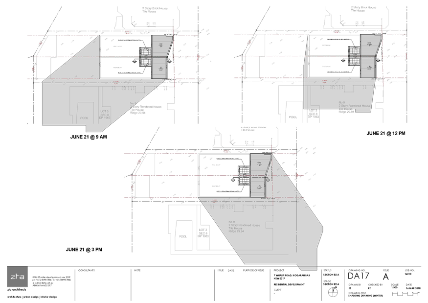
Solar Access
24. Council’s
controls require 4 hours solar access during Winter Solstice to the private
open space of the subject site and 3 hours solar access to surrounding
properties private open space or windows to main living areas. The proposed
development satisfies the relevant objectives and controls of the KDCP in
relation to solar access on site and to adjoining properties given the existing
east-west subdivision pattern.
Views and View Sharing
25. The
proposed development satisfies the relevant view and view sharing objectives
and controls of the KDCP.
Outbuildings
26. The
proposal seeks two (2) outbuildings (gazebos) within the rear western setback
which are joined by a common central wall. The gazebos are setback 1.2m from
the northern and southern side boundaries and 900mm from the rear western and
north western rear splay boundaries. The gazebos are open with powder rooms and
outdoor kitchen benches in each. Council’s controls prescribe a side
setback of 900mm from site boundaries, minimal impacts regarding solar access,
a maximum floor space of 70sqm and maximum height of 3.5m and underside of
eaves at 2.5m.
The proposal seeks
a variations to eave and maximum outbuilding height however the location of the
proposed outbuildings (gazebos) conflict with the location of the existing two
(2) trees which are to be retained. In this regard, the proposed gazebos are
not supported.
Swimming Pool
27. The
proposal seeks a part inground rectangular pool and spa for each occupancy. The
swimming pools are accessed from the terrace area. The spa is accessed from the
rear private open space within the rear setback. The sitting and setbacks of
the pool and spa comply with Council’s controls.
It is noted that
the proposal has not provided sufficient detail in relation to adequate
swimming pool fencing in particular securing the spa. The proposal has also not
identified the location for the pool pumps. Furthermore, the proposed location
of the swimming pools appears to conflict with the location of the sewer main.
It is noted that the location of the sewer main was not identified on the
survey submitted.
Front fence
28. The
proposal seeks a 1m high masonry render front fence with powder coated gates
along Wharf Road. The proposed fence is considered to be of a height and style
which is compatible with the front fences of neighbouring properties within the
immediate visual catchment along Wharf Road.
IMPACTS
Natural
Environment
29. The
site seeks significant cut and fill which is considered to adversely affect the
natural environment. The proposal seeks the removal of two (2) trees which are
considered to be of arborcultural significance. An inadequate concept
stormwater plan has been provided which has not allowed Council to undertake an
informed assessment in relation to stormwater impacts. In this regard,
the proposal is considered to result in an adverse impact to the natural
environment.
Built
Environment
30. The
proposed development would result in adverse impacts for reasons discussed
throughout the report in relation to excavation cut and fill, car parking and
BASIX provisions not met. In this regard, the proposal is considered to
result in an adverse impact to the built environment.
Social and
Economic Impact
31. The
proposed development would not result in any adverse social and/or economic
impacts within the locality.
Suitability
of the Site
32. It
is considered that the proposed development is of a scale and design that is
not suitable for the site having regard to its; size and shape, topography and
relationship to adjoining development and context.
SUBMISSIONS AND
THE PUBLIC INTEREST
33. The
proposal was notified and renotified to adjoining neighbours for a period of
fourteen (14) days during which time four (4) submissions from two (2)
objectors were received.
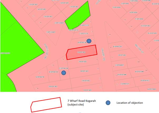
Figure 9: Subject site and submitter’s site
locations
The submissions raised several issues of which relevant concerns relating
this Section 8.2 Review have been considered and addressed below.
Inadequate
and inconsistent information
Comment:
Several concerns were raised in relation to the quality and
inconsistency of information provided within the application. Such issues
included; the accuracy of the survey and accompanying information provided
(plans and supporting documentation), applicant’s description of the
proposal, RL’s on site and on adjoining properties, levels, details on
plans, extent of works not clearly shown on plans.
An assessment has
been undertaken on the primarily based on the plans provided.
As previously
mentioned within the report, inadequate and inconsistent information has been
provided to allow Council to undertake an informed assessment of the
application.
Considerations
and submissions raised from the previous application should be considered.
Comment:
The Section 8.2 Review of Determination was notified and renotified in
accordance with Council’s DCP. The concerns raised within the submissions
have been considered as part of this assessment. The previous reason for
refusal by the IHAP has been considered as part of this application. It is
concluded that the application cannot be supported on planning grounds and
insufficient and inadequate information.
Loss of
sunlight
Comment:
Concerns were raised from adjoining property 28 Parkside Drive located to
the south west. The concerns relate to additional overshadowing impacts
proposed by the proposed gazebos at the rear of the property. As
previously mentioned within the report, the proposed outbuildings are not
supported as this conflicts with the retention of the two (2) trees within the
rear setback.
Privacy
impacts
Comment:
Concerns were raised from adjoining property 28 Parkside Drive
located to the south west. The concerns raised relate to the propose rear
gazebos. As mentioned above, the gazebos are not supported.
Visual bulk,
character, height and streetscape impacts
Comment:
The proposal is not considered to result in an unreasonable streetscape impact
given the design of the proposal. As assessed the proposal complies with
overall height (maximum 9m under the Kogarah LEP) and seeks a minor variation
in maximum ceiling height which is attributed to the fall of the site.
However the extent
of cut of the natural ground level results in adverse visual bulk and scale
particularly along the northern and southern side elevations. As previously
discussed within the report, elements such as the gazebo within the rear
setback are not supported.
Outdated
BASIX Certificate
Comment:
Concerns were raised that the BASIX Certificate was outdated. The BASIX
Certificate is considered to be outdated and does not relate to the current
design.
Asbestos in
site due to demolished dwelling
Comment:
The existing dwelling house has been demolished. Council’s site
inspection has indicated that fragments (building materials, fibro, bricks,
piping) are located on site.
Application
described as a two storey dual occupancy and not as a three storey dual
occupancy.
Comment:
The proposal has been assessed as a three storey dual occupancy as detailed
within this report. The ground floor level does not form a basement as
excavation is sought along the northern and southern side boundaries. This
is turn does not result in a basement sitting within the existing ground level.
Vegetation
not shown on survey plan. Two trees are located along the rear western
boundary.
Comment:
The submitted survey plan does not illustrate the two trees within along
the rear western boundary. Notwithstanding, Council’s Tree Preservation
Officer has commented that these two (2) trees should be retained and
protected.
Proposed
built form exceeds the established rear building line
Comment:
As previously addressed within this report, the proposal seeks a minor
variation to the rear first floor level (DW1) which is acceptable. The
remainder of the built form complies with Council’s DCP requirement of
60% lot depth of the first floor and ground floor rear setback controls.
Location of
proposed pool in location of existing sewer line
Comment:
The submitted survey does not indicate the location of the sewer line which
traverses through the rear of the subject site in a north-south direction. A search
of Council’s records indicates that a sewer line is located within the
rear of the subject site. The location of this sewer line appears to conflict
with the location of the proposed swimming pools. However the proposal is
not supported for other reasons contained within this report.
Dual
Occupancy
Comment:
Concerns were raised in relation to the proposed use as a dual occupancy.
It is noted that the subject site is zoned R2 Low Density Residential under the
Kogarah Local Environmental Plan 2012. The subject site meets the minimum
allotment size for a dual occupancy and has sought a variation to allotment
width which has been discussed earlier within the report.
REFERRALS
Council
Referrals
Development
Engineer
34. Council’s
Development Engineer has commented that the concept stormwater plan is
inconsistent with the architectural plans.
It is noted that a
revised survey has been provided which changes in ground levels. In this
regard, an informed decision cannot be undertaken in relation to stormwater
disposal and impacts.
Tree Management
Officer
35. Council’s
Tree Management Officer had previously commented that the two (2) trees within
the rear setback are of significant arborcultural value and are to remain. The
proposal in relation to the proposed outbuildings (gazebo) are unchanged in
relation to location. In this regard, the original comments prepared under
DA2107/0064 are considered to be relevant.
CONCLUSION
36. The
proposal seeks development consent for construction of a three (3) storey
attached dual occupancy, swimming pools and outbuildings on land known as 7
Wharf Road, Kogarah. The proposal results in an over development of the subject
site and is not considered compatible in regards to the sloping topography of
the site and residential context. Furthermore, the application has provided
inadequate details and inconsistent information for the purposes of assessment.
The application is
not supported for the reasons contained within this report and is therefore
recommended for refusal.
DETERMINATION
AND STATEMENT OF REASONS
37. THAT
pursuant to Section 8.2 Review of the Environmental Planning and Assessment
Act, 1979, as amended, the Council refuses development consent to Development
Application REV2018/004 for the construction of a three storey attached dual
occupancy, swimming pools and outbuildings on land Lot 2 Sec 8 DP1963 known as
7 Wharf Road, Kogarah Bay, for the following reasons:
1. REF2.1
- Refusal Reason – Environmental Planning Instrument - Pursuant to
Section 4.15(1)(a)(i) of the Environmental Planning and
Assessment Act 1979, the proposed development does not comply with
the relevant environmental planning instruments in terms of the following:
(a) Kogarah Local Environmental Plan 2012, Clause
4.4A Exceptions to Floor Space Ratio for residential accommodation in Zone R2
which results in adverse bulk and scale impacts. No clause 4.6 Exception to
Development Standard has been submitted for Consideration for excess floor
space above the Development Standard. The proposal does not reasonably satisfy
the following provisions; Part 1 1.2 Aims of plan objective (d) which states “to
protect enhance Kogarah’s natural environmental foreshores and
waterways”, R2 Low Density Residential Zone objective (a) which states
“to provide for the housing needs of the community within a low density
residential environment”, Clause Section 6.2 Earthworks and Section 6.7
Essential Services.
(b) State Environmental Planning Policy (Building
Sustainability Index: BASIX) 2004, Clause 3 Aim of Policy (1)(a) an application
for a development consent must be accompanied by a list of commitments by the applicant
as to the manner in which the development will be carried out. An inadequate
BASIX Certificate and BASIX Commitments have not been notated on the plans.
(c) State Environmental Planning Policy
(Vegetation in non-rural areas) 2017 objectives (a) which states “to
protect the biodiversity values of trees and other vegetation in non-rural
areas of the State and (b) to preserve the amenity of non-rural areas of the
State through the preservation of trees and other vegetation”. The
proposal seeks the removal of two (2) trees within the rear setback of which
are considered to be of significant arborcultural value.
(d) State Environment Planning Policy No 55
– Remediation of Land. Due to the demolition of the former dwelling
house on site. Inadequate information has been provided to ensure that the site
is currently suitable for the proposed residential use.
2. REF2.3
- Refusal Reason - Development Control Plan - Pursuant to Section
4.15(1)(a)(iii) of the Environmental Planning and
Assessment Act 1979, the proposed development does not comply with
the following sections of Kogarah Development Control Plan 2013:
(a) Section B4 Car Parking and Traffic whereby the
proposal results in one shortfall of one residential car space.
(b) Section B6 Water Management - On Site Water
Management and Stormwater Requirements. The application has not provided an
adequate concept stormwater plan reflective of the architectural design.
3. REF2.5
- Refusal Reason - Regulation - Pursuant to Section 4.15(1)(a)(iv) of
the Environmental Planning and
Assessment Act 1979, the proposed development does not comply with
the relevant Regulations in terms of the following:
(a) Invalid BASIX Certificate provided which is
contrary to the requirements of Schedule 1.
4. REF2.6
- Refusal Reason – Impacts on the Environment - Pursuant to Section
4.15(1)(b) of the Environmental Planning and
Assessment Act 1979, the proposed development is likely to have an
adverse impact on the following aspects of the environment:
(a) Natural environment – The proposal seeks
the removal of two (2) trees within the rear of the site which are of
significant arborcultural significance. The proposal seeks excessive cut
and fill which is not considered sympathetic and compatible with the immediate
residential context.
(b) Built environment – The proposal seeks
excessive cut and fill which results in unnecessary visual bulk and scale. The
proposal results in poor occupant amenity resulting in a shortfall of one
residential car space.
5. REF2.7
- Refusal Reason – Suitability of Site - Pursuant to Section
4.15(1)(c) of the Environmental Planning and
Assessment Act 1979, the site is not considered suitable for the
proposed development for the following reasons:
(a) The proposal results in excessive cut and fill
which is not considered to be compatible with the desired future character of
the area.
(b) The proposal generates a shortfall of car
parking which is likely to have an adverse amenity impact for future occupants
and increase the demand for on-street car parking.
6. REF2.8
- Refusal Reason – Public interest - Pursuant to Section
4.15(1)(e) of the Environmental Planning and
Assessment Act 1979, the proposed development is not considered to
be in the public interest and is likely to set an undesirable precedent.
7. REF2.9
- Refusal Reason
(a) The
proposal has provided inadequate and inconsistent information to allow Council
to undertaken an informed assessment of the proposal.
(b) The
proposal has provided inadequate details in relation to the Swimming Pools Act
1993.
ATTACHMENTS
|
Attachment ⇩1
|
Survey Plan - 7 Wharf Road Kogarah Bay
|
|
Attachment ⇩2
|
Site Plan - 7 Wharf Road Kogarah Bay
|
|
Attachment ⇩3
|
Revised East Elevation - 7 Wharf Road Kogarah Bay
|
|
Attachment ⇩4
|
Northern Elevation - 7 Wharf Road Kogarah Bay
|
|
Attachment ⇩5
|
Southern Elevation - 7 Wharf Road Kogarah Bay
|
|
Attachment ⇩6
|
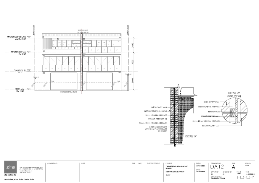
Western Elevation - 7 Wharf Road Kogarah Bay
|
|
Attachment ⇩7
|
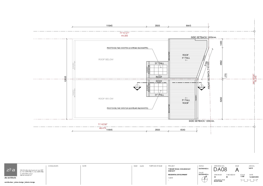
Roof Plan - 7 Wharf Road Kogarah Bay
|
|
Attachment ⇩8
|
Front Fence Elevation - 7 Wharf Road Kogarah Bay
|
|
Attachment ⇩9
|
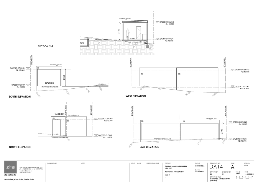
Section and Elevations Gazebo - 7 Wharf Road Kogarah Bay
|
|
Attachment ⇩10
|
Revised Landscape Plan - 7 Wharf Road Kogarah Bay
|
|
Attachment ⇩11
|
Shadows Winter - 7 Wharf Road Kogarah Bay
|
|
Attachment ⇩12
|
Waste Management Plan - 7 Wharf Road Kogarah Bay
|
|
Attachment ⇩13
|
Previous DA2017-64 IHAP Report - 31 Jan 18 - 7 Wharf Road
Kogarah Bay
|
|
Attachment ⇩14
|
Notice of Determination DA64-17 - 7 Wharf Road Kogarah
Bay
|
|
Attachment ⇩15
|
Applicant's SEE - S82A Compliance Report - 7 Wharf Road
Kogarah Bay
|
|
Georges
River Council – Local Planning Panel Monday, 18 June 2018
|
Page 67
|
REPORT TO GEORGES RIVER COUNCIL
LPP MEETING OF Monday, 18 June 2018
|
LPP Report No
|
LPP019-18
|
Development Application No
|
MOD2017/0090
|
|
Site Address & Ward Locality
|
29-31 Dora Street Hurstville
Hurstville Ward
|
|
Proposed Development
|
Section 4.55 modificiation
application to amend Condition 148 of original consent 05/DA-607 for Waratah
Private Hospital
|
|
Owners
|
Georges River Council and Cortez
Pty Ltd
|
|
Applicant
|
James Gray
|
|
Planner/Architect
|
N/A
|
|
Date Of Lodgement
|
17/07/2017
|
|
Submissions
|
Nil
|
|
Cost of Works
|
N/A
|
|
Local Planning Panel Criteria
|
Development on Council owned land
|
|
List of all relevant s.4.15
matters (formerly s79C(1)(a))
|
Hurstville Local Environmental Plan
2012
Hurstville Development Control Plan
No 2 - Hurstville City Centre
|
|
List all documents submitted
with this report for the Panel’s consideration
|
S4.55 modification statement
|
|
Report prepared by
|
Development Assessment Planner
|
|
Recommendation
|
THAT the application be approved in accordance with the
conditions included in the report.
|
|
|
Summary of matters for
consideration under Section 4.15
Have all recommendations in relation
to relevant s4.15 matters been summarised in the Executive Summary of the
assessment report?
|
Yes
|
|
Legislative clauses requiring
consent authority satisfaction
Have relevant clauses in all
applicable environmental planning instruments where the consent authority
must be satisfied about a particular matter been listed, and relevant
recommendations summarised, in the Executive Summary of the assessment
report?
|
Yes
|
|
Clause 4.6 Exceptions to
development standards
If a written request for a
contravention to a development standard (clause 4.6 of the LEP) has been
received, has it been attached to the assessment report?
|
Not
Applicable
|
|
Special Infrastructure Contributions
Does the DA require Special
Infrastructure Contributions conditions (under s7.24)?
|
Not
Applicable
|
|
Conditions
Have draft conditions been provided
to the applicant for comment?
|
No,
standard conditions have been attached with no design changes
|
|
Site Plan
|
EXECUTIVE SUMMARY
Consent is sought
to modify the consent by amending the wording of Condition 149 of 05/DA-607
which relates to the one hundred and ten (110) car parking spaces allocated as
public parking spaces within the Waratah Private Hospital. The purpose of this
modification application is to reword Condition 149 to address that the car
park is managed by the consortium and reflect current practices.
In accordance with
part 2.2 of the Hurstville Development Control Plan No 2, the modification
application was not notified and no referrals were required.
DESCRIPTION OF
THE PROPOSAL
Consent
is sought to modify the consent by amending Condition 149 of 05/DA-607 which
currently reads as:
A total of one
hundred and ten (110) car spaces of the three hundred and fifty (350) car
spaces required to satisfy the parking demand for the building shall be offered
by the applicant to be managed by Hurstville City Council as public parking
spaces, in addition to the one hundred and fifty (150) public parking spaces
proposed in the application.
To
read as follows:
A total of one
hundred and ten (110) car spaces of the three hundred and fifty (350) car
spaces required to satisfy the parking demand for the building are public
parking spaces (in accordance with the applicant’s offer made at the time
development consent 05/DA-607 was granted), in addition to the one hundred and
fifty (150) public parking spaces in the building that are owned by Georges
River Council.
HISTORY
19
Jun 06 Development
consent 05/DA-607 granted approval for the construction of an eight (8) storey
building with ground floor retail, medical centre and associated basement
parking.
The consent has
subsequently been modified several times to reflect internal configurations to
the development. Throughout the various modifications, the condition proposed
to be modified which was originally Condition 148, has been re-numbered as
Condition 149. As such, the purposes of this modification application is to
reword Condition 149 to address the fact that the car park is managed by the
consortium and reflect current practices.
DESCRIPTION OF
THE SITE AND LOCALITY
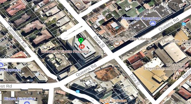
The property is
located on the western corner of the intersection of Dora Street and Queens
Road and is known as 29-31 Dora Street, Hurstville. The site is rectangular in
shape and a frontage to Dora Street of 69.53m and a frontage to Queens Road of
38.265m resulting in an area of 2,696sqm. Existing on the site is an eight
storey building which was known as the ‘Medica Centre’ until
recently changed to Waratah Private Hospital, which essentially comprises a
medical centre, Waratah Private Hospital, retail shops on the ground floor and
basement car parking.
The area
surrounding the subject site is characterised by commercial and residential
development which vary from one storey to multi storey developments.

Figure 1: Aerial Photo –
Subject Site, 29-31 Dora Street, Hurstville (Source: Nearmaps 2018)
ZONING
The subject site is zoned B4 –
Mixed Use in accordance with the Hurstville Local Environmental Plan 2012.
Refer to zoning map extract below.
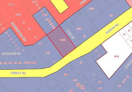
Figure 2: Zoning map extract
APPLICABLE
PLANNING CONTROLS
· Hurstville
Local Environmental Plan 2012
PLANNING
ASSESSMENT
The site has been inspected and the proposed modification
has been assessed under the relevant Section 4.15(1) "Matters for
Consideration" of the Environmental Planning and Assessment Act 1979.
Environmental Planning Instruments
Hurstville Local Environmental Plan
The extent to which the proposal complies with the
relevant standards of Local Environmental Plan is outlined in the table below.
|
Clause
|
Standard
|
Proposed
|
Complies
|
|
Part 2
– Permitted or Prohibited Development
|
B4 Mixed Use
|
The
proposal is defined as Health Service Facility. Health Service Facilities are
permissible in the zone.
|
Yes
|
|
|
Objectives
of the Zone
|
The
proposal achieves the objectives of the zone
|
Yes
|
|
4.3 – Height of Buildings
|
30m
|
NA – No additional FSR
|
Yes
|
|
4.4 – Floor Space Ratio
|
4.5:1
|
NA – no proposed additional
FSR
|
Yes
|
|
5.10 – Heritage Conservation
|
To conserve the
environmental heritage of Hurstville,
To conserve the
heritage significance of heritage items and heritage conservation areas,
including associated fabric, settings and views,
To conserve
archaeological sites,
To conserve Aboriginal objects and
Aboriginal places of heritage significance
|
The subject site is not listed as a
heritage item of significance under Schedule 5 Environmental Heritage in the
HLEP 2012 Heritage Map.
|
Yes
|
|
6.7
– Essential Services
|
The
following services that are essential for the development shall be available
or that adequate arrangements must be made available when required:
* Supply
of water, electricity and disposal and management of sewerage
*
Stormwater drainage or on-site conservation
*
Suitable vehicular access
|
Essential services are available to
the development
Suitable vehicular access is
available to the site.
|
Yes
|
State Environmental
Planning Policies
No SEPPs are
activated by the proposed development
Draft Environmental Planning Instruments
No Draft Environmental Planning instruments affect the
proposed development.
Development Control Plans
Hurstville
Development Control Plan 2 - Hurstville City Centre applies to the site. The
proposed modification does not give rise to any significant issues with respect
to the relevant provisions of the development control plan.
IMPACTS
Natural Environment
The site is not surrounded by dense vegetation and other
natural features. The proposal does not seek to remove any tress or other form
of vegetation within the existing surrounds.
Built Environment
The proposed modification would not result in any adverse
impacts upon the built environment.
Social and Economic Impact
The proposed development would not result in any adverse
social and/or economic impacts within the locality.
Suitability of the Site
It is considered
that the proposed development is of a scale and design that is suitable for the
site having regard to its size and shape, its topography and relationship to
adjoining developments.
SUBMISSIONS AND THE PUBLIC INTEREST
In accordance with
part 2.2 of the Hurstville DCP 2, the proposed modification application was not
required to be notified.
REFERRALS
The proposed modification application
did not require any referrals.
CONCLUSION
Consent is sought
to modify the consent by amending the wording of Condition 149 which relates to
the one hundred and ten (110) car parking spaces allocated as public parking
spaces. The purpose of this modification application is to reword Condition 149
to address the fact that the car park is managed by the consortium and reflect
current practices.
In view of the above, the application
is recommended for approval subject to conditions included in the report.
DETERMINATION
AND STATEMENT OF REASONS
Statement of
Reasons
* The
proposed development, subject to the recommended conditions, is consistent with
the objectives of the applicable environmental planning instruments, being
Hurstville Local Environmental Plan 2012.
* In
consideration of the aforementioned reasons, the proposed development is a
suitable response to the site and its approval is in the public interest.
THAT pursuant
to Section 4.16(1) of the Environmental Planning and Assessment Act, 1979, as
amended, the Council grants development consent to modify 05/DA-607 by the
application known as MOD2017/0090 at 29-31 Dora Street, Hurstville modifying
Condition 149 as highlighted in the consent below:
1. OC1 - Act, Regulations and Environmental
Planning Instruments Prevail - This modification to original
Development Consent No. 05/DA-607 is granted subject to compliance with the relevant requirements of the
Environmental Planning and Assessment Act 1979 as amended ("the
Act"), the Environmental Planning and Assessment Regulation 2000
("the Regulation"), the Building Code of Australia ("the
BCA"), Hurstville City Council's ("the Council's") Local
Environmental Plan 1994, Development Control Plan No. 1 (Hurstville LGA Wide
DCP) or Development Control Plan No. 2 (Hurstville City Centre) as applicable,
and any applicable codes, except if varied by this consent.
2. OC1 - Act,
Regulations and Environmental Planning Instruments Prevail –This
consent is granted subject to compliance
with the relevant requirements of the Environmental Planning and Assessment Act
1979 as amended ("the Act"), the Environmental Planning and
Assessment Regulation 2000 ("the Regulation"), the Building Code of
Australia ("the BCA"), Hurstville City Council's ("the
Council's") Local Environmental Plan 1994, the following Development
Control Plans:
(a) No.
2 - Car Parking, effective 12/08/99
(b) No.
4 – Hurstville Town Centre Vol 1, 2 & 3 effective 16/12/97
(c) No.15
- Contaminated Lands, effective 05/10/99
(d) No.18
- Crime Prevention through Environmental Design, effective 26/06/01
(e) No.
19 - Access and Mobility, effective 27/12/01
except
where varied by this consent.
3. OC2 - Approved
Plans - The development shall be carried out in accordance with the details
set out on the application form, supporting information received with the
application and the schedule of plans and details below, except as amended by
the conditions of this consent. A copy of the plans is stamped approved, and
attached to this consent.
|
Plan No
|
Plan Date
|
Description
|
Prepared By
|
|
DA000A
|
October 2005
|
Cover Page
|
Nordon Jago Architects
|
|
DA020B
|
October 2005
|
Site Analysis Plan
|
Nordon Jago Architects
|
|
DA050A
|
October 2005
|
Shadow Diagrams (June)
|
Nordon Jago Architects
|
|
DA051A
|
October 2005
|
Shadow Diagrams (Sept/March)
|
Nordon Jago Architects
|
|
DA052A
|
October 2005
|
Shadow Diagrams (December)
|
Nordon Jago Architects
|
|
DA057B
|
October 2005
|
Shadow Diagrams DCP Compliant,
Adjoining Elevations
|
Nordon Jago Architects
|
|
DA058B
|
October 2005
|
Shadow Diagrams March 2006
Proposal, Adjoining Elevations
|
Nordon Jago Architects
|
|
DA099A
|
March 2006
|
Basement Level B9 Plan
|
Nordon Jago Architects
|
|
DA100B
|
October 2005
|
Basement Level B8 Plan
|
Nordon Jago Architects
|
|
DA101B
|
October 2005
|
Basement Level B7 Plan
|
Nordon Jago Architects
|
|
DA102B
|
October 2005
|
Basement Level B6 Plan
|
Nordon Jago Architects
|
|
DA103B
|
October 2005
|
Basement Level B5 Plan
|
Nordon Jago Architects
|
|
DA104B
|
October 2005
|
Basement Level B4 Plan
|
Nordon Jago Architects
|
|
DA105B
|
October 2005
|
Basement Level B3 Plan
|
Nordon Jago Architects
|
|
DA106B
|
October 2005
|
Basement Level B2 Plan
|
Nordon Jago Architects
|
|
DA107B
|
October 2005
|
Basement Level B1 Plan
|
Nordon Jago Architects
|
|
DA110B
|
October 2005
|
Ground Level 0 Plan
|
Nordon Jago Architects
|
|
DA111B
|
October 2005
|
Level 1 Plan
|
Nordon Jago Architects
|
|
DA112B
|
October 2005
|
Level 2 Plan
|
Nordon Jago Architects
|
|
DA113B
|
October 2005
|
Level 3 Plan
|
Nordon Jago Architects
|
|
DA114B
|
October 2005
|
Level 4 Plan
|
Nordon Jago Architects
|
|
DA115C
|
November 2013
|
Level 5 Plan
|
Silver Thomas Hanley
|
|
SK01- P1 &
DA116C
|
Jan 2013 & November 2013
|
Level 6 Plan & Addition of
Internal Duct Riser
|
Murphys Architecture &
Silver Thomas Hanley
|
|
DA117C
|
November 2013
|
Level 7 Plan
|
Silver Thomas Hanley
|
|
DA118C
|
November 2013
|
Level 8 Plan
|
Silver Thomas Hanley
|
|
DA119C
|
November 2013
|
Level 9 Plan (plant)
|
Silver Thomas Hanley
|
|
DA130B
|
October 2005
|
Roof Level Plan
|
Nordon Jago Architects
|
|
DA150A
|
October 2005
|
Level 1 Plan (Detail)
|
Nordon Jago Architects
|
|
DA200B
|
October 2005
|
Cross Sections AA & BB
|
Nordon Jago Architects
|
|
DA201B
|
October 2005
|
Longitudinal Section CC and Part
Cross Section DD
|
Nordon Jago Architects
|
|
DA300B
|
October 2005
|
North – East Elevation
|
Nordon Jago Architects
|
|
DA301B
|
October 2005
|
South – East Elevation
|
Nordon Jago Architects
|
|
DA302B
|
October 2005
|
South – West Elevation
|
Nordon Jago Architects
|
|
DA303B
|
October 2005
|
North – West Elevation
|
Nordon Jago Architects
|
|
DA310B
|
October 2005
|
Contextual Elevations
|
Nordon Jago Architects
|
|
DA901
|
October 2005
|
Perspective View from Corner of
Queens Road & Dora Street
|
Nordon Jago Architects
|
|
DA902
|
October 2005
|
Perspective View from Dora Street
|
Nordon Jago Architects
|
|
DA903
|
October 2005
|
Perspective View from Queens Road
|
Nordon Jago Architects
|
|
05177- DA02B
|
4 November 2005
|
Erosion & Sedimentation Control
Plan
|
Henry and Hymas
|
|
05177- DA201B
|
3 November 2005
|
Stormwater Concept Plan
|
Henry and Hymas
|
|
DA_0531-01A
|
11 October 2005
|
Landscape Plan
|
Guy Sturt and Associates
|
|
WD162H
|
Sept 2009
|
Level 2 Plan Medical Suite Layouts
|
Nordon Jago Associates
|
|
WD163G
|
Sept 2008
|
Level 2 Plan Medical Suite Layouts
|
Nordon Jago Associates
|
|
WD164G
|
Sept 2008
|
Level 2 Plan Medical Suite Layouts
|
Nordon Jago Associates
|
|
WD165G
|
Sept 2008
|
Level 2 Plan Medical Suite Layouts
|
Nordon Jago Associates
|
|
MK620F
|
21.10.09
|
Level 6 Plan
|
Nordon Jago Associates
|
|
WD167G
|
Sept 2008
|
Level 7 Plan Medical Suite Layouts
|
Nordon Jago Associates
|
|
MK200C
|
28/08/09
|
Suite 2L Business suite
|
Nordon Jago Associates
|
|
MC AP_B1 D
|
25.11.08
|
Floor Plan Level B1 Proposed
Radiology Suite
|
A.C.E.P.T Pty Ltd
|
|
MC AP_B2 E
|
08.10.08
|
Floor Plan Level B2 Proposed
Radiology Suite
|
A.C.E.P.T Pty Ltd
|
(This condition is
amended as part of 05/DA-607REV01 (05/DA-607))
(This condition is
amended as part of 05/DA-607REV03 (05/DA-607))
(This condition is
amended as part of 05/DA-607REV07 (05/DA-607))
(This condition is
amended as part of MOD2013/0090 (05/DA-607))
4. OC3 - Amenity
- The implementation of this development shall not adversely affect the
amenity of the neighbourhood by way of the emission or discharge of noise,
vibrations, fumes, vapour, steam, soot, ash, dust, waste water, waste products,
grit, oil or other harmful products.
5. ZCI - A
positive covenant is to be created over the common property by an instrument
pursuant to Division 4 of Part 6 of the Conveyancing Act 1919, to be submitted
to Council for endorsement with the final subdivision plans. This covenant is
to be worded as follows:
"It
is the responsibility of the Building Owner/Owners Corporation to remove all
graffiti, bill posters, unapproved signage, pamphlet boxes and the like, from
the common property within 7 days of such information being reported to the
Owners Corporation."
Hurstville
City Council is to be nominated as the Authority to release, vary or modify
this covenant.
6. HOl - Hoardings
(a) A separate Development Consent
for the erection of an A class (fence type) or B class (overhead type) hoarding
along the street frontage(s) complying with WorkCover requirements must be
obtained;
(b) The
payment to Council of a footpath occupancy fee based on the area of footpath to
be occupied and Council's Schedule of Fees and Charges (available on our
website) before the commencement of work; and
(c) A
Public Risk Insurance Policy with a minimum cover of $10 million in relation to
the occupation of and works within Council's road reserve, for the full
duration of the proposed works, must be obtained a copy provided to Council.
The Policy is to note Council as an interested party. The copy is to be
provided to Council before the issue of a Construction Certificate.
7. All
pedestrian surfaces in areas such as foyers, public corridors/hallways, stairs
and ramps as well as floor surfaces in the wet rooms in both the
commercial/retail areas and residential units must have slip resistance
classifications, as determined using test methods in either wet or dry
conditions, appropriate to their gradient and exposure to wetting.
The
classifications of the new pedestrian surface materials, in wet or dry
conditions, must comply with AS/NZS 4586:2004 - Slip Resistance Classifications
of New Pedestrian Materials.
Note: SAA/SNZ
Handbook 197:1999 - An Introduction Guide to the Slip Resistance of Pedestrian
Surface Materials - should be used to assist in the use of AS/NZS 4586:2004.
8. For the
reason that the 'effective height' of the building exceeds 25m, such building
must be provided with a standby power system to maintain the operation of
essential services in the event of power source failure. Such equipment
must be separated from the remainder of the building in accordance with Clause
C2.12 of the BCA.
Reasons: *
Standby power systems have been installed in other buildings erected in the
City of Hurstville whose 'effective height' exceeds 25m. Such requirement
was based on the recommendations made by the New South Wales Fire Brigades in
respect of those particular buildings.
*In
the interest of public safety as well as the protection of fire brigade
personnel during fire fighting and rescue.
9. DE5 -
The footpath and roadway shall be kept clear of obstructions, building
materials, and liquid or solid waste of any type whatsoever at all times.
Severe fines apply for an offence and where Council makes repairs or provides
temporary public safety measures. The cost of these works may be deducted from
the damage deposit.
To Obtain a Construction Certificate
10. The
following must be submitted to either Council or an Accredited Certifier
before a Construction Certificate is issued:
(a) Fees to
be paid to Council:
|
Schedule of
fees, bonds and contributions
|
|
Fee Type
|
Paid
|
Fee Type
|
Amount
|
Receipt Date
|
Receipt No
|
|
Development Application Fee
|
X
|
DA1
|
$31033.81
|
14
Nov 05
|
247529
|
|
Development Application Fee
|
X
|
DA1
|
$110.00
|
14
Nov 05
|
247529
|
|
Plan First Fee
|
X
|
AP35
|
$31488.00
|
14
Nov 05
|
247529
|
|
Notification Fee
|
X
|
AP12
|
$150.00
|
14
Nov 05
|
247529
|
|
Notification Fee
|
X
|
AP12
|
$150.00
|
22
Mar 06
|
256197
|
|
Microfilming Fee
|
X
|
AP165
|
$225.00
|
14
Nov 05
|
247529
|
|
Long Service Levy
|
|
AP34
|
$172200.00
|
|
|
|
Security Bond
|
|
|
$75000.00
|
|
|
|
Builders Damage Deposit
|
|
BON2
|
$3200.00
|
|
|
|
Inspection Fee for Refund of Damage
Deposit
|
|
DA6
|
$92.00
|
|
|
|
S94 - Open Space & Community Recreation
|
|
CONT9
|
$993776.00
|
|
|
|
S94 - Traffic Management within the
Hurstville City Centre District - Retail
|
|
CONT
|
$37157.00
|
|
|
|
S94 - Traffic Management within the
Hurstville City Centre District - Commercial
|
|
CONT
|
$139223.38
|
|
|
|
S94 - Library Infrastructure
|
|
CONT7
|
$58786.00
|
|
|
|
S94 - Library Bookstock
|
|
CONT4
|
$2394.00
|
|
|
|
S94 - Urban
Spaces
|
|
CONT
|
$153748.00
|
|
|
|
The following fees apply where you
appoint Council as your Principal Certifying Authority (PCA). (If you appoint
a private PCA, separate fees will apply)
|
|
Building
Inspection Fees
|
|
DA6
|
$29955.00
|
|
|
|
Occupation
Certificate Fee
|
|
AP22
|
$72.00
|
|
|
11. BI1 - Building Code
of Australia (“BCA”) - A Construction
Certificate must be obtained before
the commencement of work from Council or an Accredited Certifier. Detailed plans and specifications for the proposed
building must demonstrate compliance with the BCA.
12. BI2 - Long Service Leave Levy - Payment of the Building and Construction Industry Long
Service Leave Levy in the amount of $172200.00 (0.35% of the estimated
cost of work). Note this amount is based on the cost quoted in the Development
Application, and same may increase
with any variation to estimated cost which arises with the Construction
Certificate Application. Evidence of the payment of this levy must be
submitted with the Construction Certificate application.
13. S942 - Open Space and Community Recreation - Pursuant to
Section 94(1) of the Environmental Planning and Assessment Act, 1979, payment
shall be made to Council of a monetary
contribution for open space and community recreation facilities.
The
contribution relates to Plan no. 2 and is based on the criteria that any
development which results in a nett increase in the City's population will
create extra demand on open space and community recreation facilities.
Therefore the requirement for additional open space and embellishment of
existing open space is a direct measurable consequence of the approved
development.
The
total open space and community recreation facilities contribution required and
payable before release of the Construction Certificate is $993776.00.
14. SE941A -Traffic Management within the Hurstville City Centre
District - Pursuant to Section 94(1) of the Environmental Planning and
Assessment Act, 1979, payment shall be made to Council of a monetary
contribution for the provision of traffic management facilities within the
Hurstville City Centre District.
The
contribution relates to Plan no. 1 and is based on the following criteria as a
direct consequence of the proposed development:
(a) The
increased traffic volume raises the potentiality of conditions accelerating the
deterioration of road pavement and/or traffic system operational conditions.
(b) The
provision of the scheduled facilities is essential to facilitate the traffic
system operation due to the proposed development.
(c) The
provision of a facility is a direct requirement as a result of the proposed
development.
The
contribution rate for Retail is $20.49 per square metre and Commercial is $8.18
per square metre respectively of nett increase in floor space. The total
traffic management contribution required and payable before release of the
Construction Certificate is $176380.38.
15. S947 - Urban Spaces -
Pursuant to Section 94(1) of the Environmental Planning and Assessment Act,
1979, payment shall be made to Council of a monetary contribution for urban
spaces.
The
contribution is related to Plan no. 7 and is based on the premise that any
development which results in a nett gain of people living and working in the
Hurstville Central Business District will create an extra demand on the urban
space infrastructure and facilities.
(a) The
contribution rate for commercial/retail development is $11.00 per square metre
of gross floor area.
The
total urban spaces Section 94 contribution required and payable before release
of the Construction Certificate is $153748.00
16. S946 - Library and
Information Services - Pursuant to Section 94(1) of the Environmental
Planning and Assessment Act, 1979, payment shall be made to Council of a
monetary contribution for library and information services.
The
contribution is related to Plan no. 6 and is based on the premise that any
development which results in a nett increase in the City's population will
create extra demand on Council's library and information services provision.
Furthermore, any such development will also generate an additional demand for
the acquisition of library book stock.
Contributions
are also sought from retail/commercial development within the Hurstville Town
Centre, as defined by the map in the Plan.
(a) The
contribution rate for retail/commercial development is $3.80 per square metre
of gross floor area (as defined by Hurstville Local Environmental Plan
1994). The total contribution for this development is $58786.00.
(b) The
book stock acquisition contribution for retail/commercial development is $0.13
per square metre of gross floor area (as defined by Hurstville Local
Environmental Plan 1994). The total contribution for this development is:
$2394.00
The
total Library and Information Services Section 94 contribution required and
payable before release of the Construction Certificate is $61180.00
17. S948 - Indexing of
all Section 94 Contributions - All contributions payable pursuant to
Section 94 conditions must be paid before issue of the Construction
Certificate, and will be indexed quarterly in accordance with the Consumer
Price Index - Sydney All Groups, published by the Australian Bureau of
Statistics. If you seek to obtain a Construction Certificate more than
three (3) months from the date of this consent you must contact Council to
determine the variation in the contribution(s) before payment. If you engage an
accredited certifier payment(s) must be made before issue of the Construction
Certificate. Failure to do so can result in problems including incorrect cheque
preparation, return of payment, and delay in obtaining your Construction
Certificate.
18. BDI - Damage to Council
Property - In order to insure against damage to Council property the
following is required:
(a) Payment
to Council of a Damage Deposit for the cost of making good any damage caused to
any Council property as a result of the development: $3200.00.
(b) Payment
to Council of a non refundable Public Works Inspection Fee to enable assessment
of any damage and repairs where required: $92.00.
(c) At
the completion of work Council will inspect the public works, and the damage
deposit will be refunded in full upon completion of work where no damage
occurs. Otherwise the amount will be either forfeited or partly refunded
according to the amount of damage.
(d) Prior
to the commencement of work a photographic record of the condition of the
Council nature strip, footpath and driveway crossing, or any area likely to be
affected by the proposal, shall be submitted to Council.
(e) Payments
pursuant to this condition are required to be made to Council before the issue
of the Construction Certificate.
19. The applicant is to
submit a Colour and Finishes Schedule to Council's Heritage Officer for their
approval prior to the issue of a Construction Certificate. The Colour and
Finishes Schedule is prepared to reduce the detrimental visual impact when
viewed from 33-47 Dora Street. Particular attention is to be given to the
wall adjacent to the north western boundary which is shared with the heritage
item.
20. Prior to the issue of a
Construction Certificate, a comprehensive dilapidation report for the Heritage
Item located at 33-47 Dora Street is to be provided to Council. The
report is to provide details of the stabilisation of the heritage item,
including all measures to ensure that the heritage items will not be harmed by
the works. Should the proposed development cause damage to the heritage
item evident within a 12 month period of completion of the building works, the
applicant will be responsible for any rectification works to the full cost of
the applicant.
21. SM2 - Vibration
Damage - To minimise vibration damage and loss of support to the buildings
in close proximity to the development, any excavation is to be carried out by
means of a rock saw.
Alternatively
where a hydraulic hammer is to be used within 30 metres of any building (other
than a path or a fence) a report from a qualified geotechnical engineer
detailing the maximum size of hammer to be used is to be obtained and the
recommendations in that report implemented during work on the site. The
report shall be submitted with the Construction Certificate Application.
22. PW4 - The developer must
take all measures available to control the emission of dust from the site and
in this regard adequate watering equipment acceptable to Council shall be used
on the site at all times other than in wet weather. The developer must ensure
that the contractor is able to control emission of dust from the site on
weekends when windy conditions prevail. Details to be submitted with
the Construction Certificate application.
23. PW5 - The developer must
submit a site works plan detailing sedimentation controls, fencing,
builder’s site sheds office and amenities, materials storage and
unloading arrangements with the Construction Certificate application.
This is required before the commencement of any work on-site, including
demolition.
24. An acoustic report is to
be submitted to Council for approval prior to the issue of Construction
Certificate. The report is to detail the types of acoustic treatments to
be provided to the roof top plant, diesel generators and air handling plant and
must ensure that the noise emitted from the proposed development does not
exceed the criteria set out in the EPA's Industrial Noise Policy.
25. Prior to the issue of a
Construction Certificate a report detailing the likely wind effects of the
building, as prepared by a suitably qualified consultant, must be submitted to
either Council or an accredited certifier. In the event that serious wind
effects are predicted the building must be modified so as to reduce or minimise
such wind effects.
26. A copy of the plans must
be referred to Sydney Airports Corporation Limited, PO Box 63, Mascot 1460
(telephone 9667 9111) and any requirements of that Corporation must be complied
with. Prior to the issue of the Construction Certificate written evidence
of acceptance of the proposal must be submitted to either Council or an
accredited certifier.
27. The measures detailed in
the Reflectivity Report prepared by Ove Arup Pty Ltd in November 2005 under Job
Number 85063/00 in respect of eliminating rogue or unwanted solar reflections
off the 'Medica Centre' building must be complied with in connection with such
development.
28. Glass on the south
western facade of the building fronting Queens Road must be fitted with glass
with a vertical frit of at least 30% to reduce glare to road users.
29. The floor to floor
height on Levels 2 to 7 inclusive are not to exceed a height of 3.6m.
30. Thresholds between the
public domain and main Dora Street entrance are not to exceed more than 5mm of
rise.
29a) CC7008 - Access and sanitary
facilities for persons with disabilities must be provided in accordance with
the requirements of the Premises Standards, the Building Code of Australia, and
AS 1428.1. Details must be submitted with the Construction Certificate
Application.
(This
condition was added as part of MOD2013/0090 (05/DA-607))
29b) CC7015 - Building - Alternative means of compliance with the BCA - Clause 93 and 94 EP&A Regulation 2000 - Pursuant to Clause 93 of the Environmental
Planning and Assessment Regulation 2000, the existing building the subject of
the change of use, fitout, refurbishment works and the new duct riser must be
brought into total conformity with the Building Code of Australia. In
this regard, construction plans that demonstrate compliance with the Building
Code of Australia must be submitted to the Principal Certifying Authority.
In the above
regards, it is noted that the existing building was built to comply with the
performance requirements of the BCA in lieu of the deemed to satisfy provisions
of the BCA. Also, a fire engineering statement dated 22 November 2013 from
Kevin Chan - Senior Fire Safety Engineer, for LCI Australia P/L, has been
submitted which confirms that a suitable fire safety strategy can be developed
for the development to comply with the performance requirements of the BCA. In
the circumstances, a report prepared by an accredited fire engineer must be
submitted detailing the alternative solution and certifying that the proposed
works associated with the new the fitout, refurbishment works and the new duct
riser will not render the design of the alternative solutions in the existing
building ineffective. The report must also detail and specify any additional
works that may be necessary to comply with the performance requirements of the
BCA. (Copy of the original fire engineer reports must also be submitted to the
PCA).
(This
condition was added as part of MOD2013/0090 (05/DA-607))
29c) CC7007 - Building - Engineer’s Certificate - A
certificate from a practicing qualified Structural Engineer certifying the
structural adequacy of the existing structure, to support all proposed
additional superimposed loads shall be submitted to the Certifying Authority prior
to the issue of the Construction Certificate.
(This
condition was added as part of MOD2013/0090 (05/DA-607))
31. Entry doors to all
retail units at the ground floor must have a clear width of no less than 850mm
in accordance with AS1428.2.
32. All doorways to and
within the medical centre on Level 1 must have a clear width of no less than
850mm in accordance with AS1428.2.
33. All corridors within the
medical centre on Level 1 must have a minimum width of 1200mm outside doorways
in accordance with Development Control Plan No. 19.
34. An existing toilet
adjacent to the recovery lounge is to be converted so that it is
"accessible" in accordance with AS1428.2. Alternatively, an
additional "accessible" toilet may be provided in the vicinity of the
recovery room.
35. All doors to the medical
suites on Levels 2-7 inclusive are to have a minimum door width of 850mm in
accordance with AS1428.2.
36. A clear circulation area
of 1200mm minimum is required outside all internal doorways in accordance with
AS1428.2.
37. All car spaces
designated as "accessible" car spaces on the approved stamped set of
architectural plans are to have a minimum vertical clearance of 2.5m.
38. The fit out of
accessible toilets must comply with the vertical dimensioning required under
AS1428.1.
39. Toilets within each of
the medical suites are to be designed to be accessible.
40. DR1 - Stormwater
System - All roof water, surface water and sub-surface water must be
collected and discharged to Council's drainage system in accordance with the
Australian/New Zealand Standard AS/NZS 3500.3.2:1998 National plumbing and
drainage Part 3.2: Stormwater drainage-Acceptable solutions.
On-site infiltration
(via an absorption trench) is prohibited.
Details of the
proposed drainage system must be submitted with the Construction Certificate
application.
41. DR11 - Stormwater
Drainage Plans - Stormwater drainage plans including pipe sizes, type, grade,
length, invert levels, dimensions and types of drainage pits prepared by a
qualified practising hydraulics engineer in accordance with the Australian
Institute of Engineers Australian Rainfall and Runoff (1987) and Council's
Stormwater Drainage Guidelines, shall accompany the application for the
Construction Certificate.
42. DR12 - On Site
Detention - An on-site detention (OSD) facility designed by a professional
hydrological/hydraulic engineer, shall be installed. The design must
include the computations of the inlet and outlet hydrographs and stage/storage
relationships of the proposed OSD using the following design parameters:
(a) For
events up to a 1% (depending upon the type of development) annual exceedance
probability (AEP) design event as defined by Australian Rainfall and Runoff
(May 1987). Maximum peak site discharge resulting from the development shall
not be greater than peak site discharge, where the lots were previously
occupied by a single dwelling, garage, lawn and garden.
(b) Where
the stormwater discharge points are connected to the street gutter system, the
peak flow from the site shall not increase the width of gutter flow by more
than 200mm at the design storm.
(c) The
OSD facility shall be designed to meet all safety requirements and childproof
safety fencing around the facility must be provided where the OSD facility is
open or above ground when the design peak storage depth is greater than 300mm.
A durable metal plate or similar sign is to be placed at the OSD facility and
must bear the words:
"This is an
on-site-detention basin/tank and is subject to possible flooding during heavy
storms."
(d) Positive
Covenant is to be created over any on site detention facility The covenant is
to be worded as follows:
"It is the
responsibility of the lots burdened to keep the "On-Site-Detention"
facilities, including any ancillary pumps, pipes, pits etc, clean at all times
and maintained in an efficient working condition. The On Site Detention
facilities are not to be modified it in any way without the prior approval of
Council."
Hurstville City
Council is to be nominated as the Authority to release, vary or modify this
Covenant.
Full details
shall accompany the application for the Construction Certificate.
43. Detailed design plans
and hydraulic calculations of the proposed stormwater drainage system are to be
submitted to the Roads and Traffic Authority (RTA) for approval prior to the
issue of the Construction Certificate. Details must be forwarded to:
RTA
Sydney Asset Management
83
Flushcombe Road
BLACKTOWN
NSW 2148
A plan checking
fee will be payable and a performance bond may be required before the RTA's
approval is issued. With regard to any Civil Works requirements, please
contact the RTA's Project Engineer, External Works. Documentary evidence
must be submitted to the Principal Certifying Authority with the application
for a Construction Certificate.
44. Council's existing
stormwater pipe that traverses the site shall be diverted outside the front of
the site in Queens Road and Dora Street. Details of the redirected
pipeline shall be submitted to Council's Engineer prior to the issue of a
Construction Certificate.
45. RRl - Access Levels -
An access levels application must be submitted to Council to obtain
footpath crossing levels before designing internal driveways and car parking.
Evidence that the proposed internal driveway design complies with Council's
issued levels and access standards shall be submitted with the Construction
Certificate application.
46. Off-street parking
associated with the development (such as driveway, ramp grades, aisle widths,
aisle lengths, parking bay dimensions, sight distances and loading bays) should
be designed in accordance with AS2890.1 - 2004 and AS2890.2 - 2002.
47. The car wash bay located
on Basement Level 4 is to be redesignated as a general car parking space.
48. Alignment levels
approval for the whole of the frontage of the site in Dora Street and Queens Road
must be obtained from Council prior to the issue of a Construction Certificate.
49. RR2 - Road Opening
Permit - A road opening permit must be obtained from Council, in the case
of local or regional roads, or from the Roads and Traffic Authority, in the
case of state roads, for every opening of the public road before the
commencement of work in the road.
50. PU4 - EnergyAustralia
- Substations/Kiosks EnergyAustralia shall be consulted to determine if an
electricity distribution substation is required. If so, it will be necessary
for the final film survey plan to be endorsed with an area, having the required
dimensions as agreed with EnergyAustralia, indicating the location of the
proposed electricity distribution substation site. The substation must be
located within the boundary of the development site, or within the building,
subject to compliance with the BCA. The substation site to be dedicated to
Council as public roadway, or as otherwise agreed with EnergyAustralia. For
details visit www.energy.com.au:
(a) written
confirmation of EnergyAustralia's requirements is to be submitted before the
issue of the Construction Certificate; and
(b) EnergyAustralia's
requirements are to be met before the issue of the Occupation Certificate.
51. PU7 - EnergyAustralia
- Undergrounding Electricity Mains (Hurstville CBD area) –
Arrangements are to be made with EnergyAustralia to install underground all low
voltage street mains in that section of the street/s adjacent to the
development and to provide conduits for the future under grounding of high
voltage mains. This shall include any associated services and the installation
of underground supplied street lighting columns where necessary. These works to
be carried out at your expense. For details visit www.energy.com.au:
(a) A
copy of confirmation of EnergyAustralia's requirements is to be submitted to
Council before issue of the Construction Certificate; and
(b) EnergyAustralia's
requirements are to be met before the issue of an Occupation Certificate.
Where works
within the road reserve are to be carried out by the developer, a Road Opening
Permit must obtained from Council's Customer Service Centre before
commencement of work.
52. CC7002 - Building - Fire Safety Measures prior to Construction
Certificate - Prior to the issue of a Construction Certificate a
list of the essential fire safety measures that are to be provided in relation
to the land and any building on the land as a consequence of the building work
must accompany an application for a construction certificate, which is required
to be submitted to either Council or a Certifying Authority. Such list must
also specify the minimum standard of performance for each essential fire safety
measure included in the list. The Council or Certifying Authority will then
issue a Fire Safety Schedule for the building.
(This
condition was amended as part of MOD2013/0090 (05/DA-607))
53. Waste Storage
Facilities - Provision of waste storage facilities in accordance with the
following waste generation rates:
(a) Retail
Trading - shops, to 100sqm - 0.1-0.2 cubic metres per 100sqm of floor area per
day;
(b) Restaurants
and Food Shops - 0.3-0.6sqm per 100 meals, plus up to 0.15 cubic metres of
beverage containers per 100 meals; and
(c) Office
- 0.01-0.03 cubic metres per 100sqm of floor area per day. Details shall
be submitted with the Construction Certificate application.
54. Provision shall be made
for a sufficient number of recycling bins appropriate to the specific end use
occupancies of the building, and located in an area of the building that can be
adequately serviced by waste collection vehicles. Details of these
facilities shall be submitted to Council with the Construction Certificate
application.
55. All waste and recycling
containers shall be stored in an approved waste storage area, large enough to
house a sufficient number of Mobile Garbage Bins, of an acceptable size,
appropriate to the specific end use occupancies, and located in an area of the
building that can be adequately serviced by waste collection vehicles.
Details of the provision of these facilities shall be submitted to Council with
the Construction Certificate application.
Before Commencing the Development
56. BC1 - Construction Certificate
- No work shall commence until you:
(a) Obtain
a Construction Certificate from either Hurstville City Council or an Accredited
Certifier - a fee applies for this service; and
(b) Lodge
with Hurstville City Council any Construction Certificate obtained from an
Accredited Certifier (together with associated plans and documents) - a fee
applies for this service.
57. BC2 - Notice of Commencement
- No work shall commence until you submit a Notice of Commencement (form
attached or available from our website) giving Council:
(a) Not
less than two (2) days notice of the date on which it is proposed to commence
work associated with this Development Consent.
(b) Details
of the appointment of a Principal Certifying Authority (either Hurstville City
Council or an Accredited Certifier).
(c) Details
of the name, address and licence details of the Builder.
58. A CCTV report must be
submitted to Council to investigate possible connections from adjoining
properties to Council's stormwater line that traverses the site.
59. Prior to commencement of
work in connection with the erection of the internal concrete elements in the
basement levels, copies of the relevant easements and neighbour's permission
obtained in respect of the craning over of materials and equipment,
construction of belowground (cable) anchors under and erection of scaffolding
over the neighbouring properties must be submitted to Council or accredited
certifier.
60. Excavation -
The developer shall provide written notice to the owners of adjoining lands
indicating the scope of works to be done at least fourteen (14) days prior to
commencement of shoring or excavation works. A copy of Notices forwarded
to adjoining owners shall be submitted to Council as evidence that adjoining
landowners have been notified.
61. DE3 - During excavation
of the site and construction works, Council's footpath shall be adequately
supported to Council's satisfaction.
Details
of the proposed method of supporting or retaining the footpath shall be
submitted to Council for approval before the commencement of work.
62. Security Bond - A
Security Bond of seventy five thousand dollars ($75,000.00) shall be
lodged with Council prior to commencement of works as a security against
collapse of Council's road/footpaths and/or damage to services by the placement
of ground anchors. Application for release of the Bond may be made on
construction of the basement and after the stress release of the anchors.
63. Pursuant to Section 140
of the Heritage Act 1970, an Archaeological Excavation Permit is required to be
obtained from the Heritage Council of NSW prior to any works being undertaken
on the site. A copy of the permit is to be provided to Council prior to
any works being undertaken.
Alternatively, an
"exemption" may be granted by the Heritage Council of NSW if it is
provided with an Archaeological Assessment Report which indicates that there is
little likelihood of there being any relics in the land or that any relics in
the land are unlikely to have state or local heritage significance. If an
exemption is granted, a copy of the exemption must be provided to council prior
to the undertaking of any works on the site.
64. BC3 - Site Safety
Fencing - Erect fencing to exclude public access to the site, throughout
demolition and/or construction work, except in the case of alterations to an
occupied dwelling. The fencing must be erected before the commencement of any
work.
65. BC4 - Principal
Certifying Authority (PCA) Sign - A sign must be erected in a prominent
position on the site indicating that entry to the site by unauthorised persons
is not permitted, and including the contact details of the PCA. Where Council
is the PCA, a sign may be obtained at no cost from Council's Customer Service
Centre. A PCA sign must be erected on the site before the commencement of
any work.
66. PW2 - The developer must
ensure that sediment-laden runoff from the site is controlled at all times
subsequent to commencement of construction works. Sediment control measures
must be maintained at all times and checked for adequacy at the conclusion of each
day's work. The proposed method of sediment control must be discussed with
Council's Subdivision Engineer/Manager, Assessments prior to commencement of
work.
67. Traffic Management
Plan - Prior to commencement of work, submit to Council a Traffic Management
Plan prepared by an RTA authorised traffic controller setting out the road
safety measures to be implemented during each phase of the construction and
also detailing the requirements for a work (construction) zone in Dora
Street. This Traffic Management Plan is to be approved by the Local
Traffic Committee.
68. SM1 - Site Management
- The following procedures apply:
(a) implement
the site management plan and measures, and provide for erosion and sediment
control according to the SSROC "Do It Right On Site" publication,
which can be downloaded from our website;
(b) prevent
sediment and/or building materials being carried or washed onto the footway,
gutter, road, or into Council's stormwater drainage system;
(c) ensure
soil/excavated material is not transported on wheels or tracks of vehicles or
plant and deposited on surrounding roadways;
(d) ensure
safe access to and from the site including the road reserve and footpath area,
crossings by heavy equipment, plant and materials delivery, or static loads
from cranes, concrete pumps and the like;
(e) ensure
safe loading and unloading excavation machines, building materials, formwork
and the erection of the structures within the site;
(f) ensure
storage on site of all excavated material, construction materials and waste
containers during the construction period (except where otherwise approved);
and
(g) ensure
support of any excavation beside any adjoining property or the road reserve is
designed by a Chartered Civil Engineer with National Professional Engineering
Registration 3 (NPER3) in structural design.
before the commencement of work, and
throughout work.
69. ES1 - Erosion and
Sedimentation Controls - Erosion and sedimentation controls must be
provided to ensure:
(a) compliance
with the approved Soil and Water Management Plan
(b) removal
or disturbance of vegetation and top soil is confined to within 3m of the
approved building area (no trees to be removed without approval)
(c) all
uncontaminated run-off is diverted around cleared or disturbed areas
(d) silt
fences or other devices are installed to prevent sediment and other debris
escaping from the cleared or disturbed areas into drainage systems or waterways
(e) all
erosion and sediment controls are fully maintained for the duration of
demolition/ development works
(f) controls
are put into place to prevent tracking of sediment by vehicles onto adjoining
roadways
(g) all
disturbed areas are rendered erosion-resistant by turfing, mulching, paving or
similar
(h) all
water pumped or otherwise removed from excavations or basement areas is
filtered to achieve suspended solids/non filterable residue levels complying
with the Australian Water Quality guidelines for Fresh and Marine Waters
(i) pumped
or overland flows of water are discharged so as not to cause, permit or allow
erosion
(j) compliance
with the Do it Right on Site brochure requirements publicated by SSROC
before the
commencement of work (and until issue of the Occupation Certificate).
70. PU2 - Sydney Water
- The approved plans must be submitted to Sydney Water or one of its agents for
approval before the commencement of work. For more details visit www.sydneywater.com.au.
71. CC7004
- Building - Structural details - Structural plans,
specifications and design statement prepared and endorsed by a suitably
qualified practising structural engineer who holds the applicable Certificate
of Accreditation as required under the Building Professionals Act 2005 shall be
submitted along with the Construction Certificate application to the Certifying
Authority for any of the following, as required by the building design:
(a) piers
(b) footings
(c) slabs
(d) columns
(e) structural
steel
(f) reinforced
building elements
(g) swimming
pool design
(h) retaining
walls
(i) stabilizing
works
(j) structural
framework
(This
condition was added as part of MOD2013/0090 (05/DA-607))
72. Prior
to commencement of site works,
details setting out a "designated heavy vehicle route" in connection with the transporting of soil material to and
from the site as well as transporting all waste material, including demolition
material, existing landfill and spoil from the site must be submitted to
Council's Traffic Analyst for approval.
73. Prior to commencement of
site works, the developer must provide Council with the company details of the
contractor/s responsible for the transport of material to and from the site.
The developer must also nominate a contact person who will be responsible for
all heavy vehicle operations. Relevant telephone numbers, facsimile numbers and
e-mail addresses must be submitted to Council prior to commencement of works. A
weekly reconciliation of trucking movements must be provided to Council during
the period of transporting material. This shall include, but not be limited to,
the number of trucks that have travelled to and from the site each day, and the
registration numbers (both truck and dog-trailer registration plates) of these
vehicles.
During the Development
74. IN3 - Appointment of
Principal Certifying Authority - No work shall commence in connection with
this Development Consent until;
(a) a
construction certificate for the building work has been issued by:
(i) the
consent authority; or
(ii) an
accredited certifier; and
(b) the
person having the benefit of the development consent has appointed a principal
certifying authority for the building work; and
(c) the
principal certifying authority has, no later than 2 days before building work
commences:
(i) notified
Council of his or her appointment;
(ii) notified
the person having the benefit of the development consent of any critical stage
inspections and other inspections that are required to be carried out in
respect of the building work; and
(d) the
person having the benefit of the development consent has:
(i) appointed
a principal contractor for the building work who must be the holder of a
contractor licence for the residential building work involved;
(ii) notified
the principal certifying authority of any such appointment, and
(iii) unless
that person is the principal contractor, notified the principal contractor of
any critical stage inspections and other inspections that are to be carried out
in respect of the building work; and
the
person having the benefit of the development consent has given at least 2 days
notice to the Council of the person's intention to commence the erection of the
building.
Note: If
the Principal Certifying Authority is the Council, the nomination will be
subject to the payment of a fee for the service to cover the cost of
undertaking all necessary inspections and the issue of the appropriate
certificates.
75. DD1 - The Principal
Certifying Authority must carry out the following inspections or otherwise be
satisfied by compliance certificates issued by suitably qualified professional
persons (at the Principal Certifying Authority's discretion) that the following
work has been carried out in compliance with the Development Consent,
Construction Certificates and approved details.
Work
must not proceed beyond each inspection unless the Principal Certifying
Authority is satisfied that all work complies with the Development Consent, the
Act, and the Regulations.
* All
structural inspections.
* All
inspections necessary to determine that the appropriate conditions attached to
this consent have been complied with, and
* All
inspections necessary to determine that the requirements of the Building Code
of Australia are being met.
Where
Council has been appointed as the Principal Certifying Authority, an inspection
fee applies as detailed in our current Schedule of Fees and Charges.
Forty-eight (48)
hours notice in writing must be given to Council for an inspection.
The
fee for Council to act as Principal Certifying Authority (for inspections and
certification) is $29955.00 which must be paid to Council with the
Construction Certificate application or before the issue of the Construction
Certificate.
76. DD3 - Registered
Surveyor's Reports – A Registered Surveyor’s report must be
submitted to the PCA during each of the following stages of construction:
(a) Completion
of Floor Slab Formwork - Before concrete is poured or at completion of
foundation walls detailing the location of the structure relative to adjacent
boundaries and floor levels relative to the datum shown on the approved plans.
In multi-storey buildings a further survey is must be provided at each
subsequent storey.
(b) Completion
of All Work - Detailing the location of the structure (including eaves/gutters)
relative to adjacent boundaries and its height relative to the datum shown on
the approved plans. A final Check Survey must indicate the reduced level of the
main ridge.
Work must not proceed beyond each stage until the Principal
Certifying Authority is satisfied that the height and location of the building
is proceeding in accordance with the approved plans.
77. BC5 - Bulk Excavation
or Filling Levels - The bulk excavation or filling levels for footings or
slabs, when placed, shall not exceed the levels as required by this consent. A
surveyor's certificate verifying compliance with this condition must be
submitted before placement of concrete in footings or slabs.
78. DE4 - Ground Levels -
The ground levels of the site shall not be raised, or retaining walls
constructed on the allotment boundary, except where indicated on approved plans
or approved separately by Council.
79. Disposal of contaminated
soil must be made to a licensed EPA landfill facility. Details of the
facility to which the contaminated coil is to be disposed of is to be provided
to Council, prior to the commencement of works.
80. A Site Validation Report
(SVR) must be prepared and submitted to Council prior to the construction of
footings or basement floor slabs.
81. PN1 - Hours of
Operation for Building and Demolition Work - Work in connection with the
proposed development or building that involves the demolition of any existing
buildings, any excavation or earthworks, the depositing of materials on the
site, the removal of spoil and materials from the site or the erection of the
building that requires the use of any tools (including hand tools) or any power
operated plant or machinery that creates noise on or adjacent to the site shall
only be performed between the hours of 7.00 am and 5.00 pm, Monday to Saturday
inclusive. No work is to take place on Sundays, Good Friday, Christmas Day, and
any public holiday.
Additionally,
construction work on all buildings (except that on single dwelling houses and
associated structures on the site of a single dwelling house) is prohibited on
Saturdays and Sundays on weekends adjacent to a public holiday.
A
Penalty Infringement Notice may be issued for failure to comply with this
condition.
82. All vehicles
transporting soil material to and from the site as well as transporting all
waste material, including demolition material, existing landfill and spoil,
from the subject site must ensure that the entire load is covered by means of a
tarpaulin(s) or similar material. The vehicle driver shall be responsible for
ensuring that waste material, dust or dirt particles are not deposited onto the
roadway during transit. The preferred method of covering loads is with an
automated “enviro-tarp”. It is a requirement under the Protection
of the Environment Operations (Waste) Regulation, 1996 to ensure that all loads
are adequately covered, and this shall be strictly enforced by Council’s
Law Enforcement Officers. Any breach of this legislation is subject to a
$500.00 “Penalty Infringement Notice” being issued to the drivers
of those vehicles not in compliance with the regulations.
83. Each heavy vehicle
generated by the site development must have appropriate signage identifying the
site at which it is being used. These signs must be located on both sides of
the vehicle’s rear tray and be easily identifiable at a distance of at
least 50 metres. The purpose of such signage is to enable identification of
both the vehicle and site in the event of compliant.
84. All heavy vehicle access
to and egress from the site must be made via an approved “designated
heavy vehicle route”, and at no times must heavy vehicles being used in
association with the site use any other streets to travel to and from the site.
Council’s Law Enforcement Officers will undertake regular monitoring to
ensure that all vehicles travelling to and from the site do so strictly in
accordance with the designated route. Those vehicles determined by either the
developer or Council’s officers not to be in compliance with this
requirement must be banned from transporting material to and/or from the site
for the duration of the project.
85. A responsible employee
of the development must be located within close proximity of the site during
operation hours to ensure that all outgoing heavy vehicles comply with
Council’s requirements. This employee must liaise with heavy vehicle
drivers and provide regular updates to drivers on the conditions of entry to
the subject site. The responsible employee or suitable replacement must be
located at the designated site exit at all times during heavy vehicle
operations. Contact details for this responsible person, including name and
telephone number, must be provided to Council prior to commencement of heavy
vehicle operations.
86. PW3 - The developer must
remove any material deposited on public roads, adjacent to the site, resulting
from construction/subdivision works, immediately it occurs and as directed by
Council.
87. PU12 -Telecommunications
Aerial Cables - Where the under grounding of low voltage electricity cables
is required, the developer shall be responsible for arranging and payment of
the cost of the under grounding of all telecommunications aerial cables, where
the electricity poles are to be removed.
88. Details relating to the
type of pedestrian surface materials to be used in areas such as the foyers,
public corridors/hallways, stairs and ramps as well as the floor surfaces in
the wet rooms in both the commercial/retail areas and residential units, the
location of each type of surface material, the slip resistance classifications
of those materials as determined through test methods using wet or dry
conditions, and verification by way of, for example, copies of test reports
issued by the CSIRO, that the pedestrian surface materials comply with AS/NZS
4586:2004 must be submitted to either Council or accredited certifier prior to
installation of such
materials.
89. Prior to the
installation of the standby power system, details prepared by an appropriately
qualified electrical consultant in relation to this system must be submitted to
Council or the accredited certifier.
The details must
show whether the alternative power supply is provided by means of one of the
following methods:
(i) a
single medium voltage supply taken from an electricity substation situated
within, or adjacent to, the building concerned where the power supply to the
substation consists of two (2) or more high voltage cables each taking
electricity from separate transformers; or
(ii) two
(2) or more medium voltage supplies each taking electricity from separate
electricity substations situated –
· outside the
building concerned, and
· at a suitable
distance from each other; or
(iii) a
single medium voltage supply taken from an electricity substation together with
an electricity generating plant capable of:
· generating a
medium voltage supply; and
· starting and
taking the required electrical load within a period of not more than 30 seconds
from the time of normal supply failure.
The details must also show the alternative power supply will be connected
automatically if the normal power supply fails and which fire safety systems
will be operated by the alternative power supply. Further, should the standby
power system comprise a system that takes a single medium voltage supply from
an electricity generating plant, in addition to a supply from an electricity
substation, the details must indicate:
· the location of
the electricity generating plant,
· manufacturer’s
details of the plant,
· the means of
maintaining the plant such the type of and frequency of general maintenance to
be carried out on the generating equipment, and
· the type and
frequency of any testing procedures that are to be performed to ensure
operation of the plant in an emergency situation will occur, i.e. the plant
will start and take the required electrical load within a period of not more
than 30 seconds from the time of normal supply failure.
90. During construction of
the building, the measures detailed in the Reflectivity Report prepared by Ove
Arup Pty Ltd. in November, 2005 under Job Number 85063/00 in respect of
eliminating rogue or unwanted solar reflections off the ‘Medica
Centre’ building must be implemented in connection with such
development.
91. In the event that the
report on the likely wind effects of the building, as required under this
development consent, specifies the carrying out of modifications to the
building so as to reduce or minimise such wind effects, those modifications
must be implemented in the building.
92. In the event that a
Detailed Site Investigation Report, that includes a Remedial Action Plan, is
carried out in accordance with the New South Wales Environmental Protection
Authority’s Guidelines for Consultants Reporting on Contaminated Sites,
1997 and requires the site to be remediated to ensure that it is suitable for
its intended use, any remediation measures detailed in the Remedial Action Plan
associated with the aforesaid Detailed Site Investigation Report must be
carried out prior to commencement of work in connection with the
construction of the below ground concrete elements.
Before Occupation
93. Occupation
Certificate (Class 1 to 10 buildings inclusive) - The building must not be
occupied or used until an occupation certificate is issued by the principal
certifying authority appointed for the erection of the building.
Prior
to the issue of the occupation certificate the principal certifying authority
for the building work to be carried out on the site must be satisfied that:
(a) any preconditions required by
the development consent to be met have been met; and
such
building work has been inspected by that principal certifying authority, or, in
the case of all inspections other than the last critical stage inspection, by
another certifying authority, on such occasions as are prescribed in the
Environmental Planning and Assessment Regulation, 2000, and on such other
occasions as may be required by the principal certifying authority and the
conditions required by this development consent.
94. The design and
construction of kerb, gutter and footpath off Queens Road shall be in
accordance with RTA requirements. Details of these requirements should be
obtained from RTA's Project Services Manager, Traffic Projects Section,
Blacktown.
95. The footpath kerb and
gutter in Queens Road and Dora Street shall be reconstructed to a detail
approved by Council's Engineer and with materials specified for footways
including street furniture and street trees, as provided for in Council's
Public Domain Plan applicable at the time of completion of the building.
96. PV17 - Removal and
Restoration of Redundant Crossings - Any existing vehicular crossings which
are redundant must be removed, and the kerb (and any footpath) restored at your
expense, by either prepayment to Council to:
(a) Construct
a new 150mm thick concrete vehicle crossing reinforced with F72 steel fabric.
(b) Construct
a new footpath in Dora Street and Queens Road in paving material specified by
Council.
(c) Construct
new 150mm high kerb and 450mm wide gutter in Dora Street to Council's
Engineer's levels and specifications.
(d) Provide
any street tree planting as required by Council.
Council will
provide a quote for this work upon request.
or
alternatively:
A
private contractor may carry out above work subject to:
(a Council's
conditions and specifications, including payment of asphalt infill repairs.
(b) Payment
of Council's administration fee listed in our Schedule of Fees and Charges.
(c) No
stencilled or coloured concrete may be used outside the boundary of the
property.
The work must be
complete before the issue of an Occupation Certificate.
96a) OCC7005
- Medical Wastes must be disposed of by an authorised waste disposal
contractor. Contractor details are to be submitted to the council prior to
commencement of business.
(This
condition was added as part of MOD2013/0090 (05/DA-607))
97. OCC7001
- Building - Fire Safety Certificate before Occupation or Use - In
accordance with Clause 153 of the Environmental Planning and Assessment
Regulation 2000 (the Regulation), on completion of building works and prior to
the issue of an Occupation Certificate, the owner must cause the issue of a
Final Fire Safety Certificate in accordance with Clause 170 of the Regulation.
The Fire Safety Certificate must be in the form required by Clause 174 of the
Regulation. In addition, each essential fire or other safety measure
implemented in the building or on the land on which the building is situated,
such a Certificate must state:
(a) That the measure has been assessed by a person (chosen
by the owner of the building) who is properly qualified to do so.
(b) That as at the date of the assessment the measure was
found to be capable of functioning at a standard not less than that required by
the attached Schedule.
A
copy of the certificate is to be given (by the owner) to the Commissioner
of Fire and Rescue NSW and a further copy is to be displayed in a frame
and fixed to a wall inside the building's main entrance.
(This
condition was added as part of MOD2013/0090 (05/DA-607))
98. Doors to the development
should be of solid construction and fitted with locking devices which comply
with the building Code of Australia (Fire Regulations) and the Australian
Standard AS 4145.
99. Fire exit doors must be
of solid construction and have locking devices which comply with the building
Code of Australia (fire Regulations) and have magnetic reed or micro switches
installed to detect any unauthorised access or entry to doors. The doors
should be kept closed and locked and used for emergency purposes only.
Signage to this effect should be posted on these doors.
(This
condition was amended as part of MOD2013/0090 (05/DA-607))
100. In respect of the standby power
system, at completion of work a certificate must be submitted to Council or the
accredited certifier from an electrical consultant stating which of the fire
safety systems in the building are operated by the alternative power supply and
that those fire safety systems are connected to the alternative power supply by
cabling complying with Clause C2.13(c) (iii) and (iv) of the BCA.
In the event that
the alternative power supply is in the form of an electricity generating plant
the above certificate should also certify that such plant has been installed in
accordance with the manufacturer’s requirements and will start and take
the required electrical load within a period of not more than 30 seconds from
the time of normal supply failure.
Should the
alternative power supply be provided by means of:
(i) a
single medium voltage supply taken from an electricity substation situated
within, or adjacent to, the building concerned where the power supply to the
substation consists of two (2) or more high voltage cables each taking
electricity from separate transformers; or
(ii) two
(2) or more medium voltage supplies each taking electricity from separate
electricity substations situated –
· outside the
building concerned, and
· at a suitable
distance from each other; or
documentary evidence must be provided from Energy Australia to the effect that
in the case of power supply being from a single electricity substation, that
this substation is supplied with electricity from two (2) or more high voltage
cables from separate transformers, or, where two (2) or more medium voltage
supplies each take electricity from separate electricity substations, those
substations are in fact separate electricity substations that are situated
outside the building and at a suitable distance from each other.
101. At completion of work an in-situ
(on-site) test, in wet and dry conditions, must be carried out on the
pedestrian floor surfaces used in the foyers, public corridors/hallways, stairs
and ramps as well as the floor surfaces in the wet rooms in both the
commercial/retail areas and residential units to ascertain the actual slip
resistance of such surfaces taking into consideration the effects of grout, the
gradients of the surface and changes from one material to another. The in-situ
test must be carried out in accordance with AS/NZS 4663:2004. A certificate
must be submitted to either the Council or accredited certifier detailing the
results of the slip resistance measurements and that the pedestrian floor
surfaces comply with AS/NZS 4586:2004.
102. In the event that the report on the
likely wind effects of the building, as required under this development
consent, specifies the carrying out of modifications to the building so as to
reduce or minimise such wind effects, at completion of work and prior to the
issue of an occupation certificate, a certificate/report must be submitted to
either Council or accredited certifier from an appropriately qualified person
certifying that all of the modifications specified in the wind effects report
have been implemented in the building in accordance with the
report.
103. At completion of work and prior to
the issue of an occupation certificate, a certificate/report must be submitted
to either Council or accredited certifier from an appropriately qualified
person certifying that the measures, as outlined in the Reflectivity Report
prepared by Ove Arup Pty Ltd. in November, 2005 under Job Number 85063/00 in
respect of eliminating rogue or unwanted solar reflections off the
‘Medica Centre’ building, have been implemented in the
building.
104. At completion of work and prior to
the issue of an Occupation Certificate, a certificate/report must be submitted
to either Council or an accredited certifier from a practising acoustical
consultant (who is a member of either the Australian Acoustical Society, or the
Association of Australian Acoustical Consultants) certifying that the
recommended treatments, detailed in the Acoustic Impact Report prepared by
Acoustic Logic Consultancy Pty. Ltd. on 8th November, 2005 under Reference
No. 2005500/0829A/R1/TT in relation to noise emissions from rooftop plant
installed as part of the ‘Medica Centre’ development, have been
implemented in the building.
105. As set out in this development
consent, should a Detailed Site Investigation Report, together with a Remedial
Action Plan, be prepared by a suitably qualified and experienced contamination
consultant in accordance with the New South Wales Environmental Protection
Authority’s Guidelines for Consultants Reporting on Contaminated Sites,
1997, on the basis that the subject land is contaminated and remediation of the
land is necessary; prior to the issue of an occupation certificate, a
Validation Report confirming that the site has been remediated in accordance
with the New South Wales Environmental Protection Authority’s Guidelines
for Consultants Reporting on Contaminated Sites, 1997, must be submitted to
Council or accredited certifier.
106. LA1 - Completion to Approved
Landscape Plan - All landscape works in accordance with the landscape plan
shall be completed before the issue of the occupation certificate.
107. The planter located on top of the
Level 1 podium on it south-western and north-western edges must have a minimum
soil depth of at least 600mm.
108. PU3 - Sydney Water - Trade Waste
Water - Trade waste water must be disposed of in accordance with the
requirements of Sydney Water. For more details visit www.sydneywater.com.au or
call 13 20 92. A copy of the trade waste water agreement must be
provided to the Principal Certifying Authority before the issue of the
Occupation Certificate.
109. The
components of the automatic sliding
access doors from Dora Street to the main lobby are to comply with AS1428.1.
110. Emergency
egress routes and services should include audible and visual warnings and
signals to assist people with sensory disabilities.
111. Handrails
fully compliant with AS1428.2 are to be provided to both sides of the ground
floor stairway and all internal stairways (except fire stairs) in accordance
with Development control Plan No. 19 - Access and Mobility.
112. Tactile
Ground Surface Indicators are to be provided to the top and bottom of all
stairs in accordance with Hurstville Development Control Plan No. 19 - Access
Mobility.
113. Internal
components (including control panel, handrails, visual and audio devices) to
all lifts must comply with AS1735.12.
114. All
lift lobbies must have appropriate audio-visual components and call buttons in
accordance with AS1735.12.
115. Tactile
Ground Surface Indicators must be provided at the top of the western stairs
(Stair 1) in accordance with AS1428.2.
116. Any
reception desk within the medical centre or individual medical suites are to be
provided with a section no higher than 870mm above finished floor level to
cater for wheel chair users.
117. Tactile
Ground Surface Indicators are to be provided at the top and bottom of all car
park stairways in accordance with AS1428.4.
118. Illumination
levels of paths, corridors and stairs should be a minimum of 150lux and in accordance with AS 1428.2 and Development
Control Plan No 19.
119. Accessible
toilets are to be provided with appropriate identification signage. The
signs to the male and female and
accessible toilets, car parking, lift lobbies should be tactile and have
Braille included.
120. All “accessibility”
signage is to comply with Building Code of A Parts D3.6 and Development Control Plan No 19.
121. The street number must be
prominently displayed on the Dora Street Frontage adjacent to the main entry of the building. The
building number should be a minimum height of 120mm and be visible at night.
122. Lighting
fixtures within the basement parking areas, public domain and main lobby areas
of the building are to be of high quality vandal resistant materials.
123. Building materials on the ground
level of the development should be of non-pourus materials or treated with graffiti resistant materials to reduce
opportunities for malicious damage offences.
124. All operable windows must be fitted with key-operated window lock
sets.
125. Glass windows and doors fronting
the public domain at ground level are to be reinforced with shatter resistant film, be laminated or
have high quality retractable metal security grills or shutters installed.
126. A monitor intruder alarm system
which has been designed and installed to the Australian Standard –
Domestic and Commercial Alarm Systems should be installed. The system is
to be maintained on a regular basis. Consideration should be given to
incorporating duress facility into the system to enable staff to activate the
system manually in the event of an emergency such as robbery.
127. A surveillance
system must be installed. A number of cameras must be strategically
located around the perimeter of the development and within the public parking
area.
128. An emergency control and evacuation plan needs to be prepared and
adopted by Council prior to the issue of an Occupation Certificate.
129. This condition is deleted as part
of MOD2013/0090 (05/DA-607).
130. Proposed lighting within the car park, public domain and main lobby areas
of the building are to comply with the minimum Australian Lighting Standards.
131. All car spaces designated as “accessible” car spaces on the
approved stamped set of architectural plans are to be provided with appropriate
vertical signage indicating terms of parking in a bay for people with
disabilities (reference to AS 2890.5).
132. A
digital sign is to be provided on the Dora Street frontage, indicating to
drivers in both a south east bound or north-west bound direction along Dora
Street, the number of parking spaces available to the public within the
development.
133. Car
spaces 1 to 10 on Basement Level 1,
and car spaces 30 to 41 on Basement Level 2 are to appropriately signed/marked
to indicate that these spaces are reserved for medical staff only.
134. Car
spaces 21 and 22 on Basement Level 2 are to be appropriately signed/marked to
indicate that these spaces are reserved for courier vehicles only. The
sign is limit any parking within these spaces to 15 minutes only.
135. The
proposed set down/pick up area (indented Porte cochere) on Dora Street should
be signposted as "No Parking", which will allow 2 minutes to set down
and pick up.
136. PV8
- Parking Space Number/Availability, Retail and Industrial Uses -
One hundred and fifty (150) public parking spaces and three hundred and fifty
(350) parking spaces are to be provided and these spaces must be unobstructed
and available at all times for the parking of visitors/customers/
employees/service vehicles.
137. PVI2
- Use of Car Parking Spaces – The car parking spaces shall
be linemarked and used only for the
parking of vehicles and not used for the storage of any materials or waste
matter.
138. PV15
- Disabled Parking - The parking space(s) for disabled persons must be
sized/marked/signposted in compliance with Australian Standard 2890.1-1993.
139. ZC4
- If security shutters are installed at vehicular entry/exit point(s), only
open grille/trellis style screens
may be used. Opaque or solid roller shutters are prohibited. Security shutters
are not permitted on fire exits. This condition does not apply to individual
garage areas.
140. Appropriate
waste disposal facilities shall be provided for all hazardous and clinical
waste generated from the use and
occupation of the building. Details shall be submitted prior to issue of
the Occupation Certificate.
After Occupation/Ongoing Conditions
141. The hours of operation of the
public car park and associated access thereto, is limited to between 6.00am and
10.00pm, seven (7) days a week.
(This condition
is amended as part of MOD2013/0090 (05/DA-607))
142. The hours of operation of the medical suites located on Levels 2-7
are limited to 7.00am to 8.00pm Monday to Saturday only.
(This condition
is amended as part of MOD2013/0090 (05/DA-607))
143. The hours of operation of the day surgery located on Level 1 is
limited to 24 hours a day, 7 days a week.
(This condition
is amended as part of MOD2013/0090 (05/DA-607))
144. Separate
development consent must be obtained for the first occupation and use of any of
the retail tenancies located on the ground level.
145. ONG7002 -
Building - Annual Fire Safety Statement - In accordance with
Clause 177 of the Environmental Planning and Assessment Regulation, 2000 the
owner of the building premises must cause the Council to be given an annual
fire safety statement in relation to each essential fire safety measure
implemented in the building. The annual fire safety statement must be given:
(a) Within twelve (12)
months after the date on which the fire safety certificate was received.
(b) Subsequent annual
fire safety statements are to be given within twelve (12) months after the last
such statement was given.
(c) An annual
fire safety statement is to be given in or to the effect of Clause 181 of the
Environmental Planning and Assessment Regulation, 2000.
(d) A copy of the
statement is to be given to the Commissioner of Fire and Rescue NSW, and a
further copy is to be prominently displayed in the building.
(This condition is
amended as part of MOD2013/0090 (05/DA-607))
146. LA2 - Maintenance to Approved
Landscape Plan - All landscape works in accordance with the landscape plan
shall be maintained.
147. PN4 - Offensive Noise Generally -
The use of the premises, building services, equipment, machinery and ancillary
fittings must not give rise to offensive noise as defined under the Dictionary
of the Protection of the Environment Operations Act 1997.
148. MI1 - The street number of the
property, according to its rateable address indicated in Council's records,
must be clearly displayed on the front of the building, front fence or the
like.
149. A total of one hundred and ten
(110) car spaces of the three hundred and fifty (350) car spaces required to
satisfy the parking demand for the building are public parking spaces (in
accordance with the applicant’s offer made at the time of development consent
05/DA-607 was granted), in addition to the one hundred and fifty (150) public
parking spaces in the building that are owned by Georges River Council.
(This
condition is amended as part of MOD2017/0090 (05/DA-607))
150. PV18
- Vehicles must enter and exit in forward direction - With the exception
of garbage and recycling collection vehicles, all other vehicles must be driven
in a forward direction entering or exiting the property. Adequate space must be
provided and maintained on the land to permit all vehicles to turn. A durable
metal or similar sign at the entrance of the site indicating that "All
vehicles are to enter and exit the site in a forward manner".
151. PV2 - Loading and Unloading -
The loading and unloading of all vehicles, goods, materials, and containers in
relation to the shops/commercial use is to take place in the loading bay (zone)
only. All car park spaces reserved for the loading bay (zone) are to be clearly
signposted at all times.
152. The
pedestrian surface materials in the foyers, public corridors/hallways, stairs
and ramps as well as the floor surfaces in the wet rooms in both the
commercial/retail areas and residential units must be maintained on a regular
basis which must include, as part of the maintenance programme, inspections and
testing of the floor surfaces which must be carried out in accordance with
AS/NZS 4663:2004 – Slip Resistance Measurement of Existing Pedestrian
Surfaces.
153. ZC2 - Only signage that is exempt
under Council's DCP no.14 – Exempt and Complying Development or
has consent from Council may be affixed to the building. All signage must
comply with Council's DCP no. 23 – Advertising and Signage.
In particular:
(a) window
signs should be on the inside of the glass and must not cover more than one
half of the window
(b) if
a language other than English is used on the sign, there must be an accurate
English translation in lettering of at least the same size
(c) signs
should look professional (not handwritten) and must be securely fastened
(d) signs,
posters or notices must not be glued to any part of the exterior of the
building
154. SU6 - Positive Covenant - A
positive covenant shall be created pursuant to Division 4 of Part 6 of the Conveyancing
Act, 1919 as amended and Section 7(3) of the Strata Titles Act, 1973 with
respect to the maintenance of the required on-site detention facilities. The
location and extent of the detention facilities shall be delineated on the Plan
of Subdivision.
155. SU9 - Positive Covenant - a
positive covenant is to be created over any on site detention facility.
The covenant is
to be worded as follows:
"It
is the responsibility of the lots burdened to keep the
"On-Site-Detention" facilities, together with any ancillary pumps,
pipes, pits etc, clean at all times, maintained in an efficient working
condition and are not to be modified it in any way without the prior approval
of Council."
Hurstville
City Council is to be nominated as the Authority to release, vary or modify
this Covenant.
OSD
Sign - A screw-on, professionally made sign shall be installed adjacent to
the on-site-detention facility, containing the following text:
"This
is an on-site-detention basin/tank and is subject to possible overflow during
heavy storms."
OSD
Maintenance - The on-site detention drainage facility shall be maintained
at all times in accordance with the approved plans and the positive covenant on
the title. The positive covenant shall be created pursuant to Division 4 of
Part 6 of the Conveyancing Act and be registered before issue of the Occupation
Certificate, or created on any plan of subdivision of the site before
determination of a subdivision/strata certificate.
156. ZC3 - No goods for sale or display
are to be placed outside the front facade of the building unless approved by
Council.
157. The provision, servicing, and
location of all waste management facilities shall, in general be carried out
and installed in accordance with the submitted Waste Management Plan.
However, should any aspect of the provision, servicing, or location of these
facilities, prove inadequate or unsatisfactory, all such arrangements shall be
subject to review by Council's Manager, Environmental Services.
Other Approvals - Section 78(5), Local Government
Act 1993
Nil
Advices to Applicant
158. Consent
Operation - This consent operates from the date
the original consent was endorsed, ie 3 May 2006, except as qualified by
Section 93 of the Act.
This development consent will lapse unless
acted upon within five (5) years from the date of the original endorsement,
except as qualified by Section 99 of the Environmental Planning and Assessment
Act 1979.
159. If
you
are not satisfied with this determination, you may:
(a) Apply
for a Review of a Determination under Section 96AB of the Environmental
Planning and Assessment Act 1979. A request for review and the decision by
Council of that request must be made within twenty-eight (28) days from the
date of this Notice of Determination and be accompanied by the relevant fee in
accordance with Environmental Planning and Assessment Regulations 2000 Clause
123I. You must ensure that an application for review of determination
gives Council a reasonable period in which to review its decision having regard
to the relevant issues and complexity of the application.
OR
(b) Appeal
to the Land and Environment Court within six (6) months after the date on which
you receive this Notice of Determination, under Section 97AA of the
Environmental Planning and Assessment Act 1979.
158a) ADV7001
- Should the Council be appointed as the Principal Certifying Authority in
determining the Construction Certificate, the building must comply with all the
applicable deemed to satisfy provision of the BCA. However, if an
alternative solution is proposed it must comply with the performance
requirements of the BCA, in which case, the alternative solution, prepared by
an appropriately qualified fire consultant, accredited and having specialist
qualifications in fire engineering, must justifying the non-compliances with a
detailed report, suitable evidence and expert judgement. Council will also
require if deemed necessary, for the alternative solution to undergo an
independent peer review by either the CSIRO or other accredited
organisation. In these circumstances, the applicant must pay all costs
for the independent review.
(This condition is
added as part of MOD2013/0090 (05/DA-607))
158b) ADV7004
- Should the Council be appointed as the Principal Certifying Authority, the
Construction Certificate Application must be accompanied by the following
details, with plans prepared and certified by an appropriately qualified person
demonstrating compliance with the BCA:
a. Fire services and equipment including extinguishers,
emergency lights, exit signs, hose reel, smoke hazard management, etc.
b. Mechanical ventilation details of the kiosk and kitchen
exhaust system.
c. Essential fire services and equipment including hydrant
systems, hose reels, sprinklers, mechanical air handling system, portable fire
extinguishers, emergency lights, exit signs, smoke hazard management and
warning systems, etc.
d. The existing and new Fire Engineered Building Report
prepared by an accredited fire engineer, confirming that the existing
alternative solution implemented in the building will not be rendered
ineffective by the proposed building alterations and fit-out works.
e. Detailed architectural plans of the whole of the
existing building with sufficient details to enable assessment for compliance
with the BCA and fire engineering report.
(This condition is
added as part of MOD2013/0090 (05/DA-607))
160. AD1
- Dial Before you Dig - contact Sydney One Call Service to ascertain
which utility services are underground in the proposed excavation area, via
details of:
(a) street/house
number and street name
(b) side
of the street
(c) name
of nearest cross street
(d) distance
from nearest cross street
For
more details visit www.dialbeforeyoudig.com.au. You can find out the
location of Council drainage pipes by contacting Council's Service Delivery
Directorate.
161. AD2
- Dividing Fences - You must satisfy the requirements of the Dividing
Fences Act before erecting any fencing on common boundaries. The Chamber
Magistrate at the Local Court advises on the Dividing Fences Act, particularly
for legal advice or disputes, and the Community Justice Centre can also assist
with disputes. Where Development Consent conditions expressly require the
erection of new dividing fences, they must be erected at your expense and
Development Consent conditions have precedence over the provisions of the
Dividing Fences Act.
162. AD3
- Covenants - irrespective of the terms of this consent you must make
sure that covenants on the title of the property are complied with for proposed
construction. For more details contact the Lands Department -
www.lands.nsw.gov.au.
163. AD4
- WorkCover Authority - For premises which are/will be workplaces
a copy of the approved plan to the WorkCover Authority shall be submitted to
ensure that the proposal complies with WorkCover requirements. Where factory
registration is required by WorkCover, a separate application to Council may be
required for a statement of compliance with the egress provisions of the
Building Code of Australia. If so it is best to do so as soon as possible. For
more details visit www.workcover.nsw.gov.au.
164. AD5
- Australia Post - A mail box meeting certain position, dimension and
height requirements must be installed to satisfy Australia Post. For more
details visit www.auspost.com.au.
165. AD6
- Access for Persons with a Disability - In addition to Development
Control Plan no. 19 - Access and Mobility and the Building Code of Australia,
the Commonwealth Disability Discrimination Act 1992 may impose greater
obligations on providing access/facilities for disabled persons. For more
details visit the Human Rights and Equal Opportunity Commission website
www.hreoc.gov.au.
166. AD7
-Tree Preservation - Council's Tree Preservation Order prohibits the
ringbarking, cutting down, lopping, removing, injuring, or the wilful
destruction of any tree, that is 3 metres or more in height, have a girth of 30
cm or more when measured 45 cm above the ground and/or has a branch spread of 3
metres or more, except with the specific consent of the Hurstville City
Council. Severe penalties apply for an offence.
167. AD8
- Stencilling - Colouring or stencilling of the footpath crossing within
the road reserve is prohibited.
168. AD9
- Construction Zone - You may apply for a construction zone on the
roadway adjacent to the site for the duration of the construction work, by way
of written application and payment of fees detailed in our Schedule of Fees and
Charges.
169. AD10
- EnergyAustralia - The minimum safe distance from overhead power lines
shall be maintained in accordance with the requirements of EnergyAustralia. For
details visit www.energy.com.au.
170. AD11 - Other approvals required -
Where it is proposed to:
(a) pump
concrete from within a public road reserve or laneway
(b) stand
a mobile crane within the public road reserve or laneway
(c) use
part of Council's road/footpath area,
(d) pump
storm water from the site to Council's storm water drains
(e) store
waste containers, skip bins, and/or building materials on part of Council's
footpath or roadway
an
appropriate application for a construction zone, a pumping permit, a hoarding,
an approval to stand a mobile crane or an application to pump water into a
public road, together with the necessary fee in accordance with Council's
Schedule of Fees and Charges shall be submitted to Council and approval
obtained before commencement of any of the those activities.
171. AD12
- Obstruction of Road or Footpath - The use of the road or footpath for
the storage of any building materials, waste materials, temporary toilets,
waste bins any other matter is not permitted unless approved in accordance with
Council's Waste Skip Bin Policy. A penalty infringement notice may be issued
for any offence. A severe penalty applies.
172. If not already in place, "No
Stopping" parking restrictions should be applied along the full Queens
Road frontage of the subject site.
Prior to
implementing this full time parking restriction, please contact Traffic
Management Services of the RTA for a Work Instruction.
173. All works associated with the
proposed development shall be at no cost to the RTA.
174. Council's Traffic Committee
investigate the feasibility of placing timed parking restrictions along Dora
Street between Queens Road and Bond Street, and along Bond Street between Dora
and Patrick Streets, to provide a higher turnover of parking spaces for the
general public, at least during the construction period.
175. To minimise the period of absence
of public parking spaces, construction of the proposed development should be
staged and managed to allow the use of the basement parking levels for public
parking as soon as practicable, and certainly prior to the completion of all
building works. It is recommended that details of the timing of
construction stages to enable use of the public car park as soon as practicable
be submitted to and agreed by Council prior to the issue of a Construction
Certificate. This is to ensure that the inconvenience caused by the
temporary loss of public car parking is kept to the minimum practicable period.
176. If you
need more information, please contact the undersigned on 9330-6400 during
normal office hours.