|
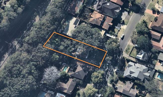
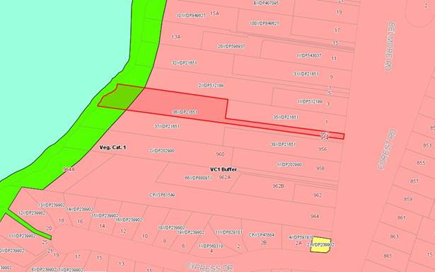
Georges
River Council – Local Planning Panel Thursday, 16 August
2018
|
Page 2
|
|
3. Reports and LPP Deliberations in Closed
Session - 6.30pm
|
LPP030-18 954
– 956 Forest Road Lugarno - DA2016/0104
(Report by
Development Assessment Officer)
LPP031-18 22
Wyong Street Oatley - DA2017/0605
(Report by
Team Leader Development Assessment)
LPP032-18 85-87
Railway Parade Mortdale - DA2017/0398
(Report by
Independent Assessment)
|
4. Confirmation of Minutes by Chair
|
REPORT TO GEORGES RIVER COUNCIL
LPP MEETING OF Thursday, 16 August 2018
|
LPP Report No
|
LPP030-18
|
Development Application No
|
DA2016/0104
|
|
Site Address & Ward Locality
|
954 – 956 Forest Road Lugarno
Peakhurst Ward
|
|
Proposed Development
|
Demolition of an existing dwelling,
construction of three single dwellings, construction of an attached dual
occupancy, ancillary swimming pools, Torrens title subdivision
|
|
Owners
|
Mr B Ghrayche
|
|
Applicant
|
Mr B Ghrayche
|
|
Planner/Architect
|
GAT and Associates (Planner) Nexus Architecture
(Architect)
|
|
Date Of Lodgement
|
6/05/2016
|
|
Submissions
|
Two (2) submissions received
|
|
Cost of Works
|
$1,750,000.00
|
|
Local Planning Panel Criteria
|
Variation to Building Height
Development Standard exceeding 10%
|
|
List of all relevant s.4.15
matters (formerly s79C(1)(a))
|
Environmental Planning and Assessment Regulation 2000, State
Environmental Planning Policy No 55 – Remediation of Land,
State Environmental Planning Policy BASIX 2004, Greater
Metropolitan Regional Environmental Plan No 2 – Georges River
Catchment,
Hurstville Local Enviornmental Plan
2012, Hurstville Development Control Plan No 1 - LGA Wide
|
|
List all documents submitted
with this report for the Panel’s consideration
|
Survey, Site Plan,
Architectural Plans,
Landscape Plan,
Concept Drainage Plan
|
|
Report prepared by
|
Development Assessment Officer
|
|
Recommendation
|
That the application be refused in accordance with the
reasons stated in the report.
|
|
|
Summary of matters for
consideration under Section 4.15
Have all recommendations in relation
to relevant s4.15 matters been summarised in the Executive Summary of the
assessment report?
|
Yes
|
|
Legislative clauses requiring
consent authority satisfaction
Have relevant clauses in all
applicable environmental planning instruments where the consent authority
must be satisfied about a particular matter been listed, and relevant
recommendations summarised, in the Executive Summary of the assessment
report?
|
Yes
|
|
Clause 4.6 Exceptions to
development standards
If a written request for a
contravention to a development standard (clause 4.6 of the LEP) has been
received, has it been attached to the assessment report?
|
Yes
- Building Height
|
|
Special Infrastructure
Contributions
Does the DA require Special
Infrastructure Contributions conditions (under s7.24)?
|
Not
Applicable
|
|
Conditions
Have draft conditions been provided
to the applicant for comment?
|
No,
application recommended for refusal
|
|
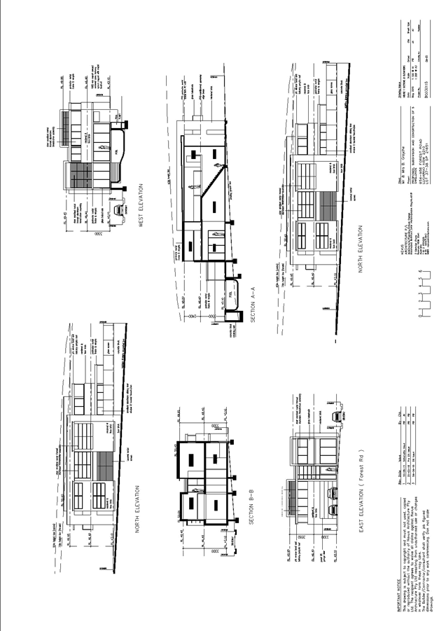
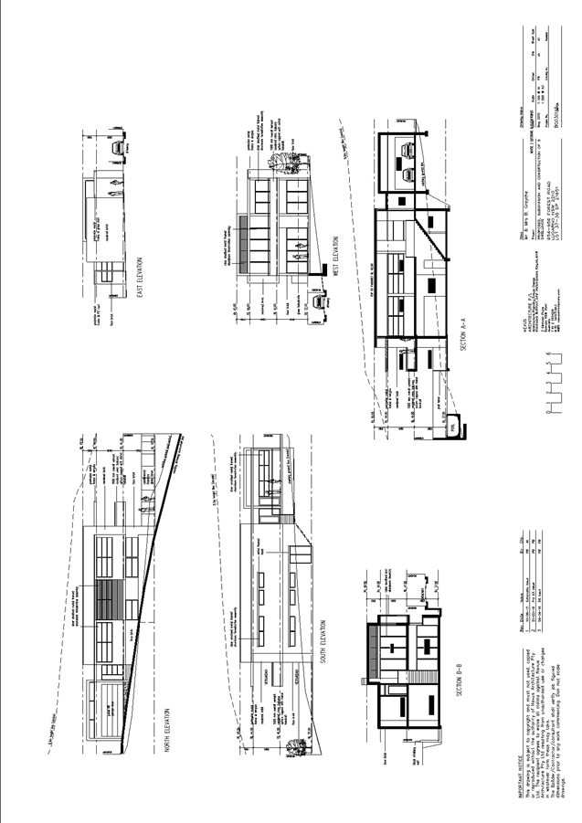
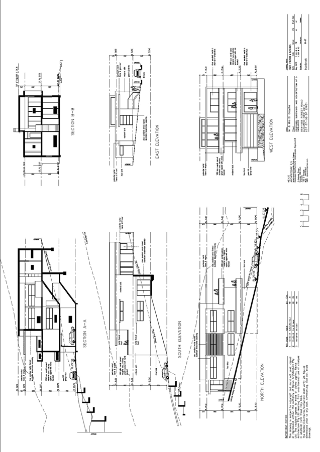
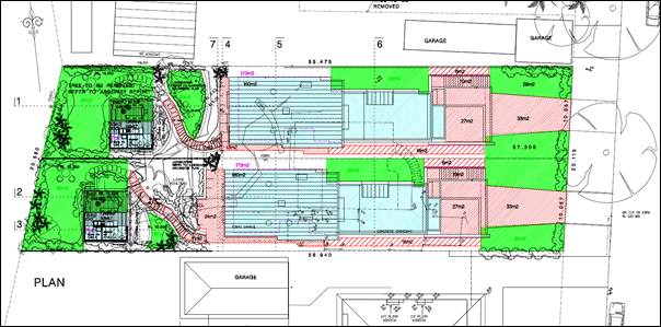
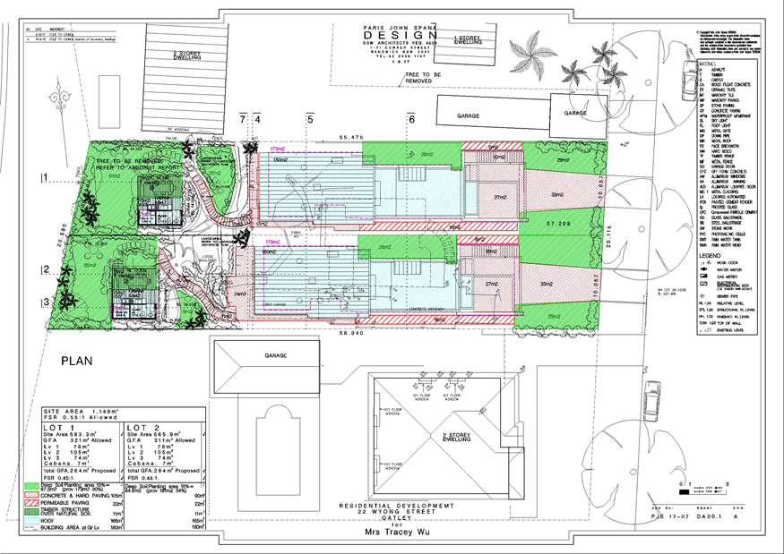
Site Plan
|
Executive Summary
Site and Locality
1. The
subject site consists of Lots 37 and 38 in DP 21651 commonly known as 954-956
Forest Road, Lugarno, The site currently contains an existing dwelling house
with ancillary structures such as sheds and a garage forward of the building
line.
2. The
site is located on the western side of Forest Road between Ulster Street to the
north and Cypress Drive to the south. The site immediately adjoins Salt Pan
Creek to the rear.
3. The
site has a total area of 3996sqm and there is combination of two (2) existing
allotments.
4. The
site provides Forest Road with frontage of 15.24m frontage whilst the northern
side boundary is 301m in length and the southern side boundary is 216m.
Proposal
5. The
development application (DA) seeks development consent for demolition of an
existing dwelling, construction of three single dwelling’s, construction
of an attached dual occupancy, ancillary swimming pools, Torrens title
subdivision
Zoning and
Permissibility
6. The
Hurstville planning controls are applicable to the assessment of this
application. The proposed development has been assessed against the applicable
relevant planning controls. A clause 4.6 Variation has been provided seeking to
allow an exceedance to the building height standard for the dual occupancy. This
variation is not supported.
7. The
subject site zoned as R2 Low Density Residential and RE1 Public Recreation
under the Hurstville Local Environmental Plan 2012. This is shown graphically
in the diagram below:
8. All
development works are located within the R2 Low Density Residential. Under the
HLEP 2012 provisions both “subdivision”, “dwelling
houses” and “dual occupancy” forms of development
are permissible subject to development consent.
Submissions
9. The
application was notified/advertised to residents/owners in accordance with HDCP
No 1 requirements; in response, two (2) submissions were received. The amended
plans did not generate a greater environmental impact than the original
proposal and did not necessitate re-notification.
Conclusion
10. That
the application cannot be supported for the reasons contained within this
report.
Report in Full
Proposal
11. The
development application seeks consent for:
· Demolition of
existing single storey fibro dwelling and all ancillary outbuilding;
Dwelling 1
(DW1)
· Two storey
dwelling house (5 bedrooms), double garage with swimming pool
Ground
floor: double garage, bathroom, entry, kitchen, family, dining, living,
front veranda, rear veranda;
First
floor: four bedrooms, two bathrooms, two front balconies and rear balcony;
Swimming
pool;
Dwelling 2
(DW2)
· Two storey
dwelling house (5 bedrooms), double garage with swimming pool
Ground
floor: double garage, entry, dining, living, kitchen, two bathrooms, two
bedrooms, rear balcony;
Lower
ground floor: two bedrooms, storage, study, two bathrooms, rumpus;
Swimming
pool;
Dwelling 3
(DW3)
· Part two –
three storey dwelling house (5 bedrooms) with double garage
Garage
floor plan: double garage, media/study, bathroom;
Lower
ground floor plan: three bedrooms, two bathrooms, rumpus, balcony;
Ground
floor plan: living room, dining, kitchen, entry, two bathrooms, laundry,
rear balcony;
Dwelling
4-5 (attached dual occupancy) (DW4 and DW5)
· Stepped attached
dual occupancy (5 bedrooms each), double garage (for each occupancy)
Entry/roof
level: double garage, entry, lift;
Level 1:
family room, bathroom, bar, utility room, terrace;
Level 2:
lounge room, dining, kitchen, two bedrooms, media/study, bathroom, two
balconies;
Level 3: two
bedrooms, two bathrooms, rear terrace;
Subdivision
· 4 lot Torrens
Title Subdivision inclusive of 3 x allotments 550sqm (accommodating a dwelling
each) and rear allotment (accommodating the attached dual occupancy);
· Right of
carriageway, driveway along northern side boundary with width of 3m;
· Associated
landscape and building works
Amended
proposal
· Additional
swimming pool details provided for DW1 and DW2;
· Realignment of
driveway and passing bays along northern side boundary;
COMPLIANCE
AND ASSESSMENT
12. The
subject site has been inspected and proposal assessed under the relevant
Section 4.15 "Matters for Evaluation" of the Environmental Planning
and Assessment Act 1979 (as amended) as follows:
Environmental
Planning Instruments
HURSTVILLE
LOCAL ENVIRONMENTAL PLAN 2012 (As amended Rev 6 Aug 16)
13. The
extent to which the proposed development complies with the Hurstville Local
Environmental Plan 2012 is detailed and discussed in the table below.
|
Clause
|
Standard
|
Assessment Under HLEP 2012
|
Complies
|
|
Part 2 – Permitted or
Prohibited Development
|
R2 Low Density Zone
RE1 Public Recreation
|
The development is defined as
subdivision, dwelling house and dual occupancy.
Dual occupancies are permissible in
the zone
Dwelling House x 3 permissible
Subdivision permitted under Clause
2.6 of LEP.
No construction works proposed in
the part of the site zoned RE1 Public Recreation. Subdivision permitted
under Clause 2.6 of LEP.
|
Yes
Yes
Yes
Yes
|
|
|
Objectives
of the Zone
|
The
proposal fails to meet the objectives of the zone as the developments height,
level of cut & fill and failure to provide compliant private open space
areas will not ensure that a high level of residential amenity is achieved and
maintained. Nor will it encourage greater visual amenity through maintaining
and enhancing landscaping as a major element in the residential environment.
|
No
|
|
4.1 Minimum Subdivision Lot Size
|
Land identified as “K”
on lot size map which prescribes a minimum allotment size 550sqm
|
Lots 1-3: 550sqm
|
Yes
|
|
4.1A – Minimum lot size for
dual occupancies
|
Dual occupancy – 630sqm if
land identified as “G” on lot size map; 1000sqm if land
identified as “k” on lot size map;
|
Applicable to the rear of the site
- Land is identified as “k” on the lot size map which requires
1000sqm of site area. Dual occupancy = 2350sqm (inclusive of access handle
comprising of 396sqm)
|
Yes
|
|
4.1B – Exception to minimum
sizes for dual occupancies
|
Subdivision may be granted if there
is a dual occupancy and after the subdivision there will only be 1 dwelling
per lot
|
Whilst the proposal seeks consent
for a 2 into 4 lot Torrens title subdivision, subdivision of the proposed
dual occupancy development is not sought at this stage.
However the 2350sqm (inclusive of
access handle comprising of 396sqm) site area for the proposed dual occupancy
lot would be able to occur at a later date (subject to the current control
remaining unchanged).
|
N/A
|
|
4.3 – Height of Buildings
|
9m as identified on Height of
Buildings Map
|
DW1: 7.8m
DW2: 7.8m
DW3: 8.41m
DW4-5: Range 9m – 14.5m
|
Yes
Yes
Yes
No
|
|
4.4 – Floor Space Ratio
AND
4.5 – Calculation of floor
space ratio and site area
|
0.6:1 as identified on Floor Space
Ratio Map
|
When calculated in accordance with
C4.5 of the LEP, the development results in an FSR as follows:
DW1 – 3: 0.55:1
DW4-5: 0.37.3:1
|
Yes
Yes
|
|
Clause 4.6 Variation
|
Clause 4.6 Variation to Clause 4.3
– Height of Buildings to be provided for consideration
|
Clause 4.6 Variation to Clause 4.3
– Height of Buildings. Development Standard 9m, proposal seeks maximum
height of 14.5m
|
No.
(See addition assessment below)
|
|
5.9 – Preservation of Trees
or Vegetation
|
Trees to be removed are specified
in DCP No.1
|
See assessment under DCP1 below,
supported by Arborist report and Tree Management Officer
|
Yes
|
|
6.4 – Foreshore Scenic
Protection Area (FSPA)
|
Objectives of clause to be
satisfied
|
The proposed development is
generally consistent with the objectives of clause 6.4
|
Yes
|
|
6.5 – Gross Floor Area of
Dwellings in residential zones
|
Gross floor area 0.55:1 maximum for
dwelling
|
DW1 – DW3: 0.55:1 for each
dwelling
|
Yes
|
|
6.7 – Essential Services
|
Development consent must not be
granted to development unless services that are essential for the development
are available
|
Essential services are available to
the development with appropriate conditions being able to be applied if
consent were to be granted.
|
Yes
|
(1)
Height of Buildings
14. Under
the provisions of the Hurstville LEP, Clause 4.3 – Height of Buildings
stipulates a height control of 9 metres measures from ground level existing for
the subject site.
As detailed in
the above table, Dwellings 1 – 3 are compliant with this control and no
further consideration under Clause 4.6 is required. However the proposed Dual
Occupancy development (being referred to as Dwellings 4 and 5) proposes a
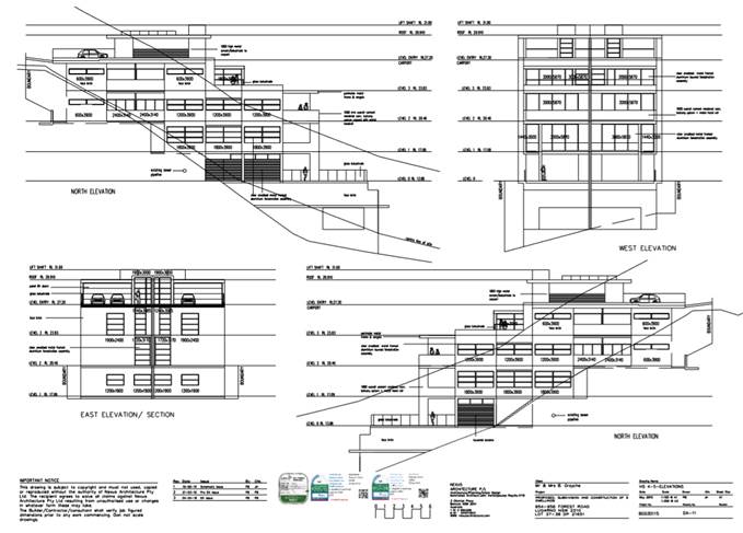
height range of 9m – 14.5m. This is shown graphically in the
submitted elevation plan below:
The applicant seeks
a variation to the Building Height Development Standard under Clause 4.6
– Exceptions to Development Standards of Hurstville Local Environmental
Plan 2012. The statement has been prepared by the applicant’s Planning
consultant, GAT and Associates (dated April 2016) and is attached to this
report.
Clause 4.6
stipulates the following:
(1) The objectives of this
clause are as follows:
(a) to
provide an appropriate degree of flexibility in applying certain development
standards to particular development,
(b) to
achieve better outcomes for and from development by allowing flexibility in
particular circumstances.
(2) Development
consent may, subject to this clause, be granted for development even though the
development would contravene a development standard imposed by this or any
other environmental planning instrument. However, this clause does not apply to
a development standard that is expressly excluded from the operation of this
clause.
(3) Development
consent must not be granted for development that contravenes a development
standard unless the consent authority has considered a written request from the
applicant that seeks to justify the contravention of the development standard
by demonstrating:
(a) that
compliance with the development standard is unreasonable or unnecessary in the
circumstances of the case, and
(b) that
there are sufficient environmental planning grounds to justify contravening the
development standard.
(4) Development
consent must not be granted for development that contravenes a development
standard unless:
(a) the
consent authority is satisfied that:
(i) the
applicant’s written request has adequately addressed the matters required
to be demonstrated by subclause (3), and
(ii) the
proposed development will be in the public interest because it is consistent
with the objectives of the particular standard and the objectives for
development within the zone in which the development is proposed to be carried
out, and
(b) the
concurrence of the Secretary has been obtained.
(5) In deciding whether to
grant concurrence, the Secretary must consider:
(a) whether
contravention of the development standard raises any matter of significance for
State or regional environmental planning, and
(b) the
public benefit of maintaining the development standard, and
(c) any
other matters required to be taken into consideration by the Secretary before
granting concurrence.
…”
In addressing the
above LEP provision, consideration of the applicants request is outlined below:
“Clause
4.6 – Exceptions to Development Standards
(1) The objectives of this
clause are as follows:
(a) to provide an appropriate degree of flexibility in
applying certain development standards to particular development,
(b) to achieve better outcomes for and from development by
allowing flexibility in particular circumstances.”
Planning
consultant comment: “As detailed in this written request for a
variation to the maximum height of a building being a development standard
under the Hurstville LEP 2012, the proposed development meets the requirements
prescribed under Clause 4.6 of the Hurstville LEP 2012.”
…
The
use of Clause 4.6 to enable an exception to this development control is
appropriate in this instance and the consent authority may be satisfied that
all requirements of Clause 4.6 have been satisfied in terms of merits of the
proposed development and the content in this Clause 4.6 variation request
report.”
DAO comment:
Council acknowledges the applicants ability to seek a variation to the
development standard to enable flexibility, however this is subject to meeting
a number of stipulated preconditions including that the development standard is unreasonable or unnecessary in
the circumstances of the case, and that there are sufficient environmental planning grounds to
justify contravening the development standard.
(2) “Development consent
may, subject to this clause, be granted for development even though the
development would contravene a development standard imposed by this or any
other environmental planning instrument. However, this clause does not apply to
a development standard that is expressly excluded from the operation of this
clause.”
DAO comment:
The exception is sought under subclause (1) to the maximum building height
controls of the Hurstville Local Environmental Plan 2012. Clause 4.3 is not
excluded from the operation of this clause.
(3) “Development
consent must not be granted for development that contravenes a development
standard unless the consent authority has considered a written request from the
applicant that seeks to justify the contravention of the development standard
by demonstrating:
(a) that compliance with
the development standard is unreasonable or unnecessary in the circumstances of
the case, and
(b) that there are
sufficient environmental planning grounds to justify contravening the
development standard.”
Planning
consultant comment: ‘As noted above, Clause 4.3 of the Hurstville
LEP 2012 states that the subject land is subject to a maximum height of 9
metres.
Houses 1, 2
and 3 have all been designed within the 9m height control.
Houses 4 and
5 will provide for a maximum building height of 14.5m as measured to the top of
the lift overrun.
With respect
to Houses 4 and 5 the non-compliance is considered to be a consequence of the
natural fall of the land. The subject site falls sharply from east to west as
shown on the submitted Site Plan, from RL 43.15 at the centre of the front
boundary and RL 9.02 at the rear of Houses 4 and 5. This represents a drop of
34.13 metres across the site. We respectfully submit that the proposed
variation is a result of the topography of the site rather than an
overdevelopment of the site. This is evident through compliance with
Council’s floor space ratio and landscaped are controls.
The proposed
variation from the development standard is assessed against the accepted
“5 Part Test” for the assessment of a development standard
variation established by the NSW Land and Environment Court in Wehbe vs
Pittwater Council (2007) LEC 827.
In the
matter of Four2Five, the Commissioner stated within the judgement the
following, in reference to a variation:
“…the
case law developed in relation to the application of SEPP 1 may be of
assistance in applying Clause 4.6. While Wehbe concerned an objection under
SEPP 1, in my view the analysis is equally applicable to a variation under
Clause 4.6 where Clause 4.6 (3)(a) uses the same language as Clause 6 of SEPP
1.”
It is
therefore our submission that the Wehbe test is of relevance in the
consideration of a standard to determine whether or not it is unreasonable or
unnecessary in the circumstances of the case and it is evident in the Four2Five
matter, the above test is relevant. As detailed within this section, a
variation is considered to provide for a better planning outcome.
In the
decision of Wehbe vs Pittwater Council (2007) LEC 827 , Chief Justice Preston
expressed the view that there are five (5) different ways in which an objection
may be well founded and that approval of the objection may be consistent with
the aims of the policy. This attributes to determining whether compliance with
the standard is unreasonable or unnecessary in the circumstances of the case as
set out below:
|
First
|
The most
commonly invoked way is to establish that compliance with the development
standards is unreasonable or unnecessary because the objectives of the
development standard are achieved notwithstanding non - compliance with the
standard.
The
rationale is that development standards are not ends in themselves but means
of achieving ends. The ends are environmental or planning objectives. If the
proposed development proffers an alternative means of achieving the
objective, strict compliance with the standard would be unnecessary and
unreasonable.
|
|
Second
|
A second way
is to establish that the underlying objective or purpose is not relevant to
the development with the consequence that compliance is unnecessary.
|
|
Third
|
A third way
is to establish that the underlying objective or purpose would be defeated or
thwarted if compliance was required with the consequence that compliance is
unreasonable
|
|
Fourth
|
A fourth way
is to establish that the development standard has been virtually abandoned or
destroyed by the Council’s own actions in granting consents departing
from the standard and hence compliance with the standard is unnecessary and
unreasonable
|
|
Fifth
|
A fifth way
is to establish that “the zoning of particular land” was
“unreasonable or inappropriate” so that “a development
standard appro priate for that zoning was also unreasonable or unnecessary as
it applied to that land” and that “compliance with the standard
in that case would also be unreasonable or unnecessary
|
The
following discussion is provided in response to each of the above:
i. the objectives of the standard are achieved
notwithstanding non - compliance with the standard;
The
objectives supporting the maximum height of buildings control identified in
Clause 4.3 are discussed below. Consistency with the objectives and the absence
of any environmental impacts, would demonstrate that strict compliance with the
height standard would be both unreasonable and unnecessary in this instance.
The discussion provided below demonstrates how the proposal is consistent with
the objectives of Clause 4.3.
The
development as proposed will be in the public interest as it is consistent with
the objectives of the development standard (being Clause 4.3), which are as
follows:
(1)
The objectives of this clause are as follows: (a) to ensure that
buildings are compatible with the height, bulk and scale of the existing and
desired future character of the locality, (b) to minimise visual impact,
disruption of views, loss of privacy and loss of solar access to existing
development and to public areas and public domain, including parks, streets and
lanes, (c) to minimise the adverse impact of development on heritage
items, (d) to nominate heights that will provide a transition in built
form and land use intensity, (e) to establish maximum building heights
that achieve appropriate urban form consistent with the major centre status of
the Hurstville City Centre, (f) to facilitate an appropriate transition
between the existing character of areas or localities that are not undergoing,
and are not likely to undergo, a substantial transformation, (g) to
minimise adverse environmental effects on the use or enjoyment of adjoining
properties and the public domain.
The proposed
semi-detached dwellings are considered to be complementary to the height, bulk
and scale of the locality. Both of the proposed dwellings have been designed
well within the maximum floor space ratio achievable for the site, and provide
for substantial landscaping on the site particularly to the rear setback. In
this regard, the proposed dwellings do not represent an overdevelopment of the
site rather it is the significant slope of the land that has resulted in the
numerical non-compliance with building height.
As detailed
above, the site falls from east to west with a notable 34m change in level. The
change in topography is notably more pronounced in the location of Houses 4 and
5 as the site nears the foreshore. However specific regard has been made to
ensure that the dwellings do not appear as dominant elements to the foreshore,
with a rear setback of between 62 – 74 metres proposed. This area will be
landscaped, complementing the RE1 zoning to the rear boundary of the site and
softening the appearance of the built form.
Although the
proposed semi-detached dwellings will exceed the rear building alignment of
adjoining properties, the bulk of these dwellings are focused to the front
section of the built form, with the rear portion of the dwellings more
substantially stepped in its height and includes the terrace projections rather
than solid building elements.
As
acknowledged above, an area of land to the rear of the site is zoned RE1 and
will not be altered by this proposal. As such, the development will not
adversely impact marine habitats or the like.
In terms of
views, the development has been stepped in height and articulated at each level
through the use of glazing and varied projections. As a result, the proposal
will not obstruct views to the Georges River from adjoining properties.
With regards
to privacy, where windows are proposed to a side boundary, they have been
setback a minimum distance of 1500mm from the boundary and offset. The northern
access handle provides for increased separation between the proposed dwellings
and the neighbouring property. The dwellings include blade walls along the
terraces to ensure privacy is maintained between the two dwellings, given their
semidetached nature. The proposed balustrades are to be constructed using
glass, and will be transparent, ensuring visual bulk is minimised. It is not
considered that the variation will result in adverse impacts to the adjoining
properties, and will not compromise the architecture of the dwellings. A degree
of flexibility is considered reasonable in this instance.
The proposal
will result in additional overshadowing to the southern neighbour. It is
considered that the proposed overshadowing is not substantially different to
the approved dual occupancy approved by Council in 2014. We respectfully submit
that the overshadowing is a result of the orientation of the site.
The site is
not listed as an item of heritage, nor is the site located within the vicinity
of a heritage item.
As detailed
above, the proposed height of the dwellings is considered to be consistent with
the multi-level character of dwellings along the foreshore.
It is
considered that this submission provides sufficient environmental planning
grounds to justify contravening the development standard. As demonstrated, the
objectives of the standard have been achieved.
ii. the
underlying objective or the purpose of the standard is not relevant to the
development and therefore compliance is unnecessary;
The
underlying objective or purpose of the standard is relevant to the development
and is achieved as outlined in (i) above. Therefore this clause is not
applicable.
iii. the
underlying objector purpose would be defeated or thwarted if compliance was required
and therefore compliance is unreasonable;
Not
applicable as the underlying objective or purpose would not be defeated or
thwarted if compliance was required.
iv. the
development standard has been virtually abandoned or destroyed by the
Council’s own actions in granting consents departing from the standard
and hence compliance with the standard is unnecessary and unreasonable; and
While the
standard has not been abandoned or destroyed, Hurstville Council has varied LEP
standards in the past.
v. the
zoning of the land is unreasonable or inappropriate s o t h a t a development
standard appropriate for that zoning is also unreasonable and unnecessary as it
applies to the land and compliance with the standard would be unreasonable or
unnecessary. That is, the particular parcel of land should not have been
included in the particular zone.
Not
applicable as the zoning of the site is appropriate.
Are there
Sufficient Environmental Planning Grounds?
The
assessment above and shown throughout the Statement of Environmental Effects
demonstrates that the resultant environmental impacts of the proposal will be
satisfactory.
As stated,
due to the topography of the site, the overall height of the building breach
varies between 5.5m for Houses 4 and 5, as measured to the top of the lift
overrun. Houses 1, 2 and 3 are compliant with the control.
As stated,
the development satisfies the objectives of the height control. While there is
a breach to the height limits, the development has shown that it would not
create any loss of privacy or views as a result. The number of storeys and
envelope of the development is of a respectable nature that is consistent with
multi-level dwellings on the foreshore. The breach in height is also
exacerbated by the slope of the site.
The proposed
dwellings have been stepped in their design to respond to the significant
changes in topography to minimise their massing as viewed from the foreshore
and to enable view lines to be retained from neighbouring properties.
The proposal
retains a large area of landscaping on the site, including three large trees
within the rear setback which will partially screen the development from view,
reducing the perceived height of the building.
The proposed
semi-detached dwellings (Houses 4 and 5) will exceed the rear building
alignment of the adjoining properties, however the bulk of the dwellings has
been focused to the front of the site with the rear portion of the dwellings
more substantially stepped in its height and includes open terrace
projections rather than solid building elements.
As
demonstrated the proposal is compliant with the floor space ratio and open
space controls prescribed by Council.
The proposal
will not result in any adverse amenity impacts to adjoining properties in terms
of overshadowing or privacy. A variation is therefore considered to be
reasonable in this instance.
In this
case, strict compliance with the development standard for the height of
buildings in the Hurstville LEP 2012 is unnecessary and unreasonable.”
DAO Comment:
The detailed submission by the applicant
is acknowledged, however not concurred with. It is considered that the provided
variation request does not adequately justify the proposed extent of variation
of up to 61%. The proposal is able to the redesigned to better reflect
the sites topography whilst reducing the buildings bulk and scale.
As such, it is considered that the proposed
application of the development standard is both reasonable and necessary to
apply in the circumstances of the case.
Furthermore, there have not been sufficient
environmental planning grounds provided to justify contravening the development
standard.”
(4) “Development consent
must not be granted for development that contravenes a development standard
unless:
(a) the consent authority is satisfied that:
(i) the applicant’s written request has adequately
addressed the matters required to be demonstrated by subclause (3), and
(ii) the proposed development will be in
the public interest because it is consistent with the objectives of the
particular standard and the objectives for development within the zone in which
the development is proposed to be carried out, and
(b) the concurrence of the Director-General has been
obtained.”
Planning
consultant comment: “Clause 4.6 states that the development
consent must not be granted for development that contravenes a development
standard unless the proposed development will be in the public interest because
it is consistent with the objectives of the particular standard and the
objectives for development within the zone in which the development is to be
carried out.
It is
considered that this submission provides sufficient environmental planning
grounds to justify contravening the development standard under Part 4.
The
development as proposed will be in the public interest as it is consistent with
the objectives of the development standard (being Clause 4.3), as detailed
under Point 3(i) of this submission.
Furthermore,
it is important to also consider the objectives of the R2 Low Density
Residential zone in relation to the development, which are as follows:
1 Objectives
of zone
· To
provide for the housing needs of the community within a low density residential
environment.
· To
enable other land uses that provide facilities or services to meet the day to
day needs of residents.
· To
encourage development of sites for a range of housing types, where such development
does not compromise the amenity of the surrounding area, or the natural or
cultural heritage of the area.
· To
ensure that a high level of residential amenity is achieved and maintained.
· To
encourage greater visual amenity through maintaining and enhancing
landscaping as a major element in the residential environment.
· To
provide for a range of home business activities where such activities are not
likely to adversely affect the surrounding residential amenity.
In response
to the above the following is provided:
The proposal
provides for increased residential accommodation on the site, including
detached and semi-detached dwellings which are characteristic of the low
density environment. Several townhouse developments exist further to the south
of the subject site.
The proposal
does not include any other land uses.
The proposed
dwellings include a mix of two, three and five level dwellings including
detached and semi-detached dwellings. The proposed dwellings have been designed
to comply with Council’s floor space ratio control and provide for good
landscaping and open space recreation areas.
The proposed
landscaped areas include a mix of shrub and tree plantings, with specific
regard made to ensure sight lines will not be obscured along the driveway. It
is acknowledged that an area of land to the rear of the site is zoned RE1 and
will not be altered by this proposal. As such, the development will not
adversely impact marine habitats or the like.
6. Public
Benefit of Maintaining the Standard
It is
considered that the public benefit will not be undermined by varying the
standard. The development retains the two storey residential dwelling on site
with majority of the additions located on the ground floor and towards the
outdoor private open spaces.
The built
form is considered to be consistent with the character of the R2 zoning
applying to the site, respecting the low density character of the area and
foreshore.
It is not
considered that the variation sought raises any matter of significance for
State or regional environmental planning.
The
departure from the maximum height of buildings control within the Hurstville
LEP 2012 allows for the orderly and economic use of the site in a manner which
achieves the outcomes and objectives of the relevant planning controls.
7. Is the
Variation Well Founded?
It is
considered that this has been adequately addressed in Parts 4 and 5 of this
submission. In summary, this Clause 4.6 Variation is well founded as required
by Clause 4.6 of the Hurstville LEP 2012 in that:
· Compliance
with the development standard would be unreasonable and unnecessary in the
circumstances of the development;
· There
are sufficient environmental planning grounds to justify the departure from the
standard;
· The
development meets the objectives of the standard to be varied (the height of
buildings), as well as the objectives of the E4 Environmental Living zoning of
the land;
· The
proposed development is in the public interest and there is no public benefit
in maintaining the standard;
· The
breach does not raise any matter of State of Regional Significance; and
· The
development submitted generally aligns with Council’s Development Control
Plan.
Based on the
above, the variation is considered to be well founded.”
DAO comment:
The applicant has submitted a written request, as such the proposed variation
can be considered.
Notwithstanding,
the proposed exceedances are not considered to be in the public interest.
In addition, the
proposal does not satisfy the objectives of the zone as the developments
height, level of cut & fill and failure to provide compliant private open
space areas will not ensure that a high level
of residential amenity is achieved and maintained. Nor will it encourage
greater visual amenity through maintaining and enhancing landscaping as a major
element in the residential environment.
(5) “In deciding whether
to grant concurrence, the Director-General must consider:
(a) whether
contravention of the development standard raises any matter of significance for
State or regional environmental planning, and
(b) the
public benefit of maintaining the development standard, and
(c) any
other matters required to be taken into consideration by the Director-General
before granting concurrence.”
DAO comment:
The proposed variation does not raise any matter of significance for state or
regional environmental planning. The proposed variation is site specific and
there is no specific benefit in maintaining the development standard in this
instance. There are no matters to be taken into consideration by the
Director-General before granting concurrence.
(6) “Development consent must not be
granted under this clause for a subdivision of land in Zone RU1 Primary
Production, Zone RU2 Rural Landscape, Zone RU3 Forestry, Zone RU4 Primary
Production Small Lots, Zone RU6 Transition, Zone R5 Large Lot Residential, Zone
E2 Environmental Conservation, Zone E3 Environmental Management or Zone E4
Environmental Living if:
(a) the
subdivision will result in 2 or more lots of less than the minimum area
specified for such lots by a development standard, or
(b) the
subdivision will result in at least one lot that is less than 90% of the
minimum area specified for such a lot by a development standard.
Note. When this Plan was made it did not include
Zone RU1 Primary Production, Zone RU2 Rural Landscape, Zone RU3 Forestry, Zone
RU4 Primary Production Small Lots, Zone RU6 Transition, Zone R5 Large Lot
Residential, Zone E2 Environmental Conservation, Zone E3 Environmental
Management or Zone E4 Environmental Living.”
DAO comment:
The application does not include subdivision in any of the prescribed zones.
(7) “After determining a
development application made pursuant to this clause, the consent authority
must keep a record of its assessment of the factors required to be addressed in
the applicant’s written request referred to in subclause (3).”
DAO comment:
A record is kept of the assessment of the application and details relating to
the variation sought.
(8) “This clause does not
allow development consent to be granted for development that would contravene
any of the following:
(a) a development
standard for complying development,
(b) a development
standard that arises, under the regulations under the Act, in connection with a
commitment set out in a BASIX certificate for a building to which State
Environmental Planning Policy (Building Sustainability Index: BASIX) 2004
applies or for the land on which such a building is situated,
(c) clause
5.4.”
DAO comment:
The application satisfies this requirement as:
· The development
proposed is not complying development.
· A BASIX
certificate has been issued for the proposal.
· Clause 5.4 of the
Hurstville Local Environmental Plan does not apply to the proposal.’
STATE
ENVIRONMENTAL PLANNING INSTRUMENTS
15. Compliance
with the relevant state environmental planning policies is detailed and
discussed in the table below.
|
State
Environmental Planning Policy
|
Complies
|
|
Greater Metropolitan Regional
Environmental Plan No 2 – Georges River Catchment – proposal
seeks to drain to rear and if consent were to be granted appropriate
conditions of consent could be imposed.
|
Yes
|
|
State Environmental Planning Policy
55 – Remediation of Land
Rear: allotment previously vacant,
Front of site: contains an existing
dwelling
|
Yes
|
|
State Environmental Planning Policy
(Vegetation in non-rural areas) 2017
|
Yes
|
|
State Environmental Planning Policy
(Building Sustainability Index BASIX) 2004 – valid Basix certificate
provided
DW1: 718190S dated 29 April 2016
DW2: 719284S dated 29 April 2016
DW3: 719288S dated 29 April 2016
DW4: 719404S dated 29 April 2016
DW5: 719584S dated 29 April 2016
BASIX commitments appropriately notated on plans
|
Yes
Yes
|
Draft
Environmental Planning Instruments
16. There
are no draft environmental planning instruments that apply to the development
application.
Any other
matters prescribed by the Regulations
17. The
Regulations prescribe the following matters for consideration for development
in the Hurstville Council area:
Bushfire
Assessment
The site is
identified as being bushfire prone and was referred to the New South Wales
Rural Fire Service for comment. In response, comments were received which
supported the proposal. If consent were to be granted appropriate conditions of
consent could be imposed.
Demolition
Safety standards
for demolition and compliance with AS 2601 - 2001 apply to the demolition of
any buildings affected by the proposal. If consent were to be granted
appropriate conditions of consent could be imposed.
Development
Control Plans
18. The
proposal has been assessed under the relevant Sections of HDCP Plan No 1 as
follows.
DEVELOPMENT
CONTROL PLAN NO 1 – LGA WIDE - SECTION 3.1 VEHICLE ACCESS, PARKING &
MANOUVERING
19. The
extent to which the proposed development complies with Section 3.1 Vehicle
Access, Parking & Manouvering is detailed and discussed in the table
below.
It is noted that
a traffic certification report prepared by Auswide Traffic Engineers Rev 1.0
dated March 2016 accompanied the application. The traffic report demonstrated
adequate turning areas and swept paths B85 and sight lines in accordance with
AS2890.1-2004. Council’s Senior Traffic Engineer has not raised any
concerns with the application.
|
Section 3.1
|
Standard
|
Proposal
|
Complies
|
|
3.1.4.1 - Resident parking
|
3 x dwelling house (3+ bedrooms) =
6 spaces
1 x dual occupancy = 4 spaces
Total = 10
|
6 garage spaces (2 spaces per
dwelling house)
4 garage spaces (carport considered
to be an enclosed garage)
10 garage spaces provided
|
Yes
Yes
Yes
|
|
3.1.4.2 –Dimension of car
spaces, car parking layout, circulation, egress and egress
|
Compliance with AS2890.1 2004 and
AS2890.2
|
To comply with Australian
Standards. Driveway supported by Council’s Senior Traffic Engineer
|
Yes
|
|
3.1.4.3 – Stencilling of
driveways
|
Finished with plain concrete
|
To be provided as plain concrete
|
Yes
|
|
3.1.4.4 – Ramps transitions,
driveways
|
Ramp grades to comply with AS2890.2
2004, Part 2
Longitudinal section 1:20 to be provided
with development application
|
Compliant with gradients in AS
Provided and supported by
Council’s Senior Traffic Engineer
|
Yes
Yes
|
DEVELOPMENT
CONTROL PLAN NO 1 – LGA WIDE – SECTION 3.2 SUBDIVISION
20. The
proposal has been assessed under the relevant applicable controls as per below.
|
Section 3.1
|
Standard
|
Proposal
|
Complies
|
|
Minimum allotment size
|
550sqm
3m access handle
|
Proposed Lot 1: 550sqm
Proposed Lot 2: 550sqm
Proposed Lot 3: 550sqm
Proposed Lot 4: 2350sqm
3.66m
|
Yes
|
|
|
Dual occupancy – R2 Low
Density Residential 1000sqm (Scenic Foreshore Protection Area)
|
Proposed Lot 4: 2350sqm
|
Yes
|
|
|
Minimum allotment width for
dwellings and dual occupancies is 15m
|
15.24m
|
Yes
|
|
|
Battle axe allotment maximum number
of lots R2 - 6
|
3 lots
|
Yes
|
|
|
Newly created allotments must
demonstrate how solar access, vehicular access, setbacks, landscaped areas
and tree preservation can be achieved
|
Adequate solar access, vehicular
access, setbacks, landscape and tree preservation areas achieved
|
Yes
|
|
Roads, Vehicular Access and Car
Parking
|
Requirements to be satisfied in
accordance with Council requirements and Australian Standards
|
Compliant with Australian Standards
|
Yes
|
|
Utilities and Services
|
Utilities and Services to be
provided in accordance with Council requirements
|
Adequate utilities are available
and if consent were to be granted appropriate conditions of consent applied
requiring connection.
|
Yes
|
|
Drainage
Overland Flow Paths
Flow of Run-off across property
boundaries
Control of seepage
Width of Easements
|
Adequate drainage to be provided
|
Appropriate stormwater drainage has
been proposed.
If the proposal is considered to be
worthy of approval conditions of consent can be applied.
|
Yes
|
|
Issues of Consideration
|
S94 Contributions to apply for each
additional allotment created by land subdivision
|
Section 94 Contributions apply to
this development
|
Yes
|
DEVELOPMENT
CONTROL PLAN NO 1 – LGA WIDE – SECTION 3.3 ACCESS & MOBILITY
21. This
section of the Development Control Plan is not applicable to the assessment of
this application.
DEVELOPMENT
CONTROL PLAN NO 1 – LGA WIDE - SECTION 3.4 CRIME PREVENTION THROUGH
ENVIRONMENTAL DESIGN
22.
|
Section 3.4
|
Standard
|
Proposal
|
Complies
|
|
Blind Corners
|
To be avoided
|
No blind corners evident given
nature of proposal, appropriate sight lines provided
|
Yes
|
|
Entrances
|
Clearly visible and not confusing
|
Entrance to each dwelling is
visible from the street DW1, other dwelling entrances visible from access
handle
|
Yes
|
|
Site and building Layout
|
-Provide surveillance opportunities
-Building addresses street
-Habitable rooms are directed
towards the front of the building
-Garages are not dominant
-Offset windows
|
Natural surveillance of the site is
available from the dwellings. Surveillance of street is available from the
dwellings where possible.
|
Yes
|
|
Landscaping
|
-Avoid dense medium height shrubs
-Allow spacing for low growing
dense vegetation
-Low ground cover or high canopy
trees around car-parks and pathways
-Vegetation used as a barrier for
unauthorised access
|
Landscaping proposed is appropriate
with adequate landscape planting proposed
|
Yes
|
|
Lighting
|
-Diffused/movement sensitive
lighting provided externally
-Access/egress points illuminated
-No light-spill towards neighbours
-Hiding places illuminated
-Lighting is energy efficient
|
These requirements can be
conditions of consent
|
Yes
|
|
Building Identification
|
-Clearly numbered buildings
-Entrances numbered
-Unit numbers provided at entry
|
House number requirement can be a condition
of consent
|
Yes
|
|
Security
|
Provide an appropriate level of
security for each dwelling and communal areas
|
Appropriate level of security
provided for the dwellings
|
Yes
|
|
Ownership
|
Use of fencing, landscaping, colour
and finishes to imply ownership
|
Ownership implied given nature and
design of proposal
|
Yes
|
DEVELOPMENT
CONTROL PLAN NO 1 – LGA WIDE – SECTION 3.5 LANDSCAPING
23. This
section of the Development Control Plan is not applicable to the assessment of
this application in relation to the proposed dwelling house development.
Consideration of the provisions in relation to the dual occupancy component of
the development is detailed as follows:
|
Section
|
Standard
|
Proposed
|
Complies
|
|
Street and neighbourhood landscape character
|
Development contributes to the creation of a
distinct, attractive landscape character for streets and neighbourhoods
|
The proposed
landscaping will not reduce the visual impact of the building given its bulk
and height.
|
No
|
|
Landscaping area and dimensions
|
The size and dimensions of landscaping areas
are adequate to minimise the visual impact of buildings and structures and
provides areas of a high level of utility and amenity
|
The proposed
landscaping will not reduce the visual impact of the building given its bulk
and height.
|
No
|
|
Significant trees and vegetation
|
Development protects existing significant
trees and vegetation:
|
An arborist report accompanied the
development application. Council’s Tree Management Officer supports the
proposal subject to the removal of one (1) English Oak and one (1) Blackbutt
due to low retention value and life expectancy. One (1) Eucalyptus Tree is at
the front of the property is to be retained. However the application is not
supported for other reasons.
|
Yes
|
|
Front, side and rear boundaries
|
Landscaping in front setbacks:
a. integrates the public and private domain
b. is coordinated with the street planting
pattern and species
c. reduces the visual impact of
building
structures and hardstand
And
Landscaping alongside boundaries reduces the
visual impact of buildings on adjoining premises
|
The proposed
development is situated on a battle-axe allotment and therefore will not
impact the streetscape.
Notwithstanding,
the proposed landscaping will not reduce the visual impact of the building
given its bulk and height.
|
No
|
|
Communal &
Private Open Space
|
Landscaping in communal open space and private
open space contributes
|
No communal
open space areas are proposed.
The proposed
landscaping will not impact the useability or amenity
|
Yes
|
|
Car Parks
|
Landscaping reduces the environmental impacts
of car parks
|
No car park is
proposed as part of this application.
|
Not
applicable
|
|
Landscape Plans
|
Development applications are supported by
sufficient detail to demonstrate achievement of the objectives of this
chapter
|
Landscape Plans
have been submitted
|
Yes
|
|
Landscaping near areas of ecological
significance
|
Landscaping that is located adjacent to areas
of ecological significance protects and strengths the ecological values of
the area
|
There are no
identified of areas of ecological significance.
|
Not
applicable
|
|
Landscaping near bushfire prone areas
|
Landscaping within or adjacent to areas that
are bushfire prone minimise risk or bushfire hazard to people and property
|
The NSW RFS
have reviewed the proposed development and not raised any objection in this
regard.
|
Yes
|
|
Stormwater management
|
Landscaping facilitates on site stormwater
infiltration and does not result in significant adverse water quality impacts
|
The landscaping proposed is not envisaged to
impact on the onsite stormwater management
|
Yes
|
|
Maintenance
|
Landscaping areas are able to be easily
maintained
|
Appropriate
conditions can be imposed if the application is approved requiring
maintenance of landscaping.
|
Yes
|
|
Safety
|
Landscaping provides for personal and property
safety
|
The landscaping proposed is not envisaged to
impact on personal and property safety
|
Yes
|
|
Utilities
|
Landscaping does not interfere with the
effective functioning of utilities
|
The landscaping proposed is not envisaged to
interfere with the effective functioning of utilities
|
Yes
|
DEVELOPMENT
CONTROL PLAN NO 1 – LGA WIDE – SECTION 3.6 PUBLIC DOMAIN
24. This
section of the Development Control Plan is not applicable to the assessment of
this application.
DEVELOPMENT
CONTROL PLAN NO 1 – LGA WIDE - SECTION 3.7 DRAINAGE AND ON-SITE DETENTION
(OSD) REQUIREMENTS
25. Appropriate
stormwater drainage has been proposed. If the proposal is considered to
be worthy of approval conditions of consent can be applied.
DEVELOPMENT
CONTROL PLAN NO 1 – LGA WIDE – SECTION 4.1 SINGLE DWELLING HOUSES
26. Dwellings
1-3 located at the front of the site have been assessed as follows.
|
Section 4.1
|
Standard
|
Proposed
|
Complies
|
|
Streetscape
|
Must not
diminish the quality of the streetscape
|
The proposed
dwellings are considered to be compatible with the existing and future
desired streetscape
|
Yes
|
|
Maximum Floor
Area
|
For site area
for lots 1 – 3 totals 550sqm x 0.55:1 = 302.sqm max
|
DW1 –
DW3: 0.55:1 for all dwelling houses
|
Yes
|
|
Landscaped Areas
and Private Open Spaces
|
25% to be
landscaped area (min. width of 2m)
15sqm of
landscaped area to be provided in the front yard
Principal
Private Open Space Min. dimension of 4m x 5m
|
DW1- DW3:
>25% landscaping for each allotment
DW1: More than
15sqm within front setback. This dwelling fronts Forest Road
DW1- DW3: >
4m x 5m on site, appropriate gradient and accessible to living areas
|
Yes
Yes
Yes
|
|
Building Height
|
Max.
height = 9m
Max. ceiling
height = 7.2m
|
DW1: 7.8m
DW2: 7.8m
DW3: 8.41m
DW1: 6.9
DW2: 8
DW3: 8
|
Yes
Yes
Yes
Yes
No
No
|
|
Setback
Controls
|
Front Setback
(Building Line):
4.5m to front
wall of the dwelling
5.5m to garage
|
DW1: 5.5m
(measured to solid fin wall of front veranda)
DW1: 5.5m
(measured to garage door)
|
Yes
Yes
|
|
|
Side Boundary
Setbacks:
900mm to ground
floor level
1.5m to first
floor level (SFPA)
|
1.5m ground
floor (min)
1.5m first
floor (min)
|
Yes
Yes
|
|
|
Rear Setback:
Ground floor
level 3m
First floor
level 6m
|
DW1-DW3: More
than 3m
More than 6m
|
Yes
Yes
|
|
Balconies &
Terraces
|
Direct access
from a habitable room
Overlooking
impacts can be minimized with the use of privacy screens between1.8m high
|
All balconies
accessed from habitable rooms, no roof top terraces proposed
Privacy screens
provided 1.8m in height where appropriate
|
Yes
Yes
|
|
Façade
Articulation
|
Garage must be
setback 5.5m
Garage doors
facing the street must occupy less than 40% for sites greater than 12m wide
Habitable room
to street
Dwellings must
have a front door or window to a habitable room fronting the street
Dwellings must
incorporate multiple building elements
|
DW1: 5.5m
DW1: Less than
40%
DW2-3: Do not
have a street frontage - Not applicable
DW1: Habitable
rooms face street
DW1: Windows on
ground and first floor front the street
Dwellings
incorporate design elements providing modulation and articulation resulting
in contributory visual interest
|
Yes
Yes
Yes
Yes
Yes
|
|
Car Parking
|
3 bedrooms or
more, 2 spaces to be provided (1 space is to be located behind building line)
Garages must
not extend further towards the front boundary than the front wall
Max. driveway
crossing width: 2.7m and 4.5m
AS2890.1
– Max. driveway gradient = 1 in 5 (20%)
|
DW1 –
DW3: 2 spaces for each dwelling house
DW1: Garage
recessed from the front wall articulation which is the only dwelling with
direct street presentation
DW1: 3m
Shared access
driveway: 3m
Compliant with
gradient CC
|
Yes
Yes
Yes
Yes
|
|
Visual Privacy
|
Windows to be offset
by 1m. Neighbouring principal private open space is not overlooked by
proposed living areas.
|
Window offsets,
high light windows and obscured glazing are used to mitigate privacy impact
|
Yes
|
|
Solar Design
|
Principal
private open space of both the subject lot and adjoining lot must receive a
minimum of 3hrs direct solar access between 9am and 3pm in mid-winter (June)
|
3hrs direct
solar access between 9am and 3pm in mid-winter (June) achievable on most of
the principal private open spaces
|
Yes
|
|
Stormwater
|
Stormwater
assessment
|
Proposal seeks
to drain to the rear – appropriate conditions can be applied if consent
were to be granted.
|
Yes
|
DEVELOPMENT CONTROL PLAN NO 1 – LGA WIDE - SECTION 4.3 DUAL OCCUPANCY HOUSING
27. Dwellings 4-5
have been considered as follows.
|
Section 4.3
|
Requirement
|
Proposal
|
Complies
|
|
Site Area
|
1000sqm FSPA
|
1,924sqm (excluding access handle)
|
Yes
|
|
Site Width
|
15m for attached dual occupancy
|
15.24m
|
Yes
|
|
Height
|
9m for two storey
|
14.5m
|
No
|
|
Wall Height
|
6.8m for two storey
(As per DCP table - Option 3 forms
an attached dual occupancy)
|
>6.8m
|
No
|
|
Floor to ceiling heights
|
2.7m – 3.6m
|
2.75m – 3m
|
Yes
|
|
Maximum storeys
|
2 storeys
|
Ranging: 3-4 habitable storeys
|
No
|
|
Flat roof maximum parapet height
|
450mm
|
Flat roof proposed
|
Yes
|
|
Front Setbacks
|
5.5m
|
DW1: 10.55m from boundary of Lot 3
(accommodating DW3)
|
Yes
|
|
Side Setbacks
|
900mm single storey
1500mm two storey
|
Ground and floors above: 1,500mm
|
Yes
|
|
Eaves Setbacks
|
750mm or
450mm non-combustible
|
More than 450mm
non-combustible
|
Yes
|
|
Rear Setbacks
|
7m ground floor
9m first floor
|
70m minimum to rear southern
elevation of dwellings
|
Yes
|
|
Floor Space Ratio
|
As per Hurstville LEP 2012 FSR =
0.6:1
|
0.373:1
|
Yes
|
|
Presentation to the street
|
Windows to street
Attached may not be mirror-reverse
Design to have two of;
- Entry
feature
- Window
feature
- Balcony/window
box
- Architectural
element to break façade
- Open
veranda
- Bay
windows
- Pergola/similar
features above garage doors
Entrance clearly visible from
street
Garage recess 300mm
Maximum recommended roof pitch
35°
Dormers where used maximum 1.5m
wide and lower than roof ridge
|
The proposed development is located
on a battle-axe lot and has no direct street frontage. These requirements are
therefore not applicable to the proposed development.
|
N/A
|
|
Balconies
|
2m maximum depth for rear balconies
1.8m maximum height for privacy
screens
|
The private open space to the
dwellings is provided in the form of balconies located on the rear elevation
that are accessible from the family room, rumpus room and bedrooms.
|
No
|
|
Materials and Finishes
|
To compliment surrounding
development
Minimise high contrasting colour
schemes
Fire rating of BCA to be achieved
|
Proposed materials and finishes are
acceptable and adopt contemporary tones
|
Yes
|
|
Views
|
Windows to provide views of private
open space and approaches to dwelling
Minimise view loss to surrounding
properties
Flat rooves may be used to protect
views
|
Views from adjoining developments
are not affected by the proposed development as adjoining developments maintain
direct views to Salt Pan Creek.
|
Yes
|
|
Landscaped Area
Private Open Space
|
Driveway and pathway the only
paving permitted in the front yard
25% landscaping in FSPA
2m minimum width
Landscape Plan to be provided
Landscape work to be completed
prior to occupation
Protection of the root zone of
trees to be retained is to be considered
At ground level
Minimum dimensions 4m x 5m
Accessible from living area
Maximise visual privacy and
acoustic amenity to occupants and neighbours
Maximise solar access
|
Yes, driveway and turning area
provided for adequate vehicular access
More than 25%
>70% with 2m width
Landscape plan to be submitted as a
condition of consent
Subject to conditions of consent
The private open space to the
dwellings is provided in the form of balconies located on the rear elevation
that are accessible from the family room / rumpus rooms.
|
Yes
Yes
Yes
Yes
Yes
No
|
|
Vehicular Access and parking
|
1 garage and 1 driveway space per
dwelling or as the building envelope permits
Garage setback 5.5m and recessed a
minimum 300mm into façade
Driveway width 3m minimum
Driveways setback from side
boundary by 1.5m minimum
Crossing at least 6m from
intersection
|
Development provides appropriate
vehicles access to the dwellings via the existing access handle to the
battle-axe lot which will be ramped. The garage has a 10.55m setback from the
“front boundary” of the site to provide appropriate turning movements.
|
Yes
|
|
Cut and Fill
|
Cut/fill maximum 600mm
Fill only within building footprint
|
Maximum excavation is 3400mm
|
No
|
|
Visual Privacy and Acoustic Amenity
|
Balconies and main windows directed
towards front and rear
Windows of habitable rooms to be
offset by 1m from the window of the neighbouring dwelling or screened or
provided with 1.5m bottom sill heights
Privacy screens to be provided to
rear balconies at no higher than 1.8m
Driveways and A/C units to be sited
away from adjoining neighbours
|
Balconies primarily orientated
towards rear southern elevation. Windows to the development on the side
elevations of the ground and first floor are conditioned to have a sill
height no less than 1.5m
Level 2 side balconies along the
northern and southern side elevations are accessed from bedrooms only which
are only 1.8m in depth and do not view onto adjoining private open space
|
Yes
Yes
|
|
Solar Design, Water and Energy
Efficiency
|
Must comply with BASIX
Cross ventilation to be provided
All rooms to have a window
Shadow diagrams for 2 storey
proposals
3 hours solar access during
midwinter solstice to be provided to subject and neighbouring dwellings
|
Complies with BASIX requirement and
requirements of subsection in relation to cross ventilation and shadows
|
Yes
|
|
Site Facilities
|
3m x 1m garbage storage
6m³ storage
Mailbox
Outdoor Clothes line
|
6m³ storage can be provided to
each dwelling
|
Yes
|
|
Stormwater Drainage
|
Drainage by gravity
Alternatives:
(1) Easement
(2) Charged
and gravity
(3) OSD
and infiltration
|
Development can drain by gravity to
the rear of the site with any overflow being to Salt Pan Creek subject to
conditions of consent
|
Yes
|
|
Building Envelope Graphics
|
As per diagrams
|
Option 3 forms an attached dual
occupancy
|
Yes
|
|
Stormwater
Assessment
|
|
|
Existing Stormwater System
|
Gravity
to rear of site
|
|
Proposed Stormwater System
|
Gravity
to rear of site with overflow to Salt Pan Creek
|
|
Stormwater objectives for
development type met?
|
Yes,
consistent with objectives
|
|
Slope to rear (measured centreline
of site)
|
Yes –
34.13m fall from front to rear
|
|
Gravity to street (from property
boundary to street kerb)?
|
No
|
|
Discharge into same catchment?
|
Yes
|
|
Easement required?
|
No
|
DEVELOPMENT
CONTROL PLAN NO 1 – LGA WIDE - SECTION 5.6 SWIMMING POOLS
28. The
proposal seeks development consent for two (2) swimming pools for DW1 and DW2
which are located above ground. The relevant controls have been considered as
follows.
|
Section 5.6
|
Requirement
|
Complies
|
|
Pool sitting
|
Top of pool to be close to natural
ground level as possible
|
No
All pools elevated.
|
|
|
One side of swimming pool 500mm at
or below natural ground level, other side maybe up to 500mm above ground
level
|
No
All pools elevated >500mm
|
|
|
Swimming pools above 500mm,
landscaping treatment required
|
No
Landscape treatment inadequate due
to proposed level of elevation.
|
|
|
Steeply sloping sites one site
maybe up to 1000mm
|
No
All pools elevated > 1m
|
|
|
No fill between pool and boundary
|
Yes
|
|
|
Spill water overflow not to affect
adjoining properties
|
Yes
|
|
|
1.5m side setback
|
Yes
|
|
Noise control and nuisance
|
Pool pump sited appropriately to
reduce noise
Mechanical equipment to be sound
treated
Construction, location and use of
swimming pool no nuisance to neighbouring properties
|
Yes
|
|
Heated swimming pools
|
Solar heating, heat pumps and gas
heating
|
Yes
|
|
Landscaping
|
Trees and shrub planting to be
provided
Paved and other impervious areas to
be minimised
Swimming pools to be designed to
ensure the retention of existing trees
Swimming pools located to existing trees,
elevated decks are preferred as the swimming pool coping to ensure minimal
damage
Swimming pool water must not
discharge to bushland areas located on private or public land
|
Yes
Yes
Yes
Yes
Yes (appropriate conditions can be
imposed if consent to be granted)
|
4. Impacts
Natural
& Built Environment
29. The
proposed dual occupancy height non-compliance, is considered to adverse impacts
on the locality resulting in an unacceptable bulk and scale of development.
Social
Impact
30. The
proposed development has no apparent social impacts given the residential
nature of the use.
Economic
Impact
31. The
proposed development has no apparent adverse economic impacts given the
residential nature of the development. Development Contributions apply to new
additional housing. A credit is granted for the existing dwelling house which
is to be demolished.
Suitability
of the Site
32. The
proposal forms a permissible use within the R2 Low Density Residential Zone
within the LEP however, the development as proposed needs to be amended to more
appropriately respond to the site topography.
REFERRALS,
SUBMISSIONS AND THE PUBLIC INTEREST
Resident
33. The
application was notified/advertised to residents/owners in accordance with
Council’s requirements, in response on two (2) submissions were received
raising the following concerns.
Proposed
driveway access
Comment:
Concerns were raised in relation to the proposed shared driveway access along
the northern side boundary. Concerns were raised in relation to the extent of
excavation sought. The proposal was referred to Council’s Senior
Traffic Engineer who raised no concerns in relation to the driveway design.
Safety issues
Comment:
concerns were raised in relation to safety issues for the proposed driveway
along the northern side boundary. No safety concerns were raised by
Council’s Senior Traffic Engineer. The driveway is to comply with the
Australian Standards for driveway gradients.
Bulk and
scale, general view loss impact
Comment:
Concerns were raised in relation to bulk and scale in particular to the dual
occupancy at the rear of the property. As previously addressed within the
report, the proposal seeks variation in height due to the steeply sloping
topography of the site. It is agreed that the height of the dual occupancy
development is not acceptable.
Accuracy of
plans
Comment:
Concerns were raised in relation to the accuracy of the plans. The assessment
of the application indicates that the plans are adequate for the purposes of development
assessment. An assessment has been undertaken based on the information
provided, site inspection and information systems.
Impact on
adjoining properties due to excavation
Comment: Concerns
were raised in relation to the extent of the excavation sought. It was
suggested, that appropriate engineering conditions be imposed to ensure
protection of adjoining property and construction of retaining wall. If the
application were to be approved, appropriate conditions can be imposed to
address impacts.
Council
Referrals
34.
Team Leader
Subdivision and Development
Council’s
Acting Team Leader Subdivision and Development has raised no objection to the
application subject to conditions of consent being attached to any consent
granted.
Senior Traffic
Engineer
Council’s
Senior Traffic Engineer raised no concerns with the proposal in relation to the
design and safety aspects.
Tree Management
Officer
An arborist report
accompanied the development application. Council’s Tree Management
Officer supports the proposal subject to the removal of one (1) English Oak and
one (1) Blackbutt due to low retention value and life expectancy. One (1)
Eucalyptus Tree is at the front of the property is to be retained. However the
application is not supported for other reasons.
External Referrals
35.
New South Wales Rural Fire Service
The proposal is
supported by the New South Wales Rural Fire Service subject to conditions of
consent. It is noted that amended bushfire report was provided during the
development assessment process.
New South Wales Department of
Primary Industries Water
The proposal was referred to the New
South Wales Department of Primary Industries Water. In response, no concerns
were raised.
CONCLUSION
36. The
proposed development does not comply with the Building Height Development
Standard prescribed in Hurstville Local Environmental Plan 2012.
The submitted 4.6
variation to the Building Height Development Standard does not adequately
justify that the development standards is unreasonable and unnecessary in the
circumstances of the case, nor does it provide adequate environmental planning
grounds to justify departure from the standard
The applicant was
advised on numerous occasions that the height variation to the dual occupancy
would not be supported.
The proposal is
subsequently:
· Inconsistent with
the objectives of the R2 Low Density Residential Zone under the Hurstville
Local Environmental Plan 2012 in that the developments height, level of cut
& fill and failure to provide compliant private open space areas will not
ensure that a high level of residential
amenity is achieved and maintained; and
· not considered to
be of an appropriate bulk, scale and form for the site and character of the locality.
In view of the
above, the application is recommended for refusal.
DETERMINATION
37. THAT
pursuant to Section 4.16(1) of the Environmental Planning and Assessment Act
19749 (as amended) the Council refuses Development Application DA2016/0104 for
the demolition of an existing dwelling, construction of three single dwellings,
construction of an attached dual occupancy, ancillary swimming pools, Torrens
title subdivision at Lots 37 and 38 DP 21651 and known as 954-956 Forest Road,
Peakhurst, for the reasons outlined as follows:
1. The
proposed development does not comply with the Building Height Development
Standard prescribed in Hurstville Local Environmental Plan 2012.
2. The
submitted 4.6 variation to the Building Height Development Standard does not
adequately justify that the development standards is unreasonable and
unnecessary in the circumstances of the case, nor does it provide adequate
environmental planning grounds to justify departure from the standard
3. The
proposal is inconsistent with the objectives of the R2 Low Density Residential
Zone under the Hurstville Local Environmental Plan 2012 in that the
developments height, level of cut and fill and failure to provide compliant
private open space areas will not ensure that
a high level of residential amenity is achieved and maintained
4. The
proposed development is not considered to be of an appropriate bulk, scale and
form for the site and character of the locality.
ATTACHMENTS
|
Attachment ⇩1
|
Site Plan and Driveway Section - 954 - 956 Forest Road
Lugarno
|
|
Attachment ⇩2
|
House 1 - Sections and Elevations - 954 - 956 Forest Road
Lugarno
|
|
Attachment ⇩3
|
House 2 - Sections and Elevations - 954 - 956 Forest Road
Lugarno
|
|
Attachment ⇩4
|
House 3 - Sections and Elevations - 954 - 956 Forest Road Lugarno
|
|
Georges River Council – Local Planning
Panel Thursday, 16 August 2018
|
Page 57
|
REPORT TO GEORGES RIVER COUNCIL
LPP MEETING OF Thursday, 16 August 2018
|
LPP Report No
|
LPP032-18
|
Development Application No
|
DA2017/0398
|
|
Site Address & Ward Locality
|
85-87 Railway Parade Mortdale
Blakehurst Ward
|
|
Proposed Development
|
Demolition of existing structures
and construction of six storey mixed use development with basement parking
|
|
Owners
|
Tina Turner, Ian Hargraves, Vicki Hargraves
|
|
Applicant
|
CD Architects
|
|
Planner/Architect
|
Planner – Planning Ingenuity
/ CD Architects
|
|
Date Of Lodgement
|
8/09/2017
|
|
Submissions
|
One (1) submission in relation to
notification of the originally lodged proposal. One (1) submission in relation
to the notification of the amended plans.
|
|
Cost of Works
|
$11,856,608.00
|
|
Local Planning Panel Criteria
|
Local Planning Panels Direction
- State Environmental Planning Policy No 65—Design Quality of
Residential Apartment Development applies to the proposed development.
|
|
List of all relevant s.4.15
matters (formerly s79C(1)(a))
|
Greater Metropolitan Regional
Environmental Plan No 2 – Georges River Catchment, State Environmental
Planning Policy (Infrastructure) 2007, State Environmental Planning Policy
No 55 - Remediation of Land, State Environmental Planning Policy No 65
– Design Quality of Residential Apartment Development, State
Environmental Planning Policy (Building Sustainability Index: BASIX)
2004, State Environmental Planning Policy (Vegetation in Non-Rural
Areas) 2017, Draft Environment State Environmental Planning Policy,
Apartment Design Guide,
Kogarah Local Environmental Plan
2012, Kogarag Development Control Plan 2013
|
|
List all documents submitted
with this report for the Panel’s consideration
|
Amended Plans submitted to
Council for assessment on 12 June 2018
|
|
Report prepared by
|
Independent Assessment and
Coordinator Development Assessment
|
|
Recommendation
|
That the application be deferred pending concurrence
from Sydney Trains as outlined in this report.
|
|
|
Summary of matters for
consideration under Section 4.15
Have all recommendations in relation
to relevant s4.15 matters been summarised in the Executive Summary of the
assessment report?
|
Yes
|
|
Legislative clauses requiring
consent authority satisfaction
Have relevant clauses in all
applicable environmental planning instruments where the consent authority
must be satisfied about a particular matter been listed, and relevant
recommendations summarised, in the Executive Summary of the assessment
report?
|
Yes
|
|
Clause 4.6 Exceptions to
development standards
If a written request for a
contravention to a development standard (clause 4.6 of the LEP) has been
received, has it been attached to the assessment report?
|
A
4.6 variation provided – variation to Floor Space Ratio. Refer to
discussion within the report
|
|
Special Infrastructure
Contributions
Does the DA require Special
Infrastructure Contributions conditions (under s7.24)?
|
Not
Applicable
|
|
Conditions
Have draft conditions been provided
to the applicant for comment?
|
No
|
|
Site Plan

|
Executive Summary
1. The
development application (DA) seeks consent for the demolition of all existing
structures on the subject site, and the construction of a six (6) storey
mixed-use development comprising ground level commercial floor space with
shop-top housing above and two and a half levels of parking within a basement
and at ground floor, at 85-87 Railway Parade, Mortdale.
2. More
specifically, the residential component of the development will include forty
(40) apartments, comprising seven (7) x one bedroom apartments, thirty (30) x
two bedroom apartments, and three (3) x three bedroom apartments.
3. The
proposal will include one (1) commercial premise on the ground floor which has
frontage to both Railway Parade and Ellen Subway as it wraps around the corner
of the site.
4. Pedestrian
and vehicular access to the site is provided off Railway Parade. The two and a
half parking levels of the building will accommodate seventy eight (78) cars,
and nineteen (19) bicycles.
5. The
subject site is located on the south-western corner of Ellen Subway which is
generally south of the Mortdale railway station and T4 Eastern Suburbs &
Illawarra Rail Line. Adjoining land to the north and west of the subject site
is zoned B2 Local Centre under the provisions of the Kogarah Local
Environmental Plan 2012 (KLEP2012).
6. Opposite
to the south of the site and also to the east is land zoned R2 Low Density
Residential under the provisions of the KLEP2012.
7. Existing
development on the subject site and surrounds is predominantly low density
residential, with some neighbourhood shops located opposite on the southern
side of Railway Parade.
8. DA2017/0570
is currently under assessment by Georges River Council (GRC) on the property
adjoining to the north at 1 Ellen Subway. This DA seeks consent for the
demolition of existing structures and construction of seven (7) storey mixed
use development with basement car parking.
9. The
subject site is generally free of any significant environmental constraints
that would prove a material limitation to redevelopment of the land for the
proposed purposes. The possible exception is a large and significant White
Cedar tree located adjacent to the subject site within the Ellen Subway verge.
This is however to be retained and protected as part of the proposed
development.
10. Having
regard to the zoning of the site and surrounds, it is clear the future
character of land within the immediate vicinity of the subject site is
transitioning to a higher density mixed-use environment.
11. The
proposal has been assessed against the matters for consideration under Section
4.15 of the Environmental Planning and Assessment Act 1979 (the Act).
Key areas of non-compliance with the relevant planning controls are outlined
below:
Floor
Space Ratio (FSR)
At around
2.55:1, the proposal exceeds the 2.5:1 FSR development standard prescribed for
the site under clause 4.4 of the KLEP2012. At the time of writing the
assessment report, no clause 4.6 written request had been submitted to Council
for assessment, and as such, development consent cannot be granted for the
proposal pursuant to clause 4.6(3) of the KLEP2012.
Regarding the
FSR non-compliance, in the opinion of the assessment planner, there is merit in
allowing a variation to the development standard. As such, the applicant has
been invited to submit a clause 4.6 written request for consideration by the
GRC local planning panel prior to determination of the DA.
Should the
applicant not submit a written request, or should the written request not
satisfy the provisions of clause 4.6 of the KLEP2012, then the GRC Local
Planning Panel should consider either refusal or deferral of the development
consent for the proposal.
Sydney
Trains
Division 15
(Railways) of the State Environmental Planning Policy (Infrastructure) 2007 (ISEPP)
is applicable to the site as pursuant to clause 86(1) the site is within 25m of
a rail corridor (T4 Eastern Suburbs & Illawarra line). Under clause
86(2), a referral was made to the Rail Authority
(Sydney Trains) on 26 April 2018; a response was received on 10 May 2018 with
the rail authority issuing a “Stop the Clock” letter until
information was provided by the applicant.
As per clause
86(3) of the ISEPP, the consent authority must not grant consent to development
to which this clause applies without the concurrence of the rail authority for
the rail corridor to which the DA relates.
At the
finalisation of this report Sydney Trains have not provided concurrence. As
this matter does not fundamentally impact the design or impacts of the
development, it is requested that the LPP consider the application and if
supportable when the additional matters are received that delegation be granted
to the Manager of Development and Building having regard to the conditions
contained below and amendments arising from the concurrence from Sydney Trains.
BASIX
A revised
BASIX certificate has been submitted - BASIX Certificate No. 852364M_02 dated 8
August 2018.
12. As
part of the assessment of the subject DA, notification of the proposal was
undertaken in accordance with the provisions of the Kogarah Development
Control Plan 2013 (KDCP2013) on 14 September 2017. In response to the
notification of the DA, one (1) submission dated 19 September 2017 was received
objecting to the proposal.
13. The
objections raised were on the basis of loss of solar access from overshadowing,
excessive building height, and the appropriateness of the R2 Low Density Residential
zone on the southern side of Railway Parade.
14. On
9 July 2018 re-notification of amended plans submitted by the applicant took
place in accordance with the provisions of the KDCP2013. In response one (1)
submission was received raising concern with the density of development,
community safety due to increased demand on utility services and roads and
transport, that high density is not needed and the lack of green spaces. The
height of 6 storeys is excessive, 2 should be the limit, but the approvals are
supported due to the income they derive.
15. The
application has been assessed having regard to the Heads of Consideration under
Section 4.15 of the Environmental Planning and Assessment Act 1979, the
provisions of the relevant State Environmental Planning Policies, Local
Environmental Plans and Development Control Plans.
Report in Full
DESCRIPTION OF
THE PROPOSAL
16. The
DA seeks consent for the demolition of all existing structures on the subject
site, and the construction of a six-storey mixed-use development comprising of
a ground level commercial floor space with shop-top housing above, and two and
a half levels of parking.
17. Further
details of the proposal are as follows.
Demolition
18. The
proposal involves the demolition of all existing structures. The existing
structures to be demolished include the single storey brick dwelling at 85
Railway Parade, and a two storey brick dwelling and detached garage at 87
Railway Parade including ancillary structures namely retaining walls, footpaths
and external stairs.
Commercial
Component
19. The
proposed mixed-use development contains a commercial component at ground level
with an area of 212sqm. The commercial floor space extends for approximately
half the width of the Railway Parade frontage and wraps around the corner,
which activates a portion of the Ellen Subway frontage. A continuous awning
along the Railway Parade and part of Ellen Subway frontages will provide
weather protection for pedestrians. Plant, services areas and the waste rooms
associated with both the commercial and residential components of the
development are also located at ground level behind the commercial tenancy and
building entry.
Residential
Component
20. The
proposal contains a total of forty (40) apartments over 5 levels. The apartment
composition is:
- Seven (7)
x single bedroom apartments;
- Thirty
(30) x two bedroom apartments; and
- Three (3)
x three bedroom apartments.
21. With
8 nominated as ‘liveable’ or ‘adaptable’ dwellings
which are equitably distributed across the 5 residential levels. Each apartment
has an open plan living and dining arrangement and a private open space in the
form of a terrace or balcony which is directly accessible from the living area.
Access and
Parking
22. The
plans show vehicular access to the site from Railway Parade, at the
south-western corner of the allotment. The car park comprises two and a half
levels which are predominantly in basement to accommodate 78 car parking
spaces. Of these 78 spaces, 59 spaces are allocated to the residential
apartments, 8 as visitor parking spaces for the residences, 9 spaces for the
commercial component of the development, 1 car wash bay and 1 loading bay.
23. Bicycle
parking spaces are also included within the basement levels for a total of 19
bicycles.
24. Pedestrian
access from the parking area to the upper levels is provided via a stairwell
and passenger lift.
25. The
parking levels of the building also contain storage areas for the apartments,
along with a bulky goods waste room.
Landscaping
26. The
proposal generally includes deep soil areas to the rear of the site that have a
minimum of 3m dimensions. There is also some smaller deep soil components
located along portions of the Ellen Subway frontage.
27. The
principal communal open space area for the development will be located on the
roof top. The roof top terrace incorporates outdoor furniture and raised
planter beds at its edges to limit the trafficable area of the roof top.
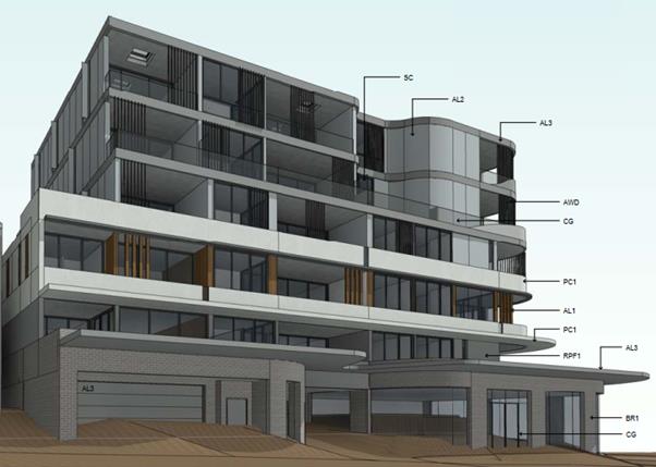
Figure 1
– Perspective of the proposed development as viewed from the Railway
Parade frontage, looking north. Noted on the ground floor is the basement
parking entry to the left of frame, the pedestrian entry to the centre and the
commercial premises to the right of frame which wraps around the corner of
Railway Parade and Ellen Subway. Located above the ground floor are five levels
of residential accommodation.
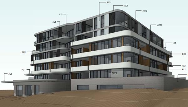
Figure 2 -
Perspective of the proposed development as viewed from the Ellen Subway
frontage, looking south-west. Noted on the ground floor is the commercial
premise to the left of frame which wraps around the corner to the Railway
Parade frontage. The openings to the right of frame at the ground floor level
are to the upper level of the parking area. Located above the ground floor is
five levels of residential accommodation. Noted in this image is the contour of
the embankment to the Ellen Subway frontage which is to be maintained as per
the recommendation of the Design Review Panel.
HISTORY
28. The
following provides a brief outline as to the history of the subject DA:
08/09/2017 Subject
DA, being DA2017/0398 lodged with Georges River Council (GRC).
18/09/2017 Application
notified for a 14-day period from 18 September 2017 until 2 October 2017. One
(1) submission was received on 21 September 2017, objecting to the proposal.
13/10/2017 Design
Review Panel (DRP) meeting held. The recommendation from the meeting was that
the application be supported, subject to a number of issues being resolved
– refer to detailed discussion later in this report.
21/11/2017 Request
for additional information sent to the applicant raising the following issues:
- Consideration
of site amalgamation with the adjoining property at 1 Ellen Subway.
- Deletion of the
balcony area off Bedroom 2 of Unit 106.
- Building above
the ground floor to be setback from the south-western boundary.
- A minimum 6m
setback is to be provided to ensure a more pronounced podium.
- The break in
the building between Unit 101 and 109 is to be increased.
- The commercial
area layout was considered not to provide a high level of usability, and also
should be enlarged.
- Privacy
concerns from balconies off Units 401, 402 and 403 and the impact to the future
building to be located at 1 Ellen Subway.
- Consideration
for additional deep soil area.
- Fire booster
doors open up onto the Council verge area of Railway Parade.
- No structures
to be built outside of the property boundaries.
- Manoeuvrability
concerns with visitor space 05-08 on Basement 1 level.
26/04/2018 Request
received from Sydney Trains for a formal referral to be made by Council
pursuant to Clause 86 of State Environmental Planning Policy
(Infrastructure) 2007. A referral was made and received by Sydney
Trains on 27 April 2018.
10/05/2018 “Stop
the Clock” letter issued by Sydney Trains until information is submitted
relating to excavation, structural design and associated information.
11/05/2018 “Stop
the Clock” letter issued by Sydney Trains forwarded to the applicant.
28/06/2018 Amended
and additional information provided in response to the minutes from the 13
October 2018 DRP meeting and the request for additional information dated 21
November 2017.
Reference
should be made to the detailed assessment under SEPP65 for the responses to the
DRP assessment.
The
following provides a response to the additional information request raised by
Council on 21 November 2017:
- The applicant
has advised that as per their discussion with Council officers, site
amalgamation will not be perused with the adjoining property at 1 Ellen Subway,
Mortdale. While it may be argued that better urban design outcomes could be
achieved with site amalgamation, there is no specified site amalgamation
requirements for the subject site or adjoining land under the provisions of
Appendix 3 - Site Amalgamation for RFB Development with Part C
‘Residential’ of the KDCP2013. It is also noted that there are no
minimum allotment dimension or size requirements under the relevant planning
controls that are offended by the proposed development. Given the proposal is
generally capable of satisfying the relevant planning provisions, it is
contended there is no site amalgamation/isolation issue with the subject site.
- The balcony
area off Bedroom 2 of Unit 106 has been removed as part of the latest plan
amendments by the applicant as requested by Council.
- The building
has not been setback from the south-western boundary has had been requested by
Council in the additional information letter. The applicant refers to previous
discussions on this matter with Council officers.
- There has been
no change to the setbacks to create a more pronounced podium as had been
requested by Council.
- Regarding the
break in the building between Unit 101 and 109 being increased, the applicant
has responded by commenting that the aforementioned break is provided to allow
natural light to the residential lobby on the upper levels of the same
building, and that there are no windows between these units along this
interface that would otherwise trigger any sensitivity associated with the
visual privacy and building separation requirements of the Apartment Design
Guide (ADG).
- In response to
Council’s request for improved size and usability of the commercial area,
the applicant has noted that the commercial area has been amended due to the
relocation of the pedestrian and vehicular access. The commercial area now
occupies the corner of the development in a ‘square’ form with
shopfront glazing from three sides to maximize activation and promote
flexibility of usage to the occupants. It is noted however that the size of the
commercial area has not changed. On this point it is noted that the size of the
commercial area does not offend any specific planning controls.
- Regarding the
privacy concerns from balconies off Units 401, 402 and 403, the applicant has
noted that the setback of 6m (from balcony) and 9m (from building wall) to the
northern boundary on Level 4 has been provided as per ADG requirement.
Additionally, the applicant has noted that the 1.4m depth of planters and also
screens to Unit 401, 402 and 403 will assist in the protection of privacy to
future tenants.
- No additional
deep soil area is provided despite Council’s request. Despite this, the
applicant notes that landscaping with 1.5m planters are provided along the
western boundary.
- The fire booster
doors have now been relocated to open within the subject site as per
Council’s request.
- The applicant
notes that given the pedestrian and vehicular access has been relocated from
Ellen Subway to Railway Parade, there are no longer any structures located
within the embankment of Ellen Subway.
- The applicant
has now provided a turning bay next to the visitors car bays in Basement 1 to
allow cars to manoeuver and exit when the parking is fully occupied.
09/07/2018 Referral
made to Sydney Trains.
12/07/2018 Amended
information re-notified for a 14-day period from 12 July 2018 until 26 July
2018. One (1) submission was received in response to this notification.
29. A
review of GRC’s online DA tracking website has not identified any DAs
lodged on the subject site prior to the lodgement of the subject application.
30. A
review of neighbouring allotments has revealed DA2017/0520 is currently under
assessment by GRC for the demolition of existing structures and construction of
seven (7) storey mixed use development at 1 Ellen Subway, Mortdale – see
discussion later in the assessment report for further details on this adjoining
DA.
DESCRIPTION OF
THE SITE AND LOCALITY
31. The
subject site has a street address of 85 - 87 Railway Parade, Mortdale, and is
formally known as Lot 7 Sec. 1 in Deposited Plan 1884, Lot 8 in Deposited Plan
456956, and Lot 1 in Deposited Plan 171157.
32. The
combined area and dimensions of the subject site are as follows:
|
Site Area
|
1367.2sqm
|
|
Frontage to Railway Parade
|
34.44m
|
|
Frontage to
Ellen Subway
|
38.99m
|
|
Rear northern
boundary
|
27.43m
|
|
Side western
boundary
|
44.195m
|
33. The
subject site is located on the south western corner of Ellen Subway being the
corner of Railway Parade and Ellen Subway, being is approximately 30m south of
the Mortdale Railway Station and the T4 Eastern Suburbs and Illawarra Line.
34. At
the eastern edge of the subject site is Lot 1 in Deposited Plan 171157 which is
at the corner of Railway Parade and Ellen Subway. Located in the middle of the
three allotments is 85 Railway Parade which includes a single storey brick
house with a tiled roof. Adjoining to the west is 87 Railway Parade which
includes a two storey brick house with a tiled roof, and a detached garage at
the rear of the site with vehicle access off Railway Parade.
35. The
subject site comprises mostly garden plants and shrubs, and is generally clear
of any significant trees, except for an 8m high Jacaranda tree located within
the north-eastern rear corner of 85 Railway Parade. Adjoining the subject site
within the verge of Ellen Subway is a 9m high White Cedar tree which has a 12m
canopy spread that encroaches upon the eastern portion of the subject site.
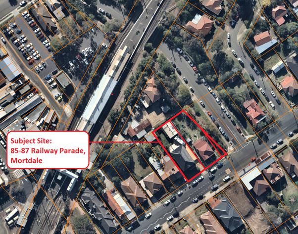
Figure 3
– Aerial photograph depicting the subject site and surrounds at 17 July
2018. Noted in this image is the proximity of the subject site to the Mortdale
railway station to the north-west, and the associated T4 Eastern Suburbs &
Illawarra Line. Beyond to the north-west is the Mortdale neighbourhood centre.
Immediately adjacent to the north and west is land also zoned B2 Local Centre
under the KLEP2012. Opposite the site to the south and east is land zoned R2
Low Density Residential.
36. Adjoining
the subject site to the north is 1 Ellen Subway, Mortdale. This land contains a
two-storey brick dwelling and carport, and also a single storey building with
other small structures. This land is accessed via Ellen Subway. Currently under
assessment by GRC is DA2017/0570 for the demolition of these existing
structures and construction of a seven (7) storey mixed use development with
basement car parking.
Figure 4
– Perspective image of the proposed residential flat building current
under assessment by GRC on the neighbouring land to the north at 1 Ellen
Subway, Mortdale (DA2017/0570). This development adjoins the T4 railway line
and the rear boundary of the subject site. The proposal is for demolition of
existing structures and construction of seven (7) storey mixed use development
with basement carpark.
37. Adjoining
to the south west of the subject site is land at 89 Railway Parade Mortdale.
This land currently includes a two storey semi-detached brick dwelling house. A
double garage presents to the street and vehicular and pedestrian access is
from Railway Parade.
38. Immediately
opposite the site, within Railway Parade Mortdale being land at 116 and 118
Railway Parade. This land includes a pair of mixed use buildings comprising a
commercial and residential component. The building at 118 Railway Parade is a
two storey structure, with the commercial component occupying the ground floor
and the residential component provided as shop-top housing. The building at 116
Railway Parade is a single storey structure with the commercial component
fronting the street at ground level and the residential component situated at
the rear. Both buildings have an awning extending over the Railway Parade
footpath.
39. To
the east of the site at 83 Railway Parade, on the opposite side of Ellen
Subway, is a single storey brick cottage with vehicular access from Rosemont
Avenue. A single bathroom window is located on the south western elevation of
the cottage that faces the subject site, and a timber paling fence extends the
length of the south western property boundary. Substantial vegetation is
situated along the verge between 83 Railway Parade and Ellen Subway and is
known as Ellen Subway Gardens (Rosemont Avenue Reserve).
Figure 5
– View of the subject site from the corner of Railway Parade and Ellen
Subway looking northwest. Noted in this image is the two-storey brick dwelling
at 87 Railway Parade to the left of frame, the single storey brick dwelling to
the centre of the frame, and the triangular vegetated allotment adjacent to Ellen
Subway which includes the White Cedar tree which has a canopy spread that
encroaches upon the eastern portion of the subject site – the tree is
without foliage given it is deciduous and the photograph was captured in July
2018.
Figure 6 - View
of the subject site from the southern side of Railway Parade looking north east
across the site’s frontage to Railway Parade. Noted in this image is the
two storey dwelling at 89 Railway Parade to the far-left of frame, two storey
brick dwelling at 87 Railway Parade to the centre-left of frame, the single
storey brick dwelling to the centre-right of frame, and brick cottage on the
opposite side of Ellen Subway to the far right of frame.
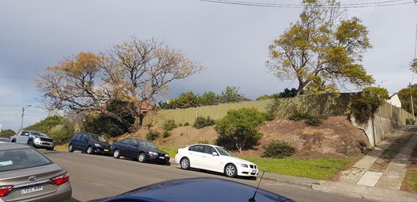
Figure 7 - View
of the subject site from the eastern side of Ellen Subway looking south-west to
the secondary street frontage of the site to Ellen Subway. Noted is the
Colorbond fence to 85 Railway Parade, and the land between the Colorbond fence
and Ellen Street largely comprising of Lot 1 in DP 171157 which also forms part
of the subject site except for a small portion adjacent to the driveway at the
right of frame which is Lot 1 DP 171156.
Figure 8
– Image of the dwelling house located at 85 Railway Parade captured from
the footpath of Railway Parade looking north.
Figure 9
– Image of the dwelling house located at 87 Railway Parade captured from
the footpath of Railway Parade looking north.
Figure 10 - Two
storey semi-detached brick dwelling house with the double garage presenting to
the street at 89 Railway Parade. Image captured from Railway Parade looking
north.
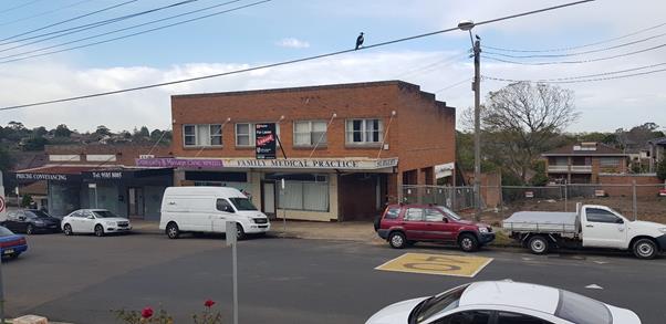
Figure 11
– Image of the mixed use buildings opposite the subject site on the
southern side of Railway Parade at 116 and 118 Railway Parade. Image captured
from the northern side of Railway Parade looking south.
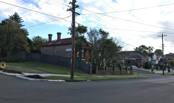
Figure 12
– image of the dwelling house/cottage on the opposite corner of the
subject site at 83 Railway Parade. Image captured from the southern side of
Railway Parade looking north east.
APPLICABLE
PLANNING CONTROLS
· Greater Metropolitan
Regional Environmental Plan No 2 – Georges River Catchment
· State Environmental
Planning Policy (Infrastructure) 2007
· State Environmental
Planning Policy No 55 - Remediation of Land
· State Environmental
Planning Policy No 65 – Design Quality of Residential Apartment
Development
· State Environmental
Planning Policy (Building Sustainability Index: BASIX) 2004
· State Environmental
Planning Policy (Vegetation in Non-Rural Areas) 2017
· Draft Environment State
Environmental Planning Policy
· Kogarah Local
Environmental Plan 2012
· Hurstville Local
Environmental Plan 2012
· Kogarah Development
Control Plan 2013
· Apartment Design Guide
PLANNING
ASSESSMENT
40. The
site has been inspected and the proposed development has been assessed under
the relevant Section 4.15(1) "Matters for Consideration" of the Environmental
Planning and Assessment Act 1979 (the Act).
Environmental Planning
Instruments
Kogarah Local
Environmental Plan 2012
Zoning
41. The subject site is zoned
Zone B2 Local Centre under the provisions of the Kogarah Local
Environmental Plan 2012 (KLEP2012). Refer to zoning map extract below
Figure 13
– Zoning map extract from the KLEP2012 demonstrating the subject
site is located within the B2 Local Centre zone. Within the B2 zone, mixed use
development for the purposes of shop-top housing is permitted with consent.
42. The objectives of the B2 zone are as
follows:
- To
provide a range of retail, business, entertainment and community uses that
serve the needs of people who live in, work in and visit the local area.
- To
encourage employment opportunities in accessible locations.
- To
maximise public transport patronage and encourage walking and cycling
43. The
proposed development is capable of
achieving consistency with the objectives of the B2 zone as it will provide for
a mix of both commercial and residential land uses within an accessible
location to the nearby Mortdale Railway Station. Additional, employment
opportunities will arise from the proposed commercial area on the ground floor
of the building.
44. The
extent to which the proposal complies with the relevant standards of Kogarah
Local Environmental Plan 2012 (KLEP2012) is outlined in the table below.
|
Clause
|
Standard
|
Proposed
|
Complies
|
|
Part 2 – Permitted or
Prohibited Development
|
B2
Local Centre
|
The proposal being shop top housing
and commercial premises are permissible forms of development with Council's
consent.
|
Yes
|
|
|
Objectives of the Zone
|
Consistent with zone objectives
|
Yes
– see comments above
|
|
4.3 – Height of Buildings
|
21m as identified on Height of
Buildings Map
|
Proposal measures a maximum of 21m
at the lift overrun.
|
Yes
|
|
4.4 – Floor Space Ratio
|
2.5:1 as identified on Floor Space
Ratio Map
|
2.558:1, 2.32% variation to the
standard.
|
No
– see comment below
|
|
4.5 – Calculation of floor
space ratio and site area
|
FSR and site area calculated in
accordance with Cl.4.5
|
Noted.
|
Noted
|
|
5.10 – Heritage Conservation
|
The objectives of
this clause are;
(i) to conserve the environmental
heritage of Kogarah,
(ii) to conserve the heritage
significance of heritage items and heritage conservation areas, including
associated fabric, settings and views.
|
The site is within the vicinity of
the Mortdale Railway Station and car sheds, which is listed as an item (I71)
of State significance within the Hurstville Local Environmental 2012. Council
has not required a heritage impact assessment and considered that the
proposal is unlikely to result in any undue impacts on the nearby item.
Notably, a DA is currently under
assessment at 1 Ellen Subway
The DA was referred to
Council’s Heritage officer for comment who has recommended support of
the proposal – refer to detailed heritage response in the referrals
section later in this assessment report.
|
Yes
|
|
6.2 Earthworks
|
To ensure that earthworks do not
have a detrimental impact on environmental functions and processes,
neighbouring uses, cultural or heritage items or features of the surrounding
land
|
The proposed earthworks are
considered acceptable having regard to the provisions of this clause as the
works are not likely to have a detrimental impact on environmental functions
and processes, neighbouring uses, cultural or heritage items or features of
the surrounding land.
|
Yes
|
Clause 4.6
Exceptions to development standards
45. Clause
4.4 of the KLEP2012 prescribes that the maximum floor space ratio (FSR) for a
building is not to exceed the FSR shown for the land on the FSR Map. The FSR
Map for the subject site under the KLEP2012 indicates a maximum FSR of 2.5:1.
46. The
subject site has a combined site area of 1,367.2sqm, which means the maximum
gross floor area (GFA) for buildings on the land is 3,418sqm. As part of the
documentation submitted with the DA, the applicant has provided GFA calculation
diagrams, and the information within these diagrams indicates that the proposal
is compliant by less than 1sqm, with a total GFA of 3,417.57sqm.
47. However,
the GFA diagrams also show that relevant elements have been excluded from this
calculation, and therefore the proposal has been assessed as being
non-compliant with the FSR standard. It is estimated that the total proposed
GFA is approximately 3,498sqm, which would equate to a non-compliant FSR of
2.558:1 and would represent a 2.32% variation to the FSR development standard
under clause 4.4 of the KLEP2012.
48. The
estimated 80sqm discrepancy between the applicant’s GFA calculation of
3,416.68sqm and the DA assessment planner’s calculation of approximately
3,498sqm appears to relate to the following building components:
- Residential
and commercial waste rooms on the ground floor of the building have been
excluded from the GFA calculation as outlined in part (e) of the GFA
definition, only garbage areas in a ‘basement’ are excluded from
the GFA calculation. The aforementioned waste rooms are not within the
‘basement’ as per the definition contained within the Dictionary of
the KLEP2012. This is because the floor level of the storey immediately above
the garbage rooms is not less than 1m above ground level (existing), but is in
fact several metres above the ground level (existing).
- The
pedestrian access to the WC on the ground floor has not been included within
the GFA definition, despite there being no apparent reason to exclude this when
having regard to the GFA definition.
- The
proposal includes a surplus of one (1) residential car parking space over that
of the requirements of the consent authority. Per part (g) of the GFA
definition, car parking to meet any requirements
of the consent authority (including access to that car parking) is excluded
from the GFA definition.
49. The
applicant has provided a formal written clause 4.6 request dated 8 August 2018,
of which is attached to this report, a synopsis of the justification is
outlined below:
Lot size –
1,367.2sqm
Permitted FSR
2.5:1 – 3,418sqm
Proposed FSR
– 3,470.2sqm being a variation 1.53% or 52.42sqm
The excess floor
space relates to the waste enclosure located above ground level.
Conclusion:
This written
request has been prepared in relation to the proposed variation to the FSR development
standard contained in KLEP 2012.
Despite the
non-compliance with the standard, the proposed FSR and subsequent form are
compatible with the emerging character of the locality as anticipated by the
changes to the height and FSR development standards.
It is important
to note that the building density variation is not a by-product of
non-compliant development height as there is no calculable gross floor area
that exceeds the height limit. Rather, the resultant density increase is a
result of the waste enclosure being located at the ground level rather than
within a basement and therefore not excluded from GFA.
The proposal
represents the first major redevelopment of land in the Mortdale Precinct south
of the rail corridor and will establish an appropriate pattern of development.
The mixed-use development will have no significant adverse impact on the
amenity of adjoining or nearby properties and will offer a substantial level of
internal amenity for future residents in a highly accessible location.
The proposal
provides for 40 new high-quality dwellings and new commercial floor space in
the Georges River Local Government Area and therefore assists in meeting the
housing and commercial needs of the community needs of the community. The
commercial floor space proposed is proximate to the existing Mortdale Town
Centre and will support ongoing economic activity in the locality. The floor
space is function in terms of its layout, attractive due to its exposure and
visibility from Railway Parade and Ellen Subway, and will conceivably
accommodate a broad range of commercial and business uses. This aspect of the
development will create new employment opportunities and will undoubtedly have
a positive economic impact.
The request
explains that, with the proposed variation, the development satisfies the
objectives of the standard and the objectives of Zone B2. It further explains
why it is therefore unreasonable and unnecessary to require strict compliance
with the FSR development standard. In addition, this request demonstrates that
there are sufficient site specific environmental planning grounds to justify
the variation, and therefore the proposal is considered to be in the public
interest.
50. The
request for a variation to the floor space ratio development standard in the
circumstances of the case is supported for the following reasons:
- None of
the GFA identified above constitutes residential apartments or commercial floor
area of the building, and such, the applicant is not unduly benefiting from the
FSR non-compliance through additional apartments or commercial spaces.
- The GFA
variation is largely a technical non-compliance that has largely come about
through strict application of the relevant definitions within the Dictionary of
the KLEP2012 that are unsympathetic to site anomalies, such as the varying
topography of the land. Although these areas are located on a ‘ground
level’, the gradual slope down to the commercial corner results in the
areas away from the corner moving closer towards meeting the definition of the
basement level. The areas listed above are located part way through this level,
and their finished floor levels are well below the existing ground levels of
the site.
- A reason
why the garbage rooms are not considered ‘basement’ despite their
floor level being almost 2m below existing ground level, is because of the
higher ceiling heights required on the ground floor of shop top housing
development that see the floor level of the storey immediately above the
garbage rooms being more than 1m above ground level (existing).
- The areas
of non-compliance are internal to the building, and do not include windows that
would overlook adjoining property, nor do these parts of the building
contribute to increased overshadowing etc.
- It is contended
that irrespective of the numerical non-compliance with the FSR development
standard, the objectives of the development standard and also the B2 zone are
still achieved.
- In the
circumstances of the above, it would likely be in the public interest for the
consent authority to permit the minor 2.32% variation of the control.
51. Given
the above, it is recommended that the clause 4.6 variation to the FSR
development standard be supported in the circumstances of this case.
Environmental
Planning and Assessment Regulations 2000
52. The proposed
development satisfies the relevant matters for consideration under the
Regulations.
State
Environmental Planning Policies
Greater Metropolitan Regional Environmental
Plan No 2 – Georges River Catchment
53. The
site is within the area affected by the Greater Metropolitan Regional Environmental Plan No 2 — Georges River Catchment. The
proposal, including the disposal of stormwater, is considered to be consistent
with Council's requirements for the disposal of stormwater in the catchment.
54. All
stormwater from the proposed development will be managed by the proposed
stormwater system and will be treated in accordance with Council’s Water
Management Policy and would therefore satisfy the relevant provisions of the
Deemed State Environmental Planning Policy – Georges River Catchment.
State Environmental Planning
Policy (Infrastructure) 2007
55. Divisions
5 (Electricity Transmission or Distribution) and 17 (Roads and Traffic) of the State
Environmental Planning Policy (Infrastructure) 2007 (ISEPP) are not
applicable to the proposal. There is no information to indicate that an
external referral to the relevant energy supply authority was required in
accordance with clause 45 of the ISEPP. The proposal does not constitute
“Traffic generating development”, thus a referral was not made to
Roads and Maritime Services (RMS).
56. Division
15 (Railways) of the ISEPP is however applicable to the site as pursuant to
clause 86(1) it is within 25m of a rail corridor. As required by clause
86(2), a referral was made to the Rail Authority
(Sydney Trains) on 26 April 2018; a response was received on 10 May 2018 with
the rail authority issuing a “Stop the Clock” letter until
information was provided by the applicant.
57. As
per clause 86(3) of the ISEPP the consent authority must not grant consent to
development to which this clause applies without the concurrence of the rail
authority for the rail corridor to which the DA relates.
58. Sydney
Trains have not provided comments at the time of preparation of this report 8
August 2018.
State Environmental Planning
Policy No 55 - Remediation of Land
59. A
review of the site history indicates that the site has been used for
residential purposes for extended periods of time, and
such uses and/or development are not typically associated with activities that
would result in the contamination of the site. Further to the site
review, submitted information and site inspections did not identify evidence of
contamination. With consideration to the above, and assuming that recommended
consent conditions and are satisfied in the event of an approval, it is
unlikely that the site is contaminated and the site would therefore be suitable
for the proposed development.
State Environmental Planning
Policy (Building Sustainability Index: BASIX) 2004
60. BASIX
Certificate No. 852364M_02 dated 8 August 2018 has been issued for the proposed
development.
State Environmental Planning
Policy (Vegetation in Non-Rural Areas) 2017
61. The
objectives of the SEPP are to protect the biodiversity values of trees and
other vegetation in non-rural areas and preserve the amenity of non-rural areas
through the preservation of trees and other vegetation. This policy applies
pursuant to Clause 5(1) of the SEPP as the site is within both Georges River
Council and the B2 Local Centre zone. Pursuant to Clause 8(1) of the SEPP,
clearing does not require authority under the policy as it is a type of
clearing that is authorised under Section 60O of the Local Land Services Act
2013 (specifically, that associated with a development consent issued under
Part 4 of the Environmental Planning and Assessment Act 1979).
State Environmental Planning Policy No 65—Design Quality of
Residential Apartment Development
62. State
Environmental Planning Policy No.65 – Design Quality of
Residential Flat Buildings (SEPP 65) was gazetted on 26 July 2002 and
applies to the assessment of DAs for residential flat developments of three or
more storeys in height and containing at least four dwellings. Amendment 3 to
SEPP 65 commenced on 17 July 2015 and implemented various changes including the
introduction of the Apartment Design Guide (ADG) to replace the Residential
Flat Design Code. Given the nature of the development proposed, SEPP 65 applies.
63. Clause
28(2) of SEPP65 requires that the consent authority take into consideration the
following as part of the determination of DAs to which SEPP 65 applies:
a) the advice (if any) obtained from the design review panel, and
b) the design quality of the development when evaluated in accordance
with the design quality principles, and
c) the Apartment Design Guide.
64. The
following provides a comment in relation to items a) and b) above. An
assessment against c) is contained within Attachment A.
65. The
DA was assessed by the Design Review Panel (DRP) at a meeting held on 13
October 2018 having regard to each of the nine (9) Design Quality Principles.
66. In
their report, the DRP recommends support of the application, subject to the
issues raised within their Report being resolved.
67. It
is noted that the DRP indicates that the application satisfied the design
quality principles contained within SEPP65.
68. The
issues raised by the DRP are covered below, followed by a comment on how they
have been resolved:
|
SEPP 65
– Design Quality of Residential Flat Buildings
|
DRP
Comment
|
Planner
Comment
|
|
Context and Neighbouring Character
Good design
responds and contributes to its context. Context is the key natural and
built features of an area, their relationship and the character they
create when combined. It also includes social, economic, health and
environmental conditions.
Responding
to context involves identifying the desirable elements of an area’s
existing or future character. Well designed buildings respond to
and enhance the qualities and identity of the area including the adjacent
sites, streetscape and neighbourhood.
Consideration
of local context is important for all sites, including sites in established
areas, those undergoing change or identified for change.
|
The site is
located in an area recently rezoned B2 with a permissibly density of 2.5:1
and a height of 21m. It would be the first site to be redeveloped in the
block bounded by Ellen Subway, Railway Parade and the railway to the north.
Ellen Subway to the south of the railway underpass has wide nature strips on
both sides with extensive planting and adjacent to the subject site is a very
attractive and significant tree (Melia azedarach – Native white
cedar), which should be conserved.
Vehicular
access to the subject site and the adjoining site to the north is a critical
issue and desirably both should be served by only a single cut through the
existing embankment. Note that the ownership of the embankment is unclear and
owners consent will be necessary.
The site
adjoins Railway Parade to the south which offers the potential for commercial
frontages on this site and the adjoining sites in the block. This also
appears to be the obviously desirable location for the pedestrian entrance.
|
Noted. A DA
has also subsequently been lodged for the adjoining site to the north at 1
Ellen Subway, Mortdale for the demolition of existing structures and
construction of seven (7) storey mixed use development.
Regarding
the native White Cedar located on the Ellen Subway frontage, it is noted that
the applicant has relocated the access driveway to the development to the
Railway Parade frontage and included a ‘cut-out’ in the basement
to accommodate the retention of the tree as per the DRP request.
The
application has been referred to Council’s Tree Management Officers who
have confirmed retention of the tree is capable, subject to the imposition of
consent conditions.
Acknowledging
the critical nature of vehicular access along the Ellen Subway frontage, the
applicant has relocated the vehicular entry to the Railway Parade frontage.
A commercial
tenancy to the Railway Parade frontage has been included in the amended
plans. This wraps partially around to the Ellen Subway frontage but not so
far as to impact on the existing significant vegetation.
The
pedestrian entry to the building has been positioned on the railway parade
frontage as recommended by the DRP. This would leave only the single
cut-through of the existing embankment to accommodate parking for the
adjoining development at 1 Ellen Subway, Mortdale as recommended by the DRP.
With the
vehicular access moved to the Railway Parade frontage, this would also
ameliorate land ownership concerns raised by the DRP over what was presumably
the wedge shaped lot at Lot 1 in DP 171156.
|
|
Built
Form and Scale
Good design
achieves a scale, bulk and height appropriate to the existing or desired
future character of the street and surrounding buildings.
Good design
also achieves an appropriate built form for a site and the building’s
purpose in terms of building alignments, proportions, building type,
articulation and the manipulation of building elements.
Appropriate
built form defines the public domain, contributes to the character
of streetscapes and parks, including their views and vistas, and
provides internal amenity and outlook.
|
The form
and scale is generally appropriate for the new increased density development
of the area. However the strong white horizontal bands of the lower three (3)
storeys should be made less dominant and relate more sympathetically to this
context.
The
following issues should be addressed:
- Vehicular
entry and basement construction should be located in a way which ensures that
there be no adverse impact on the important tree, and the
attractive character of the landscaped public property.
- Future
vehicular access to the adjacent site to the north must be resolved as part
of this development, desirably with shared access through this site.
Council should condition approval for the subject development to ensure that
this access will be protected to serve the adjoining site as well.
- Pedestrian
entrance should be relocated to the Railway Parade frontage
- The
Panel recommends that amenities be provided to support the communal space on
the roof garden. This should attempt to conform where possible with the
height and floor space ratio.
|
The comments
from the DRP noting the form and scale of the development being generally
appropriate for the area are noted.
Regarding
the comments from the DRP on the ‘strong white horizontal bands of the
lower three (3) storeys’, these have since been made less dominant via
the applicant’s amended plans in the following manner:
- The
horizontal bands have been reduced from 4 storeys to 3 storeys to relate to
the lower density dwellings along Railway Parade.
- The
overall bands are divided with series of slots to reduce the length of the
balustrade as well as introduction of vertical screens to balance the
horizontality of the balconies.
The
vehicular entry has been relocated to the Railway Parade frontage to address
previous impact on the White Cedar tree on the Ellen Subway frontage, and
increase opportunities for landscaping on the Ellen Subway frontage.
Given the
location of the vehicular entry has changed to the Railway Parade frontage;
there is no need to include a shared vehicular access to the adjoining development
currently under consideration by Council at 1 Ellen Subway. The outcome of
this arrangement will still ensure only one cut-through of the embankment is
proposed, and this will be located in a position that is in the vicinity of
the existing vehicular access cut-through for 1 Ellen Subway.
The
pedestrian entry has been relocated to the Railway Parade frontage as
requested by the DRP.
The roof
top communal open space is claimed by the applicant to include a child play
area to better support the use of this space for different age groups.
However this is not reflected on the drawings. A condition requiring this is
imposed.
|
|
Density
Good design
achieves a high level of amenity for residents and each apartment, resulting
in a density appropriate to the site and its context.
Appropriate
densities are consistent with the area’s existing or projected
population. Appropriate densities can be sustained by existing or proposed
infrastructure, public transport, access to jobs, community facilities and
the environment.
|
Compliant
and acceptable
|
Noted.
|
|
Sustainability
Good design
combines positive environmental, social and economic outcomes.
Good
sustainable design includes use of natural cross ventilation and sunlight for
the amenity and liveability of residents and passive thermal design
for ventilation, heating and cooling reducing reliance on technology and
operation costs. Other elements include recycling and reuse of materials and
waste, use of sustainable materials and deep soil zones for groundwater
recharge and vegetation.
|
Subject to
BASIX
|
Noted. A
revised BASIX certificate has been provided.
|
|
Landscape
Good
design recognises that together landscape and buildings operate as
an integrated and sustainable system, resulting in attractive developments
with good amenity. A positive image and contextual fit of well
designed developments is achieved by contributing to the landscape
character of the streetscape and neighbourhood.
Good
landscape design enhances the development’s environmental performance
by retaining positive natural features which contribute to the local
context, co-ordinating water and soil management, solar access,
micro-climate, tree canopy, habitat values and preserving green
networks.
Good
landscape design optimises useability, privacy and opportunities
for social interaction, equitable
access, respect for neighbours’ amenity and
provides for practical establishment and long term management.
|
As
mentioned above, the existing embankment and trees along Ellen Subway are a
valuable landscape asset that should be retained, protected and
enhanced. To this end, and as mentioned above, the existing landform and
significant vegetation must be retained and protected, including from
any constraint that this development places on future development of
adjoining sites. The tree protection zone for the existing Melia sp.
should be calculated, mapped and protected.
Any level
changes between the development and the existing levels along Ellen Subway
should be handled via thoughtful landscape initiatives in preference
to built structures or retaining walls.
In
addition, the street landscape in front of the adjacent site to the north
must be conserved and therefore considered in the design of this site.
Street tree
planting should be provided to Railway Parade and Ellen Subway.
The
proposed floor level of the commercial space is not apparent in the drawings
provided however any grading required to ensure accessibility from the
footpath must occur within the property boundary.
A program
of use that considers the likely recreational needs of residents should be
developed for the roof top communal open space. This may include separate
areas for group gatherings, solitary pursuits, or children’s play. A
small kitchenette and wc facilities should be provided. The design should
eliminate any small, non-functional spaces.
Access must
be provided to the ‘pebble roof’ on level 1 for maintenance.
There may be opportunity to provide greening of the north facing wall in this
area.
The
super-sized balconies require planter boxes to delineate private open space,
provide an appropriate sense of scale, and screen along the property
boundary.
The reason
for the ‘nature strip’ adjacent to the commercial frontage on
Railway Parade is unclear – see architectural plan DA1103. The Railway
Parade streetscape must be more fully resolved including levels, paving,
landscape, any street furniture, lighting, etc.
|
The
proposal now includes the vehicular and pedestrian access points on the
Railway Parade frontage, meaning that pressure on the landscaped outcome for
Ellen Subway has been largely ameliorated. A revised landscape plan has not
been submitted to Council however, given the critical nature of the
building’s presentation to Ellen Subway the application will be
conditioned that a detailed landscape plan be provided prior to the issue of
a Construction Certificate. It is recommended that a condition be included
whereby an updated landscape plan is provided prior to the issue of a
Construction Certificate.
As outlined
above, the revised landscape plan is considered necessary for the proposed
DA, and this should include details on any level changes adjacent to the
Ellen Subway frontage.
The amended
proposal maintains a deep soil area along the northern boundary with a
minimum width of 3m.
The revised
landscape plan is to include the proposed street tree planting in accordance
with Council’s specifications.
The
applicant details a children’s play area and BBQ space has now been
included on the rooftop terrace as recommended by the DRP, however this is
not reflected on the plans.
This will
help facilitate use of the space by a wider age group. The applicant has
noted that a WC is provided on the ground level which is accessible via the
lift from the rooftop.
A maintenance
access door has been provided to enable access to the ‘pebble
roof’ on Level 1 of the building as per the DRP recommendations.
The large
balconies on Level 4 of the building now include planter boxes to help define
the edge of the building, and provide some screening to the property
boundary. Planter boxes are also proposed for the extent of the rooftop area
that does not comprise of the communal open space area.
Given no
amended landscape plan has been provided, there is still no detailing of the
nature strips in front of the commercial premises on Railway Parade. As such,
it is recommended a condition be included that details be provided with the
Construction Certificate.
|
|
Amenity
Good design
positively influences internal and external amenity for residents
and neighbours. Achieving good amenity contributes to positive living
environments and resident well being.
Good
amenity combines appropriate room dimensions and shapes, access to sunlight,
natural ventilation, outlook, visual and acoustic privacy, storage, indoor
and outdoor space, efficient layouts and service areas and ease of access for
all age groups and degrees of mobility.
|
The
following issues should be addressed:
- The
narrow natural light slot. See comments above under
‘Landscape’ – greening of this pebble roof might be
considered.
- Balconies
should be provided with screening to ensure privacy and protection from
strong winds, particularly corner balconies.
- Provide
screening and protection to bedroom windows.
|
The pebble
roof remains as such on Level 1. Opportunities to landscape this have not
been included in the amended plans, nor has this matter been appropriately
responded to the applicant.
Screening
has now been provided to all balconies. The corner balconies are protected with
solid balustrades from privacy and wind impact.
|
|
Safety
Good design
optimises safety and security within the development and the public domain.
It provides for quality public and private spaces that are clearly defined
and fit for the intended purpose. Opportunities to maximise passive
surveillance of public and communal areas promote safety.
A positive
relationship between public and private spaces is achieved through clearly
defined secure access points and well lit and visible areas that are easily
maintained and appropriate to the location and purpose.
|
Satisfactory
|
Noted.
|
|
Housing
Diversity and Social Interaction
Good design
achieves a mix of apartment sizes, providing housing choice for different
demographics, living needs and household budgets.
Well
designed apartment developments respond to social context by providing
housing and facilities to suit the existing and future social mix.
Good design
involves practical and flexible features, including different types of
communal spaces for a broad range of people and providing opportunities for
social interaction among residents.
|
Satisfactory
Consider
however proximity to the railway station and nearby schools.
|
Noted.
The proposed
development is within close proximity of the Mortdale railway station and
Mortdale neighbourhood centre. The apartment mix proposed is not considered
to respond poorly to this, and a good mix of dwellings sizes is included.
|
|
Aesthetics
Good design
achieves a built form that has good proportions and a balanced composition of
elements, reflecting the internal layout and structure. Good design uses a
variety of materials, colours and textures.
The visual
appearance of a well-designed apartment development responds to the
existing or future local context, particularly desirable elements and
repetitions of the streetscape.
|
Requires
further refinement to take into account the evolving context, preferably
avoiding stark dark and white contrast.
|
The
applicant has responded through the introduction of polished concrete to the
horizontal bands signifying weathering effects on the façade, as well
as the vertical timber-looking composite cladding panelling which will
complement the existing abundance of green strips along the embankment as
well as the RE1 zoned land diagonally across the site to the north.
Blue bricks
which are applied to the ground level wall level reinforce the podium style
expression, as well as respond to the surrounding buildings which are
predominantly brick dwellings.
|
69. Having
regard to the above, it is considered the advice provided by the DRP has
generally been adopted by the applicant in the amendments to the drawings. The
only outstanding matter would be that pertaining to a revised landscape plan
which, should the DA be approved, can be addressed via the following condition:
Landscape
Plan. The submission of a revised landscape plan having regard to
the applicant’s design amendments undertaken throughout the course of the
development application assessment, in particular responding to the comments
raised by the Design Review Panel in their report dated 13 October 2017, and in
response to Council’s additional information request dated 21 November
2017. The revised landscape plan should include, but not be limited to the
following:
- The
landscape treatment of the Ellen Subway frontage, ensuring the White Cedar tree
is retained, along with the sloping nature of the embankment.
- Any
level changes between the development and the existing levels along Ellen
Subway should be handled via thoughtful landscape initiatives rather than built
structures or retaining walls.
- Detail
planting for all planter boxes proposed to ensure appropriate screening and
softening of the building. This also includes the narrow light slot where the
pebble roof is located.
- The
Railway Parade streetscape must be more fully resolved including levels,
paving, landscape, any street furniture, lighting, etc.
70. The
Apartment Design Guide (ADG) provides planning and design standards for
apartments across NSW. It provides design criteria and general about how
development proposals can achieve the nine design quality principles identified
in SEPP 65.
71. As
outlined earlier, Clause 28 of SEPP65 requires the consent authority to take
into consideration the provisions of the ADG. Contained in Attachment A is a
detailed compliance table assessment how the proposed development, as currently
amended, performs against the relevant provisions of the ADG.
72. As
demonstrated within the ADG compliance table, the proposal is satisfactory when
considered against the relevant objectives, design criteria and design guidance
for residential flat buildings.
Draft
Environmental Planning Instruments
Draft
Environment SEPP
73. The
Draft Environment SEPP was exhibited from 31 October 2017 to 31 January 2018.
This consolidated SEPP proposes to simplify the planning rules for a number of
water catchments, waterways, urban bushland, and Willandra Lakes World Heritage
Property.
74. Changes
proposed include consolidating the following seven existing SEPPs:
· State
Environmental Planning Policy No. 19 – Bushland in Urban Areas
· State
Environmental Planning Policy (Sydney Drinking Water Catchment) 2011
· State
Environmental Planning Policy No. 50 – Canal Estate Development
· Greater
Metropolitan Regional Environmental Plan No. 2 – Georges River Catchment
· Sydney Regional
Environmental Plan No. 20 – Hawkesbury-Nepean River (No.2-1997)
· Sydney Regional
Environmental Plan (Sydney Harbour Catchment) 2005
· Willandra Lakes
Regional Environmental Plan No. 1 – World Heritage Property.
75. The
proposal is not inconsistent with the provisions of this Draft Instrument.
Development
Control Plans
KOGARAH DEVELOPMENT CONTROL PLAN NO 2013 (KDCP)
Part
C1 KDCP 2013 – Development
Compliance Table
76. A
detailed assessment of the development against the relevant sections of KDCP
2013 is contained in Attachment B of this assessment report.
77. Below
is a discussion on the key non-compliances/issues with the KDCP2013.
Active
Frontages
78. Part
3.6.2 of D1 outlines requirements for active frontages within the B1 and B2
zones. The objectives of the controls are provided as follows:
a) Achieve a well designed
streetscape that engages and activates the commercial locality and contributes
to its economic viability.
b) Ensure streetscapes enhance
pedestrian safety and provide adequate lighting and opportunities for passive
surveillance.
c) Provide shopfronts and openings
that relate in scale and proportion to the new and existing neighbouring
buildings.
d) Preserve the surviving heritage
character of whole shop frontages and their elements.
e) Ensure that non-retail uses and
their entries do not detract from the retail streetscape.
f) Design buildings with
active frontages that engage and activate the centre.
79. The
proposal provides a large commercial area at the street corner, which is the
most prominent location of the site, as well as being the lowest point of the
site.
80. The
commercial area occupies approximately one-third of the Ellen Subway frontage
which is currently characterised by a continuous embankment, between the
intersection with Railway Parade and the Railway bridge further to the north. A
previous design had sought a basement entry along this frontage; however, the
Design Review Panel had considered that the streetscape would be better served
with the retention of trees within the embankment, and the maintenance of a
landscape setting within at this frontage.
81. This
is consistent with Part 3.13 of Part D1, which requires landscape buffers to
the proposed adjacent to low density residential development, an appropriate
landscape buffer is to be planted to provide separation and screening between
the proposed development and the existing low density development. Single
dwellings within the R2 Low Density Residential zone sit directly opposite the
site across Ellen Subway, and the retention of the embankment will better allow
for a landscape buffer between the higher density development at the subject
site, and the low density development on the eastern side of Ellen Subway. As a
consequence of the retention of the embankment, there is little utility in
providing an active frontage at the northern end of this frontage, as the
ground floor areas will sit behind the retained embankment.
82. The
commercial area comprises over half of the frontage to Railway Parade, with the
remainder occupied by a residential lobby, basement vehicular access, and
services (i.e. emergency egress, fire hydrant pump room, and fire booster).
Given these services cannot be located on the Ellen Subway frontage, it is
considered that the active frontages at the Railway Parade frontage is
maximised, noting that the residential lobby will also generate pedestrian
traffic, and will be visible from the street.
83. It
should be noted that the shortest pedestrian route from the site to Mortdale
Railway Station is along Railway Parade, and not Ellen Subway. It is considered
that active frontages have been optimised at this site.
Parking
84. Part
B4 and Clause 3.7 of Part D1 outline car parking requirements for the subject
development.
85. The
table below indicates the required residential parking:
|
Type
|
Required
Parking & Dwelling Mix
|
Number
of Dwellings
|
Total
Required Parking
|
|
1 Bed
|
1
|
7
|
7
|
|
2 Bed
|
1.5
|
30
|
45
|
|
3+ Bed
|
2
|
3
|
6
|
|
Total Parking
|
|
|
58
|
|
Visitor
|
1/5
|
40
|
8
|
|
Total Residential Parking
|
|
|
66
|
86. The
proposal provides a total of 67 parking spaces which is compliant with the
requirement for residential parking. One (1) additional resident parking space
is provided above that required by Part 3.7; this is discussed further within
in relation to the floor space ratio non-compliance.
87. The
proposal also complies with the minimum requirements for accessible parking,
and carwash spaces.
88. In
relation to non-residential parking, Part B4 outlines the following relevant
parking rates:
· 1
space per 25sqm for retail
· 1
space per 40sqm for commercial
89. The
calculations on the plan show that parking has been provided in accordance with
the higher retail parking rates, despite retail not being specifically
proposed. This is considered to be preferable, as it requires a greater amount
of parking, which may be necessary in the event that the use is changed to a
retail use via a complying development application. The proposal provides the 9
parking spaces (rounded up) required for the 212sqm of commercial/retail floor
space that is proposed. The proposal also provides the required loading bay.
90. Finally,
bicycle parking is required in accordance with the following:
|
Type
|
Required
|
Proposed
|
Total
Required
|
|
Bicycle - Residents
|
1/3
|
40
|
13.3
|
|
Bicycle - Visitors
|
1/10
|
40
|
4.0
|
|
Bicycle Commercial
|
1/5
|
8.5
|
0.8
|
|
Total Bicycle
|
|
|
18.2
|
91. The
proposal complies with this requirement.
Design &
Layout of Car Parking Areas
92. Part
B4 and Clause 3.7 of Part D1 also provide further guidance on the design of car
parking areas. The proposal does not comply with the following specific
requirements:
· Separate driveways
should be provided for the use of residents and service/ customer vehicles
accessing non-residential development.
· Basement car
parking is to be located within the building footprint.
· Include natural
ventilation to basement and semi basement car parking.
93. Each
of these non-compliances is considered to be acceptable as discussed below:
· The site is not
large enough to accommodate two driveways, and to do so would be to the
detriment of the streetscape, and landscaping within the street.
· The basement is
predominately located within the building footprint, with the exception of a
small portion of a basement which extends towards the Ellen Subway boundary
towards the northern corner of the site. Given the limited space available at
each level to provide parking, and the proportion of each basement level
dedicated to manoeuvring, a small encroachment outside of the footprint is
acceptable. The additional area of the basement is located away from the tree
to be retained and will not be visible from the street.
· Natural
ventilation is not provided as landscaping is provided within the area
described above. Exhaust is able to be expelled to above the roof.
IMPACTS
Natural
Environment
94. The
proposed development is unlikely to result in adverse impacts to the natural
environment. There are three (3) street tree located on the nature strip at the
front of the site with the most important of these being the White Cedar be
retained and protected. A landscape plan prepared by a qualified landscape
architect has been prepared for the development which shows appropriate deep
soil planting to the northern boundary. It is noted a condition for an updated landscape
plan has been recommended prior to the issue of a Construction Certificate
condition to ensure the landscape outcome reflects the applicant’s
amended plans, particularly with regard to the sensitive Ellen Subway frontage
and the retention of the significant White Cedar tree.
95. The
proposed excavation to the site is for the purposes of providing two basement
levels for car parking and associated facilities. The excavation is consistent
with that required for most new developments and has generally been supported
by Council’s development engineers.
Built
Environment
96. The
proposed development is unlikely to result in adverse impacts to the built
environment. The proposed development complies with the relevant requirements
except for FSR. This variation is discussed in the report and is supported by a
Clause 4.6 variation as the additional 80m² of floor area is not
considered to result in adverse impacts to adjoining developments and the
streetscape. The applicant has furnished Council with a 4.6 variation to the
Floor Space Ratio development standard. See detailed discussion earlier in this
report.
Social
Impact
97. No
adverse social impacts have been identified as part of the assessment of the
subject DA that could not otherwise be addressed by conditions of consent
should the DA be approved.
98. It
is noted that the proposal will provide for 40 new dwellings with a mix of
typology in the Georges River Local Government Area and therefore assist in
meeting the housing needs of the community. The range of dwelling sizes,
including adaptable, can cater for a cross-section of the community including a
range household compositions, and could therefore be construed as having a
positive social impact.
Economic
Impact
99. The
proposed development has no apparent adverse economic impact. There may be a
positive economic impact as a result of the development through increased
demand, and the provision of additional commercial floor space within the
Mortdale neighbourhood centre. Employment opportunities would also arise beyond
construction of the proposed development with the associated commercial
premises, and also ongoing maintenance of the building.
Suitability
of the Site
100. Should
the outstanding matters associated with Sydney Trains under the ISEPP be
addressed, the proposed development is considered capable of satisfying the
objectives and requirements of the relevant planning provisions. In this
circumstance, the subject site would be suitable for the proposed development.
DEVELOPER
CONTRIBUTIONS
101. The
proposed development requires payment of $436,286.41 of developer contributions
based on the provisions of an additional dwellings on the subject site. The
contribution amount is based on the following.
|
DEVELOPMENT
CONTRIBUTIONS
|
|
|
Kogarah Section 94
Development Contributions Plan No.1 - Roads and Traffic Management -
Residential
|
$25,298.64
|
|
|
Kogarah Section 94
Development Contributions Plan No.5 - Open Space 2007
|
$395,938.30
|
|
|
Kogarah Section 94
Development Contributions Plan No.9 - Kogarah Libraries - Buildings
|
$8,785.47
|
|
|
Kogarah Section 94
Development Contributions Plan No.9 - Kogarah Libraries - Books
|
$6,264.00
|
|
|
TOTAL for
Section 7.11 contributions
|
$436,286.41
|
|
SUBMISSIONS AND
THE PUBLIC INTEREST
102. As
part of the assessment of the subject DA, notification of the proposal was
undertaken in accordance with the provisions of the Kogarah Development
Control Plan 2013 (KDCP2013) on 14 September 2017. In response to the
notification of the DA, one (1) submission dated 19 September 2017 was received
objecting to the proposal.
103. On
9 July 2018 re-notification of amended plans submitted by the applicant took
place in accordance with the provisions of the KDCP2013. In response one (1)
submission has been received.
104. The
issues raised in the submission dated 19 September 2017 are covered below,
followed by a response from the assessing planner:
1. Loss
of Solar Access – concern has been raised that the development
will result cause overshadowing and consequently a loss of solar access to the
property at 114 Railway Parade, Mortdale.
Planner Comment
– Part C1 – Low Density Housing of the KDCP2013 includes
the development controls pertaining to dwelling houses. Control 1.6(3)
specifies the minimum solar access for dwelling houses as follows:
Where the
neighbouring properties are affected by overshadowing, at least 50% of the
neighbouring existing primary private open space or windows to main living
areas must receive a minimum of 3 hours sunlight between 9am–3pm on 21
June.
105. Submitted
with the DA are shadow diagrams which depict the impact of the proposal on
solar access to the open space of neighbouring properties. As demonstrated in
shadow diagram extracts below, the objector’s property will not experience
any overshadowing as a result of the proposed development between the 9am-3pm
on 21 June (i.e. the winter solstice).
106. Given
compliance with the solar access provisions of the KDCP2013 are achieved, it is
noted that pursuant to Section 4.14(3A)(a) of the Act, Council is not to require more onerous standards.
107. Having regard to the above, the overshadowing impacts of the
proposed development are considered satisfactory.
2. Building
Height and Number of Storeys – concern is raised over
the building height of the proposed development, both in terms of its overall
height and number of storeys. The objector claims the building height is
excessive for the neighbourhood of Mortdale.
Planner Comment
– Clause 4.3 of the KLEP2012 is a non-discretionary development
standard that outlines the height of a building must not to exceed the maximum
height shown on the Height of Buildings Map.
108. The
Height of Buildings Map indicates a maximum building height of 21m for the
subject site.
109. The
assessment of the proposed development has revealed that the building will have
a maximum building height of 21m, and as such achieves compliance with the
maximum building height prescribed for the subject site under the KLEP2012.
110. The KDCP2013
also prescribes a number of development controls in relation to building
height, including floor to ceiling heights, the massing of buildings, and the
height of new development at the street boundary. As outlined within the
compliance tables included within this assessment report, the proposed
development achieves satisfactory compliance with these development controls.
111. Having regard to the above, the building height of the
proposed development is considered satisfactory.
3. Zoning
on Opposite Side of Railway Parade – the objector suggests that
mixed-use development should occur on the opposite (southern) side of Railway
Parade via a land use zoning change.
Planner Comment
– The land on the southern side of Railway Parade, Mortdale is currently
zoned R2 Low Density Residential under the provisions of the KLEP2012, while
land to which this DA relates is zoned B2 Local Centre under the KLEP2012. The
difference in zoning is considered largely attributable to the B2 land’s
proximity to the Mortdale railway station.
112. Any
suggested zoning changes to the KLEP2012 should be made to Council’s
strategic planning department, or formally pursued via submission of a planning
proposal.
113. While
the objector’s comments are noted, they are not considered pertinent to
the assessment of the subject DA.
4. Development
Density – the high density is jeopardising the safety of the
community.
Planner Comment
– The density proposed by this application is consistent with the
planning instruments applicable to the site with respect to height and scale.
5. Impact
on utilities, traffic and transport
Planner Comment
– The application proposes compliant car parking with pedestrian and
vehicle access compliant with the relevant Australian Standards to ensure
safety of the public and the future users/occupiers of the building.
114. The
utilities are considered able to be extended to meet the demands of the
development. The applicant will be required if the proposed development is
supported to have all the utility providers comments and requirements in place
prior to development commencing.
115. An
assessment of the additional traffic movements in relation to development
within this precinct was considered when the site was zoned for commercial
purposes having regard to the development form envisaged.
6. Increase
in crime
Planner comment
– the comments in relation to crime are noted, this application is
consistent with the development form and density envisaged by the planning
controls. The design has activated the street frontages and is considered not
be directly impact the crime rates of the locality.
7. Supporting
this form of development as it has financial benefits for Council –
Planner
comment – this application will derive Section 94
contributions in accordance with the adopted Section 94 Plan. The money from
this development will be used by Council for community improvements.
REFERRALS
Council
Referrals
Tree
Management/Landscaping
116. Council’s
Tree and Landscape Officer has reviewed the amended plans and supported the
amendments made to retain the White Cedar tree on site. Conditions of consent
have been recommended.
Building
117. The
applicant has indicated the location of fire safety measures, as a result the
application is considered acceptable for a DA assessment whereby a full
compliance check at the Construction Certificate assessment stage will be
undertaken. Standard conditions imposed.
Environmental
Health Officer
118. Comments:
Acoustic
Report
The Acoustic
Report submitted by Acoustic Logic Consultancy (Project number 20171088.1)
dated 28 August 2017 assessed noise impacts associated with the proposed mixed
development at the 85-87 Railway Parade, Mortdale. Unattended noise
monitoring (day, evening and night) was conducted from 18 August 2017 to 25
August 2017 to establish the background noise levels.
Acoustic Logic
reported that major external noise sources are traffic noise from Railway
Parade and Ellen Subway and train noise from the South Coast and T4 Rail
Corridors. Acoustic Logic reported that internal noise levels are compliant and
recommended the following construction:
• Glazed
windows and doors
• External
roof/ ceiling construction from concrete or masonry elements
• External
walls to be constructed from concrete or masonry elements
• Entry
doors will be via internal corridors. The construction will be formulated pursuant
to the Building Code of Australia
Habitable rooms
on southern façade of the development will be able to achieve the
internal noise goals with windows open. All habitable spaces along southern
façades of the development will be required to have their windows closed
in order to meet acoustic requirements. Supplementary ventilation requirements
to meet the Australian standard AS1668.2 will be confirmed by the mechanical
engineer.
The acoustic
consultant recommended detailed acoustic review should be undertaken at
Construction Certificate stage to determine acoustic treatments to control
noise emissions to satisfactory levels.
This application
was also accompanied by waste management plan by Elephants Foot Recycling
Solutions dated 28/08/2017 which addresses waste management during demolition,
construction and ongoing management.
Based on the
submitted information, no objections are raised to DA2017/0398 for demolition
of existing structures and construction of six storey mix use development
comprising ground level commercial floor space and shop top housing above two
and half levels of basement parking and associated landscaping and drainage
works the subject to… conditions of consent.”
Drainage
Engineer
119. The
application has been reviewed by Council’s Development Engineer who
considers the application to be acceptable subject to the imposition of
conditions.
Heritage
120. Comments:
The proposed
demolition of existing dwellings within the subject site can be considered
acceptable given they appear to have no identifiable heritage values which
would warrant protection. The proposed development would likely have little or
no adverse heritage impact on heritage items in the vicinity of the subject
site including those noted in pt 2 above.
From a brief
site survey, the proposed building would not likely obscure any significant
views to and from the Mortdale Railway Parade. The proposed building has the
potential to over-shadow a heritage item of State significance. It will be
incumbent upon the applicant to confirm if the heritage item would be impacted
by over-shadowing, and if so, discuss the extent of adverse heritage impacts
which may arise and measures to be taken to minimise same – if any.”
Waste
121. The
application is considered acceptable from a waste room size, configuration and
access arrangement. The proposal is supported subject to conditions.
External
Referrals
Sydney Trains
122. A
formal referral was made to Sydney Trains on 26 April 2018 pursuant to Clause
86 (Excavation in, above, below or adjacent to rail corridors) of State
Environmental Planning Policy (Infrastructure) 2007.
123. A
“Stop the Clock” letter was subsequently issued by Sydney Trains on
10 May 2018 seeking additional information that includes:
1. Geotechnical
Report based on actual borehole testing with a section specific to any
potential impacts to the rail corridor and Structural report/drawings.
2. Construction
methodology with details pertaining to structural support during
excavation.
3. Cross
sectional drawings showing ground surface, rail tracks, sub soil profile,
proposed basement excavation and structural design of sub ground support
adjacent to the Rail Corridor. RL depths and horizontal distances between the
site boundary, closest point of excavation and the rail corridor boundary and
centre of the nearest rail track must be provided by a registered surveyor.
4. Detailed
Survey Plan showing the relationship of the proposed development with respect
to RailCorp’s land and infrastructure.
124. This
information was forwarded to the applicant on 11 May 2018.
125. At
the finalisation of this report Sydney Trains have not provided concurrence. As
this matter will not fundamentally impact the design or impacts of the
development given all issues raised by Sydney Trains have been addressed by the
development amendment to move all access pedestrian and vehicle to be via
Railway Parade, it is requested that the LPP consider the application and if
supportable when concurrence from Sydney Trains is received delegation be
granted to the Manager of Development and Building having regard to the
conditions contained below and any amendments arising from Sydney Trains
concurrence.
CONCLUSION
126. The
application has been assessed having regard to the Heads of Consideration under
Section 4.15 of the Environmental Planning and Assessment Act 1979, the
provisions of the relevant State Environmental Planning Policies, Local
Environmental Plans and Development Control Plans. The application seeks
approval for the demolition of existing
structures and construction of a six storey mixed use development with basement
parking.
127. At
the finalisation of this report Sydney Trains have not provided concurrence. As
this matters do not fundamentally impact the design or impacts of the
development given there is no impact or access across Ellen Subway and is not
adjacent to the railway corridor, which has alleviated the concerns previously
raised by Sydney Trains, it is requested that the LPP consider the application
and if supportable when the concurrence is received that delegation be granted
to the Manager of Development and Building having regard to the conditions
contained below and amendments arising from the concurrence from Sydney Trains.
DETERMINATION
AND STATEMENT OF REASONS
128. Statement
of Reasons
· The proposed
development is considered to be an appropriate scale and form for the site and
the character of the locality
· The proposed
development, subject to the recommended conditions, will have no unacceptable
adverse impacts upon the natural or built environments
· In consideration
of the aforementioned reasons, the proposed development is a suitable and
planned use of the site and its approval is in the public interest
129. THAT
pursuant to Section 4.16(1)(b) of the Environmental Planning and
Assessment Act 1979, as amended, the Council defer development consent to
Development Application DA2017/0398 at 85
- 87 Railway Parade, Mortdale for the demolition of existing structures and
construction of a six storey mixed use development with basement parking, for
the following reasons:
· For concurrence to
be provided by Sydney Trains required by Clause 86 of State Environmental
Planning Policy (Infrastructure) 2007, relating to excavation in, above or
adjacent to rail corridors as the matters raised in their initial comments have
been resolved as there is not impact on the rail corridor or land in the
ownership of Sydney Trains being Ellen Subway subject to the adoption of the
conditions outlined below.
SECTION
A - GENERAL CONDITIONS
1. Approved
Plans - The development will be implemented in accordance with the approved
plans and supporting documentation listed below which have been endorsed by
Council’s approved stamp, except where marked up on the plans and/or
amended by conditions of this consent:
Plans
|
Description
|
Reference No.
|
Date
|
Revision
|
Prepared by
|
|
Compliance Summary
|
DA 1003
|
09/02/2018
|
B
|
CD Architects
|
|
Site Plan
|
DA 1005
|
29/06/2018
|
B
|
CD Architects
|
|
Site Analysis
|
DA 1006
|
01/09/2017
|
A
|
CD Architects
|
|
Demolition Plan
|
DA 1007
|
29/06/2018
|
B
|
CD Architects
|
|
Basement 2 Floor Plan
|
DA 1101
|
26/06/2018
|
C
|
CD Architects
|
|
Basement 1 Floor Plan
|
DA 1102
|
26/06/2018
|
C
|
CD Architects
|
|
Ground Floor Plan
|
DA 1103
|
26/06/2018
|
C
|
CD Architects
|
|
Level 01 Floor Plan
|
DA 1104
|
26/06/2018
|
B
|
CD Architects
|
|
Level 02 Floor Plan
|
DA 1105
|
26/06/2018
|
B
|
CD Architects
|
|
Level 03 Floor Plan
|
DA 1106
|
26/06/2018
|
B
|
CD Architects
|
|
Level 04 Floor Plan
|
DA 1107
|
26/06/2018
|
B
|
CD Architects
|
|
Level 05 Floor Plan
|
DA 1108
|
26/06/2018
|
B
|
CD Architects
|
|
Roof Terrace Level Plan
|
DA 1109
|
01/09/2017
|
A
|
CD Architects
|
|
Roof Plan
|
DA 1110
|
01/09/2017
|
A
|
CD Architects
|
|
North Elevation
|
DA 2001
|
26/06/2018
|
B
|
CD Architects
|
|
South Elevation / Streetscape Elevation
|
DA 2002
|
26/06/2018
|
B
|
CD Architects
|
|
East Elevation
|
DA 2003
|
26/06/2018
|
B
|
CD Architects
|
|
West Elevation
|
DA 2004
|
26/06/2018
|
B
|
CD Architects
|
|
Section A
|
DA 3001
|
29/06/2018
|
B
|
CD Architects
|
|
Driveway Section
|
DA 3002
|
29/06/2018
|
B
|
CD Architects
|
|
Section B
|
3003
|
07/06/2018
|
A
|
CD Architects
|
|
Pre and Post Adaptable Unit Layout
|
DA 5001
|
01/09/2017
|
A
|
CD Architects
|
|
Finishes Schedule
|
DA 7041
|
29/06/2018
|
B
|
CD Architects
|
|
Survey Plan
|
10549-DET
|
04/07/2017
|
A
|
CitiSurv Pty Ltd
|
Reports
and Documents
|
Description
|
Reference No.
|
Date
|
Prepared by
|
|
BASIX Certificate No. 852364M_02
|
---
|
8 August 2018
|
Outsource Ideas Pty Ltd
|
|
Access Report
|
217177
|
25/08/2017
|
Accessible Building Solutions
|
|
DA Acoustic Assessment
|
20171088.1/2808A/R0/MF
|
28/08/2017
|
Acoustic Logic
|
|
Arboricultural Impact Assessment
|
AIA-CDA (M) 08/17
|
25/08/2017
|
NSW Tree Services Pty Ltd
|
|
Waste Management Plan
|
---
|
05/09/2018
|
CD Architects
|
|
Waste Management Plan
|
---
|
29/08/2017
|
Elephant’s Foot Waste Compactors Pty Ltd
|
2. Amended
Landscaping Plan - The following amendments are to be made to the plans:
A. An
electric security door and intercom system shall be installed at the entrance
of the carpark (i.e. the car park entrance from Railway Parade) to prevent
unauthorised pedestrian and vehicular access to the site outside the approved
operating hours of any future commercial activity.
B. Another
electric security door and intercom system shall be installed within the
carpark to prevent unauthorised pedestrian and vehicular access to the Basement
1 and Basement 2 car park levels from the ground level whilst any approved
commercial activity is undertaken.
C. The
southwest side elevations of the balconies of Units 204, 303 and 503 are to be
screened to prevent overlooking of the adjoining site. The screens shall
be at least 1.8m above the finished floor levels of the associated balcony and
consist of fixed angled louvres to direct views away from the adjoining site to
the southwest (i.e. 89 Railway Parade). The materials and colours of such
screens shall be consistent with the approved material and colour schedule.
D. Where
natural ventilation of the carpark is proposed, any ventilation features (e.g.
grills) shall be integrated into the façade and landscaped design.
The design of such features shall not form a prominent feature when viewed from
public areas, and the materials and colours of such elements shall be consistent
with the approved material and colour schedule.
E. All
skylights associated with units on Level 5 shall be of an openable
design. The skylights must be capable of being manually opened/closed in
the event of a power failure. The skylights must also be designed so that
any hinges face towards the planter boxes on the rooftop level (i.e. so that
the skylights open away from the planter boxes, and so that the planter boxes
do not block breezes that would assist with the natural ventilation of the
Level 5 apartments).
F. Where
not already addressed by an approved BASIX Certificate, energy efficient
lighting shall be implemented throughout the development.
The amendments specified within this
condition shall be indicated on the plans submitted construction drawings and
completed to the satisfaction of the certifying authority.
3. This
consent does not approve any use of the commercial premises on the ground
floor. Consent shall be obtained for the first use of such premises.
4. No
advertising and/or signage is approved as part of this consent. Any new/future
signage must either:
· Obtain
separate consent(s); and/or
· Be
erected/installed in accordance with relevant exempt provisions within State
Environmental Planning Policy (Exempt and Complying Development Codes) 2008.
5. Any
outdoor/security lighting must be located, designed and shielded in a manner
that does not cause disturbance to surrounding premises and/or passing
vehicular traffic.
6. Any
new boundary fencing erected along the side and rear boundaries shall not
exceed a height of 1.8 metres.
7. Any
new electrical connections to the site are to be carried out using underground
cabling.
8. Any
materials or surfaces addressing the public domain on the ground and first
floor (where accessible by members of the public) shall utilise
graffiti-resistant materials.
9. The
design of the carpark shall allow for electric vehicle charging points to be
installed in the future. The location(s) of any such charging point
should be located within parking spaces within the ground floor carpark.
SECTION
B - SEPARATE APPROVALS UNDER OTHER LEGISLATION
10. Section
138 Roads Act 1993 and Section 68 Local Government Act 1993 - Unless
otherwise specified by a condition of this consent, this Development Consent
does not give any approval to undertake works on public infrastructure.
If separate activity approvals are required under other legislation, these
approvals will be obtained and evidence of the approval(s) provided to the
Certifier prior to the issue of the Construction Certificate.
Separate approval is required under the Roads Act 1993
and/or the Local Government Act 1993 for any of the following activities
carried out in, on or over a public road (including the footpath) listed below.
(a) Placing or storing
materials or equipment;
(b) Placing or storing
waste containers or skip bins;
(c) Erecting a
structure or carrying out work
(d) Swinging or hoisting
goods over any part of a public road by means of a lift, crane or the like;
(e) Pumping concrete from
a public road;
(f) Pumping
water from the site into the public road;
(g) Constructing a
vehicular crossing or footpath;
(h) Establishing a
“works zone”;
(i) Digging
up or disturbing the surface of a public road (e.g. Opening the road for the
purpose of connections to utility providers);
(j) Stormwater
and ancillary works in the road reserve;
(k) Stormwater and
ancillary to public infrastructure on private land; and
(l) If any
excavation is to be supported by the use of below ground (cable) anchors that
are constructed under Council’s roadways/footways.
These
separate activity approvals will be obtained and evidence of the approval
provided to the Certifying Authority prior to the issue of the Construction
Certificate.
The relevant
Application Forms for these activities can be downloaded from Council’s
website www.georgesriver.nsw.gov.au
For further
information, please contact Council’s Customer Service Centre on (02)
9330 6400.
11. Vehicular
Crossing - Major Development - The following vehicular crossing and road
frontage works will be required to facilitate access to and from the proposed
development site:
(a) Construct a footpath
for the full length of the frontage(s) of the site in accordance with
Council’s Specifications applying at the time construction approval is
sought.
(b) All associated road
pavement restorations.
(c) Installation of
turf as required across all street frontages.
(d) The thickness and
design of the driveway will be in accordance with Council’s
Specifications applying at the time construction approval is sought.
(e) Construct a new 150mm
high concrete kerb with 450mm wide gutter for the full frontage(s) of the site
in in accordance with Council’s Specifications for kerb and guttering,
applying at the time construction approval is sought.
(f) Any
existing vehicular crossing and/or laybacks which are redundant will be
removed. The kerb and gutter, any other footpath and turf areas will be
restored at the expense of the applicant. The work will be carried out in
accordance with Council’s specification, applying at the time
construction approval is sought.
Constructing
a vehicular crossing and/or footpath requires separate approval under the Roads
Act 1993, prior to the commencement of those works.
12. Building
- Hoarding Application - Prior to demolition of the buildings on the site
or the commencement of work above ground level a separate application for the
erection of an A class (fence type) or a B class hoarding or C type scaffold,
in accordance with the requirements of Work Cover Authority of NSW, will be
erected along that portion of the footway/road reserve, where the building is within
3 metres of the street boundary.
An
application for this work (Hoarding Application) under Section 68 of the Local
Government Act 1993 and the Roads Act 1993 will be submitted for
approval to Council.
13. Below
ground anchors - In the event that the excavation associated with the
basement carpark is to be supported by the use of below ground (cable) anchors
that are constructed under Council’s roadways/footways, an application
will be lodged with Council under Section 68 of the Local Government Act
1993 and the Roads Act 1993 for approval, prior to commencement of
those works.
(a) That
cable anchors will be stressed released when the building extends above ground
level to the satisfaction of Council.
(b) The
applicant has indemnified Council from all public liability claims arising from
the proposed works, and provide adequate insurance cover to the satisfaction of
council.
(c) Documentary
evidence of such insurance cover to the value of $20 million.
(d) The
applicant must register a non-terminating bank guarantee in favour of Council
for the amount of $34,440.00.
The guarantee will be released when the cables are
stress released. In this regard it will be necessary for a certificate to be
submitted to Council from a structural engineer at that time verifying that the
cables have been stress released.
(e) That
in the event of any works taking place on Council’s roadways/footways
adjoining the property while the anchors are still stressed, all costs
associated with overcoming the difficulties caused by the presence of the
‘live’ anchors will be borne by the applicant.
Unless authorisation is received to
the contrary, Sydney Trains will not permit any rock anchors/bolts (whether
temporary or permanent) within its land or easements.
SECTION C - REQUIREMENTS OF OTHER GOVERNMENT
AGENCIES
14. Notice
of Requirements for a Section 73 Certificate - A Notice of Requirements for
a Section 73 Compliance Certificate under the Sydney Water Act 1994 that
relates specifically to this development consent must be obtained from Sydney
Water Corporation. An application will be made through an authorised
Water Servicing Co-ordinator. The Notice of Requirements will be submitted
prior to the commencement of work. The Section 73 Compliance Certificate
must be submitted to the Principal Certifier prior to the issue of the
Occupation Certificate.
15. Electricity
Supply - An application will be made to Ausgrid for a network connection.
This may require the network to be extended or its capacity augmented. Evidence
of this application to Ausgrid will be provided to the Certifier prior to the
issue of a Construction Certificate.
SECTION
D - PRIOR TO THE ISSUE OF THE CONSTRUCTION CERTIFICATE
16. Prior
to the issue of a Construction Certificate, the Applicant is to submit a
revised landscape plan to Council’s satisfaction which has regard to the
design amendments undertaken throughout the course of the development
application assessment, in particular responding to:
· The
comments raised by the Design Review Panel (DRP) in their report dated 13
October 2017; and
· Council’s
additional information request dated 21 November 2017.
The revised
landscape plan shall be prepared by a qualified landscape architect and shall
include (but is not limited to) the following details:
A. Proposed landscape
treatment of the Ellen Subway frontage, ensuring the White Cedar tree is
retained, along with the sloping nature of the embankment. This condition
does not authorise the removal of the Melia azedarach (White
Cedar).
B. Any
level changes between the development and the existing levels along Ellen
Subway should be handled via thoughtful landscape initiatives rather than built
structures or retaining walls.
C. Planting
details for all planter boxes are to ensure that such landscaping appropriately
screens and softens of the building. This shall also include the narrow
light slot on the eastern side of the building where the pebble roof is
located.
D. Details
of mature trees that are to be planted within the deep soil area at the rear of
the site (i.e. adjacent to the northern boundary); such details must however
incorporate minimum 75L pot sizes for all large trees.
E. Details
shall also be provided for the landscape screening of units with landscaped
areas on Level 1, specifically:
ii. The rear
boundaries of the private open space areas of Units 102, 103 and 104; and
iii. The southwest side
boundaries of the private open space areas of Units 104, 105 and 106.
Such landscape screening shall be of capable of growing to a
thickness that will effectively obscure views of adjoining sites from the
nominated private open space areas. Such vegetation shall be capable of
growing to a maximum mature height of two metres above the finished ground
levels and shall be capable of growing in areas with limited solar access,
should such areas be overshadowed by future development on adjoining sites.
F. The
Railway Parade streetscape must be more fully resolved including levels,
paving, landscaping, any street furniture, lighting, etc.
All proposed
vegetation shall consist of locally native species. No environmental
weeds are to be planted on the site.
17. Prior
to the activation of this consent, the Applicant is to submit a revised set of
stormwater and engineering plans, which shall have regard to:
A. The
design amendments undertaken throughout the course of the development
application assessment; and
B. Any
changes to the site layout and landscape design as a result of satisfying the
requirements above.
The design specifics
of the stormwater system shall reflect the requirements of the engineering
conditions contained within Part B of this consent Council’s standards
and requirements.
18. Any
clarification of the stormwater design shall be obtained from Council’s
Development Engineer prior to the lodgement of the amended engineering plans.
19. Requirement
for a Construction Certificate - The erection of a building must not
commence until a Construction Certificate has been issued by the consent
authority, the Council (if the Council is not the consent authority) or an
accredited Certifier.
20. Appointment
of a Principal Certifier - The erection of a building must not commence
until the beneficiary of the development consent has appointed a Certifier for
the building work.
21. Fees
to be paid - The fees listed in the table below will be paid in accordance
with the conditions of this consent and Council’s adopted Fees and
Charges applicable at the time of payment (available at www.georgesriver.nsw.gov.au).
Payments
will be made prior to the issue of the Construction Certificate or prior to the
commencement of work (if there is no associated Construction Certificate).
Council will only accept Bank Cheque or Electronic Funds Transfer (EFT)
for transaction values of $500,000 or over. Council will be contacted prior to
payment to determine correct total amount to be paid and bank account details
(if applicable).
A summary of the fees to be paid are listed below:
|
Fee Type
|
Fee
|
|
GENERAL FEES
|
|
|
Long Service Levy
(to Long Service Corporation) Or, provide evidence of Payment direct to the
Long Service Corporation. See https://portal.longservice.nsw.gov.au/bci/levy/
|
|
|
Builders Damage
Deposit
|
$42,567.84
|
|
Vehicular crossing
and frontage work deposit
|
$40,600.00
|
|
Inspection Fee for
Refund of Damage Deposit
|
$742.00
|
|
DEVELOPMENT
CONTRIBUTIONS
|
|
|
Kogarah Section 94
Development Contributions Plan No.1 - Roads and Traffic Management -
Residential
|
$25,298.64
|
|
Kogarah Section 94
Development Contributions Plan No.5 - Open Space 2007
|
$395,938.30
|
|
Kogarah Section 94
Development Contributions Plan No.9 - Kogarah Libraries - Buildings
|
$8,785.47
|
|
Kogarah Section 94
Development Contributions Plan No.9 - Kogarah Libraries - Books
|
$6,264.00
|
|
TOTAL for
Section 7.11 contributions
|
$436,286.41
|
|
|
|
General Fees
The fees and charges above are subject to change and are as set out in
the version of Council's Schedule of Fees and Charges or as required by other
Government Authorities, applicable at the time of payment.
Development Contributions
Indexation
The above contributions will be adjusted at the time of payment to
reflect changes in the cost of delivering public amenities and public services,
in accordance with the indices provided by the relevant Section 94 Development
Contributions Plan.
Timing of Payment
The contribution will be paid and receipted by Council prior to the
release of the Construction Certificate.
Further Information
A copy of all current Development Contributions Plans may be inspected
at Council’s offices or viewed on Council’s website
www.georgesriver.nsw.gov.au.
22. Pre-Construction
Dilapidation Report - Private Land - A professional engineer specialising
in structural or geotechnical engineering will prepare a Pre-Construction
Dilapidation Report detailing the current structural condition of all
neighbouring buildings likely to be affected by the excavation as determined by
the consulting engineer.
The
report will be prepared at the expense of the applicant and submitted to the
satisfaction of the Certifier prior to the issue of the Construction
Certificate.
A
copy of the pre-construction dilapidation report is to be provided to the
properties that are the subject of the dilapidation report a minimum of 5
working days prior to the commencement of work. Evidence confirming that a copy
of the pre-construction dilapidation report was delivered to the adjoining
properties must be provided to the Certifier prior to the commencement of any
work on the site.
Should
the owners of properties (or their agents) refuse access to carry out
inspections, after being given reasonable written notice, this will be reported
to Council to obtain Council’s agreement to complete the report without
access. Reasonable notice is a request for access in no sooner than 14 days
between 8.00am-6.00pm.
23. Fire
Safety Measures - Prior to the issue of a construction certificate a list
of the essential fire safety measures that are to be provided in relation to
the land and any building on the land as a consequence of the building work
must accompany an application for a construction certificate, which is required
to be submitted to the Certifier. Such a list must also specify the
minimum standard of performance for each essential fire safety measure included
in the list. The Certifier will then issue a Fire Safety Schedule for the
building.
24. Structural
details - Engineer's details prepared by a practising Structural Engineer
being used to construct all reinforced concrete work, structural beams, columns
and other structural members. The details are to be submitted to the Principal
Certifier for approval prior to construction of the specified works.
A copy will be forwarded to Council where Council is not the Principal
Certifier.
25. Damage
Deposit - Major Works - In order to insure against damage to Council
property the following is required:
(a) Pay Council, before
the issue of the Construction Certificate, a damage deposit for the cost of
making good any damage caused to any Council property as a result of the
development and to ensure the construction of the civil works to be complete at
the applicant’s expense: $68,000.00
(b) Pay Council, before
the issue of the Construction Certificate, a non-refundable inspection fee to
enable assessment of any damage and repairs where required: $150.00
(c) Submit to
Council, before the commencement of work, a dilapidation report of the
condition of the Council nature strip, footpath and driveway crossing, or any
area likely to be affected by the proposal.
At
the completion of work Council will review the dilapidation report and the
Works-As-Executed Drawings (if applicable) and inspect the public works.
The
damage deposit will be refunded in full upon completion of work where no damage
occurs and where Council is satisfied with the completion of works.
Alternatively, the damage deposit will be forfeited or partly refunded based on
the damage incurred.
26. Access
for Persons with Disabilities - Access for persons with
disabilities will be provided throughout the site, including to all common
rooms, lobby areas and sanitary facilities in accordance with the requirements
of the Premises Standards, the Building Code of Australia and AS 1428.1.
Details must be submitted with the Construction Certificate Application.
Pedestrian access throughout basement levels will be highlighted/line marked
and sign posted to safeguard egress.
27. Commonwealth
Disability (Access to Premises) Standard - The Commonwealth Disability
(Access to Premises - Buildings) Standards 2010 (the Premises Standards)
applies to all applications (including a Construction Certificate). This requires
any new building, part of a building and the affected part of the existing
building to comply with the Premises Standards, the Building Code of Australia
and AS 1428.
28. Geotechnical
Report - The applicant must submit a Geotechnical Report, prepared by a
professional engineer specialising in geotechnical engineering who holds the
relevant Certificate of accreditation as required under the Building
Professionals Act 2005 in relation to dilapidation reports, all site works
and construction. This is to be submitted before the issue of the
Construction Certificate and is to include:
(a) Investigations
certifying the stability of the site and specifying the design constraints to
be placed on the foundation, any earthworks/stabilisation works and any excavations.
(b) Dilapidation Reports
on the adjoining properties prior to any excavation of site works. The
Dilapidation Report is to include assessments on, but not limited to, the
dwellings at those addresses and any external paths, grounds etc. This will
be submitted to the Certifying Authority and the adjoining residents as part of
the application for the Construction Certificate. Adjoining residents are
to be provided with the report five (5) working days prior to any works on the
site.
(c) On-site guidance by a
vibration specialist during the early part of excavation.
(d) Rock breaking
techniques. Rock excavation is to be carried out with tools such as rock
saws which reduce vibration to adjoining buildings and associated structures.
(e) Sides of the
excavation are to be piered prior to any excavation occurring to reinforce the
walls of the excavation to prevent any subsidence to the required setbacks and
neighbouring sites.
29. Vibration
Damage - To minimise vibration damage and loss of support to the buildings
in close proximity to the development, any excavation is to be carried out by
means of a rock saw and if available, in accordance with the guidelines of the
Geotechnical Engineer’s report.
Alternatively where a hydraulic hammer is to be used within 30 metres of
any building (other than a path or a fence) a report from a qualified
geotechnical engineer detailing the maximum size of hammer to be used is to be
obtained and the recommendations in that report implemented during work on the
site. The report must be submitted with the Construction Certificate
application.
30. Slip
Resistance - All pedestrian surfaces in areas such as foyers, public
corridors/hallways, stairs and ramps as well as floor surfaces in the wet rooms
in any commercial/retail/residential units will have slip resistance
classifications, as determined using test methods in either wet or dry
conditions, appropriate to their gradient and exposure to wetting. The
classifications of the new pedestrian surface materials, in wet or dry
conditions, will comply with AS/NZS4586:2004 - Slip Resistance Classifications
of New Pedestrian Materials and will be detailed on the plans lodged with the
application for the Construction Certificate.
31. Advice
from Fire and Rescue NSW - Prior to the issue
of a Construction Certificate the applicant may be required, under the Environmental
Planning & Assessment Regulation, 2000 to seek written comment from FR
NSW about the location of water storage tanks, construction of hydrant/booster
pump and valve rooms, and any Fire Engineered Solution developed to meet the
performance requirements under the Category 2 Fire Safety Provisions.
The applicant is also advised to seek written advice from FR NSW on the
location and construction of the proposed Fire Control Centre Facility and
location and installation of the sites Fire Indicator / Mimic Panels.
32. Site
Management Plan - Major Development - A Site Management Plan must be
submitted with the application for a Construction Certificate, and include the
following:
(a) location of
protective site fencing;
(b) location of site
storage areas/sheds/equipment;
(c) location of
building materials for construction, e.g. stockpiles
(d) provisions for public
safety;
(e) dust control
measures;
(f) method
used to provide site access location and materials used;
(g) details of methods of
disposal of demolition materials;
(h) method used to
provide protective measures for tree preservation;
(i) provisions
for temporary sanitary facilities;
(j) location
and size of waste containers/skip bins;
(k) details of
proposed sediment and erosion control measures;
(l) method
used to provide construction noise and vibration management;
(m) construction and demolition
traffic management details.
The
site management measures are to be implemented prior to the commencement of any
works including demolition and excavation. The site management measures are to
be maintained throughout the works, to maintain reasonable levels of public
health, safety and amenity. A copy of the Site Management Plan will be kept on
site and is to be made available upon request.
33. Traffic
Management - Compliance with AS2890 - All driveways, access ramps,
vehicular crossings and car parking spaces will be designed and constructed in
accordance with the current version of Australian Standards, AS 2890.1-2004
(for car / motorbike parking facilities), AS 2890.2-2002 (for commercial
vehicle facilities), AS 2890.6-2009 (Off-street parking for people with
disabilities) and AS 2890.3-2015 (bicycles). A “Detailed Design”
certificate, prepared by a tertiary qualified and experienced traffic engineer
that fully addresses this condition, will be submitted to the Principal
Certifier with the Construction Certificate Application. An “As
Constructed” certificate, prepared by a tertiary qualified and
experienced traffic engineer that fully addresses this condition, must be
submitted to the Principal Certifier with the Occupation Certificate
Application.
34. Construction
Traffic Management Plan - A Construction Traffic Management Plan detailing:
(a) construction vehicle
routes;
(b) anticipated number of
trucks per day;
(c) hours of
construction;
(d) Access arrangements;
and
(e) Proposed traffic
measures to minimise impacts of construction vehicles
must
be submitted for the approval of Council’s Engineers. Council’s
Engineers will specify in writing that they are satisfied with the Traffic
Management Plan prior to the issue of the Construction Certificate.
35. SEPP
65 Design Verification Statement - A design verification statement,
prepared by a qualified designer, must be submitted to the Certifier verifying
that the plans and specifications achieve or improve the design quality of the
development for which development consent was granted, having regard to the
design quality principles set out under Schedule 1 of State Environmental
Planning Policy No 65 -Design Quality of Residential Flat Development.
36. Waste
Management Plan - A Waste Management Plan incorporating all requirements in
respect of the provision of waste storage facilities, removal of all materials
from the site that are the result of site clearing, extraction, and, or
demolition works and the designated Waste Management Facility must be submitted
to the Certifier prior to the issue of any Construction Certificate.
37. Car
Wash Bays – Plans and specifications of the car washing system
approved by Sydney Water must be submitted with the application for the Construction
Certificate.
All
car washing bays will be contained within a roofed and bunded car wash bay with
pre-treatment approved by Sydney Water. The water from the car wash bay
must be graded to a drainage point and connected to
sewer.
If
alternative water management and disposal options are proposed (ie where water
is recycled, minimised or reused on the site), detailed plans and
specifications of the water recycling system must be submitted with the
application for the Construction Certificate for approval.
38. Design
Quality Excellence (Major Development) - In order to ensure the design
quality excellence of the development is retained:
(a) The
design architect is to have direct involvement in the design documentation,
contract documentation and construct stages of the project;
(b) Evidence
of the design architect’s commission is to be provided to the Council
prior to the issue of the Construction Certificate.
39. Driveway
Construction Plan Details - Detailed engineering plans for the driveway
will be submitted with the Construction Certificate application.
40. Council
Property Shoring - Prior to the issue of the Construction Certificate,
plans and specifications prepared by a professional engineer specialising in
practising structural engineering will detail how Council’s property will
be supported at all times.
Where any shoring is to be supporting, or located on Council’s
property, certified structural engineering drawings detailing; the extent of
the encroachment, the type of shoring and the method of removal, will be
included on the plans. Where the shoring cannot be removed, the plans
will detail that the shoring will be cut to 150mm below footpath level and the
gap between the shoring and any building will be filled with a 5MPa lean
concrete mix.
41. BASIX
Commitments - All energy efficiency measures as detailed in the BASIX Certificate
must be implemented on the plans lodged with the application for the
Construction Certificate.
42. Tree
Removal & Replacement - Tree removal - Permission is granted for
the removal of the Jacaranda. Consent is not given for the removal of the
White Cedar tree within Council’s road reserve.
43. On-Site
Detention - A 23.1sqm On-Site Detention system with a Maximum Site Discharge
of 23.9 Litres per Second is to be provided in accordance with the Stormwater
Concept Plan and associated Design Assessment Report. The overflow is to be
directed to the site drainage system.
44. Requirements
of amended stormwater plans - A Detailed Stormwater Plan and supporting
information of the proposed on-site stormwater management system is to be
submitted. The required details in this Plan and the relevant checklist are
presented in Council’s Water Management Policy. The detailed
stormwater plans are to include the following:
A. The
design parameters and the general concept of the proposed on-site stormwater
management system are to be the same as documented in the approved Concept
Stormwater Plan for the proposed development. Any conceptual variations to the
stormwater design will require written approval from Council and will require
to be justified and supported by appropriate details, calculations and
information to allow for proper assessment.
B. The
Detailed Stormwater Plan is to address the following issue(s):
i. The
Concept Stormwater Plan has the stormwater discharge from the site draining to
the north and away from the site’s main natural catchment and toward a
location prone to significant flooding. The Detailed Stormwater Plan is to be
amended to direct the stormwater discharge from the On-site Detention storage
to discharge towards the intersection of Railway Parade and Ellen Subway.
ii. A
suitably qualified engineer is to certify that appropriate design measures have
been taken to ensure that the ground floor and basement levels are protected
from flooding in the case of the On-site Detention system malfunctioning.
iii. An
oil/silt separator sized to the catchment area must be specified on the
Detailed Stormwater Plan and located downstream of the proposed basement car
parks and prior to discharge to Councils stormwater system.
C. The
Detailed Stormwater Plan is to be certified by a professional engineer
specialising in hydraulic engineering. A Statement, that the stormwater system
has been designed in accordance with the document ‘Water Management
Policy. Kogarah Council. August 2006’ and satisfies the provisions and
objectives of that policy along with the requirements stated above must be
included with the Detailed Stormwater Plan.
D. The
Detailed Stormwater Plan is to be lodged and receive written approval by
Council prior to the issue of a Construction Certificate.
45. Under
Awning Lighting - The design of the awning shall incorporate under-awning
lighting of the public footpath and entrances to the development. This
information shall be reflected on construction drawings submitted to the
certifying authority.
46. Acoustic
requirements for timber flooring - If timber flooring is installed within
the development, then appropriate insulation between floors shall achieve a
minimum sound attenuation of (50Rw).
47. Design
of Waste Management facilities - The design of the waste storage areas
shall incorporate the following requirements:
(a) Waste room floors are to be
sealed;
(b) Waste room walls and floors and
surfaces shall be flat and even;
(c) All walls are to be painted
with light colour and washable paint;
(d) Equipment electric outlets are to
be installed 1700mm above floor levels;
(e) The bin storage rooms will be
mechanically exhausted as required by AS 1668.2;
(f) Light switches
installed at a height of 1.6m;
(g) Waste rooms must be well lit
(sensor lighting recommended);
(h) Optional automatic odour
and pest control system installed to eliminate all pests;
(i) All
personnel doors are to be hinged and self-closing;
(j) Waste collection area
must hold all bins - bin movements should be undertaken with ease of access;
(k) Conform to the Building
Code of Australia, Australian Standards and local laws; and childproofing and
public/operator safety shall be assessed and ensured.
This information shall be
reflected on construction drawings submitted to the certifying authority.
48. Excavation
works near tree to be retained – Excavation near trees are to satisfy
the following requirements:
(a) A
cut out within the basement shall cater for and be at least the TPZ being 8.28
metres radially around the trunk of the Melia azedarach (White Cedar) to
allow the retention and viability of this tree. Tree Protection measures shall
be implemented for this tree.
(b) Excavations
around the trees to be retained on site or the adjoining properties shall be
supervised by the Project Arborist to ensure that the root system will not
adversely be affected.
(c) Where
the Tree Protection Zone (TPZ) of trees on site or adjoining sites become
compromised by any excavation works, the Project arborist shall be consulted to
establish the position of any major roots and determine the necessary measures
to protect these roots. The recommendations of the Arborist shall be submitted to
Council prior to any further demolition or construction works taking place.
(d) Tree
Protection Zone around the trees to be retained are not to have soil level
changes, building product / materials stored or services installed in this
area. Any structures proposed to be built in this area of the trees are to
utilise pier and beam or cantilevered slab construction.
Details
satisfying this condition shall be shown on the Construction Certificate plans.
Removal or pruning of any other tree (that would require consent of
Council) on the site is not approved. All pruning must be undertaken by a
minimum certificate Level 3, Licenced and insured Tree surgeon / Arborist in
accordance with AS4373 -2007 Pruning of Amenity Trees and Amenity Tree
Industry, Code of Practice (SafeWork NSW August 1998).
SECTION
D - PRIOR TO THE COMMENCEMENT OF WORK (INCLUDING DEMOLITION AND EXCAVATION)
49. Demolition
& Asbestos - The demolition work will comply with the provisions of
Australian Standard AS2601:2001 - Demolition of Structures, NSW Work Health
& Safety Act 2011 and the NSW Work Health & Safety Regulation
2011. The work plans required by AS2601:2001 will be accompanied by a
written statement by a suitably qualified person that the proposals contained
in the work plan comply with the safety requirements of the Standard. The work
plans and the safety statement will be submitted to the Certifier prior to the
commencement of works.
For
demolition work which involves the removal of asbestos, the asbestos removal
work will be carried out by a licensed asbestos removalist who is licensed to
carry out the work in accordance with the NSW Work Health & Safety Act
2011 and the NSW Work Health & Safety Regulation 2011 and the Demolition
Code of Practice (NSW Wok Cover July 2015).
50. Dial
before your dig - The applicant will contact “Dial Before You Dig on
1100” to obtain a Service Diagram prior to the issuing of the Construction
Certificate. The sequence number obtained from “Dial Before You
Dig” will be forwarded to Council’s Engineers for their records.
51. Dilapidation
Report on Public Land - Major Development Only - Prior to the commencement
of works (including demolition and excavation), a dilapidation report will be
prepared for the Council infrastructure adjoining the development site,
including:
(a) Photographs showing
the existing condition of the road pavement fronting the site,
(b) Photographs showing
the existing condition of the kerb and gutter fronting the site,
(c) Photographs
showing the existing condition of the footpath pavement fronting the site,
(d) Photographs showing
the existing condition of any retaining walls within the footway or road, and
(e) The Dilapidation
Report will be prepared by a qualified structural engineer. The report
will be provided to the Certifier and a copy provided to the Council.
The
Dilapidation Report will be prepared by a professional engineer. The report
will be provided to the Certifier and a copy provided to the Council.
The
report is to be supplied in electronic format in Word or PDF. Photographs are
to be in colour, digital and date stamped.
52. Registered
Surveyor's Report - During Development Work - A report will be submitted to
the Certifier at each of the following applicable stages of construction:
(a) Set out
before commencing excavation.
(b) Floor
slabs or foundation wall, before formwork or commencing brickwork.
(c) Completion
of Foundation Walls - Before any construction of flooring, detailing the
location of the structure relative to adjacent boundaries and floor levels
relative to the datum shown on the approved plans.
(d) Completion
of Floor Slab Formwork - Before pouring of concrete/walls construction,
detailing the location of the structure relative to adjacent boundaries and
floor levels relative to the datum shown on the approved plans. In
multi-storey buildings a further survey will be provided at each subsequent
storey.
(e) Completion
of any Roof Framing - Before roof covered detailing eaves/gutter setback from
boundaries.
(f) Completion
of all Work - Detailing the location of the structure (including eaves/gutters)
relative to adjacent boundaries and its height relative to the datum shown on
the approved plans. A final Check Survey will indicate the reduced level
of the main ridge.
Work
will not proceed beyond each stage until the Principal Certifier is satisfied
that the height and location of the building is proceeding in accordance with
the approved plans.
53. Utility
Arrangements - Arrangements are to be made with utility authorities
in respect to the services supplied by those authorities to the development.
The cost associated with the provision or adjustment of services within the
road and footway areas is to be at the applicant’s expense.
54. Structural
Engineer’s Details - Supporting Council road/footway - Prior to the
commencement of work in connection with the excavation of the site associated
with the basement carpark, structural engineer’s details relating to the
method of supporting Council’s roadways/footways will be submitted to the
satisfaction of Council.
55. Demolition
Notification Requirements - The following notification requirements apply
to this consent:
(a) The
developer /builder will notify adjoining residents five (5) working days prior
to demolition. Such notification is to be a clearly written note giving
the date demolition will commence, contact details of the developer/builder,
licensed asbestos demolisher and the appropriate regulatory authority.
Notification is to be placed in the letterbox of every premises (including
every residential flat or unit, if any) either side and immediately at the rear
of the demolition site.
(b) Five
(5) working days prior to demolition, the developer/builder is to provide
written notification to Council advising of the demolition date, details of the
SafeWork licensed asbestos demolisher and the list of residents advised of the
demolition.
(c) On
demolition sites where buildings to be demolished contain asbestos, a standard
commercially manufactured sign containing the words “DANGER ASBESTOS
REMOVAL IN PROGRESS” measuring not less than 400mm x 300mm is to be
erected in a prominent visible position (from street frontage) on the site. The
sign is to be erected prior to demolition work commencing and is to remain in
place until such time as all asbestos material has been removed from the site
to an approved waste facility.
56. Erosion
& Sedimentation Control - Erosion and sediment controls must be in
place prior to commencement of any work on the site. These measures
include:
(a) Compliance with the approved
Erosion & Sediment Control Plan
(b) Removal or
disturbance of vegetation and top soil is confined to within 3m of the approved
building area (no trees to be removed without approval)
(c) All clean water
runoff is diverted around cleared or exposed areas
(d) Silt fences,
stabilised entry/exit points or other devices are installed to prevent sediment
from entering drainage systems or waterways
(e) All erosion and
sediment controls are fully maintained for the duration of demolition,
excavation and/or development works
(f) Controls
are put into place to prevent tracking of sediment by vehicles onto adjoining
roadway
(g) All disturbed areas
are rendered erosion-resistant by turfing, mulching, paving or similar
(h) Compliance with
Managing Urban Stormwater - Soils and Construction (Blue Book) produced by
Landcom 2004.
These
measures are to be implemented prior to the commencement of work (including
demolition and excavation) and will remain until works are completed and all
exposed surfaces are landscaped/sealed.
57. Structural
Engineer’s Details - Supporting excavations and adjoining land -
Prior to the commencement of work in connection with the excavation of the site
associated with the basement car park, structural engineer’s details
relating to the method of supporting the excavation will be submitted.
58. Road
Opening Permit - A Road Opening Permit will be obtained from Council, in
the case of local or regional roads, or from the RMS, in the case of State
roads, for every opening of a public road reserve to access services including
sewer, stormwater drains, water mains, gas mains, and telecommunications before
the commencement of work in the road.
59. Notice
of Commencement - The beneficiary of the development consent must give at
least two (2) days notice to the Council and the Principal Certifier of their
intention to commence the erection of a building.
60. Notification
of Critical Stage Inspections - No later than two (2) days before the
building work commences, the Principal Certifier must notify:
(a) the consent authority
and the Council (if not the consent authority) of his or her appointment; and
(b) the beneficiary of
the development consent of the critical stage inspections and other inspections
that are to be carried out with respect to the building work.
SECTION E - DURING WORK
61. Critical
Stage Inspections - The last critical stage inspection must be undertaken
by the Principal Certifier. The critical stage inspections required to be
carried out vary according to Building Class under the Building Code of
Australia and are listed in Clause 162A of the Environmental Planning and
Assessment Regulation 2000.
62. Site
sign - A sign must be erected in a prominent position onsite
only showing:
(a) the name, address and
telephone number of the Principal Certifying Authority for the work, and
(b) the name of the principal
contractor or the person responsible for the works and a telephone number on
which that person may be contacted outside working hours, and
(c) that
unauthorised entry to the work site is prohibited.
The
sign must to be maintained while the building work, subdivision work or
demolition work is being carried out, but must be removed when the work has
been completed.
63. Site
sign - A clearly legible Site Management Sign is to be erected
and maintained throughout the course of the works. The sign is to be
centrally located on the main street frontage of the site and is to clearly
state in legible lettering the following:
A. The builder's
name, builder's telephone contact number both during work hours and after
hours.
B. That no works
are to be carried out in Council's Road Reserve without prior application and
approval of a Road Opening Permit from Council.
C. That a Road
Opening Permit issued by Council must be obtained for any road openings or
excavation within Council's Road Reserve associated with development of the
site, including stormwater drainage, water, sewer, electricity, gas and
communication connections. During the course of the road opening works
the Road Opening Permit must be visibly displayed at the site.
D. That no skip
bins or materials are to be stored on Council's Road Reserve.
E. That the contact
number for Northern Beaches Council for permits is 9970 1111.
64. Soil
& Erosion Control Measures - Prior to the commencement of works
(including demolition and excavation), a durable site sign, issued by Council
in conjunction with this consent, will be erected in a prominent location on
site. The site sign warns of the penalties which apply to pollution, storing
materials on road or footpath and breaches of the conditions relating to
erosion and sediment controls. The sign will remain in a prominent location on
site up until the completion of all site and building works.
65. Cost
of work to be borne by the applicant - The applicant will
bear the cost of all works associated with the construction of the development
that occurs on Council property. Care will be taken to protect Council's
roads, including the made footway, kerbs, etc., and, where plant and vehicles
enter the site, the footway will be protected against damage by deep-sectioned
timber members laid crosswise, held together by hoop iron straps and chamfered
at their ends. This construction must be maintained in a state of good
repair and condition throughout the course of construction.
66. Obstruction
of Road or Footpath - The use of the road or footpath for the storage of
any building materials, waste materials, temporary toilets, waste or skip bins,
or any other matter is not permitted unless separately approved by Council
under the Roads Act 1993 and/or the Local Government Act 1993.
67. Hours
of Construction for Demolition and Building Work - Any work activity or
activity associated with the development consent that requires the use of any
tools (including hand tools) or any power operated plant and machinery must not
be performed, or permitted to be performed, except between the hours of 7.00 am
to 5.00 pm, Monday to Saturday inclusive. No work or ancillary activity is
permitted on Sundays, or Public Holidays.
68. Hazardous
or Intractable Waste – Removal and Disposal. Hazardous or intractable
waste arising from the demolition or construction process must be removed and
disposed of in accordance with the requirements of SafeWork NSW and the NSW
Environment Protection Authority and all applicable legislation.
69. Structural
Certificate During Construction - The proposed building will be constructed
in accordance with details designed and certified by the practising qualified
structural engineer. All structural works associated with the foundations,
piers, footings and slabs for the proposed building will be inspected and
structurally certified for compliance by an independent practising geotechnical
and structural engineer. In addition, a Compliance or Structural
Certificate, to the effect that the building works have been carried in
accordance with the structural design, will be submitted to the Principal
Certifier at each stage of Construction or prior issue of the Occupation
Certificate.
70. Stormwater
to Kerb - Any stormwater connections to the kerb and gutter are to be in
accordance with Council's 'Specification for Construction by Private
Contractors'.
All
roof water and surface water from paved or concreted areas are to be disposed
of in accordance with the Stormwater Plan by means of a sealed pipeline
constructed in accordance with AS/NZS 3500.3:2015. The line will pass through a
silt arrestor pit.
71. Redundant
Driveway - All existing vehicular crossings adjacent to the subject
premises that have become redundant will be removed and the footway and kerb
and gutter reinstated at the developer/applicant’s expense.
72. Damage
within Road Reserve & Council Assets - The owner will bear the cost of
restoring any footpath, roadway and any other Council assets damaged due to
works at, near or associated with the site. This may include works by Public
Utility Authorities in the course of providing services to the site.
73. Public
Utility & Telecommunication Assets - The owner will bear the cost of
any relocation or modification required to any Public Utility Authority assets
including telecommunication lines & cables and restoring any footpath,
roadway and any other Council assets damaged due to works at, near or
associated with the site.
74. Works
Zone - The installation of a "Works Zone" for the site will
require the approval from the Traffic Advisory Committee. As a result, the
applicant will provide a formal request to Council's Traffic Section with the
duration and exact location of the required "Works Zone" at least 6
weeks prior to its required installation date. All costs
associated with the installation of a “Works Zone” will be at the
applicants expense.
75. Waste
Management Facility - All materials removed from the site as a result of
demolition, site clearing, site preparation and, or excavation will be disposed
of at a suitable Waste Management Facility. No vegetation, article, building
material, waste or the like will be ignited or burnt.
Copies
of all receipts for the disposal, or processing of all such materials will be
submitted to the Principal Certifier and Council, where Council is not the
Principal Certifier.
76. Site
Safety Fencing - Site fencing will be erected in accordance with SafeWork
Guidelines, to exclude public access to the site throughout the demolition
and/or construction work, except in the case of alterations to an occupied
dwelling. The fencing will be erected before the commencement of any work and
maintained throughout any demolition and construction work.
A
demolition licence and/or a high risk work license may be required from
SafeWork NSW (see www.SafeWork.nsw.gov.au).
77. General
Tree Removal Requirements – Tree removal shall be undertaken subject
to the following requirements:
(a) All tree
removal shall be carried out by a minimum certificate Level 3, Licenced and
insured Tree Surgeon/Arborist to ensure that removal is undertaken in a safe
manner and complies with the AS 4373-2007 - Pruning of Amenity Trees and
Tree Works Industry Code of Practice (Work Cover NSW 1.8.98).
(b) No trees
are to be removed on the site or neighbouring properties without the prior
written approval of Council.
78. Street
Tree Removal / Replacement by Council – Tree planting within the road
reserve will be subject to the following:
(a) Three (3)
street trees shall be provided in the road reserve fronting the site.
(b) Council
shall be appointed to remove and plant all tree/s on public land. All costs
associated with the removal of the tree/s and the planting of replacement trees
shall be met by the applicant. Fees and charges outlined in the table below are
subject to change and are set out in the current version of Council's
‘Schedule of Fees and Charges’, applicable at the time of payment.
|
Fee Type – Tree removal on
public land
|
Amount
|
|
Administration Fee for Tree Removal
|
$154.50
|
|
Replacement Tree Fee (per Tree) x3
|
$185.40
|
|
Cost of tree removal
|
To
be determined
|
|
Cost of Stump Grinding
|
To
be determined
|
A copy of the
Hurstville City Council’s Tree Removal and Pruning Guidelines and Kogarah
City Council, Street Tree Management Strategy and Masterplan, can be downloaded
from Council’s website www.georgesriver.nsw.gov.au.
SECTION
F - PRIOR TO THE ISSUE OF THE OCCUPATION CERTIFICATE
79. Occupation
Certificate - A person must not commence occupation or use of the whole or
any part of a new building unless an Occupation Certificate has been issued in
relation to the building. Only the Principal Certifier appointed for the
building work can issue the Occupation Certificate.
80. SEPP
65 Design Verification Statement - The Principal Certifier will not issue
an Occupation Certificate to authorise a person to commence occupation of the
residential flat development unless the he/she has received a design
verification from a qualified designer, being a statement in which the qualified
designer verifies that the residential flat development achieves the design
quality of the development as shown in the plans and specifications in respect
of which the construction certificate was issued, having regard to the design
quality principles set out in Part 2 of State Environmental Planning Policy No
65 Design Quality of Residential Flat Development.
81. Restriction
to User and Positive Covenant for On-Site Detention Facility - A
Restriction on Use of the Land and Positive Covenant shall be created and
registered on the title of the property, which places the responsibility for
the maintenance of the on-site stormwater management system on the owners of
the land. The terms of the instrument are to be in accordance with
Council’s standard terms and restrictions which are as follows;
Restrictions
on Use of Land
The
registered proprietor shall not make or permit or suffer the making of any
alterations to any on-site stormwater management system which is, or shall be,
constructed on the lot(s) burdened without the prior consent in writing of
Georges River Council. The expression “on-site stormwater management
system” shall include all ancillary gutters, pipes, drains, walls, kerbs,
pits, grates, tanks, chambers, basins and surfaces designed to manage
stormwater quantity or quality including the temporary detention or permanent
retention of stormwater storages. Any on-site stormwater management system
constructed on the lot(s) burdened is hereafter referred to as “the
system.
Name of
Authority having the power to release, vary or modify the Restriction referred
to is Georges River Council.”
Positive
Covenants
1. The
registered proprietor of the lot(s) hereby burdened will in respect of the
system:
a) keep the
system clean and free from silt, rubbish and debris
b) maintain
and repair at the sole expense of the registered proprietors the whole of the
system so that it functions in a safe and efficient manner
c) permit
the Council or its authorised agents from time to time and upon giving
reasonable notice (but at any time and without notice in the case of an
emergency) to enter and inspect the land for the compliance with the
requirements of this covenant
d) comply
with the terms of any written notice issued by the Council in respect of the
requirements of this covenant within the time stated in the notice.
2. Pursuant
to Section 88F(3) of the Conveyancing Act 1919 the Council shall have the
following additional powers:
a) in the
event that the registered proprietor fails to comply with the terms of any
written notice issued by the Council as set out above the Council or its
authorised agents may enter the land with all necessary materials and equipment
and carry out any work which the Council in its discretion considers reasonable
to comply with the said notice referred to in part 1(d) above
b) the
Council may recover from the registered proprietor in a Court of competent
jurisdiction:
i. any
expense reasonably incurred by it in exercising its powers under subparagraph
(a) hereof. Such expense shall include reasonable wages for the Council’s
employees engaged in effecting the work referred to in (a) above, supervising
and administering the said work together with costs, reasonably estimated by
the Council, for the use of materials, machinery, tools and equipment in
conjunction with the said work.
ii. legal
costs on an indemnity basis for issue of the said notices and recovery of the
said costs and expenses together with the costs and expenses of registration of
a covenant charge pursuant to section 88F of the Act or providing any
certificate required pursuant to section 88G of the Act or obtaining any
injunction pursuant to section 88H of the Act. Name of Authority having the
power to release vary or modify the Positive Covenant referred to is Georges
River Council.
82. Maintenance
Schedule – On-site Stormwater Management - A Maintenance
Schedule for the proposed on-site stormwater management measures is to be
prepared and submitted to Council. The Maintenance Schedule shall outline the
required maintenance works, how and when these will be done and who will be
carrying out these maintenance works.
83. Structural
Certificate - The proposed building will be constructed in accordance with
details designed and certified by a practising qualified structural engineer.
All structural works associated with the foundations, piers, footings and slabs
for the proposed building will be inspected and structurally certified for
compliance by an independent practising geotechnical and structural
engineer. In addition, a Compliance or Structural Certificate, to the
effect that the building works have been carried out in accordance with the
structural design, will be submitted to the Principal Certifier at each stage
of construction and prior to the issue of the Occupation Certificate.
84. Consolidation
of Site - The site will be consolidated into one allotment and by a Plan of
Consolidation being prepared by a Registered Surveyor. This Plan will be
registered at the NSW Land and Property Information prior to the issue of a
final occupation certificate.
85. Requirements
prior to the issue of the Occupation Certificate - The following will be
completed and or submitted to the Principal Certifier prior to the issue of the
Occupation Certificate:
(a) All the
stormwater/drainage works will be completed in accordance with the approved
Construction Certificate plans prior to the issue of the Occupation
Certificate.
(b) The internal
driveway construction works, together with the provision for all services
(conduits and pipes laid) will be completed in accordance with the approved
Construction Certificate plans prior to the issue of the Occupation
Certificate.
(c)
Construct any new vehicle crossings required.
(d) Replace all
redundant vehicle crossing laybacks with kerb and guttering, and replace
redundant concrete with turf.
(e) A Section 73 (Sydney
Water) Compliance Certificate for the Subdivision will be issued and submitted
to the Principal Certifier prior to the issue of the Occupation Certificate.
(f) Work as
Executed Plans prepared by a Chartered Professional Engineer or a Registered
Surveyor when all the site engineering works are complete will be submitted to
the Principal Certifier prior to the issue of the Occupation Certificate.
THIS CONDITION MAY NEED TO BE CHECKED WITH COUNCIL’S
DEVELOPMENT ENGINEER.
86. Dilapidation
Report on Public Land for Major Development Only - Upon completion of
works, a follow up dilapidation report will be prepared for the items of
Council infrastructure adjoining the development site. The dilapidation
report will be prepared by a professional engineer specialising in structural
engineering, and include:
(a) Photographs showing
the condition of the road pavement fronting the site
(b) Photographs showing
the condition of the kerb and gutter fronting the site
(c) Photographs
showing the condition of the footway including footpath pavement fronting the
site, and
(d) The full name and
signature of the professional engineer.
The
report will be provided to the Principal Certifier and a copy provided to the
Council. The reports are to be supplied in electronic format in Word or PDF.
Photographs are to be in colour, digital and date stamped.
Council
will use this report to determine whether or not to refund the damage deposit.
Council’s
Engineering Services Division will advise in writing that the works have been
completed to their satisfaction prior to the issue of an Occupation
Certificate.
87. Stormwater
Drainage Works - Works As Executed - Prior to the issue of the Occupation
Certificate, stormwater drainage works are to be certified by a professional
engineer specialising in hydraulic engineering, with Works-As-Executed drawings
supplied to Council detailing:
(a) Compliance with conditions of
development consent relating to stormwater;
(b) The structural adequacy of the
On-Site Detention system (OSD);
(c) That the works
have been constructed in accordance with the approved design and will provide
the detention storage volume and attenuation in accordance with the submitted
calculations;
(d) Pipe invert levels and surface
levels to Australian Height Datum;
(e) Contours
indicating the direction in which water will flow over land should the capacity
of the pit be exceeded in a storm event exceeding design limits.
88. Fire
Safety Certificate before Occupation or Use - In accordance with Clause 153
of the Environmental Planning and Assessment Regulation 2000, on
completion of building works and prior to the issue of an Occupation
Certificate, the owner will cause the issue of a Final Fire Safety Certificate
in accordance with Clause 170 of the aforesaid Regulation. The Fire Safety
Certificate will be in the form or to the effect of Clause 174 of the
Environmental Planning and Assessment Regulation, 2000. In addition, in
relation to each essential fire or other safety measure implemented in the
building or on the land on which the building is situated, such a Certificate
is to state:
(a) That the measure has
been assessed by a person (chosen by the owner of the building) who is properly
qualified to do so.
(b) That as at the date
of the assessment the measure was found to be capable of functioning at a
standard not less than that required by the attached Schedule.
A
copy of the certificate is to be given by the applicant to the Commissioner of
Fire & Rescue NSW and a further copy is to be displayed in a frame and
fixed to a wall inside the building's main entrance.
89. Acoustic
Certification - Prior to the issue of any Occupation Certificate, a
suitably qualified acoustic consultant will certify that the operation of the
premises and plant equipment will not give rise to a sound pressure level at
any affected premises that exceeds the relevant acoustic criteria. The
development will at all times comply with these noise levels post occupation.
90. BASIX
Certificate - All energy efficiency measures as detailed in the approved
BASIX Certificate in the plans approved with the Development Consent, will be
implemented before issue of any Occupation Certificate. A Compliance
Certificate will be provided to the Principal Certifier regarding the
implementation of all energy efficiency measures as detailed in the approved
BASIX Certificate before any Occupation Certificate is issued.
91. Long
Service Levy - The Long Service Corporation administers a scheme which
provides a portable long service benefit for eligible workers in the building
and construction industry in NSW. All benefits and requirements are determined
by the Building and Construction Industry Long Service Payments Act 1986.
Payment
of the required Long Service Levy payment must be made and proof of payment
provided to the Principal Certifier prior to the issue of an Occupation
Certificate.
92. Notice
to Council - Allocation of street addresses - Prior to the issue of any
Occupation Certificate, ‘as-built’ drawings detailing the installed
and allocated street/unit address and numbering will be submitted to the
satisfaction of Council.
93. Allocation
of Car Parking Spaces – A total of 76 car parking spaces, one car
wash bay, one loading bay and a minimum of 23 bicycle parking spaces associated
with the development is to be allocated as follows:
A. Residential
Component:
· Fifty
nine (59) residential spaces, including four (4) accessible spaces.
· Eight
(8) visitor spaces.
· One
(1) dedicated wash bay.
· Seventeen
(17) bicycle spaces and two (2) visitor spaces)
B. Commercial
Component:
· Nine
(9) spaces, including one (1) accessible space.
· Four
(4) bicycle spaces.
C. Loading Bay:
· One
(1) space
94. Signage
for allocation of parking - Prior to an occupation certificate, the
allocation of all onsite parking shall be clearly indicated via signage and/or
line-marking.
95. Vehicular
Access A vehicular access (entry and exit) must be provided from Stanley
Lane. To that end, the applicant must submit a formal application to
Council for its approval for the following interim Traffic Management Measures
(TMMs).
96. Electricity
Supply - Evidence will be provided demonstrating that the development has
been connected to the Ausgrid, if required.
97. Structural
Certificates - The proposed structure will be constructed in accordance
with details designed and certified by the practising qualified structural
engineer. In addition, Compliance or Structural Certificates, to the effect
that the building works have been carried in accordance with the structural
design, will be submitted to the Principal Certifier prior issue of the
Occupation Certificate.
98. Stormwater
& Ancillary Works - Applications under Section 138 Roads Act and/or
Section 68 Local Government Act 1993 – The applicant must obtain all
necessary approvals. An approval for a new or modified vehicular crossing
will contain the approved access and/or alignment levels which will be required
to construct the crossing and/or footpath. Once approved, all work will be
carried out by a private contractor in accordance with Council’s
specifications prior to the issue of an Occupation Certificate.
The developer
must meet all costs of the extension, relocation or reconstruction of any part
of Council’s drainage system (including design drawings and easements)
required to carry out the approved development.
The
preparation of all engineering drawings (site layout plans, cross sections,
longitudinal sections, elevation views together with a hydraulic grade
analysis) and specifications for the new storm water drainage system to be
arranged by the applicant. The design plans must be lodged and approved
by Council prior to the issue of a Construction Certificate.
NOTE: A minimum of four weeks should be allowed for
assessment.
99. Vehicular
crossing & Frontage work - Major development - The following road
frontage works shall be constructed in accordance with Council's Specification
for Vehicular Crossings and Associated Works together with the Vehicular
Crossing Approval issued by Council’s Engineering Services Division:
(a) Construct a 1.5m wide footpath for the full length of both street
frontages of the site.
(b) Construct a new heavy duty vehicular crossing.
(c) Construct new kerb and gutter for the full length of both street
frontages of the site.
(d) Any existing vehicular crossing and/or laybacks which are redundant
must be removed.
A private contractor shall carry out the above work, at the expense of
the applicant and in accordance with Council’s Specification for
Vehicular Crossings and Associated Works.
SECTION
G - ONGOING CONDITIONS
100. Noise
Control - The use of the premises will not give rise to the transmission of
offensive noise to any place of different occupancy. Offensive noise is defined
in the Protection of the Environment Operations Act 1997.
101. Amenity
of the Neighbourhood - The implementation of this development will not
adversely affect the amenity of the neighbourhood or interfere unreasonably
with the comfort or repose of a person who is outside the premises by reason of
the emission or discharge of noise, fumes, vapour, odour, steam, soot, dust,
waste water, waste products, grit, oil or other harmful products.
102. Activities
and Storage of Goods Outside Buildings - There will be no activities
including storing or depositing of any goods or maintenance to any machinery
external to the building with the exception of waste receptacles.
103. Maintenance
of Landscaping - All trees and plants forming part of the landscaping will
be maintained. Maintenance includes watering, weeding, removal of rubbish
from tree bases, fertilising, pest and disease control, replacement of dead or
dying plants and any other operations required to maintain healthy trees,
plants and turfed areas.
The maintenance of the
landscaping shall be undertaken in perpetuity. Should any plants or trees
die, then they shall be replaced with the same species (i.e. like for like).
104. Annual
Fire Safety Statement - The owner of the building premises will ensure the
Council is given an annual fire safety statement in relation to each essential
fire safety measure implemented in the building. The annual fire safety
statement will be given:
(a) Within 12 months after
the date on which the fire safety certificate was received.
(b) Subsequent annual
fire safety statements are to be given within 12 months after the last such
statement was given.
(c) An annual fire
safety statement is to be given in or to the effect of Clause 181 of the Environmental
Planning and Assessment Regulation 2000.
(d) A copy of the
statement is to be given to the Commissioner of Fire & Rescue NSW, and a
further copy is to be prominently displayed in the building.
105. Responsibility
of Owners Corporation - The Owners Corporation will be responsible for
presenting all approved waste and recycling receptacles for collection, and
returning all receptacles to the Main Waste Collection Room, as soon as
practicable after they have been serviced.
The
Owners Corporation will also be responsible for maintaining all equipment,
systems, facilities and storage areas used in conjunction with the provision of
waste management services in accordance with all applicable regulatory
requirements, relevant health and environmental standards, and to the
satisfaction of Council.
106. Management
of Waste Facilities – The ongoing management of onsite waste
facilities shall be undertaken in accordance with the following requirements:
(a) Occupational Health and Safety
issues such as slippery floors in waste rooms and the weight of the waste and
recycling receptacles will need to be monitored.
(b) Cleaners will monitor the bin
storage area and all spills will be attended to immediately by cleaners.”
107. The ongoing
operation of Recycling and Waste Management Services is to be undertaken in
accordance with the Waste Management Plan.
108. Any external
plant/air-conditioning system must not exceed a noise level of 5dBA above the
background noise level when measured at the boundaries of the property.
109. Any graffiti on
the site is to be removed within forty eight (48) hours.
SECTION H - OPERATIONAL
REQUIREMENTS UNDER THE ENVIRONMENTAL PLANNING & ASSESSMENT ACT 1979
110. Requirement
for a Construction Certificate - The erection of a building must not
commence until a Construction Certificate has been issued.
111. Appointment
of a PCA - The erection of a building must not commence until the applicant
has:
(a) appointed a PCA for the building work; and
(b) if relevant, advised the PCA that the work
will be undertaken as an Owner -Builder.
If the work is not going to be undertaken by an Owner - Builder, the
applicant must:
(c) appoint a Principal Contractor to
undertake the building work. If residential building work (within the meaning
of the Home Building Act 1989) is to be undertaken, the Principal Contractor
must be a holder of a contractor licence; and
(d) notify the PCA of the details of any such
appointment; and
(e) notify the Principal Contractor of any
critical stage inspections or other inspections that are required to be carried
out in respect of the building work.
An Information Pack is attached for your convenience should you wish to
appoint Georges River Council as the PCA for your development.
112. Notification
Requirements of PCA - No later than two days before the building work
commences, the PCA must notify:
(a) the consent authority and the Council (if not
the consent authority) of his or her appointment; and
(b) the applicant of the critical stage
inspections and other inspections that are to be carried out with respect to
the building work.
113. Notice
of Commencement - The applicant must give at least two days notice to the
Council and the PCA of their intention to commence the erection of a building.
A Notice of Commencement Form is attached for your convenience.
114. Critical
Stage Inspections - The last critical stage inspection must be undertaken
by the PCA. The critical stage inspections required to be carried out
vary according to Building Class under the Building Code of Australia and are
listed in Clause 162A of the Environmental Planning and Assessment Regulation
2000.
115. Notice
to be given prior to critical stage inspections - The principal contractor
for a building site, or the owner-builder, must notify the PCA at least 48
hours before each required inspection needs to be carried out.
Where Georges River Council has been appointed as the PCA, 48 hours
notice in writing, or alternatively 24 hours notice by facsimile or telephone,
must be given when specified work requiring inspection has been completed.
116. Occupation
Certificate - A person must not commence occupation or use of the whole or
any part of a new building unless an Occupation Certificate has been issued in
relation to the building or part.
Only the PCA appointed for the building work can issue the Occupation
Certificate.
An Occupation Certificate Application Form is attached for your
convenience.
SECTION I -
PRESCRIBED CONDITIONS
117. Clause
97A – BASIX Commitments - This Clause requires the fulfilment of all
BASIX Commitments as detailed in the BASIX Certificate to which the development
relates.
118. Clause 98
– Building Code of Australia - Requires all building work to be
carried out in accordance with the Building Code of Australia.
119. Clause 98A
– Erection of Signs - Requires the erection of signs on site and
outlines the details which are to be included on the sign. The sign must
be displayed in a prominent position on site and include the name and contact
details of the Principal Certifier and the Principal Contractor.
120. Clause 98E
– Protection & support of adjoining premises - If the development
involves excavation that extends below the level of the base of the footings of
a building on adjoining land, this prescribed condition requires the person who
benefits from the development consent to protect and support the adjoining
premises and where necessary underpin the adjoining premises to prevent any
damage.
END CONDITIONS
121. Review of Determination - Section 8.2 of the
Environmental Planning and Assessment Act confers on an applicant who is
dissatisfied with the determination of the application the right to lodge an
application with Council for a review of such determination. Any such
review must however be completed within 6 months from its determination.
Should a review be contemplated sufficient time should be allowed for Council
to undertake public notification and other processes involved in the review of
the determination.
Note: Review provisions do not apply to
Complying Development, Designated Development, State Significant Development,
Integrated Development or any application determined by the Sydney South
Planning Panel or the Land & Environment Court.
122. Appeal
Rights - Part 8 (Reviews and appeals) of the
Environmental Planning and Assessment Act 1979 confers on an applicant who is
dissatisfied with the determination of the application a right of appeal to the
Land and Environment Court of New South Wales.
123. Lapsing of Consent - This consent will
lapse unless the development is physically commenced within 5 years from the
Date of Operation of this consent, in accordance with Section 4.53 of the
Environmental Planning and Assessment Act 1979 as amended
124. Electricity
Supply - This development may need a connection to the Ausgrid network
which may require the network to be extended or its capacity augmented. The
applicant is advised to contact Ausgrid for further details and information on
lodging your application to connect to the network.
125. Disability
Discrimination Act – The applicant is responsible to ensure
compliance with this and other anti-discrimination legislation.
126. Security
deposit administration & compliance fee - Under the Local Government
Act 1993, a security deposit (or part) if repaid to the person who provided
it is to be repaid with any interest accrued on the deposit (or part) as a
consequence of its investment.
Council
will cover administration and other costs incurred in the investment of these
monies. The current charge is $50.00 plus 2% of the bond amount per annum.
The
interest rate applied to bonds is set at Council's business banking facility
rate as at 1 July each year. Council will accept a bank guarantee in lieu
of a deposit.
All
interest earned on security deposits will be used to offset the Security
Deposit Administration and Compliance fee. Where interest earned on a deposit
is not sufficient to meet the fee, it will be accepted in full satisfaction of
the fee.
127. These conditions
comprise the operational and statutory conditions which must be satisfied under
the Environmental Planning and Assessment Act 1979 and the Environmental
Planning & Assessment Regulation 2000. Please refer to the full details
of the Act and Regulations as in force, at www.legislation.nsw.gov.au. It
is the responsibility of the beneficiary of this consent to determine which
operational and statutory conditions apply.
If you need more information, please contact the
Development Assessment Officer, below on 9330-6400 during normal office hours.
ATTACHMENTS
|
Attachment ⇩1
|
Site Context Analysis Plan - 85-87 Railway Parade
Mortdale
|
|
Attachment ⇩2
|
Elevations - 85-87 Railway Parade Mortdale
|
|
Attachment ⇩3
|
Shadow Diagrams - 85-87 Railway Parade Mortdale
|