AGENDA - LPP
|
Meeting:
|
Georges River Local Planning
Panel (LPP)
|
|
Date:
|
Monday, 3 September 2018
|
|
Time:
|
4.00pm
|
|
Venue:
|
Dragon Room, Georges River
Civic Centre, corner MacMahon and Dora Streets, Hurstville
|
|
Panel Members:
|
Sue
Francis (Chairperson)
Michael Leavey (Expert Panel
Member)
Juliet Grant (Expert Panel
Member)
George Vardas (Community
Representative)
|
|
Council Staff:
|
Meryl
Bishop (Director Environmental and Planning)
Ryan Cole (Manager
Development and Building)
Nicole Askew (Coordinator
Development Assessment)
Cathy Mercer (Team Leader DA
Administration)
Monica Wernej (DA Admin
Assistant)
|
|
1. On Site Inspections - 1.00pm – 3.30pm
a) 266 Belmore Road
Riverwood
b) 37 Gungah Bay
Road Oatley
c) 5A Algernon
Street Oatley
d) 74-78 Carwar
Avenue Carss Park
e) 621-635
Princes Highway Blakehurst
|
|
Break - 3.30pm
|
|
2. Public Meeting
– Consideration of Items 4.00pm –
6.00pm
|
|
Public Meeting Session Closed - 6.00pm
(Break – Light Supper served to Panel
Members)
|
|
Georges
River Council – Local Planning Panel Monday, 3 September
2018
|
Page 2
|
|
3. Reports and LPP Deliberations in Closed
Session - 6.30pm
|
LPP033-18 266
Belmore Road Riverwood – DA2017/0418
(Report by
Development Assessment Planner)
LPP034-18 37
Gungah Bay Road Oatley – MOD2018/0089
(Report by
Independent Assessment)
LPP035-18 5A
Algernon Street Oatley – DA2017/0573
(Report by Independent
Assessment)
LPP036-18 74-78
Carwar Avenue Carss Park – DA2017/0256
(Report by
Development Assessment Planner)
LPP037-18 621-635
Princes Highway Blakehurst – MOD2017/0166
(Report by
Independent Assessment)
|
4. Confirmation of Minutes by Chair
|
REPORT TO GEORGES RIVER COUNCIL
LPP MEETING OF Monday, 03 September 2018
|
LPP Report No
|
LPP033-18
|
Development Application No
|
DA2017/0418
|
|
Site Address & Ward Locality
|
266 Belmore Road Riverwood
Peakhurst Ward
|
|
Proposed Development
|
Construction of a fixed shade
structure within and upon Council's footpath
|
|
Owners
|
Georges River Council
|
|
Applicant
|
Omar El Masri
|
|
Planner/Architect
|
Ahmed Jadid (Architect)
|
|
Date Of Lodgement
|
19/09/2017
|
|
Submissions
|
No submissions
|
|
Cost of Works
|
$10,000.00
|
|
Local Planning Panel Criteria
|
Georges River Council is the Land
Owner
|
|
List of all relevant s.4.15
matters (formerly s79C(1)(a))
|
State Environmental Planning Policy
No 55 - Remediation Of
Land;
Greater
Metropolitan Regional Environmental Plan No 2 – Georges River
Catchment;
Hurstville Local Environmental Plan
2012;
Hurstville Development Control Plan
No 1 2018
|
|
List all documents submitted
with this report for the Panel’s consideration
|
Architectural Plans
Statement of Environmental Effects
|
|
Report prepared by
|
Development Assessment Planner
|
|
Recommendation
|
That the application be refused in accordance with the reasons
stated in the report.
|
|
|
Summary of matters for
consideration under Section 4.15
Have all recommendations in relation
to relevant s4.15 matters been summarised in the Executive Summary of the
assessment report?
|
Yes
|
|
Legislative clauses requiring
consent authority satisfaction
Have relevant clauses in all
applicable environmental planning instruments where the consent authority
must be satisfied about a particular matter been listed, and relevant
recommendations summarised, in the Executive Summary of the assessment
report?
|
Yes
|
|
Clause 4.6 Exceptions to
development standards
If a written request for a
contravention to a development standard (clause 4.6 of the LEP) has been
received, has it been attached to the assessment report?
|
Not
Applicable
|
|
Special Infrastructure
Contributions
Does the DA require Special
Infrastructure Contributions conditions (under s7.24)?
|
Not
Applicable
|
|
Conditions
Have draft conditions been provided
to the applicant for comment?
|
No,
standard conditions have not been attached
|
|
Site Plan
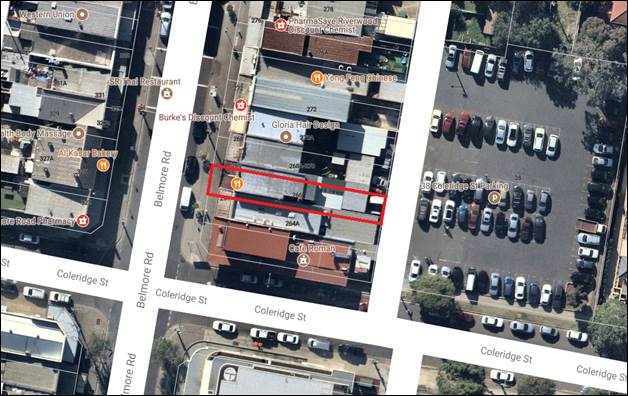
Figure 1. Aerial
View- 266 Belmore Rd Riverwood (Source: Nearmap 2018, photo date 17 July
2018)
|
Executive
Summary
Proposal
1. The
application seeks approval for the construction of a semi-enclosed fixed shade
structure enclosed with a weatherproof barrier on and within the Council
footpath. The structure is to covered additional outdoor seating area (10
tables, 16 chairs) for the existing commercial premise at 266 Belmore Road
Riverwood.
Site and Locality
2. The
subject site is identified as Lot 16, DP 16391, 266 Belmore Rd Riverwood, is a
rectangular shaped allotment having a primary street frontage to Belmore Road,
and rear access via an unnamed service lane.
Located on the site is a two
storey building. The subject premise is occupied by Valley Door Café.
The tenancy has a 5.9m wide frontage to Belmore Road, which is its primary
entry. The footpath measures 7.90m from the shop’s entrance to the street
kerb and gutter of Belmore Road. A Council street tree is located on the
footpath adjacent to the subject tenancy. The proposal does not seek the
removal of the street tree.
Adjoining the
site are one and two storey buildings primarily used as retail and commercial
premises. The site is in close proximity to residential lots located to the
east.
Zoning and Permissibility
3. The
subject site is zoned B2 – Local Centre and being identified as a
“Commercial premises” the proposal being an awning over an outdoor
area is a permissible form of development with consent.
Submissions
4. The
proposal did not require notification as per Council’s notification
policy. No submissions were received by Council regarding the proposal.
Conclusion
5. The
application seeks approval for the construction of a fixed shade structure
which is proposed to be semi-enclosed with a weatherproof barrier within and
upon Council footpath.
The proposal
has been assessed against the relevant environmental regulations, planning
instruments and Development Control Plans and is considered to be an
inappropriate development form on Council land and is not supported and
recommended for refusal for the reasons.
Report
in Full
Proposal
6. The
application seeks approval for the construction of a semi-enclosed fixed shade
structure enclosed with a weatherproof barrier on and within the Council
footpath. The structure is to covered additional outdoor seating area (10
tables, 16 chairs) for the existing commercial premise at 266 Belmore Road
Riverwood.
The Site and Locality
7. The
subject site is identified as Lot 16, DP 16391, 266 Belmore Rd Riverwood, is a
rectangular shaped allotment having a primary street frontage to Belmore Road,
and rear access via an unnamed service lane.

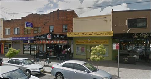
Figure 2. Elevation with the area of the proposed work within
the confines of the red outline.
Source: Google Maps 2018
Located on the site is a two
storey building. The subject premise is occupied by Valley Door Café.
The tenancy has a 5.9m wide frontage to Belmore Road, which is its primary
entry. The footpath measures 7.90m from the shop’s entrance to the street
kerb and gutter of Belmore Road. A Council street tree is located on the
footpath adjacent to the subject tenancy. The proposal does not seek the removal
of the street tree.
Adjoining the site are one and
two storey buildings primarily used as retail and commercial premises. The site
is in close proximity to residential lots located to the east.
Background
8. The
subject DA (DA2017/0418) has been lodged on 19 September 2017.
PLANNING
ASSESSMENT
9. The
site has been inspected and the proposed development has been assessed under
the relevant Section 4.15(1) “Evaluation” of the Environmental
Planning and Assessment Act 1979.
Environmental
Planning Instruments
Hurstville Local Environmental Plan 2012
10. The
subject site is zoned B2 – Local Centre and being identified as a
“Commercial premises” the proposal being an awning over an outdoor
area is a permissible form of development with consent. The relevant clauses of
the Local Environmental Plan which apply to the proposed development are
detailed below:
|
Applicable
LEP Clause
|
Standard
|
Proposed
|
Complies
|
|
5.10 Heritage
conservations
|
The objectives of this clause are
as follows:
(a) to conserve the environmental
heritage of Hurstville,
(b) to conserve the heritage
significance of heritage items and heritage conservation areas, including
associated fabric, settings and views,
(c) to conserve archaeological
sites, (d) to conserve Aboriginal objects and Aboriginal places of heritage
significance.
|
Development
has not been identified as a heritage item or located within a heritage
conservation area as per HLEP 2012.
|
Yes
|
|
6.6 Active street frontages
|
(1) The objective of this clause is
to promote uses that attract pedestrian traffic along certain ground
floor street frontages in Zone B2 Local Centre, Zone B3 Commercial Core and
Zone B4 Mixed Use.
|
The
proposed awning over an outdoor dining area supports a café which
facilitates and attracts pedestrian movement.
|
Yes
|
State
Environmental Planning Policies
11. Compliance
with the relevant state environmental planning policies is detailed in the
table below.
|
STATE ENVIRONMENTAL PLANNING
POLICY
|
Complies
|
|
State Environmental Planning Policy
No 55 - Remediation Of Land
|
Yes
|
|
Greater Metropolitan Regional
Environmental Plan No 2 – Georges River Catchment
|
Yes
|
|
State Environmental Planning Policy
(Building Sustainability Index BASIX) 2004
|
N/A
|
Draft Environmental Planning Instruments
12. The Draft Environment SEPP was exhibited from 31 October 2017 to 31
January 2018. This consolidated SEPP proposes to simplify the planning rules
for a number of water catchments, waterways, urban bushland, and Willandra
Lakes World Heritage Property. Changes proposed include consolidating the
following seven existing SEPPs:
· State Environmental Planning Policy No. 19 – Bushland in Urban
Areas,
· State Environmental Planning Policy (Sydney Drinking Water
Catchment) 2011,
· State Environmental Planning Policy No. 50 – Canal Estate
Development,
· Greater Metropolitan Regional Environmental Plan No. 2 –
Georges River Catchment,
· Sydney Regional Environmental Plan No. 20 – Hawkesbury-Nepean
River (No.2-1997),
· Sydney Regional Environmental Plan (Sydney Harbour Catchment) 2005,
· Willandra Lakes Regional Environmental Plan No. 1 – World
Heritage Property.
The
proposal is not inconsistent with the provisions of this Draft Instrument.
Hurstville Development Control Plan 2018
13. The proposed development is subject to the provisions of Hurstville
Development Control Plan No. 1 (Amendment No. 6) 2018. The relevant
clauses of the Development Control Plan which apply to the proposed development
are detailed below.
|
Applicable DCP Control
|
Requirement
|
Proposed
|
Complies
|
|
6.2 Riverwood (Section 6 -
Controls for Specific Sites and Localities)
Part B – Belmore Road and
Mixed Use Development Controls
|
DS15.1. The requirements for
footpath restaurants and cafes are contained in Council’s Public Spaces
Local Approvals Policy (Activities on Public Land- Roads and Footpaths) which
can be found in Appendix 2
|
Outdoor dining application
(APP2017/0220) lodged with Council and approved.
|
No, refer to comment (1)
|
(1) Outdoor
dining
The development
application has been lodged for the construction of a permanent fixed structure
on over and within Council’s land being a cover over proposed outdoor
dining within the footpath area of Belmore Road Riverwood. However, for outdoor
dining applications requiring the erection of permanent or semi-permanent
structures on the public footway, a development approval from Council must be
obtained under Section 125 of the Roads Act.
Under Schedule 1 of
the Environmental Planning and Assessment Regulation 2000,
(i) if the applicant is not the owner
of the land, a statement signed by the owner of the land to the effect that the
owner consents to the making of the application.
As the application
is located on Council land (footpath), owners consent from Council is required
prior to the commencement of any works. Council has granted authority to lodge
a Development Application.
It is noted that APP2017/0220
for outdoor dining has expired on 5 of July 2018.
IMPACTS
Natural Environment
14. The
proposed development has minimal impacts on the natural environment.
Built Environment
15. The
proposed development is likely to have an adverse impact on the built
environment in that it is not consistent with the predominant character of the
street and footpath along Belmore Road.
The application proposes a semi enclosed fixed structure on
the footpath to be used for outdoor dining purposes. No other fixed structures
are located on Council’s footpath within the locality.
A structure of this scale and form is considered to be
inconsistent with the immediate streetscape character.
Social Impact
16. The
proposed development is likely to have an adverse impact on the pedestrian
activity along the footpath adjacent to Belmore Road as well as those that are
alighting from their vehicles whereby they would need to navigate the
structures’ within the public domain.
It is noted that a pedestrian study has not been conducted
with regard to the potential impacts that could arise as a result of the
proposed structure.
Economic Impact
17. The
proposed development has potential economic impacts relating to the maintenance
and upkeep of the public domain given the development will be on public land.
Suitability of the Site
18. The
proposal is not suitable for the site as it
introduces a new scale and form of development within the public domain which
will be out of character in the current streetscape.
SUBMISSIONS AND THE PUBLIC INTEREST
19. The
proposal did not require notification as per Council’s
notification policy. No submissions were received by Council regarding the
proposal.
REFERRALS
Council
Referrals
Premium
Facilities and Properties Team
20. Council’s
Premium Facilities and Properties Team have provided owners consent for this application.
External
Referrals
21. No
external referrals were required for this application.
CONCLUSION
22. The
application seeks approval for the construction of a fixed shade structure
which is proposed to be semi-enclosed with a weatherproof barrier within and
upon Council footpath.
The proposal has
been assessed against the relevant environmental regulations, planning instruments
and Development Control Plans and is considered to be an inappropriate
development form on Council land and is not supported and recommended for
refusal for the reasons.
DETERMINATION
23. That
pursuant to Section 4.16(1)(b) of the Environmental Planning and Assessment
Act, 1979, as amended, that the Local Planning Panel (Panel), the determining
authority of the application under the Local Planning Panels Direction -
Development Applications dated 23 February 2018, that the Panel refuse development
consent to Development Application DA2017/0418 for the construction of a fixed
shade structure within and upon Council’s footpath at Lot 16, DP16391 and
known as 266 Belmore Road, Riverwood, to the following reasons:
1. Pursuant
to Section 4.15 (1)(b) of the Environmental Planning and Assessment Act 1979,
the proposed development is likely to have an adverse impact on the following
aspects of the environment:
(a) Social impacts – An adverse impact
would result from the proposed development on the pedestrian activity of the
locality and adjoining commercial/retail premises;
(b) Social impacts - The application will
result in an adverse streetscape presentation due to the bulk and scale of the
development; and
(c) The application is not in the public
interest.
ATTACHMENTS
|
Attachment ⇩1
|
Site plan and layout - 266 Belmore Road Riverwood
|
|
Georges
River Council – Local Planning Panel Monday, 3 September
2018
|
Page 10
|
REPORT
TO GEORGES RIVER COUNCIL
LPP MEETING OF Monday, 03 September 2018
|
LPP Report No
|
LPP034-18
|
Development Application No
|
MOD2018/0089
|
|
Site Address & Ward Locality
|
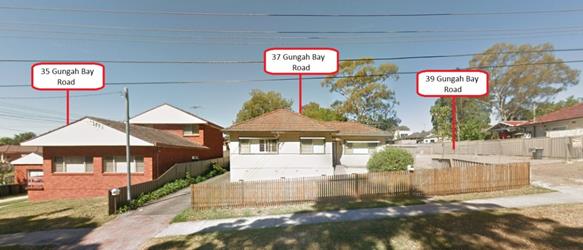
37 Gungah Bay Road Oatley
Peakhurst Ward
|
|
Proposed Development
|
Section 4.55(1A) Modificaiton application
- Siting the approved dwelling a further 0.62m to the south
|
|
Owners
|
Mrs J Wang and Mr B Zhou
|
|
Applicant
|
Mrs J Wang
|
|
Planner/Architect
|
Green Tree Designs
|
|
Date Of Lodgement
|
6/07/2018
|
|
Submissions
|
Nil
|
|
Cost of Works
|
Nil for the modification
|
|
Local Planning Panel Criteria
|
Applicant is Council Staff Member
|
|
List of all relevant s.4.15
matters (formerly s79C(1)(a))
|
Greater Metropolitan Regional
Environmental Plan No 2 – Georges River Catchment,
State Environmental Planning Policy
(Building Sustainability Index: BASIX) 2004,
Hurstville Local Environmental Plan
2012
|
|
List all documents submitted
with this report for the Panel’s consideration
|
Architectural Plans
|
|
Report prepared by
|
Independent Assessment
|
|
Recommendation
|
THAT the application be approved in accordance the
conditions included in the report.
|
|
|
Summary of matters for
consideration under Section 4.15
Have all recommendations in relation
to relevant s4.15 matters been summarised in the Executive Summary of the
assessment report?
|
Yes
|
|
Legislative clauses requiring
consent authority satisfaction
Have relevant clauses in all
applicable environmental planning instruments where the consent authority
must be satisfied about a particular matter been listed, and relevant
recommendations summarised, in the Executive Summary of the assessment
report?
|
Yes
|
|
Clause 4.6 Exceptions to
development standards
If a written request for a
contravention to a development standard (clause 4.6 of the LEP) has been received,
has it been attached to the assessment report?
|
Not
Applicable
|
|
Special Infrastructure
Contributions
Does the DA require Special
Infrastructure Contributions conditions (under s7.24)?
|
Not
Applicable
|
|
Conditions
Have draft conditions been provided
to the applicant for comment?
|
No,
standard conditions have been attached with no design changes
|
|
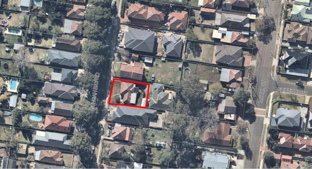
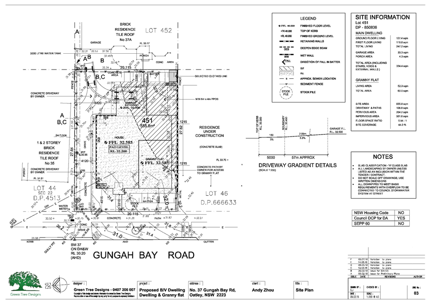
Site Plan
|
Executive Summary
Proposal
1. Council
is in receipt of a Section 4.55 Modification Application for siting the
approved dwelling a further 0.62m to the south.
Site and Locality
2. The
subject site is legally described as Lot 451 DP 850836 and is known as 37
Gungah Bay Road, Oatley. The property is located on the eastern side of Gungah
Bay Road, between Acacia Street and Linda Avenue Oatley.
The
dimensions of the site are approximately 20.115m (width including the right of
carriageway) x 27.62m (depth), with a total area of 555.8sqm, which
accommodates an existing single storey fibro dwelling.
The property
is affected by a 1m wide drainage easement and 3.5m wide right of carriageway
(ROC) and easement for services which extends along the northern side of the
allotment.
The immediate
locality consists of a mix of detached dwelling houses in a predominantly low
density residential setting.
Zoning and Permissibility
3. The
site is zoned R2 - Low Density Residential under the provisions of Hurstville
Local Environmental Plan 2012 (HLEP 2012). The approved development and the
modified form remains a residential dwelling with attached secondary dwelling
which are both permissible with development consent and satisfy the zone
objectives.
Submissions
4. No
objections were received in relation to the proposed application.
Conclusion
5. Following
a detailed assessment of the modification, it is considered that Section 4.55
Modification Application No MOD2018/0089 is recommended for approval subject to
updated conditions of consent.
Report in Full
Proposal
6.
Council is in receipt of a Section 4.55 Modification Application for siting the
approved dwelling a further 0.62m to the south. The proposed works are
specifically detailed below:
The subject
allotment is affected by a right of carriageway, located adjacent to the side
northern boundary. The approved dwelling was sited 3.5m as annotated on the
plans measured from the northern boundary to the external façade of the
two storey dwelling.
For the
purposes of construction, no scaffolding is permitted to be located within over
or upon the right of carriageway which would restrict access to those
benefiting from the right of carriageway.
The following
modification application seeks consent to relocate the approved dwelling 0.62m
further to the south, which will facilitate the placement of scaffolding within
the northern setback of the site to facilitate construction of the development
without impacting the right of carriageway.
No other
changes are proposed.

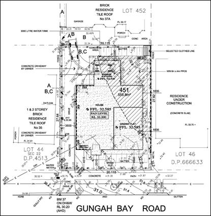
Approved site plan showing the 3.5m setback from the
northern boundary

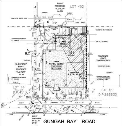
Proposed setback of 4.12m from the northern boundary
The Site and Locality
7. The
subject site is legally described as Lot 451 DP 850836 and is known as 37
Gungah Bay Road, Oatley. The property is located on the eastern side of Gungah
Bay Road, between Acacia Street and Linda Avenue Oatley.
The
dimensions of the site are approximately 20.115m (width including the right of
carriageway) x 27.62m (depth), with a total area of 555.8sqm, which
accommodates an existing single storey fibro dwelling.
The property
is affected by a 1m wide drainage easement and 3.5m wide right of carriageway
(ROC) and easement for services which extends along the northern side of the
allotment.
The immediate
locality consists of a mix of detached dwelling houses in a predominantly low
density residential setting.
Streetscape
view - 37 Gungah Bay Road, Oatley (Source: Google Maps 2018)
Background
8. The
applicant is an officer of Georges River Council. Development Application
DA2017/0419 was assessed externally by Creative Planning Solutions (CPS)
(Report by Independent Assessment) and presented to Local Planning Panel (LPP)
formerly known as the Independent Hearing and Assessment Panel (IHAP), due to
probity.
The Local
Planning Panel, on the 26 April 2018 approved the application subject to the
following:
Determination
Approval
The Georges
River Council LPP as the delegate of the Georges River Council determines
Development Application No. 2017/0419 for the demolition of existing structures
and the construction of a two storey dwelling with an attached single storey
secondary dwelling at 37 Gungah Bay Road, Oatley, by granting consent to the
application subject to the conditions recommended in the report submitted to
the LPP meeting of 26 April 2018 as amended by the following new condition:
7A. Prior to
the issue of a Construction Certificate the approved plans are to be amended
to:
a) Show
the proposed separate pedestrian access to the secondary dwelling along the
southern side boundary; and
b) To
include materials and finishes to the following first floor walls:
(i) Western
wall to the master bedroom; and
(ii)
Southern wall to the sitting room, stairs and bathroom; to break up the expanse
of blank walls. If windows are proposed, the windows on the western elevation
are to match the western windows of the secondary dwelling, and any window on
the southern elevation to the bathroom is to be a high level window, with a
minimum lower sill height of 1.5m.
Section 4.55
Assessment
9. This
application has been made pursuant to Section 4.55(1A) of the Environmental
Planning and Assessment Act 1979 to modify Development Consent DA2018/0089
dated 6 July 2018. Section 4.55(1A) of the Environmental Planning and
Assessment Act 1979 enables the consent authority to modify a development
consent upon application by the applicant or any person entitled to act on the
consent, provided that the consent authority:
1. Is satisfied that the proposed modification is of minimal
environmental impact?
Officer Comment: The modification
proposes relocating the dwelling a further 0.62m to the south to enable
development to be undertaken without impacting the right of carriageway.
The relocation of
the approved dwelling 0.62m further to the south will enable construction to be
undertaken within the confines of the allotment without any construction
materials being on over or within the right of carriageway. The proposed
development is of minimal environmental impact.
2. Is satisfied the proposed development as modified is
substantially the same development for which consent was originally granted?
Officer Comment: The proposed
development as modified retails the residential use and is substantially the
same development for which consent was originally granted.
3. Has consulted with the relevant Minister, public authority or
approval body with respect to a condition imposed on the consent or general
terms of approval.
Officer Comment: Not Applicable
4. Has advertised and or notified the application in accordance with
the regulations or a development control plan?
Officer Comment: The application was
subject to neighbour notification in accordance with the provisions of
Hurstville Development Control Plan 2012. No submissions were received.
5. Has considered any submissions made concerning the proposed
modification.
Officer Comment: No submissions
received.
State Environmental
Planning Policies
GREATER METROPOLITAN REGIONAL ENVIRONMENTAL PLAN NO 2 –
GEORGES RIVER CATCHMENT (DEEMED SEPP)
10. All stormwater from the proposed development can be treated in accordance with
Council’s Water Management Policy and will satisfy the relevant
provisions of the Deemed State Environmental Planning Policy – Georges
River Catchment.
STATE
ENVIRONMENTAL PLANNING POLICY (BUILDING SUSTAINABILITY INDEX: BASIX) 2004
11. A
BASIX Certificate is required to be lodged for any development application in
NSW for a new home or for any alteration and addition of $50,000 or more to an
existing home.
A revised
BASIX Certificate was submitted with the amendment given the relocation of the
built form. The revised BASIX Certificate is referenced as 912132M_2, prepared
by Outsource Ideas dated 16 August 2018.
STATE
ENVIRONMENTAL PLANNING POLICY NO 55 - REMEDIATION OF LAND (SEPP 55)
12. SEPP 55 aims to promote the remediation of contaminated land in order to
reduce the risk of harm to human health or any other aspect of the environment.
Clause 7 requires contamination and remediation to be considered in determining
a development application. The consent authority must not consent to the
carrying out of development on land unless it has considered whether or not the
land is contaminated.
The
site has a history of residential uses and as such, site contamination is not
suspected. In this regard, no further assessment is warranted with regards to
site contamination.
HURSTVILLE
LOCAL ENVIRONMENTAL PLAN
13. The
allotment is subject to the provisions of the Hurstville Local Environmental
Plan 2012 (HLEP 2012).
Part 2 –
Permitted or Prohibited Development
Clause 2.1
– Land Use Zones
14. The
site is zoned R2 - Low Density Residential under the provisions of Hurstville
Local Environmental Plan 2012 (HLEP 2012). The approved development and the
modified form remains a residential dwelling with attached secondary dwelling
which are both permissible with development consent and satisfy the zone
objectives.
Part 4 –
Principal Development Standards
|
Applicable KLEP Clause
|
Development Standards
|
Development Proposal
|
Complies
|
|
4.3 Height of Buildings
|
9m
|
As approved (7.75m)
|
No changes proposed
|
|
4.4 Floor Space Ratio
|
0.6:1
|
As approved (0.57:1)
|
No changes proposed
|
|
5.4(9) Secondary dwellings
floor space
|
Floor area not to exceed the
greater of 60sqm or 10% of total floor area of principal dwelling whichever
is greater
|
As approved (52.0sqm)
|
No changes proposed
|
DEVELOPMENT
CONTROL PLAN
15. The
proposed development is subject to the provisions of the Hurstville Development
Control Plan No.1 2012 (HDCP 2012). There are no modifications proposed that
result in an amendment to the calculations undertaken with respect to the HDCP
2012 compliance table except for the following component:
Setbacks
The development
as approved has a northern side boundary setback of 3.5m and a southern side
boundary setback of 1.8m.
The development
cannot be constructed in in the current location without construction
scaffolding being installed on, over or within the right of carriageway. The
will result in the right of carriageway being obstructed during the
construction. As a result the application is seeking to ameliorate this issue
by the relocation of the development a further 0.62m from the northern side
boundary, resulting in a setback of 4.12m, which will result in a southern side
boundary setback of 1.215m as opposed to the approved setback of 1.835m.
The proposed side
setbacks exceed the 900mm setback nominated in Clause 4.4.3 of the HDCP. As a
result the application is considered to be acceptable and worthy of support.
Impacts
Natural
Environment
16. The
proposed modification is not considered to have an unsatisfactory impact in
terms of the Natural Environment.
Built Environment
17. The
proposed modification is considered acceptable in terms of impacts on the built
environment.
Social and
Economic Impact
18. The
proposal is considered acceptable in terms of social and economic impacts.
Suitability
of the Site
19. The
site presents a number of constraints including existing vegetation and the
need for appropriate stormwater disposal. The applicant’s DA submission
has not adequately addressed these issues, and therefore it is considered that
the site is not suitable for the development as currently proposed in this DA.
Submissions
20. No
objections were received in relation to the proposed application.
Public Interest
21. The
proposed development is of a scale and character that is not contrary to the
public interest.
CONCLUSION
22. The
application has been assessed having regard to Section 4.55 of the
Environmental Planning and Assessment Act 1979, and the provisions of the
Hurstville Local Environmental Plan 2012.
Following a
detailed assessment of the modification sought to relocate the development
0.62m further from the northern boundary, it is considered that Section 4.55
Modification Application No MOD2018/0089 is worthy of support subject to
updated conditions of consent.
DETERMINATION AND STATEMENT OF
REASONS
23. Statement
of Reasons
· The proposed development
is considered to be an appropriate scale and form for the site and the
character of the locality;
· The proposed
development, subject to the recommended conditions, will have no unacceptable
adverse impacts upon the natural or built environments; and
· In consideration of the
aforementioned reasons, the proposed development is a suitable and planned use
of the site and its approval is in the public interest.
24. Pursuant to the provisions of Section 4.55 of the Environmental
Planning and Assessment Act, as amended, development consent DA2017/0419
granted on 26 April 2018 for the demolition of existing
structures and the construction of a two storey dwelling with an attached
single storey secondary dwelling on Lot 451 DP
850836 and known as 37 Gungah Bay Road, Oatley, is
amended in the following manner:
DEVELOPMENT CONSENT is granted to the Development Application
described above, subject to the conditions in Schedules A, B and C.
Consent Operation - This consent operates from the
date the original consent was determined, ie 26 April 2018, except as qualified
by Section 93 of the Act.
This development consent will lapse unless acted upon within five (5)
years from the date of the original endorsement, except as qualified by Section
8.15 of the Environmental Planning and Assessment Act 1979.
Right of Review – If you are dissatisfied
with this decision, you may apply for a Review of a Determination under Section
8.9 of the Environmental Planning and Assessment Act 1979. A request for review
and the decision by Council of that request must be made within twenty-eight
(28) days from the date of this Notice of Determination and be accompanied by
the relevant fee in accordance with Environmental Planning and Assessment
Regulations 2000 Clause 123I. You must ensure that an application for
review of determination gives Council a reasonable period in which to review
its decision having regard to the relevant issues and complexity of the
application.
Right of Appeal – Appeal to the Land and Environment Court
within six (6) months after the date on which you receive this Notice of Determination,
under Section 8.9 of the Environmental Planning and Assessment Act 1979.
Schedule
A – Site Specific Conditions
GENERAL
CONDITIONS
The conditions
that follow this Section A of the Notice of Determination are general
conditions which are imposed to ensure that the development is carried out in
accordance with the development consent.
1. Approved Plans -
The development must be implemented in accordance with the approved
plans and supporting documentation listed below which have been endorsed by
Council’s approved stamp, except where marked up on the plans and/or
amended by conditions of this consent:
|
Description
|
Reference No.
|
Date
|
Revision
|
Prepared by
|
|
Site Plan
|
Dwg No. 03
|
05.07.18
|
F
|
Green Tree Designs
|
|
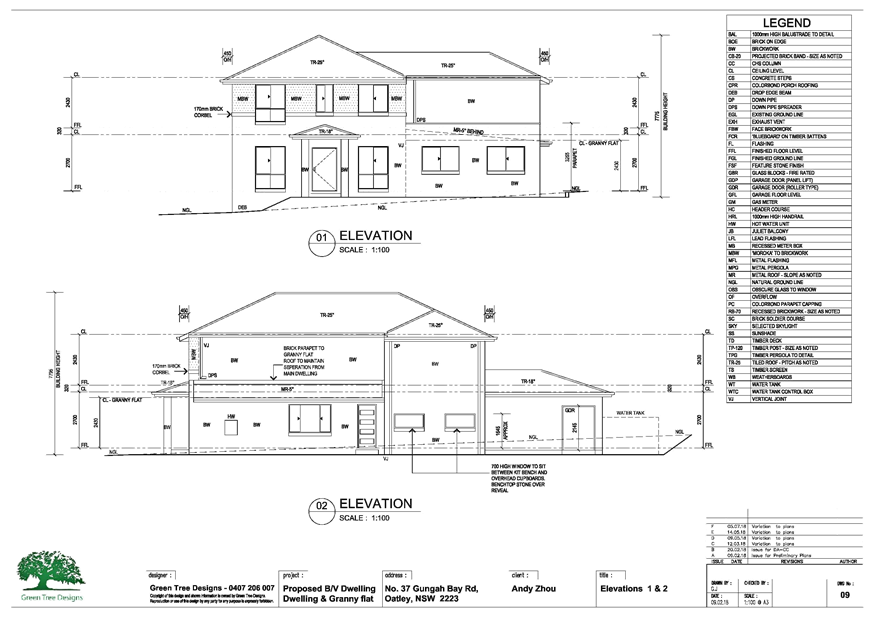
Elevations 1 & 2
|
Dwg No. 09
|
05.07.18
|
F
|
Green Tree Designs
|
|
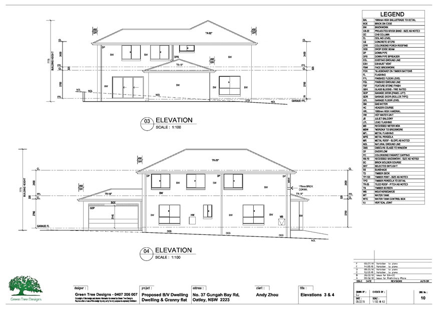
Elevations 3 & 4
|
Dwg No. 10
|
05.07.18
|
F
|
Green Tree Designs
|
|
Ground Floor Plan
|
Dwg No. 07
|
05.07.18
|
F
|
Green Tree Designs
|
|
First Floor Plan
|
Dwg No. 08
|
05.07.18
|
F
|
Green Tree Designs
|
|
Schedule of External Finishes
|
201714
|
17.09.18
|
-
|
-
|
(This
condition is modified as part of MOD2018/0089 (DA2017/0419))
2. Fencing - Fencing
does not form part of this application. Consent for any fencing should be
pursued separately from this application.
3. Right of
Carriageway - This consent does not authorise any buildings, structures or
other elements within the existing right of carriageway described in Deposited
Plan 850836 (such as the proposed fill and batter slope) as shown on the site
plan referred to in Condition 1.
SEPARATE
APPROVALS UNDER OTHER LEGISLATION
These conditions
have been imposed to ensure that the applicant is aware of any separate
approvals required under other legislation, for example: approvals required
under the Local Government Act 1993 of the Roads Act 1993.
4. Roads Act 1993
and Section 68 Local Government Act 1993 - Unless otherwise specified by a
condition of this consent, this Development Consent does not give any approval
to undertake works on public infrastructure.
Separate approval
is required under Section 138 of the Roads Act 1993
and/or Section 68 of the Local Government Act
1993 for any of the following activities carried out in, on
or over a public road (including the footpath) listed below.
An application is
required to be lodged and approved prior to the commencement of any of the
following works or activities;
(a) Placing or storing materials or equipment;
(b) Placing or storing waste containers or skip
bins;
(c) Erecting a structure or carrying out
work
(d) Swinging or hoisting goods over any part of a
public road by means of a lift, crane or the like;
(e) Pumping concrete from a public road;
(f) Pumping water from the site into
the public road;
(g) Constructing a vehicular crossing or footpath;
(h) Establishing a “works zone”;
(i) Digging up or disturbing the
surface of a public road (e.g. Opening the road for the purpose of connections
to utility providers);
(j) Stormwater & ancillary works
in the road reserve; and
(k) Stormwater & ancillary to public
infrastructure on private land
(l) If any excavation is to be
supported by the use of below ground (cable) anchors that are constructed under
Council’s roadways/footways.
These separate
activity approvals must be obtained and evidence of the approval provided to
the Certifying Authority prior to the issue of the Construction Certificate.
The relevant
Application Forms for these activities can be downloaded from Council’s
website www.georgesriver.nsw.gov.au.
For further information, please contact Council’s Customer Service Centre
on (02) 9330 6222.
5. Vehicular
Crossing - Minor Development - Constructing a vehicular crossing and/or
footpath requires a separate approval under Section 138 of the Roads Act 1993
prior to the commencement of those works.
To apply for
approval, complete the Driveway Crossing on Council Road Reserve Application
Form which can be downloaded from Georges River Council’s Website at www.georgesriver.nsw.gov.au.
Lodge the application form, together with the associated fees at
Council’s Customer Service Centre, during business hours. Refer to
Section P1 and P2, in Council’s adopted Fees and Charges for the
administrative and inspection charges associated with Vehicular Crossing
applications.
An approval for a
new or modified vehicular crossing will contain the approved access and/or
alignment levels which will be required to construct the crossing and/or
footpath. Once approved, all work shall be carried out in
accordance with Council’s specifications applicable at the time, prior to
the issue of an Occupation Certificate.
REQUIREMENTS OF
OTHER GOVERNMENT AGENCIES
These conditions
have been imposed by other NSW Government agencies either through their role as
referral bodies, concurrence authorities or by issuing General Terms of
Approval under the Integrated provisions of the Environmental Planning and
Assessment Act 1979.
6. Sydney Water
– Tap in TM - The approved plans must be submitted to a
Sydney Water Tap in TM to determine whether the development
application will affect Sydney Water’s sewer and water mains, stormwater
drains and/or easements, and if further requirements need to be met. The
approved plans will be appropriately endorsed. For details please refer
to ‘Plumbing, building and developing’ section of Sydney
Water’s web site at www.sydneywater.com.au
then see ‘Building’, or telephone 13000 TAP IN (1300 082
746). The Certifying Authority must ensure that a Tap in TM
agent has appropriately stamped the plans prior to the issue of the
Construction Certificate.
PRIOR TO THE ISSUE OF THE
CONSTRUCTION CERTIFICATE
These conditions
either require modification to the development proposal or further
investigation/information prior to the issue of the Construction Certificate to
ensure that there is no adverse impact.
7. Fees to be paid
- The fees listed in the table below must be paid in accordance with the
conditions of this consent and Council’s adopted Fees and Charges
applicable at the time of payment (available at www.georgesriver.nsw.gov.au).
Payments must be
made prior to the issue of the Construction Certificate or prior to the
commencement of work (if there is no associated Construction Certificate).
Council will only
accept Bank Cheque or Electronic Funds Transfer (EFT) for transaction values of
$500,000 or over. Council must be contacted prior to payment to determine
correct total amount to be paid and bank account details (if applicable).
A summary of the
fees to be paid are listed below:
|
Fee Type
|
Fee
|
|
GENERAL FEES
|
|
Long Service Levy (to Long Service
Corporation)
Or, provide evidence of Payment
direct to the Long Service Corporation.
See https://portal.longservice.nsw.gov.au/bci/levy/
|
|
Builders Damage Deposit
|
$1,900.00
|
|
Inspection Fee for Refund of Damage
Deposit
|
$550.00
|
|
|
|
General Fees
The fees and
charges above are subject to change and are as set out in the version of
Council's Schedule of Fees and Charges or as required by other Government
Authorities, applicable at the time of payment.
7A. Prior
to the issue of a Construction Certificate the approved plans are to be amended
to:
(a) Show
the proposed separate pedestrian access to the secondary dwelling along the
southern side boundary; and
(b) To
include materials and finishes to the following first floor walls:
(i) Western
wall to the master bedroom; and
(ii) Southern
wall to the sitting room, stairs and bathroom;
to break up the
expanse of blank walls. If windows are proposed, the windows on the
western elevation are to match the western windows of the secondary dwelling,
and any window on the southern elevation to the bathroom is to be a high level
window, with a minimum lower sill height of 1.5m.
8. Damage Deposit
– Minor Works - In order to insure against damage to Council property
the following is required:
(a) Pay
Council, before the issue of the Construction Certificate, a damage deposit for
the cost of making good any damage caused to any Council property as a result
of the development: $1,900.00
(b) Pay
Council, before the issue of the Construction Certificate, a non-refundable
inspection fee to enable assessment of any damage and repairs where
required: $550.00
(c) Submit to
Council, before the commencement of work, a photographic record of the
condition of the Council nature strip, footpath and driveway crossing, or any
area likely to be affected by the proposal.
At the completion
of work Council will inspect the public works, and the damage deposit will be
refunded in full upon completion of work where no damage occurs. Otherwise the
amount will be either forfeited or partly refunded according to the amount of
damage.
9. Site Management
Plan - A Site Management Plan detailing all weather access control points,
sedimentation controls, fencing, builder’s site sheds office, amenities,
materials storage and unloading arrangements must be submitted with the
application for the Construction Certificate.
10. BASIX Commitments - All
energy efficiency measures as detailed in the BASIX Certificate No. 912132M_2
must be implemented on the plans lodged with the application for the
Construction Certificate.
(This condition
is modified as part of MOD2018/0089 (DA2017/0419))
11. Low reflectivity roof - Roofing
materials must be low glare and reflectivity. Details of finished external
materials including colours and texture must be provided to the Certifying
Authority.
12. Stormwater System - The
submitted stormwater plan has been assessed as a concept plan only. Final
detailed plans of the drainage system, prepared by a professional engineer
specialising in hydraulic engineering, shall be submitted for approval with the
Construction Certificate.
(a) All
stormwater shall drain by gravity to Council's kerb and gutter directly in
front of the development site in accordance with the Australian/New Zealand
Standard AS/NZS 3500.3: 2015 (as amended).
(b) All
overflows of roof waters from any rainwater tank shall drain by gravity to
Council’s kerb and gutter directly in front of the development site in
accordance with the Australian/New Zealand Standard AS/NZS 3500.3: 2015 (as
amended).
(c) All
other impervious surface water runoff such as driveways and footpaths shall
drain by gravity to Council’s kerb and gutter directly in front of the
development site.
13. Stormwater Drainage Plan
Details - Stormwater drainage plans including pipe sizes, type, grade,
length, invert levels, dimensions and types of drainage pits prepared by a
professional engineering specialising in hydraulic engineering shall be
submitted with the Construction Certificate application.
These plans shall
be prepared in accordance with the Australian Institute of Engineers Australian
Rainfall and Runoff (1987) and Council's Stormwater Drainage Policy
14. Driveway Construction Plan
Details - Detailed engineering plans for the driveway shall be submitted
with the Construction Certificate application for approval that show:
(a) Longitudinal and cross sections, gradients,
access onto the proposed lots, type of construction materials designed in
accordance with Council's Subdivision standards and AS/NZS2890.1-2004.
(b) Suitable underground provision for the supply
of all relevant services to the proposed lots (proposed position of pipes and
conduits).
(c) The full length of the driveway
designed with a minimum 150mm thick reinforced concrete and minimum of 2.7m
wide pavement/kerb face to kerb face width, and a non-slip surface.
15. Structural
details - Engineer's details prepared by a
practising Structural Engineer being used to construct all reinforced concrete
work, structural beams, columns & other structural members. The
details are to be submitted to the Principal Certifying Authority for approval
prior to construction of the specified works.
A copy shall be
forwarded to Council where Council is not the PCA.
16. Engineer’s
Certificate - A certificate from a professional Engineer specialising in
structural engineering certifying the structural adequacy of the existing
structure, to support all proposed additional superimposed loads shall be
submitted to the Certifying Authority prior to the issue of the Construction
Certificate.
17. Commonwealth
Disability (Access to Premises) Standard - The
Commonwealth Disability (Access to Premises - Buildings) Standards 2010
(the Premises Standards) applies to all applications (i.e. Construction
Certificate). This requires any new building, part of a building and the
affected part of the existing building to comply with the Premises Standards,
the Building Code of Australia and AS 1428.
18. Waste Management Plan - A
Waste Management Plan incorporating all requirements in respect of the
provision of waste storage facilities, removal of all materials from the site
that are the result of site clearing, extraction, and, or demolition works and
the designated Waste Management Facility shall be submitted to the Certifying
Authority prior to the issue of any Construction Certificate.
19. Waste Storage - Residential
and Mixed Use Developments - The plans shall include details of the waste
storage area. The waste storage area shall not be visible from the street. The
waste storage area shall be located within the lot/building in accordance with
the approved plans.
20. Landscape Plans - All
landscape works shall be carried out in accordance with the approved landscape
plans. The landscaping shall be maintained in accordance with the approved
plans in perpetuity.
21. Tree Removal prohibited - This
consent does not approve the removal or pruning (branches or roots) of any
trees on the subject property, Council’s public footway, public reserves
or on neighbouring properties.
PRIOR TO THE COMMENCEMENT OF WORK (INCLUDING DEMOLITION &
EXCAVATION)
These conditions
have been imposed to ensure that all pre-commencement matters are dealt with
and finalised prior to the commencement of work.
22. Demolition & Asbestos -
The demolition work shall comply with the provisions of Australian Standard
AS2601:2001 – Demolition of Structures, NSW Work Health &
Safety Act 2011 and the NSW Work Health
& Safety Regulation 2011. The work plans required by AS2601:2001
shall be accompanied by a written statement by a suitably qualified person that
the proposals contained in the work plan comply with the safety requirements of
the Standard. The work plans and the safety statement shall be submitted to the
PCA prior to the commencement of works.
For demolition
work which involves the removal of asbestos, the asbestos removal work must be
carried out by a licensed asbestos removalist who is licensed to carry out the
work in accordance with the NSW Work Health &
Safety Act 2011 and the NSW Work Health
& Safety Regulation 2011 unless specified in the Act and/or
Regulation that a license is not required.
All demolition
work including the removal of asbestos, shall be undertaken in accordance with
the Demolition
Code of Practice (NSW Work Cover July 2015)
Note:
Copies of the Act, Regulation and Code of Practice can be downloaded free of
charge from the SafeWork NSW website: www.SafeWork.nsw.gov.au.
23. Demolition Notification
Requirements - The following notification requirements apply to this
consent:
(a) The developer /builder must notify adjoining
residents five (5) working days prior to demolition. Such notification is
to be a clearly written note giving the date demolition will commence, contact
details of the developer/builder, licensed asbestos demolisher and the
appropriate regulatory authority. Notification is to be placed in the letterbox
of every premises (including every residential flat or unit, if any) either
side and immediately at the rear of the demolition site.
(b) Five (5) working days prior to demolition, the
developer/builder is to provide written notification to Council advising of the
demolition date, details of the SafeWork licensed asbestos demolisher and the
list of residents advised of the demolition.
(c) On demolition sites where buildings to
be demolished contain asbestos, a standard commercially manufactured sign
containing the words “DANGER ASBESTOS REMOVAL IN PROGRESS” measuring
not less than 400mm x 300mm is to be erected in a prominent visible position
(from street frontage) on the site. The sign is to be erected prior to
demolition work commencing and is to remain in place until such time as all
asbestos material has been removed from the site to an approved waste facility.
24. Demolition work involving
asbestos removal - Work involving bonded asbestos removal work (of an area
of more than 10 square metres) or friable asbestos removal work must be
undertaken by a person who carries on a business of such removal work in
accordance with a licence under clause 458 of the Work Health
and Safety Regulation 2011.
25. Dial before your dig - The
applicant shall contact “Dial Before You Dig on 1100” to obtain a
Service Diagram prior to the issuing of the Construction Certificate. The
sequence number obtained from “Dial Before You Dig” shall be
forwarded to Council’s Engineers for their records.
26. Existing drainage easement,
drainage reserve or stormwater drainage system benefiting Council - Council
drainage easement(s) drainage reserve(s) or stormwater system either pass
through or are adjacent to the site. No building or other structure must
be placed over the drainage easement or stormwater system or within the zone of
influence taken from the invert of any pipe.
The applicant must
determine the exact location, size and level details of the potentially
affected stormwater drainage systems and without causing any damage to the
public system ensure its protection. The owner, principal contractor or owner
builder must not obstruct or otherwise remove, disconnect or render inoperable
the Stormwater Drainage System.
Works such as
fences must not obstruct the natural stormwater flowpath or alter the flowpath
in such a way as to direct or concentrate stormwater on to neighbouring
properties.
Where the
relocation or reconstruction of Council’s drainage system is approved
then all work carried out on Council’s assets will revert to the
ownership, care, control or management of Council. Therefore, upon handover to
Council, the asset must comply with Council’s Construction of drainage
and associated works specification.
The applicant must
meet all costs associated with such works.
Note: This
condition does not set aside the need to obtain relevant approvals under the Roads Act 1993
or Local
Government Act 1993 for works within Roads and other public places.
27. Registered Surveyors Report
- During Development Work - A report must be submitted to the PCA at each
of the following applicable stages of construction:
(a) Set out before commencing
excavation.
(b) Floor slabs or foundation wall,
before formwork or commencing brickwork.
(c) Completion of Foundation Walls -
Before any construction of flooring, detailing the location of the structure
relative to adjacent boundaries and floor levels relative to the datum shown on
the approved plans.
(d) Completion of Floor Slab Formwork
- Before pouring of concrete/walls construction, detailing the location of the
structure relative to adjacent boundaries and floor levels relative to the
datum shown on the approved plans. In multi-storey buildings a further
survey must be provided at each subsequent storey.
(e) Completion of any Roof Framing -
Before roof covered detailing eaves/gutter setback from boundaries.
(f) Completion of all Work -
Detailing the location of the structure (including eaves/gutters) relative to
adjacent boundaries and its height relative to the datum shown on the approved
plans. A final Check Survey must indicate the reduced level of the main
ridge.
Work must not proceed beyond each
stage until the PCA is satisfied that the height and location of the building
is proceeding in accordance with the approved plans.
28. Utility Arrangements - Arrangements
are to be made with utility authorities in respect to the services supplied by
those authorities to the development. The cost associated with the provision or
adjustment of services within the road and footway areas is to be at the
applicant’s expense.
DURING CONSTRUCTION
These conditions
have been imposed to ensure that there is a minimal impact on the adjoining
development and surrounding locality during the construction phase of the
development.
29. Site sign – Soil
& Erosion Control Measures - Prior to the commencement of works
(including demolition and excavation), a durable site sign, issued by Council
in conjunction with this consent, must be erected in a prominent location on
site. The site sign warns of the penalties which apply to pollution, storing
materials on road or footpath and breaches of the conditions relating to
erosion and sediment controls. The sign must remain in a prominent location on
site up until the completion of all site and building works.
30. Hours of construction for
demolition and building work - Any work activity or activity associated
with the development consent that requires the use of any tools (including hand
tools) or any power operated plant and machinery that creates noise on or
adjacent to the site shall not be performed, or permitted to be performed, except
between the hours of 7.00 am to 5.00 pm, Monday to Saturday inclusive. No work
or ancillary activity is permitted on Sundays, or Public Holidays.
Note: A penalty infringement
notice may be issued for any offence.
31. Ground levels and retaining
walls - The ground levels of the site shall not be excavated, raised or
filled, or retaining walls constructed on the allotment boundary, except where
indicated on approved plans or approved by Council.
32. Physical connection of
Stormwater to site - No work is permitted to proceed above the ground floor
slab level of the building until there is physical connection of the approved
stormwater drainage system from the land the subject of this consent to
Council's stormwater pipeline in Gungah Bay Road.
33. Cost of work to be borne by
the applicant - The applicant shall bear the cost of all works associated
with the construction of the development that occurs on Council property.
Care must be taken to protect Council's roads, including the made footway,
kerbs, etc., and, where plant and vehicles enter the site, the footway shall be
protected against damage by deep-sectioned timber members laid crosswise, held
together by hoop iron straps and chamfered at their ends. This construction
shall be maintained in a state of good repair and condition throughout the
course of construction.
34. Obstruction of Road or
Footpath - The use of the road or footpath for the storage of any building
materials, waste materials, temporary toilets, waste or skip bins, or any other
matter is not permitted unless separately approved by Council under Section 138
of the Roads Act
1993 and/or under Section 68 of the Local Government
Act 1993. Penalty infringement Notices may be issued for any offences
and severe penalties apply.
35. Waste Management Facility -
All materials removed from the site as a result of demolition, site
clearing, site preparation and, or excavation shall be disposed of at a
suitable Waste Management Facility. No vegetation, article, building material,
waste or the like shall be ignited or burnt.
Copies of all
receipts for the disposal, or processing of all such materials shall be
submitted to the PCA and Council, where Council is not the Principal Certifying
Authority.
PRIOR TO THE ISSUE OF THE OCCUPATION CERTIFICATE
These conditions
have been imposed to ensure that all works have been completed in accordance
with the Development Consent prior to the issue of the Occupation Certificate
36. BASIX Certificate - All
energy efficiency measures as detailed in the approved BASIX Certificate in the
plans approved with the Development Consent must be implemented before issue of
any Occupation Certificate.
37. BASIX Compliance
Certificate - A Compliance Certificate must be provided to the PCA
regarding the implementation of all energy efficiency measures as detailed in
the approved BASIX Certificate before any Occupation Certificate is issued.
38. Completion of Landscape
Works - All landscape works must be completed before the issue of the Final
Occupation Certificate.
39. Driveways
and parking spaces - Minor Development - Internal driveways and
parking spaces are to be adequately paved with concrete or bitumen, or
interlocking pavers to provide a dust-free surface.
40. Demolition - The
dwelling house must be demolished prior to the issue of the Occupation
Certificate.
ONGOING CONDITIONS
These conditions have been imposed to ensure that the use or operation of
the development does not adversely impact on the amenity of the neighbourhood
or environment.
41. Amenity of the
neighbourhood - The implementation of this development shall not adversely
affect the amenity of the neighbourhood or interfere unreasonably with the
comfort or repose of a person who is outside the premises by reason of the
emission or discharge of noise, fumes, vapour, odour, steam, soot, dust, waste
water,
ADVICE
This advice has
been included to provide additional information and where available direct the
applicant to additional sources of information based on the development type.
42. Long Service Levy - The
Long Service Corporation administers a scheme which provides a portable long
service benefit for eligible workers in the building and construction industry
in NSW. All benefits and requirements are determined by the Building and
Construction Industry Long Service Payments Act 1986. More information about
the scheme and the levy amount you are required to pay to satisfy a condition
of your consent can be found at http://www.longservice.nsw.gov.au.
The required Long
Service Levy payment can be direct to the Long Service Corporation via their
web site https://online.longservice.nsw.gov.au/bci/levy.
Payments can only be processed on-line for the full levy owing and where the
value of work is between $25,000 and $6,000,000. Payments will be accepted for
amounts up to $21,000, using either MasterCard or Visa.
43. Security deposit
administration & compliance fee - Under Section 97 (5) of the Local Government Act
1993, a security deposit (or part) if repaid to the person who provided it
is to be repaid with any interest accrued on the deposit (or part) as a
consequence of its investment.
Council must cover
administration and other costs incurred in the investment of these monies. The
current charge is $50.00 plus 2% of the bond amount per annum.
The interest rate
applied to bonds is set at Council's business banking facility rate as at 1
July each year. Council will accept a bank guarantee in lieu of a
deposit.
All interest
earned on security deposits will be used to offset the Security Deposit
Administration and Compliance fee. Where interest earned on a deposit is not
sufficient to meet the fee, it will be accepted in full satisfaction of the
fee.
44. Council as PCA –
Deemed to Satisfy Provisions of BCA - Should the Council be appointed as
the PCA in determining the Construction Certificate, the building must comply
with all the applicable deemed to satisfy provision of the BCA. However,
if an alternative fire solution is proposed it must comply with the performance
requirements of the BCA, in which case, the alternative solution, prepared by
an appropriately qualified fire consultant, accredited and having specialist
qualifications in fire engineering, must justifying the non-compliances with a
detailed report, suitable evidence and expert judgement. Council will also
require if deemed necessary, for the alternative solution to undergo an
independent peer review by either the CSIRO or other accredited
organisation. In these circumstances, the applicant must pay all costs
for the independent review.
45. Site Safety Fencing - Site
fencing must be erected in accordance with SafeWork Guidelines, to exclude
public access to the site throughout the demolition and/or construction work,
except in the case of alterations to an occupied dwelling. The fencing must be
erected before the commencement of any work and maintained throughout any
demolition and construction work.
A demolition licence and/or a high risk work
license may be required from SafeWork NSW (see www.SafeWork.nsw.gov.au).
Schedule B - Prescribed Conditions
Prescribed
conditions are those which are mandated under Division 8A of the Environmental
Planning and Assessment Regulation 2000 and given weight by Section 80A
(11) of the Environmental Planning and Assessment Act 1979.
Detailed below is
a summary of all the prescribed conditions which apply to development in New
South Wales. Please refer to the full details of the prescribed conditions as
in force, at www.legislation.nsw.gov.au.
46. BASIX Commitments - This
Clause requires the fulfilment of all BASIX Commitments as detailed in the
BASIX Certificate to which the development relates.
47. Building Code of Australia
& Home Building Act 1989 - Requires all building work to be carried out
in accordance with the Building Code of Australia. In the case of
residential building work to which the Home Building Act
1989 relates, there is a requirement for a contract of insurance to be in
force before any work commences.
48. Erection of Signs - Requires
the erection of signs on site and outlines the details which are to be included
on the sign. The sign must be displayed in a prominent position on site
and include the name and contact details of the PCA and the Principal
Contractor.
49. Home Building Act 1989 - If
the development involves residential building work under the Home Building Act 1989, no work is
permitted to commence unless certain details are provided in writing to
Council. The name and licence/permit number of the Principal Contractor
or Owner Builder and the name of the Insurer by which work is insured under
Part 6 of the Home Building Act 1989.
Schedule C – Operational & Statutory
Conditions
These conditions
comprise the operational and statutory conditions which must be satisfied under
the Environmental Planning and Assessment Act 1979 and the Environmental
Planning & Assessment Regulation 2000. Please refer to the full details of
the Act and Regulations as in force, at www.legislation.nsw.gov.au.
50. Requirement for a
Construction Certificate - The erection of a building must not commence
until a Construction Certificate has been issued.
51. Appointment of a PCA - The
erection of a building must not commence until the applicant has:
(a) appointed a PCA for the building work; and
(b) if relevant, advised the PCA that the work
will be undertaken as an Owner -Builder.
If the work is not
going to be undertaken by an Owner - Builder, the applicant must:
(c) appoint a Principal Contractor to
undertake the building work. If residential building work (within the meaning
of the Home
Building Act 1989) is to be undertaken, the Principal Contractor must be a
holder of a contractor licence; and
(d) notify the PCA of the details of any such
appointment; and
(e) notify the Principal Contractor of any
critical stage inspections or other inspections that are required to be carried
out in respect of the building work.
An Information
Pack is attached for your convenience should you wish to appoint Georges River
Council as the PCA for your development.
52. Notification of Critical
Stage Inspections - No later than two days before the building work
commences, the PCA must notify:
(a) the consent authority and the Council (if not
the consent authority) of his or her appointment; and
(b) the applicant of the critical stage
inspections and other inspections that are to be carried out with respect to
the building work.
53. Notice of Commencement - The
applicant must give at least two days notice to the Council and the PCA of
their intention to commence the erection of a building.
A Notice of
Commencement Form is attached for your convenience.
54. Critical Stage Inspections
- The last critical stage inspection must be undertaken by the PCA.
The critical stage inspections required to be carried out vary according to
Building Class under the Building Code of Australia and are listed in Clause
162A of the Environmental
Planning and Assessment Regulation 2000.
55. Notice to be given prior to
critical stage inspections - The principal contractor for a building site,
or the owner-builder, must notify the PCA at least 48 hours before each
required inspection needs to be carried out.
Where Georges
River Council has been appointed as the PCA, 48 hours notice in writing, or
alternatively 24 hours notice by facsimile or telephone, must be given when
specified work requiring inspection has been completed.
56. Occupation Certificate - A
person must not commence occupation or use of the whole or any part of a new
building unless an Occupation Certificate has been issued in relation to the
building or part.
Only the PCA
appointed for the building work can issue the Occupation Certificate.
An Occupation
Certificate Application Form is attached for your convenience.
If you need more
information, please contact the undersigned below on 9330-6400 during normal office
hours.
ATTACHMENTS
|
Attachment ⇩1
|
Site Plan - 37 Gungah Bay Road Oatley
|
|
Attachment ⇩2
|
Elevation 1 and 2 - 37 Gungah Bay Road Oatley
|
|
Attachment ⇩3
|
Elevation 3 and 4 - 37 Gungah Bay Road Oatley
|
|
Attachment ⇩4
|
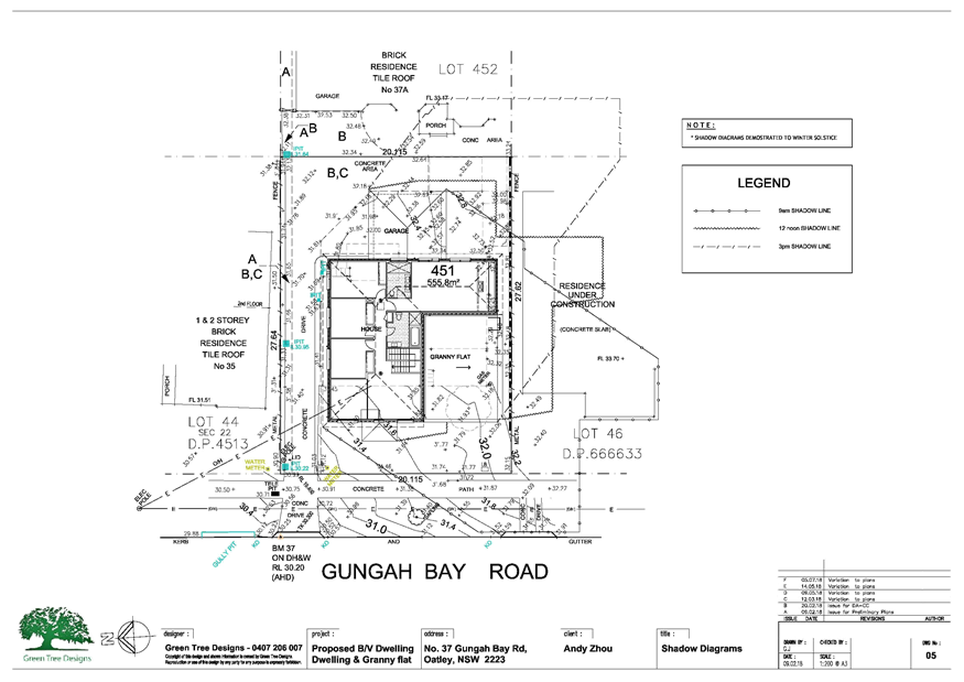
Shadow Diagram - 37 Gungah Bay Road Oatley
|
|
Georges
River Council - Georges River Local Planning Panel (LPP) - Monday, 3 September
2018
LPP034-18 37 Gungah Bay Road Oatley
[Appendix
1] Site Plan - 37
Gungah Bay Road Oatley
|
Page 30
|
|
Georges River Council - Georges River Local Planning
Panel (LPP) - Monday, 3 September 2018
LPP034-18 37 Gungah Bay Road Oatley
[Appendix
2] Elevation 1
and 2 - 37 Gungah Bay Road Oatley
|
Page 31
|
|
Georges River Council - Georges River Local Planning
Panel (LPP) - Monday, 3 September 2018
LPP034-18 37 Gungah Bay Road Oatley
[Appendix
3] Elevation 3
and 4 - 37 Gungah Bay Road Oatley
|
Page 32
|
|
Georges River Council - Georges River Local Planning
Panel (LPP) - Monday, 3 September 2018
LPP034-18 37 Gungah Bay Road Oatley
[Appendix
4] Shadow Diagram
- 37 Gungah Bay Road Oatley
|
Page 33
|
|
Georges River Council – Local Planning
Panel Monday, 3 September 2018
|
Page 34
|
REPORT TO GEORGES RIVER COUNCIL
LPP MEETING OF Monday, 03 September 2018
|
LPP Report No
|
LPP035-18
|
Development Application No
|
DA2017/0573
|
|
Site Address & Ward Locality
|
5A Algernon Street Oatley
Blakehurst Ward
|
|
Proposed Development
|
Demolition of existing structures
and construction of an attached dual occupancy including a swimming pool and
modified front fence
|
|
Owners
|
J Kowald and D G Killaed
|
|
Applicant
|
M Cubed Design
|
|
Planner/Architect
|
M Cubed Design
|
|
Date Of Lodgement
|
22/11/2017
|
|
Submissions
|
Thirteen (13) submissions
|
|
Cost of Works
|
$950,455
|
|
Local Planning Panel Criteria
|
>10 submissions
|
|
List of all relevant s.4.15 matters
(formerly s79C(1)(a))
|
Environmental Planning and
Assessment Regulations 2000, Greater Metropolitan Regional Environmental Plan
No 2 - Georges River Catchment,
State Environmental Planning Policy
No 55 - Remediation of Land, State Environmental Planning Policy (Building
Sustainability Index: BASIX) 2004,
Kogarah Local Environmental Plan
2012, Kogarah Development Control Plan 2013
|
|
List all documents submitted
with this report for the Panel’s consideration
|
Architectural plans
Landscape plan
Statement of Environmental Effects
|
|
Report prepared by
|
Independent Assessment and Team
Leader Development Assessment
|
Planning
|
Recommendation
|
That the application be approved in accordance with the
conditions included in the report.
|
|
|
Summary of matters for
consideration under Section 4.15
Have all recommendations in relation
to relevant s4.15 matters been summarised in the Executive Summary of the
assessment report?
|
Yes
|
|
Legislative clauses requiring
consent authority satisfaction
Have relevant clauses in all
applicable environmental planning instruments where the consent authority
must be satisfied about a particular matter been listed, and relevant
recommendations summarised, in the Executive Summary of the assessment
report?
|
Yes
|
|
Clause 4.6 Exceptions to
development standards
If a written request for a
contravention to a development standard (clause 4.6 of the LEP) has been
received, has it been attached to the assessment report?
|
Not
Applicable
|
|
Special Infrastructure Contributions
Does the DA require Special
Infrastructure Contributions conditions (under s7.24)?
|
Not
Applicable
|
|
Conditions
Have draft conditions been provided
to the applicant for comment?
|
No,
standard conditions have been attached and design changes
|
|
Site Plan
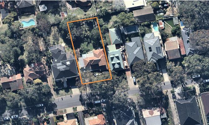
|
Executive Summary
Proposal
1. The
development proposes demolition works and the erection of an attached dual
occupancy including a swimming pool.
Site and Locality
2. The
subject site is located on the northern side of Algernon Street, located
between Clifton and Phipps Streets. The site is a regular shaped allotment with
frontage of 20.115m and side boundaries of 50.31m for a site area of 1012sqm.
Zoning and Permissibility
3. The
property is zoned R2 Low Density Residential under Kogarah LEP 2012. The
proposal is permissible with Council’s consent.
Submissions
4. The
proposal has been notified to neighbours in accordance with Kogarah DCP 2013,
and thirteen (13) submissions have been received. These are discussed in the
body of the report.
Conclusion
5. The
proposal is recommended for approval subject to conditions of consent.
Report in Full
DESCRIPTION OF
THE PROPOSAL
6. Council is in receipt of a development application (DA2017/0573) for demolition
of existing structures and construction of an attached dual occupancy including
a swimming pool and modified front fence at property 5A Algernon Street,
Oatley.
The
proposed dual occupancy is configured such that both dwellings are located side
by side and attached by way of a small length of common wall at ground floor
level with both addressing Algernon Street.
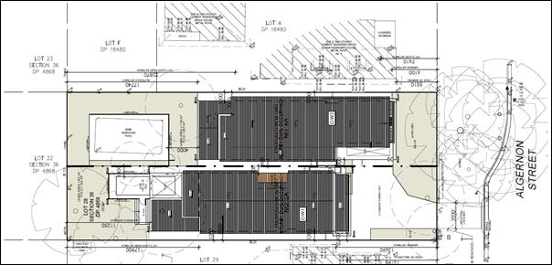
Figure 1: Site Plan of Proposal
(Revised)
The
dwellings comprise two (2) floor levels. The ground floor levels of both
dwellings include combined kitchen/dining/living areas, separate lounge and
study rooms, together with covered rear terraces and garages. The larger of the
dwellings (eastern side) includes a double garage. The smaller of the
dwellings (the western side) includes a single garage and an east facing side
courtyard. The first floor levels of both dwellings include four (4) bedrooms,
bathroom facilities and front and rear balconies.
The
proposed building is of contemporary architectural design featuring mainly
rendered and painted external walls, minor elements of external timber, metal
and stone cladding and shallow pitched steel roofing including some minor
parapet elements at the front and rear of the dwellings.
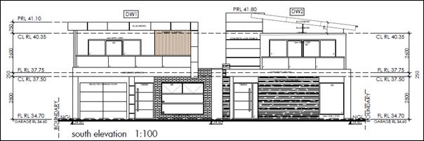
Figure 2: Front Elevation of
Proposal (Revised)
The
garages and entries of both dwellings will be accessible via a common driveway
and footpath crossing located adjacent to the south western corner of the site.
The
new swimming pool is located in the rear yard of the smaller of the dwellings
(western dwelling), immediately adjacent to the covered rear terrace. This
swimming pool is sited substantially below ground level and setback from the
site boundaries. The existing semi inground swimming pool located in the rear
yard of the eastern dwelling is existing and is proposed to be retained.
The
existing cement rendered masonry fence located adjacent to the front boundary
is to be modified to facilitate the widened driveway access will be up to 1m in
height at its western extremity.
Stormwater
runoff from the roofs of the dwellings is to be directed to a series of above
ground rainwater tanks and then to a detention tank located below the common
driveway, which discharges to an outlet in the street kerb and gutter fronting
the site. Stormwater runoff from the driveway surfaces is to be directed to the
street.
The
front setback and rear yards of the dwellings are to be landscaped by way of a
mixture of tree, shrub and groundcover planting including two (2) Kentia Palm
trees, a Tuckeroo tree and a Water Gum tree to be located adjacent to the
street frontage.
DESCRIPTION OF
THE SITE AND LOCALITY
7. The
site is located off the northern side of Algernon Street between Clifton and
Phipps Streets. It is a rectangular shaped lot having front and rear
boundaries of 20.115m, side boundaries of 50.31m and an overall area of
1012sqm. It is presently occupied by a one (1) and two (2) storey cement
rendered brick and weatherboard house with tiled roof, and rear extension with
a skillion metal roof. A semi inground swimming pool is located in the rear
yard.
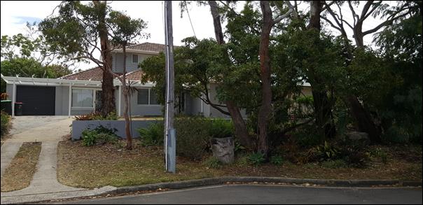
Figure
3: Subject site as viewed from the street
The site falls away
gently from the front boundary to the rear boundary by approximately 2670mm (or
5.31% grading). There are several trees on the site inclusive of two (2)
Eucalyptus pilularis trees, two (2) Corymbia gummifera, one (1) Angophora Costata,
one (1) Pittosporum undulatum, one (1) Acacia Elata, and one (1) Eucalyptus
Robusta tree located at the nature strip in front of the site. There are two
(2) Eucalyptus scoparia located within the site at south western boundary
(front left hand corner). In addition, there are seven (7) other species
located in the northern end (rear yard) of the subject site, being one (1)
Glochidion ferdinandi, two (2) Washingtonia robusta, one (1) Angophora Costata,
one (1) Brachychiton discolour, one (1) Macadamia tetraphylla, and one (1)
Lagunaria Patersonia tree.
Immediately to the
east, west and north and across the road to the south are detached dwelling
houses. The wider locality is characterised by low density housing comprising
mainly of detached dwelling houses.


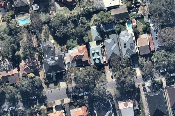
Figure
4: Aerial photo of site (outlined by orange colour) and surrounds
ZONING
8. The
site is zoned R2 Low Density Residential in accordance with the Kogarah Local
Environmental Plan 2012 (refer to zoning map extract below).


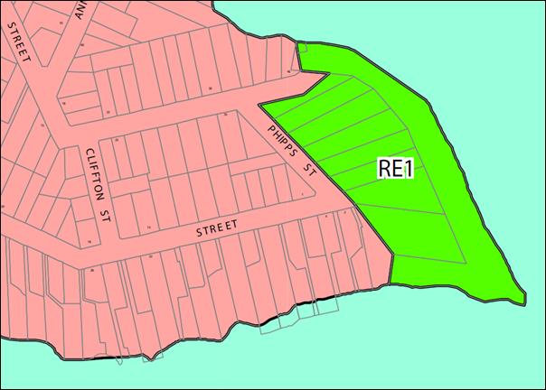
Figure
5: Zoning map extract (Source: NSW Legislation website)
APPLICABLE
PLANNING CONTROLS
9. The
following environmental planning instruments and development control plans are
relevant to the site and proposal:
· Greater Metropolitan
Regional Environmental Plan No. 2 (Georges River Catchment)
· State Environmental
Planning Policy No. 55 - Remediation of Land
· State Environmental
Planning Policy (Building Sustainability Index: BASIX) 2004
· State Environmental
Planning Policy (Vegetation in Non-Rural Areas) 2017
· Kogarah Local
Environmental Plan 2012
· Kogarah Development
Control Plan 2013
PLANNING
ASSESSMENT
10. The
site has been inspected and the proposed development has been assessed under
the relevant Section 4.15(1) "Matters for Evaluation" of the
Environmental Planning and Assessment Act 1979.
Environmental Planning Instruments
Kogarah Local
Environmental Plans
11. The
provisions of the Kogarah Local Environmental Plan 2012 are of relevance to the
proposal. A comparison of the proposal against key provisions in the
Local Environmental Plan is tabled as follows.
|
Clause
|
Provision
|
Proposed
|
Complies
|
|
2.3 Zone objectives and Land Use
Table
|
The site is within
the R2 Low Density Residential zone. Development for
the purpose of a ‘dual occupancy’ may be carried out only with
development consent.
The relevant
objective of the zone is to provide for the housing
needs of the community within a low density residential environment.
|
The proposal is defined as a
‘dual occupancy’.
The proposal is not inconsistent
with the zone objectives.
|
Yes
Yes
|
|
2.7 Demolition requires development
consent
|
Development consent is required for
demolition of the buildings.
|
The current application includes
the demolition of existing structures; the swimming pool on site is to be
retained.
|
Yes
|
|
4.1B Minimum lot size for dual
occupancies
|
650sqm (min)
|
1012sqm
|
Yes
|
|
4.1C Minimum subdivision lot size
for dual occupancies
|
Development
consent may be granted for the subdivision of the land, but only
if there is a dual occupancy on the land that was lawfully erected and
the lot size for each resulting lot will be at least 300sqm.
|
The plans include the
subdivision of the land, but there is no existing lawfully erected dual
occupancy on the land.
|
No – a condition of consent
is imposed to the effect that the subdivision of the land is excluded from
the approval
|
|
4.3 Height of buildings
|
9m (max)
|
8.2m
|
Yes
|
|
4.4A Exceptions to floor space
ratio for residential accommodation in Zone R2
|
0.439:1 FSR or 444.3sqm GFA (max)
|
0.318:1 FSR or
321.95sqm GFA
|
Yes
|
Environmental
Planning and Assessment Regulations 2000
12. The requirements of Australian Standard ‘AS
2601-1991: The Demolition of Structures’ are of relevance to the
application as the proposal includes demolition of existing structures, the
swimming pool is to be retained. The requirements of this standard including
the management of asbestos containing materials will be readily addressed by
the imposition of suitable conditions of consent.
State
Environmental Planning Policies
13. Compliance
with the relevant state environmental planning policies is detailed and
discussed below.
Greater
Metropolitan Regional Environmental Plan No 2 - Georges River Catchment
14. All
stormwater from the proposal will be treated in accordance with Council’s
Water Management Policy and satisfy the relevant provisions of the above state
policy.
State
Environmental Planning Policy No 55 - Remediation of Land
15. Having
regard to the residential zoning of the site and the types of uses permissible
within the zone, it is considered unlikely that the land is contaminated.
Based on council’s records, the site has not been used for any
potentially contaminating activities and hence it is unlikely that the land is
contaminated.
State
Environmental Planning Policy (Building Sustainability Index: BASIX) 2004
16. A
BASIX Certificate has been issued for the proposal and the commitments required
by this certificate have been satisfied. The Basix certificate will need to be
updated to incorporate the new changes proposed.
State
Environmental Planning Policy (Vegetation in Non-Rural Areas) 2017
17. The
objectives of this instrument have been met, namely:
The aims of
this Policy are:
(a) to
protect the biodiversity values of trees and other vegetation in non-rural
areas of the State, and
(b) to
preserve the amenity of non-rural areas of the State through the preservation
of trees and other vegetation.
through the
redesign of the proposal to retain various trees on the site whilst
facilitating development.
Draft Environmental Planning Instruments
18. The Draft
Environment SEPP was exhibited from 31 October 2017 to 31 January 2018. This consolidated SEPP proposes to simplify the planning rules for a number of water
catchments, waterways, urban bushland, and Willandra Lakes World Heritage
Property. Changes proposed include consolidating the following seven existing
SEPPs:
· State Environmental Planning Policy No. 19 – Bushland in Urban
Areas
· State Environmental Planning Policy (Sydney Drinking Water
Catchment) 2011
· State Environmental Planning Policy No. 50 – Canal Estate
Development
· Greater Metropolitan Regional Environmental Plan No. 2 – Georges
River Catchment
· Sydney Regional Environmental Plan No. 20 – Hawkesbury-Nepean
River (No.2-1997)
· Sydney Regional Environmental Plan (Sydney Harbour Catchment) 2005
· Willandra Lakes Regional Environmental Plan No. 1 – World
Heritage Property.
The proposal is not inconsistent with the provisions of
this Draft Instrument.
Development
Control Plans
19. The
provisions of the Kogarah Development Control Plan 2013
are of relevance to the proposal. A comparison of the proposal against
the controls in the development control plan is tabled as follows.
|
Control
|
Requirement
|
Proposed
|
Complies
|
|
Building Height
- Upper Ceiling
- Roof (Parapet)
- Roof (Ridgetop)
|
7.2m (max)
7.8m (max)
9m (max)
|
6.3m
8.1m - Dwelling 1
8.2m - Dwelling 2
|
Yes
No (see below)
Yes
|
|
Number of Levels
|
2 (max)
|
2
|
Yes
|
|
Second Level Depth
|
60% (max)
|
68.95% - Dwelling 1
59% - Dwelling 2
|
No (see below)
Yes
|
|
Setbacks
-Front
-Rear
Side (East)
Side (West)
|
5.5m
7.6m (min)
1.2m (min)
1.2m (min)
|
5.51m
9.77m
0.9m-1.2m+
0.9m-1.2m+
|
Yes
Yes
Yes (see below)
Yes (see below)
|
|
Glazing to Front Facade
|
35% (max)
|
<35%
|
Yes
|
|
Deep Soil Landscaping
|
15% (min)
|
26.26% (265.8sqm)
|
Yes
|
|
Balconies/Terraces per Dwelling
- Total Area
- Setback
- Depth
|
40sqm (max)
3m (min)
2.5m (max)
|
25.3sqm/22.45sqm
3.2m
2.3m/2.3m
|
Yes
Yes
Yes
|
|
Car Parking
|
3 spaces (min)
|
3 garage spaces (Dwelling 1 has
only 1 car space)
|
No
|
Note:
The setback and depth controls for balconies/terraces (referred to in the above
table) only apply to side and rear balconies and not front balconies.
The following
comments are made with respect to the proposal satisfying the objectives and
controls contained within the Development Control Plan.
The proposal will benefit from the eastern dwelling being relocated
towards Algernon Street to have a front setback of 4.0m to the garage southern
wall:
· Significant reduction of overshadowing to the immediate western
neighbour;
· Increased
articulation to the façade, thus contributing to the reduction of the
bulk and scale of the development;
· Unobstructed
on-site parking space to the western dwelling in front of the respective
balcony; and
· Increased
setback to the tree species to be retained at the rear eastern end of the site,
as recommended by council’s Tree Management Officer.
It
is noted that the nature strip in front of the subject site occupies an angle
(and street narrowing) on the south east, thus eliminating the potential
on-street parking in front of the site. The effort to maintain on-site parking
will be achievable with the increased articulation between the dwellings.
The
alternative has been discussed with Council’s Tree Management Officer,
and the following has been recommended:
Subject species,
Eucalyptus Pilularis, referenced on the arobricultural assessment as
‘T3’, may be impacted from this dwelling, but by moving the
dwelling 1.5m closer to the front, therefore is 7.5m to T3 and this
encroachment is as a percentage – 5.94 % incursion Into the TPZ of T3, to
which is a MINOR incursion in accordance with AS4970-2009, Protection of trees
on development sites.
- To
add, the front fence shall not be constructed from strip concrete footings.
This front fence can only be of “post and rail” type construction;
whereas hand dug piers/ holes shall be dug in the location for posts and away
from roots from trees to be protected.
- Tree
protection measures (fencing, mulch and signage) shall be installed before ANY
works to this site and shall be encompassing the entire front council verge and
to approximately 1m from the side of the NE garage and nominated TPZ upon
Conditions set out.
- Any
excavations along the side of the NE garage/footings shall be supervised by the
engaged AQF Level 5 project Arborist for this site.
Further
to this, the alternative method of construction for the front fence shall be
that the existing fence may be removed by hand tools only, no machinery, and at
the supervision of the consultant arborist to determine the health of the
surrounding roots. If the footing structure of the existing fence is
inadequate, the front fence must be constructed with ‘post and
rail’ type construction.
As a result it is recommended that the applicant reduce the front
setback to 4.5m for the eastern dwelling, and retain the front setback of the
western dwelling. The above protection measures, together with the protection
and retention of the Glochidion Ferdinandi (noted as ‘T11’
on the arboricultural assessment).
Building Scale
and Height
20. The
overall building height is within the permissible height controls and therefore
is deemed compliant.
Floor Space
21. The
external walls are sufficiently articulated to reduce the visual bulk and scale
and the overall floor space ratio of the development is compliant.
Rhythm of Built
Elements in the Streetscape
22. The
proposal is located in a street that is typified by a variety of built forms
including more recent construction utilising contemporary design approaches.
There is little consistency in terms of the rhythm of built elements. Strict
application of the primary and secondary building façade controls is
unnecessary in the circumstances. Notwithstanding, the front facade of the dual
occupancy is sufficiently articulated to reduce its visual bulk when viewed
from the public domain.
Building
Setbacks
23. The
proposal generally complies with the side setback requirements, and the front
and rear setback requirements (a condition has been imposed to relocate the
eastern dwelling toward Algernon Street to have a front setback of 4.0m to the
garage to facilitate the retention of the tree in the rear yard which will
assist in the functionality and serviceability of the car parking for the
western dwelling). The protrusion of the two dwellings in the rear yard does
not comply, however it is deemed acceptable given the environmental factors.
Fenestration
and External Materials
24. The
proposed materials and colours are not inconsistent with the streetscape.
Open Space
25. The
proposal readily complies with the deep soil landscaped area control. The rear
private open spaces are adjacent to and accessible from the main living areas
of the dwellings. The private open spaces are of a high quality given their
generous dimensions and leafy open outlooks.
Vehicular
access, Parking and Circulation
26. The
proposal provides three (3) covered parking spaces, and shared manoeuvrability.
This is generally consistent with the relevant controls, being a minimum of
three (3) car spaces for the overall development, with the amended street
setback (conditioned) the functionality for the western dwelling will be
workable and compliant.
Privacy
27. The
rear balconies have a side setback in excess of 3m to the immediate neighbours.
The rear yard and private open space for each dwelling does not obstruct any
neighbouring properties, however the alfresco area has the potential to result
in some impact onto the allotment adjoining, as a result a privacy screen is to
be erected on the eastern elevation having a minimum height above the finished
floor level of 1.7m.
Solar Access
28. The
building is orientated and achieves good levels of solar access to its main
living areas and rear private open space. The proposal results in no excessive
overshadowing to the western and eastern neighbours, providing sunlight in the
morning for the eastern neighbour and sunlight in the afternoon for the western
dwelling. The impact of overshadowing to the immediate neighbours is considered
acceptable.
Views and View
Sharing
29. The
dual occupancy will not result in any unreasonable adverse impacts in terms of
view loss having regard to its siting and design and the prevailing topography
of the immediate locality. The proposal is generally consistent with the
planning controls relating to floor space ratio and building height and
appropriately setback from the street frontage. Reasonable view sharing
is achieved in the circumstances.
Additional
Design Requirements for Attached Dual Occupancies
30. The
relevant controls are outlined and addressed as follows.
§ Minimum site requirements for
dual occupancies
|
Dwelling Type
|
Minimum Frontage
|
Minimum Site
Area
|
Note
|
|
Dual occupancies (attached)
|
18m
|
850sqm
|
The minimum site
area requirements for dual
occupancies are contained in Clause 4.1A of Kogarah LEP 2012.
|
Comment: The
site of the proposal has a frontage of 20.115m and an area of 1012sqm and
complies.
§ Each
dwelling within an attached dual occupancy development should either be side by
side or one dwelling above the other. It is not acceptable to have one dwelling
behind the other.
Comment: The dual occupancy is designed
to be side by side and complies.
§ One dual occupancy dwelling must not intrude into the rear yard
further than 5m beyond the other.
Comment: The western dwelling intends to
protrude in excess of 5m into the rear yard of the eastern dwelling. This
proposal, whilst non-compliant, is deemed satisfactory given the site
constraints and environmental factors.
§ Attached dual occupancies should take account of the building form
and roof lines of adjoining dwellings, where a pattern is established by a
group of adjoining houses.
Comment: There is little consistency in
terms of the built form of existing dwellings in the immediate locality of the
site. The proposal’s individual architectural expression is acceptable.
§ No more than one third of the width of the frontage of a property
should be used for driveways and access ways.
Comment: The extent of the site frontage
used for driveways and access ways is less than one third satisfying this
control.
§ Access to garaging and additional parking spaces for dual occupancy
dwellings should not result in large expanses of paved surfaces to the front of
the building.
Comment: The layout has been modified to
respond to the environmental factors of the site, including the singular footpath crossing on the south western end of the site.
§ Garages for each dwelling within an attached dual occupancy
development must be single fronted only. However, garages that provide for
tandem parking may be acceptable.
Comment: The garage for the eastern
dwelling is double-fronted and contrary to this control. Notwithstanding,
as this garage is not facing the street directly, it does not unduly dominate
the front façade of the building when viewed from the street. The
double garage will be screened from view to some extent by the existing trees
within the road reserve immediately adjoining the site. The garaging
arrangements are acceptable in the circumstances.
§ Where existing dwellings in a streetscape are on one side of a block
and have a side driveway, this pattern should also be observed by the design of
the attached dual occupancy.
Comment: The garage for the eastern
dwelling contributes in the compliance of this proposal, given that it faces
the western boundary.
§ Attached dual occupancies should not have central garages or
driveways.
Comment:
The garages and associated driveway are not centralised in keeping with this
control.
Swimming Pools
The
proposed swimming pool associated with western dwelling satisfies the relevant
objectives. The existing swimming pool on site is being retained and will be
associated with the eastern dwelling.
Comment: The proposal is considered to
be acceptable.
Front Fences
31. The front fence
shall not be constructed from strip concrete footings. This front fence can
only be of “post and rail” type
construction; whereas hand dug piers/holes can be dug in the location for posts
and away from the roots of the trees to ensure the tree protection.
An alternative method of construction for the front fence shall be that
the existing fence may be removed by hand tools only, no machinery, and at the
supervision of the consultant arborist to determine the health of the
surrounding roots. If the footing structure of the existing fence is
inadequate, the front fence must be constructed with ‘post and
rail’ type construction.
IMPACTS
Natural
Environment
32. The
proposed development would not result in any adverse impacts upon the natural
environment for reasons discussed throughout the repo and the retention of
trees. Importantly, the grove trees within the road reserve immediately
adjoining the site are being retained.
Built
Environment
33. The
proposed development would not result in any adverse impacts upon the built
environment for reasons discussed throughout the report.
Social
Impact
34. The
proposed development would not result in any adverse social impacts within the
locality.
Economic
Impact
35. The
proposed development would not result in any adverse economic impacts within
the locality.
Suitability
of the Site
36. The
proposal is of a scale and design that is suitable for the site having regard
to its size and shape, topography, vegetation and relationship to adjoining
developments.
SUBMISSIONS AND
THE PUBLIC INTEREST
37. The application
was publicly notified on two (2) separate occasions in accordance with the
provisions of the development control plan. In response to the initial public notification
of the application, seven (7) submissions were received. In response to the
most recent public notification of the application, five (5) submissions were
received. The submissions received are summarised and addressed as follows.
Stormwater
Stormwater runoff
from subject site to the rear.
Comment:
This development proposes to drain the roofs of each of the dwellings to drain
to a rainwater tank with both dwellings connecting to an onsite detention
system within the driveway which discharges the overflow into the street gutter
network in Algernon Street Oatley, which meets with the requirements of the
Kogarah Development Control Plan.
Retaining wall
Is there a
retaining wall to the rear of the property to prevent water flow?
Comment:
The application is not proposing to install a retaining wall along the rear
boundary. The stormwater is being discharged via rainwater tanks and an onsite
detention system within the driveway which discharges the overflow into the
street gutter network in Algernon Street Oatley, which meets with the
requirements of the Kogarah Development Control Plan.
Bulk and scale
Bulk and scale and
impact on the streetscape/not consistent with the traditional streetscape.
Comment:
This application seeks to demolish the exiting traditional single dwelling and
construct an attached two (2) storey dual occupancy. The contemporary nature of
the dwelling seeks a skillion roof design behind a parapet roof form. The
materials and finishes are predominately rendered with decorative face
brickwork with concrete/cladding columns. The finishes whilst contemporary are
not considered to result in an adverse impact on the streetscape as it is a
modern design with supporting modern finishes. The application is considered to
be acceptable.
Traffic and car
parking impacts
Comment:
The application is seeking to construct two (2) dwelling on the site. The
eastern dwelling is seeking to accommodate a double garage, and the western
dwelling contains a single dwelling with a car space within the driveway. The
on grade car space was considered to be compromised due to the turning circle
into the double garage. As a result the application is recommending the eastern
dwelling be relocated closer to Algernon Street which assists with the car
parking space and will retain Tree 3 in the rear of the site. The application
is considered acceptable.
Loss of trees
Comment:
The development will result in tree removal; the application has been
redesigned to relocate the eastern dwelling toward Algernon Street to have a
4.0m setback to preserve the significant trees on the site. The application has
been reviewed by Council’s Tree and Landscape Officer who supports the
application in its amended form.
Loss of privacy
Comment:
The application seeks to construct two (2) dwelling on the site with a
separating wall through the centre. The upper level of both dwellings contains
bedrooms and supporting service rooms, there are no entertaining spaces at the
level. As a result there is no adverse impact onto the adjoining allotments.
There are alfresco
areas to the ground floor of each dwelling and upper level balconies which have
incorporated screens to reduce the impact onto the adjoining allotments. This
is considered to address the visual impacts from the proposed development onto
neighbouring allotments.
Fencing
Fencing materials
and height.
Comment:
There is 1.8m fencing proposed to the perimeter of the site and dividing the
subject dwellings. The application will be conditioned that this be lapped and
capped. This is fencing is considered to be acceptable.
The front fencing
is a maximum if 1m in height which is proposed to be rendered masonry. If the
existing footing is insufficient to accommodate the proposed fence, new strip
footings are not supported as they will result in the undermining of the tree
roots, as a result the fencing to be erected will be a post and rail fence.
This has been conditioned.
Impact on
private outdoor areas
Comment:
The applicant has included screening to entertaining areas and upper balconies
which limits the visual impact onto the adjoining allotments. The application
is considered to be acceptable in this regard as no adverse privacy or
overlooking impacts are envisaged.
Impact on
property values
Comment:
Property values are not a matter for consideration under the provisions of the
Environmental Planning and Assessment Act 1979.
Overshadowing
Comment:
The allotment is oriented north south. The proposed built form will result in
some overshadowing onto the western neighbour in the morning and the eastern
neighbour in the afternoon. The shadowing impact of the development is
considered not to be adverse on the allotments adjoining.
The eastern
dwelling will be relocated closer to Algernon Street to assist with the
retention of Tree 3 and the manoeuvring of vehicles within the front setback
associated with the western dwelling which sill improve the solar access to the
eastern property. The application is considered to be acceptable in the regard.
REFERRALS
Council
Referrals
Stormwater
Engineer
38. Council’s
Stormwater Engineer has undertaken a review of the proposal and advised that
the proposal complies with Council’s stormwater controls in Kogarah DCP
2013. Appropriate conditions of consent have been provided which are included
in the recommended conditions below.
Tree Management
Officer
39. Council’s
Tree and Landscape Officer has reviewed the plans and documentation and
undertaken a site inspection, recommendations as to tree protection zones have
been recommended which have resulted in the need to relocate the dwelling. This
has been included in the recommended conditions below.
CONCLUSION
40. The
application is for demolition of existing structures and
construction of an attached dual occupancy including a
swimming pool and modified front fence. The application has been assessed
having regard to the State Instruments, Council’s Local Environmental
Plan, Development Control Plan, the environmental nature of the site and the
concerns raised by the neighbours. The application is considered to have merit
with respect the development proposed and the design changes conditioned will
result in the retention of vegetation in the rear and an improved outlook to
the eastern neighbours. The application is recommended for support subject to
the conditions referenced below.
DETERMINATION
AND STATEMENT OF REASONS
Statement of
Reasons
· The proposed development
is considered to be an appropriate scale and form for the site and the
character of the locality;
· The proposed
development, subject to the recommended conditions, will have no unacceptable
adverse impacts upon the natural or built environments; and
· In consideration of the
aforementioned reasons, the proposed development is a suitable and planned use
of the site and its approval is in the public interest.
THAT pursuant
to Section 4.16(1)(a) of the Environmental Planning and Assessment Act, 1979,
as amended, the Council grants development consent to Development Application
DA2017/0573 for the demolition of existing structures and
construction of an attached dual occupancy including a swimming pool and
modified front fence at Lot 28 DP4868 and known as 5A
Algernon Street, Oatley, subject to the following conditions of consent.
Section A Development
Details
1. Approved
Plans - The development must be implemented in accordance with the approved
plans listed below which have been endorsed by Council’s approved stamp,
except where amended by conditions of this consent:
|
Description
|
Drawing No.
|
Dated
|
Revision
|
Prepared by
|
|
Site/Roof Plan
|
2/17
|
19/04/2018
|
-
|
M Cubed Design
|
|
Ground Floor Plan
|
3/17
|
19/04/2018
|
-
|
M Cubed Design
|
|
First Floor Plan
|
4/17
|
19/04/2018
|
-
|
M Cubed Design
|
|
Elevations
|
7/17
8/17
|
19/04/2018
|
-
|
M Cubed Design
|
|
Sections & Streetscape
|
9/17
15/17
|
19/04/2018
|
-
|
M Cubed Design
|
|
External Finishes
|
-
|
01/11/2017
|
1/11/17
|
M Cubed Design
|
|
Demolition Plan
|
11/17
|
01/11/2017
|
1/11/17
|
M Cubed Design
|
|
BASIX Certificate
|
875422S
|
02/11/2017
|
02/11/17
|
M Cubed Design
|
|
BASIX Certificate
|
875434S
|
02/11/2017
|
02/11/17
|
M Cubed Design
|
Section B Separate
Approvals Required Under Other Legislation
2. Roads
Act 1993 and Section 68 Local Government Act 1993 - Unless otherwise
specified by a condition of this consent, this Development Consent does not
give any approval to undertake works on public infrastructure.
Separate approval is required under Section 138 of the Roads Act 1993
and/or Section 68 of the Local Government Act 1993 for any of the following
activities carried out in, on or over a public road (including the footpath)
listed below.
An application is required to be lodged and approved prior to the
commencement of any of the following works or activities;
(a) Placing or storing materials or equipment;
(b) Placing or storing waste containers or skip bins;
(c) Erecting a structure or carrying out work
(d) Swinging or hoisting goods over any part of a public road by means of
a lift, crane or the like;
(e) Pumping concrete from a public road;
(f) Pumping water from the site into the public road;
(g) Constructing a vehicular crossing or footpath;
(h) Establishing a “works zone”;
(i) Digging up or disturbing the surface of a public road (eg Opening the
road for the purpose of connections to utility providers);
(j) Stormwater and ancillary works in the road reserve;
(k) Stormwater and ancillary to public infrastructure on private land;
and
(l) If any excavation is to be supported by the use of below ground
(cable) anchors that are constructed under Council’s roadways/footways.
These separate activity approvals must be obtained and evidence of the
approval provided to the Certifying Authority prior to the issue of the
Construction Certificate.
The relevant Application Forms for these activities can be downloaded
from Council’s website www.georgesriver.nsw.gov.au.
For further information, please contact Council’s Customer Service Centre
on (02) 9330 6400.
3. Vehicular
Crossing - Minor Development - Constructing a vehicular crossing and/or
footpath requires a separate approval under Section 138 of the Roads Act 1993
prior to the commencement of those works.
To apply for approval, complete the Driveway Crossing on Council Road
Reserve Application Form which can be downloaded from Georges River
Council’s Website at www.georgesriver.nsw.gov.au. Lodge the application
form, together with the associated fees at Council’s Customer Service
Centre, during business hours. Refer to Section P1 and P2, in Council’s
adopted Fees and Charges for the administrative and inspection charges
associated with Vehicular Crossing applications.
An approval for a new or modified vehicular crossing will contain the
approved access and/or alignment levels which will be required to construct the
crossing and/or footpath. Once approved, all work shall be carried out in
accordance with Council’s specifications applicable at the time, prior to
the issue of an Occupation Certificate.
4. Road
Opening Permit - A Road Opening Permit must be obtained from Council, in
the case of local or regional roads, or from the RMS, in the case of State
roads, for every opening of a public road reserve to access services including
sewer, stormwater drains, water mains, gas mains, and telecommunications before
the commencement of work in the road.
Section C Requirements
of Concurrence, Integrated & Other Government Authorities
5. Sydney
Water - Tap in TM - The approved plans must be submitted to a Sydney
Water Tap in TM to determine whether the development application will affect
Sydney Water’s sewer and water mains, stormwater drains and/or easements,
and if further requirements need to be met. The approved plans will be appropriately
endorsed. For details please refer to ‘Plumbing, building and
developing’ section of Sydney Water’s web site at www.sydneywater.com.au then see
‘Building’, or telephone 13000 TAP IN (1300 082 746). The
Certifying Authority must ensure that a Tap in TM agent has appropriately
stamped the plans prior to the issue of the Construction Certificate.
6. Notice
of Requirements for a Section 73 Certificate - A Notice of Requirements of
what will eventually be required when issuing a Section 73 Compliance
Certificate under the Sydney Water Act 1994 must be obtained from Sydney Water
Corporation. Application must be made through an authorised Water
Servicing Co-ordinator. Please refer to the ‘Plumbing, building and
developing’ section of the web site www.sydneywater.com.au then refer to
‘Providers’ under ‘Developing’ or telephone 13 20 92
for assistance.
Following application, a ‘Notice of Requirements’ will advise
of water and sewer infrastructure to be built and charges to be paid.
Please make early contact with the Co-ordinator, as it can take some time to
build water/sewer pipes and this may impact on other services and building,
driveway or landscape design.
The Notice of requirements must be submitted prior to the commencement of
work. A Section 73 Compliance Certificate will be required at the completion of
development in accordance with further conditions.
7. Section
73 Compliance Certificate - A Section 73 Compliance Certificate under the
Sydney Water Act 1994 must be submitted to the PCA prior to the issue of the
Occupation Certificate.
Section D Prior to the
Issue of a Construction Certificate
8. Fees
to be paid - The fees listed in the table below
must be paid in accordance with the conditions of this consent and
Council’s adopted Fees and Charges applicable at the time of payment
(available at www.georgesriver.nsw.gov.au).
Payments must be made prior to the issue of the
Construction Certificate or prior to the commencement of work (if there is no
associated Construction Certificate).
Please contact Council prior to the payment of
Section 7.11 Contributions to determine whether the amounts have been indexed
from that indicated below in this consent and the form of payment that will be
accepted by Council.
Council will only accept Bank Cheque or
Electronic Funds Transfer (EFT) for transaction values of $500,000 or over.
Council must be contacted prior to payment to determine correct total amount to
be paid and bank account details (if applicable).
A summary of the fees to be paid are listed
below:
|
Fee Type
|
Fee
|
|
GENERAL FEES
|
|
Long Service Levy (to Long Service Corporation) Or,
provide evidence of Payment direct to the Long Service Corporation. See
https://portal.longservice.nsw.gov.au/bci/levy/
|
|
Builders Damage Deposit
|
$1,900.00
|
|
Inspection Fee for Refund of Damage Deposit
|
$155.00
|
|
DEVELOPMENT
CONTRIBUTIONS
|
|
Kogarah Section 94 Development Contributions Plan No.1 -
Roads and Traffic Management - Residential
|
$1,468.02
|
|
Kogarah Section 94 Development Contributions Plan No.5 -
Open Space 2007
|
$29,154.62
|
|
Kogarah Section 94 Development Contributions Plan No.9 -
Kogarah Libraries - Buildings
|
$756.54
|
|
Kogarah Section 94 Development Contributions Plan No.9 -
Kogarah Libraries - Books
|
$539.40
|
General Fees
The fees and charges above are subject to
change and are as set out in the version of Council's Schedule of Fees and
Charges or as required by other Government Authorities, applicable at the time
of payment.
Development Contributions
The Section 7.11 contribution is imposed to
ensure that the development makes adequate provision for the demand it
generates for public amenities and public services within the area.
Indexation
The above contributions will be adjusted at the
time of payment to reflect changes in the cost of delivering public amenities
and public services, in accordance with the indices provided by the relevant
Section 94 Development Contributions Plan.
Timing of Payment
The contribution must be paid and receipted by
Council prior to the release of the Construction Certificate.
Further Information
A copy of the all current Development
Contributions Plans may be inspected or a copy purchased at Council’s
offices (Georges River Civic Centre, MacMahon Street, Hurstville and Kogarah
Library and Service Centre, Kogarah Town Square, Belgrave Street, Kogarah) or
viewed on Council’s website www.georgesriver.nsw.gov.au.
9. Damage
Deposit - Minor Works - In order to insure against damage to Council
property the following is required:
(a) Pay Council, before the issue of the Construction Certificate, a
damage deposit for the cost of making good any damage caused to any Council
property as a result of the development: $1,900.00
(b) Pay Council, before the issue of the Construction Certificate, a
non-refundable inspection fee to enable assessment of any damage and repairs
where required: $155.00
(c) Submit to Council, before the commencement of work, a photographic
record of the condition of the Council nature strip, footpath and driveway
crossing, or any area likely to be affected by the proposal.
At the completion of work Council will inspect the public works, and the
damage deposit will be refunded in full upon completion of work where no damage
occurs. Otherwise the amount will be either forfeited or partly refunded
according to the amount of damage.
10. Site Management
Plan - A Site Management Plan detailing all weather access control points,
sedimentation controls, fencing, builder’s site sheds office, amenities,
materials storage and unloading arrangements must be submitted with the
application for the Construction Certificate. The site management measures are
to be implemented prior to the commencement of any works including demolition
and excavation. The site management measures are to be maintained throughout
the works, to maintain reasonable levels of public health, safety and amenity.
A copy of the Site Management Plan must be kept on site and is to be made
available upon request.
11. BASIX
Commitments - All energy efficiency measures as detailed in the BASIX
Certificate must be implemented on the plans lodged with the application for
the Construction Certificate.
12. Required design
changes – The following changes are required to be made and shown on
the Construction Certificate plans:
a) Building Setbacks - Except where otherwise
dimensioned on the approved plans, the dual occupancy building is to be setback
from the boundaries as follows:
i) The eastern dwelling is to be
relocated towards Algernon Street to have street setback of 4.0m from the
front allotment boundary;
ii) The south western corner of the building
at Dwelling 1 is to be a minimum distance of 13.69m from the front boundary;
iii) The south eastern side wall adjacent to the
garage of Dwelling 2 is to be a minimum distance of 0.9m from the adjacent side
boundary; and
iv) The south western side wall adjacent to the
garage of Dwelling 1 is to be a minimum distance of 0.9m from the adjacent side
boundary.
b) Eastern Window to Dwelling 2 adjacent to
first floor hallway (W18 on plan) is to be provided with obscured, frosted or
sandblasted glazing.
c) The 1.8m high fencing nominated on the
plans is to be lapped and capped timber.
The above details are to be indicated on the plans accompanying any
construction certificate for the development.
d) Referring to Stormwater Concept Plan dated
23 April 2018. Issue A and prepared by KD Stormwater Pty Ltd, design changes
are required and shown on the Construction Certificate plans.
i) Considering a driveway area grated
box drainage shall designed and connected to the proposed silt arrestor pit.
ii) Rainwater tank details including water
supply distribution configurations.
13. Erosion &
Sedimentation Control - Erosion and sediment controls must be provided to
ensure:
(a) Compliance with the approved Erosion & Sediment
Control Plan
(b) Removal or disturbance of vegetation and top soil is confined to
within 3m of the approved building area (no trees to be removed without
approval)
(c) All clean water runoff is diverted around cleared or
exposed areas
(d) Silt fences, stabilised entry/exit points or other devices are
installed to prevent sediment from entering drainage systems or waterways
(e) All erosion and sediment controls are fully maintained for the
duration of demolition, excavation and/or development works
(f) Controls are put into place to prevent tracking of sediment by
vehicles onto adjoining roadway
(g) All disturbed areas are rendered erosion-resistant by turfing,
mulching, paving or similar
(h) Compliance with Managing Urban Stormwater - Soils and Construction
(Blue Book) produced by Landcom 2004.
These measures are to be implemented prior to the commencement of work
(including demolition and excavation) and must remain until works are completed
and all exposed surfaces are landscaped/sealed.
14. Stormwater
System - The submitted stormwater plan has been assessed as a concept plan
only. Final detailed plans of the drainage system, prepared by a professional
engineer specialising in hydraulic engineering, shall be submitted for approval
with the Construction Certificate.
a) All roof waters and all overflows
from any rainwater tank shall drain to Council’s kerb and gutter directly
in front of the development site by a suitably designed charged and gravity
system.
The design of
this proposed drainage system must be prepared by a professional engineer who
specialises in hydraulic engineering and be submitted for approval with the
Construction Certificate application.
b) Stormwater drainage plans including
pipe sizes, type, grade, length, invert levels, dimensions and types of
drainage pits prepared by a professional engineer who specialises in Hydraulic
Engineering in accordance with the Australian Institute of Engineers Australian
Rainfall and Runoff (2005 or 2016) and Council's Stormwater Drainage
Guidelines, shall accompany the application for the Construction Certificate.
15. On site
detention - The submitted stormwater plan has been assessed as a concept
plan only. Final detailed plans of the drainage system, prepared by a
professional engineer specialising in hydraulic engineering, shall be submitted
for approval with the Construction Certificate.
An on-site detention (OSD) facility
designed by a professional engineer who specialises in Hydraulic Engineering
must be designed, approved and installed.
Full details shall
accompany the application for the Construction Certificate.
16. Stormwater
Drainage Plan Details – Stormwater drainage plans including pipe
sizes, type, grade, length, invert levels, dimensions and types of drainage
pits prepared by a professional engineering specialising in hydraulic
engineering shall be submitted with the Construction Certificate application.
These plans shall be prepared in accordance with the
Australian Institute of Engineers Australian Rainfall and Runoff (2005 or 2016)
and Council's Water Management Policy (Kogarah Council), August 2006.
17. Driveway
Construction Plan Details – Detailed engineering plans for the
driveway shall be submitted with the Construction Certificate application for
approval that show:
(a) Longitudinal and cross sections, gradients,
access onto the proposed lots, type of construction materials designed in
accordance with Council's Subdivision standards and AS/NZS2890.1-2004.
(b) Suitable underground provision for the supply
of all relevant services to the proposed lots (proposed position of pipes and
conduits).
(c) The full length of the driveway
designed with a minimum 150mm thick reinforced concrete and minimum of 2.7m
wide pavement/kerb face to kerb face width, and a non-slip surface.
18. Structural
details - Engineer's details prepared by a practising Structural Engineer
being used to construct all reinforced concrete work, structural beams, columns
and other structural members are to be submitted to the Principal Certifying
Authority for approval prior to construction of the specified works.
A copy shall be forwarded to Council where Council is not
the PCA.
19. Traffic
Management – Compliance with AS2890 – All driveways, access
ramps, vehicular crossings and car parking spaces shall be designed and constructed
in accordance with the current version of Australian Standards, AS 2890.1 (for
car parking facilities) and AS 2890.2 (for commercial vehicle facilities).
20. Waste
Management Plan - A Waste Management Plan incorporating all requirements in
respect of the provision of waste storage facilities, removal of all materials
from the site that are the result of site clearing, extraction, and, or
demolition works and the designated Waste Management Facility shall be
submitted to the Certifying Authority prior to the issue of any Construction
Certificate.
21. Landscape Plan
- All landscape works shall be carried out in accordance with the approved
landscape plans and specifications, drawn by Outliers Design Studio,
reference numbers - LA - 001. The landscaping shall be maintained
in accordance with the approved plans in perpetuity.
22. General
Landscape Requirements
a) The proposed plant species, pot/ bag size
and quantities of plants shall be in accordance with the proposed plant
schedule upon the landscape plan. If plant species, pot/ bag size and
quantities cannot be sourced, Council shall be contacted for alternatives.
b) Landscaping soil used within the front
garden beds and lawn areas shall be in accordance with Australian Native
Landscapes – “Low 'P' Mix™”
c) No fertilisers shall be used within the
front garden beds and front lawn areas.
23. Completion of
Landscape Works – All landscape works must be completed before the
issue of the Final Occupation Certificate in accordance with approved landscape
plans and specifications, drawn by Outliers Design Studio, reference numbers
– LA – 001 and 1.1a, b and c above.
24. Compliance with
submitted Arborist Report - The recommendations outlined in the
Arborist’s Report titled Arboricultural Impact Assessment prepared by
Jacksons Nature Works, dated 1st November, has been overturned and the
trees below shall be retained. Details of tree protection measures to be
implemented must be detailed and lodged with the Construction Certificate
application for approval and shall be in accordance with Section 4 - Australian
Standard AS 4970-2009: Protection of trees on development sites.
Any excavations along the side of the NE garage / footings shall be
supervised by the engaged AQF Level 5 project Arborist for this site
25. The trees to be retained and protected are listed in the
table below.
|
Tree Species
|
Location of
Tree / Tree No.
|
Tree
Protection Zone (metres)
|
|
T1 – Angophora costata
|
Front
council verge
|
5.7m
|
|
T2 – Eucalyptus pilularis
|
Front Council verge
|
6.4m
|
|
T3 - Eucalyptus pilularis
|
Front Council verge
|
9.6m
|
|
T5 – Corymbia gummifera
|
Front Council verge
|
4.0m
|
|
T6 – Corymbia gummifera
|
Front Council verge
|
5.3m
|
|
T7 - Acacia elata
|
Front Council verge
|
4.2m
|
|
T8 – Eucalyptus robusta
|
Front Council verge
|
4.8m
|
|
T11 – Glochidion ferdinandi
|
Back yard of site
|
6.0m
|
|
T15 – Brachychiton discolor
|
Boundary fence line backyard
|
10.8m
|
|
T16 – Macadamia tetraphylla
|
Backyard fence line
|
5.8m
|
|
T17 – Lagunaria patersonia
|
Backyard fence line
|
2.8m
|
Details of the trees to be retained must be
included on the Construction Certificate plans.
26. General Tree
Protection Measures.
a) All trees to be retained shall be
protected before and maintained during demolition, excavation and construction
of the site.
b) The entire Council verge shall have
tree protection fencing installed around its entirety
c) The tree protection measures must
be in undertaken in accordance AS4970 -2009 Protection of trees on development
sites.
d) Details of the tree protection
measures to be implemented must be provided with the application for a
Construction Certificate by a suitably qualified Arborist (AQF Level 5 or above
in Arboriculture).
e) The Arborist must be present
on-site during the stages of construction when works are being undertaken that
could impact on the tree canopy or root zone within the tree protection zone to
implement the tree protection measures as required.
f) Unless otherwise specified in
AS 4970-2009 Protection of trees on development sites, a protective fence
consisting of 1.8 metres high, fully supported chainmesh fence shall be erected
around the base of the tree. The distance of the fence from the base of each
tree is to be in accordance with the TPZ listed in the table above. A layer of
organic mulch 100 millimetres thick shall be placed over the protected area and
no soil or fill should be placed within the protection area.
g) The Tree Protection Zone of each
tree, to be protected, shall be watered thoroughly, regularly to minimise the
effects of construction works.
h) No services shall be installed
within the TPZ of the tree unless approved by Council. This fence shall be kept
in place during demolition, construction and also have a sign displaying
‘Tree Protection Zone – DO NOT ENTER’ attached to the fence
and must also include the name and contact details of the Project Arborist.
27. Excavation works near tree to be retained.
a) Excavations around the trees to be
retained on site or the adjoining properties shall be supervised by the Project
Arborist to ensure that the root system will not adversely be affected.
b) Where the Tree Protection Zone
(TPZ) of trees on site or adjoining sites become compromised by any excavation
works, the Project arborist shall be consulted to establish the position of any
major roots and determine the necessary measures to protect these roots. The
recommendations of the Arborist shall be submitted to Council prior to any
further demolition or construction works taking place.
c) Tree Protection Zone around the
trees to be retained are not to have soil level changes or services installed
in this area. Any structures proposed to be built in this area of the trees are
to utilise pier and beam or cantilevered slab construction. Details satisfying
this condition shall be shown on the Construction Certificate plans.
d) The front fence shall not be
constructed from strip concrete footings. This front fence can only be of
“post and rail” type construction, whereas hand dug piers/ holes
shall be dug in the location for posts and away from roots from trees to be
protected.
e) Tree protection measures (fencing,
mulch and signage) shall be installed before ANY works to this site and shall
be encompassing the entire front council verge and to approximately 1 metre
from the side of the NE garage and nominated TPZ upon Conditions set out by
council.
28. Pier and Beams
a) To preserve the T11, Glochidion
ferdinandi the footings of the proposed alfresco and steps, shall be
isolated pier and beam construction within a 5 metre radius of the trunk. The
piers shall be hand dug and located such that no roots of a diameter greater
than 50mm are severed or injured in the process of any site works during the
construction period. The beam shall be located on or above the existing soil
levels.
Details of this
construction method shall be shown on the Construction Certificate plans.
Removal or
pruning of any other tree (that would require consent of Council) on the site
is not approved. All pruning must be undertaken by a qualified Arborist in
accordance with AS4373 -2007 Pruning of Amenity Trees and Amenity Tree
Industry, Code of Practice (SafeWork NSW August 1998).
29. Tree Removal & Replacement
(a) Tree removal
Permission is
granted for the removal of the following trees
|
Tree Species
|
Number of trees
|
Location
|
|
T4-
Pittosporum undulatum
|
1
|
Front Council verge
|
|
T9 & T10
– Eucalyptus scoparia
|
2
|
Front boundary line
|
|
T12 –
Washingtonia robusta
|
1
|
Backyard of site
|
|
T13 –
Angophora costata
|
1
|
Backyard of site
|
|
T14 –
Washingtonia robusta
|
1
|
Backyard of site
|
(b) General Tree
Removal Requirements
i) All tree removal shall be
carried out by a certified Tree Surgeon/Arborist to ensure that removal is
undertaken in a safe manner and complies with the AS 4373-2007 - Pruning of
Amenity Trees and Tree Works Industry Code of Practice (Work Cover NSW 1.8.98).
ii) No trees are to be removed on the
site or neighbouring properties without the prior written approval of Council.
iii) Council shall be appointed to remove
and plant all tree/s on public land. All costs associated with the removal of
the tree/s and the planting of replacement trees shall be met by the applicant.
Fees and charges outlined in the table below are subject to change and are set
out in the current version of Council's ‘Schedule of Fees and Charges’,
applicable at the time of payment.
(c) Street Tree
Replacement by Council
|
Fee Type – Tree removal on
public land
|
Amount
|
|
Administration
Fee for Tree Removal
|
$154.50
|
|
Replacement
Tree Fee (per Tree)
|
$185.40
|
|
Cost of tree
removal
|
To be determined
|
|
Cost of Stump
Grinding
|
To be determined
|
A copy of the Hurstville City Council’s
Tree Removal and Pruning Guidelines and Kogarah City Council, Street Tree
Management Strategy and Masterplan, can be downloaded from Council’s
website www.georgesriver.nsw.gov.au.
30. Allocation
of street addresses.
|
Dwelling description on plans
|
Current Lot/DP
|
New Primary Addresses
|
|
DW2
|
Lot 28 Sec 36 DP 4868
|
5A Algernon Street, Oatley NSW
2223
|
|
DW1
|
Lot 28 Sec 36 DP 4868
|
5B Algernon Street, Oatley NSW
2223
|
31. Swimming Pools
- Use and Maintenance - The following apply to the construction:
(a) no ground level may be raised or filled except where shown
specifically on the approved plans;
(b) all pool/spa waste water is to be discharged to the sewer according
to the requirements of Sydney Water;
(c) the swimming pool must not be used for commercial or professional
purposes;
(d) drain paved areas to the landscaped areas or a suitable lawful
drainage system; and
(e) arrange any external pool/spa lighting to minimise glare nuisance to
adjoining owners.
Section E Prior to the
Commencement of Work (Including Demolition & Excavation)
32. Dial before
your dig - The applicant shall contact “Dial Before You Dig on
1100” to obtain a Service Diagram prior to the issuing of the
Construction Certificate. The sequence number obtained from “Dial
Before You Dig” shall be forwarded to Council’s Engineers for their
records.
33. Demolition
& Asbestos - The demolition work shall comply with the provisions of
Australian Standard AS2601:2001 - Demolition of Structures, NSW Work Health
& Safety Act 2011 and the NSW Work Health & Safety Regulation
2011. The work plans required by AS2601:2001 shall be accompanied by a
written statement by a suitably qualified person that the proposals contained
in the work plan comply with the safety requirements of the Standard. The work
plans and the safety statement shall be submitted to the PCA prior to the
commencement of works.
For demolition work which involves the removal of asbestos, the asbestos
removal work must be carried out by a licensed asbestos removalist who is
licensed to carry out the work in accordance with the NSW Work Health &
Safety Act 2011 and the NSW Work Health & Safety Regulation 2011 unless
specified in the Act and/or Regulation that a license is not required.
All demolition work including the removal of asbestos, shall be
undertaken in accordance with the Demolition Code of Practice (NSW Work Cover
July 2015)
Note: Copies of the Act, Regulation and Code of Practice can be
downloaded free of charge from the SafeWork NSW website:
www.SafeWork.nsw.gov.au.
34. Demolition
Notification Requirements - The following notification requirements apply
to this consent:
(a) The developer /builder must notify adjoining residents five (5)
working days prior to demolition. Such notification is to be a clearly
written note giving the date demolition will commence, contact details of the
developer/builder, licensed asbestos demolisher and the appropriate regulatory
authority. Notification is to be placed in the letterbox of every premises
(including every residential flat or unit, if any) either side and immediately
at the rear of the demolition site.
(b) Five (5) working days prior to demolition, the developer/builder is
to provide written notification to Council advising of the demolition date,
details of the SafeWork licensed asbestos demolisher and the list of residents
advised of the demolition.
(c) On demolition sites where buildings to be demolished contain
asbestos, a standard commercially manufactured sign containing the words
“DANGER ASBESTOS REMOVAL IN PROGRESS” measuring not less than 400mm
x 300mm is to be erected in a prominent visible position (from street frontage)
on the site. The sign is to be erected prior to demolition work commencing and
is to remain in place until such time as all asbestos material has been removed
from the site to an approved waste facility.
35. Demolition work
involving asbestos removal - Work involving bonded asbestos removal work
(of an area of more than 10 square metres) or friable asbestos removal work
must be undertaken by a person who carries on a business of such removal work
in accordance with a licence under clause 458 of the Work Health and Safety
Regulation 2011.
36. Registered
Surveyors Report - During Development Work - A report must be submitted to
the PCA at each of the following applicable stages of construction:
(a) Set out before
commencing excavation.
(b) Floor slabs or
foundation wall, before formwork or commencing brickwork.
(c) Completion of
Foundation Walls - Before any construction of flooring, detailing the location
of the structure relative to adjacent boundaries and floor levels relative to
the datum shown on the approved plans.
(d) Completion of
Floor Slab Formwork - Before pouring of concrete/walls construction, detailing
the location of the structure relative to adjacent boundaries and floor levels
relative to the datum shown on the approved plans. In multi-storey
buildings a further survey must be provided at each subsequent storey.
(e) Completion of any
Pool Formwork - Before concreting of pool shell, detailing the location of the
pool relative to the adjacent boundaries and its height relative to the datum
shown on the approved plans.
(f) Completion
of any Roof Framing - Before roof covered detailing eaves/gutter setback from
boundaries.
(g) Completion of all
Work - Detailing the location of the structure (including eaves/gutters)
relative to adjacent boundaries and its height relative to the datum shown on
the approved plans. A final Check Survey must indicate the reduced level
of the main ridge.
Work must not proceed beyond each stage until the PCA is satisfied that
the height and location of the building is proceeding in accordance with the
approved plans.
37. Utility
Arrangements - Arrangements are to be made with utility authorities in
respect to the services supplied by those authorities to the development. The
cost associated with the provision or adjustment of services within the road
and footway areas is to be at the applicant’s expense.
Section F During
Construction
38. Site sign - Soil
& Erosion Control Measures - Prior to the commencement of works (including
demolition and excavation), a durable site sign, issued by Council in
conjunction with this consent, must be erected in a prominent location on site.
The site sign warns of the penalties which apply to pollution, storing
materials on road or footpath and breaches of the conditions relating to
erosion and sediment controls. The sign must remain in a prominent location on
site up until the completion of all site and building works.
39. Hours of
construction for demolition and building work - Any work activity or
activity associated with the development consent that requires the use of any
tools (including hand tools) or any power operated plant and machinery that
creates noise on or adjacent to the site shall not be performed, or permitted
to be performed, except between the hours of 7.00 am to 5.00 pm, Monday to
Saturday inclusive. No work or ancillary activity is permitted on Sundays, or
Public Holidays.
Note: A penalty infringement notice may be issued for any offence.
40. Physical
connection of Stormwater to site - No work is permitted to proceed above
the ground floor slab level of the building until there is physical connection
of the approved stormwater drainage system from the land the subject of this
consent to Council's kerb and gutter system.
41. Cost of work to
be borne by the applicant - The applicant shall bear the cost of all works
associated with the construction of the development that occurs on Council
property. Care must be taken to protect Council's roads, including the
made footway, kerbs, etc., and, where plant and vehicles enter the site, the
footway shall be protected against damage by deep-sectioned timber members laid
crosswise, held together by hoop iron straps and chamfered at their ends.
This construction shall be maintained in a state of good repair and condition
throughout the course of construction.
42. Obstruction of
Road or Footpath - The use of the road or footpath for the storage of any
building materials, waste materials, temporary toilets, waste or skip bins, or
any other matter is not permitted unless separately approved by Council under
Section 138 of the Roads Act 1993 and/or under Section 68 of the Local
Government Act 1993. Penalty infringement Notices may be issued for any
offences and severe penalties apply.
43. Swimming Pools
- Filling with water - The pool/spa shall not be filled until the safety
fences have been completed in accordance with the approved plans and
specifications and inspected by the PCA.
44. Waste
Management Facility - All materials removed from the site as a result of
demolition, site clearing, site preparation and, or excavation shall be
disposed of at a suitable Waste Management Facility. No vegetation, article,
building material, waste or the like shall be ignited or burnt.
Copies of all receipts for the disposal, or processing of all such
materials shall be submitted to the PCA and Council, where Council is not the
Principal Certifying Authority.
45. Ground levels
and retaining walls - The ground levels of the site shall not be excavated,
raised or filled, or retaining walls constructed on the allotment boundary,
except where indicated on approved plans or approved by Council.
46. Tree removal on
private land – The trees identified as ‘to be
removed/pruned’ on the approved plans or by conditions of this consent
shall be removed in accordance with AS4373 -2007 and the Amenity Tree
Industry Code of Practice (SafeWork NSW, August 1998)
Section G Prior to the
issue of the Occupation Certificate
47. Requirements
prior to the issue of the Occupation Certificate - The following shall be
completed and or submitted to the PCA prior to the issue of the Occupation
Certificate:
a) All the stormwater/drainage works
shall be completed in accordance with the approved Construction Certificate
plans prior to the issue of the Occupation Certificate.
b) The internal driveway construction
works, together with the provision for all services (conduits and pipes laid)
shall be completed in accordance with the approved Construction Certificate
plans prior to the issue of the Occupation Certificate.
c) Construct any new vehicle crossings
required.
d) Replace all redundant vehicle
crossing laybacks with kerb and guttering, and replace redundant concrete with
turf.
e) A Section 73 (Sydney Water)
Compliance Certificate for the Subdivision shall be issued and submitted to the
PCA prior to the issue of the Occupation Certificate.
f) Work as Executed Plans
prepared by a Chartered Professional Engineer or a Registered Surveyor when all
the site engineering works are complete shall be submitted to the PCA prior to
the issue of the Occupation Certificate.
g) The construction of the driveway
crossing shall be completed in accordance with the conditions and specifications
of the Section 68 Activity Approval.
48. Stormwater
drainage works - Works As Executed – Prior to the issue of the
Occupation Certificate, storm water drainage works are to be certified by a
professional engineer specialising in hydraulic engineering, with
Works-As-Executed drawings (prepared by a registered surveyor) supplied to
Council detailing:
(a) Compliance with conditions of development
consent relating to stormwater;
(b) The structural adequacy of the On-Site
Detention system (OSD);
(c) That the works have been constructed in
accordance with the approved design and will provide the detention storage
volume and attenuation in accordance with the submitted calculations; and
(d) Pipes invert levels and surface levels to
Australian Height Datum.
49. Restriction to
User and Positive Covenant for On-Site Detention Facility - A Restriction
on Use of the Land and Positive Covenant shall be created and registered on the
title of the property, which places the responsibility for the maintenance of
the on-site stormwater management system on the owners of the land. The
terms of the instrument are to be in accordance with Council’s standard
terms and restrictions which are as follows:
Restrictions on Use of Land
The registered proprietor shall not make or permit or suffer the
making of any alterations to any on-site stormwater management system which is,
or shall be, constructed on the lot(s) burdened without the prior consent in
writing of Georges River Council. The expression “on-site stormwater
management system” shall include all ancillary gutters, pipes, drains,
walls, kerbs, pits, grates, tanks, chambers, basins and surfaces designed to
manage stormwater quantity or quality including the temporary detention or
permanent retention of stormwater storages. Any on-site stormwater management
system constructed on the lot(s) burdened is hereafter referred to as
“the system”.
Name of Authority having the power to release, vary or modify the
Restriction referred to is Georges River Council.
Positive Covenants
1. The registered proprietor of the lot(s) hereby burdened will in
respect of the system:
a) keep the system clean and free from silt, rubbish and debris
b) maintain and repair at the sole expense of the registered
proprietors the whole of the system so that if functions in a safe and
efficient manner
c) permit the Council or its authorised agents from time to time and
upon giving reasonable notice (but at any time and without notice in the case
of an emergency) to enter and inspect the land for the compliance with the
requirements of this covenant
d) comply with the terms of any written notice issued by the Council
in respect of the requirements of this covenant within the time stated in the
notice.
2. Pursuant to Section 88F(3) of the Conveyancing Act 1919 the Council
shall have the following additional powers:
a) in the event that the registered proprietor fails to comply with
the terms of any written notice issued by the Council as set out above the
Council or its authorised agents may enter the land with all necessary
materials and equipment and carry out any work which the Council in its
discretion considers reasonable to comply with the said notice referred to in
part 1(d) above
b) the Council may recover from the registered proprietor in a Court
of competent jurisdiction:
i. any expense reasonably incurred by it in exercising its powers
under subparagraph (i) hereof. Such expense shall include reasonable wages for
the Council’s employees engaged in effecting the work referred to in (i)
above, supervising and administering the said work together with costs,
reasonably estimated by the Council, for the use of materials, machinery, tools
and equipment in conjunction with the said work.
ii. legal costs on an indemnity basis for issue of the said notices
and recovery of the said costs and expenses together with the costs and
expenses of registration of a covenant charge pursuant to section 88F of the
Act or providing any certificate required pursuant to section 88G of the Act or
obtaining any injunction pursuant to section 88H of the Act. Name of Authority
having the power to release vary or modify the Positive Covenant referred to is
Georges River Council.
50. Maintenance
Schedule – On-site Stormwater Management – A Maintenance
Schedule for the proposed on-site stormwater management measures is to be
prepared and submitted to Council. The Maintenance Schedule shall outline the
required maintenance works, how and when these will be done and who will be
carrying out these maintenance works.
51. Vehicular
crossing - Minor development - The vehicular crossing and/or footpath works
shall be constructed by a private contractor at the expense of the applicant,
in accordance with the Vehicular Crossing Approval issued by Council’s
Engineering Services Division and in accordance with Council’s
Specification for Vehicular Crossings and Associated Works and the
issued.
Any existing vehicular crossing and/or laybacks which are redundant must
be removed. The kerb and gutter, any other footpath and turf areas shall be
restored at the expense of the applicant and in accordance with Council’s
Specification for Vehicular Crossings and Associated Works.
NOTE: No stencilled or coloured concrete may be used outside the boundary
of the property.
The work must be completed before the issue of an Occupation Certificate.
52. BASIX
Certificate - All energy efficiency measures as detailed in the approved
BASIX Certificate in the plans approved with the Development Consent, must be
implemented before issue of any Occupation Certificate.
53. BASIX Compliance
Certificate - A Compliance Certificate must be provided to the PCA
regarding the implementation of all energy efficiency measures as detailed in
the approved BASIX Certificate before any Occupation Certificate is issued.
54. Driveways and
parking spaces - Minor Development - Internal driveways and parking spaces
are to be adequately paved with concrete or bitumen, or interlocking pavers to
provide a dust-free surface.
55. Completion of
Landscape Works - All landscape works must be completed before the issue of
the Final Occupation Certificate.
Section H Operational
Conditions (Ongoing)
56. Swimming Pools
- Resuscitation Notice - An expired air resuscitation warning notice
complying with the Swimming Pools Act 1992 must be affixed in a prominent
position adjacent to the pool.
57. Maintenance of
Landscaping - All trees and plants forming part of the landscaping must be
maintained. Maintenance includes watering, weeding, removal of rubbish
from tree bases, fertilizing, pest and disease control, replacement of dead or
dying plants and any other operations required to maintain healthy trees,
plants and turfed areas.
58. Outdoor Lighting
- To avoid annoyance to the occupants of adjoining premises or glare to
motorist on nearby roads, outdoor lighting must comply with AS 4282-1997:
Control of the obtrusive effects of outdoor lighting.
59. Amenity of the
neighbourhood - The implementation of this development shall not adversely
affect the amenity of the neighbourhood or interfere unreasonably with the
comfort or repose of a person who is outside the premises by reason of the
emission or discharge of noise, fumes, vapour, odour, steam, soot, dust, waste
water, waste products, grit, oil or other harmful products.
60. Subdivision
- No approval is granted to any form of subdivision for this development.
Section I Operational
Requirements Under the Environmental Planning & Assessment Act 1979
61. Requirement for
a Construction Certificate - The erection of a building must not commence
until a Construction Certificate has been issued.
62. Appointment of
a PCA - The erection of a building must not commence until the applicant
has:
(a) appointed a PCA for the building work; and
(b) if relevant, advised the PCA that the work will be undertaken as an
Owner -Builder.
If the work is not going to be undertaken by an Owner - Builder, the
applicant must:
(c) appoint a Principal Contractor to undertake the building work. If
residential building work (within the meaning of the Home Building Act 1989) is
to be undertaken, the Principal Contractor must be a holder of a contractor
licence; and
(d) notify the PCA of the details of any such appointment; and
(e) notify the Principal Contractor of any critical stage inspections or
other inspections that are required to be carried out in respect of the
building work.
An Information Pack is attached for your convenience should you wish to
appoint Georges River Council as the PCA for your development.
63. Notification
Requirements of PCA - No later than two days before the building work
commences, the PCA must notify:
(a) the consent authority and the Council (if not the consent authority)
of his or her appointment; and
(b) the applicant of the critical stage inspections and other inspections
that are to be carried out with respect to the building work.
64. Notice of
Commencement - The applicant must give at least two days notice to the
Council and the PCA of their intention to commence the erection of a building.
A Notice of Commencement Form is attached for your convenience.
65. Critical Stage
Inspections - The last critical stage inspection must be undertaken by the
PCA. The critical stage inspections required to be carried out vary
according to Building Class under the Building Code of Australia and are listed
in Clause 162A of the Environmental Planning and Assessment Regulation 2000.
66. Notice to be
given prior to critical stage inspections - The principal contractor for a
building site, or the owner-builder, must notify the PCA at least 48 hours
before each required inspection needs to be carried out.
Where Georges River Council has been appointed as the PCA, 48 hours
notice in writing, or alternatively 24 hours notice by facsimile or telephone,
must be given when specified work requiring inspection has been completed.
67. Occupation
Certificate - A person must not commence occupation or use of the whole or
any part of a new building unless an Occupation Certificate has been issued in
relation to the building or part.
Only the PCA
appointed for the building work can issue the Occupation Certificate.
Section J Prescribed
Conditions
68. BASIX
Commitments - This Clause requires the fulfilment of all BASIX Commitments
as detailed in the BASIX Certificate to which the development relates.
69. Building Code
of Australia & Home Building Act 1989 - Requires all building work to
be carried out in accordance with the Building Code of Australia. In the
case of residential building work to which the Home Building Act 1989 relates,
there is a requirement for a contract of insurance to be in force before any
work commences.
70. Erection of
Signs - Requires the erection of signs on site and outlines the details
which are to be included on the sign. The sign must be displayed in a
prominent position on site and include the name and contact details of the PCA
and the Principal Contractor.
71. Home Building
Act 1989 - If the development involves residential building work under the
Home Building Act 1989, no work is permitted to commence unless certain details
are provided in writing to Council. The name and licence/permit number of
the Principal Contractor or Owner Builder and the name of the Insurer by which
work is insured under Part 6 of the Home Building Act 1989.
72. Protection
& support of adjoining premises - If the development involves
excavation that extends below the level of the base of the footings of a
building on adjoining land, this prescribed condition requires the person who
benefits from the development consent to protect and support the adjoining
premises and where necessary underpin the adjoining premises to prevent any
damage.
73. Site Excavation
- Excavation of the site is to extend only to that area required for building
works depicted upon the approved plans. All excess excavated material
shall be removed from the site.
All excavations and backfilling associated with the erection or
demolition of a building must be executed safely and in accordance with
appropriate professional standards.
All excavations associated with the erection or demolition of a building
must be properly guarded and protected to prevent them from being dangerous to
life or property.
If the soil conditions require it, retaining walls associated with the
erection or demolition of a building or other approved methods of preventing
movement of the soil shall be provided and adequate provision shall be made for
drainage.
END CONDITIONS
74. Review
of Determination - Section 8.2 of the Environmental Planning and Assessment
Act confers on an applicant who is dissatisfied with the determination of the
application the right to lodge an application with Council for a review of such
determination. Any such review must however be completed within 6 months
from its determination. Should a review be contemplated sufficient time
should be allowed for Council to undertake public notification and other
processes involved in the review of the determination.
Note: Review provisions do not apply to
Complying Development, Designated Development, State Significant Development,
Integrated Development or any application determined by the Sydney South
Planning Panel or the Land & Environment Court.
75. Appeal
Rights - Part 8 (Reviews and appeals) of the Environmental Planning and
Assessment Act 1979 confers on an applicant who is dissatisfied with the
determination of the application a right of appeal to the Land and Environment
Court of New South Wales.
76. Lapsing
of Consent - This consent will lapse unless the development is physically
commenced within 5 years from the Date of Operation of this consent, in
accordance with Section 4.53 of the Environmental Planning and Assessment Act
1979 as amended.
77. Torrens Title Subdivision of a Dual Occupancy
Development - A separate development application is required to be lodged
with Council for the Torrens Title Subdivision of a Dual Occupancy. Development
consent for Torrens Title Subdivision cannot be granted until after the final
Occupation Certificate has been issued for the Dual Occupancy Development.
78. Site Safety
Fencing - Site fencing must be erected in accordance with SafeWork Guidelines,
to exclude public access to the site throughout the demolition and/or
construction work, except in the case of alterations to an occupied dwelling.
The fencing must be erected before the commencement of any work and maintained
throughout any demolition and construction work.
A demolition licence and/or a high risk work license may be required from
SafeWork NSW (see www.SafeWork.nsw.gov.au).
79. Register your Swimming Pool - All swimming pools
in NSW are required to be registered. Fines apply for pools that are not
registered. To register please visit: swimmingpoolregister.nsw.gov.au.
80. Long Service Levy - The Long Service Corporation
administers a scheme which provides a portable long service benefit for
eligible workers in the building and construction industry in NSW. All benefits
and requirements are determined by the Building and Construction Industry Long
Service Payments Act 1986. More information about the scheme and the levy
amount you are required to pay to satisfy a condition of your consent can be
found at http://www.longservice.nsw.gov.au.
The required Long Service Levy payment can be direct to the Long Service
Corporation via their web site https://online.longservice.nsw.gov.au/bci/levy.
Payments can only be processed on-line for the full levy owing and where the
value of work is between $25,000 and $6,000,000. Payments will be accepted for
amounts up to $21,000, using either MasterCard or Visa.
81. Security deposit administration & compliance fee
- Under Section 97 (5) of the Local Government Act 1993, a security deposit (or
part) if repaid to the person who provided it is to be repaid with any interest
accrued on the deposit (or part) as a consequence of its investment.
Council must cover administration and other costs incurred in the
investment of these monies. The current charge is $50.00 plus 2% of the bond
amount per annum.
The interest rate applied to bonds is set at Council's business banking
facility rate as at 1 July each year. Council will accept a bank
guarantee in lieu of a deposit.
All interest earned on security deposits will be used to offset the
Security Deposit Administration and Compliance fee. Where interest earned on a
deposit is not sufficient to meet the fee, it will be accepted in full
satisfaction of the fee.
82. Stormwater & Ancillary Works - Applications under
Section 138 Roads Act and/or Section 68 Local Government Act 1993 - To
apply for approval under Section 138 of the Roads Act 1993:
(a) Complete the Driveway Crossing on Council Road Reserve Application
Form which can be downloaded from Georges River Council’s Website at
www.georgesriver.nsw.gov.au.
(b) In the Application Form, quote the Development Consent No. (eg.
DA2018/0148) and reference this condition number (e.g. Condition 23)
(c) Lodge the application form, together with the associated fees at
Council’s Customer Service Centre, during business hours. Refer to
Council’s adopted Fees and Charges for the administrative and inspection
charges associated with Vehicular Crossing applications.
An approval for a new or modified vehicular crossing will contain the
approved access and/or alignment levels which will be required to construct the
crossing and/or footpath. Once approved, all work shall be carried out by a
private contractor in accordance with Council’s specifications prior to
the issue of an Occupation Certificate.
The developer must meet all costs of the extension, relocation or
reconstruction of any part of Council’s drainage system (including design
drawings and easements) required to carry out the approved development.
The preparation of all engineering drawings (site layout plans, cross
sections, longitudinal sections, elevation views together with a hydraulic
grade analysis) and specifications for the new storm water drainage system to
be arranged by the applicant. The design plans must be lodged and
approved by Council prior to the issue of a Construction Certificate.
NOTE: A minimum of four weeks should be allowed for assessment.
83. Council as PCA - Deemed to Satisfy Provisions of BCA
- Should the Council be appointed as the PCA in determining the Construction
Certificate, the building must comply with all the applicable deemed to satisfy
provision of the BCA. However, if an alternative fire solution is
proposed it must comply with the performance requirements of the BCA, in which
case, the alternative solution, prepared by an appropriately qualified fire
consultant, accredited and having specialist qualifications in fire
engineering, must justifying the non-compliances with a detailed report,
suitable evidence and expert judgement. Council will also require if deemed
necessary, for the alternative solution to undergo an independent peer review
by either the CSIRO or other accredited organisation. In these circumstances,
the applicant must pay all costs for the independent review.
If you
need any more information, please contact the undersigned on 9330 6400 between
9.00am - 11.00am business days.
ATTACHMENTS
|
Attachment ⇩1
|
Site and Context Analysis - 5A Algernon Street Oatley
|
|
Attachment ⇩2
|
North and West Elevation - 5A Algernon Street Oatley
|
|
Attachment ⇩3
|
West and East Elevation - 5A Algernon Street Oatley
|
|
Attachment ⇩4
|
South and East Elevation - 5A Algernon Street Oatley
|
|
Attachment ⇩5
|
Shadows - March - September 21st - 5A Algernon Street Oatley
|
|
Attachment ⇩6
|
Shadows - June 21st - 5A Algernon Street Oatley
|
|
Georges
River Council - Georges River Local Planning Panel (LPP) - Monday, 3
September 2018
LPP035-18 5A Algernon Street Oatley
[Appendix
1] Site and
Context Analysis - 5A Algernon Street Oatley
|
Page 69
|
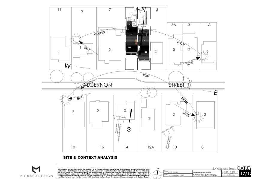
|
Georges River Council - Georges River Local Planning
Panel (LPP) - Monday, 3 September 2018
LPP035-18 5A Algernon Street Oatley
[Appendix
2] North and West
Elevation - 5A Algernon Street Oatley
|
Page 70
|
|
Georges River Council - Georges River Local Planning Panel
(LPP) - Monday, 3 September 2018
LPP035-18 5A Algernon Street Oatley
[Appendix
3] West and East
Elevation - 5A Algernon Street Oatley
|
Page 71
|
|
Georges River Council - Georges River Local Planning
Panel (LPP) - Monday, 3 September 2018
LPP035-18 5A Algernon Street Oatley
[Appendix
4] South and East
Elevation - 5A Algernon Street Oatley
|
Page 72
|
|
Georges River Council - Georges River Local Planning
Panel (LPP) - Monday, 3 September 2018
LPP035-18 5A Algernon Street Oatley
[Appendix
5] Shadows -
March - September 21st - 5A Algernon Street Oatley
|
Page 73
|
|
Georges River Council - Georges River Local Planning
Panel (LPP) - Monday, 3 September 2018
LPP035-18 5A Algernon Street Oatley
[Appendix
6] Shadows - June
21st - 5A Algernon Street Oatley
|
Page 74
|
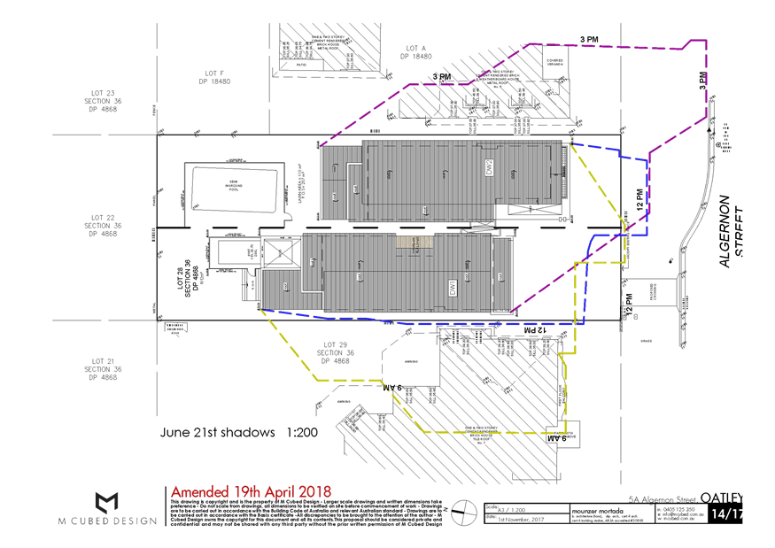
|
Georges River Council – Local Planning
Panel Monday, 3 September 2018
|
Page 75
|
REPORT TO GEORGES RIVER COUNCIL
LPP MEETING OF Monday, 03 September 2018
|
LPP Report No
|
LPP036-18
|
Development Application No
|
DA2017/0256
|
|
Site Address & Ward Locality
|
74-78 Carwar Avenue Carss Park
Blakehurst Ward
|
|
Proposed Development
|
Minor works including a new
retractable awning and paving, increase in seating and trading hours to existing
cafe within Carss Park (Carss Park Cafe and Grill)
|
|
Owners
|
Georges River Council
|
|
Applicant
|
Peter Szamek
|
|
Planner/Architect
|
Andrew Robinson Planning
Services and Complete
|
|
Date Of Lodgement
|
23/08/2017
|
|
Submissions
|
Three (3) submissions
|
|
Cost of Works
|
$150,000.00
|
|
Local Planning Panel Criteria
|
Development on Council Owned
Land
|
|
List of all relevant s.4.15
matters (formerly s79C(1)(a))
|
· Greater
Metropoliton Regional Envornmental Plan No 2 – Georges River Catchment
· Kogarah Local Environmental
Plan 2012
|
|
List all documents submitted
with this report for the Panel’s consideration
|
Architectural Plans
|
|
Report prepared by
|
Development Assessment Planner
|
M
|
Recommendation
|
THAT the application be approved in accordance with the
conditions included in the report.
|
|
|
Summary of matters for
consideration under Section 4.15
Have all recommendations in relation
to relevant s4.15 matters been summarised in the Executive Summary of the
assessment report?
|
Yes
|
|
Legislative clauses requiring
consent authority satisfaction
Have relevant clauses in all
applicable environmental planning instruments where the consent authority
must be satisfied about a particular matter been listed, and relevant
recommendations summarised, in the Executive Summary of the assessment
report?
|
Yes
|
|
Clause 4.6 Exceptions to
development standards
If a written request for a
contravention to a development standard (clause 4.6 of the LEP) has been
received, has it been attached to the assessment report?
|
Not
Applicable
|
|
Special Infrastructure
Contributions
Does the DA require Special
Infrastructure Contributions conditions (under s7.24)?
|
Not
Applicable
|
|
Conditions
Have draft conditions been provided
to the applicant for comment?
|
No,
standard conditions have been attached with no design changes
|
|
Site Plan
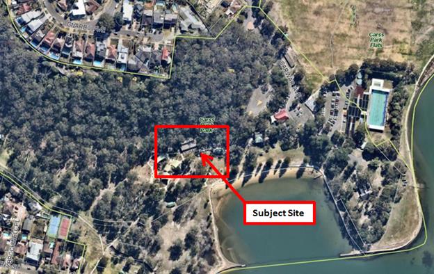
|
Executive Summary
Proposal
1. Development
consent is sought for the construction of a retractable awning over the
existing outdoor terrace area, paving of a 9sqm within the outdoor terrace,
increase in seating from 80 to 120 patrons and increase in approved trading
hours from the approved 6.30am to 10.00pm Monday to Sunday inclusive to 6.30am
to 11.00pm on Fridays and Saturdays.
Site and Locality
2. The
subject site identified as Lot 376 in DP 1118749 and is known as Carss Park
Cafe and Grill. The site is centrally located within Carss Bush Park in Carss
Park, adjacent to the waters of Kogarah Bay. Carss Bush Park is bounded by Todd
Park to the west, residential properties in Miowera Street, part Bunyala
Street, part Gnarbo and Allawah Avenues Carwar Avenue and Carlton Crescent to
the north, Kogarah Bay and Carss Park Flats to the east and residential
properties in Church, Brockwell Place, Torrens and Beach Streets to the south.
Carss Park
offers various services and recreational activities including the Carss Park
Cafe, Kogarah War Memorial Olympic Swimming Pool, sports field, playground
areas and various other amenities.
Zoning and Permissibility
3. The
subject site is zoned RE1 – Public Recreation in accordance with the
Kogarah Local Environmental Plan 2012.
Submissions
4. The
proposal was notified to adjoining neighbours for a period of
fourteen (14) days during which time three (3) submissions were received, one
(1) in support and two (2) objections.
Conclusion
5. The
proposed development generally complies with the planning controls and
objectives within Kogarah Local Environmental Plan 2012 and Carss Bush Park
& Todd Park Plan of Management 2004. In view of the above, the application
is recommended for approval subject to conditions included in the report.
Report in Full
Proposal
6. Development
consent is sought for the construction of a retractable awning over the
existing outdoor terrace area, paving of a 9sqm area within the outdoor
terrace, increase in seating from 80 to 120 patrons and increase in approved
trading hours from the approved 6.30am to 10.00pm Monday to Sunday inclusive to
6.30am to 11.00pm on Fridays and Saturdays.
The proposed
awning measures at 16.5m wide, 7m deep and 3.5m high and will be divided into
four (4) sections, with each section having metal guide tracks on either side
which will secure the awning when extended over the paved terrace area. The
awning will comprise the following specifications as per the supplier:
Coated
fabric for textile architecture.
Fabric
consisting of a 100 % polyester backing coated on both sides with fire-retarded
polyvinyl chloride and with a varnish made of polymethyl metacrylate and
polyvinyl chloride.
Overall
nominal weight per unit area: 694 g/sqm.
Nominal
weight per unit area of the backing: 194 g/sqm. Colour: white.
The proposal
seeks approval to accommodate the additional patrons by proposing an additional
9sqm of paved area within the existing front setback of the café, where
the existing terrace is located. Historically, a tree was located within the
unpaved area, which has subsequently been removed by Council. The area will be
paved using pavers to match the existing aesthetics of the site.
The Site and Locality
7. The
subject site identified as Lot: 376 in DP: 1118749 and is known as Carss Park
Cafe and Grill. The site is centrally located within Carss Bush Park in Carss
Park, adjacent to the waters of Kogarah Bay. Carss Bush Park is bounded by Todd
Park to the west, residential properties in Miowera Street, part Bunyala
Street, part Gnarbo and Allawah Avenues Carwar Avenue and Carlton Crescent to
the north, Kogarah Bay and Carss Park Flats to the east and residential
properties in Church, Brockwell Place, Torrens and Beach Streets to the
south.
Carss Park offers various
services and recreational activities including the Carss Park Cafe, Kogarah War
Memorial Olympic Swimming Pool, sports field, playground areas and various
other amenities.
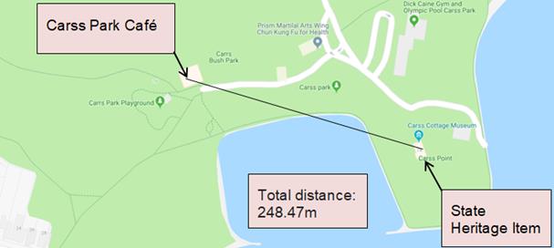
Aerial
Photo – Subject Site, 74-78 Carwar Avenue, Carss Park (Source:
Nearmaps 2018)
Carss Park
Café and Grill
Background
8. The
subject DA (DA2017/0256) was lodged on 20 July 2017.
PLANNING
ASSESSMENT
9. The
site has been inspected and the proposed development has been assessed under
the relevant Section 4.15(1) "Matters for Consideration" of the
Environmental Planning and Assessment Act 1979.
Environmental
Planning Instruments
Local
Environmental Plan
10. The
extent to which the proposal complies with the relevant standards of Local
Environmental Plan is outlined in the table below.
|
Clause
|
Standard
|
Proposed
|
Complies
|
|
Part 2 – Permitted or
Prohibited Development
|
RE1 Public
Recreation
|
The proposal is defined as kiosk.
Kiosks are permissible within the zone.
|
Yes
|
|
|
Objectives of the Zone
|
The proposal achieves the
objectives of the zone.
|
Yes
|
|
4.3 – Height of Buildings
|
No maximum applicable height
as identified on Height of Buildings Map
|
3.5m
|
Yes
|
|
4.4 – Floor Space Ratio
|
No maximum applicable FSR as
identified on Floor Space Ratio Map
|
NA – no additional FSR
proposed
|
Yes
|
|
5.10 – Heritage Conservation
|
To conserve the
environmental heritage of Kogarah,
To conserve the
heritage significance of heritage items and heritage conservation areas,
including associated fabric, settings and views,
To conserve
archaeological sites,
To conserve Aboriginal objects and
Aboriginal places of heritage significance
|
The subject site (Carss Bush Park)
has been identified as a heritage item of local significance under Schedule 5
Environmental Heritage in the KELP 2012 Heritage Map.
In addition, the allotment contains
a State Significant Heritage Item – Carss Cottage, which is located
over 200m away from the Carss Park Café Site, which is illustrated in Figure
2 above. The application was referred to the Office of Environment and
Heritage in which a response was received detailing this cottage is not
within the curtilage of the State Item and is therefore not Integrated.
The application was also reviewed
by Council’s Heritage Advisor where the application has been supported
given the distance from the item and that the development will not impact
upon the heritage nature of the site or the cottage.
The application is supported by
Council’s Heritage Advisor.
See additional comments below.
|
Yes (1)
|
|
6.1 – Acid sulfate soils
|
Works within 500m of adjacent class
1, 2, 3 or 4 land that is below 5 metres
Australian Height Datum and by
which the watertable is likely to be lowered below 1 metre Australian Height
Datum on adjacent Class 1, 2, 3 or 4 land.
|
The site has the following Acid
Sulfate Soil constrains:
- Class
2
- Class
3
- Class
5
The allotment does not propose any
cut and fill works, as per the submitted Section Plan with the Development
Application.
As such there are no requirements
to investigate the acid sulphate soils.
|
Yes
|
|
6.7 – Essential Services
|
The following services that are
essential for the development shall be available or that adequate
arrangements must be made available when required:
* Supply of water, electricity and
disposal and management of sewerage
*Stormwater drainage or on-site
conservation
*Suitable vehicular access
|
Essential services are available to
the development.
Suitable vehicular access is
available to the site.
|
Yes
|
(1)
Heritage
Carss Park Cafe
and Grill is located within the boundaries of Carss Bush Park. Carss Bush Park
is identified as an item of environmental heritage in the Kogarah Local
Environmental Plan 2012 identified as Item 31. Carss Bush Park comprises of a
number of buildings, one of these being Carss Cottage, which is listed on the
State Heritage List.
The subject site
is not located within the visual catchment of the State Heritage Listed Carss
Cottage therefore; the proposal has been assessed in relation to its impact on
the heritage significance of Carss Bush Park. The proposed works involve minor
alterations to the Cafe structure, which contributes to the social significance
of Carss Bush Park. The proposed minor additions would be limited to a small
area of the cafe including the skillion shaped retractable awning to match the
skillion roof of the existing building and minor paving located on the existing
ground floor terrace of the cafe.
The proposed works
have been assessed against the objectives of Clause 5.10 of Kogarah LEP 2012,
and will have no adverse impacts on the environmental heritage of Carss Park.
This included referral to Council’s Heritage Advisor, who has advised
that the proposal is acceptable from a heritage point of view.
The proposed awning
is an extension to an existing awning that provides shelter for the existing
community centre’s deck along the north and west edges. The awning will
remain within the existing building’s footprint therefore; will not
appear excessively bulky when viewed from Carwar Avenue and Carlton
Crescent.
The proposed works
will not affect the heritage significance of Carss Bush Park, adjoining roads,
public land or waterways and are therefore supported.
Referral to
Office of Environment and Heritage
11. The
recreational allotment in Carss Park contains a State Significant Heritage
item, identified as ‘Carss Cottage’.
The application
was referred to the Office of Environment and Heritage on 15 June 2018.
Council has
received written correspondence in relation to the proposed application, with
the Office of Environmental and Heritage deeming the proposed work is not
integrated as the works are not proposed within the curtilage of the State
Item.
State
Environmental Planning Policies
12. Compliance
with the relevant State Environmental Planning Policies is detailed below.
Greater
Metropolitan Regional Environmental Plan No 2 – Georges River Catchment
13. The
site is within the area affected by the Greater Metropolitan Regional
Environmental Plan No 2 – Georges River Catchment. The proposal,
including the disposal of stormwater, is consistent with Council’s
requirements for the disposal of stormwater in the catchment.
State
Environmental Planning Policy No 55 – Remediation of Land
14. The
subject site is zoned RE1 public recreation and has a history of public
recreation use therefore, it is considered unlikely that the land is
contaminated.
Draft
Environmental Planning Instruments
15. The
Draft Environment SEPP was exhibited from 31 October 2017 to 31 January 2018.
This consolidated SEPP proposes to simplify the planning rules for a number of
water catchments, waterways, urban bushland, and Willandra Lakes World Heritage
Property. Changes proposed include consolidating the following seven existing SEPPs:
· State Environmental Planning Policy No. 19 – Bushland in Urban
Areas
· State Environmental Planning Policy (Sydney Drinking Water
Catchment) 2011
· State Environmental Planning Policy No. 50 – Canal Estate
Development
· Greater Metropolitan Regional Environmental Plan No. 2 –
Georges River Catchment
· Sydney Regional Environmental Plan No. 20 – Hawkesbury-Nepean
River (No.2-1997)
· Sydney Regional Environmental Plan (Sydney Harbour Catchment) 2005
· Willandra Lakes Regional Environmental Plan No. 1 – World
Heritage Property.
The proposal is not
inconsistent with the provisions of this Draft Instrument.
Development
Control Plans
16. There
are no controls that relate to this form of development in Kogarah Development
Control Plan 2013.
Carss Bush Park
& Todd Park Plan of Management 2004
17. The
subject kiosk has been identified as a facility that could offer community
benefit in the Carss Bush Park and Todd Park Plan of Management 2004. General
performance measures have been included in the document which include limiting
the hours of operation to 6.30am to 10.00pm, maximum patronage limited to 80
persons and prohibit any structural extension to the existing footprint of the
kiosk. These strategies and objectives were included as a guide to assist
Council with converting the original Kiosk to a licensed Restaurant/ Kiosk
subsequent to the termination of the previous lease in 2001. The plan of
management indicates that the strategies and objectives are as listed unless
expressly permitted by development consent.
The proposed
awning measures at 16.5m wide, 7m deep and 3.5m high. The proposed retractable
awning does not constitute a permanent structure as it will be located outside
the cafe, providing shade over the outdoor seating area therefore, it will not
have any adverse impacts on the surrounding existing natural and built
environment. The awning is supported subject to conditions of consent.
The proposal to
increase in patron capacity and trading hours has been assessed and in this regard
is supported due to the following reasons:
- The
subject site is currently already operating as a cafe;
- The
site is located within Carss Bush Park, which is not immediately adjacent to
residential development;
- The
subject site can accommodate an increase in seating for patronage without the
need for further development;
- Carss
Park Life Saving Hall is approved to trade until 11.00pm for private events;
and
- An
increase in car parking spaces is not required to accommodate the increase in
patrons.
Notwithstanding
the above, it is recommended that the increase in patrons from 80 persons to
120 persons and increase in trading hours from 6.00pm – 10.00pm to 6.00pm
– 11.00pm on Friday and Saturday be granted for a trial period of twelve
(12) months. The trial period will allow for Council to monitor the performance
of the Cafe and Grill to ensure that compliance with all conditions is
maintained.
IMPACTS
Natural
Environment
18. The
site is surrounded by dense vegetation with large trees and other natural
features. The proposal does not seek to remove any trees or other form of
vegetation within the existing surrounds.
Built
Environment
19. The
proposed development would not result in any adverse impacts upon the built
environment for reasons discussed throughout the report.
Social and
Economic Impact
20. The
proposed development would not result in any adverse social and/or economic
impacts within the locality.
Suitability
of the Site
21. It
is considered that the proposed development is of a scale and design that is
suitable for the site having regard to its size and shape, its topography and
relationship to adjoining developments.
SUBMISSIONS AND
THE PUBLIC INTEREST
22. The
proposal was notified to adjoining neighbours for a period of
fourteen (14) days during which time three (3) submissions were received, one
(1) in support and two (2) objections.
NB: Two individual submissions received a further submission was received
from Kogarah Bay Progress Association Inc which did not reference any
particular surrounding residential properties.
The submissions raised the following issues.
Increase in
patron capacity
Comment:
The increase in patrons will not have an adverse effect on the surrounding
natural and built environments. As noted previously in this report, the
café building is located a significant distance (over 100m) from the
nearest residential property, and so it is considered that the increased patron
capacity would have minimal amenity or noise impacts. The premise is trading as
a Cafe with existing patron activity subject to the approved capacity. The
proposed patron increase will be trialled for a period of twelve (12) months,
which will allow any potential impacts from the proposal to be monitored.
Extension
of trading hours
Comment:
The increase in trading hours is permissible subject to consent from
Council. The proposed increase in trading hours is for one additional hour on
Fridays and Saturdays, from the approved 10.00pm to 11.00pm. The proposal does
not seek to change the use from its existing operation as a cafe and grill
therefore, the proposed increase in trading hours is unlikely to have adverse effects
on the surrounding natural and built environment however this is subject to a
trial period of twelve months.
It is also noted
that Carss Bush Park contains another building the Carss Park Life Saving Club
building that is available for hire until 11pm, and is used regularly for
parties and gatherings. While it is considered that the use of the subject
building (as a café open every Friday/Saturday night) is slightly
different to a club building used more infrequently on a hire basis, the
extended hours of operation of the café until 11pm would be consistent
with the use of the Life Saving Club building.
Excess
noise created as a result of increased patronage and extension of trading
hours
Comment:
Conditions of consent regarding noise control have been included to ensure
that the premise complies with noise requirements. Noise level controls have
been specified in the conditions in order to limit the noise emitted from the
premises between 7.00am and 11pm.
REFERRALS
Council
Referrals
Heritage
Advisor
23. The
proposal is supported by Council’s heritage advisor subject to standard
conditions. Council’s Heritage advisor requested that a schedule of
materials and finishes should be submitted prior to the issue of construction
certificate.
CONCLUSION
24. The
proposal seeks approval for a retractable awning, new paving, and increase in
seating and trading hours to the existing Carss Park Cafe & Grill.
The
application was notified for a period of fourteen days and three submissions
were lodged. One submission was in support of the proposal while the remaining
two raised concerns regarding the proposed increase in patrons, trading hours
and potential noise impacts as a result of the proposal. The proposed
development generally complies with the planning controls and objectives within
Kogarah Local Environmental Plan 2012 and Carss Bush Park & Todd
Park Plan of Management 2004.
In view of the
above, the application is recommended for approval subject to conditions
included in the report.
DETERMINATION
AND STATEMENT OF REASONS
Statement of
Reasons
· The proposed development
is considered to be an appropriate scale and form for the site and the
character of the locality;
· The proposed development,
subject to the recommended conditions, will have no unacceptable adverse
impacts upon the natural or built environments;
· In consideration of the
aforementioned reasons, the proposed development is a suitable and planned use
of the site and its approval is in the public interest.
THAT pursuant
to Section 4.16(1) of the Environmental Planning and Assessment Act, 1979, as
amended, the Council grants development consent to Development Application
DA2017/0256 for the construction of retractable awning, new paving, increase in
seating and trading hours to the existing Cars Park Cafe and Grill at 74-78
Carwar Avenue, Carss Park, subject to the following conditions of consent:
CONDITIONS
Schedule
A – Site Specific Conditions
GENERAL
CONDITIONS
These conditions
have been imposed to ensure that the development is carried out in accordance
with the approved plans and to ensure that the appropriate fees and bonds are
paid in relation to the development.
1. Approved
Plans - The development must be implemented in accordance with the approved
plans and supporting documentation listed below which have been endorsed by
Council’s approved stamp, except where marked up on the plans and/or
amended by conditions of this consent:
|
Description
|
Reference No.
|
Date
|
Revision
|
Prepared by
|
|
Proposed canopy - Conceptual Site Plan
|
Dwg No. 2
|
29/05/2015
|
Rev 3
|
Complete Urban
|
|
Proposed canopy - Sections
|
Dwg No. 3
|
29/05/2015
|
Rev 3
|
Complete Urban
|
PRIOR TO THE
ISSUE OF THE CONSTRUCTION CERTIFICATE
These conditions
either require modification to the development proposal or further
investigation/information prior to the issue of the Construction Certificate to
ensure that there is no adverse impact.
2. Building
Works To Comply With BCA - Heritage Buildings Or Buildings Within Conservation
Area - Any building works required to ensure compliance with the BCA or new
building standards not specified in the submitted/approved plan must not damage
existing fabric and building features. If such upgrading works will potentially
impact on existing fabric and features, details of the works must be submitted
and approved by Council’s Heritage Advisor prior to issue of a
Construction Certificate.
3. External
Colour Scheme (Other Buildings) - The external colour scheme is to be
sympathetic to the architectural style and period of the building and/or
Heritage Conservation Area. A schedule of colours is to be submitted to and
approved by Council’s Heritage Advisor prior to the issue of the
Construction Certificate.
4. General
Heritage -
(a) The proposed works are to be carried out in a manner
that minimises demolition, alterations and new penetrations/fixings to the
significant fabric of the existing building.
(b) The fabric and features to be retained by the proposal
must be properly protected during the process of demolition and construction.
(c) All conservation and adaptation works are to be in
accordance with the Articles of the Australian ICOMOS Burra Charter 1999.
(d) New services are to be surface mounted rather than
chased-in to existing walls to minimise impact on heritage fabric.
(e) Appropriately qualified tradespersons (as appropriate)
are to be commissioned who are skilled in traditional building and engineering
trades to carry out the proposed scope of works.
5. Access
for Persons with a Disability - for persons with disabilities must be
provided to the premises/building in accordance with the requirements of the
Premises Standards, the Building Code of Australia, and AS 1428.1. Details must
be submitted with the Construction Certificate Application for approval.
6. Tree
Removal prohibited - This consent does not approve the removal or pruning
(branches or roots) of any trees on the subject property, Council’s
public footway, public reserves or on neighbouring properties.
7. Fees
to be paid - The fees listed in the table below must be paid in accordance
with the conditions of this consent and Council’s adopted Fees and
Charges applicable at the time of payment (available at www.georgesriver.nsw.gov.au).
Payments must be made prior to the issue of the Construction Certificate
or prior to the commencement of work (if there is no associated Construction
Certificate).
Please contact Council prior to the payment of Section 7.11 Contributions
to determine whether the amounts have been indexed from that indicated below in
this consent and the form of payment that will be accepted by Council.
Council will only accept Bank Cheque or Electronic Funds Transfer (EFT)
for transaction values of $500,000 or over. Council must be contacted prior to
payment to determine correct total amount to be paid and bank account details
(if applicable).
A summary of the fees to be paid are listed below:
|
Fee Type
|
Fee
|
|
GENERAL FEES
|
|
Long Service
Levy (to Long Service Corporation) Or, provide evidence of Payment direct to
the Long Service Corporation. See https://portal.longservice.nsw.gov.au/bci/levy/
|
|
Builders Damage
Deposit
|
$1,900.00
|
|
Inspection fee
for refund of damage deposit
|
$155.00
|
|
DEVELOPMENT
CONTRIBUTIONS
|
|
Georges River
Council Section 94A Development Contributions Plan 2017
|
$700.00
|
General Fees
The fees and charges above are subject to change and are as set out in
the version of Council's Schedule of Fees and Charges or as required by other
Government Authorities, applicable at the time of payment.
Development Contributions
The Section 7.11 contribution is imposed to ensure that the development
makes adequate provision for the demand it generates for public amenities and
public services within the area.
A Section 7.12 contribution has been levied on the subject development
pursuant to the Georges River Council Section 94A Contributions Plan.
Indexation
The above contributions will be adjusted at the time of payment to
reflect changes in the cost of delivering public amenities and public services,
in accordance with the indices provided by the relevant Section 94 Development
Contributions Plan.
Timing of Payment
The contribution must be paid and receipted by Council prior to the
release of the Construction Certificate.
Further Information
A copy of the all current Development Contributions Plans may be
inspected or a copy purchased at Council’s offices (Georges River Civic
Centre, MacMahon Street, Hurstville and Kogarah Library and Service Centre,
Kogarah Town Square, Belgrave Street, Kogarah) or viewed on Council’s
website www.georgesriver.nsw.gov.au.
8. Erosion
& Sedimentation Control - Erosion and sediment controls must be
provided to ensure:
(a) Compliance with the approved Erosion & Sediment Control Plan
(b) Removal or disturbance of vegetation and top soil is
confined to within 3m of the approved building area (no trees to be removed
without approval)
(c) All clean water runoff is diverted around cleared or exposed areas
(d) Silt fences, stabilised entry/exit points or other
devices are installed to prevent sediment from entering drainage systems or
waterways
(e) All erosion and sediment controls are fully maintained
for the duration of demolition, excavation and/or development works
(f) Controls are put into place to prevent tracking of
sediment by vehicles onto adjoining roadway
(g) All disturbed areas are rendered erosion-resistant by
turfing, mulching, paving or similar
(h) Compliance with Managing Urban Stormwater - Soils and
Construction (Blue Book) produced by Landcom 2004.
These measures are to be implemented prior to the commencement of work
(including demolition and excavation) and must remain until works are completed
and all exposed surfaces are landscaped/sealed.
9. Damage
Deposit - Minor Works - In order to insure against damage to Council
property the following is required:
(a) Pay Council, before the issue of the Construction Certificate, a
damage deposit for the cost of making good any damage caused to any Council
property as a result of the development: $1,900.00
(b) Pay Council, before the issue of the Construction Certificate, a
non-refundable inspection fee to enable assessment of any damage and repairs
where required: $150.00
(c) Submit to Council, before the commencement of work, a photographic
record of the condition of the Council nature strip, footpath and driveway
crossing, or any area likely to be affected by the proposal.
At the completion of work Council will inspect the public works, and the
damage deposit will be refunded in full upon completion of work where no damage
occurs. Otherwise the amount will be either forfeited or partly refunded
according to the amount of damage.
10. Waste
Management Plan - A Waste Management Plan incorporating all requirements in
respect of the provision of waste storage facilities, removal of all materials
from the site that are the result of site clearing, extraction, and, or
demolition works and the designated Waste Management Facility shall be
submitted to the Certifying Authority prior to the issue of any Construction
Certificate.
ONGOING
CONDITIONS
These conditions
have been imposed to ensure that the use or operation of the development does
not adversely impact on the amenity of the neighbourhood or environment.
11. Noise Control
- The use of the premises must not give rise to the transmission of offensive
noise to any place of different occupancy. Offensive noise is defined in the
Protection of the Environment Operations Act 1997 (as amended).
12. Hours of
operation - The approved hours of operation shall be restricted to the
following:
(a) The extended hours of operation are: 6.30am to 11.00pm on Fridays and
Saturdays
The use may operate over the extended hours of operation for a trial
period of twelve (12) months from the date of the Occupation Certificate (where
one is issued) or the date at which the use commences operation where no
Occupation Certificate is required to be issued.
Should the applicant intend to continue operating over the extended hours
of operation, the consent is to be modified by an application under Section
4.55 of the Environmental Planning and Assessment Act 1979. The assessment of
this application will be based on the operation of the use over the nominated
trial period.
Where a Section 4.55 application is not received before the trial period
ends, the hours of operation will revert back to the standard hours of
operation 6.30am to 10.00pm Fridays and Saturdays.
13. Outdoor Lighting
- To avoid annoyance to the occupants of adjoining premises or glare to
motorist on nearby roads, outdoor lighting must comply with AS 4282-1997:
Control of the obtrusive effects of outdoor lighting.
14. Lighting -
General Nuisance - Any lighting on the site shall be designed so as not to
cause a nuisance to other residences in the area or to motorists on nearby
roads and to ensure no adverse impact on the amenity of the surrounding area by
light overspill or glare.
Flashing, moving or intermittent lights or signs are prohibited.
15. Activities and
storage of goods outside buildings - There shall be no activities including
storing or depositing of any goods or maintenance to any machinery external to
the building with the exception of waste receptacles.
16. Variable
Maximum Patron Capacity -
(a) The maximum patron capacity within the premises shall
be limited to 80 persons at any time.
(b) Notwithstanding (a) above, the use may operate with a
maximum patron capacity of 120 persons. This maximum patron capacity may be
reviewed by Council at any time, subject to the operator of the premises being
given twenty one (21) days written notice that a review of the maximum patron
capacity will take place. In that time the operator may submit to Council any
information they wish to be considered in support of the maximum patron
capacity.
(c) Any review of the maximum patron capacity in (b) above
by Council will be based on, among other things, the performance of the
operator in relation to the compliance with the development consent conditions,
any substantiated complaints received and any views expressed during public
consultation or from other stakeholders including the Police.
(d) Following a review, Council may allow the use to
continue to operate with a maximum patron capacity as specified in (b) above,
require the use to revert to the maximum patron capacity specified in (a) above
or otherwise modify the condition as considered appropriate.
(e) The purpose of the reviewable condition is to allow
ongoing assessment of the maximum patron capacity in relation to neighbourhood
amenity, public safety and operational performance and allow management to
demonstrate successful practices in relation to the above.
17. Licensed
Premises - Noise Levels (7.00am to 12midnight) - The LA10 noise level
emitted from the premises, measured between the hours of 7am and 12 midnight,
is not to exceed the background noise level in any octave band frequency
(centred on 31.5Hz to 8 kHz inclusive) by more than 5 dB, when measured at the
boundary of any adjoining residence.
18. Amenity of the
neighbourhood - The implementation of this development shall not adversely
affect the amenity of the neighbourhood or interfere unreasonably with the
comfort or repose of a person who is outside the premises by reason of the
emission or discharge of noise, fumes, vapour, odour, steam, soot, dust, waste
water, waste products, grit, oil or other harmful products.
Schedule
B – Prescribed Conditions
Prescribed
conditions are those which are mandated under Division 8A of the Environmental
Planning and Assessment Regulation 2000 and given weight by Section 80A
(11) of the Environmental Planning and Assessment Act 1979.
Detailed below is
a summary of all the prescribed conditions which apply to
development in New South Wales. Please refer to the full details of the
prescribed conditions as in force, at www.legislation.nsw.gov.au.
It is the
responsibility of the beneficiary of this consent to determine which prescribed
conditions apply.
19. Clause 98A
– Erection of Signs - Requires the erection of signs on site and
outlines the details which are to be included on the sign. The sign must
be displayed in a prominent position on site and include the name and contact
details of the Principal Certifying Authority and the Principal Contractor.
20. Clause 98C-
Entertainment Venues - Schedule 3A of the Environmental Planning and
Assessment Act 1979 outlines the prescribed conditions which apply to
Entertainment Venues.
21. Clause 98D
– Erection of sign for maximum number of persons - This prescribed
condition applies to entertainment venues, function centres, pubs, registered
clubs and restaurants. This condition requires the erection of a sign
which states the maximum number of persons (as specified in the consent) that
are permitted in the building.
22. Clause 98E
– Protection & support of adjoining premises - If the development
involves excavation that extends below the level of the base of the footings of
a building on adjoining land, this prescribed condition requires the person who
benefits from the development consent to protect and support the adjoining
premises and where necessary underpin the adjoining premises to prevent any
damage.
Schedule C – Operational & Statutory
Conditions
These conditions
comprise the operational and statutory conditions which must be satisfied under
the Environmental Planning and Assessment Act 1979 and the Environmental
Planning & Assessment Regulation 2000. Please refer to the full details of
the Act and Regulations as in force, at www.legislation.nsw.gov.au.
It is the
responsibility of the beneficiary of this consent to determine which
operational and statutory conditions apply.
23. Requirement for
a Construction Certificate - The erection of a building must not commence
until a Construction Certificate has been issued by the consent authority, the
Council (if the Council is not the consent authority) or an accredited
certifier.
An application
form for a Construction Certificate is attached for your
convenience.
24. Appointment of
a Principal Certifying Authority - The erection of a building must not
commence until the beneficiary of the development consent has:
(a) appointed
a Principal Certifying Authority (PCA) for the building work; and
(b) if
relevant, advised the PCA that the work will be undertaken as an Owner-Builder.
If the work is not
going to be undertaken by an Owner-Builder, then the beneficiary of the consent
must:
(a) appoint a Principal Contractor to undertake
the building work. If residential building work (within the meaning of the Home
Building Act 1989) is to be undertaken, the Principal Contractor must be a
holder of a contractor licence; and
(b) notify
the PCA of the details of any such appointment; and
(c) notify the Principal Contractor of any
critical stage inspections or other inspections that are required to be carried
out in respect of the building work.
An Information
Pack is attached for your convenience should you wish to appoint
Georges River Council as the Principal Certifying Authority for your
development.
25. Notification of
Critical Stage Inspections - No later than two (2) days before the building
work commences, the PCA must notify:
(a) the consent authority and the Council (if
not the consent authority) of his or her appointment; and
(b) the beneficiary of the development consent
of the critical stage inspections and other inspections that are to be carried
out with respect to the building work.
26. Notice of
Commencement - The beneficiary of the development consent must give at
least two (2) days notice to the Council and the PCA of their intention to
commence the erection of a building.
A
Notice of Commencement Form is attached for your convenience.
27. Critical Stage Inspections
- The last critical stage inspection must be undertaken by the Principal
Certifying Authority. The critical stage inspections required to be
carried out vary according to Building Class under the Building Code of
Australia and are listed in Clause 162A of the Environmental Planning and
Assessment Regulation 2000.
28. Notice to be
given prior to critical stage inspections - The principal contractor for a
building site, or the owner-builder, must notify the principal certifying
authority at least 48 hours before each required inspection needs to be carried
out.
Where Georges
River Council has been appointed PCA, forty eight (48) hours notice in writing,
or alternatively twenty four (24) hours notice by facsimile or telephone, must
be given to when specified work requiring inspection has been completed.
29. Occupation
Certificate - A person must not commence occupation or use of the whole or
any part of a new building unless an Occupation Certificate has been issued in
relation to the building or part.
Only the Principal
Certifying Authority appointed for the building work can issue the Occupation
Certificate.
An Occupation
Certificate Application Form is attached for your convenience.
If you need more
information, please contact the undersigned on 9330 6400 between 9.00am -
11.00am business days.
ATTACHMENTS
|
Attachment ⇩1
|
Existing Site Plan - 74-78 Carwar Avenue Carss Park
|
|
Attachment ⇩2
|
Site Plan - 74-78 Carwar Avene Carss Park
|
|
Georges
River Council - Georges River Local Planning Panel (LPP) - Monday, 3
September 2018
LPP036-18 74-78 Carwar Avenue Carss Park
[Appendix
1] Existing Site
Plan - 74-78 Carwar Avenue Carss Park
|
Page 92
|
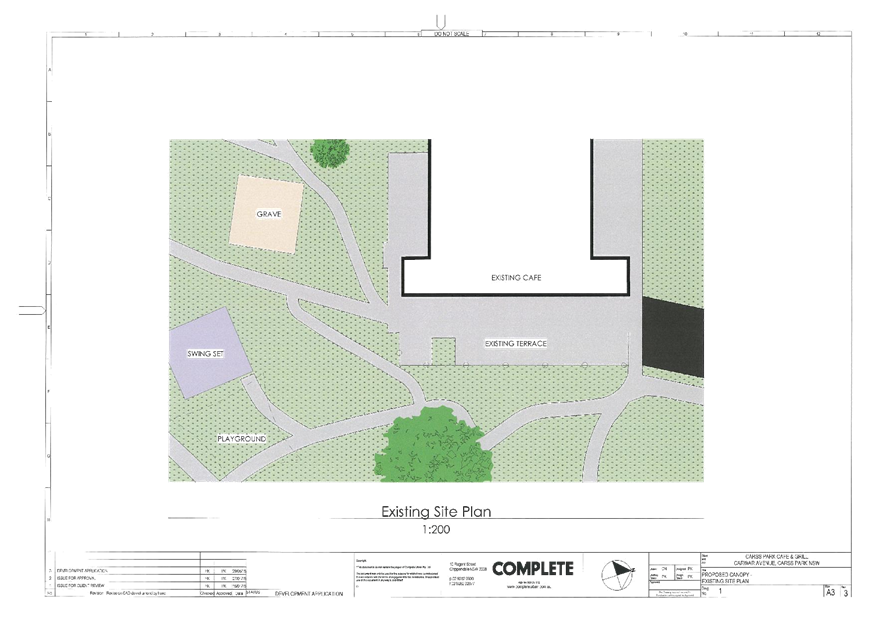
|
Georges River Council - Georges River Local Planning
Panel (LPP) - Monday, 3 September 2018
LPP036-18 74-78 Carwar Avenue Carss Park
[Appendix
2] Site Plan -
74-78 Carwar Avene Carss Park
|
Page 93
|
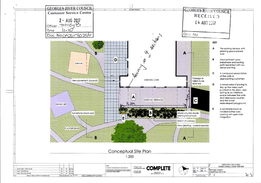
|
Georges River Council – Local Planning
Panel Monday, 3 September 2018
|
Page 94
|
REPORT TO GEORGES RIVER COUNCIL
LPP MEETING OF Monday, 03 September 2018
|
LPP Report No
|
LPP037-18
|
Development Application No
|
MOD2017/0166
|
|
Site Address & Ward Locality
|
621-635 Princes Highway Blakehurst
Blakehurst Ward
|
|
Proposed Development
|
Modification application - Internal
and external modifications to the existing approved mixed use development
including an additional residential level
|
|
Owners
|
Mr G Katsenos, Ms K Katsenos, Mr N
Katsenos and Ms A Katsenos
|
|
Applicant
|
Blakehurst Investments No 1 Pty Ltd
|
|
Planner/Architect
|
Stephen Kerr of City Plan
Services and Level 33 Architectural Division
|
|
Date Of Lodgement
|
2/11/2017
|
|
Submissions
|
Nil
|
|
Cost of Works
|
$19,569,739.00
|
|
Local Planning Panel Criteria
|
Reasons to be referred to the panel
as the application being subject to State Environmental Planning Policy No 65
– Design Quality of Residential Apartment Development is referenced in
Schedule 1, 4(b) of the Local Planning Panels Direction - Development
Applications dated 23 February 2018 as required to be determined by the Local
Planning Panel.
|
|
List of all relevant s.4.15
matters (formerly s79C(1)(a))
|
Greater Metropolitan Regional
Environmental Plan No 2 – Georges River Catchment, State Environmental
Planning Policy (Infrastructure) 2007, State Environmental Planning Policy No
55 - Remediation of Land ,
State Environmental Planning Policy
No 65 – Design Quality of Residential Apartment Development, State
Environmental Planning Policy (Building Sustainability Index: BASIX) 2004,
State
Environmental Planning Policy (Vegetation in Non-Rural Areas) 2017, Kogarah
Local Environmental Plan 2012, Kogarah Development Control Plan 2013
|
|
List all documents submitted
with this report for the Panel’s consideration
|
Architectural plans, Landscape
plans,
Revised acoustic report,
Draft Stratum plan, High Voltage
Power Clearance Certificate,
Revised BASIX
|
|
Report prepared by
|
Independent Assessment
|
|
Recommendation
|
THAT the application be approved in accordance with the
conditions included in the report.
|
|
|
Summary of matters for
consideration under Section 4.15
Have all recommendations in relation
to relevant s4.15 matters been summarised in the Executive Summary of the
assessment report?
|
Yes
|
|
Legislative clauses requiring
consent authority satisfaction
Have relevant
clauses in all applicable environmental planning instruments where the
consent authority must be satisfied about a particular matter been listed,
and relevant recommendations summarised, in the Executive Summary of the
assessment report?
|
Yes
|
|
Clause 4.6 Exceptions to
development standards
If a written request for a
contravention to a development standard (clause 4.6 of the LEP) has been
received, has it been attached to the assessment report?
|
Not
Applicable
|
|
Special Infrastructure Contributions
Does the DA require Special
Infrastructure Contributions conditions (under s7.24)?
|
Not
Applicable
|
|
Conditions
Have draft conditions been provided
to the applicant for comment?
|
No,
conditions have been attached with updates only to reflect the modified works
|
|
Site Plan
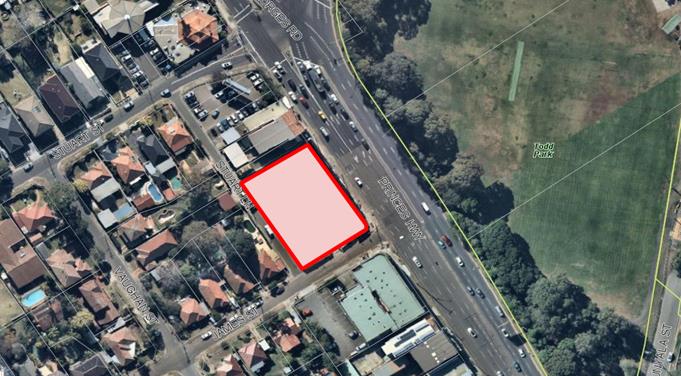
|
EXECUTIVE SUMMARY
Proposal
1. This proposal as
modified seeks to alter the layout of the approved mixed-use development
approved under Development Application DA2016/157. The modifications proposed
primarily relate to the provision of an additional floor level, relocation of
the communal open space to the rooftop, a revised apartment and car parking mix
and stratum subdivision.
Site and Locality
2. This application
relates to land at 621-635 Princes Highway, Blakehurst ("the
site") which is legally described as Lot1 DP1242789 registered 23 May
2018.
The site is located on the western side of Princes Highway.
The site has three (3) street frontages, being Princes Highway to the east,
James Street to the south and Stuart Lane to the west. The site has an area of
1,836sqm and frontages of 48.76m to Princes Highway with a splay to the James
Street intersection of 2.155m, 33.505m to James Street with a 2.155m splay to
the James Street and Stuart Lane intersection and 48.76m to Stuart Lane.
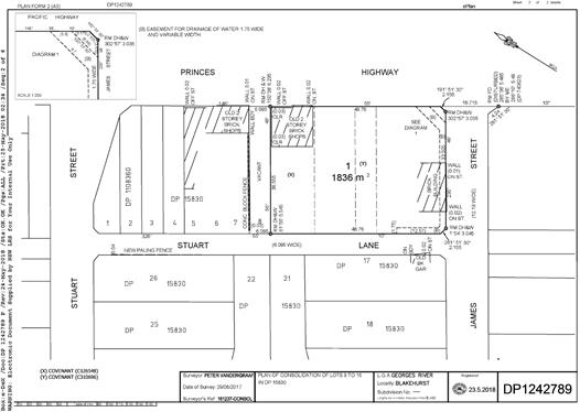
Zoning and Compliance with LEP
Standards
3. The
site is zoned B2 –Local Centre Zone under Kogarah
Local Environmental Plan 2012 (LEP) and the proposed modifications are
permissible with Council’s consent. The proposal satisfies all relevant
objectives contained within the LEP.
Development Control Plan
4. The Kogarah
Development Control Plan 2013 ("KDCP") provides detailed provisions
to guide development to achieve the objectives of the KLEP, providing detailed
controls and objectives for residential development. The proposed modifications
do not seek substantial departures from KDCP where relevant.
Submissions
5. The
application was neighbour notified three (3) times during the assessment of the
application with the
most recent notification being from 20 July 2018 to 3 August 2018. No
submissions were received during any of the notification periods of the
application.
Level of
Determination
6. The
application is referred to the Local Planning Panel for determination as the
proposal relates to modifications of an approved
development that is subject to the provisions of State
Environmental Planning Policy No 65 – Design Quality of Residential Flat
Development as outlined in Schedule 1, 4(b) of the Local Planning Panels
Direction - Development Applications dated 23 February 2018.
DESCRIPTION OF
THE PROPOSAL
7. This modified
proposal seeks to alter the layout of the approved mixed use development approved under Development Application DA2016/157 dated 11 May 2017. The modifications
proposed primarily relates to the provision of an additional floor level,
relocation of the communal open space to the rooftop, a revised apartment and
car parking mix and stratum subdivision.
The
modification will result in an increase of three (3) residential apartments,
providing a total of forty six (46) residential apartments within the building
and the provision of one hundred and fifteen (115) spaces within the basement
parking levels in lieu of the approved one hundred and eight (108) spaces.
A
written summary followed up by a floor plan detail comparison if provided
below:
Basement 3: Basement ramp modified and
car park exhaust added including the layout of the infrastructure and parking
spaces.
Basement 2:
Basement ramp modified and car park exhaust added including the layout of the infrastructure and parking spaces.
Basement 1:
Basement ramp modified and car park exhaust added including the layout of the infrastructure and parking spaces. Deep
soil added to the James Street and Princes Highway intersection.
Ground floor
plan: Three (3) ambulant toilets added to the childcare
centre one (1) with shower. The fire stairs have been reconfigured and a new
egress point added from the childcare centre. Carpark exhaust included together
with the relocation of the substation and a new fire booster cupboard included.
The gradient to the basement has been amended together with an additional
egress stair onto Stuart Lane. Deep soil landscaping has been provided to the
Princes Highway and James Street intersection.
Level 1 plan:
Car park exhaust added; a new hydraulic cupboard has been
included, a new Perspex roof is included over the child care play area to
provide light to penetrate. Acoustic attenuation included over the children’s
play area. The green wall has been included on the plans along Stuart Lane, a
roof over the substation has also been provided.
Level 2/3 plan:
Car park exhaust added along with a hydraulic cupboard.
Level 4 plan:
The unit layouts of apartments 4.1 through to and including
4.8 which front the Princes Highway have been amended from two (2) storey
apartments to single level apartments. Three (3) units have been deleted from
this level and replaced by non-trafficable roofing.
Level 5 plan
(referenced on the approved plans as the roof terrace area): The unit layouts of apartments 5.1 through to and including 5.7 which
front the Princes Highway have been amended from two (2) storey apartments to
single level apartments. The communal open space has been relocated from this
level to the level above.
Roof plan:
A new common open space area has been provided that includes an enclosed
barbeque room. An access ramp has been provided for accessible access to the
grass area while a new stormwater tank has also been included. Additional
planting has been proposed. The central gas hot water plant is also located at
this level.
HISTORY
8.
· Development Consent No. DA2016/157 for the demolition of the
existing building and construction of a six storey mixed use development
incorporating five levels of residential apartments, three levels of basement
car park and a child care centre was approved on 11 May 2017.
· This 4.55(2) application was submitted with
Council on 2 November 2017 and was neighbour notified three (3) times with the
most recent being from 20 July 2018 to 3 August 2018 where nil submissions were
received.
· The proposal was reviewed by the Design Review
Panel during their meeting held on 7 June 2018 where a number of design
recommendations were made.
· In
response to the recommendations, the architectural and landscape details were
amended and resubmitted to Council on 6 July 2018
· This
report has been prepared on the architectural plans and details submitted with
Council on 6 July 2018.
|
Design
element
|
Approved
under DA157/2016
|
Proposed
|
Control
|
Complies
|
|
Gross floor area
|
4,580sqm
|
4,593sqm (FSR 2.5:1)
|
4,593.5sqm (FSR 2.5:1)
|
Yes
|
|
Height
|
18.735m (RL25.800)
(6 storeys)
|
22m (RL30.70)
(7 storeys)
|
21m
|
No
(Lift Overrun only)
|
|
Number of units and mix
|
43 units:
1B: 11 units 2B: 22 units 3B: 10 units
|
46 units:
1 Bed - 16 units
2 Bed - 23 units
3 Bed - 7 units
|
N/A
|
Yes
|
|
Car parking
|
108 Spaces
|
115 spaces
|
95 spaces
|
Yes
|
|
Communal open space
|
561.5sqm
|
744sqm (40%)
|
459sqm (25%)
|
Yes
|
|
Deep soil
|
128.6sqm (7%)
|
101sqm (5.5%)
|
128.6sqm (7%)
|
No
|
DESCRIPTION OF
THE SITE AND LOCALITY
9. This application
relates to land at 621 - 635 Princes Highway, Blakehurst ("the site")
which is legally described as Lot1 DP1242789 registered 23 May 2018.
The site is located on the western side of Princes Highway.
The site has three (3) street frontages, being Princes Highway to the east,
James Street to the south and Stuart Lane to the west. The site has an area of
1,836sqm and frontages of 48.76m to Princes Highway with a splay to the James
Street intersection of 2.155m, 33.505m to James Street with a 2.155m splay to
the James Street and Stuart Lane intersection and 48.76m to Stuart Lane.
The allotment is rectangular and has a cross- fall of
approximately 2.5m, running generally from west to east towards the
intersection of Princes Highway and James Street. The
development site is located within the Blakehurst neighbourhood centre and
walking distance to bus stops with regular services to Miranda, Cronulla and
Hurstville.
The
site is surrounded by older style commercial buildings and low density
residential development. The surrounding context, will over time, transform as
a result of the recent amendments to the planning controls applicable to both
the subject and neighbouring sites.
The site photographs below detail the nature of both the subject site and
existing surrounding precinct.
Subject
site as viewed along the Princes Highway frontage
Subject
site as viewed along Stuart Lane
Eastern
boundary of neighbouring dwellings fronting James and Vaughan Street
View
towards the Princes Highway/James Street intersection
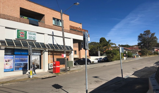
View
towards neighbouring shop-top housing development across James Street
Statutory
Considerations
ENVIRONMENTAL PLANNING AND ASSESSMENT ACT 1979
10. An assessment of the
application has been undertaken pursuant to the provisions of the Environmental
Planning and Assessment Act 1979.
S4.55 (2) States that a consent authority may, on application being made by the applicant
or any other person entitled to act on a consent granted by the consent
authority and subject to an in accordance with the regulations, modify the
consent if:
a) it is satisfied that the development to which the consent as
modified relates is substantially the same development as the development for
which the consent was originally granted and before that consent as originally
granted was modified (if at all), and
Comment: During the proceedings of Tipalea Watson Pty Ltd v Ku-ring-gai
Council (NSWLEC 253) 2003 "substantially the same development"
had the meaning of “essential characteristics” of the
approved development. In addition, during the Court proceedings of Moto
Projects (No. 2) Pty Ltd v North Sydney Council (1999) 106 LGERA 298,
Bignold, J held that: -
“The requisite factual finding obviously requires a comparison
between the development, as currently approved, and the development as proposed
to be modified. The result of the comparison must be a finding that the
modified development is “essentially or materially” the same as the
(current) approved development.”
The
proposed modifications to not result in a change to the nature of the
development while the overall scale and character of the development and its
overall impact to both the streetscape and surrounding development remains
consistent with that originally approved.
The proposed modifications do not vary the essential
features of the approved development and do not substantially alter the
approved built form or use of the site.
Overall, the
built form as approved under Development Consent No. DA157/2016 remains
substantially the same as the approved development. Other matters such as the
setbacks, general layout and access remain largely consistent with the approved
design.
b) it has consulted with the relevant Minister, public authority or
approval body (within the meaning of Division 5) in respect of a condition
imposed as a requirement of a concurrence to the consent or in accordance with
the general terms of an approval proposed to be granted by the approval body
and that Minister, authority or body has not, within 21 days after being
consulted, objected to the modification of that consent, and
No
conditions were originally imposed by either the Consent Authority, relevant
Minister, Public Authority or Approval Body. In this case, further consultation
is not warranted.
(c) it has notified the application in accordance
with:
(i) the regulations, if the regulations so require, or
(ii) a development control plan, if the consent authority
is a council that has made a development control plan that requires the
notification or advertising of applications for modification of a development
consent, and
The proposed modifications were neighbour notified on three
(3) separate occasions with the most recent being from 20 July 2018 to 3 August
2018 where no submissions were received.
d) it has considered any submissions made concerning the proposed
modification within the period prescribed by the regulations or provided by the
development control plan, as the case may be.
No submissions
were received during the notification period from 20 July 2018 to 3 August 2018 of the amended and
most relevant architectural plans and details.
S4.55 (3)
– States that in determining an application
for modification of a consent under this section, the consent authority must
take into consideration such of the matters referred to in section 4.5(1) as
are of relevance to the development the subject of the application. The consent authority must also take into
consideration the reasons given by the consent authority for the grant of the
consent that is sought to be modified.
Comment: An
assessment of the application has been carried out under the provisions of
Section 4.15(c) of the Environmental Planning and Assessment Act, 1979. The
matters of relevance to this application have been considered. The following is
an assessment of the proposed development under the provisions of Section
4.15(1) of the Environmental and Planning Assessment Act
S4.15 (1)
– Matters for Consideration - General
S4.15 (1)(a)(i)
Provisions of Environmental Planning Instruments
APPLICABLE
PLANNING CONTROLS
11. The following Environmental
Planning Instruments are relevant to this application:
· Greater Metropolitan
Regional Environmental Plan No 2 – Georges River Catchment
· State
Environmental Planning Policy No 55 - Remediation of Land
· State
Environmental Planning Policy No 65 – Design Quality of Residential Flat
Development
· State
Environmental Planning Policy (Infrastructure) 2007
· State
Environmental Planning Policy (Vegetation in Non-Rural Areas) 2017
· State
Environmental Planning Policy (Building Sustainability Index: Basix) 2004
· Kogarah Local
Environmental Plan 2012
· Kogarah
Development Control Plan 2013
Compliance with the relevant state environmental planning policies is
detailed below:
Deemed State Environmental Planning Policy – Georges River
Catchment
12. All
stormwater from the proposed development will continue
to be treated in accordance with Council’s Water Management Policy and
would satisfy the relevant provisions of the Deemed State Environmental
Planning Policy – Georges River Catchment.
State
Environmental Planning Policy (Building Sustainability Index: BASIX) 2004
13. The applicant has submitted
a revised BASIX Certificate for the proposal as modified. The Certificate
number is to be inserted. The commitments made result in reductions in
energy and water consumption within the development.
State
Environmental Planning Policy No 55 - Remediation of Land
14. The purpose of State
Environmental Planning Policy No 55 – Remediation of Land (SEPP 55) is to
ensure that land which is contaminated is identified and appropriately
remediated so as to be suitable for the proposed development.
Any issues related
to land contamination on the site was addressed during the assessment of DA2016/157. A summary of remediation and validation works was
prepared by EI Australia dated 19 February 2018. This summary concluded that after demolition and remediation works were
completed, all fill soils had been removed from the site including the
previously identified hotspots in accordance with the Remediation Action Plan
(RAP) prepared by EI (2017) titled “Remediation Action Plan, 621-635
Princes Highway, Blakehurst, NSW”. (Report Ref. E23011.E06_Rev0,
dated 21 December, 2017).
In
this instance, the proposed modifications do not warrant further investigation
works with regard to land contamination.
State
Environmental Planning Policy (Infrastructure) 2007
15. Part 3 of the Policy provides development controls
for various land uses and activities. Division 17 addresses the consideration
of RMS and, specifically, Subdivision 2 applies to development in or adjacent
to road corridors and road reservations. Specifically: -
§ Clause
102 applies noise criteria to residential development adjacent to the road
corridor for a freeway, a tollway or a transitway or any other road with an
annual average daily traffic volume of more than 40,000 vehicles (based on the
traffic volume data published on the website of the RMS) and that the consent
authority considers is likely to be adversely affected by road noise or
vibration; and
§ Clause
104 identifies traffic generating development which must be referred to the
Road and Traffic authority.
The development will not result in more than 200 motor vehicles with
access to "any road", and therefore is not required to be referred to
the RMS under 104 of the ISEPP as "traffic generating development".
In
this regard, the additional traffic generated by the increase of three (3)
residential apartments, providing a total of forty-six (46) residential
apartments within the building and the provision of one hundred and fifteen
(115) spaces within the basement parking levels in lieu of the approved one
hundred and eight (108) spaces, will not have any noticeable or unacceptable
effect on the road network serving the site in terms of road network capacity
or traffic-related environmental effect.
In the
circumstances, it can be concluded that the proposed development has no
unacceptable traffic implications."
The
Princes Highway, however, does have an annual average daily traffic volume of
more than 40,000 vehicles and therefore the noise criteria prescribed for
residential development under Clause 102 apply. The proposal is accompanied by
a revised Environmental Noise Impact Assessment prepared by Renzo Tonin &
Associates dated 20 July 2018. This report concludes that elements of the
building need to provide attenuation from the noise generated from the Princes
Highway and the Rail corridor. This can be addressed as part of the
construction certificate plans and documentation.
Clause
45 of SEPP Infrastructure requires the Consent Authority to consider any DA for
any development carried out:
§ within or immediately adjacent to an easement
for electricity purposes (whether or not the electricity infrastructure
exists);
§ immediately adjacent to an electricity
substation;
§ within 5m of an overhead power line; or
§ includes installation of a swimming pool any
part of which is: within 30m of a structure
supporting
an overhead electricity transmission line and/or within 5m of an overhead
electricity power line.
The
proposal is not within or immediately adjacent to any of the above electricity
infrastructure and does not include a proposal for a swimming pool. As such the
application is not required to be referred to the electricity supply authority.
In this regard, the subject application is considered to satisfy the provisions
of Clause 45 SEPP Infrastructure.
The
existing approval confirmed the development was outside of the 5m which was
confirmed by an authorized energy consultant This proposed has been accompanied
by a letter form AAPE Pty Ltd dated 21 August 2018 which is an authorized
electrical consultant confirming the development does not come within 5m of the
high voltage power lines.
State Environmental Planning Policy (Vegetation in Non-Rural Areas)
2017
16. The Vegetation SEPP
regulates clearing of native vegetation on urban land and land zoned for environmental
conservation/management that does not require development consent.
The Vegetation
SEPP applies to clearing of:
1. Native
vegetation above the Biodiversity Offset Scheme (BOS) threshold where a
proponent will require an approval from the Native Vegetation Panel established
under the Local Land Services Amendment Act 2016; and
2. Vegetation
below the BOS threshold where a proponent will require a permit from Council if
that vegetation is identified in the council’s development control plan (DCP).
The Vegetation
SEPP repeals clause 5.9 and 5.9AA of the Standard Instrument - Principal
Local Environmental Plan with regulation of the clearing of vegetation
(including native vegetation) below the BOS threshold through any applicable
DCP.
The proposed
development does not involve the removal of any significant tress or
vegetation. In this regard, there are references in the applicable DCP to
maximising tree retention in any development proposal and the issue is
addressed through consideration of the proposed built form and the proposed
landscaping works that are to be undertaken on site. This issue is
addressed in more detail in the accompanying Landscape Plan prepared by Taylor
Brammer.
State Environmental Planning Policy No 65—Design Quality of
Residential Apartment Development
17. The
proposed modifications were reviewed by the Design Review Panel during their
meeting held on 7 June 2018. The comments recommendations made by the Panel and
the respective plan amendments made to the proposal are detailed below.
Principle 1
– Context and Neighbourhood Character
Panel Comment:
No
Officer
Comment: The proposal as modified relates satisfactorily
to the desired future character of the area. The proposed modifications are
therefore appropriate in this regard.
Principle 2
– Built Form and Scale
Panel Comment:
The creation of a roof top communal open space has resulted in
the lift overruns that exceed the 21m height control. The Panel does not
believe this is an issue because the elements are small and located in the
centre of the building where they will not be easily seen, or cause any adverse
amenity impacts.
The
ground floor plan and cross section need to be properly coordinated to show the
right gradients of the vehicle entry ramp.
Officer
Comment: The gradients of the vehicle entry ramp have been
amended in order to allow for compliant slopes and ease of access. This is
detailed within correspondence provided by Terraffic Pty Ltd reference number
16053 dated 10 April 2018 which confirms compliance with the conditions of
consent and the relevant Australian Standards.
The
proposed modifications are minor in overall form, consistent with the scale of
existing and emerging contextual development and are generally consistent with
the desired future character of the area. The proposal as modified is
satisfactory in regards to this principle.
Principle 3 -
Density
Panel Comment:
Complies
Officer
Comment: The development satisfies the requirement and the additional roof
top barbecue area has been included in the GFA calculations.
Principle 4
– Sustainability
Panel Comment:
The issue of environmental sustainability was raised and there
was some lack of clarity as to the intentions for rain water recycling. It is
strongly recommended that for a development of such a large scale, and with a
large roof top available, initiatives relating to rain water recycling for
irrigation and other uses such as toilet flushing should be included.
The
deep soil has been reduced however it was unclear from the discussion with the
applicant the extent of the reduction. It is of concern that this site has
limited deep soil already and is relying on a small corner of deep soil under
upper level cantilevers which would significantly compromise tree planting.
Tree planting on deep soil is critical to improve local micro climate, provide
shade and other environmental services.
When a stormwater
recycling tank is provided, it must not be within the deep soil zone.
Officer
Comment: A Stormwater Recycling Tank has been provided on
the roof terrace proposed to be used for the irrigation of landscaping. The
total amount of deep soil provided is 101sqm which is 5.5% of the site area. The proposal dedicates a
1.75m wide stormwater easement that was initially dedicated as an area of deep
soil. The provision of this easement is in direct response to the requirements
made by Council’s hydraulic engineer.
While
the extent of deep soil landscaping provided is being marginally reduced, the
101m2 of area being provided is still a substantial increase to what
was provided to the site prior to redevelopment. The extent of deep soil
provided will still allow for the planting of a number of substantial tree
species as depicted in the amended landscaping plan prepared by Taylor Brammer.
The proposal as modified is satisfactory in this regard.
Principle 5- Landscape
Panel Comment:
The architectural drawings seem to contradict the roof top
landscape plan that was tabled. The following changes should be made to the
roof top space:
§ Delete
plastic lawn and replace with planting and soil;
§ Provide
a good proportion of planting area to paved area. This should minimise
expansive hard surfaces and heat retention. The priority should be on providing
soft landscaping that can provide shade, withstand high winds and provide
adequate screening between roof top gathering spaces;
§ Provide
adequate planted screening around perimeter to deal with strong wind
conditions;
§ Provide
irrigation;
§ Provide
a fully enclosed space for gatherings in
inclement weather equipped with kitchenette.;
§ Locate
2 bbqs accessed from each of the lifts and under shelter;
§ Larger
tree species be provided in roof top podium space - species should be greater
than 6m height and roof slab should be designed to accommodate soil loads.
Officer
Comment: The landscape plan prepared by Taylor Brammer has since been
amended to be reflective of the architectural plans. This plan now depicts the
provision of natural lawn in lieu of acrylic lawn while a ramped area has also
been provided to allow for ease of access to this area. A stormwater irrigation
tank has been introduced to the roof while an enclosed barbecue space with
kitchenette has been added this has been included in the GFA calculations. The
proposal as modified is satisfactory in this regard.
Principal 6 - Amenity
Panel Comment: Refer to
comments under ‘Landscape’.
Officer Comment: The
green wall originally approved along the Stuart Lane elevation has been
reinstated while additional sanitary facilities have been added to the
childcare component of the development in accordance with regulations.
Principal 7- Safety
Panel Comment: No
additional comment
Officer
Comment: Residential apartments, Childcare Centre,
communal open space and car parking areas will be accessible via a secure
electronic system. Common areas are proposed to be appropriately lit with
clearly defined pathways. The proposal as modified is satisfactory in regards
to the requirements of this principle.
Principal 8 – Housing
Diversity and Social Interaction
Panel Comment: See
comments under landscaping
Officer
Comment: The design of the proposal as modified
provides for varied housing choice for a variety of household types. The
reconfiguration of the top is designed to provide appropriate communal
facilities at rooftop level with various spaces including bbq and kitchenette
facilities, which will encourage and provide opportunities for social
interaction between future occupants.
Principal 9 – Aesthetics
Panel Comment: No further
comment
Officer
Comment: The proposal as modified does not seek to
substantially alter the previously approved palette of colours and materials on
site. As modified, the development will continue to provide visual interest
when viewed from the public domain.
APARTMENT DESIGN GUIDE
18. The
proposal has been assessed against the Apartment Design Guide (ADG). The
proposed development is considered to have performed adequately in respect to
the objectives and design criteria contained within the ADG. The relevant
issues are discussed below:
|
Design Criteria
|
Required
|
Proposed
|
Complies
|
|
Min. Internal Area
(unit size)
|
1 bedroom - 50sqm
2 bedroom - 70sqm
3 bedroom - 90sqm
|
All apartments meet or exceed the
minimum area requirements.
|
Yes
|
|
Private Open Space and Balconies
|
1 bedroom - 8sqm and a 2m depth.
2 bedroom - 10sqm and a 2m depth.
3 + bedroom - 12sqm and 2.4m depth.
For apartments at ground level or
on a podium or similar structure, a private open space is provided instead of
a balcony. It must have a minimum area of 15sqm and a minimum depth of 3m.
|
All units provide private open
space and balconies that generally comply with the minimum area and width
requirements.
|
Yes
|
|
Min. Communal Open Space
|
25% of site area (459sqm)
|
40% or 744sqm
|
Yes
|
|
Deep Soil Landscape
|
7% (128.6sqm)
|
5.5% (101sqm)
|
No, however the available deep soil
landscaping is considered to meet the objectives of the controls.
|
|
Building Separation
|
Minimum required separation
distances from buildings to the side and rear boundaries are as follows:
Up to 12 m (4 storeys)
· 6m - habitable and
balconies and;
· 3m - Non Habitable
Up to 25m
(5-8 storeys)
· 9m - habitable and
balconies and;
· 4.5m - Non Habitable
Over 25m (9+ storeys)
· 12m - habitable and
balconies and;
· 6m - Non Habitable
Separation distances between buildings
on the same site should combine required building separations depending on
the type of room.
|
The modifications result in a
change to the level of separation provide on the fourth floor which has
resulted in the deletion of three units. A minimum separation distance of 9m
is provided from the south-western face of units 4.4 and 4.5 to the boundary
along Stuart Lane. This portion of the building is further separated by
Stuart Lane from the nearest neighbouring property boundaries located along
both James and Vaughan Streets.
On the fifth floor, identical
setbacks are proposed to Stuart Lane as those observed on the fourth floor
below.
The proposed roof terrace level
observes setbacks that range from 9m to 18.636m from Stuart Lane. Again, this
level if further separated from the nearest neighbouring properties fronting
James and Vaughan Streets by Stuart Lane.
In summary, the proposed
modifications result in levels of building separation that are consistent
with or exceed the minimum requirements outlined within the ADG.
|
|
|
Solar Access
|
Minimum 70% of units
|
39 of 46 Units or 86%
|
Yes
|
|
Cross Ventilation
|
Minimum 60% of units
|
29 of 46 Units or 62%
|
Yes
|
PLANNING
ASSESSMENT
19. The
site has been inspected and the proposed development has been assessed under
the relevant Section 4.15(1) "Matters for Consideration" of the
Environmental Planning and Assessment Act 1979.
Environmental Planning
Instruments
ZONING
20. The
site is zoned B2 –Local Centre Zone under Kogarah Local Environmental
Plan 2012 and the proposal is a permissible form of development with
Council’s consent.


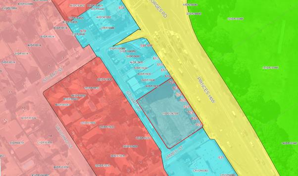
Kogarah Local Environmental Plan
21. The
extent to which the proposal complies with the relevant standards of Local
Environmental Plan is outlined in the table below.
|
Clause
|
Standard
|
Proposed
|
Complies
|
|
2.3
– Zone objectives and Land Use Table
|
Meets
objectives of B2 –Local Centre zone
Development
must be permissible with consent
|
The
proposed modifications are to an approved mixed use development which is
permissible with consent.
|
Yes
|
|
4.3
– Height of Buildings
|
21m
as identified on Height of Buildings Map
|
22m
to the top of the lift overrun
|
No
– See discussion below
|
|
4.4
– Floor Space Ratio
|
2.5:1
as identified on Floor Space Ratio map
|
2.5:1
or 4,590sqm
|
Yes
|
|
Clause
6.2 – Earthworks
|
To
ensure that earthworks do not have a detrimental impact on environmental
functions and processes, neighbouring uses, cultural or heritage items or
features of the surrounding land.
|
The
proposed modifications do not necessitate the need for any
additional earthworks beyond that approved.
|
Yes
|
4.3 Height of Buildings
A maximum height of 22m (top of the lift overrun) is
proposed that is marginally in excess of the 21m height limit permitted for the
site (refer to architectural extract below).
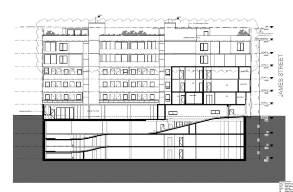
Section through plans showing the
height non-compliance.
In accordance with Gann & Anor v Sutherland Shire
Council [2008], the Land & Environment Court found that a development
application can be modified even where this would result in the breach of
development standards. Furthermore, it was the Court's view that no objection
pursuant to Clause 4.6 of Standard template LEPs was required to be lodged,
however that the consent authority was still required to take the relevant
matters referred to in Section 79C (now 4.15) in accordance with the
requirements of Section 96(3) (now 4.55) of the EP&A Act.
The applicant has addressed the relevant requirements in
the documentation submitted to Council, with rationale provided to justify the
proposed additional height.
The applicant, as part of the submission has requested
that the variation be supported as the proposed variation to the maximum height
is acceptable as the variation solely relates to the
lift motor rooms. These spaces are located centrally within the development so
as not to cause any increased environmental impacts on amenity of visual
intrusion. The variation has further detailed lift access to the roof
facilitates equitable access for all to the substantial communal open space
area and supporting amenities.
Following a review of the application, it is considered
the height variation as proposed is acceptable for the following reasons:
a) Whilst
the proposal as modified exceeds the maximum height permitted on the subject
site, the variation is minimal and the resulting bulk, scale, mass and form of
the development will remain entirely consistent with the future desired
character of the area as envisaged by the relevant controls.
b) The
proposal as modified continues to satisfy the relevant objectives of the height
standard.
d) The
proposal as modified is consistent with the objectives of the B2 Local
Centre Zone.
e) The
proposal as modified does not result in significant adverse environmental
planning impacts upon adjoining or nearby properties in terms of overshadowing,
aural and visual privacy, solar access, natural ventilation and views &
vistas.
f) The
proposal as modified provides a high quality built form that will provide a
positive contribution to the emerging character of the locality.
In this regard, the modifications sought as part of this application are
considered to result in orderly development of this site and seeking numeric
compliance will not result in any benefits to the public domain or surrounding
development. This minor breach does not result in the loss of development
potential to any adjoining allotment. Compliance with the height standard is
deemed unreasonable and unnecessary and flexibility should be applied, given
the circumstances of this individual case.
Stratum Subdivision
22. The
parent application did not include Stratum Subdivision, as a result this has
not be included in the modification assessment. The Stratum Subdivision will
need to be considered in the future as a separate application. A condition will
be included to this effect.
Section 4.15(1)(a)(ii) – Provisions of any Draft
EPI’s
Draft Environment SEPP
23. The
Draft Environment SEPP was exhibited from 31 October 2017 to 31 January 2018.
This consolidated SEPP proposes to simplify the planning rules for a
number of water catchments, waterways, urban bushland, and Willandra Lakes
World Heritage Property.
Changes proposed include consolidating the following
seven existing SEPPs:
· State
Environmental Planning Policy No. 19 – Bushland in Urban Areas
· State
Environmental Planning Policy (Sydney Drinking Water Catchment) 2011
· State
Environmental Planning Policy No. 50 – Canal Estate Development
· Greater
Metropolitan Regional Environmental Plan No. 2 – Georges River Catchment
· Sydney
Regional Environmental Plan No. 20 – Hawkesbury-Nepean River (No.2-1997)
· Sydney
Regional Environmental Plan (Sydney Harbour Catchment) 2005
· Willandra
Lakes Regional Environmental Plan No. 1 – World Heritage Property.
The proposal is not inconsistent with the provisions of this Draft
Instrument.
Section 4.15(1)(a)(iii) – Provisions of any
Development Control Plan
The following Development Control Plan is
relevant to this application.
Kogarah Development Control Plan 2013
24. The Kogarah Development
Control Plan 2013 ("KDCP") provides detailed provisions to guide
development to achieve the objectives of the KLEP, providing detailed controls
and objectives for residential development. In this instance, the controls outlined
in Part D1: Development in Business B1 and B2 Zones and Part D2: Commercial
Locality Guides are at odds with KLEP 2012 standards applicable to the site.
The proposed modifications do not result in any further departure from the DCP
controls over what was already supported as part of the original development
approval for the site. In this regard, the proposal as modified is
satisfactory.
Section 4.15(1)(a)(iv) – Provisions of
regulations
25. The provisions of the
Regulations relating to demolition have been considered in the assessment of
the original development application. In accordance with clauses 115(3) &
(3A) of the EP&A Regulations, the Section 96 modification was accompanied
by a 'design verification statement' confirming that the design as modified was
directed by a registered architect and that it complies with the design quality
principles. All relevant provisions of the Regulations have been considered in
the assessment of this proposal as modified.
Section 4.15(1)(a)(b) – Likely Impacts of Development
26. The
modifications result in some additional overshadowing
to the neighbouring properties as detailed in the shadow diagram located post
this discussion. This diagram provides a comparative analysis detailing the
extent of shadowing incurred by the neighbouring properties as part of the
original DA approval, in relation to what is anticipated to result from the
proposed modifications.
In summary, the additional shadows will result in the following
additional impact:
§ 637-643 Princes Highway, Blakehurst: Two retail windows are affected
by the
additional shadow at 3pm, 21
September;
§ 6 James Street, Blakehurst: Part of the rear yard and driveway are
affected by the
additional shadow at 9am, 21 June; and,
§ 4 Vaughan Street, Blakehurst: A small part of the rear yard is
affected by the
additional shadow at 9am, 21 September.
The shadow diagrams demonstrate that any additional
shadows cast as a result of the proposed modifications will have a minor impact
on surrounding properties and acceptable levels of solar access area provided.
Traffic
27. The application has
redesigned the basement access, car parking design and maneuverability, the amended proposal has been accompanied by correspondence prepared by Terraffic
Pty Ltd reference number 16053 dated 10 April 2018 which certifies the revised
design is compliant with the relevant Australian Standards and Council
controls.
Section 4.15(1)(a)(c) – Suitability of the Site
28. There are no known major physical constraints, environmental impacts,
natural hazards or exceptional circumstances that would hinder the suitability
of the site for the proposed development.
Section
4.15(1)(d) – Public Submissions
29. The proposal as modified has been notified in accordance with the provisions of
Kogarah DCP, no submissions were received.
Section
4.15(1)(e) – Public interest
30. The proposal as modified has
been assessed against the relevant planning policies applying to the site
having regard to the objectives of the controls. As demonstrated in the
assessment of the application, there are sufficient environmental planning grounds
in which to warrant support of increase to the height standard for the lift
overuns. The proposal as modified does not create unreasonable impacts on
surrounding properties and is consistent with the future desired character of
the area. The proposal as modified is in the public interest.
REFERRALS
Council
Referrals
31.
Stormwater
The applicant has
confirmed the drainage design for the application has not been altered, with
the exception of the additional 2000 litre rainwater tank to the roof level. No
referral was considered necessary.
Traffic
The
application has redesigned the basement access, car parking design and
maneuverability, the amended proposal has been accompanied by correspondence
prepared by Terraffic Pty Ltd reference number 16053 dated 10 April 2018 which
certifies the revised design is compliant with the relevant Australian
Standards and Council controls, no referral to the traffic engineers was
considered necessary.
Waste
Council’s
Waste Officer has reviewed the application and notes that a minimum of 4 by 660
litre bin are required for a twice weekly residential collection. And a
recycling bin is to be provided in the bin rooms for levels 4 through to 6. A
condition will be incorporated to this effect.
External
Referrals
32. No
external referrals were required to be provided, the
applicant provided details confirming the development does not come within 5m
of the high voltage lines which is consistent the approval issued. The
documentation was provided by AAPE Pty Ltd dated 21 August 2018.
CONCLUSION
33. The
application has been assessed having regard to the
Heads of Consideration under Section 4.15 of the Environmental Planning and
Assessment Act 1979, the provisions of the relevant State Environmental
Planning Policies, Local Environmental Plans and Development Control Plans. The
application seeks approval for modifications to the provision
of an additional floor level, relocation of the communal open space to the
rooftop, a revised apartment and car parking mix and stratum subdivision.
The application
has been considered having regard to the State Environmental Planning
Instruments, the Local Environmental Plan and the Development control plan
applicable to the site. The application has adequately addressed the assessment
criteria and where not numerically compliant has demonstrated the objectives of
the controls have been achieved. The application is considered worthy of
support subject to updated plans and conditions being referenced as outlined
below.
DETERMINATION
AND STATEMENT OF REASONS
Statement of
Reasons
· The proposed development
is considered to be an appropriate scale and form for the site and the
character of the locality;
· The proposed
development, subject to the recommended conditions, will have no unacceptable
adverse impacts upon the natural or built environments; and
· In consideration of the
aforementioned reasons, the proposed development is a suitable and planned use
of the site and its approval is in the public interest.
THAT pursuant
to Section 4.16(1) of the Environmental Planning and Assessment Act, 1979, as
amended, the Council grants development consent
to Development Application Modification Number DA2017/0166 associated with 621
- 635 Princes Highway, Blakehurst which is legally described as Lot1
DP1242789 to amend
the approval for demolition of the existing building and the construction of a
six storey mixed use development incorporating five levels of residential
apartments, three levels of basement carpark and a child care centre by the
provision of an additional floor level, relocation of the communal open space
to the rooftop, a revised apartment and car parking mix, amendments to
facilitate fire services and access to and within the basement subject to the
following conditions of consent:.
CONDITIONS
SPECIFIC
DEVELOPMENT CONDITIONS
SECTION A -
General Conditions
The conditions
that follow in this Section A of the Notice of Determination are general
conditions which are imposed to ensure that the development is carried out in
accordance with the development consent.
(1) Approved
Plans of Consent
The development
must be implemented in accordance with the approved plans, specifications and
details listed below and any supporting information submitted with the
Development Application except as amended by any conditions attached to the
Development Consent:
|
Description
|
Drawing No.
|
Date
|
Issue/Revision
|
Prepared by
|
|
Cover Sheet
|
S96 000
|
2 July 2018
|
N
|
Level 33 Architectural Division
|
|
Site Analysis/Site Plan and Roof
Plan
|
S96 001
|
19 June 2018
|
M
|
Level 33 Architectural Division
|
|
Demolition Plan
|
S96 002
|
19 June 2018
|
M
|
Level 33 Architectural Division
|
|
Basement Plan B3
|
S96 100
|
19 June 2018
|
M
|
Level 33 Architectural Division
|
|
Basement Plan B2
|
S96 101
|
19 June 2018
|
M
|
Level 33 Architectural Division
|
|
Basement Plan B1
|
S96 102
|
19 June 2018
|
M
|
Level 33 Architectural Division
|
|
Ground Floor Plan
|
S96 103
|
19 June 2018
|
M
|
Level 33 Architectural Division
|
|
Level 1 Floor Plan
|
S96 104
|
2 July 2018
|
N
|
Level 33 Architectural Division
|
|
Level 2 Floor Plan
|
S96 105
|
19 June 2018
|
M
|
Level 33 Architectural Division
|
|
Level 3 Floor Plan
|
S96 106
|
19 June 2018
|
M
|
Level 33 Architectural Division
|
|
Level 4 Floor Plan
|
S96 107
|
2 July 2018
|
N
|
Level 33 Architectural Division
|
|
Level 5 Floor Plan
|
S96 108
|
19 June 2018
|
M
|
Level 33 Architectural Division
|
|
Roof Terrace Plan
|
S96 109
|
19 June 2018
|
M
|
Level 33 Architectural Division
|
|
Roof Plan
|
S96 110
|
19 June 2018
|
M
|
Level 33 Architectural Division
|
|
James Street Elevation
|
S96 200
|
2 July 2018
|
N
|
Level 33 Architectural Division
|
|
Princes Highway Elevation
|
S96 201
|
19 June 2018
|
M
|
Level 33 Architectural Division
|
|
North West Elevation
|
S96 202
|
19 June 2018
|
M
|
Level 33 Architectural Division
|
|
Stuart Lane Elevation
|
S96 203
|
2 July 2018
|
N
|
Level 33 Architectural Division
|
|
Section 01
|
S96 300
|
19 June 2018
|
M
|
Level 33 Architectural Division
|
|
Section 02
|
S96 301
|
19 June 2018
|
M
|
Level 33 Architectural Division
|
|
Section 03
|
S96 302
|
19 June 2018
|
M
|
Level 33 Architectural Division
|
|
Waste Management Plan
|
S96 850
|
19 June 2018
|
M
|
Level 33 Architectural Division
|
|
Materials and Finishes
|
S96 950
|
19 June 2018
|
M
|
Level 33 Architectural Division
|
|
Cover Sheet
|
LA00
|
2 July 2018
|
J
|
Taylor Brammer Landscape Architects
Pty Ltd
|
|
Ground Floor Landscape Plan
|
LA01
|
18 June 2018
|
I
|
Taylor Brammer Landscape Architects
Pty Ltd
|
|
Level 1 to 5 Landscape Plan
|
LA02
|
2 July 2018
|
I
|
Taylor Brammer Landscape Architects
Pty Ltd
|
|
Roof Garden Landscape Concept Plan
|
LA03
|
18 June 2018
|
K
|
Taylor Brammer Landscape Architects
Pty Ltd
|
|
Landscape Details
|
LA04
|
19 September 2017
|
E
|
Taylor Brammer Landscape Architects
Pty Ltd
|
|
Landscape Details
|
LA05
|
19 September 2017
|
D
|
Taylor Brammer Landscape Architects
Pty Ltd
|
|
Landscape Details
|
LA06
|
2 July 2018
|
H
|
Taylor Brammer Landscape Architects
Pty Ltd
|
|
Landscape Details
|
LA07
|
19 September 2017
|
B
|
Taylor Brammer Landscape Architects
Pty Ltd
|
|
Revised Acoustic Report
|
TJ175-01F02
|
20 July 2018
|
-
|
Renzo Tonin and Associates
|
|
Electrical Clearance Letter
|
-
|
21 August 2018
|
-
|
AAPE Pty Ltd
|
|
Traffic Engineering Letter
|
16053
|
10 April 2018
|
-
|
Terraffic Pty Ltd
|
|
Stormwater plans
|
D1 to D7 D
|
6 March 2017
|
D
|
EZE Hydraulic Engineers Drawing
|
|
Proposed Drainage Diversion Design
|
TD1(D), TD2(C), TD3(D) and TD4(D)
|
-
|
-
|
EZE Hydraulic
Engineers
|
|
Plan of Easement for Drainage
|
-
|
-
|
161237
|
Greg Ireton Gibson
|
Note - No approval is granted
to the Stratum Subdivision, this will need to be considered as a separate
application.
(This condition is modified as part
of MOD2017/0166 (DA157/2016))
SECTION B – Prior to the
Issue of a Construction Certificate or Demolition
Conditions
The conditions
that follow in this Section B of the Notice of Determination relate to the
payment of fees, amendments being made to the proposal, further investigation
being undertaken or the preparation of documentation that must be complied with
prior to the issue of a Construction Certificate or Demolition.
Note: A
copy of the Construction Certificate shall be forwarded to Council prior to
commencement of construction where Council is not the certifier who issued the
Construction Certificate.
(2) Asset &
Building Fees
Payment of the
following amounts as detailed below:
• *Builders
Long Service Levy of $56,582.00
• Inspection
Fee of $ 1,530.00
• Security
Deposit Stormwater Asset $25,000.00
• Asset
Inspection Fee of $ 110.00
• Sign
Installation $ 650.00
*Note: The
Builders Long Service Levy quoted is based on the market value of the proposed
building works and the Levy Rate applicable at the time of assessing the
Development Application and may be subject to change prior to payment.
(3) Restoration
Deposit
A deposit of
$45,100.00 shall be lodged with Council to ensure the construction of the
following works to be completed at the applicant's expense:
•
Construction of a new concrete kerb and gutter and footpath across the full
street frontage in Stuart Lane.
•
Construction of a new concrete footpath from the back of the kerb to the
boundary across the full street frontage in Stuart Lane, James Street and
Princes Highway.
• All
associated road pavement restorations. These works are to be in accordance with
plans and specifications to be issued by Council.
(4) Section 94
Index
Section 94
Contributions are to be paid as detailed below in the following condition, and
until paid all contributions will be indexed four (4) times a year (on the following
dates) to allow for the cost increases: 31 January, 30 April, 31 July and 31
October.
(5) Section 94
Contributions
As at the date of
Development Consent the following contributions have been levied on the subject
development under Section 94 of the Environmental Planning and Assessment Act,
1979 and the nominated Section 94 Contributions Plans:
No.1 – Roads
and Traffic Management – Residential $ 838.04
No.5 – Open
Space 2007 $373,747.87
No.9 –
Kogarah Libraries – Buildings $ 8,470.34
No.9 – Kogarah
Libraries – Books $ 6,039.00
TOTAL $389,095.47
Any of the above
Section 94 Contributions Plans may be inspected at the Georges River Council
Customer Service Centres.
Revised Section
94 calculations are to be inserted.
(This condition is modified as part
of MOD2017/0166 (DA157/2016))
(6)
Dilapidation Report
Prior to issue of
any construction certificate or commencement of any demolition or earth works
on site, the applicant shall submit, for acceptance by the Principal Certifying
Authority (PCA), with a copy forwarded to Council where Council is not the PCA,
a full dilapidation report on the visible and structural condition of the
following properties;
(i) All
neighbouring buildings likely to be affected by the excavation as determined by
the consulting engineer. The report must be completed by a suitably qualified
consulting structural/geotechnical engineer as determined necessary by that
professional based on the excavations for the proposal, the subsoil conditions
and any recommendations of a geotechnical report for the site. The report shall
have regard to protecting the applicant from spurious claims for structural
damage and shall be verified by all stakeholders as far as practicable.”
Reports relating
to properties that refuse access to carry out inspections to complete the
dilapidation report, after being given reasonable written notice to request
access (at least 14 days) at a reasonable time (8.00am-6.00pm), are not to hold
up the release of the Construction Certificate.
(7) Soil and Water
Management
A Soil and Water
Management Control Plan, incorporating contour levels and prepared in
accordance with Environmental Site Management Policy shall be submitted to
Council detailing all measures to control soil erosion and sedimentation runoff
from the site during excavation and construction activities.
(8) SEPP No 65
Certification
A design
verification statement from a qualified designer shall be submitted that
verifying that the plans and specifications achieve the design quality of the
development for which consent was granted having regard to the design quality
principles of State Environmental Planning Policy No. 65.
(9) Adaptable
Housing Compliance
The nominated
adaptable units shall comply with the adaptable housing provisions of AS4299
– Adaptable Housing and AS1498 – Access and Mobility (Parts 1 and
2). The Adaptable Housing checklist and circulation diagram demonstrating
compliance shall be submitted.
(10) Ausgrid
Sub Station
The applicant is
to confer with Ausgrid to determine if an electricity distribution substation
is required. If so, shall be incorporated within the Construction Certificate
and it will be necessary for the final film survey plan to be endorsed with an
area having dimensions 5m x 4m over the location of the proposed electricity
distribution substation to be dedicated to Council as public roadway, or as
otherwise agreed with Ausgrid. Ausgrid’s requirements are to be met prior
to release of the occupation certificate.
(11) Clearances
to Overhead Mains
If any part of the
proposed structure, within 5m of a street frontage, is higher than 3m above
footway level, the applicant is to confer with Ausgrid to determine if
satisfactory clearances to any existing overhead mains will be affected. If so,
the applicant is to make arrangements with Ausgrid for any necessary
modification to the electrical network in question.
These works to be
at the applicant’s expense and Ausgrid’s requirements are to be met
prior to actual construction commencing on site or as agreed with Ausgrid.
(12) Sydney
Water (DA Only)
The approved plans
must be processed through Sydney Water to determine whether the development
will affect any Sydney Water asset’s (sewer and water mains, stormwater
drains and/or easements) and if any further requirements need to be met. An
approval receipt will be issued by Sydney Water which is to be submitted to
Council or the Principal Certifying Authority. Please refer to the web site
www.sydneywater.com.au for;
• Sydney
Water Tap in – see Plumbing, building and developing and then Sydney
Water Tap in; and
• Building
over/adjacent to a Sydney Water Asset - see Plumbing, building and developing,
building then Building Approvals or telephone 13 20 92.
(13) Driveways
The design
boundary level on the southern edge of the driveway shall be RL8.54.
The design
boundary level on the northern edge of the driveway shall be RL 8.22.
The driveway
grades from the street boundary to the basement slab shall comply with the
requirements of “AS/NZS 2890.1:2004 - Off Street Car Parking”.
In accordance with “AS/NZS 2890.1:2004 - Off Street Car Parking,
Section 3.3(a)”, the first 6m into the property from the James Street
boundary shall be at a maximum grade of 1:20.
(14) Parking
restriction sign
The applicant
shall pay a fee of $650.00 to cover the costs for Council to install parking
restriction signage in Stuart Lane, subject to approval from the Local Traffic
Committee. (see Bonds and Deposits)
(15) Design
Plans/Hydraulic
Detailed design
plans and hydraulic calculations of any changes to the stormwater drainage
system are to be submitted to Roads and Maritime for approval, prior to the
commencement of any works.
Details should be
forwarded to:
The Sydney Asset
Management
Roads and Maritime
Services
PO Box 973
Parramatta CBD 2124.
(16) Plan
checking fee
A plan checking
fee will be payable and a performance bond may be required before Roads and
Maritime approval is issued. With regard to the Civil Works requirement please
contact the Roads and Maritime Project Engineer, External Works Ph: 8849 2114
or Fax: 8849 2766.
(17) Site
investigation
A preliminary site
contamination investigation is be undertaken in order to determine if any
contaminates are present on either surface or subsurface levels of the site. If
contaminates are identified, a detailed investigation is to be carried out and
forwarded to Council for review.
(18) Concept
Plans
The submitted
stormwater plans, Job No. 14009 Drawings D1-D7 Revision D by Eze Hydraulic
Engineers dated 6 March 2017 have been assessed and approved as a concept plan
only. No detailed assessment of the design has been undertaken. A Detailed
Stormwater Plan and supporting information of the proposed on-site stormwater
management system is to be submitted. The required details in this Plan and the
relevant checklist are presented in the document ‘Water Management
Policy. Kogarah Council. August 2006’ The design parameters and the
general concept of the proposed on-site stormwater management system are to be
the same as documented in the approved Concept Stormwater Plan for the proposed
development. Any conceptual variations to the stormwater design will require
written approval from Council and will require to be justified and supported by
appropriate details, calculations and information to allow for proper
assessment.
The Detailed
Stormwater Plan is to address the following issue(s):
•
An oil/silt separator sized to the catchment area must be specified on the
Detailed Stormwater Plan and located downstream of the proposed basement car
parks and prior to discharge to Councils stormwater system.
•
The design is to include design measures to minimise the potential for
surcharge of the Council stormwater system into the sites drainage system.
(19) Stormwater
Asset
Protection of the
new and existing Council stormwater assets during construction will be the
responsibility of the applicant. Sufficient asset protection measures must be
undertaken by the applicant during construction. A Security Bond of $25,000
will be required to be lodged prior to the issue of a Construction Certificate.
(19A) Waste
The plans are to
demonstrate that a minimum of 4 by 660 litre bins are to be provided for the
residential component of the application to facilitate a twice week pickup.
A recycling bin is
to be provided within the waste rooms of levels 4 through to 6.
(This condition is modified as part
of MOD2017/0166 (DA157/2016))
SECTION C
– Prior to Commencement of Construction Conditions
The conditions
that follow in this Section C of the Notice of Determination are specific to
the proposed development and must be complied with prior to the commencement of
construction on the site.
(20)
Geotechnical Report
Excavation of the
site is to extend only to that area required for building works depicted upon
the approved plans. All excess excavated material shall be removed from the
site. In this regard, all excavated waste materials shall be disposed of at an
approved Waste Depot. No rock breaking or other machinery for the excavation,
drilling, cutting or removal of rock shall be used on the site prior to the
acceptance by the principal certifying authority of the following
documentation:
(i) A report by a
geotechnical engineer detailing the measures recommended in undertaking the
works so as to prevent damage to any adjoining or nearby buildings.
(ii) The type and
size of machinery proposed.
(iii) The routes
of all trucks to convey material to and from the site.
(21)
Certification of Detailed Plan
The detailed
stormwater plan is to be certified by a Chartered Professional Engineer. A
statement, that the stormwater system has been designed in accordance with
Council’s Water Management Policy and satisfies the provisions and
objectives of that policy, must be included in the Stormwater Detailed Plan.
(22) On-Site
Detention
A 49.5m3 On-Site
Detention system with a Maximum Site Discharge of 32.2 Litres per Second is to
be provided in accordance with the Stormwater Concept Plan and associated
Design Assessment Report. The overflow is to be directed to the site drainage
system.
(23)
Certification by Mechanical Engineer
To ensure that
adequate provision is made for ventilation of the building, mechanical and /or
natural ventilation shall be provided. These systems shall be designed in
accordance with the provisions of:-
a) The Building
Code of Australia;
b) Australian
Standard AS 1668 Part 1 - 1998;
c) Australian
Standard AS 1668 Part 2 - 2002;
d) The Public
Health Act 2010;
e) The Public
Health Regulation 2012;
f) Australian
Standard 3666.1 - 2002;
g) Australian
Standard 3666.2 - 2002;
h) Australian
Standard 3666.3 - 2000.
Details of all
mechanical and /or natural ventilation systems, along with specific
certification, provided by an appropriately qualified person, verifying
compliance with the abovementioned requirements.
(24) Structural
Engineer’s Details
Engineer's details
prepared by a practising Structural Engineer being used to construct all
reinforced concrete work, structural beams, columns & other structural
members. The details are to be submitted to the Principal Certifying Authority
for approval prior to construction of the specified works.
A copy shall be
forwarded to Council where Council is not the PCA.
(25) Protection
of Site – Hoarding
A hoarding or
fence must be erected between the work site and the public place if:
•
the work involved in the erection or demolition of a building is likely to
cause obstruction or inconvenience to pedestrian or vehicular traffic in a
public place; or
•
if it involves the enclosure of a public place. If necessary an awning is to be
erected which is sufficient to prevent any substance from or in connection with
the work from falling into a public place. Any such hoarding, fence or awning
is to be removed when the work has been completed. If the work site is likely
to be hazardous to persons in a public place, it must be kept lit between
sunset and sunrise.
(26) Ground
Anchors
Should the
proposed development require the installation of ground anchors to a road
reserve the following must be complied with:
• The
appropriate Roads Act 1993 approvals shall be obtained.
• The
anchoring is to be de-stressed once no longer required.
•
The work is to be clear of all services contained within the public roadway and
the required dial before you dig investigations are to be undertaken in relation
to any services that may be in the proposed anchor locations.
•
Public liability insurances being held by the builder/ developer with a copy
being submitted to Council.
•
A works-as-executed plan showing the exact location of all anchoring points
being submitted to Council upon their installation. It is to be noted that if
anchoring into adjacent private properties is required any such approval would
need to be obtained from the owners of this property.
(27) Driveway
In respect to
vehicular access to the proposed development the gutter crossing and driveway
are to be reconstructed between the kerb and street alignment to
Council’s specifications. In this regard a separate driveway application
is to be lodged with Council for works outside the property boundary.
Furthermore the design boundary level is to be received from Council prior to
construction of the internal driveway.
(28) Council
Infrastructure Inspection
Prior to the
commencement of any works an authorised representative of the applicant is to organise
and attend a meeting on site with Council’s Infrastructure Compliance
Co-ordinator to discuss protection of Council’s infrastructure. To
organise this meeting contact Council’s Customer Service Centre on 9330
6400.
(29) Public
Liability Insurance
All nominated
contractors / applicants carrying out driveway and/or restoration works on
Council property must carry public liability insurance with a minimum cover
of twenty million dollars ($20,000,000.00). In this regard, prior to
commencement of works, the principal contractor is to lodge an
“Application for the Construction of Work by Private Contractor” to
Council, which includes submitting evidence of their current insurance. The
principal contractor must ensure that sub-contractors are also adequately
insured.
(30) Soil
Erosion Controls
Prior to
commencement of any site works, erosion and sediment controls are to be
installed in accordance with Environmental Site Management Policy and any
approved Soil & Water Management Plan and shall incorporate:
•
Measures to prevent sediment and other debris escaping from the cleared or
disturbed areas into drainage systems or waterways;
•
Controls to prevent tracking of sand, soil, aggregates, etc, by vehicles onto
adjoining roadways.
(31) Excavation
The developer is
to submit design drawings and documents relating to the excavation of the site
and support structures to Roads and Maritime for assessment, in accordance with
Technical Direction GTD2012/001.
The developer is
to submit all documentation at least six (6) weeks prior to commencement of
construction and is to meet the full cost of the assessment by Roads and
Maritime.
If it is necessary
to excavate below the level of the base of the footings of the adjoining
roadways, the person acting on the consent shall ensure that the owner/s of the
roadway is/are given at least seven (7) days notice of the intention to
excavate below the base of the footings. The notice is to include complete
details of the work.
(32)
Construction vehicles
All demolition and
construction vehicles are to be contained wholly within the site and vehicles
must enter the site before stopping. A construction zone will not be permitted
on Princes Highway.
(33) Road
Occupancy licence
A Road Occupancy
Licence should be obtained from Transport Management Centre for any works that
may impact on traffic flows on Princes Highway during construction activities.
(34) Footing,
Piers and Loadbearing structures
Footings, piers
and any other load bearing structures in the vicinity of the Council stormwater
system are to be located so that all loads are transferred below the zone of
influence of the stormwater asset or to bed rock. All load bearing structures
must be located outside of the proposed drainage easement (B) in favour of
Council as defined on the Plan of Proposed Easement for Drainage Surveyors
Reference 161237 submitted to Council on the 10th March 2017. The footing
schedule must be documented on the Detailed Structural Plans and certification
to this effect shall be provided by an accredited certifier.
(35) Stormwater
Trunk Design
The submitted
Stormwater Trunk Drainage Diversion Design Plans, Job No. 14009 Drawings TD1-4
Revision D by Eze Hydraulic Engineers dated 6 March 2017 have been assessed and
approved as a concept plan only. No detailed assessment of the design has been
undertaken. A Detailed Stormwater Plan will need to be lodged and receive
written approval from Council’s Stormwater Section. The Detailed
stormwater Plan is to address the following issues:
i)
The diversion plan is to be amended so that all notes and details are clearly
legible.
ii)
The pipe trench details are to be amended to be in accordance with
Council’s requirements. Contact Council’s Stormwater section for
these requirements.
iii)
A three metre long subsoil drain wrapped in filter fabric sock is to be
installed adjacent to the base of the inlet pipes. The subsoil drain is to be
laid upstream of each new junction pit and are to be connected for discharge
into the junction pits.
iv)
The Stormwater Detailed Plan is to be accompanied with a statement by a
qualified Hydraulic Engineer that the proposed deviation has been designed to
provide Council's stormwater system with no loss in Hydraulic Capacity.
v) All junction
pits are to be amended to have solid non-slip access covers.
(36) Road and
Maritime Services
The applicant is
required to gain approval from the Roads and Maritime Services with regard to
the modifications to the stormwater discharge into their system. This approval
and all related plans and correspondence are to be forwarded to Council.
(37)
Reconstruction Works
The reconstruction
works on Council’s stormwater system is to be carried out by a qualified
plumber, drainer or civil construction company with a minimum limit of twenty
million dollar public and product liability insurance. In this regard,
qualification details of the person / company carrying out these works along
with a certificate of currency for the product and public liability insurance
are to be submitted to Council’s Stormwater Section before commencement.
Prior to the works
commencing the contractor who will be carrying out the works is required to
organise and attend an onsite meeting with a representative of Council’s
Stormwater section. Contact phone number (02) 9330 6400.
(38)
Inspections
All Inspections of
Council's Stormwater system deviation will be required to be undertaken by
Council’s Stormwater Section. Inspections will be required at the
following points in construction:
a) Preparation of
sub-base prior to the laying of the pipes.
b)
Completion of laying of new Reinforced Concrete pipes and any associated
concrete form work.
c) Completion of
backfilling of trenches.
d) Prior to
casting or installation of pits.
e)
Completion of excavation and demolition of existing redundant sections of
Council's stormwater pipes.
f)
Any additional inspections as specified by Council. The applicant is
responsible for the organisation of all inspections and is to give a minimum of
24 hours notice for each.
(39) Scheduling
of Works
The contractor
carrying out the deviation of Council's stormwater system is provide detail of
the scheduling of works to show that Council's drainage network and it's
capacity shall be maintained at all times during construction. Site management
and staging of the works will be the responsibility of the applicant, and must
address all risks involved with working on a live asset. Sufficient water
quality and sediment control must be maintained during construction.
(40) Product
details of access lids and surrounds
Product details of
the access lids and surrounds proposed for the new junction pits along the
diversion of Council’s stormwater system are to be submitted for approval
by Council. The lids are to a minimum load class rating ‘D’ in
accordance with both AS3996 : 2006 - Australian Standard Load Classifications
and the Water Services Association of Australia (WSAA) Specification WSA
PS-290. The lids shall also be certified as suitable with respect to slip
resistance for a pedestrian area.
SECTION D
– Construction and Operational Conditions
The conditions
that follow in this Section D of the Notice of Determination are imposed to
ensure the development is constructed and operates having regard to relevant
legislation and does not unreasonably impact on the amenity of the locality or
environment during the construction phase or the operation of the use.
(41)
Inspections -Multi Unit
The following
lists of inspections are the MANDATORY CRITICAL STAGE INSPECTIONS that MUST
be carried out by the Principal Certifying Authority (PCA).
(a) at the
commencement of building works
(b)
prior to covering waterproofing in any wet areas, for a minimum of 10% of rooms
with wet areas within a building, and
(c) prior to
covering any stormwater drainage connections, and
(d)
after the building work has been completed and prior to any occupation
certificate being issued in relation to the building.
Certificates from
your engineer or subcontractor are NOT acceptable in the first instance
for the above inspections. Failure to have your PCA carry out these inspections
could result in a delay or refusal to issue an Occupation Certificate.
In addition to the
above, it is recommended that the following inspections be carried out for the
subject development;
. Erosion Control
. Earthworks/Excavation
. Building setout
. Concrete
reinforcement
. Timber and/or
steel framework
.
Mechanical/Hydraulic work
. Driveways
. Landscaping
. External
Finishes
(42) Storage of
materials on Public Road
All building
materials or waste containers must be stored within the confines of the site.
The storage of such building materials, waste containers or equipment
associated with the project upon the public roadway, including the pedestrian
footway or unpaved verge, is prohibited.
(43) Use of
Crane on Public Road
Prior approval
must be obtained from Council a minimum of 24 hours before the use on any site
of a crane, hoist or similar machinery that will be used to transfer materials
across Council’s footpath. This includes cranes that are situated on
roadways, footpaths and road reserves.
Any application
for approval must be accompanied by the following information:-
•
Site sketch indicating the proposed location of the crane, pedestrian controls
and traffic controls;
•
A copy of current public liability insurance with minimum cover of twenty
million dollars ($20,000,000) indemnifying Council in the event of an incident;
• A copy of
an RMS accredited traffic control plan;
•
Proof that the local area command of the NSW Police have been advised of the proposal.
The use of a
crane, hoist or similar machinery on any site without prior approval is
prohibited.
(44) Building
Height - Surveyors Certificate
The proposed
building is not to be erected at a height greater than that indicated on the
approved plan. A certificate from a Registered Surveyor verifying the correct
Reduced Level of the ground floor slab and boundary clearances shall be
submitted prior to inspection of the steel reinforcement.
(45) Excavation
of Site
Excavation of the
site is to extend only to that area required for building works depicted upon
the approved plans. All excess excavated material shall be removed from the
site. In this regard, all excavated waste materials shall be disposed of at an
approved Waste Depot (details are available from Council).
All excavations
and backfilling associated with the erection or demolition of a building must
be executed safely and in accordance with appropriate professional standards.
All excavations associated with the erection or demolition of a building must
be properly guarded and protected to prevent them from being dangerous to life
or property.
If the soil
conditions require it, retaining walls associated with the erection or
demolition of a building or other approved methods of preventing movement of
the soil shall be provided and adequate provision shall be made for drainage.
(46) Stormwater
to Kerb
Any stormwater
connections to the kerb and gutter are to be in accordance with Council's 'Specification
for Construction by Private Contractors'.
(47) Redundant
Driveway
All existing
vehicular crossings adjacent to the subject premises that have become redundant
shall be removed and the footway and kerb and gutter reinstated at the
developer/applicants expense.
(48) Work
within Road Reserve
A Development
Consent or any related Construction Certificate does not allow for the erection
of a structure or to carry out work in, on or over a public road. Should a
structure or work be required a separate approval under S138 of the Road Act
1993 must be granted by Council prior to the commencement of any works within
the road reserve. Applications may be made at Council’s Customer Service
Centre.
(49) Damage
within Road Reserve & Council Assets
The owner shall
bear the cost of restoring any footpath, roadway and any other Council assets
damaged due to works at, near or associated with the site. This may include
works by Public Utility Authorities in the course of providing services to the
site.
(50) Public
Utility & Telecommunication Assets
The owner shall
bear the cost of any relocation or modification required to any Public Utility
Authority assets including telecommunication lines & cables and restoring
any footpath, roadway and any other Council assets damaged due to works at,
near or associated with the site.
(51) Garbage
Room
The proposed
garbage room being provided with the following:-
a)
A smooth concrete floor graded and drained to a floor waste connected to the
sewer of the Water Board.
b)
The walls being cement rendered with the intersection of the walls and floor
being coved to a radius of not less than 25mm.
c) The door being
close fitting to prevent the access of rats and mice.
d)
A cold water hose cock being provided for the cleaning of containers and the
room itself.
e)
Ventilation being provided by means of direct connection to the outside air to
the satisfaction of Council.
f)
A sign, minimum size 600mm x 600mm, directing residents not to place
recyclables in garbage carts and encouraging residents to recycle. Details of
an acceptable wording for the sign are available from Council.
(52) Hours of
Construction
Construction may
only be carried out between 7.00 am and 5.00 pm on Monday to Saturday and no
construction is to be carried out at any time on a Sunday or a public holiday.
(53) Restriction
on Hours of Excavation (other than single residential dwelling)
Despite the
general hours of construction above,
a)
The hours where rock breaking, cutting, hammering and drilling occur shall be
limited to 9:00am – 4:00pm on weekdays only.
b)
A noise management plan for the above works, prepared by a suitably qualified
acoustical practitioner in accordance with the Interim Noise Construction
Guidelines prepared by the Department of Environment & Climate Change NSW,
must be submitted to Council prior to commencement of any excavation
works.
(54) Provision
of Amenities
Toilet facilities
are to be provided, at or in the vicinity of the work site on which work
involved in the erection or demolition of a building is being carried out, at
the rate of one toilet for every 20 persons or part of 20 persons employed at
the site or as specified by Workcover requirements.
• each
toilet provided must be a standard flushing toilet and must be connected:
• to a
public sewer; or
•
if connection to a public sewer is not practicable, to an accredited sewage
management facility approved by the Council; or
•
if connection to a public sewer or an accredited sewage management facility is
not practicable, to some other sewage management facility approved by the
Council.
The provision of
toilet facilities must be completed before any other work is commenced.
(55) Letter
Boxes
Suitable letter
box facilities (including Owner's Corporation in the case of strata units)
shall be provided in accordance with Australia Post specifications.
(56) Car Wash
To ensure that
waste water is treated in an acceptable manner the car wash bay shall be
designed and constructed to ensure that waste water is discharged to the sewer
in accordance with the requirements of Sydney Water. Evidence of a permit
issued by Sydney Water shall be submitted.
(57) Basix
Certificate Details – DA Only
Construction of
building works given Development Consent must be carried out in accordance with
BASIX certificate details to be inserted and all required commitments
must be satisfied.
(This condition is modified as part
of MOD2017/0166 (DA157/2016))
(58) Air
Conditioning / Offensive Noise
Air conditioning
plant and equipment shall be installed and operated so as to not create an
offensive noise as defined under the Protection of the Environment Operations
Act 1997 and Protection of the Environment Operations (Noise Control)
Regulation 2008.
(59) Building
Finishes
The building
finishes are to be constructed in accordance with the perspective submitted
with the Development Application.
(60) Allocation
of Car Parking Spaces
A minimum of 115
off street car parking spaces shall be constructed, drained, marked and
maintained at all times in accordance with the approved plans.
These spaces shall
be allocated as follows:
a) 83 are to be
allocated to the residential units.
b) 12 are to be
allocated as visitor parking spaces.
c) 20 are to be
allocated to the Childcare Centre.
(This condition is modified as part
of MOD2017/0166 (DA157/2016))
(61)
Residential Car Parking Spaces
A minimum of one
(1) unrestricted car parking space shall be allocated to each residential unit.
Where a three (3) or more bedroom residential unit is provided within the
development it is to be allocated two parking spaces in the first instance.
(62)
Commercial/Retail Parking Spaces
The required
commercial/retail car parking spaces shall be allocated evenly amongst the
commercial/retail units based on the gross floor area of each unit.
(63) Visitor
Parking
A directional sign
shall be provided at the front of the site indicating the availability of
visitor and/or customer parking on site. Those visitor and/or customer spaces
shall be marked or signposted.
(64) Works Zone
The installation
of a "Works Zone" for the site will require the approval from the
Traffic Advisory Committee. As a result, the applicant shall provide a formal
request to Council's Traffic Section with the duration and exact location of
the required Works Zone" at least 6 weeks prior to its required
installation date. All costs associated with the installation of a “Works
Zone” will be at the applicant’s expense.
(65) Road
Closure
A Road Closure
Application form and associated documents shall be submitted to Council for
approval at least 5 business days prior to any proposed lane usage for concrete
pours, cranes or other activities involved in the demolition, excavation and
construction on the site.
(66) Roof and
surface water
All roof water and
surface water from paved or concreted areas are to be disposed of in accordance
with the Stormwater Plan by means of a sealed pipeline constructed in
accordance with AS/NZS 3500.3:2015. The line must pass through a silt arrestor
pit.
(67) Softfall
details
Details nominated
as softfall shall comply to the Australian and New Zealand Standard AS/NZS
4422: 1996 /Amdt 1-1999 Playground surfacing –Specifications,
requirements and test methods (especially in areas of modular play areas). All
other play equipment or structures to be installed within the childcare centre
shall comply with AS 4685:2014 Parts 1-6. A playground compliance certificate
shall be issued to Council at the completion of the project.
(68) New
Pavements
All new pavements
shall comply with AS/NZS 4586:2004 for low slip resistance classification for
new pedestrian surface materials.
(69) Planter
Box
All planters box
waterproofing on slab shall be certified by a qualified waterproofing
technician.
(70) Noise
& Vibration
To minimise the
impact of noise the proposed development constructed in accordance with the recommendations
of the acoustic report reference TJ175-01F02 & TJ175-01F03, prepared by
Renzo Tonin & Associates, titled “Acoustic Assessment for Development
Application” & “child care centre acoustic assessment”
and submitted as a part of the development application.
(71) Acoustic
Validation Report
A report prepared
by suitably qualified Acoustic Consultant shall be submitted to the Principal
Certifying Authority (PCA). This report needs to certify that the development
complies with the requirements of State Environmental Planning Policy
(Infrastructure) 2007, conditions of development consent and recommendations of
acoustic reports reference TJ175-01F02 & TJ175-01F03, prepared by Renzo
Tonin & Associates and the supporting report TJ175-01F02 dated 20 July 2018
prepared by Renzo Tonin and Associates. The validation report shall include
post construction validation test results.
(This condition is modified as part
of MOD2017/0166 (DA157/2016))
(72) No
Offensive Noise
To minimise the
noise impact on the surrounding environment, the use of the premises, building
services, equipment, machinery and ancillary fittings shall not give rise to
“offensive noise” as defined under the provisions of the Protection
of the Environment Operations Act 1997.
(73) Delivery Hours
No deliveries,
loading or unloading associated with the premises are to take place between the
hours of 10pm and 7am on any day.
(74) Parking
Availability Sign
A parking
availability sign related to the childcare centre is to be provided along the entrance
to the Childcare centre carpark along James Street. This sign is to be suitable
located as to not result in any adverse impacts to neighbouring properties.
(75) Glazing
The ground floor
glazed areas along the Princes Highway and James Street elevations are to
remain unobstructed and unmodified at all times.
SECTION E
– Prior to Occupation or Subdivision Certificate Conditions
The conditions
that follow in this Section E of the Notice of Determination relate to
conditions that ensure that the development is completed in accordance with the
requirements of the Development Consent prior to the issue of either an
Occupation Certificate or a Subdivision Certificate.
(76) Adaptable
Housing Certification
Certification
shall be provided by a person suitably accredited by the Association of
Consultants in Access Australia, verifying that the development has been
constructed in accordance with the requirements of AS4299 - Adaptable
Housing and AS1428 - Design for Access and Mobility and in
accordance with the report and checklist submitted with the Construction
Certificate.
(77) SEPP No 65
Certification
A design
verification statement from a qualified designer shall be submitted verifying
that the development achieves the design quality of the development as shown in
the plans and specifications in respect of which the construction certificate
was issued, having regard to the design quality principals of State
Environmental Planning Policy No. 65.
(78) Completion
of Landscaping
Certification
shall be provided from a suitably qualified and experienced Landscape Designer
or Landscape Architect. This Certification shall verify that the landscape
works have been completed in accordance with the approved detailed landscape
plan and relevant conditions of this consent.
Note: A Landscape
Designer is a person eligible for membership of the Australian Institute of
Landscape Designers and Managers and a Landscape Architect is a person eligible
for membership of the Australian Institute of Landscape Architects as a
Registered Landscape Architect.
(79)
Consolidation of Lots
The lots covered
by this development consent shall be consolidated into one lot and proof of
registration of the consolidation shall be submitted to Council.
(80) Section 73
Compliance Certificate
A Section 73
Compliance Certificate under the Sydney Water Act, 1994 must be obtained from
Sydney Water Corporation.
Application must
be made through an authorised Water Servicing Coordinator.
Please refer to
the Building Developing and Plumbing section of the web site
www.sydneywater.com.au then refer to “Water Servicing Coordinator”
under “Developing Your Land” or telephone 13 20 92 for assistance.
Following
application a “Notice of Requirements” will advise of water and
sewer infrastructure to be built and charges to be paid. Please make early
contact with the Coordinator, since building of water / sewer infrastructure
can be time consuming and may impact on other services and building, driveway
or landscape design.
The Section 73
Certificate must be submitted to the Principal Certifying Authority.
(81) Stormwater
Compliance Certificate
A Stormwater
Compliance Certificate is to be obtained for the constructed on-site stormwater
management systems in conjunction with the works-as-executed drawings and the
final inspection. This Certificate is to be signed by an accredited hydraulic
engineer (preferably be the original design consultant) and submitted to the
Principal Certifying Authority. Copy of the standard Stormwater Compliance
Certificate is shown in Council’s Water Management Policy.
If the proposed
works involve Council owned stormwater infrastructure (or infrastructure to be
owned by Council), then the applicant should organise inspection with Council
and pay Council the appropriate inspection fee.
Inspection is to
be carried out at the following specified stages:
• Prior to
backfilling of pipelines trenches.
• Prior to
backfilling of drainage connection to pipeline or channels.
•
Prior to casting pits and other concrete structures including kerb and gutter,
aprons, pathways, vehicular crossings, dish crossings and pathway steps.
(82) Positive
Covenant
A Restriction on
Use of the land and Positive Covenant shall be created and registered on the
title of the property, which places the responsibility for the maintenance of
the on-site stormwater management system on the owner of the land. The terms of
the instrument are to be generally in accordance with the Council’s
standard terms and conditions for Restriction on Use of the land and Positive
Covenant shown in Council’s Water Management Policy.
(83)
Maintenance Schedule
A Maintenance
Schedule for the proposed on-site stormwater management measures is to be
prepared and submitted. The Maintenance Schedule shall outline the required
maintenance works, how and when these will be done and who will be carrying out
these maintenance works.
(84) Fire
Safety Schedule
Certain items of
equipment or forms of construction shall be nominated as "fire safety
measures" within the building. Upon completion of works, and before
occupation of the building, each of the fire safety measures is required to be
certified by an appropriately competent person (chosen by the owner of the
building). The certificate is to state that the measure was inspected and found
to be designed, installed and capable of operating to a standard not less than
that required by the relevant regulations.
Further, it is the
responsibility of the owner of the building that each fire safety measure is
again inspected and certified as to its condition every twelve (12) months
following the submission to Council of the original certification.
(85) BASIX
Completion Receipt
In accordance with
clause 154C of the Environmental Planning and Assessment Regulation 2000, prior
to issuing a final occupation certificate the certifying authority must apply
to the Director-General for a BASIX completion receipt.
(86) Works as
Executed
A Works As
Executed plan of Council's Stormwater system deviation as constructed including
all levels will be required to be submitted and received written approval from
Council.
(87) Drainage
easement
A drainage
easement of variable width is to be granted in favour of Council over the newly
constructed Council owned drainage pipeline within the lot(s) subject to this
development consent. The easement shall be in accordance with the proposed
easement (B) as defined on the Plan of Proposed Easement for Drainage Surveyors
Reference 161237 submitted to Council on the 10th March 2017. Any proposal to
modify the alignment and extent of this easement will require approval by
Council’s stormwater section. All costs including surveying and legal
costs are to be borne by the applicant.
(88)
Dilapidation Report
A Dilapidation
Report will be required prior to the release of the Security Deposit to ensure
the new asset has not failed during the works on site. The dilapidation report
is to include CCTV footage of the full extent of the Council stormwater asset
within the property and is to include the inspection and notation of all visible
defects and joints along the asset. The report is to be carried out upon
completion of all construction works. The Security Bond may be released after
the completion of the final inspection for the stormwater pipe replacement and
written approval from Council that the report has met these requirements.
(89)
Certification of Food Premises
To ensure that
adequate provision is made for the cleanliness and maintenance of all food
preparation areas all building work in connection with the occupation or use of
the premises intended for the preparation and storage of food shall be designed
and implemented in accordance with the requirements of:-
a) Food Act 2003;
b) Food Regulation
2010;
c) Food Safety
Standards 3.1.1, 3.2.2 and 3.2.3;
d)
Australian Standard AS 4674 – 2004 (Design, construction and fit-out
of food premises);
e) Sydney Water
Corporation;
f) Australian
Standard AS 1668 Part 1 – 1991;
g) Australian
Standard AS 1668 Part 2 – 1991;
h) The Building
Code of Australia.
Certification to
this effect shall be provided by an appropriately qualified person.
(90) Food
Business Registration
Prior to the issue
of the Interim/Final Occupation Certificate the proprietor of a food business
must notify the Georges River Council. Notification form is available on Council
website at http://www.georgesriver.nsw.gov.au/Services/Food-Businesses/Notifications
SECTION F
– Prescribed Conditions
The following are
prescribed conditions of development consent pursuant to s.80A(11) of the
Environmental Planning and Assessment Act 1979 and cl.98 of the Environmental
Planning and Assessment Regulation 2000.
(91) Compliance
with the Building Code of Australia
The development
must be carried out in accordance with the provisions of the Building Code of
Australia.
(92) Insurance
Requirements under Home Building Act 1989
The builder or
person who does the residential building work must comply with the applicable
requirements of Part 6 of the Home Building Act, 1989. This means that a
contract of insurance must be in force in accordance with Part 6 of that Act
before any building work authorised to be carried out by the consent commences.
It is the
responsibility of the builder or person who is to do the work to satisfy
Council that they have complied with the applicable requirements of Part 6 of
the Home Building Act, 1989.
If Council is the
Principal Certifying Authority it will not carry out any inspections until a
copy of the insurance certificate is received.
(93) Erection
of Signs
A sign must be
erected in a prominent position on any site on which building work, subdivision
work or demolition work is being carried out:
(a)
showing the name, address and telephone number of the principal certifying
authority for the work, and
(b)
showing the name of the principal contractor (if any) for any building work and
a telephone number on which that person may be contacted outside working hours,
and
(c) stating that
unauthorised entry to the work site is prohibited.
The sign is to be
maintained while the building work, subdivision work or demolition work is
being carried out, but must be removed when the work has been completed.
(94)
Notification of Home Building Act 1989 Requirements
Residential
building work within the meaning of the Home Building Act 1989 must not
be carried out unless the principal certifying authority for the development to
which the work relates (not being the council) has given the council written
notice of the following information:
(a) in the case of
work for which a principal contractor is required to be appointed:
(i) the name and
licence number of the principal contractor, and
(ii) the name of
the insurer by which the work is insured under Part 6 of that Act,
(b) in the case of
work to be done by an owner-builder:
(i) the name of
the owner-builder, and
(ii) if the
owner-builder is required to hold an owner-builder permit under that Act, the
number of the owner-builder permit.
If arrangements
for doing the residential building work are changed while the work is in
progress so that the information notified above becomes out of date, further
work must not be carried out unless the principal certifying authority for the
development to which the work relates (not being the council) has given the
council written notice of the updated information.
(95) Shoring
and Adequacy of Adjoining Property
If the development
involves an excavation that extends below the level of the base of the footings
of a building on adjoining land, the person having the benefit of the
development consent must, at the person’s own expense:
(a) protect and
support the adjoining premises from possible damage from the excavation, and
(b) where
necessary, underpin the adjoining premises to prevent any such damage.
The above
condition does not apply if the person having the benefit of the development
consent owns the adjoining land or the owner of the adjoining land has given
consent in writing to that condition not applying.
(96) Council
Notification of Construction
The erection of a
building which is the subject of a Development Consent must not be commenced
until:
a) Detailed plans
and specifications of the building have been endorsed with a construction
certificate by Council or an accredited certifier.
b) the person
having the benefit of the development consent has:
• appointed
a Principal Certifying Authority (PCA),and
• notified
Council (if Council is not the PCA) in writing of the appointment, and
• given at
least 2 days notice to Council of their intention to commence the erection of
the building. The notice may be in writing or by phone.
SECTION G
– Demolition Conditions
The following
conditions are imposed to ensure the demolition associated with the proposed
development is carried out having regard to relevant legislation and does not
unreasonably impact on the amenity of the locality or environment.
(97) Demolition
Conditions-Asbestos
(a) Demolition of
buildings where asbestos is determined to be present should only occur 7am
– 5pm Monday to Saturdays, and must not occur on Sundays or Public
Holidays, to ensure that the persons carrying out the work have access to
WorkCover professionals if required.
(b) All asbestos
removal shall be undertaken in accordance with the requirements of WorkCover’s
‘How to Safely Remove Asbestos’ Code of Practice and
Council’s Asbestos Policy.
(c) Written notice
must be provided to Georges River Council five (5) working days (excluding
public holidays) prior to commencement of any works.
Written notice is
to include the following details:
• Date the
demolition will commence
• Name,
address, contact details (including after hours) and licence number of the
demolisher and asbestos removalist (if different). Work must not commence prior
to the nominated demolition date.
Note: it is
the responsibility of the persons undertaking demolition work to obtain the
relevant WorkCover licences and permits.
(d) The owner is
to notify all owners and occupiers of premises on either side, opposite and at
the rear of the development site five (5) working days prior to demolition.
Such notification is to be clearly written on A4 size paper stating the date
the demolition will commence and is to be placed in the letterbox of every
premises (including every residential flat or unit, if any). The demolition
must not commence prior to the date and time stated in the notification.
(e) A demolition
or asbestos removal contractor licensed under the Work Health and Safety
Regulations 2011 must undertake removal of more than 10m2 of bonded
asbestos (or otherwise specified by WorkCover or relevant legislation).
Removal of friable
asbestos material must only be undertaken by a contractor that holds a current
AS1 Friable Asbestos Removal Licence.
(f) Demolition
sites that involve the removal of asbestos must display a standard commercially
manufactured sign containing the words ‘DANGER ASBESTOS REMOVAL IN
PROGRESS’ measuring not less than 400mm x 300mm is to be erected in a
prominent visible position on the site to the satisfaction of Council’s
officers. The sign is to be erected prior to demolition work commencing and is
to remain in place until such time as all asbestos has been removed from the
site to an approved waste facility.
(g) All asbestos
waste must be stored, transported and disposed of in compliance with the
Protection of the Environment Operations (Waste) Regulation 2005. All receipts
detailing method and location of disposal must be submitted to Council as
evidence of correct disposal.
(h) A Clearance
Certificate or Statement, prepared by a suitably qualified occupational
hygienist must be provided to Council upon completion of demolition and
asbestos related works, which confirms that the relevant legislative
requirements in relation to safe removal and disposal have been satisfied.
(i) A Work Cover
Licensed Demolisher is to be engaged to carry out any demolition works using
mechanical equipment where the structure is over 4 metres in height or to carry
out any manual demolition works on a structure over 10 metres in height.
(j) The provision
of temporary fences and footpath crossing pads prior to commencement of
demolition operations. Further, no waste materials or bins are to be placed on
Council's roadways or footpaths.
(k) No waste
materials are to be burnt on site.
(l) No trees as
defined by Council's Tree Preservation Order being removed or damaged on the
site without the prior written approval of Council.
(m) Compliance
with the provisions of Australian Standard AS 2601-1991:"The Demolition of
Structures", which requires notification of demolition to be submitted at
least seven (7) days prior to demolition to the NSW Workcover Authority.
(n) Effective
erosion and sediment control measures are to be undertaken during the course of
demolition and building works in accordance with Council’s
‘Environmental Site Management Policy’. Failure to implement
appropriate measures may result in a $750 Penalty Infringement Notice
(individual) and/or $1,500 (corporation) being issued and/or the incurring of a
maximum penalty of $250,000 (corporation) or $120,000 (individual) through the
Land and Environment Court.
(o) Appropriate
measures are to be implemented on site to control dust and other air borne
matter and demolition material is to be stored and stacked in a manner so as to
minimise the risk of damage or nuisance to neighbouring properties.
(p) Council being
notified upon completion of the demolition works so that an inspection can be
made of the roadway and footpath.
(q) All
non-recyclable demolition material being disposed of at an approved waste
disposal depot. Details as to the method and location of disposal of demolition
materials (weight dockets, receipts, etc.) should be kept as evidence of
approved method of disposal.
(r) A sign must be
erected in a prominent position on any site on which building work, subdivision
work or demolition work is being carried out:
(a) showing the
name, address and telephone number of the principal certifying authority for
the work, and
(b) showing the
name of the principal contractor (if any) for any building work and a telephone
number on which that person may be contacted outside working hours, and
(c) stating that
unauthorised entry to the work site is prohibited.
The sign is to be
maintained while the building work, subdivision work or demolition work is
being carried out, but must be removed when the work has been completed
END
CONDITIONS
Advisory Notes
(i) Worksite
Safety
It is usually the
owner/applicant’s responsibility to ensure that the development site is a
safe working environment. This may be by the engagement of an appropriately
competent principal contractor. There are various legislative and WorkCover
requirements with respect to maintaining a safe work-site. Details of these
requirements and legislation, as well as, guidance and advisory material, can
be found on the WorkCover Website www.workcover.nsw.gov.au.
(ii) Worksite
Safety Scaffolding
Council is
committed to worksite safety and requiring that all scaffolding is installed by
competent and qualified professionals with the relative appropriate standards.
The applicable Australian Standards for the scaffolding is AS/NZS1576 in
respect of the design of the scaffolding and AS/NZS4576 with respect to the erection
of the scaffolding. Also, you should ensure that those erecting scaffolding are
appropriately qualified and have the appropriate qualifications to erect
scaffolding. For further information regarding this please see www.workcover.nsw.gov.au.
(iii) Kid Safe
NSW
Kidsafe NSW has
produced Safer Homes for Children Design and Construction Guidelines for
builders, renovators and home owners. The guidelines identify common hazards
for children and recommended practical design applications to improve child
safety for all areas of the home. Free copies of the Guidelines are available
from Council’s Customer Service Centre, or contact Kidsafe on (02) 9845
0890 or their website http://www.kidsafensw.org/homesafety/index.htm for more
information.
(iv) Dial
Before You Dig
Underground pipes
and cables may exist in the area. In your own interest and for safety,
telephone 1100 before excavation or erection of structures. Information on the
location of underground pipes and cables can also be obtained by fax on 1300
652 077 or through the following website www.dialbeforeyoudig.com.au.
(v) Disability
Discrimination Act
This authorisation
does not imply that the proposal complies with Disability Discrimination Act
1992. The Proponent is responsible to ensure compliance with this and other
anti-discrimination legislation. The Disability Discrimination Act 1992 covers
disabilities not catered for in the minimum standards called up in the Building
Code of Australia which references AS 1428.1 – Design for Access and
Mobility. AS1428 Parts 2, 3 & 4 provides the most comprehensive
technical guidance under The Disability Discrimination Act 1992.
(vi) Demolition
Waste
Sorting your
construction and demolition waste will save you money. For pricing and disposal
options for sorted loads of tiles, bricks, timber concrete or asphalt call
Waste Service NSW on 1300 651 116.
(vii) Property
Address
Property addresses
shall be allocated by Council in accordance with the Addressing Standard AS/NZS
4819:2011.
ATTACHMENTS
|
Attachment ⇩1
|
Princes Highway Elevation - 621-635 Princes Highway
Blakehurst
|
|
Attachment ⇩2
|
North West Elevation - 621-635 Princes Highway Blakehurst
|
|
Attachment ⇩3
|
Stuart Lane Elevation - 621-635 Princes Highway Blakehurst
|
|
Attachment ⇩4
|
James Street Elevation - 621-635 Princes Highway Blakehurst
|
|
Attachment ⇩5
|
Material Finishes - 621-635 Princes Highway Blakehurst
|
|
Georges
River Council - Georges River Local Planning Panel (LPP) - Monday, 3 September
2018
LPP037-18 621-635 Princes Highway Blakehurst
[Appendix
1] Princes
Highway Elevation - 621-635 Princes Highway Blakehurst
|
Page 136
|
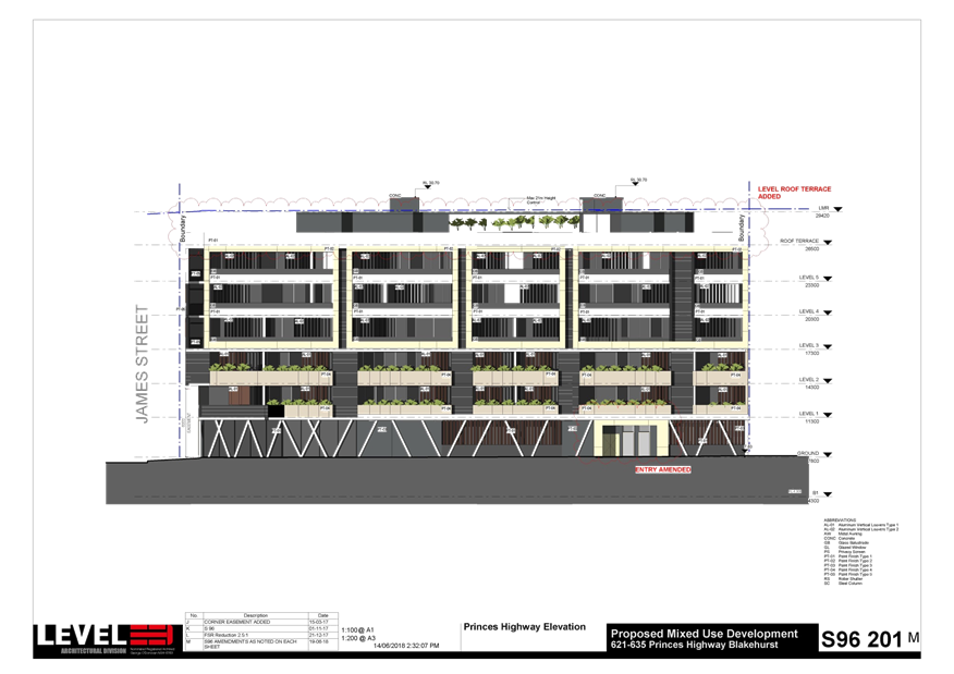
|
Georges River Council - Georges River Local Planning
Panel (LPP) - Monday, 3 September 2018
LPP037-18 621-635 Princes Highway Blakehurst
[Appendix
2] North West
Elevation - 621-635 Princes Highway Blakehurst
|
Page 137
|
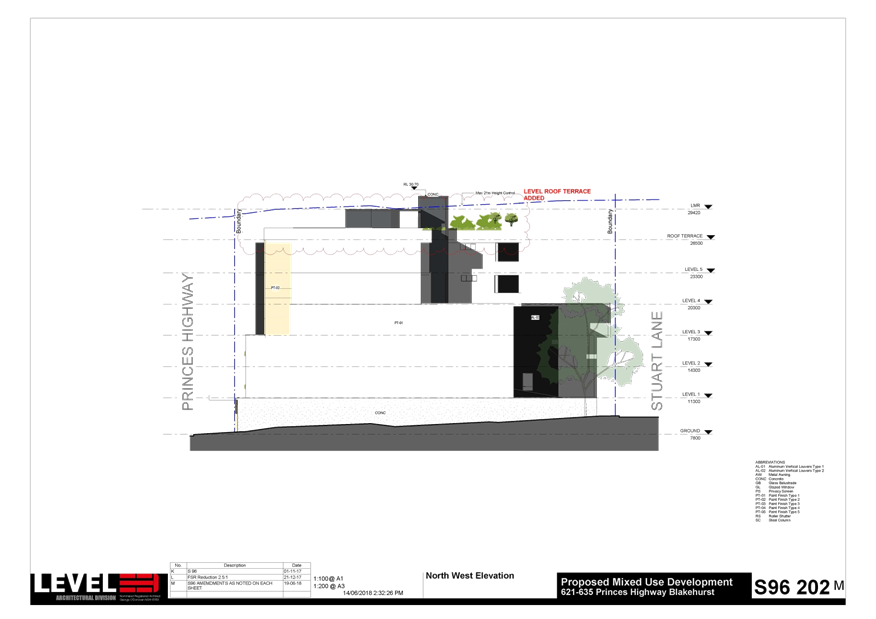
|
Georges River Council - Georges River Local Planning
Panel (LPP) - Monday, 3 September 2018
LPP037-18 621-635 Princes Highway Blakehurst
[Appendix
3] Stuart Lane Elevation
- 621-635 Princes Highway Blakehurst
|
Page 138
|
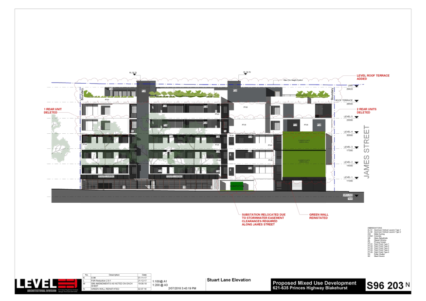
|
Georges River Council - Georges River Local Planning
Panel (LPP) - Monday, 3 September 2018
LPP037-18 621-635 Princes Highway Blakehurst
[Appendix
4] James Street
Elevation - 621-635 Princes Highway Blakehurst
|
Page 139
|
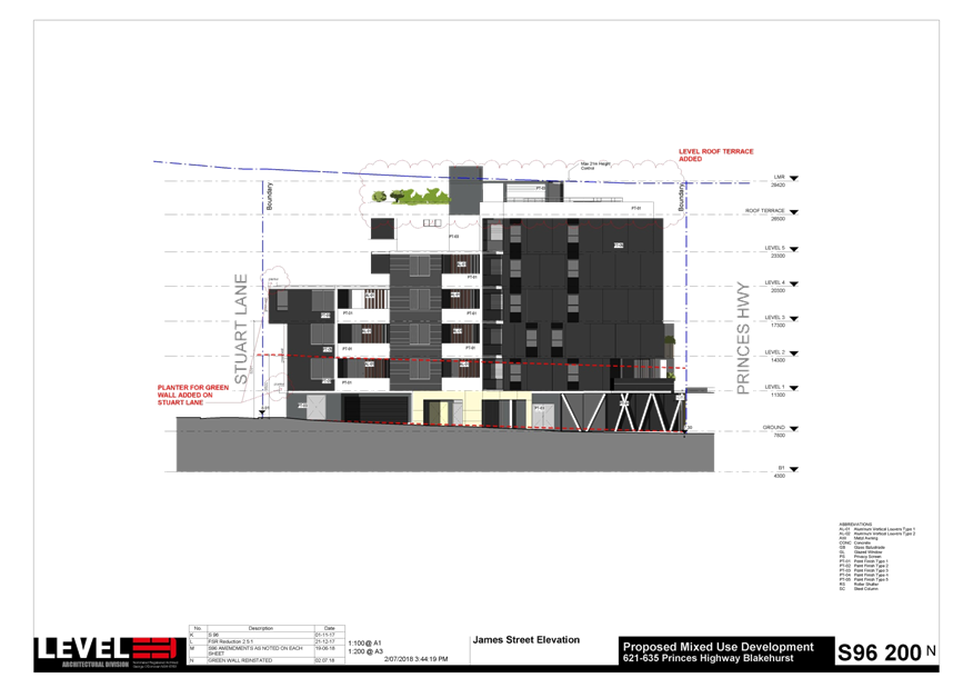
|
Georges River Council - Georges River Local Planning
Panel (LPP) - Monday, 3 September 2018
LPP037-18 621-635 Princes Highway Blakehurst
[Appendix
5] Material
Finishes - 621-635 Princes Highway Blakehurst
|
Page 140
|