Agenda
Environment and Planning Committee
Monday, 11 February 2019
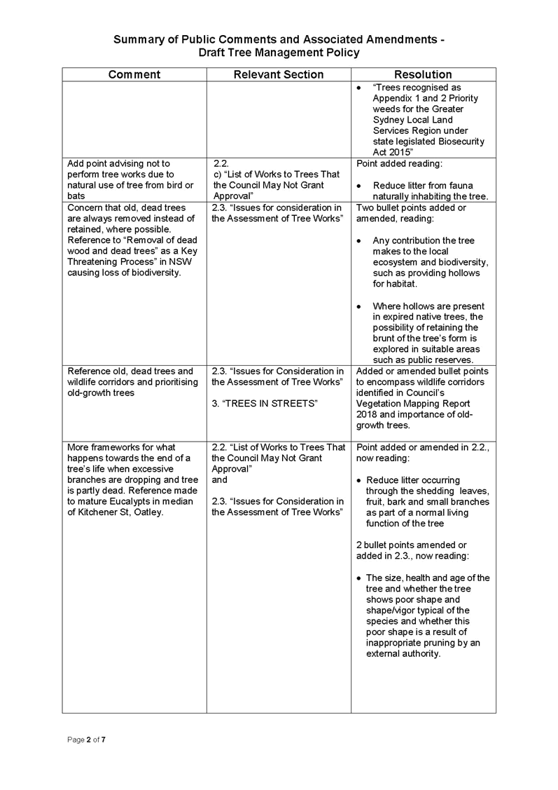
 7.00pm
Georges River Civic Centre
Hurstville
Agenda
Environment and Planning Committee
Monday, 11 February 2019
7.00pm
Georges River Civic Centre
Hurstville
Georges River Council – Environment and Planning - Monday, 11 February 2019 Page 2
Environment and Planning
1. Acknowledgement of Country
2. Apologies
3. Disclosures of Interest
4. Public Addresses to the Meeting
5. Confirmation of Minutes of Previous Meeting
MINUTES: Environment and Planning - 03 December 2018
6. Committee Reports
ENV001-19 Kogarah North Public Domain Plan
(Report by Senior Strategic Planner).................................... 3
ENV002-19 Summary of Development Applications Lodged and Determined - October-December 2018
(Report by Manager Development and Building)................ 186
ENV003-19 Tree Management Policy
(Report by Manager Environment Health & Regulatory Services)......................................................................... 194
ENV004-19 Minutes of the Economic Development Advisory Committee 9 October and 19 November 2018
(Report by Economic Development Officer)....................... 249
Georges River Council – Environment and Planning - Monday, 11 February 2019 Page 4
Item: ENV001-19 Kogarah North Public Domain Plan
Author: Senior Strategic Planner
Directorate: Environment and Planning
Matter Type: Committee Reports
|
(a) That Council endorse the Kogarah North Public Domain Plan (December 2018, Revision G) as a Strategic Planning document:
i. that will inform the preparation of the new Georges River Contributions Plan and Planning Agreement Policy.
ii. that will inform advice to applicants on Council’s requirements for public domain works in the Kogarah North Precinct.
(b) That the Kogarah North Public Domain Plan informs the list of public domain works in the Kogarah North Precinct for the purposes of negotiating Voluntary Planning Agreements.
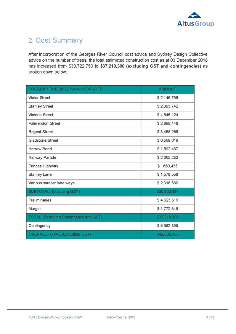
|
Executive Summary
1. The Kogarah Local Environmental Plan 2012 – Amendment No. 2 (New City Plan) gazetted on 26 May 2017, introduced increased height and floor space ratio controls that allowed higher density residential uses across the Kogarah North Precinct.
2. Council engaged Atlas Urban to prepare the Kogarah North Public Domain Plan (the Plan) (Attachment 1) in February 2018. The Plan will guide the transformation of the Precinct to a new high density residential environment. The key aims of the Plan are to:
a. Reflect the role of Kogarah North as being part of a Strategic Centre;
b. Provide streetscape design guidelines for public domain improvements for private development; and
c. Prepare a work schedule and associated costings for Section 7.11 and 7.12 Contributions purposes.
3. The Plan is accompanied by a Preliminary Cost Plan (Attachment 2). This Cost Plan includes a cost summary and a Table of Works proposed under the Kogarah North Public Domain Plan that will inform Council’s new Contributions Plan and Planning Agreement Policy.
4. The Plan was developed after consultation with key stakeholders, including residents, Department of Education and Councillors. Residents in the Precinct were sent a letter notifying them of the preparation of the Plan and the Plan was displayed on Council’s ‘Have Your Say’ webpage for feedback.
5. This Report recommends that Council endorse the Plan as a Strategic Planning document that will inform the new Georges River Contributions Plan and Planning Agreement Policy. The Plan will provide advice to applicants on Council’s requirements for public domain works in the Kogarah North Precinct.
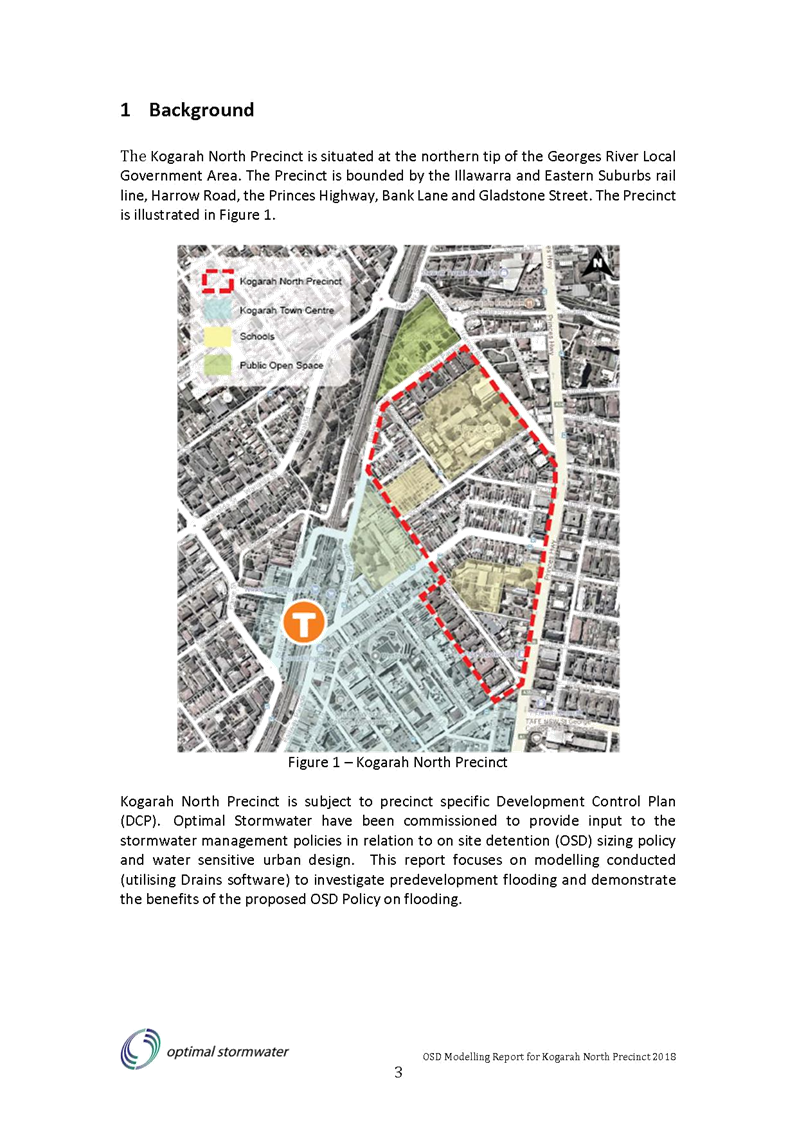
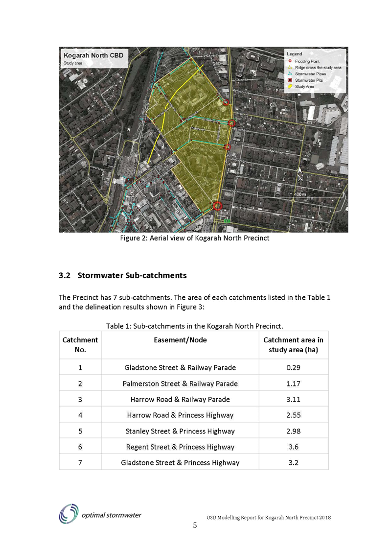
Kogarah North Precinct (Study area)
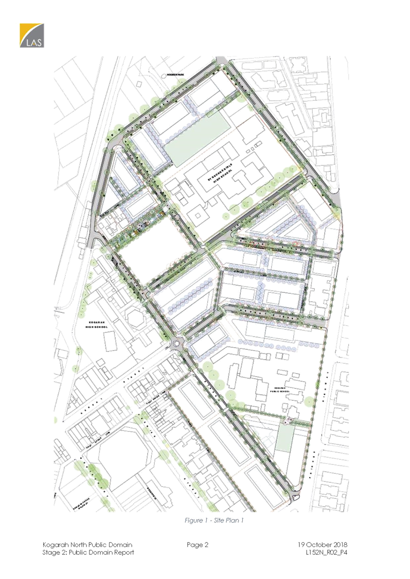
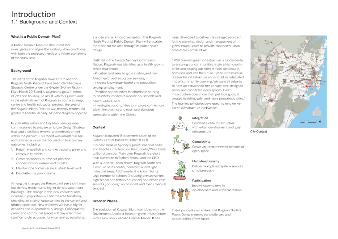
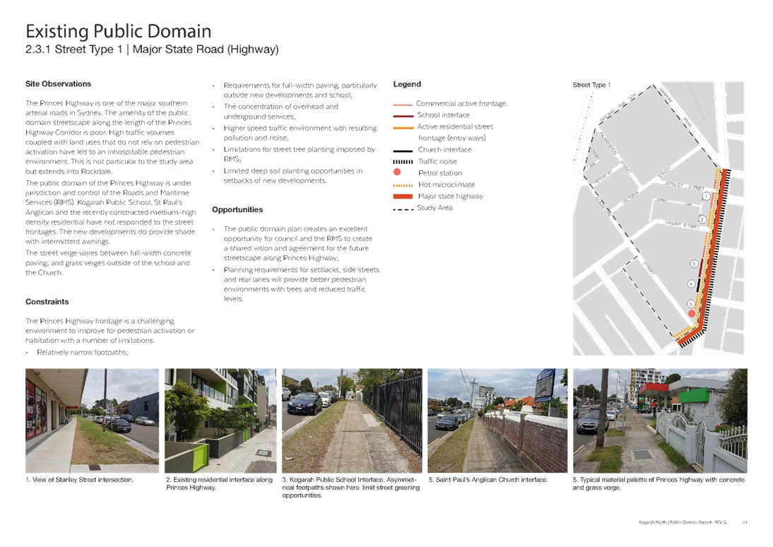
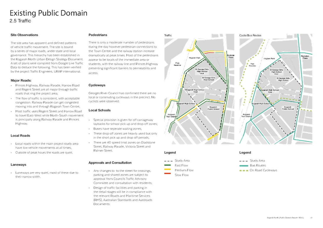
6. The Kogarah North Precinct is situated at the north-eastern tip of the Georges River Local Government Area. The Precinct is bounded by the Illawarra and Eastern Suburbs rail line, Harrow Road, the Princes Highway, Bank Lane and Gladstone Street. The Precinct is illustrated in Figure 1.
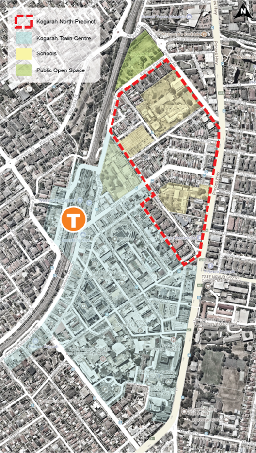
Figure 1: Kogarah North Precinct
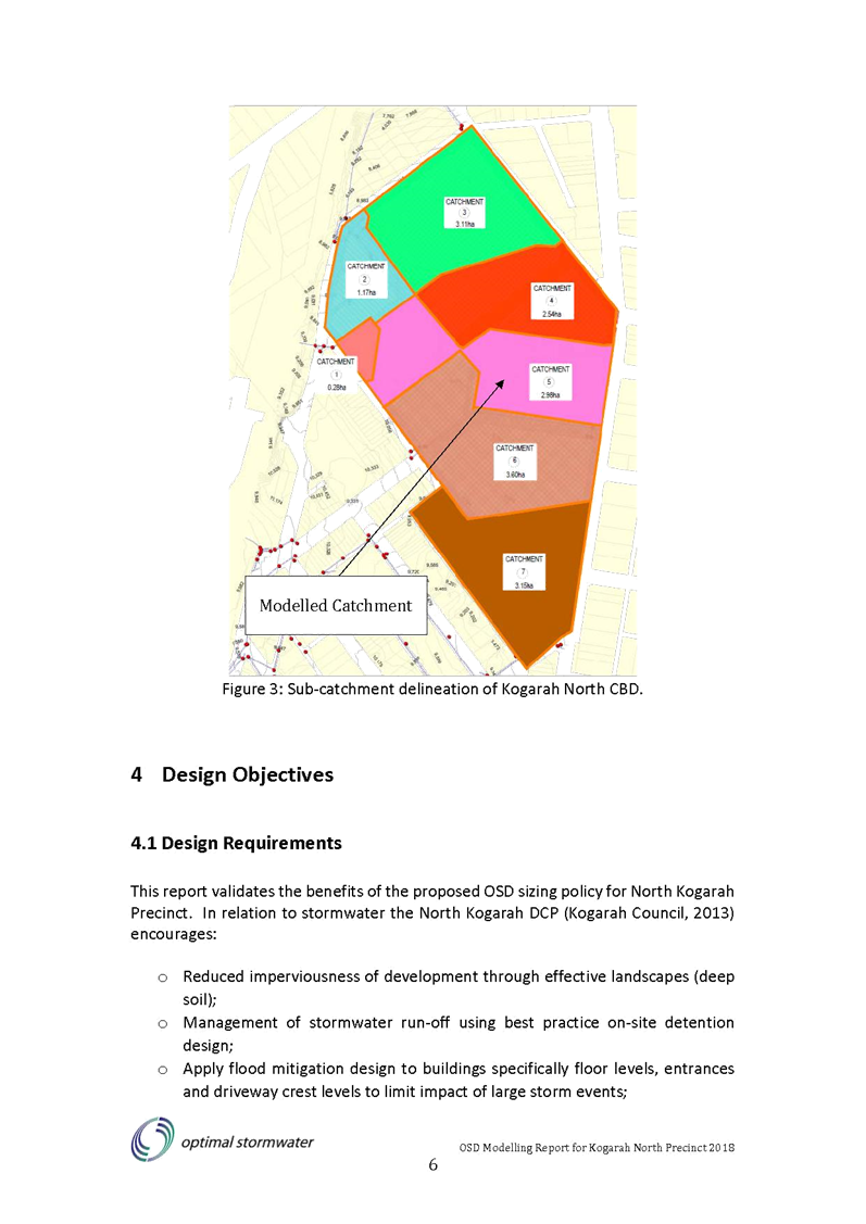
7. The study area is zoned R4 – High Density Residential, SP2 Infrastructure and B2 – Local Centre under Kogarah Local Environmental Plan 2012 as illustrated in Figure 2.
8. The study area includes three schools zoned SP2 Infrastructure. They include:
· St George Girls High School bounded by Palmerston Street, Victoria Street and Harrow Road.
· Kogarah High School bounded by Palmerston Street, Victor Street, Gladstone Street and Victoria Street.
· Kogarah Primary School bounded by Gladstone Street, Princes Highway and R4 High Density Residential zoned land.
Strategic Context
Greater Sydney Region Plan (A Metropolis of Three Cities) (the ‘Region Plan’)
9. Kogarah has been identified as a Strategic Centre and a Collaboration Area (health and education precinct) in the Region Plan. Kogarah is an area of intense mixed economic and social activity that is built around the transport network and features major public investment in services like hospitals, education and sports facilities. A strategy to prioritise public transport investment to improve connectivity from Norwest and Kogarah via Bankstown is also included.
South District Plan
10. The South District Plan supports the Region Plan in identifying Kogarah as a Strategic Centre and a Collaboration Area. Kogarah is recognised as a centre of medical expertise, with over 50 per cent of the centre’s jobs in the Health Care and Social Assistance sectors. St George Public Hospital, a major tertiary and teaching hospital, is the District’s leading hospital. The Plan recognises that collaborative planning will encourage land uses that can grow health and ancillary services and provide opportunities for new allied health and education services. The Plan specifies a target of between 16,000 and 20,500 additional jobs by 2036.
11. The Plan sets five-year housing targets for the South District that are consistent with known housing approvals and construction activity. The housing supply target for Georges River (from 2016-2021) is 4,800. Providing housing choice for moderate income households, students and health visitors is important to support the growth of the precinct, as is improving accessibility to the precinct and connections from the public transport network.
Kogarah Local Environmental Plan 2012
12. The New City Plan amendment to the Kogarah LEP 2012 was gazetted on 26 May 2017. The amended Kogarah LEP rezoned the Precinct from mostly R2 Low Density Residential to R4 High Density Residential and permits development to a maximum height of 33 metres and maximum FSR of 4:1; allowing for higher density residential uses across the Precinct.
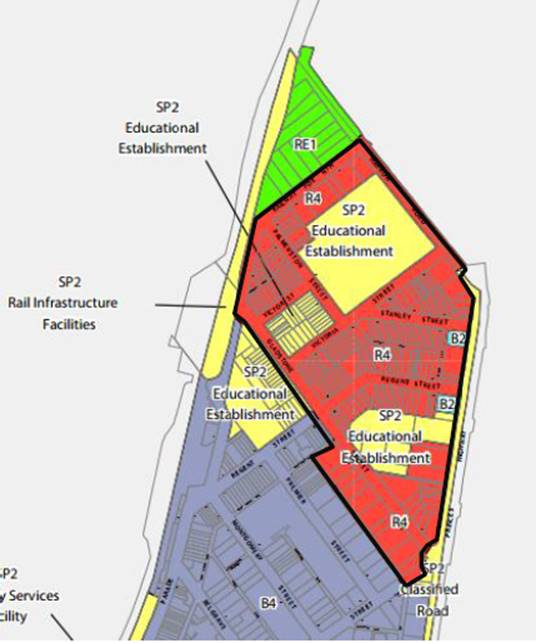
Figure 2: Land Zoning Map under Kogarah LEP 2012
Kogarah North Precinct Urban Design Strategy
13. Council prepared the Kogarah North Precinct Urban Design Strategy (the ‘Strategy’) which was endorsed by Council on 27 November 2017.
14. The Strategy was prepared to facilitate renewal and redevelopment within the Precinct in a coordinated way. This Urban Design Strategy forms the basis for future local planning and plan-making within the Precinct. The primary outcomes of the Strategy include:
a. Retain, embellish and connect existing green and community assets;
b. Create secondary routes that prioritise connections for walkers and cyclists;
c. Maintain the human-scale at street level; and
d. De-clutter the public realm.
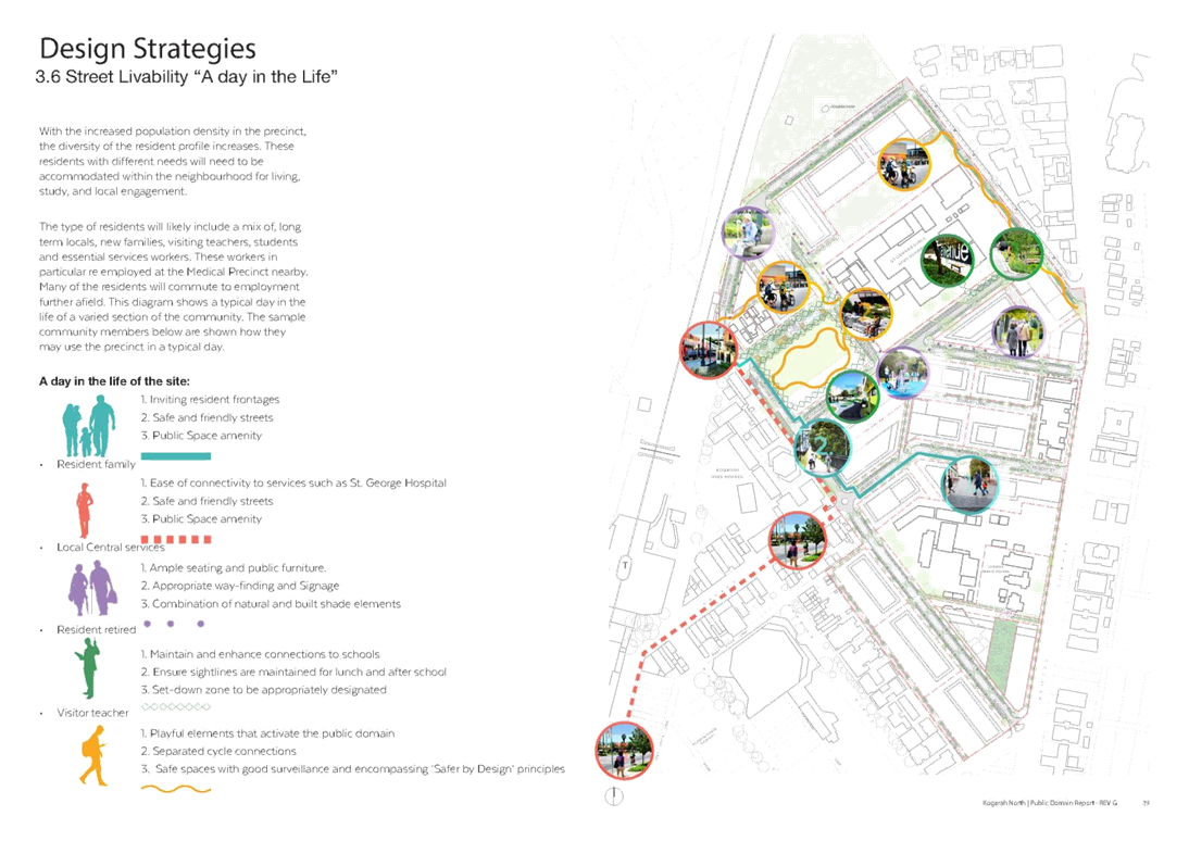
15. Among the changes, the Precinct will see a shift from low density residential to higher density apartment buildings. This equates to an increase from the existing 500 to a proposed 1900 dwellings. The change in the local character and increase in population will see the area transform, providing an array for opportunities for the current and future population. New residents will live in higher density apartment buildings. Consequently, public and communal spaces will play a far more significant role as places for entertaining, socialising, exercise and all kinds of recreation. The Kogarah North Precinct Public Domain Plan will articulate the vision for the area through its public space design.
Kogarah North Precinct Development Control Plan
16. The Kogarah North DCP which was endorsed by Council on 18 December 2017 forms Part E4 of the Kogarah DCP 2013. The DCP was formulated to respond to the design quality principles of State Environmental Planning Policy No. 65 – Design Quality of Residential Apartment Development (SEPP 65) and the NSW Apartment Design Guide 2015 (the ‘ADG’).
17. The urban design principles from the Strategy have been included in this part of the DCP. Design Option 3 was endorsed by Council at its meeting held 1 May 2017. Design Option 3 places an emphasis on creating a built form that complies with the ADG and defines a four storey street wall character. This option places emphasis on transitioning between the scale of the heritage items and the new built form with reduced heights and increased setbacks adjacent to the heritage items. This option also takes into account the height of buildings so as to minimise their overshadowing impact to existing and future open space areas.
Kogarah North Public Domain Plan
18. Atlas Urban commenced work on the draft Kogarah North Public Domain Plan (the ‘draft Plan’) in February 2018 to guide the transformation of the Precinct to a new high density residential environment.
Design Principles
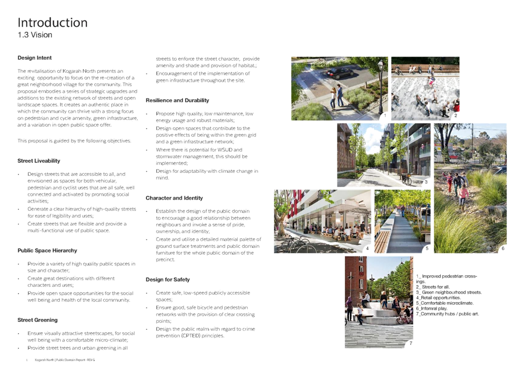
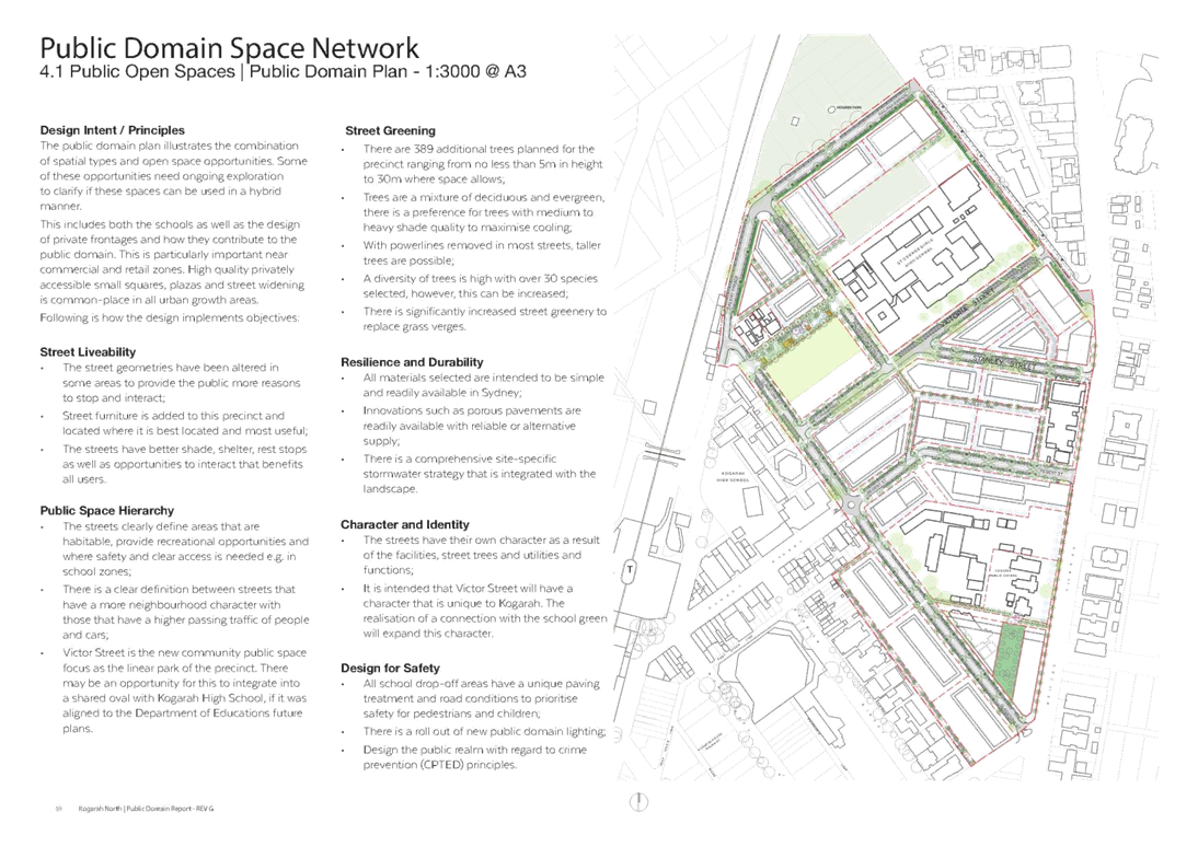
19. The draft plan is based on a number of design principles. These principles and how they are implemented are listed below:
· Street Liveability – This refers to the quality of the street and the way it presents to users:
o Street configurations have been altered to provide reasons to interact;
o Street furniture added where best located; and
o Better shade, shelter and rest stops provided for interaction.
· Public Space Hierarchy – This refers to the organisation of public spaces like streets, parks and open spaces by their levels of importance to users:
o Streets clearly define the accessible and safe areas;
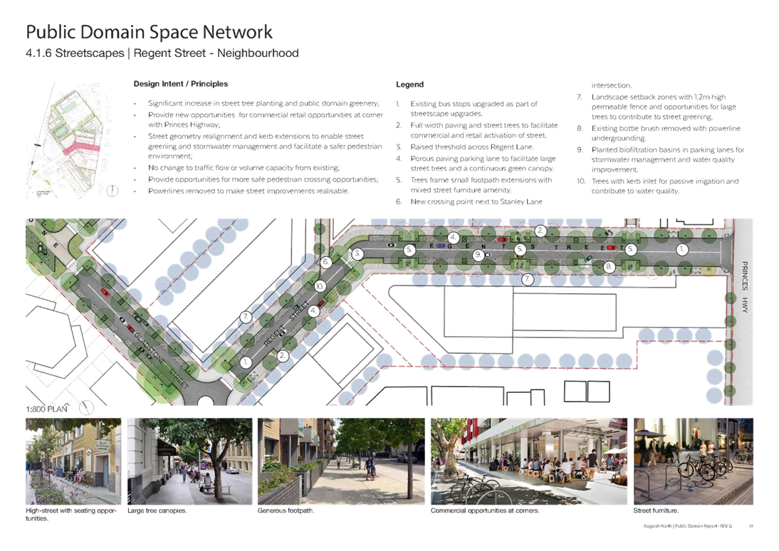
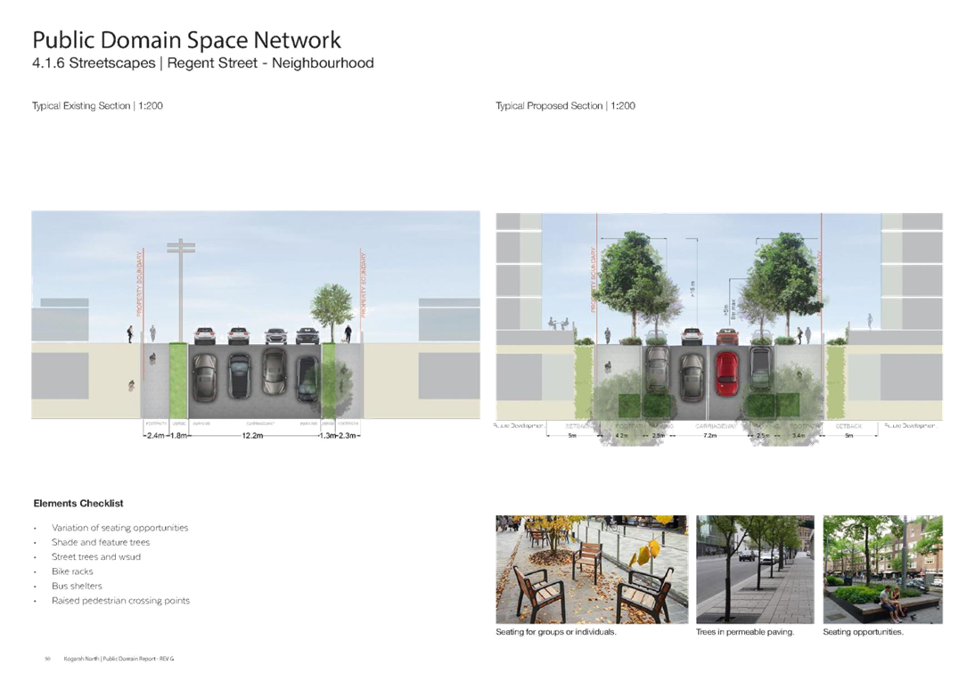
o Street types defined – whether through site links or neighbourhood streets; and
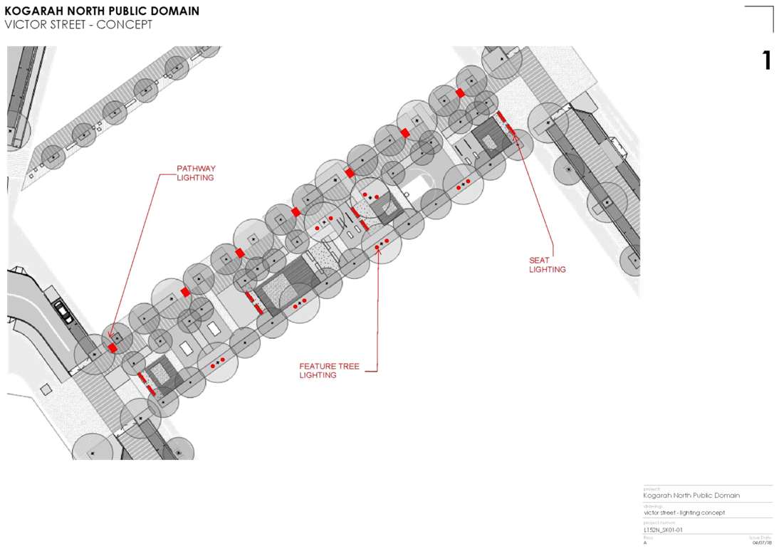
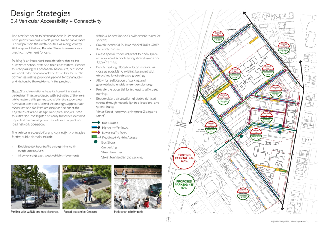
o Victor Street proposed as the new community public space.
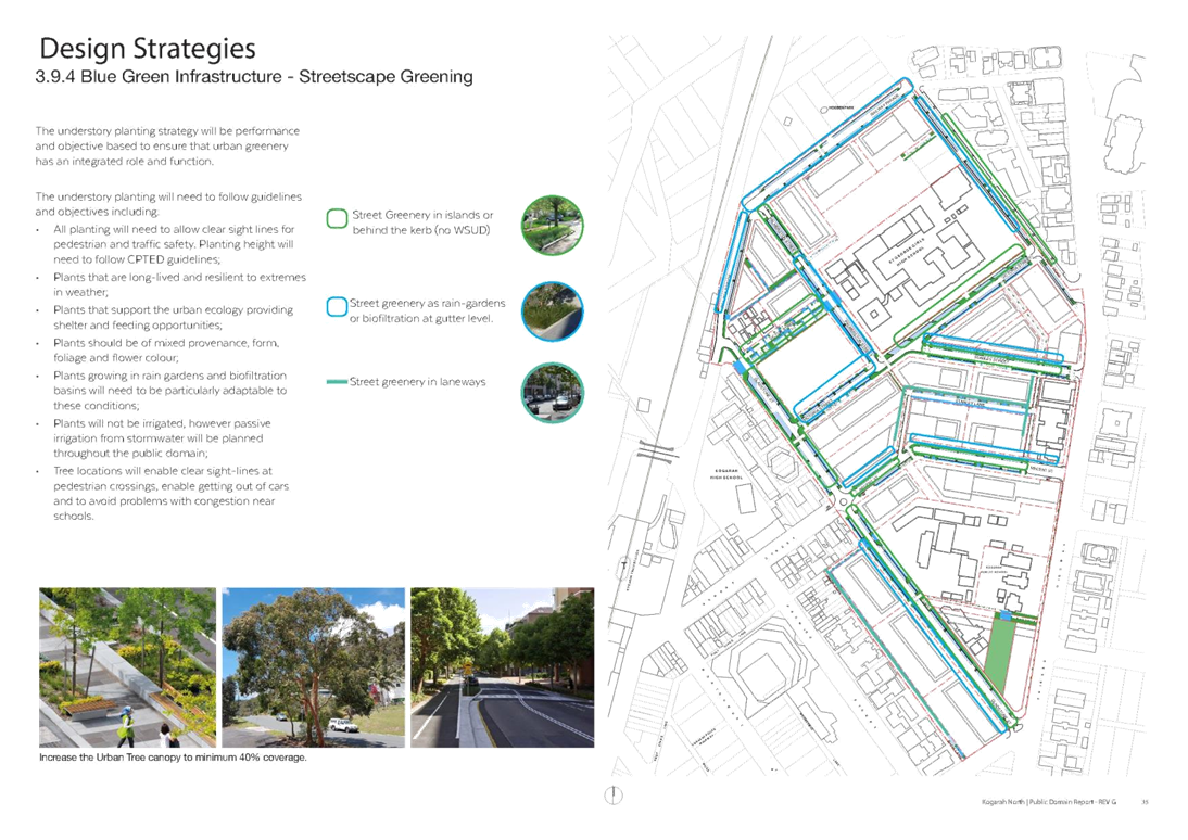
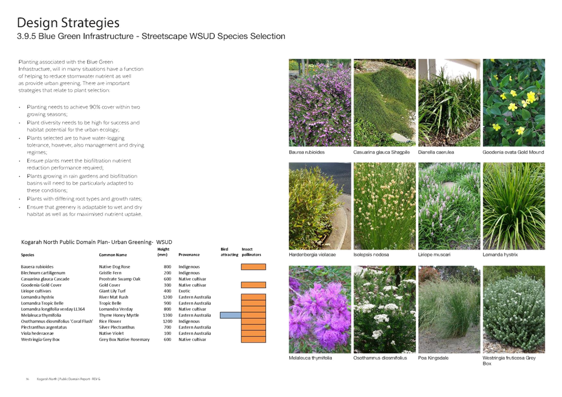
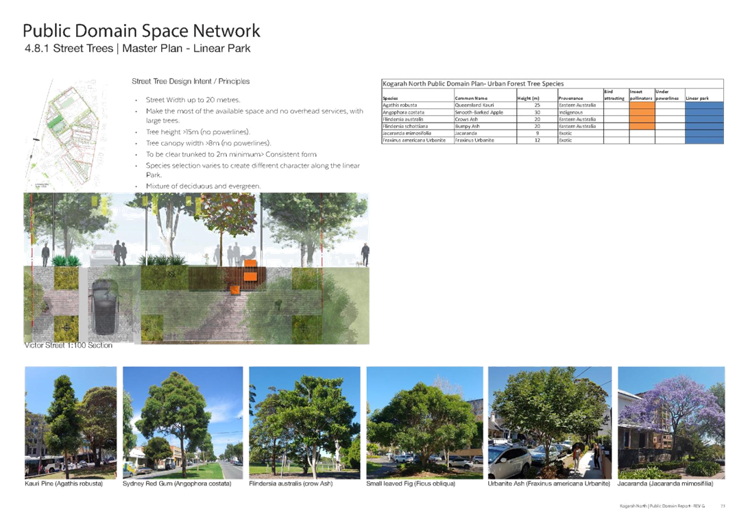
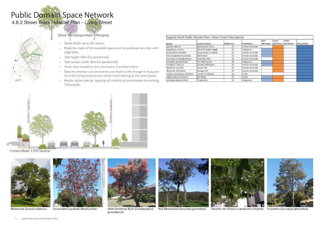
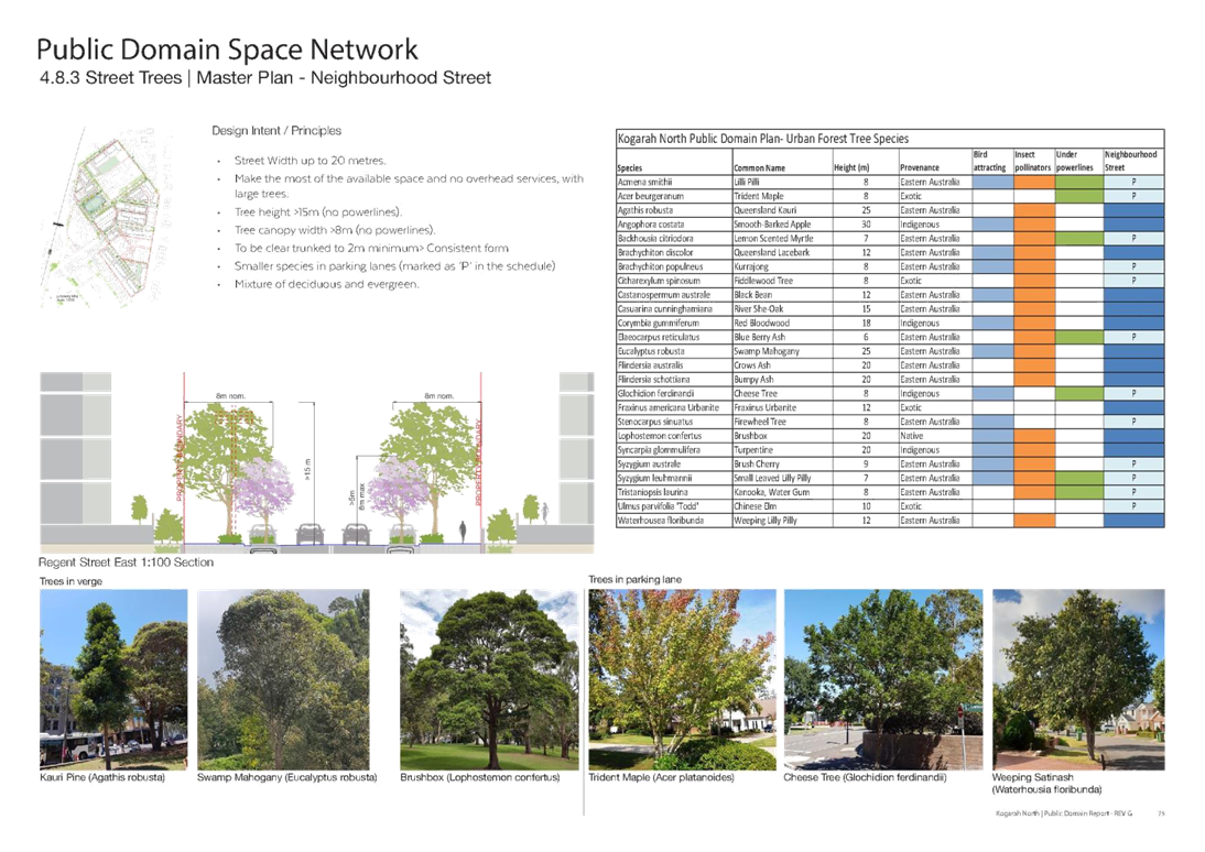
· Street Greening – This refers to improving the street amenity by planting trees, shrubs and ground cover:
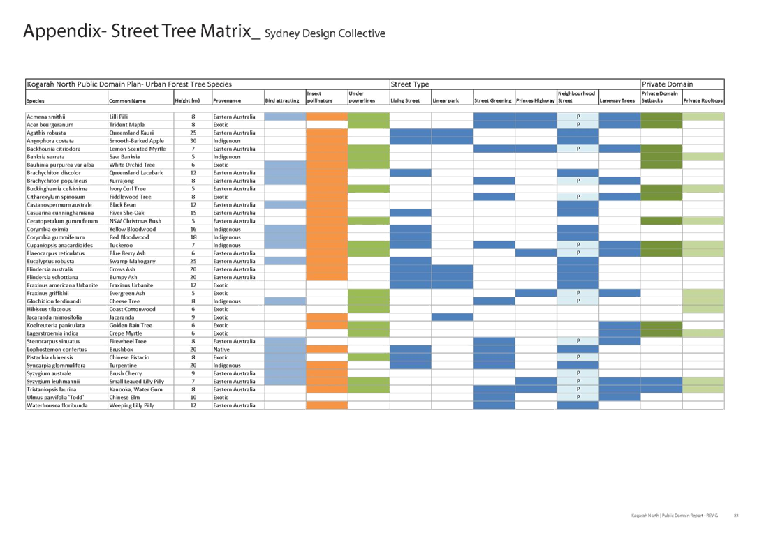
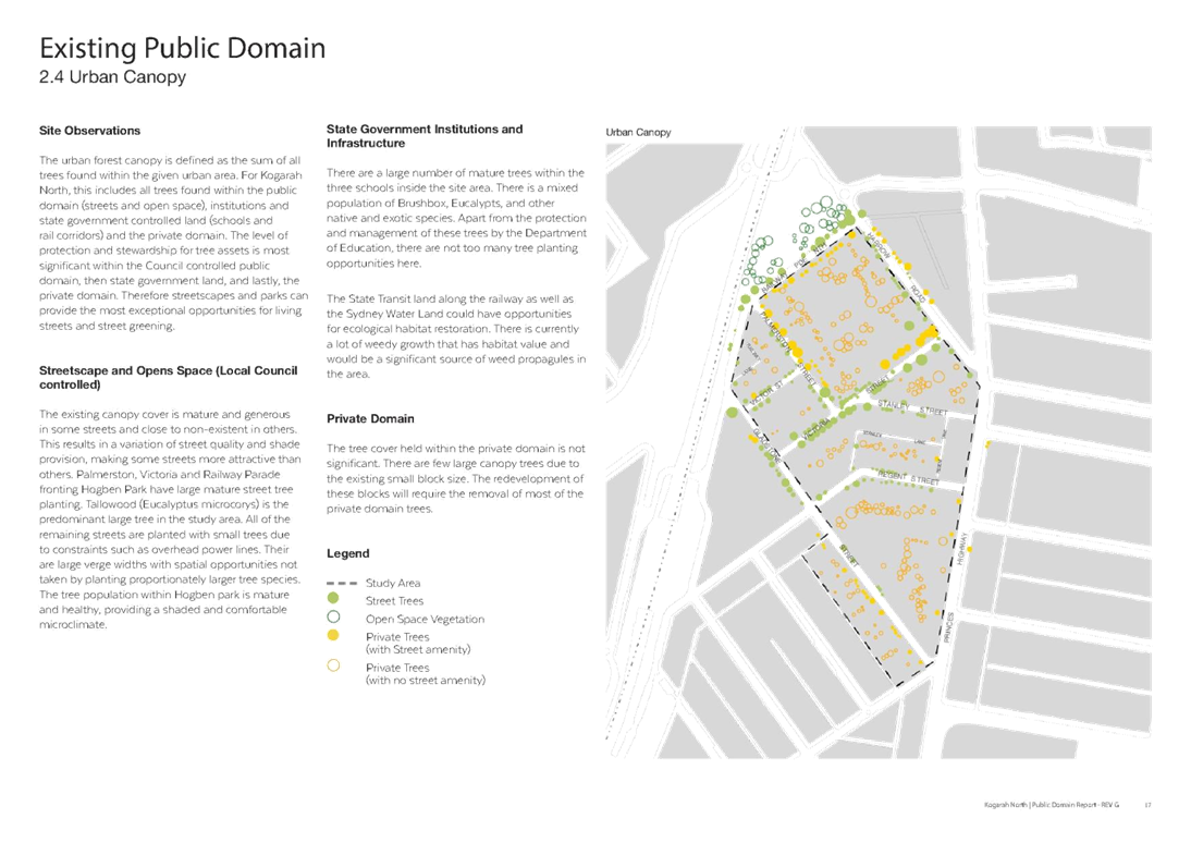
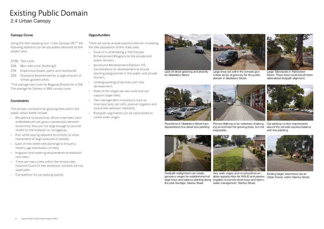
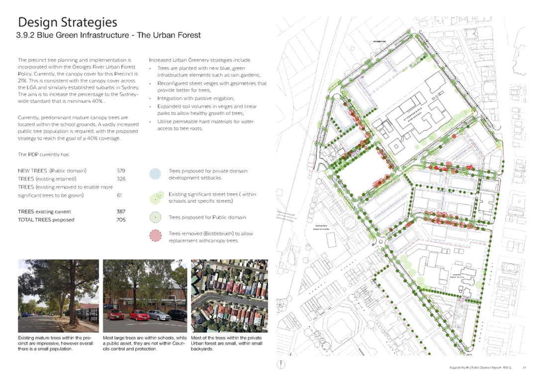
o 389 additional trees planned (taking the canopy cover from 21% to 40%) for the precinct that are a mixture of deciduous and evergreen;
o Power lines are planned to be removed in most streets; and
o An increased street greenery to replace grass verges.
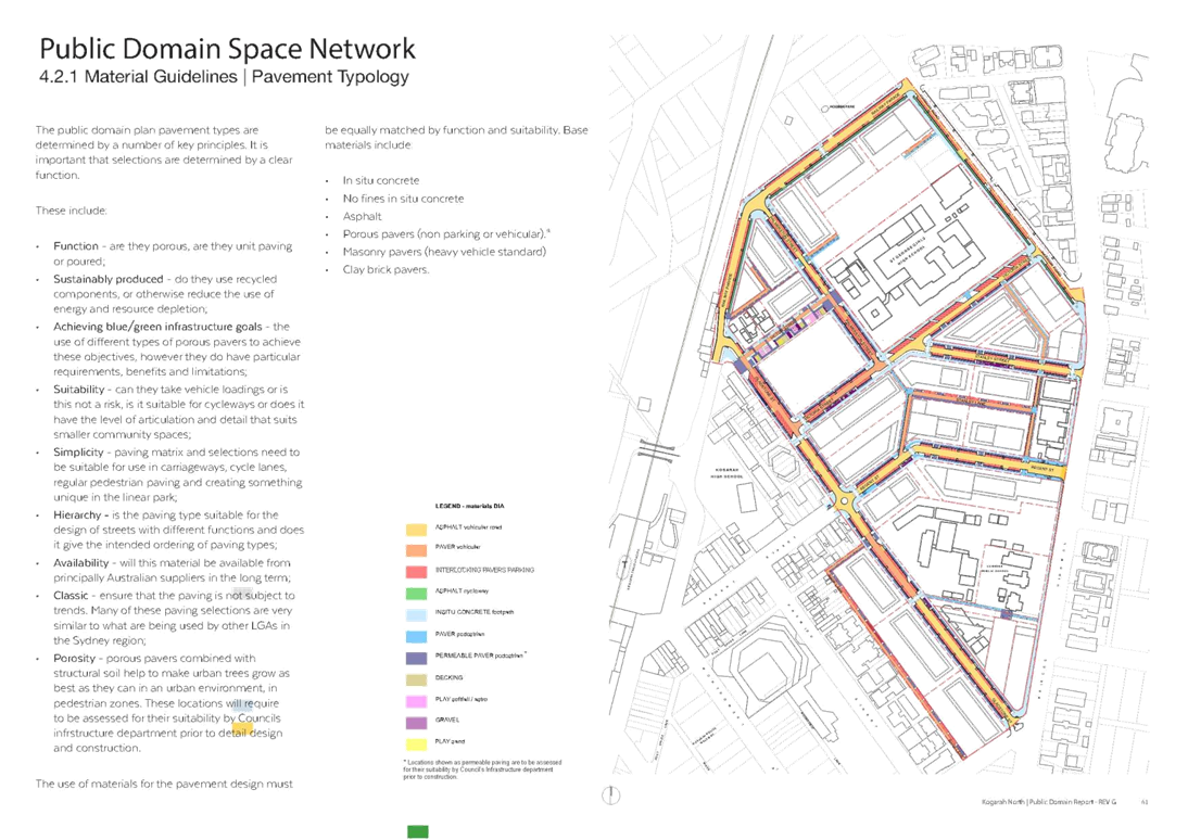
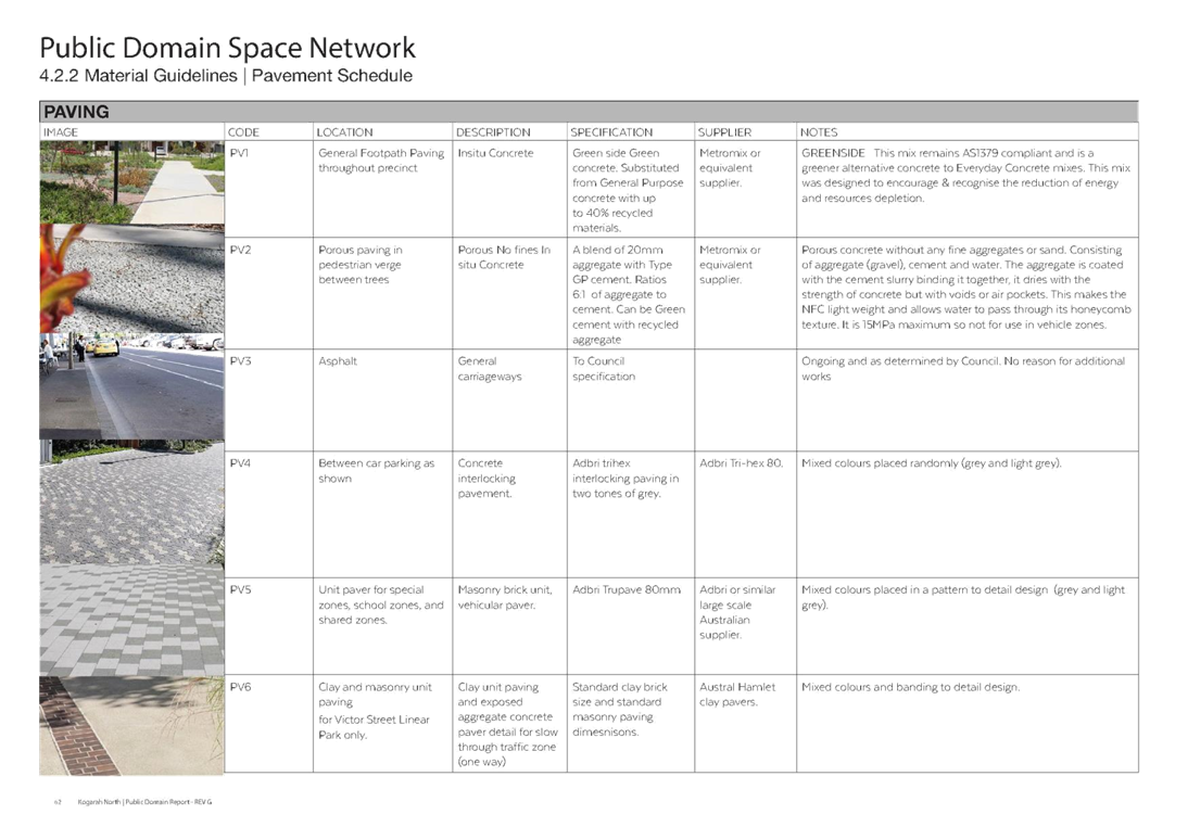
· Resilience and Durability – This refers to the choice of materials for the public spaces that are durable and sustainable:
o Materials selected are intended to be simple and readily available;
o Alternatives like porous pavements chosen for relevant areas; and
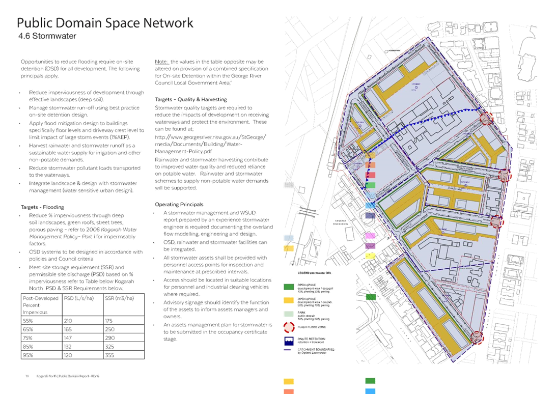
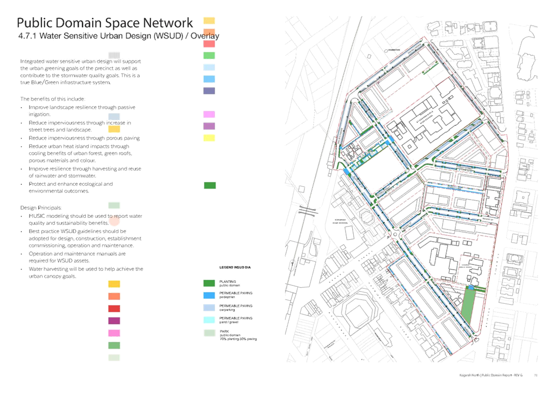
o A comprehensive site specific stormwater strategy integrated with the landscape is envisaged.
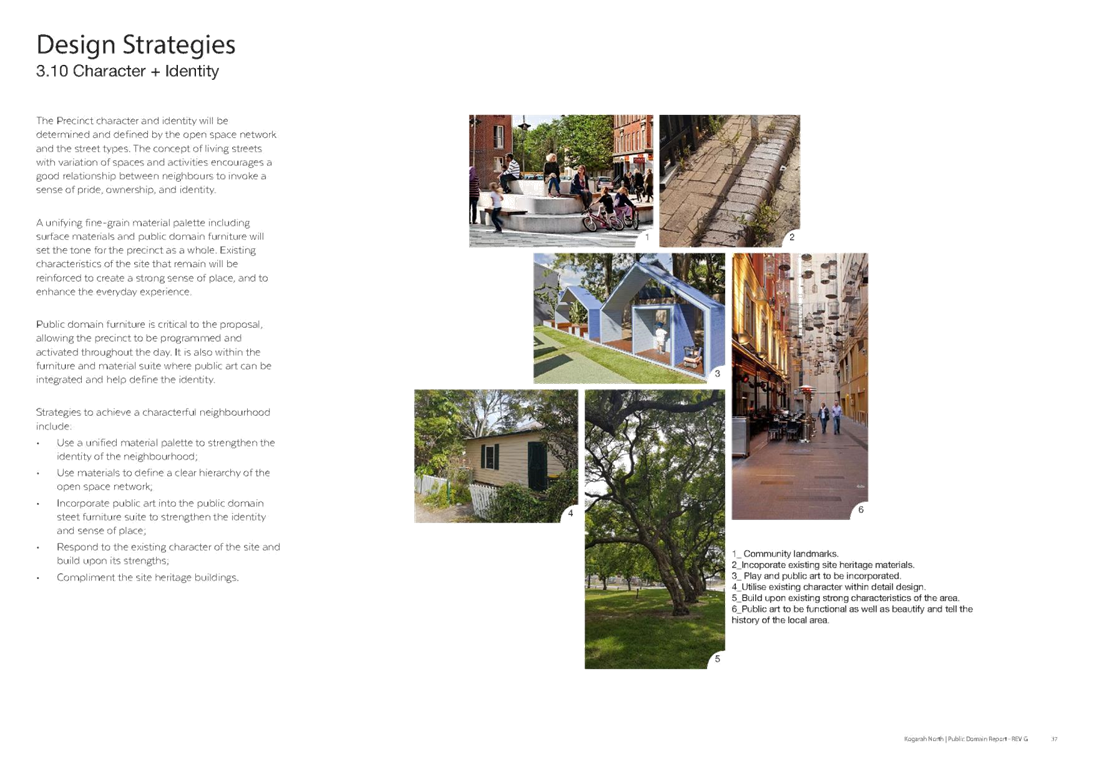
· Character and Identity – This refers to how the public spaces are perceived:
o Most streets are designed to have a specific character; and
o Victor Street is intended to have a character that is unique to Kogarah (i.e. a Linear Park).
· Design for Safety – This refers to the incorporation of safety elements in the precinct in terms of surveillance, access control and space management:
o All school drop-off areas will be treated to prioritise safety for pedestrians and children;
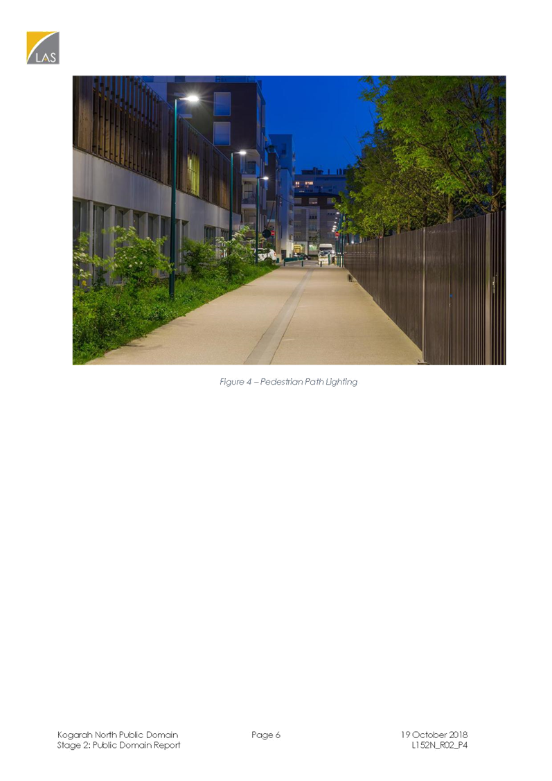
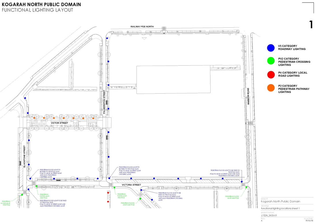
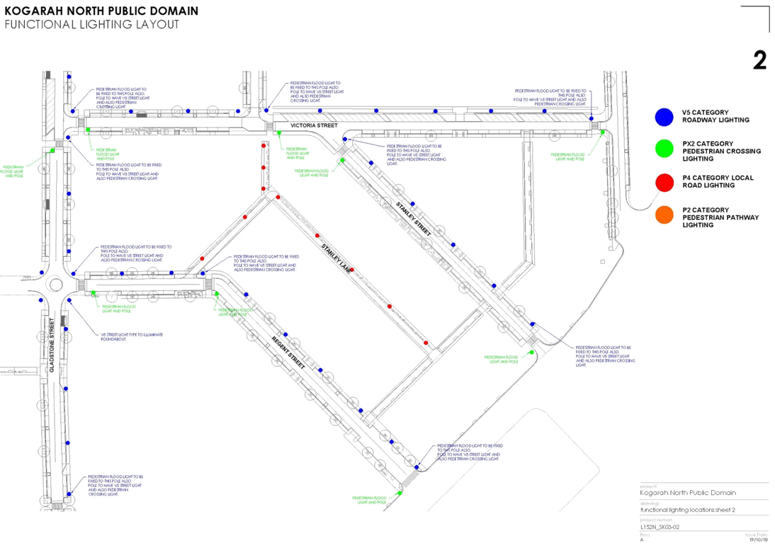
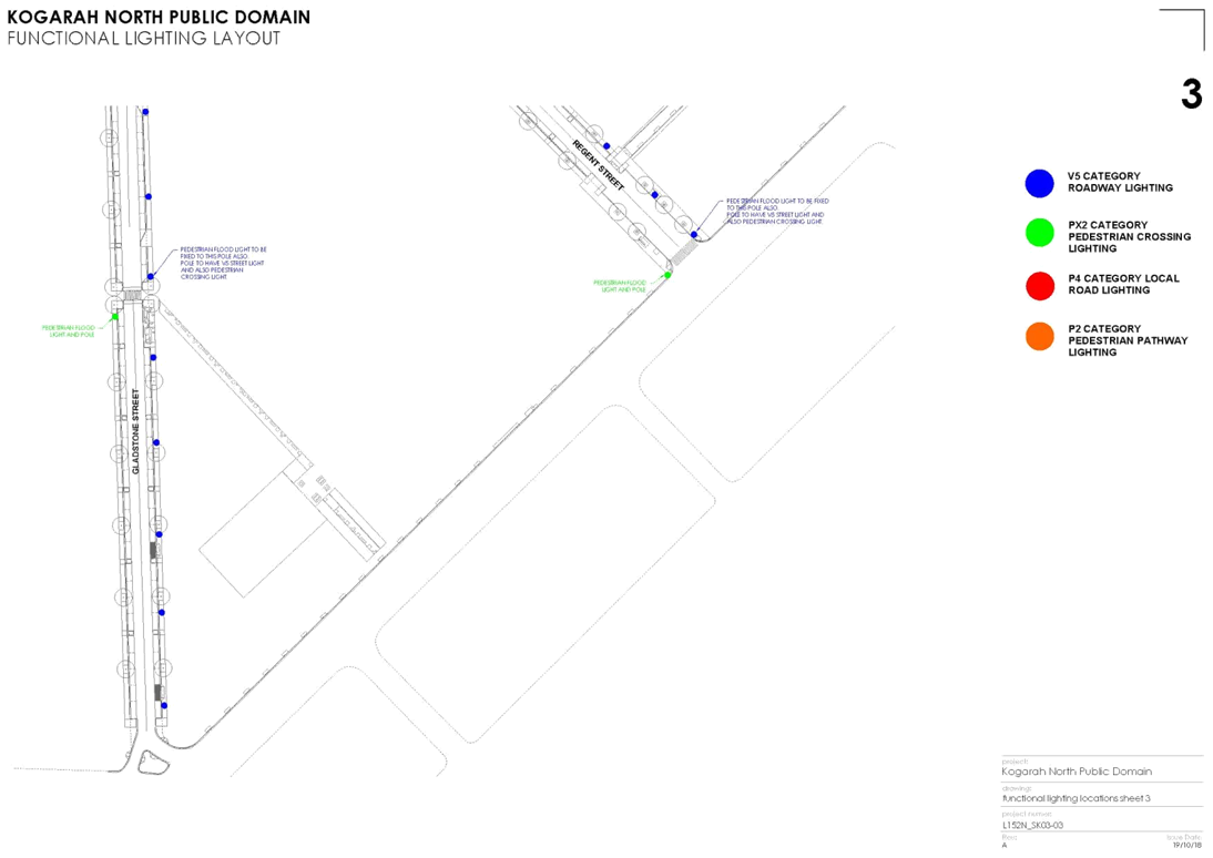
o There will be a roll-out of new public domain lighting; and
o Crime prevention principles will be utilised in the public realm.
Key Features of the Plan
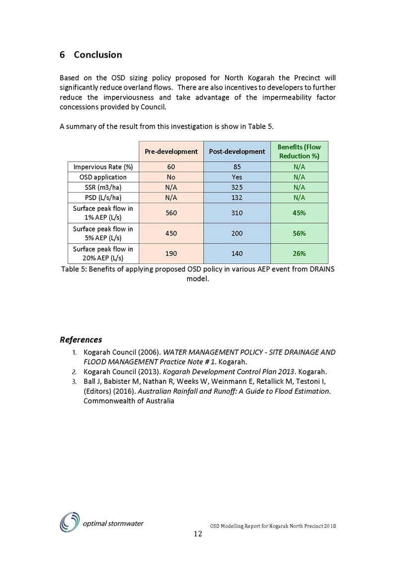
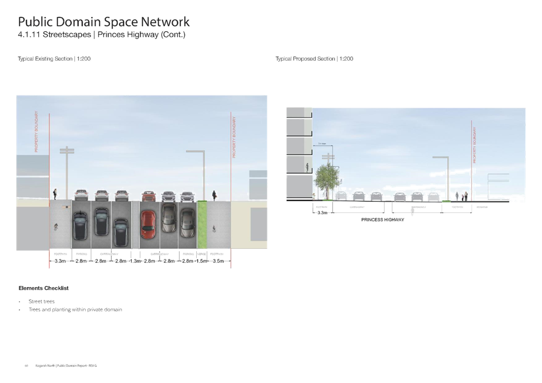
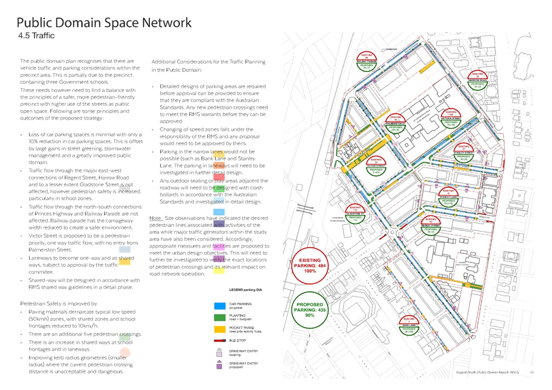
20. This Plan strikes a balance between the benefits of improved public domain; including enhanced tree canopy and retaining on-street parking. The existing tree canopy of 21% within the Precinct is proposed to be exceeded to approximately 40% (Refer Section 3.9.2 of the Plan). To facilitate this increase in tree canopy, there has been a reduction in car parking spaces in the Precinct of less than 10%; from 484 to 435. The majority of spaces lost are on Victoria Street (26% loss approximately) and Victor Street (34% loss approximately). Incremental change to the parking will be staggered and occur over the 10 year period. The impact on the reduction in spaces will be minimised by the provision of parking within private developments. The potential loss of spaces will be offset by large gains in street greening, stormwater management and a greatly improved public domain. Traffic flow is also not affected and pedestrian safety is increased, particularly in school zones.
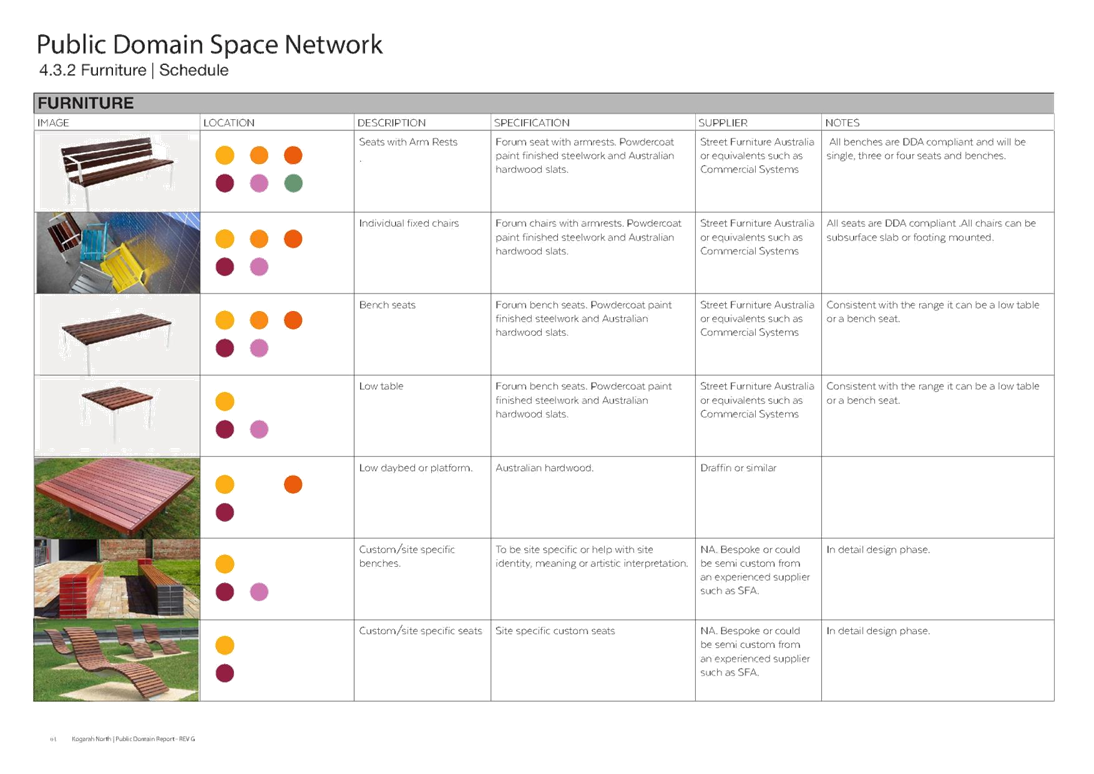
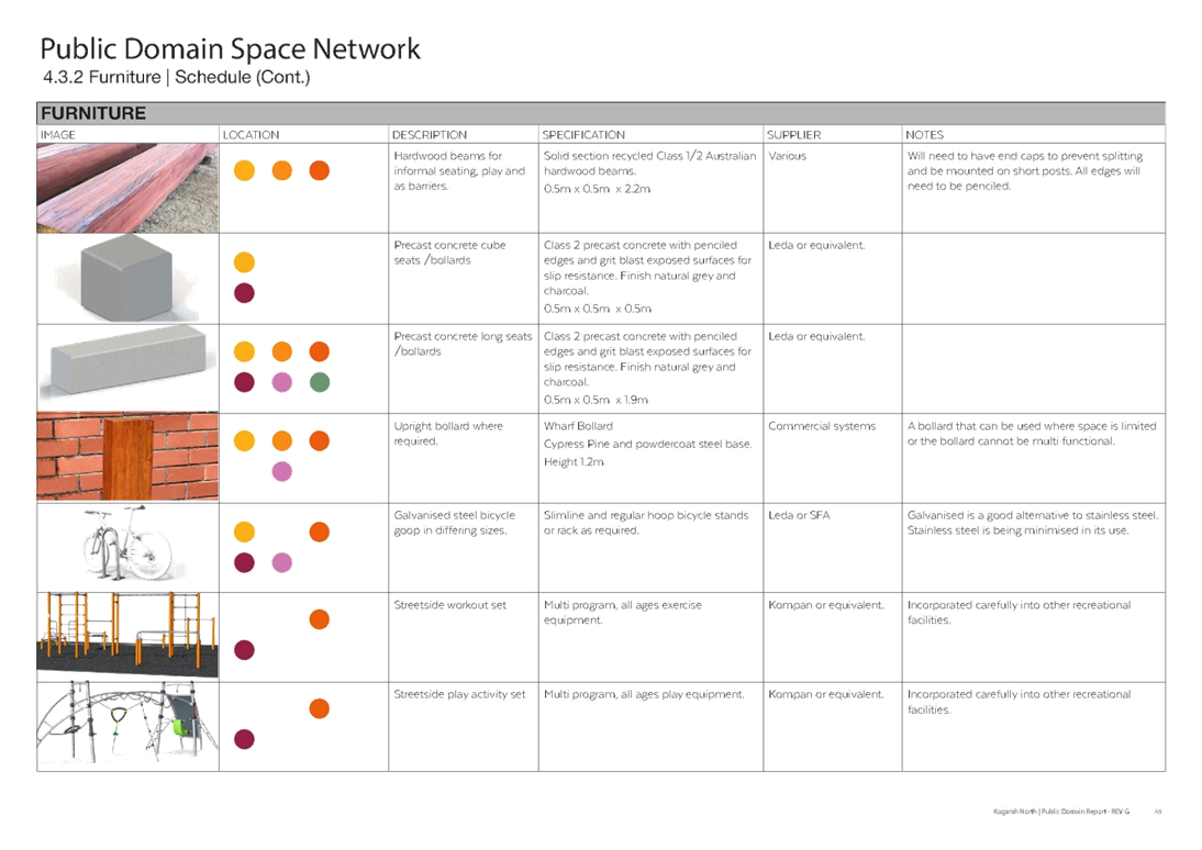
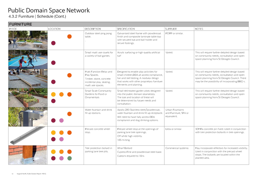
21. The Plan includes:
· Masterplans for various streets and a pocket park.
· Various types of pavements and footpaths with associated kerbs and line marking
· Shared ways and raised pedestrian thresholds outside school areas
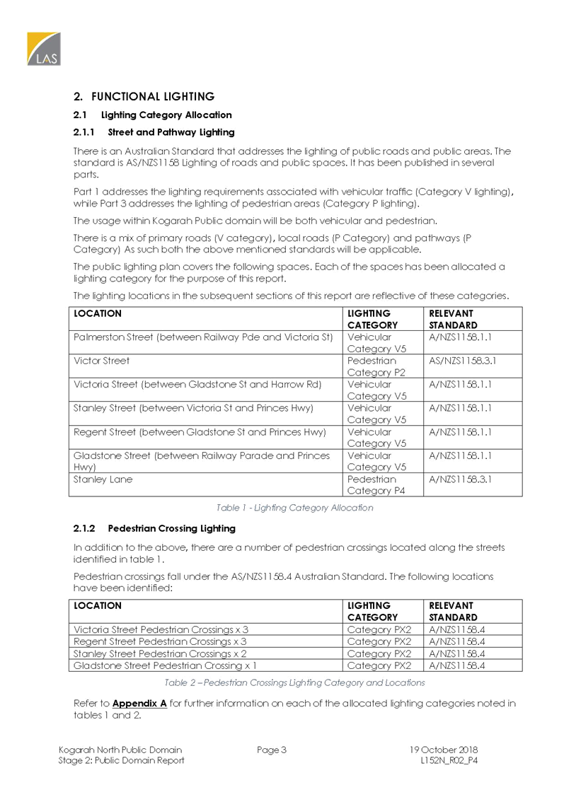
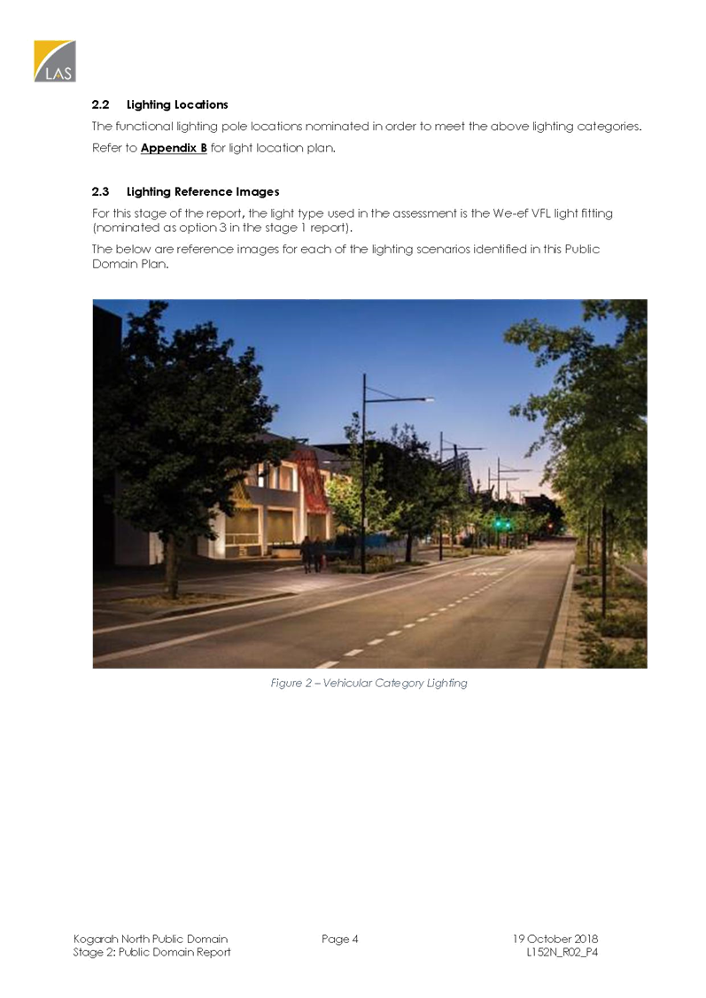
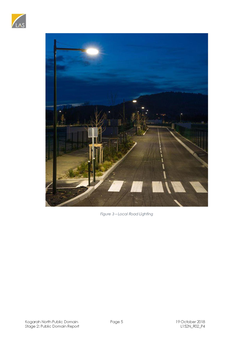
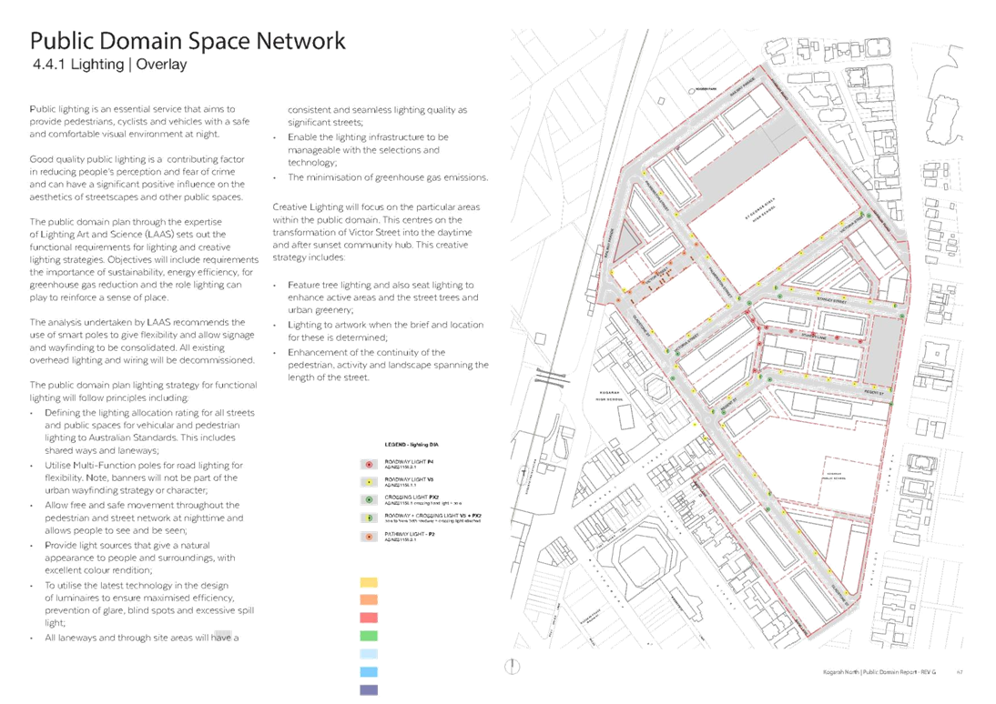
· Street lighting for roadways, crossings and pathways
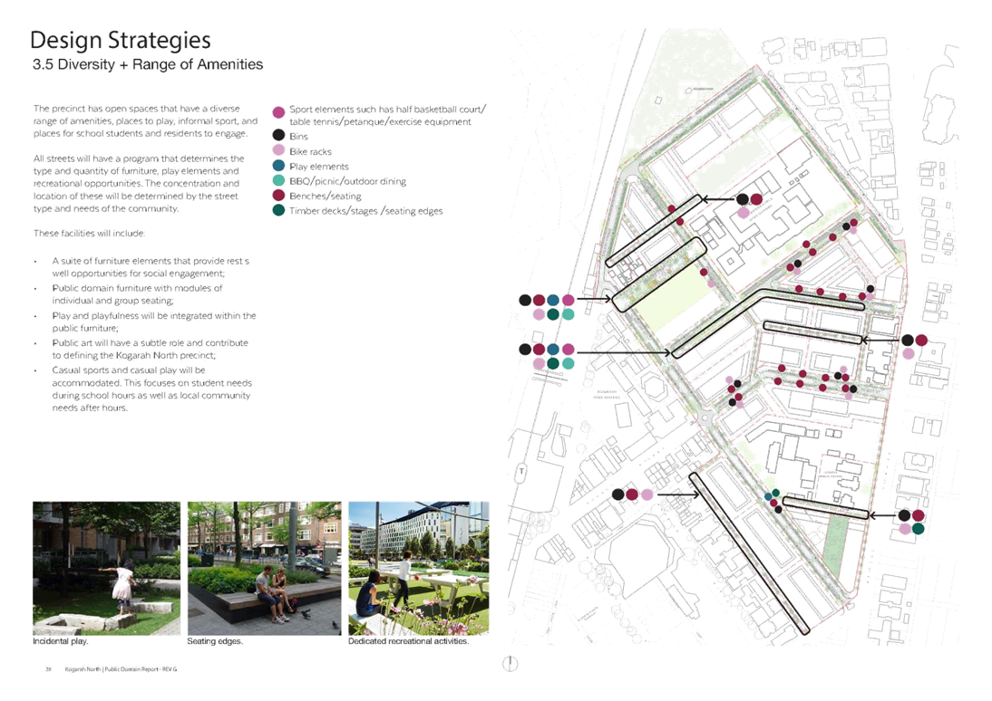
· Activity zones e.g. multi-use half-courts, exercise equipment, children’s play areas, community planting boxes
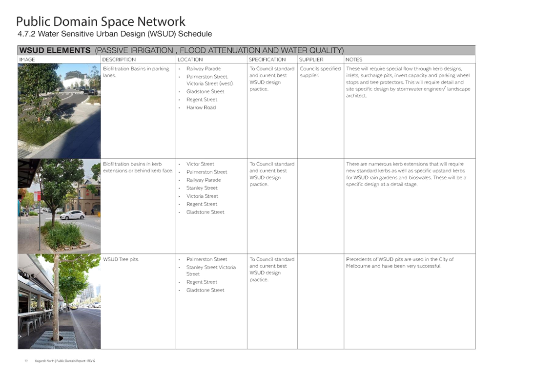
· Extensive landscaping with plantings and trees utilising Water Sensitive Urban Design elements (WSUD)
· Undergrounding of existing power lines and communications cables
· Outdoor fixed furniture for community use
· Drinking fountains
· Public art
· Bus shelters
Structure of the Plan
22. The Plan comprises the following chapters:
1. Introduction – This chapter mainly includes the background to the project, the vision, the methodology and stakeholder consultation.
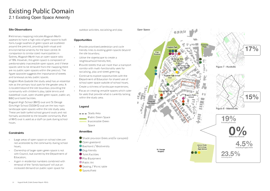
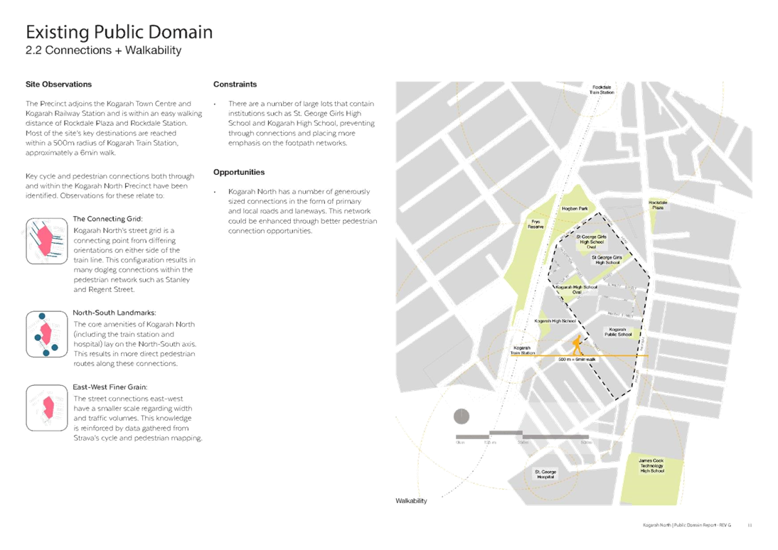
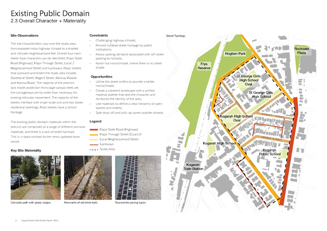
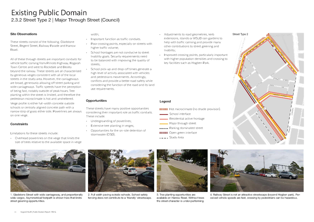
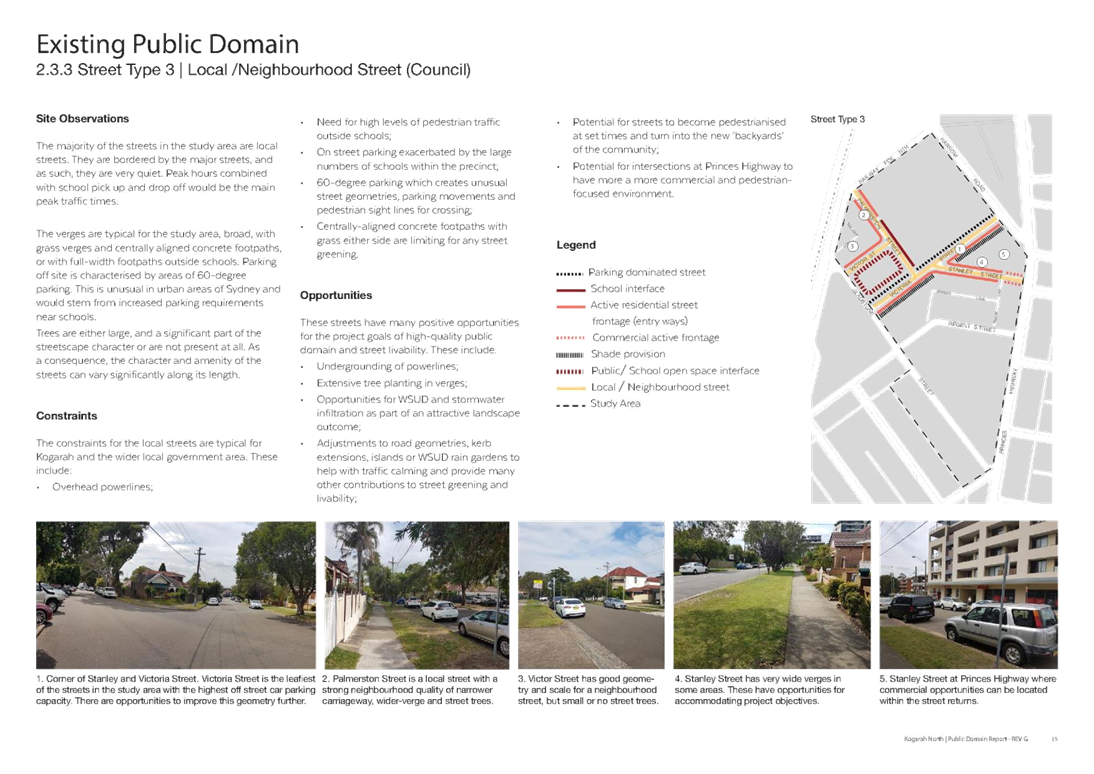
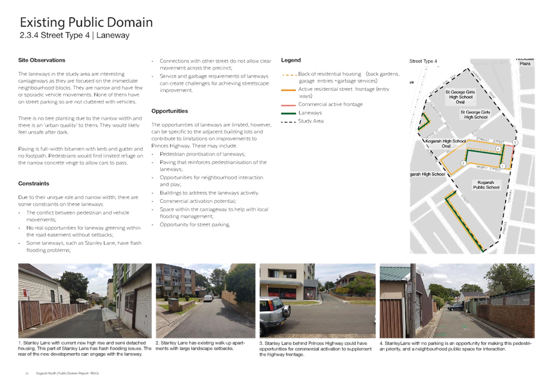
2. Existing Public Domain – This chapter includes a review of existing open space amenity, connections, overall character, urban canopy, traffic, stormwater and urban elements.
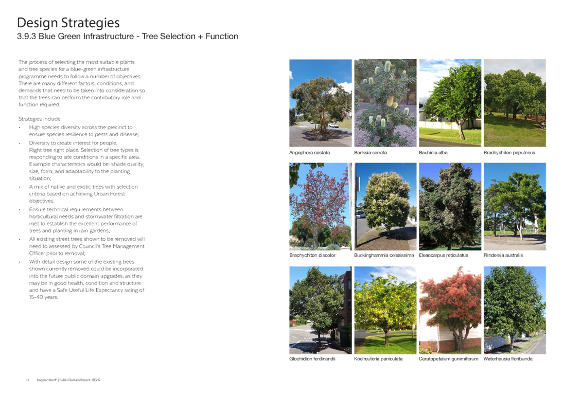
3. Design Strategies – This chapter discusses the proposed Public Domain Network, Accessibility & Connectivity, Vehicular Accessibility & Connectivity, Diversity and Range of Amenities, Private Communal Space, Public Accessible Space, Blue Green Infrastructure (i.e. the integration of stormwater management with urban greenery), Character & Identity and Design for Safety.
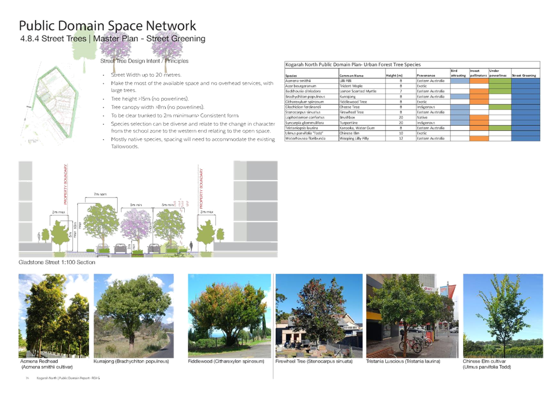
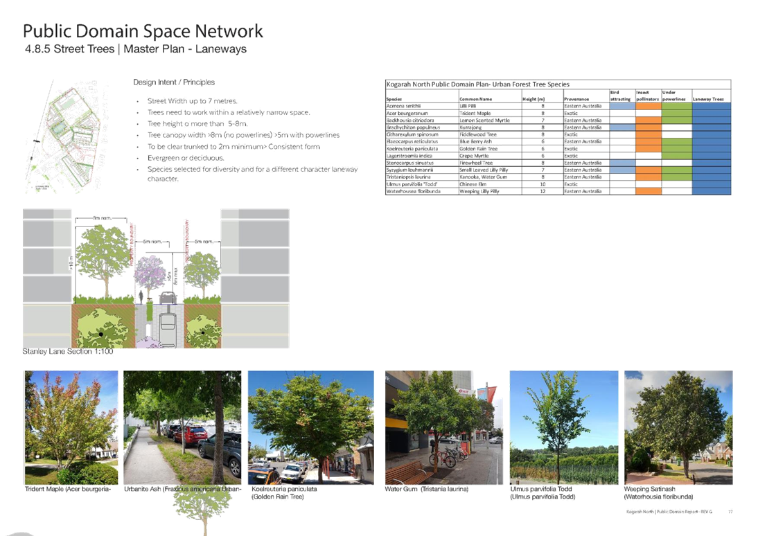
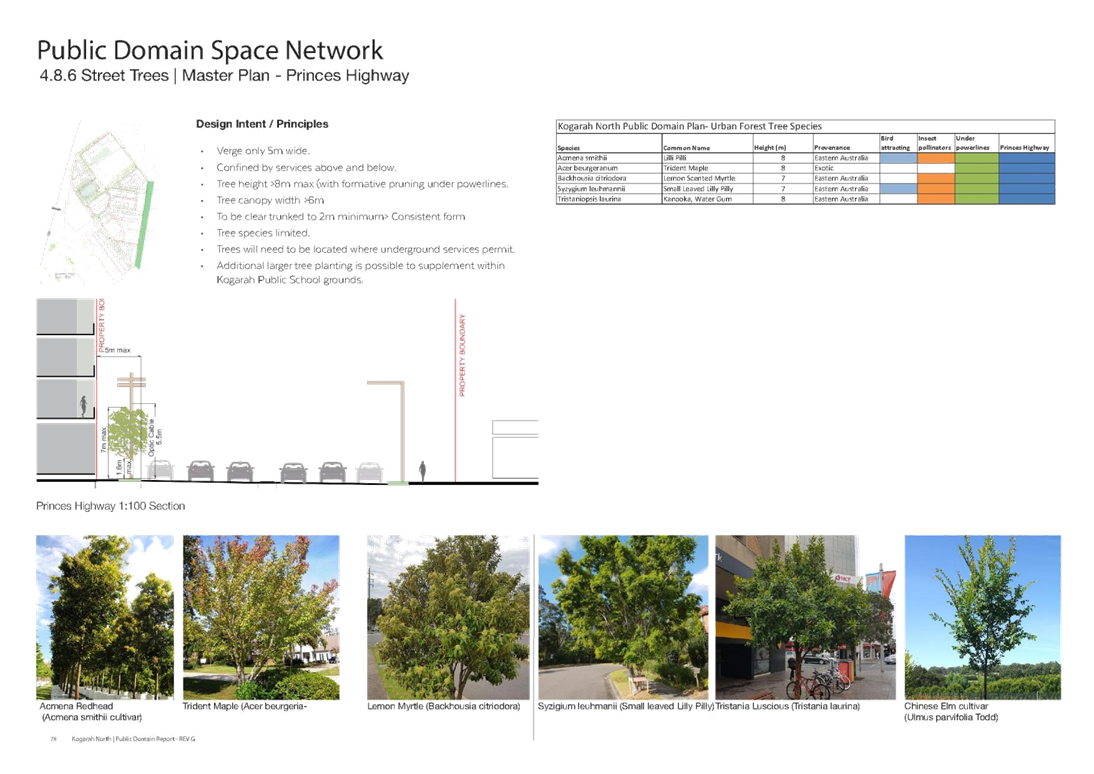
4. Public Domain Network – This chapter includes Masterplans for various streets (Refer Table 1), Material Guidelines, Furniture, Lighting, Traffic, Stormwater, Water Sensitive Urban Design and Street Trees Masterplan.
5. Appendices – These include:
A. Stormwater Modelling – this includes analysis of the pre-development stormwater catchment conditions and testing the stormwater drainage post development.
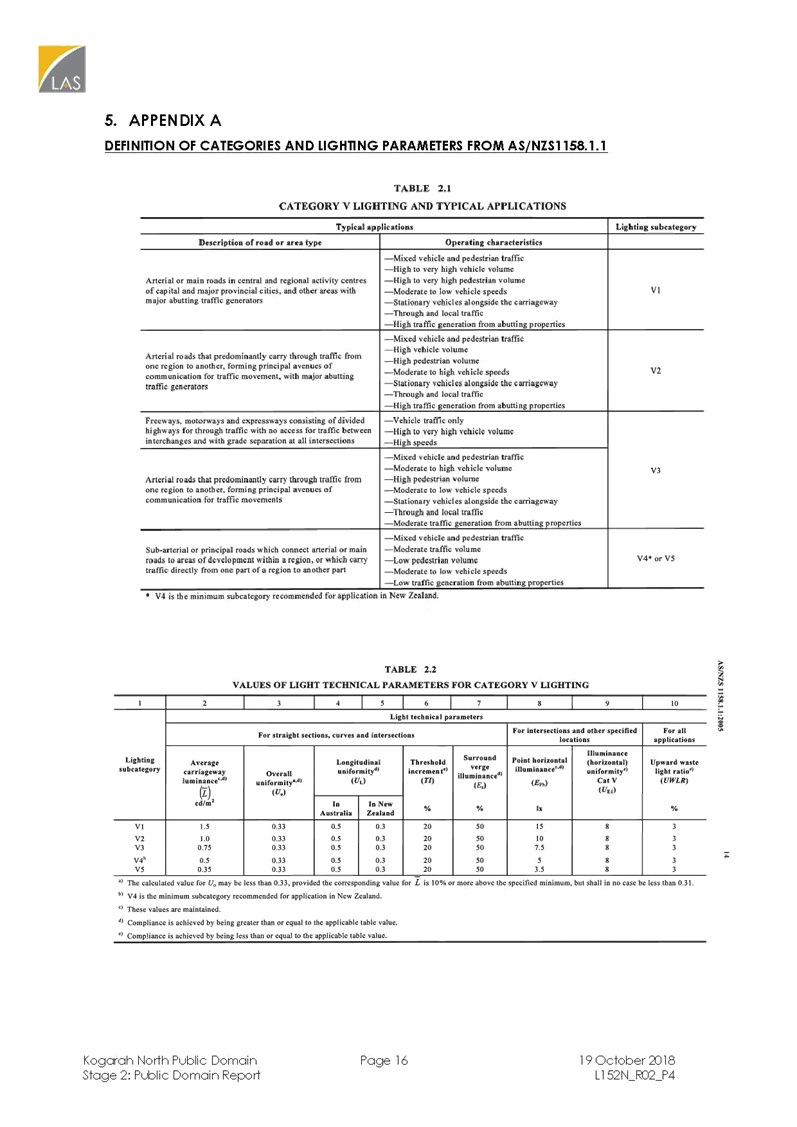
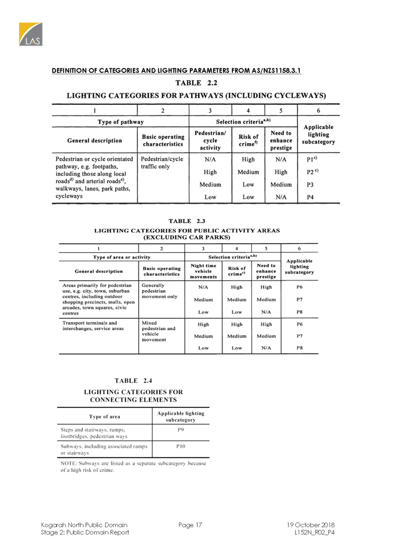
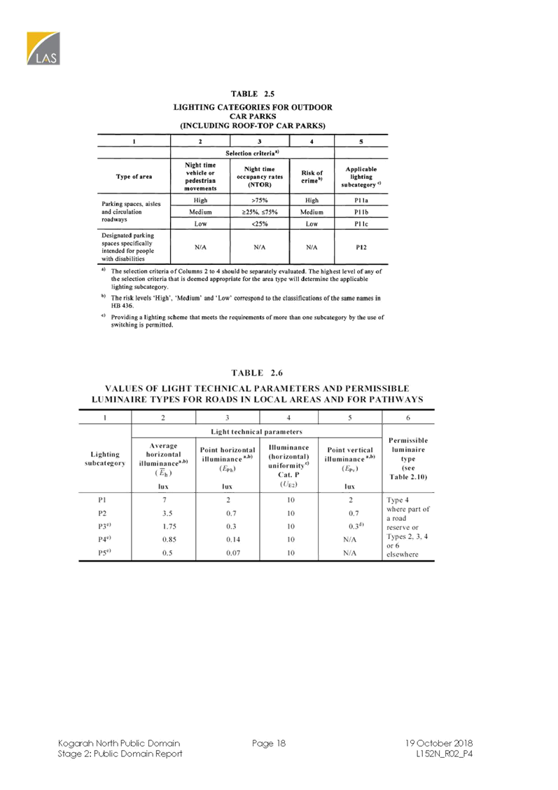
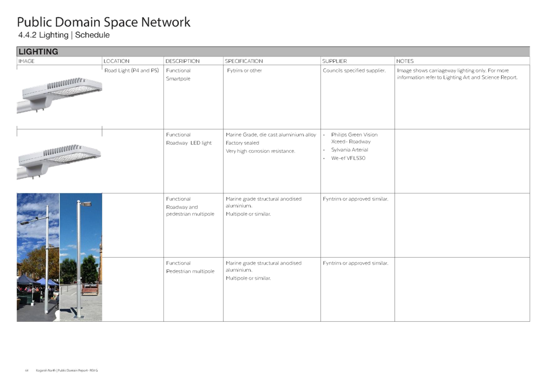
B. Lighting - this includes provision of lighting requirements for the future high density residential environment. The lighting is separated into functional roadway lighting and featured lighting for specific streets like Victor Street.
C. Street Tree Planting Schedule and Selections – this includes Urban Forest Tree Species for the Precinct.
D. Stanley Street Pocket Park – this provides an example of additional open space in the public domain network in the form of a Pocket Park.
Consultation for the draft Plan
The draft Plan has also been the subject of consultation as discussed below:
Community Consultation
23. Council sent approximately 460 letters in April 2018 to residents within the precinct advising them of the commencement of the Kogarah North Public Domain Plan and inviting their comments, however no formal submissions were received.
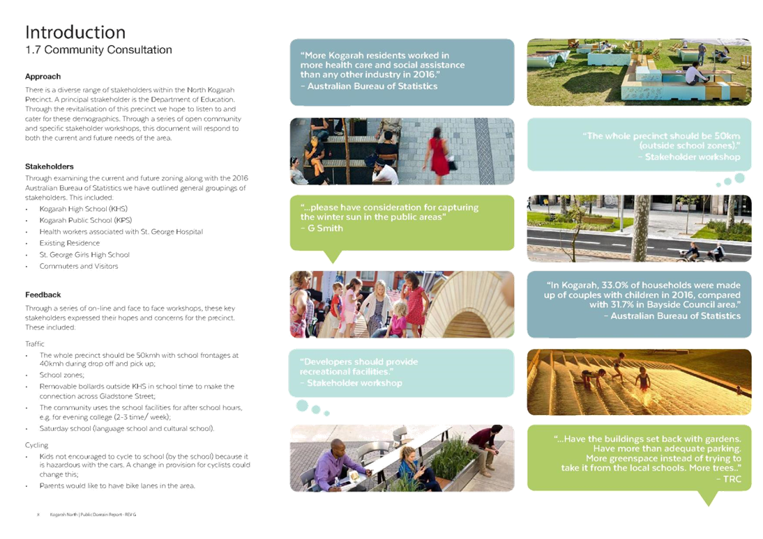
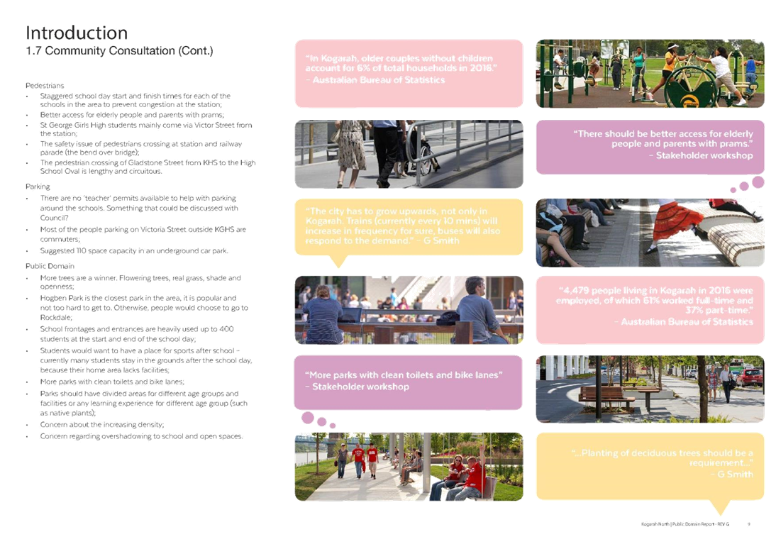
24. The draft Plan was uploaded on Council’s ‘Have Your Say’ webpage in early April 2018 to invite ideas and comments from the community including residents, business owners, health and education workers and visitors. Ten comments were received and the comments related to parking and traffic movements, pedestrian-safety issues and encouragement of active transport, improved public domain works (including capturing winter sun in the public areas within the Precinct), need for infrastructure to support the future high-rise developments in terms of improved transport, medical, shops and local streets. The comments made did not require any amendments to the Plan. The final Plan addresses the issues raised in terms of providing a better public domain, traffic movements, increasing the tree canopy and improving the overall quality of this precinct.
25. Applicants of development applications were also notified of the draft Plan.
26. The Land and Environment Court (the ‘Court’) has used the draft Plan by including conditions in approvals for major development applications in the Kogarah North Precinct. In negotiating the Court appeals, Council and its legal team have ensured that conditions are included in any consent issued to address the future aspirations of the Precinct. Additional development contributions have also been levied under Section 7.13 (3) of the Environmental Planning & Assessment Act 1979 to facilitate public works in the Kogarah North Precinct.
Consultation with the Department of Education
27. A key stakeholder in the preparation of this Plan is the Department of Education as there are three schools in the Precinct. The Precinct has limited publicly accessible open space and the school sites have large open spaces that are not accessible to the community after school hours.
28. Council is continuing to explore opportunities with the Department of Education for shared use of school open space outside of school hours. A Memorandum of Understanding with the Department of Education has been executed to facilitate this work.
Councillor Workshops
29. The draft Plan was presented to Councillors at a workshop on 20 August 2018. The Councillors raised questions with regard to the security of publicly accessible space, sharing of facilities with the Department of Education and liability issues, local examples of linear parks, loss of car parking spaces which is offset by the benefits of an improved public domain, use of Hogben Park for the Precinct and costings for the public domain improvements.
30. A second Councillor workshop was held in 19 November 2018 to address issues raised in the August Workshop. Further issues raised related to a special levy for developers to exceed the $20k cap for development contributions as Section 7.11 of the Environmental Planning & Assessment Act 1979 is not adequate, integration of high rise development and pocket parks, how Council will raise the $37m for the proposed public works and amendments to the future Georges River Contribution Plan.
31. The issues raised by Councillors in relation to exceeding the $20k cap will need to be considered by Council’s Director Environment & Planning and Director Legal Services and may require liaison with the Independent Pricing and Regulatory Tribunal (IPART). Council has commenced the preparation of the new Georges River Section 7.11 and Section 7.12 Contributions Plans. Council may consider the amount of levy charged under the Section 7.12 Plan.
Final Kogarah North Public Domain Plan
32. The Kogarah North Public Domain Plan (Revision G, 18 December 2018), has been updated as a result of feedback from Council staff, the community, the Councillors and Department of Education.
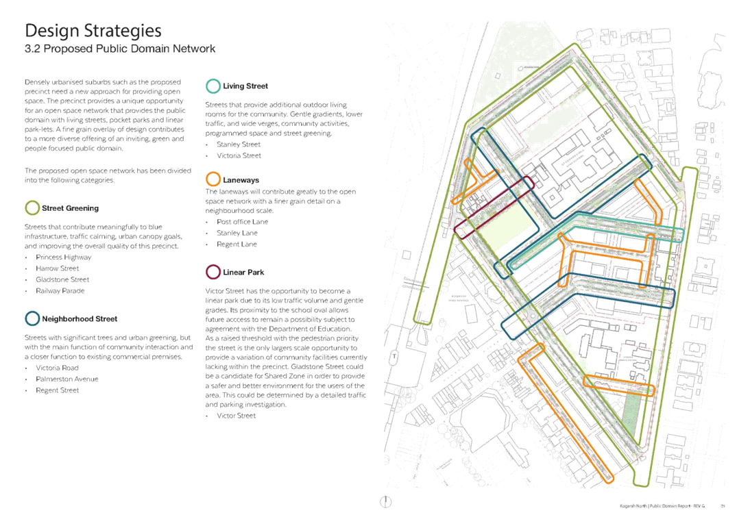
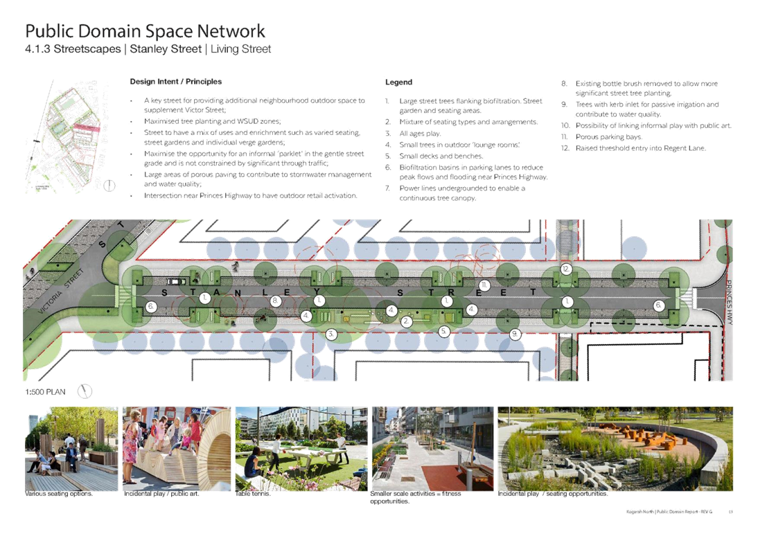
33. Densely urbanised suburbs such as the proposed Precinct need a new approach for providing open space. This Precinct provides a unique opportunity for an open space network that improves the public domain within the Precinct in terms of linear parks, living streets, neighbourhood streets, street greening, laneways and pocket parks; that are defined in Table 1 below. These are supported by traditional park public spaces beyond the site boundary such as Hogben Park.
|
Street Category |
Definition |
Street Name |
|
Linear Park |
A park in an urban or suburban setting that is substantially longer than it is wide.
|
· Victor Street |
|
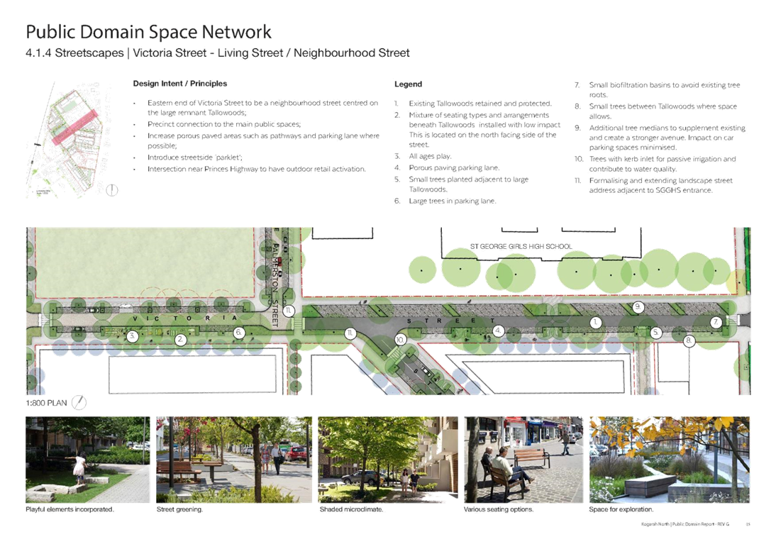
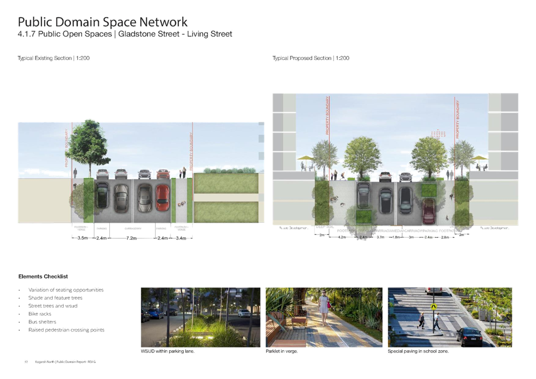
Living Street |
· Streets that provide additional outdoor living rooms for the community. · Generally have gentle gradients, lower traffic, and wide verges, community activities, programmed space and street planting.
|
· Stanley Street, · Victoria Street, · Gladstone Street |
|
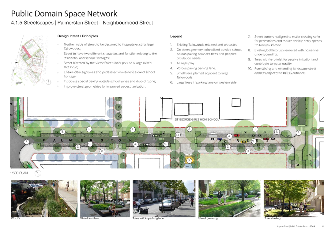
Neighbourhood Street |
Streets with significant trees and urban greening, but with the main function of community interaction.
|
· Palmerston Street, · Regent Street |
|
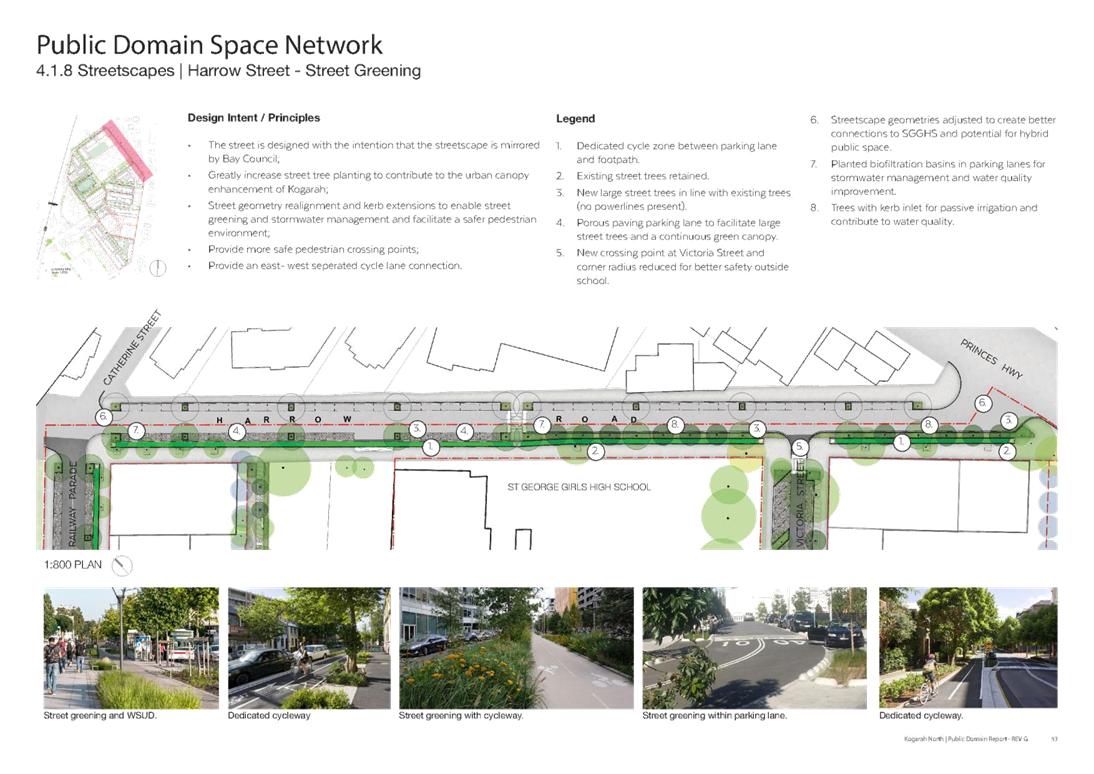
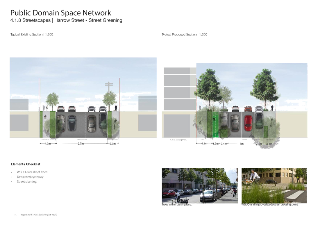
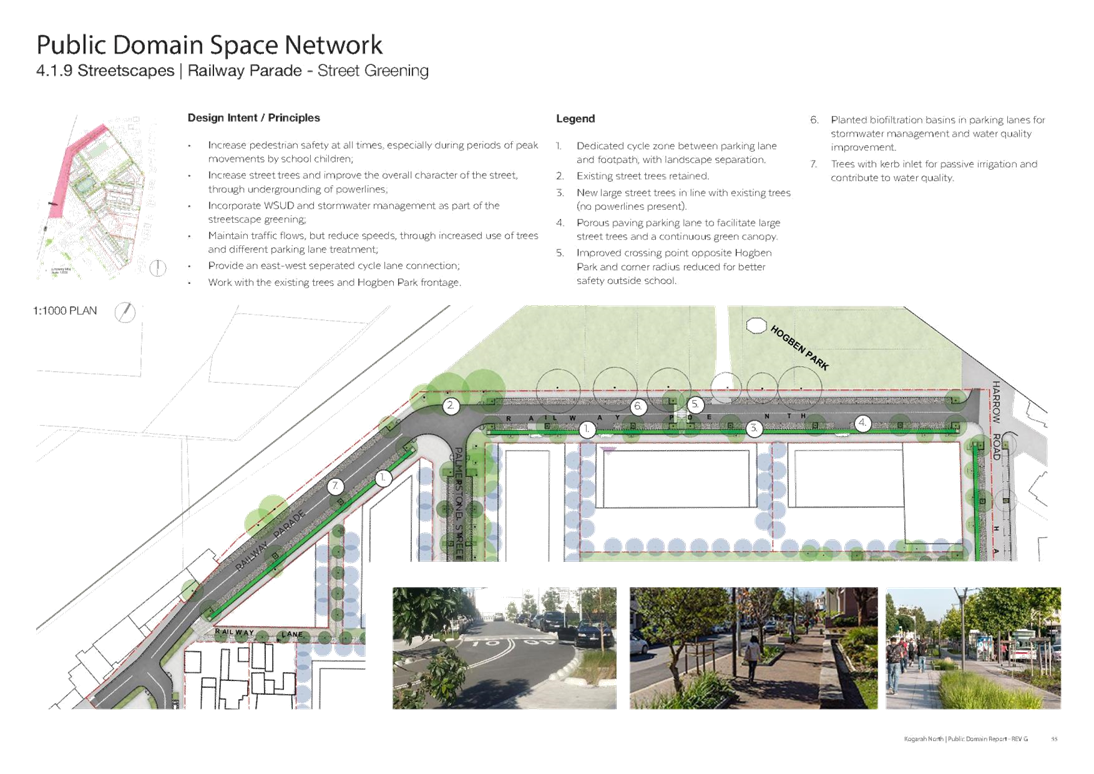
Street Greening |
Streets that contribute meaningfully to blue infrastructure, traffic calming, urban canopy goals and improving the overall quality of this precinct.
|
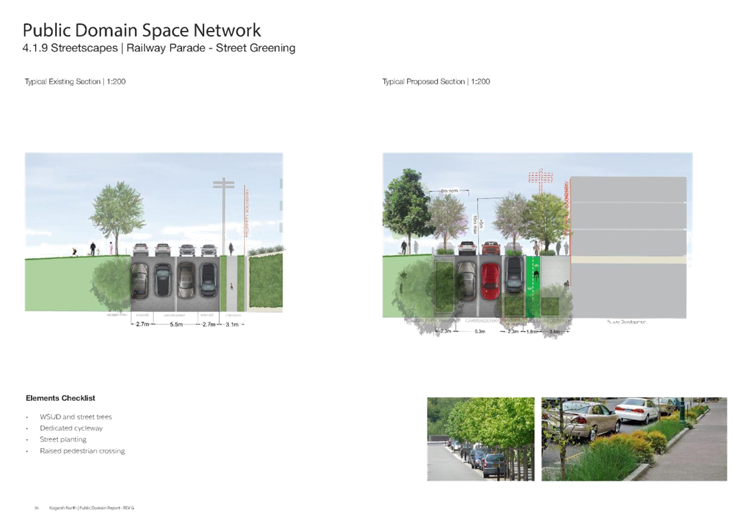
· Harrow Street, · Railway Parade |
|
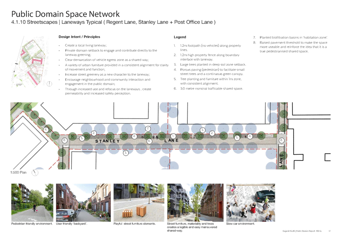
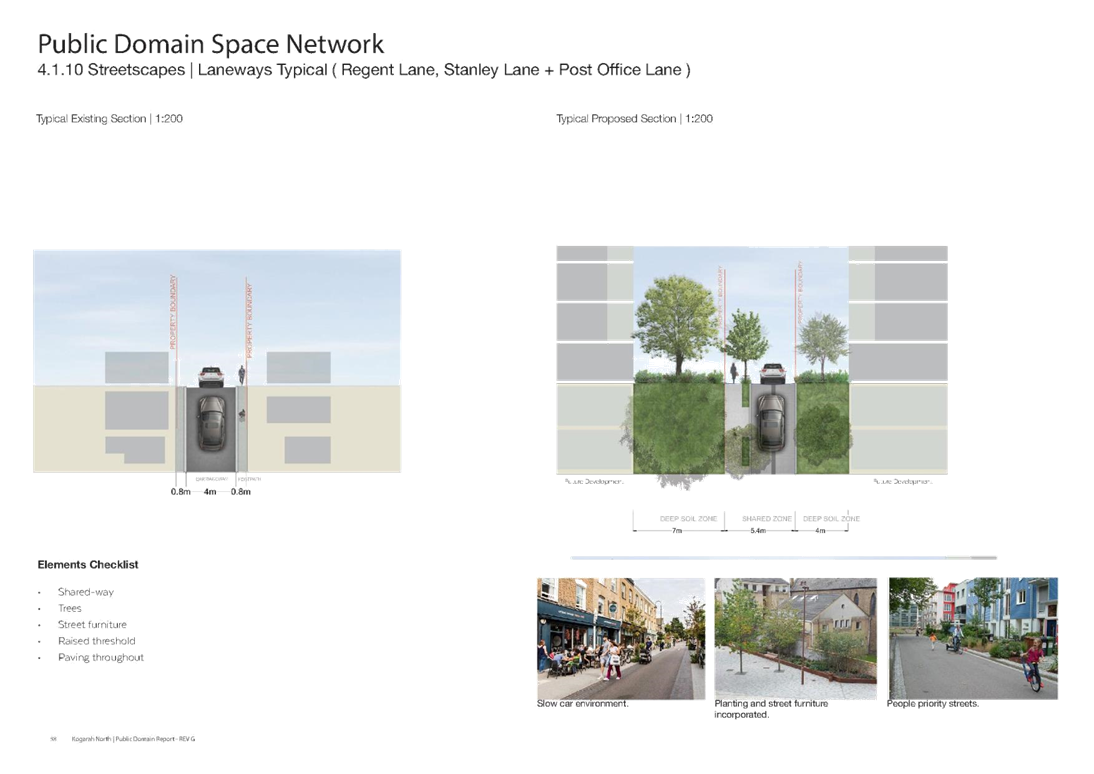
Laneways |
Contribute to the open space network with a finer grain detail on a neighbourhood scale.
|
· Regent Lane, · Stanley Lane and · Post Office Lane |
|
Pocket Park |
· A small road-side park either on public or private land. · Often on a small, irregular piece of land and accessible to the public.
|
· Cnr Stanley and Victoria Streets
|
Table 1: Street category and definition
34. Section 4 of the Kogarah North Public Domain Plan includes Masterplans for various streets under the categories of Linear Parks, Living Streets, Neighbourhood Streets, Street Greening, Laneways and Pocket Parks as listed above. Examples of various streets within the Precinct have been included in the Plan to explain the character envisaged for each category.
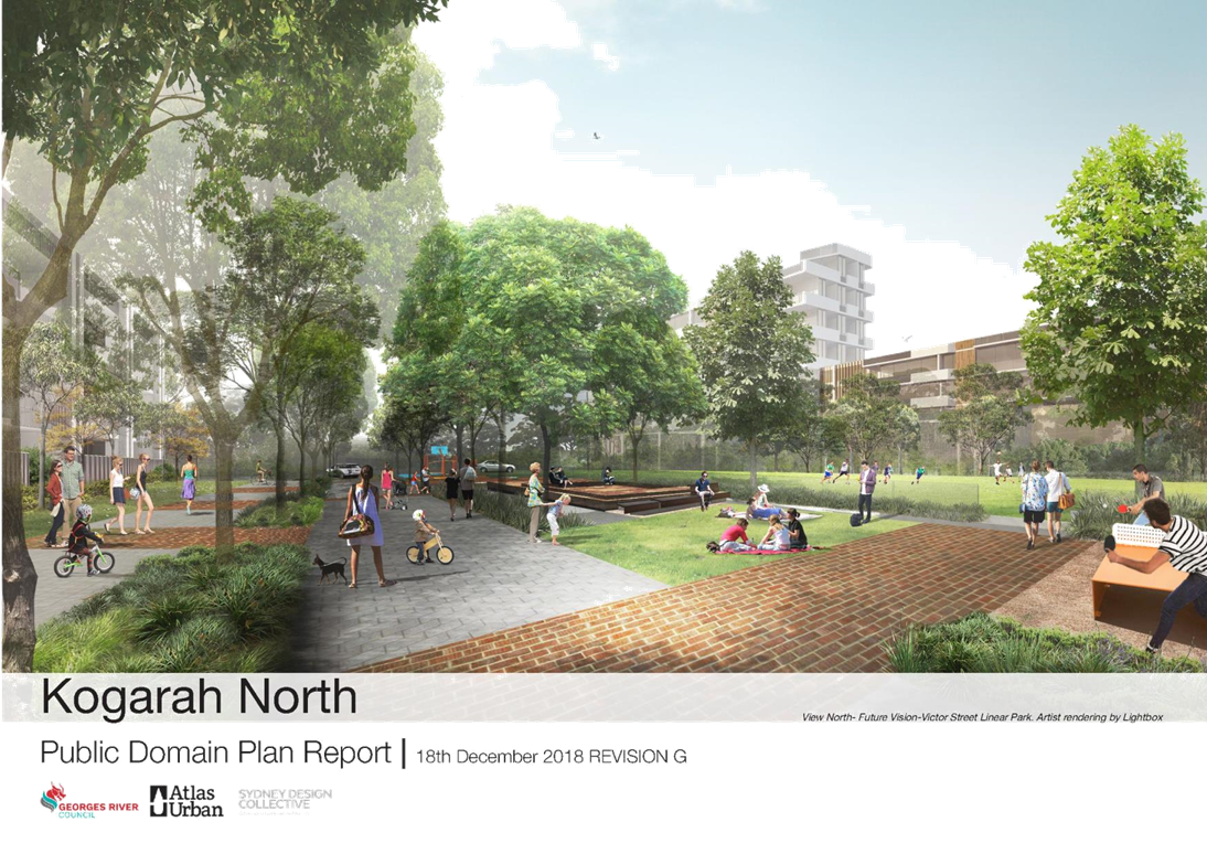
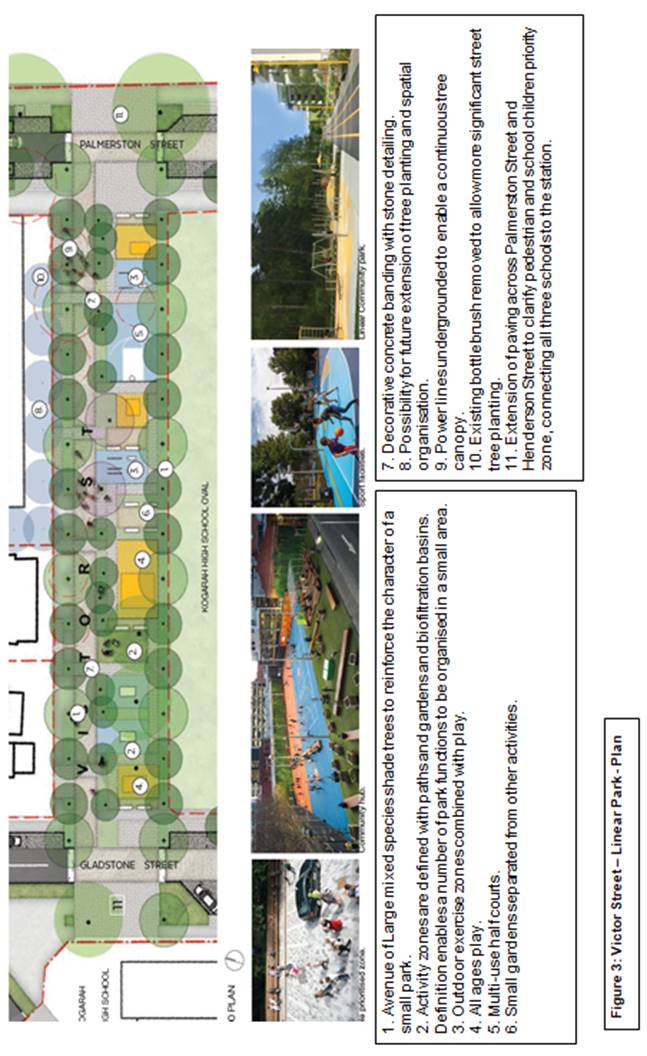
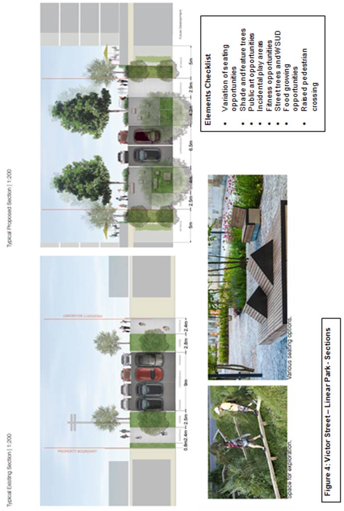
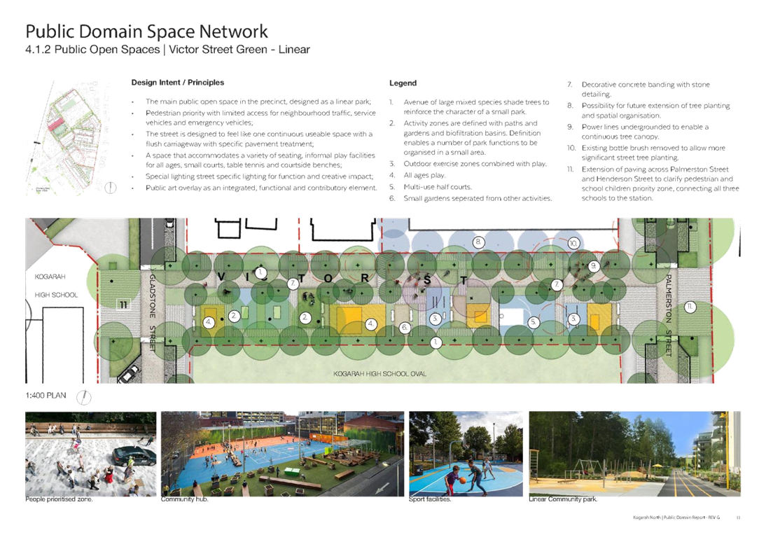
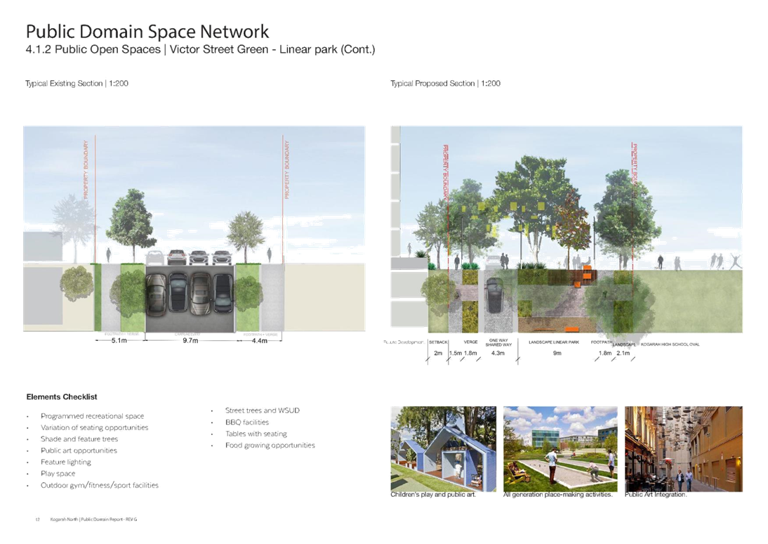
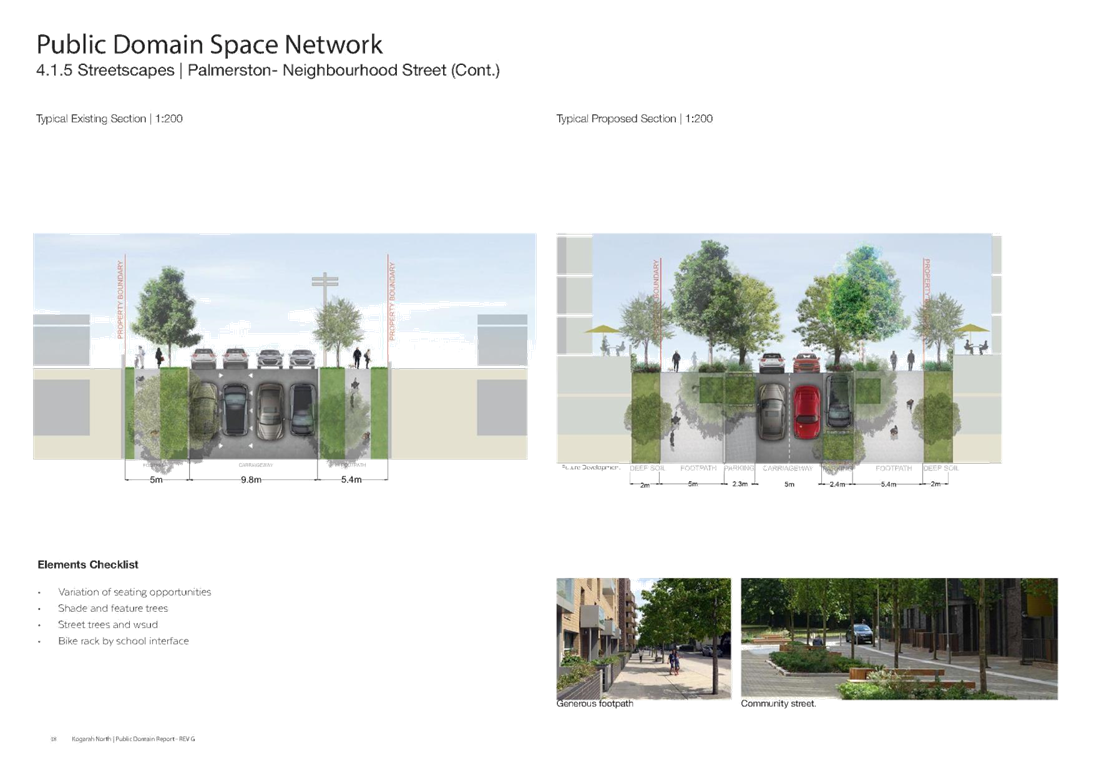
Victor Street Green – Linear Park
35. Provided below are details of one category, the Victor Street Linear Park. Victor Street has the opportunity to become a linear park due to its low traffic volume and gentle grades. Its proximity to the Kogarah High School oval allows future access to it a possibility; subject to agreement with the Department of Education. This street is the only larger scale opportunity to provide a variation of community facilities currently lacking within the precinct.
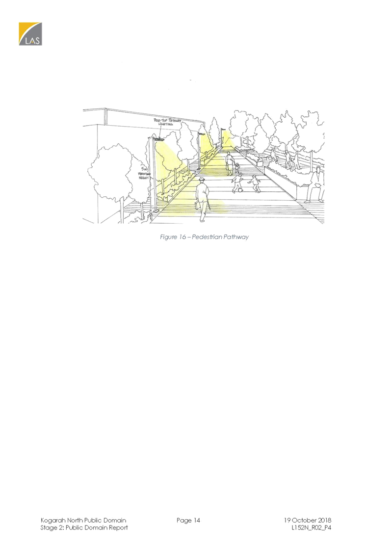
36. Figures 3 and 4 detail the components of the Victor Street Linear Park which include:
· Programmed recreational space
· A variety of seating opportunities
· Shade and feature trees
· Public art opportunities
· Feature lighting
· Play space
· Outdoor gym/fitness/sport facilities
· Street trees and Water Sensitive Urban Design (WSUD)
· BBQ facilities
· Food growing opportunities
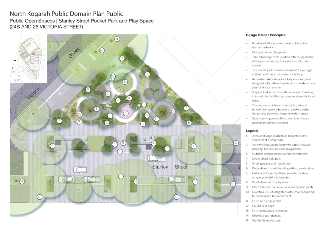
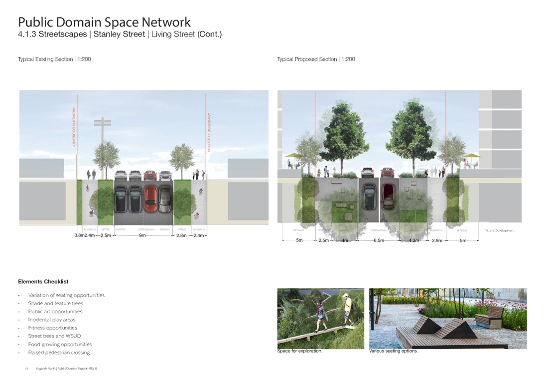
Stanley Street Pocket Park (24B and 26 Victoria Street)
37. The Plan also includes an example of a Pocket Park, located at the corner of Stanley and Victoria Streets. It is adjacent to the proposed development at 11 Stanley Street and 28-36 Victoria Street. This Park proposes to enhance the public domain of the future high density residential character of the Precinct (Refer Figures 5 and 6).
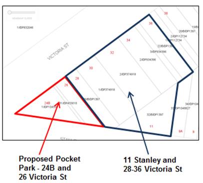
Figure 5: Stanley Street Pocket Park Location
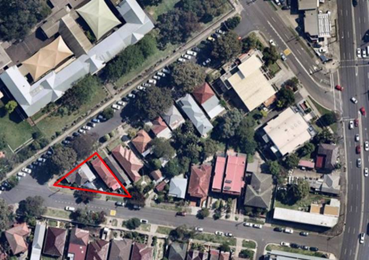
Figure 6: Stanley Street Pocket Park Aerial View
38. The Stanley Street Pocket Park is on a triangular piece of land and has been proposed to improve the amenity and provide additional open space within the future high-density environment (Refer Figure 7). The Park includes:
· An enclosed cycle loop for young children.
· Perimeter safety fence.
· A variety of seating, informal play facilities and plantation for recreational purposes.
· Good orientation, visibility, open and inviting as it is surrounded by roads.
· Privacy from adjoining apartments with a treated blank wall that will face the Pocket Park.
39. This proposed Pocket Park is located on privately-owned land. The acquisition of the land will be considered in the preparation of the new Georges River Local Environmental Plan, Development Control Plan and Section 7.11 Contributions Plan.
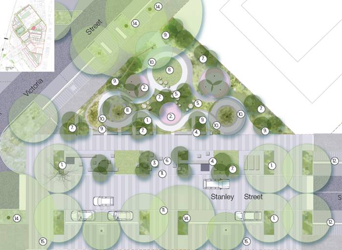
Legend
|
i. Avenue of large shade trees to reinforce the character of a small park. ii. Activity zones are defined with paths, massed planting, turf mounds and raingardens. iii. Outdoor exercise zones combined with play. iv. Linear street-side park. v. Small gardens and nature play. vi. Decorative concrete banding with stone detailing. vii. Native Cabbage Tree Palm grove to create a unique and distinct character. viii. Shade trees within play area
|
ix. Playful, fence/ barrier for increased public safety. x. Bike/trike circuit integrated with small mounding for interest and fun movement. xi. Flush kerb edge profile. xii. Raised kerb edge. xiii. Parking on raised threshold. xiv. Existing trees retained. xv. Stanley Street footpath.
|
Figure 7: Stanley Street Pocket Park Concept
Preliminary Cost Plan
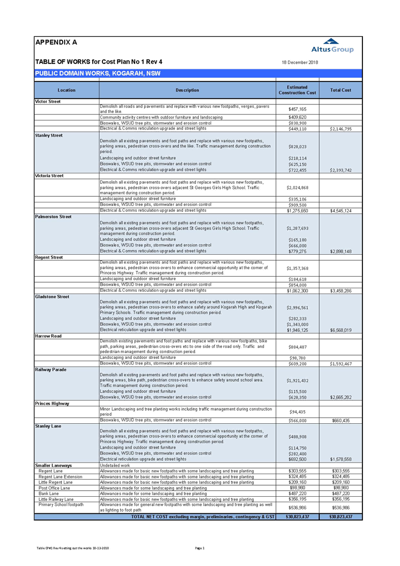
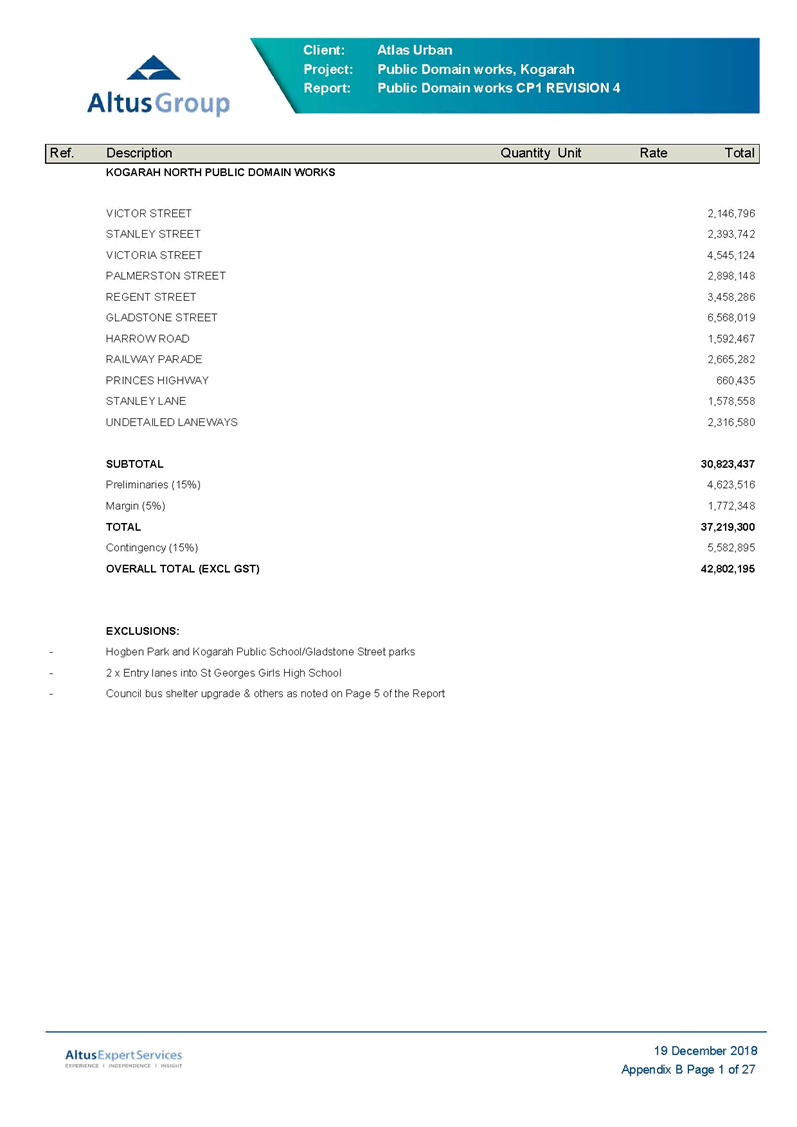
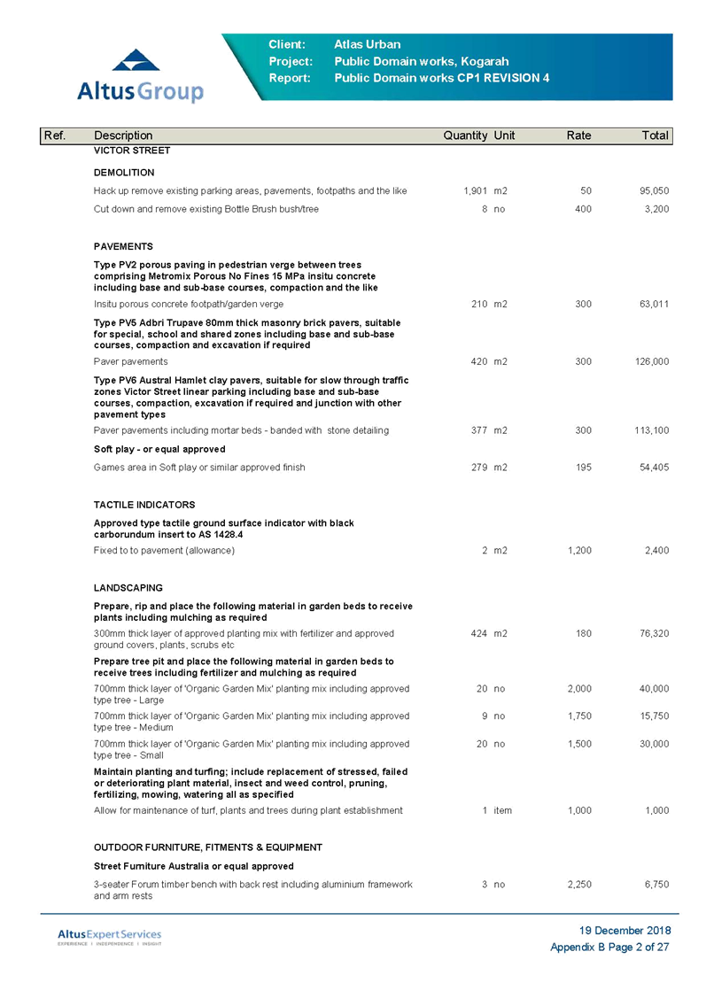
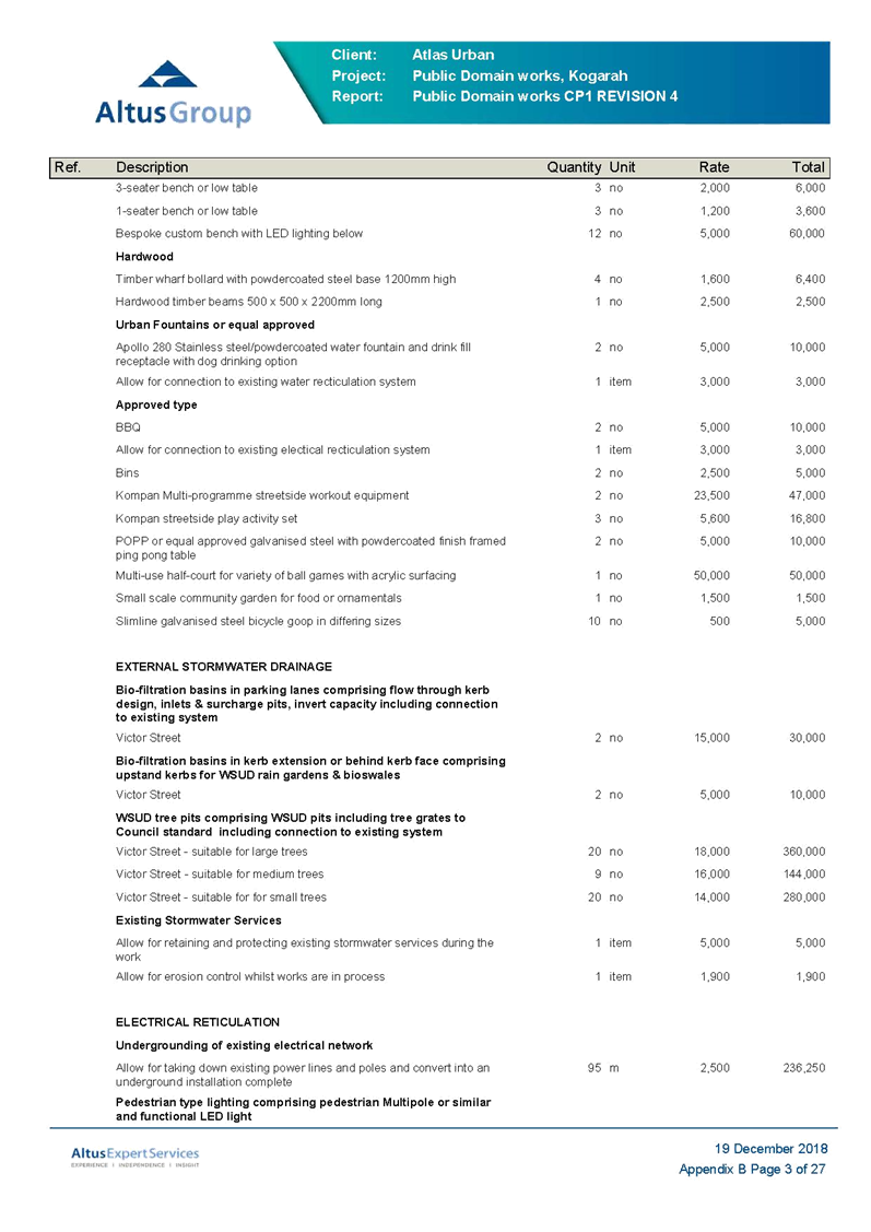
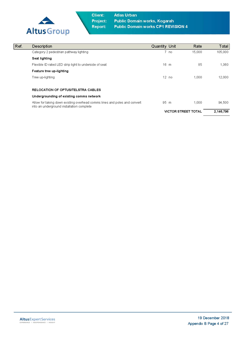
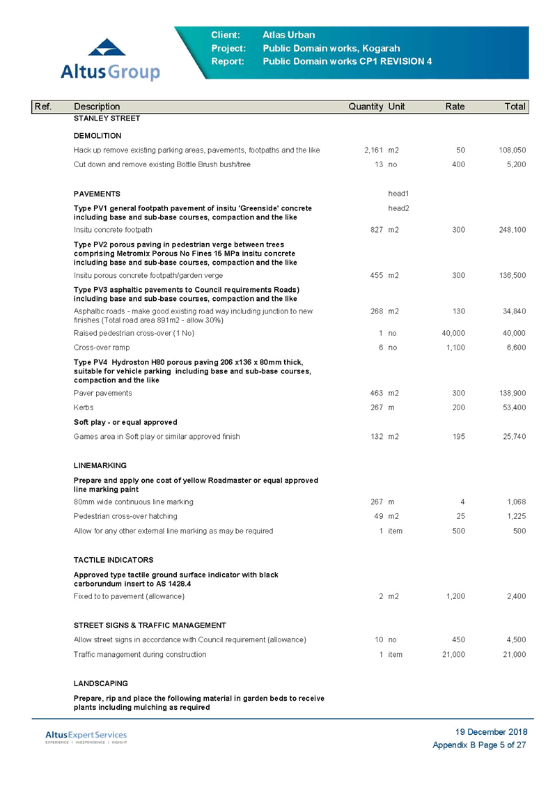
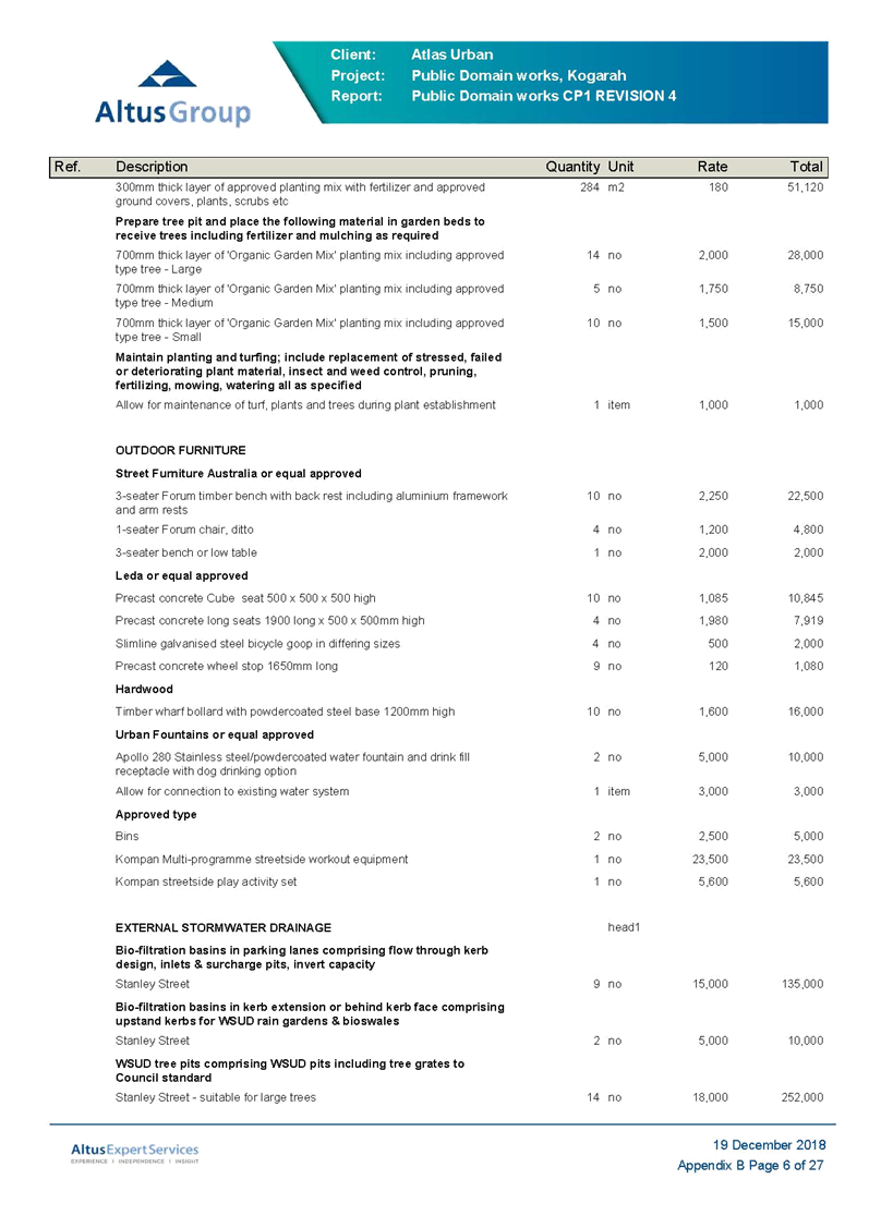
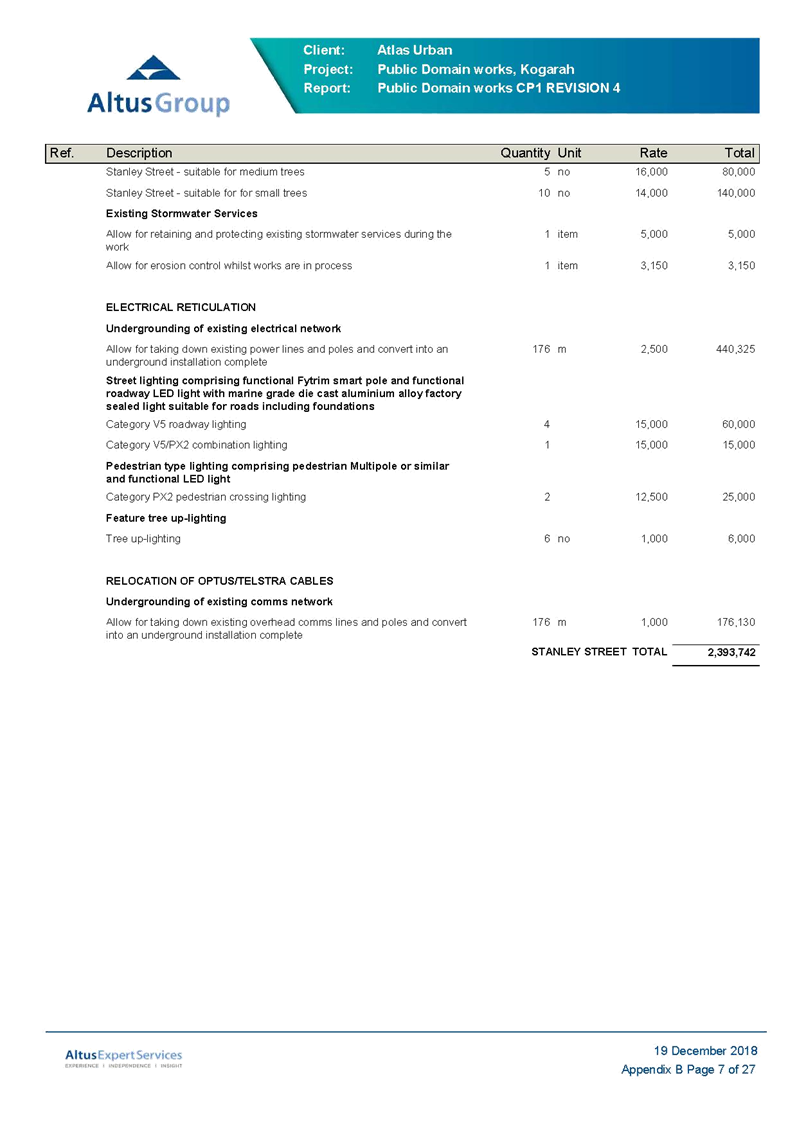
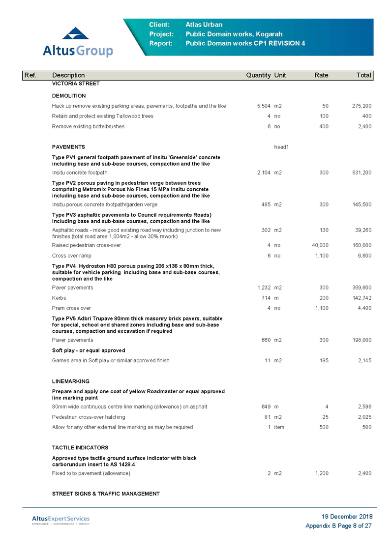
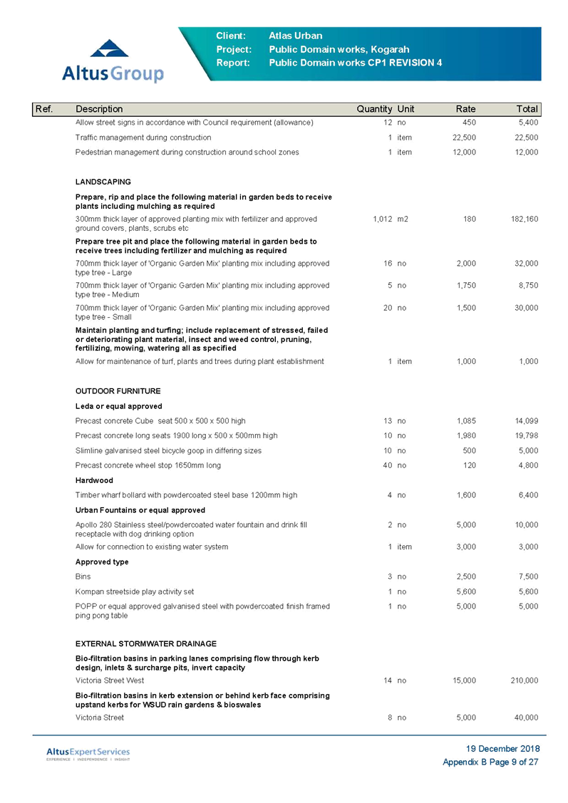
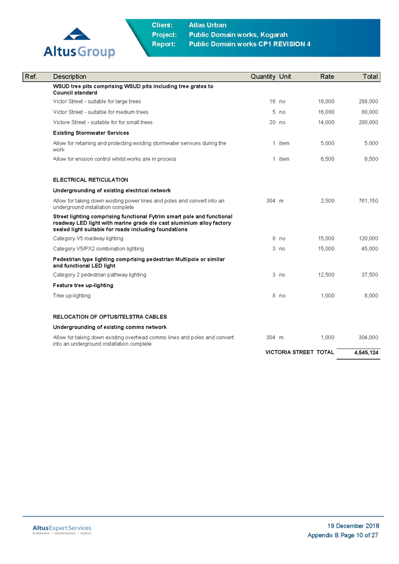
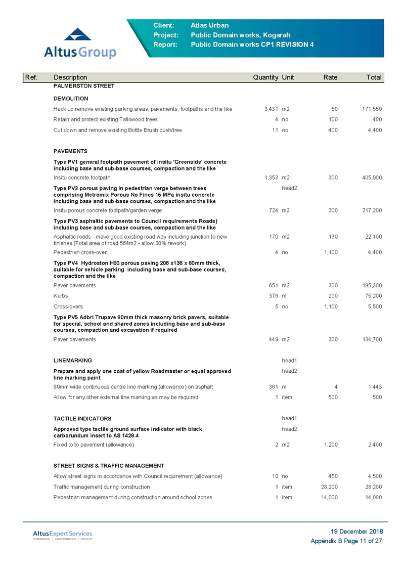
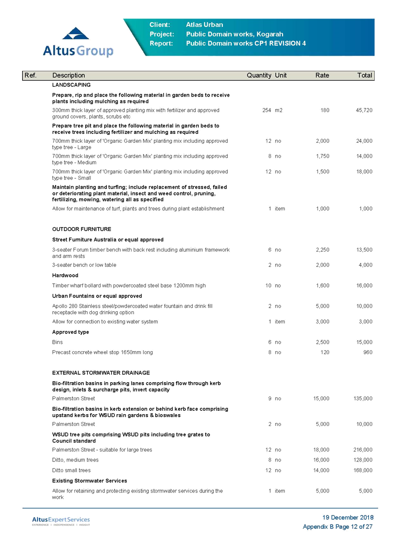
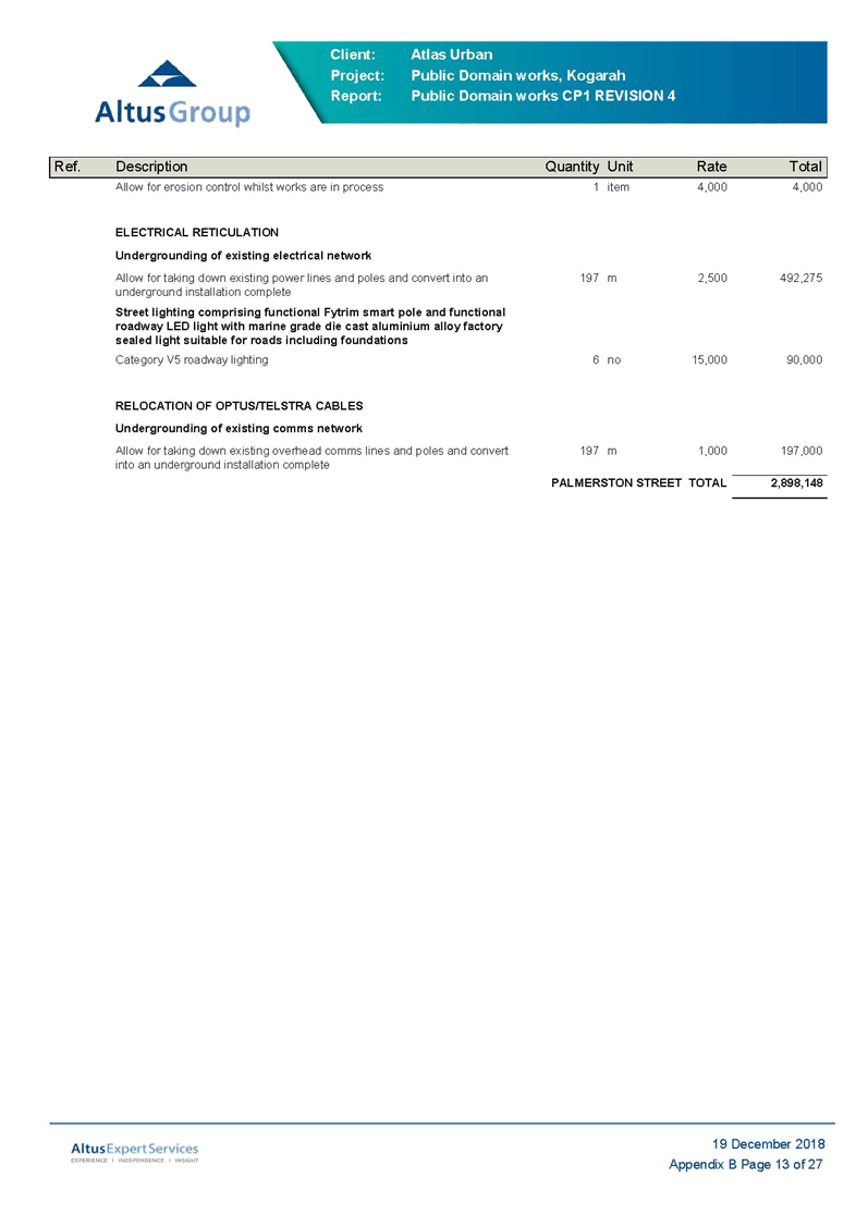
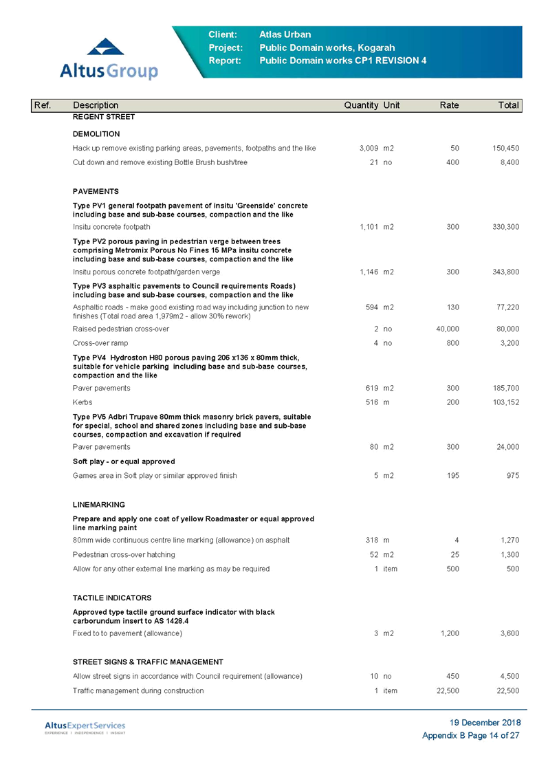
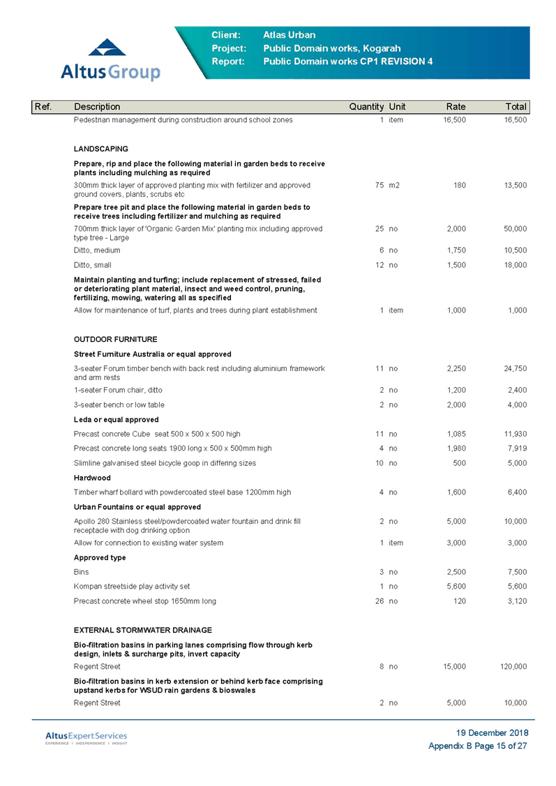
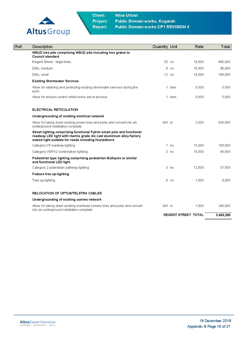
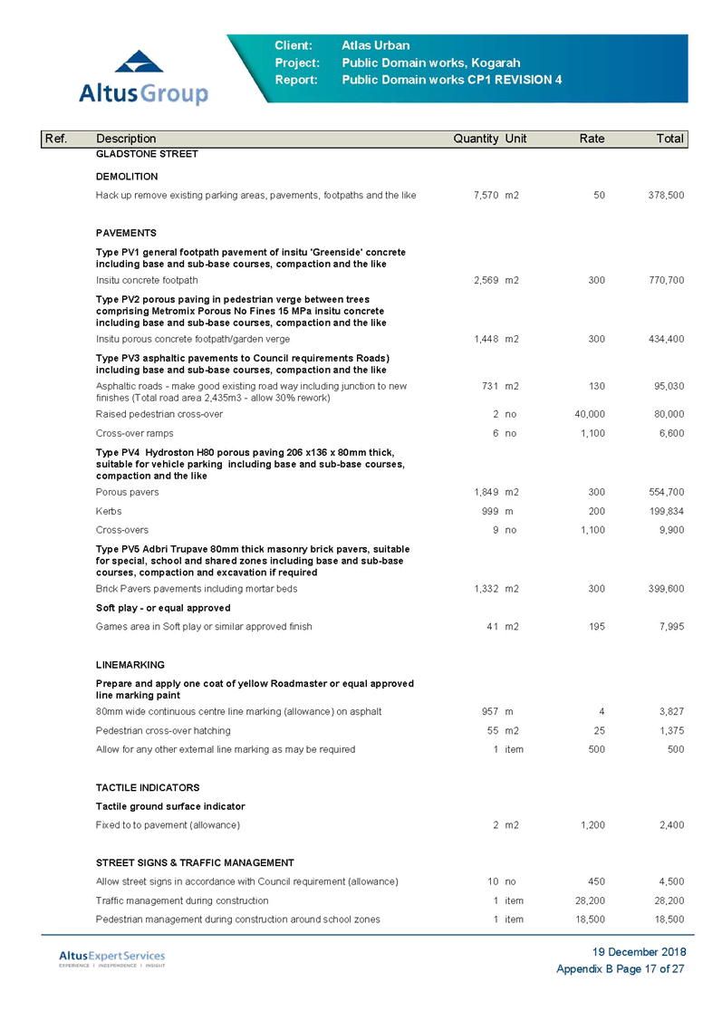
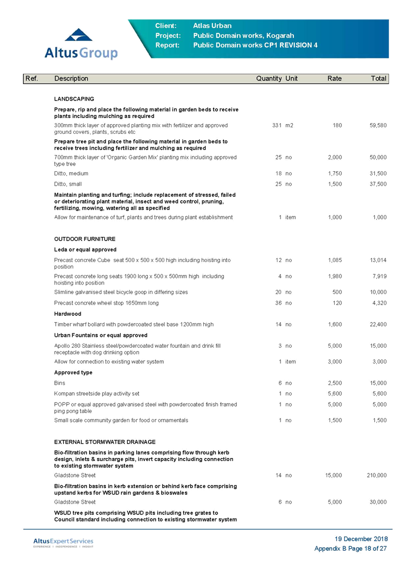
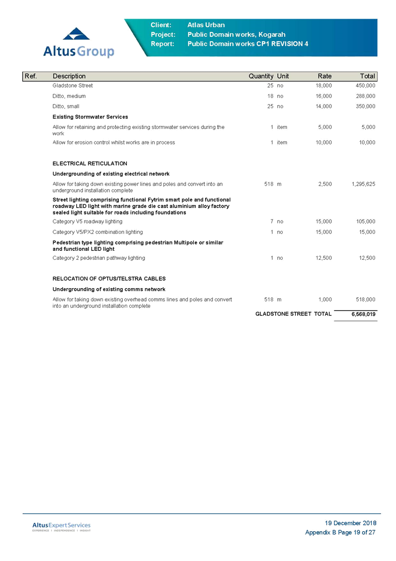
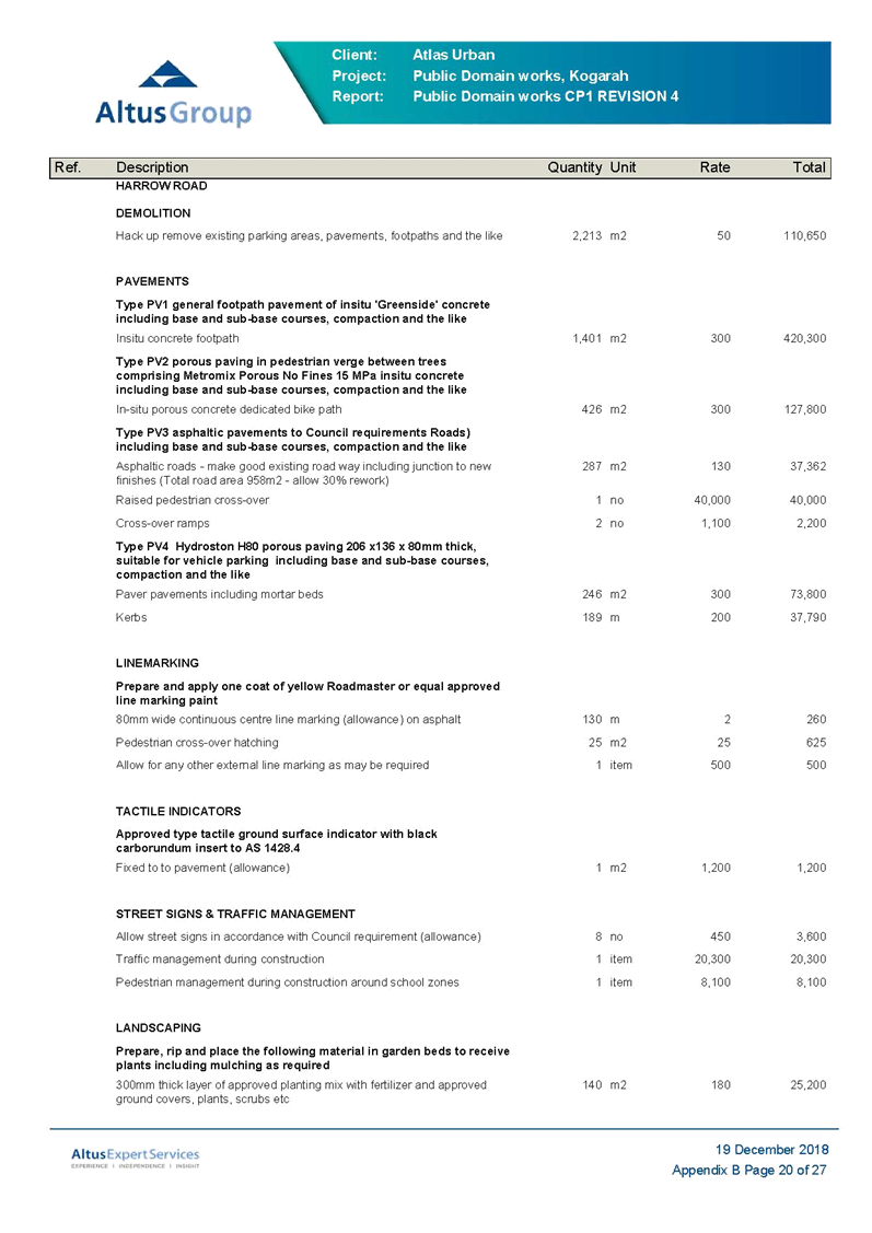
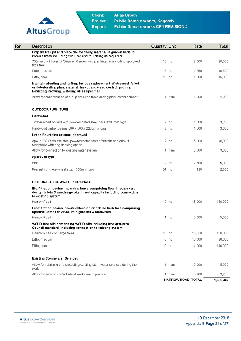
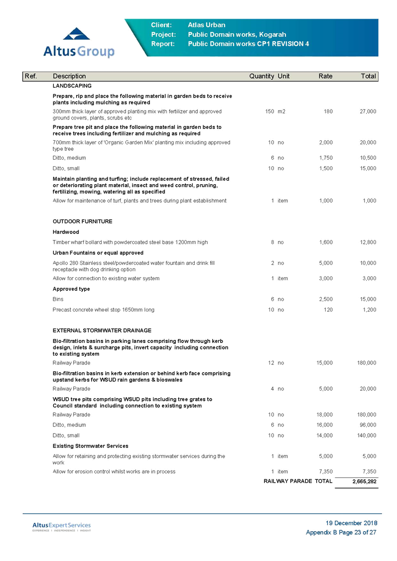
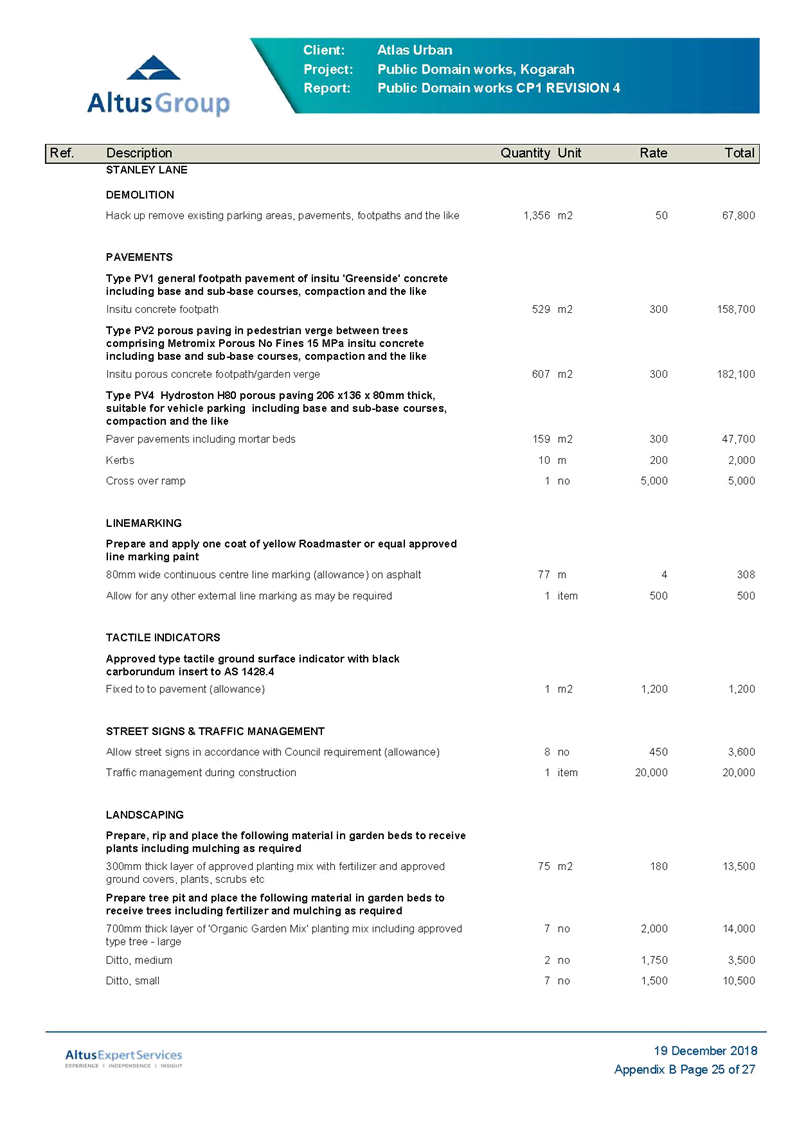
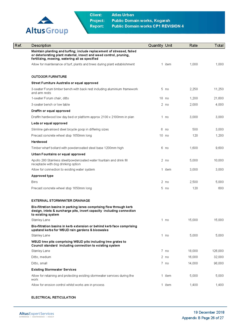
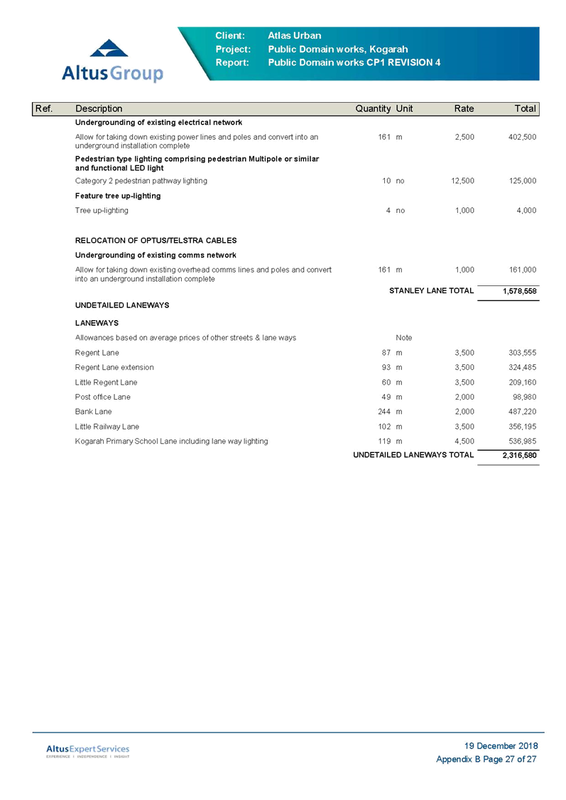
40. In conjunction with the Kogarah North Public Domain Plan, Atlus Group has prepared a Preliminary Cost Plan No 1 Rev 4, December 2018 (Refer Attachment 2). The total estimated construction cost of all the works proposed under the Plan as at 03 December 2018 is $37,219,300 (excluding GST and contingencies).
41. A more detailed cost estimate will be prepared later as work under the Public Domain Plan progresses.
42. The funding for these works may be sourced from a range of areas including Section 7.11 development contributions, grant funding, Planning Agreements and Council’s internal reserve and general revenue funds.
43. Council has commenced the preparation of the new Georges River Section 7.11 and Section 7.12 Contributions Plans. The preliminary Cost Plan will feed into the Contributions Plan process and a series of workshops will be held with Councillors during the preparation of the new Contributions Plans.
44. All developments within the Kogarah North Precinct are currently levied development contributions under Council’s existing Contributions Plans. The contribution rate levied is up to $20,000 per 3-bedroom dwelling (i.e. the Ministerial cap on residential contributions). These contributions are for the provision of a range of public domain works and community facilities identified in the existing plans. Once the new Georges River Contributions Plan is prepared, the contributions will be allocated to the facilities in the new Plan.
Next Steps
45. The Kogarah North Public Domain Plan (December 2018, Revision G) will form the basis for providing advice to applicants on Council’s requirements for public domain works in the Kogarah North Precinct.
46. The Kogarah North Public Domain Plan (December 2018, Revision G) is placed on Council’s website.
47. The works and costings from the Preliminary Cost Plan No 1 Rev 4, December 2018 will inform the new Contributions Plan and Planning Agreements Policy for Georges River Council.
Financial Implications
48. Within budget allocation.
Risk Implications
49. Operational risk/s identified and management process applied.
Community Engagement
50. Council sent approximately 460 letters to residents within the Kogarah North Precinct in April 2018 advising them of the commencement of the Kogarah North Public Domain Plan and inviting their comments. The Department of Education and Councillors have also been consulted. The draft Plan was also placed on Council’s ‘Your Say’ webpage.
File Reference
18/471
|
Attachment ⇩1 |
Kogarah North Public Domain Plan |
|
Attachment ⇩2 |
Preliminary Cost Plan |
|
Georges River Council - Environment and Planning - Monday, 11 February 2019 ENV001-19 Kogarah North Public Domain Plan [Appendix 1] Kogarah North Public Domain Plan |
Page 24 |


|
Georges River Council - Environment and Planning - Monday, 11 February 2019 ENV001-19 Kogarah North Public Domain Plan [Appendix 2] Preliminary Cost Plan |
Page 185 |


Item: ENV002-19 Summary of Development Applications Lodged and Determined - October-December 2018
Author: Manager Development and Building
Directorate: Environment and Planning
Matter Type: Committee Reports
|
That Council receive and note the Summary of Development Applications Lodged and Determined report for the second quarter of the 2018/2019 financial year being October – December 2018. |
Executive Summary
1. This report provides a snap-shot of Council’s development applications lodged and determined within the second quarter of the 2018/2019 financial year.
2. In order to consider trends and Council performance associated with development assessment; information provided within the report includes:
· Applications Received for Processing and Determination
· Applications Considered by the Local Planning Panel
· Applications Considered by the Sydney South Planning Panel
· Total Application Processing Times
· Application Type Breakdown
· Estimated Value of Development Applications Determined
· Timeframes Associated With Undetermined Applications
Background
3. The information contained below provides a snap-shot of Council’s development applications lodged and determined within the second quarter of the 2018/2019 financial year.
Applications Received for Processing and Determination – Q1 2018/2019 financial year
4. The total development applications lodged (‘L’) and determined (‘D’) in the first quarter is provided as follows:
|
2018 |
DA (‘L’) |
DA (‘D’) |
MOD (‘L’) |
MOD (‘D’) |
REV (‘L’) |
REV (‘D’) |
TOTAL (‘L’) |
TOTAL (‘D’) |
|
October |
49 |
62 |
22 |
13 |
1 |
1 |
72 |
76 |
|
November |
68 |
55 |
25 |
16 |
0 |
2 |
93 |
73 |
|
December |
69 |
41 |
14 |
8 |
0 |
0 |
83 |
49 |
Table 1
5. For ease of reference a graph of all applications (DA’s, Modifications and Reviews) by month since July 2017 is outlined in Figure 1 below:
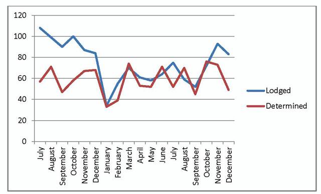
Figure 1
6. The supporting data for the total applications determined is based on the following:
Development Applications
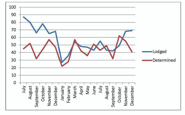
Figure 2
Modification Applications
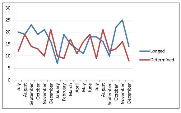
Figure 3
Applications Considered - Local Planning Panel – Q1 2018/2019 financial year
7. The total development applications considered by the Georges River Local Planning Panel (since commencement in March 2018) is 64. A break down per month is provided as follows:
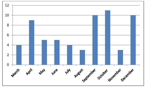
Figure 4
8. A list of the applications considered by the Georges River Local Planning Panel in the second quarter is detailed as follows:
|
DA No. |
Address |
Proposal |
Officer Recommendation |
LPP Decision |
Date |
|
DA2017/0487 |
301 Kingsgrove Road Kingsgrove |
Child Care Centre |
Approval |
Deferred for Plan of Management and amended traffic report |
5/10/18 |
|
DA2018/0124 |
13 Allawah Avenue Carss Park |
Dual Occupancy |
Approval |
Approved |
5/10/18 |
|
DA2017/0323 |
48-50 Bellevue Parade Allawah |
Relocation of modular classroom building |
Approval |
Approved |
5/10/18 |
|
DA2017/0500 |
54 Woids Avenue Allawah |
Alterations and additions to residential flat building |
Approval |
Approved |
5/10/18 |
|
DA2018/0132 |
470 Railway Parade Allawah |
Alterations to Hotel |
Approval |
Approved |
5/10/18 |
|
DA2017/0567 |
29 Barry Avenue Mortdale |
Warehouse – use place of public worship |
Approval |
Approved |
18/10/18 |
|
DA2017/0528 |
64 Algernon Street Oatley |
Alterations and additions to dwelling |
Refusal |
Refused |
18/10/18 |
|
DA2017/0660 |
8 Park Road Hurstville |
Mixed Use Development |
Deferred Commencement Approval |
Deferred Commencement Approval |
18/10/18 |
|
DA2017/0655 |
198-200 Princes Highway Kogarah Bay |
Residential Flat Building |
Approved |
Deferred for expert traffic and mechanical ventilation advice |
15/11/18 |
|
DA2018/0143 |
51 Elwin Street Peakhurst |
Torrens Title subdivision |
Deferred Commencement Approval |
Deferred Commencement Approval |
15/11/18 |
|
DA2018/0293 |
37 Woronora Parade Oatley |
Torrens Title subdivision |
Approval |
Approved |
3/12/18 |
|
DA2016/0224 |
65-67 Lawrence Street Peakhurst |
Residential Flat Building |
Deferred Commencement Approval |
Deferred for redesign |
3/12/18 |
|
DA2016/0343 |
345 Belmore Road Riverwood |
Mixed Use Development |
Refusal |
Deferred for Remediation Action Plan |
3/12/18 |
|
MOD2018/0096 |
367 Princes Highway Carlton |
Additional floor to existing structure |
Approval |
Approved |
3/12/18 |
|
DA2017/0487 |
301 Kingsgrove Road Kingsgrove |
Child Care Centre |
Refusal |
Refused |
11/12/18 |
|
MOD2018/0085 |
27-33 Nielsen Avenue Carlton |
Additional apartment to residential flat building |
Approval |
Refused |
11/12/18 |
|
DA2018/0111 |
37 Junction Road Beverly Hills |
Dual Occupancy |
Request for advice on reduced site width |
Application supported. |
11/12/18 |
|
DA2018/0039 |
121 Belmore Road Peakhurst |
Temporary relocation of Penshurst Public School |
Deferred Commencement Approval |
Deferred Commencement Approval |
13/12/18 |
|
DA2018/0057 |
67 Millett Street Hurstville |
Secondary Dwelling |
Approval |
Approved |
13/12/18 |
|
DA2018/0217 |
1-5 James Street Blakehurst |
Residential Flat Building |
Approval |
Deferred for redesign |
13/12/18 |
Table 2
Total Application Processing Times
9. Based on the gross turn-around times of all applications (DA’s, Modifications and Reviews), the average processing times for applications determined in the second quarter was 132 days.
10. Based on application type, the average times is as follows:
|
Average Processing Time (days) |
|
|
Residential |
147 |
|
Tourist |
0 |
|
Commercial / retail / office |
106 |
|
Infrastructure |
0 |
|
Industrial |
0 |
|
Community facility |
250 |
|
Subdivision only |
74 |
Table 3
11. The above figures will remain higher for a period of time as planning officers continue to process the backlog of applications.
12. The average determination times remained at 132 days, whilst the average time of all applications currently undetermined is currently sitting at 105 days. As the backlog of applications continues to fall, this time period is also anticipated to reduce.
Application Types
13. Based on the NSW Department of Planning Annual Performance Monitoring Development Category Types, the category of applications determined is as follows:
|
Total Applications |
|
|
1: Residential - Alterations & additions |
32 |
|
2: Residential - Single new dwelling |
29 |
|
3: Residential - New second occupancy |
30 |
|
4: Residential - New multiunit |
7 |
|
5: Residential - Seniors Living |
0 |
|
6: Residential - Other |
0 |
|
7: Tourist |
0 |
|
8: Commercial / retail / office |
11 |
|
9: Mixed |
1 |
|
10: Infrastructure |
0 |
|
11: Industrial |
0 |
|
12: Community facility |
4 |
|
13: Subdivision only |
15 |
Table 4
Estimated Value of Development Applications Determined
14. The total estimated value of applications determined in the second quarter was $75,391,368.
15. For comparative purposes, a graph between the first and second quarters of 2018/2019 against the data for 2017/2018 is detailed below:
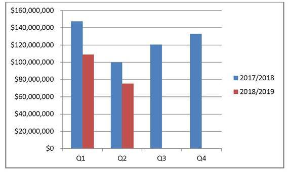
Figure 5
16. The respective breakdown of estimated cost of works against the total number of applications determined is as follows:
|
Total Applications |
|
|
$0 - $100,000 |
42 |
|
$100,001 - $250,000 |
13 |
|
$250,001 - $500,000 |
10 |
|
$500,001 - $1,000,000 |
42 |
|
$1,000,001 - $5,000,000 |
16 |
|
$5,000,001 - $10,000,000 |
1 |
|
>$10,000,000 |
1 |
Table 5
17. A 2018/2019 financial year to date breakdown of development value is provided as follows:
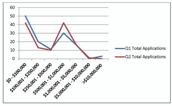
Figure 6
Timeframes Associated With Undetermined Applications
18. At the end of the first quarter of the 2018/2019 total undetermined applications has dropped to 380. A breakdown of the total number of applications is provided as follows:
|
Total Applications |
|
|
Development Applications |
311 |
|
Modifications |
68 |
|
Reviews |
1 |
Table 6
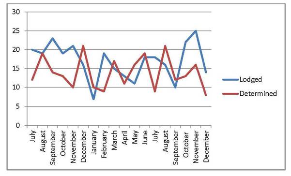
Figure 7
Conclusion
19. The number of applications being determined is increasing and the total number of applications within the system is decreasing which will in turn see an improvement in the overall processing times.
20. The Development Assessment Team continue to implement actions that assist in improving processing times and customer service. Such actions include referral templates, standardised conditions of consent, focus on provision of development planning advice.
21. A further report on the actions / improvements to the Development Advisory Service will be presented to Council in May 2019.
Financial Implications
22. Within budget allocation.
Risk Implications
23. No risks identified.
Community Engagement
24. Not applicable.
File Reference
17/1645
Georges River Council – Environment and Planning - Monday, 11 February 2019 Page 204
Item: ENV003-19 Tree Management Policy
Author: Manager Environment Health & Regulatory Services
Directorate: Environment and Planning
Matter Type: Committee Reports
|
(a) That Council endorse the Tree Management Policy contained in Attachment 1, as amended following the recent public exhibition. (b) That Council endorse the exhibited Schedule of Fees & Charges, under Section 1.11 Tree Management:
· Offset Fee or Tree Replacement (per tree) - $2,250 · Review of Tree Removal and Pruning Application on Private Land: - Stage 1 Review - $70 - Stage 2 Review - $140 (c) That the application of the Offset Fee or Tree Replacement Fee be reviewed within 6 months of the Policy’s adoption. (d) That Council adopt the Greater Sydney Region Plan’s target for canopy cover of 40% by 2038. (e) That a further report be provided to Council within 12 months which includes an update on the operational projects required to assist the Policy’s implementation and an evaluation of the Policy’s operation.
|
Executive Summary
1. The Canopy Enhancement Program was first envisaged on 7 August 2017 (CCL152-17) with the objective of the Program to:
· Develop a broader tree management framework via a Tree Management Policy
· Establish a baseline vegetation level via a Vegetation Mapping Project which would also:
o Identify an achievable canopy target
o Identify areas suitable for green web corridors
2. Since that time a number of key Council resolutions and presentations as listed below have led to the development of the draft Tree Management Policy which Council endorsed for public exhibition on 24 September 2018:
• Council meeting dated 23 April 2018 – Tree Maintenance Bonds
• Council Meeting dated 23 May 2018 - Street Tree Management in Georges River Local Government Area
• Council meeting dated 24 September 2018 - Georges River Council Draft Tree Management Policy 2018
• Councillor briefing dated 2 October, 2018 – Vegetation Mapping Report
• Councillor briefing dated 11 December 2018 - Draft Tree Management Policy and Urban Forest Enhancement
3. The draft Tree Management Policy and associated fees and charges were placed on public exhibition between 17th October and 14th November 2018, with thirty-one submissions being received. Of these submissions, thirty-one supported the creation of the Policy and the increased protection of trees, three opposed greater protection of trees and one contained a mixed response.
4. A review of the submissions received during the Public Exhibition period has been conducted with a summary of the proposed amendments resulting from the public exhibition and feedback received from Councillors during the briefings on 2 October and 11 December 2018 are provided within this report.
5. The key aspects of the Vegetation Mapping Report being ‘Urban Canopy Enhancement’; ‘Role of Street Trees as Wildlife Corridors’, ‘Trees in Parks’ and the 40% canopy cover target have been incorporated into the Tree Management Policy. These amendments will form a comprehensive Policy for the preservation, enhancement and management of trees on private and public lands within the LGA. To support this Policy it is recommended that Council adopt the Greater Sydney Region Plan’s target for canopy cover of 40% by 2038.
6. This report recommends that Council endorse the Tree Management Policy contained in Attachment 1, as amended following the recent public exhibition and the associated fees and charges as exhibited. It is also recommended that the application of the Offset Fee or Tree Replacement Fee be reviewed within 6 months of the Policy’s adoption.
7. As there are a number of operational matters which are either required to supplement or support the Policy, a further report on the implementation of the Policy is proposed to be reported to Council within 12 months of the Policy’s adoption.
Background
8. Council at its meeting on 24 September 2018, resolved:
a) To place the Draft Tree Management Policy and associated amendment to the Schedule of Fees and Charges on public exhibition for 28 days with extensive consultation occurring between key stakeholder groups such as Oatley Flora and Fauna, Miles Dunphy Reserve Backyard and Kogarah Bay Progress Association.
b) That Council review the Draft Tree Management Policy within 6 months of completion of the Georges River Urban Forest Strategy.
c) That the General Manager be delegated to make formatting changes, editing and other minor amendments to the Draft Policy before it being placed on public exhibition.
d) That Council endorse the amendment to the Georges River Council 2018/19 Schedule of Dees and Charges Section 1.11 Tree Management to insert the items:
· Offset Fee or Tree Replacement (per tree) - $2,250.
· Review of Tree Removal and Pruning application
Stage 1 Review - $ 70
Stage 2 Review - $140
e) That, following the public exhibition, a Councillor workshop and briefing be held to provide an overview of the comments raised by the community on the provisions within the Draft Policy.
9. This report provides an update on the actions taken to address the above resolutions.
Tree Management Policy
(a) Public Exhibition
10. The Draft Policy and proposed amendments to Council’s fees and charges were placed on public exhibition between Wednesday, 17th October 2018 and Wednesday, 14th November 2018. Copies of the Draft Policy were on display on Council’s Website; Council’s Civic Centre and Kogarah and Hurstville Libraries. In addition eight public information sessions were provided, as outlined in the table below being advertised via Council’s website, via a notice in The Leader and through direct email invitations to the groups outlined in Council’s previous resolution.
|
Date |
Location |
Time |
Attendees |
|
23 October |
Oatley Library |
15:00 to 16:00 |
8 |
|
29 October |
Hurstville Library |
11:30 to 12:30 |
0 |
|
31 October |
Kingsgrove Community Centre |
10:00 to 2:00 |
6 |
|
1 November |
South Hurstville Library |
11:15 to 12:30 |
1 |
|
2 November |
Kogarah Library |
11:15 to 12:30 |
0 |
|
6 November |
Oatley Library |
11:15 to 12:30 |
2 |
|
7 November |
Kingsgrove Community Centre |
10:00 to 12:00 |
2 |
|
9 November |
Penshurst Library |
11:15 to 12:30 |
0 |
(b) Submissions Received
11. On completion of the public exhibition period a total of thirteen written submissions and nineteen verbal submissions were received at the public information sessions. The verbal submissions received at the public information sessions were all in support of the direction contained within the Policy. In addition three further written submissions were received after the closure of the public exhibition period, resulting in a total of thirty-five submissions being received.
12. Of these submissions, thirty-one supported the creation of the Policy and the increased protection of trees, three opposed greater protection of trees and one contained a mixed response. An in-depth overview of the submissions and their resulting proposed changes to the Policy are contained in Attachment 2. The most frequent issues raised included:
· One definition for “tree” with preference for the 3m height definition (3 submissions)
· Inclusion of habitat values under “Environmental and Ecological Values” section of Policy (7 submissions)
· Support for Significant Tree Register with community input (7 submissions)
· Inclusion of Environmental and Social Benefits of trees in introduction (7 submissions)
· Clarify the replating ratio as the document indicates it can be between 2:1 and 4:1.
· Standard for trees used as offset plantings should have a trunk size of 150mm radius (7 submissions)
Further details of the proposed amendments to the Draft Policy in response to submissions are provided below.
(c) Proposed Amendments to Tree Management Policy
13. A table which details the submissions and recommended amendments to the Policy is contained in Attachment 2. The following is a summarised overview of the proposed amendments for each section of the Policy:
· POLICY ADMINISTRATION – This section outlines relevant documents related to the Policy. Amendments to this section of the Policy include:
o Related Documents – The following additional references have been included:
§ Georges River Council Vegetation Mapping Report 2018
§ Sydney Green Grid – South District
§ SSROC Southern Sydney Connected Corridors for Biodiversity Habitats 2018/19
· PURPOSE – This section outlines the direction and approach of the Policy and lists the overall objectives. Amendments to this section of the Policy include:
o Urban Canopy Target - The final objective has been changed to include a 40% urban canopy target as referenced in the Greater Sydney Regional Plan.
· SCOPE – This section details the location where the Policy applies and includes a definition of a tree. While there are no proposed amendments to this section of the Policy, a number of submissions were made seeking the standardisation of the two former Council’s tree definitions into one definition. As these definitions are contained within each of the former Council’s Development Control Plans each definition will have to be retained until a harmonised Georges River Council Development Control Plan is finalised. This project is proposed to be completed by mid-2020 following which the Policy will be updated.
· INTRODUCTION (Section 1) - This section provides details of the value and benefits of trees and sets the framework of the Policy. Amendments to this section of the Policy include:
o 1.1 ‘Environmental and Ecological Benefits’ - An addition has been made to include habitat hollows and habitat values under this sub-section.
o 1.5 ‘Urban Canopy Enhancement’ – A new sub-section has been added which includes:
§ Urban Canopy Target - reference has been made to the 40% urban canopy target, as well as a description of the two canopy cover amounts identified via the Vegetation Mapping Report, being 38% including Mangroves and 23% without Mangrove vegetation.
§ Urban Forest Enhancement Program – reference has been made to the Urban Forest Enhancement program and its relation to the achievement of the urban canopy target of 40%.
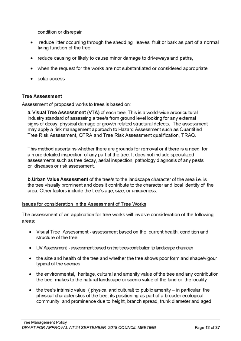
· ASSESSMENT FRAMEWORK (Section 2) – This section outlines the assessment framework for works to trees. Amendments to this section of the Policy include:
o 2.2. b) ‘Exempt Works’ – Removal of suggestion to transplant undesirable species. References to legislation have also been updated.
o 2.2. c) ‘List of Works to Trees That the Council May Not Grant Approval’ – Additions to list made to include naturally occurring leaf or bark litter caused by fauna using a tree.
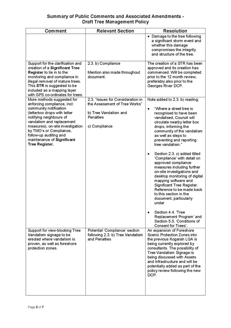
o 2.3. ‘Issues for Consideration in the Assessment of Tree Works’ – Amendments were made to reflect public comment in regard to; size and age of trees and presence of hollows, poor shape of tree contributed to by inappropriate pruning by external authorities, damage to trees caused by significant storms, the possibility of retaining trees and a reference to wildlife corridors identified in Council’s Vegetation Mapping Report 2018.
o 2.3. b) ‘Tree Vandalism and Penalties’ – Included a description of Council’s method of circulating letter box drops in the event of a vandalised street tree needing removal and steps to preventing and reporting tree vandalism.
o 2.3. b) i. ‘Penalties’ – Clarification given to the difference in monetary penalties given to individuals or corporations.
o 2.3. c) ‘Compliance’ – This section was added to address comments supporting tighter enforcement of compliance. Details include methodology to follow-up compliance in tree replacement planting or the provision of sufficient landscape areas on development sites. Methods listed are desktop monitoring using digital mapping software and further on-site investigation by Tree Management Officers.
o Formatting – altered throughout, including amendment of wording to reflect current legislation in the Biosecurity Act 2015.
· TREES IN STREETS (Section 3) – This section provides information on street tree species and selection taking into account location. It outlines the approach to street tree pruning and maintenance and provides details on the mechanisms for the request and approval for street tree pruning and removal. Amendments to this section of the Policy include:
o Wildlife Corridors - a reference to wildlife corridors has been added to the purpose of street trees.
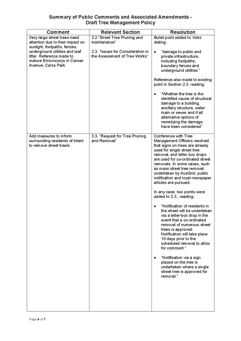
o 3.2 ‘Street Tree Pruning and Maintenance’ - damage to public infrastructure and underground utilities has been added as a potential risks removed by pruning of street trees.
o 3.5 ‘Role of Street Trees as Wildlife Corridors’ and 3.6 ‘Trees in Parks’ – these two new sub-sections have been added to support the Vegetation Mapping Report’s recommendations in particular examples of how the canopy targets of 40% can be achieved via wildlife corridors and additional tree planting in open space areas.
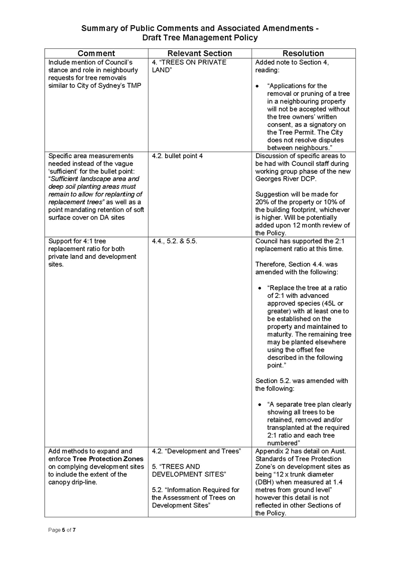
· TREES ON PRIVATE LAND (Section 4) – This section focuses on guiding tree works on private land and includes the introduction of an offset fee. Amendments to this section of the Policy include:
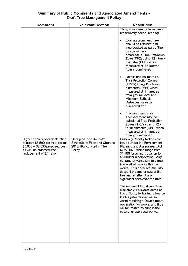
o 4.2 Development and Trees - uniform description of tree protection zones to be in line with the Australian Standard AS 4970 – Protection of Trees on Development Sites,
o 4.3 Tree Replacement Program – clarification of a 2:1 tree replacement ratio
o 4.7 ‘Role of Community Engagement in Urban Canopy Enhancement’ – a new sub-section using recommendations from the Vegetation Mapping Report has been added to encourage achievement of 40% canopy target by engaging residential property owners to maintain tress located within identified wildlife corridor areas.
· TREES AND DEVELOPMENT SITES (Section 5) – This section provides guidance and information on the design phrase and construction approach to ensure the protection of trees on a development site and adjoining properties. Amendments to this section of the Policy include:
o Tree Protection Zones – uniform description of tree protection zones to be in line with the Australian Standard AS 4970 – Protection of Trees on Development Sites,
o 5.6 ‘Protection of Trees within Development Sites in Identified Biodiversity Corridors’ – a new sub-section had been added which details the importance of trees to biodiversity corridors and urban canopy targets of 40%. Reference is made of using a Significant Tree Register to protect mature trees in corridor areas.
(d) Other Issues raised in submissions
14. A number of submissions recommended that private premises adjoining public places where tree vandalism had taken place be notified through letter-box drops of the existence of public tree vandalism, what steps are being taken to identify and punish the offenders and tips on reporting tree vandalism. Submissions also recommended that the vandalised trees remain (where they are safe to do so) and/or large signs be installed as a deterrent to vandalise trees to improve views. Whilst the comments supporting the use of view-blocking tree vandalism signage are supported; more discussion is needed concerning the practical application of such signage. Thus, this proposal will be further investigated during the first year of the Policy’s implementation and considered further as part of the 12 month review.
15. Comment was made to apply specific area measurements in Section 4.2. ‘Development and Trees’ instead of the perceivably vague ‘Sufficient landscape area and deep soil planting areas must remain to allow for replanting of replacement trees.’ As such, a suggestion has been made to include; “being the larger of either 20% of the entire property or 10% of the building footprint.”
16. This suggestion will require further investigation with a variety of staff to determine the practical application for all forms of residential development before being considered. Therefore this matter will be further researched during the first year of the Policy’s implementation and considered at the proposed 12 month review. Consideration will also be given to including such requirements into the upcoming Development Control Plan harmonisation.
17. The issue regarding the use of Security Payments and Returnable Bonds on both private and public land was also raised in submissions. Council is in possession of a legal opinion which indicates that the application of security bonds via a condition of development consent on private land is not valid; however Council may apply a refundable security deposit for street trees. This matter is currently administered through the development assessment process and it is proposed not to be included within this Policy.
(e) Fees and Charges
18. No submissions were received during the public exhibition regarding the ‘Review of Tree Removal and Pruning Application Fee.’ A number of submissions were received in relation to the $2,250 ‘Offset Fee or Tree Replacement Fee’ which suggested that the fee was too low and should be within the range of $6,000 to $10,000 per tree. This matter is further addressed later in this report.
19. Submissions in regard to fees and charges during public consultation were mostly focused around a misinterpretation of the variability in penalties of $1,500 to $6,000. The Policy has since been amended in Section 2.3. b) i. to clarify the two separate penalty amounts of $1,500 and $6,000 are for an individual and corporation, respectively. Further comments were made on the enforcement of the tree offset, which has been addressed in Section 2.3. c) ‘Compliance’.
(f) Councillor Briefing
20. On 11 December 2018, Councillors were provided with a briefing to discuss the submissions received during the public exhibition period. A summary of the sixteen written public submissions received through e-mail and letter was provided along with proposed amendments to the Draft Policy. The key matters raised by Councillors at the briefing related to the composition and operation of review panels, the application of the Offset Fee or Tree Replacement Fee, assigning a value to a tree, and these are discussed in further detail in the following sections of this report.
(g) Review of Tree Permit Applications
21. Review of a Council Decision on Works to a Tree on Private Land - Currently, Council has a one stage review process for trees on private property whereby the property owner is required to submit a Review Tree Management Application Form (at no cost), with the recommended, but not required addition of an accompanying arborist report. The tree is then viewed by a different Tree Management Officer. If the property owner is unhappy with the outcome of the review, there is no further process for review and hence no process to prevent further complaints to senior staff members.
22. The Policy proposes a detailed two stage review process for Trees on Private Land, which aims to solidify and enhance the existing one stage process whereby the resident can appeal the first determination. The details of the proposed two stage process are as follows:
· Stage 1 Review – The applicant lodges a Review Tree Management Application Form, (to be adapted from the existing form - ‘Review of Determination for an Application to Prune or Remove Trees’) and the prescribed $70 fee. The review will subsequently be undertaken by an alternate Tree Management Officer.
· Stage 2 Review – If the applicant is not satisfied with the decision resulting from the Stage 1 Review, a second review can be requested through the above Form and the payment of the prescribed $140 fee. It is proposed that this application will be reviewed by an Internal Review Panel comprising of three senior staff members from a pool of five potential staff including; Director Assets and Infrastructure, Director Environment and Planning, Manager Infrastructure, Manager Environment, Health and Regulatory Services and, Manager Development and Building. The Panel will assess the application based on the ten point criteria found in Section 4.4.2 of the Policy.
23. Review of a Council Decision on Removal of a Street Tree or Trees - An individual can request the review of a decision to remove a street tree or trees, as long as they are a rate-paying resident. Their application for review must be in writing, however there is no requirement pay a fee or to complete the abovementioned Form. The request for review is to be assessed by an alternate Tree Management Officer with the recommendation passed onto an Internal Review Panel. This Panel is proposed to be comprised of a combination of three senior staff members from a pool of five potential staff including; Director Assets and Infrastructure, Director Environment and Planning, Manager Infrastructure, Manager Environment, Health and Regulatory Services and, Manager Development and Building.
24. A request was made at the 11 December briefing to consider what role Councillors would have in the above review process as the draft Tree Management Policy only provides a Policy development role for Councillors. In considering this request contact was made with both Sutherland Shire Council and Canterbury Bankstown Council’s to determine how their review processes operated. The following was identified:
· Sutherland Council has a potential three stage review process, whereby the first stage requires a $160 fee for removal applications only (50% pensioner discount). The tree is viewed by a different Tree Management Officer from a different Ward. If a resident or Councillor is still unsatisfied, the second stage involves an assessment by an independent consultant arborist. Lastly, in the highly uncommon third stage, the application for removal is then escalated to the Compliance section.
· Canterbury Bankstown Council has a far more simplified application procedure whereby an applicant can apply for a free review simply by making a verbal request. If this is unsuccessful, the second stage review costs 50% of the original fee ($88 with a 50% pensioner discount) and requires an accompanying AQF5 arborist report. The relevant Coordinator reviews the application and provides a determination which is reviewed by the relevant manager and a determination is made. The third and final stage requires the manager to prepare a report to Council. Notably, no decision in over three years has ever reached this stage.
25. Given the experiences of the above two Council’s it is proposed not to implement a third stage review at this time, however this matter will be further evaluated as part of the recommended 12 month Policy review.
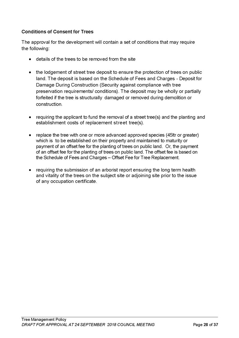
(h) Offset Fee or Tree Replacement Fee
26. The proposed Offset Fee or Tree Replacement Fee would apply to street trees and trees on private property which are required to be removed as a result of a Development Application or Tree Permit approval. Examples where the Tree Replacement Fee would apply include street trees removed due to driveway relocation or service installation while the Offset Fee would apply to trees on private property where the tree cannot be replaced on site.
27. The amount of $2,250 was selected based on the current approved Fee and Charge ‘1.21 Deposits for damage during construction’ for Security against compliance with tree preservation requirement/conditions. This amount will be effective in providing funds for the initial replacement and ongoing maintenance of a mature specimen of 45L pot size in locations identified by the Vegetation Mapping Report and will encourage the retention of mature trees on development sites.
28. The Offset Fee for Tree Replacement is an alternative to a private landholder or developer replacing the tree themselves on a site and is not a choice provided to the applicant but is determined by the assessing officer. The Offset Fee would become applicable upon notification of an approved Development Application or Tree Permit Application.
29. Currently, there is no pensioner/concession on fees associated with tree applications. However, it is recommended that in order to consider the impact of this fee the application of the offset fee or tree replacement fee be reviewed within 6 months of the Policy’s adoption.
(i) Assigning Value to a Tree
30. As there is no standard methodology for placing a financial value on a tree, further work will be conducted to develop a workable tool for the valuation of trees; this includes the assessment and testing of a range of valuation techniques. It is proposed that the development of a standard methodology for valuing a tree will be included as part of the proposed 12 month review of the Policy.
(j) Vegetation Mapping Report
31. In September 2018 Council engaged Cardno, an environmental consultant, to provide a Vegetation Mapping Report including data collection, vegetation mapping and the identification of 40%areas of public land suitable for canopy expansion to meet a recommended canopy enhancement target.
32. The outcome of this report was presented to a Councillor Briefing on 2 October, 2018 which advised of a baseline canopy cover of 23% within the LGA. This further increased to 38% when mangroves on frequently inundated land were included. A proposed canopy cover target for the LGA was discussed at both the 2 October and 11 December Council briefing and general agreement was reached to support the Greater Sydney Regional Plan’s target for canopy cover of 40% by 2038. Therefore, this 40% target has since been added to the relevant sections of the Draft Policy.
33. The Vegetation Mapping Report also provided land use type and suburb by suburb targets as well as suggestions for the development of biodiversity corridors connecting existing parklands via street tree planting and open space planting. These suggestions are currently being investigated with particular emphasis being given to the suggestions to increase open space planting and street tree planting within identified corridor linkages and examples of these have been provided in the Policy. An education program for residents within the potential corridor areas to encourage the planting and fostering of more native vegetation is also underway.
34. The mapping data included in the Vegetation Mapping report has been provided to Councils GIS department so Council can develop detailed maps to establish a baseline and monitor progress.
35. The Vegetation Mapping Report was viewed in conjunction with the Draft Tree Management Policy to better inform the Policy with the relevant sections on ‘Urban Canopy Enhancement’; ‘Role of Street Trees as Wildlife Corridors’, ‘Trees in Parks’ and ‘Role of Community Engagement in Urban Canopy Enhancement’ being added to the Policy.
36. Further, in order to obtain additional funding to implement the findings of the Vegetation Management Report, council staff submitted two extensive grant applications to Round 1 of the NSW Office of Open Space and Parklands Five Million Trees Grant Program. One application focused on street tree and public reserve planting within corridors amongst suburbs with the lowest existing canopy cover percentages. The other application focused on tree plantings within urban centres, in conjunction with Council’s Cool Places, Urban Oasis Project.
37. Council will be advised of the outcome of these applications in mid-February 2019. Should these applications be successful Council will be able to accelerate the achievement of the 40% urban canopy target prior to 2038.
Further Operational Actions
38. A number of operational actions are required for the implementation of the Policy, these include:
· Review of Council Decision – standard procedures and application forms need to be reviewed/developed to support the review process contained in Sections 3.4 ‘Review of a Council Decision on Works to a Street Tree’ and 4.4.2 ‘Review of a Council Decision on Works to a Tree on Private Property.
· Approval Framework for Street Trees - standard procedures need to be reviewed to support the approval processes contained in Section 3.3.1 Approval Framework for Street Trees.
· Valuing Trees - further work is undertaken to develop a workable tool for the valuation of trees; this includes the assessment and testing of a range of valuation techniques.
· Significant Tree Register – a register and nomination guidelines need to be developed, following community consultation.
· Tree Vandalism Signs – further investigation is required to determine the practical application of such signage
· DCP Amendments – consideration is to be given in the consolidated DCP to include detailed landscape and tree retention areas on development sites and the harmonisation of the definition of a tree.
39. The Policy is proposed to be reviewed within 12 months following its implementation and any maters identified for review, including the above operational actions will be reported to Council at that time.
Conclusion
40. The Draft Tree Management Policy was developed due in part to Council’s need to have an informed framework and policy in place for the management of private and public trees, particularly with concern to development sites and the need to establish an urban canopy target. The final Policy needs to be read in conjunction with the following documents:
· State Environmental Planning Policy (Vegetation in Non Rural Areas) 2017
· Kogarah DCP 2013 – B2 Tree management and green web
· Hurstville DCP no.1 (Amendment 5) Appendix 1 Preservation of trees and Vegetation
· Kogarah Street Tree Management Strategy and Masterplan 2009
· Hurstville Street Tree Management Study 2015
· Vegetation Mapping Report 2018
41. With the adoption of the Tree Management Policy, Council will have an established baseline of canopy cover to monitor, maintain and enhance in conjunction with a Significant Tree Register. In addition to this Council will have a stronger position to be able to protect trees on both public and private land and will have a transparent process for the assessment and review of applications for works to trees.
42. It is proposed that the Policy be reviewed 12 months following its adoption. This review will include assessments on the success of the Policy’s framework, application and review process, including compilation of the Internal Review Panels and results of reviews. A review of the application of the Offset Fee or Tree Replacement Fee is proposed to be reviewed within 6 months of the Policy’s adoption.
Financial Implications
43. The preparation and exhibition of the Policy is met within budget allocation.
Risk Implications
44. The draft Policy provides a framework for the management of trees and therefore is a risk mitigation measure.
Community Engagement
45. Community engagement was conducted including:
· Copies of the Draft Policy were on display on Council’s Website; Council’s Civic Centre and Kogarah and Hurstville Libraries between 17th October 2018 and 14th November 2018.
· Eight public information sessions were provided across the LGA, being advertised via Council’s website, via a notice in The Leader and through direct email invitations to the community groups detailed in Council’s previous resolution.
File Reference
17/1831, D19/18519
|
Attachment ⇩1 |
Georges River Council Tree Management Policy |
|
Attachment ⇩2 |
Detailed Comments and Amendments from the Public Exhibition - Draft Tree Management Policy Final |
|
Georges River Council - Environment and Planning - Monday, 11 February 2019 ENV003-19 Tree Management Policy [Appendix 1] Georges River Council Tree Management Policy |
Page 241 |


Item: ENV004-19 Minutes of the Economic Development Advisory Committee 9 October and 19 November 2018
Author: Economic Development Officer
Directorate: Environment and Planning
Matter Type: Committee Reports
|
That Council adopts the recommendations contained within the minutes of the Economic Development Advisory Committee meetings held on Tuesday 9 October and Monday 19 November 2018. |
Executive Summary
1. Minutes of the Economic Development Advisory Committee Meetings held on Tuesday 9 October and Monday 19 November are attached for Council’s consideration and adoption (Attachments 1 and 2).
Background
2. In accordance with Council practice, items considered by the Economic Development Advisory Committee will be presented to the Environment and Planning Committee, then to Council for their adoption and posted on Council’s website.
Financial Implications
3. The recommendations contained within the minutes of the Economic Development Advisory Committee have no financial implications.
Risk Implications
4. No risks identified.
Community Engagement
5. Community engagement was not required for the purpose of this report.
File Reference
D19/7704 and D19/7705
|
Attachment ⇩1 |
Minutes Economic Development Advisory Committee 09 October 2018 |
|
Attachment ⇩2 |
Minutes Economic Development Advisory Committee Meeting 19 November 2018 |
|
Georges River Council - Environment and Planning - Monday, 11 February 2019 ENV004-19 Minutes of the Economic Development Advisory Committee 9 October and 19 November 2018 [Appendix 1] Minutes Economic Development Advisory Committee 09 October 2018 |
Page 253 |