|
AGENDA Environment and Planning Committee
Tuesday, 11 June 2019 7.00pm
Georges River Civic Centre Hurstville
|
|
|
AGENDA Environment and Planning Committee
Tuesday, 11 June 2019 7.00pm
Georges River Civic Centre Hurstville
|
|
Georges River Council – Environment and Planning - Tuesday, 11 June 2019 Page 3
Environment and Planning
1. Acknowledgement of Country
2. Apologies
3. Disclosures of Interest
4. Public Addresses to the Meeting
5. Confirmation of Minutes of Previous Meeting
MINUTES: Environment and Planning - 13 May 2019
6. Committee Reports
ENV015-19 Terms of Reference - Environment and Planning Standing Committee
(Report by Manager, Office of the General Manager)............................................. 3
ENV016-19 Interim Policy - Georges River Development Control Plan 2020
(Report by Strategic Planner).................................................................................... 11
ENV017-19 9 Gloucester Road, Hurstville - Planning Proposal and draft DCP
(Report by Senior Strategic Planner)....................................................................... 23
ENV018-19 Revised offer to enter into a Voluntary Planning Agreement for 9 Gloucester Road and 420-430 Forest Road, Hurstville
(Report by Executive Strategic Planner).................................................................. 95
ENV019-19 Georges River Commercial Centres Strategy - Part 1 Centres Analysis for Public Exhibition
(Report by Strategic Planner/Urban Designer).................................................... 119
ENV020-19 Evidence Base for Local Housing Strategy
(Report by Strategic Planner).................................................................................. 419
ENV021-19 Georges River Inclusive Housing Strategy and Delivery Program
(Report by Senior Strategic Planner)..................................................................... 499
ENV022-19 Hurstville City Centre Transport Management and Accessibility Plan - TMAP 2018
(Report by Senior Strategic Planner)..................................................................... 580
Georges River Council – Environment and Planning - Tuesday, 11 June 2019 Page 4
Item: ENV015-19 Terms of Reference - Environment and Planning Standing Committee
Author: Manager, Office of the General Manager
Directorate: Office of the General Manager
Matter Type: Committee Reports
|
That the revised Terms of Reference for the Environment and Planning Standing Committee be received and noted. |
Executive Summary
1. At its meeting on 27 May 2019, Council adopted a revised Code of Meeting Practice.
2. To ensure compliance with Council’s revised Code of Meeting Practice, all Terms of Reference documents for all of Council’s Standing and Advisory Committees have been revised.
Financial Implications
3. No budget impact for this report.
Risk Implications
4. No risks identified.
Community Engagement
5. Relevant community engagement was conducted during the public exhibition of Council’s Code of Meeting Practice.
6. No additional community engagement is required.
File Reference
D19/127937
|
Attachment ⇩1 |
Terms of Reference - Environment and Planning Standing Committee - Amended - June 2019 - VERSION 4 |
|
Georges River Council - Environment and Planning - Tuesday, 11 June 2019 ENV015-19 Terms of Reference - Environment and Planning Standing Committee [Attachment 1] Terms of Reference - Environment and Planning Standing Committee - Amended - June 2019 - VERSION 4 |
Page 7 |


Item: ENV016-19 Interim Policy - Georges River Development Control Plan 2020
Author: Strategic Planner
Directorate: Environment and Planning
Matter Type: Committee Reports
|
(a) That Council endorse the contents of the Georges River Interim Policy DCP. (b) That Council endorse the use of the Georges River Interim Policy DCP for assessing Development Applications until such a time as the Georges River Development Control Plan 2020 is adopted by Council. (c) That notification be provided to the community that the Georges River Interim Policy DCP will come into effect on 22 July 2019. (d) That the Georges River Interim Policy DCP be published on Council’s website upon it coming into effect.
|
Executive Summary
1. At its meeting dated 24 September 2018, Council (NM087-28) resolved:
a) That Council note as a result of the 2016 Council amalgamation there are numerous Development Control Plans (DCP) that apply across the Local Government Area for similar development types, which contain inconsistent controls (for example: lot width and site area provisions for Dual Occupancy Developments and inconsistent storey (height) limits to overall Local Environmental Plan (LEP) Building Height Controls); and
b) That the General Manager prepare a report to Council on the establishment of an Interim Policy on the application of key DCP provisions which are inconsistent across the Local Government Area (such as those mentioned above) including options for assessing development applications on a consistent basis until such time as a comprehensive DCP is prepared and implemented for the entire Local Government Area.
2. The aim of an Interim Policy is to create harmonisation of inconsistent controls. Regularly varied residential controls have been reviewed to determine which are considered best practice to be enforced in the interim, until a comprehensive DCP is implemented. This will give greater certainty to the community that Development Applications can be assessed in a consistent manner.
3. A draft outline of the Policy was briefed to Councillors on 1 April 2019. Issues primarily relating to landscaping and side setbacks were raised, as well as current inconsistencies between the Kogarah LEP 2012 and Kogarah DCP 2013 (i.e. height provisions for residential flat building development).
4. It is the recommendation of this report that Council now adopt the Georges River Interim Policy DCP, that it be made publicly available on Council’s website and that the Policy be in place until comprehensive planning framework is developed and adopted.
Background
5. As a result of the May 2016 amalgamation of Kogarah City Council and Hurstville City Council, the current Georges River Council has four operative DCPs:
· Hurstville Development Control Plan 1 - Applies to land within the Peakhurst, Mortdale and Hurstville Wards;
· Hurstville Development Control Plan Number 2 - Amendment No. 8 - Applies to sites within the Hurstville City Centre excluding the 'deferred matters' on the Hurstville Local Environmental Plan 2012 Land Application Map;
· Hurstville Development Control Plan Number 2 - Amendment No. 5 - Applies to sites within the Hurstville City Centre identified as 'deferred matters' on the Hurstville Local Environmental Plan 2012 Land Application Map; and
· Kogarah Development Control Plan 2013 - Applies to land within the Blakehurst and Kogarah Bay Wards.
6. Council is currently preparing a number of strategic plans and planning documents which will be completed over the next two years – one of which is the comprehensive Development Control Plan (DCP). The comprehensive DCP is required to be effective upon gazettal of the Georges River LEP 2020.
7. Notwithstanding, it has been acknowledged that the assessment of development throughout the Georges River LGA is setting an inconsistent precedent due to the different controls that are in the DCPs applying to the LGA (i.e. setbacks, lot frontage width, solar access controls).
8. At its meeting dated 24 September 2018, Council (NM087-28) resolved:
a) That Council note as a result of the 2016 Council amalgamation there are numerous Development Control Plans (DCP) that apply across the Local Government Area for similar development types, which contain inconsistent controls (for example: lot width and site area provisions for Dual Occupancy Developments and inconsistent storey (height) limits to overall Local Environmental Plan (LEP) Building Height Controls); and
b) That the General Manager prepare a report to Council on the establishment of an Interim Policy on the application of key DCP provisions which are inconsistent across the Local Government Area (such as those mentioned above) including options for assessing development applications on a consistent basis until such time as a comprehensive DCP is prepared and implemented for the entire Local Government Area.
9. In accordance with the resolution, consultation was undertaken with officers from the Development Assessment and Building group to determine which controls needed to be harmonised to reflect the standards currently applied, ensure practicality in their application, and prevent inappropriate development. A comparison of residential controls across the two former Councils and relevant SEPPs, as well as a review of Council’s variations register occurred.
10. Council’s Legal Counsel reviewed the outcomes of the above, noting that there is a risk of error in law with the Interim Policy, should Council not allow currently operative DCP controls to be applied. The Interim Policy will have no statutory recognition in the assessment of a Development Application, pursuant to the EP&A Act 1979.
11. A presentation of proposed Interim Policy controls was given at a Councillor Workshop dated 1 April 2019. Issues primarily relating to side setback controls in two storey development, and landscaping provisions such as minimum dimensions and site area were raised, as well as current inconsistencies between the Kogarah LEP 2012 and Kogarah DCP 2013 (i.e. height provisions for residential flat building development).
12. It was intended that following the workshop, that a Policy document and report be prepared for a subsequent Council meeting.
Georges River Interim Policy DCP
13. The aim of the Interim Policy is to address current inconsistencies in development controls. The Interim Policy will give certainty to the community that Development Applications are being assessed on a more consistent basis.
14. As Georges River Council data shows that residential development makes for over 70% of Development Applications, it was determined that an Interim Policy is to be directed at the current residential components of the DCPs, and where the controls are inconsistent with the current LEPs.
15. Controls relating to dwelling houses, dual occupancies, multi dwelling housing and residential flat buildings were reviewed as part of this process, with the best practice development controls included in the Interim Policy (Please refer to Attachment 1).
16. Council officers prepared a comparison of residential controls in the Hurstville DCP No.1, Kogarah DCP 2013 and relevant SEPPs, identifying where there is inconsistency. Key examples are as follows:
|
Chapter |
Category |
Hurstville DCP Control |
Kogarah DCP Control |
Recommendation |
|
Dual occupancy |
Minimum lot width (attached)
|
15m |
18m |
15m (Hurstville) |
|
Standard dwelling |
Building Setback (rear) |
3m – ground
floor. |
6m or 15% of the average site length – whichever is greater.
|
6m or 15% of the average site length – whichever is greater (Kogarah) |
17. A brief overview of the Interim Policy is as follows:
· Dwelling Houses – Interim development controls relating to Building Setback (Front, Rear and Side), Landscaped Area, Private Open Space, and Basement Excavation.
· Dual Occupancies – Interim development controls relating to Site Frontage and Parking. Reference to Minimum lot size to be referred to respective LEPs. Note that Building Setbacks (Side) are subject to further investigation.
· Multi Dwelling Housing (3 or more dwellings) – Note that controls relating to Site Frontage, Building Setbacks (Front) and Solar Access will be subject to further investigation.
· Residential Flat Buildings – Controls relating to height to be referred to respective LEPs. Controls relating to Private Open Space, Communal Open Space, Parking and Solar Access are subject to ADG (SEPP 65) controls.
18. The Interim Policy will be a public document to be used by Development Assessment officers in their day-to-day assessment of residential development applications. It will ensure that assessment is consistent across development across the entire LGA.
19. The Interim Policy is a supplementary document to the operative DCPs. The current DCP controls will continue to apply if a particular control is not specified in the Interim Policy. All controls listed in the operative DCPs will still legally apply.
20. Whilst the Interim Policy will have no statutory recognition in the assessment of a Development Applications pursuant to the EP&A Act 1979, the policy will be a guide and be used to ensure there is consistency in Development Assessment.
Next Steps
21. The Interim Policy will not be publicly exhibited; however Council will be publicly notifying the community online that the Policy will be coming into effect on 22 July 2019.
22. The Policy will be available on Council’s website under ‘Development’.
Financial Implications
23. No budget impact for this report.
Risk Implications
24. No risks identified.
Community Consultation
25. No community consultation as part of this Policy, however the community will be notified of this Policy coming into effect on 22 July 2019. Upon adoption, it will be published on Council’s website.
File Reference
D18/2312
|
Attachment ⇩1 |
Georges River DCP - Interim Policy |
|
Georges River Council - Environment and Planning - Tuesday, 11 June 2019 ENV016-19 Interim Policy - Georges River Development Control Plan 2020 [Attachment 1] Georges River DCP - Interim Policy |
Page 22 |


Item: ENV017-19 9 Gloucester Road, Hurstville - Planning Proposal and draft DCP
Author: Senior Strategic Planner and Strategic Planner
Directorate: Environment and Planning
Matter Type: Committee Reports
|
(a) That Council endorse the proposed amendments to DCP No. 2 – Hurstville City Centre for 9 Gloucester Road, Hurstville for public exhibition;
(b) That Council endorse an amended Planning Proposal for 9 Gloucester Road, Hurstville (also known as 420-430 Forest Road, Hurstville) seeking an increase to the maximum building height applying to the site from 23m, to a range of heights of 23m, 30m, 40m, 55m and 60m, and increase the FSR from 3:1 to 4:1 (including a minimum non-residential FSR of 0.5:1) to be forwarded to the Department of Planning and Environment for consideration and approval to publicly exhibit;
(c) That Council publicly exhibit the amended Planning Proposal and amendments to DCP No. 2 – Hurstville City Centre for 9 Gloucester Road, Hurstville concurrently in accordance with the Environmental Planning and Assessment Act 1979 and Environmental Planning and Assessment Regulation 2000;
(d) That Council endorse that the General Manager may make minor modifications to any numerical, typographical, interpretation and formatting errors, if required, in preparation for the public exhibition of the amendments to DCP No. 2;
(e) That Council advise the Department of Planning and Environment of its decision; and
(f) That a further report be submitted to Council following the public exhibition period.
|
Executive Summary
1. On 9 October 2015, the former Hurstville City Council received a Planning Proposal (PP2015/0005) for 9 Gloucester Road, Hurstville to amend the maximum permissible height and floor space ratio (FSR) of the subject site.
2. Following a number of amendments, the Planning Proposal sought to increase the permissible height from 23m to a range of heights of 23m, 30m, 40m, 55m and 60m, and increase the FSR from 3:1 to 4:1 (including a minimum non-residential FSR of 0.3:1) – facilitating a residential yield of 420 units, 2,770sqm of commercial/retail floor space, as well as community facilities (subject to a VPA offer).
3. At its meeting on 27 August 2018, Council resolved to endorse an amended Planning Proposal to be forwarded to the Department of Planning and Environment for a Gateway Determination, seeking to amend the Hurstville Local Environmental Plan 2012 (HLEP 2012) to increase the FSR from 3:1 to 4:1 (including a minimum non-residential FSR of 0.5:1) and increase the maximum building height applying to the site from 23m to a range of heights of 23m, 30m, 40m, 50m and 60m.
4. Council’s resolution contained a numerical error relating to the proposed height, referencing a height of 50m in the proposed height range instead of 55m. This error was carried over from the Applicant’s Planning Proposal which was referred to the Department of Planning and Environment, and a Gateway Determination was received on 26 February 2019.
5. An amended Planning Proposal and supporting documentation, including the correct height range and extension of timing to complete the amendment to the LEP is recommended to be forwarded to the Department of Planning and Environment for their endorsement and approval to publicly exhibit.
6. At its meeting dated 27 August 2018, Council also endorsed the preparation of an amendment to the Hurstville Development Control Plan (DCP) No.2 – Hurstville City Centre.
7. This report outlines the amendments to DCP No. 2 - Hurstville City Centre for 9 Gloucester Road, Hurstville and recommends that Council endorse it for public exhibition concurrently with the Planning Proposal. Following the public exhibition, submissions on the Planning Proposal and DCP amendments will be reported to Council.
8. A separate report is contained in this Business Paper on a revised offer to enter into a Voluntary Planning Agreement (VPA) dated 23 April 2019 received in relation to the amendments made to the Planning Proposal.
Background
9. On 9 October 2015, GTB Hurstville Pty Ltd submitted a Planning Proposal for 9 Gloucester Road, Hurstville to:
· Increase the maximum permissible height from 23m to a range of heights between 23m and 60m (approximately 5-18 storeys);
· Increase the FSR from 3:1 to 4.5:1;
· Provide a yield of approximately 450 – 475 residential units;
· Provide 1,700sqm of commercial/retail floor space;
· Provide a 300sqm community facility (subject to a future VPA offer);
· Provide a 1,000sqm publicly accessible park (subject to a future VPA offer); and
· Create a public through-site link (subject to a future VPA offer).
10. Since the lodgement of the Planning Proposal in October 2015, a total of four (4) revised Planning Proposals have been received, with variations to the requested height, FSR, quantum of retail/commercial floor space and residential yield.
11. The Applicant’s latest revised Planning Proposal (Revision No. 5) was lodged on 30 May 2018, requesting to amend HLEP 2012 to increase the FSR from 3:1 to 4:1 (including a minimum non-residential FSR of 0.3:1) and to increase the maximum building height applying to the site from 23m to a range of heights being 23m, 30m, 40m, 55m and 60m (refer to Figure 1).

Figure 1 – Proposed Height of Buildings Map
12. At its meeting on 27 August 2018, Council considered the abovementioned revision of the Planning Proposal and resolved:
a) That Council endorse the Planning Proposal to amend Hurstville Local Environmental Plan 2012 as follows, in relation to 9 Gloucester Road, Hurstville (Lot 30 DP785238):
i. To amend the Floor Space Ratio Map to increase the floor space ratio from 3:1 to 4:1 (including a minimum non-residential FSR of 0.5:1); and
ii. To amend the Height of Buildings Map to increase the maximum building height applying to the site from 23m to a range of heights of 23m, 30m, 40m, 50m and 60m.
b) That Council endorse the Planning Proposal to be forwarded to the delegate of the Greater Sydney Commission for a Gateway Determination under Section 3.34 of the Environmental Planning and Assessment Act 1979.
c) That the Planning Proposal be placed on formal public exhibition in accordance with the conditions of any Gateway Determination issued by the Department of Planning and Environment and demonstrating the provision of public benefit in accordance with the Council’s VPA Policy.
d) That
Council endorse the preparation of an amendment to the Hurstville Development
Control Plan No.2 – Hurstville City Centre (“HDCP No.2”) to
run concurrently with an amendment to the Hurstville Local Environmental Plan
2012 (if Gateway approval is given by the Department of Planning and
Environment), to reflect urban design considerations for any future development
of the site including the provision of public access, built form, boundary
setbacks, deep soil areas, tree retention, vehicular access and any other
relevant issues. The DCP is to be prepared at the proponent’s cost.
13. In accordance with Council’s resolution, the Planning Proposal was forwarded to the Department of Planning and Environment on 5 October 2018 and Council received a Gateway Determination to publicly exhibit the Planning Proposal on 26 February 2019.
14. The Gateway Determination requires Council to finalise the amended LEP by 26 February 2020 (12 months from receiving Gateway Determination).
15. The Gateway Determination also requires the Planning Proposal to be updated to demonstrate that it is consistent with Section 9.1 Directions 1.1 Business and Industrial Zones and 3.5 Development Near Regulated Airports and Defence Airfields. This has been adhered to by the Applicant in the latest Planning Proposal report (refer to Attachment 1).
Planning Proposal
16. The Applicant’s latest submitted Planning Proposal (Revision No. 5) sought to amend the HLEP 2012 to allow for a range of heights, being 23m, 30m, 40m, 55m and 60m.
17. Council’s resolution to refer the Planning Proposal to the Department of Planning and Environment for a Gateway Determination contained a numerical error relating to the proposed height, stating that the proposed heights ranged between 23m, 30m, 40m, 50m and 60m. The error was carried over from the Applicant’s Planning Proposal report which referred to a height range including 50m in Part 2 – Explanation of the Provisions. The remainder of the report including the Height of Buildings Map referred to a height range including 55m.
18. Unaware of the error at the time, the Planning Proposal was forwarded to the Department of Planning and Environment, who assessed the Planning Proposal based on a height range that included 50m rather than 55m.
19. In March 2019, the Applicant submitted an amended Planning Proposal to reflect the originally intended height range that included 55m.
20. The proposed heights, inclusive of 55m, are consistent with Council’s endorsed Hurstville City Centre Urban Design Strategy 2018, which acknowledges that the site is subject to a Planning Proposal and recommends that the HLEP 2012 be amended to increase the maximum permissible height of the subject site from 23m, to a range of heights up to 60m at the western end of the site, stepping down to 40m at the eastern end.
21. The Department of Planning and Environment have advised Council to forward the amended Planning Proposal (refer to Attachment 1) for their consideration and approval to proceed with public exhibition.
22. It should be noted that Council’s resolution also amends the Applicant’s latest submitted Planning Proposal by increasing the minimum non-residential FSR from 0.3:1 to 0.5:1, to ensure there is a sufficient supply of commercial floor space within the Hurstville City Centre.
23. The latest Planning Proposal, taking into account the increase of non-residential FSR, will facilitate a development comprising 400 residential units and 4,620sqm of commercial floor space.
Offer to enter into a Voluntary Planning Agreement (VPA)
24. As background, on 19 June 2018, Council received a letter of offer to enter into a VPA from the Applicant in association with the Planning Proposal at the time. The VPA Offer and Heads of Agreement (HOA) were prepared in consultation with Council staff and set out a range of public benefits and terms for a VPA.
25. In summary the VPA Offer of June 2018 and HOA provided for a total contribution value of $4,287,000 and included a range of public benefits as outlined below:
a) Monetary contribution of $2,824,808 for public domain works and public road infrastructure;
b) Public domain improvements including the undergrounding of overhead power lines outside the site.
c) Public access easement to a 1,000sqm open space area/pocket park on the site and embellishments to the park and including a children’s playground;
d) Public access easement to and from and across the land and pocket park;
e) Public art works.
26. Council resolved at its meeting on 27 August 2018 to accept and endorse in principle the VPA Offer dated 18 June 2018, with Council accepting the offer as a total monetary contribution of $4,287,000.
27. At the same Council Meeting of 27 August 2018, Council resolved in relation to the Planning Proposal PP2015/0005 to endorse the proposal with an increase in the total FSR from 3:1 to 4:1 however with an amendment to the minimum non-residential FSR. The non-residential FSR was increased from 0.3:1 to 0.5:1, thereby reducing the residential FSR.
28. As such the Developer submitted a revised VPA Offer dated 23 April 2019. This revised VPA Offer provides for a total monetary contribution of $3,619,308 for public facilities including public infrastructure amenities and services, key traffic and road infrastructure in the Hurstville City Centre.
29. The revised VPA Offer is based on and reflects the revised non-residential and residential FSR within the amended Planning Proposal PP2015/0005 and the RLV rates from the Hill PDA report.
30. A separate report is included in this Business Paper on the revised VPA Offer and Heads of Agreement for Council’s consideration.
Amendment No. 11 to DCP No. 2 – Hurstville City Centre
31. In accordance with Council’s resolution of 27 August 2018, Amendment No. 11 to DCP No.2 – Hurstville City Centre has been prepared for the subject site (refer to Attachment 2). This amendment comprises a new Section (8.3) in existing Section 8 – Controls for Specific Sites and Localities which will include specific controls for the subject site in accordance with the Planning Proposal, including the Concept Master Plan (refer to Figure 2).

Figure 2 – Concept
Master Plan
32. The key elements addressed in Section 8.3 of the DCP for the subject site include:
· Design Excellence – To promote design excellence through the creation of a sustainable and liveable environment for people, through the use of expert panels and active engagement between Council and Applicants that aligns with the vision for the Hurstville City Centre.
· Commercial Floor Space – To ensure a wide range of employment floor space is provided on the site to complement the proposed minimum non-residential FSR of 0.5:1.
· Built Form and Setbacks – To provide a vibrant mixed use development that takes advantage of the site’s location and to ensure adequate transition compliant with the Apartment Design Guide between the new development and adjoining residential development.
· Façade Treatment and Street Corners – To ensure building facades are appropriately modulated and articulated to provide visual interest along the street and other areas of the public domain.
· Pedestrian Access and the Public Domain – To ensure that the development incorporates a through-site pedestrian link that enhances the permeability of the site.
· Active Street Frontages – To ensure ground floor frontages are pedestrian oriented and of high design quality to add vitality to the streets.
· Open Space and Landscaping – To provide residents with passive and active recreational opportunities that has reasonable solar access, landscaping and deep soil planting.
· Tree Retention – To ensure all new development retains existing trees and proposes new trees in accordance with the proposed tree planting plan to ensure an enhancement of the existing canopy cover. This is consistent with the Hurstville City Centre Urban Design Strategy 2018 which identifies that the site is well planted with mature street trees, creating a green gateway to the Centre when entering via King Georges Road.
· On-Site Parking – To provide adequate basement car parking for the buildings’ users and visitors.
· Vehicle Access – To integrate adequate car parking and servicing access without compromising street character, landscape or pedestrian amenity and safety.
Councillor Workshop
33. A Councillor workshop outlining the draft DCP amendments for the subject site, as well as the change in height from 50m to 55m was held on 13 May 2019. No issues were raised at the Councillor workshop.
Next Steps
34. The next steps in finalising Amendment No. 11 to DCP No. 2 are tabulated below:
|
The Environment and Planning Committee endorses the Planning Proposal and Amendment No. 11 to DCP No. 2 for public exhibition (this report) |
11 June 2019 |
|
Council endorses the Planning Proposal and Amendment No. 11 to DCP No. 2 for public exhibition |
24 June 2019 |
|
Exhibit the Planning Proposal and Amendment No. 11 to DCP No. 2 |
Mid July – Mid August 2019 |
|
Council Report on submissions received on the Planning Proposal and Amendment No. 11 to DCP No. 2 seeking endorsement for their adoption |
October 2019 |
|
Planning Proposal sent to the Department of Planning and Environment for finalisation |
Post Council consideration |
|
DCP No. 2 – Hurstville City Centre (Amendment No. 11) comes into effect |
When the Planning Proposal is gazetted and a notice is placed in the newspaper. |
Financial Implications
35. No budget impact for this report.
Risk Implications
36. No risks identified.
Community Engagement
37. In accordance with the Gateway Determination issued on 26 February 2019, the Planning Proposal will be publicly exhibited for a minimum period of 28 days. The public exhibition will comply with the notice of requirements for material that must be made available along with Planning Proposals as identified in Section 5.5.2 of A guide to preparing Local Environmental Plans (Department of Planning and Environment 2018).
38. Exhibition material, including explanatory information, land to which the Planning Proposal applies, description of the objectives and intended outcomes, copy of the Planning Proposal and relevant maps will be available for viewing during the exhibition period on Council’s website and at Council offices and libraries.
39. Notification of the public exhibition will be made through:
· Newspaper advertisement in The St George and Sutherland Shire Leader;
· Public exhibition notice on Council’s website;
· Notices in Council offices and libraries; and
· Letters to
adjoining landowners (in accordance with Council’s Notification
Procedures).
40. As per Condition 3 of the Gateway Determination, consultation is required with the following public authorities/organisations under Section 3.34(2)(d) of the Act:
· Roads and Maritime Services;
· Transport for NSW;
· NSW Department of Education;
· Sydney Airport Corporation; and
· Civil Aviation Safety Authority.
File Reference
D19/714
|
Attachment ⇩1 |
Planning Proposal Report - 9 Gloucester Road, Hurstville - 27 May 2019 |
|
Attachment ⇩2 |
DCP No.2 Amendment No.11 Section 8.3 - 9 Gloucester Road, Hurstville |
|
Attachment 3 |
ASIC Organisation Extract - GTB Hurstville Pty Ltd (Confidential) |
|
Georges River Council - Environment and Planning - Tuesday, 11 June 2019 ENV017-19 9 Gloucester Road, Hurstville - Planning Proposal and draft DCP Attachment 1] Planning Proposal Report - 9 Gloucester Road, Hurstville - 27 May 2019 |
Page 33 |


Item: ENV018-19 Revised offer to enter into a Voluntary Planning Agreement for 9 Gloucester Road and 420-430 Forest Road, Hurstville
Author: Executive Strategic Planner
Directorate: Environment and Planning
Matter Type: Committee Reports
|
(a) That Council accept and endorse the Letter of Offer to enter into a Voluntary Planning Agreement (VPA) dated 23 April 2019 from Great Tang Brothers Hurstville Pty Ltd (GTB) (Attachment 1) and Heads of Agreement (HOA) signed by the GTB (Attachment 2) in relation to the amended Planning Proposal PP2015/0005 for 9 Gloucester Road and 420-430 Forest Road, Hurstville (May 2019) seeking to increase density and height of buildings on the land for a mixed use development. The VPA Offer and HOA provides for a total monetary contribution of $3,619,308 and includes the following: i. the monetary contribution is for public facilities including public infrastructure amenities and services. This also includes the provision of key traffic and road infrastructure in the Hurstville City Centre;
ii. the contribution value is based on the Hill PDA report residual land value rates of $1,073 per square metre of additional residential gross floor area and $349 per square metre of additional non-residential gross floor area.
iii. the total contribution value is to be recalculated at the time of payment of the monetary contribution based on the actual final additional residential and non-residential GFA permissible by the LEP amendment;
iv. the VPA Offer and final VPA will not exclude the application of s7.11, 7.12 and 7.24 development contributions (previously referred to as s94, s94A and S94EF contributions) to the Development.
(b) That Council delegate authority to the General Manager to negotiate the final terms and enter into the Heads of Agreement referred to above.
(c) That Council delegate authority to the General Manager to negotiate the specific terms of the Voluntary Planning Agreement based on the VPA Offer and Heads of Agreement and to subsequently exhibit a draft of the Voluntary Planning Agreement in accordance with the relevant provisions of the Environmental Planning and Assessment Act and Regulation.
(d) That Council delegate authority to the General Manager to: a. Authorise any minor changes to the draft Voluntary Planning Agreement, following its public exhibition, provided that those changes do not diminish the value or nature of the public benefits to be delivered as identified in (a) above; b. Subsequently enter into the Voluntary Planning Agreement on behalf of Council.
(e) That GTB Hurstville Pty Ltd be informed of Council’s decision.
|
Executive Summary
1. A revised letter of offer to enter into a Voluntary Planning Agreement (revised VPA Offer) (Attachment 1) dated 23 April 2019 from the Great Tang Brothers (GTB) was received by Council in association with the amended Planning Proposal PP2015/0005 for 9 Gloucester Road and 420-430 Forest Road, Hurstville. A revised Heads of Agreement to enter into a VPA (Attachment 2) has been signed by GTB providing the key terms of the VPA Offer.
2. The revised VPA Offer and HOA provides for a total monetary contribution of $3,619,308 and includes the following:
i. the monetary contribution is for public facilities including public infrastructure amenities and services. This also includes the provision of key traffic and road infrastructure in the Hurstville City Centre;
ii. the contribution value is based on the Hill PDA report residual land value rates of $1,073 per square metre of additional residential gross floor area and $349 per square metre of additional non-residential gross floor area.
iii. the total contribution value is to be recalculated at the time of payment of the monetary contribution based on the actual final additional residential and non-residential GFA permissible under the LEP amendment;
iv. the VPA Offer and final VPA will not exclude the application of s7.11, 7.12 and 7.24 development contributions (previously referred to as s94, s94A and S94EF contributions) to the Development.
3. The revised VPA Offer replaces the VPA offer dated 19 June 2018 that was reported to Environment and Planning Committee Meeting on 13 August 2018 (ENVO23-18) and Council Meeting of 27 August 2018. This previous VPA offer provided for a total contribution of $4,287,000 that comprised a monetary contribution of $2,824,808, construction of a pocket park and playground, and a range of public domain works. At the Council Meeting of 27 August 2018 Council resolved to “accept and endorse in principle the Letter of Offer to enter into a Voluntary Planning Agreement (VPA) dated 19 June 2018…” and “that Council advises the proponent that it will accept a total monetary contribution of $4,287,000….based on the residual land value rates of $1,073 per square metre of additional residential gross floor area and $349 per square metre of additional non-residential gross floor area”:
4. At the same Council Meeting of 27 August 2018, Council resolved in relation to the Planning Proposal PP2015/0005 to endorse the proposal with an increase in the total FSR from 3:1 to 4:1 however with an amendment to the minimum non-residential FSR. The non-residential FSR was increased from 0.3:1 to 0.5:1, thereby reducing the residential FSR for the site.
5. The revised VPA Offer is based on and reflects the revised non-residential and residential FSR and floorspace within the amended Planning Proposal PP2015/0005 endorsed by Council on 27 August 2018 and as presented in this Business Paper. The revised VPA Offer is based on the same residual land value rates of $1,073/m2 for residential and $349/m2 for non-residential as established by Hill PDA. These residual land values were endorsed by Council’s economic consultants SGS Economics.
6. As outlined in the Committee report of 27 August 2018 (ENVO23-18), the value of the offer has been supported by specialist reports prepared by the Developers consultants including Hill PDA Consulting and quantity surveyors. These reports have been assessed by Council staff and Council’s economic consultants SGS Economics in accordance with Council’s Policy on Planning Agreements as outlined in this report. The revised HOA has been prepared in consultation with the Developer, Council staff and Council’s solicitors.
7. The revised VPA Offer has been assessed against Council’s Policy on Planning Agreements and is considered reasonable and satisfactory in respect of the Acceptability Test. As the offer seeks to provide public benefits commensurate with uplift sought via the Planning Proposal in accordance with Council’s Policy, it is recommended that Council accept the revised Offer dated 23 April 2019 and the signed Heads of Agreement.
Background
Planning Proposal
8. GTB Hurstville Pty Ltd submitted a Planning Proposal request (PP2015/0005) on 9 October 2015 that sought to amend the Hurstville Local Environmental Plan 2012 (“HLEP 2012”) in relation to 9 Gloucester Road and 420-430 Forest Road, Hurstville (Lot 30 DP785238). The Planning Proposal was amended a number of times.
9. The Planning Proposal was presented to the Environment and Planning Committee Meeting of 13 August 2018. The Committee resolved “That Council defer consideration of the Planning Proposal to amend the Hurstville LEP 2012 in relation to 9 Gloucester Road, Hurstville to allow further investigation into increasing the non-residential FSR on the site”
10. At the Council Meeting of 27 August 2018 Council resolved:
a. That Council endorse the Planning Proposal to amend Hurstville Local Environmental Plan 2012 as follows, in relation to 9 Gloucester Road, Hurstville (Lot 30 DP785238):
i. To amend the Floor Space Ratio Map to increase the floor space ratio from 3:1 to 4:1 (including a minimum non-residential FSR of 0.5:1); and
ii. To amend the Height of Buildings Map to increase the maximum building height applying to the site from 23m to a range of heights of 23m, 30m, 40m, 50m and 60m.
b. That Council endorse the Planning Proposal to be forwarded to the delegate of the Greater Sydney Commission for a Gateway Determination under Section 3.34 of the Environmental Planning and Assessment Act 1979.
c. That the Planning Proposal be placed on formal public exhibition in accordance with the conditions of any Gateway Determination issued by the Department of Planning and Environment and demonstrating the provision of public benefit in accordance with the Council’s VPA Policy.
d. That Council endorse the preparation of an amendment to the Hurstville Development Control Plan No.2 – Hurstville City Centre (“HDCP No.2”) to run concurrently with an amendment to the Hurstville Local Environmental Plan 2012 …..”
11. A report on an amended Planning Proposal dated May 2019 and the Draft DCP is reported to the Environment and Planning Committee on 11 June 2019. As outlined in the report, Council’s resolution of 27 August 2018 contained a numerical error relating to the proposed height, stating a height of 50m in the proposed height range instead of 55m. This error was carried over from the Applicant’s Planning Proposal which was referred to the Department of Planning and Environment and a Gateway Determination was received on 26 February 2019.
12. The amended Planning Proposal, including the correct height range, is recommended to be forwarded to the Department of Planning and Environment for their consideration and approval to publicly exhibit in conjunction with the amendments to DCP No. 2 - Hurstville City Centre for 9 Gloucester Road, Hurstville.
13. In summary the amended Planning Proposal with an increase in the FSR from 3:1 to 4:1 and minimum non-residential FSR of 0.5:1, results in a total additional floorspace of 9,240sqm above the existing planning controls under Hurstville LEP (which includes an ‘additional’ 5,544sqm of residential and 3,696sqm of non-residential floorspace).
14. The proposal will facilitate a development comprising 400 residential units and 4,620sqm of non-residential floor space.
15. The Planning Proposal was assessed separately to the VPA Offer.
Original VPA Offer
16. The VPA Offer dated 19 June 2018 (previous VPA Offer) and signed Heads of Agreement, provided in association with the Planning Proposal, offered a total contribution value of $4,287,000 and included the following public benefits:
a. Monetary contribution of $2,824,808 for public works, facilities, public domain and road infrastructure.
b. Public domain works to be carried out by the Developer to the total value of $1,273,736, as follows:
i. Undergrounding of overhead power lines ‘outside’ of the Land (estimated value of $508,839) on the northern side of Forest Road between the Land and No. 458 Forest Road (Highpoint Hurstville site), with an approximate length of 111 metres, connecting with the existing underground lines and the provision of smart poles.
ii. Children’s playground and construction and installation of a publicly accessible pocket park (estimated value of $764,897) with an area of 1,000sqm;
iii. Registration of easement for public access to the pocket park and public positive covenant and public positive covenant.
c. Public art - construct and install immediately within and around the site (with an estimated value of $188,456).
d. The VPA Offer and final VPA will not exclude the application of section 7.11, s7.12 and s7.24 development contributions (previously referred to as s94, s94A and s94EF contributions) to the Development.
e. The HOA agreement provides terms for the provision of bank guarantees as security and timing of the contributions and public domain works.
17. The VPA Offer was based on and supported by specialist reports prepared by the Developers consultants including Hill PDA Consulting and quantity surveyors. These reports were assessed by Council staff and Council’s economic consultants SGS Economics in accordance with Council’s Policy on Planning Agreements.
18. The value of the VPA Offer was based on residual land value rates of $1,073 per square metre of additional residential gross floor area and $349 per square metre of additional non-residential gross floor area (as established by the Hill PDA Planning report).
19. The VPA Offer was reported to the Environment and Planning Committee on 13 August 2018 (ENVO23-18). The Committee resolved “that Council defer consideration of the letter of offer to enter into a VPA …to enable the General Manager to further consider the offer in relation to the Council’s VPA Policy August 2016” and “that once further consideration has taken place a report will be provided to the Environment and Planning Committee”.
20. At the Council meeting of 27 August 2018, Council resolved to accept and endorse in principle the VPA Offer, with Council accepting the offer as a total monetary contribution of $4,287,000 as follows:
a) That Council accept and endorse in principle the Letter of Offer to enter into a Voluntary Planning Agreement (VPA) dated 19 June 2018 from Great Tang Brothers (GTB) Hurstville Pty Ltd (Attachment 1) and Heads of Agreement (HOA) signed by the Developer (Attachment 2) in relation to Planning Proposal PP2015/0005 for 9 Gloucester Road and 420-430 Forest Road, Hurstville seeking to increase density and height of buildings on the land for a mixed use development.
b) That Council advises the proponent that it will accept a total monetary contribution of $4,287,000. The contribution value is based on residual land value rates of $1,073 per square metre of additional residential gross floor area and $349 per square metre of additional non-residential gross floor area (as established by a Hill PDA Consulting report). The total contribution value is to be recalculated at the time of payment of the monetary contribution based on the actual additional GFA permissible under the LEP amendment.
c) The VPA Offer and final VPA will not exclude the application of s7.11, 7.12 and 7.24 development contributions (previously referred to as s94, s94A and S94EF contributions) to the Development
d) That Council delegate authority to the General Manager to negotiate the final terms and enter into the Heads of Agreement referred to above.
e) That Council delegate authority to the General Manager to negotiate the specific terms of the Voluntary Planning Agreement and to subsequently exhibit a draft of the Voluntary Planning Agreement in accordance with the relevant provisions of the Environmental Planning and Assessment Act and Regulation.
f) That Council delegate authority to the General Manager to:
a. Authorise any minor changes to the draft Voluntary Planning Agreement, following its public exhibition, provided that those changes do not diminish the value or nature of the public benefits to be delivered as identified in (a) above;
b. Subsequently enter into the Voluntary Planning Agreement on behalf of Council.
g) That Great Tang Brothers Hurstville Pty Ltd be informed of Council’s decision.
VPA Offer dated 23 April 2019
21. GTB Hurstville Pty Ltd submitted a letter of offer to enter into a VPA Offer (revised VPA Offer) dated 23 April 2019 (Attachment 1).
22. The revised VPA Offer is submitted in relation to the amended Planning Proposal and is based on the amendment to the Planning Proposal increasing the minimum non-residential FSR from 0.3:1 to 0.5:1.
23. The VPA offers a total monetary contribution of $3,619,308 and provides for the following:
a. the contribution value is based on the Hill PDA report residual land value rates of $1,073 per square metre of additional residential gross floor area and $349 per square metre of additional non-residential gross floor area and is calculated using the Council’ VPA Policy land value capture formula.
b. the total contribution value is to be recalculated at the time of payment of the monetary contribution based on the actual final additional GFA permissible under the LEP amendment;
c. the VPA offer will be formalised into a Heads of Agreement;
d. the VPA Offer and final VPA will not exclude the application of s7.11, 7.12 and 7.24 development contributions (previously referred to as s94, s94A and S94EF contributions) to the Development.
24. The table below summarises the Planning Proposals uplift in the FSR from the current Hurstville LEP 2012 and the residual land value rates that apply to calculate the value of the VPA contribution using the formula from Council’s VPA Policy.
|
|
Current FSR (HLEP 2012) |
Planning Proposal FSR |
Uplift |
Uplift in GFA (based on site area 9,240sqm) |
Hill PDA Report |
|
|
RLV Rates |
Total VPA Contribution Value (50% of uplift) |
|||||
|
Total FSR |
3.0:1 |
4.0:1 |
1.0:1 |
9,240 |
|
|
|
Residential FSR |
2.9:1 |
3.5:1 |
0.6:1 |
5,544 |
$1,073/sqm |
$2,974,356 |
|
Non Residential FSR |
0.1:1 |
0.5:1 |
0.4:1 |
3,696 |
$349/sqm |
$644,952 |
|
Total |
$3,619,308 |
|||||
25. The VPA Offer provides for a lesser monetary contribution to that resolved by Council on 27 August 2018 due to the amendment made to the Planning Proposal increasing the minimum non-residential FSR from 0.3:1 to 0.5:1 and resulting decrease in the residential FSR (reduced from 3.7:1 to 3.5:1).
26. As stated in the VPA Offer the value is based on the residential land values established in the Hill PDA report prepared for the original VPA Offer. As stated above and in the Committee report of 13 August 2018 (ENVO23-18), the VPA Offer was based on and supported by specialist reports prepared by the Applicants consultants including Hill PDA Consulting and quantity surveyors. These reports were assessed by Council staff and Council’s economic consultants SGS Economics in accordance with Council’s Policy on Planning Agreements.
27. Council received legal advice advising that a revised VPA Offer for contributions that are less than the amount specified in the Council resolution of 27 August 2018 be reported back to the Council for consideration and subject to a further resolution of Council.
28. A Company Search for the Developer is attached (Attachment 4 – Confidential).
Heads of Agreement (HOA)
29. A revised Heads of Agreement (HOA) to enter into a VPA has been prepared by Council’s solicitors Lindsay Taylor Lawyers based on the revised VPA Offer in consultation the Applicant and Council officers.
30. The HOA has been signed by GTB Hurstville Pty Ltd and represents a binding offer to enter into a planning agreement (Attachment 2).
31. The HOA contains the key commercial terms of a VPA to be entered into between GTB Hurstville and Council, if the VPA Offer is accepted by Council. Nothing prevents the parties from requiring further terms to be included in the VPA which are consequential, incidental or supplemental to the terms in this HOA.
32. The HOA states that “The parties agree that the terms of the HOA constitute an irrevocable offer by the Developer, pursuant to s7.7(3) of the Act, to enter into Agreement on the terms set out in this Heads of Agreement, and are binding on the parties to the extent that they constitute an irrevocable offer by the Developer pursuant to s93I(3) of the Act. The Developer does not object to the Council imposing a condition of development consent in respect of the Development requiring an Agreement on the terms set out in this Heads of Agreement to be entered into and complied with”.
33. In summary the HOA provides the following public benefits and provisions:
i. A total monetary contribution of $3,619,308. This value is based on residual land value rate of $1,073 per square metre of additional residential gross floor area and $349 per square metre of additional non-residential gross floor area (as established by a Hill PDA Consulting report). The total contribution value is to be recalculated at the time of payment on the monetary contribution based on the actual additional residential and non-residential GFA permissible under the LEP amendment.
ii. The monetary contribution is for public facilities including public infrastructure amenities and services. This also includes the provision of key traffic and road infrastructure in the Hurstville City Centre.
iii. The monetary contribution is to be paid within 28 days after the commencement of the LEP Amendment.
iv. A bank guarantee is to be provided as security at the time the VPA is executed for the full amount of the monetary contributions.
v. The VPA is to apply to the Land, the commencement of the LEP amendment and the Development. The VPA is to be registered on the Land.
vi. The Developer is to pay Council’s reasonable costs for negotiating, preparing, executing, monitoring, enforcing and administering the VPA.
vii. The VPA will not exclude the application of s7.11, 7.12 and 7.24 development contributions (previously referred to as s94, s94A and S94EF contributions) to the Development.
34. The HOA will only be executed by Council if and after Council has resolved accept the VPA Offer and to enter into the HOA as presented in this report.
Assessment of the Revised VPA Offer - Policy on Planning Agreements
35. Council’s Policy on Planning Agreements (August 2016) sets out the principles and framework for the negotiation, assessment, preparation and implementation of VPAs.
36. The Policy provides an Acceptability Test to assess the acceptability of a proposed planning agreement. The Letter of Offer and public benefits have been assessed in accordance with the Policy and ‘Acceptability Test’ as follows.
|
Does the Planning Agreement: |
Assessment |
|
(a) Satisfy the statutory requirements for planning agreements contained in the Act and Regulation? |
· The VPA Offer and HOA do not form a ‘planning agreement’ (VPA) under the terms of the Act and Regulations. The HOA represents a binding offer to enter into a VPA from the Developer.
· The purpose of the VPA Offer and HOA is to outline the general terms on which the VPA will be based. At this stage, the general terms should meet the requirements of section 7.4(2) of the Act, which describes what a public purpose includes (without limitation) on which a VPA can be based. Section 7.4(2) describes a public purpose includes (without limitation) any of the following:
(a) the provision of (or the recoupment of the cost of providing) public amenities or public services, (b) the provision of (or the recoupment of the cost of providing) affordable housing, (c) the provision of (or the recoupment of the cost of providing) transport or other infrastructure relating to land, (d) the funding of recurrent expenditure relating to the provision of public amenities or public services, affordable housing or transport or other infrastructure, (e) the monitoring of the planning impacts of development, (f) the conservation or enhancement of the natural environment.
The VPA Offer and key terms of the HOA fall under points (a) and (c) of the listed public purposes above. The HOA provides for a monetary contribution to be used to Council’s discretion for “public facilities including public infrastructure amenities and services. This also includes the provision of key traffic and road infrastructure in the Hurstville City Centre”.
Additionally, the Letter of Offer states that “the final voluntary planning agreement will contain provisions necessary to ensure compliance with the provisions of the Environmental Planning and Assessment Act 1979”.
· Other legislative requirements for VPAs include, but are not limited to, securities, dispute mechanisms, the application of section 7.11 and 7.12 development contributions (previously section 94 and section 94A).
In this case, the VPA Offer states that the VPA would not exclude the application of s7.11, 7.12 or 7.24 contributions. As such any future development application would be levied contributions in accordance with the relevant development contributions plan.
· In respect of securities, the HOA provides that a bank guarantee is to be provided to Council at the time the VPA is executed for the full amount of the monetary contribution.
· In respect of dispute mechanisms, the HOA provides for expert determination for matters for which can be determined and mediation for other matters.
· Council’s Policy on Planning Agreements template for Planning Agreements provides standard clauses in this regard and also requires the VPA be registered on the title of the Developer’s Land.
· A further statutory requirement is the public notification of the proposed Planning Agreement, once both parties have agreed on its final form. The minimum exhibition period under the EP&A Act is 28 days. |
|
(b) Comply with the principles set out in clause 2.3 of this Policy? |
· Clause 2.3 of the Council’s Policy on Planning Agreements contains the following eleven (11) principles on the Council’s use of planning agreements: (a) “planning decisions must not be bought or sold through planning agreements; (b) the Council will not allow planning agreements to improperly fetter the exercise of its functions under the Act, Regulation or any other Act or law; (c) the Council will not use planning agreements for any purpose other than a proper planning purpose; (d) the consideration, negotiation and assessment of a proposed planning agreement will be separate from the consideration of the planning merits of a development application or planning proposal; (e) the Council will not use planning agreements as a means to overcome revenue raising or spending limitations to which it is subject or for other improper purposes; (f) development that is unacceptable on planning grounds will not be permitted because of public benefits offered by developers that do not make the development acceptable on planning grounds; (g) the Council will not seek benefits under a planning agreement that are wholly unrelated to the development; (h) in assessing a development application or planning proposal, the Council will not take into consideration planning agreements that are wholly unrelated to the subject matter of the development application or planning proposal, nor will the Council give disproportionate weight to a planning agreement; (i) the Council will not allow the interests of developers, individuals or interest groups to outweigh the public interest when considering a proposed planning agreement; (j) the Council will not improperly rely on its position in order to extract unreasonable public benefits from developers under planning agreements; and (k) where the Council has a commercial stake in development the subject of a planning agreement, it will take appropriate steps to ensure that it avoids a conflict of interest between its role as a planning authority and its interests in the development”.
· Taking the above principles into consideration, Council staff have negotiated, assessed and prepared the terms of the VPA Offer and HOA.
· The Developer will only become obliged to provide the public benefits outlined in the VPA Offer and HOA should the proposed amendments to Hurstville LEP 2012 outlined in the Planning Proposal be gazetted.
· The monetary contribution will provide public benefits that are directly in relation to ameliorating impacts of the development brought about by the Planning Proposal and future Development. |
|
(c) Be directed towards a proper or legitimate planning purpose ordinarily ascertainable from the statutory planning controls and other adopted planning policies applying to development and the circumstances of the case? |
· As discussed under item ‘(a)’ above, the proposed public benefits outlined in the HOA fall under the description of a public purpose of the Act.
|
|
(d) Provide for public benefits that bear a relationship to the development that is not wholly unrelated to the development? |
· The public benefits under the VPA Offer and HOA bear relationship to the development, and provide benefit to the greater public by providing for public facilities including public infrastructure, amenities and services that includes the provision of key traffic and road infrastructure in the Hurstville City Centre. |
|
(e) Produce outcomes that meet the general values and expectations of the public and protect the overall public interest? |
· The general expectations of the public and the protection of the public interest in the case of development, is that the developer will bear some cost in ameliorating against the impacts their private development of their land on its neighbours and the greater community. Whilst development contributions plans raise funds for Council to put toward capital projects to mitigate against the impacts of ongoing development, those plans are based on particular predictions made from planning controls in place at the time the plans were published. Planning Agreements are able to provide where particular development was ‘unforeseen’ by the Development Contributions Plan, i.e. where the developer seeks an increase over and above the current development standards contained in a Local Environmental Plan to obtain a greater outcome.
· The Planning Proposal seeks to increase the FSR and building heights under Hurstville LEP. As such the public benefits contained in the VPA Offer and HOA provide further mitigation against the impact of the Development commensurate with the uplift sought in the planning controls. As such they can be reasonably viewed to be meeting the general values and expectation of the public.
· As outlined below, the Hill PDA Consulting report and peer review by SGS, provide support and justification for the basis of the calculation of the contribution value in the VPA offer. |
|
(f) Provide for reasonable means of achieving the relevant purposes and outcomes and securing the benefits?
|
· The HOA provides that the monetary contribution is to be paid within 28 days after the commencement of the LEP Amendment and that a bank guarantee is to be provided as security at the time the VPA is executed. These will be contained in the VPA. |
|
(g) Protect the community’s reasonable planning expectations and avoid environmental harm? |
· As per item ‘(e)’ above, the public benefits to be provided under the VPA will enhance the public domain, facilities and infrastructure and provide some amelioration against the impacts of the development. In terms of avoiding environmental harm, this is addressed by the Development Consent. |
|
(h) Ensure the quantum of the public benefit offered is commensurate with the value of the development contributions which the Council considers are reasonably due in the circumstances? |
The quantum of the public benefit offered in the VPA Offer is considered to be reasonable for the following reasons and as outlined in the section below: · The proposed VPA will provide a total contribution of $3,619,308 which is based on residual land values established by specialist economic consultants and in accordance with the land value capture formula in Council’s Policy on Planning Agreements. · The contributions are over and above the standard 7.11 or 7.12 development contributions (previously referred to as s94 or s94A contributions). |
Land Value Capture Assessment
37. Council’s Policy on Planning Agreement, 2016 provides that where a planning proposal is likely to result in an increase in value of the unimproved land the subject of the planning proposal, Council will determine appropriate contributions by applying land value capture or use an alternative mechanism.
38. For the purpose of the Policy, land value capture is a public financing mechanism by which Council captures for the community’s benefit a share of the unearned increment to developers in land value increases arising from an instrument change which facilitates development, plus any associated or consequential changes to any DCP.
39. The Policy states that “Land Value Capture is distinguishable from development contribution mechanisms under s94 and s94A of the Act in that it is focused on value sharing between the Council on behalf of the community and developers, rather than on financing the costs to the Council of addressing particular impacts of development such as the need for public open space and recreation facilities, community facilities, road improvements and traffic management.”
40. The Policy provides a formula for calculating a contribution associated with land value capture, by assessing the residual land value (RLV) of a site under the existing and proposed controls. The Policy then seeks to capture 50% of the increase in the RLV for public benefits.
![]()
Where:
C = Monetary Contribution or Value of Public Benefits Package
RLV(2) = Residual land value of a site following either and instrument change, plus associated of consequential changes to any Hurstville or Kogarah Development Control Plan(s), applying to the site, or the consent to development on the site allowing an exceedance of the development standards or other planning controls, which in both cases allow intensified development.
RLV(1) = Residual value of a site under the existing LEP and Hurstville or Kogarah Development Control Plan provisions.
41. The Policy provides average residual land values for precincts in the Hurstville City Centre. These rates are averages and are subject to changes in the property market. The subject site is within the ‘Hurstville West Precinct’ which has an average residential RLV of $2,500 per sqm, retail RLV of $2,000 per sqm and commercial RLV of $1,500 per sqm.
42. As the RLVs in the Policy are averages and were prepared at a given point in time, the Policy states in section 5.15 that if a developer does not agree with the RLVs in the Policy then:
“the developer will be required to provide the Council with sufficient details, costs and valuations to determine a realistic figure for the residual land values under the existing and altered statutory planning controls, or resulting from the exceedance of development standards/planning controls.
Such documentation provided to the Council is to be verified by a certified practising valuer or a qualified and experienced land economist, or both if necessary. The Council’s staff responsible for the planning agreement may engage an independent land economist and other specialists to review information provided by the developer. Costs incurred by the Council will be met by the developer”.
43. As outlined in the report to the Committee Meeting of 13 August 2018 (ENVO23-18) and above, GTB engaged land economists, Hill PDA Consulting, to assess the RLV for site and development. Hill PDA undertook a number of assessments of the site over the period of time that revisions to the Planning Proposal were made. The final report “Assessment of Value Uplift for the purpose of the VPA in relation to 9 Gloucester Road, Hurstville”, dated 12 April 2018 (Attachment 3 – Confidential Report) and additional supporting documentation provided on 29 May 2018 provides justification and an assessment of the development and local market.
44. The Hill PDA report recommends a residential residual land value of $1,073 per square metre of additional residential GFA and non-residential residual land value rate of $349 per square metre of additional non-residential commercial GFA for the Development.
45. Council engaged SGS Economics and Planning at the time to undertake an independent peer review of the Hill PDA Consulting assessment reports over the course of the Planning Proposal revisions and of the final report referred to above. SGS Economics advised Council that they support the assumptions and methods applied by Hill PDA and that the residual land value rates are considered appropriate. SGS note that they are satisfied with the justification Hill PDA provided for the decrease in residential RLV from earlier reports.
46. The table below summaries the Planning Proposals uplift in the FSR from the current Hurstville LEP 2012 and the residual land value rates that apply to calculate the value of the VPA contribution using the formula from Council’s VPA Policy.
|
|
Current FSR (HLEP 2012) |
Planning Proposal FSR |
Uplift |
Uplift in GFA (based on site area 9,240sqm) |
Hill PDA Report |
|
|
RLV Rates |
Total VPA Contribution Value (50% of uplift) |
|||||
|
Total FSR |
3.0:1 |
4.0:1 |
1.0:1 |
9,240 |
|
|
|
Residential FSR |
2.9:1 |
3.5:1 |
0.6:1 |
5,544 |
$1,073/sqm |
$2,974,356 |
|
Non Residential FSR |
0.1:1 |
0.5:1 |
0.4:1 |
3,696 |
$349/sqm |
$644,952 |
|
Total |
$3,619,308 |
|||||
47. The revised VPA Offer is based on the above RLV rates from the Hill PDA Consulting report, which were supported by Council’s SGS Economics peer review.
48. The Committee should note that Council at the Meeting of 27 August 2018 accepted and endorsed in principle the previous VPA Offer and that the contribution value is based on residual land value rates of $1,073 per square metre of additional residential GFA and non-residential residual land value rate of $349 per square metre of additional non-residential GFA.
49. Each site has unique residual land values reflecting the planning controls, site specific issues, neighbourhood amenity, access to local infrastructure and services, and as such there is variation of the RLV rates between sites and across the City Centre. On this basis the offer is considered reasonable and to satisfy the Land Value Capture component of Council’s Policy on Planning Agreements. The Offer is consistent with Council’s Policy and is considered commensurate with the development uplift being sought via the Planning Proposal.
Securities and Timing of Works
50. Section 7.4(g) of the EP&A Act requires a Planning Agreement to contain suitable means of enforcement in the form of a bond or bank guarantee in the event of a breach of the VPA by the developer. The HOA provides the following:
|
Public Benefit |
Security |
Timing of Provision |
|
Monetary contribution |
A bank guarantee is required upon execution of the planning agreement to full amount of the contribution. |
To be paid to Council within 28 days after the commencement of the LEP Amendment |
51. Additionally the VPA is to be registered on the title of the land following execution. The Council may lodge a caveat on the title of the Land or any part of it to which the charge applies and on which the Agreement is not registered.
Development Contributions – Section 7.11 Contributions
52. The estimated development contributions under the Hurstville Section 94 Development Contributions Plan (as at the March Quarter 2019) for a development comprising 400 residential units (146 x 1 bedroom units, 202 x 2 bedroom units and 52 x 3 bedroom units) and 4,620sqm of non-residential floor space is $5,531,258.30.
53. As noted above the VPA contributions would be in addition to the developer contributions under s7.11, s7.12 or 7.24.
Next Steps
54. Should Council endorse and accept the revised VPA Offer and Heads of Agreement and provide delegations to the General Manager, and accept the Planning Proposal as reported separately, the following steps will need to occur:
a. The General Manager negotiate the final terms and enter into the Heads of Agreement,
b. The General Manager negotiate and finalise the draft Planning Agreement with the Developer. Council’s solicitor will prepare the draft documentation in accordance with Council’s Policy on Planning Agreements and EP&A Act,
c. Once agreement is reached on the draft VPA between the parties, the draft VPA will be publicly notified for a minimum of 28 days in accordance with the EP&A Act and Regulation in conjunction with the Planning Proposal.
d. Following public notification, should no submissions be received objecting the VPA, the General Manager, with be delegated authority to authorise minor changes to the draft VPA (provided that those changes do not diminish the value or nature of the public benefits to be delivered) will execute the VPA on behalf of Council.
e. Once entered into, the VPA is registered on the title of the land.
55. The VPA Offer relates to the amended Planning Proposal 2015/0005. The VPA will only proceed with the Planning Proposal.
Financial Implications
56. Within budget allocation.
57. Council’s Policy on Planning Agreements states that Council will generally require a planning agreement to make provision for payment by the developer of Council’s costs of negotiating, preparing, and executing the planning agreement, as well as monitoring, enforcing and administering the planning agreement. The draft VPA will make provision for Council’s reasonable costs to be meet by the Developer.
Risk Implications
58. Enterprise risk/s identified and management process applied.
59. As noted above, the VPA Offer is an offer under the Environmental Planning and Assessment Act and the Heads of Agreement, once signed, is a binding agreement between the Parties.
Community Engagement
60. Community engagement will be conducted.
61. Public notice of the draft VPA will be conducted should Council endorse and accept the VPA Offer and the Planning Proposal. The draft VPA will be on public notice for not less than 28 days before the agreement is entered into, in accordance with the EP&A Regulation. Copies of the draft VPA will be made available on Council’s website, Hurstville and Kogarah Libraries during this period.
File Reference
TRIM File: 16/595 and SF18/1785
|
Attachment ⇩1 |
Letter of Offer to enter into a VPA for 9 Gloucester Road, Hurstville (dated 23 April 2019) from GTB relating to the amended Planning Proposal |
|
Attachment ⇩2 |
VPA Offer - Heads of Agreement for 9 Gloucester Road, Hurstville signed by GTB |
|
Attachment 3 |
Hill PDA Consulting Report - Assessment of Value Uplift for 9 Gloucester Road, Hurstville (April 2018) (Confidential) |
|
Attachment 4 |
Company Search (ASIC Organisation Extract) - GTB HURSTVILLE PTY LTD (Confidential) |
|
Georges River Council - Environment and Planning - Tuesday, 11 June 2019 ENV018-19 Revised offer to enter into a Voluntary Planning Agreement for 9 Gloucester Road and 420-430 Forest road, Hurstville [Attachment 1] Letter of Offer to enter into a VPA for 9 Gloucester Road, Hurstville (dated 23 April 2019) from GTB relating to the amended Planning Proposal |
Page 112 |


Item: ENV019-19 Georges River Commercial Centres Strategy - Part 1 Centres Analysis for Public Exhibition
Author: Strategic Planner/Urban Designer
Directorate: Environment and Planning
Matter Type: Committee Reports
|
(a) That Council endorses the draft Commercial Centres Strategy – Part 1 Centres Analysis. (b) That the draft Commercial Centres Strategy – Part 1 Centres Analysis be publicly exhibited with the draft Local Strategic Planning Statement 2040. (c) That Council endorses the preparation of Part 2 of the Strategy to inform the preparation of the future Georges River Local Environmental Plan 2022 and accompanying development control plan. |
Executive Summary
1. The need for a centres strategy for the Georges River LGA arises from Council’s requirement to prepare a harmonised strategic vision and planning framework. The Commercial Centres Strategy (“the Strategy”) (refer Attachment 1) is part of a series of studies and strategies to inform the future land use planning of the Georges River LGA.
2. The Strategy is being prepared in two parts (Part 1 and Part 2) to support the staged approach to preparing the new Georges River Local Environmental Plan (“LEP”).
3. Part 1 Centres Analysis is the subject of this report. This Part conducts a stocktake of all 48 commercial centres in the Georges River Local Government Area (“LGA”) through a holistic approach with the intention of harmonising the existing planning frameworks that govern the future development of these centres.
4. This Part draws on an evidence base informed by independent expert advice, community input and an in-depth review of all centres to support the on-going viability of all centres in the LGA. The primary purpose of this Part is to inform the preparation of LEP 2020 and its accompanying development control plan.
5. An external consultant was engaged to prepare the independent expert advice by conducting a detailed economic analysis to project the long term employment floor space demand of all centres through the preparation of the Commercial Centres Economic Study (“the Study”), which is provided in Attachment 2 and must be read in conjunction with the Strategy.
6. Informed by the evidence base, Part 1 develops an existing centres hierarchy based on the existing provision of retail floor space within each centre. The hierarchy is comprised of 6 classifications with the following breakdown:
· 2 Strategic centres
· 7 Local centres
· 5 Villages
· 10 Small villages
· 24 Neighbourhood centres
· 1 B6 Enterprise Corridor
7. Part 1 also looks at the inconsistencies and deficiencies of the current planning framework. It harmonises the permissible land uses and introduces land uses that will promote employment in response to the emerging economic trends and drivers, and investigates the appropriate mix required between employment and residential floor space in mixed use developments. A set of rezoning criteria guidelines is also developed in this Part to manage proponent-led proposals that seek to expand existing centres.
8. This report seeks Council’s endorsement to publicly exhibit Part 1 of the Strategy with the draft Local Strategic Planning Statement 2040 (“LSPS 2040”) as a key document in informing the preparation of LEP 2020.
9. Part 2 of the Strategy is currently being prepared to inform the future LEP 2022 (Jobs and Activation) amendment and the accompanying development control plan. Through a place-based planning approach, this Part will consider the roles and functions of all 48 commercial centres and provide centre-specific objectives, built form controls / guidelines and investigate the potential expansion of appropriate centres.
10. It should be noted that Part 1 of the Strategy does not propose any zoning changes as part of LEP 2020. Proposed LEP recommendations relate to changes in land use permissibility and the minimum non-residential floor space ratio (“FSR”). Further investigations are required in Part 2 of this Strategy to inform LEP 2022 and beyond.
Background
11. At its meeting dated 7 August 2017 (Item CLL 149-17), Council considered the draft Georges River Employment Lands Study (“ELS”) and resolved that a further report on the future of B1 Neighbourhood Centre and B2 Local Centre zone land be presented to Council once completed.
12. The ELS provides Council with a strategic direction for employment lands across the Georges River LGA. Whilst the ELS includes an assessment of existing IN2 Light Industrial zoned lands across the LGA, the scope of the business zoned land is limited to the B1 Neighbourhood Centre and B2 Local Centre zoned land under the Hurstville Local Environmental Plan 2012 (“Hurstville LEP 2012”) and does not include consideration of the Hurstville City Centre or any centres under the Kogarah Local Environmental Plan 2012 (“Kogarah LEP 2012”).
13. At the Councillor Workshop held on 16 April 2018, a centres study was recommended to be prepared to review and create a hierarchy of all centres in the LGA as required by the South District Plan.
14. The need for a centres strategy arises from the South District Plan’s requirement to create a centres hierarchy as well as Council’s requirement to prepare a harmonised strategic vision and planning framework through the new Georges River LEP.
15. The Strategy is part of a series of studies and strategies being prepared to inform future land use planning of the Georges River LGA, including the draft LSPS 2040.
16. The draft LSPS 2040 proposes a staged approach in implementing the future land use vision for the LGA.
17. This staged approach to preparing the new Georges River LEP was endorsed by Council at its meeting dated 23 April 2019 (Item CCL020-19) and adopted by the draft LSPS 2040. The Georges River LEP is to be developed as follows:
a. LEP 2020 to focus on Harmonisation and Housing
b. LEP 2022 to focus on Jobs and Activation
c. LEP 2025 to focus on land use changes beyond the next 5 years
18. The actions nominated by the draft LSPS 2040 is sequenced in line with the 2020, 2022 and 2025 implementation timeframes. The actions specified for LEP 2020 are aimed to rectify the inconsistencies of the existing planning framework whilst enabling a comprehensive investigation to be conducted for key issues such as jobs and the on-going viability of centres.
19. This incremental approach is outlined in the draft LSPS 2040 will ensure land use planning is informed by a sound evidence base and is continually responsive to emerging trends, projections, constraints, threats and community values.
20. In accordance with the staged approach to prepare the new Georges River LEP and the immediate focus to harmonise the former Hurstville and Kogarah LGA’s planning instruments, the Strategy has been developed as two components – Part 1 and Part 2. Part 1 is intended to inform the preparation of LEP 2020 (Harmonisation and Housing) by addressing land use permissibility and the provision of non-residential floor space in mixed use zones. Part 2 will inform the preparation of LEP 2022 (Jobs and Activation).
21. Part 1 Centres Analysis is the subject of this report. This Part conducts a stocktake of all 48 commercial centres in the Georges River LGA through a holistic approach with the intention of harmonising the two existing planning frameworks that govern the future development of these centres, as well as identifying any impediments to the provision of employment floor space to support the growth of jobs. LEP 2020 and its accompanying development control plan will be informed by this document.
22. The primary purpose of Part 1 is to address immediate inconsistencies and deficiencies of the existing former Hurstville and Kogarah LEPs through a harmonised LEP 2020 and the accompanying development control plan. Part 1 will also provide the evidence base for Part 2.
23. Part 2 is currently being prepared and will be the subject of a future report. The primary purpose of Part 2 is to provide a comprehensive analysis of the 48 centres through a place-based planning approach. The outcome will include centre-specific objectives, development standards and built form controls / guidelines, which will inform LEP 2022 and the accompanying development control plan.
Strategic Context
24. The development of the Strategy is guided by an overarching strategic framework established by the Greater Sydney Commission and input from the Georges River local community. The following documents are instrumental in informing the preparation of the Strategy.
Greater Sydney Region Plan – A Metropolis of Three Cities
25. The relevant Directions and Objectives of the Greater Sydney Region Plan are outlined below:
· Direction 2: A collaborative city
o Objective 5: Benefits of growth realised by collaboration of governments, community and business
· Direction 7: Jobs and skills for the city
o Objective 21: Internationally competitive health, education, research and innovation precincts
o Objective 22: Investment and business activity in centres
o Objective 23: Industrial and urban services land is planned, retained and managed
o Objective 24: Economic sectors are targeted for success
South District Plan
26. The relevant Directions and Planning Priorities of the South District Plan are outlined below:
· Direction 2: A collaborative city
o Planning Priority S2: Working through collaboration
· Direction 5: A city of great places
o Planning Priority S6: Creating and renewing great places and local centres, and respecting the District’s heritage
· Direction 7: Jobs and skills for the city
o Planning Priority S8: Growing and investing in health and education precincts and Bankstown Airport trade gateway as economic catalysts for the District
o Planning Priority S9: Growing investment, business opportunities and jobs in strategic centres
o Planning Priority S11: Supporting growth of targeted industry sectors
Draft Local Strategic Planning Statement 2040
27. Extensive community and stakeholder engagement was conducted to facilitate discussion of the community’s future vision for the LGA in the next 20 years. The key issues raised by the community are outlined later in this report.
28. Based on the engagement outcomes, a number of local planning priorities are identified to deliver the desired future for the LGA’s economy and centres. The relevant LSPS Planning Priorities are outlined below:
· P12. Land is appropriately zoned for ongoing employment growth
· P13. Planning, collaboration and investment delivers employment growth and attractive, lively and productive centres
· P14. Hurstville, Beverly Hills and Kogarah are supported to grow safe night-time entertainment, dining and other recreational opportunities
· P15. All centres are supported for long-term viability
29. The draft LSPS 2040 will be exhibited for public consultation in from 26 June to 7 August 2019.
Purpose of the Strategy
30. The Strategy is being developed as two components (Part 1 and Part 2) to provide the framework for future planning controls and support the staged approach of implementing the LSPS. Part 1 and Part 2 are crucial in informing the preparation of LEP 2020 (Harmonisation and Housing) and LEP 2022 (Jobs and Activation) respectively.
31. The purpose of Part 1 Centres Analysis is to:
· Conduct a comprehensive review of the local demographic, economic profile and context and feasibility of selected centres through the Economic Study
· Consider and integrate the evidence base findings of the Economic Study
· Conduct an inventory check / stocktake of all business zoned land in the Georges River LGA, including a land use and floor space audit
· Develop a centres hierarchy with a clear vision, role and function for each commercial centre to better manage future growth
· Determine the appropriate mix of employment and residential floor space in mixed use zones to ensure that the provision of additional housing does not affect the viability of commercial centres and jobs growth
· Prepare recommendations that will inform future planning controls and policies in response to the need for commercial centres to adapt to change by providing for a broader range of land uses
· Develop a set of criteria to ensure rezoning requests to expand existing centres are supported by evidence-based investigations that demonstrate strategic merit.
32. Part 1 informs the preparation of the following plans and strategies:
· Local Strategic Planning Statement 2040
· Local Housing Strategy
· Georges River Local Environmental Plan 2020
· Georges River Development Control Plan 2020
· Part 2 of the Commercial Centres Strategy
Strategy Area
33. The Strategy includes all land within the Georges River LGA that is zoned:
· B1 Neighbourhood Centre (under Hurstville LEP 2012 and Kogarah LEP 2012)
· B2 Local Centre (under Hurstville LEP 2012 and Kogarah LEP 2012)
· B3 Commercial Core (under Hurstville LEP 2012)
· B4 Mixed Use (under Hurstville LEP 2012 and Kogarah LEP 2012)
· B6 Enterprise Corridor Zone (under Kogarah LEP 2012)
· Deferred Matter (under Hurstville LEP 1994)
· Schedule 1 Additional permitted uses items that nominate the service station land use in B1 Neighbourhood Centres (under Hurstville LEP 2012)
· Schedule 1 Additional permitted uses items that nominate commercial uses in residential zones (under Kogarah LEP 2012)
34. There are a total of 48 commercial centres in the Georges River LGA, identified in Figure 1 and Table 1 below. It should be noted that some centres which were formerly divided by the railway (e.g. Hurstville City Centre) have been amalgamated as one centre.
Figure 1: Commercial centres within Georges River LGA

Table 1: List of 48 commercial centres
|
No. |
Centre Name |
No. |
Centre Name |
|
1 |
B3/B4 – Hurstville City Centre |
25 |
B1 – Carss Park (Carwar Avenue) |
|
2 |
B4 – Kogarah Town Centre |
26 |
B1 – Hurstville (Gloucester Road) |
|
3 |
B4/B1 – Kogarah (Princes Highway) |
27 |
B1 – Hurstville (Kimberley Road) |
|
4 |
B6 – Carlton (Princes Highway) |
28 |
B1 – Hurstville Grove (Hillcrest Avenue) |
|
5 |
B2 – Allawah (Railway Parade) |
29 |
B1 – Hurstville Grove (Seymour Street) |
|
6 |
B2 – Beverly Hills (King Georges Road) |
30 |
B1 – Kogarah (Rocky Point Road) |
|
7 |
B2 – Blakehurst (Princes Highway) |
31 |
B1 – Kyle Bay (Kyle Parade) |
|
8 |
B2 – Carlton / Kogarah Bay (Princes Highway) |
32 |
B1 – Lugarno (Forest Road) |
|
9 |
B2 – Carlton (Railway Parade) |
33 |
B1 – Lugarno (Lime Kiln Road) |
|
10 |
B2 – Hurstville East (Forest Road) |
34 |
B1 – Oatley (Hurstville Road) |
|
11 |
B2 – Kingsgrove (Kingsgrove Road) |
35 |
B1 – Oatley (Lansdowne Parade) |
|
12 |
B2 – Kingsgrove (The Kingsway) |
36 |
B1 – Oatley (Mulga Road) |
|
13 |
B2 – Kogarah (Regent / Stanley Street) |
37 |
B1 – Peakhurst (Baumans Road) |
|
14 |
B2 – Mortdale (Railway Parade) |
38 |
B1 – Peakhurst (Belmore Road) |
|
15 |
B2 – Narwee (Broad Arrow Road) |
39 |
B1 – Peakhurst (Boundary Road) |
|
16 |
B2 – Oatley (Oatley Avenue / Frederick Street) |
40 |
B1 – Peakhurst (Forest Road) |
|
17 |
B2 – Penshurst (Forest Road) |
41 |
B1 – Peakhurst (Henry Lawson Drive) |
|
18 |
B2 – Penshurst (Penshurst Street) |
42 |
B1 – Peakhurst (Lorraine Street) |
|
19 |
B2 – Ramsgate (Rocky Point Road) |
43 |
B1 – Peakhurst (Park Street) |
|
20 |
B2 – Riverwood (Belmore Road) |
44 |
B1 – Peakhurst Heights (Pindari Road) |
|
21 |
B2 – South Hurstville (King Georges Road) |
45 |
B1 – Riverwood (Broad Arrow Road) |
|
22 |
B1 – Beverly Hills (Stoney Creek Road) |
46 |
B1 – Sans Souci (Rocky Point Road) |
|
23 |
B1 – Carlton (Andover Street) |
47 |
B1 – Sans Souci (Water Street) |
|
24 |
B1 – Carlton (Jubilee Avenue) |
48 |
B1 – South Hurstville (Connells Point Road) |
Structure of the Strategy
35. Part 1 Centres Analysis is comprised of the following key chapters:
1. Introduction – This chapter outlines the purpose and the Strategy area.
2. Policy Context – This chapter outlines the documents that create the strategic planning framework and their role in informing the preparation of this Strategy.
3. Evidence Base – This chapter provides an overview of the contents of the Economic Study prepared by HillPDA including economic trends and drivers, existing centres review and hierarchy, employment floor space demand, development capacity in centres and the capacity of the strategic centres to meet District Plan job targets.
This chapter also provides a summary of community feedback received from the various community and key stakeholder engagement activities undertaken in the past 24 months.
4. Key Issues and LEP Recommendations – This chapter summarises the key issues that need to be addressed in LEP 2020 and the corresponding LEP recommendations to ensure the future growth and viability of the LGA’s commercial centres.
5. Appendices – These include:
a. Appendix 1: Commercial Centres Economic Study prepared by HillPDA – this provides the evidence base for the Strategy.
b. Appendix 2: Centres Review – this incorporates the findings of the evidence base and provides a detailed review of all 48 commercial centres individually based on information readily available from existing Council documents, mapping, site visits and .id demographic resources.
Evidence Base
Economic Context
36. HillPDA was commissioned by Council to undertake a comprehensive review of all 48 commercial centres within Georges River LGA. This review, known as the Commercial Centres Economic Study (“the Study”), informs the preparation of this Strategy.
37. The Study is comprised of a review of the local demographic and economic profile and context, highlighting key drivers that influence economic activity and development, identifying historic and emerging trends in the commercial / retail markets and the resultant implications in land use planning, and a review of current and historic economic and employment trends.
Existing Centres Hierarchy
38. The Study conducts a review of the existing economic activity and performance of each centre. In light of this review, each centre’s ability to provide the community with access to goods and services is considered through the development of a retail hierarchy where all 48 centres are classified based on the amount of existing retail spaces and facilities accommodated.
39. The existing centres hierarchy is comprised of a six-tiered classification system based on the existing retail floor space provided. The classification considers the number and size of supermarkets and the essential retail and services provided:
· Strategic centre – regionally significant commercial centres as nominated by the Greater Sydney Region Plan and South District Plan.
· Local centre – provide essential access to day to day goods and services close to where people live with over 5,000sqm of retail floor space and anchored by at least one supermarket larger than 1,000sqm.
· Village – supports a local resident and worker population with 3,000 to 5,000sqm of retail floor space and typically includes a small supermarket or convenience store.
· Small village – supports a local resident and worker population with 1,000 to 3,000sqm of retail floor space and typically serves a local walking catchment.
· Neighbourhood centre – provides under 1,000sqm of retail floor space and typically serves a local walking catchment within a 5 to 10 minute radius.
· Enterprise corridor – specialised centre that is limited to the B6 Enterprise Corridor zoned land on Princes Highway, Carlton.
40. It is acknowledged that the existing centres hierarchy does not correlate to the existing land use zones. Local centres, villages, small villages and neighbourhood centres are comprised of a combination of B1 Neighbourhood Centre and B2 Local Centre zoned land.
41. This is due to the consideration of classification based on the existing retail floor space provided in each centre. For example, B1 – Oatley (Mulga Road) is zoned B1 Neighbourhood Centre but is classified as a “local centre” in the hierarchy because it provides a greater amount of retail floor space and a supermarket whilst B2 – Kogarah (Regent / Stanley Street) is zoned B2 Local Centre but is classified as a “neighbourhood centre” due to the limited retail floor space provided.
42. It should be noted that this document does not propose any zoning or maximum height and FSR changes as part of LEP 2020. Further investigations are required in Part 2 of this Strategy to inform LEP 2022 and beyond. Part 2 will also include a review of the existing hierarchy.
43. The existing centres retail hierarchy is tabulated below:
Table 2: Existing centres hierarchy
|
Centre Name |
Classification |
|
Hurstville City Centre |
Strategic centre |
|
Kogarah Town Centre |
Strategic centre |
|
B2 – Beverly Hills (King Georges Road) |
Local centre |
|
B2 – Kingsgrove (Kingsgrove Road) |
Local centre |
|
B2 – Mortdale (Railway Parade) |
Local centre |
|
B1 – Oatley (Mulga Road) |
Local centre |
|
B2 – Penshurst (Penshurst Street) |
Local centre |
|
B2 – Riverwood (Belmore Road) |
Local centre |
|
B2 – South Hurstville (King Georges Road) |
Local centre |
|
B2 – Hurstville East (Forest Road) |
Village |
|
B2 – Narwee (Broad Arrow Road) |
Village |
|
B2 – Oatley (Oatley Avenue / Frederick Street) |
Village |
|
B1 – Peakhurst (Forest Road) |
Village |
|
B2 – Ramsgate (Rocky Point Road) |
Village |
|
B2 – Allawah (Railway Parade) |
Small village |
|
B2 – Blakehurst (Princes Highway)* |
Small village |
|
B2 – Carlton (Railway Parade) |
Small village |
|
B2 – Carlton / Kogarah Bay (Princes Highway) |
Small village |
|
B2 – Kingsgrove (The Kingsway) |
Small village |
|
B1 – Lugarno (Forest Road) |
Small village |
|
B1 – Peakhurst (Henry Lawson Drive) |
Small village |
|
B2 – Penshurst (Forest Road) |
Small village |
|
B1 – Sans Souci (Rocky Point Road) |
Small village |
|
B1 – Beverly Hills (Stoney Creek Road) |
Neighbourhood |
|
B1 – Carlton (Andover Street) |
Neighbourhood |
|
B1 – Carlton (Jubilee Avenue) |
Neighbourhood |
|
B1 – Carss Park (Carwar Avenue) |
Neighbourhood |
|
B1 – Hurstville (Gloucester Road) |
Neighbourhood |
|
B1 – Hurstville (Kimberley Road) |
Neighbourhood |
|
B1 – Hurstville Grove (Hillcrest Avenue) |
Neighbourhood |
|
B1 – Hurstville Grove (Seymour Street) |
Neighbourhood |
|
B4/B1 – Kogarah (Princes Highway) |
Neighbourhood |
|
B2 – Kogarah (Stanley / Regent Street) |
Neighbourhood |
|
B1 – Kogarah (Rocky Point Road) |
Neighbourhood |
|
B1 – Kyle Bay (Kyle Parade) |
Neighbourhood |
|
B1 – Lugarno (Lime Kiln Road) |
Neighbourhood |
|
B1 – Oatley (Hurstville Road) |
Neighbourhood |
|
B1 – Oatley (Lansdowne Parade) |
Neighbourhood |
|
B1 – Peakhurst (Baumans Road) |
Neighbourhood |
|
B1 – Peakhurst (Belmore Road) |
Neighbourhood |
|
B1 – Peakhurst (Boundary Road) |
Neighbourhood |
|
B1 – Peakhurst (Lorraine Street) |
Neighbourhood |
|
B1 – Peakhurst (Park Street) |
Neighbourhood |
|
B1 – Peakhurst Heights (Pindari Road) |
Neighbourhood |
|
B1 – Riverwood (Broad Arrow Road) |
Neighbourhood |
|
B1 – Sans Souci (Water Street) |
Neighbourhood |
|
B1 – South Hurstville (Connells Point Road) |
Neighbourhood |
|
B6 – Carlton (Princes Highway) |
Enterprise corridor |
44. *Note: the Study classifies the B2 – Blakehurst (Princes Highway) as a “neighbourhood centre” based on the provision of retail floor space at the time of the land use audit. Further investigation conducted by Council identifies a large amount of commercial floor space provided at ground floor that presents opportunities for conversion to retail uses. For this reason, the centre is recognised as a “small village” in the existing centres hierarchy.
Employment Floor Space Demand
45. Based on future population forecasts, the LGA’s economic profile, recent market trends and drivers, capacity and supply blockages, the Study projects and identifies the employment floor space required in the LGA’s commercial centres to support the additional growth in the surrounding resident, worker and visitor population.
46. An overview of the 2036 employment floor space demand is tabulated below. The current supply of employment floor space takes into account existing vacant floor space and current planning proposals and development applications that propose employment floor space.
Table 3: Employment floor space demand in centres by 2036
|
Centre Name |
Current supply* (sqm) |
Demand by 2036 (sqm) |
Increase required (sqm) |
% of incr. |
% of total |
|
Hurstville City Centre |
330,031 |
407,366 |
77,335 |
23% |
41% |
|
Kogarah Town Centre |
163,529 |
215,715 |
52,186 |
32% |
28% |
|
B2 – Beverly Hills (King Georges Road) |
29,230 |
33,761 |
4,531 |
16% |
2% |
|
B2 – Kingsgrove (Kingsgrove Road) |
18,470 |
20,315 |
1,845 |
10% |
1% |
|
B2 – Mortdale (Morts Road) |
20,412 |
27,014 |
6,602 |
32% |
4% |
|
B1 – Oatley West (Mulga Road) |
14,731 |
16,290 |
1,559 |
11% |
1% |
|
B2 – Penshurst (Penshurst Street) |
18,004 |
20,184 |
2,990 |
17% |
2% |
|
B2 – Riverwood (Belmore Road) |
30,674 |
43,279 |
12,605 |
41% |
7% |
|
B2 – South Hurstville (King Georges Road) |
23,959 |
30,446 |
6,487 |
27% |
3% |
|
All other 39 centres combined |
144,505 |
167,757 |
21,310 |
15% |
11% |
|
Total |
793,545 |
982,127 |
187,450 |
24% |
100% |
47. Table 3 above presents an itemised breakdown of the future 2036 employment floor space demands for all strategic and local centres whilst the remaining 39 centres with the classification of “village”, “small village”, “neighbourhood” and “enterprise corridor” in the centres hierarchy have been consolidated and assessed based on the total.
48. As the future demand for the other 39 centres is presented as a consolidated total, the demand for growth equates to an average of 2 small specialty stores per centres. However, this is growth is only an average for the purpose of understanding the amount of increase in floor space required to meet the 2036 employment demand.
49. In reality, the total growth is not distributed equally amongst the 39 centres. Some centres may experience a greater demand for additional employment floor space due a number of factors, including:
· Existing classification in the centres hierarchy
· Located in areas with high forecast population growth
· Located in close proximity to existing and proposed public transport nodes (including both rail and bus networks)
· Having good visibility from passing trade, especially those with a frontage to an arterial road
· Having access to car parking provisions
· Proximity to competing centres and other higher order centres
· Opportunity for development and renewal.
50. This means that some centres will accommodate a greater increase in employment floor space of more than the average 2 small specialty stores. Further investigation will be conducted in Part 2 of the Strategy.
Development Capacity in Centres
51. To determine the ability of the centres to accommodate the projected 2036 employment floor space demands, the Study includes a development capacity assessment of the current maximum LEP height and FSR controls, including those recommended by the Hurstville City Centre Urban Design Strategy.
52. The Hurstville City Centre Urban Design Strategy (“HCCUDS”) was prepared by Council to update the existing development standards partly with the aim to identify opportunities for additional housing capacity within the Hurstville City Centre. Council considered the height and FSR recommended by the HCCUDS at its meeting on 25 June 2018 and resolved to amend the LEP controls for the Hurstville City Centre in a future planning proposal in accordance with its recommendations.
53. The development capacity assessment is conducted on a centre-by-centre basis for the strategic and local centres whilst the remaining 39 centres have been and assessed based on an average.
54. The development capacity assessment is based on two scenarios:
1. Unconstrained capacity scenario: the proportions of non-residential and residential floor space utilised in this scenario are based on the current ‘as-built’ proportional floor space composition within each respective centre.
2. Existing LEP scenario: the proportions of non-residential and residential floor space utilised in this scenario are based on the current development trend and a minimum non-residential floor space that is consistent with Council’s application of existing LEP controls:
- Provision of minimum 0.5:1 non-residential FSR in the Hurstville City Centre and Kogarah Town Centre (B4 Mixed Use zones)
- Provision of minimum 0.3:1 non-residential FSR in the B1 Neighbourhood Centre and B2 Local Centre zones.
55. It should be noted where reference is made to the existing LEP’s requirement of minimum non-residential FSR, this refers to Council’s current application of the above provisions in the assessment of both development applications and planning proposals. The Kogarah LEP 2012 currently does not prescribe a minimum non-residential FSR for any of its business zones and the Hurstville LEP 2012 does not prescribe a minimum non-residential FSR for the Hurstville City Centre.
56. A comparison between the development capacity of Scenario 1 and Scenario 2 demonstrates that the minimum non-residential FSR required by existing LEP controls for any new development leads to a significant reduction in the net employment floor space provided within each centre.
57. The Study examines the effect that this trend would generate on the ability for the commercial centres to meet their projected 2036 employment floor space requirements. A summary of the undersupply is tabulated below.
Table 4: Undersupply of non-residential floor space provided by existing LEP controls
|
Centre |
Non-resi GFA as required by LEP (sqm) |
Demand in 2036 (sqm) |
Undersupply of non-resi GFA (sqm) |
|
Hurstville City Centre – current controls |
298,796 |
407,366 |
-108,570 |
|
Hurstville City Centre – HCCUDS controls |
269,982 |
407,366 |
-137,384 |
|
Kogarah Town Centre |
66,939 |
215,715 |
-148,776 |
|
B2 – Beverly Hills (King Georges Road) |
12,158 |
33,761 |
-21,603 |
|
B2 – Kingsgrove (Kingsgrove Road) |
4,702 |
20,315 |
-15,613 |
|
B2 – Mortdale (Morts Road) |
2,229 |
27,014 |
-14,605 |
|
B1 – Oatley (Mulga Road) |
12,409 |
16,290 |
-14,061 |
|
B2 – Penshurst (Penshurst Street) |
8,874 |
20,184 |
-11,310 |
|
B2 – Riverwood (Belmore Road) |
12,598 |
43,279 |
-30,681 |
|
B2 – South Hurstville (King Georges Road) |
14,203 |
30,446 |
-16,243 |
|
All other 39 centres |
58,540 |
167,757 |
-109,217 |
|
Total |
491,447 |
982,127 |
-490,680 |
58. The consistent undersupply of employment floor space across all centres demonstrates that if redevelopment continues to occur with a reduction in net employment floor space, there would be insufficient capacity to provide essential services for the growing population in all centres across the LGA by 2036.
Capacity to Meet District Plan Job Targets
59. In addition to the development capacity assessment to determine the ability of the existing centres to accommodate the projected 2036 employment floor space demands, the Study also includes an assessment of the current maximum LEP height and FSR controls given to the strategic centres (including those recommended by the HCCUDS) and whether these existing development standards can accommodate the floor space required to deliver the baseline and higher job targets as specified by the South District Plan.
60. It should be noted that the Hurstville strategic centre is comprised of the Hurstville City Centre and the adjoining B2 – Hurstville East (Forest Road) centre. For this reason, the capacity is calculated for the consolidated area comprising of both the Hurstville City Centre and the B2 – Hurstville East (Forest Road) centre.
61. Similarly, the Kogarah strategic centre encompasses land in addition to the Kogarah Town Centre as it includes the surrounding hospital and education precincts. However, due to the SP2 Infrastructure zoning and the absence of development standards in this zone, the capacity assessment has only been undertaken for the Kogarah Town Centre.
62. The capacity of the Hurstville and Kogarah strategic centres to meet the District job targets under existing controls are summarised below.
Table 5: Capacity of strategic centres to meet District Plan job targets
|
Strategic centre |
Job target |
Accommodate under existing controls |
|
Hurstville |
Baseline (+3,400 jobs) |
Yes |
|
Higher (+8,400 jobs) |
No |
|
|
Kogarah |
Baseline (+4,200 jobs) |
Yes |
|
Higher (+8,700 jobs) |
No |
63. In summary, there is sufficient capacity to accommodate the baseline employment targets in Hurstville if the HCCUDS recommended controls are applied. There is also sufficient capacity to accommodate the baseline employment targets in Kogarah at present. However, existing planning controls will need to be reviewed in LEP 2022 to meet the higher job targets prescribed by the South District Plan.
64. LEP 2020 will focus on ensuring the continued activation of the strategic centres by increasing the requirement for minimum employment floor space through redevelopment. This will be discussed later in this report.
Community Consultation
65. A variety of community and key stakeholder engagement activities have been undertaken by Council in the past 24 months, with a number of these consultation sessions directly targeting feedback and community consideration of issues relating to economic development and future land use planning in the LGA’s commercial centres.
66. The Strategy is informed by the community feedback received from the following engagement mechanisms:
· Business Survey (2017)
The survey collected data on the businesses in the Georges River LGA to understand opportunities and challenges for local businesses.
· Town Centres ‘PlaceScore’ Survey (2017)
The survey collected the community’s opinions of various places and what they value, including ideas to make places better.
· Community Strategic Plan 2018
In 2017, various engagement mechanisms were used to gather the community’s aspirations for the Georges River LGA, including a focus on the local economy.
· Creating the 30-Minute City economic development workshops (2018)
The workshops tested economic development objectives and strategies and captures big ideas for town centres.
· Local Strategic Planning Statement 2040 Stage 1 community consultation (2019)
Various engagement mechanisms including workshops, interviews and surveys were used to facilitate discussion of the community’s future vision for the Georges River LGA in 2040, including consideration of strategic, local and neighbourhood centres as one of the focus areas.
· Commercial centres survey (2019)
A commercial centres survey was distributed to participants as part of the LSPS 2040 community consultation process. The survey collected suggestions to improve the local centres and strategic centres and information about the community’s preferences for their local shops such as the availability of facilities and services, shopping habits and the usual mode of transport to access the centres.
67. In summary, the following key issues have been identified as prevalent community concerns:
· Local jobs are highly valued
· Land for business should be affordable and attractive to investment
· A greater variety of shops, medical services, banks or essential services with better transport options will make centres more viable
· The local night time economy is important
· Cultural and arts programs or festivals and other entertainment features are desired, especially in strategic centres
· Street trees, greening of centres and landscaping is needed in centres
· Cleanliness of the public domain
· A sense of safety at all times in public spaces is valued
· Parking, transport and traffic are issues affecting accessibility and business growth
68. The above key community concerns in relation to the ongoing viability the LGA’s centres, the continued provision of employment opportunities and the presence of night time, cultural and entertainment activities are critical in informing the LEP 2020 recommendations.
69. Considerations pertaining to public domain improvements and urban design including built form controls will be addressed in Part 2 of the Strategy.
Key Issues and LEP Recommendations
Harmonisation of Existing LEPs
70. There are currently 3 LEPs in effect governing land use planning in the Georges River LGA. Whilst the Hurstville LEP 2012 has not experienced any significant amendments to its development standards, the Kogarah LEP 2012 was amended on 26 May 2017 with significant uplifts in the development standards, including in business zoned land.
71. As result, the business zoned land identified by the Hurstville LEP 2012 and Kogarah LEP 2012 exhibit notable differences in their land use permissibility and maximum development standards. For example:
· The Kogarah LEP 2012 enables more innominate land uses than the Hurstville LEP 2012 in all its business zones
· A minimum non-residential FSR is specified by the Hurstville LEP 2012 for B1 Neighbourhood Centres and B2 Local Centres to encourage an appropriate mix of residential and non-residential uses whilst this is absent from the Kogarah LEP 2012
· Some centres are divided by the railway line and affected by the presence of both LEPs. For example, B2 – Mortdale (Morts Road) has a maximum FSR of 1.5:1 under the Hurstville LEP 2012 on the northern side of the railway and a maximum FSR of 2.5:1 under the Kogarah LEP 2012 at the southern side of the railway
· Different development standards are in effect for centres with the same hierarchy classification, for example, the B2 – Beverly Hills (King Georges Road) local centre has a maximum building height of 9m to 15m whilst the B2 – South Hurstville (King Georges Road) local centre has a maximum building height of 21m
· The existing development standards are inconsistent with the centres hierarchy in that most of the centres located under the Kogarah LEP 2012 benefit from greater height and FSR controls than centres located under the Hurstville LEP 2012 irrespective of the hierarchy classification.
72. The inconsistencies in maximum development standards for business zoned land across the LGA demands a comprehensive review of the existing building heights and FSRs at a centre-specific level subject to urban design, amenity and feasibility testings. It is recommended that further investigations are conducted in Part 2 of the Strategy to address the considerations required to harmonise the disparate development standards in LEP 2022.
73. Land use permissibility and the net loss in employment floor space will be addressed in LEP 2020.
Land Use Permissibility
74. In response to the existing inconsistencies in land use permissibility across the LGA’s centres as well as the key findings gathered from the economic context and community feedback, the Strategy highlights a number of land uses that should be encouraged in LEP 2020 to promote employment and the ongoing viability of centres.
75. The recommendations for each business zone are summarised below:
Table 5: LEP 2020 Land use recommendations
|
Zone |
Land Use Considerations |
|
B6 Enterprise Corridor |
Markets and artisan food and drink industries Self-storage units Neighbourhood supermarkets |
|
B4 Mixed Use |
Medical and allied health related uses Medi-hotels / short term accommodation within close proximity to hospitals Student and visitor accommodation Community facilities Entertainment facilities Conference facilities Markets and artisan food and drink industries |
|
B3 Commercial Core |
Medical and allied health related uses Community facilities Entertainment facilities Conference facilities |
|
B2 Local Centre |
Early education and care facilities Seniors housing Markets and artisan food and drink industries Self-storage units Neighbourhood supermarkets Service stations |
|
B1 Neighbourhood Centre |
Early education and care facilities Seniors housing Service stations |
Net Loss in Employment Floor Space
76. The development capacity assessment conducted by the Study demonstrates a significant mismatch between the non-residential FSR required by the existing LEP controls and the future demand in all centres across the LGA. No centre will be able to accommodate their projected 2036 employment floor space demand if future redevelopment continues to provide a net reduction in non-residential floor space.
77. If all centres are redeveloped in accordance with the minimum non-residential FSR required by the existing LEP controls, there will be an undersupply of 490,680sqm in meeting the 2036 employment floor space demand. To ensure the on-going viability of the centres, the minimum non-residential FSR requirement specified by the LEP must be increased.
78. The non-residential FSR required by the 2036 forecasted demand is tabulated below in Table 6. This is compared to the current employment floor space provided in each centre and the minimum non-residential FSR requirement specified by the existing LEP controls. The non-residential FSR required by the 2036 is significantly larger than the current LEP requirement, with the exception of the B6 – Carlton Enterprise Corridor.
79. The KLEP 2012 currently requires a minimum non-residential FSR of 0.7:1 (35% of 2:1 FSR) to be provided through redevelopment. The minimum non-residential FSR of 0.7:1 is recommended to be retained in LEP 2020 to ensure the role of the B6 Enterprise Corridor zone is enhanced as a significant service provider and employment generator, including business, office, retail and light industrial uses.
80. Retention of the minimum non-residential FSR of 0.7:1 will generate a notable increase in the employment floor space provided in the centre, equating to an approximate 140% increase which greatly exceeds the average 15% increase required to meet the 2036 demand.
Table 6: Minimum non-residential FSR required to meet 2036 demand
|
Centre Name |
Existing non-residential FSR |
Min. non-residential FSR required by existing LEP |
Minimum non-residential FSR required by 2036 demand |
|
Hurstville City Centre |
1.20:1 |
0.5:1 |
1.48:1 |
|
Kogarah Town Centre |
1.21:1 |
0.5:1 |
1.60:1 |
|
B2 – Beverly Hills (King Georges Road) |
0.71:1 |
0.3:1 |
0.82:1 |
|
B2 – Kingsgrove (Kingsgrove Road) |
1.16:1 |
0.3:1 |
1.28:1 |
|
B2 – Mortdale (Morts Road) |
0.74:1 |
0.3:1 |
0.98:1 |
|
B1 – Oatley West (Mulga Road) |
1.06:1 |
0.3:1 |
1.17:1 |
|
B2 – Penshurst (Penshurst Street) |
0.61:1 |
0.3:1 |
0.69:1 |
|
B2 – Riverwood (Belmore Road) |
0.72:1 |
0.3:1 |
1.02:1 |
|
B2 – South Hurstville (King Georges Road) |
0.71:1 |
0.3:1 |
0.90:1 |
|
B6 – Carlton Enterprise Corridor |
0.29:1 |
0.7:1 |
0.33:1 |
|
All other 38 centres (villages, small villages and neighbourhood centres) |
0.58:1 |
0.3:1 |
0.67:1 |
81. It is recognised that redevelopment is likely to become financially unviable if the minimum non-residential FSR is increased to meet the 2036 demand without considering the overall maximum FSR provided for these centres.
82. This limitation is especially evident in the centres located under the Hurstville LEP 2012 as these centres do not benefit from the greater height and FSR controls prescribed by the Kogarah LEP 2012.
83. Whilst Part 1 of the Strategy does not include a review of the existing height and FSR controls, an interim solution is nonetheless required in LEP 2020 to address the issue of net loss in employment floor space as result of redevelopment under the current LEPs.
84. The Strategy recommends that the minimum non-residential FSR be increased in LEP 2020 from 0.3:1 for B1 Neighbourhood Centre and B2 Local Centre zoned land and 0.5:1 for B4 Mixed Use zoned land, to a minimum non-residential FSR of 1:1 in strategic centres and 0.5:1 in local centres. Further increases to the non-residential FSR requirement will be investigated in the preparation of LEP 2022.
85. It should be noted that due to the mismatch in the existing centres hierarchy classification and the existing land use zone for centres such as B1 – Oatley (Mulga Road), it is recommended that strategic and local centres are identified as special areas on LEP mapping so that the increased minimum non-residential FSR can be applied appropriately.
86. In addition to the above, a blanket clause is recommended to be inserted in LEP 2020 applicable to all B1 Neighbourhood Centre, B2 Local Centre, B4 Mixed Use and B6 Enterprise Corridor zoned land which requires a minimum non-residential FSR of 0.3:1 to be provided in all mixed use development.
87. In summary, the proposed increases and the affected centres are tabulated below:
Table 7: Proposed increases to minimum non-residential FSR
|
Classification |
Centre Name |
Min. non-residential FSR |
|
|
Existing LEP |
Proposed LEP 2020 |
||
|
Strategic centre |
Hurstville City Centre |
0.5:1 |
1:1 |
|
Strategic centre |
Kogarah Town Centre |
0.5:1 |
1:1 |
|
Local centre |
B2 – Beverly Hills (King Georges Road) |
0.3:1 |
0.5:1 |
|
Local centre |
B2 – Kingsgrove (Kingsgrove Road) |
0.3:1 |
0.5:1 |
|
Local centre |
B2 – Mortdale (Morts Road) |
0.3:1 |
0.5:1 |
|
Local centre |
B1 – Oatley West (Mulga Road) |
0.3:1 |
0.5:1 |
|
Local centre |
B2 – Penshurst (Penshurst Street) |
0.3:1 |
0.5:1 |
|
Local centre |
B2 – Riverwood (Belmore Road) |
0.3:1 |
0.5:1 |
|
Local centre |
B2 – South Hurstville (King Georges Road) |
0.3:1 |
0.5:1 |
|
Enterprise corridor |
B6 – Carlton Enterprise Corridor |
0.7:1 |
Retain as 0.7:1 |
|
All other 38 centres (villages, small villages and neighbourhood centres) |
0.3:1 |
Retain as 0.3:1 |
|
88. The existing development standards will be reviewed in Part 2 of the Strategy with the intention of providing the planning framework that will enable the LGA’s centres to meet the 2036 projected employment floor space demand. Subsequently, further review will be conducted in the preparation of LEP 2022.
Expansion of Existing Centres
89. Some centres have demonstrated a genuine need for additional employment land to be provided to accommodate future population growth.
90. A detailed and stringent assessment process that is informed by evidence-based investigations is required to demonstrate the viability of expanding existing centres. This investigation will be carried out in Part 2 of the Strategy with the intention of informing amendments LEP 2022.
91. Given that the potential expansion of appropriate centres will be investigated in Part 2 of the Strategy to inform the preparation of LEP 2022, a guideline has been developed in the interim to accompany LEP 2020 to ensure any proponent-initiated request is supported by evidence findings, strategic and site-specific merit and great urban design outcomes.
92. The guideline outlines a set of criteria that must be met by applications seeking to expand the boundary of existing centres. The criteria is as follows:
· Not an ad hoc out-of-centre rezoning
· Rationalises existing use rights and/or additional permitted use premises
· Is immediately adjacent to an existing centre with the following categorisation in the retail hierarchy of centres:
o Strategic centre
o Local centre
o Village
o Small village
· Meeting an economic demand for additional employment floor space that cannot be provided within the existing centre
· Addressing a demonstrated shortfall / retail gap, particularly in the local food and grocery network that cannot be accommodated within the existing centre
· Does not negatively impact the economic viability and performance of the existing centre
· Delivers a greater net community benefit compared to the existing use on the subject site
· Presents a significant opportunity to provide much-needed, community-oriented benefits including but not limited to:
o At-grade public gathering spaces
o Multi-use and flexible community facilities
o Through-site links
o Public view corridors and vistas
o Public car parking
o Improved traffic and road network conditions
o Facilitates arts and creative industries
· Offers the opportunity to provide better linkages between fragmented parcels of employment uses within the existing centre
· Offers the opportunity for an innovative adaptive re-use of historic buildings or creates a built form that presents an appropriate transition and interface between the existing centre boundary and the surrounding heritage fabric
· Enables a significantly improved transition and integration between the existing centre’s development potential at the centre boundary and adjoining lower density areas
· Enhances the existing centre’s identity in line with the centres hierarchy classification
· Demonstrates that there is no potential for a precedent to be set
· Provides strategic merit in expanding the existing centre that aligns with the policy direction of this Strategy and the Greater Sydney Region Plan and South District Plan
· Satisfies the strategic merit test and site-specific merit test.
93. It is recommended that this set of rezoning criteria be implemented as an interim requirement whilst place-based investigations are being carried out for Part 2 of the Strategy.
Councillor Workshops
94. The draft Part 1 of the Strategy was presented to Councillors at a workshop on 3 June 2019. The presentation outlined the purpose and structure of the Strategy, the Strategy area, the existing centres hierarchy and key issues including the loss of employment floor space as result of existing LEPs, the need to harmonise existing land uses and the guideline for assessing planning proposals that seek to expand existing centres.
95. The LEP 2020 recommendation to increase the required minimum non-residential FSR in strategic (1:1) and local centres (0.5:1) to reduce the net loss of employment floor space through redevelopment was supported at the workshop.
96. The recommendation to implement a minimum non-residential FSR requirement of 0.3:1 across all other centres was also supported.
97. However, the current Kogarah LEP 2012 local provision concerning development in the B6 Enterprise Corridor zone was highlighted where a minimum of 35% of the total 2:1 FSR must be provided as non-residential in any redevelopment. This equates to a minimum non-residential FSR of 0.7:1.
98. It was suggested that the existing 0.7:1 FSR requirement in the B6 Enterprise Corridor zone be retained at the minimum and possibly increased to provide additional employment floor space in this zone.
99. The land use audit of the centre indicates that the current employment floor space supply of 5,323sqm equates to a 0.29:1 non-residential FSR. The minimum 0.7:1 non-residential FSR required by the existing LEP will provide an overall increase in employment floor space of approximately 140% which exceeds the average 15% increase required to meet the 2036 demand.
100. Accordingly, the LEP 2020 recommendation has been amended to retain the minimum non-residential FSR requirement of 0.7:1 to ensure the B6 Enterprise Corridor zone is supported as a significant service provider and employment generator, including business, office, retail and light industrial uses.
Next Steps
101. It is recommended that the draft Part 1 Centres Analysis be placed on public exhibition with the draft LSPS 2040.
102. Part 2 of the Strategy will be prepared simultaneously to inform the preparation of LEP 2022 and the accompanying development control plan. Through a place-based planning approach, this Part will consider the economic, social community and environmental roles of all 48 commercial centres and provide centre-specific objectives and built form controls and guidelines.
Financial Implications
103. Within budget allocation.
Risk Implications
104. Enterprise risk/s identified and management process applied.
Community Engagement
105. Community engagement for the draft LSPS 2040 is from 26 June to 7 August 2019.
106. A total of 5 workshops and 5 drop-in events will be held across the LGA to provide the community with the opportunity to be involved. The draft Strategy will also be placed on Council’s ‘Your Say’ webpage.
File Reference
D19/128791
|
Attachment ⇩1 |
Draft Commercial Centres Strategy Part 1 Centres Analysis |
|
Attachment ⇩2 |
Draft Economic Study |
|
Attachment ⇩3 |
Part 1 Appendix 2 - Centres Review (1.0 Contents & Overview) |
|
Attachment ⇩4 |
Part 1 Appendix 2 - Centres Review (2.0 Strategic Centres) |
|
Attachment ⇩5 |
Part 1 Appendix 2 - Centres Review (3.0 Local Centres) |
|
Attachment ⇩6 |
Part 1 Appendix 2 - Centres Review (4.0 Villages) |
|
Attachment ⇩7 |
Part 1 Appendix 2 - Centres Review (5.0 Small Villages) |
|
Attachment ⇩8 |
Part 1 Appendix 2 - Centres Review (6.0 Neighbourhoods) |
|
Attachment ⇩9 |
Part 1 Appendix 2 - Centres Review (7.0 Special Areas) |
|
Georges River Council - Environment and Planning - Tuesday, 11 June 2019 ENV019-19 Georges River Commercial Centres Strategy - Part 1 Centres Analysis for Public Exhibition [Attachment 1] Draft Commercial Centres Strategy Part 1 Centres Analysis |
Page 141 |


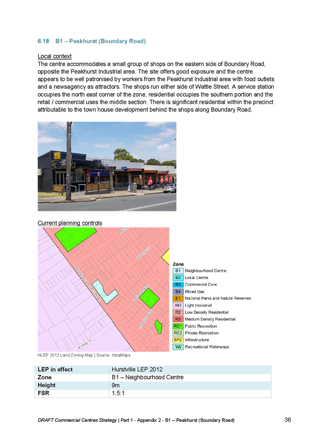

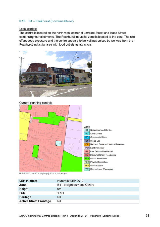


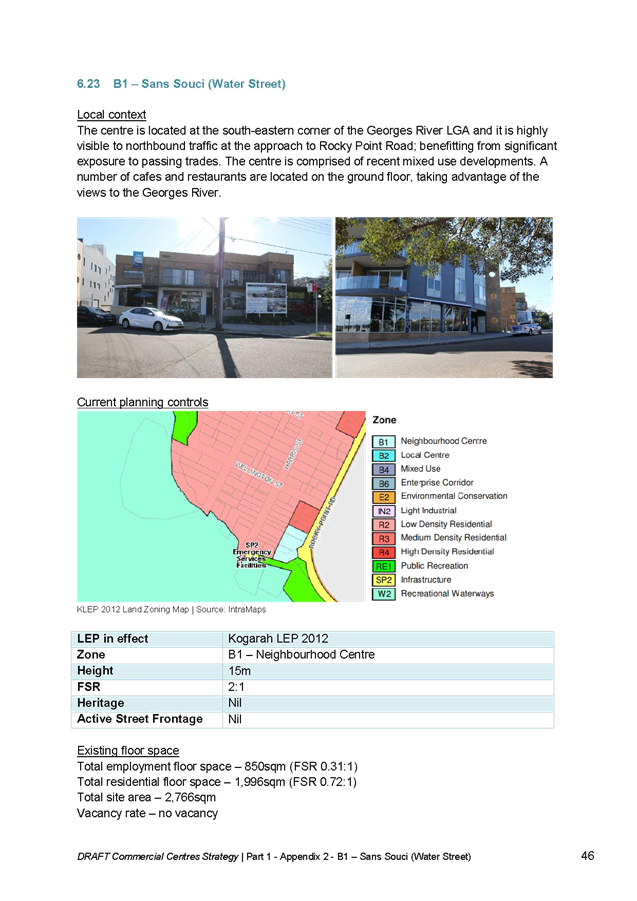

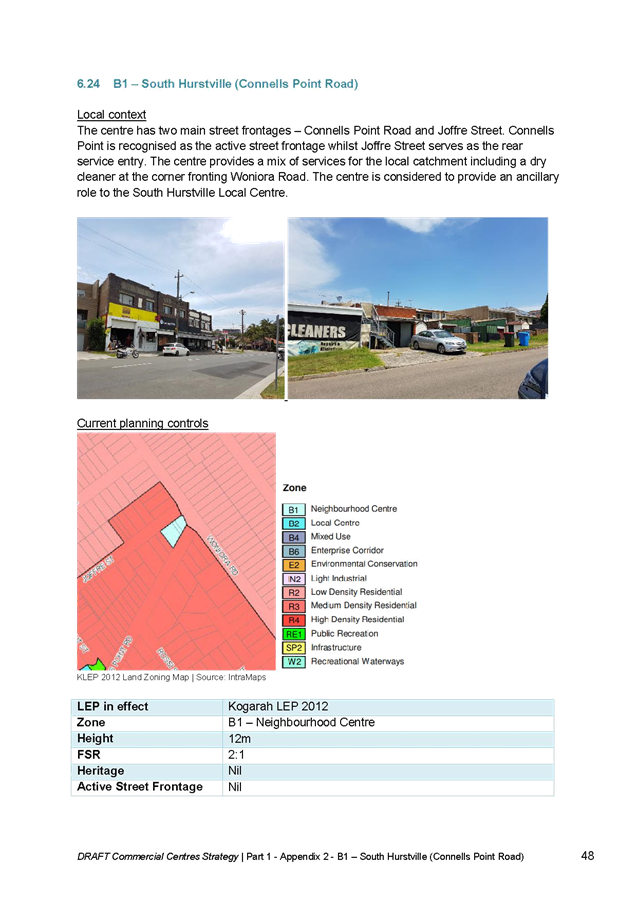
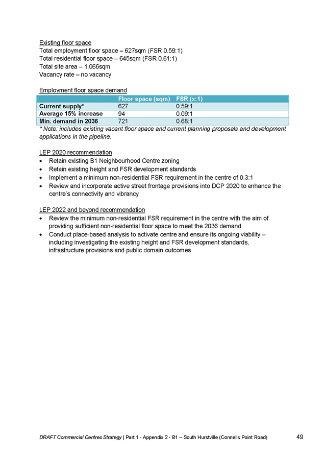
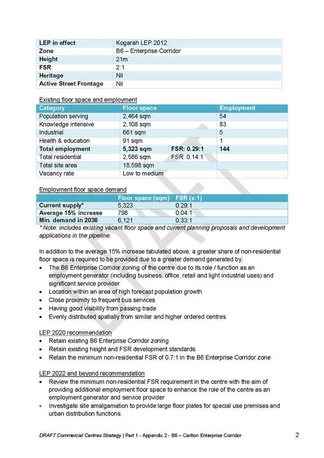
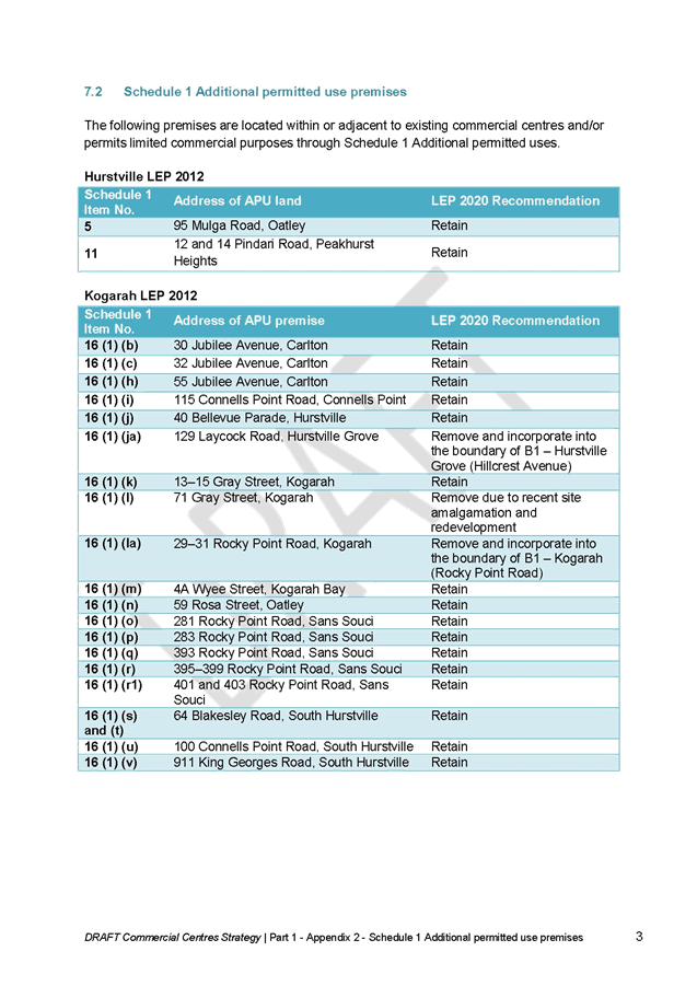
Item: ENV020-19 Evidence Base for Local Housing Strategy
Author: Strategic Planner
Directorate: Environment and Planning
Matter Type: Committee Reports
|
(a) That Council endorse the Georges River Council Evidence Base for the Local Housing Strategy for public exhibition as a supporting document for the draft Local Strategic Planning Statement 2040. (b) That the Georges River Evidence Base for Local Housing Strategy be publicly exhibited for a minimum period of 28 days alongside the draft Local Strategic Planning Statement 2040.
|
Executive Summary
1. An analysis of current and future population and housing trends was required to assist Council in the preparation of the Local Housing Strategy (including Inclusive Housing Strategy) and Local Strategic Planning Statement 2040.(LSPS)
2. The Local Housing Strategy is being prepared to address the South District Plan action to prepare a Local Housing Strategy and in March 2018, the State Government introduced legislation requiring councils to prepare LSPS.
3. The population consultants .id was engaged to provide the evidence base to inform the Strategy. They provided the demographic and housing analysis that shows the housing implications and future housing capacity of Georges River. (Attachment 1)
4. The report seeks Council’s endorsement to publicly exhibit the Georges River Evidence Base for the Local Housing Strategy alongside the draft LSPS 2040 as a supporting document.
Background
5. In March 2018, the State Government introduced legislation requiring councils to prepare a LSPS which will sets out:
a. The 20 year vision for land use in the local area;
b. The special characteristics which contribute to local identity;
c. Shared community values to be maintained and enhanced; and
d. How growth and change will be managed into the future.
6. The Greater Sydney Commission released the Greater Sydney Region Plan (A Metropolis of Three Cities) and South District Plan requiring Council to prepare a Local Housing Strategy to address the following;
a. Delivery of five year housing supply targets
b. Delivery of 6-10 year housing supply targets
c. Capacity to contribute to the longer term 20 year strategic housing targets
d. The housing strategy requirements outlined in Objective 10 of A Metropolis of Three Cities that include:
i. creating capacity for more housing in the right locations
ii. supporting planning and delivery of growth areas and planned precincts as relevant to each local government area
iii. supporting investigation of opportunities for alignment with investment in regional and district infrastructure
iv. supporting the role of centres.
e. Implement Affordable Rental Housing Targets
7. In preparing these documents an analysis of demographic factors and housing supply and trends are required.
8. The .id report provides an analysis of current and future population and housing trends, which that shows, with solid evidence, the housing implications and future housing capacity of Georges River. This will assist Council in preparing the Local Housing Strategy and LSPS 2040. (Attachment 1)
9. Workshops with Councillors on the development of the LSPS were delivered by Council staff in December 2018, February 2019, March 2019 and April 2019 in which key findings from the .id report where presented.
Structure of the .id report
10. The .id report comprises the following chapters:
· Introduction – This chapter includes the objective and policy context, approach and definitions
· Georges River Context – This chapter provides an overview on the development history, how Georges River is changing and the economic importance of housing.
· Population and Households – This chapter provides an analysis of past and future changes in age structure, migration and how households are changing and will change in the future.
· Dwellings, Tenure and Housing Stress – This chapter provides an analysis of dwelling mix and types, what dwellings households live in, housing tenure and housing stress in Georges River.
· Housing Demand – This chapter includes housing sales and rents and affordable housing for key workers.
· Residential Supply – This chapter includes where the residential development is occurring and the gaps between current supply and demand.
· Residential Capacity – This chapter provides a methodology and analysis of the areas in Georges River have development capacity.
· Policy implications – This chapter highlights the policy implications that faces Council in future policy and planning activities.
Key Findings and Policy Implications
Supporting ageing in place
11. An estimated population of 185,000 is forecast for 2036, with the largest increase in residents 60 years and older.
12. Significant growth in smaller households. High proportions of smaller households are in Lugarno, Oatley, Blakehurst, Kyle Bay and Connells Point.
13. Support services aiding the elderly to stay in their own homes longer is particularly important as ageing in place is a main trend.
Encouraging housing choices
14. There is a mismatch between the demand and supply of dwellings in Georges River. Small households are forecast to grow by 41%
15. There is limited choice for small dwellings that will suit the ageing population available outside of the growth areas of Hurstville and Kogarah.
16. Different forms of medium density housing are needed in a wider range of suburbs in Georges River in order to allow for the transition from mature families to empty nesters and older lone person households.
Need age diversification
17. The current housing supply of larger detached dwellings which older smaller households occupy does not become available to attract and retain younger households to the area.
18. Diversifying housing will free up the stock of three or more bedroom dwellings, increasing the range of dwelling choices for family households, the dominate household in the LGA.
19. Diversifying choice by facilitating alternative housing options is crucial to help maintain population levels and create more sustainable, equitable and healthy communities.
Addressing housing affordability
20. The rate of housing stress in Georges River is higher than the Greater Sydney average, especially for renters with very low or low incomes.
21. A diverse dwelling stock means a wider variety of price points within the housing market, which goes some way to addressing issues of housing affordability.
22. Consultants have been engaged to prepare an Inclusive Housing Strategy to provide appropriate provisions for the planning framework to encourage a diverse and affordable housing supply for the next 20 years.
Continue to encourage development along transport corridors
23. Residential development occurring in and around commercial centres and transport corridors provides residents easy access to amenities, services and public transport.
24. Design principles will also be important for maintaining livability outcomes and for ensuring that a proportion of housing is suitable for the elderly.
25. In new developments ensure dwelling mix is correct for the emerging households to enable residents to stay in the area.
Implication of LSPS
26. The analysis of current and future population and housing trends in the .id report informed the planning priorities, strengths and challenges and strategic context for Theme 3: Housing and neighbourhoods of the LSPS 2040.
27. The planning priorities for housing and neighbourhoods informed by the .id report are:
· A mix of well-designed housing for all life stages caters for a range of needs and incomes
28. The challenges informed by the .id report are:
· Mismatch in household composition and supply of dwellings
· Providing a supply of a diversity of housing
· Increasing the supply of inclusive/affordable housing stock for very low to medium income households (including key workers)
Implications of Local Housing Strategy
29. The analysis completed in the .id report established the evidence base and informed the objections and actions of the Local Housing Strategy.
30. The .id report indicated gaps in housing supply for example housing choice and diversification and gaps between forecast population growth and housing supply for example the mismatch between small households and small dwellings.
31. It also identified dwelling capacity which will provide a net gain of 12,134 dwellings and dwelling forecast for projected 2036 population of more than 185,000, we need to plan for an additional 14,000 new dwellings.
Next Steps
32. It is recommended that Council endorse the Georges River Evidence Base for Local Housing Strategy.
33. It is recommended that the Georges River Evidence Base for Local Housing Strategy be placed on public exhibition alongside the draft LSPS 2040.
34. The .id report provides the evidence base for the Local Housing Strategy which provides the analysis of current and future population and housing trends and the housing implications and future housing capacity of Georges River.
Financial Implications
35. Within budget allocation.
Risk Implications
36. No risks identified.
Community Engagement
37. Community engagement will be conducted as part of the draft LSPS 2040 as a supporting document from 26 June to 7 August 2019.
38. A total of 5 workshops and 5 drop-in events will be held across the LGA to allow the community to be involved. The draft LSPS and supporting documents will also be placed on Council’s ‘Your Say’ webpage.
File Reference
D19/123938
|
Attachment ⇩1 |
Georges River Evidence Base for Local Housing Strategy |
|
Georges River Council - Environment and Planning - Tuesday, 11 June 2019 ENV020-19 Evidence Base for Local Housing Strategy [Appendix 1] Georges River Evidence Base for Local Housing Strategy |
Page 428 |
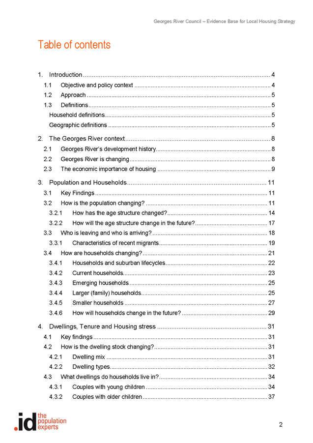
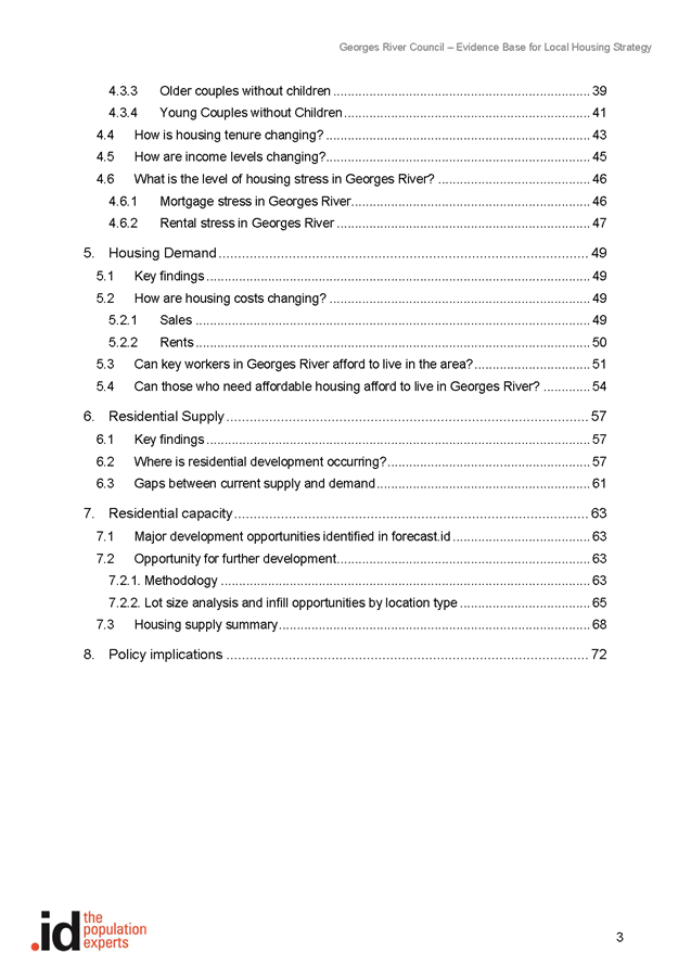
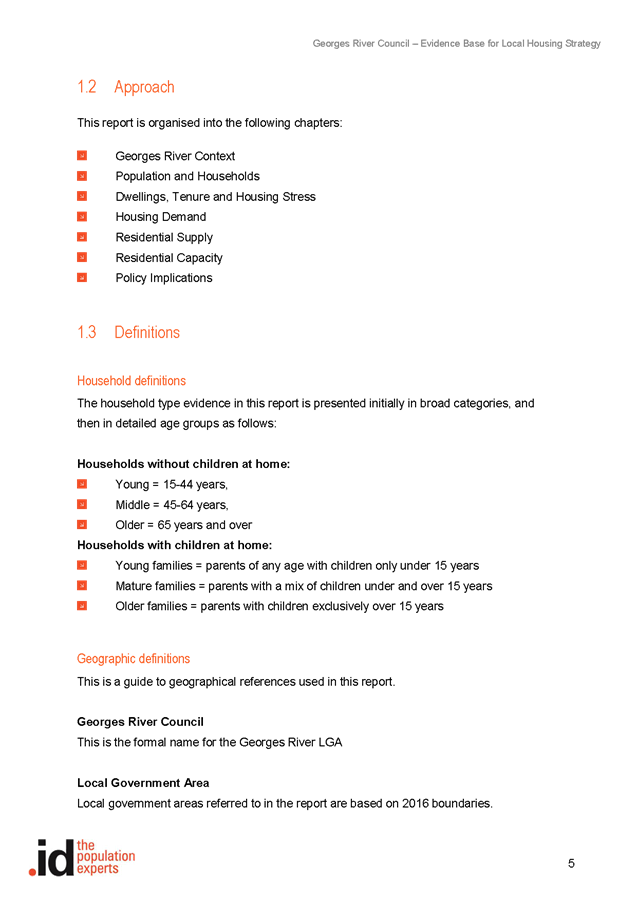

Item: ENV021-19 Georges River Inclusive Housing Strategy and Delivery Program
Author: Senior Strategic Planner
Directorate: Environment and Planning
Matter Type: Committee Reports
|
That Council endorse the Georges River Inclusive Housing Strategy - Stage 1 report: Assessment of housing needs for exhibition as a supporting document for the Local Strategic Planning Statement.
|
Executive Summary
1. Council engaged the consultant Hill PDA in December 2018 to prepare the Inclusive Housing Strategy and Delivery program for the Georges River Local Government Area (LGA).
2. The Inclusive Housing Strategy aims to:
a. promote diversity, equity, liveability and sustainability within the Georges River LGA; and
b. facilitate the provision of housing options and provide mechanisms for delivery to meet the needs of the very low, low and moderate income households as well as the wide range of users, including households in housing stress, seniors, people with disabilities, students, key workers and the broader residential market.
3. Georges River Council is preparing a number of studies that will inform Council’s Local Strategic Planning Statement (LSPS) 2040 and the Local Environmental Plan (LEP) process. One of the key studies is the Local Housing Strategy which will plan for additional housing. The recommendations and the Delivery Plan of the Inclusive Housing Strategy will clarify Council’s position on the delivery of inclusive housing within the LGA and inform the Local Housing Strategy.
4. Hill PDA are finalising the Inclusive Housing Strategy. Accordingly, it is recommended that Council endorse the findings of the Stage 1 report – Assessment of housing needs (Stage 1 Report) of the Inclusive Housing Strategy. The Stage 1 Report will be exhibited as a supporting document with the Local Strategic Planning Statement, which will be exhibited during June-August 2019. It is anticipated that the complete Report on the Inclusive Housing Strategy will be exhibited along with the Georges River LEP.
Background
5. One of the objectives of the Environmental Planning and Assessment Act 1979 is the delivery and maintenance of affordable housing. The metropolitan plan for Sydney – The Greater Sydney Region Plan and the South District Plan support this objective. Objective11 - Housing is more diverse and affordable of the Region Plan and Planning Priority S5 - Providing housing supply, choice and affordability, with access to jobs, services and public transport of the South District Plan resonate the provision of affordable housing in our local government area (LGA).
6. The NSW Government’s key policies that facilitate and encourage the development of new affordable housing and the maintenance of existing affordable housing include:
· State Environmental Planning Policy (Affordable Rental Housing) 2009 (ARH SEPP)
· State Environmental Planning Policy No 70 - Affordable Housing (Revised Schemes) (SEPP 70)
7. In February 2019, SEPP 70 was expanded to include all councils across NSW. This amendment removes the administrative step of entering a LGA into SEPP 70, thereby expediting councils' ability to investigate and develop an Affordable Housing Contributions Scheme (AHCS). This AHCS is a key document to formalise affordable housing contribution targets within Council’s LEP (Refer Figure 1). The AHCS currently relates to only Planning Proposals and maybe expanded to include infill development.

Figure 1: Process for preparing an affordable housing contributions scheme
8. The NSW Government required Councils to review and amend their Local Environmental Plans (LEPs) as soon as practicable after a District Plan is made. The Greater Sydney Region Plan and the District Plans were released in March 2018. Within the Georges River LGA, over the next 20 years, Council will need to make provision for approximately 14,000 new homes and 13,000 additional jobs to support growth. Council has a housing supply target of 4,800 additional homes within the LGA, up to 2021.The District Plan states that a 5-10% new residential floor space (subject to viability) is to be affordable housing.
9. Georges River Council is preparing a number of studies that will inform the LEP process. One of the key studies is the Local Housing Strategy which will detail how and where additional housing will be provided in the LGA.
10. On 27 November 2017, a Notice of Motion NM021-17: Georges River Council Affordable Rental Housing Policy was prepared and Council resolved:
That the General Manager prepare a report for Council that provides information on:
(a) The process that Council will need to follow to prepare an Affordable Rental Housing Policy for the Georges River Local Government Area taking into consideration the actions from the Draft Greater Sydney region Plan and the Revised Draft South District Plan.
(b) That Council commence the preparation of Affordable Rental Housing Policy and associated implementation plan for the Georges River Local Government Area taking into consideration the actions of the Draft Greater Sydney Region Plan and the Revised Draft South District Plan requiring the preparation of Affordable Rental Housing Target Schemes.
(c) That the Policy identify and assess the housing issues within the City and identify mechanisms to increase the supply of affordable housing for households on low to moderate incomes in housing stress.
(d) That the outcomes of the strategic research and the resultant Policy provisions be implemented via Council’s planning framework (such as LEPs, DCPs, VPAs, Section 94 Contributions Plans, etc) to increase the supply of affordable rental housing in the city.
(e) That Council allocate funds as part of the 2018/2019 budget process to fund the cost of preparing the Policy.
11. Council engaged Hill PDA in December 2018 to prepare the Inclusive Housing Strategy and delivery program for the Georges River Local Government Area (LGA). The recommendations and the Delivery Plan of the Inclusive Housing Strategy support the deliverables and will inform the Local Strategic Planning Statement and the Local Housing Strategy.
12. The key aims of the Inclusive Housing Strategy are to:
· To research and develop strategies to increase affordable housing supply for a range of households including the very low to moderate income households, seniors, people with a disability, students, key workers and the broader residential market
· To encourage the provision of affordable, adaptable and diverse housing
· To develop planning controls and mechanisms that prevent the loss of existing and deliver new supplies of affordable housing
· To advocate for, and build partnerships to increase, affordable and liveable housing
· To explore options for managing affordable housing.
13. The Inclusive Housing Strategy and Delivery Plan will be a standalone document which will inform the Local Housing Strategy. It will be a key component to the delivery of inclusion of affordable/inclusive housing for the whole Georges River Community and will ensure that Council’s Local Housing Strategy reflects and promotes this position. The Delivery Plan in the Strategy provides a number of mechanisms that encourage and support Inclusive Housing.
14. The Inclusive Housing Strategy and Delivery Plan is being finalised by Hill PDA. Accordingly, the Stage 1 Report – Assessment of housing needs (Appendix 1) is attached to this Report. The Stage 1 Report is informed by the evidence base prepared by population consultants .id for the Local Housing Strategy. They provided the demographic and housing analysis that shows the housing implications and future housing capacity of Georges River. A Report on the Evidence base for the Local Housing Strategy is being presented to the Environment and Planning Committee on 11 June 2019.
15. The Stage 1 Report (Appendix 1) has been broadly structured under the following heads:
· Demographic Overview
· Key Demographics
· Housing costs
· Housing stress
· Projections
· Key findings
16. The final draft of the Inclusive Housing Strategy and the supporting Delivery Plan is underway. However, it is considered important for the Council to have an understanding of the actions being proposed to address the affordable housing needs within the LGA. The proposed goals, strategies and actions in the draft Delivery Plan are outlined in Table 1 below:
|
No. |
Goal |
Strategy |
Actions |
|
1 |
Establish a policy position that supports the delivery of inclusive housing |
1.1: Incorporate inclusive housing in Council’s Local Strategic Planning Statement |
1.1.1: Specify the delivery of inclusive and affordable housing as a priority in Council’s forthcoming Local Strategic Planning Statement. 1.1.2: Revise Council planning documents and website to reflect Council’s policy position on affordable housing. 1.1.3: Produce promotional material on inclusive and affordable housing.
|
|
2 |
Facilitate the provision of affordable housing
To establish affordable housing targets for the LGA as follows:
2020-2025 14 affordable dwellings per year
(70 over five years=2%)
2025-2030 24 affordable dwellings per year
(120 over five years=4%)
2030-2040 34 affordable dwellings per year
(340 over ten years =11%)
Notes: 1. The targets are approved dwellings. 2. The target years will be based on financial years.
|
2.1: Require an affordable housing contribution on sites experiencing a planning uplift
|
2.1.1: Prepare an Affordable Housing Contributions Scheme (AHCS) pursuant to SEPP 70. 2.1.2: Identify areas to experience a zoning uplift where affordable housing contributions can apply. 2.1.3: Prepare a planning proposal to include in the forthcoming comprehensive Georges River Local Environmental Plan 2.1.4: Undertake a 5 and 10 yearly review of the Affordable Housing Contributions Scheme and LEP. 2.1.5: Require affordable housing contributions as part of a Voluntary Planning Agreement on any sites with a planning uplift LEP is amended (strategy 2.1.3).
|
|
|
|
2.2: Require an affordable housing contribution on infill development in some situations
|
2.2.1: Discuss with DPI the inclusion of infill development in the Affordable Housing Contributions Scheme 2.2.2: Prepare a planning proposal to amend the Local Environmental Plans or include in the forthcoming comprehensive Georges Rover Local Environmental Plan. 2.2.3: Monitor the delivery of affordable housing through this mechanism. 2.1.4: Identify opportunities to deliver inclusive housing as part of the Kogarah Health and Education Precinct.
|
|
|
|
2.3: Establish appropriate administrative and fund management procedures |
2.3.1: Establish an Affordable Housing Fund. 2.3.2: Establish appropriate practices for the dedication and management of affordable dwellings. 2.3.3: Establish a strong working relationship with community housing providers. |
|
|
|
2.4: Enhance Council’s knowledge of affordable housing practices. |
2.4.1: Undertake regular training sessions. 2.4.2: Allocate affordable housing responsibilities to a dedicated team member(s).
|
|
3 |
Facilitate housing choice. |
3.1: Investigate options for Council to deliver inclusive housing, including build to rent schemes on Council owned land.
|
3.1.1: Undertake a property strategy to identify Council sites suited to inclusive housing project(s). 3.1.2: Partner with Government and or developer in joint venture projects on selected sites. 3.1.3: Consider the use of Council owned land for a pilot build-to rent scheme.
|
|
|
|
3.2: Plan for low rise medium density housing in suitable locations.
|
3.2.1: Review zoning in the vicinity of rail stations. |
|
|
|
3.3: Encourage infill affordable housing through SEPP (Affordable Rental Housing) 2009. |
3.3.1: Deliver inclusive housing through incentives in SEPP (ARH) 2009. 3.3.2: Promote the incentives in SEPP (ARH) 2009 through and communications materials targeted to developers.
|
|
|
|
3.4: Encourage a mix of dwelling types and apartment sizes. |
3.4.1: Amend development controls plans to require a mix of dwelling sizes. 3.4.2: Investigate and monitor opportunities to allow more apartments in selected locations. 3.4.3: Undertake feasibility assessment to determine capacity for redevelopment in selected areas dominated by 3 storey walk up flats. 3.4.4: Encourage adaptive reuse of large homes to smaller dwellings in the southern parts of the LGA. 3.4.5: Prepare a design manual for revitalising older apartments and associated promotional materials. 3.4.6: Identify a trial location for build to rent scheme.
|
|
|
|
3.5: Retain affordable housing stock.
|
3.5.1: Investigate mechanisms to retain existing affordable and low cost housing.
|
|
|
|
3.6: Develop precinct specific responses to encourage inclusive housing.
|
Have specific actions for the following precincts: 3.4.1: Kogarah Health and Education Precinct. 3.4.2: Riverwood centre. 3.4.3: Hurstville and Allawah. 3.4.4: Oatley West/Mulgoa Road Precinct. 3.4.5: Beverly Hills – Narwee – Kingsgrove corridor.
|
Table 1: Goals, Strategies and Actions in the Draft Delivery Plan
Next steps
17. It is recommended that Council endorse Georges River Inclusive Housing Strategy - Stage 1 report: Assessment of housing needs for exhibition (June to August 2019) as a supporting document for Council’s Local Strategic Planning Statement.
18. The Local Housing Strategy will be briefed to the Councillors on 27 July 2019.
19. The completed draft Inclusive Housing Strategy and Delivery Plan is anticipated to be reported to Council later in 2019 and placed on public exhibition alongside the comprehensive LEP.
Financial Implications
20. Within budget allocation.
Risk Implications
21. No risks identified.
Community Engagement
22. Council’s draft Local Strategic Planning Statement (LSPS) 2040 and supporting studies will be exhibited from 26 June to 10 August 2019. The supporting studies include the Georges River Inclusive Housing Strategy - Stage 1 report: Assessment of housing needs and the Evidence base for Local Housing Strategy.
File Reference
17/1409
|
Attachment ⇩1 |
Georges River Inclusive Housing Strategy - Stage 1 report: Assessment of housing needs - March 2019 |
|
Georges River Council - Environment and Planning - Tuesday, 11 June 2019 ENV021-19 Georges River Inclusive Housing Strategy and Delivery Program [Appendix 1] Georges River Inclusive Housing Strategy - Stage 1 report: Assessment of housing needs - March 2019 |
Page 575 |
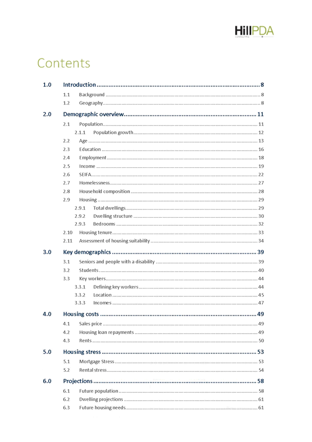
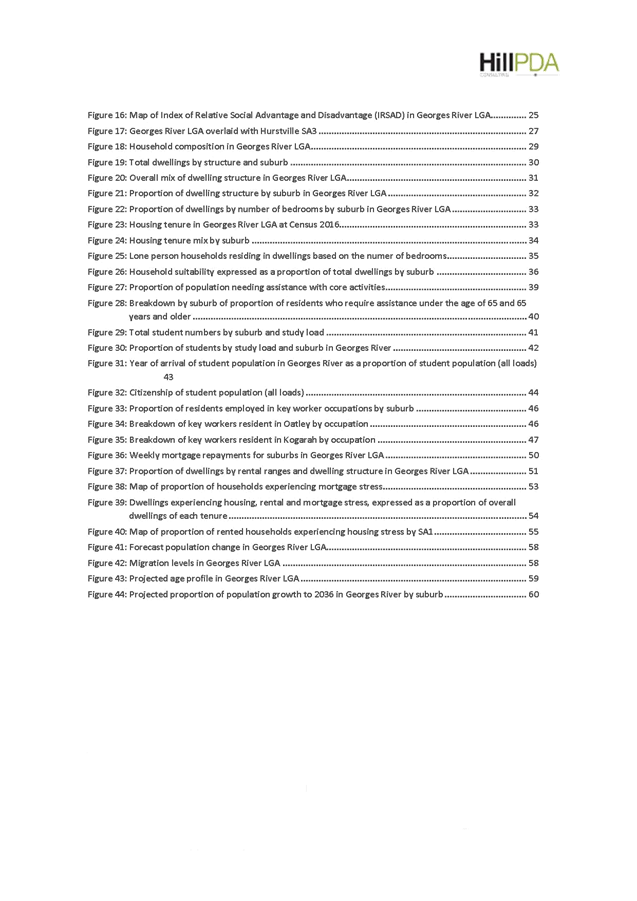


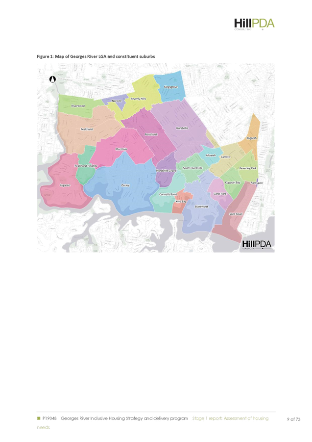

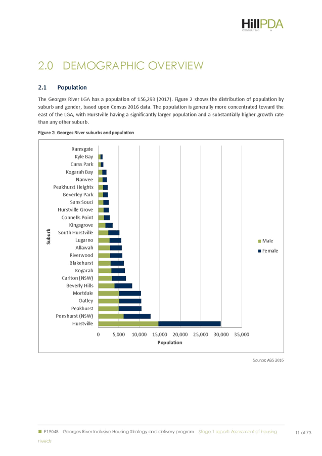
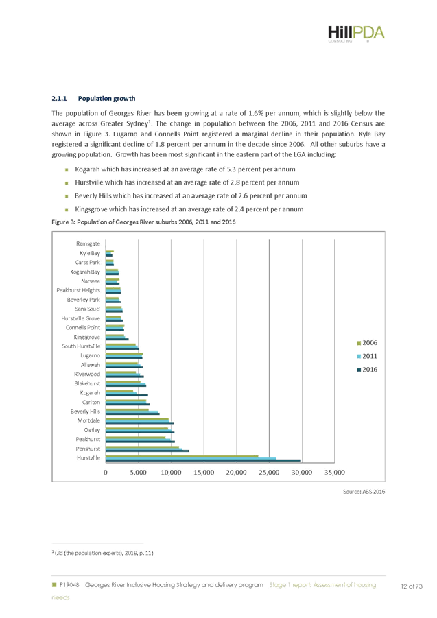
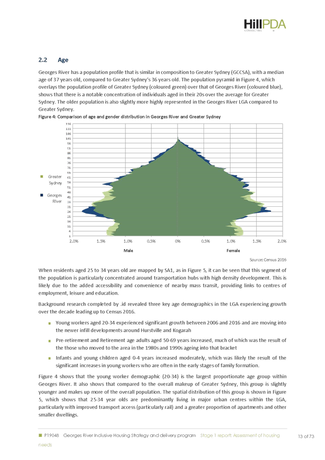

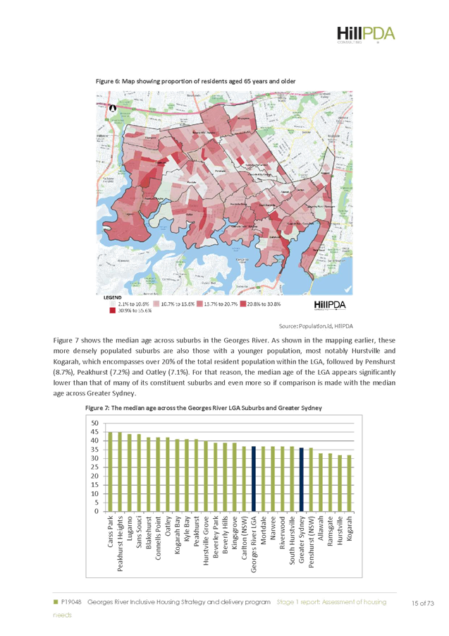

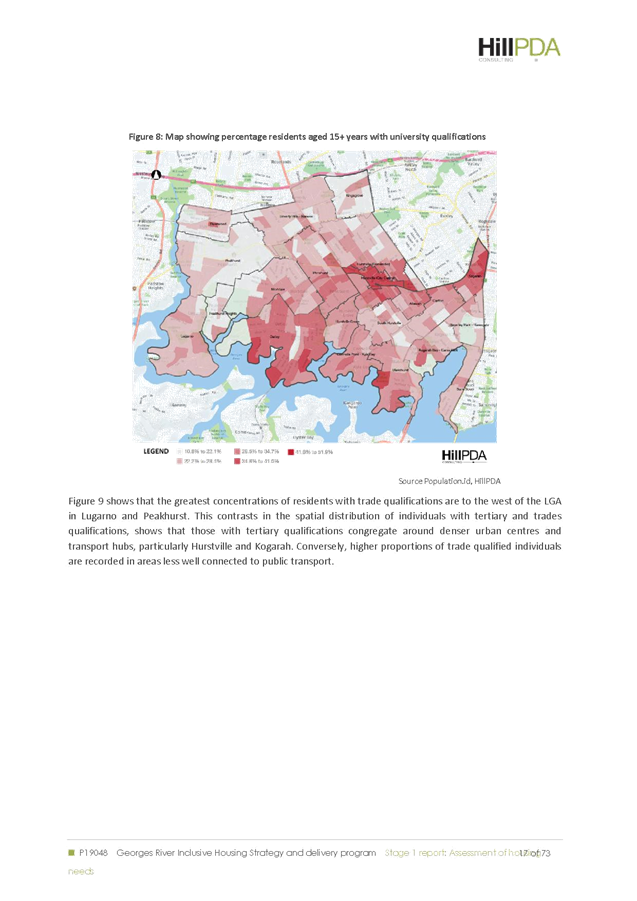
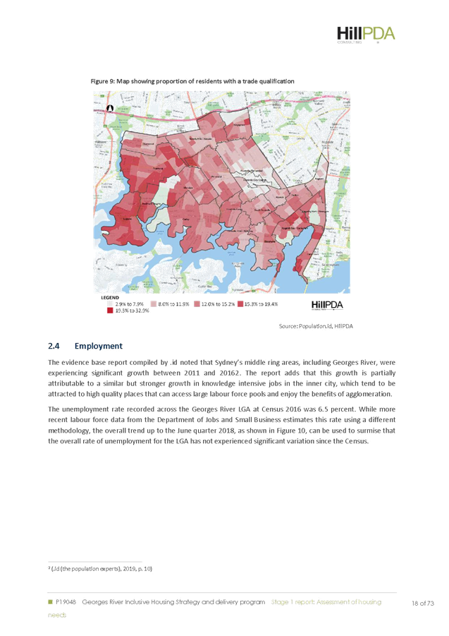
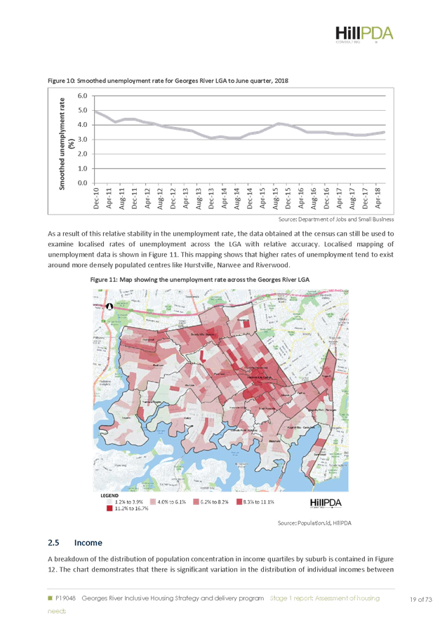
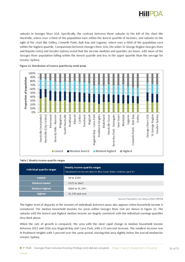
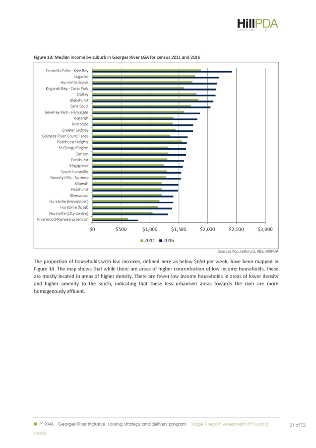
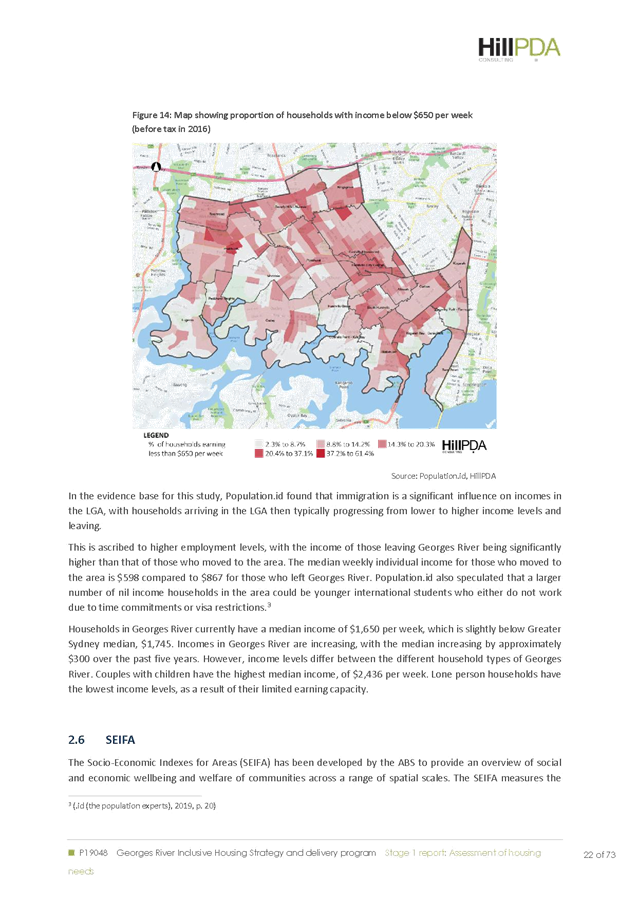
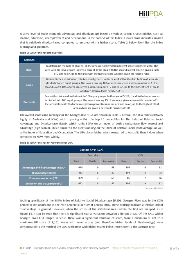
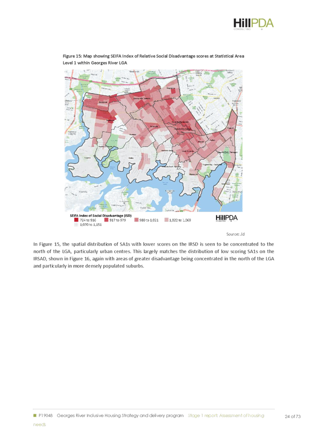
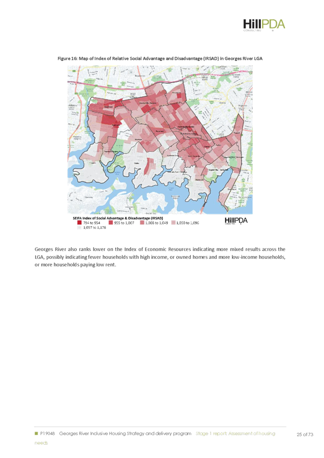
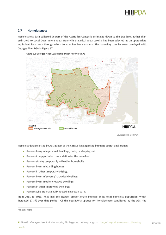
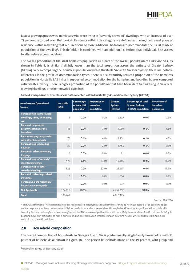
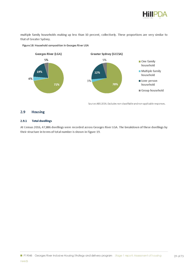
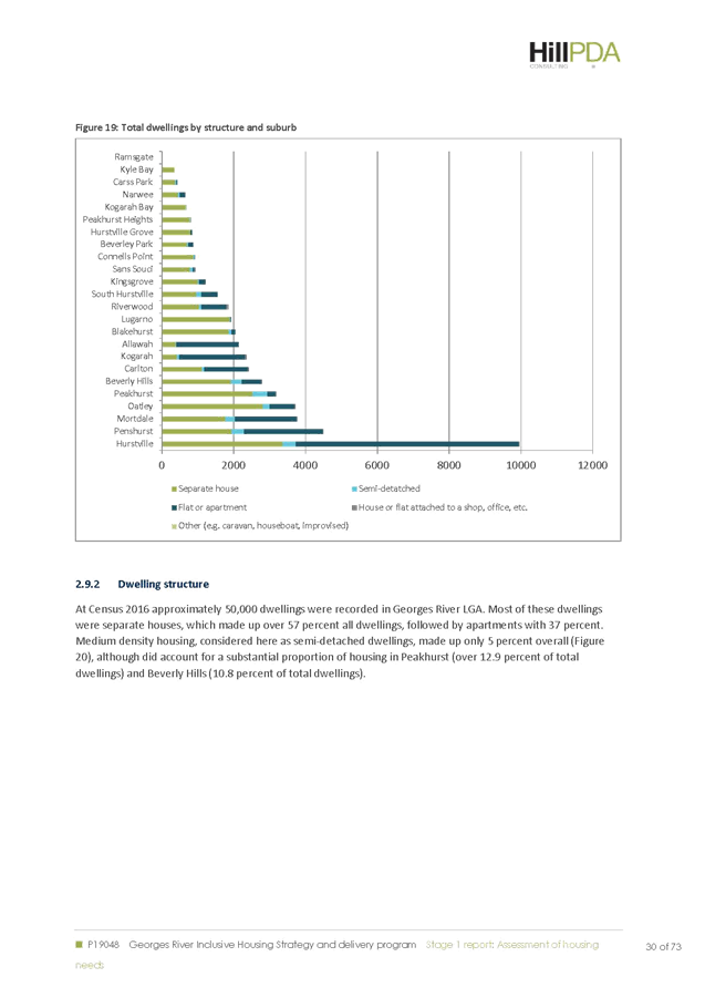
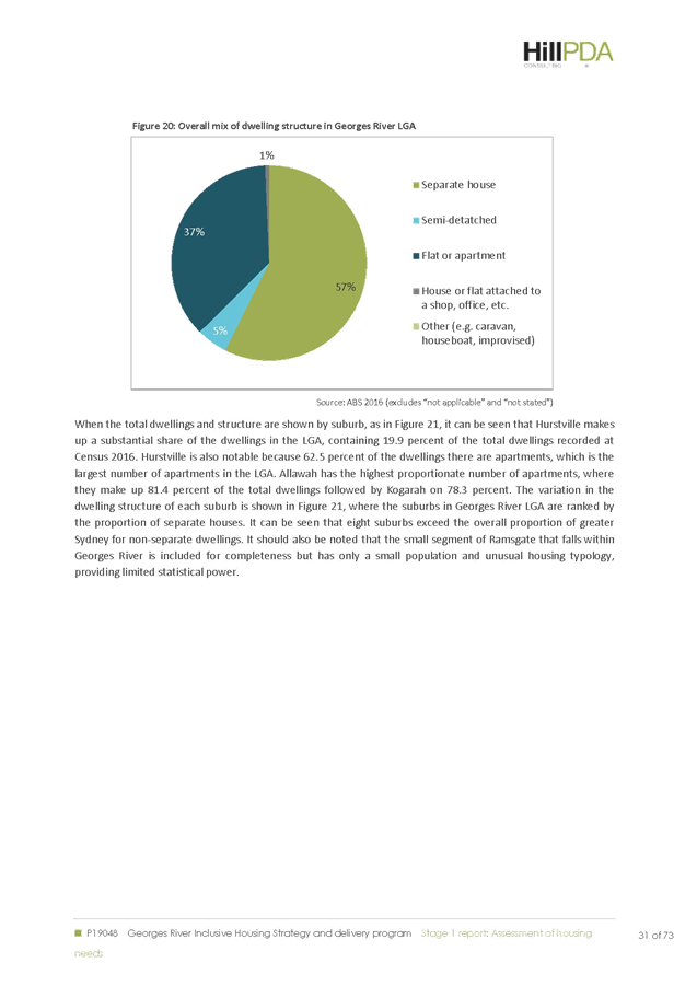
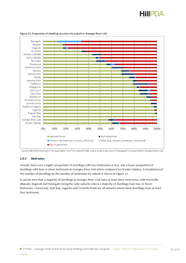
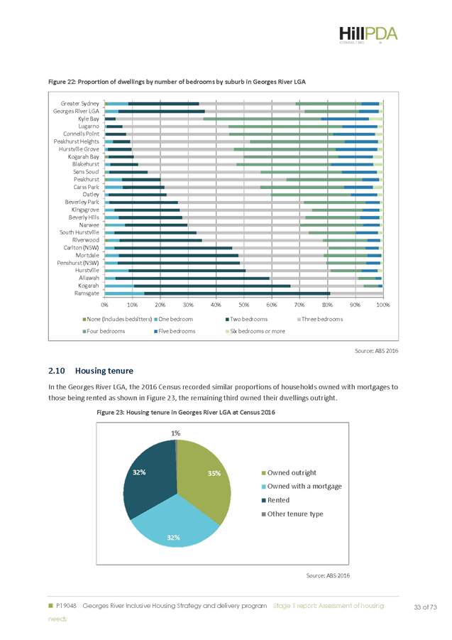
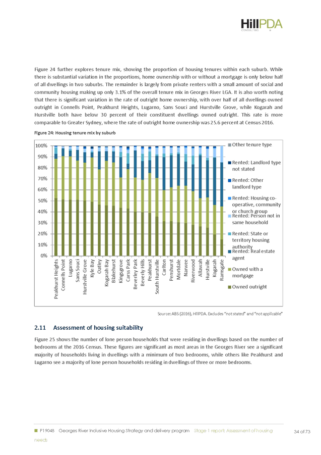
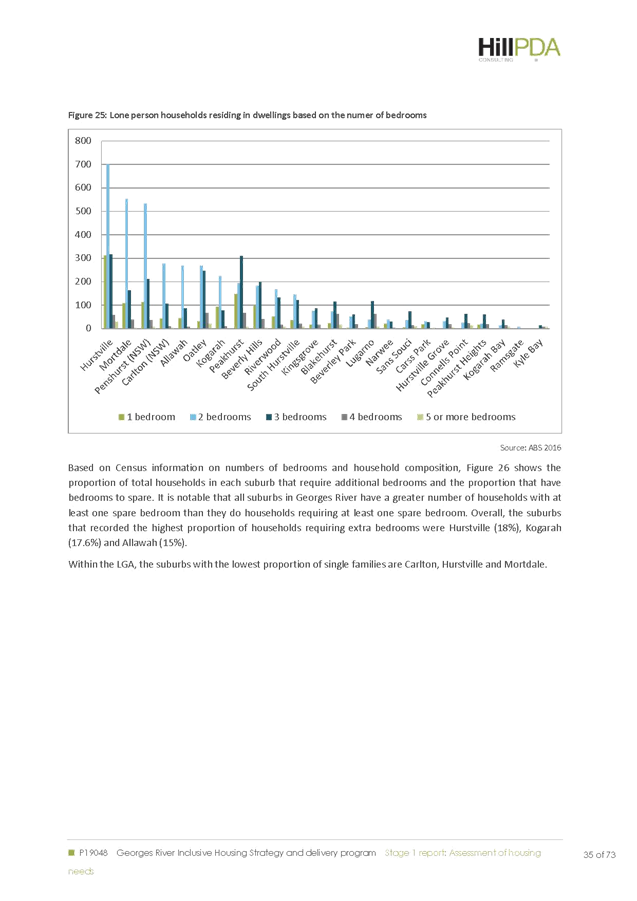
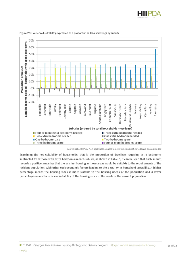
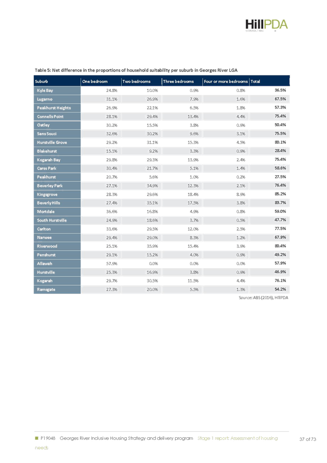

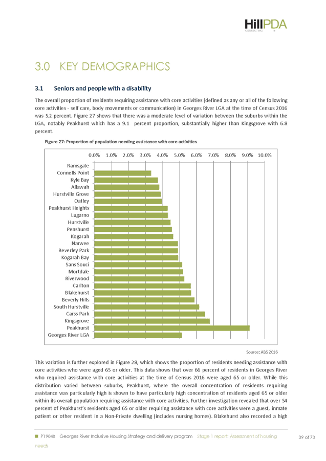
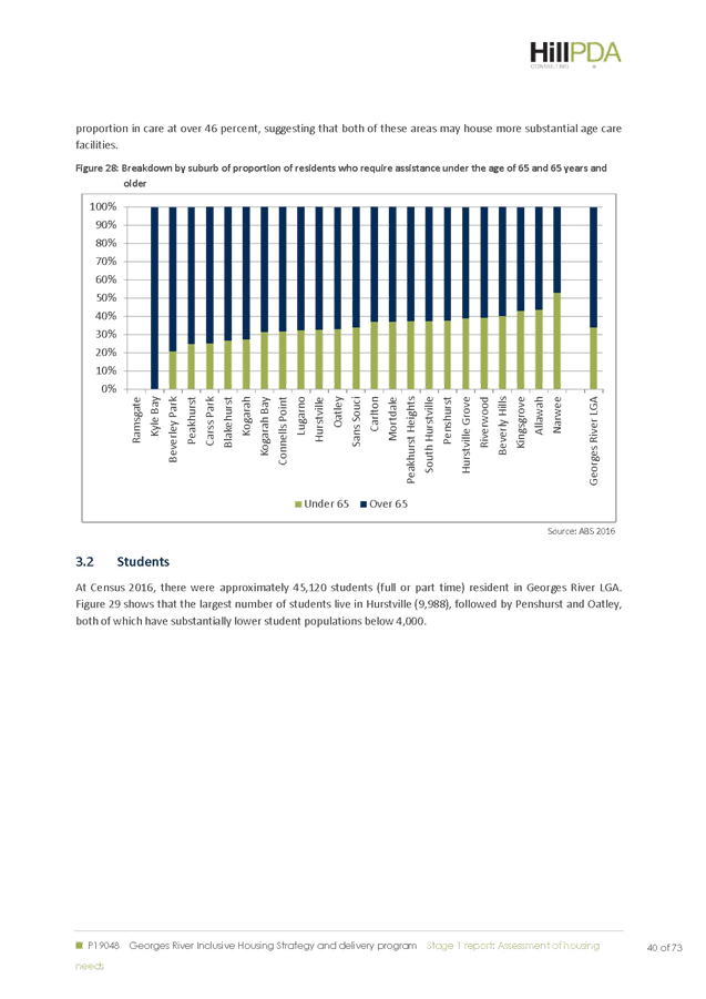
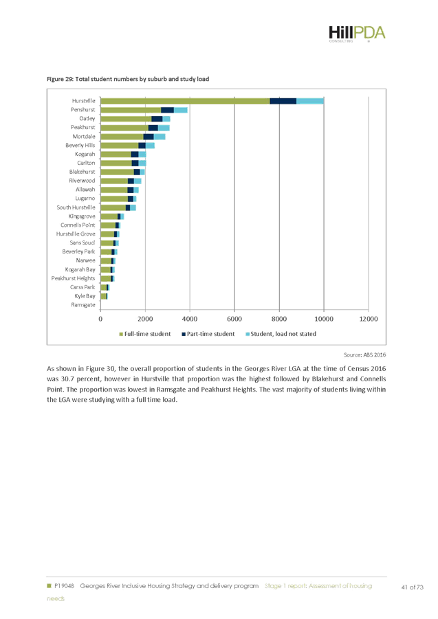
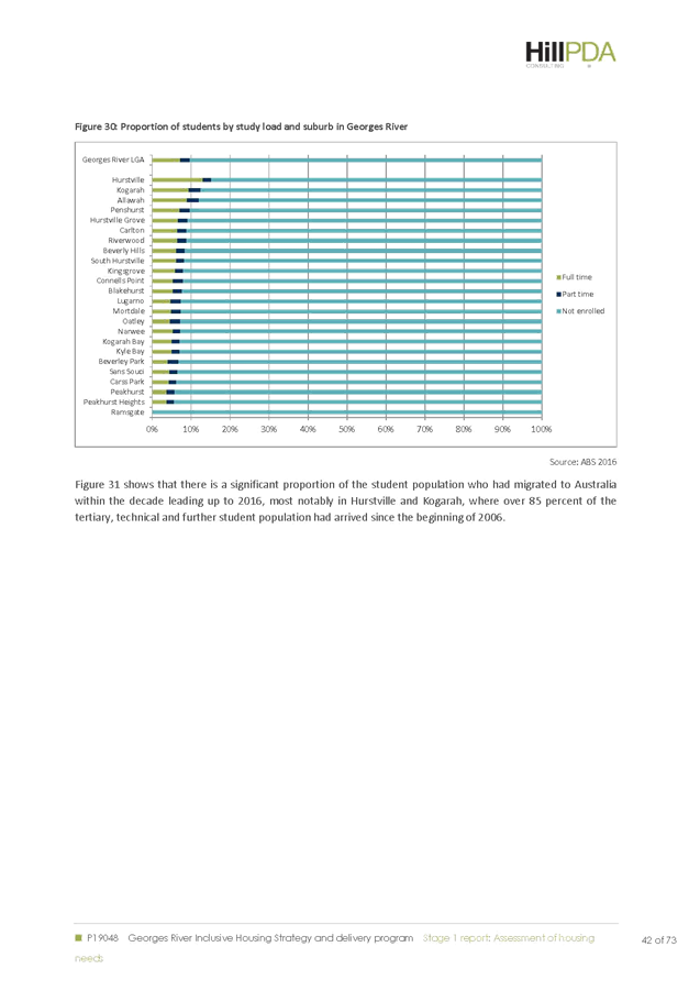
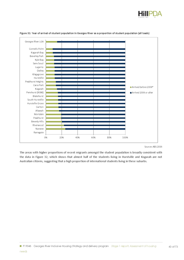
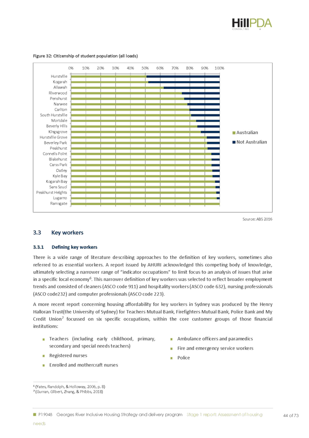
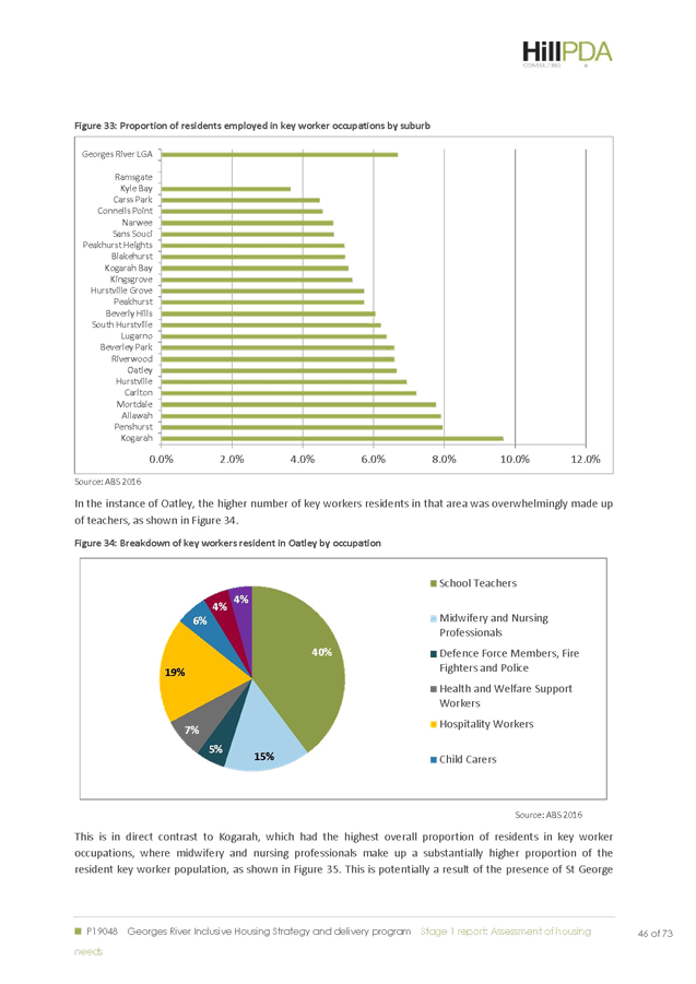
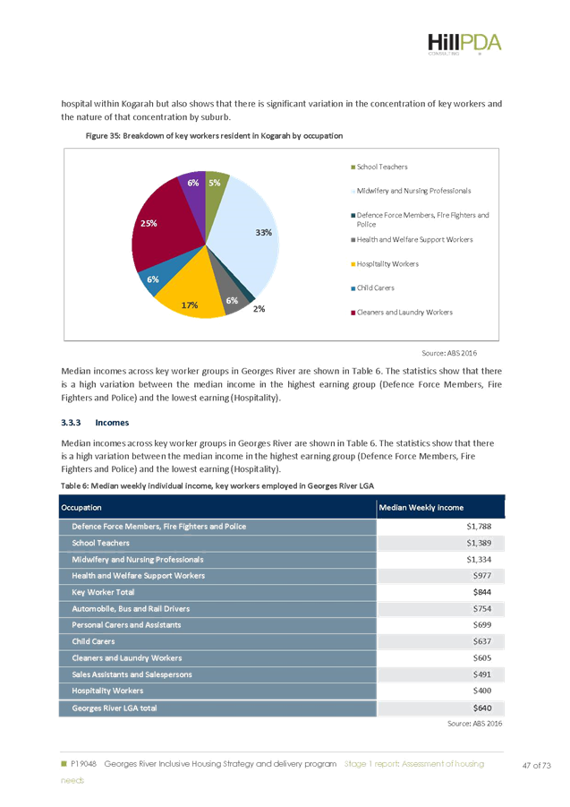

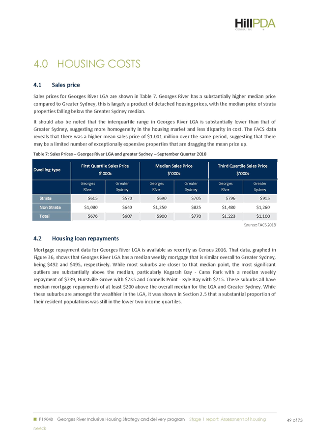
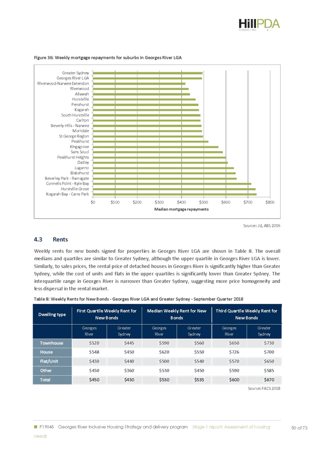
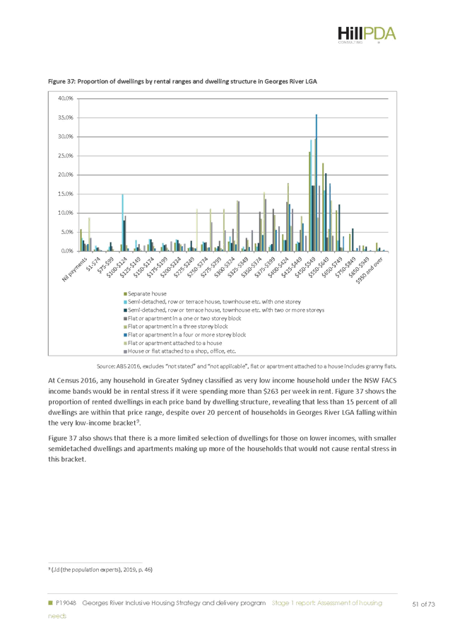
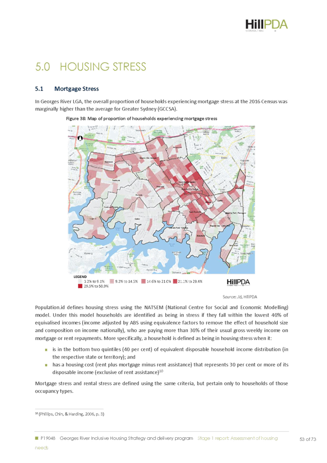
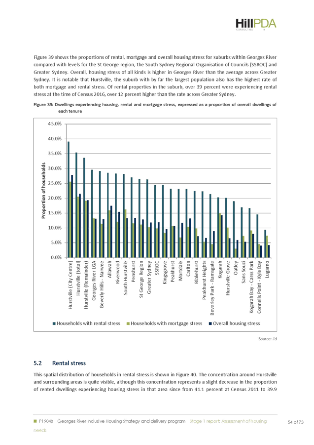
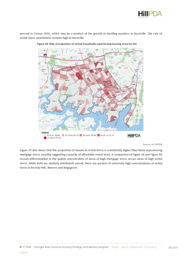
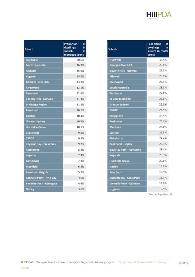

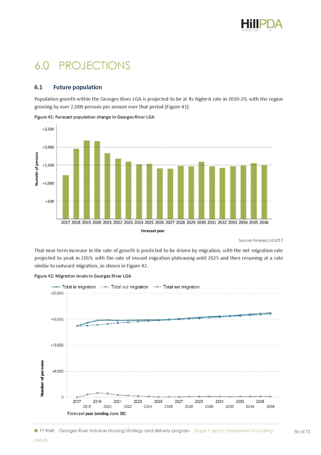
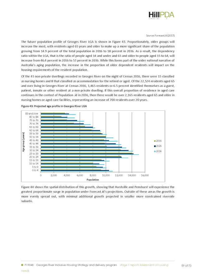
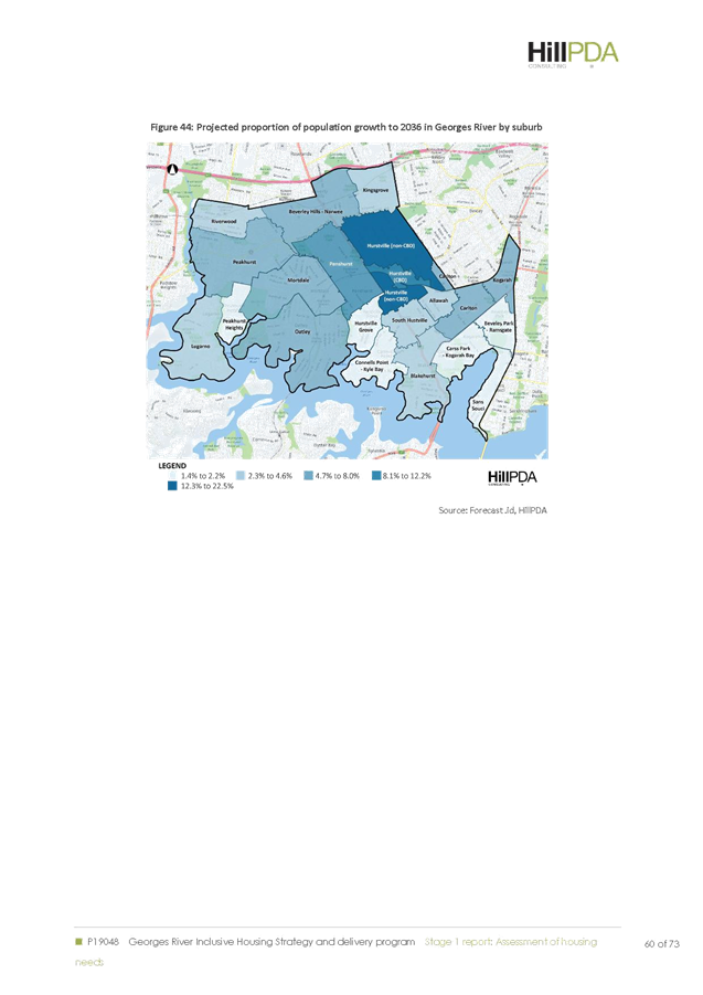
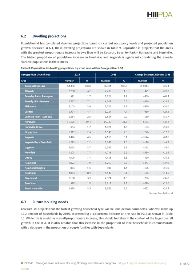
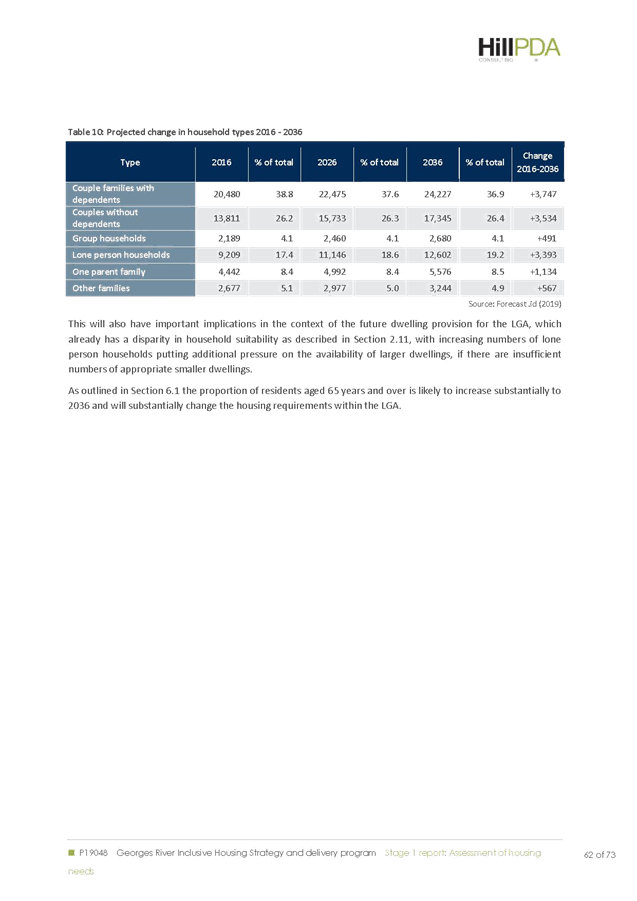

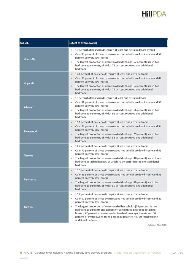
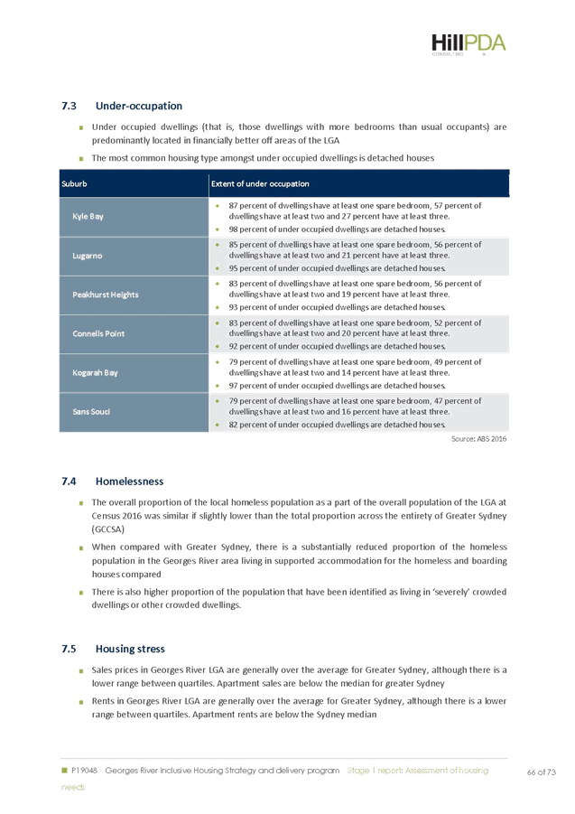


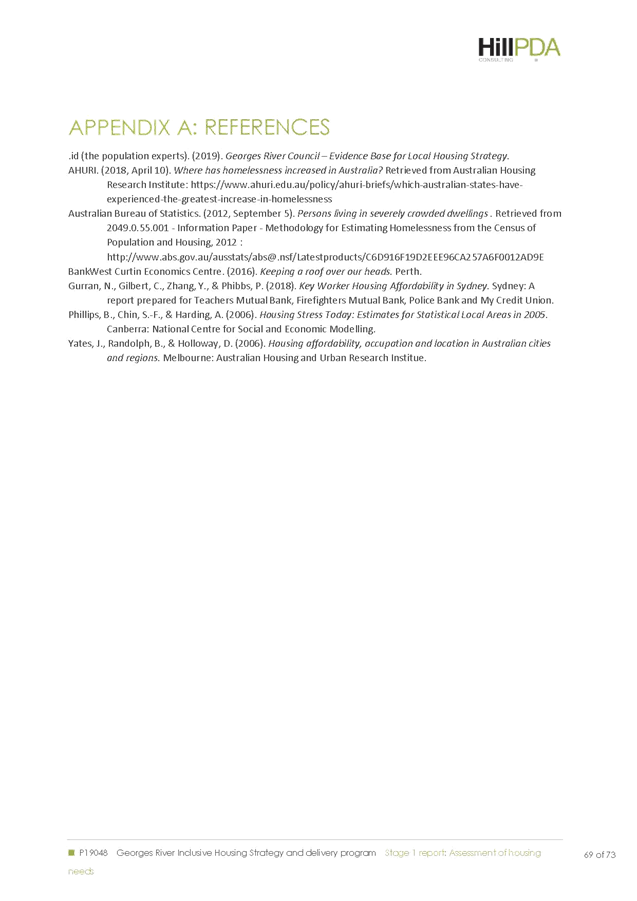
Item: ENV022-19 Hurstville City Centre Transport Management and Accessibility Plan - TMAP 2018
Author: Senior Strategic Planner
Directorate: Environment and Planning
Matter Type: Committee Reports
|
(a) That Council endorse the Hurstville City Centre Transport Management and Accessibility Plan 2018 as a strategic planning document, which will inform the preparation of development contributions plans, assessment of planning proposals / development applications and negotiations of Voluntary Planning Agreements. (b) That Council work with the transport authorities in relation to specific recommendations in the Hurstville City Centre Transport Management and Accessibility Plan 2018 Report. (c) That Council inform the Department of Planning, Industry and Environment, Transport for NSW and Roads and Maritime Services of Council’s decision.
|
Executive Summary
1. Council engaged the consultant GHD in September 2017 to update the Hurstville City Centre Transport Management and Accessibility Plan, originally prepared in 2013.
2. The purpose of the Hurstville City Centre Transport Management and Accessibility Plan 2018 (TMAP 2018) (refer Attachment 1) is to:
a. assess the proposed land use changes from development applications, planning proposals and the Hurstville City Centre Urban Design Strategy (HCCUDS);
b. provide a comprehensive assessment of the transport impacts of forecast land use development; and
c. identify a package of appropriate transport measures for the Hurstville City Centre, which would help manage the future demand for travel.
3. The TMAP 2018 states that demand for travel is expected to increase in Hurstville, due to its status as a Strategic Centre and significant land use densification under the South District Plan 2018. Although Hurstville has good public transport links, it has a high car-based mode share.
4. The TMAP 2018 notes that overall, the proposed changes from the development applications, planning proposals and the HCCUDS are considered suitable within the context of Sydney’s growing population. Travel Demand Management (TDM - Encourage travel patterns that are tailored to the capacity of the network and help manage congestion with mobility pricing reform and demand management initiatives), enhanced active transport facilities and fast, efficient and reliable public transport services will be key to managing the additional demand and limiting the overall impact on the road network.
5. The TMAP proposes an Action Plan that details a range of suggested measures across 5 categories: Land Use, Road Network, Public Transport, Active Transport and Travel Demand Management.
6. It is recommended that Council endorse the Hurstville City Centre TMAP 2018 as a strategic planning document. The TMAP will be used to inform the preparation of development contribution plans, assessment of planning proposals / development applications and discussions /negotiations relating to Voluntary Planning Agreements.
Background
7. Council engaged the consultant GHD in September 2017 to update the Hurstville City Centre Transport Management and Accessibility Plan (TMAP) building on work carried out for the original TMAP in 2013.
8. The TMAP 2013 informed the planning controls contained in the Hurstville City Centre LEP (Amendment No. 3 to HLEP 2012) in response to the vision for Hurstville as a major Centre for the South District. Since the TMAP was finalised in 2013, a number of changes to the planning controls and significant development has occurred within the Hurstville City Centre; inconsistent with the original modelling. As the cumulative effect of these developments is greater than the sum of its parts, the TMAP 2013 was required to be updated.
9. The key objectives of the Hurstville City Centre TMAP 2018 (refer Attachment 1) include:
· modelling the current major development applications and planning proposals and their implications for traffic management in the Hurstville City Centre;
· modelling the Hurstville City Centre Urban Design Strategy recommendations and proposed changes to the development standards; and
· identifying a package of transport measures which could help manage the future travel demand for the Hurstville City Centre.
10. The Sydney metropolitan plan, The Greater Sydney Region Plan – A Metropolis of three Cities and the South District Plan nominate Hurstville as a Strategic Centre. Over the next 20 years, Council will need to make provision for approximately 14,000 new homes and 13,000 additional jobs to support growth within the Georges River LGA. Council has a housing supply target of 4,800 additional homes within the LGA, up to 2021.
11. The South District Plan estimates that the City Centre had 11,600 jobs in 2016, with a forecast at 2036 of 15,000 and 20,000 (baseline and higher target respectively), indicating a significant increase.
12. This additional growth will lead to capacity constraints on the existing road network, principally on King Georges Road, which although outside the City Centre itself, acts as a pinch point for the network and may inhibit access to and from Hurstville. Other locations also lead to traffic delays, including Railway Parade, Woniora Road, Treacy Street, Queens Road and Park Street. The constraints at these locations are likely to worsen with increased development and mitigation measures need to be considered.
13. The transport infrastructure will require some capacity enhancements to cater for the additional demands, with travel demand management, enhanced active transport facilities and fast, efficient and reliable public transport services being key. Encouraging public transport, active transport use and travel demand management are critical to limiting the overall impact on the road network. This will subsequently limit the requirements for significant amounts of additional road capacity.
14. The TMAP 2018 identifies a package of appropriate transport measures for the Hurstville City Centre, which would help manage the future travel demand. These measures; which are discussed later in this report, relate to land use, road network, public transport, active transport and travel demand management.
15. The TMAP 2018 is set over a 20 year planning horizon (up to 2036) and it is recognised that some of the development potential within the HCCUDS may be realised beyond this date. The delivery of land use is likely to be driven by the needs of the market that Hurstville serves and is likely to be influenced by the development applications and Planning Proposals within the City Centre. The current building block arrangement and the accessibility of the centre to areas planned for significant employment growth will also play a part in how and the rate at which Hurstville grows as a Strategic Centre.
TMAP 2018 Methodology
16. The methodology adopted for TMAP 2018 included the following:
Policy review, data collection and modelling
17. Review of State and Local level strategy and advice to ensure the land use development proposals for Hurstville are not inconsistent with the wider policy environment.
18. Collection and analysis of a range of data including traffic counts, opal ticketing data, journey to work and household travel surveys. This data shows:
a. a high level of car use for trips accessing Hurstville City Centre;
b. the train is an important mode for commuting;
c. cycling use is relatively low; and
d. traffic congestion on the roads surrounding the City Centre, specifically Queens Road, Railway Parade and King Georges Road.
Note: Council is currently in the process of preparing the Georges River Car Parking Strategy which provides recommendations for Council’s key business centres and proposes amended car parking rates for Council’s business centres. Refer to the Environment and Planning Report of 13 May 2019. The draft Georges River Car Parking Strategy will be placed on community consultation by July 2019.
19. The collected data has been used to develop a traffic modelling framework (Refer Table 1) within and around the study area, through a three tier approach, encompassing:
· Strategic modelling using available data from the Roads and Maritime Services’ Strategic Traffic Forecasting Model (STFM);
· Detailed micro-simulation modelling to provide future traffic movements on road links; and
· Intersection movement analysis; to assess level of service and queue length per approach.
|
Step |
Modelling Step |
Purpose |
|
1 |
STFM |
To capture regional changes in land use, large scale infrastructure changes, both road and public transport |
|
1a |
Cordoning STFM |
STFM is too large to efficiently add further detail into the Hurstville area, as is required for the TMAP, so a sub-area network is extracted as the basis for the Hurstville Strategic Model. |
|
2 |
Hurstville Strategic Model (HSM) |
More detail to correctly reflect the more granular information available from the land use assessment is added to the ‘sub-area’ model. For efficiency, a sub-area model is extrapolated from the STFM for AM and PM peaks, for each modelled year, 2016, 2026, 2036, which enables more detailed work to be carried out. The model is then calibrated in detail using observed traffic volumes in accordance with the RMS Traffic Generating Guidelines 2013. |
|
2a |
Cordoning the Hurstville Strategic Model |
A further sub-area process is carried out to extract information for the micro simulation model |
|
3 |
Micro simulation model |
Provides a detailed representation of individual vehicles on the road network, allowing for in depth analysis. |
|
4 |
SIDRA models |
Used for detailed modelling of individual intersections or small networks. An efficient tool for optimising intersection configurations and signal timings |
|
5 |
Final micro simulation models |
Incorporate suggested changes to the road infrastructure to assess the impact of the changes. |
Table 1: Modelling Framework
20. These modelling outcomes capture sub-regional trends as well as the performance of individual intersections.
21. Proposed land use changes from development applications, planning proposals and the Hurstville City Centre Urban Design Strategy have been assessed and quantified to produce forecast traffic demands for 2026 and 2036. A range of sensitivity tests relating to background growth assumptions, the take-up of public and active transport and the rate of the proposed development build-out have also been tested.
Analysis
22. A range of traffic forecasts have been produced, with peak period traffic movements in Hurstville City Centre forecast to increase by 25% to 29% by 2036, through background traffic growth and additional trip generation from within Hurstville.
23. The modelling suggests that this level of traffic could double the amount of time people spend in their cars in Hurstville City Centre by 2036, although a significant proportion of this extra delay derives from King Georges Road. The modelling has also been used to pinpoint locations where the road network may come under strain in future years. Mitigation measures for these locations have been identified and tested.
Action Plan
24. Based on the increased level of traffic, it is likely that the transport infrastructure will require some capacity enhancements to cater for the additional demands. The TMAP proposes an Action Plan that details a range of suggested measures across 5 categories: Land Use, Road Network, Public Transport, Active Transport and Travel Demand Management as discussed further.
Key Recommendations
The key recommendations of the TMAP 2018 are provided under the following five themes:
Land Use
25. Land Use (LU) policies that recommend (Refer Table 2):
|
ID |
Item Description |
Purpose |
Council comment |
|
LU1 |
Support the Hurstville City Centre Urban Design Strategy (adopted June 2018) recommendations. |
To establish a sustainable growth strategy for the future development of Hurstville City Centre.
|
Council endorsed the Hurstville City Centre Urban Design Strategy in June 2018. The implementation of the Urban Design Strategy will take place through the Council’s Planning Agreement Policy and the work on the planning controls in the comprehensive LEP.
|
|
LU2 |
Establish a working group to manage the planning of transport corridors and regional growth – this will include the transport authorities and the Department of Planning, Industry and Environment. |
To establish a consistent regional planning framework for establishing parking controls in centres and employment lands and managing associated growth in regional traffic demand.
|
Council has been working with RMS and TfNSW on both the Hurstville TMAP and the Kogarah LEP Traffic Assessment. The recommendation by GHD seeks to formalise this working arrangement. |
|
LU3 |
Monitor and Review Hurstville City Centre and Regional Development. |
To provide a structured process for reviewing planning controls and network performance against progress in City Centre and regional development.
|
Council was required to review and amend their Local Environmental Plans (LEPs) after the South District Plan was released in March 2018. This included the preparation of the Local Strategic Planning Statement (LSPS), the comprehensive LEP and Development Control Plan (DCP). The LEP is being developed in a staged manner and is anticipated to be reviewed every 5 years.
|
|
LU4 |
Build compact communities. |
Communities should have sufficient density to support high-service standards of public transport (frequency, span of services and better stop and road space priority infrastructure standards). This means planning for high density areas should aim to provide these services when the demand is sufficient.
|
The Council’s Local Strategic Planning Statement (LSPS) is to guide land use planning and the delivery of significant infrastructure for the Georges River Local Government Area (LGA) until 2040. The LSPS is the mechanism to build compact communities. |
Table 2: Land use Recommendations
26. Overall, the modelling carried out for the TMAP update concludes that the planned level of development, as detailed in the Hurstville City Centre Urban Design Strategy can be accommodated without significant infrastructure upgrades.
Road Network
27. Road Network (RN) policies that recommend (Refer Table 3):
|
ID |
Item Description |
Purpose |
Council comment |
|
RN1 |
Supporting the delivery of committed road infrastructure improvements. |
To ensure that the road network can operate efficiently for the forecast levels of traffic while maintaining public transport priority and a walkable environment that supports Hurstville as a major centre.
|
Support GHD recommendation. Council needs to establish a framework to facilitate collaboration with RMS aimed at achieving this Road Network recommendation. |
|
RN2 |
Consider upgrades to King Georges Road intersections with Forest Road, Bridge Street, and Woniora Road.
|
Long term to ensure King Georges Road does not impede access to/from the Hurstville City Centre.
|
Support GHD recommendation. RMS is proposing to widen King Georges Road, between Stoney Creek Road (at Beverly Hills) and Forest Road (Hurstville) as part of the “Gateway to the South Pinch Points Program”. These upgrades are anticipated to be covered under this program which is scheduled to commence in late 2019.
|
|
RN3 |
Consider the options for upgrading the Treacy Street/West Street/Railway Parade intersection . |
Long term to ensure the intersection operates without negatively impacting on access to the Hurstville City Centre.
|
Support GHD recommendation. Council needs to investigate options for upgrade in consultation with RMS. |
|
RN4 |
Consider expanding clearways to ease accessibility during peak periods: · Railway Parade, · Treacy Street, · Forest Road and · Queens Road. Community consultation will be carried out prior to developing detailed recommendations.
|
Removing on-street parking during peak periods increases the capacity of the road network without additional infrastructure. This will need to be carefully managed to ensure that amenity and viability of the centre are not negatively impacted. |
Support GHD recommendation. Council needs to investigate options for upgrade in consultation with RMS. |
|
RN5 |
Continued review of traffic signal timing and coordination throughout the Hurstville City Centre. |
Traffic modelling for future years noted a number of changes required to green times and coordination to optimise network operation. Ongoing signal timing maintenance can reduce the traffic impacts on amenity.
|
Support GHD recommendation. Council needs to investigate options for upgrade in consultation with RMS. |
|
RN6 |
Consider upgrading the Park Road / Queens Road intersection to provide bus facilities and improve capacity. |
Traffic modelling suggests benefits would accrue from this upgrade for bus users and general traffic on Park Road through providing additional capacity as well as a dedicated bus lane.
|
Support GHD recommendation. Council needs to investigate options for upgrade in consultation with RMS. Also refer to Row 2 of Table 4 for detail below. |
|
RN7 |
Consider upgrading the Dora Street / Queens Road intersection to improve capacity. |
Traffic modelling suggests benefits would accrue from this upgrade through providing additional capacity for road users to exit from Dora Street. This is expected to be of particular benefit in the PM peak period with the expected future densification of development.
|
Support GHD recommendation. Council needs to investigate options for upgrade in consultation with RMS. Also refer to Row 1 of Table 4 for detail below. |
|
RN8 |
Consider upgrading the Forest Road / The Avenue intersection to improve capacity. |
Traffic modelling suggests benefits would accrue from this upgrade with the expected future densification of development. The upgrade provides additional capacity for the left turn movement from The Avenue to Forest Road.
|
Support GHD recommendation. Council needs to investigate options for upgrade in consultation with RMS. Also refer to Row 3 of Table 4 for detail below. |
|
RN9 |
Consider signalisation of the Forest Road / Durham Street intersection. |
Traffic modelling suggests benefits would accrue from this upgrade, particularly with the expected future densification of development. Hudson Street is expected to form the access point to some high density residential developments. Without the upgrade, delays accessing Forest Road could be considerable.
|
Support GHD recommendation. Council needs to investigate options for upgrade in consultation with RMS. Also refer to Row 4 of Table 4 for detail below. |
Table 3: Road Network Recommendations
28. Table 3 details a number of proposed road infrastructure upgrades. Whilst included in future traffic models, they do not reflect any current Government policy or commitment. They are suggested by GHD for consideration of Roads and Maritime Services in the medium to long term. In this regard, they are assumptions for modelling purposes only.
29. A range of road network schemes can improve the function of the network overall, particularly at locations identified as being bottlenecks in future year as listed in Table 3. A number of mitigation measures at these intersections are detailed Table 4 below:
|
No |
Intersection |
Issue |
Mitigation Measure |
|
1 |
Queens Road / Dora Street
|
Forecasts show that the demand egressing from Dora Street onto Queens Road, particularly the left turn in the PM peak, will lead to increasing delays. |
To improve the egress capacity from Dora Street into Queens Road, Option 1 adds a right turn bay on the south approach of Dora Street by removing one of the two Dora Street southbound lanes exiting the intersection. Similarly, on the north approach, a dedicated right turn bay and a through/left lane would be required. Refer to Figure 6-1 on p68 of the TMAP Report for the potential layout. The potential for a double-diamond signalised intersection arrangement was investigated. It was found that the intersection geometry did not allow for the two opposing right turns from Dora Street to operate at the same time. As such, GHD have concluded that the double-diamond arrangement would not be feasible at this intersection. There may be opportunities to deliver improved intersection details with further investigations and detailed modelling as part of the redevelopment of the Civic Centre site.
|
|
2 |
Park Road / Queens Road |
The Park Road approach to Queens Road is to be affected by additional delays as further development in Hurstville occurs. In addition, Park Road carries the 490, 491 and M41 bus services out of Hurstville, providing a bus approximately every 6.5 minutes in the PM peak. All of these buses stop on Park Road and then turn right into Queens Road. In seeking to improve capacity and to provide bus infrastructure and dedicated signal priority to improve bus travel time and reliability, two schemes proposed by Roads and Maritime Services at this intersection have been considered within the context of this TMAP. |
Mitigation Option 1 Option 1 (Refer Figure 6-2 on p69 of the TMAP Report) provides a bus only lane, suitable to accommodate one bus, and provides a left turn slip lane for general traffic. Option 1 will require the removal of approximately 8 car parking spaces from the adjacent car park to accommodate the high capacity left turn lane. It may also require land on the southwest corner of the intersection, and potentially impinge on development plans for this parcel of land and degrade the pedestrian environment within the City Centre. Mitigation Option 2 Option 2 will require the loss of 15 permanent parking spaces and 19 AM and PM peak period spaces to accommodate the bus lane and three general traffic lanes between Cross Street and Queens Road (Refer Figure 6-3 on p70 of the TMAP Report). Each of these options has been tested in terms of overall intersection capacity. However, the optimal arrangement of this intersection, balancing the needs of car and public transport usage, needs to be investigated further and addressed as part of the redevelopment of the Civic Centre site and changes should be subject to community consultation.
|
|
3 |
Forest Road / The Avenue |
Delays were observed in the forecast modelling on the northern approach on The Avenue. This is an issue in the PM peak, particularly when Westfield produces a substantial number of vehicle movements. Currently, there is one left turn lane which will not support the traffic growth. By changing the lane configuration to the north approach at The Avenue, this may improve capacity. Furthermore, this intersection will be impacted if the widening of The Avenue underpass between Treacy Street and Railway Parade is carried out. For the purposes of the TMAP, this intersection has been tested using forecast traffic volumes without the underpass widening. |
Mitigation Option 1 Option 1 (Refer Figure 6-4 on p71 of the TMAP Report) tests the conversion of the existing through middle lane to a shared through / left lane. In addition, the right turn movement is banned to aid the through vehicle movements. The volume of traffic currently turning right is less than 20 vehicles per hour so the ban will not have a significant effect. Local access on that section of Forest Road is likely to be minor, and through movements are directed to Park Road (northbound) so would not be expected to make up a significant proportion of southbound traffic on The Avenue. Mitigation Option 2 The second option (Refer Figure 6-5 on p73 of the TMAP Report) investigates an additional left turn lane at the north approach of The Avenue to improve capacity. This would require removing existing kerbside parking and modifying kerb line infrastructure. In investigating the feasibility of the Forest Road/The Avenue options, turn path assessments were made for the dual left turn from The Avenue into Forest Road, where two B85 cars can turn side-by-side. However, two 8.8m service vehicles would not be able to turn side-by-side. Further investigation would therefore be required for these options.
|
|
4 |
Forest Road / Wright Street / Durham Street |
The intersection of Forest Road / Wright Street / Durham Street is expected to operate within capacity. However, as infrastructure provided to facilitate local developments, this intersection is expected to be signalised, to provide increased safety for right turn movements from Forest Road into Durham Street during peak periods. Due to the poor sight distance caused by the acute angle of approach experienced by right turning vehicles from the south west, a signalised controlled intersection would provide an improved level of safety by reducing the potential for crashes with vehicles from the opposing north eastern approach. Refer Figure 6-8 on p73 of the TMAP Report. |
The intersection of Forest Road / Wright Street / Durham Street is expected to operate within capacity. However, as infrastructure provided to facilitate local developments, the East Quarter Stage 3 development aims to signalise this intersection, to provide increased safety for right turn movements from Forest Road into Durham Street during peak periods. Due to the poor sight distance caused by the acute angle of approach experienced by right turning vehicles from the south west, a signalised controlled intersection would provide an improved level of safety by reducing the potential for crashes with vehicles from the opposing north eastern approach. Figure 6-8 on page 73 of the TMAP Report provides the proposed signalised layout. The Railway Parade, Ormonde Parade / West Street and Treacy Street intersection has capacity constraints and long delays, particularly for the side roads approaching Railway Parade. This intersection has complex road geometry and competing movements from five approaches. Combined with significant physical constraints, it is difficult to provide an optimal solution to mitigate traffic impacts from additional development traffic. GHD have considered a range of options for an upgrade at this intersection, with only one considered feasible at a strategic level. However, this option requires the banning of the left turn from Ormonde Parade and was not considered feasible due to community disruption. Others were discounted due to a combination of the topography of the area, land take, disruption to the existing network or intersection operation considerations and were not investigated further as a result. Without further investigations combined with the Hillcrest / Woniora intersection, it is not possible to make a recommendation at this stage. Therefore, this intersection and the surrounding network require further detailed investigation. |
Table 4: Mitigation measures
Public Transport
30. Public Transport (PT) policies that recommend (Refer Table 5):
|
ID |
Item Description |
Purpose |
Council comment |
|
PT1 |
Adopt a target for increasing public transport mode share to 25% of trips accessing Hurstville City Centre. |
To target improvements in public transport mode share, growth in public transport patronage and help manage travel demand across the transport network.
|
Support GHD recommendation. The Georges River community has expressed a strong support for both active and passive recreation spaces, supported by pedestrian links and public transport as part of the preparation of Council’s draft LSPS. Council’s City Strategy and Innovation section is anticipated to work on this recommendation. |
|
PT2 |
Rail and Bus Service Capacity Improvements. |
To support public transport mode share targets and growth in public transport usage for travel to Hurstville City Centre.
|
See comment above. |
|
PT3 |
Rail Network Reliability Improvements. |
To promote the reliability of using public transport services and attract additional people from private vehicles to public transport for travel to Hurstville City Centre.
|
See comment above. |
|
PT4 |
Prioritise on-road public transport through enhanced signal and road space priority. |
Improve travel time and reliability to enhance the attractiveness of the services.
|
Support GHD recommendation. Council establish a framework to facilitate collaboration with TfNSW aimed at achieving this Public Transport recommendation.
|
|
PT5 |
Investigate the feasibility of introducing bus priority on strategic bus corridors. |
To prioritise bus service movements and avoid congested sections of the road network with an aim of attracting additional people from private vehicles to public transport for travel to Hurstville City Centre.
|
See comment above. |
|
PT6 |
Investigate the bus priority measures proposed at Park Road and Queens Road.
|
To assist with improving bus travel times. |
Support GHD recommendation. See comment above. |
|
PT7 |
Consider introducing more local area bus services. |
Local services could be more frequent and reliable, and so more attractive for users.
|
See comment above. |
Table 5: Public Transport Recommendations
Trains
31. Hurstville benefits from being on the T4 Eastern Suburbs/Illawarra Line from Sutherland to Bondi Junction via the CBD, providing frequent direct access to Redfern/Central/Town Hall and Martin Place, including express services. The NSW State Infrastructure Strategy 2018-2038: Building Momentum recommends the upgrade of the T4 line under the Smart Rail program in three stages as follows:
· Stage 1 – unlock capacity in Central Sydney which would benefit the T4 and T8 Airport line services.
· Stage 2 – Further uplift capacity on the T4 line. Stage 1 and Stage 2 would include the deployment of the New Intercity Fleet of trains.
· Stage 3 – Further enhancements and automation.
32. Stage 1 and Stage 2 are recommended for completion within the next 10 years and would lead to a more efficient, reliable network.
33. To maximise this opportunity, public and active transport links to the station should be safe and integrated to encourage a shift away from car access.
Bus and other rapid transit
34. As a strategic centre, Hurstville has a high provision of bus services. However, in general, these services are not well used. The time taken and the level of choice and accessibility offered means that it is challenging to compete with the private car for mode share.
35. However, moving people onto buses will free up road space for everyone, and in a capacity constrained network, this is important. Another opportunity is that the rail line passes through Hurstville in a south to north direction. This provides an opportunity for bus services to improve connectivity, travel times and frequencies to locations not served by rail and conversely, to form an integrated feeder service to the rail stations in the area.
36. Future Transport 2056 seeks to enhance rapid public transport corridors between strategic centres. The document identifies strategic transport corridors linking strategic centres like Parramatta, Campsie, Kingsgrove and Liverpool with Hurstville through a hub-and-spoke approach; with a timeframe for delivery of beyond 20 years.
37. Bus services can be supported by providing bus-specific infrastructure which improves journey times and reliability.
Active Transport
38. Active Transport (AT) policies that recommend (Refer Table 6):
|
ID |
Item Description |
Purpose |
Council comment |
|
AT1 |
Target a Hurstville City Centre Active Transport Mode Share of 20%. |
To target improvements in active transport mode share, growth in the number of people walking and cycling in Hurstville City Centre and help manage travel demand across the transport network.
|
Support GHD recommendation.
Council’s LSP includes an action in relation to preparing a Bike Plan to expand across the entire Georges River LGA and a Pedestrian Access and Mobility Plan (PAMP) for each local centre (B2) and strategic centre.
|
|
AT2 |
Pedestrian and Cycling Safety Improvements along the Hurstville City Centre Routes.
|
To remove road network conflict points. |
Support GHD recommendation. |
|
AT3 |
Develop a 2036 City Centre Bike Plan. |
To establish a comprehensive cycle network that offers an attractive and safe environment to encourage people to cycle to and around the City Centre and help to manage growth in travel demand.
|
Support GHD recommendation.
Council needs to update its Bike Plan to expand across the entire Georges River LGA and develop a Pedestrian Access and Mobility Plan (PAMP) for each local centre (B2) and strategic centre.
|
|
AT4 |
Develop a 2036 City Centre Pedestrian Access and Mobility Plan (PAMP). |
To support the development of a pedestrian friendly City Centre network that offers an attractive and safe environment and encourages street activity. To support planned growth in walking and to help manage growth in vehicle travel demand.
|
Support GHD recommendation.
Council needs to update its Bike Plan to expand across the entire Georges River LGA and develop a Pedestrian Access and Mobility Plan (PAMP) for each local centre (B2) and strategic centre. |
|
AT5 |
Ensure all new major road infrastructure includes a provision for cyclists and pedestrians (via DCP specifications). |
To promote a pedestrian and cycle friendly City Centre, which safely enhances the sustainability of the transport network through reducing car travel, congestion and emissions and promoting healthy physical activity.
|
Section 5.4.3.3. Bicycle Facilities of DCP 2 Hurstville City Centre provides requirements for Bicycle Facilities.
The proposed Georges River comprehensive DCP needs to incorporate enhanced provisions for cyclists and pedestrians.
The proposed DCP needs to promote linkages and connections.
|
|
AT6 |
Review and update way finding and signage within the study area, including to adjoining local government areas. |
To promote a pedestrian and cycle friendly City Centre, which safely enhances the sustainability of the transport network through reducing car travel, congestion and emissions and promoting healthy physical activity.
|
Support GHD recommendation.
The Georges River comprehensive DCP needs to incorporate way finding and signage within the centres and to adjoining local government areas.
|
|
AT7 |
Provide guidance and advice for the provision of end of trips facilities for new developments. |
To encourage cycling use; which enhances the sustainability of the transport network and reduces car travel, congestion and emissions.
|
Support GHD recommendation.
Council needs to update its Bike Plan to expand across the entire Georges River LGA and develop a Pedestrian Access and Mobility Plan (PAMP) for each local centre (B2) and strategic centre.
|
|
AT8 |
Audit pedestrian and cycle networks to major trips attractors (existing and proposed). |
To be used as a tool to assist in developing policies that encourages the adoption of active transport and to monitor the prevalence and usage of pedestrian and cycle infrastructure.
|
Support GHD recommendation – this will assist in updating Council’s Bike Plan and develop a Pedestrian Access and Mobility Plan (PAMP) for each local centre (B2) and strategic centre. |
|
AT9 |
Integrate bus stops and train stations with well-connected networks and provide bicycle parking at major stops and stations. |
To promote a pedestrian and cycle access to public transport, encouraging the use of active transport modes through facility design, making the transport network safer, more efficient and more enjoyable.
|
Support GHD recommendation.
The proposed Georges River comprehensive DCP needs to incorporate enhanced provisions for cyclists and pedestrians. |
|
AT10 |
Monitor and analyse bicycle riding demand. |
To assist in planning and prioritising bicycle riding network upgrades and development.
|
Support GHD recommendation. |
Table 6: Active Transport Recommendations
39. It is critical to encourage walking and cycling, as this improves the health of the population, frees up road space by removing more trips that are less than 2-10 km in length and provides environmental benefits. Future work on Hurstville City Centre Public Domain Plan and the DCP needs to include clauses in relation to improved connections and linkages.
40. There are currently very few cycling facilities and designated routes in Hurstville, with a low level of cycle use observed.
41. A Pedestrian Access and Mobility Plan (PAMP) and Cycling strategy documents are recommended to further analyse the best options for delivering active transport infrastructure.
42. These documents should include the following:
· Consideration of infrastructure improvements to encourage the active modes and to improve safety
· Consideration of the management of dockless bike schemes as an aid to improving cycling mode share
Travel Demand Management
43. Travel Demand Management (TDM) policies that recommend (Refer Table 7):
|
ID |
Item Description |
Purpose |
Council comment |
|
TDM1 |
Adopt recommendations from the ongoing Georges River Car Parking Study. |
Parking demand management can ensure the parking requirement is met, and control available parking. This will protect road network capacity and encourage more people to access by active and public transport.
|
At its meeting in May 2019, Council endorsed the Georges River Car Parking Strategy for exhibition. The public exhibition will commence in July 2019. |
|
TDM2 |
Investigate the feasibility of introducing Car-Sharing Schemes. Promote and provide on-street car parking spaces for car sharing in neighbourhoods - car sharing providers generally need density and mixed uses to be viable.
|
To optimise the use of car parking and road space and help to better manage regional road network capacity. |
Section 5.4.3.1 Car Share Schemes of DCP 2 – Hurstville City Centre has provisions to enhance sustainable transport modes. The Georges River Car Parking Strategy has recommended car sharing zones adjacent to major train stations. Car-Sharing Schemes to be investigated for both on-street and off-street car parks in Council’s strategic centres and high density areas. |
|
TDM3 |
Investigate the feasibility of introducing Alternative Work Schedule. |
Through encouraging travel outside of peak periods, the demand for travel may be spread more widely, reducing the number of vehicles on the road in the peak period, whilst utilising spare capacity in shoulder-peak or off peak periods. This can help to better manage regional road network capacity.
|
Section 5.4 of DCP 2 - Hurstville City Centre includes provisions from the TMAP 2013 with regard to investigating the feasibility of introducing Alternative Work Schedules. As part of the comprehensive DCP process, Council needs to investigate the encouragement of Alternative Work Schedule in consultation with various businesses and workplaces.
|
|
TDM4 |
Incorporate Workplace and Green Travel Plans into Planning Agreements. Update the DCP to mandate GTPs as part of the development applications for major new developments. Develop a standard GTP template for developers and other organisations. Designate a staff member to monitor the application of GTP and provide advice to the public on an ad-hoc basis.
|
To support and encourage active and public transport for accessing Hurstville City Centre and help to manage growth in regional traffic demand. |
Section 5.4 of DCP 2 - Hurstville City Centre includes provisions from the TMAP 2013 with regard to incorporating Workplace and Green Travel Plans into Planning Agreements. As part of the comprehensive DCP process, these provisions need to be strengthened. |
|
TDM5 |
Investigate the Feasibility of Implementing ‘Smarter Choices’. |
To support and encourage active and public transport for accessing Hurstville City Centre and help to manage growth in regional traffic demand.
|
Section 5.4 of DCP 2 - Hurstville City Centre includes provisions from the TMAP 2013 with regard to incorporating Workplace and Green Travel Plans into Planning Agreements. As part of the comprehensive DCP process, these provisions need to be strengthened. |
|
TDM6 |
Investigate the Feasibility of Introducing Workplace Parking Levy. |
To protect road network capacity by introducing costs associated with the convenience of parking in Hurstville City Centre and helping to rebalance the cost of travel towards active and public transport.
|
Council to investigate the feasibility of introducing a Workplace Parking Levy as part of the preparation of the comprehensive DCP. |
Table 7: Travel Demand Management Recommendations
44. The State Infrastructure Strategy recommends travel demand management, “Encourage travel patterns that are tailored to the capacity of the network and help manage congestion with mobility pricing reform and demand management initiatives” (p121).
45. Although the parking provision rate constraints and parking management and controls should be reviewed as part of the Parking Study currently being undertaken by GRC, the proposed travel demand management measures in the 2013 TMAP largely remain relevant. These proposed measures include incorporating the following into the DCP:
· Workplace and Green Travel Plans; and
· Car sharing schemes, alternative work schedules, ‘Smarter Choices’, workplace parking levies, and park and ride sites.
46. In addition, the opportunity for car-sharing technologies such as Uber Pool and other services should be included in the toolbox of measures available.
Roads and Maritime Comments
47. Consultation with RMS and TfNSW was undertaken in two stages over the preparation of the TMAP 2018 – 24 October 2018 and 4 March 2019.
Summary of RMS comments – 24 October 2018
48. The key comments from Roads and Maritime Services (RMS) were in relation to the Micro simulation and SIDRA Modelling undertaken for the Hurstville City Centre TMAP. RMS provided detailed modelling comments in relation to a number of intersections in the City Centre. RMS offered to arrange a meeting to discuss the modelling comments in further detail.
Council response
49. Council arranged a meeting between RMS, TfNSW, Council’s Strategic Planning staff and Council’s Traffic Engineers and GHD modellers on 1 November 2018. At the meeting, issues raised by RMS and a way forward were discussed. GHD agreed to update a majority of the issues raised as advised. For the remainder, GHD advised that the issues raised were either as a result of using a different plug-in or a different assumption and would not impact the report conclusions. RMS found this approach satisfactory. The updated TMAP 2018 Report was sent to RMS and TfNSW in December 2018 for a second review.
Summary of RMS comments – 4 March 2019
50. RMS forwarded a joint response from TfNSW and Roads & Maritime Services on their position on the TMAP 2018. RMS noted “…since the TMAP was finalised, a number of changes to the planning controls and significant development has occurred within the Hurstville City Centre and Council has commenced an update to the TMAP to identify the transport infrastructure required to support future growth. Roads and Maritime appreciates Council's initiative to undertake a comprehensive assessment of the cumulative growth envisaged for the City Centre.
51. TfNSW advises that a cycling strategy and Pedestrian Access and Mobility Plan (PAMP) with an appropriate parking policy should be developed and implemented by Georges River Council to help achieve the target level of active and public transport mode shares. It is also advised that the Future Transport Strategy 2056 provides the vision for future expansion of the City Serving and City Shaping corridors which includes investigation of Parramatta — Bankstown — Hurstville — Kogarah Rapid Bus Link and Macquarie Park — Hurstville via Rhodes Train/Mass Transit Link.”
52. “…With regard to the road network improvements recommended by the TMAP, some feasibility constraints have been identified by Roads and Maritime. In this regard, it is recommended that additional information/assessment is provided or alternative improvements are considered and investigated.
53. Roads and Maritime seeks clarification of the proposed funding/delivery mechanisms proposed by Council to ensure the delivery of the suggested infrastructure upgrades. It is strongly recommended that Developer Contribution Plans are developed / amended to ensure that equitable contributions are obtained for the delivery of the works. Roads and Maritime advises that it does not currently have plans or funding in its forward works program for the road network upgrade items proposed. As a number of the improvements primarily benefit local/side streets, Council should give consideration to including these upgrades within its Section 7.11 Plan for the town centre and identifying local road reservations within LEP maps with developer incentives for dedication of land to facilitate these improvements where possible.”
54. RMS note “…TMAP recommendations include ongoing involvement for TfNSW and RMS in relation to implementation of some of recommendations. TfNSW and RMS would welcome the opportunity to work with Council to support its planning process where required.”
Council response
55. Council arranged a meeting between RMS, Council’s Strategic Planning staff and GHD on 21 March 2019 to discuss issues raised by RMS and confirm on a way forward. At the meeting, GHD responses to RMS issues, actions required and a position / way forward was confirmed and agreed to amongst the stakeholders. GHD updated the TMAP 2018 in light of this agreed position and submitted the final TMAP 2018 Report in April 2019.
Next Steps
56. It is recommended that Council endorses the TMAP 2018 as a strategic planning document that will help in informing the development contributions framework and the assessment of major development applications and planning proposals in the Hurstville City Centre.
57. Council informs the Department of Planning, Industry and Environment, Transport for NSW and Roads and Maritime Services of Council’s decision.
58. Council liaises with the state transport authorities in relation to implementing a number of TMAP recommendations.
Financial Implications
59. Within budget allocation.
Risk Implications
60. No risks identified.
Community Engagement
61. Community engagement was conducted with the transport authorities including Transport for NSW and Roads and Maritime Services during the development of the TMAP 2018.
62. The TMAP 2018 will be not be exhibited, but placed on Council’s website and used as part of the assessment of development applications, negotiations of voluntary planning agreements and the preparation of the development contributions framework.
File Reference
17/2198
|
Attachment 1 |
Final - Hurstville City Centre TMAP 2018 - published in separate document |