|
AGENDA Traffic Committee
Tuesday, 04 June 2019 10.00am
Waratah Room, Ground Floor, Georges River Civic Centre, Corner of MacMahon and Dora Streets
|
|

|
AGENDA Traffic Committee
Tuesday, 04 June 2019 10.00am
Waratah Room, Ground Floor, Georges River Civic Centre, Corner of MacMahon and Dora Streets
|
|
Georges River Council – Traffic Advisory Committee Meeting - Tuesday, 4 June 2019 Page 1
Traffic Advisory Committee Meeting
Tuesday, 04 June 2019
BUSINESS
1. Apologies
2. Confirmation of Minutes of Previous Meeting
3. Matters Arising from Previous Meeting
4. Disclosures of Interest
5. Agenda Items
6. General Business
Agenda Items
TAC084-19 St Georges Road & Salisbury Street, Penshurst - Proposed Give-Way Holding Line
(Report by Traffic Engineer)......................................................................................... 3
TAC085-19 Hampton Court Road & Buchanan Street, Carlton - Proposed Give-Way Holding Line
(Report by Traffic Engineer)......................................................................................... 5
TAC086-19 Nelson Street, Sans Souci - Proposed Line Marking
(Report by Coordinator Traffic & Transport)............................................................... 7
TAC087-19 Johnstone Street, Peakhurst - Proposed "Give Way" Linemarking
(Report by Traffic Engineer)......................................................................................... 9
TAC088-19 Montgomery Street, Kogarah - Proposed Temporary "Bus Zone"
(Report by Traffic Engineer)....................................................................................... 11
TAC089-19 Victoria Avenue Penshurst - Bus Zone
(Report by Senior Traffic Engineer).......................................................................... 14
TAC090-19 Dora Street, Hurstville - Proposed 'Bus Zone' Relocation
(Report by Traffic Engineer)....................................................................................... 17
TAC091-19 Hurstville Road, Oatley - Proposed Time Changes to 'Bus Zone'
(Report by Traffic Engineer)....................................................................................... 19
TAC092-19 Clarendon Road, Peakhurst - Proposed "Bus Zone" and "No Stopping" zones
(Report by Coordinator Traffic & Transport)............................................................ 21
TAC093-19 Woniora Road, Blakehurst - Proposed "Bus Zones" and "No Stopping" zone
(Report by Coordinator Traffic & Transport)............................................................ 23
TAC094-19 Penshurst Street, Penshurst - Proposed "No Parking" zone at RSL Club
(Report by Coordinator Traffic & Transport)............................................................ 26
TAC095-19 Boundary Road, Mortdale - Proposed Changes to "No Parking" zone
(Report by Coordinator Traffic & Transport)............................................................ 28
TAC096-19 Wonoona Parade West, Oatley - Proposed Sign Changes
(Report by Coordinator Traffic & Transport)............................................................ 31
TAC097-19 Parkside Drive, Kogarah Bay - Proposed 'No Stopping' Zone Extension
(Report by Traffic Engineer)....................................................................................... 34
TAC098-19 Montgomery Street, Kogarah - Proposed 'Works Zone' adjacent TAFE NSW
(Report by Traffic Engineer)....................................................................................... 37
TAC099-19 Frederick Street, Oatley - Proposed 'Disabled Only Parking' Zone
(Report by Traffic Engineer)....................................................................................... 40
TAC100-19 Belmore Road, Riverwood - Proposed "Loading Zone"
(Report by Coordinator Traffic & Transport)............................................................ 43
TAC101-19 Planthurst Road, Carlton - Proposed "1P" zones
(Report by Coordinator Traffic & Transport)............................................................ 46
TAC102-19 Kingsgrove Road, Kingsgrove - Traffic Investigations
(Report by Coordinator Traffic & Transport)............................................................ 49
TAC103-19 Regent Street, Kogarah - Proposed "Works Zone" at No. 71-97
(Report by Traffic Engineer)....................................................................................... 53
TAC104-19 Regent Street, Kogarah - Proposed "Works Zone" at No. 70-78
(Report by Traffic Engineer)....................................................................................... 55
TAC105-19 Deferred Commencement Condition for DA2017/111 70-78 Regent Street Kogarah.
(Report by Senior Traffic Engineer).......................................................................... 57
TAC106-19 6-8 Cross Street, Hurstville - Construction Traffic Management Plan
(Report by Traffic Engineer)....................................................................................... 62
TAC107-19 Lugarno Lions Spring Festival 2019
(Report by Traffic Engineer)....................................................................................... 81
Georges River Council – Traffic Advisory Committee Meeting - Tuesday, 4 June 2019 Page 3
Item: TAC084-19 St Georges Road & Salisbury Street, Penshurst - Proposed Give-Way Holding Line
Author: Traffic Engineer
Directorate: Assets and Infrastructure
Matter Type: Agenda Items
|
(a) That a 30m Give-Way Holding Line (TB & TB1) and associated signage be installed at St Georges Road, Penshurst. (b) That a 25m Give-Way Holding Line (TB & TB1) and associated signage be installed at Salisbury Street, Penshurst, as shown on plan TC1943 attached to the report |
Executive Summary
1. This report seeks the Committee’s consideration for the proposed Give-Way Holding Line and associated signage in St Georges Road and Salisbury Street, Penshurst.
Proposal
2. Following investigation by Council officers, it is proposed to install Give-Way holding lines at the intersections of St Georges Road and Salisbury Street with Forest Road to increase safety for all road users in this area.
3. This treatment is consistent with other intersections along Forest Road, Penshurst.
Financial Implications
4. Within budget allocation – RMS Traffic Facility Grant – approximately $1,200.
File Reference
D19/111159
|
Attachment ⇩1 |
Plan TC1943 - St Georges Road & Salisbury Street, Penshurst |
|
Georges River Council - Traffic Advisory Committee Meeting - Tuesday, 4 June 2019 TAC084-19 St Georges Road & Salisbury Street, Penshurst - Proposed Give-Way Holding Line [Appendix 1] Plan TC1943 - St Georges Road & Salisbury Street, Penshurst |
Page 4 |
Georges River Council – Traffic Advisory Committee Meeting - Tuesday, 4 June 2019 Page 5
Item: TAC085-19 Hampton Court Road & Buchanan Street, Carlton - Proposed Give-Way Holding Line
Author: Traffic Engineer
Directorate: Assets and Infrastructure
Matter Type: Agenda Items
|
(a) That an 18m Give-Way Holding Line (TB & TB1) and associated signage be installed in Hampton Court Road, Carlton at the intersection of English Street. (b) That an 18m Give-Way Holding Line (TB & TB1) and associated signage be installed in Buchannan Street, Carlton at the intersection of Hampton Court Road, as shown on plan TC1948 attached to the report. |
Executive Summary
1. This report seeks the Committee’s consideration for the proposed Give-Way Holding Line and associated signage in Hampton Court Road and Buchanan Street, Carlton.
Proposal
2. Following investigation by Council officers, it is proposed to install Give-Way holding lines at the intersections of Hampton Court Road and Buchanan Street, Carlton to increase safety for all road users in this area.
3. This treatment is consistent with other intersections in the area.
Financial Implications
4. Within budget allocation – RMS Traffic Facility Grant – approximately $1,200.
File Reference
D19/112644
|
Attachment ⇩1 |
Plan TC1948 - Hampton Ct Rd and Buchanan St, Carlton |
|
Georges River Council - Traffic Advisory Committee Meeting - Tuesday, 4 June 2019 TAC085-19 Hampton Court Road & Buchanan Street, Carlton - Proposed Give-Way Holding Line [Appendix 1] Plan TC1948 - Hampton Ct Rd and Buchanan St, Carlton |
Page 6 |
Georges River Council – Traffic Advisory Committee Meeting - Tuesday, 4 June 2019 Page 7
Item: TAC086-19 Nelson Street, Sans Souci - Proposed Line Marking
Author: Coordinator Traffic & Transport
Directorate: Assets and Infrastructure
Matter Type: Agenda Items
|
(a) That a “Give Way” sign with associated line marking and a 10m dividing barrier line with raised pavement markers be installed in Nelson Street at the intersection with Vista Street. (b) That a 10m turn line be installed between the concrete median islands in Vista Street at the intersection with Nelson Street, as shown on plan TC1954 attached to the report. |
Executive Summary
1. This report seeks the Committee’s consideration of the proposed line marking in Nelson Street at Vista Street, Sans Souci.
Background
2. Council has received a request to investigate the vehicle movements at the intersection of Nelson Street and Vista Street, Sans Souci.
3. Currently there are no delineation lines at the intersection to assist drivers in this location.
Proposal
4. Upon investigation, Council is proposing to install a “Give Way” sign with associated line marking and a 10m dividing barrier line with raised pavement markers in Nelson Street at the intersection with Vista Street to improve vehicle turning movements and safety.
5. The installation of the turn line between the concrete islands will also improve turning movements at the intersection.
Financial Implications
6. Within budget allocation – RMS Traffic Facility Grant – approximately $1,000.
File Reference
D19/120243
|
Attachment ⇩1 |
Plan TC1954 - Nelson Street, Sans Souci |
|
Georges River Council - Traffic Advisory Committee Meeting - Tuesday, 4 June 2019 TAC086-19 Nelson Street, Sans Souci - Proposed Line Marking [Appendix 1] Plan TC1954 - Nelson Street, Sans Souci |
Page 8 |
Georges River Council – Traffic Advisory Committee Meeting - Tuesday, 4 June 2019 Page 9
Item: TAC087-19 Johnstone Street, Peakhurst - Proposed "Give Way" Linemarking
Author: Traffic Engineer
Directorate: Assets and Infrastructure
Matter Type: Agenda Items
|
That a 20m “Give Way” line and associated signage be installed on Johnstone Street, Peakhurst, at the intersection of Evans Street, as shown on the plan TC1956 attached to the report. |
Executive Summary
1. This report seeks the Committee’s consideration for the proposed intersection treatment on Johnstone Street and Evans Street, Peakhurst.
Background
2. A request has been received by a local resident, requesting Council to investigate the intersection of Johnstone Street and Evans Street, due to vehicles failing to stop and give way when approaching the intersection.
3. Following investigations by Council officers, it was observed that vehicles were stopping, past the intersection line of Johnstone Street and Evens Street. It is therefore proposed to install a 20m “Give Way” line and associated signage at the intersection of Johnstone Street and Evans Street to improve vehicle turning movements.
Financial Implications
4. Within budget allocation – RMS Traffic Facilities Grant – Approximately $1,000.
File Reference
D19/120773
|
Attachment ⇩1 |
TC1956_Johnstone Street Give Way |
|
Georges River Council - Traffic Advisory Committee Meeting - Tuesday, 4 June 2019 TAC087-19 Johnstone Street, Peakhurst - Proposed "Give Way" Linemarking [Appendix 1] TC1956_Johnstone Street Give Way |
Page 10 |
Georges River Council – Traffic Advisory Committee Meeting - Tuesday, 4 June 2019 Page 12
Item: TAC088-19 Montgomery Street, Kogarah - Proposed Temporary "Bus Zone"
Author: Traffic Engineer
Directorate: Assets and Infrastructure
Matter Type: Agenda Items
|
(a) That the existing 30m “Bus Zone, 8am-9.30am, 3pm-5pm, Mon-Fri” and “1P, 9:30am – 3:00pm, Mon – Fri, 8:30am – 12:30pm, Sat” zone on the eastern side of Montgomery Street, south of Post Office Lane, be converted to a “Bus Zone” from 24th June 2019 until 4th July 2019 inclusive, whilst the Band and Orchestral Festival is being held at St George Bank, as shown on plan TC1743 attached to the report. (b) Further that all parking signage be returned to its current status at the completion of the festival. |
Executive Summary
1. This report seeks the Committees consideration of the proposed installation of a temporary "Bus Zone" on Montgomery Street, Kogarah.
Background
2. Council has received a request from the Engadine Music Education Centre to investigate the possibility of installing a “Bus Zone” directly adjacent to St George Bank in Montgomery Street, Kogarah, to help facilitate the drop-off and pick-up of the children and their equipment participating in the Band and Orchestral Festival.
3. Currently the area is signposted as a “Bus Zone, 8am-9.30am, 3pm-5pm, Mon-Fri” and “1P, 9:30am – 3:00pm, Mon – Fri, 8:30am – 12:30pm, Sat” zone. The proposal would make the area a “Bus Zone” for a period of two weeks.
4. The Band and Orchestral Festival is an annual event occurring on different dates each year. Council has been informed by Engadine Music Education Centre that the event will span over nine (9) days and will be held from 24th June to 4th July 2019 inclusive, between the hours of 8:00am and 4:00pm.
5. This will be the thirteenth year that the festival has been held at the St George Bank Auditorium and there are approximately one hundred and forty (140) bands involved. The festival is a non-profit event designed to provide performance experience for school age students.
Financial Implications
6. Within budget allocation – RMS Traffic Facility Grant – Approximately $500.
File Reference
D19/118205
|
Attachment ⇩1 |
TC1743_Montgomery Street Temporary Bus Zone |
|
Georges River Council - Traffic Advisory Committee Meeting - Tuesday, 4 June 2019 TAC088-19 Montgomery Street, Kogarah - Proposed Temporary "Bus Zone" [Appendix 1] TC1743_Montgomery Street Temporary Bus Zone |
Page 13 |
Georges River Council – Traffic Advisory Committee Meeting - Tuesday, 4 June 2019 Page 15
Item: TAC089-19 Victoria Avenue Penshurst - Bus Zone
Author: Senior Traffic Engineer
Directorate: Assets and Infrastructure
Matter Type: Agenda Items
|
THAT the northern side of Victoria Street, between Ocean Lane and Ocean Street, Penshurst be restricted to 10m No Stopping, followed by 25m Bus Zone, followed by 10m Statutory No Stopping at the intersection of Ocean Street.
|
Executive Summary
1. This report seeks the Traffic Committee’s consideration to install Bus Zone signage at the existing Bus Stop on the northern side of Victoria Avenue, between Ocean Lane and Ocean Street, Penshurst.
Background
2. Punchbowl Buses have requested that Council formalise the bus zone on the northern side of Victoria Avenue, Penshurst, west of Ocean Street.
3. A bus stop has existed in this location for many years. Punchbowl Buses have recently reported that cars are parking illegally at this bus stop on a regular basis, causing interruption to bus services.
4. Accordingly Punchbowl Buses have requested that the bus stop be formalised to a bus zone with the installation of ‘Bus Zone’ signage.
5. It is recommended that the northern side of Victoria Street, between Ocean Lane and Ocean Street be restricted to 10m No Stopping, (required on the departure side of the pedestrian crossing), followed by 25m Bus Zone, followed by 10m Statutory No Stopping at the intersection with Ocean Street.
6. Plan TC/L970 (Copy attached) has been sent to Punchbowl Buses and requested that they notify the affected residents.
Financial Implications
7. Within budget allocation. – RMS Traffic Facility Grant – approximately $500
Community Engagement
8. Affected residents will be notified by Punchbowl Buses.
File Reference
D19/118631
|
Attachment ⇩1 |
Victoria Avenue Penshurst - Bus Zone-A4 SHEET |
|
Georges River Council - Traffic Advisory Committee Meeting - Tuesday, 4 June 2019 TAC089-19 Victoria Avenue Penshurst - Bus Zone [Appendix 1] Victoria Avenue Penshurst - Bus Zone-A4 SHEET |
Page 16 |
Georges River Council – Traffic Advisory Committee Meeting - Tuesday, 4 June 2019 Page 17
Item: TAC090-19 Dora Street, Hurstville - Proposed 'Bus Zone' Relocation
Author: Traffic Engineer
Directorate: Assets and Infrastructure
Matter Type: Agenda Items
|
That the existing 20m ‘Bus Zone’ in Dora Street, Hurstville at the corner of Dalcassia Street be relocated approximately 95m south of its current location to the corner of Bond Street, as shown on plan TC1942 attached to the report. |
Executive Summary
1. This report seeks the Committee’s consideration of the proposed ‘Bus Zone’ relocation in Dora Street, Hurstville.
Background
2. Council has received representation requesting the relocation of the existing ‘Bus Zone; on the eastern side of Dora Street, Hurstville, at the corner of Dalcassia Street, to be in closer proximity to the services nearby, including the hospital and library.
Proposal
3. Following investigations it is proposed to relocate the existing ‘Bus Zone’ approximately 95m south of its current location to the corner of Bond Street. The proposal will provide bus commuters closer access to the nearby services while allowing buses to safely stop parallel to the kerb without hindrance of parked vehicles, ensuring a safe situation for all road users.
Financial Implications
4. Within budget allocation – RMS Traffic Facility Grant – approximately $400.
Community Engagement
5. Businesses in the vicinity as well as the bus operators that use this stop have been notified by letter of the proposed ‘Bus Zone’ relocation. The closing date for submissions was 24th May 2019. No objections were received.
File Reference
D19/113326
|
Attachment ⇩1 |
Plan TC1942 - Dora Street, Hurstville |
|
Georges River Council - Traffic Advisory Committee Meeting - Tuesday, 4 June 2019 TAC090-19 Dora Street, Hurstville - Proposed 'Bus Zone' Relocation [Appendix 1] Plan TC1942 - Dora Street, Hurstville |
Page 18 |
Georges River Council – Traffic Advisory Committee Meeting - Tuesday, 4 June 2019 Page 19
Item: TAC091-19 Hurstville Road, Oatley - Proposed Time Changes to 'Bus Zone'
Author: Traffic Engineer
Directorate: Assets and Infrastructure
Matter Type: Agenda Items
|
That the existing ‘Bus Zone, Mon – Sat’ on the northern side of Hurstville Road, Oatley at the corner of Renown Avenue be amended to ‘Bus Zone, 7am – 7pm, Mon – Sat’, as shown on plan TC1949 attached to the report. |
Executive Summary
1. This report seeks the Committee’s consideration of the proposed time changes to the existing ‘Bus Zone’ in Hurstville Road, Oatley.
Background
2. Council has received a request to consider restricting the current ‘Bus Zone’ on the northern side of Hurstville Road, Oatley during bus operating hours to allow unrestricted parking when the zone isn’t utilised.
Proposal
3. Following investigations, it is proposed to amend the existing ‘Bus Zone, Mon – Sat’ to ‘Bus Zone, 7am – 7pm, Mon – Sat’ to allow the nearby residents to utilise this area as unrestricted parking outside these times.
Financial Implications
4. Within budget allocation – RMS Traffic Facility Grant – approximately $100.
File Reference
D19/114006
|
Attachment ⇩1 |
Plan TC1949 - Hurstville Road, Oatley |
|
Georges River Council - Traffic Advisory Committee Meeting - Tuesday, 4 June 2019 TAC091-19 Hurstville Road, Oatley - Proposed Time Changes to 'Bus Zone' [Appendix 1] Plan TC1949 - Hurstville Road, Oatley |
Page 20 |
Georges River Council – Traffic Advisory Committee Meeting - Tuesday, 4 June 2019 Page 21
Item: TAC092-19 Clarendon Road, Peakhurst - Proposed "Bus Zone" and "No Stopping" zones
Author: Coordinator Traffic & Transport
Directorate: Assets and Infrastructure
Matter Type: Agenda Items
|
That a 25m “Bus Zone” and a statutory 10m “No Stopping” zone be installed on Clarendon Road, Peakhurst, at the intersection of Johnstone Street, as shown on plan TC1947 attached to the report. |
Executive Summary
1. This report seeks the Committee’s consideration of the installation of a “Bus Zone” in Clarendon Road, Peakhurst.
Background
2. Council has been advised by a local resident that vehicles have been observed to be parking on Clarendon Road in close proximity to the intersection of Johnstone Street. As a result, the sight distance along the street for turning drivers is being impeded.
3. Upon investigation it has been noted that there is an existing “Bus Stop” on the southern side of Clarendon Road, east of Johnstone Street.
Proposal
4. As a result, it is proposed to install a 25m “Bus Zone” and statutory 10m “No Stopping” zones on Clarendon Road at the intersection with Johnstone Street to ensure that vehicles park at a satisfactory distance from the intersection and also not impede the bus stopping for patrons.
Financial Implications
5. Within budget allocation – RMS Traffic Facility Grant – approximately $200.
File Reference
D19/113222
|
Attachment ⇩1 |
Plan TC1947 - Clarendon Road, Peakhurst |
|
Georges River Council - Traffic Advisory Committee Meeting - Tuesday, 4 June 2019 TAC092-19 Clarendon Road, Peakhurst - Proposed "Bus Zone" and "No Stopping" zones [Appendix 1] Plan TC1947 - Clarendon Road, Peakhurst |
Page 22 |
Georges River Council – Traffic Advisory Committee Meeting - Tuesday, 4 June 2019 Page 24
Item: TAC093-19 Woniora Road, Blakehurst - Proposed "Bus Zones" and "No Stopping" zone
Author: Coordinator Traffic & Transport
Directorate: Assets and Infrastructure
Matter Type: Agenda Items
|
(a) That a 30m “Bus Zone” be installed on the northern side of Woniora Road, adjacent to No. 274. (b) That a 27m “Bus Zone” be installed on the southern side of Woniora Road, adjacent to No. 277. (c) That a 30m “No Stopping” zone be installed on the northern side of Woniora Road, west of the Princes Highway, as shown on plan TC1939 attached to the report. |
Executive Summary
1. This report seeks the Committee’s consideration of the proposed signage in Woniora Road, Blakehurst.
Background
2. Council has received a request to formalise the existing Bus Stops in Woniora Road near the Princes Highway.
3. Following investigation by Council officers, it was observed that vehicles were parking within the designated distance for a Bus Stop on both the northern and southern side of Woniora Road. This has resulted in buses being unable to safely stop parallel to the kerb, causing a dangerous situation for drivers and bus commuters.
Proposal
4. It is therefore proposed to install a 30m “Bus Zone” on the northern side of Woniora Road and a 27m “Bus Zone” on the southern side of the road. This would formalise NSW Road Rule 195 that already exists in these locations.
5. Furthermore, Council is also proposing the installation of a 30m “No Stopping” zone on the northern side of Woniora Road, east of the intersection with the Princes Highway. This would prevent vehicles parking in this location and improve the traffic flow in the street.
Financial Implications
6. Within budget allocation – RMS Traffic Facility Grant – approximately $1,000.
Community Engagement
7. Community engagement was conducted including: A consultation letter and associated plan on the proposal was hand delivered to the residents. Comments on the proposal were requested by 24 May 2019. No objections were received.
File Reference
D19/117972
|
Attachment ⇩1 |
Plan TC1939 - Woniora Road, Blakehurst |
|
Georges River Council - Traffic Advisory Committee Meeting - Tuesday, 4 June 2019 TAC093-19 Woniora Road, Blakehurst - Proposed "Bus Zones" and "No Stopping" zone [Appendix 1] Plan TC1939 - Woniora Road, Blakehurst |
Page 25 |
Georges River Council – Traffic Advisory Committee Meeting - Tuesday, 4 June 2019 Page 26
Item: TAC094-19 Penshurst Street, Penshurst - Proposed "No Parking" zone at RSL Club
Author: Coordinator Traffic & Transport
Directorate: Assets and Infrastructure
Matter Type: Agenda Items
|
That an 11m “No Parking, 6pm – Midnight, Penshurst RSL Bus Excepted” zone be installed on the northern side of Penshurst Street, adjacent to the RSL Club, as shown on plan TC1950 attached to the report. |
Executive Summary
1. This report seeks the Committee’s consideration of the proposed parking changes in Penshurst Street, Penshurst.
Background
2. A request has been received from a representative of Penshurst RSL Club to investigate options for their courtesy bus to park in close proximity to the Club on Penshurst Street.
3. The Courtesy Bus operates from approximately 6pm to Midnight, Wednesday to Sunday.
Proposal
4. Upon investigation of this request, it is proposed to install an 11m “No Parking, 6pm – Midnight, Penshurst RSL Bus Excepted” zone on the northern side of Penshurst Street, adjacent to the entrance to the RSL Club. This would provide an area for the Courtesy Bus to utilise whilst also providing a drop off and pick up location for other drivers.
Financial Implications
5. Within budget allocation – RMS Traffic Facility Grant – approximately $100.
Community Engagement
6. Community engagement was conducted including: A site meeting was conducted with a representative of the Penshurst RSL Club to discuss the proposed changes and no objections were received.
File Reference
D19/117899
|
Attachment ⇩1 |
Plan TC1950 - Penshurst Street, Penshurst |
|
Georges River Council - Traffic Advisory Committee Meeting - Tuesday, 4 June 2019 TAC094-19 Penshurst Street, Penshurst - Proposed "No Parking" zone at RSL Club [Appendix 1] Plan TC1950 - Penshurst Street, Penshurst |
Page 27 |
Georges River Council – Traffic Advisory Committee Meeting - Tuesday, 4 June 2019 Page 29
Item: TAC095-19 Boundary Road, Mortdale - Proposed Changes to "No Parking" zone
Author: Coordinator Traffic & Transport
Directorate: Assets and Infrastructure
Matter Type: Agenda Items
|
That the existing “No Parking, 7am – 6pm, Mon – Sat” zone on the eastern side of Boundary Road, north of Treloar Avenue, be converted to “No Parking, 5am – 9pm, Mon – Sat”, as shown on plan TC1748 attached to the report. |
Executive Summary
1. This report seeks the Committee’s consideration of the changes to the existing “No Parking” zone in Boundary Road, Mortdale.
Background
2. In May 2018, Council received a request to investigate the heavy vehicle access for the industrial premises on the western side of Boundary Road, Mortdale.
3. Upon investigation of this request, Council installed a 24m “No Parking, 7am – 6pm, Mon – Sat” zone on the eastern side of Boundary Road, north of the intersection with Treloar Avenue.
4. Council has recently been advised that heavy vehicles have required access to the driveways opposite the “No Parking” zone outside the times that it operates. As a result, vehicles parked in this location have restricted heavy vehicle access into the premises.
Proposal
5. It is therefore proposed to convert the existing “No Parking, 7am – 6pm, Mon – Sat” zone on the eastern side of Boundary Road, north of Treloar Avenue, to “No Parking, 5am – 9pm, Mon – Sat” as requested. This would improve access to the industrial premises for the heavy vehicles and also reduce the congestion along Boundary Road.
Financial Implications
6. Within budget allocation – RMS Traffic Facility Grant – approximately $100.
Community Engagement
7. Community engagement was conducted including: A consultation letter and associated plan was hand delivered to the nearby residents and businesses on 14 May 2019. Comments on the proposal were requested by 22 May 2019. No objections were received.
File Reference
D19/113373
|
Attachment ⇩1 |
Plan TC1748 - Boundary Road, Mortdale |
|
Georges River Council - Traffic Advisory Committee Meeting - Tuesday, 4 June 2019 TAC095-19 Boundary Road, Mortdale - Proposed Changes to "No Parking" zone [Appendix 1] Plan TC1748 - Boundary Road, Mortdale |
Page 30 |
Georges River Council – Traffic Advisory Committee Meeting - Tuesday, 4 June 2019 Page 32
Item: TAC096-19 Wonoona Parade West, Oatley - Proposed Sign Changes
Author: Coordinator Traffic & Transport
Directorate: Assets and Infrastructure
Matter Type: Agenda Items
|
(a) That the “No Stopping” zone on the northern side of Wonoona Parade West, west of Waratah Street, be extended by 12m. (b) That the “No Stopping” zone on the southern side of Wonoona Parade West, west of Waratah Street, be extended by 8m, as shown on plan TC1938 attached to the report. |
Executive Summary
1. This report seeks the Committees’ consideration of the proposed changes at the intersection of Wonoona Parade West and Waratah Street, Oatley.
Background
2. Council has received a request to consider options to improve the safety for drivers using the intersection of Wonoona Parade West and Waratah Street, Oatley.
3. The Roads and Maritime Service’s (RMS) crash database was reviewed between 1 July 2013 and 30 June 2018. There have been 2 recorded crashes during this time with no injuries. The eligibility criteria for the Blackspot Program is a minimum 2 injury crashes over this 5 year period. The data indicates that the location is not eligible for Blackspot Funding.
4. Council has however been advised by local residents that there were 2 crashes that occurred on 20 April 2019 and 29 April 2019.
5. Council has also organised the installation of traffic counters in Wonoona Parade West on both the eastern and western side of the intersection to determine the speed of vehicles approaching the intersection. The table below shows the 85th percentile speed and direction of travel:
|
Traffic Counter Location |
85th Percentile Speed on approach |
|
West of Waratah Street |
52 km/h (eastbound) |
|
East of Waratah Street |
51 km/h (westbound) |
6. The 85th percentile speed is defined as the speed at or below which 85% of all vehicles are observed to travel under free flowing conditions and is a widely used traffic statistical measurement.
7. Wonoona Parade West is classified as a local street and has a speed limit of 50km/h. As can be seen in the results table, the determined 85th percentile speed for each approach to the intersection is within 2 km/h of the posted speed limit.
Proposal
8. Upon investigation of this request, it is proposed to extend the existing “No Stopping” zones on the northern and southern sides of Wonoona Parade West, to the west of Waratah Street, to increase the sight distance along the streets and lead to an improvement of safety in this location.
Financial Implications
9. Within budget allocation – RMS Traffic Facility Grant – approximately $300.
Community Engagement
10. Community engagement was conducted including: A letter and plan was hand delivered to residents in vicinity of the intersection on 1 May 2019. Comments on the proposal were due by 17 May 2019. Council received two responses to the consultation letter.
11. It was recommended to extend the “No Stopping” distance further than proposed as well as limiting the extension to Monday – Friday only that would allow residents to park on weekends in that location. A roundabout was also requested to be installed.
12. The proposed extension of the “No Stopping” zone will exceed the minimum Stopping Sight Distance (SSD) required under the “Austroads Guide to Road Design – Part 3: Geometric Design” document for a 50 km/hr local street. It is determined that further loss of street parking along Wonoona Parade West is not supported.
13. Council is not in support of limiting the “No Stopping” extension to weekdays only as the crash history indicates that 2 of the 4 crashes at the intersection have occurred on a Saturday and therefore would need to be in place on weekends to improve the sight distance along the street.
14. Based on the speed data and crash history, the construction of a roundabout is not warranted at this stage. However the extension of the “No Stopping” zone will greatly improve the sight distance for drivers turning out of Waratah Street.
File Reference
D19/112645
|
Attachment ⇩1 |
Plan TC1938 - Wonoona Parade West, Oatley |
|
Georges River Council - Traffic Advisory Committee Meeting - Tuesday, 4 June 2019 TAC096-19 Wonoona Parade West, Oatley - Proposed Sign Changes [Appendix 1] Plan TC1938 - Wonoona Parade West, Oatley |
Page 33 |
Georges River Council – Traffic Advisory Committee Meeting - Tuesday, 4 June 2019 Page 35
Item: TAC097-19 Parkside Drive, Kogarah Bay - Proposed 'No Stopping' Zone Extension
Author: Traffic Engineer
Directorate: Assets and Infrastructure
Matter Type: Agenda Items
|
That the existing ‘No Stopping’ zone on the northern side of Parkside Drive, Kogarah Bay be extended approximately 31m south, as shown on plan TC1941 attached to the report. |
Executive Summary
1. This report seeks the Committee’s consideration of the proposed ‘No Stopping’ zone extension in Parkside Drive, Kogarah Bay.
Background
2. Council has received a request to investigate the current parking conditions adjacent Parkside Drive Reserve, in particular highlighting vehicles parking over the newly installed footpath.
3. There is an existing ’90 degree Angle Parking, Front to Kerb’ zone that overlaps the newly installed footpath and thus vehicles have been observed parking in this location obstructing pedestrian access to the reserve.
Proposal
4. Following investigations, it is proposed to extend the current ‘No Stopping’ zone on the northern side of Parkside Drive approximately 31m south of its current location. The proposal will eliminate parking in this location and provide a safer situation for pedestrians accessing the reserve.
Financial Implications
5. Within budget allocation – RMS Traffic Facility Grant – approximately $400.
Community Engagement
6. The sporting clubs that utilise Parkside Drive Reserve have been notified by email of the proposed extension of the current ‘No Stopping’ zone. The closing date for submissions was 24th May 2019. No objections were received.
File Reference
D19/111231
|
Attachment ⇩1 |
Plan TC1941 - Parkside Drive, Kogarah Bay |
|
Georges River Council - Traffic Advisory Committee Meeting - Tuesday, 4 June 2019 TAC097-19 Parkside Drive, Kogarah Bay - Proposed 'No Stopping' Zone Extension [Appendix 1] Plan TC1941 - Parkside Drive, Kogarah Bay |
Page 36 |
Georges River Council – Traffic Advisory Committee Meeting - Tuesday, 4 June 2019 Page 37
Item: TAC098-19 Montgomery Street, Kogarah - Proposed 'Works Zone' adjacent TAFE NSW
Author: Traffic Engineer
Directorate: Assets and Infrastructure
Matter Type: Agenda Items
|
(a) That 20m of the existing “1P, 8.30am – 6pm, Mon – Fri, 8.30am – 12.30pm, Sat” on the western side of Montgomery Street, Kogarah be converted to a “Works Zone, 7am – 5pm, Mon – Sat”, for a period of 4 weeks commencing 27th May 2019, as shown on plan TC1944 attached to the report. (b) That the parking be reinstated to its existing status at the completion of the “Works Zone” |
Executive Summary
1. This report seeks the Committee’s consideration for a “Works Zone” to be installed in Montgomery Street, Kogarah
Background
2. As part of Councils Capital Works Program, a Council approved contractor is undertaking a streetscape upgrade along Montgomery Street, Kogarah. The contractor has requested a ‘Works Zone’ to ensure parking availability and storing of materials in close proximity to the works.
3. Currently there is “1P, 8.30am – 6pm, Mon – Fri, 8.30am – 12.30pm, Sat” restriction on the western side of Montgomery Street, Kogarah.
Proposal
4. It is therefore proposed to convert 20m of the current “1P, 8.30am – 6pm, Mon – Fri, 8.30am – 12.30pm, Sat” zone to a “Works Zone, 7am – 5pm, Mon – Sat” commencing 27th May 2019 for a period of 4 weeks. This would provide an area where the vehicles involved in the works can park and store materials in close proximity to the work site.
Financial Implications
5. No budget impact for this report.
File Reference
D19/112278
|
Attachment ⇩1 |
Plan TC1944 - Montgomery Street, Kogarah |
|
Georges River Council - Traffic Advisory Committee Meeting - Tuesday, 4 June 2019 TAC098-19 Montgomery Street, Kogarah - Proposed 'Works Zone' adjacent TAFE NSW [Appendix 1] Plan TC1944 - Montgomery Street, Kogarah |
Page 38 |
Georges River Council – Traffic Advisory Committee Meeting - Tuesday, 4 June 2019 Page 40
Item: TAC099-19 Frederick Street, Oatley - Proposed 'Disabled Only Parking' Zone
Author: Traffic Engineer
Directorate: Assets and Infrastructure
Matter Type: Agenda Items
|
That a 6.7m ‘Disabled Only Parking’ zone with an associated kerb ramp be installed in Frederick Street, Oatley adjacent St Joseph’s Catholic Church, as shown on plan TC1940 attached to the report. |
Executive Summary
1. This report seeks the Committee’s consideration for the proposed ‘Disabled Only Parking’ zone with an associated kerb ramp in Frederick Street, Oatley.
Background
2. Council has received a request from a patron of St Joseph’s Catholic Church to consider the installation of a ‘Disabled Parking Only’ zone adjacent St Joseph’s Catholic Church in Frederick Street, Oatley.
Proposal
3. Following investigations, it is proposed to convert one (1) unrestricted on-street parking space to a ‘Disabled Parking Only’ zone with an associated kerb ramp at the rear to meet Australian Standard requirements.
4. This would provide an area for people with a mobility parking scheme (MPS) permit to park in close proximity to the church.
5. To facilitate the proposed zone, the existing seat at this location will be relocated closer to the property boundary.
Financial Implications
6. Within budget allocation – RMS Traffic Facility Grant – Approximately $2,000.
Community Engagement
7. St Joseph’s Catholic Church has been notified by letter of the proposed installation of the ‘Disabled Only Parking’ zone with an associated kerb ramp. The closing date for submissions was 24th May 2019. No objections were received.
File Reference
D19/111309
|
Attachment ⇩1 |
Plan TC1940 - Frederick Street, Oatley |
|
Georges River Council - Traffic Advisory Committee Meeting - Tuesday, 4 June 2019 TAC099-19 Frederick Street, Oatley - Proposed 'Disabled Only Parking' Zone [Appendix 1] Plan TC1940 - Frederick Street, Oatley |
Page 41 |
Georges River Council – Traffic Advisory Committee Meeting - Tuesday, 4 June 2019 Page 43
Item: TAC100-19 Belmore Road, Riverwood - Proposed "Loading Zone"
Author: Coordinator Traffic & Transport
Directorate: Assets and Infrastructure
Matter Type: Agenda Items
|
(a) That 11m of the existing “1P, 8.30am – 6pm Mon – Fri, 8.30am – 12.30pm Sat” zone on the eastern side of Belmore Road, south of Littleton Street, be converted to a temporary “Loading Zone, 8.30am – 6pm Mon – Fri, 8.30am – 12.30pm Sat”, as shown on plan TC1955 attached to the report. (b) That the parking be returned to its original status at the completion of the works occurring in the rear lane for the Club Rivers development. |
Executive Summary
1. This report seeks the Committee’s consideration of the proposed “Loading Zone” in Belmore Road, Riverwood.
Background
2. Council has received a request from a local business owner to consider the installation of a temporary “Loading Zone” in Belmore Road, Riverwood.
3. Council has been advised that the rear service lane is currently being used by Club Rivers development for their concrete pumps and cranes. As a result, the lane is occasionally inaccessible for delivery vehicles of the businesses along Belmore Road and they have been required to park a substantial distance from the businesses.
4. The business owner has provided Council a letter with signatures of approval from the adjacent businesses for the installation of the “Loading Zone” on Belmore Road whilst the rear lane is being utilised.
Proposal
5. Council is therefore proposing that 11m of the existing “1P, 8.30am – 6pm Mon – Fri, 8.30am – 12.30pm Sat” zone on the eastern side of Belmore Road, south of Littleton Street, be converted to a temporary “Loading Zone, 8.30am – 6pm Mon – Fri, 8.30am – 12.30pm Sat” to assist the nearby businesses.
Financial Implications
6. Within budget allocation – RMS Traffic Facility Grant – approximately $300.
Community Engagement
7. Community engagement was conducted including: A signed petition from the adjacent businesses was sent to Council supporting the proposed installation of the “Loading Zone” whilst the Club Rivers development is occurring.
File Reference
D19/120696
|
Attachment ⇩1 |
Plan TC1955 - Belmore Road, Riverwood |
|
Georges River Council - Traffic Advisory Committee Meeting - Tuesday, 4 June 2019 TAC100-19 Belmore Road, Riverwood - Proposed "Loading Zone" [Appendix 1] Plan TC1955 - Belmore Road, Riverwood |
Page 44 |
Georges River Council – Traffic Advisory Committee Meeting - Tuesday, 4 June 2019 Page 46
Item: TAC101-19 Planthurst Road, Carlton - Proposed "1P" zones
Author: Coordinator Traffic & Transport
Directorate: Assets and Infrastructure
Matter Type: Agenda Items
|
(a) That 15m of the unrestricted parking in Planthurst Road, east of the Council Depot driveway, be converted to “1P, 5am – 7pm Mon – Fri, 5am – 12.30pm Sat”. (b) That 7m of the unrestricted parking in Planthurst Road, west of the Council Depot driveway, be converted to “1P, 5am – 7pm Mon – Fri, 5am – 12.30pm Sat”, as shown on plan TC1946 attached to the report,. |
Executive Summary
1. This report seeks the Committee’s consideration of the proposed “1P” zones in Planthurst Road, Carlton.
Background
2. The Traffic Section has been notified by a representative of the Council’s Carlton Depot that large vehicles, specifically buses, have been parking directly adjacent to the Depot driveway resulting in sight distance issues along Planthurst Road for exiting vehicles. There have been a number of near misses due to the insufficient sight available due to the larger vehicles.
3. Under the NSW Road Rules, heavy vehicles (4.5 tonnes or more GVM) or long vehicles (7.5 metres or longer) must not stop on a length of road in a built up area for longer than one hour (buses excepted).
4. As buses are exempt under the Road Rules from parking unrestricted in untimed parking areas, the buses parking adjacent to the depot driveway are unable to be infringed and they are parking for extended durations when there is high use of the driveway.
Proposal
5. As a result, it is proposed to install a 15m and 7m “1P, 5am – 7pm Mon – Fri, 5am – 12.30pm Sat” zone on the eastern and western side respectively of the depot driveway to ensure that buses do not park longer than 1 hour adjacent to the driveway.
6. Converting these unrestricted parking areas to “1P” will also have a positive outcome for local businesses in the vicinity as it would provide a higher turnover of vehicles and also provide parking opportunities for their customers.
Financial Implications
7. Within budget allocation – RMS Traffic Facility Grant – approximately $100.
File Reference
D19/113268
|
Attachment ⇩1 |
Plan TC1946 - Planthurst Road, Carlton |
|
Georges River Council - Traffic Advisory Committee Meeting - Tuesday, 4 June 2019 TAC101-19 Planthurst Road, Carlton - Proposed "1P" zones [Appendix 1] Plan TC1946 - Planthurst Road, Carlton |
Page 47 |
Georges River Council – Traffic Advisory Committee Meeting - Tuesday, 4 June 2019 Page 49
Item: TAC102-19 Kingsgrove Road, Kingsgrove - Traffic Investigations
Author: Coordinator Traffic & Transport
Directorate: Assets and Infrastructure
Matter Type: Agenda Items
|
(a) That the report on the traffic investigations in Kingsgrove Road be received and noted. (b) That line marking be installed at the intersections along Kingsgrove Road, as shown on plan TC1945, Sheet 1 and 2 attached to the report. (c) That the statutory 10m “No Stopping” signs be installed in Morris Avenue and the northern side of Moreton Avenue at their intersections with Kingsgrove Road. |
Executive Summary
1. This report seeks the Committee’s consideration of the report into the traffic conditions on Kingsgrove Road, Kingsgrove.
Background
2. At the Council meeting of 25 February 2019, the following Notice of Motion was forwarded by Councillor Badalati in regards to Kingsgrove Road:
“That Council’s Traffic Engineers, in discussion with the Traffic Engineers from Bayside Council, the NSW Roads and Maritime Services and Police, investigate and recommend road safety measures under the NSW Roads and Maritime Services Black Spot Funding Program, to enhance road safety in Kingsgrove Road, Kingsgrove following the most recent tragic accident near Vivienne Street.”
3. The eligibility criteria for the Blackspot Program is a minimum 2 injury crashes over the 5 year period from 1 July 2013 to 30 June 2018. This data is reviewed from the Roads and Maritime Service’s (RMS) crash database.
4. The table below indicates the intersections along Kingsgrove Road and includes the number of injuries that have occurred to determine their eligibility for Blackspot Funding:
|
INTERSECTION WITH KINGSGROVE ROAD |
INJURIES IN THE 5 YEAR PERIOD |
|
Mashman Avenue (Signalised) |
0 |
|
Paterson Avenue (Not Signalised) |
1 |
|
Morgan Street (Signalised) |
1 |
|
Moreton Avenue (Not Signalised) |
0 |
|
Vivienne Street (Not Signalised) |
0 |
|
Morris Avenue (Not Signalised) |
1 |
|
Simmons Road (Not Signalised) |
0 |
5. The RMS crash data at the intersections along Kingsgrove Road on the western side indicate that the locations are not eligible for Council to submit a request for funding under the Federal Government Black Spot Program.
6. The intersections along Kingsgrove Road on the eastern side are under the control of Bayside Council.
7. There are a number of intersections along Kingsgrove Road that have streets offset from each other and are not the standard “four way intersection” layout. Due to their configuration and low traffic volumes, they cannot be treated with a roundabout or traffic signals.
8. The offset intersections along Kingsgrove Road have also been analysed by Council using the RMS crash data between 1 July 2013 and 30 June 2018 to determine their Blackspot eligibility.
9. Farrell Road, opposite Simmons Road, recorded one crash with no injuries. No other crashes have been recorded at the staggered intersections.
Proposal
10. Whilst the intersections are not eligible for funding under the Black Spot Program, it has been determined that there is a lack of line marking at the intersections to assist in vehicle turning movements. As a result, it is proposed to install give-way lines and associated signage and centrelines in the streets off Kingsgrove Road to improve traffic movements and safety.
11. Morris Avenue and the northern side of Moreton Avenue also require the installation of the statutory 10m “No Stopping” signs to ensure that vehicles park at an appropriate distance from the corner.
12. It should be noted that the above proposals will not result in the loss of any legal parking spaces in the streets along Kingsgrove Road.
Financial Implications
13. Within budget allocation – RMS Traffic Facilities Grant – approximately $5,000.
File Reference
D19/112167
|
Attachment ⇩1 |
Plan TC1945 - Kingsgrove Road, Kingsgrove |
|
Georges River Council - Traffic Advisory Committee Meeting - Tuesday, 4 June 2019 TAC102-19 Kingsgrove Road, Kingsgrove - Traffic Investigations [Appendix 1] Plan TC1945 - Kingsgrove Road, Kingsgrove |
Page 51 |

Item: TAC103-19 Regent Street, Kogarah - Proposed "Works Zone" at No. 71-97
Author: Traffic Engineer
Directorate: Assets and Infrastructure
Matter Type: Agenda Items
|
(a) That a 120m “Works Zone, 7am-5pm, Mon-Sat” be installed on the southern side of Regent Street, Kogarah adjacent to 71-97 Regent Street, for a period of 52 commencing in July 2019, as shown on the plan TC1953 attached to the report. (b) That the parking be reviewed at the completion of the “Works Zone” period. |
Executive Summary
1. This report seeks the Committee’s consideration for a “Works Zone” to be installed adjacent to 71-97 Regent Street, Kogarah.
Background
2. The builder of an approved development consisting of the demolition of all structures and the construction of an eleven storey residential flat building containing two hundred and thirty three residential apartments and three levels of basement car parking at 71-97 Regent Street, Kogarah, has requested the installation of a “Works Zone”. The “Works Zone” will create an area where mobile concrete pumps and vehicles associated with the construction can park.
3. Currently there is a “2P, 6am-6pm, Mon-Fi, Permit Holders Excepted, Area 1” zone in this location.
Financial Implications
4. No budget impact for this report.
File Reference
D19/119496
|
Attachment ⇩1 |
TC1953_Regent Street Works Zone |
|
Georges River Council - Traffic Advisory Committee Meeting - Tuesday, 4 June 2019 TAC103-19 Regent Street, Kogarah - Proposed "Works Zone" at No. 71-97 [Appendix 1] TC1953_Regent Street Works Zone |
Page 53 |
Georges River Council – Traffic Advisory Committee Meeting - Tuesday, 4 June 2019 Page 54
Item: TAC104-19 Regent Street, Kogarah - Proposed "Works Zone" at No. 70-78
Author: Traffic Engineer
Directorate: Assets and Infrastructure
Matter Type: Agenda Items
|
(a) That a 30m “Works Zone, 7am-5pm, Mon-Sat” be installed on the northern side of Regent Street, Kogarah adjacent to 70-78 Regent Street, for a period of 52 weeks commencing in July 2019, as shown on the plan attached to the report. (b) That the parking be reviewed at the completion of the “Works Zone” period. |
Executive Summary
1. This report seeks the Committee’s consideration for a “Works Zone” to be installed adjacent to 70-78 Regent Street, Kogarah.
Background
2. The builder of an approved development consisting of the demolition of the five existing dwellings on the site and the construction of a new residential apartment building on the site, with a three-level basement car parking area, has requested the installation of a “Works Zone”. The “Works Zone” will create an area where mobile concrete pumps and vehicles associated with the construction can park.
3. Currently there is a “2P, 6am-6pm, Mon-Fi, Permit Holders Excepted, Area 1” zone in this location.
Financial Implications
4. No budget impact for this report.
File Reference
D19/119543
|
Attachment ⇩1 |
70-78 Regent Street, Proposed Works Zone |
|
Georges River Council - Traffic Advisory Committee Meeting - Tuesday, 4 June 2019 TAC104-19 Regent Street, Kogarah - Proposed "Works Zone" at No. 70-78 [Appendix 1] 70-78 Regent Street, Proposed Works Zone |
Page 55 |
Georges River Council – Traffic Advisory Committee Meeting - Tuesday, 4 June 2019 Page 57
Item: TAC105-19 Deferred Commencement Condition for DA2017/111 70-78 Regent Street Kogarah.
Author: Senior Traffic Engineer
Directorate: Assets and Infrastructure
Matter Type: Agenda Items
|
a) THAT the developer prepare a Traffic Management plan to be submitted to RMS for review and approval to restrict the direction of travel in Stanley Lane, Kogarah to eastbound b) THAT an updated signage and linemarking plan be resubmitted to Council for obtaining approvals of restricting Stanley Lane to one way eastbound.
c) THAT detailed design plans of the proposed speed humps in Stanley Lane be prepared by the developer and submitted to Council’s design section for review and approval.
d) That all cost associated with the above mentioned changes to Stanley Lane Kogarah be paid for by the developer of 70-78 Regent Street Kogarah.
|
Executive Summary
1. This report seeks the Traffic Committee’s consideration of Deferred Commencement Condition for a Development application at 70-78 Regent Street, Kogarah.
Background
2. The Development Application at 70-78 Regent Street Kogarah was approved by the NSW Land and Environment Court.
3. The proposed development involves the demolition of the five existing dwelling houses on the site and the construction of a new residential apartment building, with three levels of basement car parking. The site will be served by a new entry/exit driveway located off the Stanley Lane site frontage.
4. One of the conditions stipulated by the court is Condition 78A Vehicular Access, stating that a vehicular access (entry and exit) must be provided from Stanley Lane.
5. To that end, the applicant must submit a formal application to Council for its approval for the following interim Traffic Management Measures (TMMs)
a) Installing "No Parking" and/or "No Stopping" restrictions along both sides of Stanley Lane for its full extent from Regent Street to Regent Lane;
b) Installing a ONE WAY westbound traffic flow condition from Regent Lane to Regent Street;
c) Installing localised speed humps (or other similar devices) along Stanley Lane to reduce traffic speed.
6. Accordingly the applicant submitted plans reflecting the above requirement. ( copy attached)
7. It is believed that the Land and Environment court has requested these changes to enhance safety within Stanley Lane, due to the approval of numerous developments within the same laneway.
8. Stanley Lane is 4.5m wide and as it exists parking is not permissible on either side of the laneway
9. Council’s traffic section does not object to the conversion of Stanley Lane to one way. However is considered that the direction of restriction should be reversed to eastbound.
10. Restricting traffic to eastbound direction in Stanley Lane would provide more storage of queuing vehicles within Stanley Lane and Regent Street while waiting for a gap to clear from the traffic queued on Regent Street during the red light phase for vehicles travelling eastbound along Regent Street.
Financial Implications
11. No budget impact for this report. All costs are borne by the Developer of 70-78 Regent Street, Kogarah
Community Engagement
12. Community engagement will be conducted during the TMP process
File Reference
D19/114586
|
Attachment ⇩1 |
Stanley Lane Deffered Commencement letter to Traffic Committee |
|
Attachment ⇩2 |
Stanley Lane |
|
Georges River Council - Traffic Advisory Committee Meeting - Tuesday, 4 June 2019 TAC105-19 Deferred Commencement Condition for DA2017/111 70-78 Regent Street Kogarah. [Appendix 1] Stanley Lane Deffered Commencement letter to Traffic Committee |
Page 58 |
|
Georges River Council - Traffic Advisory Committee Meeting - Tuesday, 4 June 2019 TAC105-19 Deferred Commencement Condition for DA2017/111 70-78 Regent Street Kogarah. [Appendix 2] Stanley Lane |
Page 60 |
Georges River Council – Traffic Advisory Committee Meeting - Tuesday, 4 June 2019 Page 62
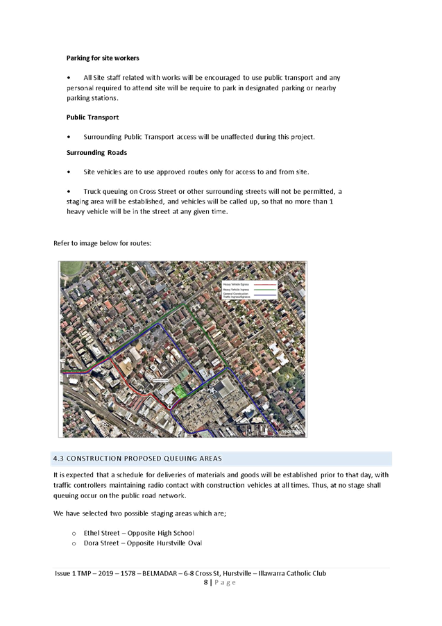
Item: TAC106-19 6-8 Cross Street, Hurstville - Construction Traffic Management Plan
Author: Traffic Engineer
Directorate: Assets and Infrastructure
Matter Type: Agenda Items
|
(a) That the “Traffic Management Plan” for 6-8 Cross Street, Hurstville, submitted by The Lack Group, be approved. (b) That a 39m “Works Zone, 7am-5pm, Mon-Sat” be installed on the northern side of Cross Street, Hurstville adjacent to 6-8 Cross Street, for a period of 52 weeks commencing in July 2019. (c) That the parking be returned to its current status at the completion of the “Works Zone” period |
Executive Summary
1. This report seeks the Committee’s consideration of the “Traffic Management Plan” (TMP) for the construction of No.6-8 Cross Street, Hurstville.
Background
2. The builder of a Council approved development at No.6-8 Cross Street, Hurstville, has lodged at TMP for approval. The project will consist of construction of a 9-storey building containing extension of existing Illawarra Catholic Club, 5 x levels of tourist and visitor accommodation comprising of 125 rooms, and basement parking.
3. Council previously approved the CTMP submitted by Moits Traffic Services in October 2018.
4. As with the excavation phase of the project, during construction, trucks will drive into Cross Street from Park Road, Hurstville in the forward direction and then cross to the opposite side of the road travelling against traffic under the guidance of authorised Traffic Controllers to access the kerbside parking outside 6-8 Cross Street in the forward direction and then leaving the site by crossing back onto the correct side of Cross Street under the direction of Traffic Controllers.
5. It is proposed to install B Class hoarding to provide overhead protection and shelter to any pedestrians and cyclists. Traffic Controllers will be positioned at the work zone to ensure that construction vehicles do not impact on pedestrian routes down Cross Street. The hoarding offers protection and safety to the public when activities are occurring.
Financial Implications
6. No budget impact for this report.
File Reference
D19/118125
|
Attachment ⇩1 |
TMP - Belmadar - Illawarra Catholic Club |
|
Attachment ⇩2 |
2018-1579-Belmadar-Cross St Hurstville - Concrete Pour |
|
Georges River Council - Traffic Advisory Committee Meeting - Tuesday, 4 June 2019 TAC106-19 6-8 Cross Street, Hurstville - Construction Traffic Management Plan [Appendix 1] TMP - Belmadar - Illawarra Catholic Club |
Page 78 |


Georges River Council – Traffic Advisory Committee Meeting - Tuesday, 4 June 2019 Page 80
Item: TAC107-19 Lugarno Lions Spring Festival 2019
Author: Traffic Engineer
Directorate: Assets and Infrastructure
Matter Type: Agenda Items
|
(a) That the Traffic Management Plan (TMP) prepared by Optimus Traffic Management for Lions Club of Lugarno – Spring Festival prepared on 7th May 2019, be approved. (b) The applicant shall provide NSW Police with a Risk Assessment for Hostile Vehicle Mitigation. In accordance with their requirements, the assessment must be carried out by an appropriately qualified person holding a Masters 2A Security License prior to the closures occurring. (c) That the proposed temporary changes to “Bus Zones” on Thurlow Street, Clarendon Road and Amy Road, be presented to a future Traffic Advisory Committee. |
Executive Summary
1. This report seeks the Committee’s consideration of the submitted TMP for the Lugarno Lions Spring Festival at Peakhurst Park, Peakhurst on Sunday 15th September 2019.
Background
2. Lugarno Lions Spring Festival is an annual event organised by the Lions Club of Lugarno during early spring each year. Last year this event attracted in excess of 40,000 people and the traffic was managed with no reported incidents with the assistance of the Hurstville SES and Police.
3. This will be the first year that the event will be held at Peakhurst Park, Peakhurst.
4. As in previous years, the implementation of the Traffic Management Plan will be overseen by the Hurstville State Emergency Services.
5. The event is classified as Class 2 – an event that impacts local traffic and transport systems and there is low scale disruption to the non‐event community.
Financial Implications
6. Within budget allocation – RMS Traffic Facility Grant – Approximately $1,000.
Community Engagement
7. Public notification will be carried out by the Lugarno Lions. Public notification will consist of advertisement in local newspapers, Council Web site, letter drops and VMS. It is proposed to notify all properties within a 1km radius (total 2,837 properties).
File Reference
D19/119662
|
Attachment 1 |
TMP final- Lugarno Lions Spring Festival - Peakhurst Park, Peakhurst 2210 (Confidential) |
|
Attachment 2 |
TMP-HVMP 2019 Festival Layout-A1 (Confidential) |


