|
Georges
River Council – Local Planning Panel Thursday, 4 July
2019
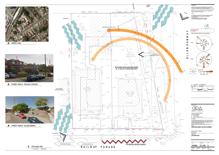
|
Page 2
|
|
3. Reports and LPP Deliberations in Closed
Session - 6.30pm
|
LPP017-19 85-87
Railway Parade Mortdale - DA2018/0547
(Report
by Senior Development Assessment Planner)
LPP018-19 1
Barratt Street Hurstville - DA2019/0054
(Report
by Development Assessment Planner)
LPP019-19 13-15
Gover Street Peakhurst - DA2018/0211
(Report
by Independent Assessment)
|
4. Confirmation of Minutes
|
REPORT TO
GEORGES RIVER COUNCIL
LPP MEETING OF Thursday, 04 July 2019
|
LPP Report No
|
LPP017-19
|
Development Application No
|
DA2018/0547
|
|
Site Address & Ward Locality
|
85-87 Railway Parade Mortdale
Mortdale Ward
|
|
Proposed Development
|
Alterations and additions to the
approved six (6) storey mixed use development to provide an additional level
of residential accommodation to facilitate four (4) additional
apartments, reconfiguration of the car park layout and changes to the rooftop
area of communal open space
|
|
Owners
|
Intra Developments Pty Ltd
|
|
Applicant
|
CD Architects
|
|
Planner/Architect
|
CD Architects/Planning Ingenuity
|
|
Date Of Lodgement
|
13/12/2018
|
|
Submissions
|
No submissions
|
|
Cost of Works
|
$131,203.00
|
|
Local Planning Panel Criteria
|
The proposed works relate to a
Residential Flat Building in accordance with the provisions of State
Environmental Planning Policy No.65
|
|
List of all relevant s.4.15
matters (formerly s79C(1)(a))
|
State
Environmental Planning Policy No 65 – Design Quality of Residential
Apartment Development, State Environmental Planning Policy (Vegetation in
Non-Rural Areas) 2017, State Environmental Planning Policy (Building
Sustainability Index: BASIX) 2004,
Greater
Metropolitan Regional Environmental Plan No 2 – Georges River
Catchment, State Environmental Planning Policy No 55 - Remediation of Land,
State Environmental Planning Policy (Infrastructure) 2007
Kogarah Local Environmental Plan,
2012, Kogarah Development Control Plan 2013
|
|
List all documents submitted
with this report for the Panel’s consideration
|
Statement of Environmental Effects
BASIX Certificate
Traffic and Parking Report
Architectural Plans
|
|
Report prepared by
|
Senior Development Assessment
Planner
|
|
Recommendation
|
That the application be refused in accordance with the
conditions included in the report.
|
|
|
Summary of matters for
consideration under Section 4.15
Have all recommendations in relation
to relevant s4.15 matters been summarised in the Executive Summary of the
assessment report?
|
Yes
|
|
Legislative clauses requiring
consent authority satisfaction
Have relevant clauses in all
applicable environmental planning instruments where the consent authority
must be satisfied about a particular matter been listed and relevant
recommendations summarised, in the Executive Summary of the assessment
report?
|
Yes
|
|
Clause 4.6 Exceptions to
development standards
If a written request for a
contravention to a development standard (clause 4.6 of the LEP) has been
received, has it been attached to the assessment report?
|
Yes
- Non-compliance with Clause 4.3 (Height) and Clause 4.4 (Floor Space Ratio)
of the Kogarah LEP2012
|
|
Special Infrastructure
Contributions
Does the DA require Special
Infrastructure Contributions conditions (under s7.24)?
|
Not
Applicable
|
|
Conditions
Have draft conditions been provided
to the applicant for comment?
|
Not
Applicable
|
|
Site Plan
Allotment outlined in
red
|
EXECUTIVE
SUMMARY
Proposal
1. The development application (DA) seeks
consent for the construction of an additional level above the approved six (6)
storey mixed use building comprising of four (4) apartments (1 x 3 bedroom and
3 x 2 bedrooms), changes to the ground floor and basement car park layout by
relocating car parking spaces and the car wash bay, and internal changes by
reducing the commercial floor area from 212sqm to 193sqm. The form and location
of the roof top communal open space has been redesigned.
2. On 16 August 2018, Georges River Local
Planning Panel approved a Development Application (DA2017/0398) for the
construction of a six (6) storey mixed use building containing forty (40)
apartments, one commercial tenancy on the ground floor and basement car
parking. The consent was “Deferred” in accordance with Section
4.16(1)(b) of the Environmental Planning and Assessment Act, 1979 subject to
the formal concurrence being received by Sydney Trains in accordance with
Clause 86 of the State Environmental Planning Policy (Infrastructure) 2007,
with delegation being granted to the General Manager of Georges River Council.
3. On 14 November 2018, Sydney Trains
granted formal concurrence to the proposal and on 5 December 2018 the consent
was activated.
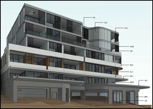
Figure 1: 3D Montage of the approved development
(DA2017/0398)
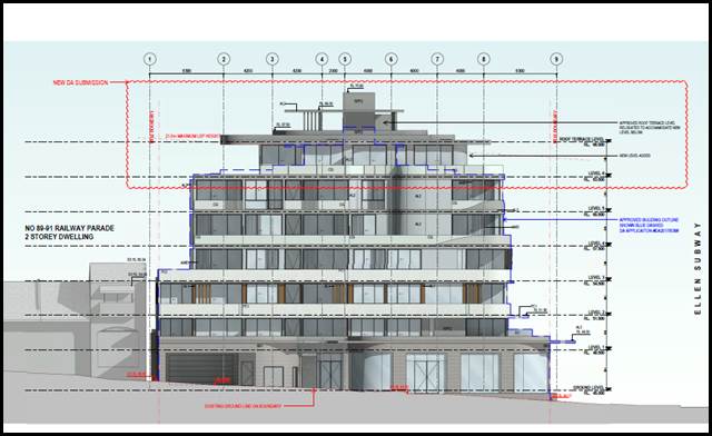
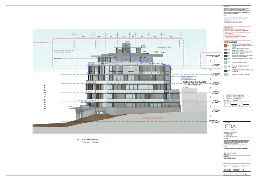
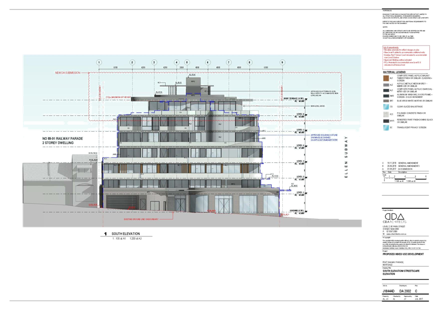
Figure 2: Southern Elevation of the proposed
development with the inclusion of the new level (as viewed from the Railway
Parade frontage)
Site and Locality
4. This
application applies to land known as 85-87 Railway Parade, Mortdale. 85 Railway
Parade has a legal description of Lot 8 DP 456956 and 87 Railway Parade is
legally identified as Lot 7 DP 1884. A third small triangular allotment also
forms part of the site and is known as Lot 1 DP 171157 and has an area of
49sqm.
5. Combined
the site has a frontage of 34.44m to Railway Parade and a secondary frontage of
44.86m in length to Ellen Subway. The total site area is 1,367.2sqm.
6. The
site is located on the south eastern side of the rail corridor removed by just
one property at the rear (1A Ellen Subway). The site is located within a small
neighbourhood business precinct and is within close proximity to the Mortdale
Railway Station and the Mortdale Town Centre.
Zoning and Permissibility
7. The
subject site is zoned B2 Local
Centre under the provisions of the Kogarah Local Environmental Plan 2012 (KLEP2012). The proposal is part of a shop top housing
(mixed use) development which is permissible with consent in the zone.
Submissions
8. The DA was notified to
adjoining properties in accordance with the Kogarah Development Control Plan
2013 (DCP2013) for a statutory notification period of 14 days. No submissions
were received.
Reason for
Referral to the Local Planning Panel
9. This
application is referred to the Georges River Local Planning Panel for
consideration, as the proposal relates to a Residential Flat Building and the
provisions of the State Environmental Planning Policy – Design Quality of
Residential Flat Development is applicable and the proposal exceeds the height
control and floor space control by more than 10%.
10. Two
(2) Clause 4.6 Statements have been submitted with the application seeking
variations to the statutory height control (Clause 4.3) and floor space control
(Clause 4.4) in accordance with the provisions of KLEP 2012 to justify and
support the non-compliances.
Planning and Design Issues
11. The
proposal exceeds the gross floor area and floor space ratio (FSR) of 2.5:1,
proposing an FSR of 2.75:1 which creates an exceedance in the gross floor area
of some 345sqm which amounts to a 10% non-compliance. The increase in the floor
space increases the bulk and scale of the development and in turn creates an
exceedance in the height. The justification for the additional floor space is
not considered to be reasonable given the nature and intent of the control and
its objectives which include to “limit the bulk and scale of
development”. The proposal fails to satisfy the objectives of the
floor space control and the Clause 4.6 Statement is not considered to be well
founded in this instance.
12. The application exceeds the overall height control of 21m
by a maximum of 2.975m which amounts to a variation of 14%. However the
variation is considered to be more like 4.5m at the highest point going off the
survey plan (variation of some 21%). The calculation of the exceedance is discussed
in more detail later in the body of this report. In summary, the objectives of
the height control include to “minimise the impact of overshadowing,
visual impact and loss of privacy on adjoining properties and open space areas”.
The non-compliance adds to the visual bulk and scale of the development and by
filling in this upper level the impact of overshadowing, and the visual impact
of the development when viewed from the streetscape and surrounds is not
minimised, but increased, so on this basis the proposed non-compliance with the
height control does not adequately address the objectives of the height control
and the Clause 4.6 Statement is not considered to be well founded or in the
public interest.
Conclusion
13. The application has been assessed having regard to the
Matters for Consideration under Section 4.15 of the Environmental Planning
and Assessment Act 1979, the provisions of the relevant State Environmental
Planning Policies, Local Environmental Plans and Development Control Plans. The
proposed additional density, scale, form and bulk of the additional level is
considered to be an unreasonable planning and urban design outcome, the Clause
4.6 Statements justifying the non-compliances with the height and floor space
are not considered to be well founded in this instance. As a result the
application is recommended for refusal.
Report
in Full
DESCRIPTION OF THE PROPOSAL
14. The DA seeks consent for alterations and
additions to the approved mixed use development defined as a shop top housing
development. The proposed development seeks to provide for four (4) new
apartments within the approved roof top level and the communal area of open
space is relocated above this new level.
15. Further details of the proposal are as
follows;
Basement 2 Plan
- The car wash bay has been relocated
from Basement 2 to the ground floor.
Basement 1 Plan
- Visitor spaces have been relocated to
the ground floor.
- Two (2) commercial spaces are located
within this level.
- Four (4) additional bicycle parking
spaces have been catered for in the designated bike storage area along the
south western section of this level.
Ground Floor Plan
- The commercial tenancy has been reduced
in size from 212sqm to 193sqm due to the provision of a fire hydrant pump room.
- The main lobby area has been decreased
in size.
- Residential and commercial waste areas
have been relocated and are reduced in size.
Levels 1-5
- No change proposed to the approved
layout.
Level 6
- Approved
roof terrace has been converted to apartments (refer to Figure 3 for the
proposed plan layout).
- Apartment
No.601 is a 2 bedroom apartment
- Apartment
No.602 is a 2 bedroom apartment
- Apartment
No.603 is a 2 bedroom apartment
- Apartment
No.604 is a 3 bedroom apartment
- The
apartments include balconies along the northern, eastern and southern sides of
the building.
Level 7 – Roof Plan
- The roof top area of 346sqm is
dedicated as communal open space including lift overrun, pergola and stair
access. This space includes the provision of a substantial area dedicated as
planter boxes located around its periphery.
DESCRIPTION OF THE SITE AND LOCALITY
16. The subject site comprises of three allotments
with the following legal descriptions;
· Lot 8 DP 456956 (85 Railway Parade)
· Lot 1 DP 171157 (small triangular allotment that
essentially forms part of 85 Railway Parade)
· Lot 7 Section 1 DP 1884 (87 Railway Parade)
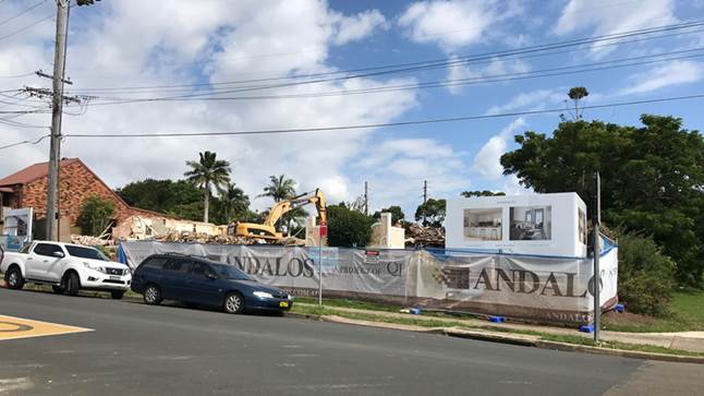
Photo 1: Existing
front view of the subject site
Photo 2: Existing
view of the Railway Parade looking towards the west
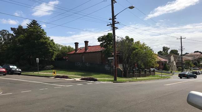
Photo 3: Adjoining
development to the east, 83 Railway Parade
17. The subject site is located on the northern side
of Railway Parade and comprises of the two larger allotments and the smaller
triangular lot. The site is located on the western side of Ellen Subway with
its intersection with Railway Parade.
18. The site has a frontage of 34.44m to Railway
Parade and secondary frontage to Ellen Subway of some 44.865m. The site is
irregular in shape and has a combined site area of 1,367.2sqm.
19. The site falls from the north-western corner
(rear) down towards Ellen Subway by over 3m and there is over 1m difference in
the height along the front of the site along the Railway Parade frontage. The
site is elevated and includes a substantial grassed public verge along the
eastern boundary adjoining Ellen Subway. Site works in accordance with DA
consent 2017/0398 have commenced and all structures on both sites have been
demolished. At the time of preparing this report earthworks were occurring on
site.
20. There is a White Cedar Tree located along the
north-eastern side of the site within the embankment along Ellen Subway.
Development Approval No.2017/0398 permitted the removal of a Jacarada Tree
which was located on site. This tree has subsequently been removed as
construction works have commenced in accordance with the recent approval. The
White Cedar Tree is located outside the property and situated on public land.
This tree is being retained and protected in accordance with DA2017/0398
approval.
21. The site is located within an area comprising of
lower scale dwelling houses and some larger medium density developments. Across
the road to the south is a small neighbourhood shopping precinct, to the south
west, 89 Railway Parade is a semi-detached brick dwelling and to the rear is 1
Ellen Subway which has been approved for redevelopment. On 21 February 2019
Council approved DA2017/0570 for the demolition and construction of a 7 storey
mixed use development comprising of a ground floor commercial tenancies, thirty
eight (38) apartments, basement car parking and associated works over Railcorp
owned land at this site (refer to Figure 4). The approval was
“deferred” pending the provision of amended plans which satisfy a
series of requirements from Sydney Trains.

Figure
3: Front elevation (3D montage) of
the approved development at 1 Ellen Subway (DA2017/0570)
22. The site is located within a very convenient and
accessible location within close proximity to Mortdale Town Centre, Mortdale
Railway Station and other services and amenities such as Renown Reserve and
Mortdale Public School.
State Environmental Planning Policies
23. Compliance
with the relevant state environmental planning policies is summarised in the
table, and discussed in more detail below.
|
State Environmental
Planning Policy
|
Complies
|
|
Greater
Metropolitan Regional Environmental Plan No 2 – Georges River Catchment
|
Yes
|
|
State
Environmental Planning Policy (Building Sustainability Index: BASIX) 2004
|
Yes
|
|
State
Environmental Planning Policy No 55 - Remediation of Land
|
Yes
|
|
State Environmental Planning Policy (Vegetation in Non-Rural
Areas) 2017
|
Yes
|
|
State
Environmental Planning Policy (Infrastructure) 2007
|
Yes
|
|
State Environmental Planning Policy No 65 —
Design Quality of Residential Apartment Development
|
Partial non-compliance with some
design standards
|
Greater
Metropolitan Regional Environmental Plan No 2 – Georges River Catchment
24. The main aims and objectives of this plan are
(not limited to);
· to maintain and improve the water quality and river flows
of the Georges River and its tributaries and ensure that development is managed
in a manner that is in keeping with the national, State, regional and local
significance of the Catchment,
· to protect and enhance the environmental quality of the
Catchment for the benefit of all users through the management and use of the
resources in the Catchment in an ecologically sustainable manner,
· to ensure consistency with local environmental plans and
also in the delivery of the principles of ecologically sustainable development
in the assessment of development within the Catchment where there is potential
to impact adversely on groundwater and on the water quality and river flows
within the Georges River or its tributaries,
· to establish a consistent and coordinated approach to
environmental planning and assessment for land along the Georges River and its
tributaries and to promote integrated catchment management policies and
programs in the planning and management of the Catchment,
25. The proposed system and method of stormwater
disposal proposed will be consistent with the approved stormwater drainage
plan. There is no change proposed to the approved stormwater/drainage
arrangement.
26. The application has been referred to Council’s Engineering
Section for comment, no objection was raised in respect to the proposed design
and no additional requirements were imposed. The originally approved
stormwater arrangement was designed in accordance with Council’s Water
Management Policy and satisfied the relevant provisions of the Deemed State
Environmental Planning Policy – Georges River Catchment.
27. The proposal is not considered to have an adverse
impact on the waterway and the Georges River catchment. The proposal aims to
protect the existing water quality and use and functionality of the catchment.
State
Environmental Planning Policy (Building Sustainability Index: BASIX) 2004
28. A BASIX Certificate has been issued for the
proposed additional apartments. The updated BASIX Certificate is dated 10
November 2018 and the proposal meets the provisions and minimum requirements of
BASIX in terms of water, thermal comfort and Energy efficiency.
State
Environmental Planning Policy No 55 - Remediation of Land
29. SEPP
55 aims to promote the remediation of contaminated land in order to reduce the
risk of harm to human health or any other aspect of the environment.
30. Clause
7 requires contamination and remediation to be considered in determining a
development application. The consent authority must not consent to the carrying
out of development on land unless it has considered whether or not the land is
contaminated.
31. A review of the site history indicates that the
site has been used for residential purposes for extended
periods of time, and such uses and/or development are not typically associated
with activities that would result in the contamination of the site. This was confirmed by the original planning assessment
report DA2017/0398 which stated that “Further to the
site review, submitted information and site inspections did not identify
evidence of contamination. With consideration to the above, and assuming that
recommended consent conditions are satisfied in the event of an approval, it is
unlikely that the site is contaminated and the site would therefore be suitable
for the proposed development.”
32. The site conditions haven’t altered since the
determination of the original application and the site has been cleared and the
consent (DA2017/0398) looks to have been taken up and construction works on
site have physically commenced. The proposal
therefore satisfies the provisions and requirements of SEPP 55.
State
Environmental Planning Policy (Infrastructure) 2007
33. The
aim of the Policy is to facilitate the effective delivery of infrastructure
across the State. The Policy also examines and ensures that the acoustic
performance of buildings adjoining the rail corridor or busy arterial roads is
acceptable and internal amenity within apartments is reasonable given the
impacts of adjoining infrastructure.
34. Clause
85 (Development adjoining a rail corridor) and Clause 87 (Impact of rail noise or vibration on
non-rail development) of the SEPP are relevant and state that;
“If the development is for the purposes
of residential accommodation, the consent authority must not grant consent to
the development unless it is satisfied that appropriate measures will be taken
to ensure that the following LAeq levels are not exceeded:
(a) in any bedroom in
the residential accommodation—35 dB(A) at any time between 10.00 pm and
7.00 am,
(b) anywhere else in
the residential accommodation (other than a garage, kitchen, bathroom or
hallway)—40 dB(A) at any time.”
35. A
Noise and Vibration Report was submitted with the originally approved
development (DA2017/0398). That report addressed the provisions of the Policy
in respect to achieving acoustic compliance. The report suggested a series of
construction methods and materials (ie double glazed windows) and confirms that
windows along the southern elevation can be operable at any time but openings
in habitable areas on other levels and along other orientations will need to be
closed in order to satisfy the minimum requirements of Clause 87. Acoustic
Logic consultants have confirmed that the provisions of the Infrastructure SEPP
can be satisfied by the new apartments.
36. In
accordance with the provisions of the Infrastructure SEPP the application was
referred to Sydney Trains on 1 January 2019. As of the date of this report (23
June 2019) no formal response has been provided. Given that Sydney Trains
provided concurrence to the approved development it can be assumed that this
concurrence will be relevant for this proposal given that the proposed works do
not alter the approved building footprint and the change is to the upper
levels. The site is also removed from the Railway Line and Station by one
property (1 Ellen Subway) and if the approved 7 storey development on this site
is constructed it will act as a buffer for the subject site. If the application
is approved the conditions or provisions of the original Sydney Trains
concurrence will need to be incorporated.
Draft
Remediation of Land SEPP
37. The
Department of Planning and Environment has announced a Draft Remediation of
Land SEPP, which will repeal and replace the current State Environmental
Planning Policy No 55—Remediation of Land.
38. The
main changes proposed include the expansion of categories of remediation work
which requires development consent, a greater involvement of principal
certifying authorities particularly in relation to remediation works that can
be carried out without development consent, more comprehensive guidelines for
Councils and certifiers and the clarification of the contamination information
to be included on Section 149 Planning Certificates.
39. Whilst
the proposed SEPP will retain the key operational framework of SEPP 55, it will
adopt a more modern approach to the management of contaminated land. The Draft
SEPP will not alter or affect the findings in respect to contamination at the
Site.
State
Environmental Planning Policy (Vegetation in Non-Rural Areas) 2017
40. The
Vegetation SEPP regulates clearing of native vegetation on urban land and land
zoned for environmental conservation/management that does not require
development consent.
41. The
Vegetation SEPP applies to clearing of:
(a) Native
vegetation above the Biodiversity Offset Scheme (BOS) threshold where a
proponent will require an approval from the Native Vegetation Panel established
under the Local Land Services Amendment Act 2016; and
(b) Vegetation
below the BOS threshold where a proponent will require a permit from Council if
that vegetation is identified in the council’s development control plan
(DCP).
42. The
Vegetation SEPP repeals clause 5.9 and 5.9AA of the Standard Instrument -
Principal Local Environmental Plan with regulation of the clearing of
vegetation (including native vegetation) below the BOS threshold through any
applicable DCP.
43. The
proposed development does not propose to change the approved situation and does
not propose the removal of any vegetation on site.
Draft
Environment SEPP
44. The Draft Environment SEPP was exhibited from 31 October 2017 to
31 January 2018. This consolidated SEPP proposes to simplify the planning rules
for a number of water catchments, waterways, urban bushland, and Willandra
Lakes World Heritage Property.
45. Changes proposed
include consolidating the following seven existing SEPPs:
· State Environmental Planning Policy No 19 – Bushland
in Urban Areas
· State Environmental Planning Policy (Sydney Drinking Water
Catchment) 2011
· State Environmental Planning Policy No 50 – Canal
Estate Development
· Greater Metropolitan Regional Environmental Plan No. 2
– Georges River Catchment
· Sydney Regional Environmental Plan No 20 –
Hawkesbury-Nepean River (No 2-1997)
· Sydney Regional Environmental Plan (Sydney Harbour
Catchment) 2005
· Willandra Lakes Regional Environmental Plan No 1 –
World Heritage Property.
46. The proposal is
consistent with the provisions of this Draft Instrument.
State Environmental
Planning Policy No 65 — Design Quality of Residential Apartment Development
47. State Environmental Planning Policy No
65 – Design Quality of Residential Flat Buildings (SEPP 65) was
gazetted on 26 July 2002 and applies to the assessment of DAs for residential
flat developments of three or more storeys in height and containing at least
four dwellings. Amendment 3 to SEPP 65 commenced on 17 July 2015 and implemented
various changes including the introduction of the Apartment Design Guide (ADG)
to replace the Residential Flat Design Code. Given the nature of the
development proposed, SEPP 65 applies.
48. Clause 28(2) of SEPP65 requires that the consent
authority take into consideration the following as part of the determination of
DAs to which SEPP 65 applies:
a) the advice
(if any) obtained from the design review panel, and
b) the design quality of the development when evaluated in
accordance with the design quality principles, and
c) the Apartment Design Guide.
49. On the 14 February 2019 the proposal was referred
to the Georges River Design Review Panel. The Panel considered the development
against each of the nine (9) Design Quality Principles (refer to Table 1) and
also considered the provisions of the Apartment Design Guide (ADG) which are
summarised and addressed in Table 2 below.
50. In addition to satisfying the nine (9) design
principles, the proposal generally satisfies the Apartment Design Guidelines in
respect to the design quality and amenity of each new apartment. Despite a few
areas of non-compliance which are detailed in this report the proposal
generally satisfies the amenity and internal layout and design requirements
within the ADG. The Tables below provide a comprehensive assessment against the
principles, objectives and controls of SEPP 65 and the ADG.
Table
1: Application of SEPP 65
|
Clause
|
Standard
|
Proposal
|
Complies
|
|
3 - Definitions
|
Complies with definition of
“Residential Apartment Development” (RAD)
|
Complies with the definition.
Section 4 (1) (Application of
Policy) of the SEPP 65 states that the policy “applies to
development for the purpose of a residential flat building, shop top housing
or mixed use development with a residential accommodation component if:
(a) the development consists of any of the following:
(i) the
erection of a new building,
(ii) the
substantial redevelopment or the substantial refurbishment of an existing
building,
(iii) the conversion
of an existing building, and
(b) the building concerned is at least 3 or more storeys
(not including levels below ground level (existing) or levels that are less
than 1.2 metres above ground level (existing) that provide for car parking),
and
(c) the building concerned contains at least 4 or
more dwellings.”
|
Yes – the proposed mixed use
development satisfies the definition of SEPP 65 as it is considered to be a
substantial redevelopment of an approved building which is more than 3
storey’s and applies to 4 or more dwellings.
|
|
4 - Application of Policy
|
Development involves the erection
of a new RFB, substantial redevelopment or refurbishment of a RFB or
conversion of an existing building into a RFB. The definition of an RFB in
the SEPP includes mixed use developments.
|
Erection of an RFB which satisfies
the SEPP’s definition of this residential land use.
Refer to definition and explanation
above in relation to the applicability of the Policy.
|
Yes
|
|
50 – Development Applications
|
Design verification statement
provided by qualified designer
Registered Architect Name and
Registration No.
|
Design Verification Statement
provided by Registered Architect: Jacob Yammine (Registration No.8395)
|
Yes
|
Table 2: Part 2 Design Quality Principles under the SEPP
|
SEPP 65 – Design Quality of Residential
Flat Buildings
|
DRP
Comment
|
General
comment
|
|
Context and Neighbouring
Character
Good design
responds and contributes to its context. Context is the key natural and
built features of an area, their relationship and the character they
create when combined. It also includes social, economic, health and
environmental conditions.
Responding
to context involves identifying the desirable elements of an area’s
existing or future character. Well-designed buildings respond to
and enhance the qualities and identity of the area including the adjacent
sites, streetscape and neighbourhood.
Consideration
of local context is important for all sites, including sites in established
areas, those undergoing change or identified for change.
|
The site is
located in an area recently rezoned B2 with a permissibly density of 2.5:1
and a height of 21m. It would be the first site to be redeveloped in the
block bounded by Ellen Subway, Railway Parade and the railway to the north.
Ellen Subway to the south of the railway underpass has wide nature strips on
both sides with extensive planting and adjacent to the subject site is a very
attractive and significant tree (Melia azederach – Native white cedar),
which should be conserved.
Vehicular access
to the subject site and the adjoining site to the north is a critical issue
and desirably both should be served by only a single cut through the existing
embankment. Note that the ownership of the embankment is unclear and owners
consent will be necessary.
Vehicular access
has been moved to the Railway Parade frontage (western boundary). This
removes the need to cut through the Ellen Subway embankment.
The site adjoins
Railway Parade to the south which offers the potential for commercial
frontages on this site and the adjoining sites in the block. This also
appears to be the obviously desirable location for the pedestrian entrance.
|
The
existing approval on the site establishes the preferred design and planning
outcome and what Council believes to be the optimal height, bulk and scale as
it generally satisfies the key planning controls in terms of height and floor
space.
It is one
of the first redevelopments in the street and will establish a precedent for
future development in the streetscape and immediate area.
|
|
Built
Form and Scale
Good design
achieves a scale, bulk and height appropriate to the existing or desired
future character of the street and surrounding buildings.
Good
design also achieves an appropriate built form for a site and the
building’s purpose in terms of building alignments, proportions,
building type, articulation and the manipulation of building elements.
Appropriate
built form defines the public domain, contributes to the character
of streetscapes and parks, including their views and vistas, and provides
internal amenity and outlook.
|
The form and scale is generally appropriate for the new increased
density development of the area. However the strong white horizontal bands of
the lower three (3) storeys should be made less dominant and relate more
sympathetically to this context.
Done
but dominant horizontal bands could be further de-emphasized.
The following issues should be addressed:
· Vehicular entry and basement construction should be located in a
way which ensures that there be no adverse impact on the important tree, and
the attractive character of the landscaped public property.
Done
· Future vehicular access to the adjacent site to the north must be
resolved as part of this development, desirably with shared access through
this site. Council should condition approval for the subject development to
ensure that this access will be protected to serve the adjoining site as
well.
Not done and not
required
· Pedestrian entrance should be relocated to the Railway Parade
frontage
Done
· The Panel recommends that amenities be provided to support the
communal space on the roof garden. This should attempt to conform where
possible with the height and floor space ratio.
The
application does raise some additional items:
· The proposed additional level now places the rooftop communal open
space, including lift and lift overrun, fire stair, shade structure and
planter walls above the 21m height standard.
· The additional level, which aligns with the lower levels, does not
align with recommended ADG separation distances on the western boundary
(minimum 6m). This should be amended to comply with minimum ADG requirements.
· Rooftop landscape plan should be further development to clearly
show intended function, design, landscape features and amenities including WC
· Green roofs should be provided on roof top areas on Level 6.
|
The panel
do not raise any serious concerns with the proposed scale of the development
as the new apartments will enclose the area which was previously approved as
the roof top area of communal open space.
The
proposal however does not comply with the minimum separation distances for
habitable areas.
Council
raises concerns regarding the scale of the development given that a 21m
height limit intends on a built form outcome of 6 storeys given that the
proposal is in a mixed use zone and the ground floor commercial tenancy is
required to have a floor to ceiling height of 3.5m in order to comply with
the ADG and floor to floor heights of 3.1 for residential levels.
|
|
Density
Good design
achieves a high level of amenity for residents and each apartment, resulting
in a density appropriate to the site and its context.
Appropriate
densities are consistent with the area’s existing or projected
population. Appropriate densities can be sustained by existing or proposed
infrastructure, public transport, access to jobs, community facilities and
the environment.
|
Compliant and
acceptable
The permissible FSR
2.5:1 is exceeded by 10%. The proposed FSR is 2.75:1. The resulting building
bulk and form does not cause any significant concerns from an urban design
perspective. However the Council may have concerns about creation of a
planning precedent.
|
The Panel
do not raise an issue with the overall bulk, scale and density of the
development however the proposal fails to comply with the key planning
controls relating to height and floor space and the non-compliances are
considered to be substantial in this case.
|
|
Sustainability
Good design
combines positive environmental, social and economic outcomes.
Good
sustainable design includes use of natural cross ventilation and sunlight for
the amenity and liveability of residents and passive thermal design
for ventilation, heating and cooling reducing reliance on technology and
operation costs. Other elements include recycling and reuse of materials and
waste, use of sustainable materials and deep soil zones for groundwater
recharge and vegetation.
|
Subject to BASIX
|
Complies
|
|
Landscape
Good
design recognises that together landscape and buildings operate as
an integrated and sustainable system, resulting in attractive developments
with good amenity. A positive image and contextual fit of well
designed developments is achieved by contributing to the landscape
character of the streetscape and neighbourhood.
Good
landscape design enhances the development’s environmental performance
by retaining positive natural features which contribute to the local
context, co-ordinating water and soil management, solar access,
micro-climate, tree canopy, habitat values and preserving green
networks.
Good
landscape design optimises useability, privacy and opportunities
for social interaction, equitable
access, respect for neighbours’ amenity and
provides for practical establishment and long term management.
|
As mentioned
above, the existing embankment and trees along Ellen Subway are a valuable
landscape asset that should be retained, protected and enhanced. To this end,
and as mentioned above, the existing landform and significant vegetation must
be retained and protected, including from any constraint that this
development places on future development of adjoining sites. The tree
protection zone for the existing Melia sp. should be calculated, mapped and
protected.
A detailed
landscape design for the embankment should be submitted to Council for
implementation.
Any level
changes between the development and the existing levels along Ellen Subway
should be handled via thoughtful landscape initiatives in preference to built
structures or retaining walls.
See above.
In addition, the
street landscape in front of the adjacent site to the north must be conserved
and therefore considered in the design of this site.
As part of above.
Street tree
planting should be provided to Railway Parade and Ellen Subway.
To Council
satisfaction (and included in landscape plan)
The proposed
floor level of the commercial space is not apparent in the drawings provided
however any grading required to ensure accessibility from the footpath must
occur within the property boundary.
Done
A program of use
that considers the likely recreational needs of residents should be developed
for the roof top communal open space. This may include separate areas for
group gatherings, solitary pursuits, or children’s play. A small
kitchenette and WC facilities should be provided. The design should eliminate
any small, non-functional spaces.
To be done with
landscape plan
Access must be
provided to the ‘pebble roof’ on level 1 for maintenance. There
may be opportunity to provide greening of the north facing wall in this area.
Access provided
The super-sized
balconies require planter boxes to delineate private open space, provide an
appropriate sense of scale, and screen along the property boundary.
The reason for
the ‘nature strip’ adjacent to the commercial frontage on Railway
Parade is unclear – see architectural plan DA1103. The Railway Parade
streetscape must be more fully resolved including levels, paving, landscape,
any street furniture, lighting, etc.
|
There is no
change to the overall landscape plan apart from relocating the communal area
of open space from Level 6 up to Level 7. The amount dedicated for this
purpose is consistent with the approved plans.
Given that
there is only one dedicated area of communal open space being located on the
roof, the higher this area is positioned the more it is impacted by external
factors such as weather and noise and it becomes more inconvenient to access
etc. If there was a small secondary area of open space available at the
ground floor level or at another point on/around the building this would
reduce the reliance on this area. The quality of this area is reduced and its
amenity reduced by repositioning a level higher.
In
addition, the treatment of this area is not well defined as no landscape plan
accompanied the application. The space is not considered to be inviting or
functional.
Further
discussion regarding the amount of the communal area of open space is
discussed later in this report. Considering a large proportion of the rooftop
area is dedicated as planter boxes it is questionable that the actual useable
area complies with the ADG provisions in relation to its size.
|
|
Amenity
Good design
positively influences internal and external amenity for residents
and neighbours. Achieving good amenity contributes to positive living
environments and resident well being.
Good
amenity combines appropriate room dimensions and shapes, access to sunlight,
natural ventilation, outlook, visual and acoustic privacy, storage, indoor
and outdoor space, efficient layouts and service areas and ease of access for
all age groups and degrees of mobility.
|
The following
issues should be addressed:
· The narrow natural light slot. See comments above under
‘Landscape’ – greening of this pebble roof might be
considered.
· Balconies should be provided with screening to ensure privacy and
protection from strong winds, particularly corner balconies.
· Provide screening and protection to bedroom windows.
Garbage storage requires direct access to basement pick up
|
The general
amenity and overall layout of the additional apartments is considered
acceptable.
The new
apartments however will adversely affect the solar access provided to the
southern facing apartments on Level 5 which relied on the provision of
skylights in the approved development scheme to provide some additional light
and solar access into the living spaces. These skylights have been removed by
the new apartments.
|
|
Safety
Good design
optimises safety and security within the development and the public domain.
It provides for quality public and private spaces that are clearly defined
and fit for the intended purpose.
Opportunities
to maximise passive surveillance of public and communal areas
promote safety.
A positive
relationship between public and private spaces is achieved through clearly
defined secure access points and well lit and visible areas that are easily
maintained and appropriate to the location and purpose.
|
Satisfactory
|
Complies
– no change proposed.
|
|
Housing
Diversity and Social Interaction
Good design
achieves a mix of apartment sizes, providing housing choice for different
demographics, living needs and household budgets.
Well-designed apartment
developments respond to social context by providing housing and facilities to
suit the existing and future social mix.
Good design
involves practical and flexible features, including different types of
communal spaces for a broad range of people and providing opportunities for
social interaction among residents.
|
Satisfactory
Consider however proximity to the railway station and nearby
schools.
|
Complies
|
|
Aesthetics
Good design
achieves a built form that has good proportions and a balanced composition of
elements, reflecting the internal layout and structure. Good design uses a
variety of materials, colours and textures.
The visual
appearance of a well designed apartment development responds to the
existing or future local context, particularly desirable elements and
repetitions of the streetscape.
|
Requires further
refinement to take into account the evolving context, preferably avoiding
stark dark and white contrast.
Further design and material consideration required.
|
The
proposed architectural treatment and proposed materials and finishes in
relation to the new apartments and associated structural and ancillary
elements are consistent with the approved development scheme, however could
be improved if the scheme is to be supported.
|
51. Despite the DRP comments providing general
positive direction and feedback, the Panel at the meeting did raise concerns
that the new apartments were not setback the minimum 9m at the upper levels.
52. Having regard to the above, the Panel considers
that the proposal generally satisfies the Design Principles of the ADG.
53. Clause 28 of SEPP65 requires the consent
authority to take into consideration the provisions of the ADG. The Table below
assesses the proposal against these provisions.
Table 3: Part 3
and Part 4 – Consideration of Residential Flat Design Code Design
Controls
|
Clause
|
Standard
|
Proposal
|
Complies
|
|
3D - Communal open space
|
1. Communal open space has a
minimum area equal to 25% of the site.
-Where it cannot be provided on
ground level it should be provided on a podium or roof
-Where developments are unable to achieve the design
criteria, such as on small lots, sites within business zones, or in a dense
urban area, they should:
• provide
communal spaces elsewhere such as a landscaped roof top terrace or a common
room
• provide
larger balconies or increased private open space for apartments
• demonstrate good proximity
to public open space and facilities and/or provide contributions to public
open space
2. Developments achieve a minimum
of 50% direct
sunlight to the principal usable
part of the communal open space for a minimum of 2 hours between 9 am and 3
pm on 21 June (mid-winter)
|
The proposal states that an area of
346sqm is to be dedicated as communal area to be located on the rooftop. This
amounts to 25% of the site. The originally approved rooftop communal area was
similar in size and area, however having a more detailed look at this
area it is not considered that the whole area is “useable” in
accordance with the intention of providing communal area (Part 3D of the ADG)
and the area is actually less than what is indicated on the floor plans. The
inclusion of the planter boxes which is a substantial area does not
constitute “communal” area as these components are not “useable”.
Council’s calculation
believes that the “useable” area of open space on the roof
amounts to approximately 290sqm which amounts to 21% of the site. This is
below the 25% minimum.
No Landscape Plan has been
submitted with the application and the treatment of this space is considered
to be unsatisfactory and lacks detail. This area requires substantial
embellishment as this is the primary and only area of open space for the
occupants.
Solar access to this space is
considered to be compliant with the ADG given the orientation of the space.
|
No – see assessment below
The treatment of the space is
considered substandard and very basic. Given this is the only area of common
open space within the development its treatment and design does not satisfy
the objectives and design intent of Part 3D of the ADG.
|
|
3E – Deep Soil zones
|
1. Deep soil zones are to meet the
following minimum
requirements:
Where the site is greater
than1500sqm = 6m min dimension
Min deep soil area of 7% (161sqm)
|
There is no change proposed to the
amount and area of dedicated deep soil planting.
As approved the development caters
for a 3m wide area of deep soil and there is also an area along the eastern
side of the site which has been provided to allow for the APZ around the
White Cedar Tree this also creates a landscaped buffer.
|
No however there is no change from
the approved plans.
|
|
3F- Visual Privacy
|
Separation between windows and
balconies is provided to ensure visual privacy is achieved.
Minimum required separation
distances from buildings to the side and rear boundaries are as follows:
Up to 12m (4 storeys)
Habitable - 6m
Non-habitable – 3m
Up to 25m (5-8 storeys)
Habitable – 9m
Non-habitable – 4.5m
|
Along the western side and
south-western side the new units No.602 and 603 are setback a minimum of 9m
from the boundary which complies.
Along the northern and north
western side the Units No.601 and 602 are setback 11.2m to the building wall
and 9.2m to the balcony edge.
The new units along the eastern
side units No.601 and 604 are setback 6.2m to the building wall and only
about 3m from the balcony to the boundary.
The front boundary setback is
governed by the provisions of the Kogarah DCP
|
Yes
Yes
No - See Note 1 for further
discussion
|
|
3G – Pedestrian Access and
entries
|
Building
entries and pedestrian access connects to and
addresses the public domain
Multiple entries (including communal building entries
and individual ground floor entries) should be provided
to activate the street edge
|
No change is proposed to the building
in accordance with DA2017/0398 approval.
Entry from Railway Parade is
retained. The main lobby area has been reduced in size which is a negative
design solution. The originally approved main lobby was large and spacious
and created a large, legible and attractive point of entry to the units
above.
The proposed reduction in this
space creates a poor design outcome and reduces the internal amenity of this
space.
|
Complies however the amended
architectural treatment is considered to be poor given the main entry and
lobby space has been reduced in its size.
|
|
3H-Vehicle Access
|
Vehicle access
points are designed and located to achieve safety, minimise conflicts between
pedestrians and vehicles and create high quality streetscapes
|
The vehicular access point is unchanged.
|
Acceptable.
|
|
3J-Bicycle and carparking
|
For development in the following
locations:
- On
sites that are within 800m of a railway station or light rail stop in the
Sydney Metropolitan Area; or
- On
land zoned and sites within 400m of land zoned B3 Commercial Core, B4 Mixed
Use or equivalent in a nominated regional centre
The minimum car parking requirement
for residents and visitors is set out in the Guide to Traffic Generating
Developments, or the car parking
requirement prescribed by the relevant council, whichever is less.
In accordance with Section 5.4.3
(High Density Residential Flat Buildings) of the RMS Traffic Generating
Guidelines. The site is located within the “Metropolitan Sub-Regional
Centres” and the following provisions apply;
0.6 spaces per 1 bedroom unit
0.9 spaces per 2 bedroom unit
1.4 spaces per 3 bedroom unit
1 space per 5 units (visitor
parking)
The provision of at least one
loading dock for residential use is desirable, although a dock intended for
commercial uses may be sufficient.
The parking provisions for
commercial use within a high density residential flat building should be
separately established by referring to the relevant guidelines for those
specific uses.
|
The site is located within 800m of
the Mortdale Railway station as such the RMS provisions are applicable.
The originally approved mixed use
development was assessed against the provisions of the ADG requirements (RMS
standards).
Approved development relied on
the following car parking provisions;
7 x 1 bedroom units = 0.6 x 7 = 4.2
spaces
30 x 2 bedroom units = 0.9 x 30 =
27 spaces
3 x 3 bedroom = 1.4 x 3 = 4.2
spaces
Residential spaces required = 36
spaces
Visitor = 40/5 = 8 spaces
8 visitor spaces are provided
Total = 45 spaces
59 Resident spaces were provided
New Units generate the
following requirements;
Total required =
7 x 1 bedroom units = 4.2 spaces
33 x 2 bedroom units = 29.7 spaces
4 x 3 bedroom units = 5.6 spaces
Subtotal = 40 spaces required for
the residential component
Visitor spaces = 44/5 = 8.8
generates the need for 9 visitor spaces
The proposal requires a total of
49 off street car parking spaces for residents and visitors
Commercial parking in accordance
with KDCP provisions which is 1 space per 40sqm but given this space is likely
to be retail then the provision of 1 space per 25sqm of GFA should be
applied. This amounts to 9 spaces
Nine (9) dedicated commercial
spaces are provided.
A total required car parking
spaces including commercial components amounts to a total of 58 spaces.
The two (2) basement levels and
ground floor area dedicated for car parking caters for the following;
59 dedicated resident spaces
9 dedicated commercial spaces
8 dedicated visitor spaces
1 x Loading Bay
1 x Car Wash Bay
The off street car parking provision
exceeds the requirements of RMS/ADG provisions.
Bicycle parking
The approved development catered
for 10 bicycle parking spaces and the additional 4 apartments has increased
the bicycle parking by a further 4 bike spaces within the basement which is compliant.
|
The car parking arrangement and
number of spaces provided complies with the ADG/RMS requirements.
The proposal complies with the
numerical requirements of the ADG given the accessible location of the site
however Council’s Traffic Engineer has raised concerns regarding the
layout and configuration of some spaces and the design of the Loading Bay.
See further discussion in regards to this matter later in this report.
|
|
4A- Solar and daylight access
|
Living rooms and private open
spaces of at least 70% of apartments in a building receive a minimum of 2
hours direct sunlight between 9am and 3pm at mid-winter in the Sydney
Metropolitan Area
A maximum of 15% of apartments in a
building receive no direct sunlight between 9am and 3pm in midwinter
|
As there is no change to the layout
and design of apartments at Levels 1 -5 these have been approved in
accordance with DA2017/0398.
The four new apartments on Level 6
will satisfy this provision apart from the south facing apartment No.603. In
totality out of 44 apartments 6 apartments fail to comply, being 7% of the
development.
Units 504 and 505 which are
orientated to the south were approved with skylights to both their living
areas (skylights installed in the roof level). These skylights would have
provided much needed additional solar access to these living spaces
throughout the day. Given that the new apartments are now to be situated on
Level 6 the skylights are no longer to be provided and this will adversely
affect the internal amenity and solar access provision to these spaces.
A total of eight (8) apartments out
of 44 would now not comply with the minimum solar access provisions of the
ADG and this equates to 18% of apartments not complying with the provisions.
|
Non-compliance – Solar access
to units 504 and 505 has been decreased and the internal amenity of these
apartments is compromised by the new apartments.
|
|
4B- Natural Ventilation
|
At least 60% of apartments are
naturally cross ventilated in the first nine storeys of the building.
Overall depth of a cross-over or
cross-through apartment does not exceed 18m, measured glass line to
glass line
The building should
include dual aspect apartments, cross through apartments and corner
apartments and limit apartment depths
|
The new apartments have been
designed to comply with the minimum cross ventilation requirements of the
ADG.
The apartments do not exceed 18m in
their depth.
All four new apartments have a dual
aspect.
|
Yes - complies
|
|
4C-Ceiling Heights
|
Measured from finished floor level
to finished ceiling level, minimum ceiling heights are:
Habitable rooms = 2.7m
Non-habitable rooms = 2.4m
|
The floor to floor height is 3m of
the new level. This is consistent with the lower levels and as approved.
Section 4C states that a minimum of
2.7m floor to ceiling height is required for habitable rooms and living
spaces. The ADG specifies that to achieve this, a floor to floor height of
3.1m would be required. The originally approved development permitted the
floor to floor height of 3m and also allowed for the first floor level to
have a reduced floor to floor height as the ground and first floor level of
mixed developments should have floor to ceiling heights of 3.3m.
Given that the residential floors
have been approved with floor to ceiling heights of 3m (in accordance with DA
consent 2017/0398) the proposed floor to ceiling height is considered to be
consistent with this approval. This is an issue that can also be easily
conditioned if the application was to be supported.
|
No but consistent with DA approval
2017/0398
|
|
4D- Apartment size and layout
|
Apartments are required to have the
following
minimum internal areas:
1 bedroom = 50sqm
2 bedroom = 70sqm
3 bedroom = 90sqm
The minimum internal areas include
only one bathroom. Additional bathrooms increase the minimum internal area by
5sqm each
Every habitable room must have a
window in an external wall with a total minimum glass area of not less than
10% of the floor area of the room. Daylight and air may not be borrowed from
other rooms
|
Apartment 601 (2 bedroom) = gross
floor area of 75sqm
Apartment 602 (2 bedroom) = gross
floor area of 75sqm
Apartment 603 (2 bedroom) = gross
floor area of 75sqm
Apartment 604 (3 bedroom) = gross
floor area of 95sqm
All four units have good amenity
and access to a number of openings along several frontages.
|
Complies
|
|
4D-2 Apartment size and layout
|
Habitable room depths are limited
to a maximum of 2.5 x the ceiling height
In open plan layouts (where the
living, dining and kitchen are combined) the maximum habitable room depth is
8m from a window
|
Satisfactory
|
Complies
|
|
|
Master bedrooms have a minimum area
of 10sqm and other bedrooms 9sqm (excluding wardrobe space).
Bedrooms have a minimum dimension
of 3m (excluding wardrobe space).
3. Living rooms or combined
living/dining rooms have a minimum width of:
-3.6m for studio and 1 bedroom
- 4m for 2 and 3 bedroom apartments
The width of cross-over or
cross-through apartments are at least 4m internally to avoid deep narrow
apartment layouts
|
All master bedrooms have a minimum
internal size of 10sqm.
Bedrooms have minimum dimensions of
3m.
Living rooms have widths of 4m, 6m
and 4.2m.
There are no cross-over or
cross-through apartments proposed.
|
Complies
|
|
4E- Private Open space and
balconies
|
All apartments are required to have
primary balconies as follows:
-1 bedroom = 8sqm/2m depth
-2 bedroom = 10sqm/2m depth
-3+ bedroom = 12sqm/2.4m
The minimum balcony depth to be
counted as contributing to the balcony area is 1m
For apartments at ground level or
on a podium or similar structure, a private open space is provided instead of
a balcony. It must have a minimum area of 15sqm and a minimum depth of 3m
|
The new apartments have the
following balcony sizes;
Apartment 601 = 41sqm
Apartment 602 = 20sqm
Apartment 603 = 18sqm
Apartment 604 = 83sqm
Each balcony has a minimum width of
2m.
Not applicable - as there are no
apartments on the ground floor.
|
Complies
|
|
4F- Common circulation areas
|
The maximum number of apartments
off a circulation core on a single level is eight
|
Maximum of 4 apartments have access
to the lobby on Level 6
|
Complies
|
|
4G- Storage
|
In addition to storage in kitchens,
bathrooms and
bedrooms, the following storage is
provided:
1 bedroom = 6m³
2 bedroom – 8m³
3 bedroom – 10m³
At least 50% of storage is to be
located within the apartment.
|
Each new apartment has dedicated
internal storage space in the following configuration;
Apartment 601 = 5.4 cubic metres
Apartment 602 = 5 cubic metres
Apartment 603 = 2 cubic metres
Apartment 604 = 3.36 cubic metres.
|
No – the proposal fails to
provide the compliant amount of storage space for each apartment.
|
|
4H- Acoustic Privacy
|
Adequate building separation is
provided within the development and from neighbouring buildings/adjacent
uses.
Window and door openings are
generally orientated away from noise sources
Noisy areas within buildings
including building entries and corridors should be located next to or above
each other and quieter areas next to or above quieter areas
Storage, circulation areas and
non-habitable rooms should be located to buffer noise from external sources
|
The acoustic report that was
prepared for the originally approved mixed use development prepared by
Acoustic Logic and dated 28 August 2017 is relied upon as the recommendations
in this report are pertinent to the proposed new apartments. The same
construction methods are proposed to be implemented in accordance as
suggested by this report.
The report suggests a series of
construction mechanisms to be adopted to reduce noise and acoustic impacts.
Also the acoustic report does not include the potential for the building at 1
Ellen Subway to be constructed and if this building is built it will act as
an additional buffer and so it is considered that noise and acoustic impacts
can be appropriately regulated and managed if the development was considered
to be approved.
|
Satisfactory - Can comply if the
proposal was to be supported.
|
|
4J – Noise and Pollution
|
To minimise impacts the following
design solutions may be used:
• physical separation
between buildings and the noise or pollution source
• residential uses are
located perpendicular to the noise source and where possible buffered by
other uses
• buildings should respond to
both solar access and noise. Where solar access is away from the noise
source, non-habitable rooms can provide a buffer
• landscape design
reduces the perception of noise and acts as a filter for air pollution
generated by traffic and industry
|
The development can comply with the
provisions of 4J of the ADG if approval of the application is considered.
|
Yes
|
|
4K – Apartment Mix
|
A range of apartment types and
sizes is provided to cater for different household types now and into the
future
The apartment mix is distributed to
suitable locations within the building
|
The development offers a mix of 1,
2 and 3 bedroom apartments. This application seeks to provide 3 additional 2
bedroom units and 1 additional 3 bedroom unit.
|
Yes
|
|
4L – Ground Floor Apartments
|
Street frontage activity is
maximised where ground floor apartments are located.
Design of ground floor apartments
delivers amenity and safety for residents.
|
There are minor changes proposed at
the ground floor level. These have been proposed as a result of a more
detailed design and to cater for services. The commercial area has reduced in
size from 212sqm to 193sqm to cater for a fire hydrant pump room. The
reduction of this space by 19sqm is considered to be small and the use and
functionality of this space remains satisfactory.
The reduction in the main lobby is
a poor design outcome as this space is important as a main entry and focal
point for the residential component.
Also the provision of commercial
car spaces within the entry ramp is inappropriate and a concern. This issue
is discussed later in this report as Council’s Traffic Engineers do not
support the provision and location of these spaces.
|
Complies
|
|
4M - Facades
|
Facades should be well resolved
with an appropriate scale and proportion to the streetscape and human scale.
|
The treatment of the new level is
generally consistent with the materials and finishes as approved
(DA2017/0398) although the DRP suggested some improvements to the
fenestration treatment and the materials and colours to soften the appearance
of the building and remove the proposed banding along the lower levels.
|
Yes however the treatment and fenestration
could be improved to soften the visual appearance of the building.
|
|
4N – roof design
|
Roof treatments are integrated into
the building design and positively respond to the street. Opportunities to
use roof space for residential accommodation and open space are maximised.
Incorporates sustainability features.
|
Roof design is consistent with the
approved development DA2017/0398 although the roof structure and its
treatment are located at a higher level.
|
Yes - satisfactory
|
|
4O – Landscape Design
|
Landscape design is viable and
sustainable, contributes to the streetscape and amenity
|
The proposed roof top landscape
design aims to be consistent with the approved rooftop design although this
application is not accompanied by a formal Landscape Plan. Therefore the roof
top communal area of open space has not been designed or treated
appropriately. This is an issue that needs further detailed attention and is
considered to be unacceptable at this current time.
|
No
|
|
4P- Planting on Structures
|
Planting on structures –
appropriate soil profiles are provided, plant growth is optimised with
appropriate selection and maintenance, contributes to the quality and amenity
of communal and public open spaces
|
This issue could be conditioned if
approval was recommended.
Access to the large amount of
planting area proposed on Level 7 is not clearly detailed or articulated.
|
Not acceptable and lacking detail.
|
|
4Q – Universal Design
|
Universal design – design of
apartments allow for flexible housing, adaptable designs, accommodate a range
of lifestyle needs
|
Satisfactory
|
Yes
|
|
4R – Adaptive reuse
|
Adaptive reuse as apartment of
existing buildings- new additions are contemporary and complementary, provide
residential amenity while not precluding future adaptive reuse.
|
Some apartments have been designed
so they could be amalgamated, consolidated or reduced. There is some general
adaptability within the design.
|
Yes acceptable
|
|
4U – Energy Efficiency.
|
Development incorporates passive
environmental design, passive solar design to optimise heat storage in winter
and reduce heat transfer in summer, natural ventilation minimises need for
mechanical ventilation
|
A compliant BASIX Certificate
accompanies the application.
|
Yes
|
|
4V – Water management and
conservation
|
Water management and conservation
– potable water use is minimised, stormwater is treated on site before
being discharged, flood management systems are integrated into the site
design
|
No change proposed to the system,
the originally approved design was considered satisfactory.
|
Yes
|
|
4W – Waste Management
|
Waste management – storage
facilities are appropriately designed, domestic waste is minimised by
convenient source separation and recycling
|
The waste management arrangement
has changed slightly.
Originally the waste storage area
on the ground floor was combined for both the residential and commercial
component.
This application creates two
separate areas. The residential area now includes compactors which reduces
the need for some bins. There is a separate room for commercial waste
provided. This is considered to be acceptable and maintains compliance with
Council’s provisions for waste disposal.
|
Yes
|
|
4X – Building Maintenance
|
Building design provides protection
form weathering
Enables ease of maintenance,
material selection reduces ongoing maintenance cost
|
The proposed external materials,
colours and finishes are generally in accordance with the originally approved
development (DA2017/0398).
|
Yes – no change proposed
|
Note (1) - Separation Distances
54. The building fails to comply with the minimum
separation distances in accordance with the provisions of Part 3F of the
Apartment Design Guide (ADG). Part 3F relates to “visual privacy”
and establishes minimum or reasonable side setbacks for RFB’s which allow
for adequate separation between buildings and therefore maintain privacy
between properties.
55. The objective of the control is to provide
“Adequate building separation distances which are shared
equitably between neighbouring sites, to achieve reasonable levels of external
and internal visual privacy”. The actual
side setback should be 9m at this level. The building is setback 9m from the
south western side and a minimum of 6m from the north eastern side. Parts of
unit 604 are setback further than 6m. This section of the building adjoins
Ellen Subway so the combined setback to the immediately adjoining property to
the east, 83 Railway Parade is approximately 17m and comprises of 6m for the
building at this level plus 3m for the Council verge plus 6m for the Ellen
Subway roadway plus 2m setback of the Council verge to the south of 83 Railway
Parade. The eastern facing balconies to units 601 and 604 are only setback some
3.5m-4m and this setback is considered to be unacceptable given that the
balconies are substantial in size and will have the capacity to overlook
properties to the east and north east. There is no privacy screening proposed
and the fact the balconies are designed to align with the edge of the eastern
building wall will emphasize the bulk, scale and height of the building. The
siting and design of this section of the building is not considered to be
consistent with the intent of the ADG.
Communal Open Space
56. The roof top area of communal open space has been
relocated from Level 6 to the new roof level (Level 7). The proposal fails to
comply with design criteria 3D-1 of the ADG in respect to the area and
size of the proposed roof top area of communal open space. The proposed plans
show that the communal space has a total area of 346sqm however this area
includes a substantial area of planter boxes which are located around the
periphery of the roof top and act as a border to the communal space. The
central area on the roof is the only actual area that can be utilised
physically for passive recreational and this area amounts to approximately
290sqm which comprises of 21% of the site area which is below the minimum 25%
required in accordance with the ADG. The designated planter boxes on the roof
level cannot be used for any form of recreational activities and simply act as
a landscaped buffer. In accordance with 3D-1 of the ADG, the planter boxes do
not form part of the “principle usable part of the communal open
space” and therefore are not included in the calculation.
57. The area of communal open space will
receive an adequate amount of solar access and comply with objective 3D-1(2)
due to its orientation. However, the design and quality of the space is
considered to be substandard and does not comply with the design guidance of
Objective 3D-2 which states that “communal open space is designed to
allow for a range of activities, respond to site conditions and be attractive
and inviting”.
58. The application is not accompanied by a
Landscape Plan and the space is considered to be poorly designed as it does not
include any substantial planting or integrate specific landscape features.
There is obvious landscaping proposed in the form of planter boxes etc but its
treatment, type of species and design intent is not provided or detailed
appropriately. The plans include substantial areas of planter boxes around the
periphery of the roof top area. The lack of detailing of this area is
considered to produce a substandard design response and will not be an inviting
or attractive space. There is a pergola proposed which will provide some
protection but there are no other amenities or furniture included which would
encourage the utilisation of the area for passive recreation purposes. The
space is poorly treated and has not been designed to encourage its utilisation
or promote an attractive and inviting green space for future tenants and
visitors to the development.
Environmental
Planning Instruments
Kogarah Local Environmental Plan 2012
Zoning
59. The subject
site is zoned Zone B2 Local Centre zone under the provisions of the Kogarah Local
Environmental Plan 2012 (KLEP2012). Refer to zoning map below. The
proposed development is part of an approved shop top housing development which
is a permissible land use in the zone.
60. The objectives of the
zone are as follows:
· To provide a range of retail, business, entertainment and
community uses that serve the needs of people who live in, work in and visit
the local area.
· To encourage employment opportunities in accessible
locations.
· To maximise public transport patronage and encourage
walking and cycling.
61. The proposal has been
designed to satisfy the objectives of the zone.
62. The extent to which the
proposal complies with the relevant standards of Kogarah Local
Environmental Plan 2012 (KLEP2012) is outlined in the table below.
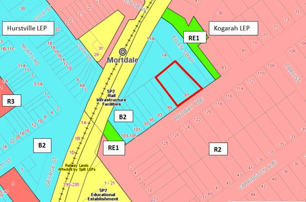
Figure 4: Zoning
map – the site is outlined in red
Table 4: KLEP2012
Compliance Table
|
Clause
|
Standard
|
Proposed
|
Complies
|
|
2.2 Zone
|
B2
Local Centre zone
|
The proposal is defined as shop top
housing which is a permissible use within the zone.
|
Yes
|
|
2.3
Objectives
|
Objectives of the Zone
|
Consistent with zone objectives
|
Yes
|
|
4.1A Minimum lot sizes for
Residential Flat Buildings
|
Clause 4.1A requires a minimum site
area of 1,000sqm for the purpose of RFB’s in the R3 zone.
|
The total site area is 1,367sqm
|
Yes
|
|
4.3 – Height of Buildings
|
21m as identified on Height of
Buildings Map
|
The building exceeds the 21m height
limit and achieves an overall height at the highest point of 23.93m
|
No – see discussion below
regarding Clause 4.6 Statement which has been submitted.
|
|
4.4 – Floor Space Ratio
|
2.5:1 as identified on Floor Space
Ratio Map
|
The proposed FSR is 2.5:1. The
proposal exceeds the FSR by 375sqm and achieves a total FSR of 2.75:1. The
GFA proposed is 3,762.67sqm
|
No – see discussion below
regarding Clause 4.6 Statement which has been submitted.
|
|
4.5 – Calculation of floor
space ratio and site area
|
FSR and site area calculated in
accordance with Cl.4.5
|
The GFA calculations provided by
the Applicant have been verified and is considered satisfactory.
|
Yes
|
|
5.10 – Heritage Conservation
|
The objectives of
this clause are;
(i) to conserve the environmental
heritage of Kogarah,
(ii) to conserve the heritage
significance of heritage items and heritage conservation areas, including
associated fabric, settings and views.
|
The site is within the vicinity of
the Mortdale Railway Station and car sheds, which is listed as an item (I71)
of State significance within the Hurstville Local Environmental 2012. Council
has not required a heritage impact assessment and considered that the
proposal is unlikely to result in any undue impacts on the nearby item.
Notably, a DA for a new 7 storey
mixed use development at No.1 Ellen Subway has been determined and approved
by the Georges River Local Planning Panel on 21 February 2019
The original DA was referred to
Council’s Heritage officer for comment who has recommended support of
the proposed development. The proposed additional level will not alter the original
comments made by Council’s Heritage Officer given that the integrity
and significance of the Item will remain unaffected. The property is also
removed from curtilage of this item.
|
Yes
|
|
6.1 Acid Sulphate Soils (ASS)
|
The objective of this clause is to ensure that development
does not disturb, expose or drain acid sulfate soils and cause environmental
damage
|
The site is not affected by any
ASS.
|
N/A
|
|
6.2 Earthworks
|
To ensure that earthworks do not
have a detrimental impact on environmental functions and processes,
neighbouring uses, cultural or heritage items or features of the surrounding
land
|
No additional earthworks are
proposed as part of this application. Demolition and earthworks have
commenced on site in accordance with DA Consent 2017/0398.
|
Yes
|
|
6.5 Airspace Operations
|
The consent authority must not grant development consent to
development that is a controlled activity within the meaning of Division 4 of
Part 12 of the Airports Act
1996 of the Commonwealth unless the applicant has obtained approval for
the controlled activity under regulations made for the purposes of that
Division.
|
The height of the proposed
development is below the Obstacle Limitation Surface (OLS).
|
N/A
|
Clause 4.6 Exceptions to development standards
Detailed assessment of variation to Clause 4.3 Height of
Buildings
63. The proposed development
seeks a variation to the development standard relating to height (Clause 4.3).
The LEP identifies a maximum height of 21m for the Site (refer to Figure 5
below) and the proposed development will exceed the height by 2.975m
which comprises of the lift overrun, fire stairs and the pergola feature
located on the new roof terrace. This is a 14% variation above the control. Any
variation to the height can only be considered under Clause 4.6 –
Exceptions to Development Standards of the KLEP.
64. The originally approved
building complied with the height control. The non-compliance is a result of
the roof terrace area being filled in to accommodate 4 new apartments and the
relocation of the communal area to the new level (6) above and the structures
on the roof (pergola and lift overrun) now exceed the height standard.
65. Clause 4.6(1) outlines the objectives
of the standard which are to “provide an appropriate degree of
flexibility in applying certain development standards to particular development”
and “to achieve better outcomes for and from development by allowing
flexibility in particular circumstances”.
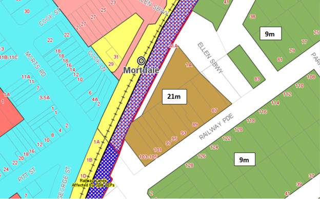
Figure 5: Extract
from the KLP (Height Map_003) designated as “R” which notes a 21m
height limit
66. The
originally approved building achieved an overall height of RL67.80 which
complied with the 21m height limit. The proposal is some 3m higher than the
approved height. The non-compliance exceeds the control by some 14%. The
non-compliance creates an additional storey and increases the scale of the
building and its visual bulk.
67. Clause
4.6(3) states that:
“Development consent must not be granted for development that
contravenes a development standard unless the consent authority has considered
a written request from the applicant that seeks to justify the contravention of
the development standard by demonstrating:
- that compliance with the development standard is unreasonable or
unnecessary in the circumstances of the case, and
- that
there are sufficient environmental planning grounds to justify contravening the
development standard”
68. To
support the non-compliance, the applicant has provided a request for a
variation to Clause 4.3 in accordance with Clause 4.6 of KLEP 2012. The Clause
4.6 request for variation is assessed as follows:
Is
the planning control in question a development standard?
69. Height
of Buildings limitation under Clause 4.3 of the KLEP 2012 is a development
standard.
What
are the underlying objectives of the development standard?
70. The
objectives of Height of Buildings standard under Clause 4.3 of KLEP 2012 are:
(a) to establish the maximum height for buildings,
(b) to minimise the impact of overshadowing, visual
impact and loss of privacy on adjoining properties and open space areas,
(c) to provide appropriate scale and intensity of
development through height controls.
71. In
order to address the requirements of Subclause 4.6(4)(a)(ii), the objectives of
Clause 4.3 are addressed in turn below.
1(a) To establish the maximum height for buildings
72. Applicants
Comments: “This objective articulates the ultimate function of the
height of buildings development standard. The maximum height for buildings on
land within the former Kogarah Local Government Area is identified on the
Height of Buildings Map. As previously described, the maximum building height
permitted on the subject site is 21m and the maximum height of the proposal is
23.975m. The proposal contravenes the standard, which has prompted the
preparation of this written variation request. Despite the nature and scale of
development proposed by this Development Application, Clause 4.3 achieves the
objective of establishing a maximum building height for the site, using the
Height of Buildings Map as a mechanism to do so. This written request
identifies the extent of variation proposed and explains why the variation is
acceptable in the circumstances.
73. The
area and degree of non-compliance with the height is shown in Figures 6 and 7
below.

Figure
6: The extent of the variation shown
in Section (courtesy of Planning Ingenuity)
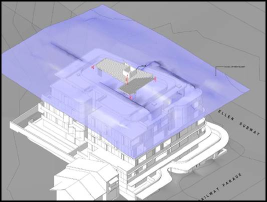
Figure
7: Height exceedance shown in 3D
(courtesy of Planning Ingenuity)
74. Officer’s
comment: Objective (a) is aimed at establishing a maximum height for
buildings so that within a given zone there is consistency in the scale and
built form of the building. It is accepted that the exceedance in the height is
centrally located within the roof form however Level 6 has become a new level
that includes structures that will be visible from the street and immediate
surrounds. The building is located on a prominent corner and any additional
height will be more obvious and visible when looking at the site from the
north, south and eastern side.
75. The
non-compliance is not considered minor as it relies on the roof level area for
its primary area of communal open space as this is the only area for passive
recreation for the development. This development is the first in the immediate
area to vary the height control by this amount. Council has on previous
occasions permitted the exceedance in the height control of ancillary
structures such as lift overruns, pergolas and areas of communal open space
(similar to that proposed) as these are generally not adding to the bulk of the
building and do not comprise of habitable areas. However given that the floor
space is non-compliant the increase in the height and floor space combined
creates a cumulative impact of increasing the bulk and scale of the building.
The building envelope and built form, as proposed, is non-compliant with the
ADG separation distances and does not comply with the maximum permitted gross
floor area for the site and therefore the additional scale and height is not
considered to reflect the desired future planning and design outcome that is
sought for this precinct.
1(b) To minimise the impact of overshadowing, visual impact and loss
of privacy on adjoining properties and open space areas
76. Applicants Comment: “The proposal
is seven storeys and Level 6 provides a compliant setback to the northern and
western site boundaries to ensure separation from the adjoining residential
properties. The proposal does not overshadow any public parks and does not result
in significant amounts of shadow cast over any adjoining residential
development beyond the approved building. Given the location of the
proposed lift overrun non-compliance centrally within the building and the
architectural treatment of the building in terms of setbacks and materials and
viewing points from which the non-compliance would be seen, visual impacts will
not be created. The proposed development provides for building setbacks that
comply with the controls of the ADG. The non-compliance cannot be seen from the
street or adjoining residential properties. The proposal is consistent with
objective (b).
77. Officer’s Comment: Objective
(b) relates to the amenity impacts that may be generated by the
exceedance. In this case the amount and degree of overshadowing that is created
by the variation, its visual impact and privacy impact need to be considered.
In terms of overshadowing the non-compliance creates additional overshadowing
so there is no “minimisation” in the impact of overshadowing in
this case from the non-compliance (refer to Figure 9). At 9am and 12pm during
mid-winter the shadows are increased but by 3pm there 8is also an increase in
the extent of the shadow created but this is likely to be tempered by the
existing development across the road (southern side) of Railway Parade. As such
the additional shadow would more than likely be covered by the existing
properties along the opposite side of the street (the shadow diagrams
haven’t considered existing shadows).
78. In terms of visual impact the additional storey
will be highly visible due to the prominent corner location of the site. The
visual bulk of the development has increased due to the “filling
in” of the sixth floor. As approved, Level 6 comprised of the area of
communal open space and the associated structures, pergola, fire stairs and
lift shaft are centrally located and generally small scale. These structures
would have been visible however they were located within the maximum height
control so there was no exceedance with the originally proposed development.
This proposal seeks to enclose this area and extend it to accommodate
additional floor space in the form of 4 new apartments. Although the apartments
are recessed behind the lower levels reducing their visibility somewhat, the utilisation
of this level for floor space creates a non-compliance with both height and
floor space, two principle planning controls. In terms of satisfying objective
(b) it cannot be said that the proposal is “minimising” the visual
impact as it is accentuating the height, bulk, scale and visual impact of the
development simply given its location. The additional level is not hidden or
obscured by any other elements or adjoining developments and it will establish
a new precedent for future development in the area.
79. The proposed roof top terrace area has been
designed to be viewed as a raised platform it is a large concrete structure
that largely will float above Level 6 (as the building wall of the new units
are recessed especially along the western side). The overhang of the roof top
level over Level 6 is over 4m along the western side which is considered to be
very visible and this protrusion is extensive and visually dominating and
overbearing.
80. In terms of privacy, the new apartments have been
designed to have their building wall recessed and setback from the edge of the
building however the new balconies on this level are substantial in size and
setback some 3m from the boundary. Their location and size will allow for
overlooking to the north, east and south. In this case the proposal through its
design fails to satisfy objective 1(b).
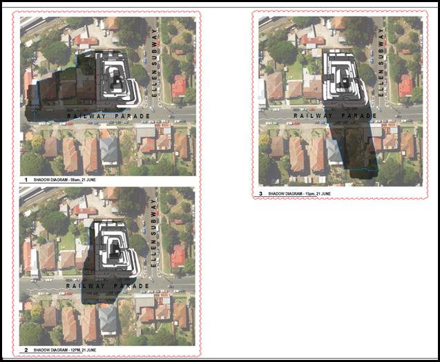
Figure 8:
Shadow Diagrams of the proposed development showing the additional shadow cast
by the variation
1(c) To provide appropriate scale and intensity of development through
height controls
81. Applicants
comment: “The minor non-compliance of the height does not offend
the objective of providing an appropriate scale and intensity of development at
the site. The proposal is in keeping with the desired built form for the site
and future development to the in accordance with the DCP controls. The built
form, bulk and scale of is appropriate for the site and the proposed
non-compliance with height will not be perceptible in the streetscape and
character of the locality. The proposed development
is therefore consistent with the objectives for maximum height, despite the
numeric non-compliance.”
82. Officer’s
comment: This objective aims to create a consistent scale and form for
development in the area and within this zone. The height control of 21m caters
for a 5-6 storey building (by calculating the following floor to floor levels,
commercial/ground floor 3.5m and 3.1m for all residential floors). The
proposed 7 storey building is not consistent with the intention of the control
and exceeds the height unnecessarily and the 7 storey proposed built form is
establishing an undesirable precedent in street and within this precinct. The
intended built form as approved, should be a maximum six (6) storey form.
83. The
proposed additional level is not in keeping with the proposed built form
approved and proposed developments within the vicinity of the site. Council is
in receipt of a Development Application for 89 Railway Parade which is a six
(6) storey mixed use development (not including the roof top level). This DA is
currently under assessment and the proposed front elevation is shown in Figure
9 below. The form of this proposal is reflective of the approved built form for
the subject site in accordance with DA consent 2017/0398.
84. The
proposed development at 89 Railway Parade achieves a maximum height of RL69.85
(to the lift overrun), RL68.50 (to the top of the pergola on the roof top) and
RL66.50 (to the parapet). In comparison the proposal has an overall height of
RL70.8 (to the lift overrun), RL69.30 (to the top of the pergola on the roof
level) and RL66.50 (to the parapet). The proposed development is higher than the
adjoining proposed development at every point apart from the parapet. The
approved development catered for the following lower heights of the building
RL67.80 (to the lift overrun), RL66.30 (top of the pergola on the roof) and
RL63.70 (to the parapet). The approved development has a better relationship to
potential future development at 89-91 Railway Parade as the site slopes upwards
from the west to the east. The fall in the land and natural slope dictates that
development to the west of the site (89-103 Railway Parade) should step up from
the corner (85 Railway Parade). The existing RL on the south eastern corner of
the site is about RL44.90 where the building commences and the south eastern
corner, existing ground level for 89 Railway parade is RL45.85 which is
approximately 1m difference so future development should naturally step down
from the west to the east. This would be the intended and preferred design and
urban design outcome and the height and floor space control encourages this to
occur through the controls. The proposed development will be higher than the
proposal at 89-91 Railway Parade which is not the intended planning and design
outcome for these sites due to the topographical features of the sites and
their natural slope.
85. The
preferred urban design outcome in terms of the anticipated height and built
form for the sites is shown indicatively in Figure 9 below which shows the
buildings responding to the natural fall of the land and the stepping of
buildings from the west to the east.
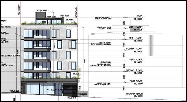
Figure 9: Proposed
front elevation of 89 Railway Parade (DA No.2018/0439) and its relationship to
the proposed development
86. The
proposal should also consider the height, bulk and scale of the approved
building at the rear, 1 Ellen Subway. This seven (7) storey mixed use
development was approved (DA2017/0570) with an overall height of RL67.6 and the
lift overrun sitting at RL68.9. 1 Ellen Subway is generally level with 85-87
Railway Parade however both properties are elevated above Ellen Subway. This roadway
is located below an existing elevated Council verge and embankment which has a
height of over 3m from the kerb and gutter. This elevated embankment further
accentuates the height of any proposed buildings located on 1 Ellen Subway and
85-87 Railway Parade when viewed from the east. The proposed development will
be a level higher than the building approved at 1 Ellen subway which is again
inconsistent with the scale of this adjoining development (refer to Figure 10
below).
87. In
conclusion the proposed scale and intensity of the proposal is inconsistent
with approved and proposed adjoining developments and the non-compliance will
establish an undesirable precedent in the immediate locality. The approved
development at the site satisfies the intended planning and design outcomes for
this site and development in this zone.
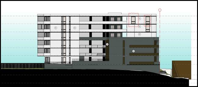
Figure 10: Eastern
elevation of the approved building at 1 Ellen Subway.
Compliance is unreasonable or unnecessary in
the circumstances of the case (clause 4.6(3)(a))
88. Applicant’s
comments: “In Wehbe V Pittwater Council (2007) NSW LEC 827 Preston
CJ sets out ways of establishing that compliance with a development standard is
unreasonable or unnecessary. This list is not exhaustive. It states, inter
alia:
“An objection under SEPP 1 may be well
founded and be consistent with the aims set out in clause 3 of the Policy in a
variety of ways. The most commonly invoked way is to establish that compliance
with the development standard is unreasonable or unnecessary because the objectives
of the development standard are achieved notwithstanding non-compliance with
the standard.”
The judgement goes on to
state that:
“The rationale is that development
standards are not ends in themselves but means of achieving ends. The ends are
environmental or planning objectives. Compliance with a development standard is
fixed as the usual means by which the relevant environmental or planning
objective is able to be achieved. However, if the proposed development proffers
an alternative means of achieving the objective strict compliance with the
standard would be unnecessary (it is achieved anyway) and unreasonable (no
purpose would be served).”
Preston CJ in the judgement then expressed
the view that there are 5 different ways in which an objection may be well
founded and that approval of the objection may be consistent with the aims of
the policy, as follows (with emphasis placed on number 1 for the purposes of
this Clause 4.6 variation [our underline]):
1. The objectives of the standard are
achieved notwithstanding non-compliance with the standard;
2. The underlying objective or purpose of
the standard is not relevant to the development and therefore compliance is
unnecessary;
3. The underlying object or purpose would be
defeated or thwarted if compliance was required and therefore compliance is
unreasonable;
4. The development standard has been
virtually abandoned or destroyed by the Council's own actions in granting
consents departing from the standard and hence compliance with the standard is
unnecessary and unreasonable;
5. The zoning of the particular land is
unreasonable or inappropriate so that a development standard appropriate for
that zoning is also unreasonable and unnecessary as it applies to the land and
compliance with the standard that would be unreasonable or unnecessary. That
is, the particular parcel of land should not have been included in the
particular zone.”
89. Officer’s
comment: In respect to Prestons CJ judgement the NSW Land and Environment
Court has established the five part test (outlined above). In this case the
development fails to satisfy the five part test for the following reasons;
a.
As previously discussed the objectives of the standard are not considered to be
satisfied.
b. The
underlying objective of the standard remains relevant and therefore compliance
is necessary and warranted.
c. Also
in this case the underlying objective has not been defeated or thwarted as the
approved development at the Site and at 1 Ellen Subway have been designed to
comply with the height standard. This further justifies that within the
immediate vicinity of the site there have to date been no variations to the
height control and as such the control has not been abandoned or destroyed.
d. The
Local Centre zone is an appropriate zoning for the site and this parcel of land
has been recently rezoned and up-scaled.
Clause
4.6(3)(b) are there sufficient environmental planning grounds to justify
contravening the standard
90. Applicant’s
comments: “Having regard to Clause 4.6(3)(b) and the need to
demonstrate that there are sufficient environmental planning grounds to justify
contravening the development standard, it is considered that there is an
absence of any material impacts of the proposed non-compliance on the amenity
of the environmental values of the locality, the amenity of future building
occupants and on area character. Furthermore, the following are submitted as
planning grounds to justify contravening the maximum building height:
The building height non-compliance is
limited to the top portion of the lift overrun and the communal open space
shade structures. The structures are primarily located at the centre of the
building. This location and the minimal bulk of these structures will ensure it
will not be highly visible from the public domain, and the impacts to adjoining
properties will be negligible. The portions of the building above the 21m
height limit are not visual intrusive on the skyline nor do they add to the
appearance of building bulk when viewed from the adjoining streets and public
domain;
· Except for this minor area of non-compliance for the
topmost portion of the lift shaft and roof top pergola, the building itself to
the rooftop parapet complies with the height limit at 21m. The result of this
is that the vast majority of the bulk of the building sits well below the
height limit;
· The rooftop provides high quality communal open space. In
order to provide equitable access to this space the lift overrun must
necessarily breach the height control, in this instance by 2.975m. Therefore,
this non-compliance provides substantial benefits to the development without
impacting neighbouring sites;
· The additional shadowing that will be caused by the height
non-compliance is negligible. The minor portion of shadows for the portion of
the lift overrun over the height limit is insignificant and acceptable;
· The breach will not result in any adverse impacts on
neighbouring properties in relation to privacy as the portion of the building
over the height limit will not enable overlooking;
· The roof top communal open provides a consolidated open
space with good solar access for future residents as encouraged by the
Apartment Design Guide (Part 3D) and is Council’s preferred location for
the communal open space;
· The proposed roof form creates variety in the skyline and
urban environment and contributes to the aesthetic and environmental design and
performance of the building;
· The non-compliant portions contain no residential or
habitable floor area; and
· Despite the minor non-compliance, the objectives of the
building height clause have been achieved as demonstrated above.
91. It is noted that in Initial Action Pty Ltd v Woollahra
Municipal Council [2018] NSWLEC 118, Preston CJ clarified what items a Clause
4.6 does and does not need to satisfy. Importantly, there does not need to be a
"better" planning outcome:
The second
way is in an error because it finds no basis in cl 4.6. Clause 4.6 does not
directly or indirectly establish a test that the non-compliant development
should have a neutral or beneficial effect relative to a compliant development.
This test is also inconsistent with objective (d) of the height development
standard in cl 4.3(1) of minimising the impacts of new development on adjoining
or nearby properties from disruption of views or visual intrusion. Compliance
with the height development standard might be unreasonable or unnecessary if
the non-compliant development achieves this objective of minimising view loss
or visual intrusion. It is not necessary, contrary to what the Commissioner
held, that the non-compliant development have no view loss or less view loss
than a compliant development.
The second
matter was in cl 4.6(3)(b). I find that the Commissioner applied the wrong test
in considering this matter by requiring that the development, which contravened
the height development standard, result in a "better environmental
planning outcome for the site" relative to a development that complies
with the height development standard (in [141] and [142] of the judgment). Clause
4.6 does not directly or indirectly establish this test. The requirement in cl
4.6(3)(b) is that there are sufficient environmental planning grounds to
justify contravening the development standard, not that the development that
contravenes the development standard have a better environmental planning
outcome than a development that complies with the development standard.
92. The non-compliance will have no adverse
impacts on adjoining properties with regard to visual, aural and privacy
impacts or overshadowing, and to require strict compliance would mean removing
parts of the building without resulting in a real planning benefit to
neighbourhood character or amenity. The proposed height non-compliance will
enable the orderly and economic redevelopment of the subject site in accordance
with the intentions of the Environmental Planning and Assessment Act, 1979.
There is no planning purpose to be served by limiting the height strictly to
the maximum allowable, particularly when the proposed additional residential
accommodation is provided in the absence of any amenity impacts and within the
footprint of the approved development. In short, we consider that there are
sufficient environmental planning grounds to justify the applicant’s
proposed variation to the height standard.
93. On “planning grounds” and in order to satisfy
that the proposal meets objective 1(b) of clause 4.6 in that allowing
flexibility in the particular circumstances of this development will achieve
“a better outcome for and from development”, we consider that
strict compliance would be counterproductive in terms of additional
opportunities for residential accommodation within an appropriate and
accessible zone.
94. Clause
4.6(4) states that:
“Development consent must not be granted for development that
contravenes a development standard unless:
(a) the consent authority is satisfied that:
(i) the applicant’s written request has adequately addressed
the matters required to be demonstrated by subclause (3), and”
95. Officer’s
Comment: It is considered that the Clause 4.6 Statement lodged with the
application addresses all the information required pursuant to Clause 4.6
however the statement is not considered to be well founded and there are
insufficient environmental planning grounds to justify contravening the
standard given that in this case the proposal does not satisfy the objectives
of the height control.
(ii) the proposed development will be in
the public interest because it is consistent with the objectives of the
particular standard and the objectives for development within the zone in which
the development is proposed to be carried out,
96. Applicant’s
comment: “Notably, under Clause 4.6(4)(a)(ii) a consent authority
must now be satisfied that the contravention of a development standard will be
in the public interest because it is consistent with the objectives of the
particular standard and the objectives for development within the zone in which
the development is proposed to be carried out. Clause 4.6(4)(a)(ii). Clause
4.6(4) also requires consideration of the relevant ‘B2 Local
Centre’ zone objectives which are provided below:
· To provide a range of retail, business, entertainment and
community uses that serve the needs of people who live in, work in and visit
the local area.
· To encourage employment opportunities in accessible
locations.
· To maximise public transport patronage and encourage
walking and cycling.
Whilst the non-compliance with the height
development standard does not, of itself, impact on the attainment of the zone
objectives, the proposed development will satisfy the objectives for the
following reasons:
· The propose additional level will not detract from but
complement the available commercial space at the ground floor;
· The development will continue provide commercial floor
space which has the potential to be occupied by a range of commercial uses that
serve the needs of the people living, working and visiting the local area.
· The site is proximate to Mortdale Railway Station and
Mortdale Town Centre and is therefore accessible.
· The approved development will create employment
opportunities in an accessible location and residents and staff will be
inclined to opt for more sustainable methods of transport given the close
proximity of the site to the railway station and town centre.
The proposal is consistent with the zone
objectives.”
97. Officer’s comment: The
objectives of the B2 Local Centre zone are generally satisfied by the
development as a whole despite the non-compliance. The amendment to the height
control will not affect the outcome and intention of the zone objectives which
are satisfied by the development as a whole since it is a mixed use
development. The proposal however fails to satisfy the “public
interest” test as the variation does not comply with the objectives of
the height standard.
(b) the concurrence of the Director-General has been
obtained.
98. Officer’s
Comment: The concurrence of the Director-General is assumed and has been
delegated to the determining authority which is the Georges River Local
Planning Panel as the non-compliance exceeds 10%.
Whether
contravention of the development standard raises any matter of significance for
State or regional environmental planning (Clause 4.6(5)(a))
99. Contravention
of the maximum height development standard proposed by this application does
not raise any matter of significance for State or regional environmental planning.
The public benefit in maintaining the development standard
(Clause 4.6(5)(b))
100. In
this case the approved development establishes the preferred and appropriate
design and built form outcome for this site with the building complying with
the height standard. There is no adequate or reasonable justification to vary
the height control as the new level of the building will not satisfy the
objectives of the height standard and create an undesirable precedent in the
streetscape. The proposed built form will be inconsistent with the approved
development at the site and adjoining the site (1 Ellen Subway) and the
proposed development at 89-91 Railway Parade (and potential future development
to the west). The proposal is considered to be out of scale with these
developments and will be a visible and dominating form at this prominent corner
location.
2. Detailed assessment of
variation to Clause 4.4 Floor Space Ratio
101. The proposed development
seeks a variation to the development standard relating to floor space (Clause
4.4). The KLEP identifies a maximum Floor Space Ratio (FSR) of 2.5:1 for the
Site (refer to Figure 11 below) and the proposed development will exceed the
floor space by 344.62sqm which amounts to a 10% variation and creates a total
FSR of 2.75:1. Any variation to the floor space can only be considered under
Clause 4.6 – Exceptions to Development Standards of the KLEP.
102. Clause 4.6(1) outlines the objectives
of the standard which are to “provide an appropriate degree of
flexibility in applying certain development standards to particular development”
and “to achieve better outcomes for and from development by allowing
flexibility in particular circumstances”.
103. The originally approved
building exceeded the floor space control. The assessment report stated that
“the proposal has been assessed as being non-compliant with the
FSR standard. It is estimated that the total proposed GFA is approximately
3,498sqm, which would equate to a non-compliant FSR of 2.558:1 and would
represent a 2.32% variation to the FSR development standard under clause 4.4 of
the KLEP2012.” The original proposal exceeded the FSR control by a
small amount and although the original proposal intended on complying with the
control, there were a few areas within the building that were not included in
the calculations but should have been in accordance with the GFA definition.
The discrepancy amounted to approximately 80sqm of floor space and this
included a waste room on the ground floor, pedestrian access to the WC on the
ground floor and also an additional car parking space as this area exceeds the
minimum requirements for car parking. The applicant submitted a Clause 4.6
Statement in respect to the non-compliance and this was supported given the
small variation and the fact most of the exceedance is in the basement or
ground floor levels.
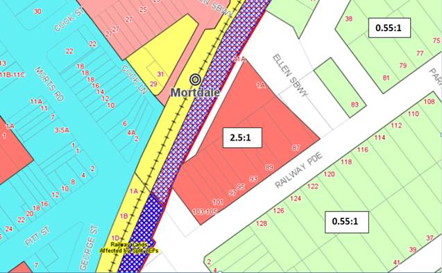
Figure 11:
Zoning map - FSR of 2.5:1
104. Clause
4.6(3) states that:
“Development consent must not be granted for development that
contravenes a development standard unless the consent authority has considered
a written request from the applicant that seeks to justify the contravention of
the development standard by demonstrating:
that compliance with the development standard is unreasonable or
unnecessary in the circumstances of the case, and
that there
are sufficient environmental planning grounds to justify contravening the
development standard”
105. To
support the non-compliance, the applicant has provided a formal request for a
variation to Clause 4.4 in accordance with Clause 4.6 of KLEP 2012. This Clause
4.6 request for variation is assessed as follows:
Is
the planning control in question a development standard?
106. Height
of Buildings limitation under Clause 4.4 of the KLEP 2012 is a development
standard.
What
are the underlying objectives of the development standard?
107. The
objectives of Floor Space Ratio standard under Clause 4.4 of KLEP 2012 are:
(a) to ensure the intensity of
development is compatible with the desired future character and zone objectives
for the land,
(b) to limit the bulk and scale of
development.
108. In
order to address the requirements of Subclause 4.6(4)(a)(ii), the objectives of
Clause 4.4 are addressed in turn below.
(a) To ensure the
intensity of development is compatible with the desired future character and
zone objectives for the land,
109. Applicants
Comments: “The proposed development adopts a suitable scale and
massing arrangement in line with that envisaged by the KLEP 2012, as amended.
Recent ‘up-zoning’ of land is anticipated to catalyse significant
change in building form and typology as sites within the locality are
redeveloped. The development (approved and subject proposal) represents the
first major redevelopment of land in the Mortdale Precinct south of the rail
corridor and will establish an appropriate pattern of development. The
mixed-use development will have no significant adverse impact on the amenity of
adjoining or nearby properties and will offer a substantial level of internal
amenity for future residents in a highly accessible location.
In our view, “compatible” does not promote
“sameness” in built form but rather requires that development fits
comfortably with its urban context. Of relevance to this assessment are the
comments of Roseth SC in Project Venture Developments Pty Ltd v Pittwater
Council [2005] NSWLEC 191:
“There are many dictionary definitions
of compatible. The most apposite meaning in an urban design context is capable
of existing together in harmony. Compatibility is thus different from sameness.
It is generally accepted that buildings can exist together in harmony without
having the same density, scale or appearance, though as the difference in these
attributes increases, harmony is harder to achieve.”
The existing built form character of the
area does not accurately reflect the level of density afforded to the site
under the applicable planning controls. Rather the subject controls would
result in a form that exceeds the prevailing building density, however one that
is entirely consistent with the desired future character for the locality
reflected in the new suite of core controls under the LEP. Despite the proposal
exceeding the applicable density by 10%, the scale of the proposal remains
appropriate and is commensurate with a form of development that is reasonably
expected under the applicable controls.
As such, the non-compliance is a negligible
exceedance of the maximum permitted density and as the building has been massed
on the site in a way that responds to the topography of the area, and provided
appropriate setbacks to each boundary the development in its current form is
entirely suitable, being compatible with the desired future character and zone
objectives.
The proposal is consistent with objective (a).”
110. Officer’s
Comment: Objective (a) is aimed at establishing a consistent built form and
massing for developments in the zone and immediate locality. The permitted
2.5:1 FSR is only applicable to a small proportion of properties located along
the south eastern side of the railway line. These properties have been
up-scaled to have heights of 21m and FSR’s of 2.5:1. Immediately to the
north east, east and south of the site are properties that are zoned R2 and the
FSR and height limits are 0.55:1 and 9m respectively so the future
redevelopment of these sites is limited and the scale and form will be
substantially lower than what is permissible at the subject site.
111. It
is important for the proposal to respect the potential redevelopment of
adjoining sites and for the proposal to sit comfortably within the context of
the streetscape and create an sympathetic transition and interface to the
adjoining, lower scale residential developments. The proposed additional level
is considered to be incompatible with the desired future character for this
precinct. The additional scale and bulk is not considered to be in keeping with
existing development and potential future redevelopment in the streetscape. The
building is situated on a prominent corner which is already in part naturally
elevated due to the existing public verge and embankment located adjacent to
Ellen Subway. The new apartments located within the originally approved roof
top space will increase the visual bulk of the development and the development
will no longer be read as a seven (7) storey building but rather an eight (8)
storey development. The desired future character for development is envisaged
through the controls and the exceedance of both the height and FSR control,
creates a cumulative impact which is unacceptable and does not translate into
what the implementation of these controls seeks to achieve in terms of creating
an appropriate bulk and scale.
(b) To limit the bulk and scale of
development
112. Applicants Comment:
“The additional level does not significantly change the approved
bulk and scale of the development. The building will continue to read as a
structure with a distinct podium base, a middle layer and a top layer. The
proposed level is recessed from the approved lower levels to create a
transition in height and appropriate spatial separation. The vertical recess at
the eastern elevation is carried through to Level 6 from the levels below and
serves to modulate the building volume while variations in materiality help to
define the layers of the building and create visual interest. The departure from the FSR standard will have no material
impact on the public domain or on the amenity of individual apartments. The
additional floor space will not translate into any notable amenity related impacts
on adjoining properties in terms of loss of privacy, view loss or
overshadowing.
The proposal is consistent with objective (b).
113. Officer’s Comment: Objective
(b) seeks to restrict and “limit” the bulk and scale of the
development. The proposed additional bulk and mass to the building is not
considered to satisfy this objective. Some additional floor space within the
basement or ground floor may be acceptable as it may not be visible and may be
obscured or acceptable as the overall scale and form of the building is largely
unaltered however the additional floor space will be highly visible and
dominating. The originally approved development allowed for a rooftop terrace
area that was setback from the edges (parapet) of the building and the new
apartments have been located within this space by enclosing it and creating
balconies that extend to the edge. Despite the recessed nature of the building
wall to all the new units the bulk, form and mass is accentuated and will be
highly visible given the prominent corner location. The relocation of the roof
top terrace and open space to the new seventh level will create an exceedance
in the height control and increase the scale of the development beyond what is
permissible or envisaged by the primary planning controls. This roof top
platform will also be very visible.
114. The massing and additional bulk of the
development will be out of keeping with the approved development at 1 Ellen
Subway and will establish an undesirable precedent as no new developments have
exceeded the height or floor space controls in this precinct and the proposed
exceedance of 10% is considered significant given the sites location, nature of
adjoining development and the fact the variation is not satisfying the
objectives of the development control. The nature, degree and extent of the
variation is considered to be unreasonable and will result in an
overdevelopment of the site.
115. The proposal is not considered to satisfy the
objectives of the FSR control.

Figure 12: Southern
elevation of the proposed development
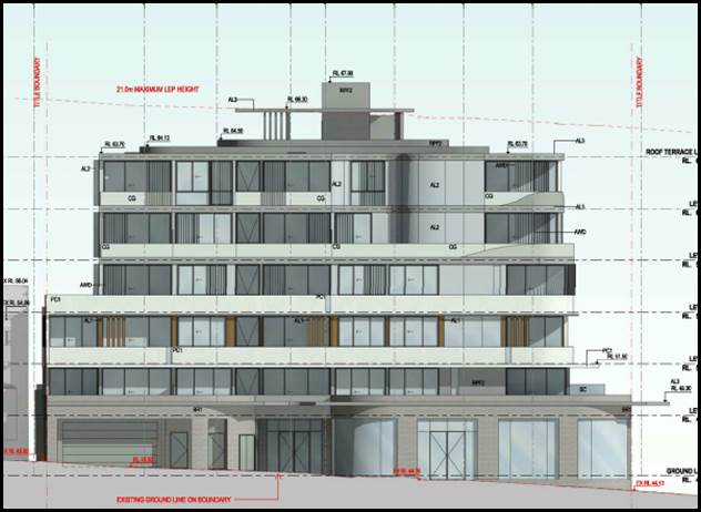
Figure 13: Southern
elevation of the development as “approved”
Compliance is unreasonable or unnecessary in
the circumstances of the case (clause 4.6(3)(a))
116. Applicant’s
Comment: “In Wehbe V Pittwater Council (2007) NSW LEC 827 Preston
CJ sets out ways of establishing that compliance with a development standard is
unreasonable or unnecessary. This list is not exhaustive. It states, inter
alia:
“An objection under SEPP 1 may be well
founded and be consistent with the aims set out in clause 3 of the Policy in a
variety of ways. The most commonly invoked way is to establish that compliance
with the development standard is unreasonable or unnecessary because the
objectives of the development standard are achieved notwithstanding
non-compliance with the standard.”
The judgement goes on to state that:
“The rationale is that development
standards are not ends in themselves but means of achieving ends. The ends are
environmental or planning objectives. Compliance with a development standard is
fixed as the usual means by which the relevant environmental or planning
objective is able to be achieved. However, if the proposed development proffers
an alternative means of achieving the objective strict compliance with the
standard would be unnecessary (it is achieved anyway) and unreasonable (no
purpose would be served).”
Preston CJ in the judgement then expressed
the view that there are 5 different ways in which an objection may be well
founded and that approval of the objection may be consistent with the aims of
the policy, as follows (with emphasis placed on number 1 for the purposes of
this Clause 4.6 variation [our underline]):
1. The objectives of the
standard are achieved notwithstanding non-compliance with the standard;
2. The underlying objective
or purpose of the standard is not relevant to the development and therefore
compliance is unnecessary;
3. The underlying object or
purpose would be defeated or thwarted if compliance was required and therefore
compliance is unreasonable;
4. The development standard
has been virtually abandoned or destroyed by the Council's own actions in
granting consents departing from the standard and hence compliance with the
standard is unnecessary and unreasonable;
5. The zoning of the
particular land is unreasonable or inappropriate so that a development standard
appropriate for that zoning is also unreasonable and unnecessary as it applies
to the land and compliance with the standard that would be unreasonable or
unnecessary. That is, the particular parcel of land should not have been
included in the particular zone.
Compliance with the floor space ratio development standard is
considered to be unreasonable and unnecessary as the objectives of that
standard are achieved for the reasons set out in this statement. For the same
reasons, the objection is considered to be well-founded as per the first method
underlined above.”
117. Officer’s
Comment: In respect to Prestons CJ judgement the NSW Land and Environment
Court has established the five part test (outlined above). In this case the
development fails to satisfy the five part test for the following reasons;
a. As
previously discussed the objectives of the standard are not considered to be
satisfied.
b. The
underlying objective of the standard remains relevant and therefore compliance
is necessary and warranted.
c. Also
in this case the underlying objective has not been defeated or thwarted as the
approved development at the Site and at No.1 Ellen Subway have been designed to
comply with the floor space ratio standard. This further justifies that within
the immediate vicinity of the site there have to date been no variations to the
FSR control (apart from a minor exceedance for the originally approved proposal
which comprised of some ancillary areas on lower levels which were not
habitable) and as such the control has not been abandoned or destroyed.
d. The
Local Centre zone is an appropriate zoning for the site and this parcel of land
has been recently rezoned and up-scaled to permit a higher density due to the
close proximity of the site to the Railway Station.
Clause
4.6(3)(b) are there sufficient environmental planning grounds to justify
contravening the standard;
118. Applicant’s
comment: “Having regard to Clause 4.6(3)(b) and the need to
demonstrate that there are sufficient environmental planning grounds to justify
contravening the development standard, it is considered that there is an
absence of any material impacts of the proposed non-compliance on the amenity
of the environmental values of the locality, the amenity of future building
occupants and on area character.
It is noted that in Initial Action Pty Ltd v
Woollahra Municipal Council [2018] NSWLEC 118, Preston CJ clarified what items
a Clause 4.6 does and does not need to satisfy. Importantly, there does not
need to be a "better" planning outcome:
86. The second way is in an error because it
finds no basis in cl 4.6. Clause 4.6 does not directly or indirectly establish
a test that the non-compliant development should have a neutral or beneficial
effect relative to a compliant development. This test is also inconsistent with
objective (d) of the height development standard in cl 4.3(1) of minimising the
impacts of new development on adjoining or nearby properties from disruption of
views or visual intrusion. Compliance with the height development standard
might be unreasonable or unnecessary if the non-compliant development achieves
this objective of minimising view loss or visual intrusion. It is not
necessary, contrary to what the Commissioner held, that the non-compliant
development have no view loss or less view loss than a compliant development.
87. The second matter was in cl 4.6(3)(b). I
find that the Commissioner applied the wrong test in considering this matter by
requiring that the development, which contravened the height development standard,
result in a "better environmental planning outcome for the site"
relative to a development that complies with the height development standard
(in [141] and [142] of the judgment). Clause 4.6 does not directly or
indirectly establish this test. The requirement in cl 4.6(3)(b) is that there
are sufficient environmental planning grounds to justify contravening the
development standard, not that the development that contravenes the development
standard have a better environmental planning outcome than a development that
complies with the development standard.
The non-compliance will have no adverse
impacts on adjoining properties with regard to visual, aural and privacy
impacts or overshadowing, and to require strict compliance would mean removing
parts of the building without resulting in a real planning benefit to
neighbourhood character or amenity.
The proposed FSR non-compliance will enable
the orderly and economic redevelopment of the subject site in accordance with
the intentions of the Environmental Planning and Assessment Act, 1979. There is
no planning purpose to be served by limiting the FSR strictly to the maximum
allowable, particularly when the proposed additional residential accommodation
is provided in the absence of any amenity impacts and within the footprint of
the approved development.
In short, we consider that there are sufficient
environmental planning grounds to justify the applicant’s proposed
variation to the FSR standard.
On “planning grounds” and in
order to satisfy that the proposal meets objective 1(b) of clause 4.6 in that
allowing flexibility in the particular circumstances of this development will
achieve “a better outcome for and from development”, the
non-compliance is minor and will not be noticeable from the street or
surrounding properties.
Strict compliance would be counterproductive
in terms of additional opportunities for residential accommodation within an
appropriate and accessible zone.
The merits of the proposal on
“environmental planning grounds” need to be balanced with the
burden that strict compliance places on the site and whether strict compliance
will result in a better or neutral outcome. The development has been designed
to provide a high quality urban outcome, designed so as to not impact on the
privacy and amenity of neighbouring properties.
The proposal will not undermine or dismiss
the relevance of the density control. Nor will the proposed built form set an
undesirable precedent for the locality currently undergoing change.
To require strict compliance would therefore result in an
unreasonable burden on future occupiers of the development with no demonstrable
built form or amenity benefits. The proposal results in additional units within
an approved high quality mixed use development which is suited to the site, is
consistent with the emerging character of the locality and will not have any
significant adverse impact on the amenity of adjoining properties in terms of
privacy, solar access, views and bulk and scale.”
119. Officer’s
comment: In terms of the proposal providing sufficient planning grounds to
justify contravention of the standard, the variation is considered to increase
the bulk, scale and massing of the building. The visual dominance of the
building will be increased and the scale of the building is larger, higher and
inconsistent with approved developments in the immediate vicinity of the site.
The proposed balconies will increase the potential for overlooking to the east,
north west and north east. In addition to this the removal of the approved
skylights on the roof level (level 6) by the proposal will adversely affect the
internal amenity and solar access to the southern facing apartments (Units 504
and Unit 505). These apartments will now fail to comply with the minimum solar
access requirements pursuant to Part 4A of the ADG. This will reduce the
amenity of these “approved” apartments to an unacceptable level.
This is an adverse environmental and planning outcome.
120. The
proposal also fails to satisfy the objectives of the floor space control and is
considered to be an overdevelopment of the site.
121. Clause
4.6(4) states that:
“Development consent must not be granted for development that
contravenes a development standard unless:
(c) the consent authority is satisfied that:
(iii) the applicant’s written request has adequately addressed
the matters required to be demonstrated by subclause (3), and”
122. Officers
Comment: It is considered that the Clause 4.6 Statement lodged with the
application addresses all the information required pursuant to Clause 4.6
however the statement is not considered to be well founded and there are
insufficient environmental planning grounds to justify contravening the
standard given that the proposal does not satisfy the objectives of the floor
space ratio control in this case.
(iv) the proposed development will be in the public interest
because it is consistent with the objectives of the particular standard and the
objectives for development within the zone in which the development is proposed
to be carried out,
123. Applicant’s
Comment: “Notably, under Clause 4.6(4)(a)(ii) a consent authority
must now be satisfied that the contravention of a development standard will be
in the public interest because it is consistent with the objectives of the
particular standard and the objectives for development within the zone in which
the development is proposed to be carried out. Clause 4.6(4)(a)(ii). Clause
4.6(4) also requires consideration of the relevant ‘B2 Local
Centre’ zone objectives which are provided below:
· To provide a range of retail, business, entertainment and
community uses that serve the needs of people who live in, work in and visit
the local area.
· To encourage employment opportunities in accessible
locations.
· To maximise public transport patronage and encourage
walking and cycling.
Whilst the non-compliance with the FSR
development standard does not, of itself, impact on the attainment of the zone
objectives, the proposed development will satisfy the objectives for the
following reasons:
· The propose additional level will not detract from but
complement the available commercial space at the ground floor;
· The approved development provide new commercial floor space
which has the potential to be occupied by a range of commercial uses that serve
the needs of the people living, working and visiting the local area.
· The site is proximate to Mortdale Railway Station and
Mortdale Town Centre and is therefore accessible.
· The approved development will create employment
opportunities in an accessible location and residents and staff will be
inclined to opt for more sustainable methods of transport given the close
proximity of the site to the railway station and town centre.
The proposal is consistent
with the zone objectives.”
124. Officer’s Comment: The
objectives of the B2 Local Centre zone are generally satisfied by the
development as a whole despite the non-compliance. The amendment to the floor
space ratio control will not affect the outcome and intention of the zone
objectives which are satisfied by the development as a whole since it is a
mixed use development. Generally the objectives are not applicable to the
proposal. The development, however fails to satisfy the “public
interest” test as the variation does not satisfy the objectives of the
floor space standard.
(d) the concurrence of the Director-General has been
obtained.
125. Officer’s
Comment: The concurrence of the Director-General is assumed and has been
delegated to the determining authority which is the Georges River Local
Planning Panel as the non-compliance exceeds 10%.
Whether
contravention of the development standard raises any matter of significance for
State or regional environmental planning (Clause 4.6(5)(a))
126. Contravention
of the maximum floor space ratio development standard proposed by this
application does not raise any matter of significance for State or regional
environmental planning.
The public benefit in maintaining the
development standard (Clause 4.6(5)(b))
127. In
this case the originally approved development establishes the preferred and
desired design, planning and built form outcome for this site with the building
complying with the height standard with a small variation to the floor space
being considered acceptable. There is no adequate or reasonable justification
to vary the floor space ratio control as the new level of the building will not
satisfy the objectives of the standard, will establish an undesirable precedent
in the streetscape.
128. The
proposed massing and built form will be inconsistent with the approved
developments at the site and adjoining the site (1 Ellen Subway) and be out of
scale with these as well as being a visible and dominating form at this
prominent corner location. The proposal by way of the exceedance in the floor
space control is considered to be an overdevelopment of the Site in this case.
Development Control Plans
KOGARAH DEVELOPMENT CONTROL PLAN NO 2013 (KDCP)
129. Following on from the
original assessment of the development, the proposal needs to address and
satisfy the provisions of Part B – General Controls and Part D1 –
Development in the B1 Neighbourhood Centres and B2 Local Centre zones as part
of the KDCP. These provisions are addressed in more detail below.
Part B – General Controls
130. B1 Heritage - In respect to the heritage provisions
(Part B1) of the KDCP, the site is located within the vicinity of Heritage
Item - Mortdale Railway Station and car sheds, which is listed as an
item (I71) of State significance within the Hurstville Local Environmental
2012. Council has not required a heritage impact assessment and considered that
the proposal is unlikely to result in any undue impacts on the nearby item.
131. The
subject site is some distance from this site separated by the presence of 1
Ellen Subway and the Railway Line. The integrity and significance of the item
will not be diminished or impacted upon negatively by the proposed development.
132. B2 Tree Management and
Greenweb – The proposal does not seek to remove any trees or existing
vegetation and therefore satisfies the provisions of this part of the KDCP.
133. B3 Developments near
busy roads and rail corridors – This part of the KDCP is relevant as
the density of the proposal is being increased and it will generate an increase
in parking. The planning control in respect to this section of the DCP states
that “Acoustic assessments for noise sensitive developments as
defined in clauses 87 and 102 of the Infrastructure SEPP may be required if
located in the vicinity of a rail corridor or busy roads”. The issue
of noise and potential acoustic impacts have been discussed earlier in this
report and would comply if the
proposal is supported. State Rail was notified of the proposal in accordance
with the provisions of the Infrastructure SEPP due to the proximity of the
development to the rail corridor. To date no response has been received
although State Rail provided concurrence to the originally approved mixed use
development. The development has been designed to satisfy the provisions and
objectives of B3 of the KDCP.
134. B4 Parking and Traffic
- The proposal seeks some changes to the parking layout and arrangement as
originally approved. Spaces have been moved and relocated to other levels i.e
visitor spaces have been moved from B1 to the ground floor and the car wash is
also now to be located on the ground floor level.
135. In respect to the provision
of parking and numbers, the application requires assessment and compliance
against the RMS/ADG parking requirements given the proximity of the site to the
Mortdale Train Station. As such the proposal does not need to comply with
Council’s car parking provisions. However the originally approved
development (DA2017/0398) assessed the parking against the KDCP. In respect to
car parking numbers the original assessment made the following assessment based
on the residential component of the development (refer to Figure 14 below).
|
Type
|
Required
Parking & Dwelling Mix
|
Number
of Dwellings
|
Total
Required Parking
|
|
1 Bed
|
1
|
7
|
7
|
|
2 Bed
|
1.5
|
30
|
45
|
|
3+ Bed
|
2
|
3
|
6
|
|
Total Parking
|
|
|
58
|
|
Visitor
|
1/5
|
40
|
8
|
|
Total Residential Parking
|
|
|
66
|
Figure 14: Car
Parking Table required for the residential component of the development as
approved
136. The originally approved
development provided for 67 residential spaces as part of the development which
satisfied the numeric requirements of Part 3.7 of the KDCP. The one additional
space was included as gross floor area as it exceeded the requirement.
137. The four (4) new additional
apartments generate the following car parking requirements;
|
Type
|
Required
Parking & Dwelling Mix
|
Number
of Dwellings
|
Total
Required Parking
|
|
1 Bed
|
1
|
7
|
7
|
|
2 Bed
|
1.5
|
33
|
50
|
|
3+ Bed
|
2
|
4
|
8
|
|
Total Parking
|
|
|
65
|
|
Visitor
|
1/5
|
44
|
9
|
|
Total Residential Parking
|
|
|
74
|
138. The proposal provides for a
total of 87 car parking spaces which will be able to cater for Council’s
requirements. The development generates the need for 9 visitor spaces however
as there is an excess in residential parking numbers one of these spaces could
be converted to a visitor space to satisfy the visitor requirements. As such
the residential component of the development satisfies the car parking
requirements for the density proposed.
139. In respect to the
commercial component the ground floor tenancy has been slightly reduced in its
gross floor area from 212sqm to 193sqm due to the inclusion of the fire hydrant
pump room which is located within this area. The originally approved
development generated the need for 9 car parking spaces to service the
commercial component.
140. Part B4 of the KDCP
outlines the relevant car parking rates for commercial and retail developments.
One (1) car parking space per 25sqm of gross floor area for retail development
is required and/or one (1) space per 40sqm for commercial floor space. The
originally approved development calculated the car parking based on the
“retail” rates within the DCP as it is more likely that the use of
this ground floor tenancy will be of a retail use and capacity given its
location, size and design. As such it generated the need for 9 car parking
spaces which were provided. The current proposal has reduced the commercial
floor space slightly to 193sqm which generates the need for 8 off street car
parking spaces rather than 9. However 9 spaces are provided which comply with
the car parking requirements.
141. The proposal was referred
to Council’s Traffic Engineers and there the amended car parking layout
and arrangement fails to satisfy a number of Council’s minimum
requirements in terms of the size and location of some facilities.
Council’s Traffic Engineer has raised the following concerns;
· The
Loading and unloading bay dimensions are too small. It needs to be
minimum of 3.5m wide and 9.5m in length. Swept path diagram will be needed for
the loading bay.
· Spaces
C01 and C02 and C08 and C09, are not in an acceptable location as they are
located within the access ramp of the car park. Manoeuvring into and out
of these car spaces will require turning and reversing movements along the
ramp, which would cause congestion and possible safety issues. Ramps need
to be clear of obstructions or congestion for efficient and safe flow of
traffic at all times.
· Elevation
plan showing required minimum height needs to be provided, including for
disabled spaces.
142. The proposal includes a
number of designated areas within the basement levels to accommodate bicycle
parking with a total of 22 bicycle spaces. A separate loading bay and car wash
bay are provided for on the ground floor.
Part D1 – Development in the B1
Neighbourhood Centres and B2 Local Centre zones
143. The objectives of
Subsection 3.4 (Building Heights) includes “ensuring appropriate
transition to lower scale residential development adjacent to the rear occurs
and that building height is in accordance with the locality requirements”.
Control 3.4.3 states that “where an allotment adjoins a low density
residential area buildings should be reduced in height in accordance with the
locality controls and setback from the adjoining property boundary”.
The proposal fails to satisfy this control as the development is seeking
greater height where it adjoins a low scale R2 zone to the south, east and
north-east. The development is not considered to satisfy this control.
144. The proposal satisfies
other provisions such as the active frontages controls (3.6.2), awning (3.6.3),
materials and finishes (3.6.5) as there is no significant change to the
treatment of the commercial component of the development and the external
finishes and architectural treatment is not being varied by this proposal.
DEVELOPER
CONTRIBUTIONS
145. The
proposed development would require payment of developer contributions under
Section 7.12 of the Environmental Planning and Assessment Act 1979 as the
proposal is increasing the density of the development by the introduction of 4
new apartments. If the development is approved a condition outlining the
required contributions will be imposed.
IMPACTS
Natural
Environment
146. The
proposed development is unlikely to result in adverse impacts to the natural
environment as the proposal does not request the removal of any existing trees
or vegetation. The original approval addressed this issue in detail and
ensured, through conditions on the consent to improve landscaping within and
around the site, in particular the landscaping treatment along the Ellen Subway
frontage and also in respect to ensuring the retention of the White Cedar Tree.
This requirement remains unchanged by this proposal.
Built
Environment
147. The
proposed development is considered to be excessive in terms of its built form,
bulk and scale and is considered to be an overdevelopment of the site by the
variation of the two key planning controls relating to height and floor space.
The exceedance of these controls is considered to be unreasonable and
unacceptable and the proposal does not reflect the desired future planning and
design outcome for this site. The increased scale and bulk of the building will
be visually dominating and will not have an appropriate relationship to the
lower scaled residential properties to the south, east and north east and will
not be consistent with the scale of the approved building at 1 Ellen Subway.
Social
Impact
148. No
adverse social impacts have been identified as part of the assessment. The
additional dwellings, in principle, will cater for a cross-section of the
community and could assist with providing for more housing in the area.
Economic
Impact
149. The
proposed development has no apparent adverse economic impact. There may be a
small positive economic impact as a result of the construction of four (4) new
apartments however the impact is considered negligible as the main larger scale
“shop top” housing development has been approved and this
development in its totality will have a more beneficial economic impact due to
its scale.
Suitability of the site
150. The site is zoned B2 – Local
Centre. The proposal is a permissible form of development in this zone.
Although the site is suitable for this form of development as “shop top
housing” is a permissible use within the zone. The additional density,
scale and height that is proposed is not considered to be acceptable given the
site considerations, context and nature of adjoining developments.
SUBMISSIONS AND THE PUBLIC
INTEREST
151. The application was
neighbour notified in accordance with Kogarah DCP 2013 for a period of 14 days.
No submissions were received. However it should be noted that after the
approval of 1 Ellen Subway and the original application for the subject Site,
Council received a number of submissions from residents concerned about the
proposed approvals and that the developments are considered to be out of
context with the scale, form and bulk of existing development in the immediate
locality and streetscape.
REFERRALS
Council
Referrals
Development
Engineer
152. The application was referred to Council’s
Engineers for comments. No objection was raised in respect to the design of the
proposed stormwater/drainage plan.
Traffic
Engineer
153. The
application was referred to Council’s Traffic Engineer for comment. A
series of issues were raised by the Traffic Engineer as discussed in the car
parking and traffic section of the report above.
Environmental
Health Officer
154. Council’s
Environmental Health Officer has raised no objection subject to
conditions of consent being attached if approval is granted.
External
Referrals
Sydney Trains
155. The application was referred to Sydney Trains in
accordance with Clause 85 and 87 of State Environmental Planning Policy
(Infrastructure) 2007. To date (25 June 2019) no formal concurrence has
been received however this could be assumed given that Sydney Trains provided
concurrence to the originally approved mixed use development. If approval is
granted the original terms of the concurrence will need to be included in the
consent.
CONCLUSION
156. The
proposal has been assessed using the matters for consideration listed in
Section 4.15 of the Environmental Planning and Assessment Act 1979. The
proposal is considered to be an unreasonable intensification of site and the
proposed additional scale, bulk and height is considered to be an unacceptable
planning and design outcome for this site and will adversely affect the
character of development in the street and immediate locality.
157. The
proposal has been assessed against the provisions of the KLEP 2012 and KDCP
2013 and the proposal exceeds the key planning controls in this environmental
planning instrument relating to height and floor space. Two Clause 4.6
Statements have been submitted with the application justifying the variation in
this case.
158. The
proposed development fails to satisfy the objectives of both the height and
floor space control standards and in this case the Clause 4.6 Statements are
not considered to be well founded and fail to satisfy the provisions and
requirements of Clause 4.6 of the KLEP.
DETERMINATION
AND STATEMENT OF REASONS
Statement of
Reasons
159. The
reasons for this recommendation are:
· The proposed
development fails to satisfy the objectives of Clause 4.3 (Height of Buildings)
control within the KLEP, the exceedance in the height of the building will
adversely affect the character of the streetscape and will be inconsistent with
development that has been approved within this precinct.
· The proposed
development fails to satisfy the objectives of Clause 4.4 (Floor Space Ratio)
control within the KLEP and the additional bulk and scale of the building will
adversely affect the character of the streetscape and will be inconsistent with
development that has been approved within this precinct.
· The additional
mass will be a visually dominating element in the streetscape, especially as
the building is located on a prominent corner and will not sit comfortably or
create a sympathetic relationship with lower scale residential development to
the east, south and north-east of the Site.
· The development fails
to satisfy the solar access provisions of the ADG and the resultant impact will
adversely affect the internal amenity of the southern orientated units on Level
5 (as approved).
· The car parking
arrangement and the proposed size of the loading dock is considered to be
substandard and fails to comply with the provisions of Kogarah Development
Control Plan.
· The proposed
development is considered to be an overdevelopment of the Site and will
adversely affect adjoining developments, as the new units by way of their
location and siting of their balconies will overlook immediately adjoining
properties to the east and north-east.
· The proposal is
considered to establish an undesirable precedent in the area and will not be in
the public interest.
· In consideration of the aforementioned reasons, the
proposed development is recommended for refusal.
Determination
A. THAT the
Georges River Local Planning Panel not support the request for variation under
Clause 4.6 of Kogarah LEP 2012, in relation to the Height of Buildings (Clause
4.3) control as the variation is not considered to be well founded.
B. THAT the
Georges River Local Planning Panel not support the request for variation under
Clause 4.4 of the Kogarah LEP 2012, in relation to the Floor Space Ratio
(Clause 4.4) control as the variation is not considered to be well founded.
C. THAT pursuant
to Section 4.16(1)(b) of the Environmental Planning and Assessment Act
1979 (as amended) the Council refuse development consent to Development
Application DA2018/0547 for alterations and additions to the approved
mixed use development by providing for four (4) new apartments in the form of 3
x 2 bedroom apartments and 1 x 3 bedroom apartment, reduction in the commercial
floor area and alterations to the basement car parking levels and relocation of
the rooftop communal open space to Level 7 of the building at Lot 8, DP 456956, Lot 7 DP 1884, Lot 1 DP
171157 and known as 85-87 Railway Parade, Mortdale, for the following
reasons:
1. The
proposed development fails to satisfy the control and objectives of Clause 4.3
(Height of Buildings) of the KLEP 2012 as the additional height and scale of
the building will adversely affect the character of development in the
streetscape and the additional height is out of scale and inconsistent with the
scale and form of approved developments in the area.
2. The
proposed increase in the scale of the building is considered to be inconsistent
with the existing character of lower scale residential development located to
the south, east and north east. The relationship of the proposed development to
the existing residential development is considered to be poor and the
transition is considered to be unacceptable given the context and character of
development in the street.
3. The
proposed development fails to satisfy the control and objectives of Clause 4.4
(Floor Space Ratio) of the KLEP 2012 as the additional floor space, its bulk,
scale and mass is inconsistent with recently approved development in the
vicinity of the site. The additional bulk and scale will be visually dominating
given the prominent corner location of the site and its elevated position. The
massing of the building, the elevated rooftop platform will be inconsistent
with recently approved development in the B2 zone.
4. The
proposed built form and the additional scale of the building will be out of
character with existing and recently approved developments and does not reflect
the desired future character for development in the street. The development
fails to consider the topographical features of the site and does not step down
to relate to the natural slope of the land. The transition and interface of the
building to the lower scale residential developments to the east and south of
the site is considered to be unacceptable and unsympathetic with the form of
these neighbouring properties.
5. The
proposed development fails to satisfy the design criteria of the SEPP 65, Part
4A-1 of the Apartment Design Guide in respect to the provision of an adequate
amount of solar access to units. The provision of a new level will remove the
skylights that included on Level 6 (rooftop) of the proposed development and
their removal will adversely affect the internal amenity of the southern
orientated living spaces of Units 504 and 504.
6. The
proposed rooftop area of communal open space fails to satisfy the provisions of
SEPP 65, Part 3D-1 of the Apartment Design Guide, in respect to the amount of
communal open space and the quality of this space. The actual principle useable
area of open space fails to satisfy the minimum 25% requirement as much of the
area comprises of planter boxes which renders a large proportion of this space
unusable and not functional for recreational purposes.
7. The
design and treatment of the rooftop area of communal open space fails to
satisfy the provisions of SEPP 65 and the design guidance of Part 4P (Planting
on structures) of the ADG and space is considered to be poor and has not been
appropriately documented or detailed.
8. The
proposal fails to satisfy the provisions of to satisfy the provisions of SEPP
65, Part 4G of the Apartment Design Guide, in respect to the amount of storage
provided for the new apartments.
9. The
proposed loading bay does not satisfy the provisions of AS2890 and the KDCP as
the space is too small. Manoeuvring into and out of this space is also awkward
and no swept paths have been provided to ensure access to this space by vans
and small rigid vehicles (SRV’s) can be achieved.
10. Car parking spaces
C01, C02 and C09 are poorly located as they are sited within the access ramp
which is an unacceptable design solution.
11. The
proposal fails to satisfy the objectives of Subsection 3.4 (Building Heights)
of the KDCP 2013 as the building adjoins a low scale R2 zone to the south, east
and north east and the scale of the proposal does not provide for an appropriate
transition of development to the east.
12. The
proposed Clause 4.6 variations in respect to the height and floor space
controls are not considered to be well founded in this case as the design of
the development fails to satisfy the objectives of the planning controls
therefore failing to satisfy the provisions of Clause 4.6.
13. The
additional height, scale and floor space proposed does not represent the
desired future character for development in the street and precinct and will
adversely affect the nature of existing development in the precinct.
14. The proposed
additional floor space, scale, bulk and mass of the building is considered to
be an overdevelopment of the site and will establish an undesirable precedent
in the area and will not be in the public interest.
ATTACHMENTS
|
Attachment ⇩1
|
Site Analysis - 85-87 Railway Parade Mortdale
|
|
Attachment ⇩2
|
Elevations - 85-87 Railway Parade Mortdale
|
|
Georges River Council – Local Planning
Panel Thursday, 4 July 2019
|
Page 81
|
REPORT TO GEORGES RIVER COUNCIL
LPP MEETING OF Thursday, 04 July 2019
|
LPP Report No
|
LPP018-19
|
Development Application No
|
DA2019/0054
|
|
Site Address & Ward Locality
|
1 Barratt Street Hurstville
Hurstville Ward
|
|
Proposed Development
|
Installation of buisness
identification sign on building facade and building facade advertsing sign
|
|
Owners
|
Georges River Council
|
|
Applicant
|
Mr Winston Tang of Lati Studio Pty
Ltd
|
|
Planner/Architect
|
Mr Winston Tang of Lati Studio Pty
Ltd
|
|
Date Of Lodgement
|
19/02/2019
|
|
Submissions
|
Zero (0) submissions
|
|
Cost of Works
|
$10,000.00
|
|
Local Planning Panel Criteria
|
Council Owned Land
|
|
List of all relevant s.4.15
matters (formerly s79C(1)(a))
|
State Environmental Planning Policy
No 64 - Advertising and Signage, State Environmental Planning Policy No 55 - Remediation
of Land
Hurstville Local Environmental Plan
2012
Hurstville Development Control Plan
No 2
|
|
List all documents submitted
with this report for the Panel’s consideration
|
Architectural plans
Heritage Impact Statement
Statement of Envirnmental Effects
|
|
Report prepared by
|
Development Assessment Planner
|
|
Recommendation
|
That the application be approved in accordance with the
conditions included in the report.
|
|
|
Summary of matters for
consideration under Section 4.15
Have all recommendations in relation
to relevant s4.15 matters been summarised in the Executive Summary of the
assessment report?
|
Yes
|
|
Legislative clauses requiring
consent authority satisfaction
Have relevant clauses in all
applicable environmental planning instruments where the consent authority
must be satisfied about a particular matter been listed and relevant
recommendations summarised, in the Executive Summary of the assessment
report?
|
Yes
|
|
Clause 4.6 Exceptions to
development standards
If a written request for a contravention
to a development standard (clause 4.6 of the LEP) has been received, has it
been attached to the assessment report?
|
Not
Applicable
|
|
Special Infrastructure
Contributions
Does the DA require Special
Infrastructure Contributions conditions (under s7.24)?
|
Not
Applicable
|
|
Conditions
Have draft conditions been provided
to the applicant for comment?
|
No,
standard conditions have been attached with no design changes. The conditions
will be available when the report is published.
|
|
Site Plan
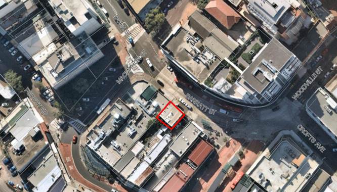
Subject site outlined in
red
|
Executive Summary
Proposal
1. Council
is in receipt of a Development Application (DA2019/0054) seeking consent for
the installation of signage, specifically for the installation of two (2) business
identification signs on the façade of an existing commercial building at
Lot P and Q, DP 27426, 1 Barratt Street, Hurstville 2220. The building is in
the ownership of Georges River Council. Owners consent was issued by Council
for the lodgement of a Complying Development Certificate for the use of the
first floor tenancy as a beauty salon (a Complying Development approval was
granted by the Hendry Group on 5 December 2018 for the fitout as a beauty
salon). Owners consent was also provided by Council for the lodgement of this
application seeking consent for signage.
Site and Locality
2. The
site is identified as Lot P and Q, DP 27426, 1 Barratt Street, Hurstville,
2220.
The site is
located on the south western side of Barratt Street between MacMahon Street to
the northwest and Woodville Street to the east.
The existing
building is a two (2) storey masonry commercial building containing two (2)
separate tenants, one (1) occupying the ground floor and the other the first
floor. The two (2) tenants share the entrance from Barratt Street and the lobby
on the ground floor. There is no other pedestrian access or vehicular access to
the site. The signage is to support the tenancy operating on the first floor of
the building.
The images
below show the proposed location of the signage on the building facades.

Image 1
– Location of the wall sign location outlined in red
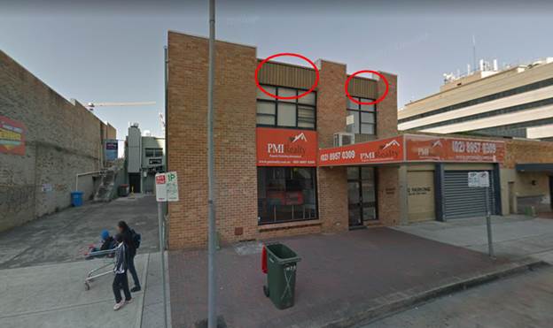
Image 2
– Location of façade signs outlined in red
The site is
adjoining a commercial and retail premises which are identified heritage items
I152, I153 and I154 – Building Facade and Hurstville Hotel in the
Hurstville Local Environmental Plan 2012 (HLEP) which is to the west of the
subject site.
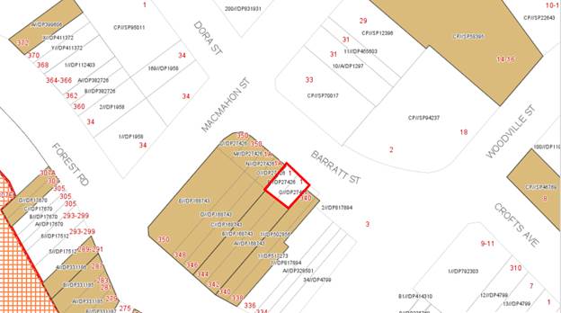
Figure 1 -
Subject site in red – Surrounding Heritage Items
The site is
within the Hurstville City Centre. There are a variety of commercial and retail
uses in the area. The Hurstville Train Station is located approximately 180m to
the south of the site with a bus interchange 40m to the south of the site.
Zoning and Permissibility
3. The
subject site is zoned B3 – Commercial Core under the provisions of the
Hurstville Local Environmental Plan 2012 (HLEP 2012). Identified as ‘Permitted
with consent’ within the B3 zone is ‘Commercial
Premise’ and ‘Signage’. The signage proposed is business
identification signage. The proposed development is ‘Permitted with
consent’.
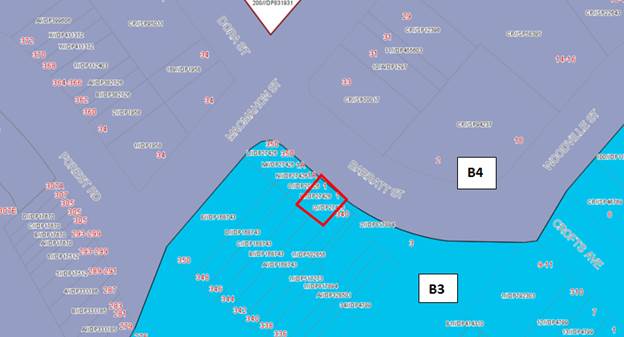
Figure
2 - Subject site in red –
Zoning map
Submissions
4. In
accordance with the provisions of Councils Public Notification DCP, the
application was placed on neighbour notification for a period of fourteen (14)
days between 1 March 2019 to 15 March 2019 where adjoining property owners were
notified in writing of the proposal and invited to comment. No submissions were
received.
Conclusion
5. The
proposed development complies with the planning controls and objectives of the
State Environmental Planning Policy No 64 and the Hurstville Local
Environmental Plan 2012. The proposed development does not seek any variations
to the provisions of the State Environmental Planning Policy No 64, Hurstville
Local Environmental Plan (2012) and the Hurstville Development Control Plan
(HDCP).
Council’s
Heritage Advisor has reviewed the application due to the relationship of the
proposed works to a number of heritage items. Council’s Heritage Advisor
raises no concerns with the proposal from a heritage perspective.
The
application is recommended for approval subject to the conditions at the end of
this report.
Report in Full
Proposal
6. Council
is in receipt of a Development Application (DA2019/0054) seeking consent for
the installation of signage, specifically for the installation of two (2) business
identification signs on the façade of an existing commercial building at
Lot P and Q, DP 27426, 1 Barratt Street, Hurstville 2220. The building is in
the ownership of Georges River Council. Owners consent was issued by Council
for the lodgement of a Complying Development Certificate for the use of the
first floor tenancy as a beauty salon (a Complying Development approval was
granted by the Hendry Group on 5 December 2018 for the fitout as a beauty
salon). Owners consent was also provided by Council for the lodgement of this
application seeking consent for signage. The proposed works are specifically
outlined below.
Signage Works
· Two (2) business
identification signs on the front façade,
o One (1) English
o One (1) Traditional Chinese
· One (1) advertising sign
on the side façade (south eastern elevation).
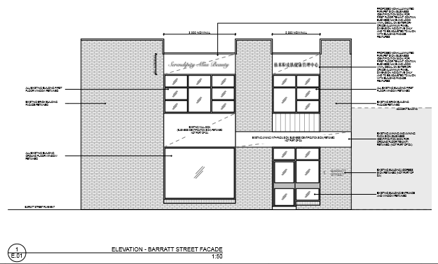
Figure 3 – Elevation from Barratt Street
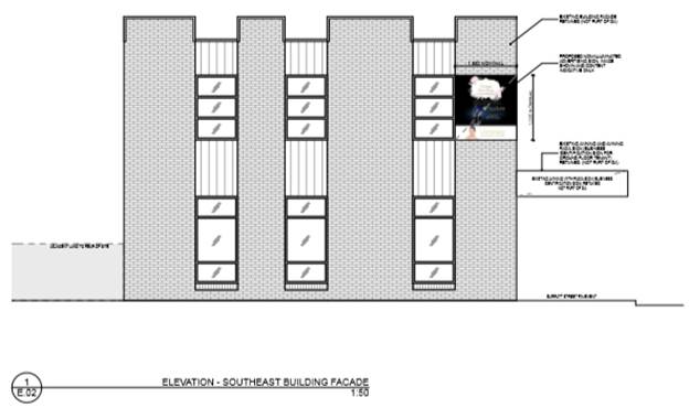
Figure 4 – Side elevation of the proposal
The Site and Locality
7. The
site is identified as Lot P and Q, DP 27426 43, 1 Barratt Street, Hurstville,
2220.
The site is
located on the south western side of Barratt Street between MacMahon Street to
the north west and Woodville Street to the east.
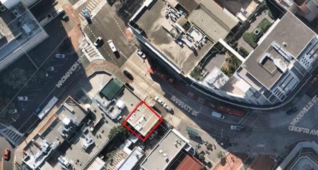
Figure 5: Aerial view of subject site
The existing
building is a two (2) storey masonry commercial building containing two (2)
separate tenants, one (1) occupying the ground floor and the other the first
floor. The two (2) tenants share the entrance from Barratt Street and the lobby
on the ground floor. There is no other pedestrian access or vehicular access to
the site.
The site is
adjoining a commercial and retail premises which are identified heritage items
I152, I153 and I154 – Building Facade and Hurstville Hotel in the
Hurstville Local Environmental Plan 2012 (HLEP) which is to the west of the
subject site.
The site is
within the Hurstville City Centre. There are a variety of commercial and retail
uses in the area. The Hurstville Train Station is located approximately 180m to
the south of the site with a bus interchange 40m to the south of the site.
Background
8. The
subject development application (DA2019/0054) was lodged 19 February, 2019.
During the assessment of the application a heritage impact statement was
provided to be assessed by Council’s Heritage Advisor to ensure the
proposed development did not adversely impact the heritage items.
The applicant
of the development was changed 28 May 2019, from Revive Soul and Body Beauty
Centre Pty Ltd to the architect Winston Tang from Lati Studio Pty Ltd.
The
application has been amended to satisfy the relevant Development Control Plan
criterion. The business identification signage on the Barrett Street elevation
(frontage) was amended providing details of the English and Mandarin wording
and symbols, given each sign is treated individually.
Council’s
Heritage Advisor reviewed the heritage impact statement and has considered the
proposed works to be appropriate.
The building
historically was Councils Baby Health Centre. In 2018 a Complying Development
Certificate was approved by Hendry Group, on 5th December 2018 for the fitout
and use of the first floor tenancy as a beauty salon. The proposed business
identification signage is to support this business use.
Planning
Assessment
9. The
site has been inspected and the proposed development has been assessed under
the relevant Section 4.15(1) Matters for Consideration of the Environmental
Planning and Assessment Act 1979.
Environmental
Planning Instrument
State Environmental Planning
Policy No 55 - Remediation of Land
10. Based
on Council’s records, the subject site has not been used for any
potentially contaminating activities. As such, it is considered unlikely that
the land is contaminated.
Clause
7(1)(a) of SEPP 55 requires the Consent Authority to consider whether land is
contaminated. Council records indicate that the subject site has not been used
for potentially contaminating purposes. The commercial building was
construction in the late 1970’s. The proposed signage to be attached to
the facades of the building, therefore not requiring the need to disturb
foundation materials. In this regard it is considered that the site poses no
risk of contamination and therefore, no further consideration is required under
Clause 7(1)(b) and (c) of SEPP 55 and the land is considered to be suitable for
the residential land use.
Deemed State Environmental
Planning Policy - Georges River Catchment
11. All
stormwater connections remain unaltered. The signage is to be attached to the
facades of the development not impacting the stormwater management system. The
proposal is considered satisfactory with respect to the relevant provisions of
the Deemed State Environmental Planning Policy – Georges River Catchment
State
environmental Planning Policy No 64 – Advertising and Signage
12.
|
Schedule 1 Assessment Criteria
|
Proposal
|
Complies
|
|
i. Character
of the area
· Is the proposal
compatible with the existing or desired future character of the area or
locality in which it is proposed to be located?
· Is the proposal
consistent with a particular theme for outdoor advertising in the area or
locality?
|
Yes, the proposed signage is
compatible with the future character of the locality and is a business
identification sign.
Yes, the proposed signage is
consistent with the outdoor advertising of the surrounding area which is
generally business identification signage within the Commercial Core of
Hurstville.
|
Yes
Yes
|
|
ii. Special
areas
· Does the
proposal detract from the amenity or visual quality of any environmentally sensitive
areas, heritage areas, natural or other conservation areas, open space areas,
waterways, rural landscapes or residential areas?
|
No, the site is not within any
conservation areas or open space areas, waterways, rural
landscapes.
|
Yes
|
|
iii. Views
and vistas
· Does the
proposal obscure or compromise important views?
· Does the
proposal dominate the skyline and reduce the quality of vistas?
· Does the
proposal respect the viewing rights of other advertisers?
|
The proposed signage will not be
located within any important view corridors. By virtue of the nominated size,
location and orientation the signs will not obscure or compromise any
potential view. They are attached to the facade of the existing commercial
building.
No, the proposed signage will not
dominate the streetscape nor does it reduce the quality of the potential
views of Barratt Street.
Yes, the proposed signage is flush
with the façade of commercial building, therefore not impacting
viewing rights.
|
Yes
Yes
Yes
|
|
iv. Streetscape,
setting or landscape
· Is the scale,
proportion and form of the proposal appropriate for the streetscape, setting
or landscape?
· Does the
proposal contribute to the visual interest of the streetscape, setting or
landscape?
· Does the
proposal reduce clutter by rationalising and simplifying existing
advertising?
· Does the
proposal screen unsightliness?
· Does the
proposal protrude above buildings, structures or tree canopies in the area or
locality?
· Does the
proposal require ongoing vegetation management?
|
The
form of the proposed signage is appropriate for the streetscape.
The proposed signage will increase
the visual interest of the local streetscape.
The proposal is sympathetic to the
façade of the building.
The proposed signage does not screen unsightliness.
No, the signage does not protrude above buildings, structures or tree canopies in the area
or locality. The signage is affixed to the façade of the building,
No, there is no vegetation located
in the area of the signage.
|
Yes
Yes
Yes
Yes
Yes
Yes
|
|
v. Site
and building
· Is the proposal
compatible with the scale, proportion and other characteristics of the site
or building, or both, on which the proposed signage is to be located?
· Does the
proposal respect important features of the site or building, or both?
· Does the
proposal show innovation and imagination in its relationship to the site or
building, or both?
|
Yes, the proposed signage is of
similar scale and size to that of the locality and does not dominate the
façade of the building.
Yes the design and position
integrate with the building structure and context.
The proposed signage serves as
business identification signage and advertising signage for a beauty salon
located on the first floor of the development.
|
Yes
Yes
Yes
|
|
vi. Associated
devices and logos with advertisements and advertising structures
· Have any safety
devices, platforms, lighting devices or logos been designed as an integral
part of the signage or structure on which it is to be displayed?
|
The proposed
signage is affixed to the façade of the building, no plant it is
required to facilitate the signage
|
Yes
|
|
vii. Illumination
· Would
illumination result in unacceptable glare?
· Would
illumination detract from the amenity of any residence or other form of
accommodation?
· Would
illumination affect safety for pedestrians, vehicles or aircraft?
· Is the
illumination subject to a curfew?
|
No, the proposed signage is not
illuminated.
No, the proposed signage is not
illuminated.
No, the proposed signage is not
illuminated.
No, the proposed signage is not
illuminated.
|
Yes
Yes
Yes
Yes
|
|
viii. Safety
· Would the
proposal reduce the safety for any public road?
· Would the
proposal reduce the safety for pedestrians or bicyclists?
· Would the
proposal reduce the safety for pedestrians, particularly children, by
obscuring sightlines from public areas?
|
The signage is installed at a
height which will allow safe travel for pedestrians, bicyclists and vehicle
roads.
No, the proposed signage is not
located on an intersection, and will not reduce safety for pedestrians and
children, or obscure sightlines.
No, the proposed
sign will not reduce safety for pedestrians, particularly
children, by obscuring sightlines from public areas.
|
Yes
Yes
Yes
|
Draft
Environmental Planning Instruments
13. The
Draft Environment SEPP was exhibited from 31 October 2017 to 31 January 2018.
This consolidated SEPP proposes to simplify the planning rules for a number of
water catchments, waterways, urban bushland, and Willandra Lakes World Heritage
Property. Changes proposed include consolidating the following seven existing
SEPPs:
· State
Environmental Planning Policy No. 19 – Bushland in Urban Areas,
· State
Environmental Planning Policy (Sydney Drinking Water Catchment) 2011,
· State
Environmental Planning Policy No. 50 – Canal Estate Development,
· Greater
Metropolitan Regional Environmental Plan No 2 – Georges River Catchment,
· Sydney
Regional Environmental Plan No. 20 – Hawkesbury-Nepean River (No 2-1997),
· Sydney
Regional Environmental Plan (Sydney Harbour Catchment) 2005,
· Willandra
Lakes Regional Environmental Plan No. 1 – World Heritage Property.
The proposal is
not inconsistent with the provisions of this Draft Instrument.
Hurstville
Local Environmental Plan
14. The
site has been inspected and the proposed development has been assessed under
the relevant Section 4.15(1) Matters for Consideration of the Environmental
Planning and Assessment Act 1979.
Development Control Plan
Hurstville Development Control
Plan (DCP) No. 2 – Amendment No. 9
15. 6.1.5 Signage
|
Clause
|
Requirement
|
Proposed
|
Complies
|
|
6.1.5.2.1
All Signage
Objectives:
To ensure the design and siting of
proposed signage complements the character of an area and the site or
building on which it is located, and does not impact adversely on the amenity
or safety of the community.
To reduce the visual complexity of
streetscapes by providing fewer, more effective signs.
|
(a) Advertising on or attached to
buildings should align and relate to the architectural design lines on a
building facade or, in the absence of architectural detail or decoration,
relate to the design lines of adjacent buildings.
(b) Council discourages advertising
signs on a building facade that are displayed on or above first floor level.
(c) The wording (or advertising
content) on any sign should relate to the premises on which the sign is
erected or the activities carried on or within the premises, except in the
case of a Billboard Sign where it can be demonstrated that general advertising
will have no detrimental impact on nearby residential areas or pedestrians,
or cause a distraction to motorists.
|
The proposed signage will be
affixed to the façade of the commercial building and is of a design
that will satisfy this control.
The proposed development includes
an advertising sign located on the south eastern building façade at
the level of the first floor. This is considered satisfactory due to the
locality and the location on a side façade. The signage proposed on
the front façade is considered to be business identification and not
advertising.
The wording of the proposed signage
is related to a business located within the commercial building.
|
Yes
Yes
Yes
|
|
General Appearance, Content and
Maintenance
|
(a) Council discourages signs prone
to deterioration and may request removal of redundant, unsafe, unsightly or
objectionable signage.
|
The proposed signage is of a
material that is designed to be placed externally.
|
Yes
|
|
Traffic and Pedestrian Safety
|
(a) The proposed advertising,
whether illuminated or not, must not impact adversely on the safety for
pedestrians, cyclists and on any public road.
(b) Signage must be securely
fastened to the structure or building to which it is attached, and must comply
with all relevant Australian Standards and Building Code of Australia
requirements.
(c) Free standing signboards must
be located and designed so that they do not pose any safety risk to
pedestrians or motorists
(d) Signage must not be liable to
interpretation as an official traffic sign or to be confused with
instructions given by traffic signals or other devices, or block the view of
traffic signals or signs.
(e) Signs facing roads with high
traffic volumes, traffic lights or major intersections may be referred to the
Roads and Maritime Services (RMS) for comment.
|
The proposed signage is considered
unlikely to detrimentally impact the safety for pedestrians, cyclists and on
any public road.
The proposed signage will require
standard conditions requiring prior to the release of Construction
Certificate the proposal must demonstrate satisfactory compliance against the
relevant Australian Standards and Building Code of Australia
requirements.
Not applicable – Signage is
not considered to be Free standing signboards.
The proposed signage is affixed to
the wall, is not illuminated or moving and does not impact on traffic
management issues or signalised intersection.
Barratt Street is not considered to
trigger a referral to RMS.
|
Yes
Yes
N/A
Yes
|
|
Illumination and Electrical
Wiring
|
(a) The lighting intensity and
hours of illumination must not unreasonably impact on any residential
properties, adjoining or within the locality.
|
The proposed signage is not
illuminated.
|
N/A
|
|
Wording and Content
|
(a) All signage must be displayed
in English but may include a translation in another language. Any translated
message must be accurate and complete, and using wording and/or numbering
that is not larger than the English message.
(b) Signs must be attractive and
professionally sign written.
(c) Changes in the content or
message of an signage are allowed without the approval of Council provided
that:
•The advertising structure
has been approved by Council;
•The size and dimensions of
the sign remain as approved, or are reduced;
•There is no change to the
intensity of, or hours of illumination;
•Moving or flashing messages
or symbols are not proposed; and
• The message is not likely
to cause distraction to motorists.
(d) The name or logo of the person
who owns or leases an advertisement or advertising structure must not be
greater than 0.25sqm, and may appear only within the advertising display
area.
(e) Where a business or
organisation offers a product or service, the name of the business or
organisation should have greater dominance over the product or service
advertising.
(f) The wording and content of the
advertising sign must not:
· Offend nearby
sensitive land uses (churches, schools, day care centres);
· Contain
undesirable discriminatory advertising messages as specified in the Anti
Discrimination Act 1977;
· Encourage
unlawful purchase, excessive consumption of alcohol; or
· Promote
anti-social behaviour.
|
The proposed development is
considered to be appropriate.
The English and alternate language
(mandarin) are the same in size.
The proposed signs are
professionally written.
The proposed signage is considered
to be appropriate; any changes will require further approval from Council.
The proposed signage is only
advertising the business within the development.
The proposed sign on the south
eastern building façade is considered to promote a product; the logo
of the company is greater in size than the product.
The proposed signage is not
considered to be offensive nor provide an undesirable finish to the building
façade.
|
Yes
Yes
Yes
Yes
Yes
Yes
|
|
Heritage Items
|
(b) Signage next to or in the
vicinity of a heritage item should be designed and located in a manner which
enhances and complements the item and streetscape, and does not dominate or
detract from the heritage item.
|
The proposed application was
accompanied by a heritage impact statement which identifies the proposal
confirming there is no impact on the identified heritage items.
The proposal was referred to
council’s heritage advisor of whom raised no objection to the
application.
|
Yes
|
The proposed development is
considered to satisfy the objectives and numerical controls of the Development
Control Plan, no variations have been sought.
Impacts
Natural Environment
16. The
proposed signage is not anticipated to have any impacts on the natural
environmental.
Built Environment
17. The
proposed development will not result in any adverse impacts upon the built
environment given there is no construction work proposed with the exception of
the installation of the sign on the external façade.
Social and Economic Impact
18. The
proposed development will not result in any adverse social and/or economic
impacts on the locality subject to compliance the conditions of consent. The
proposed advertising signage supports commercial development in the Hurstville
City centre.
Suitability
19. It
is considered that the proposed development is of a scale and design that is
suitable for the site having regard to its size and shape, its topography and
relationship to adjoining developments.
Council Referrals
Heritage Advisor
20. The
proposal is supported by Council’s Heritage Advisor, the location, size
and detailing of the signage is considered acceptable.
Development Contributions
21. The
development is not subject to a Section 7.12 (former Section 94A Contribution)
contribution as the proposed costs of works, registered with Council do not
exceed $100,000.00. Under the provisions of the Georges River Council Section
94A Contributions Plan 2017. No contributions have been levied.
CONCLUSIONS
22. The
application has been assessed having regard to the matters for consideration
under Section 4.15 (1) and 4.55 (1)(a) of the Environmental Planning and
Assessment Act 1979, and the provisions of the relevant and applicable
SEPP’s, HLEP 2012 and HDCP No.2.
DETERMINATION AND STATEMENT OF REASONS
23. Statement
of Reasons
· The proposed
development complies with the requirements of the relevant environmental
planning instruments and development control plan.
· The proposed
development does not negatively impact the adjoining heritage items, being
I152, I153 and I154 – Hurstville Hotel and the heritage façade of
338a, 340, 342a and 340 Forest Road identified in the Hurstville LEP 2012.
· The proposed
development is considered to be appropriate for the site and the character of
the locality. Subject to the implementation of the recommended conditions, the
development will have no unacceptable adverse impacts upon the natural or built
environment.
· The proposed
signage adequately identifies the commercial use operating from the first floor
of the building.
· In
consideration of the aforementioned reasons, the proposed development is a
suitable and planned use of the site and its approval is not inconsistent with
the public interest.
Determination
24. THAT
pursuant to Section 4.16 (1)(a) Environmental Planning and Assessment
Act 1979, the Georges River Local Planning Panel approves Development
Application No. DA2019/0054 for the installation of two (2) business
identification signs on the building façade at Lot P and Q, DP
27426, and known as 1 Barratt Street, Hurstville, subject to the
recommended conditions below:
Development
Details
1. Approved
Plans - The development must be implemented in accordance with the approved
plans and supporting documentation listed below which have been endorsed by
Council’s approved stamp, except where marked up on the plans and/or
amended by conditions of this consent:
|
Description
|
Reference No.
|
Date
|
Revision
|
Prepared by
|
|
Site Plan
|
A.01
|
06/06/2019
|
B
|
Lati Studio
|
|
Façade Elevation A
|
E.01
|
06/06/2019
|
B
|
Lati Studio
|
|
Façade Elevation B
|
E.0
|
06/06/2019
|
B
|
Lati Studio
|
Separate
Approvals Required Under Other Legislation
2. Roads
Act 1993 and Section 68 Local Government Act 1993 - Unless otherwise
specified by a condition of this consent, this Development Consent does not
give any approval to undertake works on public infrastructure.
Separate
approval is required under Section 138 of the Roads Act 1993 and/or Section 68
of the Local Government Act 1993 for any of the following activities carried
out in, on or over a public road (including the footpath) listed below.
An
application is required to be lodged and approved prior to the commencement of
any of the following works or activities;
(a) Placing or storing materials or equipment;
(b) Placing or storing waste containers or skip
bins;
(c) Erecting a structure or carrying out work
(d) Swinging or hoisting goods over any part of a
public road by means of a lift, crane or the like;
(e) Establishing a “works zone”;
These
separate activity approvals must be obtained and evidence of the approval
provided to the Certifying Authority prior to the issue of the Construction
Certificate.
The
relevant Application Forms for these activities can be downloaded from
Council’s website www.georgesriver.nsw.gov.au.
For further information, please contact Council’s Customer Service Centre
on (02) 9330 6400.
Prior to the
Issue of a Construction Certificate
3. Damage
Deposit - Minor Works - In order to insure against damage to Council
property the following is required:
(a)
Pay Council, before the issue of the Construction Certificate, a damage deposit
for the cost of making good any damage caused to any Council property as a
result of the development: $1,900.00
(b)
Pay Council, before the issue of the Construction Certificate, a non-refundable
inspection fee to enable assessment of any damage and repairs where required: $155.00
(c)
Submit to Council, before the commencement of work, a photographic record of
the condition of the Council nature strip, footpath and driveway crossing, or
any area likely to be affected by the proposal.
At
the completion of work Council will inspect the public works, and the damage
deposit will be refunded in full upon completion of work where no damage
occurs. Otherwise the amount will be either forfeited or partly refunded
according to the amount of damage.
4. Fees
to be paid - The fees listed in the table below
must be paid in accordance with the conditions of this consent and
Council’s adopted Fees and Charges applicable at the time of payment
(available at www.georgesriver.nsw.gov.au).
Payments must be made prior to the issue of the
Construction Certificate or prior to the commencement of work (if there is no
associated Construction Certificate).
Please contact Council prior to the payment of
Section 7.11 Contributions to determine whether the amounts have been indexed
from that indicated below in this consent and the form of payment that will be accepted
by Council.
Council will only accept Bank Cheque or
Electronic Funds Transfer (EFT) for transaction values of $500,000 or over.
Council must be contacted prior to payment to determine correct total amount to
be paid and bank account details (if applicable).
A summary of the fees to be paid are listed
below:
|
Fee Type
|
Fee
|
|
GENERAL FEES
|
|
Long Service Levy (to Long Service Corporation) Or,
provide evidence of Payment direct to the Long Service Corporation. See
https://portal.longservice.nsw.gov.au/bci/levy/
|
|
Builders Damage Deposit
|
$1,900.00
|
|
Inspection Fee for Refund of Damage Deposit
|
$155.00
|
General Fees
The fees and charges above are subject to
change and are as set out in the version of Council's Schedule of Fees and
Charges or as required by other Government Authorities, applicable at the time
of payment.
5. Structural
details - Engineer's details prepared by a practising Structural Engineer
being used to affix the signage to the façade of the building. The
details are to be submitted to the Principal Certifying Authority for approval
prior to construction of the specified works.
A copy shall be forwarded to Council where Council is not
the PCA.
6. Waste
Management Plan - A Waste Management Plan incorporating all requirements in
respect of the provision of waste storage facilities, removal of all materials
from the site that are the result of site clearing, extraction, and, or
demolition works and the designated Waste Management Facility shall be
submitted to the Certifying Authority prior to the issue of any Construction
Certificate.
Prior to the
Commencement of Work (Including Demolition & Excavation)
7. Demolition
& Asbestos - The demolition work shall comply with the provisions of
Australian Standard AS2601:2001 - Demolition of Structures, NSW Work Health
& Safety Act 2011 and the NSW Work Health & Safety Regulation 2011.
The work plans required by AS2601:2001 shall be accompanied by a written
statement by a suitably qualified person that the proposals contained in the
work plan comply with the safety requirements of the Standard. The work plans
and the safety statement shall be submitted to the PCA prior to the
commencement of works.
For
demolition work which involves the removal of asbestos, the asbestos removal
work must be carried out by a licensed asbestos removalist who is licensed to
carry out the work in accordance with the NSW Work Health & Safety Act 2011
and the NSW Work Health & Safety Regulation 2011 unless specified in the
Act and/or Regulation that a license is not required.
All
demolition work including the removal of asbestos, shall be undertaken in accordance
with the Demolition Code of Practice (NSW Work Cover July 2015)
Note:
Copies of the Act, Regulation and Code of Practice can be downloaded free of
charge from the SafeWork NSW website: www.SafeWork.nsw.gov.au.
8. Utility
Arrangements - Arrangements are to be made with utility authorities in
respect to the services supplied by those authorities to the development. The
cost associated with the provision or adjustment of services within the road
and footway areas is to be at the applicant’s expense.
During
Construction
9. Hours
of construction for demolition and building work - Any work activity or
activity associated with the development consent that requires the use of any
tools (including hand tools) or any power operated plant and machinery that
creates noise on or adjacent to the site shall not be performed, or permitted
to be performed, except between the hours of 7.00 am to 5.00 pm, Monday to
Saturday inclusive. No work or ancillary activity is permitted on Sundays, or
Public Holidays.
Note: A penalty infringement notice may be issued for any
offence.
10. Cost of work to
be borne by the applicant - The applicant shall bear the cost of all works
associated with the construction of the development that occurs on Council
property. Care must be taken to protect Council's roads, including the
made footway, kerbs, etc., and, where plant and vehicles enter the site, the
footway shall be protected against damage by deep-sectioned timber members laid
crosswise, held together by hoop iron straps and chamfered at their ends.
This construction shall be maintained in a state of good repair and condition
throughout the course of construction.
11. Obstruction of
Road or Footpath - The use of the road or footpath for the storage of any
building materials, waste materials, temporary toilets, waste or skip bins, or
any other matter is not permitted unless separately approved by Council under
Section 138 of the Roads Act 1993 and/or under Section 68 of the Local
Government Act 1993. Penalty infringement Notices may be issued for any
offences and severe penalties apply.
Operational
Conditions (Ongoing)
12. Lighting –
No lighting is approved as part of this application.
13. Amenity of the
neighbourhood - The implementation of this development shall not adversely
affect the amenity of the neighbourhood or interfere unreasonably with the
comfort or repose of a person who is outside the premises by reason of the
emission or discharge of noise, fumes, vapour, odour, steam, soot, dust, waste
water, waste products, grit, oil or other harmful products.
Operational
Requirements Under the Environmental Planning & Assessment Act 1979
14. Requirement for
a Construction Certificate - The erection of a building must not commence
until a Construction Certificate has been issued.
15. Appointment of
a PCA - The erection of a building must not commence until the applicant
has:
(a) appointed a PCA for the building work; and
(b) if relevant, advised the PCA that the work will
be undertaken as an Owner -Builder.
If
the work is not going to be undertaken by an Owner - Builder, the applicant
must:
(c) appoint a Principal Contractor to
undertake the building work. If residential building work (within the meaning
of the Home Building Act 1989) is to be undertaken, the Principal Contractor
must be a holder of a contractor licence; and
(d) notify the PCA of the details of any such
appointment; and
(e) notify the Principal Contractor of any critical
stage inspections or other inspections that are required to be carried out in
respect of the building work.
An
Information Pack is attached for your convenience should you wish to appoint
Georges River Council as the PCA for your development.
16. Notification
Requirements of PCA - No later than two days before the building work
commences, the PCA must notify:
(a) the consent authority and the Council (if not
the consent authority) of his or her appointment; and
(b) the applicant of the critical stage inspections
and other inspections that are to be carried out with respect to the building
work.
17. Notice of
Commencement - The applicant must give at least two days notice to the
Council and the PCA of their intention to commence the erection of a building.
A Notice of Commencement Form is attached for your
convenience.
18. Critical Stage
Inspections - The last critical stage inspection must be undertaken by the
PCA. The critical stage inspections required to be carried out vary
according to Building Class under the Building Code of Australia and are listed
in Clause 162A of the Environmental Planning and Assessment Regulation 2000.
19. Notice to be
given prior to critical stage inspections - The principal contractor for a
building site, or the owner-builder, must notify the PCA at least 48 hours
before each required inspection needs to be carried out.
Where
Georges River Council has been appointed as the PCA, 48 hours notice in
writing, or alternatively 24 hours notice by facsimile or telephone, must be
given when specified work requiring inspection has been completed.
20. Occupation
Certificate - A person must not commence occupation or use of the whole or
any part of a new building unless an Occupation Certificate has been issued in
relation to the building or part.
Only
the PCA appointed for the building work can issue the Occupation Certificate.
An
Occupation Certificate Application Form is attached for your convenience.
Prescribed
Conditions
21. Clause 98A -
Erection of Signs - Requires the erection of signs on site and outlines the
details which are to be included on the sign. The sign must be displayed
in a prominent position on site and include the name and contact details of the
PCA and the Principal Contractor.
22. Clause 98E -
Protection & support of adjoining premises - If the development
involves excavation that extends below the level of the base of the footings of
a building on adjoining land, this prescribed condition requires the person who
benefits from the development consent to protect and support the adjoining
premises and where necessary underpin the adjoining premises to prevent any
damage.
23. Clause 98 -
Building Code of Australia & Home Building Act 1989 - Requires all
building work to be carried out in accordance with the Building Code of
Australia. In the case of residential building work to which the Home
Building Act 1989 relates, there is a requirement for a contract of insurance
to be in force before any work commences.
END CONDITIONS
24. Review
of Determination - Section 8.2 of the Environmental Planning and Assessment
Act confers on an applicant who is dissatisfied with
the determination of the application the right to lodge
an application with Council for a review of such determination. Any such
review must however be completed within 6 months from its determination.
Should a review be contemplated sufficient time should be allowed for Council
to undertake public notification and other processes involved in the review of
the determination.
Note: Review provisions do not apply to
Complying Development, Designated Development, State Significant Development, Integrated Development or any application determined
by the Sydney South Planning Panel or the Land & Environment Court.
25. Appeal
Rights - Part 8 (Reviews and appeals) of the Environmental Planning and Assessment Act 1979 confers on an applicant who is
dissatisfied with the determination of the application
a right of appeal to the Land and Environment Court of New South Wales.
26. Lapsing
of Consent - This consent will lapse unless the
development is physically commenced within 5 years from
the Date of Operation of this consent, in accordance
with Section 4.53 of the Environmental Planning and Assessment Act 1979 as
amended.
27. Long Service
Levy - The Long Service Corporation administers a scheme which provides a
portable long service benefit for eligible workers in the building and
construction industry in NSW. All benefits and requirements are determined by
the Building and Construction Industry Long Service Payments Act 1986. More
information about the scheme and the levy amount you are required to pay to
satisfy a condition of your consent can be found at
http://www.longservice.nsw.gov.au.
The
required Long Service Levy payment can be direct to the Long Service
Corporation via their web site https://online.longservice.nsw.gov.au/bci/levy.
Payments can only be processed on-line for the full levy owing and where the
value of work is between $25,000 and $6,000,000. Payments will be accepted for
amounts up to $21,000, using either MasterCard or Visa.
28. Site Safety
Fencing - Site fencing must be erected in accordance with SafeWork
Guidelines, to exclude public access to the site throughout the demolition
and/or construction work, except in the case of alterations to an occupied
dwelling. The fencing must be erected before the commencement of any work and
maintained throughout any demolition and construction work.
A
demolition licence and/or a high risk work license may be required from
SafeWork NSW (see www.SafeWork.nsw.gov.au).
29. Security
deposit administration & compliance fee - Under Section 97 (5) of the
Local Government Act 1993, a security deposit (or part) if repaid to the person
who provided it is to be repaid with any interest accrued on the deposit (or
part) as a consequence of its investment.
Council
must cover administration and other costs incurred in the investment of these
monies. The current charge is $50.00 plus 2% of the bond amount per annum.
The
interest rate applied to bonds is set at Council's business banking facility
rate as at 1 July each year. Council will accept a bank guarantee in lieu
of a deposit.
All
interest earned on security deposits will be used to offset the Security
Deposit Administration and Compliance fee. Where interest earned on a deposit
is not sufficient to meet the fee, it will be accepted in full satisfaction of
the fee.
30. Council as PCA
- Deemed to Satisfy Provisions of BCA - Should the Council be appointed as
the PCA in determining the Construction Certificate, the building must comply
with all the applicable deemed to satisfy provision of the BCA. However,
if an alternative fire solution is proposed it must comply with the performance
requirements of the BCA, in which case, the alternative solution, prepared by
an appropriately qualified fire consultant, accredited and having specialist
qualifications in fire engineering, must justifying the non-compliances with a
detailed report, suitable evidence and expert judgement. Council will also
require if deemed necessary, for the alternative solution to undergo an
independent peer review by either the CSIRO or other accredited
organisation. In these circumstances, the applicant must pay all costs
for the independent review.
ATTACHMENTS
|
Attachment ⇩1
|
Site Plan - 1 Barratt Street Hurstville
|
|
Attachment ⇩2
|
Elevations - 1 Barratt Street Hurstville
|
|
Georges River Council – Local Planning
Panel Thursday, 4 July 2019
|
Page 105
|
REPORT TO GEORGES RIVER COUNCIL
LPP MEETING OF Thursday, 04 July 2019
|
LPP Report No
|
LPP019-19
|
Development Application No
|
DA2018/0211
|
|
Site Address & Ward Locality
|
13-15 Gover Street Peakhurst
Peakhurst Ward
|
|
Proposed Development
|
Demolition and construction of a
three storey residential flat building containing fifteen (15) residential
units
|
|
Owners
|
J Younane, Baskal Pty Ltd, Bisa
Group Pty Ltd, Nassif Family Holdings Pty Ltd
|
|
Applicant
|
Cornerstone Design
|
|
Planner/Architect
|
Planner – BMA Urban,
Architect – Cornerstone Design
|
|
Date Of Lodgement
|
30/05/2018
|
|
Submissions
|
No submissions received to either
the original or the amended DA plans
|
|
Cost of Works
|
$3,521,100
|
|
Local Planning Panel Criteria
|
State Environmental Planning
Policy No 65—Design Quality of Residential Apartment Development
applies to the proposed development.
|
|
List of all relevant s.4.15
matters (formerly s79C(1)(a))
|
Hurstville Local Environmental Plan
2012, Hurstville Development Control Plan No 1,
State Environmental Planning Policy
No 65 – Design Quality of Residential Apartment Development, State
Environmental Planning Policy (Vegetation in Non-Rural Areas), State
Environmental planning Policy (Infrastructure),
State Environmental Planning Policy
55 – Remediation of Land, State Environmental Planning Policy (Building
Sustainabilty Index: BASIX) 2004, Greater Metropolitan Regional Environmental
Plan No 2 – Georges River Catchment, Apartment Design Guide (ADG)
|
|
List all documents submitted
with this report for the Panel’s consideration
|
Architectural Plans,
Streetscape Drawing,
Clause 4.6 Request for Variation
under Clause 4.6 Hurstville LEP 2012
|
|
Report prepared by
|
Independent Assessment
|
|
Recommendation
|
That the application be approved in accordance with the
conditions included in the report.
|
|
|
Summary of matters for
consideration under Section 4.15
Have all recommendations in relation
to relevant s4.15 matters been summarised in the Executive Summary of the
assessment report?
|
Yes
|
|
Legislative clauses requiring
consent authority satisfaction
Have relevant clauses in all
applicable environmental planning instruments where the consent authority
must be satisfied about a particular matter been listed, and relevant
recommendations summarised, in the Executive Summary of the assessment
report?
|
Yes
|
|
Clause 4.6 Exceptions to
development standards
If a written request for a
contravention to a development standard (clause 4.6 of the LEP) has been
received, has it been attached to the assessment report?
|
Yes
– variation requested to the maximum 12m height control in clause 4.3
HLEP 2012. The development proposes a height of 13.85m which is a variation
of 1.85m or 15.4%
|
|
Special Infrastructure
Contributions
Does the DA require Special
Infrastructure Contributions conditions (under s7.24)?
|
Not
Applicable
|
|
Conditions
Have draft conditions been provided
to the applicant for comment?
|
Yes
– draft conditions made available to the applicant when the report was
published.
|
|
Aerial Photo
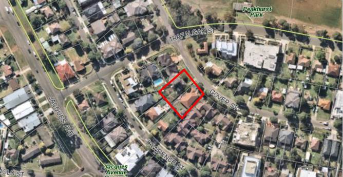
Site outlined in red
|
Executive Summary
Proposal
1. This
development application (DA) proposes demolition works, and construction of a
three (3) storey residential flat building containing five (5) units on each
level (total 15 units), basement parking for 23 vehicles and a rooftop communal
space area at 13-15 Gover Street, Peakhurst.
2. The
development proposes three (3) x one (1) bedroom, eight (8) x two (2) bedroom
and four (4) x three (3) bedroom units. Pedestrian and vehicular access to the
site is provided from Gover Street. The single level basement will accommodate
twenty three (23) car parking spaces (including four (4) visitor spaces), and
racks for up to four (4) bicycles.
Site and Locality
3. The
subject site has a street address of 13-15 Gover Street, Peakhurst, and is
legally described as Lot 167 and 168 DP 36317. The property is located on the
south western side of Gover Street.
4. The
site has a total area of 1313.1sqm, with a 33.505m frontage to Gover Street.
The land generally has a gentle slope from the rear towards the street.
5. The
site contains two (2) dwelling houses (one on each lot), with a range of sheds
and other outbuildings. There are also a number of trees within the site.
6. The
locality generally contains a mixture of both older-style detached dwellings
and dual occupancy developments, together with more modern residential flat
buildings that have been constructed within the last 5-10 years as a result of
zoning changes which have enabled such developments.
7. Having
regard to the zoning of the site and surrounds, it is clear the future
character is a higher density environment. This is apparent by the contemporary
residential flat buildings existing and under construction on a number of sites
within the surrounding R3 zoned land.
Zoning and Permissibility
8. The
subject site is zoned R3 Medium Density Residential under the provisions of
Hurstville Local Environmental Plan 2012 (HLEP). The proposed development is
permissible with development consent within this zone.
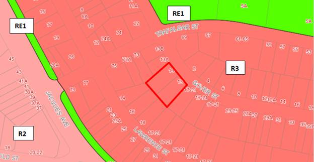
Figure 1 -
Site outlined in red
Clause 4.6
variation – height
9. The
development seeks a variation to Clause 4.3 Height of Buildings under the provisions
of the Hurstville Local Environmental Plan 2012 (HLEP). Clause 4.3 of HLEP 2012
prescribes a maximum 12m height limit, and the development proposes a height of
13.85m which is a variation of 1.85m or 15.4% above the development standard.
The applicant has submitted a written request seeking to justify the
contravention of the height standard, the request is supported. This is
discussed in detail within the body of the report.
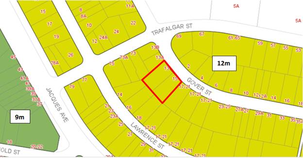
Figure 2
– Site outlined in red
Submissions
10. The
proposal has been notified to neighbours in accordance with the provisions of
Hurstville DCP No 1. No submissions were received.
11. The
DA was referred to a number of officers within Council, and the referral
responses were generally supportive of the application as discussed in the body
of this report.
Level of Determination
12. The
DA is referred to the Local Planning Panel for consideration and determination
as it involves a residential flat building affected by State Environmental
Planning Policy No 65 – Design Quality of Residential Flat Development.
Conclusion
13. The
proposed development has been assessed using the matters for consideration
listed in Section 4.15 of the Environmental Planning and Assessment Act 1979,
and in particular against the requirements of the relevant HLEP 2012 and
Hurstville DCP No 1. The proposal generally complies, with sufficient
justification provided for any variations.
14. The
proposal is considered satisfactory when assessed against the applicable
planning controls and it is recommended for approval subject to conditions.
REPORT IN FULL
Proposal
15. This
development application (DA) proposes demolition works, and construction of a
three (3) storey residential flat building containing five (5) units on each level
(total 15 units), basement parking for 23 vehicles and a rooftop communal space
area at 13-15 Gover Street, Peakhurst.
16. Further
details of the proposal are as follows:
Demolition
17. The
proposal involves demolition of all existing structures. The structures to be
demolished include the detached single storey brick dwellings at 13 and 15
Gover Street and ancillary structures including retaining walls, decks, a shed
and boundary fencing.
Residential
Component
18. The
proposal contains a total of fifteen (15) residential apartments, five (5) on
each floor of the building. The apartment composition is provided as follows:
· Three (3) x single
bedroom apartments;
· Eight (8) x two
(2) bedroom apartments; and
· Four (4) x three
(3) bedroom apartments.
19. Of
the fifteen (15) apartments proposed, two (2) single bedroom apartments are
nominated as ‘liveable’ or ‘adaptable’ dwellings and
are located on the second and third floors. A lift connects all floors of the
development. All apartments have an open plan living and dining arrangement and
a private open space in the form of a terrace or balcony which is directly
accessible from the open plan living areas.
Communal
Open Space
20. The
rooftop level of the residential flat building contains a communal open space
area. This area would be enclosed on all sides by garden beds and
planters. Included within the communal open space area are barbeque facilities,
bench seating, outdoor lounge seating areas and communal clothes drying
facilities. Access to this area will be obtained through a rooftop foyer that
is accessed via stairs and the lift. Excluding the foyer and associated
entry points, approximately 43sqm of the communal open space area is proposed
to be roofed, with the remaining area open to the sky.
Access and
Parking
21. The
submitted plans indicate that vehicular and pedestrian access will be obtained
from Gover Street. The single level basement car park contains twenty three
(23) car parking spaces. Of these spaces, nineteen 19 will be allocated
to the residential apartments, with the remaining four (4) as visitor parking
spaces (one of which would also double as a car wash bay). Bicycle racks would
also be included within the basement levels for a total of four (4) bicycles.
22. Pedestrian
access from the parking area to the upper levels is provided via a stairwell
and lift.
Landscaping
23. The
proposal includes deep soil areas around the periphery of the site and
primarily within the side and rear setbacks; such areas contain minimum dimensions.
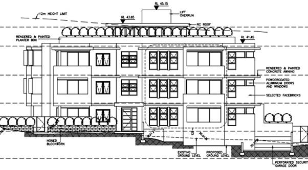
Figure 3
– An extract of the proposed development’s primary (north east)
elevation.
The Site and Locality
24. The
subject site consists of two (2) allotments with street addresses of 13 and 15
Gover Street, Peakhurst; they are formally known as Lots 167 and 168 of DP
36317 respectively. The combined area and dimensions of the subject site are as
follows:
Site Area:
· 13 Gover Street -
676.3sqm
· 15 Gover Street –
636.8sqm
Total Site area =
1,313.1sqm
The amalgamated
allotment has dimensions of:
· Frontage – 33.505m
· Rear – 38.705m
· East – 36.885m
· West – 36.885m
25. The
subject site is located on the south-western side of the Gover Street.
Adjoining the site to the east is a large site (17 Gover Street) which contains
a residential flat building complex consisting of one and two storey buildings,
that were previously approved in 1992 pursuant to SEPP No. 5 Housing for Older
People or People with a Disability (see above). Adjoining allotments to
the south (rear) and western side boundaries each contain a single attached or
detached dwellings.
26. Each
allotment within the subject site contains a detached dwelling house and
associated development (ie a shed, pet enclosures, decking, etc.). There
are a number of significant trees on the subject site, though they are either
dead or dying and an assessment by Council staff have found that the trees
appear to have been poisoned.
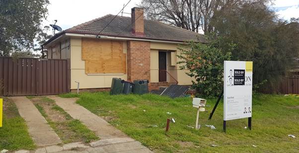
Figure 4
– 13 Gover Street, as photographed from the northeast corner of that site
on 20 July 2018
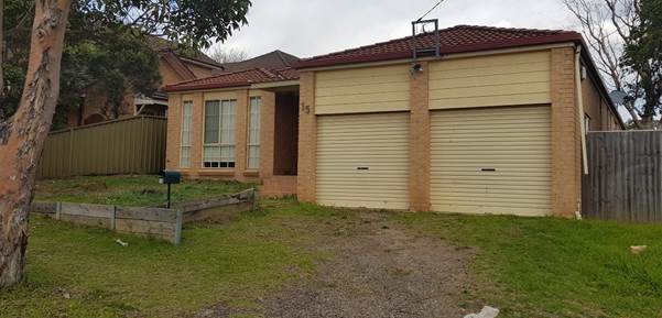
Figure 5
– 15 Gover Street, as photographed from the north west corner of that
site on 20 July 2018
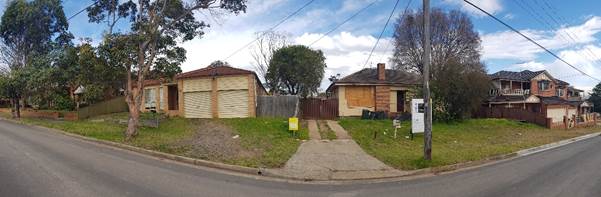
Figure 6
– A panoramic photo of the subject site (centre) and the adjoining
allotments on both sides
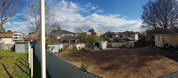
Figure 7
– A panoramic photo from the western side of 15 Gover Street, which shows
all allotments that adjoin the rear and western side of the subject site.
The residential flat building in the centre of the photo is located at 75
Trafalgar Street, which does not adjoin the subject site.
27. On
the northern side of Gover Street immediately opposite the subject site are a
number of residential allotments that contain detached single storey dwelling
houses.
28. The
subject site is not affected by any identifiable hazards (ie flooding, acid
sulphate soils, etc.). The subject site does not contain a heritage item and is
not within a heritage conservation area; there are also no heritage items
within the surrounding area.
Background
29. The
following provides a brief outline as to the history of the subject DA:
· 30 May 2018 - The
subject DA was lodged with Council.
· 13 June 2018 -
Application notified for a period from 13 June 2018 until 6 July 2018. No
submissions were received.
· 2 August 2018 - Design
Review Panel (DRP) meeting held. The recommendation from the meeting was that
the application be supported, subject to a number of issues being resolved
(refer to the discussion within this assessment report for more detail).
· 3 December 2018 -
Request for additional information sent to the applicant, which raised a number
of issues which are outlined as follows:
- Excessive
Floor Space Ratio (FSR)
- Internal
solar access
- Design
and area of the Communal Open Space
- Design
of the waste storage facilities and ventilation
- Landscaping
design
- Acoustic
privacy
- Design
of Unit G.05
- Submission
of a traffic impact assessment and minor design changes to the layout of the
basement carpark; and
- Satisfaction
of issues raised by the Design Review Panel (DRP)
· 22 March 2019 -
Amended and additional information received in response to the additional
information request. The following provides a response to the additional
information request raised by Council:
- The
plans have been amended so that the FSR complies with the applicable
development standard.
- Amended
information better demonstrates that internal solar access would comply with
ADG requirements.
- The
design and layout of the communal open space area has been amended to increase
the amount of communal open space area and to improve the amenity of this
space.
- The
waste storage area has been enlarged to meet relevant requirements, though no
bulk storage area has been included; this is consistent with sixteen (16) other
examples provided by the applicant of developments that were approved without
such facilities, thirteen (13) of which are within the Peakhurst area.
- Changes
have been made to the OSD basin so that it can be used as deep soil area and
exceed minimum storage requirements.
- It
is not possible for physical separation to be achieved between the lift and the
Units 1.05 and 2.05, and the applicant is accepting of a consent condition for
acoustic treatments to ensure that acoustic amenity is maintained.
- The
internal design of Unit G.05 has been modified to address Council/DRP
concerns. The excessively large storage area has been deleted and a new
BASIX certificate prepared.
- Amendments
to the car park (including sight triangles) have been undertaken.
PLANNING
ASSESSMENT
30. The
subject site has been inspected and the development has been assessed under the
relevant Section 4.15 (1) “Matters for Consideration of the Environmental
Planning & Assessment Act 1979.
Environmental
Planning Instruments
State
Environmental Planning Policies
Greater Metropolitan
Regional Environmental Plan No 2 – Georges River Catchment
31. The
site is within the area affected by the Greater Metropolitan Regional Environmental Plan No 2 — Georges River
Catchment. The proposal, including the disposal of stormwater, is
considered to be consistent with Council's requirements for the disposal of
stormwater in the catchment.
32. Stormwater
associated with the proposed development will be managed by the proposed onsite
stormwater system and will be treated in accordance with Council’s Water
Management Policy; it would therefore satisfy the relevant provisions of the
Deemed State Environmental Planning Policy – Georges River Catchment.
State
Environmental Planning Policy (Infrastructure) 2007
33. Divisions
5 (Electricity Transmission or Distribution) and 17 (Roads and Traffic) of the
State Environmental Planning Policy (Infrastructure) 2007 (ISEPP) are
not applicable to the proposal. There is no information to indicate that
an external referral to the relevant energy supply authority was required in
accordance with clause 45 of the ISEPP. The proposal does not adjoin a
classified road and does not constitute “Traffic generating
development” under Schedule 3 of the ISEPP; a referral to Roads and
Maritime Services (RMS) was therefore not required.
State
Environmental Planning Policy No 55 - Remediation of Land
34. Clause
7(1)(a) of SEPP 55 requires the Consent Authority to consider whether land is
contaminated. Council records indicate that the subject site has been used for
residential purposes for a significant period of time with no prior land uses.
In this regard it is considered that the site poses no risk of contamination
and therefore, no further consideration is required under Clause 7(1)(b) and
(c) of SEPP 55 and the land is considered to be suitable for the residential
land use.
State
Environmental Planning Policy (Building Sustainability Index: BASIX) 2004
35. BASIX
Certificate No. 909867M_02 dated 12 March 2019 has been issued for the proposed
development. The issue of this certificate has been prepared in
accordance with Clause 55A of the Environmental Planning and Assessment
Regulation 2000, (which requires that an amended BASIX certificate be submitted
with amended information). Compliance with the commitments of the BASIX
Certificate (both prior to the issue of Construction and Occupation
Certificates) would be subject to conditions in accordance with the
Regulations. With regard to the above, the provisions of the SEPP have
been satisfied.
State
Environmental Planning Policy (Vegetation in Non-Rural Areas) 2017
36. The
objectives of this SEPP are to protect the biodiversity
values of trees and other vegetation in non-rural areas and preserve the
amenity of non-rural areas through the preservation of trees and other
vegetation. This policy applies pursuant to Clause 5(1)(a) of the SEPP as the
site is within both Georges River Council and the R3 Medium Density Residential
zone. Pursuant to Clause 8(1) of the SEPP, clearing does not require authority
under the policy as it is a type of clearing that is authorised under Section
60O of the Local Land Services Act 2013 (specifically, that associated with a
development consent issued under Part 4 of the Environmental Planning and
Assessment Act 1979).
Draft State Environmental Planning Policy (Environment)
(Environment SEPP)
37. The Draft Environment SEPP was exhibited from 31 October
2017 to 31 January 2018. This consolidated SEPP proposes to simplify the
planning rules for a number of water catchments, waterways, urban bushland, and
Willandra Lakes World Heritage Property.
38. Changes proposed include consolidating the following seven
existing SEPPs:
· State Environmental Planning Policy No. 19 – Bushland
in Urban Areas
· State Environmental Planning Policy (Sydney Drinking Water
Catchment) 2011
· State Environmental Planning Policy No. 50 – Canal
Estate Development
· Greater Metropolitan Regional Environmental Plan No 2
– Georges River Catchment
· Sydney Regional Environmental Plan No. 20 –
Hawkesbury-Nepean River (No 2-1997)
· Sydney Regional Environmental Plan (Sydney Harbour Catchment)
2005
· Willandra Lakes Regional Environmental Plan No. 1 –
World Heritage Property.
The proposal is consistent with the provisions of this
Draft Instrument.
State Environmental
Planning Policy No 65—Design Quality of Residential Apartment Development
39. State
Environmental Planning Policy No.65 – Design Quality of Residential Flat
Buildings (SEPP 65) was gazetted on 26 July 2002 and applies to the assessment
of DAs for residential flat buildings of three or more storeys in height and
containing at least four dwellings. Amendment 3 to SEPP 65 commenced on
17 July 2015 and implemented various changes including the introduction of the
Apartment Design Guide (ADG) to replace the Residential Flat Design Code.
Pursuant to cl. 4(1) of the SEPP, this policy would apply to the subject
application.
40. A
detailed planning assessment of relevant provisions within the ADG is
undertaken later in this report.
41. Clause
28(2) of SEPP65 requires that the consent authority take into consideration the
following as part of the determination of DAs to which SEPP 65 applies:
a) the advice (if any) obtained from the design review
panel, and
b) the design quality of the development when evaluated in
accordance with the design quality principles, and
c) the Apartment Design Guide.
As required
by clause 28(2) of the SEPP 65, the Design Review Panel’s review of the
proposal is provided below. In addition, an assessment has also been undertaken
in terms of the Apartment Design Guide (ADG), which is also undertaken as
provided below.
Design Review
Panel’s Review of Proposal
42. The
DA was assessed by the DRP at a meeting held on 13 October 2018 having regard
to each of the nine (9) Design Quality Principles. In their Report, the DRP
recommends support of the application, subject to the issues raised within
their Report being resolved.
43. It
is noted that the DRP indicates that the application satisfied the design
quality principles contained within SEPP65.
44. The
issues raised by the DRP are covered below, followed by a comment on how they
have been resolved.
|
SEPP
65 – Design Quality of Residential Flat Buildings
|
DRP
Comment
|
Planner
Comment
|
|
Principle
1: Design quality principles
Good
design responds and contributes to its context. Context is the key natural
and built features of an area, their relationship and the character they
create when combined. It also includes social, economic, health and
environmental conditions.
Responding
to context involves identifying the desirable elements of an area’s existing
or future character. Well-designed buildings respond to and enhance the
qualities and identity of the area including the adjacent sites, streetscape
and neighbourhood.
Consideration
of local context is important for all sites, including sites in established
areas, those undergoing change or identified for change.
|
The
site is within an evolving medium density precinct at the north end of Gover
Street. The site has a cross fall of approximately 1 metre and a slope
from rear to front of about 1 metre and comprises two amalgamated residential
lots.
There
are 3 very large trees on the site all of which are dying for causes unknown,
potential poisoning. In this suspicious circumstance it is recommended
that Council investigate the reasons for their demise. The loss of these
trees makes it crucial to provide substantial large trees as part of this
proposal.
|
The
subject site and surrounding area were previously located within a
low-density residential area. Changes to the zoning of the area as R3
Medium Density residential zone has resulted in the proliferation of
higher-density residential development (including residential flat buildings)
within the surrounding area.
The
proposed development is therefore considered to be consistent with the
current/future character of the area.
The
Panel’s comments regarding poisoned trees are noted and have been
reviewed as part of the landscape officer’s comments.
|
|
Principle
2: Built Form and Scale
Good
design achieves a scale, bulk and height appropriate to the existing or
desired future character of the street and surrounding buildings.
Good
design also achieves an appropriate built form for a site and the
building’s purpose in terms of building alignments, proportions,
building type, articulation and the manipulation of building elements.
Appropriate
built form defines the public domain, contributes to the character of
streetscapes and parks, including their views and vistas, and provides
internal amenity and outlook.
|
The
built form comprises a 5 unit per floor footprint over 3 levels with communal
facilities at rooftop. While the building is centralized in the site,
privacy issues and impacts along all boundaries need to be carefully
considered – see Landscape.
The
architect has assured the Panel that the single open stair is achievable as
an alternative solution, and will be compliant with the BCA
requirements. See further comments below under Amenity.
Applicant
is seeking variation to Clause 4.6 LEP Height Control of 12m. The
excess height is due to the lift overrun and rooftop amenities, and the
variation is supported.
|
Aside
from the floor space ratio, there are no specific density controls which
apply to the site.
A
variation to the building height standard under HLEP 2012 has been proposed;
consideration of the variation is contained within the HLEP 2012 assessment,
however the variation is considered to be both acceptable and
supportable. Despite beaching the height standard, such a variation
would not result in significant or unreasonable impacts on either the subject
site or surrounding area. The variation would likely result in improved
amenity to the communal open space areas and is consistent with the height
and scale of higher-density residential development within the local area.
The
centrally located building would be highly articulated and would have an
acceptable presentation to the public domain. Views and outlooks from
surrounding areas would not be affected.
|
|
Principle
3: Density
Good
design achieves a high level of amenity for residents and each apartment,
resulting in a density appropriate to the site and its context.
Appropriate
densities are consistent with the area’s existing or projected
population. Appropriate densities can be sustained by existing or proposed
infrastructure, public transport, access to jobs, community facilities and
the environment.
|
Stated
to being compliant with the 1:1 FSR control.
|
As
indicated above, aside from the FSR standard there are no density
requirements which apply to the site. The design of the building would afford
a high level of internal amenity, with high levels of solar access and
natural ventilation being proposed. The FSR being proposed by the
applicant is considered to be consistent with that of newer/higher-density
residential development within the surrounding area.
|
|
Principle
4: Sustainability
Good
design combines positive environmental, social and economic outcomes.
Good
sustainable design includes use of natural cross ventilation and sunlight for
the amenity and liveability of residents and passive thermal design for
ventilation, heating and cooling reducing reliance on technology and
operation costs. Other elements include recycling and reuse of materials and
waste, use of sustainable materials and deep soil zones for groundwater
recharge and vegetation.
|
See
notes above under Context regarding the poor condition of the existing site
trees. This significantly impacts on local micro-climates and it is
imperative that the design replaces these lost trees with trees of a similar
scale.
Highly
desirable to introduce sustainability measures such as solar energy
collection and rainwater recycling for irrigation.
|
High
levels of natural solar access and ventilation are proposed. Proposed
deep soil areas on the site will also be well in excess of minimum
requirements.
Further
to the above, a compliant BASIX Certificate has been submitted with the
subject application. The commitments will be reinforced by a condition of
consent.
|
|
Principle
5: Landscape
Good
design recognises that together landscape and buildings operate as an
integrated and sustainable system, resulting in attractive developments with
good amenity. A positive image and contextual fit of well-designed
developments is achieved by contributing to the landscape character of the
streetscape and neighbourhood.
Good
landscape design enhances the development’s environmental performance
by retaining positive natural features which contribute to the local context,
co-ordinating water and soil management, solar access, micro-climate, tree
canopy, habitat values and preserving green networks.
Good
landscape design optimises useability, privacy and opportunities for social
interaction, equitable access, respect for neighbours’ amenity and
provides for practical establishment and long term management.
|
The
following recommendations are made:
· Provide
additional large trees in the rear boundary, minimum 3 extra. These
should be greater than 10m at maturity and it is not recommended that the
scribbly gums are used as these will not provide adequate scale. These
should be a minimum 400 litre at installation and should be fully
irrigated. Documentation should be provided in the DA submission
demonstrating irrigation design.
· Reconfigure
the courtyard on the eastern boundary to pull back the stair access and
provide additional space for planting.
· Delete
the stairs on the western boundary and provide new tree planting in this
corner.
· Replace
the 3 small trees (water gums) proposed in the Gover Street setback with 1
large tree such as a gum that would provide appropriate scale and height to
complement the streetscape.
· Reconfigure
the rooftop planters to create increase planting zones and define smaller
external gathering spaces.
· Relocate
the OSD tank clear of deep soil zones.
|
The
applicant proposes a good landscape design through the provision of large
landscaped and deep soil areas, both around the periphery of the subject site
and on the roof. The design of the landscape layout maximise both
functionality and useability, and will contribute to maintenance of visual
privacy, both within the proposed development and on surrounding sites.
Further,
the applicant has responded to the comments and requirements of the DRP as
follows:
· Six
large trees are proposed within the rear setback (which includes three Red
Gums, three Scribbly Gums and a Blueberry Ash); which is an increase upon the
three trees previously proposed. Five of the six trees within the
setback would be capable of growing to heights of more than 10 metres.
Four of the trees would have 400L pot sizes. Irrigation plans have also
been submitted.
· The
courtyard on the eastern side of the site has not been pulled back, however
the courtyard and associated stairs on the southwest side of the site have
been reconfigured and reduced in size to provide additional planting areas.
· A
large Water Gum has been proposed within the front setback (in addition to a
Scribbly Gum and Water gum) within the front setback.
· The
design of the rooftop planters (particularly those at the front/northern end
of the roof) have been amended and increased in size.
· The
applicant has advised that the OSD system in the front of the site is a
basin, and not a tank; the capacity of the basin is also oversized to allow
for deep-soil planting in the area.
|
|
Principle
6: Amenity
Good
design positively influences internal and external amenity for residents and
neighbours. Achieving good amenity contributes to positive living
environments and resident well being.
Good
amenity combines appropriate room dimensions and shapes, access to sunlight,
natural ventilation, outlook, visual and acoustic privacy, storage, indoor
and outdoor space, efficient layouts and service areas and ease of access for
all age groups and degrees of mobility.
|
The
amenity of the development is generally of good standard but the following
detailed issues should be addressed:
· The
entry doors should be moved closer to the street to avoid the deeply recessed
space.
· Unit
G01 and units above are awkwardly planned with no entry lobby and poorly
relating living and dining spaces. It is recommended that this
apartment is redesigned so that a living / dining space can have a more
cohesive arrangement and the defined entry to the apartment introduced.
· Unit
G05 has a large storeroom which appears to be a potentially habitable room
without a window. This apartment should be redesigned so that such
space has access to natural light and ventilation.
· Notably
the design achieves good compliance levels with solar access and natural
ventilation.
· The
seat adjacent to the entry steps has poor outlook and could be better
located.
|
The
plans propose a high level of amenity. A variety of units and room
sizes are proposed, all of which would have appropriate volumes of storage
and visual privacy. The proposal also exceeds minimum requirements for
solar access, cross ventilation, and indoor and outdoor space.
Further,
the applicant has responded to the comments and requirements of the DRP as
follows:
· The
depth of the entry’s recess has been reduced by approximately 500mm;
the design of the approaches to the entry have also been changed to improve
view lines to the building’s main entry.
· The
design of Units G.01, 1.01 and 2.01 have been altered to integrate the living
and dining spaces.
· Unit
G.05 has been reconfigured to remove the aforementioned storage
‘room’ that was previously proposed.
· High
levels of solar access and ventilation are proposed.
· The
timber seating has been relocated adjacent to the new primary entrance point
from the street on the amended plans.
|
|
Principle
7: Safety
Good
design optimises safety and security within the development and the public
domain. It provides for quality public and private spaces that are clearly
defined and fit for the intended purpose. Opportunities to maximise passive
surveillance of public and communal areas promote safety.
A
positive relationship between public and private spaces is achieved through
clearly defined secure access points and well lit and visible areas that are
easily maintained and appropriate to the location and purpose.
|
See
comment above relating to recessed main entrance doors which would be a
potential security hazard.
|
All
units on the northern elevation would feature internal and external living
areas that would overlook the public domain, thereby maximising active and
casual surveillance of the street. The main entry point to the building has
been amended in response to the DRP’s feedback so that it would be
capable of being directly observed from the public domain and both internal
and external approaches.
|
|
Principle
8: Housing Diversity and Social Interaction
Good
design achieves a mix of apartment sizes, providing housing choice for
different demographics, living needs and household budgets.
Well
designed apartment developments respond to social context by providing
housing and facilities to suit the existing and future social mix.
Good
design involves practical and flexible features, including different types of
communal spaces for a broad range of people and providing opportunities for
social interaction among residents.
|
The mix
of apartments proposed is satisfactory. The rooftop terrace will
provide an amenable place for gathering.
|
The
proposed development mix is three (3) x one (1) bedroom, eight (8) x two (2)
bedroom and four (4) x three (3) bedroom apartments which is considered to be
an appropriate mix of dwellings that would meet a range of needs and budgets.
As
reflected by the DRP notes, the placement and design of the rooftop communal
open space area and the high levels of amenity that would be afforded to such
areas would enable communal facilities to provide opportunities for social
interaction.
|
|
Principle
9: Aesthetics
Good
design achieves a built form that has good proportions and a balanced
composition of elements, reflecting the internal layout and structure. Good
design uses a variety of materials, colours and textures.
The
visual appearance of a well designed apartment development responds to the
existing or future local context, particularly desirable elements and
repetitions of the streetscape.
|
The building fits well within
the streetscape and substantial trees along its frontage as noted above in
Landscape would be valuable in enhancing the character of the street.
|
The
proposed development will be consistent with the existing and future
character of the streetscape (noting that the future character envisions
developments of a typology, scale and appearance similar to that of the
proposal). The visual appearance of the building would respond well to
the local context, noting the compatible scale, design and appearance of
other contemporary residential flat buildings within the surrounding area.
|
Assessment
under the Apartment Design Guide (ADG)
45. Clause
28(2) requires assessment under the Apartment Design Guide (ADG). This
assessment has been undertaken below.
|
ADG Reference
|
Clause
|
Design Criteria
|
Complies
|
|
Part 3 Siting the
Development
|
|
3B Orientation
|
3B-1 - Building types and layouts
respond to the streetscape and site while optimising solar access within the
development
|
The building would be oriented to
the north and would both address and access the street frontage.
Overshadowing to the south would be minimised.
|
Yes
|
|
3B-2 - Overshadowing of
neighbouring properties is minimised during mid-winter
|
The proposal would enable adequate
solar access of living areas and both private and communal open space (refer
to assessments below). Buildings on surrounding sites would not be
unreasonably overshadowed during mid-winter.
|
Yes
|
|
3C Public domain interface
|
3C-1 - Transition between private
and public domain is achieved without compromising safety and security
|
Access to ground floor terraces
(Unit G.02) has been provided where practical. All apartments on the
northern side of the development overlook the adjoining road reserve.
|
Yes
|
|
3C-2 - Amenity of the public domain
is retained and enhanced
|
Planting is to be used in the front
setback area to soften the appearance of the building. Apart from
stormwater facilities (the prominence of which is to be reduced through the
design of an open OSD basin, services are to be located within the basement,
access to which is at the lowest side of the primary frontage.
|
Yes
|
|
3D Communal and public open space
|
3D-1 - An adequate area of communal
open space is provided to enhance residential amenity and to provide
opportunities for landscaping
|
Required communal open space: Minimum
25% of the site area (328.3sqm, based on a site area of 1313.1sqm)
Proposed communal open space:
328.4sqm (includes boundary planters and excludes access to the roof (i.e.
stairs, lift, foyer etc.).
The proposal would comply with
minimum requirements; if it were however deemed that the planters should be
excluded from the calculations (in that they do not contribute to a
‘usable’ space), then 232.7sqm of communal open space would be
provided.
Such a shortfall of communal open
space is considered to be supportable in this instance. Due to the
northern orientation of the site, the placement of additional communal open
space at ground level would be unlikely to provide additional space that
would be of high amenity (given the likely amount of overshadowing that would
be associated with situating such areas to the rear (i.e. south) of the
proposed RFB). Further, Peakhurst Park is located approximately 65
metres walking distance from the subject site. This location includes
expansive open space in addition to a number of facilities that include two
soccer fields, two mini soccer fields, a junior league field, a League/Touch
field, a cricket wicket and cricket practice nets.
With regard to the above any such
noncompliance to the design criteria is considered to be supportable on
merit.
|
Yes
|
|
A numerical
breakdown has not been provided, however the shadow plans indicate that more
than 50% of usable areas within the proposed communal area would be capable
of receiving at least two hours of direct solar access in mid-winter.
|
Yes
|
|
3D-2 - Communal open space is
designed to allow for a range of activities, respond to site conditions and
be attractive and inviting
|
The proposed
communal open space areas would contain a variety of community facilities
including group tables/seating areas, BBQ facilities and space for a variety
of activities.
Open and unshaded
areas would be provided by a pergola roof that would cover part of the
communal areas.
|
Yes
|
|
3D-3 - Communal open space is
designed to maximise safety
|
The communal area
would be on the rooftop, so the development would be technically non-compliant
in that it could not be observed from units within the development.
Other design guidance criteria would however be satisfied and is considered
to be supportable.
|
Yes
|
|
3E Deep soil zones
|
3E-1 - Deep soil zones provide
areas on the site that allow for and support healthy plant and tree growth.
They improve residential amenity and promote management of water and air
quality
|
At least 7% of
the site (i.e. 91.9sqm) shall comprise deep soil zones, with minimum
dimensions of 3m.
Proposed deep
soil area: Approx. 225.3sqm, or 17.2% of the site area (inclusive of minimum
dimensions)
|
Yes
|
|
3F Visual privacy
|
3F-1 - Adequate building separation
distances are shared equitably between neighbouring sites, to achieve
reasonable levels of external and internal visual privacy
|
Separation between windows and
balconies is provided to ensure visual privacy is achieved. Minimum
setbacks between respective boundaries and habitable rooms/boundaries are to
be as follows:
· Required
Side/rear boundaries:
o Habitable rooms and balconies:
6m
o Non-habitable rooms: 3m
· Proposed
setbacks from side/rear boundaries:
o South east (side) boundary:
Minimum 6.04m
o North west (side) boundary):
Minimum 6m
o South west (rear) boundary:
Minimum 5.6m
As acknowledged by the
applicant’s Statement of Environmental Effects, parts of the
development would not satisfy the minimum 6 metre setback to the rear
boundary. The areas affected by the setback breaches include parts of
the balconies on the southeast and southwest corners of the building (with
minimum setbacks of 5.6m and 5.645m respectively), and parts of exterior
walls adjacent to the balconies (with minimum setbacks of 5.8m and 5.9m
respectively). The size and areas of the breaches are reflective of the
irregular shape of the rear boundary (which increases the size of the rear
setback towards the centre of the site, and reduces setbacks adjacent to the
side boundaries), and the remainder of the rear setback complies with the 6m
requirement.
Elements of the exterior walls that
would breach the rear setback area do not contain any windows, therefore the
objective regarding separation and visual privacy would be satisfied.
Only the edges of the balconies would breach the rear setback area, and from
the balustrades the maximum depth of the noncompliance would be approximately
150-190mm (i.e. the vast majority of the balconies would be more than 6m from
the rear boundary and would subsequently satisfy the objective regarding
privacy). The unit 1.04 and 2.04 balconies i.e. those on the southwest
side of the proposed RFB) would also include angled louvre screens that would
direct views away from the subject site’s rear setback.
With regard to the above, it is
considered unlikely that full compliance with the design criteria would have
a discernible impact on building separation and subsequent visual privacy
between adjoining sites. Further, Planning Circular PS 17-001 issued by
the Department of Planning and Environment states that the ADG should not be
applied as a set of strict development standards where the objectives of the
criteria can be met.
It is agreed with the
applicant’s planner that visual privacy between sites would be unlikely
to be compromised as a result of the proposed noncompliance.
The minor building separation
variations that are proposed on the rear elevation are therefore considered
to be acceptable.
|
Yes
|
|
3F-2 - Site and building design
elements increase privacy without compromising access to light and air and
balance outlook and views from habitable rooms and private open space
|
Proposed privacy elements on side
and rear-facing balconies would not adversely affect access to light and
air. The louvered screens would be directed towards the northeast and
northwest, thereby maximising solar access to such areas.
|
Yes
|
|
3G Pedestrian access and entries
|
3G-1 - Building entries and
pedestrian access connects to and addresses the public domain
|
Multiple ground floor entrances
proposed, with entries oriented towards the road frontage.
|
Yes
|
|
3G-2 - Access, entries and pathways
are accessible and easy to identify
|
Building access would be clearly
identifiable from the adjoining road frontage. Entrances to the
building and carpark are integrated into the building design.
|
Yes
|
|
3H Vehicle access
|
3H-1 - Vehicle access points are designed
and located to achieve safety, minimise conflicts, between pedestrians and
vehicles and create high quality streetscapes
|
The proposed single garage entrance
would be located at the lowest point of the primary boundary. No
parking or vehicle standing areas are proposed within the front setback.
|
Yes
|
|
3J Bicycle and car parking
|
3J-1 - Car parking is provided
based on proximity to public transport in metropolitan Sydney and centres in
regional areas
|
Proposed car parking rates are to
be in accordance with the DCP, which for reference is as follows:
Required parking:
· 19 residential
spaces (11 spaces for 1 and 2 bedroom apartments, and 8 spaces for 3 bedroom
apartments)
· 3.75 visitor
spaces (rounded up to 4)
Proposed parking:
· 19 residential
spaces
· 4 visitor spaces
Refer to the assessment of the DCP
for further information.
|
Yes
|
|
3J-2 - Parking and facilities are
provided for other modes of transport
|
Racks for four bicycle parking
spaces are located in a convenient location within the basement.
|
Yes
|
|
3J-3 - Car park design and access
is safe and secure
|
Secure access to the carpark is to
be controlled by a security gate at the bottom of the driveway ramp.
|
Yes
|
|
3J-4 - Visual and environmental
impacts of underground car parking are minimised
|
The carpark would be both
ventilated via natural (i.e. airflow through the garage security door) and
mechanical (a riser through the centre of the building) means.
|
Yes
|
|
Part 4
Designing the building
|
|
Amenity
|
|
4A Solar and daylight access
|
4A-1 – to optimise the number
of apartments receiving sunlight to habitable rooms, primary windows and
private open space
|
Required:
· Living room and
Private Open Space areas within at least 70% of all apartments must receive
at least 2 hours of direct sunlight between 9am and 3pm in mid-winter.
Proposed:
· The internal
solar access plans indicate that 12 of the 15 (i.e. 80% of proposed
apartments would receive at least 2 hours of direct solar access on June 21.
|
Yes
|
|
Required:
· A maximum of 15%
of apartments receive no direct sunlight between 9am and 3pm in mid-winter.
Proposed:
· All proposed
apartments would receive solar access between 9:00am and 3:00pm in
mid-winter. Three of the proposed apartments (i.e. 20%) would however
receive less than two hours of solar access (with such access being obtained
between approximately 2:00pm and 3:00pm in mid-winter).
|
Yes
|
|
4A-2 - Daylight access is maximised
where sunlight is limited
|
Daylight is considered to be
satisfactorily maximised; daylight access is not proposed primarily through
highlight windows and ground level courtyards are mostly open to the sky.
|
Yes
|
|
4A-3 - Design incorporates shading
and glare control, particularly for warmer months
|
N/A - given orientation of the site
and proposed adjoining development.
|
Yes
|
|
4B Natural ventilation
|
4B-1 - All habitable rooms
are naturally ventilated
|
The proposal demonstrates
compliance.
|
Yes
|
|
4B-2 - The layout and design of
single aspect apartments maximises natural ventilation
|
The proposal
would satisfy most requirements, however the 9m depths of Units G.01, 1.01
and 2.01 would all exceed maximum (ie 8m) depth requirements. The
maximum 8m depth requirement would apply irrespective of the orientation of
the apartment, however the apartments and the affected rooms within them
would have large openings, and therefore be likely to be capable of being
ventilated. As such, the variation to the design guidance is
considered to be supportable.
|
Yes
|
|
4B-3 - The number of apartments with
natural cross ventilation is maximised to create a comfortable indoor
environment for residents
|
Required: At least 60% of
all apartments are naturally cross ventilated.
Proposed: 12 (80%) of the
proposed apartments would be capable of being cross-ventilated.
|
Yes
|
|
4C Ceiling heights
|
4C-1 - Ceiling height achieves sufficient natural ventilation and daylight
access
|
Required:
· Minimum ceiling
height for a habitable room is 2.7m
· Minimum ceiling
height for a habitable room is 2.4m
· Minimum 3.3m
ceiling height required for commercial areas/ground floor in mixed use
developments.
Proposed:
· Minimum 2.7m
ceiling heights for units
|
Yes
|
|
4C-2 - Ceiling height increases the
sense of space in apartments and provides for well proportioned rooms
|
Proposal considered acceptable
|
Yes
|
|
4D Apartment size and layout
|
4D-1 - The layout of rooms within an
apartment is functional, well organised and provides a high standard of
amenity
|
Apartments are required to have the
following minimum internal areas:
Studio – 35sqm
1 bedroom – 50sqm
2 bedroom – 70sqm
3 bedroom – 90sqm
Additional requirements:
· These
calculations only provide for 1 bathroom, and 5sqm is to be added for each additional
bathroom.
· A fourth bedroom
and further additional bedrooms are to increase the internal floor area by
12sqm
Proposed development:
Unit G.01
– 2br – 78sqm – complies
Unit G.02
– 2br – 76.7sqm – complies
Unit G.03
– 2br – 84.3sqm – complies
Unit G.04
– 3br – 98.8sqm – complies
Unit G.05
– 1br – 51.4sqm – complies
Unit 1.01
– 2br – 78sqm – complies
Unit 1.02
– 2br – 78sqm – complies
Unit 1.03
– 2br – 84.6sqm – complies
Unit 1.04
– 3br – 97.7sqm – complies
Unit 1.05
– 1br – 51.5sqm – complies
Unit 2.01
– 3br – 95sqm – complies
Unit 2.02
– 2br – 77.2sqm – complies
Unit 2.03
– 2br – 84.1sqm – complies
Unit 2.04
– 3br – 97.5sqm – complies
Unit 2.05
– 1br – 51.3sqm – complies
|
Yes
|
|
Required:
Every habitable room must have a
window in an external wall with a total minimum glass area of not less than
10% of the floor area of the room. Daylight and air may not be borrowed from
other rooms.
|
Yes
|
|
4D-2 - Environmental performance of
the apartment is maximised
|
Required:
Habitable room depths are limited to
a maximum of 2.5 x ceiling height.
Proposed:
Complies except for open plan
layouts apply; refer to the assessment below.
|
Yes
|
|
Required:
In open plan layouts (where the
living, dining and kitchen are combined) the maximum habitable room depth is
8m from a window.
Proposed:
Complies, except for Units G.01,
1.01 and 2.01.
The proposal would satisfy most
requirements, however the 9m depths of Units G.01, 1.01 and 2.01 would all
exceed maximum (i.e. 8m) depth requirements. It is noted that the
maximum 8m death requirement would apply irrespective of the orientation of
the apartment; however the apartments and the affected rooms within them that
are subject to the noncompliance would all be oriented towards the
north. Such areas would likely be subject to substantial and direct
solar access; further, the open plan living areas of the affected apartments
have substantial openings (both doors and windows) to facilitate
ventilation. Despite the noncompliant room depths, amenity and
environmental performance of such areas is expected to be maintained.
The noncompliance is therefore considered to be supportable on merit.
|
Yes
|
|
4D-3 - Apartment layouts are
designed to accommodate a variety of household activities and needs
|
Required:
Master bedrooms have a minimum area
of 10sqm and other bedrooms 9sqm (excluding wardrobes).
|
Yes
|
|
Required:
Bedrooms have a minimum dimension of
3m (excluding wardrobes).
|
Yes
|
|
Required:
Living rooms or combined
living/dining rooms have a minimum width of:
· 1-bedroom
apartments: Minimum 3.6m
· 2-bedroom
apartments: Minimum 4m
Proposed:
· 1-bedroom
apartments: Minimum 5.1m
· 2-bedroom
apartments: Minimum 4m
|
Yes
|
|
4E Private open space and balconies
|
4E-1 - Apartments provide
appropriately sized private open space and balconies to enhance residential
amenity
|
1 bedroom apartments are to have
primary balconies with a minimum area of 8sqm and a minimum depth of 2m.
2 bedroom apartments are to have
primary balconies with a minimum area of 10sqm and a minimum depth of 2m.
Proposed development:
Unit 1.01 – 2br –
14.47sqm – complies
Unit 1.02 – 2br –
10.97sqm – complies
Unit 1.03 – 2br –
15.47sqm – complies
Unit 1.04 – 3br –
13.25sqm – complies
Unit 1.05 – 1br – 9.97sqm
– complies
Unit 2.01 – 3br –
14.47sqm – complies
Unit 2.02 – 2br –
10.97sqm – complies
Unit 2.03 – 2br –
15.47sqm – complies
Unit 2.04 – 3br –
13.25sqm – complies
Unit 2.05 – 1br –
9.29sqm – complies
|
Yes
|
|
For apartments at ground level or
on a podium or similar structure, a private open space is provided instead of
a balcony. It must have a minimum area of 15sqm and a minimum depth of 3m.
Proposed development:
Unit G.01 – 2br –
20.67sqm – complies
Unit G.02 – 2br –
60.9sqm – complies
Unit G.03 – 2br –
65.6sqm – complies
Unit G.04 – 3br –
115.98sqm – complies
Unit G.05 – 1br –
26.76sqm - complies
|
Yes
|
|
4E-2 - Primary private open space
and balconies are appropriately located to enhance liveability for residents
|
With the
exception of a secondary courtyard which would extend from Bedroom 1 of Unit
G.01, all Private Open Space areas adjoin and form extensions of internal
living room.
|
Yes
|
|
4E-3 - Private open space and
balcony design is integrated into and contributes to the overall
architectural form and detail of the building
|
All balconies
would be integrated into the building. Plant equipment and clothes
dying facilities are not proposed on the balconies.
|
Yes
|
|
4E-4 - Private open space and
balcony design maximises safety
|
Balustrading to balconies
appears to be to compliant heights to promote safety. To comply with relevant
AS if approved by way of condition.
|
Yes
|
|
4F Common circulation and spaces
|
4F-1 - Common circulation spaces
achieve good amenity and properly service the number of apartments
|
Maximum number
of dwellings off circulation core: 5
|
Yes
|
|
4G Storage
|
4G-1 - Adequate, well designed
storage is provided in each apartment
|
In addition to storage in kitchens,
bathrooms and bedrooms, 6m³ of storage is to be provided for 1 bedroom apartments,
8m³ for 2 bedroom apartments and 10m3 for three or more
bedroom apartments. At least 50% is to be located within the apartment.
Proposed minimum storage
areas:
Unit G.01 – 2br –
6.93sqm – complies
Unit G.02 – 2br –
8.2sqm – complies
Unit G.03 – 2br –
9.6sqm – complies
Unit G.04 – 3br –
10.46sqm – complies
Unit G.05 – 1br –
5.45sqm – does not comply
Unit 1.01 – 2br –
6.93sqm – complies
Unit 1.02 – 2br –
8.2sqm – complies
Unit 1.03 – 2br –
9.6sqm – complies
Unit 1.04 – 3br –
10.46sqm – complies
Unit 1.05 – 1br –
5.45sqm – does not comply
Unit 2.01 – 2br –
6.93sqm – complies
Unit 2.02 – 2br –
8.2sqm – complies
Unit 2.03 – 2br –
9.6sqm – complies
Unit 2.04 – 3br –
10.46sqm – complies
Unit 2.05 – 1br –
5.45sqm – does not comply.
Note 1: The above calculations
do not include built-in wardrobes.
Note 2: The indicated storage
volumes on the plans show the storage volumes of the development prior to the
submission of amended information. These have been revised since
amendments were made and have not be relied upon for the above assessment.
The proposed development is
unlikely to provide a sufficient amount of dedicated storage space for the
one bedroom apartments. The shortfall of storage within affected
apartments is not significant, and it is noted that the substantial size (ie
12sqm, excluding wardrobes) of the bedrooms within the noncompliant
apartments are well in excess of minimum requirements (noting that they are
accessible apartments). It is therefore considered likely that there
would be sufficient space within the affected apartments to provide
additional furniture and/or facilities that would provide necessary storage
space in accordance with the design guidance. The noncompliance is
therefore considered to be satisfactory.
|
No
to 3 units
|
|
4G-2 - Additional storage is
conveniently located, accessible and nominated for individual apartments
|
The development has demonstrated
compliance
|
Yes
|
|
4H Acoustic privacy
|
4H-1 - Noise transfer is minimised
through the siting of buildings and building layout
|
The design of most apartments would
locate noise-sensitive areas (i.e. bedrooms) away from areas of acoustic
intrusion. The following areas of concern are however noted:
• The
bedrooms of Units G.05, 1.05 and 2.05 would adjoin the lift. It is noted
that wardrobes are to be situated between the shaft and the bedroom in
accordance with design guidance requirements. A condition is
recommended to require that appropriate acoustic treatments is provided to
ensure that acoustic amenity of the affected bedrooms are retained.
• The
northwest (ie side) facing windows of Bedroom 2 within Unit G.01 would
directly overlook the driveway and basement security door beneath.
While the basement entrance would be situated below the affected bedroom, it
is recommended that a condition require that these windows be sealed (ie
unopenable) to prevent acoustic disturbance of this area.
|
Yes
|
|
4H-2 - Noise impacts are mitigated
within apartments through layout and acoustic treatments
|
The proposal is capable of
satisfying design criteria/guidance.
|
Yes
|
|
4K Apartment Mix
|
4K-1 - A range of apartment types
and sizes is provided to cater for different household types now and into the
future
|
The proposed development includes
the following mix:
· One bedroom: 3
· Two bedrooms: 8
· Three bedrooms:
4
|
Yes
|
|
4K-2 - The apartment mix is
distributed to suitable locations within the building
|
One, two and three bedroom
apartments are to be situated on all floors.
|
Yes
|
|
4L Ground floor apartments
|
4L-1 - Street frontage activity is maximised
where ground floor apartments are located
|
Direct access is to be provided to
Unit G.02. The slope of the site and the locations of stormwater
facilities and the driveway would preclude direct access to Unit G.01,
however this unit would be designed to both overlook and activate the public
domain.
|
Yes
|
|
4L-2 - Design of ground floor
apartments delivers amenity and safety for residents
|
Privacy and safety would be
afforded to street-facing apartments in accordance with design guidance
requirements. Solar access would be afforded to all ground floor
apartments, with only Unit 2.03 not obtaining more than 2 hours of solar
access between 9:00am to 3:00pm on June 21.
|
Yes
|
|
4M Facades
|
4M-1 - Building facades provide
visual interest along the street while respecting the character of the local
area
|
The development is considered
acceptable in this regard.
|
Yes
|
|
4M-2 - Building functions are
expressed by the facade
|
The development is considered
acceptable in this regard.
|
Yes
|
|
4N Roof design
|
4N-1 - Roof treatments are
integrated into the building design and positively respond to the street
|
The development is considered
acceptable in this regard.
|
Yes
|
|
4N-3 - Roof design incorporates
sustainability features
|
The development is considered
acceptable in this regard.
|
Yes
|
|
4O Landscape design
|
4O-1 - Landscape design is viable
and sustainable
|
The development is considered
acceptable in this regard.
|
Yes
|
|
4O-2 - Landscape design contributes
to the streetscape and amenity
|
The development is considered acceptable
in this regard.
|
Yes
|
|
4P Planting on structures
|
4P-1 – Appropriate soil
profiles are provided
|
The development is considered
acceptable in this regard.
|
Yes
|
|
4P-2 - Plant growth is optimised
with appropriate selection and maintenance
|
The development is considered
acceptable in this regard.
|
Yes
|
|
4P-3 - Planting on structures
contributes to the quality and amenity of communal and public open spaces
|
The development is considered
acceptable in this regard.
|
Yes
|
|
4Q Universal design
|
4Q-1 - Universal design features
are included in apartment design to promote flexible housing for all
community members
|
Hurstville DCP No. 1 requires that
RFBs containing five or more dwellings provide at least one adaptable
dwelling, designed in accordance with relevant Australian Standards must be
provided for every 10 dwellings. 15 dwellings are proposed, which
includes two adaptable dwellings in accordance with this requirement.
|
Yes
|
|
4Q-2 - A variety of apartments with
adaptable designs are provided
|
Only one-bedroom apartments are
proposed to be adaptable.
|
Yes
|
|
4Q-3 – Apartment layouts are
flexible and accommodate a range of lifestyle needs
|
The development is considered
acceptable in this regard.
|
Yes
|
|
Performance
|
|
4U Energy efficiency
|
4U-1 - Development
incorporates passive environmental design
|
The proposal satisfies solar access
requirements; refer to assessment above. Clothes drying facilities are
to be provided on the rooftop level.
|
Yes
|
|
4U-2 - Development incorporates
passive solar design to optimise heat storage in winter and reduce heat
transfer in summer
|
The development is considered
acceptable in this regard.
|
Yes
|
|
4U-3 - Adequate natural
ventilation minimises the need for mechanical ventilation
|
The development is considered
acceptable in this regard.
|
Yes
|
|
4V Water management and
conservation
|
4V-1 - Potable water use is
minimised
|
Complies, or is capable of
satisfying design criteria/guidance.
|
Yes
|
|
4V-2 - Urban stormwater is
treated on site before being discharged to receiving waters
|
Complies, or is capable of
satisfying design criteria/guidance.
|
Yes
|
|
4W Waste management
|
4W-1 - Waste storage facilities
are designed to minimise impacts on the streetscape, building entry and
amenity of residents
|
A waste storage area is to be
located within the basement carpark adjacent to the carpark entrance.
It would be screened from the public domain by the carpark security door and
internal walls. The waste storage area would be ventilated via a riser
space within the carpark that would be vented out to the roof.
A bulk storage area is not
proposed. In response to the noncompliance, the applicant has indicated
that Georges River Council do typically not require that bulky storage areas
be provided for developments with only a moderate housing yield; to support
such a claim, they have provided a list of developments that have been
approved within Peakhurst (including developments at 23-25 and 51-55 Gover
Street) by Council without bulk waste storage areas.
|
Yes
|
|
4W-2 - Domestic waste is minimised
by providing safe and convenient source separation and recycling
|
The proposed storage facilities to
enable storage of 13 x 240L bins. Guidance requirements relating to
commercial waste are not applicable to the proposal.
|
Yes
|
|
4X Building maintenance
|
4X-1 - Building design detail
provides protection from weathering
|
Complies, or is capable of
satisfying design criteria/guidance.
|
Yes
|
|
4X-2 - Systems and access
enable ease of maintenance
|
Complies, or is capable of
satisfying design criteria/guidance.
|
Yes
|
|
4X-3 - Material selection
reduces ongoing maintenance costs
|
Complies, or is capable of
satisfying design criteria/guidance.
|
Yes
|
Hurstville
Local Environmental Plan 2012
Zoning
46. The subject site is zoned R3 Medium
Density Residential under the provisions of the Hurstville Local Environmental Plan (HLEP) 2012.
47. The objectives of the R3 zone are as follows:
· To provide for the housing needs of the community within a
medium density residential environment.
· To provide a variety of housing types within a medium
density residential environment.
· To enable other land uses that provide facilities or
services to meet the day to day needs of residents.
· To ensure that a high level of residential amenity is
achieved and maintained.
· To provide for a range of home business activities, where
such activities are not likely to adversely affect the surrounding residential
amenity.
48. The
proposed development is consistent with the objectives of the R3 zone as
follows:
· The
proposed design enables the development to provide for the housing needs of the
locality in a manner that is consistent with that typically found within the R3
zone.
· A
variety of housing types are proposed, in that one, two and three bedroom
apartments are proposed with a variety of internal configurations.
· The
proposal would not prevent surrounding sites from providing facilities or
services that could meet the needs of local residents.
· A
high level of residential amenity would be achieved and maintained, both for
residents on the subject site and those within surrounding sites.
· While
facilities have not been provided to accommodate home businesses, the
configurations of the apartments could allow for some home business activities
to occur (i.e. a home office) without disturbing surrounding residential
amenity. The proposal does not prevent surrounding properties from
accommodating home businesses.
49. The
extent to which the proposal complies with the relevant standards of HLEP 2012
is outlined in the table below.
|
Clause
|
Standard
|
Proposed
|
Complies
|
|
Part 2
– Permitted or Prohibited Development
|
R3 Medium Density Residential
|
‘Residential
flat buildings’ are permissible within the R3 zone.
|
Yes
|
|
|
Objectives
of the Zone
|
The
proposal satisfies the objectives of the R3 zone.
|
Yes
|
|
4.3 – Height of Buildings
|
12m as identified on Height of
Buildings Map
|
Maximum height: 13.85 metres (lift
overrun)
|
No – see assessment below
|
|
4.4 – Floor Space Ratio
|
1:1 as identified on Floor Space
Ratio Map
|
Proposed GFA: 1,316sqm
Proposed FSR: 1:1
|
Yes
|
|
4.5
– Calculation of floor space ratio and site area
|
FSR and
site area calculated in accordance with Cl.4.5
|
Noted
|
Noted
|
|
4.6
– Exceptions to development standards
|
|
Refer to
separate assessment below.
|
Yes
|
|
5.10
– Heritage Conservation
|
The objectives of
this clause are;
(i.) to
conserve the environmental heritage of Kogarah,
(ii.) to
conserve the heritage significance of heritage items and heritage
conservation areas, including associated fabric, settings and views.
|
The site
does not contain a heritage item, nor is it within a heritage conservation
area. There are also no heritage items within the surrounding area.
|
N/A
|
|
6.1
– Acid Sulphate Soils
|
|
The site
is not mapped as being potentially affected by acid sulphate soils on the ASS
Map.
|
Yes
|
|
6.2 Riparian land and watercourses
|
|
The site is not identified as
“Sensitive Land” on the Riparian Lands and Watercourses Map
|
Yes
|
|
6.7 Essential Services
|
The following services that are
essential for the development are to be made available or that adequate
arrangements have been made to make them available when required:
(a) the
supply of water,
(b) the
supply of electricity,
(c) the
disposal and management of sewage,
(d) stormwater
drainage or on-site conservation,
(e) suitable
road and vehicular access.
|
The subject is connected to
suitable water supply, power and sewage disposal systems. The proposed
works would also provide suitable onsite stormwater and drainage infrastructure
and vehicle access facilities.
|
Yes
|
|
6.9 – Airspace Operations
|
|
The proposed development will not
penetrate the Limitation or Operations Surface Level for Sydney Airport
|
Yes
|
Clause 4.6
– Exceptions to Development Standards
50. Under
Clause 4.3 of HLEP 2012, the site is subject to a height limit of 12m. The
subject application proposes a maximum building height of 13.85m (ie a 1.85m or
15.4% variation to the standard).
51. As
shown below, the variation affects part of the fourth storey being the communal
open spaces area, the only parts of this level affected by the variation to the
height standard includes the following:
· The
semi-enclosed section that includes the access lift and stairs, the foyer,
ventilation riser and BBQ facilities (7.39m x 8.13m);
· The
roof, which projects beyond the aforementioned section and also covers a small
section of the open areas at the northern end of the communal open space area
(9.24m x 10.15m); and
· The
lift overrun (2.73m x 3.19m).
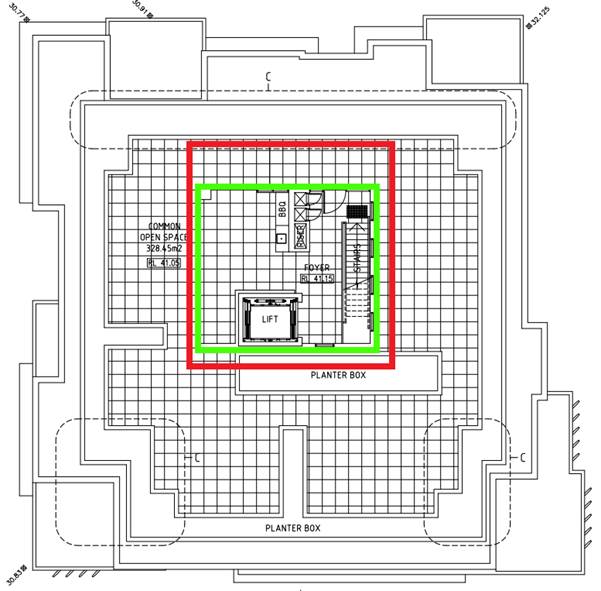
Figure 8
– An extract of the rooftop plan showing the communal open space
area. The expanse of the roof on this level is indicated by the red
border, while the area of the semi-enclosed section described above is
indicated by the green border.
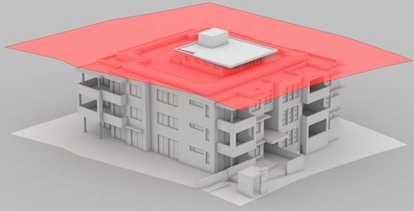
Figure 9
– An extract of the applicant’s 3D model of the proposed building
as viewed from the north east. The image shows the part of the building
affected by the variation to the 12m height standard, which is denoted in red.
52. The
maximum height of the building is associated with the lift overrun (RL
45.15). The remainder of the area affected by the height variation is
less significant, as the height of the roof (RL 43.65) would be 1.5m lower than
the overrun.
53. The
variation to the standard is created by the applicant’s decision to
situate the development’s communal open space on the roof, as opposed to
at ground level. The areas which breach the standard are therefore
required to both:
· Provide
access to the communal open space area; and
· Provide
shelter for certain areas and facilities within the communal open space area.
54. It
is noted that the applicant’s variation request indicates that the height
of the building would be 13.58m (ie a 1.58m or a 13.2% variation to the
standard), which is inconsistent with the 13.85m or 15.4% height identified by
the Assessment Officer’s assessment. It is considered likely that the
inconsistency has come about as a result of which ground levels have been used
to identify building height. Despite the inconsistency, the area affected
by the height non-compliance (as shown below) would remain unchanged, it is
considered unlikely that the extra 270mm identified in this assessment would
result in additional and discernible impacts. Further, the difference would not
change the level of determination (i.e. Council’s Local Planning Panel)
of the application. The submitted variation to the development standard
(assessed below) is therefore considered acceptable.
Applicant’s
Request for Variation under Clause 4.6
55. A
variation pursuant to clause 4.6 (Exceptions to development standards) has been
submitted by the applicant, and is assessed below.
56. A
variation to the standard (prepared by BMA Urban) was written with regard to
case law established by the NSW Land and Environment Court (LEC) (which
included Winten Property Group v North Sydney Council, Wehbe v
Pittwater Council and Four2Five Pty Ltd v Ashfield Council) and the
guidelines of the NSW Department of Planning and Environment. This statement
concluded that there are sufficient planning grounds to vary the building
height standard.
57. The
reasonableness of the proposed building height variation is considered with
regard to clause 4.6 of HLEP 2012 below.
Development
standard to be varied
58. The
applicant seeks to vary the 12m height limit imposed by clause 4.3(2) of HLEP
2012; as building height is identified by the Environmental Planning and
Assessment Act 1979 as a development standard, the provisions of clause 4.6
(Exceptions to Development Standards) are applicable.
59. The
majority of the proposed building will comply with the standard, with the
proposed breach to occur at the tallest points of the building, which includes
part of the semi-enclosed structure on the top floor, the roof above that
section and the lift overrun. As indicated above, the proposed development
would breach the 12m building height standard. The maximum height of the breach
(ie the lift overrun) would be 1.85m (ie a 15.4% variation to the standard),
with the remainder of area affected by the variation (ie the enclosed rooftop
section and associated roof breaching the standard by a maximum of 350mm).
60. Pursuant
to clause 4.6(2) of HLEP 2012, consent may be granted for development even
though the development would contravene a development standard prescribed by an
environmental planning instrument. However, pursuant to clause 4.6(4), consent
can only be granted if Council is satisfied that the applicant’s written
submission on the matter is well founded and if the proposal is in the
public’s interest by being consistent with the objectives of the specific
development standard and the relevant zoning. With regard to 4.6(4)(b) of
HLEP 2012, Planning Circular PS 18-003 (dated 21 February 2018), advises that
the concurrence of the Secretary may not be assumed for exceptions to
development standards under environmental planning instruments that adopt
Clause 4.6 of the Standard Instrument where the variation to a numerical
standard is greater than 10%.
61. Is
compliance unreasonable or unnecessary in the circumstances of the case?
Clause 4.6
– Exemptions to development standards
62. In
accordance with the NSWLEC decision in Wehbe v Pittwater Council, a way
that strict compliance can be seen to be unreasonable and unnecessary is if it
can be demonstrated that the objectives of the standard would be achieved,
despite the proposed height non-compliance. The objectives of the building
height development standard within clause 4.3(1) of HLEP 2012 are individually
considered in respect of the proposed development, as follows:
63. (a)
to ensure that buildings are compatible with the height, bulk and scale of the existing
and desired future character of the locality
64. Comment:
As indicated above, the subject site and surrounding area are located within an
R3 Medium Density Residential zone; previously, this area was within a
lower-density residential zone. While the earlier zoning only permitted
lower-density residential development (ie dwelling houses dual occupancies,
etc.), the current R3 zoning permits higher-density residential development (ie
multi-dwelling housing, residential flat buildings (RFBs), etc.) and is
reflected by a number of RFBs that have been recently constructed within the
area; examples of such development include the following:
· 3-7
Gover Street, Peakhurst
· 23-25
Gover Street, Peakhurst
· 61
Trafalgar Street, Peakhurst
· 67
Trafalgar Street, Peakhurst
· 75
Trafalgar Street, Peakhurst
· 25-27
Lawrence Street, Peakhurst
· 47
Lawrence Street, Peakhurst
· 53
Lawrence Street, Peakhurst
65. The
examples provided above are all three plus storey developments, a number of
which contain rooftop communal open space areas. The height, bulk and scale of
these developments is similar to that proposed by the subject application. With
regard to the above and the planning principles regarding character within Project
Venture Developments Pty Ltd v Pittwater Council, the height and scale of
the development is considered to be consistent with the desired future
character of the area.
66. (b)
to minimise visual impact, disruption of views, loss of privacy and loss of
solar access to existing development and to public areas and public domain,
including parks, streets and lanes,
67. Comment:
The area that is the subject of the height variation is a relatively small area
on the top level; aside from being setback considerably (ie 4.75m) from the
front building line, this section of the building would also be obscured by
planters and associated vegetation that are to surround the rooftop communal
area (unlike other similar and contemporary developments within the surrounding
area, such as the RFB at 75 Trafalgar Street). It is therefore considered
likely that the non-compliant section of the development would have a minimal
impact when viewed from the adjoining public domain (i.e. the Gover Street road
reserve). The development complies with the provisions relating to visual
privacy (noting that the variation would have no impact on privacy) and solar
access (both in terms of internal solar access and the overshadowing of
adjoining sites). There are no significant views obtainable from
surrounding sites and the public domain, therefore provisions relating to view
sharing are considered to be irrelevant in this instance.
68. (c)
to minimise the adverse impact of development on heritage items,
69. Comment: The objective is not applicable to the proposal, as there
are no heritage items on the subject site or within the surrounding area.
70. (d) to
nominate heights that will provide a transition in built form and land use
intensity,
71. Comment:
As indicated above, the height of the proposed development is consistent with,
but not significantly greater than, other higher-density development within the
surrounding area. The subject site is well within the R3 zone, and unlike
development on the periphery of that zone, would therefore not be required to
provide transition (in terms of height and density) to development in adjoining
lower-density zones.
72. (e)
to establish maximum building heights that achieve appropriate urban form
consistent with the major centre status of the Hurstville City Centre
73. Comment:
The objective is not applicable to the proposal, as the site is well outside of
the Hurstville City Centre.
74. (f)
to facilitate an appropriate transition between the existing character of areas
or localities that are not undergoing, and are not likely to undergo, a
substantial transformation,
75. Comment:
The subject site and surrounding area were zoned R3 under HLEP 2012 when it was
gazetted. It is therefore envisioned that development within this area
would progressively transition from lower density to higher-density residential
development, and current development within the area (examples of which are
provided above) are reflective of this progressive change in character. The
proposed development is considered to be in line with this transition.
76. With regard to
this objective, it is agreed with the applicant’s variation request that
development on adjoining sites to the northwest (ie 13A and 13B Gover Street
and 73 and 73A Trafalgar Street), while capable of potentially accommodating
RFBs, would be of a scale smaller to that of the subject development.
77. As such, an
acceptable level of transition between pubic areas to the north and the
proposed development on the subject site would be achieved.
78. (g)
to minimise adverse environmental effects on the use or enjoyment of adjoining
properties and the public domain.
79. Comment:
The height of the proposed development is unlikely to adversely affect the
amenity of adjoining sites. While overshadowing associated with the proposed
development is notable in mid-winter, it would quickly move across a number of
adjoining sites and would fully comply with relevant requirements. The
height variation would also not affect the visual privacy and amenity of
surrounding sites.
80. As it is located
on the south western side of Gover Street and nearby public parks, the proposed
development would not have any foreseeable impacts on the amenity and use of
the surrounding public domain by way of overshadowing.
81. With regard to
the above, the proposed development is considered to be consistent with the
objectives of the standard.
82. Are there
sufficient environmental planning grounds to justify the proposed contravention
of the development standard?
83. The objectives of
clause 4.6 of HLEP 2012 are to provide an appropriate degree of flexibility in
applying certain development standards to particular development, and to
achieve better outcomes for and from development. It is agreed with the
applicant’s variation request that the non-compliance would affect a
relatively small area of the development and would not result in adverse environmental
impacts on the surrounding area. It is also agreed with the applicant
that there is unlikely to be any significant public benefit in restricting the
height of the building to the 12m standard. Further, enforcement of the
height standard would likely require a relocation of the communal open space to
ground level. However, given the orientation and dimensions of the subject
site, it is unlikely that a communal open space area at ground level would
receive sufficient solar access and would subsequently be subject to poor
amenity.
84. Is the
proposal in the public interest?
85. A development is
seen to be in the public’s interest if it is consistent with the
objectives of the development standard and the zone in which the particular
development is carried out. The proposed development is seen to be consistent
with the objectives of the building height development standard. The proposed
development is also considered to be consistent with the objectives of the R3
Medium Density Residential zone for the reasons covered earlier in this report.
86. Initial
Action Pty Ltd vs Woollahra Council (2018) NSWLEC 118
87. Written
applications to vary development standards will not only address the above
matters but may also address matters set out in the ‘five part
test’ established by the NSW Land and Environment Court in its
consideration of a recent Land and Environment Court case – Initial
Action Pty Ltd vs Woollahra Council [2018] NSWLEC 118 (“the five part
test”). Councils may choose to not only use the principles of Clause 4.6
and SEPP1 but also this five part test.
88. Court cases
dealing with applications to vary development standards resulted in the Land
and Environment Court setting out a five part test for consent authorities to
consider when assessing an application to vary a standard to determine whether
the objection to the development standards is well founded. Consideration of
these principles and extent of variation have been considered below.
|
1. the objectives of the standard
are achieved notwithstanding non-compliance with the standard;
|
Assessment Officer’s
comment: The preceding assessment has undertaken a full assessment in
terms of the objectives of the height control standard under HLEP 2012. It is
concluded that the proposal is consistent with the objectives of the height
control under HLEP 2012 notwithstanding numerical non-compliance.
|
|
2. the underlying objective or
purpose of the standard is not relevant to the development and therefore
compliance is unnecessary;
|
Assessment
Officer’s comment: The underlying objective / purpose of the
Standard is relevant to the development proposal. However, the nature and
extent of the variation is considered to be acceptable in the circumstances.
In particular, the variation is confined to a small portion at the centre of
the building, which would have additional minimal impact upon neighbouring
properties or when viewed from the public domain.
|
|
3. the underlying object of purpose
would be defeated or thwarted if compliance was required and therefore compliance
is unreasonable;
|
Assessment Officer’s
Comment: It is considered that the purpose of Clause 4.6 of HLEP 2012,
which is to allow variations such as to the height control standard in this
instance, would be thwarted if strict compliance was required.
As mentioned, the development
proposes a relatively minor variation to the height control only for the lift
overrun and rooftop communal open space, with the habitable floor levels
being fully compliant with the height controls.
|
|
4. the development standard has
been virtually abandoned or destroyed by the council’s own actions in
granting
consents departing from the
standard and hence compliance with the standard is unnecessary and
unreasonable;
|
Assessing Officer’s
comments: Although the development standard has not been “abandoned
or destroyed” in granting (previous) consents departing from the
standard, Council (and the Land and Environment Court on appeal) has
generally been consistent in only allowing variations to the height control
for lift overruns and non-habitable space at the upper level, such as rooftop
common open space, with the remainder of the building (ie habitable floor
space) being required to comply with the height control.
Generally, the height control standard
has been strictly applied, with variations only being permitted to minor
components such as lift overruns and rooftop common open space.
The variations to the height
control in this development only relate to the lift overrun and rooftop
communal open space, so therefore the variation to the height control would
be similar to recent approvals, both within the immediate vicinity of this R3
zone in Peakhurst, as well as the City generally.
|
|
5. the compliance with development
standard is unreasonable or inappropriate due to existing use of land and
current environmental character of the particular parcel of land. That is,
the particular parcel of land should not have been included in the zone.
|
Assessment Officer’s
comment: The subject site is within an area of Peakhurst that has
recently been re-zoned to allow a higher density of residential development,
including residential flats, under the new R3 zoning under HLEP 2012. The
subject site is a mid-block property, surrounded on all sides by land also zoned
R3 under HLEP 2012, and so the zoning of the subject site is considered to be
appropriate.
The variations to the height
control are generally consistent with those approved for other residential
flat developments in this locality. As mentioned above, these are generally
only for lift overruns and rooftop communal open space.
The proposed development is
considered to be consistent with the desired future character of the
immediate area of Peakhurst that has recently been re-zoned to R3 under HLEP
2012.
|
89. In
addition to the above, the Court decision in Initial Action Pty Ltd v Woollahra
Municipal Council [2018] NSWLEC 118 has further clarified the correct approach
in the consideration of Clause 4.6 requests. This advice further confirms that
clause 4.6 does not require that a development that
contravenes a development standard must have a neutral or better environmental planning outcome than one that does not. This is considered to be
the case in this instance given the additional height sought and minimal impact
generated.
Conclusion
90. Strict compliance
with the 12m building height limit is seen to be both unreasonable and
unnecessary in the circumstances of the subject application, and there are
sufficient environmental planning grounds to justify contravention of the
development standard.
91. The proposed
development is seen to meet the objectives of the building height development
standard, the R3 Medium Density Residential zone and both the existing and
desired future character of the local area.
92. The
applicant’s submission pursuant to Clause 4.6 of HLEP 2012 is considered
to be well-founded, and it is recommended that the proposed variation to the
12m height limit be supported in this particular instance.
Development
Control Plans
Hurstville Development Control Plan
93. A
detailed assessment of the development against the relevant sections of HDCP is
contained in the DCP compliance table below. This assessment identifies a
number of areas of non-compliance which are discussed below the table.
Compliance
Table – Hurstville Development Control Plan No. 1
|
Performance Criteria
|
Design Solution
|
Proposal
|
Complies
|
|
|
3.1 Vehicle Access, Parking
& Manoeuvring
|
|
|
Car parking and service vehicle
areas are:
a. sufficient,
safe and convenient and meets user requirements including pedestrians, cyclists
and vehicles
b. safe,
easily accessible, does not obstruct the passage of vehicles or create
traffic conflicts, impact pedestrians or cyclists and does not result in
detrimental effects to adjoining or nearby properties
c. provided
according to projected needs and provide pleasant areas in which to park
|
DS1.1
In determining the prescriptive
parking requirements for each type of land use, Council has been informed by
a range of technical studies and documents
|
Noted
|
-
|
|
a.
DA1.2 |
In calculating the number of car
spaces required, Council takes into consideration:
a. the
type of development (or land use) proposed
b. the
size and scale of the development
c. the
intensity of the development
d. street
hierarchy and existing traffic situation
Noted
|
-
|
|
a.
DS1.3 |
Required:
1-2 bedrooms: 1 space per dwelling
3 bedrooms and over: 2 spaces per
dwelling
Visitor spaces:” 1 space per
4 dwellings
Minimum required number of
residential spaces: 19
Proposed number of residential
spaces: 19
Minimum required number of visitor
spaces: 4 (rounded up from 3.75)
Proposed number of visitor spaces:
4
|
Yes
|
|
|
DS1.5
Refer to AS 2890 for the design and
layout of parking facilities.
|
Compliance with the standard
subject to conditions.
|
Yes
|
|
|
DS1.6
Stacked parking not encouraged; permitted
where:
a. No
more than 2 cars in stacked arrangement
b. Likely
to maintain a low turnover
c. Able
to function easily in management of future operations
|
Not proposed.
|
N/A
|
|
|
DS1.7
All driveways to be finished in
plain concrete
|
Compliance subject to conditions.
|
Yes
|
|
|
DS1.8
In streets which have brick paved
surfaces, driveways are constructed to Council’s Engineering
Specification including a concrete base with matching brick paving surface.
|
|
N/A
|
|
|
DS1.9
Alignment levels for all points of
vehicular access must be obtained prior to submission of a development
application. These levels will be made available by Council’s
Engineering Department following the payment of the appropriate fee.
|
Conditions are recommended that
would require Council’s engineers to review driveway construction plans
prior to the issue of the Construction Certificate.
|
Yes
|
|
|
DS10.10
The AS/NZS 2890.1 2004 Ground
Clearance Template is to be used as follows:
a. prepare
a longitudinal section of the grade change or irregularity to natural scale,
and to the same scale as the template – scale to be 1:20
|
Noted.
|
-
|
|
|
DS1.11
Basement car parks to be
concentrated under building footprints to maximise deep soil landscaping.
|
Complies.
|
Yes
|
|
|
DS1.12
Design of basement car parks to
minimise visual impact and maximise pedestrian safety.
|
The car park entrance is at the
lowest point of the site; the entirety of the car park is defined as a
basement, thereby minimising visual impact. Separate internal and
external pedestrian access to the car park is proposed.
|
Yes
|
|
|
DS1.13
Access to basement car parks to be
located away from doors and windows of habitable rooms.
|
The bedroom windows of Unit G.01
(ie the dwelling closest to the car park entrance) will overlook the adjacent
driveway entrance. A condition is recommended requiring the side facing
windows to be sealed to prevent acoustic disturbance. Mechanical ventilation
is required.
|
Yes
|
|
|
DS1.14
Basement car parks preferred for
commercial and residential flat buildings.
|
A basement carpark is proposed.
|
Yes
|
|
|
DS1.15
All basement car parking to have
security doors. Where mechanical ventilation proposed, details are to
be shown.
|
A security door is proposed at the
bottom of the car park ramp. The applicant has indicated that ventilation
would occur via a riser space adjacent to the meter room; the void would exit
via the roof adjacent to the lift, and would not be visible from surrounding
public spaces.
|
Yes
|
|
|
DS1.16
Parking complies with AS 1428 &
AS 2890
|
No objection raised by the
engineer; compliance with the standard is subject to conditions.
|
Yes
|
|
|
DS1.17
Parking for people with
disabilities beyond minimum standards encouraged.
|
Minimum requirements satisfied.
|
Yes
|
|
|
DS1.19
A designated car washing area
(which may also be a designated visitor car space) is required for
residential developments of four or more dwellings.
|
A designated wash bay is proposed
within the basement; within a designated visitor space.
|
Yes
|
|
|
DS1.20
Car wash bays which collect waste
water must be covered and discharge the water to the sewer in accordance with
the requirements of Sydney Water
|
A connection to the sewer has been
conditioned.
|
Yes
|
|
|
Parking areas:
a. promote
pleasant, safe car parking areas and protect the natural environment
b. are
designed to reflect the environmental conditions of the land
c. incorporate
measures to protect the natural environment
|
DS2.1
Proposals for parking areas are to
be accompanied by a landscape plan, prepared by a qualified landscape
architect or designer, illustrating means to soften the visual impact of
parked cars and any associated structures, as per these landscaping controls.
|
A suitable landscape plan has been
prepared screening the basement entry.
|
Yes
|
|
|
DS2.2
Significant environmental features
within the land such as rock outcrops, benches and trees are to be retained
as a landscaped feature of the parking area.
|
Given that significant existing
trees on site are in decline, they are proposed to be removed, and this
removal is supported.
|
N/A
|
|
|
DS2.4
Parking areas are to incorporate a
150mm concrete
kerb or edge treatment to reduce
the likelihood of vehicles damaging adjoining landscaped areas. The use of
bollards should also be considered.
|
At grade parking not proposed;
kerbing and bollards are not required, as the driveway is in a straight line
and is ramped to separate it from adjacent landscaped areas.
|
N/A
|
|
|
DS2.5
All parking areas are to have
adequate drainage for runoff and seepage. Council requires that minimum
gradients be provided in car parks.
|
Appropriate conditions recommended.
|
N/A
|
|
|
DS2.6
Car parks may provide for temporary
detention of water to a max. depth of 150mm, though pollutant traps are to be
provided.
|
No part of the car park is acting
as an open OSD.
|
Yes
|
|
|
Car parking areas are designed to:
a. prevent
crime through environmental design
b. reduce
conflict between vehicles and pedestrians
c. include
features which suggest to both residents and potential offenders that car
parking areas are owned, cared for and not amenable to crime
d. include
features that minimise vehicular and pedestrian conflict
e. be
illuminated and provide users with a feeling of security and safety
f. allow
for drive by surveillance
|
DS3.1
Onsite parking to be in areas
clearly visible from habitable and public spaces
|
While secured, the carpark entrance
is in a location that is visible from units addressing the street.
|
Yes
|
|
|
DS3.2
Onsite driveways to provide an
unobstructed view of passing vehicles and pedestrians.
|
Achieved.
|
Yes
|
|
|
DS3.3
Sloping ramps from car parks,
garages and other communal areas are to have at least one full car length of
level driveway before they intersect pavements and carriageways.
|
A non-compliance is proposed, in
that a 1:20 ramp is proposed within the first 6m to the site (i.e. the first
car length would not be level). The gradient is not considered to be so steep
as to inhibit view lines of the pathway or affect movement of vehicles from
the basement carpark. The variation is considered to be acceptable on merit.
|
No – acceptable on merit.
|
|
|
DS3.4
Entry to basement car parks,
including pedestrian routes, are to be available only to residents through
security access/egress routes via main buildings.
|
Secure gated access is proposed.
|
Yes
|
|
|
D3.5
Visitor parking shall be provided
in open unrestricted areas. If visitor parking is provided within a secure
parking area (basement or otherwise) suitable access provisions shall be made
such as a security intercom
|
All onsite visitor car parking is
situated within the basement. Compliance with access provisions can
however be attained through a condition of consent.
|
Yes
|
|
|
DS3.7
The intensity of lighting in the
entranceway to covered or underground car parks is to be graded from the most
bright (at the entrance proper), to minimum levels of accepted illumination
(away from entrances), to allow for the gradual adjustment of
driver/pedestrian “light” vision.
|
Compliance can be attained through
a condition of consent.
|
Yes
|
|
|
DS3.8
To minimise pedestrian and
vehicular conflict:
a. parking
design to prevent or manage through traffic.
b. Pedestrian
exits are to be separated.
c. Where
large volumes of pedestrian movements are proposed, clear and convenient
pathways are to be provided.
|
Two separate and secure pedestrian
entrance/exit points, both from the public domain and through the building.
|
Yes
|
|
|
3.2 Subdivision
Section is not applicable;
subdivision of the site/development is not proposed.
|
|
|
3.3 Access & Mobility
|
|
|
PC1. Development is designed for
access and mobility
and to:
a. provide
information, awareness and understanding of access and mobility issues
b. create
appropriate levels of access and mobility for new developments, alterations
and additions to existing buildings, public buildings and open space
c. assist
in providing a continuous path of travel throughout the City of Hurstville
d. ensure
compliance with the Disability Discrimination Act, 1992 (Commonwealth), as
well as the relevant Australian Standards
e. provide
controls for adaptable housing which recognise the diverse accommodation
needs of the community, particularly older persons and people with a
disability
|
DS1.1
Development is to comply with Table
1 – Assessment Criteria; relevant criteria is outlined as follows:
Adaptable housing
In developments containing five or
more dwellings, a minimum of one adaptable dwelling, designed in accordance
with relevant Australian Standards must be provided for every ten dwellings
or part thereof.
General access requirements
Access for all persons through the
principal entrance and access to any common laundry, kitchen, sanitary or
other common facilities in accordance with relevant Australian Standards.
Parking
One accessible parking space for
every adaptable dwelling designed in accordance with Australian Standards.
|
Required adaptable housing:
Two adaptable dwellings (Units 1.05
and 2.05) are proposed.
Access for all is available through
the principal entrance of the building. The nominated rooms will be in
accordance with the relevant standards.
Allocated accessible parking is
proposed for each of the adaptable dwellings.
|
Yes
|
|
|
3.4 Crime Prevention Through
Environmental Design
Note – this section of the
DCP states that it applies to residential flat buildings and therefore an
assessment has been undertaken in relation to the proposed development as
follows:
|
|
|
Site and building layout:
a. ensures
that the way in which the site, and the buildings within the site, are laid
out enhance security and feelings of safety.
b. ensures
that private and public spaces are clearly delineated
c. ensures
that the design of the development allows for natural surveillance to and
from the street and between individual dwellings or commercial units within
the site
d. provides
entries that are clearly visible and avoid confusion
e. avoids
blind corners in pathways, stairwells, hallways and car parks
f. provides
natural surveillance for communal and public areas
g. ensures
that design for natural surveillance also provides for a suitable streetscape
appearance
h. where
permitted, provides appropriate mixed uses within buildings to increase
opportunities for natural surveillance, while protecting amenity
i. locates
public services (ATMs, telephones, help points, bicycle storage etc) in areas
of high activity
j. designs
car parks to allow for natural surveillance and ensure clear sight lines,
ease of access and safety
|
DS1.1
Avoid blank walls fronting the
street.
|
No blank walls are proposed which
address the public domain.
|
Yes
|
|
|
DS1.2
Offset windows, doors and balconies
to allow for observation while protecting privacy.
|
Internal offsetting is not
proposed. Appropriate visual privacy measures are proposed.
|
Yes
|
|
|
DS1.4
Entrances to be located in
prominent positions and be easily recognisable.
|
The main building entrance and
associated entry features are clearly identifiable.
|
Yes
|
|
|
DS1.5
Pathways within and to the
development should be direct and all barriers along the pathways should be
permeable including landscaping and fencing.
|
Direct pathways are proposed;
permeable landscaped barriers are proposed.
|
Yes
|
|
|
DS1.7
Locate active uses and habitable
rooms adjacent to communal or public areas.
|
A technical variation is proposed,
in that that the communal open space area would be located on the roof, and
as such habitable areas would not be located next to such a space. The
performance criteria would be met in that the communal open space area would
be secured and there would be suitable separation of private and communal
areas. As such, the variation is considered to be supportable.
|
Yes
|
|
|
DS1.8
Communal areas and utilities to be
seen and well lit.
|
Communal areas would be well let,
and access to such areas would be via highly visible areas.
|
Yes
|
|
|
DS1.10
Waiting areas should be visible
from the building entry.
|
Waiting areas would be located
within or adjacent to building circulation and access areas; such areas would
be visible from the building entry on the ground floor.
|
Yes
|
|
|
DS1.11
Seating to be located in active use
areas.
|
Outdoor seating is located adjacent
to the main entrance.
|
Yes
|
|
|
Multi-dwelling houses and
Residential Flat Buildings.
|
|
|
DS1.12
Building is to address the street.
|
The main entrance and living areas
within units will address the public domain.
|
Yes
|
|
|
DS1.13
Habitable rooms to be located at
the front of the dwelling.
|
Habitable rooms will be located
around the periphery of the building.
|
Yes
|
|
|
DS1.14
Parking structures should not
dominate the streetscape.
|
Basement parking is proposed, with
the entrance to be at the lowest point of the road frontage.
|
Yes
|
|
|
DS1.27
Minimise the number of entry and
exit points to car parks
|
One vehicular entry/exit point and
two pedestrian entrance/exit points confirmed.
|
Yes
|
|
|
DS1.28
Access to lifts, stairwells and
pedestrian pathways should be clearly visible within the car parks.
|
Satisfied
|
Yes
|
|
|
DS1.29
Car park design should avoid hidden
recesses.
|
Satisfied
|
Yes
|
|
|
DS1.32
Locate disabled parking spaces in
highly visible and convenient areas.
|
Satisfied
|
Yes
|
|
|
Site and building layout:
k. ensures
that the way in which the site, and the buildings within the site, are laid
out enhance security and feelings of safety.
l. ensures
that private and public spaces are clearly delineated
m. ensures
that the design of the development allows for natural surveillance to and
from the street and between individual dwellings or commercial units within
the site
n. provides
entries that are clearly visible and avoid confusion
o. avoids
blind corners in pathways, stairwells, hallways and car parks
p. provides
natural surveillance for communal and public areas
q. ensures
that design for natural surveillance also provides for a suitable streetscape
appearance
r. where
permitted, provides appropriate mixed uses within buildings to increase
opportunities for natural surveillance, while protecting amenity
s. locates
public services (ATMs, telephones, help points, bicycle storage etc) in areas
of high activity
t. designs
car parks to allow for natural surveillance and ensure clear sight lines,
ease of access and safety
|
Open Space
|
|
|
DS1.34
Open spaces should be clearly
designated and situated at locations easily observed by people. Parks and
playgrounds should be located in front of buildings; shopping centres etc and
should face the street rather than back lanes.
|
A technical variation is proposed,
in that that the communal open area would be located on the roof, and as such
would not be observed from units within the development. The design and
layout of the space would however permit observation by persons within the
communal open space area.
|
Yes
|
|
|
DS1.35
Seating, play equipment, BBQ areas
etc should be provided to encourage the use of open spaces
|
Seating, BBQ and gathering
facilities provided in the communal open space area.
|
Yes
|
|
|
DS1.36
Seating should be conveniently
located and easily seen.
|
The main building entrance and
associated entry features are clearly identifiable.
|
Yes
|
|
|
D1.38
Pathways should be direct, follow
pedestrian desire lines and avoid blind corners.
|
The design of the communal open
space areas will provide adequate sight lines.
|
Yes
|
|
|
Lighting
|
|
|
DS1.8
Communal areas and utilities to be seen
and well lit.
|
Communal areas will be well let,
and access to such areas will be via highly visible areas.
|
Yes
|
|
|
DS1.10
Waiting areas should be visible
from the building entry.
|
Waiting areas would be located
within or adjacent to building circulation and access areas; such areas would
be visible from the building entry on the ground floor.
|
Yes
|
|
|
DS1.11
Seating to be located in active use
areas.
|
Outdoor seating would be located
adjacent to the main building entrance.
|
Yes
|
|
|
Car Parks
|
|
|
D1.25
Avoid large expanses of car parks.
Where large expanses of car parks are proposed, surveillance such as security
cameras should be provided.
|
|
N/A
|
|
|
DS1.26
Where possible, locate entry/exit
points in close proximity and close to the car park operator or shops, cafes etc.
|
|
N/A
|
|
|
DS1.27
Minimise the number of entry and
exit points to car parks
|
One vehicular entry/exit point and
two pedestrian entrance/exit points confirmed.
|
Yes
|
|
|
DS1.28
Access to lifts, stairwells and
pedestrian pathways should be clearly visible within the car parks.
|
|
Yes
|
|
|
DS1.29
Car park design should avoid hidden
recesses.
|
|
Yes
|
|
|
DS1.32
Locate disabled parking spaces in
highly visible and convenient areas.
|
|
Yes
|
|
|
DS1.33
Where staff car parking is provided
it should be separate and secured from the public car park.
|
|
N/A
|
|
|
Lighting
|
|
|
a. enhances
the amenity and safety of a site after dark by increasing opportunities for
casual surveillance, deterring unauthorised access and reducing feelings of
fear and vulnerability of legitimate site user
b. enhances the
amenity and safety of a site after dark by increasing opportunities for
casual surveillance, deterring unauthorised access and reducing feelings of
fear and vulnerability of legitimate site users
c. is
provided to enable natural surveillance, particularly in entrances/exits,
service areas, pathways and car parks
d. be clearly
identifies all exist and entries after dark
e. ensures
service areas such as garbage areas and loading bays are well lit
is designed so it doesn’t
produce areas of glare and shadow
|
DS1.2
Dwelling and commercial unit main
entries should be well lit at night.
|
The main entry should be capable of
being well illuminated by internal and external lighting.
|
Yes
|
|
|
DS2.2
Use diffused lights and/or movement
sensitive lights
|
Types of lighting would be subject
to BASIX Commitments.
|
Yes
|
|
|
DS2.3
All lighting must be vandal
resistant and easy to maintain.
|
The design of the lights would be
in accordance with relevant standards.
|
Yes
|
|
|
DS2.4
Direct lights towards access/egress
routes and possible hiding places to illuminate potential offenders, rather
than towards buildings or resident observation points.
|
There is no information to indicate
that lighting would be directed towards the building.
|
Yes
|
|
|
DS2.5
Illuminate possible places for
intruders to hide
|
|
Yes
|
|
|
DS2.6
Lighting should have a wide beam of
illumination, which reaches to the beam of the next light, or the perimeter
of the site or area being traversed, thereby avoiding dark shadows
|
Noted.
|
-
|
|
|
DS2.7
Generally areas should be lit to
enable users to identify a face 15 metres away.
|
Noted
|
-
|
|
|
DS2.8
Avoid light spillage onto
neighbouring properties as this can cause nuisance and reduce opportunities
for natural surveillance
|
Compliance subject to conditions.
|
Yes
|
|
|
DS2.9
Use energy efficient lamps/fittings/switches
to save Energy.
|
Lighting efficiency would be
subject to BASIX commitments.
|
Yes
|
|
|
Landscaping
|
|
|
Lighting and fencing:
a. does
not reduce the security of a site
b. where
used to delineate private space, is used in a way which enhances safety
c. does
not obstruct casual surveillance and allows intruders to hide
d. uses
vegetation as barriers to deter unauthorised access avoids large trees/shrubs
and buildings
works that could enable an intruder
to gain access
|
DS2.19
Avoid medium height vegetation with
concentrated top to bottom foliage. Plants such as low hedges and shrubs,
creepers, ground covers and high canopied vegetation are good for natural
surveillance.
|
Proposed shrubs would grow to a
maximum height of approximately 1.2m, however the plant’s ability to
obscure view lines would be reduced by the sloped front setback.
|
Yes
|
|
|
DS2.20
Trees with dense low growth foliage
should be spaced or crown raised to avoid a continuous barrier.
|
|
Yes
|
|
|
DS2.21
Use low ground cover or high
canopied trees, clean trunks, to a height of 2m around children’s play
areas, car parks and along pedestrian pathways.
|
The proposal would comply with
regard to landscaping around the driveway.
|
Yes
|
|
|
DS2.22
Avoid vegetation, which conceals
the building entrance from the street.
|
|
Yes
|
|
|
DS2.23
Select planting species having
regard to their type and location to minimise possible places for intruders
to hide.
|
|
Yes
|
|
|
DS2.24
When planting is provided within 5m
of a pedestrian pathway, it should be lower than 1 metre or thin trunked
with high canopy.
|
|
N/A
|
|
|
DS2.25
Planting should not prevent
informal surveillance by adjacent residents.
|
|
Yes
|
|
|
DS2.26
Prickly plants can be used as
effective barriers. Species include bougainvilleas, roses, succulents, and
berberis species.
|
Noted but not proposed.
|
N/A
|
|
|
DS2.27
Avoid large trees, carports,
skillion extensions, fences,
and downpipes next to second storey
windows or balconies that could provide a means of illegal access to the
building.
|
|
Yes
|
|
|
DS2.28
Ensure vegetation is maintained
regularly.
|
|
|
|
|
Fencing
|
|
|
Fencing
a. does
not restrict casual surveillance between the site and the street due to its
height, location and design
b. where
on the front boundary, should be designed to maximise opportunities for
casual surveillance between the site and the street and minimise
opportunities for concealment
|
DS4.1
Front fences are to be
predominantly open in design to allow sight through the fences eg picket
fences, wrought iron.
|
Front fencing is not proposed.
|
N/A
|
|
|
DS4.2
If noise insulation is required,
install double-glazing at the front of the building rather than a high solid
fence (greater than 1 metre).
|
|
N/A
|
|
|
DS4.3
Fences are not to inhibit
surveillance of the communal areas, pathways, and footpath by occupants of
the building. Both the height of the fence in relation to the building as
well as the nature of the construction materials need to be considered.
|
|
Yes
|
|
|
Security and Operational Management
|
|
|
Security and Operational Management
a. ensures
an appropriate level of security is
achieved
b. provides
an appropriate level of security for individual buildings and communal areas
to reduce opportunity for unauthorised access
c. ensures
individual dwellings are equipped with appropriate security devices
d. ensures
an appropriate level of security is achieved in communal areas
c. provides
adequate security to commercial premises with extended hours of operation
|
DS5.1
Locks are to be fitted on all doors
and windows to the Australian Standard.
|
Front fencing is not proposed.
|
N/A
|
|
|
DS5.3
Install viewers on entry doors to
allow building occupants to see who is at the door before it is opened.
|
|
Yes
|
|
|
DS5.4
Install intercom, code or card
locks or similar for main entries to residential flat buildings and
commercial premises including car parks.
|
|
Yes
|
|
|
DS5.5
Entry doors are to be self-closing
and signs displayed requesting building occupants not to leave doors wedged
open.
|
Subject to conditions
|
Yes
|
|
|
DS5.6
Consider installing user/sensor
electronic security gates at car park entrances, garbage areas and laundry
areas etc., or provide alternative access controls.
|
Security gates proposed at the
carpark entrance.
|
Yes
|
|
|
DS5.7
Pedestrian entry to basement
parking must be through secured access via the main building.
|
Pedestrian entry to the basement
carpark is via secure entry points.
|
Yes
|
|
|
DS5.9
If security grilles are used on
windows they must be operable from inside in case of emergencies
|
Subject to conditions.
|
Yes
|
|
|
DS5.13
Use security devices, such as an
intercom or remote lock facility in multi-level car parks where appropriate
|
Subject to conditions.
|
Yes
|
|
|
Building Identification
|
|
|
|
DS6.3
Street numbers are to be at least
7cm high, and positioned between 1m and 1.5m above ground level on the street
frontage.
|
Subject to conditions
|
Yes
|
|
|
DS6.4
Street numbers should be made of
durable materials preferably reflective or luminous, and should be
unobstructed (e.g. by foliage).
|
Subject to conditions
|
Yes
|
|
|
DS6.6
Both directional and behavioural
signage should be provided at entrances to open space areas and parks.
|
Subject to conditions.
|
Yes
|
|
|
Building Ownership
|
|
|
Building Ownership:
Development is:
a. designed
to promote a sense of site ownership and to encourage responsibility in
making sure the site is well looked after and cared for
b. designed
to promotes pride and sense of place and ownership and reduce illegitimate
use/entry.
|
DS7.1
Use psychological barriers such as
fences, gardens, lawn strips, varied textured surfaces to define different
spaces within a development
|
Barriers like those suggested are
proposed on the primary frontage.
|
Yes
|
|
|
DS7.3
Ensure the speedy repair or
cleaning of damaged or vandalised property and the swift removal of graffiti.
|
Subject to conditions
|
Yes
|
|
|
Open Space
|
|
|
DS7.5
Provide features that reflect the
community’s needs and that will consequently be well utilised (e.g.
play equipment, seating areas etc).
|
BBQ, seating and planters are
provided within the open space areas.
|
Yes
|
|
|
Building Maintenance
|
|
|
Building Maintenance:
Development is:
a. creates
the impression that the site is well looked after and well cared for
b. uses
materials that reduce the opportunity for vandalism.
|
DS9.1
Ensure the speedy repair or
cleaning of damaged or vandalised property and the swift removal of graffiti.
|
Subject to conditions
|
Yes
|
|
|
DS9.3
Strong, wear resistant laminate,
impervious glazed ceramics, treated masonry products, stainless steel
materials, anti-graffiti paints and clear over sprays will reduce the
opportunity for vandalism. Flat or porous finishes should be avoided in areas
where graffiti is likely to be a problem.
|
Subject to conditions
|
Yes
|
|
|
|
DS9.5
External lighting should be vandal
resistant. High mounted and/or protected lights are less susceptible to
vandalism.
|
|
Yes
|
|
|
|
DS9.6
Communal/street furniture should be
made of hardwearing vandal resistant materials and secured by sturdy anchor
points or removed after hours.
|
|
Yes
|
|
|
3.5 Landscaping
|
|
|
Street and Neighbourhood Landscaped
Character
Development contributes to the
creation of a distinct, attractive landscape character for streets and
neighbourhoods
|
DS1.1
Where the surrounding area has an
existing desired landscape character, similar species are to be planted
except where undesirable under DCP Appendix 1.
|
Given the variety of development
within the local area, a demonstrated consistent and desired landscaped
character has not been identified within the immediate surroundings.
Regardless, the proposed landscape regime would utilise primarily native
species which is consistent with the future character of the area.
|
Yes
|
|
|
DS1.2
Where there is no existing desired
character, a range of species are to be proposed that are consistent with DCP
Appendix 1.
|
Proposed trees and large vegetation
selections are consistent with Appendix 1. No issue has been raised
with Council’s landscape officer.
|
Yes
|
|
|
Landscaping Area and Dimensions
The size and dimensions of
landscaping areas are adequate to minimise the visual impact of buildings and
structures and provides areas of a high level of utility and amenity
|
DS2.1
No design proposal is provided and
each proposal is assessed on its own merits.
|
The proposed size and dimensions of
landscaped areas meet minimum requirements. No issue has been raised by
Council’s Landscape Officer.
|
Yes
|
|
|
Significant Trees and Vegetation
Development protects existing
significant trees
and vegetation:
|
DS3.1
Site layout and design is to ensure
long term retention and health of existing trees and vegetation.
|
Existing trees are to be
removed. The design of landscaped areas would however provide
sufficient dimensions and space for the establishment of trees and
vegetation.
|
Yes
|
|
|
DS3.2
Where significant trees or
vegetation are removed to permit development, they are to be replaced with
species capable of attaining similar size, coverage and maturity.
|
The large trees proposed on the
landscape plans would consist of native species. No issue has been
raised by Council staff with regard to species selection.
|
Yes
|
|
|
Front, Side and Rear Boundaries
Landscaping in front setbacks:
a. integrates
the public and private domain
b. is
co-ordinated with the street planting pattern and species
c. reduces
the visual impact of buildings, structures and hardstand
|
DS4.1
Landscaping in front setbacks
consists of:
· Areas with
sufficient to accommodate planting.
· Shade trees that
grow to an equal or greater height than that of the building.
· Screening shrubs
where required to reduce impacts of blank walls.
· Low shrubs and
ground overs to complete coverage.
|
Sufficient unencumbered landscape
area is proposed for a Sydney Red gum, a Scribbly gum and a variety of
smaller landscaped areas; the former of these has a mature height of 10+m,
which would enable a height similar to that of the roofline on Level 2.
Low shrubs, ground covers and grass are proposed to complete coverage.
|
Yes
|
|
|
Landscaping alongside boundaries
reduces the visual impact of buildings on adjoining premises
|
DS5.1
Landscaping is provided along the
entire length of rear boundaries where buildings are located and consists of:
a. an
area of sufficient dimensions to accommodate planting Note: this area
must be a minimum of 2m
b. shade
trees that grow to a height consistent with or greater than that of the
building
c. screening
shrubs where required to mitigate the visual impact of blank walls d. low shrubs
and ground covers to ensure complete coverage of planting area.
|
Landscaping is proposed along the
rear boundary, with minimum dimensions in accordance with the ADG. Six
large trees are proposed along the rear boundary, in addition to shrubs and
plants with a mature height of 3+ metres.
|
Yes
|
|
|
Communal and private open space
areas
Landscaping
in communal open space and private open space contributes to the their
useability and amenity
|
DS6.1
A minimum of one shade tree is
planted in each area of private open space.
|
The dimensions of the ground-level
POS areas would not enable shade tree planting in the POS areas of Units
G.01, G.02 or G.05. Whilst a technical variation, the landscaping
treatments within these areas adjacent to the site boundary would satisfy
other DCP requirements; planting of shade trees within these areas would also
limit available solar access to the affected apartments. The variation
is therefore considered to be satisfactory and supportable on merit.
|
Yes
|
|
|
DS6.2
Trees in communal open areas are to
provide shade to 25% of that area at maturity.
|
The limitations associated with
soil depths of the roof top may limit the ability of the trees to cover 25%
of the communal open space areas. The combined shaded area of both the
trees and sheltered lobby would however likely provide sufficient shade for
this area.
|
Yes
|
|
|
DS6.3
Minimum of 50% of the communal open
area shall be covered in turf/planting area.
|
The
proportion of communal open space covered by planting: Approx. 115sqm,
or 31.6%.
Refer to the main body of the
report for an assessment of this variation.
|
No
|
|
|
DS6.4
Tree planting in communal and
private open space areas will:
· Enable
penetration of winter sun and mitigate penetration of afternoon summer sun.
· Enable
penetration of desirable cooling winds in summer and mitigate penetration of
undesirable cold winter winds.
|
The design of the communal open
space area would enable a range of climatic environments at varying times of
the year (i.e. enabling direct sunlight during winter and penetrating cooling
winds in summer).
|
Yes
|
|
|
Landscaping Plans
Development applications are
supported by sufficient detail to demonstrate achievement of the objectives
of this chapter
|
DS8.1
Required documentation:
· Survey plans
· Concept level
landscaped plan
· Detailed
landscape plan
|
Survey plans and landscaped plans
(supported by an Arboricultural Impact Assessment) submitted. No issue
has been raised by Council’s landscape officer.
|
Yes
|
|
|
Landscaping Near Areas of
Ecological Significance
Landscaping that is located
adjacent to areas of ecological significance protects and strengths the
ecological values of the area
|
DS9.1
Landscaping comprises species that
are consistent with the dominant species in the adjoining area of ecological
significance
|
Site is not adjacent to areas of
ecological significance.
|
N/A
|
|
|
Stormwater Management
Landscaping facilitates on site
stormwater infiltration and does not result in significant adverse water
quality impacts
|
DS11.1
Opportunities for onsite stormwater
infiltration are provided through
· Turf/raised
planting beds
· Minimising
impervious areas
|
Pervious areas outside of the
building/basement footprint would be maximised.
|
Yes
|
|
|
DS11.2
Landscaped areas are suitably
drained and ensure that soil/sediment does not leave the site.
|
The design the landscaped area
would not foreseeably result in loss of soil and sediment form the site.
|
Yes
|
|
|
Maintenance
Landscaped areas are able to be
easily maintained
|
DS12.1
Trees that have short lives, drop
branches or that can damage underground pipes are to be avoided.
|
The landscape plans do not indicate
that proposed trees and vegetation would have short life spans. No
issue is raised with selected vegetation, subject to submissions.
|
Yes
|
|
|
DS12.2
Turfed areas are readily accessible
for cutting devices.
|
Turfed areas would be capable of
access for maintenance.
|
Yes
|
|
|
DS12.3
Planting beds have a durable
irrigation system.
|
Irrigation plans would be subject
to conditions of consent.
|
Yes
|
|
|
DS12.4
One house cock is provided for each
communal or landscaped open area.
|
Subject to conditions.
|
Yes
|
|
|
Safety
Landscaping provides for personal
and property safety
|
DS13.1
Landscaping is in accordance with
CTPED principles.
|
Refer to assessment above.
|
Yes
|
|
|
DS13.2
Landscaping enables clear sight
lines along pathways and minimises concealment.
|
|
Yes
|
|
|
DS13.1
Front setbacks do not contain dense
screening vegetation.
|
|
Yes
|
|
|
Utilities
Landscaping does not interfere with
the effective functioning of utilities
|
DS14.1
Landscaping does not interfere with
the function of overhead or underground utilities.
|
There is no information to indicate
that the proposed landscaping would affect surrounding utilities.
|
Yes
|
|
|
3.6 Public Domain
|
|
|
General
Development contributes to the
creation of attractive, comfortable and safe streets that comprise consistent
and high quality paving, street furniture and street tree plantings
|
DS1.1
Works in the public contain to
obtain all necessary council and statutory approvals prior to commencement of
works.
|
Can be satisfied through imposition
of conditions.
|
Yes
|
|
|
DS1.3
Construction activity that damages
council assets in the public domain such as kerb and gutter is to replace the
damaged asset to the same or an equivalent standard.
|
Can be satisfied through conditions
of consent.
|
Yes
|
|
|
DS1.5
Footpath pavement width is to allow
for comfortable walking, unimpeded by obstacles.
|
Can be satisfied through imposition
of conditions.
|
Yes
|
|
|
|
|
DS1.8
Street trees are to be provided on
all streets to achieve the following outcomes:
a. coordinated
palette of climatically responsive species
b. reinforce
the street hierarchy and create distinct places
c. be
robust and low-maintenance
d. be
planted in a coordinated, regularly spaced and formalised manner
e. increase
the comfort of the public domain for pedestrians
f. enhance
the environmental performance of the precinct by increasing opportunities for
energy efficiency, reducing the heat island effect and proving habitat for
wildlife
|
Noted. Existing street trees
are not proposed to be removed.
|
Yes
|
|
|
3.7 Stormwater
|
|
|
Part A – Residential Flat
Buildings, Multi Dwelling Housing and Boarding Houses
|
|
|
General
Stormwater management is provided
on site:
a. to not
increase the existing level of hazard to persons or property
b. to ensure
rainwater run-off and overland flow is directed into an approved stormwater
drainage system
c. to
reduce and control rainwater run-off in order to minimise overland flows,
soil erosion and siltation in streams and water ways.
d. to
encourage an environmentally sustainable regime of stormwater management that
achieves a balance between collecting and re-using rainwater, maintaining
acceptable environmental flows in streams and allowing for on-site surface
infiltration
via landscaping
|
DS1.1
Stormwater flows are managed within
the drainage sub-catchment the site is located.
|
Flows are managed within the
subject site’s sub catchment.
|
Yes
|
|
|
DS1.2
Existing flow patterns are
formalised and not significantly altered.
|
|
Yes
|
|
|
DS1.3
Development does not concentrate,
divert or increase overland flows onto adjoining properties. Where
overland flows are an issue, post-development flood analysis is to be
provided.
|
|
Yes
|
|
|
DS1.4
Measures are implemented during
construction to reduce soil erosion from development sites.
|
Erosion and sediment control
measures are indicated on the engineering plans and are subject to
conditions.
|
Yes
|
|
|
DS1.5
A concept stormwater management
plan is to be provided showing how waters are to be discharged.
|
Plans submitted.
Council’s development engineer has reviewed the information and has
raised no submissions, subject to conditions.
|
Yes
|
|
|
DS1.6
Onsite retention and roof runoff
using detention tanks and storage/reuse must be provided.
|
Roof runoff and OSD are proposed.
|
Yes
|
|
|
DS1.7
Runoff is discharged to the road kerb,
easement or downstream, property.
|
The discharge site to the kerb is
located on the northwest side of the site.
|
Yes
|
|
|
DS1.8
Onsite infiltration is maximised.
|
Pervious surfaces are proposed
outside of the building/basement footprint, maximising onsite infiltration.
|
Yes
|
|
|
DS1.9
Overland flow paths are designed
for the 100-year ARI event.
|
Considered
|
Yes
|
|
|
DS1.10
Onsite stormwater and drainage is
to be designed for the 20-year ARI event.
|
Council’s development
engineers have recommended conditions that would require engineering plans
(which factor in rainfall and runoff) to be in accordance with Australian
Institute of Engineers Australian Rainfall and Runoff requirements and
Council’s DCP.
|
Yes
|
|
|
DS1.11
Where the property falls to the
street, the drainage system is to be gravity-fed.
|
The site slopes to the street.
|
Yes
|
|
|
DS1.12
Discharge point to the gutter must
not exceed 25L/sec.
|
Complies.
|
Yes
|
|
|
DS1.13
Development on sites more than 700m2
must discharge into Council’s drainage system. A gully pit with a
2400 lintel is to be constructed; a new pipe is required if no pipe exists.
|
Considered by the Development
Engineers.
|
Yes
|
|
|
DS1.14
All other impervious surface runoff
is to drain by gravity to Council’s drainage system.
|
Acknowledged in the design.
|
Yes
|
|
|
DS1.18
Water runoff from impervious
surfaces to be intercepted and gravity drained to Council’s drainage
system.
|
|
Yes
|
|
|
DS1.19
Rate of discharge of room and
pavement runoff to be controlled via an OSD system.
|
|
Yes
|
|
|
DS1.20
OSD facilities shall be designed in
accordance with Council’s Drainage and OSD Policy.
|
Subject to conditions.
|
Yes
|
|
|
DS1.21
Pump-out systems are only allowed
to drain basements and driveway ramps.
|
A basement pump-out is proposed.
|
Yes
|
|
|
DS1.22
For pump-out systems, discharge is
to be to a harvest/reuse system of Council’s drainage system.
|
Discharge to be sent to the
proposed OSD system and discharged to Gover Street.
|
Yes
|
|
|
4 Specific Controls for
Residential Development
|
|
|
4.1 Residential Flat Buildings
|
|
|
Neighbourhood Character
Development is sited and designed
to respect existing or desired future neighbourhood and streetscape
character, including:
a. the pattern
of development of the neighbourhood, including elements that shape the
streetscape such as the relationship and interface between the public and
private domain
b. the built
form, scale and character of surrounding development including height,
setbacks, front fencing, roofs and the location and proportions of private
open space
c. notable
natural features of the site, including topography and vegetation
|
DS1.1
The development application is
supported by a Statement of Environmental Effects (SEE) that:
a. includes
a satisfactory neighbourhood and site description, including identification
of key features of the site and neighbourhood.
b. shows
how the siting and design response derives from and responds to the key
features identified in the neighbourhood and site description.
c. demonstrates
that the residential development proposal respects the existing or desired
neighbourhood character and satisfies objectives of the zone in the LEP
|
An SEE (prepared by BMA Urban) has
been provided, and generally addresses relevant requirements of the DCP
within Sections 1 and 2 of that document.
|
Yes
|
|
|
Site Frontage
Site frontage enables:
a. siting
of a building and structures
b. provision
of adequate setbacks
c. provision
of adequate landscaped open space
d. efficient
vehicle access, parking and manoeuvring
e. creation
of high quality built form
|
DS1.2
The minimum street frontage is 24m
Note: minimum street
frontage may be reduced where development is proposed on an isolated site.
|
Proposed site frontage: 33.5m
|
Yes
|
|
|
Isolated Sites
Development:
a. enables
suitable development of existing isolated sites in a manner which responds to
the site context and constraints and maintains a high level of amenity for
future occupants and neighbours.
b. avoids the
creation of isolated sites as a result of the development of adjoining lots
|
DS3.1
Where a site is isolated, Council
will consider on merit an application for an RFB which does not meet minimum
frontage requirements.
|
Frontage complies (see DS1.2)
|
N/A
|
|
|
DS3.2
Where an application for a
Residential Flat Building will result in the creation of an isolated site,
the applicant must show that reasonable efforts have been made to amalgamate
the site. Where this has not been achieved, it must be shown that the
isolated site is capable of accommodating a suitable development in the
future. In order to satisfy this requirement the applicant must provide:
a. evidence
of offers made to acquire the site to be isolated (e.g. correspondence
including responses to offers) based on at least two independent valuations.
These valuations must be based on the site to be isolated forming part of the
development site.
b. a
schematic design which demonstrates how the isolated site may be developed
|
A review of surrounding sites
indicates that the proposal would not result in site isolation. Details
of surrounding sites are` as follows:
· The site adjoining the
southeast boundary (17-21 Gover Street) is a large seniors living development
that has a site area capable of accommodating future large-scale residential
development.
· Sites adjoining the
rear and northwest side boundaries contain individual dwellings that are
adjoined by common boundaries. Council’s website indicates that
there are no current proposals or consents on these sites for high-density
residential development. It is considered likely that these surrounding
sites could be amalgamated, and thus would contain areas capable of
accommodating appropriate future residential development if proposed.
|
Yes
|
|
|
Building
height:
a. is
compatible with the existing or desired future character of the area
b. creates
human scale streetscapes
c. creates
functional and high amenity internal spaces
d. enables
adequate solar access to the main living areas and principal private open
space
e. facilitates
penetration of desirable natural breezes
f. facilitates
view sharing
|
DS4.1
Maximum building height is in
accordance with Hurstville LEP 2012 and three storeys.
|
Refer to the assessment of Clauses
4.3 and 4.6 of HLEP 2012.
Refer to comments below regarding
building height.
|
No
|
|
|
Excavation
Excavation minimises disturbance of
the existing landform and facilitates engagement between the public and
private domains, including providing opportunities for direct overlooking of
the street from the main living areas
|
DS5.1
Natural ground level is not to be
excavated more than 500mm for the finished ground floor level.
|
Excluding cut required of the
basement, a maximum of 375mm cut proposed for the ground floor.
|
Yes
|
|
|
DS5.2
Maximum excavation for a finished
floor level facing a public street is 500mm below natural ground level.
|
Maximum 375mm cut proposed for
ground floor.
|
Yes
|
|
|
Setbacks:
a. are
compatible with predominant patterns of buildings and gardens that define the
existing and desired character of the neighbourhood
b. engage with
and activate the street
c. reduce
the appearance of building bulk
d. enable
adequate solar access to the main living areas and principal private open
space
e. facilitate
penetration of desirable natural breezes
f. facilitate
view sharing
g. minimise
noise transmission
|
DS6.1
The minimum setback to a primary or
secondary street is 6m.
Note: Setbacks to the side
and rear boundary and building separations are to be provided in accordance
with the design criteria in the Visual Privacy.
|
Minimum front setback - 6m
|
Yes
|
|
|
D6.2
An articulation zone allowing for lightweight
elements (eaves, sunhoods, blade walls, battens, etc.) may intrude up to 1m
within a road boundary setback for a maximum of 25% of the horizontal
distance of the total façade.
|
Minimum proposed setback of
articulation elements (balconies): 5.09mm
|
Yes
|
|
|
Vehicle access, parking and
manoeuvring is
provided on site and:
a. caters
for the needs of residents and visitors
b. minimises
visual impact on scenic quality or streetscapes
c. ensures
the safe movement of vehicles and pedestrians
|
DS7.1
Carparking is to be provided as
follows:
· 1 space per 1 or two
bedroom dwelling
· 2 spaces per 3 or more
bedroom dwelling
· For developments with
more than 4 dwellings, 1 visitor space per 4 dwellings or part thereof.
|
Required parking:
· 19 residential spaces
(11 spaces for 1 and 2 bedroom apartments, and 8 spaces for 3 bedroom
apartments)
· 3.75 visitor spaces
(rounded up to 4)
Proposed parking:
· 19 residential spaces
· 4 visitor spaces
|
Yes
|
|
|
DS7.2
Car parking is provided in basement
form or provided behind the main building face and is not visually prominent
from the street.
|
Basement parking proposed.
|
Yes
|
|
|
DS7.3
Vehicle access and manoeuvring
space must not occupy more than:
· 40% of the frontage
where street frontage is 20m or less
· 33% of the frontage
where street frontage is more than 20m
|
Front setback area: Approx. 188sqm
33% of front setback area: 62sqm
Area of car parking facilities:
Approx. 36.3sqm, or 19.3%
|
Yes
|
|
|
DS7.4
Maximum height of a basement above
natural ground level: 1m
|
Maximum height of basement above
ground level: Approx. 950mm
|
Yes
|
|
|
DS7.5
Large exposed foundations, voids
and walls facing street frontages are not created as part of basements.
|
|
Yes
|
|
|
DS7.6
Basement parking is adequately
ventilated.
|
Mechanical ventilation of the
carpark is proposed.
|
Yes
|
|
|
Landscaped Open Space
Landscaped open space is provided
on site and:
a. is
useable for a range of passive recreation purposes
b. is
consistent with and enhances the existing landscape character of the area
c. mitigates
the visual impact on buildings and infrastructure
d. achieves
appropriate levels of amenity and safety for new dwellings
e. facilitates
activation of the street
|
DS8.1
At least 20% of the site area is to
consist of landscaped open space.
|
Site area: 1313.1sqm
20% of site area: 267sqm
Proposed site area: Approx.
328sqm, or 25% (inclusive of minimum dimensions)
Note: ADG requirements for deep
soil space have also been met.
|
Yes
|
|
|
DS8.2
Minimum dimensions of landscaped
open space is 2m in any direction.
|
|
|
DS8.3
Landscaping between the street
boundary and the front of the building shall maintain a balance between
visual impact of the development and maintaining causal surveillance.
|
|
Yes
|
|
|
DS8.4
A landscape plan is to be provided
by a qualified person which addresses design solutions.
|
Refer to plans prepared by Zenith
Landscape Designs (as amended).
|
Yes
|
|
|
Solar Access
Development ensures an appropriate
amount of solar access to main living areas and areas of principal private
open space of adjoining sites
|
DS9.1
Development must permit at least 3
hours of sunlight to the windows of living areas and adjoining principal
private open space of adjacent dwellings between 9:00am and 3:00pm on June
21.
|
Minimum criterion achieved.
|
Yes
|
|
|
Noise
Development is sited, designed and constructed
to:
a. minimise
the intrusion of noise from external sources into habitable rooms, in
particular bedrooms
b. minimise
noise transmission between dwellings within the development and from the
development to adjoining dwelling houses
|
D10.1
Windows of adjacent dwellings are
separated by at least 3m
|
Control satisfied.
|
Yes
|
|
|
D10.2
Site layout separates active
recreation areas, parking areas, accessways and service equipment areas from
bedroom areas.
|
Units G.05, 1.05 and 2.05 all
feature bedrooms that directly adjoin the lift; these would be subject to a
condition to ensure that appropriate acoustic attenuation is provided.
|
Yes
|
|
|
D10.3
Dwellings are designed so that the
internal noise level from outside sources does not exceed the parameters established
by the NSW Environment Protection Authority (EPA).
|
Will be reviewed as part of the
Construction Certificate assessment.
|
Yes
|
|
|
Streetscape
Development
creates a high quality interface between the public and private domain that
contributes to the creation of
streetscapes that:
a. are
compatible with the existing or desired future scale and form of adjoining
and surrounding development
b. respond
to dominant architectural elements of existing housing that contributes to
neighbourhood character, including roofs, windows, colours, materials and
other details
c. are
compatible with the existing or desired future street rhythm established by
elements such as topography, building width and building separation
d. contribute
to the creation of a public domain that is attractive, comfortable, safe and
active
|
DS11.1
Development on corner sites
addresses both street frontages and provides opportunities for passive casual
surveillance of the public domain from main living areas and principal
private open space through the use of large transparent windows and other
openings.
Note: Large expanses of
blank, unarticulated walls on any street frontage is not supported.
|
Not a corner allotment.
|
N/A
|
|
|
DS11.2
In more urban streetscapes,
development emphasises corners by increased scale or massing treatments
compared to the remainder of the building.
Note: compliance with
maximum building height under the LEP must be achieved in these situations.
|
|
Yes
|
|
|
DS11.3
Roofs:
a. Have
a pitch of 35o r up to 45o where an attic is involved.
b. Provide
a varied shape with hips, gables or other forms
c. Mark
the entrance to a building by the use of a porch, portico or similar element
|
Refer to the main report for an
assessment regarding this non-compliance.
The main entrance to the building
is identified using a covered stairway and landing.
|
No
|
|
|
DS11.5
To reduce building bulk and
increase visual interest through articulation, maximum wall lengths on one
plane shall be 6m.
|
Refer to the main report for an
assessment regarding the non-compliance.
|
No
|
|
|
Stormwater
Stormwater management is provided
on site and:
a. provides
for the efficient and functional mitigation of stormwater impacts
b. does not
adversely affect other properties
c. promotes
on-site infiltration
d. causes
minimal change to existing ground levels
e. does not
detract from streetscape quality
|
DS12.1
Stormwater management is in
accordance with Section 3.7 of this DCP.
|
Refer to separate assessments
within this report.
|
Yes
|
|
|
Fencing
Front fencing:
a. provides
appropriate levels of privacy, security and noise attenuation
b. activates
the street and provides opportunities for passive casual surveillance of the
street
c. contributes
to a high level of visual streetscape quality
|
DS13.1
Fencing is in accordance with
Appendix 2.
|
No front fencing proposed.
|
N/A
|
|
|
Site Facilities
Building services are provided on
site that:
a. cater
for the needs of residents
b. are
integrated with the balance of the development
c. do
not detract from streetscape quality
|
DA14.1
Electricity and phone lines are
provided underground, unless there the connection of electricity and
telephone lines directly from the service pole to the fascia of the front
dwelling.
|
Underground services would be
required, and is subject to conditions of consent.
|
Yes
|
|
|
DS14.2
Mail and garbage collection areas
are integrated into the overall design of the development.
|
Garbage facilities are located
within the basement and considered acceptable by Council’s Waste
Officer.
|
Yes
|
|
|
DS14.3
Development provides space for the
storage of recyclable goods within each dwelling or in a central storage
area.
|
While not specified, there is
adequate space within each dwelling for the internal and temporary storage of
waste.
|
Yes
|
|
|
DS14.4
A master TV antenna is required for
development with more than two dwellings.
|
Can be achieved.
|
Yes
|
|
|
DS14.5
Storage is provided in accordance
with the ADG
|
Refer to ADG assessment.
|
Yes
|
|
|
DS14.6
Communal outdoor clothes dying
facilities must be screened from the street.
|
Facilities are to be located on the
roof adjacent to the entry foyer; these would be sufficiently screened from
the road reserve by planters and associated landscaping.
|
Yes
|
|
|
|
|
|
|
|
94. Control:
DS6.3 of Section 3 of the DCP - 50% of the communal open area is to consist of turf/planting
area
The
proposal’s communal open space area is to be located on the rooftop. As
such, it is not practicable to provide such extensive areas as turf/planting.
Nonetheless, the applicant’s plans propose approximately 115sqm (ie
31.6%) of the proposed communal open space to be covered by planting.
95. Despite
such a variation, all of the aforementioned planting would consist of planters
accommodating plants/shrubs and medium-height trees. Such landscaping
treatments would therefore contribute to amenity, privacy and shading.
96. With
regard to the above and considering that the Performance Criteria would be
satisfied, the variation is therefore considered to be supportable on merit.
97. Control:
DS4.1 of Section 4 of the DCP - Building height and number of storeys
Note: This
assessment relates to the number of storeys; refer to the assessment
of Clauses 4.3 and 4.6 of HLEP 2012 for an assessment of ‘building
height’.
98. Three
(3) residential levels are proposed in addition to a fourth level containing
the communal open space area. While inconsistent with the three-storey
control, the appearance of the top level would be filtered by virtue of its
small area (and subsequently increased setbacks) and rooftop planting around
the periphery of the top floor; as such, the fourth storey would be unlikely to
substantially change the form and scale of the development when viewed from the
streetscape. The rooftop location of the communal area would facilitate
better amenity and solar access than if it were located at ground level due to
the following considerations:
· The required
locations of the driveway and OSD in addition to side and rear building
setbacks would prevent a suitably sized and dimensioned communal open space
from being placed within the front setback. Overlooking of a communal open area
within the front setback would also likely reduce the privacy and amenity of
residents;
· Due to the
northeast-southwest orientation of the site, communal open space within the
side and/or rear setbacks would be less likely to obtain sufficient solar
access.
99. It
is also noted that another RFB development at 75 Trafalgar Street
(approximately 15m south west of the subject site) contains a similar site
layout (ie three (3) residential storeys with a communal area above) therefore
the current proposal – if approved – would not be inconsistent with
the local area.
100. For
the reasons outlined above, the non-compliance is considered to be acceptable
on merit.
101. Control:
DS11.3 of Section 4 of the DCP - Roof Pitch
The plans
propose a technical non-compliance, in that a pitched and/or varied roof is not
proposed. A pitched roof design would likely further increase the already
non-compliant height of the building and may adversely affect solar access to surrounding
sites. Further, it is noted that other contemporary RFBs (or similar such
structures) within the surrounding area generally do not employ pitched roofs;
therefore a flat roof deign would not be inconsistent with the surrounding
area. With regard to the above, the variation would not set a development
precedent within the area, and the variation to the control is considered to be
acceptable on merit.
102. Control:
DS11.5 of Section 4 of the DCP - Wall length
A technical
non-compliance is proposed, in that a number of walls would exceed the
nominated 6m horizontal plane. The longest wall would be 11.48m (on the rear
elevation).
103. Despite
the inconsistency, the relevant performance criteria of the DCP will be
satisfied. A high level of articulation is proposed on all elevations
(particularly those visible from the public domain); walls that are subject to
the non-compliance contain windows of varying shapes and sizes, therefore the
walls would not be blank. Further, proposed landscaping treatments would
further assist in reducing any visual impacts associated with the
non-compliance; six large trees are proposed adjacent to the rear boundary,
thereby filtering and minimising the impact of the variation.
104. With
regard to the above, the variation is considered to be acceptable on merit.
Section 7.11 Contributions
105. The
development requires payment of contributions under Section 7.11 of the
Environmental Planning & Assessment Act 1979. These have been calculated
and a condition of consent has been included in the recommendation.
IMPACTS
106. Natural
Environment
The
development is unlikely to have adverse impacts on the natural environment,
Basement excavation is proposed, however the extent of the excavation is
consistent with what would be expected for a residential flat development, and
the development is unlikely to adversely affect the existing drainage systems
and soil stability in the locality. The proposed tree removal has been assessed
as satisfactory by Council’s Landscape Officer subject to appropriate
conditions.
107. Built
Environment
The proposed
development is unlikely to have adverse impacts on the built environment. The
development achieves a bulk and scale suitable to the existing and desired
future character of the locality, and provides a form with visual interest that
responds to the slope of the land. Though the development varies from a number
of controls in Hurstville LEP 2012 and DCP No 1, the extent of the variations
are acceptable as discussed throughout this report.
108. Social
Impacts
The
development would contribute additional housing stock to the area and cater to
the needs of families by providing a range of dwelling sizes through a mix of
one bedroom, two bedroom and three bedroom units. There will be minimal adverse
social impacts associated with this development.
109. Economic
Impacts
The
development will have positive short term economic benefit associated with
construction employment and minimal adverse economic impacts over the longer
term.
110. Suitability
of the Site
Council’s
mapping system has been reviewed in terms of possible site constraints (such as
flooding, land subsidence etc), and there are no constraints that would render
the land as unsuitable for the proposed development.
SUBMISSIONS
111. The DA was advertised and notified to neighbours in accordance with
Hurstville DCP 2013, for a period from 13 June to 6 July 2018. No submissions
were received by Council as a result of this process. Note: Although
amended plans were received during processing of this DA, as mentioned
previously, these did not substantially alter the design of the building.
Accordingly, re-notification to neighbours of the amended plans was not
required.
REFERRALS
112. The
DA was referred to a number of officers within Council. The comments of these
officers are outlined as follows.
Council
Referrals
Council’s
Landscape Officer
113. Council’s
Landscape Officer has undertaken an assessment of the proposal and raised no
objections or concerns. Appropriate conditions have been issued and are
included in the recommendation below.
Building
Surveyor
114. Council’s
Building Surveyor has undertaken an assessment of the proposal. The proposal has been examined for general compliance with
the Fire Safety and construction provisions of Clause 98 of the EP&A
Regulation and with the Building Code of Australia. The proposal involves the
demolition of existing dwellings, associated outbuildings and the construction
a three storey residential flat building over basement car parking. The
building will contain a total of fifteen apartments while the basement parking
for twenty three vehicles, storage areas and lift access to the sole occupancy
units above.
115. Appropriate
conditions of consent have been provided which are included in the
recommendation below.
Engineering
(Stormwater)
116. Council’s
Stormwater Engineer has undertaken an assessment of the proposal in terms of
stormwater considerations, and raised no objections subject to appropriate
conditions, which are included in the recommendation below.
Waste Officer
117. Council’s
Waste Officer has undertaken an assessment of the proposal and advised that the
original proposal was not suitable for waste requirements – in particular
the waste bin storage area was not large enough for the proposed development.
118. The
amended plans have enlarged the bin storage area to ensure that it can
accommodate 14 x 240L bins as required.
Geographic
Information Systems (GIS) Officer
119. Council’s
GIS Officer has undertaken a review of the proposal in terms of street
numbering, and provided applicable conditions of consent for this development.
CONCLUSION
120. The
application has been assessed having regard to the matters for consideration
under Section 4.15 of the Environmental Planning and Assessment Act 1979, the
provisions of the relevant State Environmental Planning Policies, Local
Environmental Plans and Development Control Plans. The application seeks
approval for the demolition of existing
structures and the construction of a residential flat building with basement
parking.
121. It is recommended that the development application be
approved, subject to conditions attached to this report.
DETERMINATION
AND STATEMENT OF REASONS
122. Statement
of Reasons
· The proposed
development is considered to be an appropriate scale and form for the site and
the character of the locality
· The proposed
development, subject to the recommended conditions, will have no unacceptable
adverse impacts upon the natural or built environments
· In consideration
of the aforementioned reasons, the proposed development is a suitable and
planned use of the site and its approval is in the public interest
123. Determination
THAT Georges
River Local Planning Panel supports the request for variation under Clause 4.6
of Hurstville LEP 2012, in relation to the height controls contained in Clause
4.3 of Hurstville LEP 2012.
124. FURTHER,
THAT pursuant to Section 4.16(1)(b) of the Environmental Planning and
Assessment Act 1979, as amended, the Georges River Local Planning Panel approve
development consent to Development Application DA2018/0211 for the demolition
works and construction of a residential flat building at Lot 167, DP 36317 and Lot 168 of DP 36317 and known as 13-15
Gover Street, Peakhurst, subject to the following conditions of consent.
GENERAL
CONDITIONS
Section
A – List of Approved Plans
1. Approved
Plans - The development will be implemented in accordance with the approved
plans and supporting documentation listed below which have been endorsed by
Council’s approved stamp, except where marked up on the plans and/or
amended by conditions of this consent:
Plans:
|
Description
|
Reference No.
|
Date
|
Revision
|
Prepared by
|
|
Basement Plan
|
DA 02
|
16/01/2019
|
C
|
Cornerstone Design
|
|
Site/Ground Floor Plan
|
DA 03
|
16/01/2019
|
C
|
Cornerstone Design
|
|
First Floor Plan
|
DA 04
|
16/01/2019
|
C
|
Cornerstone Design
|
|
Second Floor Plan
|
DA 05
|
16/01/2019
|
C
|
Cornerstone Design
|
|
Rooftop Plan
|
DA 06
|
13/01/2019
|
C
|
Cornerstone Design
|
|
Elevations
|
DA 07
|
17/10/2018
|
B
|
Cornerstone Design
|
|
Elevations
|
DA 08
|
17/10/2018
|
B
|
Cornerstone Design
|
|
Section A-A & Streetscape Elevation
|
DA 09
|
17/10/2018
|
B
|
Cornerstone Design
|
|
Landscape Plan
|
18-3685 LO1
|
27/02/2019
|
B
|
Zenith Landscape Designs
|
|
Landscape Plan
|
18-3685 LO2
|
27/02/2019
|
B
|
Zenith Landscape Designs
|
|
Existing Tree Plan
|
18-3685 LO3
|
28/02/2019
|
B
|
Zenith Landscape Designs
|
|
Irrigation Plan
|
18-3685 LO4
|
28/02/2019
|
B
|
Zenith Landscape Designs
|
|
Stormwater Drainage/Sediment Control
|
1894-S1/3
|
08/03/2018
|
A
|
John Ramonous & Associates
|
|
Stormwater Drainage/Sediment Control
|
1894-S2/3
|
08/03/2018
|
A
|
John Ramonous & Associates
|
|
Stormwater Drainage/Sediment Control
|
1894-S3/3
|
08/03/2018
|
A
|
John Ramonous & Associates
|
|
Schedule of Finishes – 13-15 Gover Street,
Peakhurst
|
-
|
-
|
-
|
-
|
Reports
and Documents:
|
Description
|
Reference No.
|
Date
|
Prepared by
|
|
BASIX Certificate No. 909867M_02
|
|
12/03/2019
|
Max Brightwell
|
|
Statement of Compliance – BCA Access Provisions
|
218054
|
22/03/2018
|
Accessible Building Solutions
|
|
Geotechnical Desktop Study
|
21301/1352C
|
May 2018
|
STS Geogtechnical
|
|
Arboricultural Assessment Report
|
4520
|
30/05/2018
|
Tree and Landscape Consultants
|
|
Site Waste Management Plan
|
-
|
-
|
-
|
Section B – Separate
Approvals Required by Other Legislation
2. Section
138 Roads Act 1993 and Section 68 Local Government Act 1993 – Unless
otherwise specified by a condition of this consent, this Development Consent
does not give any approval to undertake works on public infrastructure.
Separate
approval is required under Section 138 of the Roads Act 1993 and/or Section 68 of the Local Government Act 1993 for any
of the following activities carried out in, on or over a public road (including
the footpath) listed below.
An
application is required to be lodged and approved prior to the commencement of
any of the following works or activities;
(a) Placing or storing materials or equipment;
(b) Placing or storing waste containers or skip
bins;
(c) Erecting a structure or carrying out work
(d) Swinging or hoisting goods over any part of a
public road by means of a lift, crane or the like;
(e) Pumping concrete from a public road;
(f) Pumping water from the site into the
public road;
(g) Constructing a vehicular crossing or footpath;
(h) Establishing a “works zone”;
(i) Digging up or disturbing the
surface of a public road (e.g. Opening the road for the purpose of connections
to utility providers);
(j) Stormwater & ancillary works in
the road reserve; and
(k) Stormwater & ancillary to public
infrastructure on private land
(l) If any excavation is to be
supported by the use of below ground (cable) anchors that are constructed under
Council’s roadways/footways.
These
separate activity approvals must be obtained and evidence of the approval
provided to the Certifying Authority prior to the issue of the Construction
Certificate.
The
relevant Application Forms for these activities can be downloaded from
Council’s website www.georgesriver.nsw.gov.au. For
further information, please contact Council’s Customer Service Centre on
(02) 9330 6222.
3. Below
ground anchors - Information to be submitted with S68 Application under LGA
1993 and S138 Application under Roads Act 1993 - In the event that the
excavation associated with the basement carpark is to be supported by the use
of below ground (cable) anchors that are constructed under Council’s
roadways/footways, an application must be lodged with Council under Section 68
of the Local Government Act 1993 and the Roads Act 1993 for
approval, prior to commencement of those works.
The
following details must be submitted:
(i) That cable anchors will
be stressed released when the building extends above ground level to the
satisfaction of Council;
(ii) The applicant has indemnified
council from all public liability claims arising from the proposed works, and
provide adequate insurance cover to the satisfaction of Council.
(iii) Documentary evidence of such
insurance cover to the value of $20 million;
(iv) The applicant must register a
non-terminating bank guarantee in favour of Council. An amount will be
determined when the application is lodged;
(v) The guarantee will be released
when the cables are stress released. In this regard it will be necessary for a
certificate to be submitted to Council from a structural engineer at that time
verifying that the cables have been stress released.
(vi) In the event of any works taking
place on Council’s roadways/footways adjoining the property while the
anchors are still stressed, all costs associated with overcoming the
difficulties caused by the presence of the ‘live’ anchors will be
borne by the applicant.
4. Vehicular
Crossing – Major Development - The following vehicular crossing and
road frontage works will be required to facilitate access to and from the
proposed development site:
(a) Construct
a 1.2m wide footpath for the full length of the frontage of the site on James
Street and on Vaugh Street up to including the entry to Unit 4 of the building
in accordance with Council’s Specifications applying at the time
construction approval is sought.
(b) The
thickness and design of the driveway shall be in accordance with
Council’s Specifications applying at the time construction approval is
sought.
(c) Any
existing vehicular crossing and/or laybacks which are redundant must be
removed. The kerb and gutter, any other footpath and turf areas shall be
restored at the expense of the applicant. The work shall be carried out
in accordance with Council’s specification, applying at the time
construction approval is sought.
Constructing a
vehicular crossing and/or footpath requires separate approval under Section 138
of the Roads Act 1993, prior to the commencement of those works.
5. Road
Opening Permit - A Road Opening Permit must be obtained from Council for
every opening of a public road reserve to access services including sewer,
stormwater drains, water mains, gas mains, and telecommunications before the
commencement of work in the road.
Section C - Requirements of other Government Authorities
6. Sydney
Water – Tap in TM - The approved plans must be submitted
to a Sydney Water Tap inTM to determine whether the development
application will affect Sydney Water’s sewer and water mains, stormwater
drains and/or easements, and if further requirements need to be met. The
approved plans will be appropriately endorsed. For details please refer
to ‘Plumbing, building and developing’ section of Sydney
Water’s web site at www.sydneywater.com.au then see
‘Building’, or telephone 13000 TAP IN (1300 082 746). The Certifying
Authority must ensure that a Tap inTM agent has appropriately
stamped the plans prior to the issue of the Construction Certificate.
7. Notice
of Requirements for a Section 73 Certificate - A Notice of Requirements of
what will eventually be required when issuing a Section 73 Compliance
Certificate under the Sydney Water Act 1994 must be obtained from Sydney Water
Corporation.
8. Application
must be made through an authorised Water Servicing Co-ordinator. Please
refer to the ‘Plumbing, building and developing’ section of the web
site www.sydneywater.com.au then refer to ‘Providers’ under
‘Developing’ or telephone 13 20 92 for assistance.
Following
application, a ‘Notice of Requirements’ will advise of water and
sewer infrastructure to be built and charges to be paid. Please make
early contact with the Co-ordinator, as it can take some time to build
water/sewer pipes and this may impact on other services and building, driveway
or landscape design.
The
Notice of requirements must be submitted prior to the commencement of work. A
Section 73 Compliance Certificate will be required at the completion of
development in accordance with further conditions.
9. Section
73 Compliance Certificate - A Section 73 Compliance Certificate under the
Sydney Water Act 1994 must be submitted to the Principal Certifier prior to the
issue of the Occupation Certificate.
10. Electricity
Supply - An application is required to be made to Ausgrid for a network
connection. This may require the network to be extended or its capacity
augmented. Evidence of this application being lodged with Ausgrid is required
to be provided to the Certifying Authority prior to the issue of a Construction
Certificate. For further details, you are advised to contact Ausgrid on 13 13
65 or www.ausgrid.com.au (Business and Commercial Services).
Section
D – Prior to Issue of a Construction Certificate
11. Fees
to be paid - The fees listed in the table below will be paid in accordance
with the conditions of this consent and Council’s adopted Fees and
Charges applicable at the time of payment (available at www.georgesriver.nsw.gov.au).
Payments
will be made prior to the issue of the Construction Certificate or prior to the
commencement of work (if there is no associated Construction Certificate).
Council
will only accept Bank Cheque or Electronic Funds Transfer (EFT) for transaction
values of $500,000 or over. Council will be contacted prior to payment to
determine correct total amount to be paid and bank account details (if
applicable).
A summary of the fees to be paid are
listed below:
|
Fee Type
|
Fee
|
|
GENERAL FEES
|
|
Long Service Levy (to Long Service
Corporation)
Or, provide evidence of Payment
direct to the Long Service Corporation.
See https://portal.longservice.nsw.gov.au/bci/levy/
|
|
Builders Damage Deposit
|
$41,412.18
|
|
Inspection Fee for Refund of Damage
Deposit
|
$310.00
|
|
Driveway and Restoration Works
Design
Inspection Fee (Multi-unit Development)
|
$371.00
per inspection
|
|
|
|
DEVELOPMENT CONTRIBUTIONS
|
|
Hurstville Section 94 Development
Contributions Plan 2012 - Residential (Community Facilities)
|
$23,673.83
|
|
Hurstville Section 94 Development
Contributions Plan 2012 - Residential (Open Space, Recreation, Public Domain)
|
$167,388.74
|
|
TOTAL CONTRIBUTIONS PAYABLE
|
$191,062.57
|
General
Fees
The
fees and charges above are subject to change and are as set out in the version
of Council's Schedule of Fees and Charges or as required by other Government
Authorities, applicable at the time of payment.
Development
Contributions
Indexation
The
above contributions will be adjusted at the time of payment to reflect changes
in the cost of delivering public amenities and public services, in accordance
with the indices provided by the relevant Section 94 Development Contributions
Plan.
Timing
of Payment
The
contribution will be paid and receipted by Council prior to the release of the
Construction Certificate.
Further
Information
A
copy of all current Development Contributions Plans may be inspected at
Council’s offices or viewed on Council’s website
www.georgesriver.nsw.gov.au.
12. Damage
Deposit - Major Works - In order to insure against damage to Council
property the following is required:
(a) Pay Council,
before the issue of the Construction Certificate, a damage deposit for the cost
of making good any damage caused to any Council property as a result of the
development: $41,412.18
(b) Pay Council,
before the issue of the Construction Certificate, a non-refundable inspection
fee (for two inspections) to enable assessment of any damage and repairs where
required: $310.00.
(c) Submit to
Council, before the commencement of work, a photographic record of the
condition of the Council nature strip, footpath and driveway crossing, or any
area likely to be affected by the proposal.
At the completion of work Council will inspect the public works, and the
damage deposit will be refunded in full upon completion of work where no damage
occurs. Otherwise the amount will be either forfeited or partly refunded
according to the amount of damage.
13. The
following changes are required to be made and shown on the Construction
Certificate plans:
(a) The
windows addressing the north west (ie side) boundary within Bedroom 1 of Unit
G.01 are to be modified so that they cannot be opened.
(b) Provisions
are to be made at the entrance to the basement carpark for visitor
vehicles. Such measures are to include an intercom system within the
entrance driveway that would enable visitors entering the car park to directly
contact residents within the apartment to be visited.
14. Fire
Safety Measures - Prior to the issue of a construction certificate a list
of the essential fire safety measures that are to be provided in relation to
the land and any building on the land as a consequence of the building work
must accompany an application for a construction certificate, which is required
to be submitted to the Certifier. Such a list must also specify the
minimum standard of performance for each essential fire safety measure included
in the list. The Certifier will then issue a Fire Safety Schedule for the
building.
15. Structural
details - Engineer's details prepared by a practising Structural Engineer
being used to construct all reinforced concrete work, structural beams, columns
and other structural members. The details are to be submitted to the Principal
Certifier for approval prior to construction of the specified works.
A
copy will be forwarded to Council where Council is not the Principal Certifier.
16. Access
for Persons with Disabilities - Access for persons with
disabilities must be provided to the site, including to all foyer areas,
basement carpark, required sanitary and kitchen facilities and allocated
balconies in accordance with the requirements of the Premises Standards, the
Building Code of Australia and AS 1428.1. Details must be submitted with the
Construction Certificate Application.
In
regards to the above, pedestrian access throughout basement levels shall be
highlighted/line marked and sign posted to safeguard egress.
In
the event that full compliance cannot be achieved the services of an accredited
access consultant is to be obtained to determine alternative methods of
compliance, such a report must be submitted to and endorsed by the Principal
Certifying Authority prior to issue of the Construction Certificate.
17. Commonwealth
Disability (Access to Premises) Standard - The Commonwealth Disability
(Access to Premises - Buildings) Standards 2010 (the Premises Standards)
applies to all applications (including a Construction Certificate). This
requires any new building, part of a building and the affected part of the
existing building to comply with the Premises Standards, the Building Code of
Australia and AS 1428.
18. Geotechnical
Report - The applicant must submit a Geotechnical Report, prepared by a
suitably qualified Geotechnical Engineer who holds the relevant Certificate of
accreditation as required under the Building Professionals Act 2005 in
relation to dilapidation reports, all site works and construction. This
is to be submitted before the issue of the Construction Certificate and
is to include:
(a) Investigations certifying the stability of the site and
specifying the design constraints to be placed on the foundation, any
earthworks/stabilisation works and any excavations.
(b) Dilapidation Reports on the adjoining properties prior to
any excavation of site works. The Dilapidation Report is to include
assessments on, but not limited to, the dwellings at those addresses and any
external paths, grounds etc. This will be submitted to the Certifying
Authority and the adjoining residents as part of the application for the
Construction Certificate. Adjoining residents are to be provided with the
report five (5) working days prior to any works on the site.
(c) On-site guidance by a vibration specialist during
the early part of excavation.
(d) Rock breaking techniques. Rock excavation is to be
carried out with tools such as rock saws which reduce vibration to adjoining
buildings and associated structures.
(e) Sides of the excavation are to be piered prior to any
excavation occurring to reinforce the walls of the excavation to prevent any
subsidence to the required setbacks and neighbouring sites.
19. Vibration
Damage - To minimise vibration damage and loss of support to the buildings
in close proximity to the development, any excavation is to be carried out by
means of a rock saw and if available, in accordance with the guidelines of the
Geotechnical Engineer’s report.
Alternatively
where a hydraulic hammer is to be used within 30 metres of any building (other
than a path or a fence) a report from a qualified geotechnical engineer
detailing the maximum size of hammer to be used is to be obtained and the
recommendations in that report implemented during work on the site. The
report must be submitted with the Construction Certificate application.
20. Slip
Resistance - All pedestrian surfaces in areas such as foyers, public
corridors/hallways, stairs and ramps as well as floor surfaces in the wet rooms
in any commercial/retail/residential units will have slip resistance classifications,
as determined using test methods in either wet or dry conditions, appropriate
to their gradient and exposure to wetting. The classifications of the new
pedestrian surface materials, in wet or dry conditions, will comply with
AS/NZS4586:2004 - Slip Resistance Classifications of New Pedestrian Materials
and will be detailed on the plans lodged with the application for the
Construction Certificate.
21. Advice
from Fire and Rescue NSW - Prior to the issue
of a Construction Certificate the applicant may be required, under Clause 144
of the Environmental Planning & Assessment Regulation, 2000 to seek written
comment from FR NSW about the location of hydrant facilities and any Fire
Engineered Solution developed to meet the performance requirements under the
Category 2 Fire Safety Provisions.
22. Site
Management Plan - A Site Management Plan must be submitted with the
application for a Construction Certificate, and include the following:
(a) location of
protective site fencing;
(b) location of site
storage areas/sheds/equipment;
(c) location of
building materials for construction, e.g. stockpiles
(d) provisions for public
safety;
(e) dust control
measures;
(f) method used to
provide site access location and materials used;
(g) details of methods of
disposal of demolition materials;
(h) method used to
provide protective measures for tree preservation;
(i) provisions
for temporary sanitary facilities;
(j) location
and size of waste containers/skip bins;
(k) details of
proposed sediment and erosion control measures;
(l) method
used to provide construction noise and vibration management;
(m) construction and demolition
traffic management details.
The
site management measures are to be implemented prior to the commencement of any
works including demolition and excavation. The site management measures are to
be maintained throughout the works, to maintain reasonable levels of public
health, safety and amenity. A copy of the Site Management Plan will be kept on
site and is to be made available upon request.
23. Driveway
Construction Plan Details engineering plans for the driveway shall be
submitted with the Construction Certificate application for approval that show:
(a) Longitudinal
and cross sections, gradients, access onto the proposed lots, type of
construction materials designed in accordance with Council's Subdivision
standards and AS/NZS2890.1-2004.
(b) Suitable
underground provision for the supply of all relevant services to the proposed
lots (proposed position of pipes and conduits).
(c) The
full length of the driveway designed with a minimum 150mm thick reinforced
concrete and minimum of 2.7m wide pavement/kerb face to kerb face width, and a
non-slip surface.
24. Traffic
Management - Compliance with AS2890 – All driveways, access ramps,
vehicular crossings and car parking spaces shall be designed and constructed in
accordance with the current version of Australian Standards, AS 2890.1 (for car
parking facilities) and AS 2890.2 (for commercial vehicle facilities).
25. Construction
Traffic Management Plan - A Construction Traffic Management Plan detailing:
(a) construction vehicle
routes;
(b) anticipated number of
trucks per day;
(c) hours of
construction;
(d) Access arrangements;
and
(e) Proposed traffic
measures to minimise impacts of construction vehicles
must
be submitted for the approval of Council’s Engineers. Council’s
Engineers will specify in writing that they are satisfied with the Traffic
Management Plan prior to the issue of the Construction Certificate.
26. Waste
Management Plan - A Waste Management Plan incorporating all requirements in
respect of the provision of waste storage facilities, removal of all materials
from the site that are the result of site clearing, extraction, and, or
demolition works and the designated Waste Management Facility must be submitted
to the Certifier prior to the issue of any Construction Certificate.
27. Car
Wash Bays – Plans and specifications of the car washing system
approved by Sydney Water must be submitted with the application for the
Construction Certificate.
All
car washing bays will be contained within a roofed and bunded car wash bay with
pre-treatment approved by Sydney Water. The water from the car wash bay
must be graded to a drainage point and connected to sewer.
If
alternative water management and disposal options are proposed (i.e. where
water is recycled, minimised or reused on the site), detailed plans and
specifications of the water recycling system must be submitted with the
application for the Construction Certificate for approval.
28. Design
Quality Excellence - In order to ensure the design quality excellence of
the development is retained:
(a) The
design architect is to have direct involvement in the design documentation,
contract documentation and construct stages of the project;
(b) Evidence
of the design architect’s commission is to be provided to the Council
prior to the issue of the Construction Certificate.
29. SEPP
65 Design Verification Statement - A design verification statement,
prepared by a qualified designer, must be submitted to the Certifier verifying
that the plans and specifications achieve or improve the design quality of the
development for which development consent was granted, having regard to the
design quality principles set out under Schedule 1 of State Environmental
Planning Policy No 65 -Design Quality of Residential Flat Development.
30. Council
Property Shoring - Prior to the issue of the Construction Certificate,
plans and specifications prepared by a professional engineer specialising in
practising structural engineering will detail how Council’s property will
be supported at all times.
Where
any shoring is to be supporting, or located on Council’s property,
certified structural engineering drawings detailing; the extent of the
encroachment, the type of shoring and the method of removal, will be included
on the plans. Where the shoring cannot be removed, the plans will detail
that the shoring will be cut to 150mm below footpath level and the gap between
the shoring and any building will be filled with a 5MPa lean concrete mix.
31. BASIX
Commitments - All energy efficiency measures as detailed in the BASIX
Certificate must be implemented on the plans lodged with the application for
the Construction Certificate.
32. Required
design changes - Referring to Stormwater Plans dated 8 March 2018 and
prepared by John Romanous & Associates, design changes are required and
shown on the Construction Certificate plans and submitted to Council for
further assessment and approval.
· According
to Hurstville DCP 1, Section 3.7.3, Part A for Development Requirements,
development sites greater that 700sqm in area must discharge stormwater into
Council’s stormwater system. The site drainage shall be connected to
Council’s drainage kerb inlet pit located in front of the property 13B
Gover Street. Please note that a drainage application under Section 68 of the
Local Government Act 1993 and Section 138 of the Roads Act 1993 is required to
get approval to connect to Council’s drainage system.
· A
new 375mm diameter RCP drainage line shall be designed and constructed along
Gover Street from the site to the nearest kerb inlet pit (in front of 13B Gover
Street). This is to ensure Council’s requirements are met.
· The
proposed drainage along Gover Street shall be documented on a detailed features
survey plan that describes all existing structures, utility services,
vegetation and other relevant information.
· The
inlet pits shall be cast-in-situ and conforming to Council's standard drainage
pit details.
· The
minimum distance from the lintel to the near end of the splay of the driveway
at kerb line shall be at least 500mm.
· A
drainage system longitudinal section drawn at a scale of 1:100 or 1:200
horizontally and 1:10 or 1:20 vertically and showing crossing utility services,
pipe size, class and type (minimum class 2), pipe support type in accordance
with AS l25 or AS 2032 as appropriate, pipeline chainages, pipeline grade,
hydraulic grade line and any other information necessary for the design and
construction of the drainage system.
· The
provided OSD volume of 8.5m3 is considered low volume for a site area of
1313sqm. The stormwater consultant is to revisit the OSD calculations and
clarify.
· Orifice
size calculation details are shown on the Stormwater Plan.
· Basement
sub soil drainage details.
33. Acoustic
requirements for timber flooring - If timber flooring is installed within
the development, then appropriate insulation between floors shall achieve a
minimum sound attenuation of (50Rw).
34. Acoustic
attenuation for apartments adjoining lift core – Where bedrooms:
(a) Within
apartments adjoin the internal lift core; and
(b) Within
Unit G.01,
then appropriate
noise attenuation measures are to be applied to prevent transmission of noise
in accordance with the Building Code of Australia (BCA)
35. Design
of Waste Management facilities - The design of the waste storage areas
shall incorporate the following requirements:
(a) Waste room floors
are to be sealed;
(b) Waste room walls
and floors and surfaces shall be flat and even;
(c) All walls
are to be painted with light colour and washable paint;
(d) Equipment electric
outlets are to be installed 1700mm above floor levels;
(e) The bin storage
rooms will be mechanically exhausted as required by AS 1668.2;
(f) Light
switches installed at a height of 1.6m;
(g) Waste rooms must
be well lit (sensor lighting recommended);
(h) Optional automatic
odour and pest control system installed to eliminate all pest types and assist
with odour reduction (building management to decide at building handover)
(i) All
personnel doors are to be hinged and self-closing;
(j) Waste
collection area must hold all bins - bin movements should be undertaken with
ease of access;
(k) Conform to
the Building Code of Australia, Australian Standards and local laws; and
childproofing and public/operator safety shall be assessed and ensured.
This information
shall be reflected on construction drawings submitted to the certifying
authority.
36. Landscape
Plans – All landscape works shall be carried out in accordance
with the approved landscape plans and specifications, drawn by Zenith Landscape
Designs, reference numbers – 18 – 3685 L01. The landscaping shall
be maintained in accordance with the approved plans in perpetuity, subject to
the following –
· Three
(3) more native trees shall be planted for this proposal. Two (2) native trees
shall be planted within the subject site at a minimum 75 litre bag size and be
planted within the south western large lawn area, whilst a third street tree
shall be planted by Council at the owners expense.
· The
two trees nominated above to be added, shall be able to reach nine (9) metres
at maturity and Species selected from Hurstville DCP, Appendix 1, 5 Recommended
Species for Landscaping
General
Landscape Requirements
a) The
proposed plant species, pot/bag size and quantities of plants shall be in
accordance with the proposed plant schedule upon the landscape plan. If plant
species, pot/ bag size and quantities cannot be sourced, Council shall be
contacted for alternatives.
b) Tree/
s proposed upon the approved landscape plan shall comply with NATSPEC
Specifying Trees: a guide to assessment of tree quality (2003), and be planted
and maintained in accordance with Councils standard specification.
37. Compliance
with submitted Arborist Report – The recommendations outlined in the
Arborist’s Report titled Arboricultural Assessment Report, prepared by
TALC, dated 30th May, must be implemented throughout the relevant stages of
construction. Details of tree protection measures to be implemented must
be detailed and lodged with the Construction Certificate application for
approval and shall be in accordance with Section 4 - Australian Standard AS 4970-2009:
Protection of trees on development sites.
|
Tree Species
|
Location of Tree / Tree No.
|
Tree Protection Zone (metres)
Fencing distance from trunk
|
|
T7 – Lophostemon confertus
|
Council street tree
|
7.0
metres radially
|
|
T8 – Ceratopetalum
gummiferum
|
17 – 19 Gover, front side
fence
|
3.0
metres radially
|
|
T9 – Ceratopetalum
gummiferum
|
17 – 19 Gover, front side
fence
|
3.0
metres radially
|
38. Tree
Protection and Retention – The following trees shall be retained and
protected:
|
Tree Species
|
Location of Tree / Tree No.
|
Tree Protection Zone (metres)
Fencing distance from trunk
|
|
T7 – Lophostemon confertus
|
Council street tree
|
7.0
metres radially
|
|
T8 – Ceratopetalum
gummiferum
|
17 – 19 Gover, front side
fence
|
3.0
metres radially
|
|
T9 – Ceratopetalum
gummiferum
|
17 – 19 Gover, front side
fence
|
3.0
metres radially
|
Details of the trees to be retained
must be included on the Construction Certificate plans.
General Tree
Protection Measures
(a) All
trees to be retained shall be protected before and maintained during
demolition, excavation and construction of the site.
(b) The
tree protection measures must be in undertaken in accordance AS4970 -2009
Protection of trees on development sites.
(c) Details
of the tree protection measures to be implemented must be provided with the
application for a Construction Certificate by a suitably qualified Arborist
(AQF Level 5 or above in Arboriculture).
(d) The
Project Arborist must be present on-site during the stages of excavation,
demolition and construction when works are being undertaken that could impact
on the tree canopy or root zone within the tree protection zone of each tree.
(e) Unless
otherwise specified in AS 4970-2009 Protection of trees on development sites,
a protective fence consisting of 1.8 metres high, fully supported chainmesh
fence shall be erected around the base of the tree. The distance of the fence
from the base of each tree is to be in accordance with the TPZ listed in the
table above. A layer of organic mulch 100 millimetres thick shall be placed
over the protected area and no soil or fill should be placed within the
protection area.
(f) The
Tree Protection Zone of each tree, to be protected, shall be watered thoroughly
and regularly to minimise the effects of construction works.
(g) No
building products/ materials or services shall be installed within the TPZ of
the tree/s unless approved by Council. This fence shall be kept in place during
demolition, construction and also have a sign displaying ‘Tree Protection
Zone – DO NOT ENTER’ attached to the fence and must also include
the name and contact details of the Project Arborist.
Excavation works
near tree to be retained
(a) Excavations
around the trees to be retained on site or the adjoining properties shall be
supervised by the Project Arborist to ensure that the root system will not
adversely be affected.
(b) Where
the Tree Protection Zone (TPZ) of trees on site or adjoining sites become
compromised by any excavation works, the Project arborist shall be consulted to
establish the position of any major roots and determine the necessary measures
to protect these roots. The recommendations of the Arborist shall be submitted
to Council prior to any further demolition or construction works taking place.
(c) Tree
Protection Zone around the trees to be retained are not to have soil level
changes, building product / materials stored or services installed in this
area. Any structures proposed to be built in this area of the trees are to
utilise pier and beam or cantilevered slab construction.
Details
satisfying this condition shall be shown on the Construction Certificate plans.
Removal or pruning
of any other tree (that would require consent of Council) on the site is not
approved. All pruning must be undertaken by a qualified Arborist in accordance
with AS4373 -2007 Pruning of Amenity Trees and Amenity Tree Industry,
Code of Practice (SafeWork NSW August 1998).
39. Pre-Constructing
Dilapidation Report – A professional engineer specialising in
structural or geotechnical engineering shall prepare a Pre-Construction
Dilapidation Report detailing the current structural condition of adjoining
premises that shall be affected by the excavation as determined by the
consulting engineer. The report shall be prepared at the expense of the
applicant and submitted to the satisfaction of the Certifying Authority prior
to the issue of the Construction Certificate.
A
copy of the pre-construction dilapidation report is to be provided to the adjoining
properties (subject of the dilapidation report), a minimum of 5 working days
prior to the commencement of work. Evidence confirming that a copy of the
pre-construction dilapidation report was delivered to the adjoining properties
must be provided to the PCA. Should the owners of properties (or their
agents) refuse access to carry out inspections, after being given reasonable
written notice, this shall be reported to Council to obtain Council’s
agreement to complete the report without access. Reasonable notice is a request
for access in no sooner than 14 days between 8.00am-6.00pm.
40. Stormwater
System – The submitted stormwater plan has been assessed as a
concept plan only. Final detailed plans of the drainage system, prepared by a
professional engineer specialising in hydraulic engineering, shall be submitted
for approval with the Construction Certificate.
(a) All
stormwater shall drain by gravity to Council's drainage kerb inlet pit in
accordance with the Australian/New Zealand Standard AS/NZS 3500.3: 2015 (as
amended).
(b) Stormwater
drainage plans including pipe sizes, type, grade, length, invert levels,
dimensions and types of drainage pits prepared by a professional engineer who
specialises in Hydraulic Engineering in accordance with the Australian
Institute of Engineers Australian Rainfall and Runoff (1987) and Council's
Stormwater Drainage Guidelines, shall accompany the application for the
Construction Certificate.
(c) The
underground basement car park must pump to and all other stormwater must drain
by gravity to the OSD system.
(d) The
construction of the building and driveway shall be designed to protect the
underground basement from possible inundation by surface waters. The crest of
the driveway shall be set least 150 mm above the top of the kerb levels.
(e) The
sub soil drainage for the below ground structures including basement car parks
shall be designed in accordance with the findings and recommendations in the
geotechnical report. The geotechnical report should assess any possible impact
of the proposed development upon existing ground water table and surrounding
land and buildings. Should the results of the report indicate that the site is
likely to experience issues associated with groundwater management, a
fully-tanked dry basement with no sub soil drainage collection or disposal and
an allowance made for any hydrostatic pressures.
41. On
Site Detention – The submitted stormwater plan has been assessed as a
concept plan only. Final detailed plans of the drainage system, prepared by a
professional engineer specialising in hydraulic engineering, shall be submitted
for approval with the Construction Certificate.
An on-site
detention (OSD) facility designed by a professional engineer who specialises in
Hydraulic Engineering must be designed, approved and installed. The
design must include the computations of the inlet and outlet hydrographs and
stage/storage relationships of the proposed OSD using the following design
parameters:
(a) peak
flow rates from the site are to be restricted to a permissible site discharge
(PSD) equivalent to the discharge when assuming the site contained a single
dwelling, garage, lawn and garden.
(b) at
Annual Recurrence Intervals of 2 years and 100 years.
Full details
shall accompany the application for the Construction Certificate.
42. Pump-Out
System Design for Stormwater Disposal – The design of the
pump-out system for storm water disposal will be permitted for drainage of
basement areas only, and must be designed in accordance with the following criteria:
(a) The
pump stormwater pit shown in the Civil Engineering Plan prepared by WSP is
acceptable to Council. The pump system shall consist of two pumps, connected in
parallel, with each pump being capable of emptying the holding tank at the rate
equal to the rate of inflow for the one-hour duration storm. The holding tank
shall be capable of holding one hour’s runoff from a one-hour duration
storm of the 1 in 100 year storm.
(b) The
pump system shall be regularly maintained and serviced, every six (6) months;
and
(c) The
drainage disposal shall be discharged to the OSD system. Details and
certification of compliance from a professional engineer specialising in civil
engineering shall be provided for approval with the Construction Certificate
application.
43. Stormwater
Plans - Stormwater drainage plans including pipe sizes, type, grade,
length, invert levels, dimensions and types of drainage pits prepared by a
professional engineering specialising in hydraulic engineering shall be
submitted with the Construction Certificate application.
These plans
shall be prepared in accordance with the Australian Institute of Engineers
Australian Rainfall and Runoff (2005 or 2016) and Council's drainage guidelines
in Appendix 2 of the Hurstville Development Control Plan 1.
44. Intensity
of carpark lighting – Prior to occupation, the intensity of lighting
at the entrance to the basement carpark is to be designed to allow for
progressive adjustment of light.
45. Erosion
& Sedimentation Control - Erosion and sediment controls must be in
place prior to commencement of any work on the site. These measures
include:
(a) Compliance with the
approved Erosion & Sediment Control Plan
(b) Removal or
disturbance of vegetation and top soil is confined to within 3m of the approved
building area (no trees to be removed without approval)
(c) All clean water
runoff is diverted around cleared or exposed areas
(d) Silt fences,
stabilised entry/exit points or other devices are installed to prevent sediment
from entering drainage systems or waterways
(e) All erosion and
sediment controls are fully maintained for the duration of demolition,
excavation and/or development works
(f) Controls are
put into place to prevent tracking of sediment by vehicles onto adjoining
roadway
(g) All disturbed areas
are rendered erosion-resistant by turfing, mulching, paving or similar
(h) Compliance with
Managing Urban Stormwater - Soils and Construction (Blue Book) produced by
Landcom 2004.
These
measures are to be implemented prior to the commencement of work (including
demolition and excavation) and will remain until works are completed and all
exposed surfaces are landscaped/sealed.
Section
E – Prior to Commencement of Work
46. Demolition
& Asbestos - The demolition work will comply with the provisions of
Australian Standard AS2601:2001 - Demolition of Structures, NSW Work Health
& Safety Act 2011 and the NSW Work Health & Safety Regulation
2011. The work plans required by AS2601:2001 will be accompanied by a
written statement by a suitably qualified person that the proposals contained
in the work plan comply with the safety requirements of the Standard. The work
plans and the safety statement will be submitted to the Certifier prior to the
commencement of works.
47. Removal
of asbestos – For demolition work which involves the removal of
asbestos, the asbestos removal work will be carried out by a licensed asbestos
removalist who is licensed to carry out the work in accordance with the NSW
Work Health & Safety Act 2011 and the NSW Work Health & Safety
Regulation 2011 and the Demolition Code of Practice (NSW Wok Cover July
2015).
48. Dial
before your dig – The applicant shall contact “Dial Before You
Dig on 1100” to obtain a Service Diagram prior to the issuing of the
Construction Certificate. The sequence number obtained from “Dial
Before You Dig” shall be forwarded to the Principal Certifying Authority
(PCA) and Council for their records.
49. Dilapidation
Report on Public Land – Prior to the commencement of works
(including demolition and excavation), a dilapidation report must be prepared
for the Council infrastructure adjoining the development site.
The report must
include the following:
(a) Photographs
showing the existing condition of the road pavement fronting the site,
(b) Photographs
showing the existing condition of the kerb and gutter fronting the site,
(c) Photographs
showing the existing condition of the footpath pavement fronting the site,
(d) Photographs
showing the existing condition of any retaining walls within the footway or
road, and
(e) The
full name and signature of the structural engineer.
The Dilapidation
Report must be prepared by a professional engineer. The report must be provided
to the PCA and a copy provided to the Council.
The report is to be
supplied in electronic format in Word or PDF. Photographs are to be in colour,
digital and date stamped.
Note: Council
will use this report to determine whether to refund the damage deposit after
the completion of works.
50. Registered
Surveyor's Report - During Development Work - A report will be submitted to
the Certifier at each of the following applicable stages of construction:
(a) Set out
before commencing excavation.
(b) Floor
slabs or foundation wall, before formwork or commencing brickwork.
(c) Completion
of Foundation Walls - Before any construction of flooring, detailing the
location of the structure relative to adjacent boundaries and floor levels
relative to the datum shown on the approved plans.
(d) Completion
of Floor Slab Formwork - Before pouring of concrete/walls construction,
detailing the location of the structure relative to adjacent boundaries and
floor levels relative to the datum shown on the approved plans. In
multi-storey buildings a further survey will be provided at each subsequent
storey.
(e) Completion
of any Roof Framing - Before roof covered detailing eaves/gutter setback from
boundaries.
(f) Completion
of all Work - Detailing the location of the structure (including eaves/gutters)
relative to adjacent boundaries and its height relative to the datum shown on
the approved plans. A final Check Survey will indicate the reduced level
of the main ridge.
Work
will not proceed beyond each stage until the Principal Certifier is satisfied
that the height and location of the building is proceeding in accordance with
the approved plans.
51. Utility
Arrangements - Arrangements are to be made with utility authorities in
respect to the services supplied by those authorities to the development. The
cost associated with the provision or adjustment of services within the road
and footway areas is to be at the applicant’s expense.
52. Structural
Engineer’s Details - Supporting Council road/footway - Prior to the
commencement of work in connection with the excavation of the site associated
with the basement carpark, structural engineer’s details relating to the
method of supporting Council’s roadways/footways will be submitted to the
satisfaction of Council.
53. Demolition
Notification Requirements - The following notification requirements apply
to this consent:
(a) The
developer/builder will notify adjoining residents five (5) working days prior
to demolition. Such notification is to be a clearly written note giving
the date demolition will commence, contact details of the developer/builder,
licensed asbestos demolisher and the appropriate regulatory authority.
Notification is to be placed in the letterbox of every premises (including
every residential flat or unit, if any) either side and immediately at the rear
of the demolition site.
(b) Five
(5) working days prior to demolition, the developer/builder is to provide
written notification to Council advising of the demolition date, details of the
SafeWork licensed asbestos demolisher and the list of residents advised of the
demolition.
(c) On
demolition sites where buildings to be demolished contain asbestos, a standard
commercially manufactured sign containing the words “DANGER ASBESTOS
REMOVAL IN PROGRESS” measuring not less than 400mm x 300mm is to be
erected in a prominent visible position (from street frontage) on the site. The
sign is to be erected prior to demolition work commencing and is to remain in
place until such time as all asbestos material has been removed from the site
to an approved waste facility.
54. Structural
Engineer’s Details - Supporting excavations and adjoining land -
Prior to the commencement of work in connection with the excavation of the site
associated with the basement car park, structural engineer’s details
relating to the method of supporting the excavation will be submitted.
55. Road
Opening Permit - A Road Opening Permit will be obtained from Council, in
the case of local or regional roads, or from the RMS, in the case of State
roads, for every opening of a public road reserve to access services including
sewer, stormwater drains, water mains, gas mains, and telecommunications before
the commencement of work in the road.
56. Notice
of Commencement - The beneficiary of the development consent must give at
least two (2) days’ notice to the Council and the Principal Certifier of
their intention to commence the erection of a building.
57. Notification
of Critical Stage Inspections - No later than two (2) days before the
building work commences, the Principal Certifier must notify:
(a) the consent authority
and the Council (if not the consent authority) of his or her appointment; and
(b) the beneficiary of
the development consent of the critical stage inspections and other inspections
that are to be carried out with respect to the building work.
Section F – During
Construction
58. Critical
Stage Inspections - The last critical stage inspection must be undertaken
by the Principal Certifier. The critical stage inspections required to be
carried out vary according to Building Class under the Building Code of
Australia and are listed in Clause 162A of the Environmental Planning and
Assessment Regulation 2000.
59. Site
sign - A sign must be erected in a prominent position onsite only showing:
(a) the name, address and
telephone number of the Principal Certifying Authority for the work, and
(b) the name of the
principal contractor or the person responsible for the works and a telephone
number on which that person may be contacted outside working hours, and
(c) that
unauthorised entry to the work site is prohibited.
The
sign must to be maintained while the building work, subdivision work or
demolition work is being carried out, but must be removed when the work has
been completed.
60. Site
sign - A clearly legible Site Management Sign is to be erected and
maintained throughout the course of the works. The sign is to be
centrally located on the main street frontage of the site and is to clearly
state in legible lettering the following:
A. The builder's
name, builder's telephone contact number both during work hours and after
hours.
B. That no works
are to be carried out in Council's Road Reserve without prior application and
approval of a Road Opening Permit from Council.
C. That a Road
Opening Permit issued by Council must be obtained for any road openings or
excavation within Council's Road Reserve associated with development of the
site, including stormwater drainage, water, sewer, electricity, gas and
communication connections. During the course of the road opening works
the Road Opening Permit must be visibly displayed at the site.
D. That no skip
bins or materials are to be stored on Council's Road Reserve.
E. That the contact
number for Northern Beaches Council for permits is 9970 1111.
61. Soil
& Erosion Control Measures - Prior to the commencement of works
(including demolition and excavation), a durable site sign, issued by Council
in conjunction with this consent, will be erected in a prominent location on
site. The site sign warns of the penalties which apply to pollution, storing
materials on road or footpath and breaches of the conditions relating to
erosion and sediment controls. The sign will remain in a prominent location on
site up until the completion of all site and building works.
62. Cost
of work to be borne by the applicant – The applicant shall bear the
cost of all works associated with the construction of the development that
occurs on Council property. Care must be taken to protect Council's
roads, including the made footway, kerbs, etc., and, where plant and vehicles
enter the site, the footway shall be protected against damage by deep-sectioned
timber members laid crosswise, held together by hoop iron straps and chamfered
at their ends. This construction shall be maintained in a state of good
repair and condition throughout the course of construction.
63. Obstruction
of Road or Footpath – The use of the road or footpath for the storage
of any building materials, waste materials, temporary toilets, waste or skip
bins, or any other matter is not permitted unless separately approved by
Council under Section 138 of the Roads Act 1993 and/or under Section 68 of the
Local Government Act 1993. Penalty infringement Notices may be issued for
any offences and severe penalties apply.
64. Hours
of Construction for Demolition and Building Work - Any work activity or
activity associated with the development consent that requires the use of any
tools (including hand tools) or any power operated plant and machinery must not
be performed, or permitted to be performed, except between the hours of 7.00 am
to 5.00 pm, Monday to Saturday inclusive. No work or ancillary activity is
permitted on Sundays, or Public Holidays.
65. Hazardous
or Intractable Waste – Removal and Disposal – Hazardous or
intractable waste arising from the demolition or construction process must be
removed and disposed of in accordance with the requirements of SafeWork NSW and
the NSW Environment Protection Authority and all applicable legislation.
66. Structural
Certificate During Construction – The proposed building must be
constructed in accordance with details designed and certified by the practising
qualified structural engineer. All structural works associated with the
foundations, piers, footings and slabs for the proposed building must be
inspected and structurally certified for compliance by an independent
practising geotechnical and structural engineer. In addition, a
Compliance or Structural Certificate, to the effect that the building works
have been carried in accordance with the structural design, will be submitted
to the Principal Certifying Authority at each stage of Construction or prior
issue of the Occupation Certificate.
67. Stormwater
to Kerb - Any stormwater connections to the kerb and gutter are to be in
accordance with Council's 'Specification for Construction by Private
Contractors'.
All
roof water and surface water from paved or concreted areas are to be disposed
of in accordance with the Stormwater Plan by means of a sealed pipeline
constructed in accordance with AS/NZS 3500.3:2015. The line will pass through a
silt arrestor pit.
68. Redundant
Driveway - All existing vehicular crossings adjacent to the subject
premises that have become redundant will be removed and the footway and kerb
and gutter reinstated at the developer/applicant’s expense.
69. Damage
within Road Reserve & Council Assets - The owner will bear the cost of
restoring any footpath, roadway and any other Council assets damaged due to
works at, near or associated with the site. This may include works by Public
Utility Authorities in the course of providing services to the site.
70. Public
Utility & Telecommunication Assets - The owner will bear the cost of
any relocation or modification required to any Public Utility Authority assets
including telecommunication lines & cables and restoring any footpath,
roadway and any other Council assets damaged due to works at, near or
associated with the site.
71. Works
Zone - The installation of a "Works Zone" for the site will
require the approval from the Traffic Advisory Committee. As a result, the
applicant will provide a formal request to Council's Traffic Section with the
duration and exact location of the required "Works Zone" at least 6
weeks prior to its required installation date. All costs associated
with the installation of a “Works Zone” will be at the applicants
expense.
72. Waste
Management Facility - All materials removed from the site as a result of
demolition, site clearing, site preparation and, or excavation will be disposed
of at a suitable Waste Management Facility. No vegetation, article, building
material, waste or the like will be ignited or burnt.
Copies
of all receipts for the disposal, or processing of all such materials will be
submitted to the Principal Certifier and Council, where Council is not the
Principal Certifier.
73. Site
Safety Fencing - Site fencing will be erected in accordance with SafeWork
Guidelines, to exclude public access to the site throughout the demolition
and/or construction work, except in the case of alterations to an occupied
dwelling. The fencing will be erected before the commencement of any work and
maintained throughout any demolition and construction work.
74. A
demolition licence and/or a high risk work license may be required from
SafeWork NSW (see www.SafeWork.nsw.gov.au).
75. General
Tree Removal Requirements – Tree removal shall be undertaken subject
to the following requirements:
(a) All tree
removal shall be carried out by a minimum certificate Level 3, Licenced and
insured Tree Surgeon/Arborist to ensure that removal is undertaken in a safe
manner and complies with the AS 4373-2007 - Pruning of Amenity Trees and
Tree Works Industry Code of Practice (Work Cover NSW 1.8.98).
(b) No trees are
to be removed on the site or neighbouring properties without the prior written
approval of Council.
76. Tree
removal – Permission is granted for the removal of the following
trees:
|
Tree Species
|
Number
of trees
|
Location
|
|
T1 – Callistemon viminalis
|
X1
|
Side fence of No 15 Gover
|
|
T2 – Leptospermum
petersonii
|
X1
|
Front yard of No 13
|
|
T3 – Acmena smithii
(poisoned)
|
X1
|
Side fence of No 13
|
|
T4 – Lagerstroemia indica
|
X1
|
Back corner of fence of No 13
|
|
T5 – Eucalyptus nicholii
(poisoned)
|
X1
|
Back fence of No 15
|
|
T6 – Cupressus
sempervirens
|
X1
|
Back yard of No 15
|
General Tree
Removal Requirements
(a) All tree
removal shall be carried out by a minimum certificate Level 3, Licenced and
insured Tree Surgeon/Arborist to ensure that removal is undertaken in a safe
manner and complies with the AS 4373-2007 - Pruning of Amenity Trees and
Tree Works Industry Code of Practice (Work Cover NSW 1.8.98).
(b) No trees are
to be removed on the site or neighbouring properties without the prior written
approval of Council.
Street Tree
Removal / Replacement by Council –
(a) .Three (3)
street trees of species Lophostemon confertus and pot sizes 25 litre
must be provided in the road reserve fronting the site.
(b) Council
shall be appointed to remove and plant all tree/s on public land. All costs
associated with the removal of the tree/s and the planting of replacement trees
shall be met by the applicant. Fees and charges outlined in the table below are
subject to change and are set out in the current version of Council's
‘Schedule of Fees and Charges’, applicable at the time of payment.
|
Fee Type – Tree removal on
public land
|
Amount
|
|
Administration Fee for Tree Removal
|
$154.50
|
|
Replacement Tree Fee (per Tree) x3
|
$185.40
|
|
Cost of tree removal
|
To
be determined
|
|
Cost of Stump Grinding
|
To
be determined
|
Tree
Replacement within subject site
The following
replacement trees are to be planted prior to the issue of either an Occupation
Certificate or Subdivision Certificate (whichever is first). All replacement
trees must be replanted a minimum of 3m away from any driveway, building or
structure.
|
Tree Species
|
Number of trees
|
Location
|
Pot Size
|
|
Two trees selected by applicant as
per Hurstville DCP – Recommended Species for Landscaping
|
X2
|
Within large grassed/ garden zone,
south west area
|
Minimum 75 litre bag and to reach
maturity of nine (9) metres in height
|
|
All nominated trees above shall be
planted with the pot/bag removed, watered, staked and mulched at .500mm
surrounding the base, away from stem.
|
A copy of the
Hurstville City Council’s Tree Removal and Pruning Guidelines and Kogarah
City Council, Street Tree Management Strategy and Masterplan, can be downloaded
from Council’s website www.georgesriver.nsw.gov.au.
77. Physical
connection of stormwater to site – No work is permitted to proceed
above the ground floor slab level of the building until there is physical
connection of the approved stormwater drainage system from the land the subject
of this consent to Council's drainage system.
Utility Services
The applicant
shall undertake and bear all costs associated with the liaison, approval and
relocation of any utility services. All correspondence and approvals between
the Applicant and utility authorities shall be provided to the Council in
conjunction with engineering documentation for the stormwater drainage works.
Drainage
Works
Construction
inspections shall be required by Council’s Asset Engineer for the Council
stormwater drainage works on public roads at the following hold points: -
o Upon excavation of
trenches shown on the approved drainage drawings.
o Upon installation
of pipes and other drainage structures.
o Upon backfilling
of excavated areas and prior to the construction of the final pavement surface.
An inspection
fee is applicable for each visit, and at least 24 hours’ notice will be
required for the inspections.
Section G – Prior to Issue
of Occupation Certificate
78. Occupation
Certificate - A person must not commence occupation or use of the whole or
any part of a new building unless an Occupation Certificate has been issued in
relation to the building. Only the Principal Certifier appointed for the
building work can issue the Occupation Certificate.
79. SEPP
65 Design Verification Statement - The Principal Certifier will not issue
an Occupation Certificate to authorise a person to commence occupation of the
residential flat development unless the he/she has received a design
verification from a qualified designer, being a statement in which the
qualified designer verifies that the residential flat development achieves the
design quality of the development as shown in the plans and specifications in
respect of which the construction certificate was issued, having regard to the
design quality principles set out in Part 2 of State Environmental Planning
Policy No 65 Design Quality of Residential Flat Development.
80. Restriction
to User and Positive Covenant for On-Site Detention Facility – A Restriction
on Use of the Land and Positive Covenant shall be created and registered on the
title of the property, which places the responsibility for the maintenance of
the on-site stormwater management system on the owners of the land. The
terms of the instrument are to be in accordance with Council’s standard
terms and restrictions which are as follows;
Restrictions
on Use of Land
The
registered proprietor shall not make or permit or suffer the making of any
alterations to any on-site stormwater management system which is, or shall be,
constructed on the lot(s) burdened without the prior consent in writing of
Georges River Council. The expression “on-site stormwater management
system” shall include all ancillary gutters, pipes, drains, walls, kerbs,
pits, grates, tanks, chambers, basins and surfaces designed to manage
stormwater quantity or quality including the temporary detention or permanent
retention of stormwater storages. Any on-site stormwater management system
constructed on the lot(s) burdened is hereafter referred to as “the
system.
Name of Authority
having the power to release, vary or modify the Restriction referred to is
Georges River Council.”
Positive
Covenants
1. The
registered proprietor of the lot(s) hereby burdened will in respect of the
system:
(a) keep
the system clean and free from silt, rubbish and debris
(b) maintain
and repair at the sole expense of the registered proprietors the whole of the
system so that if functions in a safe and efficient manner
(c) permit
the Council or its authorised agents from time to time and upon giving
reasonable notice (but at any time and without notice in the case of an
emergency) to enter and inspect the land for the compliance with the
requirements of this covenant
(d) comply
with the terms of any written notice issued by the Council in respect of the
requirements of this covenant within the time stated in the notice.
2. Pursuant
to Section 88F(3) of the Conveyancing Act 1919 the Council shall have the
following additional powers:
(a) in
the event that the registered proprietor fails to comply with the terms of any
written notice issued by the Council as set out above the Council or its
authorised agents may enter the land with all necessary materials and equipment
and carry out any work which the Council in its discretion considers reasonable
to comply with the said notice referred to in part 1(d) above
(b) the
Council may recover from the registered proprietor in a Court of competent
jurisdiction:
(i.) any
expense reasonably incurred by it in exercising its powers under subparagraph
(i) hereof. Such expense shall include reasonable wages for the Council’s
employees engaged in effecting the work referred to in (i) above, supervising
and administering the said work together with costs, reasonably estimated by the
Council, for the use of materials, machinery, tools and equipment in
conjunction with the said work.
(ii.) legal
costs on an indemnity basis for issue of the said notices and recovery of the
said costs and expenses together with the costs and expenses of registration of
a covenant charge pursuant to section 88F of the Act or providing any
certificate required pursuant to section 88G of the Act or obtaining any
injunction pursuant to section 88H of the Act. Name of Authority having the
power to release vary or modify the Positive Covenant referred to is Georges
River Council.
81. Structural
Certificates - The proposed building must be constructed in accordance with
details designed and certified by a practising qualified structural engineer.
In addition, Compliance or Structural Certificates to the effect that the
building works have been carried out in accordance with the structural design,
must be submitted to the Principal certifying Authority prior to issue of the
Occupation Certificate.
82. Consolidation
of Site - The site will be consolidated into one allotment and by a Plan of
Consolidation being prepared by a Registered Surveyor. This Plan will be
registered at the NSW Land and Property Information prior to the issue of a
final occupation certificate.
83. Requirements
prior to the issue of the Occupation Certificate - The following will be
completed and or submitted to the PCA prior to the issue of the Occupation
Certificate:
(a) All
the stormwater/drainage works will be completed in accordance with the approved
Construction Certificate plans prior to the issue of the Occupation
Certificate.
(b) Work
as Executed Plans prepared by a Chartered Professional Engineer or a Registered
Surveyor when all the site engineering works are complete will be submitted to
the Principal Certifier prior to the issue of the Occupation Certificate.
84. Completion
of Major Works - Prior to the issue of the Occupation Certificate, the
following works will be completed at the applicant’s expense to the
satisfaction of Council’s Engineering Services section:
(a) Stormwater pipes,
pits and connections to public stormwater systems within the road related area;
(b) Driveways and
vehicular crossings within the road related area;
(c) Removal of
redundant driveways and vehicular crossings;
(d) New footpaths within
the road related area;
(e) Relocation of
existing power/light pole if/where required;
(f) Relocation/provision
of street signs if/where required;
(g) New or replacement
street trees if/where required;
(h) New footway verges,
where a grass verge exists, the balance of the area between the footpath and
the kerb or site boundary over the full frontage of the proposed development
will be turfed. The grass verge will be constructed to contain a uniform
minimum 75mm of friable growing medium and have a total cover of turf
predominant within the street.
(i) New or
reinstated kerb and guttering within the road related area; and
(j) New or
reinstated road surface pavement within the road.
Council’s
Engineering Services Section will advise in writing that the works have been
completed to their satisfaction prior to the issue of the Occupation
Certificate. [Note: The damage deposit paid to Council will not be
released until the works have been completed to Council’s satisfaction].
85. Dilapidation
Report on Public Land - Upon completion of works, a follow up dilapidation
report will be prepared for the items of Council infrastructure adjoining the
development site. The dilapidation report will be prepared by a professional
engineer specialising in structural engineering, and include:
(a) Photographs showing
the condition of the road pavement fronting the site
(b) Photographs showing
the condition of the kerb and gutter fronting the site
(c) Photographs
showing the condition of the footway including footpath pavement fronting the
site, and
(d) The full name and
signature of the professional engineer.
The
report will be provided to the Principal Certifier and a copy provided to the
Council. The reports are to be supplied in electronic format in Word or PDF.
Photographs are to be in colour, digital and date stamped.
Council
will use this report to determine whether or not to refund the damage deposit.
Council’s
Engineering Services Division will advise in writing that the works have been
completed to their satisfaction prior to the issue of an Occupation
Certificate.
86. Stormwater
Drainage Works - Works As Executed - Prior to the issue of the Occupation
Certificate, storm water drainage works are to be certified by a professional
engineer specialising in hydraulic engineering, with Works-As-Executed drawings
supplied to Council detailing:
(a) Compliance with
conditions of development consent relating to stormwater;
(b) The structural
adequacy of the On-Site Detention system (OSD);
(c) That the works have
been constructed in accordance with the approved design and will provide the
detention storage volume and attenuation in accordance with the submitted
calculations;
(d)
Pipe invert levels and surface levels to
Australian Height Datum;
(e) Contours indicating
the direction in which water will flow over land should the capacity of the pit
be exceeded in a storm event exceeding design limits.
Council’s
Engineering Services section will advise in writing that they are satisfied
with the Works-As-Executed prior to the issue of an Occupation Certificate.
A
Works As Executed plan of Council's Stormwater system extension as constructed
including all levels will be submitted and approved by Council.
87. Fire
Safety Certificate before Occupation or Use - In accordance with Clause 153
of the Environmental Planning and Assessment Regulation 2000, on completion
of building works and prior to the issue of an Occupation Certificate, the
owner will cause the issue of a Final Fire Safety Certificate in accordance
with Clause 170 of the aforesaid Regulation. The Fire Safety Certificate will
be in the form or to the effect of Clause 174 of the Environmental Planning and
Assessment Regulation, 2000. In addition, in relation to each essential fire or
other safety measure implemented in the building or on the land on which the
building is situated, such a Certificate is to state:
(a) That the measure has
been assessed by a person (chosen by the owner of the building) who is properly
qualified to do so.
(b) That as at the date
of the assessment the measure was found to be capable of functioning at a
standard not less than that required by the attached Schedule.
A
copy of the certificate is to be given by the applicant to the Commissioner of
Fire & Rescue NSW and a further copy is to be displayed in a frame and
fixed to a wall inside the building's main entrance.
88. Acoustic
Certification - Prior to the issue of any Occupation Certificate, a
suitably qualified acoustic consultant will certify that the operation of the
premises and plant equipment will not give rise to a sound pressure level at
any affected premises that exceeds the relevant acoustic criteria. The
development will at all times comply with these noise levels post occupation.
89. BASIX
Certificate - All energy efficiency measures as detailed in the approved
BASIX Certificate in the plans approved with the Development Consent, will be
implemented before issue of any Occupation Certificate. A Compliance
Certificate will be provided to the Principal Certifier regarding the
implementation of all energy efficiency measures as detailed in the approved
BASIX Certificate before any Occupation Certificate is issued.
90. Long
Service Levy - The Long Service Corporation administers a scheme which
provides a portable long service benefit for eligible workers in the building
and construction industry in NSW. All benefits and requirements are determined
by the Building and Construction Industry Long Service Payments Act 1986.
Payment
of the required Long Service Levy payment must be made and proof of payment
provided to the Principal Certifier prior to the issue of an Occupation
Certificate.
91. Allocation
of Car Parking Spaces – A total of twenty-three (23) car parking
spaces, and a minimum of four (4) bicycle parking spaces associated with the
development is to be allocated as follows:
· Nineteen
(19) residential spaces, including two (2) accessible spaces.
· Four
(4) visitor spaces.
o One
(1) of the four visitor spaces is to also be shared as a wash bay.
· Four
(4) bicycle spaces.
92. Signage
for allocation of parking - Prior to an occupation certificate, the
allocation of all onsite parking shall be clearly indicated via signage and/or
line-marking.
93. Electricity
Supply - Evidence will be provided demonstrating that the development has
been connected to the electricity network.
94. Structural
Certificates - The proposed structure will be constructed in accordance
with details designed and certified by the practising qualified structural
engineer. In addition, Compliance or Structural Certificates, to the effect
that the building works have been carried in accordance with the structural
design, will be submitted to the Principal Certifier prior issue of the
Occupation Certificate.
95. Stormwater
& Ancillary Works - Applications under Section 138 of the Roads Act
and/or Section 68 Local Government Act 1993, the applicant must obtain
all necessary approvals. An approval for a new or modified vehicular
crossing will contain the approved access and/or alignment levels which will be
required to construct the crossing and/or footpath. Once approved, all work
will be carried out by a private contractor in accordance with Council’s
specifications prior to the issue of an Occupation Certificate.
The
developer must meet all costs of the extension, relocation or reconstruction of
any part of Council’s drainage system (including design drawings and
easements if applicable) required to carry out the approved development.
The
preparation of all engineering drawings (site layout plans, cross sections,
longitudinal sections, elevation views together with a hydraulic grade
analysis) and specifications for the new storm water drainage system to be
arranged by the applicant. The design plans must be lodged and approved
by Council prior to the issue of a Construction Certificate.
NOTE: A minimum of four weeks should be allowed for
assessment.
96. Completion
of Landscape Works – All landscape works must be completed before the
issue of the Final Occupation Certificate in accordance with approved landscape
plans and specifications, drawn by Zenith Landscape Designs, reference numbers
– 18 – 3685 L01 and subject to the following being completed:
· Three
(3) more native trees must be planted for this proposal. Two (2) native trees
shall be planted within the subject site at a minimum 75 litre bag size and be
planted within the south western large lawn area, whilst a third street tree
shall be planted by Council at the owners expense.
· The
two trees nominated above to be added, shall be able to reach nine (9) metres
at maturity and species selected from Hurstville DCP, Appendix 1, 5 Recommended
Species for Landscaping
97. Allocation
of street addresses – In order to comply with AS/NZS 4819:2011 Rural
and Urban Addressing, the NSW Addressing User Manual (Geographical Names Board
of NSW) and Georges River Council’s requirements, the street address for
the subject development is allocated as follows:
Primary
Address
· 15 Gover Street,
Peakhurst NSW 2210
Unit
Addresses
|
Unit description on DA plans
|
Proposed street address to
comply with AS/NZS 4819:2011 and NSW Addressing Manual
|
|
Unit G.01
|
G01/15 Gover Street, Peakhurst NSW
2210
|
|
Unit G.02
|
G02/15 Gover Street, Peakhurst NSW
2210
|
|
Unit G.03
|
G03/15 Gover Street, Peakhurst NSW
2210
|
|
Unit G.04
|
G04/15 Gover Street, Peakhurst NSW
2210
|
|
Unit G.05
|
G05/15 Gover Street, Peakhurst NSW
2210
|
|
Unit 1.01
|
101/15 Gover Street, Peakhurst NSW
2210
|
|
Unit 1.02
|
102/15 Gover Street, Peakhurst NSW
2210
|
|
Unit 1.03
|
103/15 Gover Street, Peakhurst NSW
2210
|
|
Unit 1.04
|
104/15 Gover Street, Peakhurst NSW
2210
|
|
Unit 1.05
|
105/15 Gover Street, Peakhurst NSW
2210
|
|
Unit 2.01
|
201/15 Gover Street, Peakhurst NSW
2210
|
|
Unit 2.02
|
202/15 Gover Street, Peakhurst NSW
2210
|
|
Unit 2.03
|
203/15 Gover Street, Peakhurst NSW
2210
|
|
Unit 2.04
|
204/15 Gover Street, Peakhurst NSW
2210
|
|
Unit 2.05
|
205/15 Gover Street, Peakhurst NSW
2210
|
Details indicating compliance with
this condition must be shown on the plans lodged with and Construction
Certificate for approval.
98. Works
as Executed and Certification of Stormwater Works – Prior to the
issue of an Occupation Certificate, the PCA must ensure that the stormwater
drainage system has been constructed in accordance with the approved design and
relevant Australian Standards. A works-as-executed drainage plan and
certification must be forwarded to the PCA and Council, from a professional
engineer specialising in hydraulic engineering.
This Plan and
Certification shall confirm that the design and construction of the stormwater
drainage system satisfies the conditions of development consent and the
Construction Certificate stormwater design details approved by the PCA.
The
works-as-executed drainage plan must be prepared by a professional engineer
specialising in hydraulic engineering in conjunction with a Registered Surveyor
and must include the following details:
(a) The
location of any detention basin/s with finished surface levels;
(b) Volume
of storage available in any detention areas;
(c) The
location, diameter, gradient and material (i.e. PVC, RC etc.) of all stormwater
pipes;
(d) The
orifice size/s
99. Vehicular
Crossing and Frontage Work – Major development – The following
road frontage works shall be constructed in accordance with Council's
Specification for Vehicular Crossings and Associated Works together with the
Vehicular Crossing Approval issued by Council’s Engineering Services
Division:
(a) Construct
footpath for the full length of the frontage of the site in accordance with
Council’s Specifications for footpaths.
(b) Construct
the vehicular crossing in accordance with Council’s Specifications for
vehicular crossings.
(c) Construct
a new 150mm high concrete kerb with 450mm wide gutter for the full frontage(s)
of the site in accordance with Council’s Specifications for kerb and
guttering.
(d) Any
existing vehicular crossing and/or laybacks which are redundant must be
removed. The kerb and gutter, any other footpath and turf areas shall be
restored at the expense of the applicant and in accordance with Council’s
Specification for Vehicular Crossings and Associated Works.
The above works
shall be carried out at the expense of the applicant and in accordance with
Council’s Specification for Vehicular Crossings and Associated Works.
The driveway and
road frontage works are to be completed before the issue of the Occupation
Certificate.
100. Completion
of Major Works – Prior to the issue of a Final Occupation
Certificate, the following works must be completed at the applicant’s
expense to the satisfaction of Council’s Engineering Services section:
(a) Driveways
and vehicular crossings within the road related area;
(b) Removal
of redundant driveways and vehicular crossings;
(c) New
footpaths within the road related area;
(d) Relocation
of any existing above ground utility services
(e) Relocation/provision
of street signs
(f) New
or replacement street trees;
(g) New
footway verges, where a grass verge exists, the balance of the area between the
footpath and the kerb or site boundary over the full frontage of the proposed
development must be turfed. The grass verge must be constructed to contain a
uniform minimum 75mm of friable growing medium and have a total cover of turf
predominant within the street.
(h) New
or reinstated kerb and guttering within the road related area; and
(i) New
or reinstated road surface pavement within the road.
Council’s
Engineering Services Section must advise in writing that the works have been
completed to their satisfaction prior to the issue of the Occupation
Certificate. Note: The damage deposit paid to Council will not be released
until the works have been completed to Council’s satisfaction
101. Dilapidation
Report on Public Land for Major Development Only – Upon completion of
works, a follow up dilapidation report must be prepared for the items of
Council infrastructure adjoining the development site.
The dilapidation report must be
prepared by a professional engineer specialising in structural engineering, and
include:
(a) Photographs
showing the condition of the road pavement fronting the site
(b) Photographs
showing the condition of the kerb and gutter fronting the site
(c) Photographs
showing the condition of the footway including footpath pavement fronting the
site
102. Stormwater
drainage works - Works As Executed – Prior to the issue of the
Occupation Certificate, storm water drainage works are to be certified by a
professional engineer specialising in hydraulic engineering, with
Works-As-Executed drawings supplied to Council detailing:
a. Compliance
with conditions of development consent relating to stormwater;
b. The
structural adequacy of the On-Site Detention system (OSD);
c. That
the works have been constructed in accordance with the approved design and will
provide the detention storage volume and attenuation in accordance with the
submitted calculations; and
d. Pipe
inverts levels and surface levels to Australian Height Datum.
Section H – Operational
Conditions (Ongoing)
103. Any
outdoor/security lighting must be located, designed, oriented and shielded in a
manner that does not cause disturbance to surrounding premises and/or passing
vehicular traffic. This requirement also applies to external lighting
within the rooftop communal open space area.
104. Any
new boundary fencing erected along the side and rear boundaries shall not
exceed a height of 1.8m.
105. Any
new electrical and telecommunication connections to the site are to be carried
out using underground cabling.
106. Any
materials or surfaces addressing the public domain on the ground and first
floor (where accessible by members of the public) shall utilise
graffiti-resistant materials.
107. All
communal entrances for the building will be capable of being secured.
Entry doors are to be self-closing and signs are to be displayed requesting
that building occupants not wedge doors open.
108. If
any security screens/grilles are installed, they are to be openable from within
the building.
109. Building
identification numbering that presents to public areas (ie the adjoining road
reserve) are to be at least 7cm high and are to be situated 1-1.5m above ground
level on the street frontage. The numbering is to be constructed from
durable materials and shall not be obscured by vegetation.
110. At
least one (1) hose cock is to be made available within the rooftop communal
open space area.
111. Noise
Control - The use of the premises will not give rise to the transmission of
offensive noise to any place of different occupancy. Offensive noise is defined
in the Protection of the Environment Operations Act 1997.
112. Amenity
of the Neighbourhood - The implementation of this development will not
adversely affect the amenity of the neighbourhood or interfere unreasonably
with the comfort or repose of a person who is outside the premises by reason of
the emission or discharge of noise, fumes, vapour, odour, steam, soot, dust,
waste water, waste products, grit, oil or other harmful products.
113. Maintenance
of Landscaping - All trees and plants forming part of the landscaping will
be maintained. Maintenance includes watering, weeding, removal of rubbish
from tree bases, fertilising, pest and disease control, replacement of dead or
dying plants and any other operations required to maintain healthy trees,
plants and turfed areas.
The
maintenance of the landscaping shall be undertaken in perpetuity. Should
any plants or trees die, then they shall be replaced with the same species
(i.e. like for like).
114. Annual
Fire Safety Statement - The owner of the building premises will ensure the
Council is given an annual fire safety statement in relation to each essential
fire safety measure implemented in the building. The annual fire safety
statement will be given:
(a) Within 12 months
after the date on which the fire safety certificate was received.
(b) Subsequent annual
fire safety statements are to be given within 12 months after the last such
statement was given.
(c) An annual fire
safety statement is to be given in or to the effect of Clause 181 of the Environmental
Planning and Assessment Regulation 2000.
(d) A copy of the
statement is to be given to the Commissioner of Fire & Rescue NSW, and a
further copy is to be prominently displayed in the building.
115. Responsibility
of Owners Corporation - The Owners Corporation will be responsible for
presenting all approved waste and recycling receptacles for collection, and
returning all receptacles to the waste collection room, as soon as practicable
after they have been serviced.
The
Owners Corporation will also be responsible for maintaining all equipment,
systems, facilities and storage areas used in conjunction with the provision of
waste management services in accordance with all applicable regulatory
requirements, relevant health and environmental standards, and to the
satisfaction of Council.
116. Management
of Waste Facilities – The ongoing management of onsite waste
facilities shall be undertaken in accordance with the following requirements:
(a) Occupational
Health and Safety issues such as slippery floors in waste rooms and the weight
of the waste and recycling receptacles will need to be monitored.
(b) Any cleaners will
monitor the bin storage area and all spills will be attended to immediately be
cleaners.
117. The
ongoing operation of recycling and waste management services is to be
undertaken in accordance with the Waste Management Plan.
118. Any
external plant/air-conditioning system must not exceed a noise level of 5dBA
above the background noise level when measured at the boundaries of the
property.
119. Any
graffiti on the site is to be removed within forty-eight (48) hours.
Section I
– Operational Requirements under the Environmental Planning &
Assessment Act 1979
120. Requirement
for a Construction Certificate - The erection of a building must not commence until a Construction Certificate has been issued.
Should Council be appointed as the Principal Certifying Authority, the
Construction Certificate Application must be accompanied by details, with plans
prepared and certified by an appropriately qualified person demonstrating
compliance with the BCA.
In this regard, detailed construction plans and specifications that
demonstrate compliance with the above requirements of the BCA, must be
submitted to the Principal Certifying Authority with the Construction
Certificate Application.
Should there be any non-compliance, an alternative method of fire
protection and structural capacity must be submitted, with all supporting
documents prepared by a suitably qualified person.
In the event that full compliance with the BCA cannot be achieved and the
services of a fire engineer are obtained to determine an alternative method of
compliance with the BCA, such report must be submitted to and endorsed by the
Principal Certifying Authority prior to issue of the Construction Certificate.
121. Appointment
of a PCA - The erection of a building must not commence until the applicant has:
(a) appointed a PCA for the building work; and
(b) if relevant, advised the PCA that the work will be undertaken as an
Owner -Builder.
If the work is not going to be undertaken by an Owner - Builder, the
applicant must:
(c) appoint a Principal Contractor to undertake the building work. If
residential building work (within the meaning of the Home Building Act 1989) is
to be undertaken, the Principal Contractor must be a holder of a contractor
licence; and
(d) notify the PCA of the details of any such appointment; and
(e) notify the Principal Contractor of any critical stage inspections or
other inspections that are required to be carried out in respect of the
building work.
An Information Pack is attached for your convenience should you wish to
appoint Georges River Council as the PCA for your development.
122. Notification
Requirements of Principal Certifier - No later than two days before the building work commences, the Principal Certifier must notify:
a) the
consent authority and the Council (if not the consent authority) of his or her
appointment; and
b) the
applicant of the critical stage inspections and other inspections that are to
be carried out with respect to the building work.
123. Notice
of Commencement - The applicant must give at least two days notice to the Council and the Principal Certifier of their intention to
commence the erection of a building.
124. Critical
Stage Inspections - The last critical stage inspection must be undertaken
by the Principal Certifier. The critical stage inspections required to be
carried out vary according to Building Class under the
Building Code of Australia and are listed in Clause 162A of the Environmental
Planning and Assessment Regulation 2000.
125. Notice
to be given prior to critical stage inspections - The principal contractor
for a building site, or the owner-builder, must notify the Principal Certifier
at least 48 hours before each required inspection needs
to be carried out. Where Georges River Council has been appointed as the
Principal Certifier, 48 hours notice in writing, or alternatively 24 hours
notice by facsimile or telephone, must be given when specified work requiring
inspection has been completed.
126. Occupation
Certificate - A person must not commence occupation or use of the whole or
any part of a new building unless an Occupation Certificate has been issued in
relation to the building or part. Only the
Principal Certifier appointed for the building work can issue the Occupation
Certificate.
Section K Prescribed
Conditions
127. Clause
97A - BASIX Commitments - This Clause requires the fulfilment of all BASIX
Commitments as detailed in the BASIX Certificate to which the development
relates.
128. Clause
98 – Building Code of Australia & Home Building Act 1989 - Requires
all building work to be carried out in accordance with the Building Code of
Australia. In the case of residential building work to which the Home
Building Act 1989 relates, there is a requirement for a contract of insurance
to be in force before any work commences.
129. Clause
98A – Erection of Signs - Requires the erection of signs on site and
outlines the details which are to be included on the sign. The sign must
be displayed in a prominent position on site and include the name and contact
details of the Principal Certifier and the Principal Contractor.
130. Clause
98B – Home Building Act 1989 - If the development involves
residential building work under the Home Building Act 1989, no work is
permitted to commence unless certain details are provided in writing to
Council. The name and licence/permit number of the Principal Contractor
or Owner Builder and the name of the Insurer by which work is insured under
Part 6 of the Home Building Act 1989.
131. Clause
98E - Protection & support of adjoining premises - If the development
involves excavation that extends below the level of the base of the footings of
a building on adjoining land, this prescribed condition requires the person who
benefits from the development consent to protect and support the adjoining premises
and where necessary underpin the adjoining premises to prevent any damage.
132. Clause
98E - Site Excavation - Excavation of the site is to extend only to that
area required for building works depicted upon the approved plans. All
excess excavated material shall be removed from the site.
All
excavations and backfilling associated with the erection or demolition of a
building must be executed safely and in accordance with appropriate
professional standards.
All
excavations associated with the erection or demolition of a building must be
properly guarded and protected to prevent them from being dangerous to life or
property.
If
the soil conditions require it, retaining walls associated with the erection or
demolition of a building or other approved methods of preventing movement of
the soil shall be provided and adequate provision shall be made for drainage.
END CONDITIONS
133. Review of Determination - Section 8.2 of
the Environmental Planning and Assessment Act confers on an applicant who is dissatisfied with the determination of the application
the right to lodge an application with Council for a review of such
determination. Any such review must however be completed within 6 months
from its determination. Should a review be contemplated sufficient time
should be allowed for Council to undertake public notification and other
processes involved in the review of the determination.
Note: Review provisions
do not apply to Complying Development, Designated Development, State Significant Development, Integrated Development or any application determined
by the Sydney South Planning Panel or the Land & Environment Court.
134. Appeal Rights - Part 8 (Reviews and
appeals) of the Environmental Planning and Assessment
Act 1979 confers on an applicant who is dissatisfied
with the determination of the application a right of appeal to the Land and
Environment Court of New South Wales.
135. Lapsing of Consent - This consent will lapse unless the development is physically commenced within 5 years from the Date of Operation of this consent, in accordance with
Section 4.53 of the Environmental Planning and Assessment Act 1979 as amended.
136. Long
Service Levy - A Long Service Levy shall be paid in respect to this
development. Details are provided below;
a) The Long Service
Corporation administers a scheme which provides a portable long service benefit
for eligible workers in the building and construction industry in NSW. All
benefits and requirements are determined by the Building and Construction
Industry Long Service Payments Act 1986. More information about the scheme and
the levy amount you are required to pay to satisfy a condition of your consent
can be found at http://www.longservice.nsw.gov.au.
b) The required
Long Service Levy payment can be direct to the Long Service Corporation via
their web site https://online.longservice.nsw.gov.au/bci/levy. Payments
can only be processed on-line for the full levy owing and where the value of
work is between $25,000 and $6,000,000. Payments will be accepted for amounts
up to $21,000, using either MasterCard or Visa.
137. Disability
Discrimination Act - This application has been assessed in accordance with
the Environmental Planning and Assessment Act 1979. No guarantee is given
that the proposal complies with the Disability
Discrimination Act 1992. The applicant is responsible to ensure compliance with
this and other anti-discrimination legislation. The Disability
Discrimination Act 1992 covers disabilities not catered for in the minimum
standards called up in the Building Code of Australia which refers to
AS1428.1-Design for Access and Mobility.
138. Security
deposit administration & compliance fee - Under Section 97 (5) of the
Local Government Act 1993, a security deposit (or part) if repaid to the person
who provided it is to be repaid with any interest accrued on the deposit (or
part) as a consequence of its investment.
a) Council must cover
administration and other costs incurred in the investment of these monies. The
current charge is $50.00 plus 2% of the bond amount per annum.
b) The interest rate applied
to bonds is set at Council's business banking facility rate as at 1 July each
year. Council will accept a bank guarantee in lieu of a deposit.
c) All interest earned on
security deposits will be used to offset the Security Deposit Administration
and Compliance fee. Where interest earned on a deposit is not sufficient to
meet the fee, it will be accepted in full satisfaction of the fee.
139. Stormwater
& Ancillary Works - Applications under Section 138 Roads Act and/or Section
68 Local Government Act 1993 - To apply for approval under Section 138 of
the Roads Act 1993:
(i) Complete the Driveway
Crossing on Council Road Reserve Application Form which can be downloaded from
Georges River Council’s Website at www.georgesriver.nsw.gov.au
(ii) In the Application Form,
quote the Development Consent No. (eg. 2017/DA/****)
(iii) Lodge the application form, together
with the associated fees at Council’s Customer Service Centre, during
business hours. Refer to Council’s adopted Fees and Charges for the
administrative and inspection charges associated with Vehicular Crossing
applications.
An approval for a new vehicular crossing will contain the approved access
and/or alignment levels which will be required to construct the crossing and/or
footpath. Once approved, all work shall be carried out by a private contractor
in accordance with Council’s specifications prior to the issue of an
Occupation Certificate.
The developer must meet all costs of the extension, relocation or
reconstruction of any part of Council’s drainage system (including design
drawings and easements) required to carry out the approved development.
The preparation of all engineering drawings (site layout plans, cross
sections, longitudinal sections, elevation views together with a hydraulic
grade analysis) and specifications for the new storm water drainage system to
be arranged by the applicant. The design plans must be lodged and
approved by Council prior to the issue of a Construction Certificate.
Note: A minimum of four weeks should be allowed for assessment.
140. Site
Safety Fencing - Site fencing must be erected in accordance with SafeWork
Guidelines, to exclude public access to the site throughout the demolition
and/or construction work, except in the case of alterations to an occupied
dwelling. The fencing must be erected before the commencement of any work and
maintained throughout any demolition and construction work. A demolition
licence and/or a high risk work license may be required from SafeWork NSW (see www.SafeWork.nsw.gov.au).
141. Noise
- Noise related conditions - Council will generally enforce noise
related conditions in accordance with the Noise Guide for Local Government (http://www.environment.nsw.gov.au/noise/nglg.htm) and
the Industrial Noise Guidelines (http://www.environment.nsw.gov.au/noise/industrial.htm)
publish by the Department of Environment and Conservation. Other state
government authorities also regulate the Protection of the Environment
Operations Act 1997.
Useful links relating to Noise:
(a) Community
Justice Centres - free mediation service provided by the NSW Government
(www.cjc.nsw.gov.au).
(b) Department
of Environment and Conservation NSW, Noise Policy Section web page (www.environment.nsw.gov.au/noise).
(c) New
South Wales Government Legislation home page for access to all NSW legislation,
including the Protection of the Environment Operations Act 1997 and the
Protection of the Environment Noise Control Regulation 2000 (www.legislation.nsw.gov.au).
(d) Australian
Acoustical Society - professional society of noise-related professionals
(www.acoustics.asn.au /index.php).
(e) Association
of Australian Acoustical Consultants - professional society of noise
related professionals (www.aaac.org.au).
(f) Department
of Gaming and Racing - (www.dgr.nsw.gov.au).
ATTACHMENTS
|
Attachment ⇩1
|
Streetscape - Issue B - 13-15 Gover St Peakhurst
|
|
Attachment ⇩2
|
07 Elevations - Issue B - 13-15 Gover St Peakhurst
|
|
Attachment ⇩3
|
08 Elevations - Issue B - 13-15 Gover St Peakhurst
|