AGENDA - LPP
|
Meeting:
|
Georges River Local Planning
Panel (LPP)
|
|
Date:
|
Thursday, 18 July 2019
|
|
Time:
|
4.00pm
|
|
Venue:
|
Council Chambers, Civic
Centre, Hurstville
|
|
Panel Members:
|
Adam Seton (Chairperson)
John Brockhoff (Expert Panel
Member)
Helen Deegan (Expert Panel
Member)
George Vardas (Community
Representative)
|
|
Council Staff:
|
Meryl Bishop (Director
Environment and Planning)
Ryan Cole (Manager Devlopment
and Building)
Nicole Askew (Coordinator
Development Assessment)
Cathy Mercer (PA to Manager
Development and Building)
Sue Matthew (Team Leader DA
Admin)
|
|
1. On Site Inspections - 1.00pm – 3.30pm
a) 87a Jubilee Avenue Beverly
Park
b) 41 Edward Street Carlton
c) 2 Dardanelles Street
Mortdale
|
|
Break - 3.30pm
|
|
2. Public Meeting
– Consideration of Items 4.00pm – 6.00pm
|
|
Public Meeting Session Closed - 6.00pm
(Break – Light Supper served to Panel
Members)
|
|
Georges
River Council – Local Planning Panel Thursday, 18
July 2019
|
Page 2
|
|
3. Reports and LPP Deliberations in Closed
Session - 6.30pm
|
LPP020-19 87a
Jubilee Avenue Beverley Park (Beverley Park Golf Club) - DA2017/0471
(Report by
Independent Assessment)
LPP021-19 87a
Jubilee Avenue Beverley Park (Beverley Park Golf Club) - DA2017/0472
(Report by
Independent Assessment)
LPP022-19 2
Dardanelles Street Mortdale - DA2018/0291
(Report by
Contract Planner)
LPP023-19 41 Edward
Street Carlton - DA2018/0046
(Report by
Senior Building Surveyor)
|
4. Confirmation of Minutes
|
REPORT TO
GEORGES RIVER COUNCIL
LPP MEETING OF Thursday, 18 July 2019
|
LPP Report No
|
LPP020-19
|
Development Application No
|
DA2017/0471
|
|
Site Address & Ward Locality
|
87a Jubilee Avenue Beverley Park
(Beverley Park Golf Club)
Kogarah Bay Ward
|
|
Proposed Development
|
Development Application for the
erection of new perimeter fencing and gates associated with the Beverley Park
Golf Course
|
|
Owners
|
Georges River Council; NSW
Department of Industry
|
|
Applicant
|
Frank Bates, on behalf of Beverley
Park Golf Club Limited
|
|
Planner/Architect
|
No Planner or Architect was used in
preparation of this development application
|
|
Date Of Lodgement
|
9/10/2017
|
|
Submissions
|
152 submissions received – 75
submissions in support, 77 submissions of objection
|
|
Cost of Works
|
$435,270.00
|
|
Local Planning Panel Criteria
|
Georges River Council is the
landowner of many of the allotments forming part of the subject site; also
the development is the subject of ten (10) or more unique submissions by way
of objection.
|
|
List of all relevant s.4.15
matters (formerly s79C(1)(a))
|
Environmental Planning and
Assessment Act 1979, Environmental Planning and Assessment Regulation 2000,
Kogarah Local Environmental Plan 2012, Kogarah Development Control Plan 2013,
State Environmental Planning Policy
(Vegetation in Non-Rural Areas) 2017, State Environmental Planning Policy 55
– Remediation of Land; State Environmental Planning Policy
(Infrastructure) 2007; State Environmental Planning Policy (Coastal
Management) 2018
Greater Metropolitan Regional
Environmental Plan No 2 – Georges River Catchment, Draft State
Environmental Planning Policy (Environment); Roads Act 1993
|
|
List all documents submitted
with this report for the Panel’s consideration
|
Fence Location and Elevation Plans
Manufacturer’s Specifications
of Proposed Fencing
|
|
Report prepared by
|
Independent Assessment
|
;
|
Recommendation
|
THAT the application be refused in accordance with the
reasons stated in the report
|
|
|
Summary of matters for
consideration under Section 4.15
Have all recommendations in relation
to relevant s4.15 matters been summarised in the Executive Summary of the
assessment report?
|
Yes
|
|
Legislative clauses requiring
consent authority satisfaction
Have relevant clauses in all
applicable environmental planning instruments where the consent authority
must be satisfied about a particular matter been listed and relevant
recommendations summarised, in the Executive Summary of the assessment
report?
|
Yes
|
|
Clause 4.6 Exceptions to
development standards
If a written request for a
contravention to a development standard (clause 4.6 of the LEP) has been
received, has it been attached to the assessment report?
|
Not
Applicable
|
|
Special Infrastructure
Contributions
Does the DA require Special
Infrastructure Contributions conditions (under s7.24)?
|
Not
Applicable
|
|
Conditions
Have draft conditions been provided
to the applicant for comment?
|
No,
as the recommendation of this report is refusal
|
|
Site Photo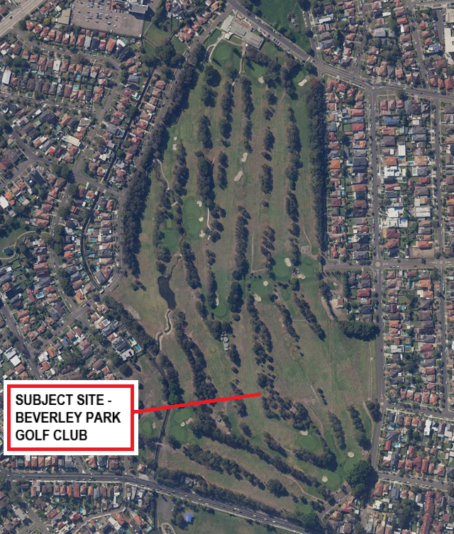
Aerial Photo –
Beverley Park Golf Course
|
Executive Summary
Proposal
1. The
development application (DA2017/0471) proposes the construction of security
fencing and gates associated with the Beverley Park Golf Course. According to
the “Manufacturer’s Specifications” (submitted with the
development application), the fence is to be constructed of pre-galvanised
steel panels, generally to a height of 2100mm and panel widths of 2400mm
between galvanised steel posts. The fence is proposed to have a “sharp
spear” top profile. Details of the fence panelling and a sample photo is
provided in the body of the report see figure 1 and 2 below.
2. The
fence is proposed to be constructed around the entire perimeter of the Beverley
Park Golf Course with a total length of around 2.4km, to replace the existing
“Koppers log” fence which is generally around 700mm in height.
According to the applicant’s DA documentation, the reasons given for the
proposed new fencing includes to prevent vandalism/damage to the Course, to
prevent unauthorised entry including golfers entering the course without paying
green fees (such players are not covered by insurance), to prevent people from
unauthorised entry to the course for purposes other than playing golf.
3. In
addition to this DA for the perimeter fencing (DA2017/0471), the applicant has
lodged a separate DA for a new maintenance shed/staff amenities building at the
eastern side of the site (near Weeney Street). This separate DA (DA2017/0472)
for the maintenance shed/ staff amenities building is the subject of a separate
report on this agenda.
Site and Locality
4. The
subject site has a street address of 87a Jubilee Avenue, Beverley Park, and is
more commonly known as Beverley Park Golf Course. The entire Golf Course
consists of some 34 allotments of land generally bounded by Jubilee Avenue
(northern side), Battye Avenue, Weeney Street, Burgess Street and Targo Road
(eastern side), Ramsgate Road (southern side), and a drainage channel adjacent
to Harslett Crescent, and Ferry Road (western side).
5. The
subject site has an area of approximately 2.93ha (29,300sqm), and is generally
level/flat except for minor undulations throughout the golf course. The site
contains a number of structures typical of a golf course (including a
club-house, site maintenance buildings, toilet facilities etc).
6. In
terms of vegetation, areas of the site where golfing facilitates are located
either contain structures and/or are cleared, though areas between the fairways
and around the perimeter of the course are heavily vegetated with predominantly
mature vegetation.
7. The
locality surrounding the golf course is predominantly residential in nature,
consisting of low-density (typically dwelling houses and some dual occupancy
developments) either adjacent to the golf course and/or across adjoining
streets, while there are also sporting fields and open space to the south and
north of the golf course.
Zoning and Permissibility
8. The
subject site is located within the RE1 Public Recreation zone under Kogarah
Local Environmental Plan (LEP) 2012. The proposed development is permissible
with Council’s development consent.
9. With
the exception of land adjoining the southern boundary that is also zoned RE1,
and two allotments to the south zoned SP2 Infrastructure (Water Supply
Systems), all other land surrounding the Golf Course is zoned R2 Low Density
Residential.
10. Development
on surrounding land largely reflects their respective zoning regimes, with the
RE1 zone containing community facilities and the R2 zones containing low
density residential development.
Submissions
11. The
development application has been advertised and notified to neighbours in
accordance with Kogarah DCP 2013, and a significant number of submissions have
been received, both in support of the proposed development and objecting to the
proposed development. In total, 152 submissions were received – 75
submissions in support and 77 submissions by way of objection were received.
These are discussed in detail in the body of the report.
Reason for
Referral to the Local Planning Panel
12. The
DA is referred to the Local Planning Panel for determination, as the DA is
subject to 10 or more unique submissions by way of objection as referenced in
Section 9.1 (Environmental Planning and Assessment Act 1979) Minister’s
Direction dated 23 February 2018. Further, referral to the Local Planning Panel
is also required because many of the allotments comprising the subject site are
owned by Georges River Council (and/or the allotments are under Council’s
care, control and management).
Issues of
Concern
13. The
main issues of concern in relation to this DA are summarised as follows, (and
these are discussed in more detail in the body of the report):
· Tree removal and
natural environment issues:
· Encroachment on
road reserves:
· Land Owner’s
consent from Sydney Water:
· Acid sulphate
soils:
· Objectives of the
RE1 zone:
14. The
proposal as currently submitted is unacceptable in relation to these issues.
Further, in relation the issue of tree removal and encroachment on road
reserves, there has been insufficient information submitted to Council to
enable a full and detailed assessment to be made.
Conclusion
15. The
application has been assessed having regard to the matters for consideration
under Section 4.15 of the Environmental Planning and Assessment Act 1979, the
provisions of the relevant State Environmental Planning Policies, Local
Environmental Plans and Development Control Plans.
16. As
a result of the key issues identified above, the subject DA has been
recommended for refusal. The detailed reasons for refusal are contained in the
body of this report.
Report in Full
Proposal
17. The
development application proposes the construction of perimeter security fencing
and gates associated with the Beverley Park Golf Course. According to the
“Manufacturer’s Specifications” (submitted with the
development application), the fence is to be constructed of pre-galvanised
steel panels, generally to a height of 2100mm and panel widths of 2400mm
between galvanised steel posts. The fence is proposed to have a “sharp
spear” top profile. The total length of the fence would be approximately
2.4km being the perimeter of the Golf Course.
18. Below
are details of the fence panelling and a sample photo, as provided by the
applicant:
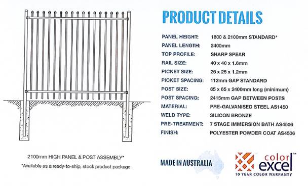
Figure 1
– Fencing specifications
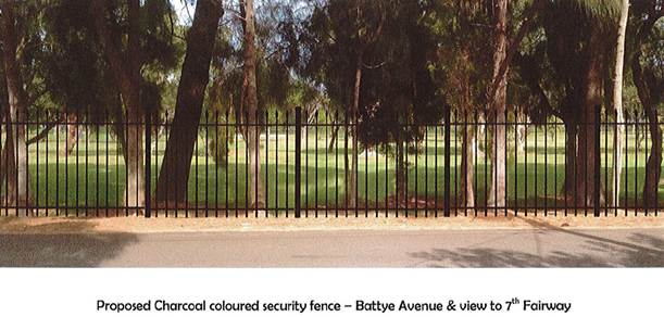
Figure 2
– photomontage of the proposed fencing
19. The
applicant’s DA documentation also includes a plan showing the location of
fencing and gates, as well as the opening times and usage of each of the gates.
This plan is provided below, together with details of the gates, opening times
and usage:
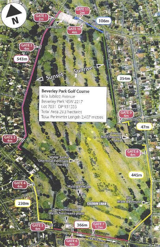
Figure 3 -
An extract from the applicant’s site map/plan.
20. Details
of gates, opening times and usage, as shown in the above site map/plan is
provided below:
Gate 1:
o Located adjacent to Ferry Avenue.
o For use by golfing/social members
for golf/clubhouse activities and other events.
o In use from 5:30am until the
clubhouse closes.
Gate 2:
o Located adjacent to Ferry Avenue
(opposite 26 Ferry Avenue).
o For use by course and Council staff
for maintenance of the drainage channel.
o In use from 7:00am to 5:00pm
Gate 3:
o Located adjacent to Ferry Avenue
(opposite 66 and 68 Ferry Avenue).
o For use by course and Council staff
for maintenance of the drainage channel.
o In use from 7:00am to 5:00pm
Gate 4:
o Located adjacent to Harslett
Crescent (opposite 78 Harslett Crescent).
o For use by emergency vehicles,
course and Council staff for maintenance of the drainage channel.
o In use from 7:00am to 5:00pm
Gate 5:
o Located adjacent to Ramsgate Road.
o For use by Sydney Water employees.
o In use from 7:00am to 5:00pm
Gate 6:
o Located adjacent to Ramsgate Road.
o For use by Council staff and Sydney
Water employees.
o In use from 7:00am to 5:00pm
Gate 7:
o Located adjacent to Ramsgate Road.
o For use by Council staff and Sydney
Water employees.
o In use from 7:00am to 5:00pm
Gate 8:
o Located adjacent to Burgess Street (opposite
56-58 Burgess Street).
o For use by emergency vehicles,
course staff and Council staff.
o In use from 7:00am to 5:00pm
Gate 9:
o Located adjacent to Burgess Street
(opposite 56-58 Burgess Street).
o For use by course staff,
contractors, deliveries for soil and sand, emergency vehicles and Council
staff.
o In use from 5:00am to 5:00pm, Monday
to Saturday.
Gate 10:
o Located adjacent to Jubilee Avenue.
o For use by course staff, emergency
vehicles and Council staff.
o In use when required, seven days.
Gate 11:
o Located adjacent to Jubilee Avenue.
o For use by social members and public
visiting for golf and clubhouse activities and during other events staffed by
club management.
o In use from 5:30am until the
clubhouse closes.
21. As
part of the proposal, 116 trees are proposed to be removed (excluding other
trees that have previously been approved for removal by Council), with a
further 38 to be pruned. Submitted information indicates that replacement trees
would be planted, however the number of trees to replace those being removed is
unclear (information within the application responses to submissions suggest
that 217 replacement trees would be planted, however the submitted
Arboricultural assessment indicates that replenishment trees are to be planted
at a 1:1 ratio (ie 116 trees).
22. NOTE:
It should be noted that under Council’s current Tree Management Policy,
replacement planting is now required to be undertaken at a ratio of 2:1.
However, there is an area of inconsistency between the applicant’s
submitted information and the Arborist report.
The Site and Locality
23. The
subject site has a street address of 87a Jubilee Avenue, Beverley Park, and is
more commonly known as Beverley Park Golf Course. The entire Golf Course consists
of some 34 allotments of land generally bounded by Jubilee Avenue (northern
side), Battye Avenue, Weeney Street, Burgess Street and Targo Road (eastern
side), Ramsgate Road (southern side), and a drainage channel adjacent to
Harslett Crescent, and Ferry Road (western side).
24. The
subject site comprises 34 irregularly-shaped allotments, which are listed and
shown as follows:
|
· Lot
161, DP 19098
|
· Lot
1, DP 1115160
|
· Lot
2, DP 723730
|
|
· Lot
1, DP 1115657
|
· Lot
1, DP 1122814
|
· Lot
3, DP 723730
|
|
· Lot
2, DP 1115657
|
· Lot
1, DP 1127867
|
· Lot
4, DP 723730
|
|
· Lot
1, DP 1115465
|
· Lot
1, DP 724240
|
· Lot
5, DP 723730
|
|
· Lot
1, DP 457030
|
· Lot
1, DP 1148376
|
· Lot
6, DP 723730
|
|
· Lot
1, DP 669359
|
· Lot
2, DP 1148376
|
· Lot
7, DP 723730
|
|
· Lot
1, DP 669358
|
· Lot
9, DP12389
|
· Lot
55, DP 3097
|
|
· Lot
1, DP 1115626
|
· Lot
10, DP12389
|
· Lot
56, DP 3097
|
|
· Lot
1, DP1114452
|
· Lot
2, DP 230426
|
· Lot
57, DP 3097
|
|
· Lot
2, DP 1114452
|
· Lot
7031, DP 93155
|
· Lot
58, DP 3097
|
|
· Lot
2, DP 1115160
|
· Lot
4, DP 230427
|
|
|
· Lot
1, DP 1122814
|
· Lot
1, DP 723730
|
|
Figure 4
– Details of the lot and DP’s across the site.
25. The
subject site has an area of approximately 29,300sqm (excluding encroachments on
public road reserves). The topography of the site is mostly level, with some undulating
sections where the site has been modified to incorporate certain features (e.g.
topographical features, golfing hazards, etc.). Development on the site
includes features and structures associated with the Beverly Park Golf Club
(BPGC), and includes the following:
· A
large clubhouse, which includes facilities including a pro-shop, restaurant,
bar, gaming and function facilities;
· Car
parking facilities;
· Site
maintenance facilities, and facilities which support the operation of onsite
equipment, which are located within the centre on eastern sides of the site;
· Toilet
facilities;
· Golfing
fairways, tee-off areas, putting greens and associated features (i.e. sand
bunkers, water hazards, etc.); and
· Pathways
and associated site infrastructure.
26. In
addition to the above, there are other features on the site that include the
following:
· An
open drainage channel that traverses the southeast side of the subject site
into the Georges River;
· Flood
mitigation facilities;
· Water
network assets, including a sewage pumping station at the southern end of the
subject site.
27. In
terms of vegetation, areas of the site where golfing facilitates are located
either contain structures and/or are cleared, though areas between the fairways
and around the perimeter of the course are heavily vegetated with predominantly
mature vegetation.
28. The
locality surrounding the golf course is predominantly residential in nature,
consisting of low-density (typically dwelling houses and some dual occupancy
developments) either adjacent to the golf course and/or across adjoining
streets, while there are also sporting fields and open space to the south and
north of the golf course.
Background
29. 9
October 2017 – The subject DA (DA2017/0471 for the proposed fencing) was
lodged with Council. Also lodged on this date was DA2017/0472 for the
construction of a new maintenance shed and staff amenities near Weeney Street
on the eastern side of the golf course. A separate report for the maintenance
shed/staff amenities building appears in this agenda.
30. The
DA was neighbour notified and referred to a number of officers within and
outside Council. The notification period was from 6 March to 22 March 2018
(which was later extended until 4 April 2018). In total, 152 submissions were
received – 75 submissions in support and 77 submissions by way of
objection were received, as discussed in the Submissions section of this
report, below.
31. On
12 April 2018, Council Officers advised the applicant of a number of
deficiencies with the level of information submitted for assessment with the
DA. The applicant was requested to provide the following information:
· site
analysis;
· plans
and elevations of the proposed fence (photomontage provided however it is not
to scale and does not show the height of the proposed structure);
· landscape
plan;
· arborist
report;
· golf
course safety evaluation (to take into account the course layout and proposed
removal of existing trees which may act as a buffer to shield surrounding
residences);
32. In
addition, the applicant was further advised as follows:
There may appear to be valid reasons for the erection of the fence
(ie general safety and security reasons) however these need to be carefully
balanced with the zoning of the land (being RE1 Public Recreation) and relevant
objectives in order to evaluate the competing interests.
As such, it would be reasonable for the applicants to address the
full range of available options to meet their objectives for the erection of
the fence to determine whether or not there is scope to consider a revised
proposal that may still provide public access at certain locations (near
entrances where staff are present to discourage unauthorized use of the course
and vandalism) at particular times. In this regard, relevant options could be
discussed and/or eliminated.
A public information session and/or workshop would be required to
canvas these options. Again, it would have been prudent for the applicant to
undertake pre-DA consultations with surrounding residents to discuss potential
options.
33. The
applicant was requested to provide the additional information by 3 May 2018;
however on request from the applicant, this period was extended until 17 May
2018 due to the nature of information requested.
34. On
10 July 2018, the applicant requested a meeting with Council officers to
discuss the nature and content of the additional information request, and
whether their information was sufficient.
35. Also
at this stage, it became apparent that several locations of the existing
“Koppers log” fencing encroached within the road reserve, and this
would have implications for the proposed fencing. This was being investigated
by staff in Council’s Property Team and General Counsel, and this issue
was discussed separately with the applicant.
36. Meeting
was held between the applicant and Council officers on 31 July 2018. In
relation to the DA for the perimeter fencing, the following issues were
discussed:
· Document provided
on the analysis of alternate security arrangements
· Arborist report
provided – 116 trees to be removed (50 immediately due to risk) and 36
trees require pruning. The report identified that trees need to be planted to
replace those tree that have been removed. Though the Arborist report was
submitted, it was noted that the Arborist report contained no plans showing
tree locations.
· No landscape plan
was provided – the club was told that a Landscape Plan is required.
· Design and
elevation of 2 fence profiles provided – 19mm and 25mm.
· Issues relating to
the encroachment of the existing “Koppers Log” and proposed steel
fencing into the road reserve, in various locations, was discussed.
37. On
6 August 2018, the applicant submitted additional information in relation to
Council’s previous additional information requests. This additional
information included an Arboricultural assessment, mapping, and land
owner’s consent from the NSW Department of Industry – Crown Lands
and Water.
38. On
26 November 2018, Council considered a report in relation to the encroachment
of existing (and proposed) boundary fences onto the surrounding public road
reserve, and made the following resolution with regard to matter FIN099-18
(Property Matter – Proposed Lease of Road Reserve – Beverley Park
Golf Course):
“That a lease not be granted to Beverley Park Golf Club for
parts of the golf course currently encroaching upon surrounding road reserves,
in order to formalise occupation.”
39. The
lease arrangement is an independent approval process to that of the DA. Owners
consent has been provided for the lodgement of this application.
40. A
meeting was held with the applicant on 2 April 2019, to discuss outstanding
matters associated with the application. In relation to the issue of concern
regarding encroachment of the proposed fencing into the road reserve, Council
officers suggested to the applicant a number of options including:
1) Retain
current design of fencing (as currently submitted with the DA);
2) Re-design
of the fencing, with the fence to remain in current location. Potential changes
to the design could include reduction in height, a different style of fencing
(e.g. chain wire etc.);
3) Same
fence design but in a different location – i.e. entirely within property
boundaries;
4) Stage
the fence construction so as to obtain approval for the fencing on current
property boundaries and separate/subsequent approval of fencing for land within
the road reserve;
5) Withdraw
the current DA.
41. Also
at the meeting on 2 April 2019, the applicant was requested to provide the following
information which remained outstanding from Council’s previous additional
information requests:
· Site analysis;
· Plans and
elevations of the fence;
· Arborist report
– in particular the location of trees to be removed, pruned and replaced
· Landscape plan;;
· Survey plan
clearly showing the position of the fencing in relation to property boundaries;
and
· Golf course safety
evaluation.
The applicant was requested to
provide this information by 29 April 2019 to enable the DA to be referred to
the Local Planning Panel for determination.
42. The
applicant responded on 17 April 2019 to request additional time to provide the
requested information (as above); however, to date the applicant has not
provided the information required. This information is fundamental to Council
officers’ assessment.
43. In
summary, various additional information has been requested for submission from
the applicant throughout the processing of the application, most notably the
location of trees to be removed, pruned and replaced, as well as survey
information clearly showing the location of the fence in relation to property
boundaries.
44. In
order to progress this development application, this report has been prepared
on the basis of the information currently submitted to Council. As noted
elsewhere in this report, the assessment has been conducted by external town
planning consultants because the land is owned by (and/or is under care,
control and management of) Georges River Council.
PLANNING
ASSESSMENT
45. The
site has been inspected and the proposed development has been assessed under
the relevant Section 4.15(1) Matters for Consideration under the Environmental
Planning and Assessment Act 1979.
APPLICABLE
PLANNING CONTROLS
· Environmental Planning
and Assessment Act 1979 (the Act)
· Environmental Planning
and Assessment Regulation 2000 (the Regulation)
· Greater Metropolitan
Regional Environmental Plan No 2 – Georges River Catchment
· State Environmental
Planning Policy (Infrastructure) 2007
· State Environmental
Planning Policy (Coastal Management) 2018
· State Environmental
Planning Policy No 55 - Remediation of Land
· State Environmental
Planning Policy (Vegetation in Non-Rural Areas) 2017
· Kogarah Local
Environmental Plan (LEP) 2012
· Kogarah Development
Control Plan (DCP) 2013
· Roads Act 1993
State
Environmental Planning Policies
46. Compliance
with the relevant state environmental planning policies is summarised and
discussed in the table below.
Discussion on
the SEPPs relevant to the development
State
Environmental Planning Policy No 19—Bushland in Urban Areas
47. While
the former Kogarah Local Government Area (LGA) is subject to the provisions of
this SEPP, and the concerns about large-scale tree clearing by objectors are
noted, ‘Bushland’ is defined by the SEPP as follows:
48. “bushland
means land on which there is vegetation which is either a remainder of the
natural vegetation of the land or, if altered, is still representative of the
structure and floristics of the natural vegetation.”
49. The
vegetation that is proposed to be removed from the site is not a remainder of
natural vegetation of the land, nor is it considered to be representative of
the native structure and floristics of the locality. As such, the SEPP is not
considered to be applicable to the subject DA.
State
Environmental Planning Policy No 55 - Remediation of Land (SEPP 55)
50. A
review of the site history indicates that the land was vacant until the 1940s,
after which time it was developed into (and continually operated as) a golf
club with associated development (i.e. a club house, maintenance/grounds
keeping facilities, etc.). This review also suggests that land
surrounding the subject site has also been continually used for predominantly
residential development during that period of time. It is acknowledged
that the proposed works would not occur in close proximity to areas where at
least some contamination could be identified (i.e. maintenance/storage areas,
storage tanks, etc.).
51. The
scale of the ground works necessitated by the proposal is also noted, which
would be limited to minor excavation for fence footings, and replacement
vegetation planting.
52. In
the event the DA was approved, an unexpected finds condition could be imposed
to address any contaminants. As such, the proposal is considered to satisfy the
relevant provisions of SEPP No. 55.
Greater Metropolitan
Regional Environmental Plan No 2 – Georges River Catchment
53. The
site is within the area affected by the Greater Metropolitan Regional
Environmental Plan No 2 — Georges River Catchment. The proposal,
including the disposal of stormwater, is considered to be consistent with
Council's requirements for the disposal of stormwater in the catchment.
54. If
approved, the proposal would not have a foreseeable impact on river bank
disturbance, flooding, urban stormwater runoff and/or local water quality
(subject to Council’s Development Engineer conditions that could be
imposed that would help with runoff and sedimentation). Whilst the
proposal would be mostly consistent with the provisions of the Plan, as
indicated within the assessment of the clause 6.1 (Acid Sulfate Soils) of
LEP (see above), insufficient information has been provided to
demonstrate that there would be no disturbance of acid sulphate soils, which
are mapped by the LEP as potentially being present on the subject site.
Unless it can be demonstrated that acid sulphate soils are not present/would
not be disturbed by the development, the proposal would therefore fail to
satisfy clause 9(1) of the Greater Metropolitan Regional Environmental Plan No
2 – Georges River Catchment.
State
Environmental Planning Policy (Infrastructure) 2007
55. The
subject site is not in close proximity to a classified road, nor would the
proposed development affect the use of the site in a manner that would
constitute ‘traffic generating development’ in accordance with Schedule
3 of the SEPP; a referral to Roads and Maritime Services (RMS) is therefore not
required. No information has been sighted to suggest that an external
referral to the energy supply authority is required pursuant to clause 45 of
the SEPP.
State Environmental
Planning Policy (Coastal Management) 2018
56. The
far south west area of the site is identified as being within the
‘coastal environment area’. An assessment of Division 3 of
the SEPP is therefore as follows.
|
Clause
|
Standard
|
Proposed
|
Complies
|
|
13 Development on land within the
coastal environment area
|
(1) Development
consent must not be granted to development on land that is within the coastal
environment area unless the consent authority has considered whether the
proposed development is likely to cause an adverse impact on the following:
(a) the
integrity and resilience of the biophysical, hydrological (surface and
groundwater) and ecological environment,
(b) coastal
environmental values and natural coastal processes,
(c) the
water quality of the marine estate (within the meaning of the Marine Estate
Management Act 2014), in particular, the cumulative impacts of the proposed
development on any of the sensitive coastal lakes identified in Schedule 1,
(d) marine
vegetation, native vegetation and fauna and their habitats, undeveloped
headlands and rock platforms,
(e) existing
public open space and safe access to and along the foreshore, beach, headland
or rock platform for members of the public, including persons with a disability,
(f) Aboriginal
cultural heritage, practices and places,
(g) the use of
the surf zone.
|
An assessment of each of the
relevant provisions within subclause (1) is as follows:
The proposal would not foreseeably
affect surface and groundwater processes and the ecological environment.
The proposal would not have any
foreseeable impact on coastal processes.
In the event that the application
could be approved, conditions could be applied to ensure that construction
works do not affect local water quality.
Despite the removal of some native
vegetation, the areas of the site affected by the coastal zone are within a
highly developed and disturbed area; the proposal is therefore unlikely to
have a significant impact on vegetation within the coastal area and
associated ecological processes. There are no rock platforms and/or
headlands within the vicinity of the works.
There are a number of structures
(including fences and restricted access areas such as the sewage pumping
station) that would broadly prevent public access to the part of the subject
site affected by the coastal zone. The proposal is therefore unlikely
to have a significant adverse impact on accessibility to coastal and
foreshore areas.
The proposal would have no foreseeable
impact on aboriginal sites or locations. Refer to the assessment of cl.
5.10 of LEP.
There are no surf zones in close
proximity to the site.
|
Yes
|
|
|
(2) Development
consent must not be granted to development on land to which this clause
applies unless the consent authority is satisfied that:
(a) the
development is designed, sited and will be managed to avoid an adverse impact
referred to in subclause (1), or
(b) if that
impact cannot be reasonably avoided—the development is designed, sited
and will be managed to minimise that impact, or
(c) if
that impact cannot be minimised—the development will be managed to
mitigate that impact.
|
As indicated by the assessment
above, the proposal should not foreseeably affect any of considerations
within subclause (1).
|
Yes
|
State
Environmental Planning Policy (Vegetation in Non-Rural Areas) 2017
57. The
objectives of the SEPP are to protect the biodiversity
values of trees and other vegetation in non-rural areas and preserve the
amenity of non-rural areas through the preservation of trees and other
vegetation. This policy applies pursuant to Clause 5(1) of the SEPP as
the site is within both the Georges River Council and the RE1 Public Recreation
zone. Pursuant to Clause 8(1) of the SEPP, clearing does not require an
authority as it is a type of clearing that is authorised under Section 60O of
the Local Land Services Act 2013 (specifically, that associated with a
development consent issued under Part 4 of the Act).
Draft State Environmental Planning Policies
Draft Remediation of Land SEPP
58. The Department of Planning and Environment has announced a Draft
Remediation of Land SEPP, which
will repeal and replace the current State Environmental Planning Policy No 55—Remediation of
Land.
59. The
main changes proposed include the expansion of categories of remediation work
which requires development consent, a greater involvement of principal
certifying authorities particularly in relation to remediation works that can
be carried out without development consent, more comprehensive guidelines for
Councils and certifiers and the clarification of the contamination information
to be included on Section 149 Planning Certificates.
60. Whilst the proposed SEPP will retain the key
operational framework of SEPP 55, it will adopt a more modern approach to the
management of contaminated land.
61. Assessment commentary was provided earlier in this report in terms
of assessment under SEPP 55 – Contamination of Land, where it was noted
that the site has been continually operating as a golf course since the 1940s.
62. The
scale of the ground works necessitated by the proposal is also noted, which
would be limited to minor excavation for fence footings, and replacement
vegetation planting.
63. In
the event the DA was approved, an unexpected finds condition could be imposed
should any contaminants be encountered during construction.
Draft Environment SEPP
64. The Draft
Environment SEPP was exhibited from 31 October 2017 to 31 January 2018.
65. This consolidated SEPP proposes to simplify the
planning rules for a number of water catchments, waterways, urban bushland, and
Willandra Lakes World Heritage Property.
· Changes proposed include consolidating the following seven existing
SEPPs:
· State Environmental Planning Policy No. 19 – Bushland in Urban
Areas
· State Environmental Planning Policy (Sydney Drinking Water Catchment)
2011
· State Environmental Planning Policy No. 50 – Canal Estate
Development
· Greater Metropolitan Regional Environmental Plan No. 2 –
Georges River Catchment
· Sydney Regional Environmental Plan No. 20 – Hawkesbury-Nepean
River (No.2-1997)
· Sydney Regional Environmental Plan (Sydney Harbour Catchment) 2005
· Willandra Lakes Regional Environmental Plan No. 1 – World
Heritage Property.
66. Generally,
as discussed throughout this report, there has been a lack of information
submitted in relation to tree removal and replacement plantings. In particular:
· No survey
plan has been submitted to demonstrate the locations of the fences and trees to
be removed in relation to relevant property boundaries;
· No survey
and/or landscape plan(s) has been submitted to identify the locations of trees
to be removed and/or the location of replacement tree plantings;
· Information
submitted by the applicant makes inconsistent reference to the number of trees
that are to be replaced.
Kogarah Local
Environmental Plan 2012
Zoning and
Permissibility
67. The
subject site is located within an RE1 Public Recreation zone under Kogarah LEP
2012. The proposed development is permissible subject to Council’s
development consent.
68. With
the exception of land adjoining the southern boundary that is also zoned RE1
and two allotments to the south zoned SP2 Infrastructure (Water Supply
Systems), all other surrounding land is zoned R2 Low Density Residential.
69. The
following is an extract of the zoning map of the subject site and surrounding
properties.
Figure 5 - Zoning Map
Planning
Controls in Kogarah LEP 2012
70. An
assessment of the proposal in terms of the relevant standards of the LEP is
outlined in the table below.
|
Clause
|
Standard
|
Proposed
|
Complies
|
|
Part 2 – Permitted or
Prohibited Development
|
RE1 Public Recreation zone
|
The proposal does not seek to
change the existing use of the site.
There is no dictionary definition
for a ‘fence’ (or similar) within the LEP. The fence would
however be ancillary and associated with a ‘golf course’, which
is a land use activity contained within the ‘recreation facility
(outdoor)’ definition; such a land use is permissible with consent
within the RE1 zone.
|
Yes
|
|
RE1 zone Objectives
|
Objectives of the Zone
· To enable land
to be used for public open space or recreational purposes.
· To provide a
range of recreational settings and activities and compatible land uses.
· To protect and
enhance the natural environment for recreational purposes.
|
The proposal would satisfy the
first of the two zone objectives, as it continues to enable the site to be
used for public open space and recreational purposes (i.e. public golfing and
associated activities).
Given fencing could be readily
removed sometime in the future, should an alternative recreation use for the
course be proposed, the proposed works would not inhibit this.
The application does not however
satisfy the third objective. Information submitted to date has not
adequately demonstrated that the proposal would enhance the natural
environment for recreational purposes.
As covered with Council’s
DCP, the erection of fences is an insufficient reason for the removal of
trees.
There is also a lack of information
(such as survey and landscape plans) to enable an assessment to confirm both
the location and health status of affected trees. Whilst it is noted
that replacement trees are proposed, given that their replacement locations
are unknown it cannot be confirmed if they would satisfactorily enhance the
natural environment for recreation purposes.
It is therefore concluded, based on
the information currently submitted for assessment, the proposal does not
satisfactorily address the objectives of the RE1 zone under Kogarah LEP 2012.
|
No
|
|
4.3 Height of Buildings
|
|
Maximum height of the fence:
2100mm.
No height limit applies to the site
pursuant to cl.4.3(2) of the standard.
|
Yes
|
|
5.10 Heritage conservation
|
|
The site does not contain a
heritage item and is not within a heritage conservation area; there are no
heritage items within the immediate vicinity of the subject site.
Further, the National Trust no
longer identifies the site and/or surrounding area as being a heritage
conservation area. Heritage provisions therefore do not apply to the site.
The site is highly modified, and it
is unlikely that items of indigenous heritage would be present.
An ‘Extensive Search’
has also been undertaken using the AHIMS database and identified no
Aboriginal sites or places being located at the subject site. In the event
that the application could be approved, a condition could be applied
requiring that works cease if items are uncovered until the relevant
authorities have been consulted.
|
Yes
|
|
6.1 Acid sulfate soils
|
(3) Development consent must
not be granted under this clause for the carrying out of works unless an acid
sulfate soils management plan has been prepared for the proposed works in
accordance with the Acid Sulfate Soils Manual and has been provided to the
consent authority.
|
The site is affected by Class 2 and
Class 3 acid sulphate soils; some of the works would occur within areas
affected by Class 2 acid sulphate soils, which pursuant to cl.6.1(2) requires
that an Acid Sulphate Soils Management Plan (ASSMP) be undertaken for “any
works below natural ground surface”. The submitted
documentation indicates that the following works would occur below natural
ground level:
· Excavation for the
footings of the fence, which based on submitted information would extend to
approximately 300mm;
· Excavation (to an
unknown depth) to enable the compensatory planting of trees.
Neither an ASSMP or a preliminary
assessment have been submitted. Pursuant to cl. 6.1(3) the consent
authority cannot grant consent to the application unless such documentation
has been prepared.
With regard to cl. 6.1(6),
information has not been provided to demonstrate that less than one (1) tonne
of soil would be disturbed. Given the length of the fence (and the
subsequent number of footings to be dug) and the number of replacement trees
that are to be planted, it is considered likely that more than one tonne of
soil would be disturbed by the proposal.
|
No
|
|
6.2 Earthworks
|
|
The level and scale of the
earthworks proposed are limited to the fence footings and replacement
planting. Given the considerable size of the site, these earthworks are
considered minor and will not contravene the development standards under this
clause.
|
N/A
|
|
6.3 Flood planning
|
|
The proposed fences are not
habitable buildings. As covered within Council’s engineering referral
response later in this report, as open structures, the fences would not
foreseeably affect flood behaviour, nor would they reduce water storage
within the flood catchment area. As such, it is unlikely that the
fences would increase risk to life or property, and are therefore considered
to be acceptable.
|
Yes
|
|
6.4 – Foreshore Scenic
Protection Area
|
Council cannot grant consent to the
carrying out of development on land within a Foreshore Scenic Protection Area
unless consideration has been made of the following:
“(3)(a) affect the natural
environment, including topography, rock formations, canopy vegetation or
other significant vegetation, and
(b) affect the visual environment,
including the views to and from the Georges River, foreshore reserves,
residential areas and public places, and
(c) affect the environmental
heritage of Hurstville, and
(d) Contribute to the scenic
qualities of the residential areas and the Georges River by maintaining the
dominance of landscape over built form.”
|
The site is not within the
foreshore area.
|
N/A
|
Development
Control Plans
Kogarah
Development Control Plan 2013
71. An
assessment of relevant provisions within Kogarah DCP 2013 are contained within
the table below. An assessment of particular issues and non-compliances is
provided following the table.
|
KDCP 2013
|
Proposed
|
Complies
|
|
Part B – General Controls
|
|
B2 Tree Management & Green
Web
|
|
1 Preservation of Trees and
Vegetation
|
|
1.1 Tree Management
(1) Compliance
with provisions of Clause 5.9 Preservation of Trees or Vegetation of KLEP
2012 must be achieved.
(2) Development
consent or a Council permit is required to ringbark, cut down, top, lop,
remove, injure or wilfully destroy any tree, whether on private or public
land, which has:
(i.) A
height greater than 3.5m, or
(ii.) A
branch spread exceeding 3 metres in diameter
(3) An
application to ringbark, cut down, top, lop, remove, injure or wilfully
destroy any tree shall contain the following information:
(i.) An
application on the prescribed form.
(ii.) The
written consent of the land owner unless the application is for pruning a
tree over the applicant’s property from a tree on the neighbouring
property.
(iii.) Details
as to the reasons for the pruning/removal of the tree.
(iv.) A
description of trees to be removed/pruned which includes:
· A site plan showing
trees and existing structures.
· The species type
– common and full scientific names if known.
· Approximate height,
trunk and canopy spread.
(4) Irrespective
of Clause (2) above, the following tree works do not require Council approval
when undertaken in accordance with relevant Australian Standards for the
pruning of amenity trees.
(i.) Trees
that have been declared an undesirable species and identified in List 1 below
may be removed or pruned without the need for development consent or a
Council permit, provided the tree has not been identified as possessing
heritage significance.
(ii.) Works
undertaken in response to an emergency by the State Emergency Service, Rural
Fire Service or another Authority.
(iii.) Trees
that require pruning in accordance with the Electricity Supply Act 1995.
(5) Council
will be satisfied that a tree is dead and/or a risk to life or property when:
(i.) The
tree is not within the Green Web habitat corridor or habitat reinforcement
corridor and a report by a qualified Arborist (minimum AQF Level 5
Aboriculture), including photographs of the tree, is submitted which
concludes that the tree is dead or dying; or
(ii.) It
can be proven that the pruning or removal work is the only reasonable option
to avoid an immediate threat of injury or damage to life or property and the
works were undertaken to the minimum extent necessary to manage that threat;
and
(iii.) Recorded
proof of that threat, in the form of a report (Tree Hazard Assessment (THA))
by a qualified Arborist (minimum AQF Level 5 Aboriculture) including
photographs of the tree and detailing the cause of danger. Where a trunk or
limb defect assessment is undertaken, strength loss calculations and cross
section mapping must be included in the THA.
(iv.) In
the event of tree removal, the arborist report is forwarded to Council
immediately following the removal.
(v.) In
the event of pruning, the arborist report is made available to Council on
request within three (3) months after the pruning works.
|
A detailed assessment of the
control is contained within the main body of this report. That
assessment does not address control (1), as clause 5.9 of the LEP has been
repealed since the DCP control was drafted and replaced by a SEPP.
Development consent has been sought
for the removal or pruning of the affected trees.
Irrespective of the boundary
encroachment onto surrounding road reserves, as such land is also owned by
Council it is considered that owner’s consent has been submitted for
the assessment associated with the removal of trees.
The details of the trees to be
removed or pruned has been provided, though as indicated by Council’s
Consultant Arborist, such information is insufficient as it does not enable them
to verify the specific locations of the affected trees, confirm the health of
such vegetation and concur with the recommendations of the project arborist.
|
No
|
|
1.2 Matters for consideration
when determining an application for tree removal
(1) The existing
and likely future amenity of the area.
(i.) Is
the tree significant as a single specimen or as part of a group of trees;
(ii.) Is
the tree of historic or cultural significance;
(iii.) Is
the tree registered on Council’s Significant Tree Register;
(iv.) Is
the tree prominent due to its height, size, position, or age;
(v.) Is
the tree endemic, rare, or endangered;
(vi.) Does
the tree provide a significant visual screen;
(vii.) Is the
tree part of an important wildlife habitat.
(2) The
health and safety of the tree(s).
(i.) If
there are structural cracks and fractures on the branches or fractures or
cracks at the junction between two trunks and these problems cannot be
rectified without a significant loss to the tree;
(ii.) The
tree has a large number of epicormic shoots that are poorly attached through
incorrect previous pruning activities and pruning cannot rectify the problem;
(iii.) There
is a fruiting body of pathogenic fungi apparent and there is a consecutive
decline of the cambium around the wound (a canker) and the rate of decay is
exceeding the rate of growth of new tissue;
(iv.) The
tree has moved in the ground, or there is an obvious lifted mound with
exposed broken roots; or
(v.) Many
large branches or the trunk has been broken as a result of a storm event.
(vi.) The
presence of insects is not a basis for removal of a tree, but may be a
warning to provide some form of remedial treatment. Inspection and
recommendation should be sought from an AQF 5 qualified Arborist prior to
applying for tree removal.
(3) The
physical characteristics of the tree - This includes the current and
potential height, branch spread, trunk diameter, the growing environment and
life expectancy
(4) The
damage or potential damage the tree may cause.
(i.) The
damage the tree, its trunk, or its root system is causing to a structure and
where such damage cannot be controlled by measures such as the installation
of a root barrier;
(ii.) The
tree is damaging other properties, retaining walls and the like, and
precautionary root pruning or modification of the property cannot stop future
damage;
(iii.) Council
will not consider the removal of trees that have entered a drainage or sewer
system where the system is found to be in poor condition or in disrepair.
(5) Invalid
reasons to remove a tree:
(i.) To
erect a front fence, internal fence or a fence adjoining a public reserve.
(ii.) To
avoid leaf drop into gutters, downpipes or pools.
(iii.) To
increase natural light.
(iv.) To
improve the effect of street light.
(v.) To
enhance views.
(vi.) To
reduce shade.
(vii.) To
reduce fruit, resin or bird droppings.
(viii.) Minor
lifting of driveways or paths.
(ix.) Unapproved
bushfire hazard control.
(x.) Potential
damage to services without written expert advice.
(xi.) To
increase sunlight access to solar panels.
|
A detailed assessment of the
control is contained within the main body of this report. That
assessment does not address control (4), as no information has been submitted
to suggest that the trees proposed for removal are/will damage property and
assets on surrounding sites (irrespective of the issue regarding boundary
encroachment).
|
No
|
|
1.3 Trees and development sites
Where a DA includes the removal of
a substantial tree/trees, an Arborist
Report must be submitted in accordance
with Australian Standard AS 4970- 2009: Protection of Trees on Development
Sites. This report must substantiate the tree works, removal, pruning,
protection and/or ongoing management of affected trees.
As part of the development
assessment process, a Site Analysis must be undertaken to identify site
constraints and opportunities, including trees located on the site and
neighbouring sites. In planning for a development, consideration must be
given to the building/site design so that suitable trees are retained.
Council does not normally allow the removal of trees to allow a development
to proceed.
The site analysis must also
describe the impact of the proposed development on neighbouring trees. This
is particularly important where neighbouring trees are close to the property
boundary. The main issues are potential damage to the roots of neighbouring
trees (possibly leading to instability and/or health deterioration) and
canopy spread/shade from neighbouring trees that must be taken into account during
the landscape design of the new development.
Where an application proposes the
removal of substantial trees, the applicant is required to demonstrate that
an alternative design, achieving the retention of any tree(s), is not
feasible. It must also be proven that it is not possible to provide adequate
clearance between the tree(s) and the proposed building envelope and/or any
structures/hard surfaces.
|
Whilst not originally provided, an
Arboricultural assessment (prepared by McArdle Arboricultural Consultancy,
dated 20 April 2018) has been submitted as part of amended and additional
information.
A discussion of plans and
associated documentation is contained within the main body of the report.
|
No
|
|
2. Green Web Requirements
|
|
design open space to reflect and
integrate the natural heritage and underlying ecological processes of the
landscape through site layout, grading, planting, landscape material, access
and view lines.
|
There is a lack of detail (in terms
of access, replacement tree locations and associated sightlines) to be able
to assess the control. Amended plans would be required for an
assessment to be undertaken.
|
No
|
|
wherever possible, design open
space to conserve indigenous vegetation and habitat on site and retain
indigenous trees, understorey and groundcovers as a priority in the site
layout. Select bushland area to preserve the most intact and sustainable
areas of vegetation and prevent fragmentation of habitat.
|
There are no bushland areas and/or
areas if indigenous habitat on the site.
|
N/A
|
|
design vegetation to enhance and
link existing vegetation and habitat within the site and adjacent sites.
|
There is insufficient information
to identify whether areas of vegetation could be linked. An amended
survey and landscape plan would be required to confirm the suitability of
replacement locations.
|
No
|
|
design access to reduce pressures
that have potential to cause degradation of vegetation, habitat, water
quality and soil.
|
Whilst there is limited detail, the
proposed locations of the gates suggest that such access points would not
degrade vegetation. Other considerations could potentially be addressed
through conditions of consent in the event that the application could be
approved.
|
Yes
|
|
use indigenous plant stock and,
preferably, locally sourced plant material to preserve local genetic
diversity
|
Noted. Compliance with such
requirements could be addressed through conditions in the event that the
application could be approved.
|
Yes
|
|
maximise use of indigenous plant
material and preferably use exclusively indigenous plants adjacent to
remnants. Arrange plants to form plant associations based on the structure
and distribution of indigenous plant communities using a diverse range or
plants, including understorey and groundcovers, to form a viable habitat for
flora and fauna
|
Noted. Compliance with such
requirements could be addressed through conditions in the event that the
application could be approved. Additional comments would be required in
terms of the creation of an understoreys (if possible).
|
Yes
|
|
(a) In
addition, the following criteria need to be applied to create a sustainable
and diverse habitat:
(i.) maintain
and enhance diversity in plant communities and subcommunities, species,
habitat niches and structure of the plant community. Most importantly,
maintain and/or restore understorey species.
(ii.) include
and retain water holes, ponds, dams, creeks and damp spots in habitat areas.
In some cases there will be numerous benefits in creating artificial dams or
ponds which may include stormwater control facilities. Artificial water
bodies should not involve in-stream works but should be additional to natural
watercourses
(iii.) retain
old or dead trees as these provide (or will in the future) nesting holes,
hollows and perches. If there is a lack of tree holes, install nesting boxes
for a range of native species. Hollow logs or old pipes can provide shelter
for ground dwelling animals and can be mounted in trees to assist arboreal
species and birds.
(iv.) create
dense plantings of shrubs, including prickly or spiky species in areas of
little use (eg. corner back areas), to provide safe nesting sites for small
birds and protect them from cats and larger predatory birds such as
currawongs and ravens.
(v.) arrange
tree plantings so their canopies touch to allow smaller birds and mammals,
such as possums and sugar gliders, to cross roads and areas of open grass
without having to move across open ground where they are vulnerable to
attacks by predators. Ropes and wires can be used as bridges for animals
where tree canopies do not touch eg. possums have frequently been observed
using electricity supply wires for travelling in urban areas.
(vi.) clear
weed infested areas in stages rather than all at once to maintain shelter and
nesting sites provided by existing invasive plants. Observe whether nesting
activities are taking place or other resident fauna is present in the understorey
and take care not to disturb these areas when nesting is occurring. As a
general rule, never clear more than one third of the site for replanting to
ensure that resident animals are not left without food and shelter. Some
rubbish, such as car bodies, sheets of corrugated iron and timber can provide
habitat and refuges from predators for reptiles, such as blue tongue lizards,
and small mammals, such as bandicoots and bush rats.
(vii.) install
artificial shelter structures, where stable populations of birds or reptiles
reside, as part of your landscape design. They can be piles of timber logs or
rocks, wire mesh structures imitating densely branched shrubs or of pipes
imitating hollow logs. These shelters may also act as nesting sites.
(viii.) retain
leaf litter and fallen branches. They provide an important habitat for
reptiles and insects, foraging grounds and shelter against heat and
predators.
(ix.) plant
a range of indigenous flowering trees and shrubs to provide flowers and
nectar throughout the seasons to maintain bird diversity and populations.
During certain seasons, some birds rely on particular insect types that are
dependent on particular plant species, thereby controlling insect
populations, including those which are responsible for dieback in trees.
(x.) select
plants with thick and furrowed bark, high foliage nutrient and different
flowering and fruiting seasons to provide food throughout the whole year.
(xi.) minimise
use of fertilisers and irrigation to prevent nitrification and invasive
exotic plants destroying native bushland.
|
The criteria of the guidelines are
assessed as follows:
(i.) Additional
information would likely be required; however enhancement of species
diversity could be addressed through conditions if the application were
approved.
(ii.) The
proposal would not affect the retention of existing water bodies.
(iii.) Dead
and over-mature trees are proposed for removal. Current information is
insufficient to allow for an assessment of the retention of such trees; the
suitability of the trees for retention as potential nesting places would
require additional assessment by Council’s Consultant Arborist once
information was provided to enable such an assessment
(iv.) Noted.
This requirement could be conditioned in the event that the application could
be approved.
(v.) Additional
information is required to enable an assessment of the placement and
subsequent separation of trees. Other requirements regarding ropes and
wires could be addressed by conditions of consent once the suitability of
replacement tree locations is confirmed.
(vi.) Clearance
of weeds (if not already managed) could be addressed via conditions of
consent.
(vii.) Artificial
structures (if not already managed) could be addressed via conditions of
consent.
(viii.) Retention
of leaf litter and branches (if not already done) could be addressed via
conditions of consent.
(ix.) Specific
plant species could be addressed via conditions of consent.
(x.) Specific
plant species could be addressed via conditions of consent.
(xi.) Not
applicable in the context of the subject application.
|
Yes
|
|
B5 – Waste Management
& Minimisation
|
|
1. Waste Management Plan
(1) Submit
a Waste Management Plan with DAs involving:
· demolition;
· construction of
a new building(s); or
· change of use or
alterations/additions to existing premises (only when this would result in a
change of waste generation).
(2) Illustrate
on the DA plans/ drawings:
· the location and space
allocated for the storage of demolition and construction waste or materials;
· waste collection
point(s) for the site; and
· path of access for
collection vehicles.
(3) Prepare the
Waste Management Plan in accordance with the requirements in Kogarah Waste
Not Plan 2012.
(4) Demonstrate
in the Waste Management Plan the use of second hand building materials and
recycled building products during building design and construction.
(5) Retain
records (including receipts) on site demonstrating recycling and lawful
disposal of waste.
|
A waste management plan has not
been submitted with the application. The only noted reference to waste
within the applicant’s SEE is a comment stating “there will be
no waste products, odours or noise generated by the development”.
Such a statement disregards the following waste generation associated with
the development:
· The demolition
of the existing “Koppers Log” fences;
· Any excavated
soil and associated waste products (noting that acid sulphate status of the
soil is unknown);
· The felling and
likely mulching of trees and vegetation; and
· Any waste
granted by excessive fencing materials (offcuts, etc.).
Given the length of fencing that is
to be removed and, the number of trees to be removed and the significant number
of footings to be excavated (and the associated removal of soil), it is
expected that a significant amount of waste would be generated. No
information has been provided to support this.
|
No
|
|
2. Waste and Recycling
Requirements
|
Not applicable to the type of
development being proposed.
|
N/A
|
Key
non-compliances
72. B2
Tree Management & Green Web (1.1 Tree Management)
73. While
some details of the trees to be removed or pruned has been provided, as
indicated in the referral response by Council’s Tree Consultant Arborist such
information is insufficient as it does not enable the officer to verify the
specific locations of the affected trees, confirm the health of such vegetation
nor concur with the recommendations of the project arborist. This is discussed
in the Referrals section of this report.
74. B2
Tree Management & Green Web (1.2 Matters for consideration when determining
an application for tree removal)
|
Control
|
Assessment
|
|
(1) The
existing and likely future amenity of the area.
(i.) Is
the tree significant as a single specimen or as part of a group of trees;
(ii.) Is
the tree of historic or cultural significance;
(iii.) Is
the tree registered on Council’s Significant Tree Register;
(iv.) Is
the tree prominent due to its height, size, position, or age;
(v.) Is
the tree endemic, rare, or endangered;
(vi.) Does
the tree provide a significant visual screen;
(vii.) Is the
tree part of an important wildlife habitat.
|
A planning assessment of the
provisions are as follows; note that this assessment is based on the
information contained within the submitted Arboricultural assessment, the
findings and recommendations of which are not currently supported by
Council’s Consultant Arborist.
(i.) A
detailed site plan showing the specific locations of affected tress has not
been provided; the photos within the Arboricultural assessment suggests
however that both individual and groups of trees are proposed to be felled or
pruned.
(ii.) None
of the affected trees have been identified as being of historic or cultural
significance.
(iii.) None
of the affected trees are registered as being on Council’s significant
tree register.
(iv.) Despite
their height, most of the affected trees are not prominent. Six
affected trees have moderate-to-high retention values, and these are to be
retained (albeit pruned). All trees proposed to be removed have
moderate to very low retention ratings.
(v.) None
of the trees proposed to be removed are identified as being rare, endemic or
endangered.
(vi.) Whilst
a number of the trees provide a line of vegetation, they are not considered
to form a visual screen, the primary purpose of which is to filter/screen
surrounding residences from unsightly development. A number of the
objecting submissions indicate that the trees provide a protective screen
against golf balls, but there is no information to indicate that their
removal would create issues with regard to the exposure of unsightly
features.
(vii.) Despite
objecting submissions indicating otherwise, there is no information to
indicate that the trees to be removed form part of an important wildlife
habitat. This is reflected by Council’s internal referral comments.
|
|
(2) The
health and safety of the tree(s).
(i.) If
there are structural cracks and fractures on the branches or fractures or
cracks at the junction between two trunks and these problems cannot be
rectified without a significant loss to the tree;
(ii.) The
tree has a large number of epicormic shoots that are poorly attached through
incorrect previous pruning activities and pruning cannot rectify the problem;
(iii.) There
is a fruiting body of pathogenic fungi apparent and there is a consecutive
decline of the cambium around the wound (a canker) and the rate of decay is
exceeding the rate of growth of new tissue;
(iv.) The
tree has moved in the ground, or there is an obvious lifted mound with
exposed broken roots; or
(v.) Many
large branches or the trunk has been broken as a result of a storm event.
(vi.) The
presence of insects is not a basis for removal of a tree, but may be a
warning to provide some form of remedial treatment. Inspection and
recommendation should be sought from an AQF 5 qualified Arborist prior to
applying for tree removal.
|
The condition of the trees varies
considerably, however an outline of the health issues identified by the
Arboricultural assessment is outlined below (note: some trees are
affected by more than one of the following):
· Damage
to roots;
· Physical
damage to the trees at varying heights;
· Tree
canopies are unbalanced;
· The
trees contain a lean towards the adjacent road reserve;
· The
tree(s) is at risk of being ‘windthrown’ (i.e. broken, uprooted
and/or felled by the wind);
· The
tree(s) is dying/dead;
· Epicormic
growth/leaders have failed;
· The
tree(s) has become over-mature;
· The
tree(s) is poorly developed.
Whilst such issues are noted, an
assessment by Council’s Consultant Arborist (see below) has concerns
with the detail in the assessment. No survey and/or landscape plan(s) have
been submitted, and the following issues have been raised:
· As there is no
survey plan identifying both the locations of the fence and affected trees,
the arborist could not have properly assessed where the fence would be
located and what subsequent impacts the fence would have on the trees.
· The locations of
the affected trees cannot be ascertained; therefore it is not possible to
clearly identify specific trees, their health and whether the project
arborist’s findings can be substantiated.
With regard to the above, the proposal
is unable to be supported by Council’s Consultant Arborist until such a
time that amended information has been provided.
|
|
(3) The
physical characteristics of the tree - This includes the current and
potential height, branch spread, trunk diameter, the growing environment and
life expectancy.
|
The size, height, canopy spread and
trunk diameter and life expectancy/maturity have been considered by the
Arboricultural assessment, however as detailed above the submitted
information is insufficient and concurrence with the project arborist’s
findings are unable to be made by Council’s Consultant Arborist.
|
|
(5) Invalid
reasons to remove a tree:
(i.) To
erect a front fence, internal fence or a fence adjoining a public reserve.
(ii.) To
avoid leaf drop into gutters, downpipes or pools.
(iii.) To
increase natural light.
(iv.) To
improve the effect of street light.
(v.) To
enhance views.
(vi.) To
reduce shade.
(vii.) To
reduce fruit, resin or bird droppings.
(viii.) Minor
lifting of driveways or paths.
(ix.) Unapproved
bushfire hazard control.
(x.) Potential
damage to services without written expert advice.
(xi.) To
increase sunlight access to solar panels.
|
Most of the invalid reasons stated
by the control are not applicable to the subject application, and therefore
have not been discussed further.
As indicated below, the proposed
tree removal has been sought as a result of the erection of the new
fence. A letter from the course superintendent which accompanies the
application indicates that;
“Trees marked for
removal and/or trimming are either on or over the boundary and impede the
works at a height of 2.1 metres (i.e. the height of the fence) as
identified in the development application.”
The submitted Arboricultural
assessment also states that:
“A new fence is required
as part of the Development Application which will impact on trees according
to the summary.”
If the proposed tree works were
undertaken as a result of the construction of the fence, then the reasoning
for the assessment would be invalid (particularly as alternatives that would
have a lesser impact have not been investigated, as detailed below) and the
proposal would therefore be non-compliant in this regard.
As such, this non-compliance with
the control shall form part of the reasons for refusal.
|
75. To
summarise, the proposal would not satisfy the DCP requirements relating to tree
removal and associated considerations. The rationale and validity of the
reasons for removing the trees would be non-compliant, as the feasibility of
alternative proposals has not been considered. Further, insufficient
information has been submitted to both enable a detailed assessment of the
proposed tree removal and confirm whether such removal could be supported.
76. B2
Tree Management & Green Web (1.3 Trees and development sites)
77. The
control requires that “…a Site Analysis must be undertaken to
identify site constraints and opportunities, including trees located on the
site and neighbouring sites. In planning for a development, consideration must
be given to the building/site design so that suitable trees are retained.
Council does not normally allow the removal of trees to allow a development to
proceed.” Further, the control stipulates that “Where
an application proposes the removal of substantial trees, the applicant is
required to demonstrate that an alternative design, achieving the retention of
any tree(s), is not feasible. It must also be proven that it is not possible to
provide adequate clearance between the tree(s) and the proposed building envelope
and/or any structures/hard surfaces.”
78. The
Arboricultural report indicates that one hundred and sixteen (116) trees are to
be removed, with a further thirty-eight (38) to be pruned. Of those trees to be
removed, the report indicates that fifty (50) “…have structural
issues and must be removed due to the decline of the supporting stems or
rootplate. All populous trees have major structural issues and are high risk
having demonstrated failed stems, cavities and high occupation. Immediate
action is required for the safety of general public for these trees on this
list.”
79. While
the above is noted, a site analysis and/or plans have not been provided which
shows the locations of:
· Trees to be
removed within each section;
· Trees to retained
within each section (if any); and
· The locations of
new/replacement trees.
80. It
is also noted that the applicant’s Arboricultural assessment recommends
that a landscape plan be provided to portray tree replenishment on the site;
such a document has not been provided by the applicant.
81. Further,
the submitted information does not include any type of analysis to identify
whether a redesign and or relocation of the fencing (i.e. further within the
site boundaries and the treeline) is feasible to prevent unnecessary tree
removal (noting comments above which indicate that the proposed tree removal is
in part related to the construction of the fence).
82. Due
to a lack of such information, it is not possible to determine the proportion
of trees to be retained within each section. It is also not possible to
identify the site/landscape layout, particularly given the inconsistency of
information regarding tree replacement rates.
83. B5
– Waste Management & Minimisation (1. Waste Management Plan)
84. A
waste management plan has not been submitted with the application. The only
noted reference to waste within the applicant’s SEE is a comment stating
“there will be no waste products, odours or noise generated by the
development”. Such a statement disregards the following waste
generation associated with the development:
· The demolition of
the existing “Koppers Log” fences;
· Any excavated soil
and associated waste products (noting that acid sulphate status of the soil is
unknown);
· The felling and
likely mulching of trees and vegetation; and
· Any waste granted
by excessive fencing materials (offcuts, etc.).
85. Given
the length of fencing that is to be demolished, the number of trees to be
removed, and the significant number of footings to be excavated (and the associated
removal of soil), it is expected that a significant amount of waste would be
generated. No information has been provided to support this.
Roads Act 1993
86. As
noted in the Background section of this report (above), during the assessment
of the DA, it became apparent that parts of the golf course encroached onto
adjoining local road reserves. The encroachment is demarcated by the
existing “Koppers Log” fences around the perimeter of the site;
this fencing is intended to be replaced by the proposed metal spear-top
fencing. This existing fencing extends beyond the boundaries of the site, i.e.
into the road reserve, by up to approximately 6 metres.
87. The
levels of encroachment into the road reserves vary, however based on a survey
undertaken by Council in late 2018, it was found that the total area of
encroachment into the surrounding road reserves is approximately 6,137sqm, with
most of that encroachment occurring on the eastern and western sides of the
site. The encroachment into the road reserve does not involve encroachment into
the road corridor (i.e. areas of the road reserve occupied by traffic lanes),
only encroachment into the area between the boundary and the traffic lanes
(mostly footpath area).
Figure
6 - Extract of the survey plan from
Finance and Governance Committee meeting dated 12 November 2018
88. The
identified encroachments were not covered by the lease to the golf course from
Council. The leasing arrangement is a separate approval process to that of the
DA assessment for works. In this regard owners consent has been provided to
enable the lodgement of this application.
Environmental
Planning and Assessment Regulations 2000
89. With
regard to Schedule 1 (Forms) of the Environmental Planning & Assessment
Regulations 2000, a review of the documentation originally lodged with the DA
indicates there were deficiencies in the type and quality of information that
was originally submitted to Council. Such issues included the lack of
land owners’ consent, and plans not prepared in accordance with Schedule
1 of the Regulations. The deficient information included:
· Formal
descriptions of all affected allotments on the DA form;
· Detailed
plans showing the location, boundary dimensions and site area of the land;
· The
locations of existing vegetation and trees on the land;
· Existing
levels of the land in relation to buildings and roads;
· The
location and uses of buildings on site and adjoining the land;
· Sketches
of the locations of the works are not clearly shown in relation to the
land’s boundaries (noting the boundary issues discussed above) and
adjoining development, and
· Proposed
landscaping and treatment of the land (indicating plant types, locations and
their height and maturity).
90. Owner’s
consent for all affected allotments was also not submitted at the time of
lodgement, however owner’s consent from the NSW Department of Industry
(dated 4 July 2018) has since been submitted for the Crown Land (Lot 7031, DP
93155, Part Beverley Park R R70596 for Public Recreation) that is located
within the central/southern part of the subject site. However, the proposed
fence would encompass a small allotment (Lot 3, DP 230427) on the southern side
of the site; Council’s records indicate that this allotment is owned by
Sydney Water, however owner’s consent for this allotment has not been
provided and will form part of a reason for refusal.
91. Aside
from the non-compliance with the Regulations, the failure of the applicant to
submit appropriately detailed plans affects the ability for a full and proper
assessment to be undertaken. As a result, the insufficient information
forms a recommended reason for refusal.
IMPACTS
Natural
Environment
92. Due
to insufficient information, it is unclear whether the proposal would have
significant and/or long-term detrimental impact on the natural environment. The
proposal would result in significant tree removal, however as assessed above
the submitted information does not enable a detailed assessment to be
undertaken that could confirm the health of the trees proposed to be removed.
Further, due to insufficient information, both the numbers and locations of the
replacement trees is unclear, as is the suitability of the locations of those
replacement trees.
93. The
removal of a significant number of trees (including those on adjoining public
land that are not covered by the lease of the golf course) for the construction
of a fence is not considered to be an appropriate reason, particularly given
that:
· There is
insufficient information to confirm the health of the trees and their
suitability for removal;
· There is
insufficient information to identify impacts of the proposed tree removal and
the suitability of the locations of replacement trees; and
· The submitted
information does not identify alternative fence locations (and their
feasibility and suitability) that may otherwise limit impacts on existing trees
and reduce the number of trees to be removed.
94. As
such, it is not possible to definitively conclude that the proposal would have
an acceptable level of impact on the natural environment.
Built
Environment
95. The
applicant has indicated that the chosen fencing design is consistent with
similar such fencing that has been used to enclose other public facilities
within the surrounding area such as Jubilee Stadium and local public schools
(e.g. Carlton South Public School).
96. The
fencing would be more visually obtrusive than the existing “Koppers
Log” fences; however it is noted that other golf clubs (e.g. Hurstville
Golf Course, Bexley Golf Club and Canterbury Golf Course) are enclosed by
fences that are of a similar height to that being proposed and read
recessively. Compared to the aforementioned examples the proposed fence would
also be constructed of higher quality materials than the ‘chain
link’ (or similar) fencing and according to the applicant has been
specifically chosen to lessen instances of deterioration and associated
maintenance.
Social Impact
97. Based
on comments from the St George LAC’s Crime Prevention Officer, the
proposal would generally be in accordance with Crime Prevention Through
Environmental Design (CPTED) principles, and may reduce instances of
anti-social behaviour and associated impacts. Representations from the
applicant and submissions in support of the proposal also suggest that safety
risks may be improved by preventing access to the course while golf is being
played and stopping people from entering the site and potentially falling into
bodies of water. The proposal could therefore likely have some beneficial
social impacts.
98. A
large number of objections raise concern with the fence restricting the ability
of local residents from entering the site for recreational (i.e. walking and
exercise) opportunities outside of golfing hours. Whilst the land is publicly
owned, despite objections claiming to the contrary the assessing planner has
not sighted information suggesting that the lessee (i.e. the applicant) is to
provide free and unfettered access to the general public for purposes other
than playing golf. It is also noted that there are other public recreational
facilities within the area surrounding the subject site (examples of which
include Claydon Reserve, Leo Smith Reserve, Scarborough Park, Spooner Park and
Stevens Park). Any prevention of general entry to the golf course for
purposes other than the playing of golf would therefore not deprive local
residents of good access to public parks and reserves.
Economic
Impact
99. As
part of their justifications for the proposal, the applicant has requested
approval for the fence on the basis that the fence would assist to reduce the
incidences of vandalism (and associated costs for repairing acts of vandalism)
and non-paying golfers using the course. In turn, this would subsequently
assist the economic performance of the golf club.
100. Future
patronage and financial figures provided by the applicant (in terms of future
viability and expenditure to rectify instances of anti-social behaviour) are
not able to be verified, however comments from both the applicant’s
security consultant and the St George LAC’s Crime Prevention Officer
suggest that the fence (in addition to other measures) may be successful at
preventing instances of anti-social behaviour, and thereby supports the claims
by the applicant and supporting submissions that the fence would have long-term
economic benefits (i.e. by preventing unauthorised access resulting in a loss
of income and financial resources being saved through not having to rectify
vandalism or theft).
101. It
is noted that submissions raised objection with the sourcing of finance for the
proposal, the appropriateness of potential funding options and the period of
time for the investment to be recouped; such considerations are not planning
matters for consideration under the Act. Further, no information has been
sighted (including information submitted by those objecting to the proposal)
that the development would have adverse economic impacts.
102. The
proposal would therefore likely have beneficial long-term economic benefits for
the Golf Club.
Suitability
of the Site
103. Due
to the lack of information submitted by the applicant, it cannot be confirmed
that the development (as currently submitted for approval in this DA) is
suitable for the site.
104. A
detailed site analysis has not been submitted to demonstrate potential impacts
associated with the proposed fence and associated tree removal or that the site
is suitable for the works being proposed. The submitted information has not
shown the specific locations of the trees to be removed or the locations of
replacement plantings, therefore the suitability of the tree removal and
replacement with regard to any site limitations is unable to be confirmed.
105. Further,
the applicant’s information indicates that the proposed tree removal
would be associated with the construction of the fence; the removal of 116
trees is not considered to be an appropriate outcome when it has not been
demonstrated that alternative fence locations and/or designs are either
unviable and/or physically impossible to implement.
106. As
such, it has not been demonstrated that the objectives of the RE1 zone
(specifically, those relating to the protection and enhancement of the natural
environment for recreational purposes) have been satisfied. The proposed
development is therefore not considered to be suitable for the site, and shall
form part of the reasons for refusal.
SUBMISSIONS AND
THE PUBLIC INTEREST
107. The
subject application was originally notified for fourteen (14) days from 8 March
2018 to 22 March 2018 (later extended until 4 April 2018).
108. A
total of 152 submissions were received – 75 submissions in support and 77
submissions by way of objection.
109. The
issues of concern raised in the submissions have been summarised and discussed
as follows.
110. Land
Ownership
111. There
are three owners of the site, being Georges River Council (formerly Kogarah
Council), The Crown (NSW State Government) and Sydney Water. The Crown
and Sydney Water have not signed the application form.
112. Officer
Comment: The Crown Land (i.e. Lot 7031, DP 93155 – Part Bevery
Park R R70596) and Lot 3, DP 230427 (which is not part of the subject site but
which would be included within the proposed fence) are owned by the Crown and
Sydney Water respectively. All other land affected by the subject application
(including surrounding road reserves) are owned by Council.
113. It
is noted that Council (as land owner) granted consent for the lodgement of the
subject DA, though it is noted that the legal addresses of the lots affected by
the proposal were not nominated on the signed DA form. Crown land owner consent
(i.e. the Department of Industry) dated 4 July 2018 was later submitted by the
applicant for the aforementioned Crown Land.
114. Sydney
Water consent for development on Lot 3, DP 230427 has not been submitted.
115. The
DA cannot be supported in the absence of Land Owner’s consent from Sydney
Water and this forms the basis for one of the reasons for refusal of this DA.
116. Inadequate
Information
117. The
description of the proposed development on the DA form only states
‘boundary fence’; it does not state the height and type of fence,
which are matters of great significance. The proposal also fails to mention
tree removal. This makes the DA invalid.
118. Officer
Comment: The description on the DA form describes the proposal as
“Erect a perimeter security fence & gates on the boundaries of
Beverley Park Golf Course”. Whilst the specifics of the
proposal are not indicated on the form, there is no requirement for such
specifics under Schedule 1 of the Environmental Protection and Assessment
Regulation 2000.
119. Inadequate
Information – lack of detail on Lot and DP numbers of the subject land:
120. The
DA form did not have any lot or DP numbers completed.
121. Officer
Comment: The DA form does not provide the formal particulars of
title of all affected allotments to which the DA relates. This contravenes Part
1(1)(1)(c) within Schedule 1 of the Regulations.
122. Unclear
information
123. The
streetscape images included within the SEE are misleading, and depict a fence
that is higher than that proposed.
124. Officer
Comment: Whilst such comments are noted, it is noted that the photomontages
are largely for illustrative purposes only, and have not been used as the sole
basis for the assessment of the DA. The detailed information indicates the
fencing is to be 2100mm in height.
125. Inadequate
Information
126. The
information submitted is inadequate to facilitate a proper assessment. The
submitted documentation fails to satisfy the DCP, in that it does not include:
· Streetscape
analysis
· Site analysis
plan
· No arborist
report on the health or otherwise mentions the trees
· No survey plan
showing the exact boundaries of the golf course
· There is no
site plan identifying exactly what trees are proposed to be removed, their
height or canopy spread.
· There is no
flora and fauna report identifying exactly what trees are to be removed, their
height and canopy spread.
· There is very
little detail in the SEE.
127. Officer
Comment: As noted elsewhere within this assessment, there is a
considerable amount of information that has not been submitted by the
applicant; such DA information is required under the Regulations, and
ordinarily to facilitate an appropriate assessment of the proposal. The
lack of such information forms part of the reasons for refusal.
128. An
Arboricultural impact assessment by a qualified arborist was submitted after
the lodgement of the DA, however the locations of both the trees to be removed
and the replacement plantings are not provided; it is also acknowledged that
the applicant’s arborist report recommends that a landscape plan be
prepared, which has not been undertaken.
129. It
is agreed that the SEE is somewhat lacking in detail, particularly with regard
to the development’s likely impacts and how the proposal would address
such issues – this is a requirement of the Regulations under Schedule 1.
130. Owner’s
consent should have been issued by Council, not the administrator
131. Council
should not have given landowner's consent for the lessee to lodge the
application. With Council under administration for 16 months just prior, the
consent should have been decided by Councillors to maximise transparency.
132. Officer
Comment: The reasons or rationale for the owner (in this instance,
Council) to consent to the lodgement of the DA is not a matter for consideration
under the Act. The Administrator was the authorised officer of the Council at
the time owners consent was sought. Irrespective of the timing of lodgement,
transparency of processes associated with the assessment and determination of
the application would not be affected. The application would have been notified
in the same manner, and objectors would still be provided with an opportunity
to make representations before the Panel.
133. The
provision of owner’s consent is a legislative requirement for submission
of all development applications.
134. Lack
of consultation
135. The
golf course management have made no attempts to consult with the community.
136. Officer
Comment: While encouraged, there is no requirement for the applicant
to consult with the public prior to the lodgement of the DA. Neighbour
notification and public participation is facilitated by Council’s
neighbour notification and advertising processes under Kogarah DCP 2013 as the
manner in which the public is advised of the application.
137. Not
in the public interest
138. The
proposed development fails to satisfy Part 4.15(e) of the Act because it is not
in the public interest and should be refused. Ex Gratia P/L v Dungog
Council (NSWLEC 148) established that the question that needs to be answered
whether there is a public benefit is “whether the public advantages of
the proposed development outweigh the public disadvantages of the proposed
development”.
The
proposed outcome denies public access to the Beverley Park Golf Course for
passive recreation opportunities (ie walking throughout the course outside of
playing times).
139. Officer
Comment: A response to the considerations of Section 4.15 of the Act
(which includes the public interest) and which addresses the concerns of this
issue is contained within the main assessment body of this report.
140. Lack
of Survey Information
141. Information
contained within the application states that the new fence is proposed to
replace the existing “Koppers Log” fence. This reasoning cannot be
accurately relied upon because there is no detailed survey plan to ascertain
the exact location of the existing fence so as to determine the location of the
proposed replacement fence.
142. Officer
Comment: As discussed earlier, the ‘boundary’ demarcated
by the Koppers Log fences has been found to encroach onto Council’s road
reserves. The lack of a survey plan would prevent accurate placement and
measurements of the site boundaries in contravention of Schedule 1 of the
Regulations. Further, Council’s Tree Management Officer has also advised
that the lack of accurate survey information prevents a detailed assessment of
affected trees from being undertaken.
143. Objectives
of the RE1 Zone
144. The
proposal is contrary to the objectives of the RE1 zone as it fails to enhance
the natural environment for recreation purposes.
145. Officer
Comment: A detailed response to the objectives of the RE1 zone is
contained earlier in this report when responding to the LEP provisions.
Objective 3 is considered not to have been satisfied.
146. Cost
of Development
147. The
construction of a 2,090m x 2.1m meter high fence at a cost of approximately
$500,000 constitutes capital works.
148. Officer
Comment: The estimated cost of the proposed works is $435,270, and
not within the thresholds of Schedule 7 of the State Environmental Planning
Policy (State and Regional Development) 2011 to necessitate determination
by a regional planning panel.
149. Probity
150. Are
any members of the management team at Georges River Council in any way
connected with the Golf Club? Are any elected officials of Georges River
Council in any way, or in any capacity, connected with this golf club?
151. Officer
Comment: Given that the site is partially owned by Council,
assessment of the application has been outsourced to an external town planning
consultancy firm, and the determination will be made by the Georges River Local
Planning Panel where the members have been endorsed by the Department of Planning
and the elected Councillors.
152. Tree
Removal
153. The
removal of 156 trees and the replacement of those trees with a metal fence
would have a significant and detrimental impact to the whole Beverley Park
streetscape. It may take two to three decades for the replacement trees
to reach the height of most trees that will be removed. Hundreds of trees
would be removed and the feel of the suburb would change.
154. Officer
Comment: It is noted that both objectors and the applicant have made
inconsistent reference to the number of trees to be removed and the number of
trees to be replaced. Despite objections claiming that 156 trees are to
be removed, based on the Arboricultural assessment, the application proposes
the removal of 116 trees (though it is acknowledged that a separate consent has
been issued for other trees to be removed from the site). Conversely, the
applicant and a significant number of supporting submissions claim that 217
replacement trees will be planted, though the Arboricultural report recommends
a 1:1 replacement ratio, and no landscape plan has been provided to clearly
demonstrate how many replacement trees would be planted and where.
155. NOTE:
It should be noted that under Council’s current Tree Management Policy,
replacement planting is now required to be undertaken at a ratio of 2:1.
However, there is an area of inconsistency between the applicant’s
submitted information and the Arborist report.
156. It
is difficult to quantify the level of visual impact that the proposal would have.
The photomontages provided by the applicant only shows selected locations and
given that they do not appear to show the visual impact of the proposed tree
removal, it is unlikely that they provide an accurate visual
representation. Due to a lack of information (i.e. a landscape/detailed
site plan), it is not known how many trees would be retained adjacent to
certain boundaries; it is however likely that some trees/significant vegetation
would be retained along some boundaries, thereby lessening the visual impact of
the trees that are proposed to be removed. Additional plantings are also
proposed, however their number, locations and the effectiveness at reducing the
visual impact of the proposal are currently unknown.
157. Further
information in accordance with the Regulations and the recommendations of the
applicant’s arborist would be required for a better understanding of the
visual impact associated with the proposed removal of trees.
158. Without
details on the tree planting locations and species selection, it is not
possible to properly undertake an assessment in terms of tree removal.
159. Tree
replacement
160. The
number of, particularly mature trees that are to be removed (and albeit
replaced) is considerable. What will be important is what varieties and number
of plants that are chosen as replacements. It is important that Council uses
species that were common in this area.
161. Officer
Comment: In the event that the application could be approved, then
conditions could be applied that would require any replacement plantings to
consist of locally endemic (i.e. native) species.
162. Tree
Removal
163. The
course is a landmark in the LGA and the mass tree cull will be used as a
precedent for developers. Council’s proposed Tree Canopy Enhancement
Program and a rigorous compliance enforcement regime are urgently needed.
164. Officer
Comment: Each DA submitted to Council must be assessed on its own
merits. Tree removal that takes place as part of one particular DA does not
necessarily establish a precedent, particularly given tree species; health,
condition and landscape significance can vary from site to site.
165. In
any event, the proposed tree removal under the subject DA is not currently
being supported.
166. Issues
regarding Council’s Tree Canopy Enhancement Program and compliance
enforcement are outside the scope of this assessment.
167. Breach
of lease conditions
168. The
proposal is in breach of the following lease conditions:
· Section 4.3(c);
the removal of 156 trees breaches the lessee will avoid as far as damaging,
destroying or interfering with any tree that is subject to Council’s Tree
Reservation Order.
· Section
4.11(a), which requires the lessee to obtain permission from the lessor to
erect any building or structure on the land. Consent from the Crown for
the Crown land has not been obtained.
· Section 4.2,
which requires the lessee to protect native flora and flora and to reasonably
prevent damage to flora and fauna by those attending the course. The
proposed removal of threes would have a long-term negative impact on fauna.
· Section 4.34,
which requires the lessee to have regard for public safety in terms of golf
balls leaving the course. The removal of the trees would increase the
number of golf balls being sent over the boundary.
· Section
4.36(b), in that the lessee must not undertake significant work that is not
shown on the master plan.
· Section
4.44(b), in that the Council will cause its TMO to inspect all trees marked by
the Lessee for removal or significant lopping. If the TMO does not
approval such works, the lessee must obtain and submit an independent arborist
report. The DA makes no request for the removal of 156 trees and no
arborist report has been submitted.
169. Officer
Comment: A brief response to each of the objector issues raised is
provided in the order that they have been listed above:
· While the
applicant proposes the notable pruning and removal of trees on the subject
site, the lease does allow for such actions to occur with the prior consent of
Council. Consent has been sought for the removal of the trees; however it
is not currently supported owing to insufficient information.
· Consent from two
affected landowners (ie Council and the Crown) have been obtained. As indicated
elsewhere within this assessment, information submitted by the applicant does
not identify which allotments are the subject of the proposal, while consent
from the Crown was submitted at a later date. The plans indicate that the lot
owned by Sydney Water would be included within the area of works, and land
owner’s consent has not been obtained.
· Section 4.2 of the
lease is not related to matters regarding native flora and fauna.
· The matter of
trees providing a buffer against golf balls leaving the site has been addressed
elsewhere within responses to submissions. Whilst their comments do not appear
to directly related to the lease, it is noted that the applicant has indicated
that the fence has been proposed in part to prevent persons entering the site
and being placed at risk of being hit by golf balls within the course and
falling into the site’s waterways (i.e. water hazards and flood
mitigation works).
· As indicated
elsewhere within the response to submissions, documentation has been sighted
from Council which confirms that the development is not considered to be
‘significant’ development.
· An arboricultural
impact assessment has been submitted following a request for such information
from Council, however due to insufficient information the proposed tree removal
is not supported (refer to the DCP assessment and Council’s Consultant
Arborists comments for further information).
· If this
application was to be supported, it is acknowledged that a new/modified lease
would be required, this is an independent assessment and approval process to
the DA.
170. Breach
of Beverley Park Plan of Management
171. Section
6.7 of the Beverley Park Plan of Management (2006) (PoM) states, “Where
Crown land has been reserved or dedicated for a public purpose then any
development or improvements must be ancillary to the public purpose of the
reservation”. It goes on to say, “Access to cross Crown land should
be freely available as a right”. Blockage of the Crown Land by the
fence therefore contravenes the PoM.
172. The
PoM also states ‘that there are no plans for any major development or
changes to the Club House, Proshop, Workshop or Greenkeepers shed’.
173. In
respect to the lease between the Golf Club and Council which expires at the end
of 2020, it states in part; ‘notwithstanding any other provision of the
lease, the lessee must not undertake on the premises (i.e. the golf course) any
significant work that is not shown on the Master Plan.’ The PoM does not
indicate any major works for a workshop or high fence around the perimeter of
the course.
174. As
these matters are Property Matters and not part of the Act and therefore are
not Heads of Consideration that the LPP will use to make their determination,
the DA’s cannot be considered by the LPP and should be withdrawn until
the above matters are resolved.
175. Officer
Comment: In response to comments regarding ‘major development’,
it is considered that the proposed fence is not considered to be ‘major
development’; with such advice, the proposal would not breach the PoM or
lease as suggested above. Further, the lease does permit alterations
(including erection of structures), subject to consent being provided by the
lessor; such consent issued by Council as land owner for the issue of a DA
would not affect Council’s ability to determine any such application in
accordance with statutory and legal obligations. As such, Council would
not be in a position to determine the DA, in accordance with ministerial
directions such determination would be made by the independent LPP.
176. References
to Development Application No. DA2017/0472 and associated development are not
addressed, as that is the subject of a separate assessment.
177. Loss
of public access
178. The
terms of the golf course lease stipulate that as a publicly owned golf course,
free access across that land is to be maintained. Local residents should have
the right to walk into the golf course to enjoy the open space.
179. The
golf course itself is not owned by the BPGC, but is Crown Land that is a public
asset and local residents should have the right to walk into the golf course
(e.g. at sunset after golfers are finished) to enjoy the open space and the
serenity of the course itself.
180. Officer
Comment: Whilst the site is land that is under the ownership of
Council and the Crown, the operation of the site as a golf course and
associated access are currently subject to a lease, the lessor of which is
Council as per a resolution of Council on 8 February 1999.
181. It
is noted that with regard to admission of the public, the lease allows the
lessee to permit members of the public, social clubs, school children and
organised parties to play golf upon the golf course no less than 50% of the
playing times available in any week (subject to other requirements).
Information has not been sighted which advises that the lessee is to provide
more general access to the golf course (i.e. activities that do not relate
directly to golf) to members of the public at other times during the week. It
is not known which part of the lease that the objectors are referring to in
terms of free access for more generalised avidities (ie walking, gatherings,
picnics, etc.).
182. Breach
of Plan of Management/Lack of landowner’s consent from Sydney Water
183. Table
7 on page 38 of the PoM states ‘That portion of parkland that is Sydney
Water land is to remain open space. No Capital Works are permitted on
this portion of land without the consent of the Corporation. No letter of
approval from Sydney Water has been included, nor has the DA form been signed
by Sydney Water.
184. Officer
Comment: Table 7 as identified above does not specify whether the
land in question is land owned by Sydney Water or land which contains Sydney
Water Assets; based on the content of Table 1 however it is assumed that such
requirements apply to land in ‘third party ownership’ and that the
comments above relate to Lot 3, DP 230427. As indicated within the main
body of the report, the land is identified as being within Sydney Water’s
ownership, however the submitted site plans indicate that this lot is to be
enclosed within the confines of the proposed fence; owner’s consent has
not been received from Sydney Water, and comments received from Sydney Water do
not currently support the enclosure of their assets within the site.
185. Breach
of Plan of Management/Heritage Conservation
186. One
of the core strategies outlined in the PoM is for the lessee to prepare
architectural design guidelines based on the criteria of the National Trust
Heritage Conservation for Beverley Park. One of the key principles of for
leasing and licencing the golf course set out on Table 6 of Page 32 of the PoM
is ‘Aesthetics’, which states “Building form and Aesthetics
shall be in keeping with the previous “Heritage Conservation Area” initiatives
as described for Beverley Park by the National Trust. The tree-lined canopy
surrounding the golf course is the reason the National Trust gave this area a
Heritage Conservation Area Listing. The 2.1-meter-high spear top fence,
especially along Battye Avenue, Ferry Avenue and Burgess Street will decimate
the streetscape and goes against the principles and ideals of the
classification.
187. Officer
Comment: The PoM was drafted in 2006. Since this time, the
National Trust no longer identifies this area as being a heritage conservation
area, and further, Council’s LEP indicates that the land is not
identified as a Heritage Item or within a Heritage Conservation Area. The
heritage provisions to which the submissions refer are therefore not applicable
to the subject site or the wider area more generally.
188. Breach
of Plan of Management/Impacts on Flora and Fauna
189. The
PoM promotes the site as a native flora and fauna habitat. The removal of
156 trees is in direct contravention to this. The PoM states that
performance measures are to increase in the total area of native flora for
sustaining identified and potential local and migratory fauna species. The
removal of 156 trees will deplete the stock of native flora and goes directly
against this performance measure.
190. Officer
Comment: The submitted Arboricultural report indicates that there are
health issues affecting most trees that are proposed for removal, while some
trees (such as species of Oleander) are not native and would need to be removed
regardless. A minimum 2:1 tree replacement ratio would be required, and
all species would be required to consist of locally endemic species. If
appropriately placed and planted, the site would be better promoted as a native
flora habitat. It is again noted the DA currently includes insufficient
information, in terms of both tree removal and replacement planting, to be able
to support the proposal.
191. Plan
of Management
192. Under
Section 9.3 of the PoM, the Green-Web Sydney states that the Beverley Park Golf
Course has been identified by Council as a ‘Habitat Reinforcement
Area’ As a consequence Council requires the planting of native trees and
vegetation to establish a green-web link to provide for migration and habitat
around the foreshore areas of Kogarah Bay.
193. Officer
Comment: With regard to the above, it is noted that none of the site
is located within a foreshore area and does not contain any remnant bushland.
If the proposal were capable of being approved, it would be done in accordance
with conditions that would both require information showing the locations of
replanted trees to Council satisfaction and would require the planting of
native/locally endemic tree species; such measures would be considered as
consistent with Section 9.3 of the PoM.
194. Plan
of Management
195. Section
10.6.1 of the PoM states that there is an opportunity to increase the diversity
of native species within the park. Trees provide a number of recognised
benefits both in terms of the park, surrounds and the local area; with
cultural, environmental, wildlife, visual perceptual and economic values
associated with the trees. The proposed removal of the trees would adversely
affect these values. The large canopies of the existing trees cannot be
replicated with the planting of small replacement trees; the perimeter planting
around the boundary of the course is what makes Beverley Park and the golf
course so special.
196. Officer
Comment: It is agreed that Section 10.6.1 of the PoM states that
there is an opportunity to increase the diversity of native tree species within
the park. This section of the PoM does however go on to state that “The
general condition of the trees in the park range from poor to good.
Poplar species (Populus pyramidalis) located on the permitter of the 7th,
10th and 11th fairways are in state of internal
decay. In addition, several trees in the interior of the parkland are in
a poor state of health possible owning to the landfill. These trees need
attention in order to improve their condition while those that are severely
decayed or beyond saving need to be removed and replaced. The pruning or
removal of trees is considered under the provisions of Council’s Tree
Preservation Order.”
197. With
regard to the above, the PoM does allow for the pruning and/or removal of trees
that are in poor health, which appears to be reflected by the submitted
Arboricultural assessment. Whilst a notable number of permitter trees are
proposed to be removed, the DA is unclear on how many trees would be retained
near site boundaries (if any), therefore the visual impact of such tree removal
works is currently difficult to quantify.
198. Non-compliance
with SEPP 19
199. The
proposed removal of 156 trees and the erection of a permitter fence is not in
the public interest, and would therefore fail to comply with Clause 6 of SEPP
19 – Bushlands in Urban Areas.
200. Officer
Comment: As indicated within the assessment above, SEPP No. 19 is
not applicable to this application.
201. Crown
Lands Act 1989
202. The
construction of the fence would be in contravention of the Crown Lands Act
1989.
203. Officer
Comment: The Crown Lands Act 1989 was repealed in June 2018.
204. Category
of site
205. The
Beverley Park Golf Course is categorised as a sportsground. The proposed fence
contravenes the core objectives within Section 36F (Core objectives for
management of community land categorised as a sportsground) of the Local
Government Act 1993.
206. Officer
Comment: Section 36 of the Act relates to the preparation of plans
of management for community land. Whilst the objectives are noted, the
provisions of Section 36F of this Act are not directly applicable to the
subject DA.
207. Tree
Removal could increase stray golf balls
208. High
canopy trees around the site act as a physical barrier which reduce the number
of golf balls potentially hitting and damaging private homes and cars and
potentially injuring residents.
209. Officer
Comment: Whilst the issue of golf ball causing damage was raised by
a number of submissions, the information provided is largely unquantifiable,
and it is not possible to identify what impact the removal of trees would have
on surrounding properties in terms of increased risk. Due to the
applicant’s lack of information, it is not known how many trees would be
retained adjacent to certain boundaries or the level of effectiveness that such
remnant vegetation would have at minimising risk to surrounding sites. Given
the variability of tree canopies, it is however unlikely that the presence of
trees would have the effectiveness of a customised structure (i.e. a high fence
or a net) that is designed to prevent golf balls from leaving the course; this
is reflected by the specific example provided within the submission, which
suggests that existing trees alone do not prevent golf balls leaving the
course.
210. Contravenes
strategic direction by Greater Sydney Commission
211. This
DA contravenes the strategic direction set by the Greater Sydney Commission
(i.e. larger spaces in public ownership should be retained as open space and
transition to shared open space and facilities, including for organised
sports).
212. Officer
Comment: With regard to this comment, the relevant section of
Greater Sydney Commission’s South District Plan (as part of Planning
Priority S16 – Delivering high quality urban space) reads as follows:
213. “Urban
renewal and infrastructure programs should result in a net increase in open
space. Where the future of any larger spaces used for activities such as golf
courses are uncertain, due to declining membership and attendance figures, any
land or facilities in public ownership should be retained as open space and
transition to shared open space and facilities including for organised sports.
For land in private ownership, there may be opportunities for part of the land
to be repurposed or set aside for open or shared spaces.”
214. Further
to the above, the relevant actions within Action 71 are as follows:
215. “71
Maximise the use of existing open space and protect, enhance and expand public
open space by:
a. providing
opportunities to expand a network of diverse, accessible, high quality open
spaces that respond to the needs and values of communities as populations grow
b. investigating
opportunities to provide new open space so that all residential areas are
within 400 metres of open space and all high density residential areas (over 60
dwellings per hectare) are within 200 metres of open space
c. requiring
large urban renewal initiatives to demonstrate how the quantity of, or access
to, high quality and diverse local open space is maintained or improved
d. planning
new neighbourhoods with a sufficient quantity and quality of new open space
e. delivering
shared and co-located sports and recreational facilities including shared
school grounds and repurposed golf courses
f. delivering
on or complementing the Greater Sydney Green Grid
g. providing
walking and cycling links for transport as well as leisure and recreational
trips.”
216. With
regard to the proposal, a point-by-point response to the overarching strategy
outlined above is as follows:
· The proposal does
not include urban renewal and/or infrastructure programs, therefore this point
is not of relevance to this assessment;
· This assessment
does not consider the feasibility and future of the golf course; for the purpose
of providing a response however, the proposal would not change the amount of
land and/or facilities that would be retained as open space (i.e. while under
lease, the land would continue to be public owned and zoned as an RE1 Public
Recreation zone).
217. The
proposal is also not considered to be inconsistent with the relevant actions of
the strategic plan (where applicable), as the fences are structures that should
not foreseeably:
· Prevent
opportunities for the future conversion of the golf course into open,
accessible and high-quality urban space;
· Affect
opportunities to provide additional open space for residential areas in the
future; and
· Affect the
delivery of co-located sports and recreational facilities within a repurposed
golf course.
218. In
summary, the proposal would not contravene the strategic directions set by the
Greater Sydney Commission, as it would not constitute works that would prevent
the future repurposing of the golf course for open, accessible and high-quality
urban space.
219. Alternatives
have not been considered
220. There
are many alternative ways the BPGC could address their concerns regarding
security, safety and loss of revenue without the construction of a fence, such
as the following suggestions:
• Install
a small 1.2m pool fence around internal waterways within the course
• Install
CCTV security cameras
• Employ
a Course Marshall as the club has done previously to monitor the course usage
and evasion of green fees
• Have
random security at night to monitor any malicious intent
221. Officer
Comment: The applicant has submitted information that includes a
Security and Risk Assessment (prepared by Cardinal Consulting Group, dated May
2018) and a security assessment (prepared by the Crime Prevention Officer of St
George Local Area Command (LAC) dated 4 October 2017. Alternative
measures like those outlined above were investigated and discussed. Given that
such measures have not been proposed by the applicant, the planning assessment
is unable to assess hypothetical alternatives to the works being proposed.
222. Adverse
Aesthetic impact
223. The
proposed fence is a Spear Top Metal Fence, 2100mm (7ft) high in Charcoal
colour. Aesthetically the fence will be unsightly.
224. Officer
Comment: Given the zoning and use of the site, there are few
development controls which are applicable to the proposal; any assessment of
fences (or similar such structures) is therefore largely merit based. It
is noted that the design of the fence (i.e. an ‘optically permeable’
design) is consistent with the recommendations of both the NSW Police Crime
Prevention Officer and the security consultant contracted by the applicant; the
design of the fence also appears to have been selected to prevent access while
reducing potential maintenance and deterioration. The dark colour will
read as recessive and is considered an acceptable colour for fencing of this
kind.
225. It
is also noted that the Security and Risk Assessment indicates that the fence is
similar to that utilised by other golf courses and public sites.
226. Pedestrian/Vehicle
Safety
227. The
fence will visually affect the safety of pedestrians and traffic, specifically
erection of the fence adjacent to the intersection of Burgess Street and Targo
Road.
228. Officer
Comment: Despite encroachment onto the road reserve (which would be
subject to separate approvals irrespective of the determination of this
application), no pedestrian pathways or part of any road corridor would be
located within the demarcated boundaries. In terms of encroachment on the road
reserve and visibility, the Koppers Log fences and trees already encroach onto
such areas; it is therefore unclear how a new fence in the same location would
create an additional hazard for road users.
229. Hydraulic/flooding
impact
230. There
is no hydraulic assessment included to show the impact of the flooding levels
or impact with the proposed fence. There is no Hazard Assessment included
showing the risk to emergency access/egress if flooding occurs once this fence
is erected.
231. Officer
Comment: The fence is an open picket-style design that includes
65mm-wide posts spaced 2145mm apart. Council’s Drainage Engineer has
reviewed the proposal and has not raised any concerns regarding the fence and
impacts on stormwater and flood behaviour, subject to conditions.
232. No
need for fencing
233. The
fence appears to be an overreaction to instances of vandalism. Good urban
design to prevent vandalism rarely uses fences, and solutions include lighting
and active neighbourhood monitoring.
234. Officer
Comment: Fencing is one of a number of treatment options (in
addition to measures such as business identification signage, landscaping, and
lighting) contained within the NSW Police referral prepared by the St George LAC
Crime Prevention Officer. The fencing is the design requested by this
application.
235. Inappropriate
expenditure
236. The
amount of expenditure being proposed is disproportionate to damages of $230,000
over 16 years. The spending of $435,000 constitutes a gross misuse of Council
funds that could be better spent on projects elsewhere.
237. Officer
Comment: The source and appropriateness of expenditure for works
approved by a DA are not matters for consideration under the Act. The fencing
is not being funded by Council.
238. Traffic
Disruption
239. Construction
work would create major traffic disruption.
240. Officer
Comment: The site does not adjoin a classified road. In the event
that the application could be approved, conditions could be imposed that would
require appropriate road-closure approvals be obtained prior to commencement of
any works to minimise traffic impacts during works.
241. Location
of fence
242. If
the fence is approved, why cannot it be built behind the trees inside the
course?
243. Officer
Comment: The information submitted by the applicant has not
demonstrated if an alternative design and/or a relocation of the fence would be
feasible in order to mitigate impacts on trees in accordance with Section 1.3
(Trees and development sites) within Part B of the DCP. The non-compliance with
this control is addressed in detail earlier in this report.
REFERRALS
Council
Referrals
244. Consultant
Arborist
245. The
application was referred to Council’s Consultant Arborist, who has provided
the following comments.
246. Findings
and recommendations are as follows:
247. 1
- An Arborist Report from Mc Cardle Arboricultural Consultancy has been
provided and dated 20th April 2018. This report I have read and is named
an Arborist Impact Assessment and Tree Risk Assessment of trees on the
Boundary. The first issue I see is the report being labelled an
“Arborist Impact Assessment”. The boundary lines have not
been defined as yet by the way of a survey plan, so the Arborist could not properly
assess where the fencing would be sited? Council would need a proper survey
plan to undertake a proper assessment of the boundary lines and what impact the
fence would have on any trees that may be in the line of this fence.
248. The
Arborist reports Executive Summary mentions that 116 trees shall be removed, 50
have structural issues, 45 trees are exempt and 7 trees are toxic. The is hard
to quantify until a survey plan is provided, a walk around with the Author of
the Arborist to identify all trees in relation to the report and to agree/
disagree with the author findings.
249. To
add, for the purposes of impacts from the fence on the trees, I can only assume
the fencing type construction proposed would be metal posts with chain wire
attached at nominated heights and specifications. The impacts, apart from
interruption to the trees canopy/ branching at 2.1 or 2.4 metres, the inground
impacts I predict would be minimal. The poles would be hand dug and concreted
into position, under guidance to minimise impacts to any trees. Again without a
survey plan, an assessment cannot be undertaken.
250. 2
– I could not find a survey plan of the site, in addition to other
material to assess this proposal. I have found a document from W. Buxton PTY
LTD, Land Surveyors, dated 9th May 2018. This is a brief document for the
purposes of widths relating to two locations only along Battye St and is of no
use for assessing the actual boundary lines of the site as a whole.
251. Recommendations
–
252. A
survey plan be prepared with tree locations upon this plan, so Council can
determine which trees shall be affected as a total loss, need of pruning, or
removed due to structural integrity…. Or the fencing moved inwards to
retain trees and minimise potential visual impacts upon the residents opposite.
253. Development
Engineer
254. The
application was referred to Council’s Development, who advised if the
application was to be supported conditions would be imposed.
External
255. Sydney
Water
256. The
subject site both adjoins a site owned by Sydney Water and contains a number of
assets which are operated by Sydney Water and are outlined as follows:
· A sewer pumping
station is located at Lot 1, DP 230426 (a site adjoining the southwest boundary
of the subject site);
· An easement for a
Sewer protecting the sewer pipe box at Lot 7031, DP 93155 (i.e. the Crown Land
within the centre/southern section of the site);
· A 375mm water main
burdens both Lot 55, DP 3097 and Lot 7031, DP 93155 (i.e. two allotments within
the southern part of the subject site); and
· A 375mm sewer main
burdens Lot 2, DP 2320426 Lot 7031, DP 93155 (i.e. an allotment within the
southwest part of the subject site).
257. Correspondence
from Sydney Water dated 28 May 2018 states “…that the fence will
be built over Sydney Water land and easements. The applicant is required to
engage with Sydney Water’s Network Operations and Acquisitions team and
submit detailed plans of fencing near Sydney Water’s land, to ensure that
the proposed structures do not interfere with our operations or damage our
easements.”
258. No
information has been sighted to suggest that Sydney Water’s requirements
have been satisfied and/or that Sydney Water has indicated that they are now
satisfied with the proposal.
CONCLUSION
259. The
application has been assessed having regard to the matters for consideration
under Section 4.15 of the Act, provisions of the relevant State Environmental
Planning Policies, Local Environmental Plans and Development Control Plans. The
application seeks approval for proposes the construction of security fencing
and gates associated with the Beverley Park Golf Course.
260. For the reasons outlined within the recommendation
below, the DA has been recommended for refusal.
DETERMINATION
AND STATEMENT OF REASONS:
261. Statement
of Reasons:
· Insufficient
information has been submitted to enable a full and proper assessment to be
made in terms of the development and its impacts.
· The submissions
from neighbouring property owners contain many valid issues of concern, and it
cannot be adequately determined that the development can ameliorate those
concerns, based on the level of information currently submitted with the
application.
Determination:
262. THAT
pursuant to Section 4.16(1) of the Environmental Planning and Assessment
Act, 1979, as amended, the Georges River Local Planning Panel refuses development
consent to Development Application No. DA2017/0471 for proposes the
construction of security fencing and gates associated with the Beverley Park Golf
Course known as 87A Jubilee Avenue, Beverley Park (Lot 161, DP 19098, Lot 1, DP
1115657, Lot 2, DP 1115657, Lot 1, DP 1115465, Lot 1, DP 457030, Lot 1, DP
669359, Lot 1, DP 669358, Lot 1, DP 1115626, Lot 1, DP1114452, Lot 2, DP
1114452, Lot 2, DP 1115160, Lot 1, DP 1122814, Lot 1, DP 1115160, Lot 1, DP
1122814, Lot 1, DP 1127867, Lot 1, DP 724240, Lot 1, DP 1148376, Lot 2, DP
1148376, Lot 9, DP12389, Lot 10, DP12389, Lot 2, DP 230426, Lot 7031, DP 93155,
Lot 4, DP 230427, Lot 1, DP 723730, Lot 2, DP 723730, Lot 3, DP 723730, Lot 4,
DP 723730, Lot 5, DP 723730, Lot 6, DP 723730, Lot 7, DP 723730, Lot 55, DP
3097, Lot 56, DP 3097, Lot 57, DP 3097, Lot 58, DP 3097) for the following
reasons:
1. The
plans propose works on, and enclosure of, an allotment (Lot 3, DP230427) for
which land owner’s consent has not been obtained.
2. The
proposal has been submitted without details that are required by Schedule 1 of
the Environmental Planning and Assessment Regulation 2000. Required
information that has not been submitted includes (but is not limited to) the
following:
· The
address, and formal particulars of title, of the land on which the development
is to be carried out;
· A
list of any approvals of the kind referred to in section 4.46 (1) of the Act
that must be obtained before the development may lawfully be carried out
(specifically, approval under Section 138 of the Roads Act 1993 to erect
a structure or carry out works over a public road);
· Evidence
that the owner of the land on which the development is to be carried out
consents to the application;
· A
site plan containing details as required under Schedule 1 of the Regulations;
and
· A
sketch plan containing details as required under Schedule 1 of the Regulations.
3. Insufficient
information has been submitted to enable a detailed assessment of the proposal
and its associated effects. Specifically:
· No
survey plan has been submitted to demonstrate the locations of the fences and
trees to be removed in relation to relevant property boundaries;
· No
landscape plan has been submitted to identify the locations of trees to be
removed and/or the location of replacement tree plantings;
· Information
submitted by the applicant makes inconsistent reference to the number of trees
that are to be replaced.
4. The
site is affected by acid sulphate soils; however an acid sulphate soils
management plan or a preliminary assessment (as required by Clauses 6.1(3) and
6.1(4) of Kogarah Local Environment Plan 2012 respectively) has not been
submitted. Pursuant to clause 6.1(3) of Kogarah Local Environment Plan
2012, consent must not be granted to the proposal.
5. The
proposal is inconsistent with the objectives of the RE1 Public Recreation zone
within Kogarah Local Environment Plan 2012, pursuant to clause 2.3(2) of Kogarah
Local Environment Plan 2012.
6. The
proposal is inconsistent with the objectives of and controls of Section 1.2
Matters for Consideration when determining an application for tree removal
within Part B2 Tree Management and Green Web of Kogarah Development Control
Plan 2013. Specifically, the construction of fences is considered to be
an invalid reason to remove trees when no potential alternatives have been
investigated.
7. It
has not been demonstrated that the site is suitable for the proposal pursuant
to Section 4.15(c) of the Environmental Planning and Assessment Act 1979.
8. Given
that the impacts associated with the proposal have not been demonstrated and a detailed
assessment is unable to be undertaken due to a lack of information, the
proposal is therefore not considered to be in the public interest – refer
Section 4.15(e) of the Environmental Planning and Assessment Act 1979.
ATTACHMENTS
|
Attachment ⇩1
|
Golf Course - Fence Location and Elevation
|
|
Attachment 2
|
Memorandum to Georges River Council from CPS – Report
Clarification – number of Submissions (Published in separate
documentver) - Report rk Golf Club))
|
|
Georges
River Council - Georges River Local Planning Panel (LPP) - Thursday, 18 July
2019
LPP020-19 87a Jubilee Avenue Beverley Park (Beverley
Park Golf Club)
[Appendix
1] Golf Course - Fence
Location and Elevation
|
Page 61
|

|
Georges
River Council – Local Planning Panel Thursday, 18
July 2019
|
Page 63
|
REPORT TO GEORGES RIVER COUNCIL
LPP MEETING OF Thursday, 18 July 2019
|
LPP Report No
|
LPP021-19
|
Development Application No
|
DA2017/0472
|
|
Site Address & Ward Locality
|
87a Jubilee Avenue Beverley Park
(Beverley Park Golf Club)
Kogarah Bay Ward
|
|
Proposed Development
|
Demolition work and the
construction of a new maintenance building and staff amenities building, on
grade carparking, bin store area, tree removal and landscaping works
|
|
Owners
|
Georges River Council
|
|
Applicant
|
Frank Bates, on behalf of Beverley
Park Golf Club
|
|
Planner/Architect
|
Planner – MJB Urban Planning;
Architect – Dickson Designs
|
|
Date Of Lodgement
|
9/10/2017
|
|
Submissions
|
30 submissions from 18 submitters
objecting to the development
|
|
Cost of Works
|
$990,000.00
|
|
Local Planning Panel Criteria
|
Georges River Council is the
landowner of many of the allotments forming part of the subject site; also
the development is the subject of ten (10) or more unique submissions by way
of objection
|
|
List of all relevant s.4.15
matters (formerly s79C(1)(a))
|
Environmental Planning and
Assessment Act 1979; Environmental Planning and Assessment Regulation 2000;
Kogarah LEP 2012, Kogarah DCP 2013,
State Environmental Planning Policy
(Vegetation in Non-Rural Areas) 2017, State Environmental Planning Policy 55
– Remediation of Land,
Greater Metropolitan Regional
Environmental Plan No 2 – Georges River Catchment, Draft State
Environmental planning Policy (Environment)
|
|
List all documents submitted
with this report for the Panel’s consideration
|
Location Map, Site Plan,
Floor Plans, Elevations,
Landscape Plan,
Shadow Diagrams
|
|
Report prepared by
|
Independent Assessment
|
|
Recommendation
|
THAT the application be refused in accordance with the
reasons stated in the report
|
|
|
Summary of matters for
consideration under Section 4.15
Have all recommendations in relation
to relevant s4.15 matters been summarised in the Executive Summary of the
assessment report?
|
Yes
|
|
Legislative clauses requiring
consent authority satisfaction
Have relevant clauses in all
applicable environmental planning instruments where the consent authority
must be satisfied about a particular matter been listed and relevant
recommendations summarised, in the Executive Summary of the assessment
report?
|
Yes
|
|
Clause 4.6 Exceptions to
development standards
If a written request for a
contravention to a development standard (clause 4.6 of the LEP) has been
received, has it been attached to the assessment report?
|
Not
Applicable
|
|
Special Infrastructure
Contributions
Does the DA require Special
Infrastructure Contributions conditions (under s7.24)?
|
Not
Applicable
|
|
Conditions
Have draft conditions been provided
to the applicant for comment?
|
No,
as the recommendation of this report is refusal
|
|
Aerial Photo
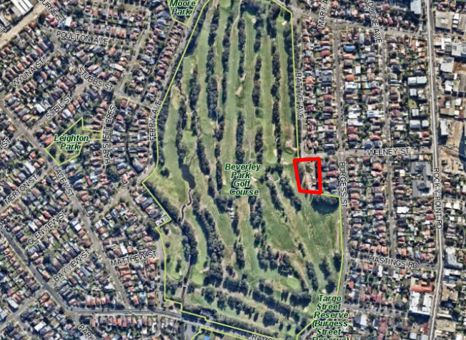
The location of the
development outlined in red
|
EXECUTIVE SUMMARY
1. The
subject development application (DA) has been lodged by Frank Bates on behalf
of Beverley Park Golf Club Limited, and seeks consent for demolition work and
the construction of a new maintenance building and staff amenities building, on
grade car parking, bin store area, tree removal and landscaping works to
replace the existing building within the Beverley Park Golf Course. As part of
the proposal, consent is also sought for the removal of six (6) trees.
2. The
key issues and considerations of the application are as follows:
· Council-owned
land – The land owner is the Council, the subject application is to
be determined by the Georges River Local Planning Panel (LPP) in accordance
with the Minister’s direction dated 23 February 2018.
· Contentious
development – The application is a contentions application, having
attracted 30 submissions from 18 submitters by way of objection as a result of
the notification of the DA. The application is required to be determined by the
LPP, given the submissions received exceed 10 outlined within the
Minister’s direction dated 23 February 2018.
· Acid sulfate
soils – The proposed works are within areas affected by Class 2 acid
sulfate soils, cl.6.1(2) of Kogarah Local Environment Plan (LEP) 2013
requires that an Acid Sulfate Soils Management Plan (ASSMP) or preliminary
assessment be undertaken for any works within Class 2 land and below natural
ground surface.
Works are
proposed below the natural ground surface, the requires assessment required by
cl.6.1(2) has not been submitted, and the application is unlikely to be
excluded from such a requirement under to cl.6.1(6) of the LEP.
Pursuant to
cl.6.1(3) of the LEP, consent must not be granted to the development as the
relevant documentation has not been prepared. Further, pursuant to Clause
9(1) of Greater Metropolitan Regional Environmental Plan No 2 - Georges River
Catchment, it has not been demonstrated that acid sulfate soils would not be
disturbed by the proposed works.
· Acoustic
Impacts – The proposal has the potential to generate acoustic impacts
on neighbouring residential properties, no acoustic assessment has accompanied
the application. In addition, there is no specific information provided
on the ongoing operations of the facility (no plan of management) to demonstrate
that the ongoing use of the premises will not create additional operational
acoustic impacts to the nearby premises, given the concentration of activity
proposed on the western side of the proposed building.
· Potential
contamination - The current fuel and chemical storage areas are most likely
to be contaminated to some extent and a Preliminary Site Investigation (PSI)
under the provisions of State Environmental Planning Policy 55 –
Remediation of Land.
· Waste
Management – the submitted waste management plan has not adequately
described the waste management procedures for the proposed development, and
there is an inconsistency between the plans and documentation provided.
3. The
subject application was originally notified for 14 days from 8 March 2018 to 22
March 2018; the original notification made reference to the incorrect
development, being DA2017/0471 which relates to proposed fencing for Beverly
Park Golf Course (BPGC). Subsequently, the application was renotified for 14
days from 19 March 2018 to 4 April 2018.
4. Upon
receiving amended plans, the application was renotified for 14 days from 23
April 2019 to 10 May 2019.
5. In
response to the three (3) notifications of the application a total of thirty
(30) submissions have been received from eighteen (18) submitters.
6. A
significant number of separate issues were raised, and responses to such
matters are contained within this planning assessment.
7. The
application has been assessed having regard to the matters for consideration
under Section 4.15 of the Environmental Planning and Assessment Act 1979 (the
Act), the provisions of the relevant State Environmental Planning Policies,
Local Environmental Plans and Development Control Plans.
8. Having
regard to the deficiencies in the information accompanying the application,
which includes acid sulfate soils, contamination, noise impacts, and waste
management procedures, it is not able to be concluded that the impacts of the
proposal will be appropriate in this sensitive location, and the subject DA has
therefore been recommended for refusal.
DESCRIPTION OF THE PROPOSAL
9. The
subject DA seeks consent for demolition work and the construction of a new
maintenance building and staff amenities building, on grade car parking, bin
store area, tree removal and landscaping works within the Beverley Park Golf
Course.
10. The
existing staff amenities building, which covers an area of approximately
150sqm, is to be demolished and replaced by a new maintenance and staff
amenities building covering an area of approximately 570sqm.
11. The
upgraded building will contain the following:
· Staff
lunchroom/kitchen;
· Toilets;
· Supervisors
Office;
· Workshop and
Machinery Store;
· Maintenance Garage
(including a fuelling bay and wash down bay);
· Fuel Storage Area;
· Pump Room; and
· Cart Storage Area.
12. External
works will consist of a verandah along the northern façade of the
building, bitumen paving to the area surrounding the new building, a bin
storage area, and a number of small garden beds scattered around the building.
The site will be provided with ten (10) formal car parking spaces.
13. Figure
1 below contains an extract of the site plan.
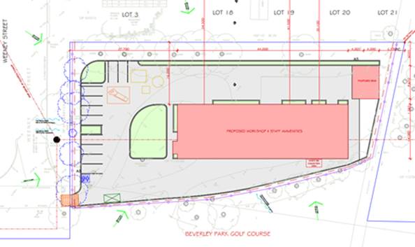
Figure
1 - An extract from the submitted
site plan
14. The
proposal seeks approval for the removal of six (6) trees, with replacement tree
planting included as part of the proposal.
HISTORY
15.
9
October 2017 Subject
development application lodged.
8 March 2017 Notification
of the subject application undertaken for a fourteen (14) day period.
This notification period was later extended until 4 April 2018.
6 August 2018 Amended
and additional information submitted to Council (arboricultural assessment,
mapping, land owner’s consent from the NSW Department of Industry –
Crown Lands and Water).
23 April 2019 Re-notification
of the subject application undertaken until 10 May 2019.
DESCRIPTION OF THE SITE AND
LOCALITY
16. The
subject application is located in a portion of the Beverley Park Golf Club
(BPGC) and will replace and enhance the existing facilities. The site has the
following description, and known as 87a Jubilee Avenue, Beverley Park. The
subject allotment being Lot 1, DP1115160, is located within the eastern portion
of BPGC where it borders Battye Avenue and Weeney Street. Five (5) residential
properties adjoin to the east of the allotment, being 8 Weeney and 43-49
Burgess Street.
17. The
BPGC consists of some 34 allotments of land generally bounded by Jubilee Ave
(northern side), Battye Avenue, Weeney Street, Burgess Street and Targo Road
(eastern side), Ramsgate Road (southern side), and a drainage channel adjacent
to Harslett Crescent, and Ferry Road (western side).
18. The
subject site comprises 34 irregularly-shaped allotments, which are listed and
shown as follows:
|
· Lot
161, DP 19098
|
· Lot
1, DP 1115160
|
· Lot
2, DP 723730
|
|
· Lot
1, DP 1115657
|
· Lot
1, DP 1122814
|
· Lot
3, DP 723730
|
|
· Lot
2, DP 1115657
|
· Lot
1, DP 1127867
|
· Lot
4, DP 723730
|
|
· Lot
1, DP 1115465
|
· Lot
1, DP 724240
|
· Lot
5, DP 723730
|
|
· Lot
1, DP 457030
|
· Lot
1, DP 1148376
|
· Lot
6, DP 723730
|
|
· Lot
1, DP 669359
|
· Lot
2, DP 1148376
|
· Lot
7, DP 723730
|
|
· Lot
1, DP 669358
|
· Lot
9, DP12389
|
· Lot
55, DP 3097
|
|
· Lot
1, DP 1115626
|
· Lot
10, DP12389
|
· Lot
56, DP 3097
|
|
· Lot
1, DP1114452
|
· Lot
2, DP 230426
|
· Lot
57, DP 3097
|
|
· Lot
2, DP 1114452
|
· Lot
7031, DP 93155
|
· Lot
58, DP 3097
|
|
· Lot
2, DP 1115160
|
· Lot
4, DP 230427
|
|
|
· Lot
1, DP 1122814
|
· Lot
1, DP 723730
|
|

Figure 2 -
Details of the lot and DP’s across the site
19. The
entire golf course has an area of approx. 23,300sqm (excluding encroachments on
public road reserves). The topography of the site is mostly level, with
some undulating sections where the site has been modified to incorporate
certain features (e.g. topographical features, golfing hazards, etc.).
Development on the site includes features and structures associated with the
BPGC, and includes (but is not limited to) the following:
· A small staff
amenities building;
· Site maintenance
facilities in the form of landscape material storage;
· Informal car
parking facilities;
· Club house;
· Golfing fairways,
tee-off areas, putting greens and associated features (i.e. sand bunkers); and
· Pathways and
associated site infrastructure.
20. Areas
of the site where golfing facilitates are located either contain structures
and/or are cleared, though areas between the fairways are heavily vegetated
with predominantly mature vegetation. The portion of the site containing the
proposed works is also largely cleared with the exception of mature vegetation lining
the boundary of this ‘portion’. A low ‘copper log’
fence traverses the boundary of the site where it adjoins Weeney Street and
Battye Avenue.
21. The
subject allotment is affected by flooding and Class 2 acid sulfate soils;
however, the LEP does not identify other significant environmental
considerations and/or hazards. The site does not contain a heritage item
and is not within a heritage conservation area; there are also no other
heritage items within the surrounding area.
ZONING
22. The
site is located within an RE1 Public Recreation zone, whilst the area directly
surrounding the site is zoned R2 Low Density Residential.
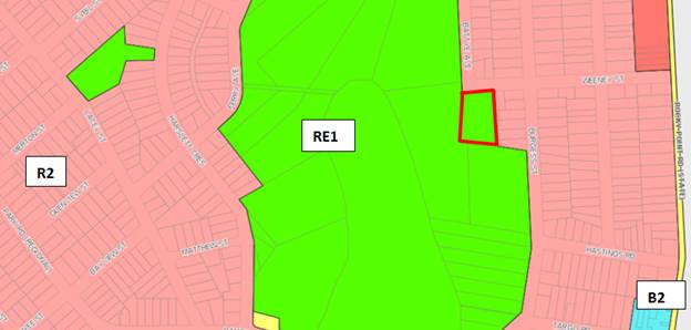
Figure 3 -
Development area outlined in red
APPLICABLE PLANNING CONTROLS
· Environmental
Planning and Assessment Act 1979 (the Act)
· Environmental
Planning and Assessment Regulation 2000 (the Regulation)
· Greater
Metropolitan Regional Environmental Plan No 2 – Georges River Catchment
· State
Environmental Planning Policy No 55 - Remediation of Land
· State Environmental
Planning Policy (Vegetation in Non-Rural Areas) 2017
· Kogarah Local
Environmental Plan (KLEP) 2012
· Kogarah
Development Control Plan (KDCP) 2013
PLANNING ASSESSMENT
23. The
site has been inspected and the proposed development has been assessed under
the relevant Section 4.15(1) "Matters for Consideration" of the
Act.
Environmental Planning
Instruments
State Environmental Planning
Policies
24. Compliance
with the relevant state environmental planning policies is detailed and
discussed in the table below.
Discussion on the SEPPs relevant
to the development
State
Environmental Planning Policy No 55 - Remediation of Land (SEPP 55)
25. A
review of the site history indicates that the subject site was vacant until the
1940s, after which time it was developed into (and continually operated as) a
golf club with associated development. This review also suggests that
land surrounding the subject site has also been continually used for
predominantly residential development during that period of time. However, it
is acknowledged that the site is likely to contain localised contamination due
to the existing diesel tank on the land. Accordingly, a Preliminary Site
Investigation (PSI) is required to be submitted with this application under
State Environmental Planning Policy – Remediation of Land.
26. The
applicant’s written response, dated 29 April 2019, indicates that they
had offered to meet Council on site for an inspection in order to address this
issue. However, a PSI, also known as a Stage 1 report, is a report that must be
prepared by an environmental scientist or someone similarly qualified and would
ordinarily be expected to be prepared in accordance with the Managing Land
Contamination Planning Guidelines, pursuant to SEPP 55. No information is
currently available to indicate that a PSI should be foregone for this
development.
27. As
the above information has not been provided as part of this application, it is
not possible to determine whether the proposal is suitable for the site, or
whether the proposal will have an adverse impact on the natural environment.
The DA in its current form will therefore not satisfy the relevant provisions
of SEPP 55.
State Environmental Planning Policy No 19—Bushland
in Urban Areas
28. While
the former Kogarah Local Government Area (LGA) is subject to the provisions of
this SEPP, and the concerns about large-scale tree clearing by objectors is
noted, ‘Bushland’ is defined by the SEPP as follows:
“bushland
means land on which there is vegetation which is either a remainder of the
natural vegetation of the land or, if altered, is still representative of the
structure and floristics of the natural vegetation.”
29. The
vegetation that is proposed to be removed from the site is not a remainder of
natural vegetation of the land, nor is it considered to be representative of
the native structure and floristics of the locality. As such, the SEPP is
not considered to be applicable to the subject DA.
State
Environmental Planning Policy (Vegetation in Non-Rural Areas) 2017
30. As
part of the application, six trees are proposed to be removed from the site to
accommodate the proposed development. Submitted information indicates that
replacement trees would be planted; however, the number of trees to replace
those being removed is unclear, noting that the landscape plan refers to
existing trees where they do not exist, whilst the proposed number of trees
stated does not match what is depicted on the plan.
31. Council’s
Tree Management Officer has reviewed the application and raised no objection to
the proposed tree removal, subject to conditions requiring amendments to the
landscape plan, including five (5) additional tree plantings. Tree management
conditions are recommended to protect trees that are to be retained. However,
given the other deficiencies of the proposal the application is recommended for
refusal.
Greater
Metropolitan Regional Environmental Plan No 2 – Georges River Catchment
32. The
site is within the area affected by the Greater Metropolitan Regional
Environmental Plan No 2 — Georges River Catchment. The proposed Concept
Stormwater Plan is considered to be consistent with Council's requirements for
the disposal of stormwater in the catchment. However, it is noted that
conditions of consent would require the submission of a Detailed Stormwater
Plan and supporting information of the proposed on-site stormwater management
system in accordance with ‘Water Management Policy, Kogarah Council,
August 2006’ prior to the issue of a Construction Certificate.
33. The
proposal would not have a foreseeable impact on river bank disturbance,
flooding, urban stormwater runoff and/or local water quality (subject to
conditions to the imposition of the aforementioned conditions). Whilst the
proposal would be mostly consistent with the provisions of the Plan, as
indicated within the assessment of the clause 6.1 (Acid Sulfate Soils) of the
LEP, insufficient information has been provided to demonstrate that there would
be no disturbance of acid sulfate soils, which are mapped by the LEP as
potentially being present on the subject site. Unless it can be
demonstrated that acid sulfate soils are not present/would not be disturbed by
the development, the proposal would therefore fail to satisfy clause 9(1) of
the Greater Metropolitan Regional Environmental Plan No 2 – Georges River
Catchment.
Draft Environmental Planning
Instruments
Draft
Remediation of Land SEPP
34. The
Department of Planning and Environment has announced a Draft Remediation of
Land SEPP, which will repeal and replace the current State Environmental Planning Policy No 55—Remediation of
Land.
35. The
main changes proposed include the expansion of categories of remediation work
which requires development consent, a greater involvement of principal
certifying authorities particularly in relation to remediation works that can
be carried out without development consent, more comprehensive guidelines for
Councils and certifiers and the clarification of the contamination information
to be included on Section 149 Planning Certificates.
36. Whilst the
proposed SEPP will retain the key operational framework of SEPP 55, it will
adopt a more modern approach to the management of contaminated land.
37. The subject site has a history of residential use and as such, site
contamination is not suspected. In this regard, no further assessment is
warranted with regards to site contamination.
Draft
Environment SEPP
38. The
Draft Environment SEPP was exhibited from 31 October
2017 to 31 January 2018.
39. This consolidated SEPP proposes to simplify the planning rules for a
number of water catchments, waterways, urban bushland, and Willandra Lakes
World Heritage Property.
· Changes proposed
include consolidating the following seven existing SEPPs:
· State
Environmental Planning Policy No. 19 – Bushland in Urban Areas
· State
Environmental Planning Policy (Sydney Drinking Water Catchment) 2011
· State
Environmental Planning Policy No. 50 – Canal Estate Development
· Greater
Metropolitan Regional Environmental Plan No. 2 – Georges River Catchment
· Sydney Regional
Environmental Plan No. 20 – Hawkesbury-Nepean River (No.2-1997)
· Sydney Regional
Environmental Plan (Sydney Harbour Catchment) 2005
· Willandra Lakes
Regional Environmental Plan No. 1 – World Heritage Property.
40. The
proposal is consistent with the provisions of this Draft Instrument given there
is no vegetation impacted by the proposed development.
Kogarah
Local Environmental Plan 2013
41. The
extent to which the proposal complies with the relevant standards of Local
Environmental Plan is outlined in the table below.
|
Clause
|
Standard
|
Proposed
|
Complies
|
|
Part 2
– Permitted or Prohibited Development
|
RE1 Public Recreation zone
|
The
proposal does not seek to change the existing use of the site, maintaining
the existing arrangements which provide for a staff amenities and maintenance
building which are already ancillary to the Beverley Park Golf Club.
A golf
club is a type of recreation facility (outdoor) which is permissible with
consent within the RE1 Zone.
|
Yes
|
|
RE1 zone
Objectives
|
Objectives
of the Zone
· To enable land to be used for public open space or
recreational purposes.
· To provide a range of recreational settings and
activities and compatible land uses.
· To protect and enhance the natural environment for
recreational purposes.
|
The
proposal is considered to meet the first two objectives of the RE1 zone by
providing services and facilities that support the operation of the BPGC
which provide recreational facilities.
However,
the DA includes insufficient information to demonstrate the proposal will be
consistent with the third objective of the zone. The development seeks
consent for a wash down area, fuel storage area, and fuel filling pad within
the proposed building.
The
applicant has failed to provide documentation that outlines the methodology
for managing fuel spills on the fuel filling pad, or details of how
the wash down area would capture pollutants in the soil and water run-off. It is also noted that site is also likely to contain
localised contamination due to the exiting diesel tank on site. Accordingly,
a Preliminary Site Investigation is required to be submitted with the DA
under State Environmental Planning Policy – Remediation of Land.
As the
above information has not been provided, as a result it is not possible to
determine whether the proposal will have an adverse impact on the natural
environment.
|
No
|
|
4.3 Height of Buildings
|
No standard applies.
However, adjoining sites have a
maximum building height of 9m.
|
The proposed building will have a
maximum height of 5m where the north-eastern most portion of the roof ridge
at 7.30 AHD is located above the existing ground level of 2.30 AHD.
|
Yes
|
|
4.4 Floor Space Ratio
|
No standard applies.
|
The proposed building contains a
gross floor area of approximately 550sqm, resulting a floor space ratio of
approximately 0.02:1 over the 23,300sqm lot.
|
Yes
|
|
4.5
Calculation of floor space ratio and site area
|
FSR and
site area calculated in accordance with Cl.4.5
|
Noted
|
N/A
|
|
5.10
Heritage conservation
|
|
The site
does not contain a heritage item and is not within a heritage conservation
area; there are no heritage items within the immediate vicinity of the
subject site.
Further,
the National Trust no longer identifies the site and/or surrounding area as being
part of a heritage conservation area. Heritage provisions therefore do
not apply to the site.
The site
is highly modified, and it is unlikely that items of indigenous heritage
would be present.
An
‘Extensive Search’ has also been undertaken using the AHIMS
database and identified no Aboriginal sites or places being located at the
subject site.
In the
event that the application could be approved, a condition could be applied
requiring that works cease if items are uncovered until the relevant authorities
have been consulted.
|
Yes
|
|
6.1 Acid
sulfate soils
|
(3) Development consent must
not be granted under this clause for the carrying out of works unless an acid
sulfate soils management plan has been prepared for the proposed works in
accordance with the Acid Sulfate Soils Manual and has been provided to the
consent authority.
|
The site
is affected by Class 2 acid sulfate soils, which pursuant to cl. 6.1(2)
requires that an Acid Sulfate Soils Management Plan be undertaken for “any
works below natural ground surface”. The submitted
documentation indicates that the following works would occur below natural
ground level:
· Excavation for the footings, which based on submitted
information would extend to approximately 600mm;
· Excavation (to an unknown depth) to enable the planting
of trees.
Neither
an ASSMP nor a preliminary assessment has been submitted. Pursuant to cl.
6.1(3) the consent authority cannot grant consent to the application unless
such documentation has been prepared.
With
regard to cl. 6.1(6), information has not been provided to demonstrate that
less than one (1) tonne of soil would be disturbed nor that it would have no
effect on lowering the watertable.
|
No
|
|
6.2
Earthworks
|
(3) Before granting development consent for
earthworks (or for development involving ancillary earthworks), the consent
authority must consider the following matters:
(a) the likely disruption of, or any
detrimental effect on, drainage patterns and soil stability in the locality
of the development,
(b) the effect of the development on the
likely future use or redevelopment of the land,
(c) the quality of the fill or the soil to be
excavated, or both,
(d) the effect of the development on the
existing and likely amenity of adjoining properties,
(e) the source of any fill material and the
destination of any excavated material,
(f) the likelihood of disturbing relics,
(g) the proximity to, and potential for
adverse impacts on, any waterway, drinking water catchment or environmentally
sensitive area,
(h) any appropriate measures proposed to
avoid, minimise or mitigate the impacts of the development.
|
Excavation
for the footings will reach a depth of approximately 600mm for the proposed
building in accordance with the submitted information.
Although
the extent of the proposed earthworks is relatively minor in nature, they are
located within an area affected by Class 2 acid sulfate soils, which pursuant
to cl. 6.1(2) requires that an Acid Sulfate Soils Management Plan be
undertaken for “any works below natural ground surface”.
Neither
an ASSMP nor a preliminary assessment have been submitted. Pursuant to
cl. 6.1(3) the consent authority cannot grant consent to the application
unless such documentation has been prepared.
|
No, refer above
|
|
6.3 Flood
planning
|
(3) Development consent must not be granted to
development on land to which this clause applies unless the consent authority
is satisfied that the development:
(a) is compatible with the flood hazard of the
land, and
(b) is not likely to significantly adversely
affect flood behaviour resulting in detrimental increases in the potential
flood affectation of other development or properties, and
(c) incorporates appropriate measures to
manage risk to life from flood, and
(d) is not likely to significantly adversely
affect the environment or cause avoidable erosion, siltation, destruction of
riparian vegetation or a reduction in the stability of river banks or
watercourses, and
(e) is not likely to result in unsustainable
social and economic costs to the community as a consequence of flooding.
|
The
proposed development has been assessed as being compatible with the flood
hazard of the land and is not likely to significantly affect flood behaviour.
The site
is affected by a 1 in 100 year ARI flood level of 1.80 AHD and a flood
planning level of 2.30 AHD. The proposed maintenance and staff amenities
complex have a minimum floor level above both these levels at 2.50 AHD,
whilst the entire portion of the site to be redeveloped is currently located
above the 1 in 100 year ARI flood level at 2.24 AHD.
The
proposal is not expected to significantly affect the environment or cause
avoidable erosion or siltation. It is not likely to result in any
unsustainable social and economic costs to the community as a consequence of
flooding.
|
Yes
|
|
6.4
– Foreshore Scenic Protection Area
|
Council cannot grant consent to the
carrying out of development on land within a Foreshore Scenic Protection Area
unless consideration has been made of the following:
“(3)(a) affect the natural environment,
including topography, rock formations, canopy vegetation or other significant
vegetation, and
(b) affect the visual environment,
including the views to and from the Georges River, foreshore reserves,
residential areas and public places, and
(c) affect the environmental
heritage of Hurstville, and
(d) Contribute to the scenic
qualities of the residential areas and the Georges River by maintaining the
dominance of landscape over built form.”
|
The site
is not within the foreshore area.
|
N/A
|
Development Control Plans
Kogarah Development Control Plan
2013
42. The
following is an assessment of the relevant prohibitions of Kogarah Development
Control Plan 2013. A detailed assessment of any notable issues and/or
non-compliances is contained within the main body of the report.
|
KDCP 2014
|
Proposed
|
Complies
|
|
Part B – General Controls
|
|
B2 Tree Management & Green
Web
|
|
1 Preservation of Trees and
Vegetation
|
|
1.1 Tree Management
(1) Compliance
with provisions of Clause 5.9 Preservation of Trees or Vegetation of KLEP
2012 must be achieved.
(2) Development
consent or a Council permit is required to ringbark, cut down, top, lop,
remove, injure or wilfully destroy any tree, whether on private or public
land, which has:
(i.) A
height greater than 3.5m, or
(ii.) A branch
spread exceeding 3 metres in diameter
(3) An
application to ringbark, cut down, top, lop, remove, injure or wilfully
destroy any tree shall contain the following information:
(i.) An
application on the prescribed form.
(ii.) The
written consent of the land owner unless the application is for pruning a
tree over the applicant’s property from a tree on the neighbouring
property.
(iii.) Details
as to the reasons for the pruning/removal of the tree.
(iv.) A
description of trees to be removed/pruned which includes:
· A site plan
showing trees and existing structures.
· The species type
– common and full scientific names if known.
· Approximate
height, trunk and canopy spread.
(4) Irrespective
of Clause (2) above, the following tree works do not require Council approval
when undertaken in accordance with relevant Australian Standards for the
pruning of amenity trees.
(i.) Trees
that have been declared an undesirable species and identified in List 1 below
may be removed or pruned without the need for development consent or a
Council permit, provided the tree has not been identified as possessing
heritage significance.
(ii.) Works
undertaken in response to an emergency by the State Emergency Service, Rural
Fire Service or another Authority.
(iii.) Trees
that require pruning in accordance with the Electricity Supply Act 1995.
(5) Council
will be satisfied that a tree is dead and/or a risk to life or property when:
(i.) The
tree is not within the Green Web habitat corridor or habitat reinforcement
corridor and a report by a qualified Arborist (minimum AQF Level 5
Arboriculture), including photographs of the tree, is submitted which
concludes that the tree is dead or dying; or
(ii.) It can be
proven that the pruning or removal work is the only reasonable option to
avoid an immediate threat of injury or damage to life or property and the
works were undertaken to the minimum extent necessary to manage that threat;
and
(iii.) Recorded
proof of that threat, in the form of a report (Tree Hazard Assessment (THA))
by a qualified Arborist (minimum AQF Level 5 Arboriculture) including
photographs of the tree and detailing the cause of danger. Where a trunk or
limb defect assessment is undertaken, strength loss calculations and cross
section mapping must be included in the THA.
(iv.) In
the event of tree removal, the arborist report is forwarded to Council
immediately following the removal.
(v.) In the
event of pruning, the arborist report is made available to Council on request
within three (3) months after the pruning works.
|
Tree protection and retention
conditions are recommended to ensure the retention of existing trees on site.
Refer to discussion of the
Vegetation SEPP for further information on tree removal.
|
Yes, subject to conditions if the
application was in a position to be supported.
|
|
2. Green Web Requirements
|
Subject to conditions, the proposal
will not be inconsistent with the Green Web Requirements.
|
Yes
|
|
B5 – Waste Management
& Minimisation
|
|
1. Waste Management Plan
(1) Submit a
Waste Management Plan with DAs involving:
· demolition;
· construction of
a new building(s); or
· change of use or
alterations/additions to existing premises (only when this would result in a
change of waste generation).
(2) Illustrate
on the DA plans/ drawings:
· the location and
space allocated for the storage of demolition and construction waste or
materials;
· waste collection
point(s) for the site; and
· path of access
for collection vehicles.
(3) Prepare the
Waste Management Plan in accordance with the requirements in Kogarah Waste
Not Plan 2012.
(4) Demonstrate
in the Waste Management Plan the use of second hand building materials and
recycled building products during building design and construction.
(5) Retain
records (including receipts) on site demonstrating recycling and lawful
disposal of waste.
|
A waste management plan has been
submitted with the application. However, the information is inadequate as
discussed within the report.
|
No
|
|
2. Waste and Recycling
Requirements
(1) All
development applications should have regard to the provisions of the Kogarah
Waste Not Plan 2012.
(2) Door widths
to waste/recycling storage rooms shall be a minimum of 1100mm and must be
wide enough to accommodate the largest chosen bin size for that development,
with a gap on either side of the bin of no less than 100mm.
(7) Waste
storage facilities must be easily accessible from residential units and
appropriately located to facilitate the removal of waste to the Council
collection point.
(8) Waste and
recycling storage areas must be visually and physically integrated into the
design of the development. Design elements such as fencing, landscaping and
roof treatments may be used to screen the waste and recycling storage area.
(10) Waste/recycling
storage areas must be designed and located to avoid adverse impacts on the
amenity of adjoining sites.
|
A waste storage area is provided
with a brick fence, measuring 7m in width, and up to approximately 2m in
height. This fence is located approximately 6m from the rear boundaries of 47
and 49 Burgess Street. The location of the facility is not appropriate as
discussed within the report.
|
No
|
|
B6 – Water Management
|
|
1. On site Water Management
& Stormwater Controls
To be in accordance with
Council’s Water Management Policy.
|
The stormwater design is supported
by Council’s Development Engineer Conditions recommended if the
application was to be supported.
|
Yes
|
|
2. Flooding and drainage
(1) Detention
storage is to be provided that is equal to or greater than the specified Site
Storage Requirements (SSR).
(2) Rainwater
tank installed to meet BASIX water conservation requirements will be given
credit for SSR purpose.
(3) Floor
levels, carparks, driveways and basements are to be designed to meet the set
guidelines.
(4) Drainage
easements servicing stormwater pipes and/or overland runoff from catchments
upstream of the development site are to be managed according to the
guidelines presented in the design practice note – Site Drainage and
Flood Management.
(5) Discharge
of stormwater runoff from a development site is to be undertaken in
accordance with the design practice note, Site Drainage and Flood Management
regarding direct discharge to kerb, discharge to a Council owned stormwater
conduit, discharge to natural areas, discharge through private property and
discharge within the development site.
(6) Habitable
floor levels are to have a minimum of 500mm freeboard above the 100 year ARI
flood level.
(7) Garage
levels are to be at or above the 100 year ARI flood level.
(8) Basements
are to be protected up to and including the 100 year ARI flood level.
(9) Driveways
and carports shall not be sited where the product of velocity and depth of
the overland flow exceeds 0.4sqm/s or the flow depth is above 300mm for the
100 year ARI flood.
(10) Alterations
and additions to existing buildings are permitted in flood affected areas
provided they substantially reduce the flood risk levels in relation to
property damage and personal safety.
(11) Developments
affected by flooding from main stream or channel bank overflows shall address
site evacuation, structural soundness of affected buildings and other risk
related issues as required by the NSW Floodplain Development Manual 2005. Any
alteration to existing surface levels for a designated overland flow
path/floodway is subject to written Council approval.
(12) Overland
flow paths/ floodways that are located outside the drainage easement for a
Council pipe should have easements or restrictions created for them.
|
The proposed floor levels of 2.50
AHD are above the flood planning level of 2.30 AHD. The entire portion of the
site to be redeveloped is also located above the flood planning level at 2.24
AHD and the car park is able to sit above this level.
|
Yes
|
|
B7 – Environmental
Management
|
|
1. Orientation: Building siting
and design
(1) Orient the
building, as far as possible, so that the longest side is on the east-west
axis.
(2) The main
facades of a building should be orientated towards the north, preferably
within a range of 30 degrees east and 20 degrees west of true north.
(3) Maximise
the number of windows on the northern face of the building.
(4) The use of
dark coloured roofing is discouraged unless solar cells are integrated into
the roof.
(5) If
development is of a commercial or industrial nature, design buildings to
ensure that as much of the floor area as possible is within 4 to 6 metres of
an external window. Office areas should, as a minimum be within 10 metres of
an external window to provide access to natural lighting.
(6) Minimise
glazing on the southern and western sides of the building.
|
The development is intended to be
provided within an area that currently is aligned in a north-south axis. The
proposed building maintains that orientation and this is appropriate in this
instance.
The high occupancy areas (staff
room etc) are located along the northern and western sides of the building
which are provided with openings.
|
Yes, subject to conditions if the
application was to be supported.
|
|
2. Energy efficiency in non
residential developments
(1) Development
is to be designed and constructed to reduce the need for active heating and
cooling by incorporating passive design measures including design, location and
thermal properties of glazing, natural ventilation, and appropriate use of
thermal mass and external shading, including vegetation.
(2) Lighting
provided as part of a development should be energy efficient, such as LED
lighting.
(3) Car parking
areas are to be designed and constructed so that electric vehicle charging
points can be installed at a later time.
|
Conditions
are able to be imposed requiring compliance with the energy efficiency
requirements contained within Section J of the Building Code of Australia
Conditions are also are also able
to require energy efficient lighting as well as requiring that the car
parking area be constructed so as to accommodate electric vehicle charging at
a later time.
|
Yes, subject to conditions if the
application was to be supported.
|
|
3. Water efficiency in non
residential developments
(1) All new
water fittings and fixtures such as showerheads, water tap outlets, urinals
and toilet cisterns, in all non-residential development, the public domain,
and public and private parks are to be the highest Water Efficiency Labelling
Scheme (WELS) star rating available at the time of development.
(2) Generally,
rainwater tanks are to be installed for all non-residential developments,
including major alterations and additions that have access to a roof form
from which rainwater can be feasibly collected and plumbed to appropriate end
uses.
(3) Generally,
water used for irrigation of public and private open space is to be drawn
from reclaimed water or harvested rainwater sources. Possible sources include
harvested stormwater, treated grey-water and wastewater and water from a
decentralised local network.
|
Conditions
are able to be imposed requiring the use of efficient water fittings in
accordance with the WELS star rating.
A rainwater tank is proposed as
part of the development.
No changes are proposed to any
existing irrigation arrangements.
|
Yes, subject to conditions if the
application was to be supported.
|
Key non-compliances
B5 –
Waste Management and Minimisation
43. The
application is accompanied by a written Waste Management Plan (WMP) as well as
an architectural plan titled ‘Soil and Waste Management Plan’,
which also features a written description of waste management arrangements. As
outlined within the discussion of the comments of Council’s Environmental
Health Officer (EHO), the application fails to properly describe the following
waste management arrangements:
· Storage of
chemical and liquid wastes (such as waste oil from maintenance of lawn mowers,
as well as empty chemical drums, etc). The WMP contains only details on the
‘removal of the grease sludge from tank adjacent to clubhouse’,
which is undertaken every 6 weeks, but the WMP does not describe how this will
be stored prior to collection.
· The methodology
for managing fuel spills on the fuel filling pad.
· Details of how the
wash down area will capture pollutants in the soil and water run-off.
44. Part
B5 states that waste storage areas must be designed and located to avoid
adverse impacts on the amenity of adjoining sites. The WMP indicates that bins
will be stored on the western side of the proposed building, but a bin
enclosure of approximately 60sqm and 2m in height, is proposed on the eastern
side of the development. The individual functions of the areas marked on the
landscape plan as ‘proposed bins’ and the area marked as
‘waste bin collection area’ is not clear. In addition, given the
western side of the development is shielded from the golf course by an
embankment, the bin storage area would be better located on the western side of
the development, to shield residential properties from any acoustic or odour
issues arising from the bins being located on the eastern side of the
development, only 6m from the rear boundary of the residential properties. It
would be expected that all waste storage within a golf course of this size,
could be arranged such that there is limited potential for impacts to adjoining
residential properties.
IMPACTS
Likely
impacts of the development
45. The
proposal seeks the use of the building from as early as 3:30am (according to
the ‘Machinery Acoustic’s Report’). Given the proximity to residential
properties, and the machinery to be used within the facility, there is the
potential that the proposal may result in unreasonable acoustic impacts.
46. Council
has requested that the applicant demonstrate that no unreasonable acoustic
impacts would be generated by the proposal. A ‘Machinery Acoustic’s
Report’, prepared by the Course Superintendent, was provided which listed
the sound pressure and sound power of each piece of machinery. The report also
provided readings from the use of the machinery in the location of the existing
maintenance shed.
47. However,
this was not prepared by a suitably qualified acoustic engineer and
Council’s Environmental Health Officer (EHO) has maintained that the
information provided to Council is not adequate to demonstrate that the
acoustic impacts will be appropriate in this location. A detailed discussion of
this matter is contained within the discussion of the EHO referral comments,
and given the information does not sufficiently model the acoustic impacts of the
proposal, this assessment cannot conclude that the impacts are appropriate in
this location.
48. Other
impacts aside from the noise are discussed throughout this report and include:
· No
acid sulfate soils management plan has been prepared in accordance with clause
6.1 of the LEP despite the site being affected by Class 2 acid sulfate soils,
and works being proposed below the natural ground surface.
· A PSI
has not been submitted with this application to enable consideration of the
localised contamination associated with the existing diesel tank on the site.
· Inadequate
waste management information has been provided, particularly in relation to
chemical and liquid storage.
Suitability
of the Site
49. Due
the aforementioned lack of information, a detailed analysis of the likely
expected impacts of the development cannot be undertaken. As such, it cannot be
concluded that the location of this development on this site is suitable for
the proposed development.
SUBMISSIONS
AND THE PUBLIC INTEREST
50. The subject
application was originally notified for 14 days from 8 March 2018 to until 22
March 2018, however it was later renotified from 19 March 2018 until 4 April
2018 due to an error within the original development description. In
response, 11 unique submissions were received from 15 signatories; 10
submissions objected to the proposal.
51. Upon
receiving amended plans, the application was renotified for 14 days from 23
April 2019 to 10 May 2019. In response, 9 unique submissions were received from
14 signatories; all the submissions objected to the proposal.
52. A
significant number of separate issues were raised by the objecting submissions,
and responses to such matters are contained within this planning assessment.
53. The
objecting submissions raised a significant number of issues. As a result,
such issues have been grouped and summarised as follows.
54. Deficient
documentation
The
documentation supporting the application was identified as being deficient by
multiple objectors. It was stated that the Architectural Drawings were
inaccurate whilst no SEE was provided.
55. Officer
Comment: Updated information such as an amended SEE and
Architectural Plans has been provided by the applicant. However, it is noted
that the package has been deemed as deficient with reference to there being not
Acoustic Report and the lack of a Preliminary Site Investigation under State
Environmental Planning Policy 55 – Remediation of Land and the non-provision
of an Acid Sulfate Soils Management Plan. The lack of such documentation
is considered vital in the assessment of this application; as a result this
shall form part of the reasons for refusal.
56. Inappropriate
bulk and scale
It has been
suggested that the proposed building is of an inappropriate bulk and scale,
thereby reducing the level of privacy enjoyed by the adjoining residential
properties, whilst blocking views to the existing golf course.
57. Officer
Comment: It is recognised that the proposed building is
significantly larger than the existing building with a footprint of
approximately 570sqm in comparison to the existing footprint of
approximately 140sqm. Although this represents a significant increase, it is
noted that the application has been redesigned to propose a greater setback (5m
to 16m) to the rear of adjoining residential properties, whilst also reducing
the maximum building RL by approximately 550mm. Furthermore, the land rises
where the adjoining dwelling houses are located, further reducing the impact of
the proposed building whilst the closest points between the building and
affected residences are between 34.5m and 41.5m away.
58. Accordingly,
it is not expected that the proposed building in its amended form will create
an unacceptable view impact, particularly from the first floor rear balconies
of 43 and 47 Burgess Street which have an RL greater than the roof RL of the
proposed building. The significant setbacks in conjunction with the reduced RL
of the building are considered to appropriately reduce the view impacts to the
rear adjoining neighbours, noting the views will largely remain of the open
green space and established vegetation. It should also be noted that
while the adjoining residences have an outlook onto the golf course, they do
not enjoy what the Land and Environment Court Planning Principles would
consider to be significant views (i.e. water views, foreshore areas, water/land
interface, views of iconic structures etc.). As such, view-sharing
principles (and any associated planning controls) would therefore not be
applicable to this planning assessment.
59. It
is not considered that there would be any significant impact to privacy of the
rear adjoining dwellings, noting the single storey nature of the proposal, lack
of habitable spaces from the eastern façade, and existing vegetation and
boundary fences which would largely screen views to the residential properties.
60. Noise
generation
Issues have
been raised regarding noise generation from the proposed development due to the
use of machinery, staff utilising the proposed verandah, and vehicular
movements associated with the 3:30am starts as stated within the
‘Acoustic Report’. The proposed hours of operation breaches those
permitted within the Beverley Park Plan of Management 2006.
61. Officer
Comment: The insufficient information provided within the submitted
acoustic information forms one of the reasons for refusal. Council’s
Environmental Health Officer has noted that the report fails to compare noise
from the current and future machinery to the background noise levels that will
occur within their proposed operating hours. Further, no supporting information
has been provided about the equipment or the methodology used to measure the
sound whilst noise produced from the proposed wash bay and machinery shed has
been excluded from the report where it has been recommended for inclusion.
62. It
is also noted that the orientation of the development which provides for the
wash down bay, cart storage area, and bin storage area from the eastern side of
the site is considered inappropriate due to the likely noise impacts it will
have on the adjoining residential areas.
63. Finally,
it is noted that specific hours cooperation were not listed within the original
SEE, and were only included within the updated SEE being 3.30am. Operational
hours that align with the Beverley Park Plan of Management 2006 could be
addressed through conditions of consent in the event that this application were
to be approved.
64. Chemicals
and fuels
Multiple
submissions raise concerns with the use of chemicals and fuels within close
proximity to residential development. It has been suggested that the proposed
building would be of an industrial nature and therefore not appropriate within
the RE1 Public Recreation Zone.
65. Officer
Comment: Council’s Environmental Health Officer has reviewed
the proposal and has found the information provided to be insufficient
regarding the handling of fuel. The application lacks detail regarding how they
propose to deal with fuel spills on the fuel filling pad, etc. The use of the
proposed development would support the operation of a land use that is
permissible within the RE1 zone; while the use of the building would be
permitted within the zone; specific operational elements are currently
considered to be unacceptable due to the lack of specific detailed information.
66. Inappropriate
location
It has been
asserted by multiple objectors that the subject site is inappropriate for the
proposed development as it is located within an area affected by flooding.
Submissions also indicate that the new building and hard stand areas would
increase the area of impervious surfaces and potentially worsen flooding
impacts within surrounding properties.
67. Officer
Comment: Council’s Development Engineer has assessed the
proposed development with reference to the Concept Stormwater Plan and its
partial location within the flood planning area. As per the referral response,
in the instance if the development were to be approved, a detailed stormwater
plan in conjunction with supporting information of the proposed on-site
stormwater management system would need to be submitted for Council approval;
such information would need to meet the requirements of Council’s Water
Management Policy and relevant Australian Standards. Further, any issues
regarding sedimentation and/or erosion could be addressed via conditions of
consent in the event that the proposal could be approved.
68. With
regard to flooding-related concerns, while the golf course is within a flood
prone area, the proposed building location would be situated outside of the
area affected by the 1 in 100 year flood level. The 2.5m AHD Finished Floor
Level (FFL) is also well above the 1.8m AHD 1 in 100 year flood level and 2.3m
AHD Probable Maximum Flood (PMF) level. The proposed development would
therefore not be adversely affected by, nor would it adversely affect flood
storage and/or behaviour during a 1:100 year flood event. Given that
adjoining residential allotments are also outside of areas affected by the 1 in
100 year flood level, it is also highly unlikely that the proposed development
would increase flooding risks to those adjoining sites during a 1:100 year
event.
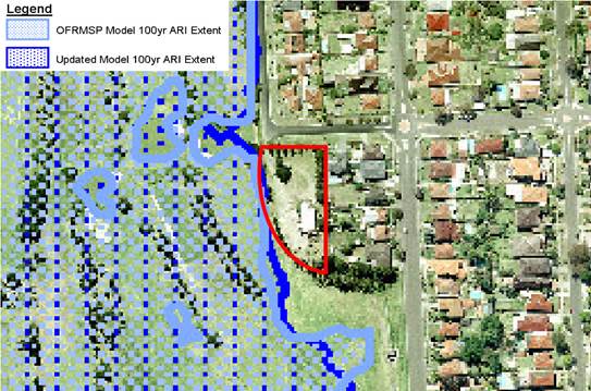
Figure 4 - Location
of the area of proposed works (outlined in red) within the 1 in 100 year ARI
flood extent
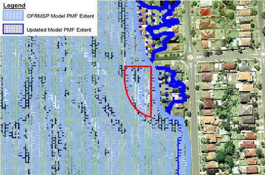
Figure
5 - Location of the area of proposed
works (outlined in red) within the PMF Extent
69. Heritage
area
A number of
submissions cite breaches of requirement to comply with the architectural
design guidelines within the Plan of Management 2006 which are based on the
criteria of the National Trust Heritage Conservation Area for Beverley Park.
70. Officer
Comment: The Plan of Management was drafted in 2006. Since
this time, the National Trust no longer identifies this area as being a
heritage conservation area. This is reflected by mapping within the LEP,
which does not show any heritage items and Heritage Conservation Areas within
the vicinity of the site (refer to Figure 5); it is noted that the heritage
mapping for the area around the subject site has not changed since the gazettal
of the LEP in 2013. The heritage provisions to which the submissions
refer are therefore not applicable to the subject site or the wider area more
generally.
Figure
6 - An extract from the heritage map
within Kogarah Local Environment Plan 2013, which shoes that neither the
subject site nor surrounding sites would be subject to heritage provisions
under Council’s LEP and/or planning policies.
71. Devaluing
properties
The visual
impact of the proposed development would devalue adjoining residential sites.
72. Officer
Comment: Impacts on property value are not a consideration for assessment
under Section 4.15 of the Environmental Planning and Assessment Act.
73. Economic
use of space
The proposed
building is not an appropriate economic use of public space when there are
better alternative locations for the building. The applicant could construct
the building in the middle of the golf course near existing water tanks so as
it is nowhere near residential homes.
74. Officer
Comment: The assessing planner is not able to comment on the
applicant’s rationale for situating the maintenance facilities in the
proposed location. With regard to flooding issues raised by submissions
however, it is noted that the centre of the site is significantly flood prone,
and is likely an inappropriate location for the placement the building and
would also impact the functionality and useability of the Golf Course.
75. Notification
The
notification of the proposed development is incorrectly notifying residents of
a different current DA at the golf course! It is strongly advised that to
resend this correctly to all residents and allow for a fair advertising period
to receive a response to assist you with your decision making in our
residential area.
76. Officer
Comment: The issue regarding an incorrect description of the
proposal was identified by Council; re-notification of the application was
undertaken with the correct description sent to residents, the additional
submissions received were considered as part of the assessment in this report.
REFERRALS
Council
Referrals
ENVIRONMENTAL
HEALTH OFFICER
77. Council’s
Environmental Health Officer (EHO) has raised a number of ongoing concerns in
relation to this application. The issues can generally be separated into the
following two (2) areas of concern: (1) acoustic impacts, and (2) contamination
and chemical storage. Each of these matters is discussed below.
Acoustic
Impacts
78. The
proposal seeks the use of the building from as early as 3:30am (according to
the Acoustic Report), and given the proximity to residential properties, and
the machinery to be used within the facility, there is potential for the
proposal to result in unreasonable acoustic impacts.
79. The
original application was not accompanied by an acoustic report; however, an a
‘Machinery Acoustic’s Report’ was later provided in a
response to a request from Council, although this was not prepared by a
suitably qualified acoustic engineer, nor prepared in accordance with any
accepted practice or standard. This report therefore exhibits a shortfall of
information, including:
· Background noise
levels for all times at which the onsite machinery would be in use, including
air conditioning units, pumps (such as those within the underground storage
tanks).
· Anticipated noise
output associated with the use of the machinery and wash down area.
80. The
applicant responded by indicating that given the models of the air conditioning
units had not yet been selected, and that it was intended that they would be
located on the western side of the building (away from residences) it was not
possible to provide information on the air conditioning units. However, it is
standard practice for an acoustic engineer to either make estimates, or set
realistic parameters, for the noise output associated with the air
conditioning, based on the specific characteristics of the proposal –
with any related recommendations able to be incorporated into the development
consent.
81. The
applicant responded with a short ‘Machinery Acoustic’s
Report’, which contained specifications of the machinery and a list of
readings recently taken from the existing shed. However, a thorough acoustic
report prepared by a suitably qualified acoustic engineer is necessary to
compare noise from the current/future machinery with background noise levels,
at the proposed operational times.
82. Although
not previously requested by Council, it is also considered that further information
is required on the ongoing operations of the facility (for instance within a
plan of management) to demonstrate that the ongoing use of the premises will
not create additional operational acoustic impacts to the nearby premises. The
proposal provides a long driveway along the eastern side of the premises, which
provides vehicular access to a wash down bay, cart storage area, and garbage
storage area. It is likely that these areas will be subject to a high level of
activity, would potentially spill out into the driveway area, and would ideally
be located on the western side of the proposed building, away from residential
areas.
83. Given
the potential impacts to neighbouring properties, the application is unable to
be approved without this information, and is subsequently recommended for
refusal.
Contamination
and Chemical Storage
84. The
application seeks a wash down bay within the maintenance garage.
Council’s EHO sought further information about the planned wash down
area, including the specific dimensions of the area, and details of how the
wash down area would capture pollutants in the soil and water run-off.
Council’s EHO also indicated that the applicant should contact Sydney
Water to determine whether or not a trade waste agreement would be necessary.
85. The
current plans indicate that the Wash Down Bay would have dimensions of 5m x 5m.
The applicant indicated that they had contacted Sydney Water, and as of 29
April 2019 had not received a response. In any event, conditions could be
imposed to require that this consultation to be carried out prior to the
commencement of works. The information in relation to the soil and water
run-off to the wash down area remains outstanding. Furthermore, the waste
management plan does not outline the methodology for managing fuel spills on
the fuel filling pad and this information also remains outstanding.
86. Council
had also requested plans and information in relation to the storage of chemical
waste, fuel storage, and liquid waste storage (such as waste oil from
maintenance of lawn mowers, as well as empty chemical drums, etc). The
applicant indicated that these will be stored in the same location as they are
currently stored, indicated to be in the middle of the course, with waste oils
to be stored and collected by a waste company on a monthly basis (although the
WMP indicates that this will be every 6 weeks). However, the current fuel and
chemical storage areas are most likely to be contaminated to some extent and a
Preliminary Site Investigation (PSI) under the provisions of State
Environmental Planning Policy 55 – Remediation of Land needs to be
submitted in support of this application.
87. The
applicant’s written response, dated 29 April 2019, indicates that they
had offered to meet Council on site for an inspection in order to address this
issue. However, a PSI, also known as a Stage 1 report, is a report that must be
prepared by an environmental scientist or someone similarly qualified and would
ordinarily be expected to be prepared in accordance with the Managing Land
Contamination Planning Guidelines, pursuant to SEPP 55. No information is
currently available to indicate that a PSI should be foregone for this
development.
88. Additionally,
the fact that the location of the tanks is unchanged is of little bearing on
this matter, given that no approval of the tanks is known to exist.
TREE
MANAGEMENT OFFICER
89. Council’s
Tree Management Officer (TMO) had initially requested the submission of a
detailed landscaped plan. This landscape plan was later provided in April 2019;
however, the landscape scheme was deemed to be inadequate and further concerns
were raised by Council.
90. Should
the application be approved, Council’s TMO recommends that a condition be
imposed requiring the following amendments:
a) The
proposed eastern concrete driveway be a minimum 8.5m away from the boundary
fence facing the neighbours. This is to ensure the driveway is no closer than
the drip line of the outer canopy of the existing trees
b) An
additional five (5) trees shall be planted. Four (4) trees of species, Lophostemon
confertus at 75 litre pot/ bag size along the eastern fence line to fill
the voids of where there are no trees, with one different tree being planted
within the front of the proposed building, lawn area, north.
c) The
one tree planted within the lawn area, species selection from Hurstville DCP,
Appendix 1, 5 Recommended species for Landscaping, Indigenous trees, all wards
and be able, be of minimum 75 litre pot/ bag size and be able to reach a height
at maturity of nine (9) metres.
d) The
proposed tree and plant species, pot/ bag size and quantities of plants shall
be in accordance with the proposed plant schedule upon the landscape plan. If
plant species, pot/ bag size and quantities cannot be sourced, Council shall be
contacted for alternatives.
e) All
trees proposed upon the approved landscape plan shall comply with AS 2303
– 2018, Tree Stock for Landscape use and NATSPEC Specifying Trees: a
guide to assessment of tree quality (2003), and be planted and maintained in
accordance with Councils standard specification.
f) If
the planted trees and plants are found to be faulty, damaged, dying or dead
within twelve (12) months of planting then they must be replaced with the same
species. If the trees are found dead before they reach a height where they are
protected by Councils Tree Management Controls, they must be replaced with the
same species and pot/bag size.
g) A
certificate of compliance for the planting of all trees and shrubs proposed for
the site. An AQF 5 Horticulturist shall be engaged and in writing certify that
all trees have been planted as per landscape plan and specifications and
forwarded to the PCA – Principal Certifying Authority.
91. The
recommended conditions require that the plans be amended prior to the issue of
a Construction Certificate and that all works be completed prior to the issue
of an Occupation Certificate. These conditions would be sufficient to properly
address the issues relating to the inconsistent information within the
application package, particularly noting that five (5) additional
plantings are required (on top of those already proposed), whereas the proposal
seeks the removal of only six (6) trees.
92. Conditions
are also recommended relating to the retention and protection of existing
trees.
DEVELOPMENT
ENGINEER
93. Council’s
Development Engineer raised no objection to the proposal, subject to the
imposition of appropriate conditions. It was also suggested that the
following advisory note be added to any development consent issued for this
development:
The property is
identified as flood liable in the Beverley Park Overland Flow Risk Management
Study and Plan 2007 and as such Flood Related Development Controls apply. The
Flood Planning Level (FPL) is identified at 2.3m (AHD) and this includes a
freeboard of 500 mm. The 1 in 100 flood year level is identified at 1.8m (AHD).
The floor levels of the development are above the FPL and the development is
not within the defined 1 in 100 year flood extents.
External
94. No
external referrals were required for this application
CONCLUSION
95. The
application has been assessed having regard to the matters for consideration
under Section 4.15 of the Act, the provisions of the relevant State Environmental
Planning Policies, Local Environmental Plans and Development Control Plans. The
application seeks approval for demolition work and the construction of a new
maintenance building and staff amenities building, on grade car parking, bin
store area, tree removal and landscaping works to replace the existing building
within the Beverley Park Golf Course.
96. For the reasons
outlined within the recommendation below, the DA has been recommended for refusal.
DETERMINATION AND STATEMENT OF
REASONS
97. THAT
pursuant to Section 4.16(1) of the Environmental Planning and Assessment
Act, 1979, as amended, the Georges River Planning Panel refuses development
consent to Development Application No. DA20170472 for demolition work and the
construction of a new maintenance building and staff amenities building, on
grade car parking, bin store area, tree removal and landscaping to replace the
existing building within the Beverley Park Golf Course within the lot known as
Lot 1 DP1115160 and known as 87a Jubilee Avenue, Beverley Park, for the
following reasons:
1. The
proposal is inconsistent with the provisions of State Environmental Planning
Policy No 55 – Remediation of Land, as there is reasonable evidence to
suggest that the land may be contaminated and a preliminary site investigation
has not been provided (Section 4.15(1)(a)(i) of the Environmental
Planning and Assessment Act 1979).
2. The
proposal is inconsistent with the provisions of Greater Metropolitan Regional
Environmental Plan No 2 - Georges River Catchment, as it has not been
demonstrated that acid sulfate soils would not be disturbed by the proposed
works (Section 4.15(1)(a)(i) of the Environmental Planning and
Assessment Act 1979).
3. The
proposal is inconsistent with the third objective of the RE1 Public Recreation,
pursuant to clause 2.3 of Kogarah Local Environment Plan 2013 (Section 4.15(1)(a)(i)
of the Environmental Planning and Assessment Act 1979).
4. The
proposal seeks to undertake works below the natural ground surface within Class
2 acid sulfate soils land, but has not been accompanied by an acid sulfate
soils management plan as required by clause 6.1 of the Kogarah Local
Environmental Plan 2012 (Section 4.15(1)(a)(i) of the Environmental
Planning and Assessment Act 1979).
5. Pursuant
to the provisions of Section 4.15(1)(a)(iii) of the Environmental Planning and
Assessment Act 1979, the proposed development does not satisfy the following
parts of the Kogarah Development Control Plan 2013:
a) B5
– Waste Management and Minimisation.
6. It
has not been demonstrated that the acoustic impacts of the proposed development
will not interfere with the amenity of the nearby residential properties
(Section 4.15(1)(b) of the Environmental Planning and Assessment act 1979).
7. It
has not been demonstrated that the site is suitable for the proposal (Section
4.15(c) of the Environmental Planning and Assessment act 1979).
8. Given
that the impacts associated with the proposal have not been demonstrated, and
that a detailed assessment is unable to be undertaken due to a lack of
information, the proposal is not considered to be in the public interest
(4.15(e) of the Environmental Planning and Assessment act 1979).
ATTACHMENTS
|
Attachment ⇩1
|
Amended - Site Evaluation Plan- Beverley Park Golf Course - 87A
Jubilee Ave Beverley Park
|
|
Attachment ⇩2
|
Amended - Elevations and Sections - Beverley Park Golf
Course - 87A Jubilee Ave Beverley Park
|
|
Attachment ⇩3
|
Amended - Landscape Plan- Beverley Park Golf Course -
87A Jubilee Ave Beverley Park
|
|
Georges
River Council - Georges River Local Planning Panel (LPP) - Thursday, 18 July
2019
LPP021-19 87a Jubilee Avenue Beverley Park (Beverley
Park Golf Club)
[Appendix
1] Amended - Site
Evaluation Plan- Beverley Park Golf Course - 87A Jubilee Ave Beverley Park
|
Page 97
|
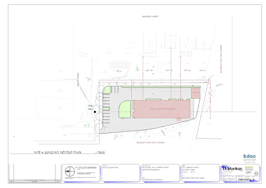
|
Georges
River Council - Georges River Local Planning Panel (LPP) - Thursday, 18 July
2019
LPP021-19 87a Jubilee Avenue Beverley Park (Beverley
Park Golf Club)
[Appendix
2] Amended - Elevations
and Sections - Beverley Park Golf Course - 87A Jubilee Ave Beverley Park
|
Page 98
|
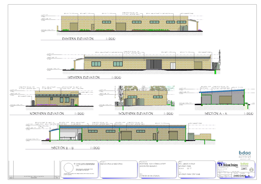
|
Georges
River Council - Georges River Local Planning Panel (LPP) - Thursday, 18 July
2019
LPP021-19 87a Jubilee Avenue Beverley Park (Beverley
Park Golf Club)
[Appendix
3] Amended -
Landscape Plan- Beverley Park Golf Course - 87A Jubilee Ave Beverley Park
|
Page 99
|
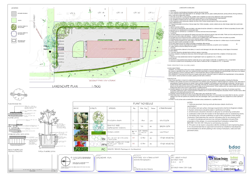
|
Georges
River Council – Local Planning Panel Thursday, 18
July 2019
|
Page 110
|
REPORT TO GEORGES RIVER COUNCIL
LPP MEETING OF Thursday, 18 July 2019
|
LPP Report No
|
LPP022-19
|
Development Application No
|
DA2018/0291
|
|
Site Address & Ward Locality
|
2 Dardanelles Street Mortdale
Blakehurst Ward
|
|
Proposed Development
|
Demolition of the existing
structures, tree removal and construction of a new two storey detached dual
occupancy development including front fence, provision of services and
landscaping works
|
|
Owners
|
T Hindi and C Hindi
|
|
Applicant
|
M Cubed Design
|
|
Planner/Architect
|
M Cubed Design – Planner and
Designer
|
|
Date Of Lodgement
|
17/07/2018
|
|
Submissions
|
7 objecting to the proposal (2
duplicates)
|
|
Cost of Works
|
$748,457.00
|
|
Local Planning Panel Criteria
|
The land owner is a relative of a
Councillor
|
|
List of all relevant s.4.15
matters (formerly s79C(1)(a))
|
Environmental Planning and
Assessment Regulations 2000, Greater Metropolitan Regional Environmental Plan
No 2 - Georges River Catchment, State Environmental Planning Policy
(Infrastructure) 2007
State Environmental Planning Policy
No 55 - Remediation of Land, State Environmental Planning Policy (Building
Sustainability Index: BASIX) 2004, State Environmental Planning Policy
(Vegetation in Non-Rural Areas) 2017, Draft Environment State Environmental
Planning Policy, Biodiversity Conservation Act 2016
Kogarah Local Environmental Plan
2012, Kogarah Development Control Plan 2013
|
|
List all documents submitted
with this report for the Panel’s consideration
|
Architectural plans
Landscape plan
|
|
Report prepared by
|
Contract Planner
|
S
|
Recommendation
|
THAT the application be approved in accordance with the
conditions included in the report.
|
|
|
Summary of matters for
consideration under Section 4.15
Have all recommendations in relation
to relevant s4.15 matters been summarised in the Executive Summary of the
assessment report?
|
Yes
|
|
Legislative clauses requiring
consent authority satisfaction
Have relevant clauses in all
applicable environmental planning instruments where the consent authority
must be satisfied about a particular matter been listed and relevant
recommendations summarised, in the Executive Summary of the assessment
report?
|
Yes
|
|
Clause 4.6 Exceptions to
development standards
If a written request for a
contravention to a development standard (clause 4.6 of the LEP) has been
received, has it been attached to the assessment report?
|
Not
Applicable
|
|
Special Infrastructure
Contributions
Does the DA require Special
Infrastructure Contributions conditions (under s7.24)?
|
Not
Applicable
|
|
Conditions
Have draft conditions been provided
to the applicant for comment?
|
No,
however they will be available when the report is published.
|
|
Site Plan
Figure
1: Subject site outlined in red
|
Executive Summary
Proposal
1. Council is in receipt of a development application
(DA2018/0291) proposing demolition of the existing structures, tree
removal and construction of a new two (2) storey detached dual
occupancy development including front fence, provision of services and
landscaping works at 2 Dardanelles Street Mortdale, known as Lot 1 in DP
1223266.
2. The proposed dual occupancy is configured such that
Dwelling 1 has an independent entry and driveway accessed from Dardanelles
Street, and Dwelling 2 has an independent entry and driveway accessed from
Grove Avenue. It is acknowledged the existing dwelling on site is oriented to
the secondary street, Grove Avenue.
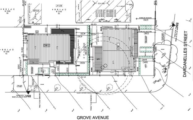
Figure
2 – Proposed site plan
Site and
Locality
3. The
site is located on the south eastern side of Dardanelles Street. A weatherboard
dwelling with tiled roof is oriented to Grove Avenue, together with an attached
metal carport, detached metal shed together with hard surfaces occupy the site.
4. The
proposal includes the demolition of the existing structures and construction of
a new two (2) storey detached dual occupancy development including front fence,
provision of services and landscaping works.
5. The
site falls approximately 3.5m from the south eastern corner of Grove Avenue to
the north western corner of Dardanelles Street. There are two (2) mature
tree species located within the property boundary which are proposed to be
removed. A total of five (5) species are located along the nature strip, four
(4) of which are proposed to be retained and one (1) to be removed to
accommodate the new driveway access in Grove Avenue.
6. To
the west is a two storey (2) brick house with tiled roof plus a detached brick
shed and swimming pool in the rear yard. To the rear is a single storey cottage
that fronts Princes Street with detached outbuildings accessed via Grove
Avenue.
7. Dardanelles
Street and the immediate locality comprise various low density residential
forms, with the Penshurst Conservation Area opposite the subject site, fronting
Grove Avenue.
Zoning and
Permissibility
8. The
site is zoned R2 Low Density Residential in accordance with the Kogarah Local
Environmental Plan 2012. The proposed development is defined as a dual
occupancy which is a permissible use in the zone and satisfies the objectives
of the zone referenced below:
• To provide for the housing needs of
the community within a low density residential environment.
• To enable other land uses that
provide facilities or services to meet the day to day needs of residents.
Figure
3 - Zoning map extract from the
KLEP2012 - Site outlined in red
Submissions
9. In
accordance with the public notification provisions of the development control
plan, the application was placed on neighbour notification for a period of
fourteen (14) days. Seven (7) submissions were received to the original DA
notification (noting that two (2) of the submissions were duplicates).
The
issues of concern raised relate to:
• Adverse
impact on the Conservation Area;
• Overshadowing;
• Streetscape;
• Setbacks;
• Out
of character, dual occupancies and subdivision should not be supported;
• Trees;
• Driveway
access from Grove Avenue; and
• Not
compliant with lot frontage.
A detailed
assessment of the submissions received are summarised and addressed in full
later in this report.
Referrals
10. The
DA was referred to a number of officers within Council, and as a result,
responses were generally supportive of the application as discussed in the body
of this report.
Reasons for
Referral to the Local Planning Panel
11. Based
on Item 1.e. of Schedule 1 of the Local Planning Panels referral criteria for
development applications, the application is referred to the Georges River
Local Planning Panel as the owner of the land is a relative of a Councillor.
Conclusions
12. The
application has been assessed having regard to the Matter for Consideration
under Section 4.15 of the Environmental Planning and Assessment Act 1979,
the provisions of the relevant State Environmental Planning Policies, and in
particular against the requirements of the relevant Kogarah Local Environmental
Plan (LEP) 2012 and Kogarah Development Control Plan (DCP) 2013. The proposal
generally complies, with sufficient justification provided for any variations.
13. The
proposal is considered satisfactory when assessed against the applicable
planning controls and it is recommended for approval subject to conditions.
Report in Full
DESCRIPTION OF
THE PROPOSAL
14. Demolition
of the existing structures, tree removal and construction of a new two storey
detached dual occupancy development including front fence, provision of
services and landscaping works at property 2 Dardanelles Street Mortdale.
15. Further details of the proposal are as follows:
Demolition – The
proposal consists of the demolition of existing structures and removal of
selected trees.
Proposed Dwelling 1
Ground floor –
Entry porch, study, lounge room, dining, kitchen, laundry, powder room, with
rear alfresco area including BBQ area, internal access stairs and double garage
access from Dardanelles Street.
First Floor –
Four (4) bedrooms, master with walk through robe and ensuite, bathroom, balcony
off the master bedroom facing Dardanelles Street and rumpus.
Proposed Dwelling 2
Ground floor –
Entry porch, study, laundry, power room, kitchen, dining, lounge room, front
balcony, rear alfresco, internal stairs and attached single garage.
First Floor –
Four (4) bedrooms, master with walk-in robe and ensuite, bathroom, balcony off
the master facing Grove Avenue and rumpus.
Landscaping –
Removal of two (2) trees within the site and one (1) tree within the public
domain along Grove Avenue. It is noted that one (1) tree within the site is
identified as a threatened and endangered species. A Flora and Fauna
Assessment Report, prepared by a suitably qualified ecologist, has been
summarised and addressed in full later in this report.
HISTORY
16. A
determination made under DA/237/2015 (former Kogarah) dated 26 November 2015,
for the demolition of existing structures and boundary realignment, was
activated through a subdivision certificate approval SC/1005/2015 (former
Kogarah) dated 19 February 2016, although the demolition has yet to be
initiated, the consent remains active.
17. The application was submitted on 17 July 2018.
18. The application was placed on exhibition, with the last
date for public exhibition being 24 August 2018, a total of seven (7)
submissions received, two (2) submissions were duplicate submissions.
19. Applicant was requested to address the non-compliant
setbacks.
20. Applicant submitted revised plans 11 October 2018.
21. Applicant was requested to engage an ecological
consultant to carry out a concise assessment of the proposal removal of a
threatened and endangered species, within the property boundary along the
secondary street, Grove Avenue 13 December 2018.
22. Desktop Flora and Fauna Assessment submitted via
applicant 14 February 2019.
23. Referral made to Council’s Parks and
Recreation/Parks and Waterways Department for assessment 14 February 2019.
24. Applicant was requested to provide an amended Flora and
Fauna Assessment Report that included findings from an inspection of the site
21 March 2019.
25. An amended Flora and Fauna Assessment Report was
submitted to Council on 18 June 2019.
DESCRIPTION OF THE SITE AND LOCALITY
26. The subject site is formally known as Lot 1 in DP 1223266 known as 2
Dardanelles Street Mortdale with an overall site area of 650.87sqm. The site
contains a weather board dwelling with tiled roof, an attached metal carport
and existing mature species oriented to Grove Avenue.
APPLICABLE PLANNING CONTROLS
Statutory consideration
ENVIRONMENTAL
PLANNING AND ASSESSMENT ACT 1979
State
Environmental Planning Policies
Compliance with
the relevant state environmental planning policies is detailed below.
Greater
Metropolitan Regional Environmental Plan No 2 – Georges River Catchment
27. All stormwater from the proposal will be treated in
accordance with Council’s Water Management Policy and satisfy the
relevant provisions of the above state policy.
State
Environmental Planning Policy (Infrastructure) 2007
28. In accordance with Clauses 101 and 102 of the State
Environmental Planning Policy (Infrastructure) 2007, the site is not located
where it is deemed to be affected by significant noise levels associated with
traffic.
State
Environmental Planning Policy No 55 - Remediation of Land
29. SEPP 55 aims to promote the remediation of contaminated
land in order to reduce the risk of harm to human health or any other aspect of
the environment.
30. Clause 7 requires contamination and remediation to be
considered in determining a development application. The consent authority must
not consent to the carrying out of development on land unless it has considered
whether or not the land is contaminated.
31. The site has a history of
residential uses and as such, site contamination is not suspected. In this
regard, no further assessment is warranted with regards to site contamination.
State
Environmental Planning Policy (Building Sustainability Index: BASIX) 2004
32. BASIX
Certificates have been issued for the proposal and the commitments required by
these certificates have been satisfied.
State Environmental Planning Policy (Vegetation in Non-Rural Areas)
2017
33. The
Vegetation SEPP regulates clearing of native vegetation on urban land and land zoned for environmental conservation/management that
does not require development consent.
The
Vegetation SEPP applies to clearing of:
a) Native
vegetation above the Biodiversity Offset Scheme (BOS) threshold where a
proponent will require an approval from the Native Vegetation Panel established
under the Local Land Services Amendment Act 2016; and
b) Vegetation
below the BOS threshold where a proponent will require a permit from Council if
that vegetation is identified in the council’s development control plan
(DCP).
34. The
Vegetation SEPP repeals clause 5.9 and 5.9AA of the Standard Instrument -
Principal Local Environmental Plan with regulation of the clearing of
vegetation (including native vegetation) below the BOS threshold through any
applicable DCP.
35. The
development proposes the removal of a species listed in the Biodiversity
Conservation Act 2016 No 63, under Part 2 Endangered ecological
communities. The Sydney Turpentine-Ironbark Forest (as described in the
determination of the Scientific Committee under Division 5 of Part 2 of the
Threatened Species Conservation Act 1995 No 101) is located within the building
envelope.
36. A
Flora and Fauna Assessment Report has been prepared by an ecological
consultant, listed in the register of Accredited Assessor Public Register as
provided by the NSW Department of Local Land Services. A test of significance
of the subject species was prepared as part of the assessment carried out and
the following conclusion reached:
“Following the Ecological site assessment and
associated 5-Part Test of Significance pursuant to section 7.3 of the BC Act
Narla were satisfied that the proposed development will not have a significant
ecological impact on any EEC or the two potentially occurring threatened fauna
species.
Loss of native tree canopy (i.e. loss of one isolated tree)
can be mitigated through replacement planting with two trees at the rear of the
property and/or on the nature strip adjoining.”
37. In
accordance with the EP&AA and Biodiversity Conservation Act requirements
for consideration, the report outlined:
· “The
species being a mature indigenous tree, a Turpentine (Syncarpia glomuifera)
· No fauna species were observed during the ecologist site
visit.
· The Turpentine tree was identified as having poor quality
habitat, only one (1) small hollow (<5cm diameter) and two (2) decorticating
bark, which could be temporarily utilised by locally occurring fauna such as
microbats.
· No threatened species breeding habitat was found on the
site.
· Office of Environment and Heritage NSW (OEH 2016a; 2016b) Native
Vegetation of the Sydney Metropolitan Area mapping indicates the presence of no
PCT within the Subject Site. The subject Site is currently classified as
Urban/Exotic/Native by OEH, to which no PCT can be assigned.
· Historically the vegetation within the Subject Site may
have been representative of “PCT 1776 Coastal Enriched Sandstone Dry
Forest”. However, processes including historic clearing, urbanisation and
weed invasion have degraded the local environment surrounding the Subject Site.
· The vegetation present on the subject site does not
constitute any known threatened ecological community listed under NSW or
commonwealth legislation.”
38. The
report has been reviewed by Council and it is considered that despite the tree
having adapted to the surrounding built environment over time, and the existing
dwelling being built in close proximity to the tree, its removal is warranted,
subject to replacement planting, as the tree has been assessed as is in decline
and with a tree protection zone of over 14m, any proposal upon that size
allotment would adversely impact tree.
39. In
this regard, the provisions of this SEPP are considered to be met.
Draft Environment State Environmental Planning Policy
Draft
Remediation of Land SEPP
40. The
Department of Planning and Environment has announced a Draft Remediation of
Land SEPP, which will repeal and replace the current State Environmental Planning Policy No 55—Remediation of
Land.
The main changes
proposed include the expansion of categories of remediation work which requires
development consent, a greater involvement of principal certifying authorities
particularly in relation to remediation works that can be carried out without
development consent, more comprehensive guidelines for Councils and certifiers
and the clarification of the contamination information to be included on
Section 149 Planning Certificates.
Whilst the proposed SEPP will retain the key
operational framework of SEPP 55, it will adopt a more modern approach to the
management of contaminated land.
The
subject site has a history of residential use and as such, site contamination
is not suspected. In this regard, no further assessment is warranted with
regards to site contamination.
Draft
Environment SEPP
41. The
Draft Environment SEPP was exhibited from 31 October 2017 to 31 January 2018.
This consolidated SEPP proposes to simplify the
planning rules for a number of water catchments, waterways, urban bushland, and
Willandra Lakes World Heritage Property.
· Changes proposed
include consolidating the following seven existing SEPPs:
· State
Environmental Planning Policy No. 19 – Bushland in Urban Areas
· State
Environmental Planning Policy (Sydney Drinking Water Catchment) 2011
· State
Environmental Planning Policy No. 50 – Canal Estate Development
· Greater
Metropolitan Regional Environmental Plan No. 2 – Georges River Catchment
· Sydney Regional
Environmental Plan No. 20 – Hawkesbury-Nepean River (No.2-1997)
· Sydney Regional
Environmental Plan (Sydney Harbour Catchment) 2005
· Willandra Lakes
Regional Environmental Plan No. 1 – World Heritage Property.
The proposal is
consistent with the provisions of this Draft Instrument given there is no
vegetation impacted by the proposed development.
Planning
Assessment
42. The
site has been inspected and the proposed development has been assessed under
the relevant Section 4.15(1) Matters for Consideration under the Environmental
Planning and Assessment Act 1979.
Environmental Planning Instruments
Kogarah Local
Environmental Plan 2012
43. The
provisions of this local environmental plan are relevant to the proposal. The
extent to which the proposal complies with the relevant standards
of Kogarah Local Environmental Plan 2012 (KLEP2012) is outlined in
the table below.
|
Clause
|
Provision
|
Proposed
|
Complies
|
|
1.2 – Aims of the Plan
|
In accordance with Clause 1.2 (2)
|
The development is consistent with
the aims of the plan.
|
Yes
|
|
1.4 - Definitions
|
“dual occupancy”
|
The proposed development meets the
relevant definitions.
|
Yes
|
|
2.3 Zone objectives and Land Use
Table
|
The site is within
the R2 Low Density Residential zone. Development for
the purpose of a ‘dual occupancy’ may be carried out only with
development consent.
The relevant
objective of the zone is to provide for the housing
needs of the community within a low density residential environment.
|
The proposal falls
within the definition of ‘dual occupancy’.
The proposal is not
inconsistent with the zone objectives.
|
Yes
Yes
|
|
2.7 Demolition requires development
consent
|
Development consent is required for
demolition of the buildings
|
The current application includes
the demolition of existing structures.
|
Yes
|
|
4.1B Minimum lot size for dual
occupancies
|
650sqm (min)
|
650.87sqm.
The proposed development seeks to
provide for housing diversity in residential zones, by proposing two (2) new
dwellings. As referenced in Clause 4.1B(2)(a), development consent must not
be granted for the erection of a dual occupancy on a lot unless the lot is at
least the minimum lot size show on the Kogarah LEP Lot size for dual
occupancies development map. With a lot size of 650.0sqm, this proposed
development complies in this respect.
In accordance with Clause
4.1B(2)(b) the proposal being for the purpose of a detached dual occupancy
also satisfies the prescribed requirements that the lot has at least two (2)
road frontages and each dwelling has a frontage to a road.
|
Yes
|
|
4.1C Minimum subdivision lot size
for dual occupancies
|
Development
consent may be granted for the subdivision of the land, but only
if there is a dual occupancy on the land that was lawfully erected and
the lot size for each resulting lot will be at least 300sqm
|
The
consent will not incorporate any subdivision approval as the proposal does
not request for the subdivision of the land.
Although the application does not
specifically seek consent for subdivision of the land, the plans include
details indicating that separate lots are intended to be created. Pursuant to
this clause, development consent cannot be granted without a lawfully erected
dual occupancy development. The imposition of an advisory condition of
consent to the effect that any proposed subdivision of the land is excluded
from the approval.
In accordance with Clause 4.1C(1),
the dual occupancy does not seek to exceed the maximum permissible floor
space ratio for the site once subdivided. Furthermore, the proposal seeks to
comply with Clause 4.1C(2)(b) in that the lot size for each resulting lot of
the future subdivision will be at least 300sqm.
|
Yes
|
|
4.3 Height of buildings
|
9m (max)
|
8.2m
|
Yes
|
|
4.4A Exceptions to floor space
ratio for residential accommodation in Zone R2
|
0.55:1 FSR or 357.5sqm GFA (max)
|
0.54:1 FSR or
353sqm GFA
|
Yes
|
|
5.10 Heritage Conservation
|
(5) Heritage assessment
The consent authority may, before granting consent to any development:
(a) on land on
which a heritage item is located, or
(b) on land that is
within a heritage conservation area, or
(c) on land that is
within the vicinity of land referred to in paragraph (a) or (b),
require a heritage management
document to be prepared that assesses the extent to which the carrying out of
the proposed development would affect the heritage significance of the
heritage item or heritage conservation area concerned.
|
The site is not listed as a
heritage item in schedule 5 or located in a heritage conservation area.
|
Yes (refer below)
|
Clause 5.10
– Heritage Conservation
44. The
subject site is located directly opposite the Penshurst Heritage Conservation
Area, with the secondary street being just outside the border of the
conservation area. The Penshurst Heritage Conservation area offers a range of
heritage listed items, with sites ranging between contributory items, neutral
items and intrusive items. Directly opposite the subject site along Grove
Avenue are three (3) sites - two (2) of which are listed as contributory items,
and one (1) of which is listed as a neutral item. The Penshurst Heritage
Conservation Area offers a substantial aesthetic contribution to the immediate
and surrounding environment. The dwellings within the conservation area offer a
unique streetscape character that dominates the surrounding streets. This
unique character promotes the conservation area and defines its respective
boundaries through its contrast in streetscape.
The proposed
development is suitable for the site and in the context of the local character
given its compliance with the development standards of the LEP and the
objectives of the dual occupancy controls in the DCP. The design of the
proposal will not detract from the heritage values of the estate to the
north-east of the site and is consistent with new development in the locality
on the south-western side of Grove Avenue and more broadly in the area.

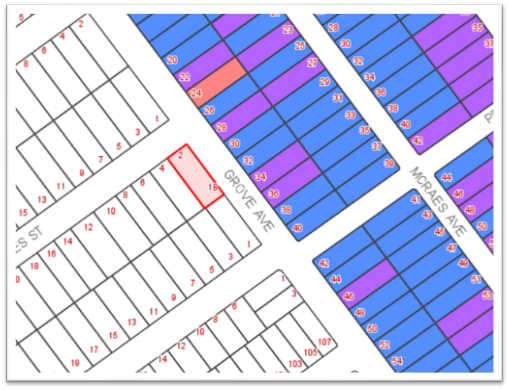
Figure
4 – Proposed site plan
Clause 6.1
– Acid Sulfate Soils
45. The
site is not shown as being affected by acid sulfate soils (ASS) on the ASS map.
Clause 6.2
– Earthworks
46. The
proposed earthworks are considered acceptable having regard to the provisions
of this clause as the works are not likely to have a detrimental impact on
environmental functions and processes, neighbouring uses, cultural or heritage
items or features of the surrounding land.
Clause 6.3
– Flood Planning
47. The
site is not identified as being within a flood planning area (FPA) on the FPA
map.
Clause 6.4
– Limited Development on foreshore area
48. The
site is not identified as being located and/or affected by foreshore area.
Section 4.15(1)
Assessment
49. An
assessment of this application with regard to the matters for consideration
under Section 4.15(1) of the Environmental Planning and Assessment Act 1979 No
203 is as follows.
Kogarah
Development Control Plan 2013
50. The
provisions of this development control plan are relevant to the proposal.
A comparison of the proposal against the key controls in the development
control plan is tabled as follows.
|
Control
|
Required
|
Proposed
|
Complies
|
|
Minimum frontage of site (primary
street)
|
18m
|
15.820m (NW)
15.240m (SE)
|
No (see below)
|
|
Height to upper Ceiling Dwelling 1
|
7.2m (max)
|
6.40m (SE)
5.90m (NE)
6.80m (NW)
6.80m (SW)
|
Yes
|
|
Height to upper Ceiling Dwelling 2
|
7.2m (max)
|
6.70m (SW)
6.70m (SW)
6.10m (NE)
6.40m (SE)
|
Yes
|
|
Height to parapet
Dwelling 1
|
7.8m (max)
|
7.230m (NW)
7.470m (SW)
|
N/A
|
|
Height to parapet
Dwelling 2
|
7.8m (max)
|
6.780m (NE)
7.160m (SE)
|
N/A
|
|
Residential Levels
|
2 (max)
|
2
|
Yes
|
|
Foundation/Basement Height
|
1m (max)
|
<1m
|
Yes
|
|
Setbacks
Dwelling 1
- Front setback (NW boundary)
- Side setback (NE boundary)
- Side setback (SW boundary)
Dwelling 2
- Front setback (NW boundary)
- Side Boundary (SE dwelling)
- Rear setback (SW boundary)
|
5.5m (min)
0.9m (min) GF
1.2m (min) FF
0.9m (min) GF
1.2m (min) FF
4.5m (min)
0.9m (min) GF /
1.2m (min) FF
3.0m
|
6.440m
0.9m GF
1.2m FF
1.2m GF
1.2m FF
3.785m
0.9m GF /
1.2m FF
3.0m
|
Yes
Yes
Yes
Yes
Yes
No (see below)
Yes
Yes
|
|
Deep Soil Landscaping
|
15% (min) or 97.5sqm
|
36.15% or 235.0sqm
|
Yes
|
|
Car Parking
|
3 spaces (min)
|
Dwelling 1 has a double garage and
Dwelling 2 has a single garage. Each garage can also accommodate cars on the
driveway.
|
Yes
|
|
Solar access
|
Min 50% of PPOS to have min 4 hours
from 9-3pm winter solstice
|
At least 50% of the PPOS will
achieve solar access for approx. 3 hours (from 12pm-3pm)
|
No (refer below)
|
|
Solar access
|
South facing POS – min 3m + H
(height of rear wall)
|
7.15m (3m + 4.15m height)
|
Yes
|
|
Solar access
|
Neighbouring properties that are
affected by overshadowing, at least 50% existing POS or windows to main
living areas have min 4 hours from 9-3pm winter solstice
|
Solar access to existing POS for a
min 50% approx. 9am-12pm
|
No (refer below)
|
|
Front Fences
|
(1) In cases where an applicant can demonstrate the need
for a front fence higher than 1.4m, the maximum height of the fence must not
exceed 1.8m.
|
The proposed front fence is a
maximum 1m in height, with side fencing proposed at 1.8m.
|
Yes
|
51. The
proposal reasonably satisfies the relevant objectives of the development
control plan having regard to the particular circumstances of the site and its
context. The variation to the site frontage, setback and solar access control
as outlined in the above table are discussed as follows.
Kogarah DCP
non-compliance of minimum frontage to site
52. The
site has a frontage of 15.24m, which is below the minimum 18m as stipulated in
Section 2.1 of Kogarah DCP 2013.
53. This
variation is acceptable as the proposal complies with the remaining controls,
and is not inconsistent with the streetscape character. Despite the numerical
non-compliance of the minimum site frontage as referenced in Section 2.1(1) of
Kogarah DCP, the proposal is consistent with the objectives of this clause.
54. The
proposed development in a detached arrangement positively contributes to the
existing streetscape character being predominantly freestanding dwellings.
Given the orientation of the dwellings to independent streets, the existing
single dwelling character in the locality is further complimented.
55. The
independent vehicular access for each dwelling has assisted in reducing the
dominance of the driveway and access when viewed from the street. Furthermore,
the single garage facing Grove Avenue highlights the typical arrangement that
is depicted along the street, thus contributing to the established building pattern.
Notwithstanding the above the development complies with all other planning
numerics.
Kogarah DCP
non-compliance of secondary street setback for Dwelling 2
56. The
distance from the front building line to the secondary street is proposed as
3740mm. The area of non-compliance occupies up to 23.54% (or 3650mm) of the
width of the building, being 15500mm wide from the south eastern end of the
site to the north western end of the site.
57. This
proposal encroaches the minimum 4500mm front setback control by 760mm. This is
deemed acceptable on merit, given that the proposal provides vertical and
horizontal articulation, and the majority of the front building line is
recessed further beyond this encroachment. The proposed design of the dwellings
is consistent with more recent construction in the area and is suitable for the
site in the context of the residential character of the area.
Kogarah DCP
non-compliance of minimum solar access to adjoining property
58. The
proposed development will overshadow the adjoining south western neighbour from
about 9am to 12pm during mid-winter. Solar access to the living areas and POS
will be achievable in the later hours of the day. There is no unreasonable
impact given that the adjoining neighbour achieves acceptable levels of
sunlight in the early hours of the day during mid-winter. Furthermore, this is
deemed tolerable given the orientation of the site.
59. The
outbuilding located on the south eastern neighbouring site will also be
overshadowed by the development from about 12pm onwards. The proposed
development is not deemed to have a significant impact on the private open
space for the south eastern neighbour, given that the private open space for
the neighbouring site is currently overshadowed by its own existing outbuilding.
SUBMISSIONS
AND THE PUBLIC INTEREST
60. The
proposal was placed on exhibition for a period of fourteen (14) days during
which time seven (7) submissions were received, with two (2) submissions being
duplicate submissions. The submissions raised the following issues.
61. Overshadowing
most of the winter day
Concerns were
raised about the development overshadowing the adjoining rear yards.
62. Officer’s
Comment: The majority of overshadowing from this proposed development is in
the early hours of the day for the south western
neighbour, and the late hours of the day for the south eastern neighbour.
Solar access is best achieved from midday onwards for the south western
neighbour, and the early hours until about midday for the south eastern neighbour.
It is noted that the rear yards of the immediate neighbours are partially
obstructed by detached structures, namely a detached brick shed for the south
western neighbour, and a detached carport and shed for the south eastern
neighbour. Given that these structures are existing, the impact of
overshadowing from the proposed development is not significantly dominant for
the rear yards of the neighbouring properties.
63. Distance
to boundary
Concerns were raised that the proposed dwelling appears too close to the
boundary.
64. Officer’s
Comment: The proposed development complies in respect of the setback
controls for the side and rear setbacks. The area of non-compliance is in
respect of the boundary of Grove Avenue and therefore are not considered to
impact on the boundaries between the subject site and adjoining sites.
65. Location
near the Penshurst Heritage Conservation Area (PHCA)
Comments were made about the purpose of the PHCA and that the proposed
development is located opposite the boundary of the PHCA. Concerns were raised
that the development faces the conservation areas (CA) contributes to the
historic character of the locality.
Concerns were raised that the proposed development has a
‘relationship’ with the setting of the type of buildings that
comprise the CA given that it fronts Grove Avenue. Concerns were also raised
that the proposal is not harmonious with the streetscape and can only be
considered to be an ‘eyesore’.
66. Officer’s
Comment: The Penshurst Heritage Conservation Area occupies a range of
dwellings with very unique streetscape character. This unique streetscape
character is the face of the conservation area, and the proposed development is
deemed acceptable as it gives rise to the separation between the heritage and
non-heritage sites.
The proposed
contemporary-style facades of the development have no significant impact on the
local amenity, based on the existing streetscape character along both
Dardanelles Street, and the western side of Grove Avenue (opposite the conservation
area). The existing streetscape character outside of the PHCA and within the
vicinity of the subject site provides a combination of single and double storey
cottages, face-brick and rendered dwellings.
The proposed
development is suitable for the site and in the context of the local character
given its compliance with the development standards of the LEP and the
objectives of the dual occupancy controls in the DCP. The design of the
proposal will not detract from the heritage values of the estate to the
north-east of the site and is consistent with new development in the locality
on the south-western side of Grove Avenue and more broadly in the area.
The applicant was
given the opportunity to comment on this concern, and the following is itemised
as a result:
· “The proposal is more than acceptable as it doesn’t try
to replicate the importance of the Macraes Estate Conservation Area (PHCA).
· The proposal does compliment the streetscape in terms of bulk,
scale, setbacks and respects the significance of the heritage area.
· Sufficient separation between the two proposed dwellings create a
harmonious feel.
· Greater separation means less of an eyesore.”
67. Driveway
access and traffic on Grove Avenue
Concerns were
raised about the driveway of the proposed development affecting the existing
driveways along the opposite side of Grove Avenue. Concerns were also raised
that Grove Avenue is a high traffic thoroughfare.
68. Officer’s
Comment: The proposed driveway for the dwelling facing the secondary street
(Grove Avenue) is a single width driveway, and the proposal includes a single
garage for this dwelling. This is deemed acceptable given that there does not
appear to be a significant increase in congestion as a result of the new
development, and furthermore off-street parking is encouraged to enable minimal
additional traffic/parking.
69. Existing
species within the property boundaries
Concerns were
raised about the proposed removal of the existing species within the subject
site, being a home for native birds that transit across the area. Concerns also
raised that this species is part of the history of this area and has been
around for over 30 years.
70. Officer’s
Comment: An assessment was carried out in respect of the proposed
development, the site constraints and the affect that the development will have
on this existing mature species. The proposed new dwellings, in any location,
will have a significant detrimental impact on the existing species given the
spread of the root system. The location of the tree on the site is such that
even if a new single dwelling was proposed, that was compliant with required
setbacks and floor space controls, would adversely impact the root system of
the tree.
71. The
tree protection zone for this species is approximately 14m and therefore would potentially
prohibit any redevelopment of the site or cause it to fail due to the new
development, should it be retained. The replacement of the existing foundations
with the proposed excavation works/new foundations, will result in severe
damage to the species, and a possible hazardous occurrence.
72. The
proposal will therefore require the significant re-planting of a range of
native species to compensate for the loss of this existing species, and
furthermore make some new contribution to the local tree canopy. The proposed
new planting for this development will permit the site’s landscaping to
grow in a healthier and more controlled environment.
73. Streetscape
character
Concerns were
raised that there are minimal dwellings of this contemporary
style along Grove Avenue and that the proposal does not suit the setting or
streetscape of Grove Avenue. Concerns were also raised that the development is
totally contrary to the streetscape of Grove Avenue. Further cconcerns
were raised about the visual impact of the development and that it is
unsympathetic to the area, totally foreign to all other dwellings along Grove
Avenue.
74. Officer’s
Comment: It is evident that there is an inconsistent streetscape character
along the western side of Grove Avenue, outside the conservation area.
Currently, there is no setting or style for the facades of the dwellings along
this side of the street, other than the built form and roof form, which are
predominately low-scale residential dwellings with hipped roofing.
75. The
proposal does not bear a significant increase in built form, given the distance
between the two (2) proposed dwellings, plus the articulation in height and
length/width along the elevations. It is noted though, that the roof form is a
variance of the existing built form in the vicinity of the proposed development.
This is deemed satisfactory given that it presents a typical roof form of a
contemporary style home. It is suggested that the contemporary style-built form
and roof form will assist in defining the separation between the heritage
items/conservation area and those outside the conservation area.
76. No
dual occupancies and subdivided properties within the area
Concerns were
raised that there are no other dual occupancies or subdivided properties within
the local area.
77. Officer’s
Comment: This site is suitably zoned for a detached dual occupancy and is
therefore permissible for such developments. Although the application does not
propose subdivision, the plans include details indicating that separate lots
are intended to be created. The site will be suitable for consideration of
subdivision after completion of a lawfully erected dual occupancy development.
Section 94
Contributions
78. The
following Section 94 contributions have been levied for the development.
|
DEVELOPMENT
CONTRIBUTIONS
|
|
Kogarah Section
94 Development Contributions Plan No.1 - Roads and Traffic Management -
Residential
|
$1,074.63
|
|
Kogarah Section
94 Development Contributions Plan No.5 - Open Space 2007
|
$14,837.75
|
|
Kogarah Section
94 Development Contributions Plan No.9 - Kogarah Libraries - Buildings
|
$388.57
|
|
Kogarah Section
94 Development Contributions Plan No.9 - Kogarah Libraries - Books
|
$277.05
|
|
Total for
development contributions
|
$16,578.00
|
Any matters
prescribed by the regulations that apply to the land to which the development
application relates
79. The
requirements of Australian Standard ‘AS 2601-1991: The Demolition
of Structures’ are of relevance to the application as the proposal
includes demolition of existing structures. The requirements of this standard
including the management of asbestos containing materials may be readily
addressed by the imposition of suitable conditions of consent.
IMPACTS
Natural and
built environments and social and economic impacts
80. The
proposed development is suitable for the site and in the context of the local
character given its compliance with the development standards of the LEP and
the objectives of the dual occupancy controls in the DCP. The design of the
proposal will not detract from the heritage values of the estate to the north
east of the site and is consistent with new development in the locality on the
south western side of Grove Avenue and more broadly in the area.
81. The
contrast in streetscape between the heritage/conservation area and non-heritage
items of conservation areas should be present to pay tribute to the dwellings
of historical value, whilst being complimentary to the locality and planning
controls for the desired future character. The proposal offers to introduce new
planting that will contribute to the local tree canopy. Accordingly, the
proposal is not considered to have an unreasonable impact on the natural and
built environment of the locality.
Suitability
of the site
82. The
proposal is of a scale and design that is suitable for the site having regard
to its size and shape, topography, vegetation and relationship to adjoining
developments.
REFERRALS
Council Referrals
83. Development
Engineering
Council’s
Development Engineer has carried out an assessment of the proposed stormwater
management system for the site. As a result, conditions have been attached to
the recommended determination.
84. Tree
and Landscape Officer
Council’s
Tree and Landscape Officer has carried out an assessment of the proposed tree
retention and tree removal for the site. As a result, conditions have been
attached to the recommended determination.
85. Parks
and Waterways
Council’s
Parks and Waterways Officer has carried out an
assessment of the proposed tree retention and tree removal for the site. As a
result, conditions have been attached to the recommended determination.
Public Interest
86. The
proposal is of a scale and character that should not conflict with the public
interest, given the density and built form. The
proposal offering a streetscape character that varies from the
opposing conservation area is deemed satisfactory given that it contributes to
providing a distinct boundary line for the border of the conservation area.
CONCLUSION
87. The
proposal has been assessed using the matters for consideration listed in
Section 4.15 of the Environmental Planning and Assessment Act 1979. The
proposal is considered to be satisfactory and recommended for approval subject
to conditions, as discussed throughout this report.
88. The
DA has been notified to neighbours on one occasion throughout the processing.
Submissions have been received from a number of adjoining owners, with the
issues of concern being inclusive of, but not limited to, the impact on the
conservation area, overshadowing, bulk, scale, contemporary form, trees,
driveway access from Grove Avenue.
89. In
this regard, it is considered that the issues of concern that have been raised
do not warrant refusal of the DA. Appropriate conditions of consent are
recommended to address particular matters.
90. The
proposal has been assessed against the provisions of Kogarah LEP 2012 and
Kogarah DCP 2013, and a number of areas of non-compliance have been identified.
The areas of non-compliance relate to solar access to adjoining property,
minimum frontage to site and secondary street setback for Dwelling 2 (facing
Grove Avenue). These non-compliances are not deemed to be unreasonable.
91. The
proposal is considered to be appropriate when assessed against the applicable
planning controls, with some matters proposed to be addressed via conditions of
consent.
DETERMINATION
AND STATEMENT OF REASONS
Statement of
Reasons
92. The
proposed development is considered to be an appropriate scale and form for the
site and the character of the locality.
93. The
proposed development will not have an unreasonable or adverse impact upon the natural
or built environments.
94. The
issues of concern raised by the neighbours do not warrant refusal and/or can be
ameliorated via conditions of consent.
95. In
consideration of the aforementioned reasons, the proposed development is a
suitable built form outcome for the site and its approval is not contrary to
the public interest.
Determination
96. That
Council as the consent authority and pursuant to Section 4.16(1)(a) of the Environmental
Planning and Assessment Act 1979 grant consent to Development Application No.
DA2018/0291 for demolition of existing structures and construction of a two (2)
storey detached dual occupancy development at Lot 1 in DP1223266 and known as 2
Dardanelles Street, Mortdale, subject to conditions below.
Section A Development Details
1. Approved
Plans - The development must be implemented in accordance with the approved
plans and supporting documentation listed below which have been endorsed by
Council’s approved stamp, except where marked up on the plans and/or
amended by conditions of this consent:
|
Description
|
Drawing No.
|
Dated
|
Revision
|
Prepared by
|
|
Site plan
|
2
|
05/10/2018
|
-
|
M Cubed Design
|
|
Ground Floor Plan
|
3
|
05/10/2018
|
-
|
M Cubed Design
|
|
First Floor Plan
|
4
|
05/10/2018
|
-
|
M Cubed Design
|
|
Roof Plan
|
5
|
05/10/2018
|
-
|
M Cubed Design
|
|
North west and south west elevations DW1, front fence
|
6
|
05/10/2018
|
-
|
M Cubed Design
|
|
South east and north east elevations DW1
|
7
|
05/10/2018
|
-
|
M Cubed Design
|
|
North east and south east elevations DW2
|
8
|
05/10/2018
|
-
|
M Cubed Design
|
|
North west and south west elevations DW2, side fence
|
9
|
05/10/2018
|
-
|
M Cubed Design
|
|
Section DW1 and section DW2
|
10
|
05/10/2018
|
-
|
M Cubed Design
|
|
Streetscape
|
17
|
05/10/2018
|
-
|
M Cubed Design
|
|
External Finishes
|
-
|
17/05/2018
|
-
|
M Cubed Design
|
Section B Separate
Approvals Required Under Other Legislation
2. Section
138 Roads Act 1993 and Section 68 Local Government Act 1993 - Unless
otherwise specified by a condition of this consent, this Development Consent
does not give any approval to undertake works on public infrastructure.
Separate approval is required under Section 138 of the Roads Act 1993
and/or Section 68 of the Local Government Act 1993 for any of the following
activities carried out in, on or over a public road (including the footpath)
listed below.
An application is required to be lodged and approved prior to the
commencement of any of the following works or activities;
a) Placing or storing
materials or equipment;
b) Placing or storing waste
containers or skip bins;
c) Erecting a structure or
carrying out work
d) Swinging or hoisting
goods over any part of a public road by means of a lift, crane or the like;
e) Pumping concrete from a
public road;
f) Pumping water from
the site into the public road;
g) Constructing a vehicular
crossing or footpath;
h) Establishing a
“works zone”;
i) Digging up or
disturbing the surface of a public road (eg Opening the road for the purpose of
connections to utility providers);
j) Stormwater and
ancillary works in the road reserve;
k) Stormwater and ancillary
to public infrastructure on private land; and
l) If any excavation
is to be supported by the use of below ground (cable) anchors that are
constructed under Council’s roadways/footways.
These separate activity approvals must be obtained and evidence of the
approval provided to the Certifying Authority prior to the issue of the
Construction Certificate.
The relevant Application Forms for these activities can be downloaded
from Council’s website www.georgesriver.nsw.gov.au.
For further information, please contact Council’s Customer Service Centre
on (02) 9330 6400.
3. Vehicular
Crossing - Constructing a vehicular crossing and/or footpath requires a
separate approval under Section 138 of the Roads Act 1993 prior to the
commencement of those works.
To apply for approval, complete the Driveway Crossing on Council Road
Reserve Application Form which can be downloaded from Georges River
Council’s Website at www.georgesriver.nsw.gov.au. Lodge the application
form, together with the associated fees at Council’s Customer Service
Centre, during business hours. Refer to Section P1 and P2, in Council’s
adopted Fees and Charges for the administrative and inspection charges
associated with Vehicular Crossing applications.
An approval for a new or modified vehicular crossing will contain the
approved access and/or alignment levels which will be required to construct the
crossing and/or footpath. Once approved, all work shall be carried out in
accordance with Council’s specifications applicable at the time, prior to
the issue of an Occupation Certificate.
4. Road
Opening Permit - A Road Opening Permit must be obtained from Council, in
the case of local or regional roads, or from the RMS, in the case of State
roads, for every opening of a public road reserve to access services including
sewer, stormwater drains, water mains, gas mains, and telecommunications before
the commencement of work in the road.
Section C Requirements of
Concurrence, Integrated & Other Government Authorities
5. Sydney
Water - Tap in TM - The approved plans must be submitted to a Sydney
Water Tap in TM to determine whether the development application will affect
Sydney Water’s sewer and water mains, stormwater drains and/or easements,
and if further requirements need to be met. The approved plans will be
appropriately endorsed.
For details please refer to ‘Plumbing, building and
developing’ section of Sydney Water’s web site at www.sydneywater.com.au then see
‘Building’, or telephone 13000 TAP IN (1300 082 746). The
Certifying Authority must ensure that a Tap in TM agent has appropriately
stamped the plans prior to the issue of the Construction Certificate.
6. Notice
of Requirements for a Section 73 Certificate - A Notice of Requirements of
what will eventually be required when issuing a Section 73 Compliance
Certificate under the Sydney Water Act 1994 must be obtained from Sydney Water
Corporation. Application must be made through an authorised Water
Servicing Co-ordinator. Please refer to the ‘Plumbing, building and
developing’ section of the web site www.sydneywater.com.au then refer to
‘Providers’ under ‘Developing’ or telephone 13 20 92
for assistance.
Following application, a ‘Notice of Requirements’ will advise
of water and sewer infrastructure to be built and charges to be paid.
Please make early contact with the Co-ordinator, as it can take some time to
build water/sewer pipes and this may impact on other services and building,
driveway or landscape design.
The Notice of requirements must be submitted prior to the commencement of
work. A Section 73 Compliance Certificate will be required at the completion of
development in accordance with further conditions.
Section D Prior to the
Issue of a Construction Certificate
7. Fees
to be paid - The fees listed in the table below
must be paid in accordance with the conditions of this consent and
Council’s adopted Fees and Charges applicable at the time of payment
(available at www.georgesriver.nsw.gov.au).
Payments must be made prior to the issue of the
Construction Certificate or prior to the commencement of work (if there is no
associated Construction Certificate).
Please contact Council prior to the payment of
Section 7.11 Contributions to determine whether the amounts have been indexed
from that indicated below in this consent and the form of payment that will be
accepted by Council.
Council will only accept Bank Cheque or
Electronic Funds Transfer (EFT) for transaction values of $500,000 or over.
Council must be contacted prior to payment to determine correct total amount to
be paid and bank account details (if applicable).
A summary of the fees to be paid are listed
below:
|
Fee Type
|
Fee
|
|
GENERAL FEES
|
|
Long Service Levy (to Long Service Corporation) Or,
provide evidence of Payment direct to the Long Service Corporation. See
https://portal.longservice.nsw.gov.au/bci/levy/
|
|
Builders Damage Deposit
|
$1,900.00
|
|
Inspection Fee for Refund of Damage Deposit
|
$155.00
|
|
Driveway Design and Inspection Fee (Dwelling)
|
$371
|
|
DEVELOPMENT
CONTRIBUTIONS
|
|
Kogarah Section 94 Development Contributions Plan No.1 -
Roads and Traffic Management – Residential
|
$1,074.63
|
|
Kogarah Section 94 Development Contributions Plan No.5 -
Open Space 2007
|
$14,837.75
|
|
Kogarah Section 94 Development Contributions Plan No.9 -
Kogarah Libraries - Buildings
|
$388.57
|
|
Kogarah Section 94 Development Contributions Plan No.9 - Kogarah
Libraries - Books
|
$277.05
|
|
Total for development contributions
|
$16,578.00
|
General Fees
The fees and charges above are subject to
change and are as set out in the version of Council's Schedule of Fees and
Charges or as required by other Government Authorities, applicable at the time
of payment.
Development Contributions
The Section 7.11 contribution is imposed to
ensure that the development makes adequate provision for the demand it
generates for public amenities and public services within the area.
Indexation
The above contributions will be adjusted at the
time of payment to reflect changes in the cost of delivering public amenities
and public services, in accordance with the indices provided by the relevant
Section 94 Development Contributions Plan.
Timing of Payment
The contribution must be paid and receipted by
Council prior to the release of the Construction Certificate.
Further Information
A copy of the all current Development
Contributions Plans may be inspected or a copy purchased at
Council’s offices (Georges River Civic Centre, MacMahon Street,
Hurstville and Kogarah Library and Service Centre, Kogarah Town Square,
Belgrave Street, Kogarah) or viewed on Council’s website www.georgesriver.nsw.gov.au.
8. Damage
Deposit - Minor Works - In order to insure against damage to Council
property the following is required:
a) Pay Council, before the issue of the
Construction Certificate, a damage deposit for the cost of making good any
damage caused to any Council property as a result of the development: $1,900.00
b) Pay Council, before the issue of the
Construction Certificate, a non-refundable inspection fee to enable assessment
of any damage and repairs where required: $155.00
c) Submit to Council, before the commencement
of work, a photographic record of the condition of the Council nature strip,
footpath and driveway crossing, or any area likely to be affected by the
proposal.
At the completion of work Council will inspect the public works, and the
damage deposit will be refunded in full upon completion of work where no damage
occurs. Otherwise the amount will be either forfeited or partly refunded
according to the amount of damage.
9. Site
Management Plan - A Site Management Plan detailing all weather access
control points, sedimentation controls, fencing, builder’s site sheds
office, amenities, materials storage and unloading arrangements must be
submitted with the application for the Construction Certificate.
The site management measures are to be implemented prior to the
commencement of any works including demolition and excavation. The site
management measures are to be maintained throughout the works, to maintain
reasonable levels of public health, safety and amenity. A copy of the Site
Management Plan must be kept on site and is to be made available upon request.
10. BASIX
Commitments - All energy efficiency measures as detailed in the BASIX
Certificates No. 928640S and 928651S must be implemented on the plans lodged
with the application for the Construction Certificate.
11. Erosion & Sedimentation
Control - Erosion and sediment controls must be provided to ensure:
a) Compliance with the
approved Erosion & Sediment Control Plan
b) Removal or disturbance of
vegetation and top soil is confined to within 3m of the approved building area
(no trees to be removed without approval)
c) All clean water runoff is
diverted around cleared or exposed areas
d) Silt fences, stabilised
entry/exit points or other devices are installed to prevent sediment from
entering drainage systems or waterways
e) All erosion and sediment
controls are fully maintained for the duration of demolition, excavation and/or
development works
f) Controls are put
into place to prevent tracking of sediment by vehicles onto adjoining roadway
g) All disturbed areas are
rendered erosion-resistant by turfing, mulching, paving or similar
h) Compliance with Managing
Urban Stormwater - Soils and Construction (Blue Book) produced by Landcom 2004.
These measures are to be implemented prior to the commencement of work
(including demolition and excavation) and must remain until works are completed
and all exposed surfaces are landscaped/sealed.
12. Stormwater
System - The submitted stormwater plan has been assessed as a concept plan
only. Final detailed plans of the drainage system, prepared by a professional
engineer specialising in hydraulic engineering, shall be submitted for approval
with the Construction Certificate.
a) All stormwater shall
drain by gravity to Council's kerb and gutter in the street as indicated on the
approved drainage plans Dwg No. DCP1/DCP2 Revision B, dated 03/05/2018 in
accordance with the Australian/New Zealand Standard AS/NZS 3500.3: 2015 (as
amended).
b) During of works, the
PCA/builder shall ensure that the stormwater discharge pipe across the footpath
is laid with minimum disturbance at a minimum 1% grade and is made in good
working condition.
c) There shall be no damage
to the adjoining driveway crossing. All damages are to be rectified to its
original condition at the cost of the applicant
d) The stormwater drainage
plans including pipe sizes, type, grade, length, invert levels, dimensions and
types of drainage pits prepared by a professional engineer who specialises in
Hydraulic Engineering in accordance with the Australian Institute of Engineers
Australian Rainfall and Runoff (1987) and Council's Stormwater Drainage
Guidelines, shall accompany the application for the Construction Certificate
13. On Site
Detention - The submitted stormwater plan has been assessed as a concept
plan only. Final detailed plans of the drainage system, prepared by a
professional engineer specialising in hydraulic engineering, shall be submitted
for approval with the Construction Certificate.
An on-site detention (OSD) facility designed by a professional engineer
who specialises in Hydraulic Engineering must be designed, approved and
installed. The design must include the computations of the inlet and
outlet hydrographs and stage/storage relationships of the proposed OSD using
the following design parameters:
a) peak flow rates from the
site are to be restricted to a permissible site discharge (PSD) equivalent to
the discharge when assuming the site contained a single dwelling, garage, lawn
and garden.
b) at Annual Recurrence
Intervals of 2 years and 100 years.
c) The proposed arrangement
of the OSD system shall discharge by gravity using the minimum allowable size
of an orifice plate Ø25mm to the street kerb and gutter.
14. Stormwater
Drainage Plan Details - Stormwater drainage plans including pipe sizes,
type, grade, length, invert levels, dimensions and types of drainage pits
prepared by a professional engineering specialising in hydraulic engineering
shall be submitted with the Construction Certificate application.
These plans shall be prepared in accordance with the Australian Institute
of Engineers Australian Rainfall and Runoff (2005 or 2016) and Council's Water
Management Policy (Kogarah Council), August 2006.
15. Driveway
Construction Plan Details – Detailed engineering plans for the
driveway shall be submitted with the Construction Certificate application for
approval that show:
a) Longitudinal and cross sections, gradients,
access onto the proposed lots, type of construction materials designed in
accordance with Council's Subdivision standards and AS/NZS2890.1-2004.
b) Suitable underground provision for the
supply of all relevant services to the proposed lots (proposed position of
pipes and conduits).
c) A longitudinal driveway sections are to be
prepared by a qualified civil/traffic engineer and be submitted for to and
approved by the Certifying Authority. These profiles are to be at 1:100 scale
along both edges of the proposed driveway, starting from the centreline of the
frontage street carriageway to the proposed basement floor level. The civil/traffic
engineer shall provide specific written certification on the plans that:
i. Vehicular access can be obtained
using grades of 25% (1 in 4) maximum and
ii. All changes in grade (transitions) comply
with Australian Standard 2890.1 (2004) – “Off-street car
parking” to prevent the scraping of the underside of the vehicles
16. Structural
details - Engineer's details prepared by a practising Structural Engineer
being used to construct all reinforced concrete work, structural beams, columns
and other structural members are to be submitted to the Principal Certifying
Authority for approval prior to construction of the specified works.
A copy shall be forwarded to Council where Council is not
the PCA.
17. Traffic
Management – Compliance with AS2890 – All driveways, access
ramps, vehicular crossings and car parking spaces shall be designed and
constructed in accordance with the current version of Australian Standards, AS
2890.1 (for car parking facilities) and AS 2890.2 (for commercial vehicle
facilities).
18. Waste
Management Plan - A Waste Management Plan incorporating all requirements in
respect of the provision of waste storage facilities, removal of all materials
from the site that are the result of site clearing, extraction, and, or
demolition works and the designated Waste Management Facility shall be
submitted to the Certifying Authority prior to the issue of any Construction
Certificate.
19. Landscape Plans
- All landscape works shall be carried out in accordance with the approved
landscape plans and specifications, drawn by The Creative Practice, reference
numbers – TCP_2DS_10, Issue A, 3/09/18. The landscaping shall be
maintained in accordance with the approved plans in perpetuity, subject to the
following -
a) The proposed tree and plant
species, pot/ bag size and quantities of plants shall be in accordance with the
proposed plant schedule upon the landscape plan. If plant species, pot/ bag
size and quantities cannot be sourced, Council shall be contacted for
alternatives.
b) Two (2) additional trees shall
be planted within the allotment of DW1, dwelling fronting Grove Street. The two
(2) additional trees shall be of species selection from Hurstville DCP, No 1,
Appendix 1, 5, Recommended Species for Landscaping, Native Trees (all wards)
and be able to reach a height at maturity of 10 metres
c) All fourteen (14) trees
proposed upon the approved landscape plan and two additional trees within (c),
shall comply with NATSPEC Specifying Trees: A Guide to Assessment of Tree
Quality (2003), and be planted and maintained in accordance with Councils
standard specification.
d) A total of fourteen (14) trees
shall be planted upon the site and form part of the landscape planting scheme.
20. Compliance with
submitted Arborist Report - The recommendations outlined in the
Arborist’s Report titled Pre development Tree Assessment Report, prepared
by Nada Kbar, dated 11/7/18, must be implemented throughout the relevant stages
of construction. Details of tree protection measures to be implemented
must be detailed and lodged with the Construction Certificate application for
approval and shall be in accordance with Section 4 - Australian Standard AS
4970-2009: Protection of trees on development sites.
The
tree/s to be retained and protected are listed in the table below.
|
Tree Species
|
Location of Tree / Tree No.
|
Tree Protection Zone (metres)
Fencing distance from trunk
|
|
T1 – Callistemon viminalis
|
Council street
tree fronting Dardanelles St
|
4.5 metres
radially
|
|
3 x Tristaniopsis laurina
|
Council street tree fronting Grove St
|
4.0 metres radially – fencing to protect all three trees
together
|
21. Tree Protection and
Retention - The following trees shall be retained and protected:
|
Tree Species
|
Location of Tree / Tree No.
|
Tree Protection Zone (metres)
Fencing distance from trunk
|
|
T1 – Callistemon viminalis
|
Council street
tree fronting Dardanelles St
|
4.5 metres radially
|
|
3 x Tristaniopsis laurina
|
Council street tree fronting Grove St
|
4.0 metres radially - fencing to
protect all three trees together
|
Details of the trees to be retained
must be included on the Construction Certificate plans.
General Tree
Protection Measures
(a) All
trees to be retained shall be protected before and maintained during
demolition, excavation and construction of the site.
(b) The
tree protection measures must be in undertaken in accordance AS4970 -2009
Protection of trees on development sites.
(c) Details
of the tree protection measures to be implemented must be provided with the
application for a Construction Certificate by a suitably qualified Arborist
who holds an AQF Level 5 or above in Arboriculture and who is a current
financial member of Arboriculture Australia – AA and or Institute
of Australian Consulting Arboriculturists – IACA.
(d) The
Project Arborist must be present on-site during the stages of excavation,
demolition and construction when works are being undertaken that could impact on
the tree canopy or root zone within the tree protection zone of each tree.
(e) Unless
otherwise specified in AS 4970-2009 Protection of trees on development sites, a
protective fence consisting of 2.4 x 1.8 metres high, fully supported chainmesh
fence shall be used. The distance of the fence from the base of each tree is to
be in accordance with the TPZ listed in the table above. A layer of organic
mulch 100 millimetres thick shall be placed over the protected area and no soil
or fill should be placed within the protection area.
(f) The
Tree Protection Zone of each tree, to be protected, shall be watered thoroughly
and regularly to minimise the effects of construction works.
(g) No
building products/ materials or services shall be installed within the TPZ of
the tree/s. This fence shall be kept in place during demolition, construction
and also have a sign displaying ‘Tree Protection Zone – DO NOT
ENTER’ attached to the fence and must also include the name and contact
details of the Project Arborist.
Excavation
works near tree to be retained
(h) Excavations
around the trees to be retained on site or the adjoining properties shall be
supervised by the Project Arborist to ensure that the root system will not
adversely be affected.
(i) Where
the Tree Protection Zone (TPZ) of trees on site or adjoining sites become
compromised by any excavation works, the Project arborist shall be consulted to
establish the position of any major roots and determine the necessary measures
to protect these roots. The recommendations of the Arborist shall be submitted
to Council prior to any further demolition or construction works taking place.
(j) Tree
Protection Zone around the trees to be retained are not to have soil level
changes, building product / materials stored or services installed in this
area. Any structures proposed to be built in this area of the trees are to
utilise pier and beam or cantilevered slab construction.
Details
satisfying this condition shall be shown on the Construction Certificate plans.
22. Tree Removal
& Replacement
Tree removal
Permission is granted for the removal of the following trees:
|
Tree Species
|
Number of trees
|
Location
|
|
T2 - Syncarpia glomulifera
|
X 1
|
Within subject site
|
|
T3 – Tristaniopsis laurina
|
X 1
|
Within proposed driveway location of
Grove St
|
General Tree
Removal Requirements
(a) All tree removal shall be carried out by a
minimum certificate Level 3, Licenced and insured Tree Surgeon/Arborist to
ensure that removal is undertaken in a safe manner and complies with the AS
4373-2007 - Pruning of Amenity Trees and Tree Works Industry Code of Practice
(Work Cover NSW 1.8.98).
(b) No trees are to be removed on the site or
neighbouring properties without the prior written approval of Council.
Street Tree
Removal / Replacement by Council –
(a) Two (2) street trees of species to be
determined must be provided in the road reserve fronting the site.
(b) Council shall be appointed to remove and plant
all tree/s on public land. All costs associated with the removal of the tree/s
and the planting of replacement trees shall be met by the applicant. Fees and
charges outlined in the table below are subject to change and are set out in
the current version of Council's ‘Schedule of Fees and Charges’,
applicable at the time of payment.
|
Fee Type – Tree removal on
public land
|
Amount
|
|
Administration
Fee for Tree Removal
|
$154.50
|
|
Replacement
Tree Fee (per Tree)
|
$452
|
|
Cost of tree
removal
|
To be determined
|
|
Cost of Stump
Grinding
|
To be determined
|
A copy of the Hurstville City
Council’s Tree Removal and Pruning Guidelines and Kogarah City Council,
Street Tree Management Strategy and Masterplan, can be downloaded from
Council’s website www.georgesriver.nsw.gov.au.
Section E Prior to the
Commencement of Work (Including Demolition & Excavation)
23. Demolition & Asbestos -
The demolition work shall comply with the provisions of Australian Standard
AS2601:2001 - Demolition of Structures, NSW Work Health & Safety Act 2011
and the NSW Work Health & Safety Regulation 2011. The work plans
required by AS2601:2001 shall be accompanied by a written statement by a
suitably qualified person that the proposals contained in the work plan comply
with the safety requirements of the Standard. The work plans and the safety
statement shall be submitted to the PCA prior to the commencement of works.
For
demolition work which involves the removal of asbestos, the asbestos removal
work must be carried out by a licensed asbestos removalist who is licensed to
carry out the work in accordance with the NSW Work Health & Safety Act 2011
and the NSW Work Health & Safety Regulation 2011 unless specified in the
Act and/or Regulation that a license is not required.
All
demolition work including the removal of asbestos, shall be undertaken in
accordance with the Demolition Code of Practice (NSW Work Cover July 2015)
Note:
Copies of the Act, Regulation and Code of Practice can be downloaded free of
charge from the SafeWork NSW website: www.SafeWork.nsw.gov.au.
24. Demolition Notification
Requirements - The following notification requirements apply to this
consent:
a) The
developer /builder must notify adjoining residents five (5) working days prior
to demolition. Such notification is to be a clearly written note giving
the date demolition will commence, contact details of the developer/builder,
licensed asbestos demolisher and the appropriate regulatory authority.
Notification is to be placed in the letterbox of every premises (including
every residential flat or unit, if any) either side and immediately at the rear
of the demolition site.
b) Five
(5) working days prior to demolition, the developer/builder is to provide
written notification to Council advising of the demolition date, details of the
SafeWork licensed asbestos demolisher and the list of residents advised of the
demolition.
c) On
demolition sites where buildings to be demolished contain asbestos, a standard
commercially manufactured sign containing the words “DANGER ASBESTOS
REMOVAL IN PROGRESS” measuring not less than 400mm x 300mm is to be
erected in a prominent visible position (from street frontage) on the site. The
sign is to be erected prior to demolition work commencing and is to remain in
place until such time as all asbestos material has been removed from the site
to an approved waste facility.
25. Demolition work involving
asbestos removal - Work involving bonded asbestos removal work (of an area
of more than 10 square metres) or friable asbestos removal work must be
undertaken by a person who carries on a business of such removal work in
accordance with a licence under clause 458 of the Work Health and Safety
Regulation 2011.
26. Dial before your dig - The
applicant shall contact “Dial Before You Dig on 1100” to obtain a
Service Diagram prior to the issuing of the Construction Certificate. The
sequence number obtained from “Dial Before You Dig” shall be
forwarded to Council’s Engineers for their records.
27. Dilapidation Report on Public
Land - Prior to the commencement of works (including demolition and
excavation), a dilapidation report must be prepared for the Council
infrastructure adjoining the development site, including:
The
report must include the following:
a) Photographs
showing the existing condition of the road pavement fronting the site,
b) Photographs
showing the existing condition of the kerb and gutter fronting the site,
c) Photographs
showing the existing condition of the footpath pavement fronting the site,
d) Photographs
showing the existing condition of any retaining walls within the footway or
road, and
e) The
full name and signature of the structural engineer.
f) The
Dilapidation Report must be prepared by a qualified structural engineer.
The report must be provided to the PCA and a copy provided to the
Council.
g) The
Dilapidation Report must be prepared by a professional engineer. The report
must be provided to the PCA and a copy provided to the Council.
The report is to be
supplied in electronic format in Word or PDF. Photographs are to be in colour,
digital and date stamped.
Note:
Council will use this report to determine whether to refund the damage deposit
after the completion of works
28. Registered Surveyors Report -
During Development Work - A report must be submitted to the PCA at each of
the following applicable stages of construction:
a) Set out before commencing excavation.
b) Floor slabs or foundation wall, before
formwork or commencing brickwork.
c) Completion of
Foundation Walls - Before any construction of flooring, detailing the location
of the structure relative to adjacent boundaries and floor levels relative to
the datum shown on the approved plans.
d) Completion of
Floor Slab Formwork - Before pouring of concrete/walls construction, detailing
the location of the structure relative to adjacent boundaries and floor levels
relative to the datum shown on the approved plans. In multi-storey
buildings a further survey must be provided at each subsequent storey.
e) Completion of any
Roof Framing - Before roof covered detailing eaves/gutter setback from
boundaries.
f) Completion
of all Work - Detailing the location of the structure (including eaves/gutters)
relative to adjacent boundaries and its height relative to the datum shown on
the approved plans. A final Check Survey must indicate the reduced level
of the main ridge.
Work
must not proceed beyond each stage until the PCA is satisfied that the height
and location of the building is proceeding in accordance with the approved
plans.
29. Utility Arrangements - Arrangements
are to be made with utility authorities in respect to the services supplied by
those authorities to the development. The cost associated with the provision or
adjustment of services within the road and footway areas is to be at the
applicant’s expense.
Section F During
Construction
30. Site sign - Soil & Erosion
Control Measures - Prior to the commencement of works (including demolition
and excavation), a durable site sign, issued by Council in conjunction with
this consent, must be erected in a prominent location on site. The site sign
warns of the penalties which apply to pollution, storing materials on road or
footpath and breaches of the conditions relating to erosion and sediment
controls. The sign must remain in a prominent location on site up until the
completion of all site and building works.
31. Hours of construction for
demolition and building work - Any work activity or activity associated
with the development consent that requires the use of any tools (including hand
tools) or any power operated plant and machinery that creates noise on or
adjacent to the site shall not be performed, or permitted to be performed,
except between the hours of 7.00 am to 5.00 pm, Monday to Saturday inclusive.
No work or ancillary activity is permitted on Sundays, or Public Holidays.
Note:
A penalty infringement notice may be issued for any offence.
32. Ground levels and retaining walls
- The ground levels of the site shall not be excavated, raised or filled, or
retaining walls constructed on the allotment boundary, except where indicated
on approved plans or approved by Council.
33. Physical connection of Stormwater
to site - No work is permitted to proceed above the ground floor slab level
of the building until there is physical connection of the approved stormwater
drainage system from the land the subject of this consent to Council’s
public drainage system.
34. Utility Services - The
applicant shall undertake and bear all costs associated with the liaison,
approval and relocation of any utility services. All correspondence and
approvals between the Applicant and utility authorities shall be provided to
the Council in conjunction with engineering documentation for the stormwater
drainage works.
35. Drainage Works - Construction
inspections shall be required by Council’s Asset Engineer for the Council
stormwater drainage connection works on public roads at the following hold
points: -
· Upon
excavation of trenches shown on the approved drainage drawings.
· Upon
installation of pipes and other drainage structures.
· Upon
backfilling of excavated areas and prior to the construction of the final
pavement surface.
An
inspection fee is applicable for each visit, and at least 24 hours’
notice will be required for the inspections.
36. Cost of work to be borne by the
applicant - The applicant shall bear the cost of all works associated with the
construction of the development that occurs on Council property. Care
must be taken to protect Council's roads, including the made footway, kerbs,
etc., and, where plant and vehicles enter the site, the footway shall be
protected against damage by deep-sectioned timber members laid crosswise, held
together by hoop iron straps and chamfered at their ends. This
construction shall be maintained in a state of good repair and condition
throughout the course of construction.
37. Obstruction of Road or Footpath
- The use of the road or footpath for the storage of any building materials,
waste materials, temporary toilets, waste or skip bins, or any other matter is
not permitted unless separately approved by Council under Section 138 of the
Roads Act 1993 and/or under Section 68 of the Local Government Act 1993.
Penalty infringement Notices may be issued for any offences and severe
penalties apply.
38. Waste Management Facility -
All materials removed from the site as a result of demolition, site clearing,
site preparation and, or excavation shall be disposed of at a suitable Waste
Management Facility. No vegetation, article, building material, waste or the
like shall be ignited or burnt.
Copies
of all receipts for the disposal, or processing of all such materials shall be
submitted to the PCA and Council, where Council is not the Principal Certifying
Authority.
39. Tree removal on private land
– The trees identified as ‘to be removed/pruned’ on the
approved plans or by conditions of this consent shall be removed in accordance
with AS4373 -2007 and the Amenity Tree Industry Code of Practice (SafeWork NSW,
August 1998)
40. BASIX Compliance Certificate
- A Compliance Certificate must be provided to the PCA regarding the
implementation of all energy efficiency measures as detailed in the approved
BASIX Certificate before any Occupation Certificate is issued.
41. Completion of Landscape Works
- All landscape works must be completed before the issue of the Final
Occupation Certificate.
42. Vehicular crossing - The
vehicular crossing and/or footpath works shall be constructed by a private
contractor at the expense of the applicant, in accordance with the Vehicular
Crossing Approval issued by Council’s Engineering Services Division and
in accordance with Council’s Specification for Vehicular Crossings and
Associated Works and the issued.
Any
existing vehicular crossing and/or laybacks which are redundant must be
removed. The kerb and gutter, any other footpath and turf areas shall be
restored at the expense of the applicant and in accordance with Council’s
Specification for Vehicular Crossings and Associated Works.
NOTE:
No stencilled or coloured concrete may be used outside the boundary of the
property.
The work must be completed before the issue of an Occupation Certificate.
43. Allocation
of street addresses
|
Dwelling description on plans
|
Current Lot/DP
|
New Primary Addresses
|
|
Lot 1 (DW 1)
|
Lot 1 in DP 1223266
|
2
Dardanelles Street MORTDALE NSW 2223
|
|
Lot 2 (DW 2)
|
Lot 1 in DP 1223266
|
1B
Grove Avenue MORTDALE NSW 2223
|
Section G Prior to the
issue of the Occupation Certificate
44. Section 73 Compliance Certificate
- A Section 73 Compliance Certificate under the Sydney Water Act 1994 must be
submitted to the PCA prior to the issue of the Occupation Certificate.
45. Completion of Landscape Works
- All landscape works must be completed before the issue of the Final Occupation
Certificate in accordance with approved landscape plans and specifications,
drawn by The Creative Practice, reference numbers – TCP_2DS_10, Issue A,
3/09/18. The landscaping shall be maintained in accordance with the approved
plans in perpetuity, subject to the following -
a) The proposed tree and
plant species, pot/ bag size and quantities of plants shall be in accordance
with the proposed plant schedule upon the landscape plan. If plant species,
pot/ bag size and quantities cannot be sourced, Council shall be contacted for
alternatives.
b) Two (2) additional trees
shall be planted within the allotment of DW1, dwelling fronting Grove St. The
two additional trees shall be of species selection from Hurstville DCP, No 1,
Appendix 1, 5, Recommended Species for Landscaping, Native Trees (all wards)
and be able to reach a height at maturity of 10 metres
c) All fourteen (14) trees
proposed upon the approved landscape plan and two additional trees within (c),
shall comply with NATSPEC Specifying Trees: a guide to assessment of tree
quality (2003), and be planted and maintained in accordance with
Council’s standard specification.
d) A total of fourteen (14)
trees shall be planted upon the site and form part of the landscape planting
scheme and certified of compliance.
46. Noise Domestic Air conditioner
and Heat pump water heaters (less than 450mm from boundary) – Prior
to the issue of any Occupation Certificate, a report prepared by a professional
acoustic engineer must be submitted to the PCA to certify that the design and
construction of the air conditioner / heat pump water heaters shall not produce
a sound level exceeding 5 dB(A) above the ambient background level at the
closest neighbouring boundary between the hours of 8:00am and 10:00pm on
Saturdays, Sundays and Public Holidays and between the hours of 7:00am and
10:00pm on any other day. Outside the specified hours, the sound level
output for the running of air conditioner shall not exceed the ambient
background noise level.
47. Requirements prior to the issue
of the Occupation Certificate - The following shall be completed and or
submitted to the PCA prior to the issue of the Occupation Certificate:
a) All the stormwater/drainage
works shall be completed in accordance with the approved Construction
Certificate plans prior to the issue of the Occupation Certificate.
b) The internal driveway
construction works, together with the provision for all services (conduits and
pipes laid) shall be completed in accordance with the approved Construction
Certificate plans prior to the issue of the Occupation Certificate.
c) Construct any new vehicle
crossings required.
d) Replace all redundant vehicle
crossing laybacks with kerb and guttering, and replace redundant concrete with
turf.
e) A Section 73 (Sydney Water)
Compliance Certificate for the Subdivision shall be issued and submitted to the
PCA prior to the issue of the Occupation Certificate.
f) Work as Executed Plans
prepared by a Chartered Professional Engineer or a Registered Surveyor when all
the site engineering works are complete shall be submitted to the PCA prior to
the issue of the Occupation Certificate.
g) The construction of the
driveway crossing shall be completed in accordance with the conditions and
specifications of the Section 68 Activity Approval.
48. Works as executed and
certification of Stormwater drainage works – Prior to the issue of an Occupation Certificate, the PCA must ensure that the stormwater
drainage
system has been constructed in accordance
with the approved design and relevant
Australian
Standards. A works-as-executed drainage plan and certification must be
forwarded to the PCA and Council, from a professional engineer specialising in
hydraulic engineering.
This
Plan and Certification shall confirm that the design and construction of the
stormwater drainage system satisfies the conditions of development consent and
the Construction Certificate stormwater design details approved by the PCA.
The
works-as-executed drainage plan must be prepared by a professional engineer
specialising in hydraulic engineering in conjunction with a Registered Surveyor
and must include the following details:
a) The location of any detention
basin/s with finished surface levels;
b) Volume of storage available
in any detention areas;
c) The location, diameter,
gradient and material (i.e. PVC, RC etc.) of all stormwater pipes;
d) The orifice size/s.
49. Restriction to User and Positive
Covenant for On-Site Detention Facility – A Restriction on Use of the
Land and Positive Covenant shall be created and registered on the title of the
property, which places the responsibility for the maintenance of the on-site
stormwater management system on the
owners of the land. The terms of the instrument are to be in accordance
with Council’s standard terms and restrictions which are as follows:
Restrictions
on Use of Land
The
registered proprietor shall not make or permit or suffer the making of any
alterations to any on-site stormwater management system which is, or shall be,
constructed on the lot(s) burdened without the prior consent in writing of
Georges River Council. The expression “on-site stormwater management
system” shall include all ancillary gutters, pipes, drains, walls, kerbs,
pits, grates, tanks, chambers, basins and surfaces designed to manage
stormwater quantity or quality including the temporary detention or permanent
retention of stormwater storages. Any on-site stormwater management system
constructed on the lot(s) burdened is hereafter referred to as “the
system”.
Name
of Authority having the power to release, vary or modify the Restriction
referred to is Georges River Council.
Positive
Covenants
1. The registered proprietor of the
lot(s) hereby burdened will in respect of the system:
a) keep the system clean and free
from silt, rubbish and debris
b) maintain and repair at the sole
expense of the registered proprietors the whole of the system so that if
functions in a safe and efficient manner
c) permit the Council or its
authorised agents from time to time and upon giving reasonable notice (but at
any time and without notice in the case of an emergency) to enter and inspect
the land for the compliance with the requirements of this covenant
d) comply with the terms of any
written notice issued by the Council in respect of the requirements of this
covenant within the time stated in the notice.
2. Pursuant to Section 88F(3) of the
Conveyancing Act 1919 the Council shall have the following additional powers:
a) in the event that the registered
proprietor fails to comply with the terms of any written notice issued by the
Council as set out above the Council or its authorised agents may enter the
land with all necessary materials and equipment and carry out any work which
the Council in its discretion considers reasonable to comply with the said
notice referred to in part 1(d) above
b) the Council may recover from the
registered proprietor in a Court of competent jurisdiction:
i. any expense
reasonably incurred by it in exercising its powers under subparagraph (i)
hereof. Such expense shall include reasonable wages for the Council’s
employees engaged in effecting the work referred to in (i) above, supervising
and administering the said work together with costs, reasonably estimated by
the Council, for the use of materials, machinery, tools and equipment in
conjunction with the said work.
ii. legal costs on an
indemnity basis for issue of the said notices and recovery of the said costs
and expenses together with the costs and expenses of registration of a covenant
charge pursuant to section 88F of the Act or providing any certificate required
pursuant to section 88G of the Act or obtaining any injunction pursuant to
section 88H of the Act. Name of Authority having the power to release vary or
modify the Positive Covenant referred to is Georges River Council.
50. Maintenance Schedule –
On-site Stormwater Management – A Maintenance Schedule for the proposed
on-site stormwater management measures is to be prepared and submitted to
Council. The Maintenance Schedule shall outline the required maintenance works,
how and when these will be done and who will be carrying out these maintenance
works.
51. Vehicular crossing - Minor
development - The vehicular crossing and/or footpath works shall be
constructed by a private contractor at the expense of the applicant, in
accordance with the Vehicular Crossing Approval issued by Council’s
Engineering Services Division and in accordance with Council’s
Specification for Vehicular Crossings and Associated Works and the
issued.
Any
existing vehicular crossing and/or laybacks which are redundant must be
removed. The kerb and gutter, any other footpath and turf areas shall be
restored at the expense of the applicant and in accordance with Council’s
Specification for Vehicular Crossings and Associated Works.
NOTE:
No stencilled or coloured concrete may be used outside the boundary of the
property.
The
work must be completed before the issue of an Occupation Certificate.
52. Stormwater drainage works –
Works As Executed - Prior to the issue of the Occupation Certificate, storm
water drainage works are to be certified by a professional engineer
specialising in hydraulic engineering, with Works-As-Executed drawings (prepared
by a registered surveyor) supplied to Council detailing:
a) Compliance with
conditions of development consent relating to stormwater;
b) Pipes invert
levels and surface levels to Australian Height Datum.
c) Drainage and
outlet works in the Easement to Drain Water
53. BASIX Certificate - All
energy efficiency measures as detailed in the revised BASIX Certificate in
accordance with the changes made to the architectural plans as per conditions
of the Development Consent, must be implemented before issue of any Occupation
Certificate.
54. Driveways and parking spaces -
Minor Development - Internal driveways and parking spaces are to be
adequately paved with concrete or bitumen, or interlocking pavers to provide a
dust-free surface.
55. Dilapidation Report on Public
Land - Upon completion of works, a follow up dilapidation report must be
prepared for the items of Council infrastructure adjoining the development
site:
The
dilapidation report must be prepared by a professional engineer specialising in
structural engineering, and include:
a) Photographs
showing the condition of the road pavement fronting the site,
b) Photographs
showing the condition of the kerb and gutter fronting the site,
c) Photographs
showing the condition of the footpath pavement fronting the site,
d) Photographs
showing the condition of any retaining walls within the footway or road
The
report must be provided to the PCA and a copy provided to the Council.
The reports are to
be supplied in electronic format in Word or PDF. Photographs are to be in
colour, digital and date stamped.
Note:
Council will use this report to determine whether or not to refund the damage
deposit. Council’s Engineering Services Division must advise in writing
that the works have been completed to their satisfaction prior to the issue of
an Occupation Certificate
56. Stormwater drainage works –
Works As Executed - Prior to the issue of the Occupation Certificate, storm
water drainage works are to be certified by a professional engineer
specialising in hydraulic engineering, with Works-As-Executed drawings supplied
to Council detailing:
a) Compliance
with conditions of development consent relating to stormwater;
b) That
the works have been constructed in accordance with the approved design and will
provide the detention storage volume and attenuation in accordance with the
submitted calculations;
c) Pipe
invert levels and surface levels to Australian Height Datum;
d) Contours
indicating the direction in which water will flow over land should the capacity
of the pit be exceeded in a storm event exceeding design limits.
Section H Operational
Conditions (Ongoing)
57. Maintenance of Landscaping -
All trees and plants forming part of the landscaping must be maintained.
Maintenance includes watering, weeding, removal of rubbish from tree bases, fertilizing,
pest and disease control, replacement of dead or dying plants and any other
operations required to maintain healthy trees, plants and turfed areas.
58. Outdoor Lighting - To avoid
annoyance to the occupants of adjoining premises or glare to motorist on nearby
roads, outdoor lighting must comply with AS 4282-1997: Control of the obtrusive
effects of outdoor lighting.
59. Amenity of the neighbourhood
- The implementation of this development shall not adversely affect the amenity
of the neighbourhood or interfere unreasonably with the comfort or repose of a
person who is outside the premises by reason of the emission or discharge of
noise, fumes, vapour, odour, steam, soot, dust, waste water, waste products,
grit, oil or other harmful products.
Section I Operational
Requirements Under the Environmental Planning & Assessment Act 1979
60. Requirement for a Construction
Certificate - The erection of a building must not commence until a
Construction Certificate has been issued.
61. Appointment of a PCA - The
erection of a building must not commence until the applicant has:
a) appointed a PCA
for the building work; and
b) if relevant,
advised the PCA that the work will be undertaken as an Owner -Builder.
If the work is not going to be undertaken by an
Owner - Builder, the applicant must:
c) appoint a
Principal Contractor to undertake the building work. If residential building
work (within the meaning of the Home Building Act 1989) is to be undertaken,
the Principal Contractor must be a holder of a contractor licence; and
d) notify the PCA of
the details of any such appointment; and
e) notify the Principal
Contractor of any critical stage inspections or other inspections that are
required to be carried out in respect of the building work.
An
Information Pack is attached for your convenience should you wish to appoint
Georges River Council as the PCA for your development.
62. Notification Requirements of PCA
- No later than two days before the building work commences, the PCA must
notify:
a) The
consent authority and the Council (if not the consent authority) of his or her
appointment; and
b) The
applicant of the critical stage inspections and other inspections that are to
be carried out with respect to the building work.
63. Notice of Commencement - The
applicant must give at least two days notice to the Council and the PCA of
their intention to commence the erection of a building.
A
Notice of Commencement Form is attached for your convenience.
64. Critical Stage Inspections -
The last critical stage inspection must be undertaken by the PCA. The
critical stage inspections required to be carried out vary according to
Building Class under the Building Code of Australia and are listed in Clause
162A of the Environmental Planning and Assessment Regulation 2000.
65. Notice to be given prior to
critical stage inspections - The principal contractor for a building site,
or the owner-builder, must notify the PCA at least 48 hours before each
required inspection needs to be carried out.
Where
Georges River Council has been appointed as the PCA, 48 hours notice in
writing, or alternatively 24 hours notice by facsimile or telephone, must be
given when specified work requiring inspection has been completed.
66. Occupation Certificate - A
person must not commence occupation or use of the whole or any part of a new
building unless an Occupation Certificate has been issued in relation to the
building or part.
Only
the PCA appointed for the building work can issue the Occupation Certificate.
An
Occupation Certificate Application Form is attached for your convenience.
Section J Prescribed
Conditions
67. BASIX Commitments - This
Clause requires the fulfilment of all BASIX Commitments as detailed in the
BASIX Certificate to which the development relates.
68. Building Code of Australia &
Home Building Act 1989 - Requires all building work to be carried out in
accordance with the Building Code of Australia. In the case of
residential building work to which the Home Building Act 1989 relates, there is
a requirement for a contract of insurance to be in force before any work commences.
69. Erection of Signs - Requires
the erection of signs on site and outlines the details which are to be included
on the sign. The sign must be displayed in a prominent position on site
and include the name and contact details of the PCA and the Principal
Contractor.
70. Home Building Act 1989 - If
the development involves residential building work under the Home Building Act
1989, no work is permitted to commence unless certain details are provided in
writing to Council. The name and licence/permit number of the Principal
Contractor or Owner Builder and the name of the Insurer by which work is
insured under Part 6 of the Home Building Act 1989.
71. Protection & support of
adjoining premises - If the development involves excavation that extends
below the level of the base of the footings of a building on adjoining land,
this prescribed condition requires the person who benefits from the development
consent to protect and support the adjoining premises and where necessary
underpin the adjoining premises to prevent any damage.
72. Site Excavation - Excavation
of the site is to extend only to that area required for building works depicted
upon the approved plans. All excess excavated material shall be removed
from the site.
All
excavations and backfilling associated with the erection or demolition of a
building must be executed safely and in accordance with appropriate
professional standards.
All
excavations associated with the erection or demolition of a building must be
properly guarded and protected to prevent them from being dangerous to life or
property.
If
the soil conditions require it, retaining walls associated with the erection or
demolition of a building or other approved methods of preventing movement of
the soil shall be provided and adequate provision shall be made for drainage.
END CONDITIONS
73. Review of
Determination - Section 8.2 of the Environmental Planning and Assessment
Act confers on an applicant who is dissatisfied with the determination of the
application the right to lodge an application with Council for a review
of such determination. Any such review must however be
completed within 6 months from its determination. Should a review be
contemplated sufficient time should be allowed for Council to undertake public
notification and other processes involved in the review of the determination.
Note: Review provisions do not apply to
Complying Development, Designated Development, State Significant Development,
Integrated Development or any application determined by the Sydney South
Planning Panel or the Land & Environment Court.
74. Appeal Rights - Part
8 (Reviews and appeals) of the Environmental Planning and Assessment Act 1979
confers on an applicant who is dissatisfied with the determination of the
application a right of appeal to the Land and Environment Court of New South
Wales.
75. Lapsing of
Consent - This consent will lapse unless the development is physically
commenced within 5 years from the Date of Operation of this consent, in
accordance with Section 4.53 of the Environmental Planning and Assessment Act
1979 as amended.
76. Torrens Title Subdivision of a
Dual Occupancy Development - A separate development application is required
to be lodged with Council for the Torrens Title
Subdivision of a Dual Occupancy. Development consent for Torrens Title
Subdivision cannot be granted until after the final Occupation Certificate has
been issued for the Dual Occupancy Development.
77. Site Safety Fencing - Site
fencing must be erected in accordance with SafeWork Guidelines, to exclude public access to the site throughout the demolition and/or
construction work, except in the case of alterations to an occupied dwelling.
The fencing must be erected before the commencement of any work and maintained
throughout any demolition and construction work.
A
demolition licence and/or a high risk work license may be required from
SafeWork NSW (see www.SafeWork.nsw.gov.au).
78. Long Service Levy - The Long
Service Corporation administers a scheme which provides a portable long service
benefit for eligible workers in the building and construction industry in NSW.
All benefits and requirements are determined by the Building and Construction
Industry Long Service Payments Act 1986. More information about the scheme and
the levy amount you are required to pay to satisfy a condition of your consent
can be found at http://www.longservice.nsw.gov.au.
The
required Long Service Levy payment can be direct to the Long Service
Corporation via their web site https://online.longservice.nsw.gov.au/bci/levy.
Payments can only be processed on-line for the full levy owing and where the
value of work is between $25,000 and $6,000,000. Payments will be accepted for
amounts up to $21,000, using either MasterCard or Visa.
79. Security deposit administration
& compliance fee - Under Section 97 (5) of the Local Government Act
1993, a security deposit (or part) if repaid to the person who provided it is
to be repaid with any interest accrued on the deposit (or part) as a
consequence of its investment.
Council
must cover administration and other costs incurred in the investment of these
monies. The current charge is $50.00 plus 2% of the bond amount per annum.
The
interest rate applied to bonds is set at Council's business banking facility
rate as at 1 July each year. Council will accept a bank guarantee in lieu
of a deposit.
All
interest earned on security deposits will be used to offset the Security
Deposit Administration and Compliance fee. Where interest earned on a deposit
is not sufficient to meet the fee, it will be accepted in full satisfaction of
the fee.
80. Stormwater & Ancillary Works
- Applications under Section 138 Roads Act and/or Section 68 Local Government
Act 1993 - To apply for approval under Section 138 of the Roads Act 1993:
(a) Complete the
Driveway Crossing on Council Road Reserve Application Form which can be
downloaded from Georges River Council’s Website at
www.georgesriver.nsw.gov.au.
(b) In the Application
Form, quote the Development Consent No. (eg. DA2017/0279) and reference this
condition number (e.g. Condition 23)
(c) Lodge the
application form, together with the associated fees at Council’s Customer
Service Centre, during business hours. Refer to Council’s adopted
Fees and Charges for the administrative and inspection charges associated with
Vehicular Crossing applications.
An
approval for a new or modified vehicular crossing will contain the approved
access and/or alignment levels which will be required to construct the crossing
and/or footpath. Once approved, all work shall be carried out by a private
contractor in accordance with Council’s specifications prior to the issue
of an Occupation Certificate.
The
developer must meet all costs of the extension, relocation or reconstruction of
any part of Council’s drainage system (including design drawings and
easements) required to carry out the approved development.
The
preparation of all engineering drawings (site layout plans, cross sections,
longitudinal sections, elevation views together with a hydraulic grade
analysis) and specifications for the new storm water drainage system to be
arranged by the applicant. The design plans must be lodged and approved
by Council prior to the issue of a Construction Certificate.
NOTE: A minimum of four weeks should be allowed for
assessment.
81. Council as PCA - Deemed to
Satisfy Provisions of BCA - Should the Council be appointed as the PCA in
determining the Construction Certificate, the building must comply with all the
applicable deemed to satisfy provision of the
BCA. However, if an alternative fire solution is proposed it must comply
with the performance requirements of the BCA, in which case, the alternative
solution, prepared by an appropriately qualified fire consultant, accredited
and having specialist qualifications in fire engineering, must justifying the
non-compliances with a detailed report, suitable evidence and expert judgement.
Council will also require if deemed necessary, for the alternative solution to
undergo an independent peer review by either the CSIRO or other accredited
organisation. In these circumstances, the applicant must pay all costs
for the independent review.
ATTACHMENTS
|
Attachment ⇩1
|
Site Plan - 2 Dardanelles St Mortdale
|
|
Attachment ⇩2
|
North west and South west elevations - Dwelling 1 - 2
Dardanelles St Mortdale
|
|
Attachment ⇩3
|
South east and North east elevations - Dwelling 1 - 2
Dardanelles St Mortdale
|
|
Attachment ⇩4
|
North east and South east elevations - Dwelling 2 - 2
Dardanelles St Mortdale
|
|
Attachment ⇩5
|
South west and North west elevations - Dwelling 2 - 2
Dardanelles St Mortdale
|
|
Georges
River Council - Georges River Local Planning Panel (LPP) - Thursday, 18 July
2019
LPP022-19 2 Dardanelles Street Mortdale
[Appendix
1] Site Plan - 2
Dardanelles St Mortdale
|
Page 141
|
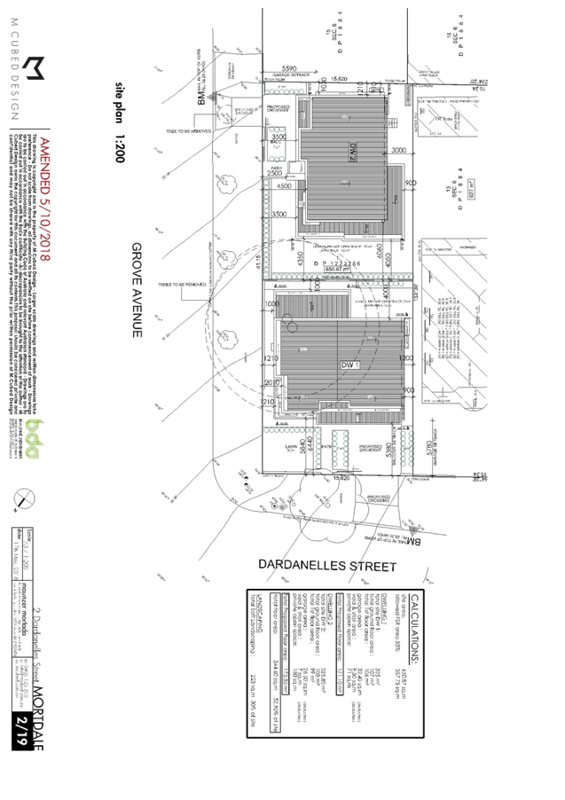
|
Georges
River Council - Georges River Local Planning Panel (LPP) - Thursday, 18 July
2019
LPP022-19 2 Dardanelles Street Mortdale
[Appendix
2] North west and South
west elevations - Dwelling 1 - 2 Dardanelles St Mortdale
|
Page 142
|
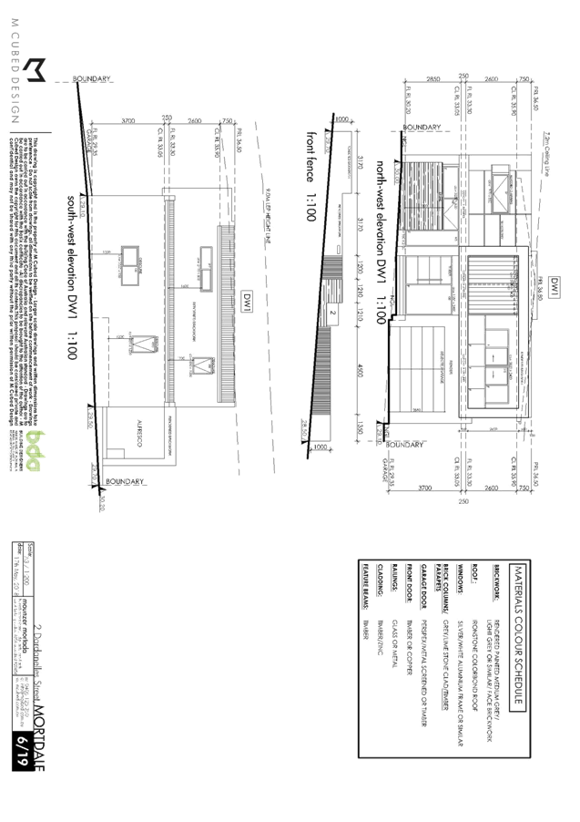
|
Georges
River Council - Georges River Local Planning Panel (LPP) - Thursday, 18 July
2019
LPP022-19 2 Dardanelles Street Mortdale
[Appendix
3] South east and North
east elevations - Dwelling 1 - 2 Dardanelles St Mortdale
|
Page 143
|
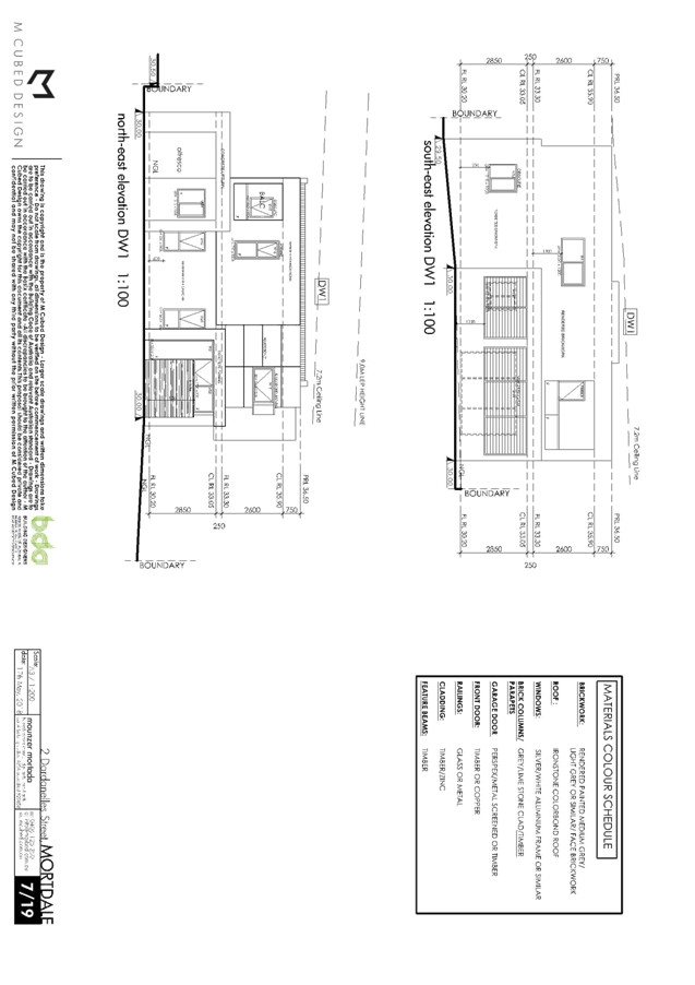
|
Georges
River Council - Georges River Local Planning Panel (LPP) - Thursday, 18 July
2019
LPP022-19 2 Dardanelles Street Mortdale
[Appendix
4] North east and South
east elevations - Dwelling 2 - 2 Dardanelles St Mortdale
|
Page 144
|
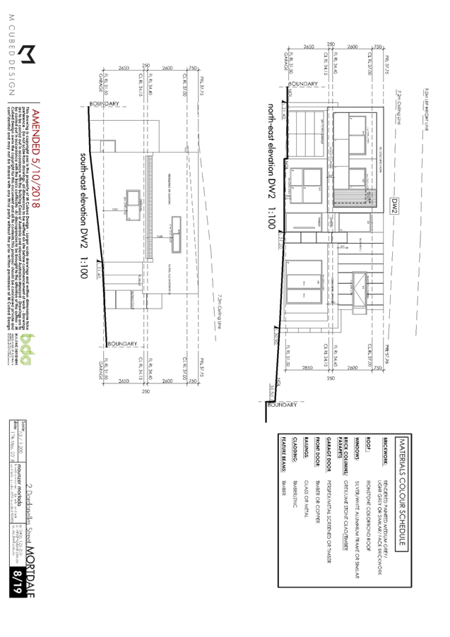
|
Georges
River Council - Georges River Local Planning Panel (LPP) - Thursday, 18 July
2019
LPP022-19 2 Dardanelles Street Mortdale
[Appendix
5] South west and North
west elevations - Dwelling 2 - 2 Dardanelles St Mortdale
|
Page 145
|
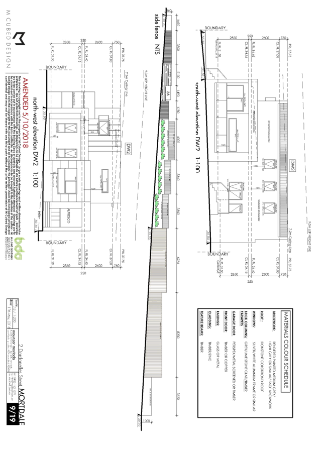
|
Georges
River Council – Local Planning Panel Thursday, 18
July 2019
|
Page 154
|
REPORT TO GEORGES RIVER COUNCIL
LPP MEETING OF Thursday, 18 July 2019
|
LPP Report No
|
LPP023-19
|
Development Application No
|
DA2018/0046
|
|
Site Address & Ward Locality
|
41 Edward Street Carlton
Kogarah Bay Ward
|
|
Proposed Development
|
Alterations and additions to an
existing dwelling, construction of a new detached secondary dwelling, tandem
carport, tree removal, fencing and landscaping works
|
|
Owners
|
Mr TC Nguyen
|
|
Applicant
|
Mr DP Hong
|
|
Planner/Architect
|
Mr Chinch Le
|
|
Date Of Lodgement
|
15/02/2018
|
|
Submissions
|
Nil
|
|
Cost of Works
|
$285,800.00
|
|
Local Planning Panel Criteria
|
Demolition works to a Heritage Item
|
|
List of all relevant s.4.15
matters (formerly s79C(1)(a))
|
State Environmental Planning Policy
No 55 - Remediation Of Land, State Environmental Planning Policy (Building Sustainability
Index: BASIX) 2004; State Environmental Planning Policy (Infrastructure)
2007, State Environmental Planning Policy (Vegetation in Non-Rural Areas)
2017,
Greater Metropolitan Regional
Environmental Plan No 2 – Georges River Catchment, Draft Environment
State Environmental Planning Policy,
Kogarh Local Environmental
Plan 2012, Kogarah Development Control Plan 2013
|
|
List all documents submitted
with this report for the Panel’s consideration
|
Architectural Plans
Heritage Impact Report
Flood Impact Report
|
|
Report prepared by
|
Senior Building Surveyor
|
|
Recommendation
|
THAT the application be approved in accordance with the
conditions included in the report.
|
|
|
Summary of matters for
consideration under Section 4.15
Have all recommendations in relation
to relevant s4.15 matters been summarised in the Executive Summary of the
assessment report?
|
Yes
|
|
Legislative clauses requiring
consent authority satisfaction
Have relevant clauses in all
applicable environmental planning instruments where the consent authority
must be satisfied about a particular matter been listed, and relevant
recommendations summarised, in the Executive Summary of the assessment
report?
|
Yes
|
|
Clause 4.6 Exceptions to
development standards
If a written request for a contravention
to a development standard (clause 4.6 of the LEP) has been received, has it
been attached to the assessment report?
|
Not
Applicable
|
|
Special Infrastructure
Contributions
Does the DA require Special
Infrastructure Contributions conditions (under s7.24)?
|
Not
Applicable
|
|
Conditions
Have draft conditions been provided
to the applicant for comment?
|
No,
standard conditions have been attached; however the conditions will be
publically available when the report is published.
|
|
Site Plan 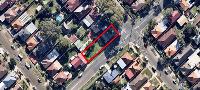
|
Executive Summary
Proposal
1. The
application seeks approval for partial demolition of the heritage dwelling,
being a rear skillion roof structure and alterations and additions to the
heritage listed dwelling. The application is also seeking construction of a
detached tandem carport for the principle dwelling, a new detached secondary
dwelling, tree removal, construction of fencing and landscaping works.
Site and Locality
2. The subject site is
legally identified as Lot 23, Section B in Deposited Plan 5409 and commonly
known as 41 Edward Street, Carlton.
This corner
site is located on the western side of Edward Street, and has its southern side
boundary adjacent to Colvin Avenue. The subject site falls approximately 400mm
to the east towards Edward Street and has a slight cross fall of up to 250mm
towards the southern side boundary adjacent to Colvin Avenue. The property is a
rectangular allotment with a 12.19m wide frontage and a length of 45.72m giving
an overall area of 557.4sqm.
The site
currently contains a single storey heritage listed dwelling constructed
primarily with brick external walls and both a pitched slate roof and metal
deck skillion roofing. The front portion of the development is a former corner
shop. There is a detached metal shed at the rear of the site and although there
is no existing onsite parking spaces in the form of a garage, carport or hard
stand parking area, there is a layback provided within the kerb/gutter of
Colvin Avenue towards the rear of the site as well as a corresponding gated
section of paling fence.
The
immediate area is dominated by residential uses containing a mix of one (1) and
two (2) storey dwelling developments. The area is generally
residential in character with other heritage listed dwellings within the vicinity.
Zoning and Permissibility
3. The site is zoned R2 – Low Density
Residential and demolition, alterations and additions to a “dwelling house” are permissible. The proposed “secondary
dwelling” is not a listed permitted or prohibited use under the provisions
of Kogarah Local Environmental Plan (KLEP) 2012.
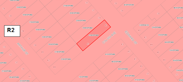
Figure 1 -
Zoning Map – site outlined in red
However,
‘Secondary Dwellings’ are permitted with consent in the R2 zone
under the provisions of State Environmental Planning Policy (Affordable Rental
Housing) 2009.
State
Environmental Planning Policy (Affordable Rental Housing) 2009 applies to the
State and the extent of any inconsistency between it and any Local Environment
Plan (Cl 8) and as such, the prescribed zones stipulated under Cl 20 of the
SEPP override the KLEP 2012 provisions to the extent of permissibility.
Accordingly
the proposed detached secondary dwelling complies with the relevant provisions
of State Environmental Planning Policy (Affordable Rental Housing) 2009, and as
such is a permissible form of development in this R2 – Low Density
Residential area.
In addition, a
‘Secondary Dwellings’ is required to be assessed under the
provisions of KLEP 2012 (including Clause 5.4(9) and Kogarah DCP.
Notification
4. The application was notified to surrounding
neighbours for a period of fourteen (14) days and was also advertised in the St
George and Sutherland Shire Leader. No submissions were received.
Conclusion
5. The application seeks approval for alterations
and additions to an existing dwelling, construction of a new detached secondary
dwelling, tandem carport, tree removal, fencing and landscaping works located
at 41 Edward Street, Carlton.
The proposal
has been assessed against the relevant environmental regulations, planning
instruments and Development Control Plans, the proposal is considered to be an
appropriate form of development and is recommended for approval subject to the
conditions listed at the end of this report.
Report in Full
Proposal
6. The
application seeks approval Alterations and additions to
an existing dwelling, construction of a new detached secondary dwelling, tandem
carport, tree removal, fencing and landscaping works. The proposed works
specifically include the following;
Alterations and
Additions to the Principle Dwelling
· Demolition of the rear
walls of the dwelling and removal of the metal deck skillion roof over this
section of the dwelling.
· Ground floor rear
additions containing bedroom 1, a master bedroom with robe and ensuite, and an
open plan living, kitchen and family room.
· A covered porch is
proposed on the southern side of the family room, with a covered alfresco area
to the west or the rear of the dwelling, also off the family room.
Secondary
Dwelling
· The proposed detached
secondary dwelling contains 2 bedrooms, an open plan kitchen/dining/living
area, a bathroom, cupboard containing the washing machine and an entry porch
facing Colvin Avenue.
Carport
· A tandem
carport is proposed to provide onsite car parking for the principal dwelling
and is accessed access off Colvin Avenue.
External Works
· This application also proposes boundary fencing the Colvin Avenue
frontage, with a sliding gated to access the tandem carport.
· A section of dwarf brick fence with 1.2m high brick piers and open
“picket” style infill panels is also proposed along the southern
side boundary in the area of the heritage dwelling.
· Another section of dwarf brick fence with 1.2m high brick piers and
open “picket” style infill panels is proposed across the front
boundary facing Edward Street in front of the façade of the dwelling not
obscuring the shop frontage.
· The existing layback on Colvin Avenue will be redundant and replaced
with kerb and gutter and turf. A new crossing and driveway will be installed to
service the new tandem carport.
The Site and Locality
7. This
corner site contains a single storey dwelling which and a detached metal garden
shed in the rear of the site. The single storey heritage listed dwelling
(dwelling and former corner store) has three distinctive sections which can be
best described as follows:
The
former “corner shop” see photo 1 below.
.
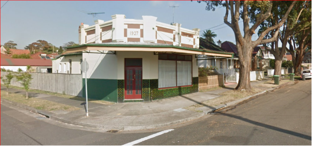
Photo 1 - 41
Edward Street looking from the intersection of Edward Street and Colvin Avenue
The
main section of the dwelling located behind the former corner shop, see photo
2.
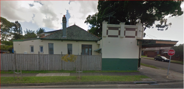
Photo 2 - 41
Edward Street looking north from Colvin Avenue
The rear section
of the dwelling that sits below a skillion roof, formerly containing the
external laundry and a separate WC, see photo 2 above.
The site is
relatively level and contained an existing detached metal shed to the rear
boundary.
This site is flood
affected and the existing dwelling is heritage building.
The following is a
quote from Council’s Heritage Architect’s comments:
“41 Edward
Street, Carlton is significant at a Local level as a representative
single-storey Federation period dwelling with a substantially intact Inter-War
corner shop addition”.
There is also
a significant street tree located in the footpath of Edward Street.
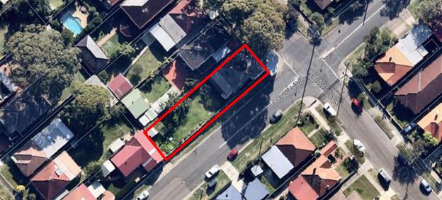
Figure 2 -
Aerial view of 41 Edward Street and neighbouring properties.
This area of
Carlton contains mostly low scale residential development, which is evident on
the adjacent allotments and within a visual catchment of the site.
The proposed
development is considered empathetic to the heritage buildings on site and is
not inconsistent with surrounding development.
PLANNING
ASSESSMENT
8. The site has been inspected and the proposed
development has been assessed under the relevant Section 4.15(1) “Matters
for consideration” of the Environmental Planning and Assessment Act 1979.
Environmental
Planning Instruments
State
Environmental Planning Instruments
9. The following State Environmental Planning
Policies are applicable to the subject site and have been addressed and
satisfied.
State Environmental Planning Policy
(Affordable Rental Housing) 2009
|
State
Environmental Planning Policy (Affordable Rental Housing) 2009
|
|
Division 2
Secondary Dwellings
|
|
Clause
|
Standard
|
Proposed
|
Complies
|
|
Clause 19 - Definition
|
Clause 19 - Definition
In this Division:
development for
the purposes of a secondary dwelling includes the
following:
(a) the erection of, or alterations or additions to, a
secondary dwelling,
(b) alterations or additions to a principal dwelling for the
purposes of a secondary dwelling.
Note - The standard instrument defines secondary dwelling as follows:
secondary dwelling
means a self-contained dwelling that:
(a) is
established in conjunction with another dwelling (the principal dwelling),
and
(b) is
on the same lot of land (not being an individual lot in a strata plan or
community title scheme) as the principal dwelling, and
(c) is located
within, or is attached to, or is separate from, the principal dwelling.
|
This
application seeks to construct a detached secondary dwelling fronting Colvin
Avenue. The principle dwelling on the site is heritage listed.
|
Yes
|
|
Clause 20 –
Land to which Division applies
|
This Division applies
to land within any of the following land use zones or within a land use zone
that is equivalent to any of those zones, but only if development for the
purposes of a dwelling house is permissible on the land:
(a) Zone
R1 General Residential,
(b) Zone
R2 Low Density Residential,
(c) Zone
R3 Medium Density Residential,
(d) Zone
R4 High Density Residential,
(e) Zone
R5 Large Lot Residential.
|
The zoning of the
land is R2
|
Yes
|
|
Clause 22
Development may be carried out with consent
|
|
22(2)
|
A consent authority
must not consent to development to which this Division applies if there is on
the land, or if the development would result in there being on the land, any
dwelling other than the principal dwelling and the secondary dwelling.
|
The site will
contain only a principle dwelling and a secondary dwelling.
|
Yes
|
|
22(3)
|
A consent authority
must not consent to development to which this Division applies unless:
(a) the
total floor area of the principal dwelling and the secondary dwelling is no
more than the maximum floor area allowed for a dwelling house on the land
under another environmental planning instrument, and
(b) the
total floor area of the secondary dwelling is no more than 60 square metres
or, if a greater floor area is permitted in respect of a secondary dwelling
on the land under another environmental planning instrument, that greater
floor area.
|
The permitted Floor Space Ratio
(FSR) according to the KLEP 2012 is 0.55:1 (306.02sqm).
The proposed FSR is 0.5:1
(278.9sqm).
Total floor area
of the secondary dwelling is 52.4sqm, in compliance with the maximum
permitted.
|
|
|
Total floor area
is not a defined term; in this regard the assessment has been undertaken
using the definition of gross floor area under the Kogarah Local
Environmental Plan in order to establish the development does not exceed the
residential floor space ratio applicable to the site.
|
|
22(4) - A consent
authority must not refuse consent to development to which this Division
applies on either of the following grounds:
(a) site
area if:
(i) the
secondary dwelling is located within, or is attached to, the principal
dwelling, or
Secondary
dwelling is detached from the primary dwelling.
(ii) the
site area is at least 450sqm.
Site area is
556.4sqm.
(b) parking
if no additional parking is to be provided on the site.
No additional parking
has been provided. (two parking spaces have been proposed for the principal
dwelling, not the secondary dwelling.
|
|
22(5) - A consent authority may consent to development to
which this Division applies whether or not the development complies with the
standards set out in subclause (4).
|
|
24 No subdivision
A consent authority must not
consent to a development application that would result in any subdivision of
a lot on which development for the purposes of a secondary dwelling has been
carried out under this Division.
Development
application will not result in any subdivision of a lot on which development
for the purposes of a secondary dwelling has been carried out under this
Division.
|
State
Environmental Planning Policy (Building Sustainability Index: BASIX) 2004
10. A BASIX Certificate is required to
be lodged for any development application in NSW for a new home or for any
alteration and addition of $50,000 or more to an existing home.
BASIX
certificate No. A295187_03 dated 02 July 2019 (principal dwelling) and
BASIX certificate No. 866339S_02 dated 02 July 2019 (secondary dwelling) have been issued for the proposed development and the commitments
required by the BASIX Certificate have been satisfied.
State Environmental Planning Policy No 55 –
Remediation of Land
11. The subject site is zoned residential and, given the types
of uses permissible within the residential zones, it is considered unlikely
that the land is contaminated.
State Environmental Planning
Policy (Vegetation in Non-Rural Areas) 2017
12. The objectives of the SEPP are to protect the biodiversity
values of trees and other vegetation in non-rural areas and preserve the
amenity of non-rural areas through the preservation of trees and other
vegetation. This policy is applicable pursuant to Clause 5(1) of the SEPP as
the site is within both Georges River Council and the R2 Low Density
Residential zone.
Pursuant to
Clause 8(1) of the SEPP, clearing does not require authority under the policy
as it is a type of clearing that is authorised under Section 60O of
the Local Land Services Act 2013 (specifically, that associated with
a development consent issued under Part 4 of the Environmental Planning
and Assessment Act 1979).
Kogarah Local Environmental Plan (KLEP) 2012
13. The site is zoned R2 – Low Density Residential and
demolition, alterations and additions to a “dwelling house” are
permissible. The proposed “secondary dwelling” is not a listed
permitted or prohibited use under the provisions of Kogarah Local Environmental
Plan (KLEP) 2012.
However,
‘Secondary Dwellings’ are permitted with consent in the R2 zone
under the provisions of State Environmental Planning Policy (Affordable Rental
Housing) 2009.
State
Environmental Planning Policy (Affordable Rental Housing) 2009 applies to the
State and the extent of any inconsistency between it and any Local Environment
Plan (Cl 8) and as such, the prescribed zones stipulated under Cl 20 of the
SEPP override the KLEP 2012 provisions to the extent of permissibility.
Accordingly
the proposed detached secondary dwelling complies with the relevant provisions
of State Environmental Planning Policy (Affordable Rental Housing) 2009, and as
such is a permissible form of development in this R2 – Low Density
Residential area.
In addition, a
‘Secondary Dwellings’ is required to be assessed under the
provisions of KLEP 2012 (including Clause 5.4(9) and Kogarah DCP.
13.7 Demolition
requires Development Consent
14. Clause 2.7 of KLEP 2012 states ‘the demolition of a
building or work may be carried out only with
development consent’. The proposed demolition has been assessed as part
of this application.
Part
4 – Principal Development Standards
|
Applicable LEP Clause
|
Development Standards
|
Development Proposal
|
Complies
|
|
4.3 Height of Buildings
|
9m
|
6.241m (Principal Dwelling)
4.805m (Secondary Dwelling)
|
Yes
Yes
|
|
4.4 Floor Space Ratio
|
0.55:1 as identified on the floor
space ratio map (0.55 x 556.4 = 306.02sqm)
|
0.5:1 (278.9sqm)
(Principal dwelling = 226.5sqm)
(Secondary dwelling = 52.4sqm)
|
Yes
|
|
4.4A
Exceptions to floor space ratio for residential accommodation in Zone R2
|
Sites with an area less than 650sqm
= 0.55:1
|
0.5:1 (278.9sqm)
(Principal dwelling = 226.5sqm)
(Secondary dwelling = 52.4sqm)
|
Yes
|
Part 5 – Miscellaneous Provisions
5.10
Heritage Conservation
15. The subject site is included in Schedule 5 –
Environmental heritage in Kogarah LEP 2012 and is identified as House and
former shop, Item No 17. It is significant at a Local level. The statement of
significance from the 2011 Kogarah Heritage Study Review for the subject site
is as follows:
“41
Edward Street, Carlton is significant at a Local level as a representative
single-storey Federation period dwelling with t substantially intact Inter-War
corner shop addition. The shop with its high integrity is relatively rare
within the Kogarah LGA and due to its prominent location makes a valuable
contribution to the street scape and historical evolution and evidence of its
locality, despite being adapted to residential use.”
The application
was supported by a Heritage Impact Statement prepared by Sydney Heritage
Consultants.
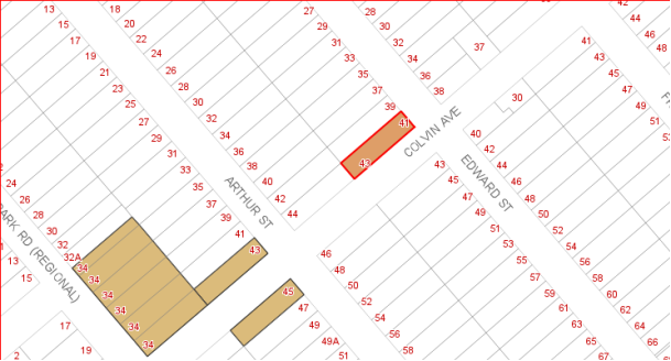
Figure 3 -
Heritage map with subject site outlined in red
16. The application has been referred to Council’s
Heritage Adviser on two (2) separate occasions. The plans the subject of this
report are supported subject to specific and standard conditions of consent,
the specific conditions include the following:
i) The tile selection for the addition to the
dwelling is to be provided and approved by Council’s Heritage Advisor
prior to the issue of a Construction Certificate.
ii) Details of the proposed brick and picket fence,
including all dimensions, materials and colours are to be provided and approved
by Council’s Heritage Advisor prior to the issue of a Construction
Certificate
iii) Existing slate tiles on the rear roof plane which
will be obscured by the proposed new addition roof, and are to be preserved
insitu or stored in a secure location on site for use in the future repair and
maintenance of the original roof.
Part 6 – Additional Local Provisions
|
Applicable KLEP 2012 Clause
|
KLEP Provisions
|
Development Proposal
|
Complies
|
|
6.1 Acid Sulfate Soils
|
The objective of this clause is to ensure that development does not
disturb, expose or drain acid sulfate soils and cause environmental damage.
|
Site has not been identified as
located in an area containing Acid Sulfate soils as per KLEP 2012 Acid
Sulfate Soils Map.
|
Yes
|
|
6.2 Earthworks
|
The objective of this clause is to ensure that earthworks for which development
consent is required will not have a detrimental impact on environmental
functions and processes, neighbouring uses, cultural or heritage items or
features of the surrounding land.
|
The earthworks proposed are
ancillary to the proposed development and will have minimal impacts on the
surrounding land and environment.
|
Yes
|
|
6.3 Flood Planning
|
The
objectives of this clause are:
(a) to minimise the flood risk to life and property
associated with the use of land,
(b) to allow development on land that is compatible with
the land’s flood hazard, taking into account projected changes as a
result of climate change,
(c) to avoid significant adverse impacts on flood
behaviour and the environment.
|
The 1:100 year ARI
flood level is RL26.05m AHD. It is proposed that the ground floor slab for
the secondary dwelling and the new additions to the existing house require a
suspended floor on piers and beams to allow the flow of water to run
underneath the development to ensure there will be no increased flooding
impacts on surrounding allotments.
|
Yes
|
|
6.4 Foreshore Scenic Protection
Area (FSPA).
|
The objective of this clause is to
ensure that development in the foreshore area will not impact on natural
foreshore processes or affect the significance and amenity of the area.
|
Site is not located in a Foreshore
Scenic Protection Area
|
NA
|
All
other relevant provisions of the LEP have been considered and it has been found
that the proposal satisfactorily addresses the objectives of these clauses.
Draft Environmental
Planning Instruments
17. The Draft Environment SEPP was exhibited from 31 October
2017 to 31 January 2018. This consolidated SEPP proposes to simplify the
planning rules for a number of water catchments, waterways, urban bushland, and
Willandra Lakes World Heritage Property. Changes proposed include consolidating
the following seven existing SEPPs:
· State Environmental Planning Policy No. 19 – Bushland in Urban
Areas,
· State Environmental Planning Policy (Sydney Drinking Water
Catchment) 2011,
· State Environmental Planning Policy No. 50 – Canal Estate
Development,
· Greater Metropolitan Regional Environmental Plan No. 2 –
Georges River Catchment,
· Sydney Regional Environmental Plan No. 20 – Hawkesbury-Nepean
River (No.2-1997),
· Sydney Regional Environmental Plan (Sydney Harbour Catchment) 2005,
· Willandra Lakes Regional Environmental Plan No. 1 – World
Heritage Property.
The proposal is not inconsistent with the provisions of this Draft
Instrument.
Kogarah
Development Control Plan 2013
18. The proposed development is subject to the provisions of
the Kogarah Development Control Plan 2013 (KDCP2013). The following comments
are made with respect to the proposal satisfying the objectives and controls
contained within the DCP.
|
1. Design Requirements
|
|
Control
|
Requirement
|
Proposal
|
Complies
|
|
1.2 Building
Scale and Height
|
|
1.2.1 Floor space
Requirements
|
(1) The floor
space ratio for dwelling houses must comply with the requirements below:
Site Area: Less than or equal to
650sqm the Maximum FSR: 0.55:1
(2) Where a secondary dwelling is
proposed, the maximum FSR/floor area includes the dwelling and the detached
secondary dwelling. In this regard, the overall development is not to exceed
the maximum floor space ratio.
(3) Notwithstanding compliance with
the numerical requirements in the DCP, applicants must demonstrate that the
bulk and relative mass of the proposed development is acceptable in the
street and on adjoining dwellings, in terms of the following impacts:
(i) streetscape considerations
(bulk and scale);
(ii) building setbacks;
(iii) landscape requirements;
(iv)the existence of significant
trees/vegetation on site;
(v) the size and shape of the
allotment; and
(vi) topography of the site.
|
0.5:1
0.5:1
Complies
|
Yes
Yes
Yes
|
|
1.2.2 Building Heights
|
(1) The maximum
building height must comply with;
Dwelling Type
Single dwelling
additions/alterations;
Maximum Height
7.2m to the
underside of the upper ceiling;
9m to the top of
the ridge (pitched roof).
Dwelling Type
Detached secondary
dwelling
Maximum Height
2.7m to the
underside of the ceiling
3.5m overall
building height
|
3.66m
6.241m
3.46m
4.805m
|
Yes
Yes
No (1)
No (1)
|
|
1.2.3 Rhythm of the Built
Elements in the Streetscape
|
(1) The primary building
façade should not exceed 40% of the overall width of the total
frontage.
(2) The secondary building
façade should be set back a minimum of 1.5m from the primary building
façade.
(3) Where the
dominant built form in the streetscape provides for a pitched hip or gable
ended presentation to the street, the new buildings and/or additions should
reflect that roof form.
|
No change to the
primary façade.
Additions are
setback 1.914m; secondary dwelling is setback 2m.
Pitched roof is
maintained with additions.
|
N/A
Yes
Yes
|
|
1.2.4 Building Setbacks
|
1.2.4.2 Front Setbacks
(1) Where the
setback of an adjacent building is greater than 5m, an appropriate setback
may be achieved by ensuring development is setback:
(i) the same
distance as one or the other of the adjoining buildings, provided the
difference between the setbacks of the two adjoining buildings is less than
or equal to 2.0m; or
(ii) the average of the
setbacks of the two adjoining buildings, if the difference between the
setbacks of the buildings is greater than 2.0m.
(2) Where the
setbacks of the adjacent buildings are 0m-5.0m, an appropriate setback may be
achieved by ensuring development is set back the same distance as one or the
other of the two adjoining dwellings.
(3) Where a development
has a frontage to two (2) streets, then the setback to the secondary street
shall be 1.2m, with the exception of dual occupancy (detached), where the
setback to the secondary street shall be 4.5m.
1.2.4.3 Side and Rear Setbacks
(1) The side and
rear boundary setbacks should comply with;
Dwelling Type
Single dwelling
Rear Setback
Buildings are to
have a minimum rear setback of 15% of the average site length, or 6m,
whichever is greater.
Where the existing
pattern of development displays an established rear setback, development
should recognise and respond to site features and cross views of neighbouring
properties.
Council may permit
a variation to the rear setback if it can be demonstrated that this will
result in the retention of significant trees or site features, has no adverse
impacts on neighbouring amenity.
Side Setbacks
For buildings
having a wall height of 3.5m or less, the minimum side boundary setback is
900mm.
For buildings
having a wall height of greater than 3.5m, the minimum side boundary setback
is 1200mm.
The above
numerical requirements may be varied to ensure side boundary setbacks and
building to building relationships are consistent with those setbacks
established within the streetscape.
Dwelling Type
Secondary dwelling
(detached from primary dwelling)
Rear Setback
3m
Side Setbacks
900mm or existing
dwelling setback, whichever is the greater of both
|
No change to the
front setback.
Additions are 1.91
and 4m, and secondary dwelling is 2m.
17.375m
(38%)
Northern side boundary =
1.028m
Southern side
boundary = 1.914m
1m
Northern =
982mm
Southern = 2m
|
N/A
Yes
Yes
No (2) (1.2m
required)
Yes
No (2)
Yes
Yes
|
|
1.2.5 Fenestration and External Materials
|
(1) New buildings
and alterations and additions should present a primary building façade
and roofing that is constructed of materials, and within a colour range, that
is complementary to the dominant character of buildings in the streetscape.
(2) Garage doors
should not dominate the street front elevation.
(3) The roof
should be similar to the angle of pitch, materials and colour of roofs in the
streetscape.
(4) The colours of
garages, window frames, and balustrading on main facades and elevations are
to be integrated with the external design of the building.
(5) Glazing shall
be limited to a maximum 35% of the total area of the overall street front
façade. This includes both primary and secondary façade bays.
|
Complies
No garage
Complies
Complies
Complies
|
Yes
N/A
Yes
Yes
Yes
|
|
1.2.6 Street Edge
|
(1) New
developments should provide front fencing that complements fencing within the
streetscape.
(2) Fencing is to
be consistent with the requirements of Section 4.2.
(3) Existing
vegetation in the front building line setback or on the street verge that
contributes to the character of the streetscape should be preserved.
(4) The driveway
location should not result in the removal of any street trees or removal of
substantial trees on the site.
|
Complies
Complies
Complies
Complies
|
Yes
Yes
Yes
Yes
|
|
1.3 Open Space
|
(1) 15% of the site area must be
deep soil landscaped area.
(2) Private open space should be
adjacent to and visible from the main living and/or dining rooms and be
accessible from those areas.
(3) Development should take
advantage of opportunities to provide north facing private open space to
achieve comfortable year round use.
(4) Where soil and drainage
conditions are suitable, unpaved or unsealed landscaped areas should be
maximised and designed to facilitate on site infiltration of stormwater.
(5) Existing significant trees and
vegetation must be incorporated into proposed landscape treatment.
|
176.6sqm
Complies
Complies
Complies
N/A
|
Yes
Yes
Yes
Yes
N/A
|
|
1.4 Vehicular
access, parking and circulation
|
(1) Car parking is to be provided
in accordance with the requirements in Section B4.
(2) On corner sites with two street
frontages vehicular access should be provided to the secondary frontage.
(3) Garages should be accessed from
a rear lane where this is available.
(4) Crossings are to be positioned
so that on-street parking and landscaping on the site are maximised, and
removal or damage to existing street trees is avoided.
(5) Garaging should be setback
behind the primary façade.
(6) The maximum driveway width
between the street boundary and the primary building façade is 4m.
(7) Where the dominant provision of
garaging within the streetscape is provided to the rear or side of
developments, new developments and additions to existing development should
provide for a side driveway or garaging behind the main street front
elevation of the building.
Car parking layout and vehicular
access requirements and design are to be in accordance with the Australian
Standards, in particular AS 2890.1-2004.
|
Parking for two
vehicles for the principal dwelling proposed in the tandem carport.
Complies
N/A
Complies
Complies
Complies
Complies
Complies
|
Yes
Yes
N/A
Yes
Yes
Yes
Yes
Yes
|
|
1.5 Privacy
|
(1) Windows from active rooms are
to be offset between adjacent dwellings so as to avoid direct overlooking
onto neighbouring windows.
(2) Where terraces and balconies
are proposed and are elevated more than 1.5m above ground level (finished)
and are located behind the street front façade, they are restricted to
a maximum width of 2.5m and must be setback a minimum 3m from any adjoining
property boundary.
(3) The area of balconies or
terraces greater than 1.5m above ground level is limited to a cumulative
total of 40sqm per dwelling.
(4) Council may consider a
variation to the above requirements where it is considered that the terrace
or balcony will not result in a loss of privacy to neighbouring properties.
(5) For active rooms or balconies
on an upper level, the design should incorporate placement of room windows or
screening devices to only allow oblique views to adjoining properties.
(7) In these circumstances, Council
will undertake an assessment of the impact of the proposed development on the
neighbouring properties having regard to:
(i) The types of rooms that are
located on the upper levels;
(ii) Whether the rooms are
“active” or “non-active”
(iii) The size and location of
proposed upper level windows, balconies, terraces and any other area
(elevated more than 1500mm above ground level).
(iv) The extent of overlooking onto
neighbouring properties.
(v) Notwithstanding the above,
where rooms on the upper levels are “non-active”, no
consideration will be given with respect to privacy issues.
Active rooms are rooms used for
normal domestic activities and include a living room, lounge room, music
room, television room, dining room, family room, kitchen, playroom, parents
retreat and the like.
Non-active rooms are rooms of a
generally passive nature and include bathroom, laundry, water closet, walk in
wardrobe, bedroom, sewing room and the like.
|
Complies
N/A
N/A
N/A
N/A
N/A
|
Yes
N/A
N/A
N/A
N/A
N/A
|
|
1.5.2 Acoustic Privacy
|
Residential development adjacent to
a rail corridor or a busy road should be designed and sited to minimise noise
impacts Refer to requirements in State Environmental Planning Policy –
Infrastructure and the NSW Department of Planning’s Development near
Rail Corridors and Busy Roads – Interim Guidelines.
|
N/A
|
N/A
|
|
1.6 Solar
Access
|
(1) At least 50% of the primary
private open space of the proposed development should have access to a
minimum of four hours of sunlight between 9am–3pm on 21 June.
(2) Where private open space is
proposed on the southern side of the building the distance from the southern
boundary of the open space to the nearest wall to the north must be a minimum
of 3m + h, where h is the height of the wall.
(3) Where the neighbouring
properties are affected by overshadowing, at least 50% of the neighbouring
existing primary private open space or windows to main living areas must
receive a minimum of 3 hours sunlight between 9am–3pm on 21 June.
(4) Shadow diagrams are to be
submitted for the winter solstice (21 June) and the spring equinox (22
September).
(5) Shadow diagrams are required to
show the impact of the proposal on solar access to the open space of
neighbouring properties. Existing overshadowing by fences, roof overhangs and
changes in level should also be reflected in the diagrams.
|
Complies
N/A
N/A
N/A
N/A
|
Yes
N/A
N/A
N/A
N/A
|
|
1.7 Views and
view sharing
|
Development shall provide for the
reasonable sharing of views. Note: Assessment of applications will refer to
the Planning Principle established by the Land and Environment Court in
Tenacity Consulting vs Warringah Council (2004) NSWLEC140
|
No view impacts
caused by the proposed works
|
N/A
|
Variations or Non-Compliances
(1) Height
The detached
secondary dwelling has an overall height of 4.805m which exceeds the height
limit of 3.5m permitted under the Kogarah Development Control Plan 2013, as
well as exceeding the height to the underside of the ceiling (2.7m permitted)
with a height of 3.46m proposed. The height of this secondary dwelling has been
raised to satisfy flood issues that affect this site and were required by
Councils Stormwater Engineers. The increase in height does not impact the
streetscape as a 1.8m high dividing fence will run along the southern side
boundary thereby screening the bulk of the building from the street. It is also
noted that the two bedroom windows (non-active rooms) that face the northern
side neighbour are highlight windows, and the rear or eastern neighbour has a
blank wall running across the length of this rear boundary, thus ensuring that
adjoining neighbours are also not adversely affected by this height
non-compliance. In this regard the increased height has not unreasonable impact
on the adjoining allotments, the heritage status of the site or the public
domain.
(2) Setbacks
Secondary
Dwelling
The detached
secondary dwelling is setback 1m from the rear boundary rather than the
required 3m under Kogarah Development Control Plan 2013. This is considered
acceptable as the rear neighbour has a large blank wall of a detached
garage/outbuilding that extends across the common rear/side boundary.
Council has been
granting variations to the rear setback of 3m down to 900mm which is consistent
with the control in the Hurstville Development Control Plan so long as there is
no unreasonable impact on adjoining allotments.
Accordingly the
location of this secondary dwelling and its relationship to the allotment
adjoining is not unreasonably impacted as a result the reduced rear setback.
In addition the
location of the secondary dwelling 1m from the rear boundary provides
functional useable space within the site for the residents, as a result this
proposed rear boundary setback variation is recommended to be supported.
Dwelling
Additions
The rear addition
to the main dwelling has an overall wall height of 3.66m. Any dwelling with a
wall height exceeding 3.5m in height requires a 1.2m side boundary setback
rather than a 900mm setback proposed.
This height has
resulted from the need for the works to be raised to address the flooding
affectations that affect this site. The breach in the wall height equates to
160mm which will not be readily discernible from the adjoining allotments and
the public domain.
This increased
height will not reduce the amenity of the adjoining allotments with respect to
availability of sunlight.
Whilst
a numeric control has been nominated, the DCP details that a variation can be
considered if:
“The
above numerical requirements may be varied to ensure side boundary setbacks and
building to building relationships are consistent with those setbacks
established within the streetscape”.
In reviewing this
application having regard to the above statement, it is considered that the
additional height does not compete with the heritage form on the site and is
not inconsistent with the bulk and scale of development within this precinct.
As a result is
considered the variations to the DCP for setbacks and height are considered
reasonable and not inconsistent with the desired development outcomes for the
locality, as a result they are recommended to be supported.
IMPACTS
Natural
Environment
19. The site has three existing fruit trees located in the
backyard that are proposed to be removed. There is also one street tree in
Colvin Avenue that will require removal for the proposed layback and driveway
required to access the proposed tandem carport. The application has been
assessed and endorsed by Council’s Landscape Officer and relevant tree
and landscaping conditions of consent are recommended including replacement
planting.
Built
Environment
20. The proposed development will not result in any
unreasonable impacts upon the built environment for reasons discussed
throughout the report.
Social and
Economic Impact
21. The proposed development will not result in any adverse
social and/or economic impacts within the locality.
Suitability
of the Site
22. It is considered that the proposed development is of a
scale and design that is suitable for the site having regard to its size and
shape, its topography and relationship to adjoining developments.
SUBMISSIONS AND
THE PUBLIC INTEREST
23. The application was notified to surrounding neighbours for
a period of fourteen (14) days between 20 February 2019 and 6 March 2019 in
accordance with this Section A2 of Kogarah Development Control Plan 2013. The
application was also advertised on St George and Sutherland Shire Leader. No
submissions were received.
REFERRALS
Council
Referrals
Landscape
Officer
24. The application has been assessed and endorsed by
Council’s Landscape Officer and relevant tree and landscaping conditions
have been recommended.
Building
Surveyor
25. The application has been assessed and endorsed by
Council’s Building Surveyor and relevant building conditions of consent
were imposed.
Heritage
Advisor
26. The proposal is supported by Council’s Heritage
advisor subject to standard and specific recommended conditions of consent.
Drainage
Engineering
27. The application has been referred to Council’s
Drainage Engineer. Stormwater related consent conditions of consent have been
imposed.
GIS
28. The application has been referred to Council’s GIS
team. A street address has been obtained for the secondary dwelling.
CONCLUSION
29. The application seeks approval for partial demolition of
the heritage dwelling, being a rear skillion roof structure and alterations and
additions to the heritage listed dwelling. The application is also seeking
construction of a detached tandem carport for the principle dwelling, a new
detached secondary dwelling, tree removal, construction of fencing and
landscaping works at 41 Edward Street, Carlton.
The
application was notified to surrounding neighbours for a period of fourteen
(14) days between 20 February 2019 and 6 March 2019 in accordance with this
Section A2 of Kogarah Development Control Plan 2013. The application was also
advertised on St George and Sutherland Shire Leader. No submissions received.
The proposed development satisfies the planning controls and
objectives within Kogarah Local Environmental Plan 2012 and Kogarah
Development Control Plan 2013.
The application is
recommended for approval subject to the conditions of consent included in this
report.
DETERMINATION
AND STATEMENT OF REASONS
Statement of
Reasons
30.
· The proposed development
is considered to be an appropriate scale and form for the site and the
character of the locality;
· The proposed
development, subject to the recommended conditions, will have no unacceptable
adverse impacts upon the natural or built environments;
· The proposed development
is respectful of the heritage nature of the site;
· In consideration of the
aforementioned reasons, the proposed development is a suitable and planned use
of the site and its approval is in the public interest.
Determination
31. That pursuant to Section 4.16 (1) of the Environmental
Planning and Assessment Act, 1979; as amended, the Georges River Local Planning
Panel grants development consent to Development Application DA2018/0046 for partial
demolition of the heritage dwelling, being a rear skillion roof structure and
alterations and additions to the heritage listed dwelling. The application is
also seeking construction of a detached tandem carport for the principle
dwelling, a new detached secondary dwelling, tree removal, construction of
fencing and landscaping works at Lot 23, Sec B, DP5409 and known as 41 Edward
Street, Carlton, subject to the conditions listed below.
SPECIFIC
DEVELOPMENT CONDITIONS
Section A Development Details
1. Approved
Plans - The development must be implemented in accordance with the approved
plans and supporting documentation listed below which have been endorsed by
Council’s approved stamp, except where marked up on the plans and/or
amended by conditions of this consent:
|
Description
|
Drawing No.
|
Date
|
Revision
|
Prepared by
|
|
Cover Page
|
1
|
13/6/2018
|
B
|
HVTD Design Pty Ltd
|
|
Site & Demolition Plan
|
2
|
13/6/2018
|
B
|
HVTD Design Pty
Ltd
|
|
Ground Floor Plan
|
3
|
13/6/2018
|
B
|
HVTD Design Pty
Ltd
|
|
Granny Flat and Carport Plan
|
4
|
13/6/2018
|
B
|
HVTD Design Pty
Ltd
|
|
Main House Elevations
|
5
|
13/6/2018
|
B
|
HVTD Design Pty
Ltd
|
|
Main House Elevation and Section
|
6
|
13/6/2018
|
B
|
HVTD Design Pty
Ltd
|
|
Granny Flat and Carport Elevations
|
7
|
13/6/2018
|
B
|
HVTD Design Pty
Ltd
|
|
Fence Elevations
|
8
|
13/6/2018
|
B
|
HVTD Design Pty
Ltd
|
|
Roof Plan (Main House)
|
9
|
13/6/2018
|
B
|
HVTD Design Pty
Ltd
|
|
Roof Plan (Granny Flat and Carport)
|
10
|
13/6/2018
|
B
|
HVTD Design Pty
Ltd
|
|
Site Analysis Plan
|
11
|
13/6/2018
|
B
|
HVTD Design Pty
Ltd
|
|
Site Management/ Sediment Control
|
12
|
13/6/2018
|
B
|
HVTD Design Pty
Ltd
|
|
Ground Floor Area Calculation Diagram
|
13
|
13/6/2018
|
B
|
HVTD Design Pty
Ltd
|
|
Landscaping Area Calculation Diagram
|
14
|
13/6/2018
|
B
|
HVTD Design Pty
Ltd
|
|
Basix Commitments
|
15
|
13/6/2018
|
B
|
HVTD Design Pty
Ltd
|
|
Draft Landscaping Plan
|
N/A
|
13/6/2018
|
B
|
HVTD Design Pty
Ltd
|
Separate Approvals Required Under Other Legislation
2. Section
138 Roads Act 1993 and Section 68 Local Government Act 1993 - Unless
otherwise specified by a condition of this consent, this Development Consent
does not give any approval to undertake works on public infrastructure.
Separate approval is required under Section 138 of the Roads Act 1993
and/or Section 68 of the Local Government Act 1993 for any of the following
activities carried out in, on or over a public road (including the footpath)
listed below.
An application is required to be lodged and approved prior to the
commencement of any of the following works or activities;
(a) Placing or storing materials or equipment;
(b) Placing or storing waste containers or skip bins;
(c) Erecting a structure or carrying out work
(d) Swinging or hoisting goods over any part of a public road by means of
a lift, crane or the like;
(e) Pumping concrete from a public road;
(f) Pumping water from the site into the public road;
(g) Constructing a vehicular crossing or footpath;
(h) Establishing a “works zone”;
(i) Digging up or disturbing the surface of a public road (eg Opening the
road for the purpose of connections to utility providers);
(j) Stormwater and ancillary works in the road reserve;
(k) Stormwater and ancillary to public infrastructure on private land;
and
(l) If any excavation is to be supported by the use of below ground
(cable) anchors that are constructed under Council’s roadways/footways.
These separate activity approvals must be obtained and evidence of the
approval provided to the Certifying Authority prior to the issue of the
Construction Certificate.
The relevant Application Forms for these activities can be downloaded
from Council’s website www.georgesriver.nsw.gov.au.
For further information, please contact Council’s Customer Service Centre
on (02) 9330 6400.
3. Vehicular
Crossing - Minor Development - Constructing a vehicular crossing and/or
footpath requires a separate approval under Section 138 of the Roads Act 1993
prior to the commencement of those works.
To apply for approval, complete the Driveway Crossing on Council Road
Reserve Application Form which can be downloaded from Georges River
Council’s Website at www.georgesriver.nsw.gov.au. Lodge the application
form, together with the associated fees at Council’s Customer Service
Centre, during business hours. Refer to Section P1 and P2, in Council’s
adopted Fees and Charges for the administrative and inspection charges
associated with Vehicular Crossing applications.
An approval for a new or modified vehicular crossing will contain the
approved access and/or alignment levels which will be required to construct the
crossing and/or footpath. Once approved, all work shall be carried out in
accordance with Council’s specifications applicable at the time, prior to
the issue of an Occupation Certificate.
4. Road
Opening Permit - A Road Opening Permit must be obtained from Council, in
the case of local or regional roads, or from the RMS, in the case of State
roads, for every opening of a public road reserve to access services including
sewer, stormwater drains, water mains, gas mains, and telecommunications before
the commencement of work in the road.
Requirements of Concurrence, Integrated & Other Government
Authorities
5. Sydney
Water - Tap in TM - The approved plans must be submitted to a Sydney
Water Tap in TM to determine whether the development application will affect
Sydney Water’s sewer and water mains, stormwater drains and/or easements,
and if further requirements need to be met. The approved plans will be
appropriately endorsed. For details please refer to ‘Plumbing,
building and developing’ section of Sydney Water’s web site at www.sydneywater.com.au then see
‘Building’, or telephone 13000 TAP IN (1300 082 746). The
Certifying Authority must ensure that a Tap in TM agent has appropriately
stamped the plans prior to the issue of the Construction Certificate.
Prior to the Issue of a Construction Certificate
6. Low
reflectivity roof - Roofing materials must be low glare and reflectivity.
Details of finished external materials including colours and texture must be
provided to the Certifying Authority.
7. Overland
Flow - To allow for the conveyance of overland flow through the site the
paling fence proposed along the south eastern side boundary adjacent to Colvin
Avenue shall be left open across the bottom for a height of 100mm above the
existing ground level except for where the vertical posts are located (i.e. to
the underside of the palings).
8. Driveway
Gates - The driveway gates facing Colvin Avenue shall be the same materials
as the lapped and capped paling fence and shall not project out over Councils
footpath during operation.
9. Bathroom
Air Lock within Secondary Dwelling - The bathroom door shall be provided
with a self-closer and mechanical ventilation shall be provided within the
bathroom to create an air lock between the W.C. and the kitchen.
10. Carport
Slab - The top of the carport slab shall be located as close to the top of
existing ground level as practical, so as to allow the conveyance of overland
flow.
11. Fees
to be paid - The fees listed in the table below
must be paid in accordance with the conditions of this consent and
Council’s adopted Fees and Charges applicable at the time of payment
(available at www.georgesriver.nsw.gov.au).
Payments must be made prior to the issue of the
Construction Certificate or prior to the commencement of work (if there is no
associated Construction Certificate).
Please contact Council prior to the payment of
Section 7.11 Contributions to determine whether the amounts have been indexed
from that indicated below in this consent and the form of payment that will be
accepted by Council.
Council will only accept Bank Cheque or
Electronic Funds Transfer (EFT) for transaction values of $500,000 or over.
Council must be contacted prior to payment to determine correct total amount to
be paid and bank account details (if applicable).
A summary of the fees to be paid are listed
below:
|
Fee Type
|
Fee
|
|
GENERAL FEES
|
|
Long Service Levy (to Long Service Corporation) Or,
provide evidence of Payment direct to the Long Service Corporation. See
https://portal.longservice.nsw.gov.au/bci/levy/
|
|
Builders Damage Deposit
|
$1,900.00
|
|
Inspection Fee for Refund of Damage Deposit
|
$155.00
|
|
Driveway Design and Inspection Fee (Dwelling)
|
$ 659.50
|
|
DEVELOPMENT CONTRIBUTIONS
|
|
|
Georges River Council Section 94A Development
Contributions Plan 2017
|
$2,858.00
|
General Fees
The fees and charges above are subject to
change and are as set out in the version of Council's Schedule of Fees and
Charges or as required by other Government Authorities, applicable at the time
of payment.
Development Contributions
The Section 7.11 contribution is imposed to
ensure that the development makes adequate provision for the demand it
generates for public amenities and public services within the area.
A Section 7.12 contribution has been levied on
the subject development pursuant to the Georges River Council Section 94A
Contributions Plan.
Indexation
The above contributions will be adjusted at the
time of payment to reflect changes in the cost of delivering public amenities
and public services, in accordance with the indices provided by the relevant
Section 94 Development Contributions Plan.
Timing of Payment
The contribution must be paid and receipted by
Council prior to the release of the
Construction Certificate.
Further Information
A copy of the all current Development
Contributions Plans may be inspected or a copy purchased at
Council’s offices (Georges River Civic Centre, MacMahon Street,
Hurstville and Kogarah Library and Service Centre, Kogarah Town Square,
Belgrave Street, Kogarah) or viewed on Council’s website www.georgesriver.nsw.gov.au.
12. BASIX
Commitments - All energy efficiency measures as detailed in the BASIX
Certificate No. A295187 (main house)
and 866339S (secondary dwelling) must be implemented on the plans lodged with
the application for the Construction Certificate.
13. Site Management
Plan - A Site Management Plan detailing all weather access control points,
sedimentation controls, fencing, builder’s site sheds office, amenities,
materials storage and unloading arrangements must be submitted with the
application for the Construction Certificate.
14. Landscape Plans
- All landscape works shall be carried out in accordance with the approved
landscape plans and specifications, drawn by Mr Chinh Le, reference numbers
– EDW – 17 dated 13.06.2018. The landscaping shall be maintained in
accordance with the approved plans in perpetuity. The proposed plant species,
pot/ bag size and quantities of plants shall be in accordance with the proposed
plant schedule upon the Draft landscape plan. If plant species, pot/ bag size
and quantities cannot be sourced, Council shall be contacted for alternatives.
15. Erosion &
Sedimentation Control - Erosion and sediment controls must be provided to
ensure:
(a) Compliance with the approved Erosion &
Sediment Control Plan
(b) Removal or disturbance of vegetation and top soil
is confined to within 3m of the approved building area (no trees to be removed
without approval)
(c) All clean water runoff is diverted around
cleared or exposed areas
(d) Silt fences, stabilised entry/exit points or
other devices are installed to prevent sediment from entering drainage systems
or waterways
(e) All erosion and sediment controls are fully
maintained for the duration of demolition, excavation and/or development works
(f) Controls are put into place to prevent
tracking of sediment by vehicles onto adjoining roadway
(g) All disturbed areas are rendered
erosion-resistant by turfing, mulching, paving or similar
(h) Compliance with Managing Urban Stormwater -
Soils and Construction (Blue Book) produced by Landcom 2004.
These measures are to be implemented prior to the commencement of work
(including demolition and excavation) and must
remain until works are completed and all exposed surfaces are
landscaped/sealed.
16. Stormwater
System - The submitted stormwater plan has been assessed as a concept plan
only. Final detailed plans of the drainage system, prepared by a professional
engineer specialising in hydraulic engineering, shall be submitted for approval
with the Construction Certificate.
(a) All stormwater shall
drain by gravity to Council's stormwater system in the street directly in front
of the development site in accordance with the Australian/New Zealand Standard
AS/NZS 3500.3: 2015 (as amended).
(b) Due to the site being
affected by flood, no fill underneath the new building’s slab up to the
1:100yr ARI flood level (RL 26.55m). The new buildings’ slab shall be
raised on piers however an open form type of fencing can be used to close the
subfloor area.
(c) Any removal or
relocating of Council’s kerb drain lintel in the street kerb shall be subject to Council’s Asset
engineer approval in writing prior of the issue of the Construction
Certificate.
(d) Stormwater drainage
plans including pipe sizes, type, grade, length, invert levels, dimensions and
types of drainage pits prepared by a professional engineer who specialises in
Hydraulic Engineering in accordance with the Australian Institute of Engineers
Australian Rainfall and Runoff (1987) and Council's Stormwater Drainage
Guidelines, shall accompany the application for the Construction Certificate.
(e) Due to the site being
affected by flood, backyard levels (including under the dwelling additions and
secondary dwelling) shall remain as existing to allow the existing overland
path to be unaltered.
17. Structural
details - Engineer's details prepared by a practising Structural Engineer
being used to construct all reinforced concrete work, structural beams, columns
and other structural members. The details are to be submitted to the Principal
Certifying Authority for approval prior to construction of the specified works.
A copy shall be forwarded to Council where Council is not the PCA.
18. Traffic
Management - Compliance with AS2890 - All driveways, access ramps,
vehicular crossings and car parking spaces shall be designed and constructed in
accordance with the current version of Australian Standards, AS 2890.1 (for car
parking facilities) and AS 2890.2 (for commercial vehicle facilities).
19. Dilapidation
Report on Public Land - Prior to the commencement of works (including
demolition and excavation), a dilapidation report must be prepared for the
Council infrastructure adjoining the development site, including:
The report must
include the following:
(a) Photographs
showing the existing condition of the road pavement fronting the site,
(b) Photographs
showing the existing condition of the kerb and gutter fronting the site,
(c) Photographs
showing the existing condition of the footpath pavement fronting the site,
(d) Photographs
showing the existing condition of any retaining walls within the footway or
road, and
(e) The full
name and signature of the structural engineer.
(f) The
Dilapidation Report must be prepared by a qualified structural engineer.
The report must be provided to the PCA and a copy provided to the
Council.
The Dilapidation
Report must be prepared by a professional engineer. The report must be provided
to the PCA and a copy provided to the Council.
The report is to
be supplied in electronic format in Word or PDF. Photographs are to be in
colour, digital and date stamped.
Note: Council will
use this report to determine whether to refund the damage deposit after the
completion of works.
20. Waste
Management Plan - A Waste Management Plan incorporating all requirements in
respect of the provision of waste storage facilities, removal of all materials
from the site that are the result of site clearing, extraction, and, or
demolition works and the designated Waste Management Facility shall be
submitted to the Certifying Authority prior to the issue of any Construction
Certificate.
21. Tree Removal
& Replacement
Tree removal
Permission is granted for the removal
of the following trees:
|
Tree Species
|
Number
of trees
|
Location
|
|
Fruit trees
|
X3
|
Backyard, northern fence line
|
General Tree Removal Requirements
(a) All tree removal shall be carried out by a
certified Tree Surgeon/Arborist to ensure that removal is undertaken in a safe
manner and complies with the AS 4373-2007 - Pruning of Amenity Trees and Tree
Works Industry Code of Practice (Work Cover NSW 1.8.98).
(b) No trees are to be removed on the site or
neighbouring properties without the prior written approval of Council.
(c) Council shall be appointed to remove
all tree/s on public land. All costs associated with the removal of the
tree/s and the planting of replacement trees shall be met by the applicant. Fees
and charges outlined in the table below are subject to change and are set out
in the current version of Council's ‘Schedule of Fees and Charges’,
applicable at the time of payment.
(d) 1 x Existing street tree to be removed within
proposed driveway by Council – Koelreuteria Spp
|
Fee Type – Tree removal on
public land
|
Amount
|
|
Administration Fee for Tree Removal
|
$154.50
|
|
Replacement Tree Fee (per Tree)
|
$452.00
|
|
Cost of tree removal
|
To
be determined
|
|
Cost of Stump Grinding
|
To
be determined
|
A copy of the
Hurstville City Council’s Tree Removal and Pruning Guidelines and Kogarah
City Council, Street Tree Management Strategy and Masterplan, can be downloaded
from Council’s website www.georgesriver.nsw.gov.au.
Prior to the Commencement of Work (Including Demolition &
Excavation)
22. Demolition
& Asbestos - The demolition work shall comply with the provisions of
Australian Standard AS2601:2001 - Demolition of Structures, NSW Work Health
& Safety Act 2011 and the NSW Work Health & Safety Regulation
2011. The work plans required by AS2601:2001 shall be accompanied by a
written statement by a suitably qualified person that the proposals contained
in the work plan comply with the safety requirements of the Standard. The work
plans and the safety statement shall be submitted to the PCA prior to the
commencement of works.
For demolition work which involves the removal of asbestos, the asbestos
removal work must be carried out by a licensed asbestos removalist who is
licensed to carry out the work in accordance with the NSW Work Health &
Safety Act 2011 and the NSW Work Health & Safety Regulation 2011 unless
specified in the Act and/or Regulation that a license is not required.
All demolition work including the removal of asbestos, shall be
undertaken in accordance with the Demolition Code of Practice (NSW Work Cover
July 2015)
Note: Copies of the Act, Regulation and Code of Practice can be
downloaded free of charge from the SafeWork NSW website: www.SafeWork.nsw.gov.au.
23. Demolition
Notification Requirements - The following notification requirements apply
to this consent:
(a) The developer /builder must notify adjoining residents five (5)
working days prior to demolition. Such notification is to be a clearly
written note giving the date demolition will commence, contact details of the
developer/builder, licensed asbestos demolisher and the appropriate regulatory
authority. Notification is to be placed in the letterbox of every premises
(including every residential flat or unit, if any) either side and immediately
at the rear of the demolition site.
(b) Five (5) working days prior to demolition, the developer/builder is
to provide written notification to Council advising of the demolition date,
details of the SafeWork licensed asbestos demolisher and the list of residents
advised of the demolition.
(c) On demolition sites where buildings to be demolished contain
asbestos, a standard commercially manufactured sign containing the words
“DANGER ASBESTOS REMOVAL IN PROGRESS” measuring not less than 400mm
x 300mm is to be erected in a prominent visible position (from street frontage)
on the site. The sign is to be erected prior to demolition work commencing and
is to remain in place until such time as all asbestos material has been removed
from the site to an approved waste facility.
24. Demolition work
involving asbestos removal - Work involving bonded asbestos removal work
(of an area of more than 10 square metres) or friable asbestos removal work
must be undertaken by a person who carries on a business of such removal work
in accordance with a licence under clause 458 of the Work Health and Safety
Regulation 2011.
25. Dial before
your dig - The applicant shall contact “Dial Before You Dig on
1100” to obtain a Service Diagram prior to the issuing of the
Construction Certificate. The sequence number obtained from “Dial
Before You Dig” shall be forwarded to Council’s Engineers for their
records.
26. Registered
Surveyors Report - During Development Work - A report must be submitted to
the PCA at each of the following applicable stages of construction:
(a) Completion of Floor Slab Formwork - Before pouring of concrete/walls
construction, detailing the location of the structure relative to adjacent
boundaries and floor levels relative to the datum shown on the approved
plans. .
(b) Completion of any Roof Framing - Before roof covered detailing
eaves/gutter setback from boundaries.
(c) Completion of all Work - Detailing the location of the structure (including
eaves/gutters) relative to adjacent boundaries and its height relative to the
datum shown on the approved plans. A final Check Survey must indicate the
reduced level of the main ridge.
Work must not proceed beyond each stage until the PCA is satisfied that
the height and location of the building is proceeding in accordance with the
approved plans.
27. Utility
Arrangements - Arrangements are to be made with utility authorities in
respect to the services supplied by those authorities to the development. The
cost associated with the provision or adjustment of services within the road
and footway areas is to be at the applicant’s expense.
During Construction
28. Site sign -
Soil & Erosion Control Measures - Prior to the commencement of works
(including demolition and excavation), a durable site sign, issued by Council
in conjunction with this consent, must be erected in a prominent location on
site. The site sign warns of the penalties which apply to pollution, storing
materials on road or footpath and breaches of the conditions relating to
erosion and sediment controls. The sign must remain in a prominent location on
site up until the completion of all site and building works.
29. Hours of
construction for demolition and building work - Any work activity or
activity associated with the development consent that requires the use of any
tools (including hand tools) or any power operated plant and machinery that
creates noise on or adjacent to the site shall not be performed, or permitted to
be performed, except between the hours of 7.00 am to 5.00 pm, Monday to
Saturday inclusive. No work or ancillary activity is permitted on Sundays, or
Public Holidays.
Note: A penalty infringement notice may be issued for any offence.
30. Cost of work to
be borne by the applicant - The applicant shall bear the cost of all works
associated with the construction of the development that occurs on Council
property. Care must be taken to protect Council's roads, including the
made footway, kerbs, etc., and, where plant and vehicles enter the site, the
footway shall be protected against damage by deep-sectioned timber members laid
crosswise, held together by hoop iron straps and chamfered at their ends.
This construction shall be maintained in a state of good repair and condition
throughout the course of construction.
31. Ground levels
and retaining walls - The ground levels of the site shall not be excavated,
raised or filled, or retaining walls constructed on the allotment boundary,
except where indicated on approved plans or approved by Council.
32. Obstruction of
Road or Footpath - The use of the road or footpath for the storage of any
building materials, waste materials, temporary toilets, waste or skip bins, or
any other matter is not permitted unless separately approved by Council under
Section 138 of the Roads Act 1993 and/or under Section 68 of the Local
Government Act 1993. Penalty infringement Notices may be issued for any
offences and severe penalties apply.
33. Waste
Management Facility - All materials removed from the site as a result of
demolition, site clearing, site preparation and, or excavation shall be
disposed of at a suitable Waste Management Facility. No vegetation, article,
building material, waste or the like shall be ignited or burnt.
Copies of all receipts for the disposal, or processing of all such
materials shall be submitted to the PCA and Council, where Council is not the
Principal Certifying Authority.
Prior to the issue of the Occupation Certificate
34. Development
Engineering - Restriction on use of land for overland flow - An additional Restriction of Use of the Land is to be
created using Section 88E of the Conveyancing Act 1919 over the subject
property on which this development is to be carried out. This Restriction
shall ensure that the stormwater overland flow-path, as determined by an
Overland Flow Analysis commissioned by Council, be maintained free from
obstructions at all times and shall be worded as follows:
In relation to the stormwater overland flow path, the flood
flow path as identified on the approved plans, for Development Application
DA2018/0046, the following Restrictions on The Use of The Land will
apply”:
(a) Property
boundary fencing is not to obstruct the free flow of surface waters across the
overland flow path in any way.
(b) no
building structures, walls, fences, trees, shrubs, grass or other vegetation
shall be erected or planted within the site of the overland flow path and/or
easement to drain water (where existing or proposed on site), except with
the approval of Council.
(c) The
existing natural ground levels of the site shall not be raised or lowered or
retaining walls constructed unless specified detailed plans are first submitted
to and approved by Council.
(d) The
overland flow path must be kept clear of obstructions at all times and
maintained to the satisfaction of Council.
This Restriction shall benefit Georges River Council and
Georges River Council is to be nominated as the Authority to release, vary or
modify this Restriction. This Restriction on Use of Land shall be registered on
the title of the land, prior to the issue of Any Occupation Certificate for the
development (Interim or Final Occupation Certificate).
Documentary evidence of the registration of this
Restriction on title is to be supplied to the Principal Certifying Authority
when application for an occupation certificate is made.
35. Requirements
prior to the issue of the Occupation Certificate - The following shall be completed and or submitted to the PCA prior to the
issue of the Occupation Certificate:
(a) All
the stormwater/drainage works shall be completed in accordance with the
approved Construction Certificate plans prior to the issue of the Occupation
Certificate.
(b)
Replace all redundant vehicle crossing laybacks with kerb and guttering, and
replace redundant concrete with turf.
(c)
Work as Executed Plans prepared by a Chartered Professional Engineer or
a Registered Surveyor when all the site engineering works are complete shall be
submitted to the PCA prior to the issue of the Occupation Certificate.
36. BASIX
Certificate - All energy efficiency
measures as detailed in the approved BASIX Certificate in the plans approved
with the Development Consent must be implemented before issue of any Occupation
Certificate.
37. Driveways and
parking spaces - Minor Development - Internal driveways and parking spaces
are to be adequately paved with concrete or bitumen, or interlocking pavers to
provide a dust-free surface.
38. Bounds of
Property - All proposed works shall be located entirely within the bounds
of the subject property.
39. BASIX Compliance
Certificate - A Compliance Certificate must be provided to the PCA
regarding the implementation of all energy efficiency measures as detailed in
the approved BASIX Certificate before any Occupation Certificate is issued.
40. Vehicular
crossing - Minor development - The vehicular crossing and/or footpath works
shall be constructed by a private contractor at the expense of the applicant,
in accordance with the Vehicular Crossing Approval issued by Council’s
Engineering Services Division and in accordance with Council’s
Specification for Vehicular Crossings and Associated Works and the
issued.
Any existing vehicular crossing and/or laybacks which are redundant must
be removed. The kerb and gutter, any other footpath and turf areas shall be
restored at the expense of the applicant and in accordance with Council’s
Specification for Vehicular Crossings and Associated Works.
NOTE: No stencilled or coloured concrete may be used outside the boundary
of the property.
The work must be completed before the issue of an Occupation Certificate.
41. Completion of
Landscape Works-All landscape works must be completed before the issue of
the Final Occupation Certificate in accordance with approved landscape plans
and specifications, drawn by Mr Chinh Le, reference numbers – EDW –
17, dated 13.05.2018.
Operational Conditions (Ongoing)
42. Heritage
Conditions-
i) The tile selection for the addition to the
dwelling is to be provided and approved by Council’s Heritage Advisor
prior to the issue of a Construction Certificate.
ii) Details of the proposed brick and picket fence,
including all dimensions, materials and colours are to be provided and approved
by Council’s Heritage Advisor prior to the issue of a Construction
Certificate
iii) Existing slate tiles on the rear roof plane which
will be obscured by the proposed new addition roof are to be preserved insitu
or stored in a secure location on site for use in the future repair and
maintenance of the original roof.
43. Amenity of the
neighbourhood - The implementation of this development shall not adversely
affect the amenity of the neighbourhood or interfere unreasonably with the
comfort or repose of a person who is outside the premises by reason of the
emission or discharge of noise, fumes, vapour, odour, steam, soot, dust, waste
water, waste products, grit, oil or other harmful products.
44. GIS -
Allocation of street addresses In order to comply with AS/NZS 4819:2011 Rural
and Urban Addressing & the NSW Addressing User Manual (Geographical Names Board
of NSW) and Georges River Council’s requirements, the street addresses
for the subject development must be allocated as follows:
|
Dwelling description on plans
|
Lot number
|
Secondary address allocated
|
|
Proposed Detached Granny Flat
|
Lot 23 Sec B In DP 5409
|
43 Colvin Ave CARLTON
NSW 2218
|
The primary address of 41 Edward Street CARLTON NSW 2218 will remain
unchanged.
Details indicating compliance with this condition must be shown on the
plans lodged with any Construction Certificate for approval.
Operational
Requirements Under the Environmental Planning & Assessment Act 1979
45. Appointment of
a PCA - The erection of a building must not commence until the applicant
has:
(a) appointed a PCA for the building work; and
(b) if relevant, advised the PCA that the work will be undertaken as an
Owner -Builder.
If the work is not going to be undertaken by an Owner - Builder, the
applicant must:
(c) appoint a Principal Contractor to undertake the building work. If
residential building work (within the meaning of the Home Building Act 1989) is
to be undertaken, the Principal Contractor must be a holder of a contractor
licence; and
(d) notify the PCA of the details of any such appointment; and
(e) notify the Principal Contractor of any critical stage inspections or
other inspections that are required to be carried out in respect of the
building work.
An Information Pack is attached for your convenience should you wish to
appoint Georges River Council as the PCA for your development.
46. Notification Requirements
of PCA - No later than two days before the building work commences, the PCA
must notify:
(a) the consent authority and the Council (if not the consent authority)
of his or her appointment; and
(b) the applicant of the critical stage inspections and other inspections
that are to be carried out with respect to the building work.
47. Notice of
Commencement - The applicant must give at least two days notice to the
Council and the PCA of their intention to commence the erection of a building.
A Notice of Commencement Form is attached for your convenience.
48. Notice to be
given prior to critical stage inspections - The principal contractor for a
building site, or the owner-builder, must notify the PCA at least 48 hours
before each required inspection needs to be carried out.
Where Georges River Council has been appointed as the PCA, 48 hours
notice in writing, or alternatively 24 hours notice by facsimile or telephone,
must be given when specified work requiring inspection has been completed.
49. Occupation
Certificate - A person must not commence occupation or use of the whole or
any part of a new building unless an Occupation Certificate has been issued in
relation to the building or part.
Only the PCA appointed for the building work can issue the Occupation
Certificate.
An Occupation Certificate Application Form is attached for your
convenience.
Prescribed
Conditions
50. Clause 97A -
BASIX Commitments - This Clause requires the fulfilment of all BASIX
Commitments as detailed in the BASIX Certificate to which the development
relates.
51. Clause 98 -
Building Code of Australia & Home Building Act 1989 - Requires all
building work to be carried out in accordance with the Building Code of
Australia. In the case of residential building work to which the Home
Building Act 1989 relates, there is a requirement for a contract of insurance
to be in force before any work commences.
52. Clause 98A -
Erection of Signs - Requires the erection of signs on site and outlines the
details which are to be included on the sign. The sign must be displayed
in a prominent position on site and include the name and contact details of the
PCA and the Principal Contractor.
53. Clause 98B -
Home Building Act 1989 - If the development involves residential building work
under the Home Building Act 1989, no work is permitted to commence unless
certain details are provided in writing to Council. The name and
licence/permit number of the Principal Contractor or Owner Builder and the name
of the Insurer by which work is insured under Part 6 of the Home Building Act
1989.
54. Clause 98E -
Protection & support of adjoining premises - If the development
involves excavation that extends below the level of the base of the footings of
a building on adjoining land, this prescribed condition requires the person who
benefits from the development consent to protect and support the adjoining
premises and where necessary underpin the adjoining premises to prevent any
damage.
55. Clause 98E -
Site Excavation - Excavation of the site is to extend only to that area
required for building works depicted upon the approved plans. All excess
excavated material shall be removed from the site.
All excavations and backfilling associated with the erection or
demolition of a building must be executed safely and in accordance with
appropriate professional standards.
All excavations associated with the erection or demolition of a building
must be properly guarded and protected to prevent them from being dangerous to
life or property.
If the soil conditions require it, retaining walls associated with the
erection or demolition of a building or other approved methods of preventing
movement of the soil shall be provided and adequate provision shall be made for
drainage.
END CONDITIONS
56. Review
of Determination - Section 8.2 of the Environmental Planning and Assessment
Act confers on an applicant who is dissatisfied with
the determination of the application the right to lodge an application
with Council for a review of such determination. Any such review must however be completed within 6 months from its
determination. Should a review be contemplated sufficient time should be
allowed for Council to undertake public notification and other processes
involved in the review of the determination.
Note: Review provisions do not apply to
Complying Development, Designated Development, State Significant Development,
Integrated Development or any application determined by the Sydney South
Planning Panel or the Land & Environment Court.
57. Appeal
Rights - Part 8 (Reviews and appeals) of the Environmental Planning and
Assessment Act 1979 confers on an applicant who is dissatisfied with the
determination of the application a right of appeal to
the Land and Environment Court of New South Wales.
58. Lapsing
of Consent - This consent will lapse unless the
development is physically commenced within 5 years from the Date of Operation
of this consent, in accordance with Section 4.53 of the Environmental Planning
and Assessment Act 1979 as amended.
59. Access to NSW
Legislations (Acts, Regulations and Planning Instruments) - NSW legislation
can be accessed free of charge at
www.legislation.nsw.gov.au
60. Long Service
Levy - The Long Service Corporation administers a scheme which provides a
portable long service benefit for eligible workers in the building and
construction industry in NSW. All benefits and requirements are determined by
the Building and Construction Industry Long Service Payments Act 1986. More
information about the scheme and the levy amount you are required to pay to
satisfy a condition of your consent can be found at http://www.longservice.nsw.gov.au.
The required Long Service Levy payment can be direct to the Long Service
Corporation via their web site
https://online.longservice.nsw.gov.au/bci/levy. Payments can only be
processed on-line for the full levy owing and where the value of work is
between $25,000 and $6,000,000. Payments will be accepted for amounts up to
$21,000, using either MasterCard or Visa.
61. Security
deposit administration & compliance fee - Under Section 97 (5) of the
Local Government Act 1993, a security deposit (or part) if repaid to the person
who provided it is to be repaid with any interest accrued on the deposit (or
part) as a consequence of its investment.
Council must cover administration and other costs incurred in the
investment of these monies. The current charge is $50.00 plus 2% of the bond
amount per annum.
The interest rate applied to bonds is set at Council's business banking
facility rate as at 1 July each year. Council will accept a bank
guarantee in lieu of a deposit.
All interest earned on security deposits will be used to offset the
Security Deposit Administration and Compliance fee. Where interest earned on a
deposit is not sufficient to meet the fee, it will be accepted in full
satisfaction of the fee.
62. Stormwater
& Ancillary Works - Applications under Section 138 Roads Act and/or Section
68 Local Government Act 1993 - To apply for approval under Section 138 of
the Roads Act 1993:
(a) Complete the Driveway Crossing on Council Road Reserve
Application Form which can be downloaded from Georges River Council’s
Website at www.georgesriver.nsw.gov.au.
(b) In the Application Form, quote the Development Consent
No. (eg. DA2018/0148) and reference this condition number (e.g. Condition 23)
(c) Lodge the application form, together with the
associated fees at Council’s Customer Service Centre, during business
hours. Refer to Council’s adopted Fees and Charges for the administrative
and inspection charges associated with Vehicular Crossing applications.
An approval for a new or modified vehicular crossing will contain the
approved access and/or alignment levels which will be required to construct the
crossing and/or footpath. Once approved, all work shall be carried out by a
private contractor in accordance with Council’s specifications prior to
the issue of an Occupation Certificate.
The developer must meet all costs of the extension, relocation or
reconstruction of any part of Council’s drainage system (including design
drawings and easements) required to carry out the approved development.
The preparation of all engineering drawings (site layout plans, cross
sections, longitudinal sections, elevation views together with a hydraulic
grade analysis) and specifications for the new storm water drainage system to
be arranged by the applicant. The design plans must be lodged and
approved by Council prior to the issue of a Construction Certificate.
NOTE: A minimum of four weeks should be allowed for assessment.
63. Site Safety
Fencing - Site fencing must be erected in accordance with SafeWork
Guidelines, to exclude public access to the site throughout the demolition
and/or construction work, except in the case of alterations to an occupied
dwelling. The fencing must be erected before the commencement of any work and
maintained throughout any demolition and construction work.
A demolition licence and/or a high risk work license may be required from
SafeWork NSW (see www.SafeWork.nsw.gov.au).
ATTACHMENTS
|
Attachment ⇩1
|
Site plan and elevations - 41 Edward Street Carlton
|
|
Georges
River Council - Georges River Local Planning Panel (LPP) - Thursday, 18 July
2019
LPP023-19 41 Edward Street Carlton
[Appendix
1] Site plan and
elevations - 41 Edward Street Carlton
|
Page 186
|