|
AGENDA Traffic Committee
Tuesday, 02 July 2019 10.00am
Waratah Room, Ground Floor, Georges River Civic Centre, Corner of MacMahon and Dora Streets
|
|

|
AGENDA Traffic Committee
Tuesday, 02 July 2019 10.00am
Waratah Room, Ground Floor, Georges River Civic Centre, Corner of MacMahon and Dora Streets
|
|
Georges River Council – Traffic Advisory Committee Meeting - Tuesday, 2 July 2019 Page 1
Traffic Advisory Committee Meeting
Tuesday, 02 July 2019
BUSINESS
1. Apologies
2. Confirmation of Minutes of Previous Meeting
3. Matters Arising from Previous Meeting
4. Disclosures of Interest
5. Speakers
Move to Closed session (Webcast stopped)
6. Agenda Item discussion
7. General Business
Move to Open session (Webcast resumed)
8. Move Agenda Recommendations
9. Meeting Closed
Agenda Items
TAC108-19 Glenwall Street, Kingsgrove - Request to Formalise Existing 'Bus Stops' to 'Bus Zones'
(Report by Coordinator Traffic & Transport)............................................................... 3
TAC109-19 Phillip Street, Blakehurst - Proposed "Bus Zone"
(Report by Coordinator Traffic & Transport)............................................................... 6
TAC110-19 Clarendon Road, Peakhurst - Proposed "Bus Zones"
(Report by Coordinator Traffic & Transport)............................................................... 8
TAC111-19 Mashman Avenue and Paterson Avenue, Kingsgrove - Directional Arrows
(Report by Coordinator Traffic & Transport)............................................................ 12
TAC112-19 Laycock Road, Hurstville Grove - Proposed Line Marking
(Report by Coordinator Traffic & Transport)............................................................ 15
TAC113-19 Barry Avenue, Mortdale - Proposed Line Marking
(Report by Traffic Engineer)....................................................................................... 18
TAC114-19 Ormonde Parade, Hurstville - Proposed changes to linemarking
(Report by Traffic Engineer)....................................................................................... 20
TAC115-19 The Strand, Penshurst - 15 minutes parking
(Report by Senior Traffic Engineer).......................................................................... 22
TAC116-19 Ecole Street, Carlton - Proposed "No Parking" zone
(Report by Coordinator Traffic & Transport)............................................................ 25
TAC117-19 Kingsway, Kingsgrove - Proposed "No Stopping" zones
(Report by Coordinator Traffic & Transport)............................................................ 28
TAC118-19 South Street, Kogarah - Pedestrian Refuge
(Report by Coordinator Traffic & Transport)............................................................ 31
TAC119-19 Greenacre Road, Connells Point - Proposed Raised Pedestrian Crossing
(Report by Coordinator Traffic & Transport)............................................................ 34
TAC120-19 Battye Avenue, Beverley Park - Speed Cushion Update
(Report by Coordinator Traffic & Transport)............................................................ 38
TAC122-19 Blakesley Road, Blakehurst - Black Spot Investigation
(Report by Coordinator Traffic & Transport)............................................................ 41
TAC123-19 South Street, Kogarah - Road Closure for Pedestrian Bridge Installation
(Report by Traffic Engineer)....................................................................................... 45
Georges River Council – Traffic Advisory Committee Meeting - Tuesday, 2 July 2019 Page 3
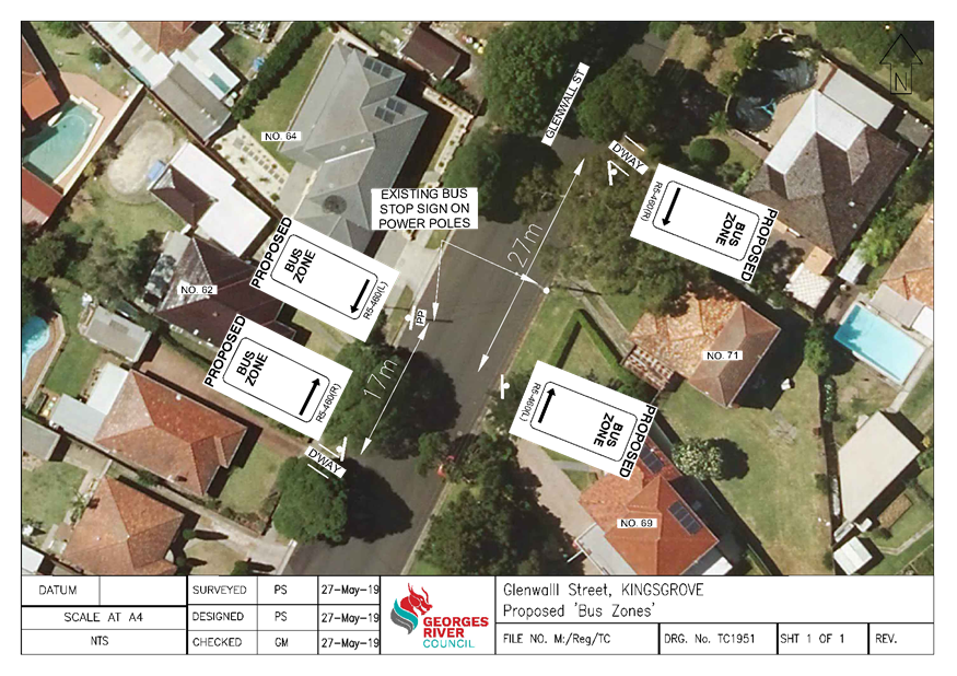
Item: TAC108-19 Glenwall Street, Kingsgrove - Request to Formalise Existing 'Bus Stops' to 'Bus Zones'
Author: Coordinator Traffic & Transport
Directorate: Assets and Infrastructure
Matter Type: Agenda Items
|
(a) That the existing ‘Bus Stop’ on the western side of Glenwall Street, south of Orbell Street, Kingsgrove be formalised to a 17m ‘Bus Zone’. (b) That the existing ‘Bus Stop’ on the eastern side of Glenwall Street, south of Orbell Street, Kingsgrove be formalised to a 27m ‘Bus Zone’, as shown on plan TC1951 attached to the report. |
Executive Summary
1. This report seeks the Committee’s consideration for the proposed formalisation of the existing Bus Stops in Glenwall Street, Kingsgrove.
Background
2. Council has received representations requesting to formalise the existing Bus Stops in Glenwall Street, Kingsgrove, in particular the two bus stops south of Orbell Street.
Proposal
3. As these locations are signposted ‘Bus Stop’ it is proposed to formalise these to ‘Bus Zone’. The proposal will eliminate vehicles parking within the designated distance for a Bus Stop and result in a safer situation for all road users.
Financial Implications
4. Within budget allocation – RMS Traffic Facility Grant – approximately $800.
Community Engagement
5. Residents in this vicinity have been notified by letter of the proposed installation of the ‘Bus Zone’. The closing date for submissions was 17 June 2019. The following feedback was received:
a. Resident at number 62 objected to the proposal and has requested that the zone be relocated due to safety concerns. They note that young children often play outside and a bus stopping adjacent to their property could pose safety issues.
6. By signposting this location as ‘Bus Zone’ it would ensure vehicles will not be parked in this location, notably increasing the sight distance for the bus driver to see young children and significantly improving safety. It is also an existing Bus Stop and on this basis the proposal is deemed acceptable.
File Reference
D19/121296
|
Attachment ⇩1 |
Plan TC1951 - Glenwall St, Kingsgrove |
|
Georges River Council - Traffic Advisory Committee Meeting - Tuesday, 2 July 2019 TAC108-19 Glenwall Street, Kingsgrove - Request to Formalise Existing 'Bus Stops' to 'Bus Zones' [Appendix 1] Plan TC1951 - Glenwall St, Kingsgrove |
Page 5 |
Georges River Council – Traffic Advisory Committee Meeting - Tuesday, 2 July 2019 Page 6
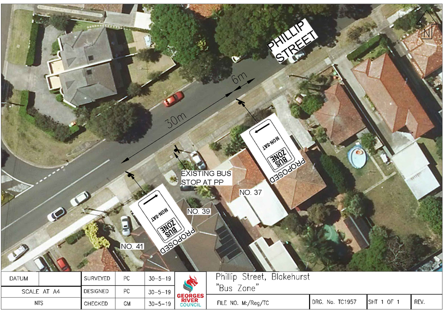
Item: TAC109-19 Phillip Street, Blakehurst - Proposed "Bus Zone"
Author: Coordinator Traffic & Transport
Directorate: Assets and Infrastructure
Matter Type: Agenda Items
|
That a 30m “Bus Zone, Mon – Sat” be installed on the southern side of Phillip Street, near Joseph Street, as shown on plan TC1957 attached to the report. |
Executive Summary
1. This report seeks the Committee’s consideration of a proposed “Bus Zone” in Phillip Street, Blakehurst.
Background
2. Council has received a request to formalise the existing Bus Stop on the southern side of Phillip Street, Blakehurst, near Joseph Street, Blakehurst.
3. Following investigation by Council officers, it was observed that vehicles were parking within the designated distance for a Bus Stop and this has resulted in buses being unable to safely stop parallel to the kerb, causing a dangerous situation for drivers and bus commuters.
Proposal
4. It is therefore proposed to install a 30m “Bus Zone, Mon - Sat” on the southern side of Phillip Street, adjacent to No. 37 to formalise NSW Road Rule 195 that already exists in this location. The bus service does not operate on Sundays.
Financial Implications
5. Within budget allocation - RMS Traffic Facility Grant – approximately $400.
Community Engagement
6. Community engagement was conducted including: a letter and plan of the proposed “Bus Zone” was distributed to the nearby residents. The closing date for submissions was 14 June 2019. No objections were received.
File Reference
D19/132042
|
Attachment ⇩1 |
Plan TC1957 - Phillip Street, Blakehurst |
|
Georges River Council - Traffic Advisory Committee Meeting - Tuesday, 2 July 2019 TAC109-19 Phillip Street, Blakehurst - Proposed "Bus Zone" [Appendix 1] Plan TC1957 - Phillip Street, Blakehurst |
Page 7 |
Georges River Council – Traffic Advisory Committee Meeting - Tuesday, 2 July 2019 Page 9
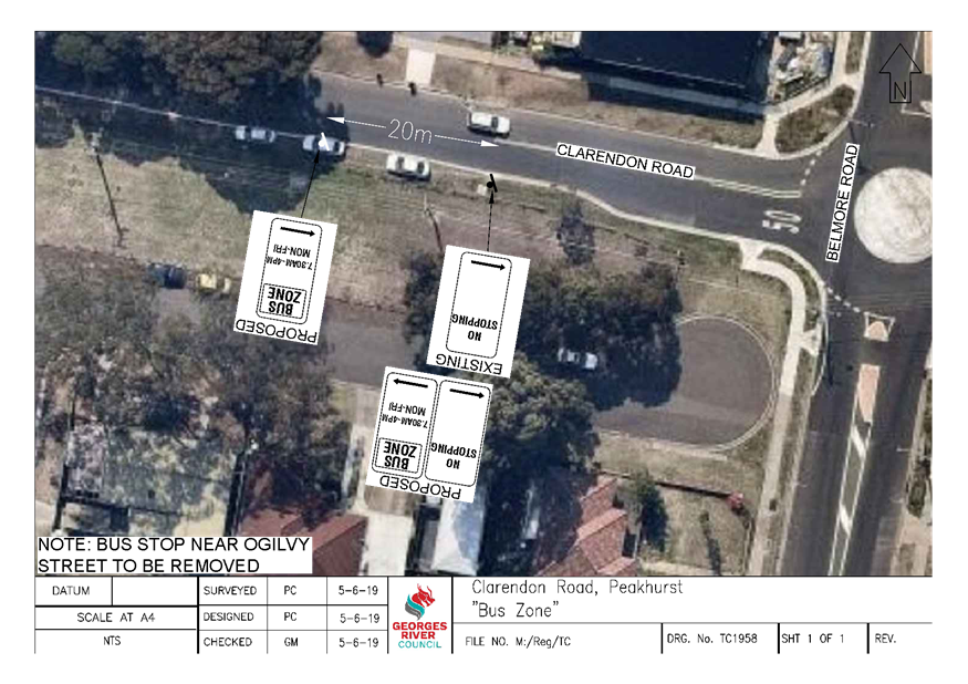
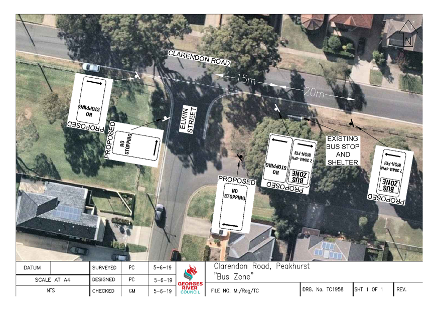
Item: TAC110-19 Clarendon Road, Peakhurst - Proposed "Bus Zones"
Author: Coordinator Traffic & Transport
Directorate: Assets and Infrastructure
Matter Type: Agenda Items
|
(a) That a 20m “Bus Zone, 7.30am – 4pm, Mon – Fri” be installed on the southern side of Clarendon Road, west of the roundabout at Belmore Road. (b) That a 20m “Bus Zone, 7.30am – 4pm, Mon – Fri” be installed on the southern side of Clarendon Road, east of Elwin Street. (c) That “No Stopping” signs be installed at the intersection of Clarendon Road and Elwin Street, as shown on plans TC1958 attached to the report. |
Executive Summary
1. This report seeks the Committee’s consideration of the proposed “Bus Zones” in Clarendon Road, Peakhurst.
Background
2. Punchbowl Bus Company has recently conducted a review of the bus stops along Route 942 that operates between Lugarno and Campsie.
3. The bus service operates along Clarendon Road between 7.30am and 4pm, Monday to Friday.
4. Punchbowl Bus Company has advised that the bus stop on Clarendon Road, west of Ogilvy Street, is proposed to be removed and relocated closer to Belmore Road.
5. The existing bus stop on Clarendon Road, east of Elwin Street, requires the installation of a “Bus Zone” to prevent vehicles parking in this location and to formalise NSW Road Rule 195 that already exists in this location.
Proposal
6. It is therefore proposed to install a new 20m “Bus Zone, 7.30am – 4pm, Mon – Fri” zone on the southern side of Clarendon Road, west of the roundabout at Belmore Road.
7. A new 20m “Bus Zone, 7.30am – 4pm, Mon – Fri” is proposed to be installed on the southern side of Clarendon Road, east of Elwin Street, adjacent to the bus shelter. It is also proposed to install “No Stopping” signs at this intersection to improve vehicle turning movements.
Financial Implications
8. Within budget allocation – RMS Traffic Facility Grant – approximately $1,000.
Community Engagement
9. Community engagement was conducted including: A letter and plan of each proposed “Bus Zone” along Clarendon Road were distributed to the nearby residents. The closing date for submissions was 14 June 2019. No objections were received.
File Reference
D19/132677
|
Attachment ⇩1 |
Plans TC1958 - Clarendon Road, Peakhurst |
|
Georges River Council - Traffic Advisory Committee Meeting - Tuesday, 2 July 2019 TAC110-19 Clarendon Road, Peakhurst - Proposed "Bus Zones" [Appendix 1] Plans TC1958 - Clarendon Road, Peakhurst |
Page 11 |
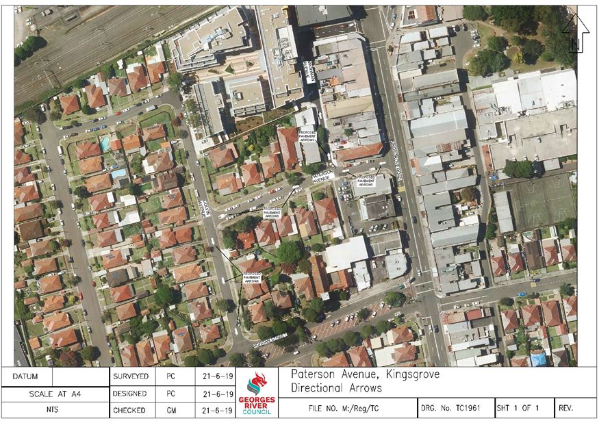
Item: TAC111-19 Mashman Avenue and Paterson Avenue, Kingsgrove - Directional Arrows
Author: Coordinator Traffic & Transport
Directorate: Assets and Infrastructure
Matter Type: Agenda Items
|
(a) That directional arrows be painted in Paterson Avenue, Mashman Avenue and the one-way section of Colvin Avenue, Kingsgrove as shown on plan TC1961 attached to the report. (b) That a traffic counter be installed in Mashman Avenue to determine the speed of vehicles in the street to determine if any further action is required. |
Executive Summary
1. This report seeks the Committee’s consideration of the proposed directional arrows on Mashman Avenue, Paterson Avenue and Colvin Avenue, Kingsgrove.
Background
2. Council has received a request from a local resident to investigate the vehicle movements along Mashman Avenue and Paterson Avenue, Kingsgrove.
3. The resident has advised that many drivers have been observed to travel contrary to the “One Way” signs in both Mashman Avenue and Paterson Avenue creating a dangerous situation for road users.
4. Paterson Avenue is signposted “One Way” in a westbound direction and Mashman Avenue is signposted “One Way” in a northbound direction.
5. It has also been brought to Councils attention that many drivers are speeding through these streets to access The Pottery shopping area or Kingsgrove Road.
Proposal
6. As a result of these concerns, it is proposed to paint directional arrows in Paterson Avenue, Mashman Avenue as well as in the one-way direction of Colvin Avenue, south of Paterson Avenue to further highlight to drivers the correct direction of travel.
7. Council will also be installing a traffic counter in Mashman Avenue after the July school holidays to ascertain the speed of vehicles in the street to determine if any further action is required.
Financial Implications
8. Within budget allocation – RMS Traffic Facility Grant – approximately $1,000.
File Reference
D19/139911
|
Attachment ⇩1 |
Plan TC1961 - Mashman Avenue, Kingsgrove |
|
Georges River Council - Traffic Advisory Committee Meeting - Tuesday, 2 July 2019 TAC111-19 Mashman Avenue and Paterson Avenue, Kingsgrove - Directional Arrows [Appendix 1] Plan TC1961 - Mashman Avenue, Kingsgrove |
Page 14 |
Georges River Council – Traffic Advisory Committee Meeting - Tuesday, 2 July 2019 Page 16
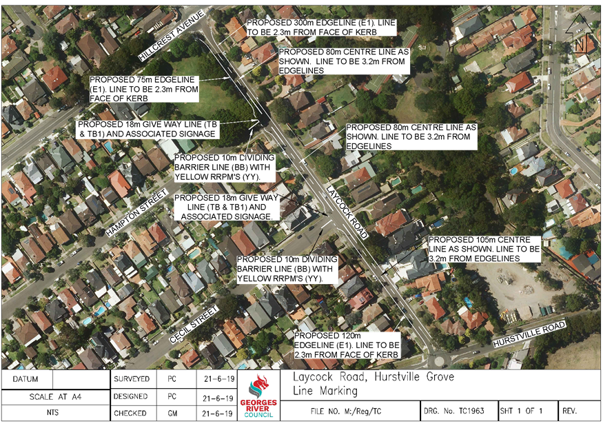
Item: TAC112-19 Laycock Road, Hurstville Grove - Proposed Line Marking
Author: Coordinator Traffic & Transport
Directorate: Assets and Infrastructure
Matter Type: Agenda Items
|
(a) That line marking be painted in Laycock Road, between Hillcrest Avenue and Hurstville Road, as shown on plan TC1963 attached to the report. (b) That Council request NSW Police to increase their patrols in Laycock Road, between Hillcrest Avenue and Hurstville Road, and infringe drivers travelling in excess of the speed limit. (c) That Council continue to monitor the speed in this section of Laycock Road to determine if any further action is required. |
Executive Summary
1. This report seeks the Committee’s consideration of the proposed line marking in Laycock Road, Hurstville Grove.
Background
2. Correspondence has been received from a resident of Laycock Road requesting the investigation of traffic movements along the street, specifically in the section between Hillcrest Avenue and Hurstville Road.
3. This section of Laycock Road has a road width of approximately 11m with parking permitted on both sides of the road and a length of approximately 320 metres. There is currently no line marking in the street or at the adjoining intersections.
4. As a result of this request, in May 2019 Council conducted a vehicle speed and volume count in Laycock Road, between Hillcrest Avenue and Hurstville Road. The results of the traffic count indicated an 85th percentile speed of 58km/h (posted speed limit of 50km/h) and an Average Annual Daily Traffic (AADT) volume of 2,907 vehicles.
5. The 85th percentile speed is defined as the speed at or below which 85% of all vehicles are observed to travel under free flowing conditions and is a widely used traffic statistical measurement.
6. Whilst the vehicle speed and volume were within acceptable limits, the speed is approaching a level that warrants the possible implementation of traffic control devices.
7. Council has also assessed the most recent Roads and Maritime Service’s (RMS) crash database for the 5 year period between October 2013 and September 2018 on this section of road. There has been one recorded crash during this time that occurred in June 2015 that involved a northbound vehicle veering left into a parked car. The resident has advised that another crash occurred in early March 2019.
Comments
8. The painting of the edge lines and a centre line is a cost effective treatment to assist in slowing vehicles by providing clear delineation for drivers and would lead to an improvement in safety at this location. The painting of the lines would not result in the loss of any parking spaces.
9. Section 2.2.2 of “Australian Standards 2890.5 – 1993 On – Street Parking”, states that the minimum parallel parking space width shall be 2.1m. This is for street parking comprising of cars and light commercial vehicles, where the parking of wide vehicles is unlikely and where a continuously marked narrow parking lane will aid traffic flow. The submitted design has a parking lane width of 2.3m and complies with the Standards.
10. The Roads and Maritime Services (RMS) “Road Design Guide” requires a minimum travel lane width of 3m and the submitted design also complies with this requirement with a lane width of 3.2m.
11. It has been determined that there is a lack of line marking at the intersections along Laycock Road to assist in vehicle turning movements. As a result, it is proposed to install give-way lines and associated signage and centrelines in the streets off this section of Laycock Road to improve traffic movements and safety.
12. Council is also requesting that NSW Police increase their patrols in Laycock Road, between Hillcrest Avenue and Hurstville Road, and infringe drivers travelling in excess of the speed limit.
13. Council will continue to monitor the speed in this section of Laycock Road to determine if any further action is required once the line marking is completed.
Financial Implications
14. Within budget allocation – RMS Traffic Facility Grant – approximately $7,000.
File Reference
D19/141058
|
Attachment ⇩1 |
Plan TC1963 - Laycock Road, Hurstville Grove |
|
Georges River Council - Traffic Advisory Committee Meeting - Tuesday, 2 July 2019 TAC112-19 Laycock Road, Hurstville Grove - Proposed Line Marking [Appendix 1] Plan TC1963 - Laycock Road, Hurstville Grove |
Page 17 |
Georges River Council – Traffic Advisory Committee Meeting - Tuesday, 2 July 2019 Page 18
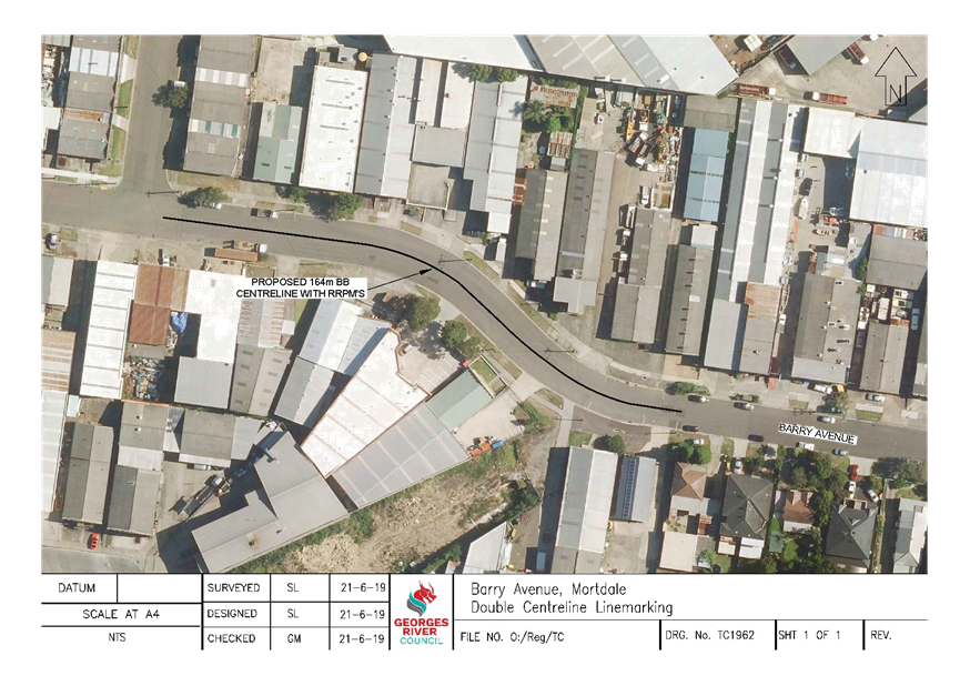
Item: TAC113-19 Barry Avenue, Mortdale - Proposed Line Marking
Author: Traffic Engineer
Directorate: Assets and Infrastructure
Matter Type: Agenda Items
|
That a 164m Dividing Barrier Line (BB) be installed on Barry Avenue, as shown on plan TC1962 attached to the report. |
Executive Summary
1. This report seeks the Committee’s consideration for the installation of a centreline on Barry Avenue, Mortdale.
Background
2. A request was received by a resident to investigate road safety on Barry Avenue, Mortdale, following an incident in which 2 vehicles were written off.
3. Traffic counts undertaken in May 2019 showed that the results of the 85th percentile speed and daily traffic volumes were within the acceptable limits for a local road. However it was observed that a low volume of vehicles were travelling in excess of the speed limit during off-peak periods. This data was given to NSW Police in June 2019 for their enforcement.
4. Furthermore to supplement enforcement and to improve safety in this location it is proposed to install a 164m Dividing Barrier Line (BB) with RRPM’s at the bend on Barry Avenue to delineate the travel lanes. This should result in a reduction of speed when travelling through this location.
5. Barry Avenue has a width of approximately 12.8m between kerbs and the centre line would be painted 6.4m from the face of the kerb. As a result there would be no loss of parking associated with the proposed line marking.
Financial Implications
6. Within budget allocation – RMS Traffic Facilities Grant – Approximately $3,000.
File Reference
D19/141060
|
Attachment ⇩1 |
TC1962_Barry Avenue Line Marking |
|
Georges River Council - Traffic Advisory Committee Meeting - Tuesday, 2 July 2019 TAC113-19 Barry Avenue, Mortdale - Proposed Line Marking [Appendix 1] TC1962_Barry Avenue Line Marking |
Page 19 |
Georges River Council – Traffic Advisory Committee Meeting - Tuesday, 2 July 2019 Page 20
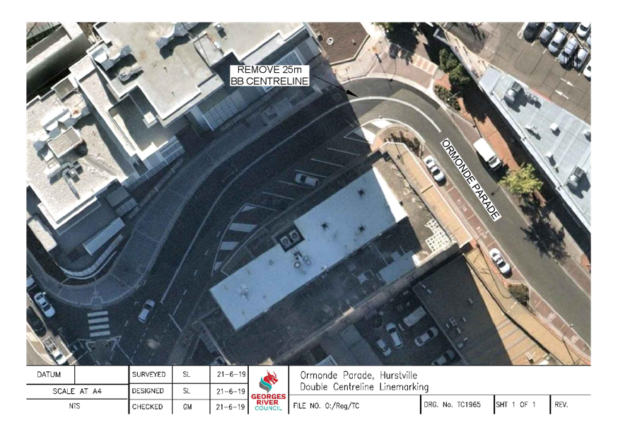
Item: TAC114-19 Ormonde Parade, Hurstville - Proposed changes to linemarking
Author: Traffic Engineer
Directorate: Assets and Infrastructure
Matter Type: Agenda Items
|
That 25m of the existing Dividing Barrier Line (BB) on Ormonde Parade, Hurstville be removed as shown on plan TC1965 attached to the report. |
Executive Summary
1. This report seeks the Committee’s consideration for the removal of line marking on Ormonde Parade, Hurstville.
Background
2. Requests have been received by Council from NSW Police and members of the public in regards to the line marking on Ormonde Parade, Hurstville.
3. Following investigation by Council officers it was observed that the line marking prevented Police vehicles from turning to park their vehicles. It also causes queuing during peak periods as vehicles could not cross over the line, despite it being a one way street. It is therefore proposed to remove 25m of the existing Dividing Barrier Line (BB) on Ormonde Parade, Hurstville. The changes should ease congestion in this location.
Financial Implications
4. Within budget allocation – RMS Traffic Facilities Grant – Approximately $1,000.
File Reference
D19/141171
|
Attachment ⇩1 |
TC1965_Ormonde Pde Line Marking |
|
Georges River Council - Traffic Advisory Committee Meeting - Tuesday, 2 July 2019 TAC114-19 Ormonde Parade, Hurstville - Proposed changes to linemarking [Appendix 1] TC1965_Ormonde Pde Line Marking |
Page 21 |
Georges River Council – Traffic Advisory Committee Meeting - Tuesday, 2 July 2019 Page 22
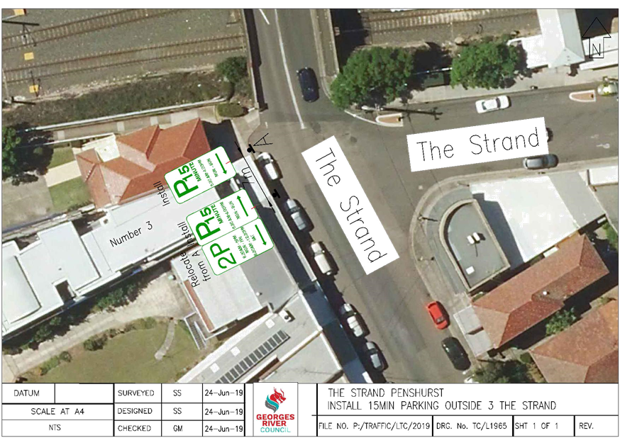
Item: TAC115-19 The Strand, Penshurst - 15 minutes parking
Author: Senior Traffic Engineer
Directorate: Assets and Infrastructure
Matter Type: Agenda Items
|
That 7m of the existing “2P” restriction along the western side of The Strand be converted to “P15 minute 6.30am - 4.00pm, Mon-Sun” outside Ki Allo Café at number 3 The Strand, Penshurst. |
Executive Summary
1. This report seeks the traffic committee’s consideration to change 7m of the existing “2P” restriction along the western side of the Strand, Penshurst to “15 minutes, 6.30am-4.00pm, Mon-Sun” outside Ki Allo café at 3 the Strand, Penshurst.
Background
2. The current parking restriction on the Strand north of Railway Parade is 2P along both sides of the street.
3. The businesses that front The Strand are predominantly businesses that rely on longer timed parking such as hairdressers and learning centres, with the exception of a café along the western side of The Strand, which requires quick turnover of parking.
4. Council received representation from the café owner at 3 The Strand, requesting Council to provide 15 minutes parking outside their café, to help provide quick turnover of parking for their business.
5. The Café advised that their operating hours are from 6:30am – 4:00pm Monday to Sunday.
6. Accordingly it is recommended that 7 metres of “P15 min, 6:30am - 4:00pm, Mon-Sun” be provided outside 3 The Strand to allow for quick turnover of parking for customers of the Cafe’.
Financial Implications
7. Within budget allocation – RMS Traffic Facility Grant – approximately $500.
Community Engagement
8. Community engagement was conducted including letter drop to affected businesses
File Reference
D19/141365
|
Attachment ⇩1 |
15 Minutes Parking The Strand Penshurst |
|
Georges River Council - Traffic Advisory Committee Meeting - Tuesday, 2 July 2019 TAC115-19 The Strand, Penshurst - 15 minutes parking [Appendix 1] 15 Minutes Parking The Strand Penshurst |
Page 24 |
Georges River Council – Traffic Advisory Committee Meeting - Tuesday, 2 July 2019 Page 26
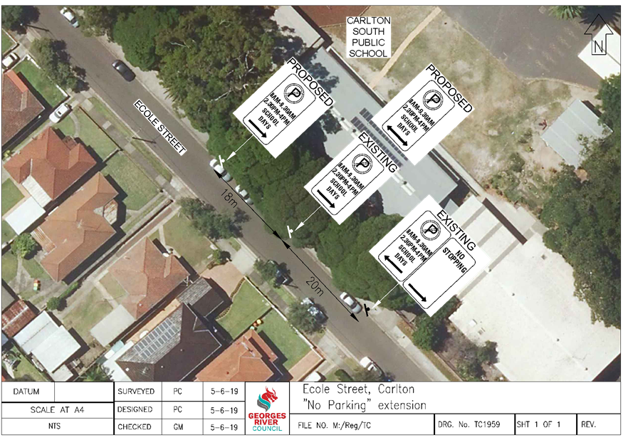
Item: TAC116-19 Ecole Street, Carlton - Proposed "No Parking" zone
Author: Coordinator Traffic & Transport
Directorate: Assets and Infrastructure
Matter Type: Agenda Items
|
(a) That the existing “No Parking, 8am – 9.30am, 2.30pm – 4pm, School Days” zone on the northern side of Ecole Street, adjacent to Carlton South Public School, be extended 18m, as shown on plan TC1959 attached to the report. (b) That the Principal of Carlton South Public School be advised of Council’s decision. |
Executive Summary
1. This report seeks the Committee’s consideration of the proposed changes to the “No parking” zone in Ecole Street, Carlton.
Background
2. Council has received a request from a representative of Carlton Couth Public School to extend the existing “No Parking” zone in Ecole Street, adjacent to the school.
3. Currently, there is an existing 20m “No Parking, 8am – 9.30am, 2.30pm – 4pm, School Days” zone on the northern side of Ecole Street that it used by parents to drop off and pick up their children.
4. The Principal and the P&C Committee have requested that the “No Parking” zone be extended by 18m which would provide an additional 3 vehicles to drop off and pick up during the peak school times. The school was not in support of extending this zone any further than 18m at this stage.
Proposal
5. As a result of this request, it is proposed to extend the existing “No Parking, 8am – 9.30am, 2.30pm – 4pm, School Days” zone on the northern side of Ecole Street, an additional 18m.
Financial Implications
6. Within budget allocation – RMS Traffic Facility Grant – approximately $200.
Community Engagement
7. Community engagement was conducted including: The school was provided a copy of the plan proposal and no objections were received.
File Reference
D19/135962
|
Attachment ⇩1 |
Plan TC1959 - Ecole Street, Carlton |
|
Georges River Council - Traffic Advisory Committee Meeting - Tuesday, 2 July 2019 TAC116-19 Ecole Street, Carlton - Proposed "No Parking" zone [Appendix 1] Plan TC1959 - Ecole Street, Carlton |
Page 27 |
Georges River Council – Traffic Advisory Committee Meeting - Tuesday, 2 July 2019 Page 29
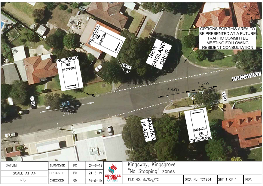
Item: TAC117-19 Kingsway, Kingsgrove - Proposed "No Stopping" zones
Author: Coordinator Traffic & Transport
Directorate: Assets and Infrastructure
Matter Type: Agenda Items
|
(a) That a 14m “No Stopping” zone be installed on the southern side of Kingsway, east of Maluka Place. (b) That “No Stopping” signs be installed on the north-western corner of Kingsway and New England Drive, as shown on plan TC1964 attached to the report. (c) That options for the north-eastern corner of Kingsway and New England Drive be considered and presented at a future Traffic Advisory Committee meeting. (d) That a traffic counter be installed in Kingsway to determine the speed and volume of vehicles in the street. |
Executive Summary
1. This report seeks the Committees’ consideration of the proposed “No Stopping” zones in Kingsway, Kingsgrove.
Background
2. Council has received a request from a local resident to investigate the parking near the intersection of Kingsway, Maluka Place and New England Drive, Kingsgrove.
3. As a result of this request a Council Officer conducted a site meeting with the resident to discuss the parking issues that are occurring in this location.
4. From the discussions, it was determined that vehicles are parking in close proximity to the intersection due to the lack of “No Stopping” signs on the corners.
Proposal
5. It is proposed to install additional “No Stopping” signs in the Kingsway near the intersections with Maluka Place and New England Drive to prevent drivers stopping near the corners and lead to an improvement in the sight distance along the street for turning drivers.
6. Options for the north-eastern corner of Kingsway and New England Drive, including line marking or parking restriction signage will be investigated and a report presented at a future Traffic Advisory Committee meeting following resident consultation.
7. Council will also install a traffic counter in the Kingsway near the intersection with New England Drive to ascertain the speed and volume of vehicles in the street to determine if any further action is required.
Financial Implications
8. Within budget allocation – RMS Traffic Facility Grant – approximately $500.
File Reference
D19/142821
|
Attachment ⇩1 |
Plan TC1964 - Kingsway, Kingsgrove |
|
Georges River Council - Traffic Advisory Committee Meeting - Tuesday, 2 July 2019 TAC117-19 Kingsway, Kingsgrove - Proposed "No Stopping" zones [Appendix 1] Plan TC1964 - Kingsway, Kingsgrove |
Page 30 |
Georges River Council – Traffic Advisory Committee Meeting - Tuesday, 2 July 2019 Page 32
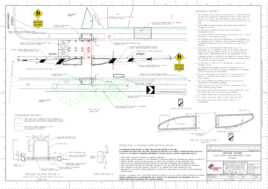
Item: TAC118-19 South Street, Kogarah - Pedestrian Refuge
Author: Coordinator Traffic & Transport
Directorate: Assets and Infrastructure
Matter Type: Agenda Items
|
That the existing pedestrian refuge in South Street, Kogarah, west of the Princes Highway, be reconstructed in accordance with the RMS Technical Direction and Plan U789 attached to the report. |
Executive Summary
1. This report seeks the Committee’s consideration of the proposed reconstruction of the pedestrian refuge in South Street, Kogarah.
Background
2. Approval has been provided for the construction of a new health care facility at 131 Princes Highway and 1A South Street, Kogarah.
3. The following condition was imposed on their Development Application in relation to the pedestrian refuge on South Street:
“The applicant shall be responsible for the reconstruction of the pedestrian refuge adjacent to the site on South Street in accordance with plans and specifications to be issued by Council. The applicant shall pay a fee of $2,000.00 to cover the costs for Council to design the pedestrian refuge. All costs associated with the construction of the pedestrian refuge including, but not limited to, traffic control shall be at the applicant’s expense.”
Proposal
4. Council’s Design Section has completed a detailed survey of South Street and have proposed the reconstruction of the existing pedestrian refuge in accordance with the requirements of the RMS “Technical Direction TDT2011/01a – Pedestrian Refuges” document. As there are existing “No Stopping” signs in this location, no further loss of parking is associated with the refuge reconstructed.
Financial Implications
5. No budget impact for this report.
File Reference
D19/132610
|
Attachment ⇩1 |
Plan U789 - South Street, Kogarah |
|
Georges River Council - Traffic Advisory Committee Meeting - Tuesday, 2 July 2019 TAC118-19 South Street, Kogarah - Pedestrian Refuge [Appendix 1] Plan U789 - South Street, Kogarah |
Page 33 |
Georges River Council – Traffic Advisory Committee Meeting - Tuesday, 2 July 2019 Page 36
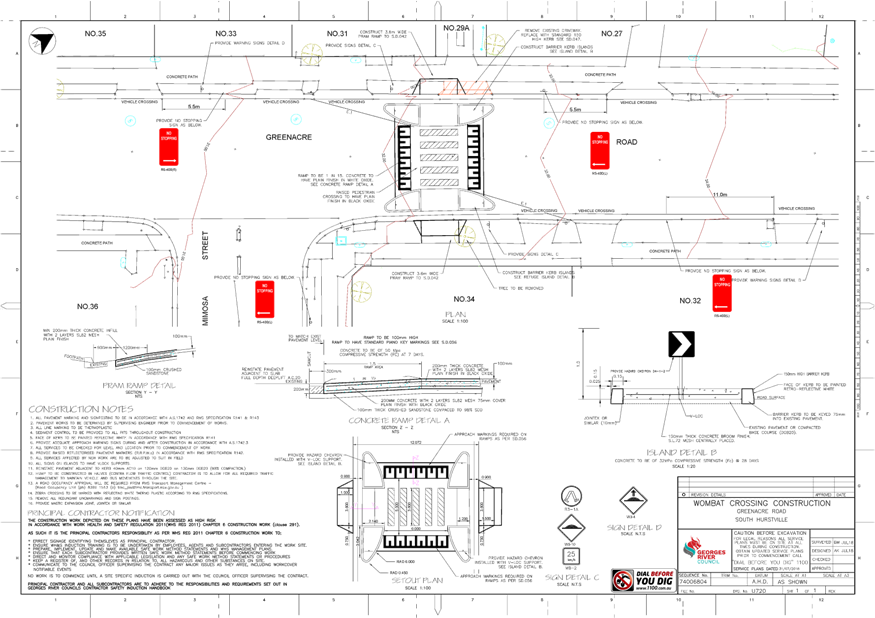
Item: TAC119-19 Greenacre Road, Connells Point - Proposed Raised Pedestrian Crossing
Author: Coordinator Traffic & Transport
Directorate: Assets and Infrastructure
Matter Type: Agenda Items
|
(a) That a raised pedestrian crossing with associated signage be installed in Greenacre Road, Connells Point, north of Mimosa Street, in accordance with the RMS Technical Direction and as shown on Plan U720 attached to the report. (b) That the applicant be advised of Council’s decision. |
Executive Summary
1. This report seeks the Committee’s consideration of a raised pedestrian crossing and associated “No Stopping” signs in Greenacre Road, Connells Point.
Background
2. Approval has been provided for the construction and use of a new Educational Establishment on the former South Hurstville Bowling Club site at 29A Greenacre Road, South Hurstville.
3. The following condition was imposed on their Development Application in relation to a pedestrian crossing to facilitate the safe movements of students across Greenacre Road:
“Pedestrian Crossing – Greenacre Road – The applicant shall be responsible for the construction of a raised marked pedestrian crossing in Greenacre Road in accordance with plans and specifications to be issued by Council. The applicant shall pay a fee $3,000.00 to cover the costs for Council to design the raised crossing. All costs associated with the construction of the crossing including, but not limited to, traffic control shall be at the applicant’s expense. This crossing is subject to approval from the Traffic Advisory Committee.”
Investigation
4. The RMS Guidelines indicate that there are reduced crossing warrants for sites used predominately by children. The Guidelines for Traffic Facilities state that the reduced warrants conducted during two counts of one hour duration immediately before and after school hours are as follows:
· The measured flows for Pedestrians (P) and Vehicles (V) are equal to or greater than 30 and 200 respectively.
5. At this stage, the new educational establishment at 29A Greenacre Road has not been completed. Therefore a pedestrian and vehicle count carried out on Greenacre Road would not be an appropriate reflection of the future use.
6. However, traffic volume counts have been conducted in Greenacre Road, north of Mimosa Street and pedestrian crossing data has been submitted as part of the Development Application for the new educational establishment.
7. The new school will cater for Years 7 and 8 and will ultimately accommodate a total of 430 students across the two years. The school will provide convenient pedestrian links within the site and via dedicated paths to and from Greenacre Road to access existing public transport services.
8. The table below indicates the expected peak hour vehicle and pedestrian volumes, based on the available data, once the new school is opened:
|
TIME |
VEHICLES (V) |
PEDESTRIANS (P) |
|
8am – 9am |
395 |
129 (30% of 430) |
|
2.45pm – 3.45pm |
385 |
172 (40% of 430) |
9. As can be seen in the table, the expected vehicle and pedestrian volumes in Greenacre Road, north of Mimosa Street, satisfy the RMS warrants for a pedestrian crossing to be installed adjacent to the school.
Proposal
10. A detailed design of the pedestrian crossing with line marking and signage has been prepared in accordance with the Australian Standards 1742.10 – 2009, Guide to Traffic Management – Part 6 (Austroads) publication and the RMS Technical Direction TDT 2001/04b.
11. The raised crossing will also operate as a speed calming device to assist in lowering vehicle speed along this section of Greenacre Road.
Financial Implications
12. No budget impact for this report - Crossing to be constructed at applicant’s expense.
Community Engagement
13. Community engagement was conducted including: a consultation letter and plan outlining the proposal for the raised pedestrian crossing and “No Stopping” zones were sent to the nearby residents on Thursday 30 May 2019. Submissions on the proposal were requested to be received by Friday 21 June 2019. Council received one written objection from a resident to the proposal. The objection is detailed in point form below:
a. Objection due to the removal of the Paperbark tree at the front of the property on Greenacre Road that provides part of the streetscape and privacy.
b. Requesting an area to place garbage bins outside the property but not in the driveway.
c. An assumed negative impact on the value of their property and a request for a reduction of rates as compensation.
14. The resident that objected lives on a corner block that has boundaries on both Greenacre Road and Mimosa Street. Adjacent to the objector’s property there is a loss of one legal parking space on Greenacre Road. The tree is required to be removed to allow the construction of a ramp to the crossing from the footpath. There may be scope to replant a tree along Greenacre Road. The proposed crossing location was deemed the most appropriate based on the location of residential driveways along Greenacre Road and the expected desire line of students entering and exiting the school.
15. While the crossing involves the removal of a street tree and three parking spaces overall, the benefit to the wider community by providing a safe crossing point on Greenacre Road and also acting as a speed hump to lower vehicle speed needs to be considered. A crossing in an alternative location would result in greater loss of street parking and would not be located in the pedestrian desire line of the students.
File Reference
D19/132769
|
Attachment ⇩1 |
Plan U720 - Greenacre Road, Connells Point |
|
Georges River Council - Traffic Advisory Committee Meeting - Tuesday, 2 July 2019 TAC119-19 Greenacre Road, Connells Point - Proposed Raised Pedestrian Crossing [Appendix 1] Plan U720 - Greenacre Road, Connells Point |
Page 37 |
Georges River Council – Traffic Advisory Committee Meeting - Tuesday, 2 July 2019 Page 39
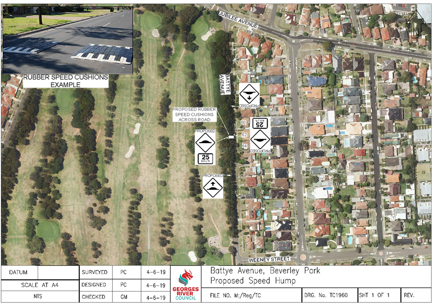
Item: TAC120-19 Battye Avenue, Beverley Park - Speed Cushion Update
Author: Coordinator Traffic & Transport
Directorate: Assets and Infrastructure
Matter Type: Agenda Items
|
(a) That rubber speed cushions with associated signage be installed in Battye Avenue, between Weeney Street and Jubilee Avenue, adjacent to number 62, as shown on plan TC1960 attached to the report. (b) That the residents in this section of Battye Avenue be advised of Council’s decision. |
Executive Summary
1. This report provides an update to the investigations for a proposed speed cushion in Battye Avenue, Beverley Park.
Background
2. At the Traffic Advisory Committee Meeting of 7 May 2019, a report was presented on the traffic issues in Battye Avenue, specifically in the section between Weeney Street and Jubilee Avenue adjacent to the Golf Course.
3. Council at its meeting of 27 May 2019 considered the Traffic Committee’s advice and adopted the following recommendations in regards to speeding vehicles in Battye Avenue:
a) “That Council consult with the residents of Battye Avenue for the installation of a speed hump.
b) That a report for a speed hump in Battye Avenue be presented to a future Traffic Advisory Committee for consideration.
c) That Council request NSW Police to increase their patrols in Battye Avenue and infringe drivers travelling in excess of the speed limit.”
Proposal
4. It is therefore proposed to install a rubber speed cushion in accordance with the requirements of the Australian Standards and Austroads “Local Area Traffic Management” documents.
5. The hump is proposed halfway between Weeney Street and Jubilee Avenue, adjacent to number 62, to lead to a reduction in vehicle speed and improve the safety for drivers and residents along this section of road. There will be no loss of street parking as drivers can park on the hump.
Financial Implications
6. Within budget allocation – RMS Traffic Facility Grant – approximately $6,000.
Community Engagement
7. A consultation letter and plan outlining the proposal for the speed cushion was sent to the nearby residents on Wednesday 5 June 2019. Submissions on the proposal were requested to be received by Wednesday 19 June 2019. No objections were received.
File Reference
D19/136877
|
Attachment ⇩1 |
Plan TC1960 - Battye Avenue, Beverley Park |
|
Georges River Council - Traffic Advisory Committee Meeting - Tuesday, 2 July 2019 TAC120-19 Battye Avenue, Beverley Park - Speed Cushion Update [Appendix 1] Plan TC1960 - Battye Avenue, Beverley Park |
Page 40 |
Georges River Council – Traffic Advisory Committee Meeting - Tuesday, 2 July 2019 Page 43
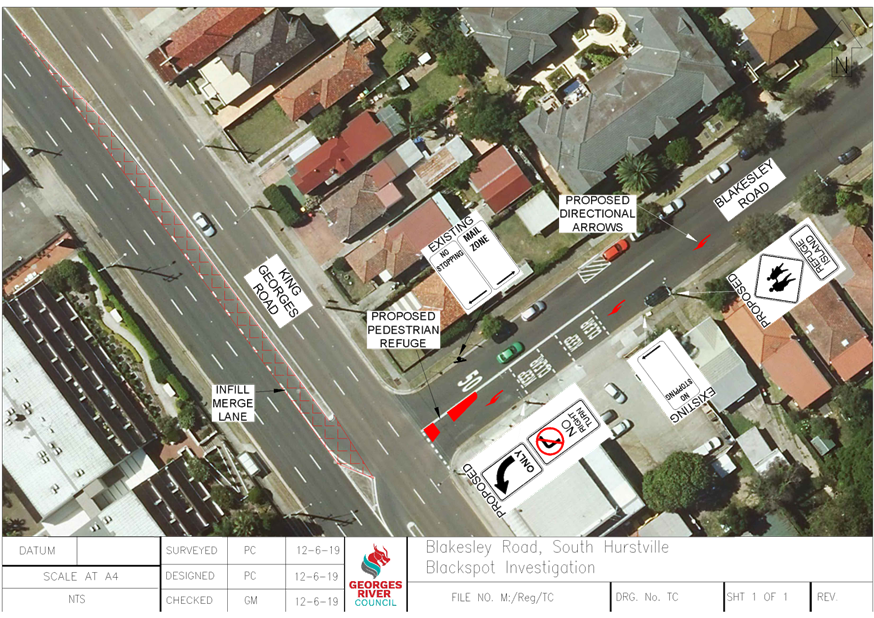
Item: TAC122-19 Blakesley Road, Blakehurst - Black Spot Investigation
Author: Coordinator Traffic & Transport
Directorate: Assets and Infrastructure
Matter Type: Agenda Items
|
(a) That Council submit a request for funding under the Federal Government Black Spot Program for the permanent removal of the right turn movement from Blakesley Road into King Georges Road, Blakehurst. (b) That as part of the request for funding, a pedestrian refuge island be installed in Blakesley Road at the intersection with King Georges Road, as shown on the concept plan attached to the report. (c) That community consultation be undertaken on the proposal. (d) That a Traffic Management Plan and detailed construction plan be submitted to the Roads and Maritime Services (RMS) for approval. (e) The removal of the right turn movement and pedestrian refuge is subject to funding being allocated under the Black Spot program. |
Executive Summary
1. This report seeks the Committee’s consideration of the proposed traffic changes at the intersection of Blakesley Road and King Georges Road, Blakehurst.
Background
2. Council and the Roads and Maritime Services (RMS) have been investigating locations in the LGA that may be eligible for funding under the Federal Government Black Spot Program.
3. Council has recently been advised that there have been a number of crashes that involve drivers turning right to exit Blakesley Road onto King Georges Road.
4. The eligibility criteria for the Black Spot Program is a minimum 2 injury crashes over the 5 year period from 1 July 2013 to 30 June 2018. This data is reviewed from the RMS crash database.
Investigations
5. The table below indicates the crash information recorded at the intersection of Blakesley Road and King Georges Road that have occurred during this 5 year period:
|
Crash Date |
No. of Injuries |
Road User Movement (RUM) Code |
|
10/12/2013 |
0 |
14 (Two right turning) |
|
1/9/2015 |
1 |
30 (Rear end) |
|
4/2/2016 |
0 |
42 (Leaving parking) |
|
9/5/2016 |
2 |
11 (Right far) |
|
7/6/2016 |
1 |
13 (Right near) |
|
9/6/2016 |
1 |
13 (Right near) |
|
22/9/2016 |
0 |
16 (Left near) |
|
14/11/2016 |
1 |
13 (Right near) |
|
25/11/2016 |
1 |
37 (Left turn side swipe) |
|
14/9/2017 |
1 |
13 (Right near) |
|
16/2/2018 |
0 |
30 (Rear end) |
|
5/6/2018 |
0 |
13 (Right near) |
6. The RMS crash data at the intersection of Blakesley Road and King Georges Road indicates that the location is eligible for Council to submit a request for funding under the Federal Government Black Spot Program.
7. On 2nd May 2019, a vehicle turning count was conducted at the intersection of Blakesley Road and King Georges Road to determine the volume of vehicles in the morning and afternoon peak periods. The results are indicated in the table below:
|
TIME |
DIRECTION |
VOLUME |
|
8am – 9am |
Turning right from King Georges Road INTO Blakesley Road |
298 |
|
Turning right from Blakesley Road INTO King Georges Road |
25 |
|
|
|
|
|
|
3:15pm – 4:15pm |
Turning right from King Georges Road INTO Blakesley Road |
151 |
|
Turning right from Blakesley Road INTO King Georges Road |
61 |
8. It can be seen in the above table that the main movement in both peak periods is for vehicles turning right from King Georges Road into Blakesley Road. Based on this information, if a turn movement were to be removed, it would be for vehicles turning right from Blakesley Road into King Georges Road due to the lesser movement. These vehicles could use the signalised intersection at Connells Point Road to access King Georges Road which is a safer alternative.
9. A representative from the RMS has advised Council that they would not support the installation of traffic signals to control vehicle turning movements at the intersection of Blakesley Road and King Georges Road. This is due to the resultant, significant, traffic queuing that would occur along King Georges Road on the red signal for vehicles exiting Blakesley Road. The installation of signals would also prohibit the left turn movement from Blakesley Road into King Georges Road that can currently be undertaken at any time with care. This left turn is a significant movement and signalising this would result in extensive queuing lengths along Blakesley Road.
10. If the right turn out of Blakesley Road was approved to be banned, Council will request the RMS to investigate the possible extension of the green time for vehicles on Connells Point Road at King Georges Road to allow more vehicles through the intersection.
11. During a recent site inspection, there were a number of pedestrians crossing Blakesley Road to access the fruit shop and nearby bus stops. As a result, as part of the Black Spot nomination, a pedestrian refuge island is proposed in Blakesley Road to assist people crossing the road near the intersection. The refuge would also perform as a filtering island to direct drivers to the left onto King Georges Road. A request has also been received for the installation of a pedestrian safety fence adjacent to the Fruit Shop and this will be investigated as part of the Black Spot nomination and final design plans being completed.
Financial Implications
12. No budget impact for this report.
File Reference
D19/133016
|
Attachment ⇩1 |
Concept Plan - Blakesley Road and King Georges Road, South Hurstville |
|
Georges River Council - Traffic Advisory Committee Meeting - Tuesday, 2 July 2019 TAC122-19 Blakesley Road, Blakehurst - Black Spot Investigation [Appendix 1] Concept Plan - Blakesley Road and King Georges Road, South Hurstville |
Page 44 |
Georges River Council – Traffic Advisory Committee Meeting - Tuesday, 2 July 2019 Page 46
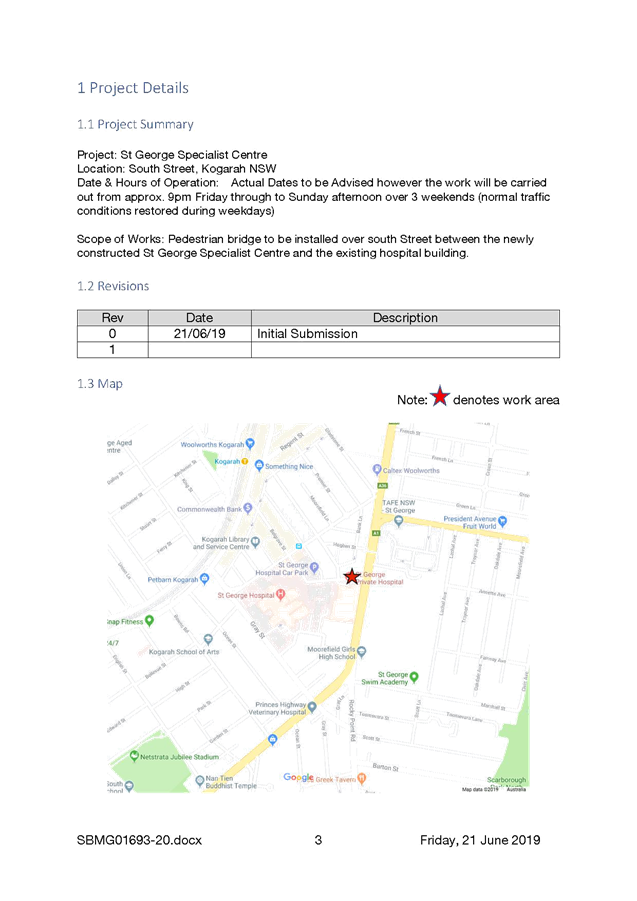
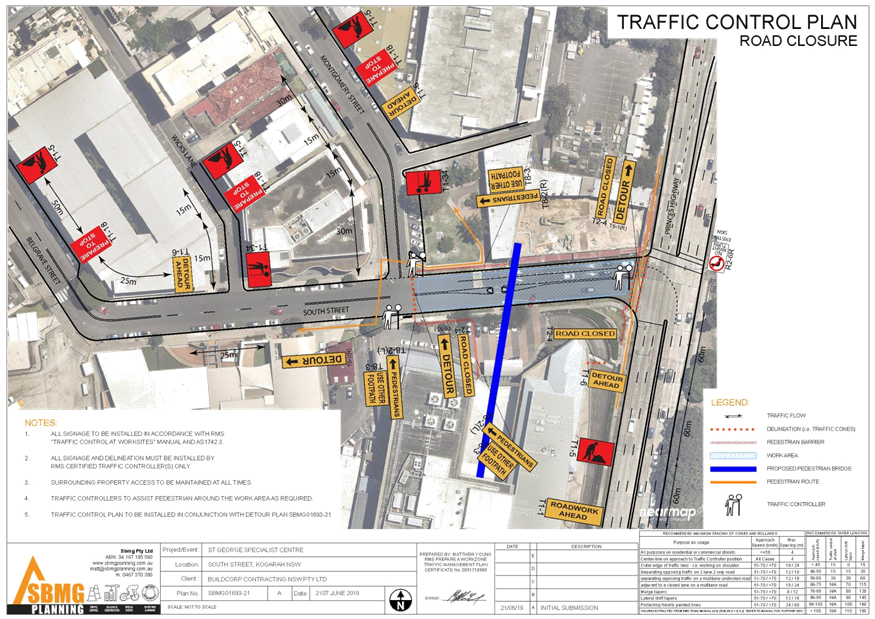
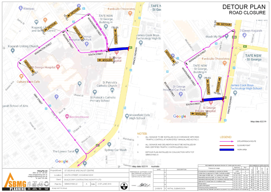
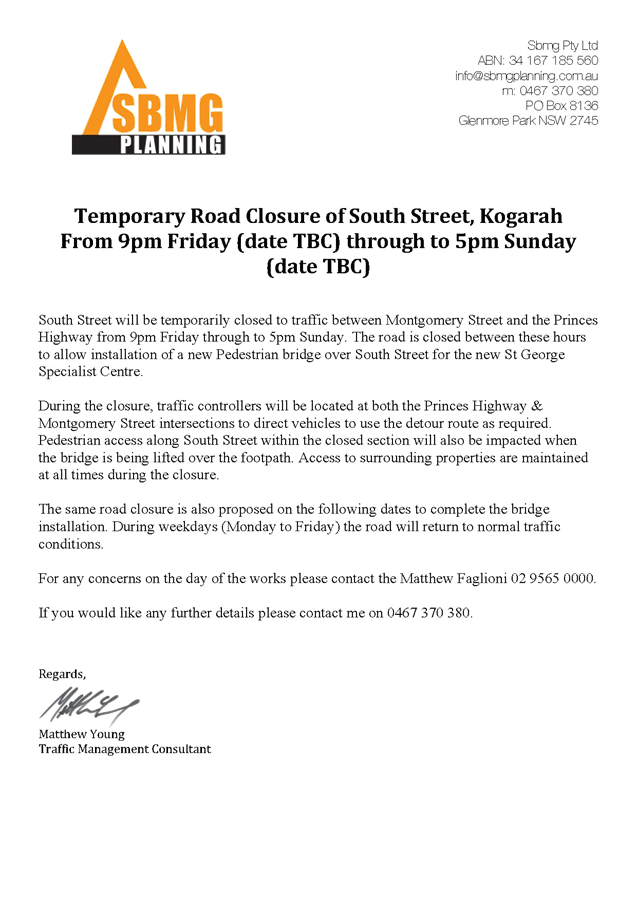
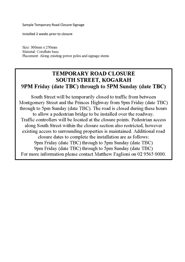
Item: TAC123-19 South Street, Kogarah - Road Closure for Pedestrian Bridge Installation
Author: Traffic Engineer
Directorate: Assets and Infrastructure
Matter Type: Agenda Items
|
That the “Traffic Management Plan” prepared by SBMG Planning dated Friday 21st June, be approved. |
Executive Summary
1. This report seeks the Committee’s consideration for the road closure for the installation of a pedestrian bridge on South Street, Kogarah.
Background
2. The developer of the new St George Specialist Centre on South Street, Kogarah has requested a series of road closures for the purpose of installing a pedestrian bridge across South Street.
3. The sections of the proposed pedestrian bridge across South Street will be lifted into place using a mobile crane standing on South Street. Due to the location of the bridge and the size of the crane and bridge sections, a 3.0m traffic lane cannot be maintained past the work area and therefore South Street is to be closed in both directions between the Princes Highway and Montgomery Street.
4. Actual closure dates are to be advised however the work will be carried out from approximately 9pm Friday through to Sunday afternoon over 3 weekends (normal traffic conditions restored during weekdays).
Public Consultation
5. A letterbox drop will be carried out by the applicant 1 week prior to the closure with contact information included for anyone with queries. The letterbox drop will include all buildings along South Street and the St George Hospital.
Financial Implications
6. No budget impact for this report.
File Reference
D19/143676
|
Attachment ⇩1 |
St George Specialist Centre - South Street Road Closure |
|
Georges River Council - Traffic Advisory Committee Meeting - Tuesday, 2 July 2019 TAC123-19 South Street, Kogarah - Road Closure for Pedestrian Bridge Installation [Appendix 1] St George Specialist Centre - South Street Road Closure |
Page 48 |