|
Georges
River Council – Local Planning Panel Thursday, 19
September 2019
|
Page 2
|
|
3. Reports and
LPP Deliberations in Closed Session - 6.30pm
|
LPP035-19 61-63
Lawrence Street, Peakhurst – DA2017/0584
(Report by
Development Assessment Planner)
LPP036-19 16 Peake
Parade, Peakhurst – DA2017/0627
(Report by
Senior Development Assessment Planner)
LPP037-19 186-190
Princes Highway Beverley Park and 2-6 Lacey Street, Kogarah Bay – DA2018/0513
(Report by
Senior Development Assessment Planner)
|
4. Confirmation of Minutes
|
MINUTES: Georges River Local
Planning Panel (LPP) - 05 September 2019 (18/653)
REPORT TO
GEORGES RIVER COUNCIL
LPP MEETING OF Thursday, 19 September 2019
|
LPP Report No
|
LPP035-19
|
Development Application No
|
DA2017/0584
|
|
Site Address & Ward Locality
|
61-63 Lawrence Street, Peakhurst
Peakhurst Ward
|
|
Proposed Development
|
Lot consolitation, demolition of
the existing structures and construction of three (3) storey residential flat
building with basement parking.
|
|
Owners
|
Younan Management Pty Ltd, CHY
Holdings Pty Ltd, Maria A. Rasic
|
|
Applicant
|
Cornerstone Design
|
|
Planner/Architect
|
Cornerstone Design
|
|
Date Of Lodgement
|
24/11/2017
|
|
Submissions
|
Nil Submissions
|
|
Cost of Works
|
$3,390,000.00
|
|
Local Planning Panel Criteria
|
Development is defined as a
“Residential Flat Building” and is subject to SEPP 65. A
Clause 4.6 variation in respect to exceedance of the height control
|
|
List of all relevant s.4.15
matters (formerly s79C(1)(a))
|
State Environmental Planning Policy
No 55 - Remediation of Land, State Environmental Planning Policy No 65 -
Design Quality of Residential Apartment Development,
State Environmental Planning Policy
(Vegetation in Non-Rural Areas) 2017, State Environmental Planning Policy
– Infrastructure, Draft Environmental State Environmental Planning
Policy, Apartment Design Guide, Greater Metropolitan Regional Environmental
Plan No 2 - Georges River Catchment,
Hurstville Local Environmental Plan
2012, Hurstville Development Control Plan No 1 - LGA Wide
|
|
List all documents submitted
with this report for the Panel’s consideration
|
Survey Plan, Architectural Plans,
Landscape Plan, Concept Stormwater Plans, Statement of Environmental Effects,
|
|
Report prepared by
|
Development Assessment Planner
|
|
Recommendation
|
THAT the application be approved, in accordance with the
conditions included within this report.
|
|
|
Summary of matters for
consideration under Section 4.15
Have all recommendations in
relation to relevant s4.15 matters been summarised in the Executive Summary
of the assessment report?
|
Yes
|
|
Legislative clauses requiring
consent authority satisfaction
Have relevant clauses in all
applicable environmental planning instruments where the consent authority
must be satisfied about a particular matter been listed and relevant
recommendations summarised, in the Executive Summary of the assessment
report?
|
Yes
|
|
Clause 4.6 Exceptions to
development standards
If a written request for a
contravention to a development standard (clause 4.6 of the LEP) has been
received, has it been attached to the assessment report?
|
Yes - Clause
4.6 Statement submitted in respect to Height
|
|
Special Infrastructure
Contributions
Does the DA require Special
Infrastructure Contributions conditions (under s7.24)?
|
Not Applicable
|
|
Conditions
Have draft conditions been
provided to the applicant for comment?
|
No, however will
be available when the report is published
|
|
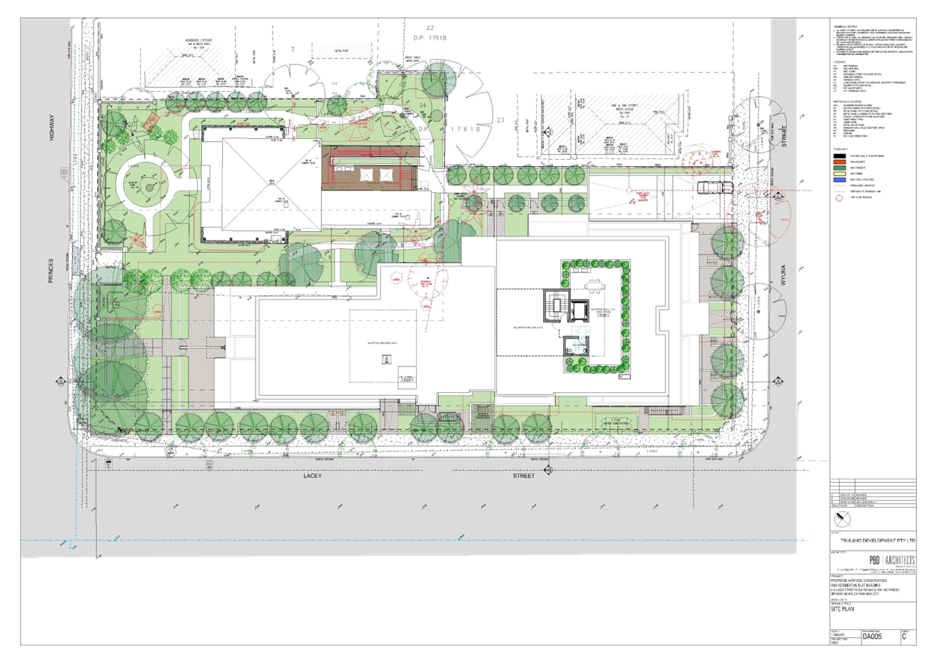
Site Plan
Sites outlined in red
|
Executive Summary
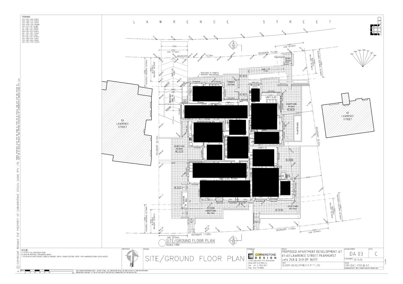
Proposal
1. Council is in receipt of an
application which proposes lot consolidation, demolition of all structures, tree
removal and the construction a three (3) storey residential flat building
containing fourteen (14) residential apartments and one (1) basement level
accommodating twenty-two (22) parking spaces and associated landscaping works
at 61-63 Lawrence Street, Peakhurst.
Specifically
the development proposes fourteen (14) residential apartments with the
following unit mix:
· 2 x 1
bedroom apartments
· 8 x 2
bedroom apartments; and
· 4 x 3
bedroom apartments.
(two (2) of the units are nominated as adaptable).
· One (1)
basement level containing twenty-two (22) vehicle car parking spaces, two (2)
being accessible and one (1) car wash bay.
Site and Locality
2. The development site involves
the amalgamation of 61 and 63 Lawrence Street, Peakhurst.
The
sites are rectangular in shape with No 61 Lawrence Street having a 15.24m arced
front northern boundary, a 36.505m side eastern boundary, a 36.73m side western
boundary, a 17.68m arced rear southern boundary and a total site area of
602.6sqm.
Number
No 63 Lawrence Street has a 15.24m arced front northern boundary, a 36.32m side
eastern boundary, a 36.505m side western boundary, a 17.68m arced rear southern
boundary and a total site area of 599.1sqm.
The
amalgamated allotments will result in a 30.48m arced front northern boundary, a
36.32m side eastern boundary, a 36.73m side western boundary, a 35.36m arced
rear southern boundary and a total site area of 1,201.7sqm.
Zoning and Permissibility
3. The development site is zoned
R3 Medium density residential under the provisions of the Hurstville Local
Environmental Plan (HLEP) 2012. The proposed development is a ‘Residential
Flat Building’ and satisfies the objectives of the zone and is
permissible with consent in the zone.
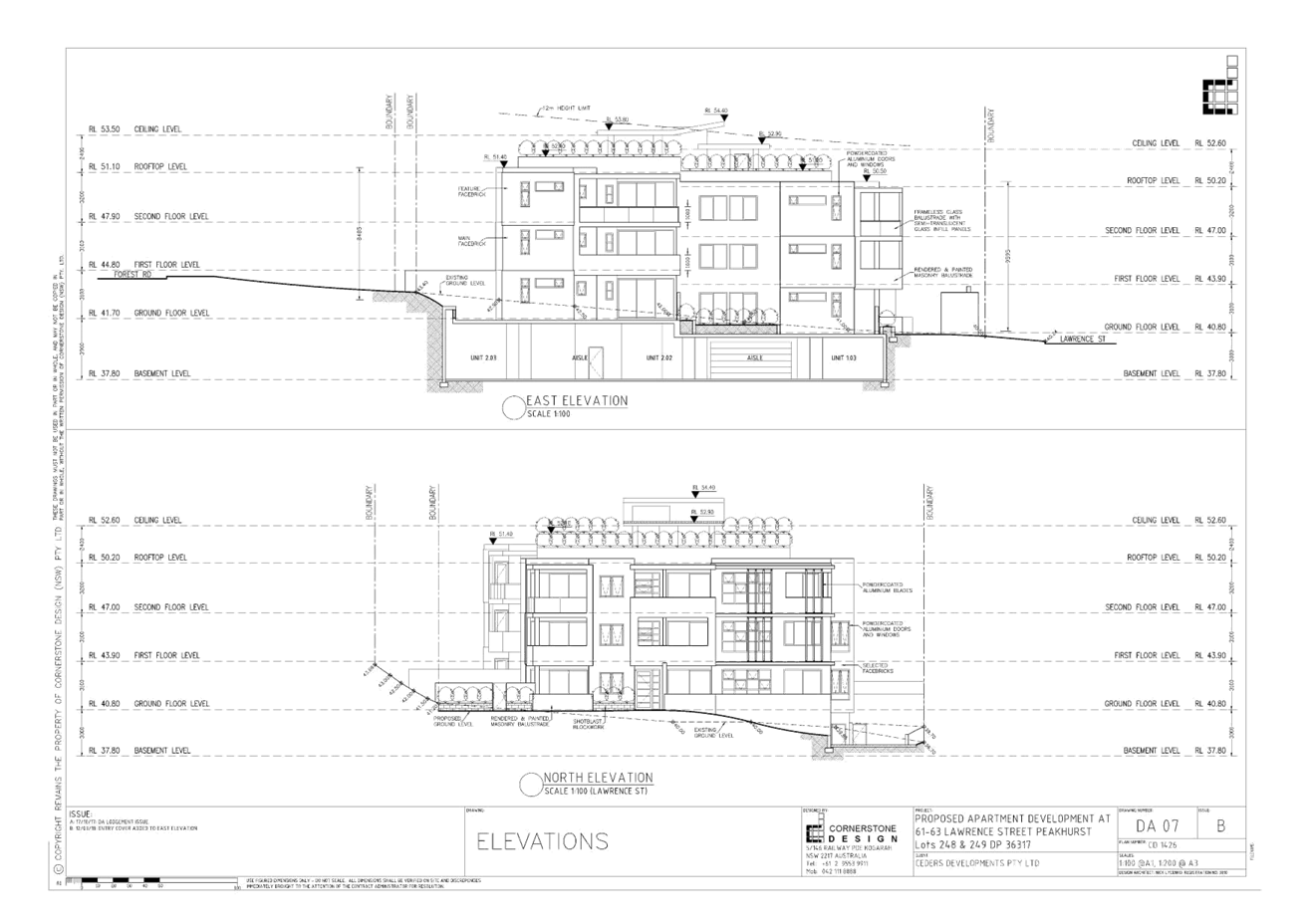
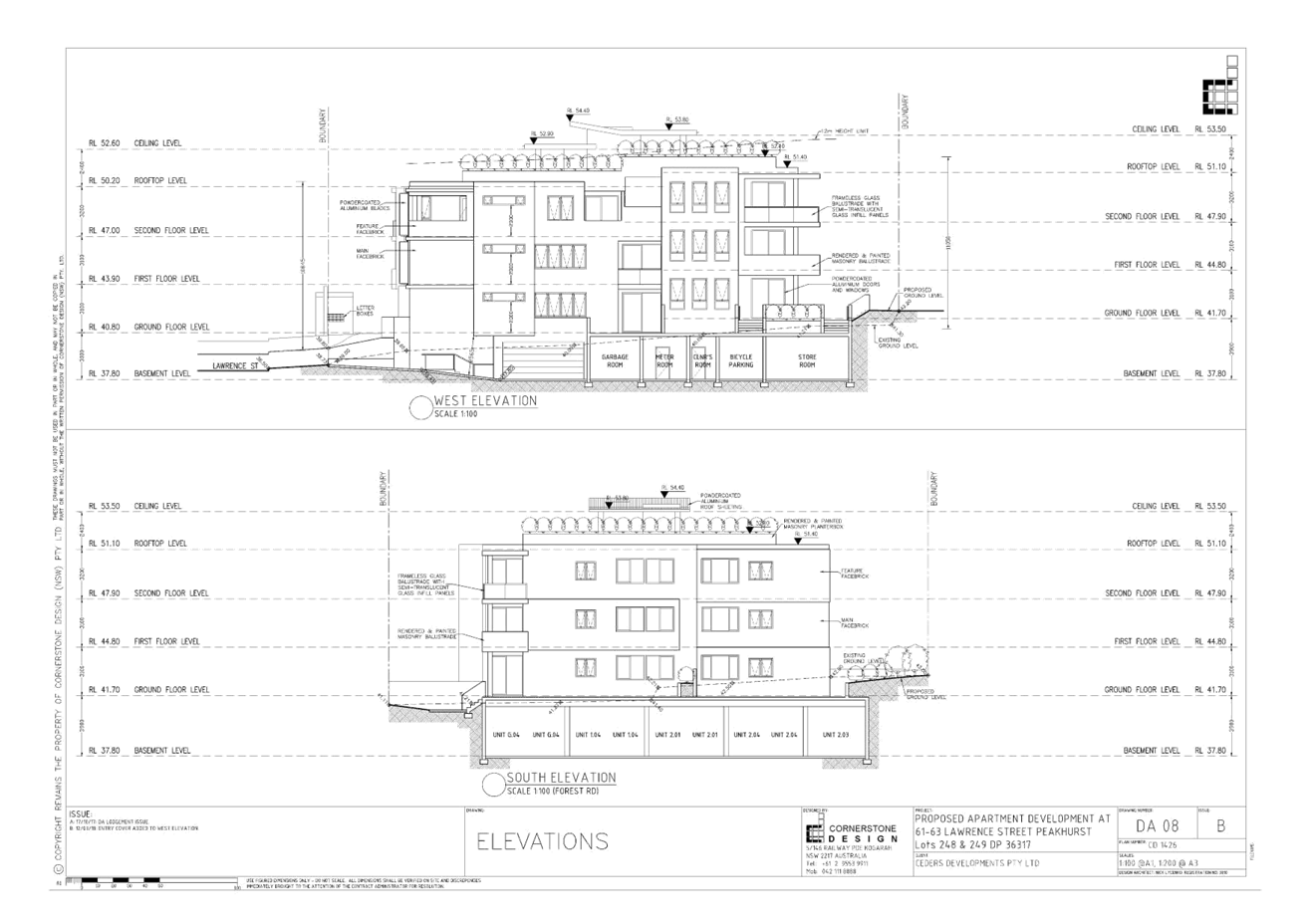
Clause 4.6 Variation - Height
4. The proposed development seeks
a maximum height of 13.85 metres, a variation to clause 4.3 Height of Buildings
under the provisions of the Hurstville Local Environmental Plan (HLEP) 2012.
The maximum building height for the development is 12m; the proposed
development seeks a 1.85m variation, equating to a 15.4% variation. The height
breach is due to the proposed lift overrun and pergola/shade structure located
on the Roof Top Level.
Submissions
5. The proposed development was
notified and advertised to the surrounding residents/owners from 6 December
2017 to 5 January 2018. No submissions were received by Council.
Conclusion
6. This application has been
assessed having regard to the matters for consideration under Section 4.15(1)
and 4.15(3) of the Environmental Planning and Assessment Act 1979, the
provisions of the relevant State Environmental Planning Policies, Local Environmental
Plan and Development Control Plans. The application seeks lot consolidation,
demolition of all structures, tree removal and the construction a three (3)
storey residential flat building containing fourteen (14) residential
apartments and one (1) basement level accommodating twenty-two (22) parking
spaces and associated landscaping works.
Following a
detailed assessment it is recommended that Development Application No.
DA2017/0584 be approved subject to the recommended conditions at the end of
this report.
Report in Full
Proposal
7. The proposed
development seeks lot consolidation, demolition of all structures, tree removal
and the construction of a three (3) storey residential flat building containing
fourteen (14) residential apartments and one (1) basement level accommodating
twenty-two (22) parking spaces and associated landscaping works. Specifically,
the proposed development contains the following;
Basement:
- Parking for twenty-two (22) vehicles which includes two
(2) accessible spaces and four (4) visitor spaces, one (1) doubles as a car
wash bay;
- Individual storage spaces allocated to each unit;
- Garbage room;
- Access lift;
- Access stairs;
- Cleaner’s room;
- Six (6) bicycle parking spaces;
- Store room; and
- Meter room.
Ground
Floor – Total: Five (5) Units:
- One (1) by three (3) bedroom apartment;
- Three (3) by two (2) bedroom apartment;
- One (1) x one (1) bedroom apartment;
- Lift; and
- Access stairs.
First Floor – Total: Five (5) Units:
- One
(1) x three (3) bedroom apartment;
- Three
(3) x two (2) bedroom apartments;
- One
(1) x one (1) bedroom apartment;
- Lift;
and
- Access
stairs.
Second
Floor – Total: Four (4) Units:
- Two (2) x three (3) bedroom apartments;
- Two (2) x two (2) bedroom apartments;
- Lift; and
- Access stairs;
|
Unit
|
Number of Units
|
|
1 bedroom units
|
2
|
|
2 bedroom units
|
8
|
|
3 bedroom units
|
4
|
|
Total
|
14
|
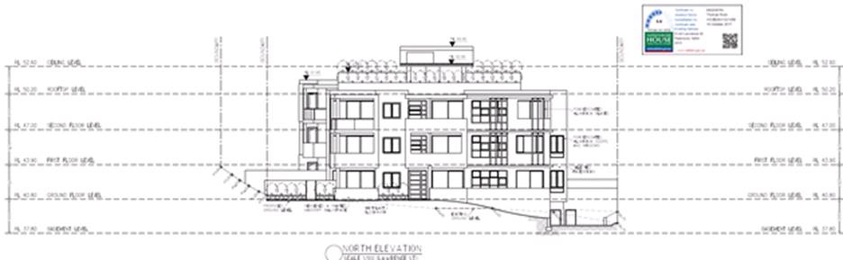
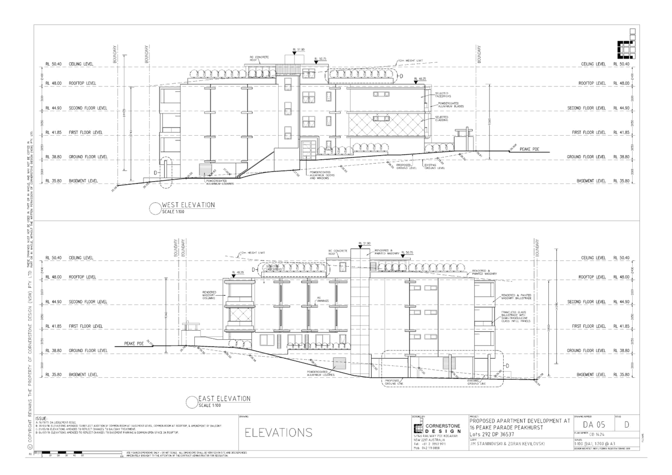
Figure 1: Northern
elevation (view from Lawrence Street) of the proposed development (Source:
Cornerstone Design, 2018)
The Site and Locality
8. The subject development site
is identified as Lot 248, DP 36317, No. 61 Lawrence Street and Lot 249, DP
36317, No. 63 Lawrence Street, Peakhurst.
The
allotment is located on the southern side of Lawrence Street, between Pearce
Avenue to the east and Trafalgar Street to the west.
The
site is generally rectangular in shape with No 61 Lawrence Street having a
15.24m arced front northern boundary, a 36.505m side eastern boundary, a 36.73m
side western boundary, a 17.68m arced rear southern boundary and a total site
area of 602.6sqm.
No
63 Lawrence Street has a 15.24m arced front northern boundary, a 36.32m side
eastern boundary, a 36.505m side western boundary, a 17.68m arced rear southern
boundary and a total site area of 599.1sqm.
The
amalgamated allotments will result in a 30.48m arced front northern boundary, a
36.32m side eastern boundary, a 36.73m side western boundary, a 35.36 arced
rear southern boundary and a total site area of 1,201.7sqm.
Existing
on site are single storey residential dwellings and seven (7), trees which are
the subject of removal.
Council’s
nature strip/verge (directly in front of 61-63 Lawrence Street) accommodates
two (2) street trees, which are to remain and be protected throughout
construction. An electricity power pole, a Telstra pit and a drainage lintel
for the purposes of stormwater drainage exist within the public domain.
The
site has a fall of 5.65m measured from the rear south-eastern corner (RL43.69)
to the front north-western corner (RL38.04).
The
site is located within the R3 - Medium Density Residential Zone and is not
affected by bushfire, acid sulfate soils, heritage, heritage conservation or
flooding. The rear southern boundary adjoins land that is zoned RE1 - Public
Recreation, which is located adjacent to the road reserve of Forest Road (State
Classified Road).
The
immediate surrounding environment is characterised by residential development
with a mixture of single dwellings, attached dual occupancies and residential
flat buildings consisting of three (3) storeys.
The
site is located approximately 1.4km from Riverwood Station and is located 300m
(east) and 450m (west) from bus stops on Forest Road. Bus routes 943 and M91
provide services from Forest Road to Hurstville Station. The site is also
located within a bus stop on Trafalgar Street which services bus route 944 to
Riverwood Station and Hurstville Station.

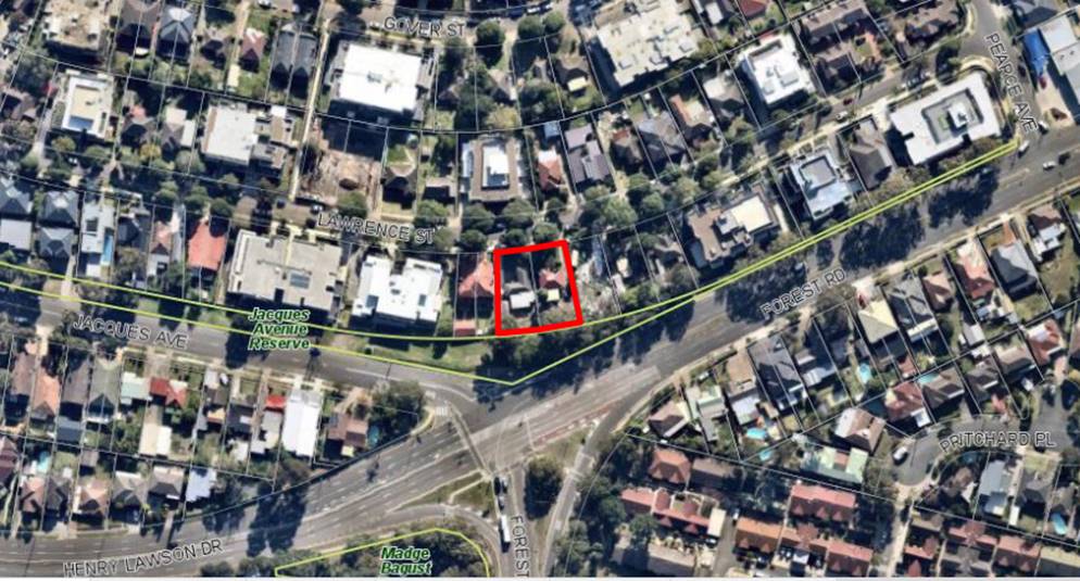
Figure 2: Locality
map for 61 Lawrence Street, Peakhurst (Source: Google Maps, 2019)
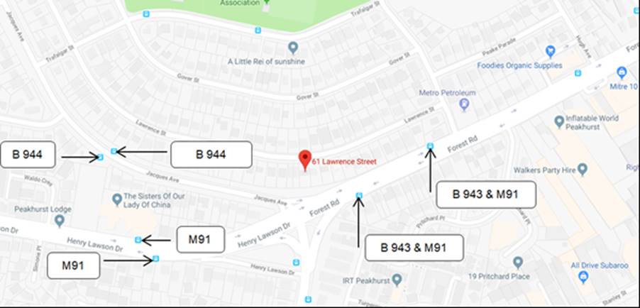
Figure 3: Bus
routes from 61 Lawrence Street (Source: Google Maps, 2019)
Background
9. DA2004/0071 59-59A
Lawrence Street, Peakhurst
Approved
by Council on 21/04/2004
Construction
of attached dual occupancy
DA2013/0283 77-79
Lawrence Street, Peakhurst
Approved
by NSW Land & Environment Court 15/10/2014
Demolition
of existing structures and construction of a three (3) storey residential flat
building comprising fifteen (15) units and basement carparking with ninteen
(19) spaces.
DA2014/1132 47-51
Lawrence Street, Peakhurst
Approved
by JRPP on 07/05/2015
Affordable
rental housing consisting of 3-4 storey residential flat building with 39
dwellings and basement car parking.
DA2017/0000 53-57
Lawrence Street, Peakhurst
Approved
by JRPP on 17/10/2016
Demolition
of existing structures and construction of a residential flat building
containing 21 dwellings with basement parking (Crown Application).
DA2016/0276 1-3
Pearce Avenue & 83 Lawrence Street, Peakhurst
Approved
by Delegated Authority on 13/06/2017
Demolition
of existing structures and removal of trees, construction of a three (3) storey
residential flat building with basement parking accessed from Lawrence Street
and Strata subdivision.
DA2016/0224 65-67
Lawrence Street, Peakhurst
Deffered
by LPP on 03/12/2018
Construction
of a part 3, part 4 storey residential flat building containing 13 apartments,
basement car parking for 19 vehicles and associated landscaping and site works.
Zoning
10. The subject site is zoned R3 –
Medium Density Residential under the Hurstville Local Environmental Plan
(HLEP), the proposed ‘Residential Flat Building’ is permissible in
the zone with the consent. The proposal satisfies the zone objectives which
are:
· To
provide for the housing needs of the community within a medium density
residential environment.
· To
provide a variety of housing types within a medium density residential
environment.
· To
enable other land uses that provide facilities or services to meet the day to
day needs of residents.
· To
ensure that a high level of residential amenity is achieved and maintained.
· To
provide for a range of home business activities, where such activities are not
likely to adversely affect the surrounding residential amenity.
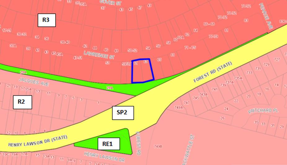
Figure 4: Zoning
Map for 61 and 63 Lawrence Street, Peakhurst outlined in blue
APPLICABLE
PLANNING CONTROLS
PLANNING
ASSESSMENT
Environmental
Planning Instruments
Hurstville
Local Environmental Plan 2012
11. The provisions of the Hurstville Local
Environmental Plan (HLEP) apply to the proposed development which complies with
the relevant provisions as follows.
|
Clause
|
Standard
|
Proposal
|
Complies
|
|
2.3 – Zone objectives and
land use table
|
R3 – Medium Density
Residential
|
The development is consistent with
the zone objectives and land use table.
|
Yes
|
|
4.3 – Height of Buildings
|
12m as identified on Height of
Buildings Map
|
13.85m.
|
No (1)
|
|
4.4 – Floor Space Ratio
|
1:1 as identified on Floor Space
Ratio Map
|
FSR = 1:1.
|
Yes
|
|
4.6 – Exceptions to
development standards
|
Formal written request required
addressing provisions of Cl.4.6
|
Formal written
request lodged and addressed in detail as part of this assessment
|
Yes - Clause 4.6 Statement
addresses relevant provisions of Clause 4.6.
|
|
6.2 - Earthworks
|
To ensure that earthworks do not
have a detrimental impact on environmental functions and processes,
neighbouring uses, cultural or heritage items or features of the surrounding
land
|
The proposed
earthworks involve excavation to accommodate one (1) level of basement car
parking.
The proposal is
considered acceptable having regard to the provisions of this clause.
The works are
unlikely to have a detrimental impact on environmental functions and
processes, neighbouring uses, or features of the surrounding land.
The proposed
basement is fully contained within the building footprint with soft
landscaping and deep soil areas proposed along the side, rear and front
boundaries.
A condition has
been recommended for dilapidation reports for the adjoining allotments and
the excavation shall be undertaken using rock saws if required.
|
Yes
|
12. Clause 4.3 - Height of Buildings – (1)
The
proposed development seeks a variation to the development standard relating to
height. Hurstville Local Environmental Plan 2012 identifies a maximum height of
12m. The proposed development will have a maximum height of 13.85m.
A
variation to the height can be considered under Clause 4.6 – Exceptions
to Development Standards in the Hurstville Local Environmental Plan. In
assessing the variation, the provisions identified in Clause 4.6 have to be
considered. The applicant’s town planning consultant, Planning Principles
has provided a response which is detailed and considered below.

Figure 5: Western
elevation of the building illustrating area of non-compliance with the height
control in red (Source: Planning Ingenuity, 2018)
Clause
4.6 Exceptions to development standards
13. The objectives of Clause 4.6 are as
follows:
(a) to
provide an appropriate degree of flexibility in applying certain development
standards to particular development,
(b) to
achieve better outcomes for and from development by allowing flexibility in
particular circumstances.
The Applicant has
shown the elements which exceed the height control and Council has concluded
with the following:
· The lift
over run which reaches a RL of 54.0 and achieves an overall numerical height of
13.0m, amounting to 1.0m over the height control.
· A roof
extension of 1.43m, which reaches a RL of 54.4 and achieves an overall
numerical height of 13.85m.
The
non-compliance amounts to 1.85m (breach to Clause 4.3 – Height of
Buildings to the HELP, 2012) which equates to a 15.4% variation in the
standard.
Is
the planning control in question a development standard?
Comment:
Yes Clause 4.3 - Height of buildings is a development standard.
What is the
underlying objective or purpose of the standard?
Comment:
The objectives of Clause 4.3 Height of buildings Standard are;
(a) to ensure that buildings are compatible with
the height, bulk and scale of the existing and desired future character of the
locality,
(b) to minimise visual impact, disruption of
views, loss of privacy and loss of solar access to existing development and to
public areas and public domain, including parks, streets and lanes,
(c) to nominate heights that will provide a
transition in built form and land use intensity,
(e) to establish maximum building heights that
achieve appropriate urban form consistent with the
major centre status of the Hurstville City Centre,
(f) to facilitate an
appropriate transition between the existing character of areas or localities
that are not undergoing, and are not likely to undergo, a substantial
transformation,
(g) to minimise adverse
environmental effects on the use or enjoyment of adjoining properties and the
public domain.
14. Applicant’s comment:
“Clause
4.3(2) of Hurstville Local Environmental Plan 2012 relates to the maximum
height requirements and refers to the Height of Buildings Map. The relevant map
identifies the subject site as having a maximum height of 12m. Building height
is defined as:
“Building height (or
height of building) means:
(a) in relation to the
height of a building in metres—the vertical distance from ground level
(existing) to the highest point of the building, or
(b) in relation to the RL of
a building—the vertical distance from the Australian Height Datum to the
highest point of the building, including plant and lift overruns, but excluding
communication devices, antennae, satellite dishes, masts, flagpoles, chimneys,
flues and the like.”
Figures
13, 14 and 15 of this report provide elevations and a sectional diagram
indicating that due to the provision of a roof shading structure and the lift
overrun when compared to the and the natural fall of the land, the building
height exceeds the maximum permissible for the site. The height non-compliances
are shaded in red”.
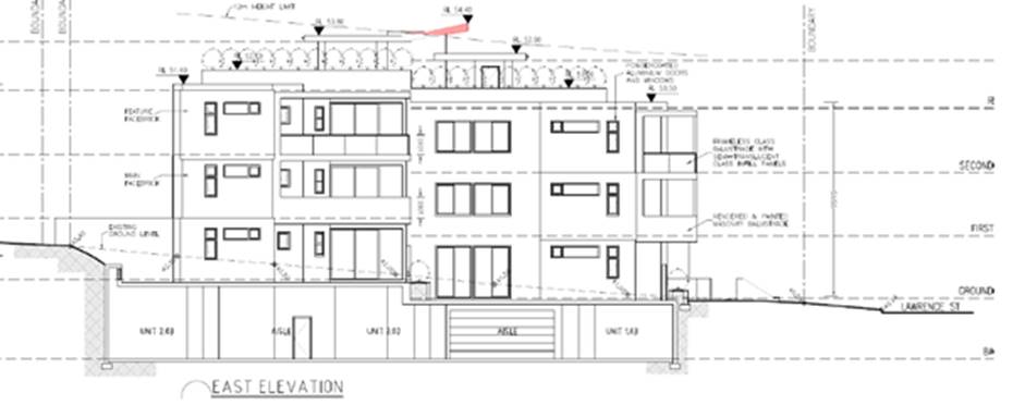
Figure 6: ‘Figure
13’ from the submitted Statement of Environmental Effects (SEE) Eastern
Elevation (Source: Planning Ingenuity, 2018)
“As
indicated in the eastern elevation, all residential floor space a significant
amount of the building is located below the maximum height limit and the
projecting elements are limited to the lift overrun and shading structure where
the site falls away to the street frontage. In addition, the building is fully
compliant with the height requirements at the street frontage to Lawrence
Street”.
Figure 7: ‘Figure
14’ from the submitted Statement of Environmental Effects (SEE) Western
Elevation (Source: Planning Ingenuity, 2018)
Figure 7: ‘Figure
15’ from the submitted Statement of Environmental Effects (SEE) Section
Plan (Source: Planning Ingenuity, 2018)
“As
indicated in Figure 14 the height non-compliance is limited to the centre of
the building where access to the roof top terrace is achieved via lift and stair
access and the shade structure is provided. The maximum extent of
non-compliance is 1.85m above the 12m height plane, representing a variation of
15.4% of the standard”.
“The
building has been designed to be below the height requirement at the street
edge and results in a building that is consistent with the scale of development
expected at the site. Maximum height control is a “development
standard” to which exceptions can be granted pursuant to clause 4.6 of
the LEP”.
Officer
Comment - The applicant’s justification is supported. As identified
in red, the extent of the height variation relates to the lift overrun and
vergola which is centrally located within the building footprint. The proposed
variation does not comprise of floor space or area which could be readily
converted into floor space.
The
height of the building results in minimal additional impacts of overshadowing
or visual bulk when viewed from the adjoining allotments and the public domain,
when compared to that of a numerically compliant building, the additional
shadowing resulting from the additional height will fall within the allotment
boundary and not adversely impact the southern allotment.
Given
the above, the proposed variation is not inconsistent with the objectives of
Clause 4.3, and is acceptable despite the numerical non-compliance.
15. 4.6 Exceptions to development
standards
(1)
The objectives of this clause are as follows:
(a) to provide an appropriate degree of flexibility in applying
certain development standards to particular development,
(b) to achieve better outcomes for and from development
by allowing flexibility in particular circumstances.
(2) Development consent may, subject to this
clause, be granted for development even though the development would contravene
a development standard imposed by this or any other environmental planning
instrument. However, this clause does not apply to a development standard that
is expressly excluded from the operation of this clause.
(3) Development consent must not be granted for
development that contravenes a development standard unless the consent
authority has considered a written request from the applicant that seeks to
justify the contravention of the development standard by demonstrating:
(a) that compliance with the development standard is unreasonable
or unnecessary in the circumstances of the case, and
(b) that there are sufficient environmental planning grounds to
justify contravening the development standard.
(4) Development consent must not be granted for
development that contravenes a development standard unless:
(a) the consent authority is satisfied that:
(i) the applicant’s written request
has adequately addressed the matters required to be demonstrated by subclause
(3), and
(ii) the proposed development will be in the
public interest because it is consistent with the objectives of the particular
standard and the objectives for development within the zone in which the
development is proposed to be carried out, and
(b) the concurrence of the Secretary has been
obtained.
(5) In
deciding whether to grant concurrence, the Secretary must consider:
(a) whether contravention of the development
standard raises any matter of significance for State or regional environmental
planning, and
(b) the public benefit of maintaining the
development standard, and
(c) any other matters required to be taken into
consideration by the Secretary before granting concurrence.
(6) Development consent must not be granted
under this clause for a subdivision of land in Zone RU1 Primary Production,
Zone RU2 Rural Landscape, Zone RU3 Forestry, Zone RU4 Primary Production Small
Lots, Zone RU6 Transition, Zone R5 Large Lot Residential, Zone E2 Environmental
Conservation, Zone E3 Environmental Management or Zone E4 Environmental Living
if:
(a) the subdivision will result in 2 or more lots
of less than the minimum area specified for such lots by a development
standard, or
(b) the subdivision will result in at least
one lot that is less than 90% of the minimum area specified for such a lot by a
development standard.
Note
- When this Plan was made it did not include Zone RU1 Primary Production, Zone
RU2 Rural Landscape, Zone RU3 Forestry, Zone RU4 Primary Production Small Lots,
Zone RU6 Transition, Zone R5 Large Lot Residential, Zone E2 Environmental
Conservation, Zone E3 Environmental Management or Zone E4 Environmental Living.
(7) After determining a development application made
pursuant to this clause, the consent authority must keep a record of its
assessment of the factors required to be addressed in the applicant’s
written request referred to in subclause (3).
(8) This clause does not allow development consent to
be granted for development that would contravene any of the following:
(a) a development standard for complying
development,
(b) a development standard that arises, under the
regulations under the Act, in connection with a commitment set out in a BASIX
certificate for a building to which State Environmental Planning Policy
(Building Sustainability Index: BASIX) 2004 applies or for the land on which
such a building is situated,
(c) clause 5.4,
(ca)
clause 6.6.
Applicant’s
Comment: “The development standards in clause 4.3 are not
“expressly excluded” from the operation of clause 4.6.
Objective
1(a) of clause 4.6 is satisfied by the discretion granted to a consent
authority by virtue of subclause 4.6(2) and the limitations to that discretion
contained in subclauses (3) to (8).
This
submission will address the requirements of subclauses 4.6(3) & (4) in
order to demonstrate to Council that the exception sought is consistent with
the exercise of “an appropriate degree of flexibility” in applying
the development standard, and is therefore consistent with objective 1(a). In
this regard, the extent of the discretion afforded by subclause 4.6(2) is not
numerically limited, in contrast with the development standards referred to in
subclause 4.6(6)”.
Objective
1(b) of clause 4.6 is addressed later in this request.
The
balance of this request will be divided into the following sections, each
dealing with the nominated aspect of Clause 4.6:
· consistency
with the development standard objectives and the zone objectives (Clause
4.6(4)(a)(ii));
· sufficient
environmental planning grounds to justify contravening the development standard
(Clause 4.6(3)(b)); and
· that
compliance is unreasonable or unnecessary in the circumstances of the case
(Clause 4.6(3)(a)).
Consistency
with the Objectives (Clause 4.6(4)(A)(Ii))
16. The objectives and relevant provisions of
clause 4.3 are as follows, inter alia:
4.3
Height of buildings
(1) The
objectives of this clause are as follows:
(a) to ensure that buildings are
compatible with the height, bulk and scale of the existing and desired future
character of the locality,
(b) to minimise visual impact, disruption
of views, loss of privacy and loss of solar access to existing development and
to public areas and public domain, including parks, streets and lanes,
(c) to
minimise the adverse impact of development on heritage items,
(d) to nominate heights that will provide
a transition in built form and land use intensity,
(e) to establish maximum building heights
that achieve appropriate urban form consistent with the major centre status of
the Hurstville City Centre,
(f) to facilitate an appropriate
transition between the existing character of areas or localities that are not
undergoing, and are not likely to undergo, a substantial transformation,
(g) to minimise adverse environmental
effects on the use or enjoyment of adjoining properties and the public domain.
(2) The height of a building on any land is not to exceed
the maximum height shown for the land on the Height of Buildings Map.
Applicant’s
Comment: “The Height of Buildings Map nominates a maximum height
of 12m for the site. It is hereby requested that an exception to this
development standard be granted pursuant to Clause 4.6 so as to permit a
maximum height of 13.85m (RL54.4), excess of 1.85m to accommodate the lift
overrun and a shade structure at the roof top of the building.
Officer
Comment – The development is of a form and scale that will provide
for the housing needs of the community in a manner that is consistent with the
medium density housing zoning of the land and the anticipated building form for
the locality, having regard to the height and floor space ratio provisions that
apply.
In
order to address the requirements of subclause 4.6(4)(a)(ii), each of the
relevant objectives of clause 4.4 are addressed in turn below”.
Objective
(a):
“Objective
(a) seeks to ensure that buildings are compatible with the height, bulk and
scale of the existing and desired future character of the locality. The
proposal is fully compliant at the Lawrence Street frontage and will be
consistent with the height and scale of future residential flat building
development. Due to the minor non-compliance being limited to the lift overrun
and shade structure at the centre of the building, the development is generally
indistinguishable from a fully compliant scheme when viewed from the public
domain and the adjoining street frontage. As such, it cannot be said that the
proposal by virtue of the minor height exceedance is incompatible with the
desired future character of the surrounding properties”.
Officer
Comment - The locality during the up-zoning was considered capable of
supporting increased population within this precinct. The proposed development
provides for a range of unit types and sizes to meet the demand of the public.
Objective
(b):
“Objective
(b) seeks to minimise the visual impact, disruption of views, loss of privacy
and loss of solar access to existing development and the adjoining public
domain from buildings. As detailed at Section 4.3.5.1 of the Statement of
Environmental Effects, the proposal has been designed to minimise loss of
privacy and is of a contemporary aesthetic that will not give rise to visual
impact. The portion of the building that exceeds the building height is minor
and limited to the centre of the building. The proposal is fully compliant with
the building height requirements for the remainder of the building and where it
fronts Lawrence Street the building appears to be of a scale that is expected
at the site.
The
non-compliant parts of the building will not in itself create any amenity
related impacts due to the centralised location of the non-compliance on the
building. On this basis, the proposal is consistent with objective (b)”.
Officer
Comment - The design of the development providing the additional height
centrally, ensures that a high level of amenity is achieved for the development
and maintained to the surrounding residential properties.
Objective
(c):
“There
are no heritage items in the vicinity of the subject site and therefore
objective (c) is met”.
Officer
Comment – There are no heritage items in the visual catchment of this
site.
Objective
(d):
“Objective
(d) seeks to nominate heights that will provide a transition in built form and
land use intensity. As discussed, the site is located at the centre of the
medium density area and would have no impact upon any nearby lower density
residential zones. The minor height non-compliance would have no bearing on
built form or land use intensity and is therefore entirely consistent with this
objective”.
Officer
Comment - The additional height is located centrally and does not adversely
impact upon the public domain or the adjoining allotments. The breach in height
is for the lift overrun and communal open space infrastructure is consistent
with other developments within this precinct and does not undermine this
objective.
Objective
(e):
“The
site is not located within Hurstville City Centre and is therefore not
applicable to the subject site”.
Officer
Comment - The applicant’s justification is considered sound given that
the underling objectives have been satisfied.
Objective
(f):
“In
relation to objective (f) the locality is undergoing a transition from low
density to medium density development and therefore the existing character of
the area will undergo change. The requirements of objective (f) are therefore
not impacted by the proposed height non-compliance”.
Officer
Comment - The additional height of the lift overrun and vergola above the
12m standard will not result in a visually dominant form and a scale not envisaged
by the up-zoning. The additional overshadowing will fall upon itself and not
cause any material impacts onto the adjoining allotments. The non-compliance
with the height standard does not contribute to an unreasonable visual impact
or loss of privacy to adjoining properties.
Objective
(g):
“Due
to its centralised location on the proposed building, the increased height of
1.85m to the lift overrun and shade structure will not result in any adverse
environmental effects on the use or enjoyment of adjoining properties and the
public domain.
The
proposed development is therefore consistent with the objectives for maximum
height, despite the numeric non-compliance”.
Officer
Comment - Despite the height non-compliance of the lift overrun and the
roof top communal open space infrastructure, the scale, form and intensity of
the building is consistent with the intended character, scale and from of the
uplift of the precinct.
Clause
4.6(4) also requires consideration of the relevant zone objectives. The objectives
of the R3 – Medium Density Residential zone are as follows:
· To
provide for the housing needs of the community within a medium density
residential environment.
· To
provide a variety of housing types within a medium density residential environment.
· To
enable other land uses that provide facilities or services to meet the day to
day needs of residents.
· To
ensure that a high level of residential amenity is achieved and maintained.
· To
provide for a range of home business activities, where such activities are not
likely to adversely affect the surrounding residential amenity.
Applicant’s
Comment: “The proposal will provide a medium density residential
development that provides a range of unit layouts, orientations, internal
living arrangements as well as the required number of adaptable dwellings. The
proposal is a well-designed and sited residential flat building that offers
high levels of residential amenity and is entirely consistent with the
intentions of the zone”.
Officer
Comment - The development is considered to observe the objectives of the
height development standard. The proposal is considered to positively
contribute to broadening of the variety of housing types within this Medium
Density Residential zone.
Sufficient
Environmental Planning Grounds (Clause 4.6(3)(b)
17. Applicant’s Comment: “Having
regard to Clause 4.6(3)(b) and the need to demonstrate that there are
sufficient environmental planning grounds to justify contravening the
development standard, as discussed above it is considered that there is an
absence of significant impacts of the proposed non-compliance on the amenity of
future building occupants, on area character and on neighbouring properties.
The assessment of this numerical non-compliance is guided by the decision of
the NSW LEC Four2Five Pty Ltd v Ashfield Council [2015] NSWLEC 90 whereby
Justice Pain ratified the decision of Commissioner Pearson.
On
“planning grounds” and in order to satisfy that the proposal meets
objective 1(b) of Clause 4.6 in that allowing flexibility in the particular
circumstances of this development will achieve “a better outcome for and
from development”, it is considered that the current proposal will
facilitate greater amenity for future residents on a site that is highly suited
for such purposes and in a configuration that will not detract from the
existing approved developments or future anticipated development on
neighbouring properties.
The
alternative would be to remove or relocate the communal open space to ground
level adjacent to private open space within the site and on adjoining sites.
This would significantly reduce the recreational amenity for future occupants
which would be counterproductive as there is no adverse impact created by the
non-compliance.
An
alternative relocation would reintroduce visual and acoustic privacy conflicts
and greatly reduce gross floor area, meaning that the allowable density could
not be realised, contrary to the zoning objectives.
The
height departure relates to encroachment of the lift over run and protruding
shade structure, with the remainder of the building positioned below the
maximum building height limit.
The
lift over run is a core service element of the development and is setback
significantly from the Lawrence Street facade and will not be readily visible
from the street level. The shading device provides necessary amenity benefits
to residents using the communal area.
There
are sufficient environmental planning grounds to justify the variation of the
height control, particularly given that:
· The
development has been designed to minimise impacts where practicable on
neighbouring properties and likely future adjoining properties;
· Strict
compliance with the building height standard would result in no material built
form benefits and loss of resident amenity;
· The
proposed height non-compliance relates to parts of the building that will be
imperceptible to the casual observer when viewed from the adjacent street
frontage of from private properties;
· The
non-compliant sections of the building do not contribute to overshadowing or
loss of privacy; and
· The
non-compliant sections of the building do not result in view loss
The
desire to achieve high amenity communal open space at the rooftop (as
encouraged by Council) provides clear amenity benefits for the residents of the
development, but not to detriment of the amenity of adjoining residents or to
area character. For Council to insist on strict compliance in this instance
would require relocation of the communal space and potentially the loss of
habitable floor area. This would result in an unreasonable burden on the
development that is to be balanced with the impacts, or lack thereof, resulting
from the non-compliance”.
Officer
Comment - Flexibility in applying the standard is appropriate and the
requisite levels of satisfaction required by the controls have been achieved in
this case, given the minor variation to the lift overrun and vergola. The
variation, at the highest point of the building is the lift over-run to ensure
appropriate access is available to the communal rooftop area.
Insistence
on compliance is unreasonable and unnecessary (Clause 4.6(3)(a)
18. Applicant’s Comment: “Returning
to Clause 4.6(3)(a), in Wehbe V Pittwater Council (2007) NSW LEC 827 Preston CJ
sets out ways of establishing that compliance with a development standard is
unreasonable or unnecessary. It states, inter alia:
“An
objection under State Environmental Planning Policy (SEPP) 1 may be well
founded and be consistent with the aims set out in clause 3 of the Policy in a
variety of ways. The most commonly invoked way is to establish that compliance
with the development standard is unreasonable or unnecessary because the
objectives of the development standard are achieved notwithstanding
non-compliance with the standard.”
The
judgement goes on to state that:
“The
rationale is that development standards are not ends in themselves but means of
achieving ends. The ends are environmental or planning objectives. Compliance
with a development standard is fixed as the usual means by which the relevant
environmental or planning objective is able to be achieved. However, if the
proposed development proffers an alternative means of achieving the objective
strict compliance with the standard would be unnecessary (it is achieved
anyway) and unreasonable (no purpose would be served).”
However,
in Four2Five v Ashfield Council [2015] NSWLEC 90 the Land and Environment Court
said that whether something was ‘unreasonable or unnecessary’ is
now addressed specifically in Clause 4.6(4)(a)(ii), with separate attention
required to the question of whether compliance is unreasonable or unnecessary.
Accordingly, while the objectives of the standard are achieved despite
non-compliance with the standard, this request goes further. It seeks to
demonstrate that requiring strict adherence to the standard would be
‘unreasonable or unnecessary’ for reasons that are additional to
mere consistency with the development standard.
Preston
CJ in the judgement then expressed the view that there are 5 different ways in
which an objection may be well founded and that approval of the objection may
be consistent with the aims of the policy, as follows (with emphasis placed on
number 1 for the purposes of this Clause 4.6 variation [our underline]):
(1) The objectives of the standard are achieved
notwithstanding non-compliance with the standard;
(2) The underlying objective or purpose of the standard is
not relevant to the development and therefore compliance is unnecessary;
(3) The underlying object of purpose would be defeated or
thwarted if compliance was required and therefore compliance is unreasonable;
(4) The development standard has been virtually abandoned or
destroyed by the Council's own actions in granting consents departing from the
standard and hence compliance with the standard is unnecessary and
unreasonable;
(5) The zoning of the particular land is unreasonable or
inappropriate so that a development standard appropriate for that zoning is
also unreasonable and unnecessary as it applies to the land and compliance with
the standard that would be unreasonable or unnecessary. That is, the particular
parcel of land should not have been included in the particular zone.
Additionally,
in an analogous context, in Botany Bay City Council v Saab Corp [2011] NSWCA
308 Court of Appeal said that a requirement may be unreasonable when ‘the
severity of the burden placed on the applicant is disproportionate to the
consequences attributable to the proposed development’. In support of
this point:
· The
proposed height variation will be visually imperceptible when viewed from the
adjoining properties and public domain;
· The
proposed development meets the objectives of the height control and strict
compliance with the height control would undermine or thwart its objectives, or
the zone’s objectives (or both); and
· The
burden placed on future residents (by relocating the communal open space area
to ground level adjacent to private open space) would be disproportionate to
any consequences that may arise from the proposed non-compliance with the
height control.
Given
that compliance with the zone and development standard objectives is achieved
and that the building complies with the overall height limit except for an
overall encroachment of a lift over run and shade structure, insistence on
strict compliance with the building height control is considered to be
unreasonable and unnecessary in the circumstances.
The
proposal is compliant with the relevant objectives and will have no adverse
environmental or amenity impacts. The proposal is therefore justified on
environmental planning grounds. For the reasons above, the proposed building
height variation is consistent with the requirements of Cause 4.6(3) of the
Local Environmental Plan (LEP).
On
this basis, the requirements of Clause 4.6(3) are satisfied.
The
proposal will provide a residential development with superior amenity and
streetscape presentation. This is achieved by well-planned and functional built
form. The non-compliance relates essentially to the provision of communal open
space on the roof level. This will provide significant high quality amenity
(views and solar access) to the future occupants of the building with minimal
impact on surrounding development. There would be no broader environmental
planning benefit achieved in requiring compliance.
Accordingly,
for the reasons stated above, we respectfully request that Council permit the
variation to the maximum building height development standard”.
Officer
Comment - The applicant has provided a written variation request. A copy of
this Clause 4.6 request for variation is provided for the Panel’s
consideration.
Environmental
Planning and Assessment Regulations 2000
19. The proposed development satisfies the
relevant matters for consideration for development under the regulations.
20. The consent authority is required to
consider the objects in Section 1.3 of the EP&A Act when making decisions
under the Act. Council has considered the objectives of the EP&A Act in the
Table below and is satisfied that the proposal complies with all objects.
|
Objects of the
EP&A Act
|
Proposal
|
Complies
|
|
a) to promote the social and economic
welfare of the community and a better environment by the proper management,
development and conservation of the State’s natural and other resources
|
The proposal is not considered to be inconsistent with this
objective.
|
Yes
|
|
b) to facilitate ecologically
sustainable development by integrating relevant economic, environmental, and
social considerations in decision-making about environmental planning and
assessment
|
The proposal is accompanied by a revised BASIX Certificate which
satisfies the requirements under State Environmental Planning Policy (BASIX)
2004 and the Regulations.
|
Yes
|
|
c) to promote the orderly and economic
use and development of land
|
The proposal is considered to provide an orderly and economic
development of the land given the recent up-zoning of the precinct.
|
Yes
|
|
d) to promote the delivery and
maintenance of affordable housing
|
The proposal
seeks development consent for fourteen (14) units, being a combination of 1,
2 and 3 bedroom units.
The proposal
does not seek to provide or retain affordable housing.
|
N/A
|
|
e) to protect the environment,
including the conservation of threatened and other species of native animals
and plants, ecological communities and their habitats
|
The proposal
does seek the removal four (4) trees on the site. The proposal is supported
by Council’s Landscape Officer; subject to conditions of consent.
|
Yes
|
|
f) to promote the sustainable
management of built and cultural heritage
|
The proposal is not listed as a heritage item or within the
immediate vicinity to a heritage item or conservation area within a Local or
State Heritage register.
|
Yes
|
|
g) to promote good design and amenity
of the built environment
|
The proposal is considered to result in a reasonable design.
|
Yes
|
|
h) to promote the proper construction
and maintenance of buildings, including the protection of the health and
safety of their occupants
|
The proposal is considered to satisfy the intent of this control,
to ensure appropriate construction and maintenance which is supported by
Council’s Building Surveyor.
|
Yes
|
|
i) to promote the sharing of the
responsibility for environmental planning and assessment between the
different levels of government in the State
|
The Design Review Panel is a Council Panel.
This
application, being the subject of State Environmental Planning Policy 65 is
required to be determined by the Georges River Local Planning Panel in accordance
with the Ministerial Direction.
|
Yes
|
|
j) to provide increased
opportunity for community participation in environmental planning and
assessment
|
The proposal was notified in
accordance with the Hurstville Development Control Plan (HDCP).
No submissions were received.
|
Yes
|
State
Environmental Planning Policies (SEPP)
21. Compliance with the relevant State
Environmental Planning Policies (SEPP) is detailed and discussed below.
Greater
Metropolitan Regional Environmental Plan No 2 – Georges River Catchment
22. This REP is applicable to the subject site and the aims
of the plan are;
(a) to maintain and improve the
water quality and river flows of the Georges River and its tributaries and
ensure that development is managed in a manner that is in keeping with the
national, State, regional and local significance of the Catchment,
(b) to protect and enhance the
environmental quality of the Catchment for the benefit of all users through the
management and use of the resources in the Catchment in an ecologically
sustainable manner,
(c) to ensure consistency with
local environmental plans and also in the delivery of the principles of
ecologically sustainable development in the assessment of development within
the Catchment where there is potential to impact adversely on groundwater and
on the water quality and river flows within the Georges River or its
tributaries,
(d) to establish a consistent
and coordinated approach to environmental planning and assessment for land
along the Georges River and its tributaries and to promote integrated catchment
management policies and programs in the planning and management of the
Catchment,
(e) (Repealed)
(f) to provide a
mechanism that assists in achieving the water quality objectives and river flow
objectives agreed under the Water Reform Package.
Comment: The
proposal generally satisfies the objectives and provisions of the Regional
Environmental Plan (REP).
State
Environmental Planning Policy 55 – Remediation of Land
23. SEPP 55 identifies that the following is
to be considered in determining a development application.
Contamination and remediation to be considered in
determining development application
(1) A consent authority
must not consent to the carrying out of any development on land unless:
(a) it has
considered whether the land is contaminated, and
(b) if the
land is contaminated, it is satisfied that the land is suitable in its
contaminated state (or will be suitable, after remediation) for the purpose for
which the development is proposed to be carried out, and
(c) if the
land requires remediation to be made suitable for the purpose for which the
development is proposed to be carried out, it is satisfied that the land will
be remediated before the land is used for that purpose.
(2) Before determining
an application for consent to carry out development that would involve a change
of use on any of the land specified in subclause (4), the consent authority
must consider a report specifying the findings of a preliminary investigation
of the land concerned carried out in accordance with the contaminated land
planning guidelines.
(3) The applicant for development consent must carry
out the investigation required by subclause (2) and must provide a report on it
to the consent authority. The consent authority may require the applicant to
carry out, and provide a report on, a detailed investigation (as referred to in
the contaminated land planning guidelines) if it considers that the findings of
the preliminary investigation warrant such an investigation.
(4) The land concerned is:
(a) land
that is within an investigation area,
(b) land on
which development for a purpose referred to in Table 1 to the contaminated land
planning guidelines is being, or is known to have been, carried out,
(c) to the
extent to which it is proposed to carry out development on it for residential,
educational, recreational or child care purposes, or for the purposes of a
hospital-land:
(i) in
relation to which there is no knowledge (or incomplete knowledge) as to whether
development for a purpose referred to in Table 1 to the contaminated land
planning guidelines has been carried out, and
(ii) on which it would have been lawful
to carry out such development during any period in respect of which there is no
knowledge (or incomplete knowledge).
Comment: The
provisions of SEPP 55 require the consent authority to determine if the land
the subject of the application is contaminated, and whether it is appropriate
for the proposed development having regard to subclause (4).
The subject site contains an older style single storey
dwelling house at 61 Lawrence Street and 63 Lawrence Street is currently
vacant. A desktop review has been conducted and it is evident that both sites
have been historically used for residential purposes for many decades.
Table 1 of the Contaminated Land Planning Guidelines
identifies contaminating uses that would trigger the preparation of a
preliminary site investigation plan to determine if and the extent of any
contamination. The uses of the site identified in Council’s records do
not show any uses identified in Table 1. Council’s records also do not
show any action or information relating to contamination being identified on
the site.
State
Environmental Planning Policy (Infrastructure) 2007 (SEPP (Infrastructure)
24. Comment: Clause 101 of the State
Environmental Planning Policy relates to development with frontage to a
classified road. Forest Road is located at the rear of the Site. This roadway
is a classified arterial road, however, there is no access from the site to this
roadway. As such Clause 101 is not applicable in this case. Clause 102 of the
State Environmental Planning Policy (Infrastructure) relates to the assessment
and consideration of road noise or vibration on non-road development.
This clause is applicable to developments that are “on land
in or adjacent to the road corridor for a freeway, a tollway or a transitway or
any other road with an annual average daily traffic volume of more than 20,000
vehicles”. The RMS website includes traffic volumes at various
locations.
The corner of Forest Road and Stoney Creek Road which is noticeably
300m to the east of the site records traffic volumes in excess of 30,000
vehicles daily. The subject site does not address Forest Road and is screened
and setback from the roadway by an existing vegetated verge however an acoustic
report was prepared and accompanies the application.
In
accordance with the State Environmental Planning Policy
a condition is included to ensure that the recommendations of the acoustic
report are integrated into the construction of the building and a condition is
included to ensure that “if the development is for the purposes of residential use, the
consent authority must not grant consent to the development unless it is
satisfied that appropriate measures will be taken to ensure that the following
LAeq levels are not exceeded:
(a) in any bedroom in the
residential accommodation—35 dB(A) at any time between 10pm and 7 am,
(b) anywhere else in the
residential accommodation (other than a garage, kitchen, bathroom or
hallway)—40 dB(A) at any time.”
The development will be constructed to satisfy the
provisions of the State Environmental Planning Policy.
The
recommendations within the acoustic report relate to installing appropriate
double glazing to windows, insulation, minimum wall thicknesses being
incorporated etc.
State
Environmental Planning Policy No 65 – Design Quality of Residential
Apartment Development
25. Comment: The extent to which the
proposed development complies with the controls and principles in the State
Environmental Planning Policy 65 – Design Quality of Residential
Apartment Development (State Environmental Planning Policy 65) and the Apartment
Design Guide (ADG) is detailed and discussed in the tables below.
Application of
SEPP 65
|
Clause
|
Standard
|
Proposal
|
Complies
|
|
3 - Definitions
|
Complies with
definition of “Residential Apartment Development” (RAD)
|
Complies with
definition
|
Yes
|
|
4 - Application
of Policy
|
Development
involves the erection of a new RFB, substantial redevelopment or
refurbishment of a RFB or conversion of an existing building into a RFB
|
Comprises the
erection of a new residential flat building
|
Yes
|
|
50(1a) –
Development Applications
|
Design
verification statement provided by qualified designer
Registered
Architect Name and Registration No.
|
Design
Verification Statement provided by Registered Architect Mr. Nickolas Lycenko
(Registration
No.3010)
|
Yes
|
Part 2 Design Quality
Principles under the SEPP
26. The original proposal was
referred to the Design Review Panel (DRP) on 1 March 2018 and the Panel was
critical of the design when assessed it against the nine (9) Design Quality
Principles and ADG. The Design Review Panel (DRP) supported the application
subject to amendments which are identified below. The Design Review Panel
(DRP) concluded the meeting stating that the proposed application
satisfies the design quality principles contained in State Environmental Planning
Policy 65.
The
table below highlights the comments in italics which are the original Design
Review Panel (DRP) comments.
|
Clause
|
DRP Panel comments
|
Complies
|
|
1 – Context and neighbourhood
character
|
The context is one of evolving medium-density 3-4 storey apartment
buildings, some on substantially sloping sites. The site falls 3m from the
rear to the front (and the rear boundary is approximately 2m below Forest
Road). There are three (3) substantial trees to the rear of the property
which are on public land which make a positive contribution to the character
of site and neighbourhood.
|
Yes,
contextually the development is consistent with the changing nature of the
streetscape and the desired future character of this precinct.
|
|
2 – Built
form and scale
|
Built form is appropriate for the evolving context and complies
with the Local Environmental Plan and Development Control Plan controls.
|
Yes
|
|
3 - Density
|
Appropriate
|
Yes
|
|
4 –
Sustainability
|
Rainwater storage must be provided. The volume of storage must be
sufficient to irrigate the soft landscape areas for a number of weeks without
rain. Storage must be located under hardstand or out of deep soil areas.
|
Yes, the
proposed development is supported by a rainwater tank. Council’s Land
Development Engineers have reviewed the drainage design and have requested
design changes prior to the issue of a Construction Certificate (CC).
|
|
5 - Landscape
|
The large areas of paved surfaces at ground level should be broken
up with planters and areas of soft landscape to create human-scale spaces
suitable for multiple uses.
The communal open space on the rooftop should, likewise, be
designed with a variety of distinct components so as to be amenable for small
groups and individuals rather than large gatherings only. A small amenities
room should be included.
The design must conserve the existing street and verge trees on
Lawrence Street and Forest Road.
A more attractive and convenient pedestrian access to the front of
the site could be provided by deleting the stairs and designing an
attractive, level landscaped pathway from the north east corner of the site
to the front door.
Direct ground floor access should be provided to Unit G.01 from
Lawrence Street.
The tree protection zones of trees to be retained must be identified,
shown on plan and respected in the design of all disciplines including civil
engineering, architecture and landscape architecture.
|
Yes, the
proposed development is supported by Council’s Tree Management Officer;
with conditions of consent.
|
|
6 - Amenity
|
Satisfactory
|
Yes
|
|
7 – Safety
|
Acceptable
|
Yes
|
|
8–Housing
diversity and social interaction
|
Acceptable
|
Yes
|
|
9 - Aesthetics
|
Further consideration should be given to the vertical blades on
the street façade to resolve outlook, privacy and wind protection.
Although as proposed they would be acceptable in appearance, their functional
value is problematic.
|
Yes – the
amendments are considered acceptable;
|
27. Design Review Panel Recommendation
The
final comments from the Design Review Panel stated “The Panel
supports the application subject to the issues raised above being resolved. The
application satisfies the design quality principles contained in SEPP 65”
The
applicant provided amended plans addressing the above recommendations which
were submitted to Council on 26 March 2018.
28. Clause 30 – Consideration
of Apartment Design Guide
|
Clause
|
Standard
|
Proposal
|
Complies
|
|
2E –
Building depth
|
12-18m
|
13.85m
|
Yes
|
|
2G –
Street setbacks
|
Align street
setbacks with building use. For example in mixed use buildings a zero street
setback is appropriate
|
The proposal is
forward of the existing building alignment of the adjoining properties, at
present they are existing housing stock that have not been developed. HDCP
suggests a front setback of 6m. The proposal is setback between 5.8m to 6m.
|
Yes; the
proposed development will be consistent with other approved and constructed
residential flat buildings within the precinct.
|
|
3D-Communal and
Public Open Space
|
1. Communal open
space has a minimum area equal to 25% of the site.
-Where it cannot
be provided on ground level it should be provided on a podium or roof
-Where developments are unable to achieve the
design criteria, such as on small lots, sites within business zones, or in a
dense urban area, they should:
• provide communal spaces elsewhere such as a landscaped roof top
terrace or a common room
• provide larger balconies or increased private open space for
apartments
•
demonstrate good proximity to public open space and facilities and/or provide
contributions to public open space
2. Developments
achieve a minimum of 50% direct
sunlight to the
principal usable part of the communal open space for a minimum of 2 hours
between 9 am and 3 pm on 21 June (mid-winter)
|
Site Area:
1,201.7sqm
Required:
300.4sqm.
Provided: 425sqm
and 35.4%.
The subject
allotment is not located within a business zone; the proposal is located
within an established medium density residential area.
A communal
rooftop area is provided as open space.
Large balconies are provided on the southern and eastern facades of the
proposed development.
A Public recreational area zoned RE1 is provided directly south of the
site; an access gate is provided for residents to access the recreational
area on the southern side of the site. No approval has been granted for this
access by Council as a result this is to be deleted via a condition.
The communal open space is provided in the form of a roof terrace. This
space receives good access to sunlight all year round. A shade structure is
provided over part of the roof terrace so that it is useable in all weather
conditions.
|
Yes
Yes
Yes
Yes
Yes
|
|
3E- Deep Soil
Zones
|
1. Deep soil
zones are to meet the following minimum
requirements:
-Where site area
is between 650sqm and 1500sqm = 3m minimum dimension
Deep soil = 7%
|
The site area is
1,207.1sqm therefore a deep soil zone equating to 7% of the site area is
required.
296.71sqm
(24.69%) of the site is provided as deep soil landscaped area and the
proposed deep soil area will allow for and support healthy plant and tree
growth.
|
Yes
|
|
3F- Visual
Privacy
|
1. Separation between windows and balconies is provided to
ensure visual privacy is achieved.
Minimum required
separation distances from buildings to the side and rear boundaries are as
follows:
Up to 12m (4
storeys)
Habitable rooms
and balconies = 6m
(12m separation
distance)
Non-habitable
rooms = 3m
(6m separation
distance)
|
Side (west)
The proposal has
a setback of 4.5m-6m to the western side boundary resulting in variation to
the ADG of 1.5m for part of the elevation.
Side (east)
The proposal has
a 5.64m-6.9m setback for the eastern side boundary with the majority of the
side setback 6m and therefore seeks to vary the ADG standard by 0.36m for
part of the elevation.
Rear (south)
The proposal
provides a setback of between 5m-6.2m to the rear boundary and therefore
seeks to vary the ADG standard by 1m for part of the elevation.
|
On merit –
addressed in detail below.
On merit –
addressed in detail below.
On merit –
addressed in detail below.
|
|
3H-Vehicle
Access
|
Vehicle access points are designed and located to achieve safety,
minimise conflicts between pedestrians and vehicles and create high quality
streetscapes
|
The vehicular
driveway is located along the western side of the Site. A driveway width of
6m is proposed. The driveway grade is compliant with AS2890.1.
|
Yes
|
|
3J- Access and
parking
|
1. For
development in the following locations:
On sites that
are within 800m of a railway station or light rail stop in the Sydney
Metropolitan Area;
- The minimum
car parking requirement for residents and visitors is set out in the Guide to
Traffic Generating
Developments, or
the car parking requirement prescribed by the relevant Council, whichever is
less
The car parking
needs for a development must be provided off street
|
The site is not
within 800mm of a train station or light rail stop so Council’s DCP
provisions for Car Parking are applicable.
A detailed
assessment in conjunction with the HDCP is provided below.
Twenty-two (22)
car parking spaces are required; and the proposed application proposes
twenty-two (22) car parking spaces;
The proposal is
therefore compliant with this control.
|
Yes
|
|
4A- Solar Access
|
Living rooms and
private open spaces of at least 70% of apartments in a building receive a
minimum of 2 hours direct sunlight between 9 am and 3 pm at mid-winter in the
Sydney Metropolitan Area
A maximum of 15%
of apartments in a building receive no direct sunlight between 9 am and 3 pm
at mid-winter
|
78.5% (11 of the
14) units comply.
Units 1 –
3 on the lower ground floor do not achieve this criterion.
7% (1 apartment)
doesn’t receive the minimum amount of solar access.
|
Yes
Yes
|
|
4B- Natural
Ventilation
|
At least 60% of
apartments are naturally cross ventilated in the first nine storeys of the
building.
|
12 out of 14
units (86%) are designed and configured to permit natural cross ventilation. Specifically,
window openings are provided on multiple elevations of each apartment to
allow for the free movement of air through internal spaces.
|
Yes
|
|
4C –
Ceiling Heights
|
Measured from
finished floor level to finished ceiling level, minimum ceiling heights are:
Habitable
rooms = 2.7m
Non-habitable
rooms = 2.4m
|
As per the
submitted ‘Section Plans’ the proposed development provides floor
to ceiling heights of 2.7m.
|
Yes
|
|
4D-Apartment
size and layout
|
Apartments are
required to have the following
minimum internal
areas:
1 bedroom =
50sqm
2 bedroom =
70sqm
3 bedroom =
90sqm
The minimum
internal areas include only one bathroom. Additional bathrooms increase the
minimum internal area by 5sqm each
Every habitable
room must have a window in an external wall with a total minimum glass area
of not
less than 10% of
the floor area of the room. Daylight and air may not be borrowed from other
rooms
|
1 – bed =
50sqm.
2 – bed =
75.08sqm.
3 – bed =
95.60sqm.
All units comply
with the minimum internal areas. Where an additional bathroom is proposed an
extra 5sqm has been provided to the dwelling.
Within prescribed range.
All windows meet
the requirements of the NCC/BCA.
|
Yes
Yes
|
|
4D-Apartment
rooms, location and sizes
|
Habitable room
depths are limited to a maximum of
2.5 x the
ceiling height
In open plan
layouts (where the living, dining and
kitchen are
combined) the maximum habitable room depth is 8m from a window
|
Rooms are
appropriately proportioned to comply with the numeric requirements of the ADG
and to permit entry of sunlight and natural ventilation throughout habitable
spaces.
Each apartment
has an open plan living, dining and kitchen area and the depth of these
spaces is varied.
Within prescribed range.
|
Yes
Yes
|
|
|
Master bedrooms
have a minimum area of 10sqm and other bedrooms 9sqm (excluding wardrobe
space)
Bedrooms have a
minimum dimension of 3m
(excluding
wardrobe space)
Living rooms or
combined living/dining rooms have a
minimum width
of:
-3.6m for studio
and 1 bedroom
- 4m for 2 and 3
bedroom apartments
The width of
cross-over or cross-through apartments
are at least 4m
internally to avoid deep narrow apartment layouts
|
The proposed
room areas comply with the relevant requirements.
Each bedroom has a minimum
dimension of 3m.
Yes all
apartments are compliant.
No cross over or
cross through apartments are proposed.
|
Yes
Yes
Yes
Yes
|
|
4E-Private Open
Space and balconies
|
All apartments
are required to have primary balconies as follows:
- 1 bedroom = 8sqm/2m depth
- 2 bedroom = 10sqm/2m depth
- 3+ bedroom = 12sqm/2.4m depth
The minimum
balcony depth to be counted as contributing to the balcony area is 1m
For apartments
at ground level or on a podium or similar structure, a private open space is
provided instead of a balcony. It must have a minimum area of 15sqm and a
minimum depth of 3m
|
The courtyard for the 1 bedroom apartment
exceeds 2m in depth and 8sqm.
All 2 bedroom apartment balconies exceed 2m
in depth and 10sqm.
All 3 bedroom
apartment balconies exceed 2m in depth and 12sqm.
Noted and used
as part of the calculations.
The units
provided at ground level have generous terraces and landscaped private open
space exceeding the minimum requirements.
|
Yes
Yes
Yes
|
|
4F-Circulation
spaces
|
The maximum
number of apartments off a circulation
core on a single
level is eight
|
A maximum of 5
apartments off a single circulation space is provided.
|
Yes
|
|
4G- Storage
|
In addition to storage
in kitchens, bathrooms and
bedrooms, the
following storage is provided:
1 bedroom -
6m³
2 bedroom -
8m³
3 bedroom -
10m³
|
All units have
internal storage solutions in the form of cupboards, WIR and internal
laundry’s. The basement also includes allocated self-contained storage
cages.
|
Yes
|
|
4K –
Apartment Mix
|
A variety of
apartment types is provided
|
4 x 3 bedroom
apartments
(28%)
8 x 2 bedroom
apartments
(57%)
2 x 1 bedroom
apartments
(14%)
|
Yes
Appropriate mix
of unit types is proposed.
|
|
4M - Facades
|
Facades should
be well resolved with an appropriate scale and proportion to the streetscape
and human scale.
|
The
façade is well articulated and varied through the use of different
materials and finishes.
|
Yes
|
|
4N- Roof Design
|
Roof treatments
are integrated into the building design and positively respond to the street.
Opportunities to
use roof space for residential accommodation and open space are maximised.
Incorporates sustainability features.
|
Roof design is
appropriate and integrated as part of the design of the development.
The provision of
a large vergola at the roof level is considered compact and appropriate.
|
Yes
|
|
4O-Landscape
Design
|
Landscape design
is viable and sustainable, contributes to the streetscape and amenity
|
The amount of
landscaped area is considered satisfactory.
|
Yes
|
|
4P-Planting on
structures
|
Planting on
structures – appropriate soil profiles are provided, plant growth is
optimised with appropriate selection and maintenance, contributes to the
quality and amenity of communal and public open spaces.
|
Landscaping of
the site which includes planting on structures has been designed by a
qualified landscape architect with details provided on species and soil
depth.
The Landscape
Plan details the proposed planting arrangement and includes a series of
larger trees and vegetation within the deep soil zones and retains some of
the mature trees at the rear.
|
Yes
|
|
4Q-Universal
Design
|
Universal design
– design of apartments allow for flexible housing, adaptable designs,
accommodate a range of lifestyle needs
|
Design and mix
of apartments allows for different occupants with varying lifestyles from
singles to families.
|
Yes
|
|
4R-Adaptive
Reuse
|
Adaptive reuse
as apartment of existing buildings- new additions are contemporary and
complementary, provide residential amenity while not precluding future
adaptive reuse
|
The proposed
layouts and orientation of apartments allow for flexibility and the ability
to facilitate a future adapted reuse.
|
Yes
|
|
4U- Energy
Efficiency
|
Development incorporates
passive environmental design, passive solar design to optimise heat storage
in winter and reduce heat transfer in summer, natural ventilation minimises
need for mechanical ventilation
|
Amended proposal
incorporates an amended and compliant BASIX Certificate, with the commitments
in the design to provide appropriate energy efficiency features.
|
Yes
|
|
4V-Water
Management and Conservation
|
Water management
and conservation – potable water use is minimised, stormwater is
treated on site before being discharged, flood management systems are
integrated into site design
|
The development
relies on an OSD basin/pump out tank with an overflow pit discharging to
Lawrence Street.
|
Yes
|
|
4W-Waste
Management
|
Waste management
– storage facilities are appropriately designed, domestic waste is
minimised by convenient source separation and recycling
|
Waste facilities
are provided which are accessible to all residents. The bins are to be stored
within a separate bin storage room in the basement adjacent to the meter room.
|
Yes
|
|
4X-Building
Maintenance
|
Building
maintenance – building design provides protection form weathering,
enables ease of maintenance, material selection reduces ongoing maintenance
cost
|
The design
incorporates a mix of external finishes that require minimal maintenance such
as face brick, timber and pre-fabricated coloured panels.
|
Yes
|
29. Justification for Clause 30
– Consideration of Apartment Design Guide in relation to Part 3F-
Visual Privacy
Comment:
The objective of the Design Criteria relating to visual privacy is as follows:
“Adequate
building separation distances are shared equitably between neighbouring sites
to achieve reasonable levels of external and internal visual privacy”.
30. In relation to the western side
setback, the building length is 25.7m. The setback proposed ranges from a
compliant 6m at the front and rear portion of the building (81.32% of
elevation) and a non-compliant 4.5m towards the front portion of the elevation
(18.68% of elevation). The proposed articulated elevation is depicted in Figure
8, where the non-compliance is highlighted orange.
Figure 8: Variation
to setback on the western elevation.
The
non-compliant portion of the building relates to bedrooms with habitable room
windows and balconies complying with the setback control. In order to address
this non-compliance, the openings to these rooms are highlight windows with
sill heights of 2.0m. This prevents the ability to overlook the western
allotment which currently contains an attached 2 storey dual occupancy.
The
allotment to the west is zoned R3 also with a 12m height limit consistent with
the subject site. The non-compliant setback has been mitigated though openings
will not result in a reduced development potential for the western allotment.
It is acknowledged that these bedrooms include an ensuite; as a result there is
scope to remove this ensuite and relocate the bedroom further from the western
boundary to achieve compliance with the setback control.
The
setback non-compliance does not result in a significant increase in shadow cast
onto the western allotment given the site orientation.
31. In relation to the eastern side setback,
the building length is 25.2m and the setback proposed ranges from 5.64m to 6.9m
along the length of the elevation. The proposed articulated elevation is
depicted in Figure 9, where the non-compliance is highlighted orange.
Figure 9: Variation
to setback on the eastern elevation.
The
non-compliance along this elevation is to bedrooms. The encroachment is to part
of the wall and is in an area where the site does narrow. The area where the
encroachment occurs contains highlight windows to prevent the overlooking of
the development site to the east. It is also acknowledged that this bedroom is
serviced by an ensuite, if this was to be removed from the proposal the bedroom
floor area at leach level could be reoriented with the development to set
further from the eastern boundary achieving a compliant side setback.
It
is further acknowledged the reduced setback will not result in a significant
increase in overshadowing therefore not impacting the development potential of
the allotment adjoining or adversely impact the amenity of the residential flat
building approved in the site via DA2016/0224 on 3 May 2019, see image below.

Figure 10: Approved
street elevation of 65-67 Lawrence Street Peakhurst
Of
note Council has received DA2019/0340 on 8 August 2019 seeking a new
residential flat building design for 65-67 Lawrence Street Peakhurst. Below is the
street elevation and montage of the new design.

Figure 11: Northern elevation of the new development
proposed on 65-67 Lawrence Street Peakhurst

Figure 12: Montage of the new development proposed on
65-67 Lawrence Street Peakhurst
32. In relation to the southern rear setback,
the building length is 18.7m and the setback proposed ranges from 5m to 6.2m
along the length of the elevation. The proposed articulated elevation is
depicted in Figure 10 below, where non-compliances are highlighted orange.
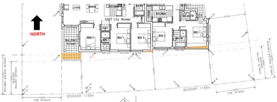
Figure 13: Variation
to setback on the southern elevation.
The
non-compliances along this elevation are to bedrooms, bathrooms and balconies.
The rear boundary of the site adjoins land zoned Public Recreation which sits
between the subject site and Forest Road. The non-compliances are minor in the
context of the development and not result in any adverse impact onto the
allotments adjoining. Given the proposed building orientation and relationship
to public land, there will not be any privacy impacts resulting from these
specific non-compliances.
Despite
not achieving strict compliance with the setback requirements to the side
boundaries, the proposal is considered to be consistent with the intent of the
control (being to maintain privacy whilst not undermining solar access) as
detailed below:
· In
relation to the side setback non-compliances the windows within the reduced
setback are high level windows with a sill height of at least 2m to bedrooms;
· In
terms of visual privacy within the site, adequate privacy measures have been
incorporated into the detailed design, the layout of the apartments, and
dimensions and orientation of the windows and balconies, such that there will
be an acceptable level of internal overlooking within the site;
· The
proposed development complies with the maximum permitted density at the site
and results in building height variation at the centre of the building to the
lift overrun and shade structure to the communal open space. The proposal
represents an efficient allocation of the permitted density at the site;
· The
trafficable area of the communal open space area located on the roof top level
is setback significantly as a result of the surrounding planter and increased
upper setback; and
The
commentary from the Panel in relation to reduced setbacks has also raised
issues of restricting development on the adjoining allotment and the potential
loss of solar access which is directly resulting from the reduced setbacks;
The
proposal is therefore acceptable as it achieves the objectives of the setback
control and provides for good levels of internal and external amenity.
33. State Environmental Planning Policy
(Vegetation in Non-Rural Areas) 2017
The
key objectives of this policy are;
(a) to protect
the biodiversity values of trees and other vegetation in non-rural areas of the
State, and
(b) to
preserve the amenity of non-rural areas of the State through the preservation
of trees and other vegetation.
Comment:
Council’s Landscape Officer has reviewed the application and concurs with
the submitted Landscape Plan; prepared by Zenith Landscape Design, the
application seeks the removal of four (4) trees, which are located within the
middle of the site (the proposed trees set for removal are not considered
endangered or native) the proposed application is considered to satisfy the
provisions of the policy. A condition of consent will be implemented to ensure
that Council’s Street trees located on Lawrence Street and Forest Road
will be retained and protected during construction.
34. Draft Environmental Planning
Instruments
The
Draft Environment SEPP was exhibited from 31 October 2017 to 31 January 2018.
This
consolidated SEPP proposes to simplify the planning rules for a number of water
catchments, waterways, urban bushland, and Willandra Lakes World Heritage
Property.
Changes
proposed include consolidating the following seven existing SEPPs:
· State Environmental Planning Policy No. 19 – Bushland in Urban
Areas
· State Environmental Planning Policy (Sydney Drinking Water
Catchment) 2011
· State Environmental Planning Policy No. 50 – Canal Estate
Development
· Greater Metropolitan Regional Environmental Plan No. 2 –
Georges River Catchment
· Sydney Regional Environmental Plan No. 20 – Hawkesbury-Nepean
River (No.2-1997)
· Sydney Regional Environmental Plan (Sydney Harbour Catchment) 2005
· Willandra Lakes Regional Environmental Plan No. 1 – World
Heritage Property.
Comment:
The proposal is not inconsistent with the provisions of this Draft Instrument.
35. Draft Remediation SEPP
The
draft SEPP was exhibited from 31 January to 13 April 2018. The following are
the aims of the SEPP as per below:
· Provide a state-wide planning framework for the remediation of land;
· Maintain the objectives and reinforce those aspects of the existing
framework that have worked well;
· Require planning authorities to consider the potential for land to
be contaminated when determining development applications and rezoning land;
· Clearly list the remediation works that require development consent;
· Introduce certification and operational requirements for remediation
works that can be undertaken without development consent;
Comment:
The proposal was considered acceptable considering that the site(s) are not
identified as contaminated or affected by acid sulphate soils. In this regard,
consideration has been applied to the draft SEPP; deeming the application as
satisfactory.
36. Development Control Plans
Hurstville
Development Control Plan No 1 - LGA Wide
The
proposed development is subject to the provisions of the Hurstville Development
Control Plan No.1. The extent to which the proposed development complies with
the provisions of this DCP are outlined in the table below.
|
Development
|
Requirements
|
Proposed
|
Complies
|
|
3.1 Vehicle
Access and Parking
|
DS1.5 Refer to
AS 2890.1 2004 and AS2890.2 Part 2 for the design and layout of parking
facilities. DS1.6
Council does not
encourage, but may consider stacked parking for parking spaces in a
controlled parking situation which:
a. allows no
more than two cars in the stacked parking arrangement;
b. is likely to
maintain a very low turnover; or
c. is able to
function easily within the management of the site’s future operation
A designated car
washing area (which may also be a designated visitor car space) is required
for service stations and residential developments of four or more dwellings.
|
Turning and
manoeuvring into and out of car spaces and isle widths are in accordance with
Australian Standards.
There are no
stacked parking spaces proposed.
A car wash bay
has been provided, within the proposed basement car parking area –
visitor space 4.
|
Yes
Yes
Yes
|
|
Numerical
parking controls
|
Residential
Accommodation
Dwelling
(1-2 bedrooms):
1 space per
dwelling
Dwelling (3
bedrooms and over):
2 spaces per
dwelling Visitor spaces:
1 space per 4
dwellings (or part thereof)
Note:
Different rates may apply where within 800m of a railway station in accordance
with the Apartment Design Guide and the RMS Guide to Traffic Generating
Development (2002)
|
2 x 1 bedroom =
2 spaces
8 x 2 bedroom =
8 spaces
4 x 3 bedroom =
8 spaces
Total required =
18 spaces
Visitor spaces
required 14/4 = 3.5 spaces
Subtotal required
= min 22 spaces (visitor space 4 doubles as a car wash bay)
Provided = 22
residential spaces including 4 visitor spaces.
|
Yes
|
|
3.3 Access and
Mobility
|
In developments
containing five or more dwellings, a minimum of one adaptable dwelling, designed
in accordance with relevant Australian Standards must be provided for every
ten dwellings or part thereof.
Access for all
persons through the principal entrance and access to any common laundry,
kitchen, sanitary or other common facilities in accordance with relevant
Australian Standards.
|
Apartment Ground
0-05 and First Floor 1-05 are nominated as adaptable apartments.
In general
access through the building for people with a disability has been catered for
and lift access has been provided to all levels including the roof communal
open space.
|
Yes
|
|
3.4 Crime
Prevention through Environmental Design
|
Ensures that the
way in which the site, and the buildings within the site, are laid out
enhance security and feelings of safety.
Ensures that private
and public spaces are clearly delineated
Ensures that the
design of the development allows for natural surveillance to and from the
street and between individual dwellings or commercial units within the site
|
The design of
the building generally complies with the objectives and controls.
|
Yes
|
|
3.5 Landscaping
|
Site layout and
design, including buildings, structures and hardstand, ensures the long term
retention and health of existing significant trees and vegetation.
Where
significant trees or vegetation are required to be removed to allow for site
development, they are to be replaced with the same or similar species
achieving the same coverage at maturity.
|
The landscaping
arrangement is considered to be satisfactory with a reasonable amount of open
space and the provision of deep soil areas, trees, plants and denser
vegetation has been catered for and assessed by Council’s Landscape
Officer; in which the application was deemed as satisfactory, subject to
conditions.
|
Yes
|
|
3.6 Public
Domain
|
Development
contributes to the creation of attractive, comfortable and safe streets that
comprise consistent and high quality paving, street furniture and street tree
plantings.
|
The front
façade and general scale of the building is considered to be an
acceptable and reasonable design response for this site.
|
Yes – will
be consistent with the character and form of development in the street.
|
|
3.7 Stormwater
|
A development
application is supported by a concept stormwater management plan showing how
surface and roof waters are to be discharged by gravity to the street or
easement and the size of all pipes.
|
Council’s
Engineers have reviewed the proposed drainage and stormwater arrangement and
have raised no objection subject to the imposition of conditions.
|
Yes
|
|
4.1 Residential
Flat Buildings
Site Frontage
Isolation
Height
Excavation
Front Setback
Landscaping
Solar Access
Noise
Streetscape
Fencing
Site Facilities
|
Min street
frontage 24m
Where an
application for a residential flat building will result in the creation of an
isolated site, the applicant must show that reasonable efforts have been made
to amalgamate the site. Where this has not been achieved, it must be shown
that the isolated site is capable of accommodating a suitable development in
the future.
In accordance
with Hurstville Local Environmental Plan 2012 and 3 storeys.
The maximum
excavation for any building’s finished ground floor level facing a
public street is 0.5m below natural ground level.
The minimum
setback to a primary or secondary street is 6m.
Minimum amount
of landscaped area of open space is 20% of the Site area
Min dimension of
landscaped open space is 2m
Development
allows for at least 3 hours of sunlight on the windows of main living areas
and adjoining principal private open space of adjacent dwellings between 9.00
am and 3.00 pm on 22 June.
Windows of
adjacent dwellings are separated by a distance of at least 3m
Development
creates a high quality interface between the public and private domain
Provides
appropriate levels of privacy, security and noise attenuation.
Development
provides space for the storage of recyclable goods, either in the curtilage
of each dwelling or in a central storage area in larger developments.
|
Street frontage
30.48m
Adjoining the
site to the left (No. 59 and 59A) is a dual-occupancy development and
adjoining the site to the right (No.63-65) is an approved 3-4 storey
residential flat building.
A variation is
requested to the 12m height control and Clause 4.6 Statement submitted and
assessed above.
The building is
proposed to be three (3) storeys.
Excavation exceeds
the minimum controls but this is an anticipated design response given the
site and the precedent that has been established for new medium density
development in the street and the accommodation of vehicles within a
basement.
Ground Floor =
5.22m - 6.2m. There is a slight encroachment within the front courtyards.
Landscaped open
space equates to 24.69% of the site.
The minimum
dimensions at the front are 4.8m and rear 6m in width. The rear is not a
secondary street as it is separated by RE1 zoned land.
Complies.
Due to the
favourable orientation of the site, the proposal results in only minor shadow
impacts as detailed on the shadow diagrams submitted with the application.
The submitted
architectural plans detail shadows cast by the proposal during mid-winter, 22
March and September and 22 December. The proposal complies with the above DCP
requirement as shadows cast at 9.00am are limited to the rear portion of the
subject site and the rear portion of the adjoining dwelling to the west and
the associated rear yard.
By 12 noon, the
shadow has moved east and is confined to the subject site, the adjacent
public recreation space and the road reserve immediately to the rear of the
subject site.
At 3pm the
shadow again falls within the subject site and partly over the rear yard of
the property to the east. The extent of overshadowing is minor and does not
impact upon windows of main living areas or adjoining principal private open
spaces. The proposal therefore achieves the numerical requirements of the
DCP.
Complies
Windows of
adjacent dwellings are separated by a distance of at least 3m.
The proposal
provides opportunities for passive casual surveillance of the public domain
from main living areas and principal private open space through the use of
large transparent windows and other openings.
Appropriate
fencing detail has been provided on the submitted architectural plans.
The bin storage
area accommodates bins for recycling.
|
Yes
Yes –
Applicant has satisfied DCP provisions in relation to site isolation.
No, but the
Clause 4.6 variation is considered acceptable and worthy of support.
Reads as a 3
storey building from the street and rear as it is appropriately stepped down
into the site.
On merit –
addressed in detail below.
This control is
superseded by the SEPP.
Yes
Yes
Yes
Yes
Yes
|
37. Front Setback Variation
PC6
of the DCP requires a 6m front setback and provides the following objectives to
the setback control.
· Are
compatible with predominant patterns of buildings and gardens that define the
existing and desired character of the neighbourhood.
· Engage
with and activate the street.
· Reduce
the appearance of building bulk.
· Enable
adequate solar access to the main living areas and principal private open
space.
· Facilitate
penetration of desirable natural breezes.
· Facilitate
view sharing.
· Minimise
noise transmission.
As
such this variation to the front setback will not be at odds with the
streetscape and will maintain consistency with the above stated objectives in
that:
· Existing
more recently constructed buildings on the southern side of Lawrence Street are
constructed with a reduced front setback that typically ranges from 4.5m to 6m.
The proposal will therefore be consistent with the emerging street setback;
· The
site frontage will be landscaped and this will assist with softening the
appearance of the building within the street and creating a landscaped setting;
· The
proposed front setback will not result in any material adverse impacts on the
adjoining properties;
· The
street is activated by the introduction of primary living space with orientation
to the Lawrence Street, providing excellent passive surveillance opportunities;
· The
private open space and living areas of all street fronting units will receive
uninterrupted solar access. Similarly, all street fronting units are naturally
cross ventilated; and
· The
proposed setback encroachment is minor and does not reduce access to views nor
will it impact on noise transmission.
IMPACTS
Natural
Environment
38. The proposed development is unlikely to
generate adverse impacts on the natural environment.
Built
Environment
39. The proposed development is unlikely to
result in adverse impacts on the built environment
Social
Impact
40. The proposal is unlikely to result in any
adverse social impacts given the design and residential use of the site.
Economic
Impact
41. The proposed development is unlikely to
generate adverse economic impacts given the residential nature of the
development.
Suitability
of the site
42. It is considered that the proposed
development is of a scale and density that is suitable for the site and is in
accordance with the desired future character of development within Lawrence
Street and the locality.
Public
Interest
43. The proposal is considered to be in the
public interest for the reasons contained within this report.
SUBMISSIONS AND
THE PUBLIC INTEREST
44. The
application was notified/advertised to residents/owners on the 06 December 2017
to 05 January 2018. No submissions were received by Council, during the
notification/advertising period.
Development
Contributions
45. The proposed development is the
subject of Contribution(s). Contribution(s) have been levied on the subject
development pursuant to the provisions of the Georges River Council -
Contributions Plan.
Contribution(s)
have been levied on the subject development by way of condition of consent,
pursuant to the provisions of the Georges River Council - Contributions Plan
with a total fee to paid – prior to the issue of a Construction
Certificate of $182,409.60.
REFERRALS
Council
Referrals
46. Development Engineer
Council’s
Development Engineer has raised no objection in relation to the stormwater
drainage design subject to conditions of consent which are included in the
recommended conditions below.
47. Waste Management Officer
Council’s
Waste Management Officer examined the application and has raised no objection
to the development.
48. Traffic Engineer
Council’s
Traffic Engineer has examined the application and has raised no objection to
the development.
49. Landscape and Tree Management
Officer
Council’s
Landscape and Tree Management Officer has raised no objection
subject to conditions which are included in the recommended conditions below.
50. Building Officer
Council’s
Surveyor has raised no objection subject to conditions which are included in
the recommended conditions below.
CONCLUSION
51. This application has been assessed having
regard to the matters for consideration under Section 4.15(1)(a) and 4.15(3) of
the Environmental Planning and Assessment Act 1979, the provisions of the
relevant State Environmental Planning Policies, Local Environmental Plans and
Development Control Plans.
The
proposal seeks consent for lot consolidation, demolition of all structures,
tree removal and the construction a three (3) storey residential flat building
containing fourteen (14) residential apartments and one (1) basement level
accommodating twenty-two (22) parking spaces and associated landscaping works.
In
summary, the development has been assessed against the requirements of the
relevant planning instruments and development control plans. Following a
detailed assessment it is considered that Development Application No
DA2017/0584 should be approved subject to the imposition of Conditions.
STATEMENT OF
REASONS
52. The reasons for this recommendation are:
· The
proposal results in a built form which is consistent with the envisaged desired
character of the R3 Medium Density Residential Zone.
· The
proposal adopts a built form which is compatible with the immediate residential
character.
· The
proposal adopts a design which provides good levels of occupant amenity.
DETERMINATION
THAT
Pursuant to Section 4.16(1a) of the Environmental Planning and Assessment Act
1979, as amended, the Georges River Local Planning Panel determine DA2017/0584
proposing lot consolidation, demolition of all structures, tree removal and the
construction a three (3) storey residential flat building containing fourteen
(14) residential apartments and one (1) basement level accommodating twenty-two
(22) parking spaces and associated landscaping works on Lot 248, DP 36317, and
Lot 249, DP 36317, and known as 61 and 63 Lawrence Street, Peakhurst, by way of
approval subject to the conditions referenced below.
SPECIFIC
DEVELOPMENT CONDITIONS
SCHEDULE A
Development
Details
1. Approved Plans - The development must be implemented in
accordance with the approved plans and supporting documentation listed below
which have been endorsed by Council’s approved stamp, except where marked
up on the plans and/or amended by conditions of this consent:
|
Description
|
Reference No.
|
Date
|
Revision
|
Prepared by
|
|
Site Analysis Plan
|
DA 01
|
17/10/2017
|
A
|
Cornerstone Design
|
|
Basement Plan
|
DA 02
|
19/08/2019
|
B
|
Cornerstone
Design
|
|
Site / Ground Floor Plan
|
DA 03
|
12/03/2018
|
C
|
Cornerstone
Design
|
|
First Floor Plan
|
DA 04
|
12/03/2018
|
C
|
Cornerstone
Design
|
|
Second Floor Plan
|
DA 05
|
17/10/2017
|
A
|
Cornerstone
Design
|
|
Rooftop Plan & Roof Plan
|
DA 06
|
12/03/2018
|
B
|
Cornerstone
Design
|
|
Elevation – North and East
|
DA 07
|
12/03/2018
|
B
|
Cornerstone
Design
|
|
Elevations – West and South
|
DA 08
|
12/03/2018
|
B
|
Cornerstone Design
|
|
Sections A-A Streetscape Elevation
|
DA 09
|
12/03/2018
|
B
|
Cornerstone Design
|
|
Schedule of Colours and Materials
|
N/A
|
N/A
|
N/A
|
Cornerstone Design
|
|
Drainage Cover Plan
|
A7231
|
06/10/2017
|
B
|
Alpha Engineering
and Development
|
|
Sediment and Erosion Control Plan
|
A7231-SW01
|
06/10/2017
|
B
|
Alpha Engineering
and Development
|
|
Basement Drainage Plan
|
A7231-SW02
|
13/03/2018
|
C
|
Alpha Engineering
and Development
|
|
Ground Floor Drainage Plan
|
A7231-SW03
|
13/03/2018
|
C
|
Alpha Engineering
and Development
|
|
OSD Basin Plan
|
A7231-SW04
|
13/03/2018
|
C
|
Alpha Engineering
and Development
|
|
Survey Plan
|
178317
|
08/06/2017
|
N/A
|
S.J. Surveying
Services Pty Ltd
|
|
Existing Tree Plan
|
17-3550 LO3
|
19/03/2018
|
N/A
|
Zenith Landscape Designs
|
|
Ground Floor Plan
|
17-3550 LO1
|
19/03/2018
|
N/A
|
Zenith Landscape
Designs
|
|
Roof Top Plan
|
17-3550 LO2
|
19/03/2018
|
N/A
|
Zenith Landscape
Designs
|
|
Waste Management Plan – Construction Stage
|
N/A
|
Undated
|
N/A
|
Cornerstone Design
|
|
Waste Management Plan – Demolition Stage
|
N/A
|
Undated
|
N/A
|
Cornerstone Design
|
|
Waste Management Plan – Ongoing Waste
|
N/A
|
Undated
|
N/A
|
Cornerstone Design
|
|
Statement of Compliance Access for people with a disability report
|
N/A
|
27/09/2017
|
N/A
|
Accessible
Building Solutions
|
|
Road Traffic Noise Assessment
|
N/A
|
November 2017
|
N/A
|
Noise and Sound Services
|
Section B - Separate Approval Required Under Other
Legislation
2. Section
138 Roads Act 1993 and Section 68 Local Government Act 1993 - Unless
otherwise specified by a condition of this consent, this Development Consent
does not give any approval to undertake works on public infrastructure.
Separate approval is required under Section 138 of the Roads Act 1993
and/or Section 68 of the Local Government Act 1993 for any of the
following activities carried out in, on or over a public road (including the
footpath) listed below.
An application is required to be lodged and approved prior to the
commencement of any of the following works or activities:
a. Placing or storing materials or equipment;
b. Placing or storing waste containers or skip
bins;
c. Erecting a structure or carrying out work;
d. Swinging or hoisting goods over any part of
a public road by means of a lift, crane or the like;
e. Pumping concrete from a public road;
f. Pumping water from the site into the
public road;
g. Constructing a vehicular crossing or
footpath;
h. Establishing a “works zone”;
i. Digging up or disturbing the surface
of a public road (eg Opening the road for the purpose of connections to utility
providers);
j. Stormwater and ancillary works in the
road reserve;
k. Stormwater and ancillary to public
infrastructure on private land.
l. If any excavation is to be supported
by the use of below ground (cable) anchors that are constructed under
Council’s roadways/footways.
These separate activity approvals must be obtained and evidence of the
approval provided to the Certifier prior to the issue of the Construction
Certificate.
The relevant Application Forms for these activities can be downloaded
from Council’s website www.georgesriver.nsw.gov.au.
For further information, please contact Council’s Customer Service Centre
on (02) 9330 6400.
3. Road
Opening Permit - A Road Opening Permit must be obtained from Council for
every opening of a public road reserve to access services including sewer,
stormwater drains, water mains, gas mains, and telecommunications before the
commencement of work in the road.
4. Building -
Hoarding Application - Prior to demolition of the buildings on the site or
the commencement of work above ground level a separate application for the
erection of an A class (fence type) or a B class hoarding or C type scaffold,
in accordance with the requirements of Work Cover Authority of NSW, must be
erected along that portion of the footway/road reserve, where the building is
within 3.0 metres of the street boundary. An application for this work under
Section 68 of the Local Government Act 1993 and the Roads Act 1993 must be
submitted for approval to Council.
The following information is to be submitted with a Hoarding Application
under s68 of the Local Government Act and s138 of the Roads Act 1993:
a) A site and location plan of the hoarding with detailed
elevation, dimensions, setbacks, heights, entry and exit points to/from the
site, vehicle access points, location of public utilities, electrical overhead
wire protection, site management plan and builders sheds location; and
b) Hoarding plan and details that are certified by an
appropriately qualified engineer; and
c) The payment to Council of a footpath
occupancy fee based on the area of footpath to be occupied and Council's
Schedule of Fees and Charges (available on our website) before the commencement
of work; and
d) A Public Risk Insurance Policy with a
minimum cover of $10 million in relation to the occupation of and works within
Council's road reserve, for the full duration of the proposed works, must be
obtained a copy provided to Council. The Policy is to note Council as an
interested party.
Section C - Requirements of other Government Authorities
5. Sydney Water –
Tap in TM - The approved plans must be submitted to a Sydney
Water Tap inTM to determine whether the development application will
affect Sydney Water’s sewer and water mains, stormwater drains and/or
easements, and if further requirements need to be met. The approved plans
will be appropriately endorsed. For details please refer to
‘Plumbing, building and developing’ section of Sydney Water’s
web site at www.sydneywater.com.au
then see ‘Building’, or telephone 13000 TAP IN (1300 082
746). The Certifying Authority must ensure that a Tap inTM
agent has appropriately stamped the plans prior to the issue of the
Construction Certificate.
6. Notice of
Requirements for a Section 73 Certificate - A Notice of Requirements of
what will eventually be required when issuing a Section 73 Compliance
Certificate under the Sydney Water Act 1994 must be obtained from Sydney Water
Corporation. Application must be made through an authorised Water
Servicing Co-ordinator. Please refer to the ‘Plumbing, building and
developing’ section of the web site www.sydneywater.com.au then refer to
‘Providers’ under ‘Developing’ or telephone 13 20 92
for assistance.
Following
application, a ‘Notice of Requirements’ will advise of water and
sewer infrastructure to be built and charges to be paid. Please make
early contact with the Co-ordinator, as it can take some time to build
water/sewer pipes and this may impact on other services and building, driveway
or landscape design.
The
Notice of requirements must be submitted prior to the commencement of work. A Section
73 Compliance Certificate will be required at the completion of development in
accordance with further conditions.
7. Utility Arrangements
- Arrangements are to be made with utility authorities in respect to the
services supplied by those authorities to the development. The cost associated
with the provision or adjustment of services within the road and footway areas
is to be at the applicant’s expense.
Section D Prior to the Issue of a
Construction Certificate
8. Amended
Architectural Plans - Amended architectural plans are to be submitted to
the PCA, prior to the release of any Construction Certificate, clearly
identifying the following:
a) Deletion of the ‘Access
Gate(s)’ on the southern side of the allotment; as identified on the
approved Landscape and Site Plan; Access cannot be granted to the RE1 - Zoned
Land, unless approval from Council’s Property Team has been lodged and
approved.
9. Electrical
Infrastructure – Prior to the issue of a Construction Certificate
documentary evidence is to be provided to the PCA demonstrating approval has
been granted by the energy provider to the relocation of the electricity power
pole to accommodate the proposed driveway. A plan showing the location of the
relocated power pole is to be provided. The relocation of this infrastructure
is to be at the expense of the developer.
10. Fire Safety Measures
- Prior to the issue of a Construction Certificate a list of the essential fire
safety measures that are to be provided in relation to the land and any
building on the land as a consequence of the building work must accompany an
application for a construction certificate, which is required to be submitted
to either Council or a PCA. Such list must also specify the minimum standard of
performance for each essential fire safety measure included in the list. The
Council or PCA will then issue a Fire Safety Schedule for the building.
11. SEPP 65 Design
Verification Statement - SEPP 65 Design Verification Statement – A
design verification statement, prepared by a qualified designer, shall be
submitted to the Certifying Authority verifying that the plans and specifications
achieve or improve the design quality of the development for which development
consent was granted, having regard to the design quality principles set out
under Schedule 1 of State Environmental Planning Policy No 65 –Design
Quality of Residential Flat Development.
12. Use of rooftop open
space
A Plan of Management (POM) for use of the roof top open space must be
submitted for approval of Council’s Manager Development and Building.
The POM must outline the:
(i) Hours of use of the rooftop deck are
not to be used between the hours of 10pm and 8am;
(ii) Maximum
number of users at any one time (suggest 10);
(iii) Provisions for no amplified music to be
played; and
(iv) Identify any other measures to ensure that the
amenity of persons within the development and in nearby existing and future
developments is maintained.
The approval of the POM shall be incorporated into the Owners
Corporation by-laws in any future Strata subdivision.
Written evidence of the approval of the POM by Council’s Manager Development
and Building is to be provided to the satisfaction of the Principal Certifying
Authority prior to the release of the Construction Certificate.
13. Access for Persons
with a Disability - Access for persons with disabilities must be provided
throughout the site, including to all common areas, lobby areas and all service
areas of the development in accordance with the requirements of the Premises
Standards, the Building Code of Australia and AS 1428.1. Details must be
submitted with the Construction Certificate Application.
In regards to the above, pedestrian access throughout basement levels
shall be highlighted/line marked and sign posted to safeguard egress.
14. Vibration Damage
- To minimise vibration damage and loss of support to the buildings in close
proximity to the development, any excavation is to be carried out by means of a
rock saw and if available, in accordance with the guidelines of the
Geotechnical Engineer’s report.
Alternatively where a hydraulic hammer is to be used within 30 metres of
any building (other than a path or a fence) a report from a qualified
geotechnical engineer detailing the maximum size of hammer to be used is to be
obtained and the recommendations in that report implemented during work on the
site. The report shall be submitted with the Construction Certificate
application.
15. Slip Resistance -
All pedestrian surfaces in areas such as foyers, public corridors/hallways,
stairs and ramps as well as floor surfaces in the wet rooms in any
commercial/retail/residential units must have slip resistance classifications,
as determined using test methods in either wet or dry conditions, appropriate
to their gradient and exposure to wetting. The classifications of the new
pedestrian surface materials, in wet or dry conditions, must comply with
AS/NZS4586:2004 - Slip Resistance Classifications of New Pedestrian Materials
and must be detailed on the plans lodged with the application for the
Construction Certificate.
16. Fire and Rescue NSW -
Building - Prior to the issue of a Construction Certificate the applicant
may be required, under Clause 144 of the Environmental Planning &
Assessment Regulation, 2000 to seek written comment from FR NSW about the
location of water storage tanks, construction of hydrant/booster pump and valve
rooms, and any Fire Engineered Solution developed to meet the performance
requirements under the Category 2 Fire Safety Provisions.
The applicant is also advised to seek written advice from FR NSW on the
location and construction of the proposed Fire Control Centre Facility and
location and installation of the sites Fire Indicator / mimic Panels (if required).
17. Traffic Management -
Compliance with AS2890 - All driveways, access ramps, vehicular crossings
and car parking spaces shall be designed and constructed in accordance with the
current version of Australian Standards, AS 2890.1 (for car parking facilities)
and AS 2890.2 (for commercial vehicle facilities).
18. Drainage/Stormwater
Design Changes - The following design changes are required and are to be
incorporated into the plans to be lodged with the Construction Certificate
application.
(a) The submitted concept hydraulic plan shall be amended to
include the reconstruction of Council’s existing gully pit directly in
front of the development site. The reconstructed pit is to conform to
Council’s standard drawing for a kerb inlet pit with grates and 2.4m
(min.) lintel and will be modified at full cost to the developer.
(b) The invert level of the outlet pipeline from the receiving
gully pit is to be confirmed by the Hydraulic Engineer and included in the Ground
Floor Drainage Plan Drawing A7231-SW03. REV C of 13/3/’18.
These design changes are to be incorporated
into the Detailed Hydraulic Plans submitted for approval with the Construction
Certificate Application.
19. Stormwater
System - The submitted stormwater plan has been assessed as a concept plan
only. Final detailed plans of the drainage system, prepared by a professional
engineer specialising in hydraulic engineering, shall be submitted for approval
with the Construction Certificate
a) All stormwater shall drain by gravity to the upper level
of Council’s stormwater pipe located under the kerb and gutter by
constructing a gully pit with 2400 mm lintel, in accordance with the
Australian/New Zealand Standard AS/NZS 3500.3: 2003 (as amended).
b) Stormwater drainage plans including pipe sizes, type,
grade, length, invert levels, dimensions and types of drainage pits prepared by
a professional engineer who specialises in Hydraulic Engineering in accordance
with the Australian Institute of Engineers Australian Rainfall and Runoff
(1987) and Council's Stormwater Drainage Guidelines, shall accompany the
application for the Construction Certificate.
20. Stormwater Systems with Basement
(a) The underground basement car park and all other stormwater
must drain by gravity to:
i. the upper level
of the existing gully pit (to be reconstructed) located directly in front
of the development site.
The design of the proposed drainage system must
be prepared by a professional engineer who specialises in hydraulic engineering
and be submitted for approval with the Construction Certificate application.
21. Protection of basement from inundation of stormwater waters
(b) Alignment levels
across the site are to be acquired from Council and compared to the
‘water surface level’ (as determined by a professional engineer who
specialises in hydraulic engineering) in the street gutter during a 1:100yr ARI
storm event. A minimum freeboard of 200mm is to exist between the gutter water
surface level and corresponding vehicle crossing/internal driveway crest level
to provide protection to the underground basement from possible inundation from
surface waters.
(c) Driveway retaining
walls are to be constructed to levels that provide protection of the
underground basement from the inundation of surface waters in a 1:100yr ARI
storm event.
Evidence from a professional engineer who
specialises in hydraulic engineering that this design requirement has been
adhered to shall be submitted with the Construction Certificate application.
22. On Site Detention
The submitted stormwater plan has been assessed
as a concept plan only. Final detailed plans of the drainage system, prepared
by a professional engineer specialising in hydraulic engineering, shall be
submitted for approval with the Construction Certificate.
An on-site detention (OSD) facility designed by
a professional engineer who specialises in Hydraulic Engineering must be
designed, approved and installed. The design must include the
computations of the inlet and outlet hydrographs and stage/storage
relationships of the proposed OSD using the following design parameters:
(a) peak flow rates from the site are to be
restricted to a permissible site discharge (PSD) equivalent to the discharge
when assuming the site contained a single dwelling, garage, lawn and garden,
(b) at Annual Recurrence Intervals of 2 years
and 100 years.
Refer to Flow Controls in Council's Draft/Adopted Stormwater Drainage
Policy.
The OSD facility shall be designed to meet all legislated safety
requirements and childproof safety fencing around the facility must be provided
where the OSD facility is open or above ground when the design peak storage
depth is greater than 300mm. A durable metal plate or similar sign is to be
placed at the OSD facility and must bear the words:
"BEWARE: This is an on-site detention basin/tank for rainwater which
could overflow during heavy storms."
Full details shall accompany the application for the Construction
Certificate.
23. Detailed
Stormwater Drainage Design
The submitted stormwater plan has been assessed as a concept plan only. A
detailed drainage design supported by a catchment area plan and drainage
calculations (including a Hydraulic Grade Line Analysis) must be submitted with
the Construction Certificate application.
24. Damage
Deposit – Major Works - In order to insure against damage to Council
property the following is required:
(a) Pay Council, before the issue of the
Construction Certificate, a damage deposit for the cost of making good any
damage caused to any Council property as a result of the development: $1900.00.
(b) Pay Council, before the issue of the
Construction Certificate, a non-refundable inspection fee (for two inspections)
to enable assessment of any damage and repairs where required: $155.00.
(c) Submit to Council, before the
commencement of work, a photographic record of the condition of the Council
nature strip, footpath and driveway crossing, or any area likely to be affected
by the proposal.
At the completion of work Council will inspect the public works, and the
damage deposit will be refunded in full upon completion of work where no damage
occurs. Otherwise the amount will be either forfeited or partly refunded
according to the amount of damage.
25. Fees to be
paid - The fees listed in the table below must be paid in accordance with
the conditions of this consent and Council’s adopted Fees and Charges
applicable at the time of payment (available at www.georgesriver.nsw.gov.au).
Payments must be made prior to the issue of the Construction Certificate
or prior to the commencement of work (if there is no associated Construction
Certificate).
Please contact council prior to the payment of S94 Contributions to
determine whether the amounts have been indexed from that indicated below in
this consent and the form of payment that will be accepted by Council.
Council will only accept Bank Cheque or Electronic Funds Transfer (EFT)
for transaction values of $500,000 or over. Council must be contacted prior to
payment to determine correct total amount to be paid and bank account details
(if applicable).
A summary of the fees to be paid are listed below:
|
Fee Type
|
Fee
|
|
GENERAL FEES
|
|
Long Service Levy (to Long Service Corporation) Or,
provide evidence of Payment direct to the Long Service Corporation. See
https://portal.longservice.nsw.gov.au/bci/levy/
|
|
Builders Damage Deposit
|
$1900.00
|
|
Inspection Fee for Refund of Damage Deposit
|
$155.00
|
|
DEVELOPMENT
CONTRIBUTIONS
|
|
Hurstville Section 94 Development Contributions Plan 2012
- Residential (Community Facilities)
|
$22,601.84
|
|
Hurstville Section 94 Development Contributions Plan 2012
- Residential (Open Space, Recreation, Public Domain)
|
$159,807.76
|
|
Total Contributions
|
$182,409.60
|
General Fees
The fees and charges above are subject to change and are as set out in
the version of Council's Schedule of Fees and Charges or as required by other
Government Authorities, applicable at the time of payment.
Development Contributions
The Section 94 contribution is imposed to ensure that the development
makes adequate provision for the demand it generates for public amenities and
public services within the area.
A Section 94A contribution has been levied on the subject development
pursuant to the Georges River Council Section 94A Contributions Plan.
Indexation
The above contributions will be adjusted at the time of payment to
reflect changes in the cost of delivering public amenities and public services,
in accordance with the indices provided by the relevant Section 94 Development
Contributions Plan.
Timing of Payment
The contribution must be paid and receipted by Council prior to the
release of the Construction Certificate.
Further Information
A copy of the all current Development Contributions Plans may be
inspected or a copy purchased at Council’s offices (Georges River Civic
Centre, MacMahon Street, Hurstville and Kogarah Library and Service Centre,
Kogarah Town Square, Belgrave Street, Kogarah) or viewed on Council’s
website www.georgesriver.nsw.gov.au.
26. Acoustic
Requirements - The proposed use and the operation of all plant and
equipment shall not give rise to an ‘offensive noise’ as defined in
the Protection
of the Environment Operations Act 1997 (as amended) and Regulations.
An Acoustic Report shall be prepared by a suitably qualified acoustic
consultant demonstrating that the operation of the premises and plant equipment
shall not give rise to a sound pressure level at any affected premises that
exceeds the background LA90, 15 min noise level, measured in the absence of the
noise sources under consideration by more than 5dB. The source noise level
shall be assessed as LAeq, 15 min in accordance with the NSW Environment
Protection Authority’s NSW Industrial
Noise Policy.
The acoustic report must also ensure
that appropriate measures will be
taken to ensure that the following LAeq levels are not exceeded:
(a) in any bedroom in the residential accommodation—35
dB(A) at any time between 10 pm and 7 am,
(b) anywhere
else in the residential accommodation (other than a garage, kitchen, bathroom
or hallway)—40 dB(A) at any time.”
The recommendations suggested in the Acoustic Report submitted with the
application shall be included in the Construction Certificate Plans.
27. Landscape
Plans - All landscape works shall be carried out in accordance with the
approved landscape plans and specifications, drawn by Zenith Landscape Design,
reference numbers – 17 – 3550 L01 – L03, dated 22/09/17. The
landscaping shall be maintained in accordance with the approved plans in
perpetuity.
28. General
Landscape Requirements
a) The proposed tree and plant species,
pot/ bag size and quantities of plants shall be in accordance with the proposed
plant schedule upon the landscape plan. If plant species, pot/ bag size and
quantities cannot be sourced, Council shall be contacted for alternatives.
b) The eleven (11) Trees proposed upon
the approved landscape plan shall comply with NATSPEC Specifying Trees: a guide
to assessment of tree quality (2003), and be planted and maintained in
accordance with Councils standard specification.
29. Tree
Protection and Retention - The following trees shall be retained and
protected:
|
Tree Species
|
Location of Tree / Tree No.
|
Tree Protection Zone (metres)
Fencing distance from trunk
|
|
T1 – Lophostemon confertus
|
Council
street tree
|
7.0
meters radially without blocking footpath
|
|
T2 – Lophostemon confertus
|
Council
street tree
|
7.0
meters radially without blocking footpath
|
|
T7 – Tristaniopsis laurina
|
65
Lawrence St Peakhurst
|
4
metres radially
|
|
T8 – Jacaranda mimosifolia
|
65
Lawrence St Peakhurst
|
2.5
metres radially
|
|
T9 – Eucalypt Spp
|
RMS
Road frontage, back fence
|
7.0
metres radially
|
|
T10 - Eucalypt Spp
|
RMS
Road frontage, back fence
|
9.5
metres radially
|
|
T11, Eucalypt Spp
|
RMS
Road frontage, back fence
|
9.5
metres radially
|
Details of the
trees to be retained must be included on the Construction Certificate plans.
General Tree Protection Measures – the following measures
are to be adhered to;
(a) All
trees to be retained shall be protected before and maintained during
demolition, excavation and construction of the site.
(b) The
tree protection measures must be in undertaken in accordance AS4970 -2009
Protection of trees on development sites.
(c) Details
of the tree protection measures to be implemented must be provided with the
application for a Construction Certificate by a suitably qualified Arborist
who holds an AQF Level 5 or above in Arboriculture and who is a current
financial member of Arboriculture Australia – AA and or Institute
of Australian Consulting Arboriculturists – IACA.
(d) The
Project Arborist must be present on-site during the stages of excavation,
demolition and construction when works are being undertaken that could impact
on the tree canopy or root zone within the tree protection zone of each tree.
(e) Unless
otherwise specified in AS 4970-2009 Protection of trees on development sites,
a protective fence consisting of 2.4 x 1.8 metres high, fully supported
chainmesh fence shall be used. The distance of the fence from the base of each
tree is to be in accordance with the TPZ listed in the table above. A layer of
organic mulch 100 millimetres thick shall be placed over the protected area and
no soil or fill should be placed within the protection area.
(f) The
Tree Protection Zone of each tree, to be protected, shall be watered thoroughly
and regularly to minimise the effects of construction works.
(g) No
building products/ materials or services shall be installed within the TPZ of
the tree/s unless approved by Council. This fence shall be kept in place during
demolition, construction and also have a sign displaying ‘Tree Protection
Zone – DO NOT ENTER’ attached to the fence and must also include
the name and contact details of the Project Arborist.
Excavation works near tree to be retained – the following
measures are to be adhered to;
a) Excavations around the trees to be
retained on site or the adjoining properties shall be supervised by the Project
Arborist to ensure that the root system will not adversely be affected.
b) Where the Tree Protection Zone
(TPZ) of trees on site or adjoining sites become compromised by any excavation
works, the Project arborist shall be consulted to establish the position of any
major roots and determine the necessary measures to protect these roots. The
recommendations of the Arborist shall be submitted to Council prior to any
further demolition or construction works taking place.
c) Tree Protection Zone around the
trees to be retained are not to have soil level changes, building product /
materials stored or services installed in this area. Any structures proposed to
be built in this area of the trees are to utilise pier and beam or cantilevered
slab construction.
Details
satisfying this condition shall be shown on the Construction Certificate plans.
Removal or
pruning of any other tree (that would require consent of Council) on the site
is not approved. All pruning must be undertaken by a qualified Arborist in
accordance with AS4373 -2007 Pruning of Amenity Trees and Amenity Tree
Industry, Code of Practice (SafeWork NSW August 1998).
30. Tree Removal
& Replacement - Permission is granted for the removal of the
following trees as illustrated, using reference locations ONLY
|
Tree Species
|
Number
of trees
|
Location
|
|
T3 – Pittosporum undulatum
|
X1
|
Front
middle of site
|
|
T4 – Tibouchina granulosa
|
X1
|
Front
middle of site
|
|
T5 – Cypress pine
|
X1
|
Front
middle of site
|
|
T6 – Brachychiton acerifolius
|
X1
|
Middle
of site
|
|
As per landscape plan – 17-
3550 L03 (page 3)
|
General Tree Removal
Requirements
(a) All tree removal
shall
be carried out by a minimum certificate Level 3, Licenced and insured Tree
Surgeon/Arborist to ensure that removal is undertaken in a safe manner and
complies with the AS 4373-2007 - Pruning
of Amenity Trees and Tree Works
Industry Code of Practice (Work Cover NSW 1.8.98).
(b) No trees
are to be removed on the site or neighbouring properties without the prior
written approval of Council.
A copy of the Hurstville City
Council’s Tree Removal and Pruning Guidelines and Kogarah City Council,
Street Tree Management Strategy and Masterplan, can be downloaded from
Council’s website www.georgesriver.nsw.gov.au.
31. Pre-construction
Dilapidation Report - A professional engineer specialising in structural or
geotechnical engineering shall prepare a Pre-Construction Dilapidation Report
detailing the current structural condition of adjoining premises that shall be
affected by the excavation as determined by the consulting engineer.
The report
shall be prepared at the expense of the applicant and submitted to the
satisfaction of the Certifying Authority prior to the issue of the Construction
Certificate.
A copy of the
pre-construction dilapidation report is to be provided to the adjoining
properties (subject of the dilapidation report), a minimum of 5 working days
prior to the commencement of work. Evidence confirming that a copy of the
pre-construction dilapidation report was delivered to the adjoining properties
must be provided to the PCA.
Should the owners
of properties (or their agents) refuse access to carry out inspections, after
being given reasonable written notice, this shall be reported to Council to
obtain Council’s agreement to complete the report without access.
Reasonable notice is a request for access in no sooner than 14 days between
8.00am-6.00pm.
32. Traffic
Management - Compliance with AS2890 - All driveways, access ramps,
vehicular crossings and car parking spaces shall be designed and constructed in
accordance with the current version of Australian Standards, AS 2890.1 (for car
parking facilities) and AS 2890.2 (for commercial vehicle facilities).
33. Erosion &
Sedimentation Control - Erosion and sediment controls must be provided to
ensure:
(a) Compliance with the approved Erosion & Sediment
Control Plan
(b) Removal or disturbance of vegetation and top
soil is confined to within 3m of the approved building area (no trees to be
removed without approval)
(c) All clean water runoff is diverted around
cleared or exposed areas
(d) Silt fences, stabilised entry/exit points or
other devices are installed to prevent sediment from entering drainage systems
or waterways
(e) All erosion and sediment controls are fully
maintained for the duration of demolition, excavation and/or development works
(f) Controls are put into place to prevent
tracking of sediment by vehicles onto adjoining roadway
(g) All disturbed areas are rendered
erosion-resistant by turfing, mulching, paving or similar
(h) Compliance with Managing Urban Stormwater -
Soils and Construction (Blue Book) produced by Landcom 2004.
These measures are to be implemented prior to the commencement of work
(including demolition and excavation) and must remain until works are completed
and all exposed surfaces are landscaped/sealed.
34. Stormwater System - The submitted stormwater plan has been assessed as a
concept plan only. Final detailed plans of the drainage system, prepared by a
professional engineer specialising in hydraulic engineering, shall be submitted
for approval with the Construction Certificate.
(a) All
stormwater shall drain by gravity to Council's kerb and gutter directly in
front of the development site in accordance with the Australian/New Zealand
Standard AS/NZS 3500.3: 2015 (as amended).
(b) Stormwater
drainage plans including pipe sizes, type, grade, length, invert levels,
dimensions and types of drainage pits prepared by a professional engineer who
specialises in Hydraulic Engineering in accordance with the Australian
Institute of Engineers Australian Rainfall and Runoff (1987) and Council's
Stormwater Drainage Guidelines, shall accompany the application for the
Construction Certificate.
(c) All
stormwater shall drain by gravity to Council's kerb and gutter directly in
front of the development site in accordance with the Australian/New Zealand
Standard AS/NZS 3500.3: 2015 (as amended).
(d) The
underground basement car park must pump to and all other stormwater must drain
by gravity to the OSD system.
(e) The construction of the building and driveway
shall be designed to protect the underground basement from possible inundation
by surface waters. The crest of the driveway shall be set least 150 mm above
the top of the kerb levels.
(f) The sub soil drainage for the below
ground structures including basement car parks shall be designed in
accordance with the findings and recommendations in the geotechnical report.
The geotechnical report should assess any possible impact of the proposed
development upon existing ground water table and surrounding land and
buildings. Should the results of the report indicate that the site is likely to
experience issues associated with groundwater management, a fully-tanked dry
basement with no sub soil drainage collection or disposal and an allowance made
for any hydrostatic pressures.
(g) All roof water and surface water from paved or
concreted areas are to be disposed of in accordance with the Stormwater Plan by
means of a sealed pipeline constructed in accordance with AS/NZS 3500.3:2015.
(h) All overflows of roof waters from any
rainwater tank shall drain by gravity to Council’s kerb and gutter
directly in front of the development site in accordance with the Australian/New
Zealand Standard AS/NZS 3500.3: 2015 (as amended).
(i) All other impervious surface water runoff
such as driveways and footpaths shall drain by gravity to Council’s kerb
and gutter directly in front of the development site.
(j) All roof waters and all overflows from
any rainwater tank shall drain to Council’s kerb and gutter directly in
front of the development site by a suitably designed charged system.
All outlets from
any charged system must be constructed at 45 degrees to the direction of flow
in the street gutter.
The design of this
proposed drainage system must be prepared by a professional engineer who
specialises in hydraulic engineering and be submitted for approval with the
Construction Certificate application.
(k) Where the approved concept plan provides an
absorption system, the final plan must be accompanied by a report and results
of a recognised Falling Head Test or a Constant Head Test. The testing is to be
conducted at the proposed location of the absorption system. The On-Site
Stormwater Absorption System is to be designed using the hydraulic conductivity
of the site and in accordance with Councils Water Management Policy. Note: The
factor of safety(s) for the soil infiltration rate may be reduced to one not
five as quoted in the Water Management Policy.
(l) All surface water runoff such as
driveway/footpath shall drain to a suitability designed absorption trench in
the rear yard. Such trenches must be located at least 3m from any property
boundary and be constructed across the contour of the land.
The design of this
proposed drainage system must be prepared by a professional engineer who
specialises in Hydraulic Engineering. Certification of the adequacy of the
absorption trench system for the surface area being drained shall also be
provided by the hydraulics engineer.
Design details and
certification shall be submitted for approval with the Construction Certificate
application.
All stormwater
shall drain to Council’s kerb and gutter directly in front of the
development site by a suitably designed sump and pump system;
All outlets from
any pump system must be constructed at 45 degrees to the direction of flow in
the street gutter.
The
design of this proposed drainage system must be prepared by a professional
engineer who specialises in hydraulic engineering and be submitted for approval
with the Construction Certificate application.
(m)
Stormwater drainage plans including pipe sizes, type, grade, length, invert
levels, dimensions and types of drainage pits prepared by a professional
engineer who specialises in Hydraulic Engineering in accordance with the
Australian Institute of Engineers Australian Rainfall and Runoff (1987) and
Council's Stormwater Drainage Guidelines, shall accompany the application for
the Construction Certificate.
35. Development
Engineering - Driveway Construction Plan Details - Engineer's details shall be submitted with the
Construction Certificate application regarding the proposed construction of the
driveway.
These details shall show longitudinal and cross sections, gradients,
swept paths, type of construction materials and shall be designed in accordance
with AS/NZS2890.1-2004.
The driveway shall be designed with a surface that shall
be non-slip.
36. On Site Detention -
The submitted stormwater plan has been assessed as a concept plan only. Final
detailed plans of the drainage system, prepared by a professional engineer
specialising in hydraulic engineering, shall be submitted for approval with the
Construction Certificate.
An on-site detention (OSD) facility designed by a professional engineer
who specialises in Hydraulic Engineering must be designed, approved and
installed. The design must include the computations of the inlet and
outlet hydrographs and stage/storage relationships of the proposed OSD using
the following design parameters:
(a) Maximum Site
Discharge to be provided in accordance with the Stormwater Concept Plan and
associated Design Assessment Report. The overflow is to be directed to the site
drainage system.
(b) Peak
flow rates from the site are to be restricted to a permissible site discharge
(PSD) equivalent to the discharge when assuming the site contained a single
dwelling, garage, lawn and garden,
(c) At
Annual Recurrence Intervals of 2 years and 100 years.
Refer to Flow Controls in Council's Draft/Adopted Stormwater Drainage
Policy.
The OSD facility shall be designed to meet all legislated safety
requirements and childproof safety fencing around the facility must be provided
where the OSD facility is open or above ground when the design peak storage
depth is greater than 300mm. A durable metal plate or similar sign is to be
placed at the OSD facility and must bear the words:
"BEWARE: This is an on-site detention basin/tank for rainwater which
could overflow during heavy storms."
Full details shall accompany the application for the
Construction Certificate.
37. Detailed
Stormwater Drainage Design - The submitted stormwater plan has been
assessed as a concept plan only. A detailed drainage design supported by a
catchment area plan and drainage calculations (including a Hydraulic Grade Line
Analysis) must be submitted with the Construction Certificate application.
38. Structural details
- Engineer's details prepared by a practising Structural Engineer being used to
construct all reinforced concrete work, structural beams, columns and other
structural members. The details are to be submitted to the Principal Certifying
Authority for approval prior to construction of the specified works. A copy
shall be forwarded to Council where Council is not the PCA.
39. Site
Management Plan - A Site Management Plan must be submitted with the
application for a Construction Certificate, and include the following:
(a) location of protective site fencing;
(b) location of site storage areas/sheds/equipment;
(c) location of building materials for construction, e.g.
stockpiles
(d) provisions for public safety;
(e) dust control measures;
(f) method used to provide site access location and materials
used;
(g) details of methods of disposal of demolition materials;
(h) method used to provide protective measures for tree
preservation;
(i) provisions for temporary sanitary facilities;
(j) location and size of waste containers/skip bins;
(k) details of proposed sediment and erosion control measures;
(l) method used to provide construction noise and vibration
management;
(m) construction and demolition traffic management details.
The site management measures are to be implemented prior to the
commencement of any works including demolition and excavation. The site
management measures are to be maintained throughout the works, to maintain
reasonable levels of public health, safety and amenity. A copy of the Site
Management Plan must be kept on site and is to be made available upon request.
40. Waste
Management Plan - A Waste Management Plan incorporating all requirements in
respect of the provision of waste storage facilities, removal of all materials
from the site that are the result of site clearing, extraction, and, or
demolition works and the designated Waste Management Facility shall be
submitted to the Certifying Authority prior to the issue of any Construction
Certificate.
41. Waste Storage -
The plans shall include details of the waste storage area. The waste storage
area shall not be visible from the street. The waste storage area shall be
located within the lot/building in accordance with the approved plans.
The waste storage area shall be large enough to accommodate the required
number of bins for the development and located in an area to suitably facilitate
servicing on waste collection day.
The path to the bin room is to be at least 1.0 metres wide and kept clear
and unobstructed at all times.
The waste room
will contain the following to minimise odours, deter vermin, protect
surrounding areas, and make it a user-friendly and safe area:
i. waste
room floor to be sealed;
ii. waste
room walls and floor surface is flat and even;
iii. all
walls painted with light colour and washable paint;
iv. equipment
electric outlets to be installed 1700mm above floor levels;
v. The
bin storage rooms will be mechanically exhausted as required by AS 1668.2;
vi. light
switch installed at height of 1.6m;
vii. waste
rooms must be well lit (sensor lighting recommended);
viii. optional
automatic odour and pest control system installed to eliminate all pest
ix. types
and assist with odour reduction - this process generally takes place at
building handover - building management make the decision to install;
x. all
personnel doors are hinged and self-closing;
xi. waste
collection area must hold all bins - bin movements should be with ease of
access;
xii. conform
to the Building Code of Australia, Australian Standards and local laws; and
childproofing and public/operator safety shall be assessed and ensured.
xiii. Occupational
Health and Safety issues such as slippery floors in waste rooms and the weight
of the waste and recycling receptacles will need to be monitored.
xiv. Cleaners
will monitor the bin storage area and all spills will be attended to
immediately by cleaners.
42. BASIX
Commitments - All energy efficiency measures as detailed in the BASIX
Certificate No. 863388M_02, dated 24 November 2017 must be implemented on the
plans lodged with the application for the Construction Certificate.
43. Consolidation
of Site - The site shall be consolidated into one allotment and by a Plan
of Consolidation being prepared by a Registered Surveyor. This Plan shall be
registered at the NSW Land and Property Information prior to the issue of a
final occupation certificate.
44. Allocation of
street addresses - In order to comply with AS/NZS 4819:2011 Rural and Urban
Addressing & the NSW Addressing User Manual (Geographical Names Board of
NSW) and Georges River Council’s requirements, the street addresses for
the subject development must be allocated as advised by Georges River Council.
Details indicating compliance with this condition must be shown on the
plans lodged with any Construction Certificate for approval.
45. Pre-Construction
Dilapidation Report - Private Land - A professional engineer specialising
in structural or geotechnical engineering shall prepare a Pre-Construction
Dilapidation Report detailing the current structural condition of adjoining
premises including but not limited to:
(a) All neighbouring buildings with a common
boundary to the subject site
The report shall be prepared at the expense of the applicant and
submitted to the satisfaction of the Certifying Authority prior to the issue of
the Construction Certificate.
A copy of the pre-construction dilapidation report is to be provided to
the adjoining properties (subject of the dilapidation report), a minimum of 5
working days prior to the commencement of work. Evidence confirming that a copy
of the pre-construction dilapidation report was delivered to the adjoining
properties must be provided to the PCA.
Should the owners of properties (or their agents) refuse access to carry
out inspections, after being given reasonable written notice, this shall be
reported to Council to obtain Council’s agreement to complete the report
without access. Reasonable notice is a request for access in no sooner than 14
days between 8.00am-6.00pm.
Section E Prior to the Commencement of Work (Including Demolition
& Excavation)
46. Development
Engineering – Physical connection of Stormwater to site - No work is
permitted to proceed above the ground floor slab level of the building until
there is physical connection of the approved stormwater drainage system from
the land the subject of this consent to Council's drainage network in Lawrence
Road.
Stormwater
drainage connection to Council’s infrastructure shall be carried out to
the satisfaction of the Council’s engineering services unit.
47. Registered
Surveyors Report - During Development Work - A report must be submitted to
the PCA at each of the following applicable stages of construction:
(a) Set out before commencing excavation.
(b) Floor slabs or foundation wall, before
formwork or commencing brickwork.
(c) Completion of Foundation Walls - Before any
construction of flooring, detailing the location of the structure relative to
adjacent boundaries and floor levels relative to the datum shown on the
approved plans.
(d) Completion of Floor Slab Formwork - Before
pouring of concrete/walls construction, detailing the location of the structure
relative to adjacent boundaries and floor levels relative to the datum shown on
the approved plans. In multi-storey buildings a further survey must be
provided at each subsequent storey.
(e) Completion of any Roof Framing - Before roof
covered detailing eaves/gutter setback from boundaries.
(f) Completion of all Work - Detailing the
location of the structure (including eaves/gutters) relative to adjacent
boundaries and its height relative to the datum shown on the approved
plans. A final Check Survey must indicate the reduced level of the main
ridge.
Work must not proceed beyond each stage until the PCA is satisfied that
the height and location of the building is proceeding in accordance with the
approved plans.
48. Dial before
your dig - The applicant shall contact “Dial Before You Dig on
1100” to obtain a Service Diagram prior to the issuing of the
Construction Certificate. The sequence number obtained from “Dial
Before You Dig” shall be forwarded to Council’s Engineers for their
records.
49. Demolition
Notification Requirements - The following notification requirements apply
to this consent:
(a) The developer /builder must notify adjoining
residents five (5) working days prior to demolition. Such notification is
to be a clearly written note giving the date demolition will commence, contact
details of the developer/builder, licensed asbestos demolisher and the
appropriate regulatory authority. Notification is to be placed in the letterbox
of every premises (including every residential flat or unit, if any) either
side and immediately at the rear of the demolition site.
(b) Five (5) working days prior to demolition, the
developer/builder is to provide written notification to Council advising of the
demolition date, details of the SafeWork licensed asbestos demolisher and the
list of residents advised of the demolition.
(c) On demolition sites where buildings to be
demolished contain asbestos, a standard commercially manufactured sign
containing the words “DANGER ASBESTOS REMOVAL IN PROGRESS”
measuring not less than 400mm x 300mm is to be erected in a prominent visible position
(from street frontage) on the site. The sign is to be erected prior to
demolition work commencing and is to remain in place until such time as all
asbestos material has been removed from the site to an approved waste facility.
50. Structural
Engineers Details - Supporting Council road/footway - Prior to the
commencement of work in connection with the excavation of the site associated
with the basement car park, structural engineer’s details relating to the
method of supporting the excavation must be submitted.
51. Stormwater
drainage works – Works As Executed - Prior to the issue of the
Occupation Certificate, storm water drainage works are to be certified by a
professional engineer specialising in hydraulic engineering, with
Works-As-Executed drawings supplied to Council detailing:
(a) Compliance with conditions of development
consent relating to stormwater;
(b) The structural adequacy of the On-Site
Detention system (OSD);
(c) That the works have been constructed in
accordance with the approved design and will provide the detention storage
volume and attenuation in accordance with the submitted calculations; and
(d) Pipe invert levels and surface levels to
Australian Height Datum.
52. Dilapidation Report on Public
Land - Prior to the commencement of works (including demolition and
excavation), a dilapidation report must be prepared for the Council
infrastructure adjoining the development site. The report must include
the following:
(a) Existing stormwater drainage pipe
(b) Existing kerb and gutter
(c) Photographs showing the existing condition of the road pavement
fronting the site
(d) Photographs showing the existing condition of the kerb and
gutter fronting the site
(e) Photographs showing the existing condition of the footpath
pavement fronting the site
(f) Photographs showing the existing condition of any
retaining walls within the footway or road,
(g) Closed circuit television/video inspection (in DVD format) of
public stormwater drainage systems fronting, adjoining or within the site, and
(h) The full name and signature of the structural engineer.
The
Dilapidation Report must be prepared by a qualified structural engineer.
The report must be provided to the Certifier and a copy provided to the
Council.
The
report is to be supplied in electronic format in Word or PDF. Photographs
are to be in colour, digital and date stamped.
Note:
Council will use this report to determine whether to refund the damage
deposit after the completion of works.
Section F During Construction
53. Engineering -
Vehicular Crossing & Frontage work – Major Development - The
following vehicular crossing and road frontage works will be required to
facilitate access to and from the proposed development site:
(a) Construct a 1.50 metre wide x 80mm thick concrete path
for the full length of the frontage of the site in Lawrence Street in
accordance with Council’s Specifications for footpaths.
(b) Construct a 150mm thick concrete vehicular
crossing reinforced with F82 fabric in accordance with Council’s Specifications
for vehicular crossings.
(c) Construct a new 150mm high concrete kerb with
450mm wide gutter for the full frontage(s) of the site Lawrence in accordance
with Council’s Specifications for kerb and guttering.
(d) Any existing vehicular crossing and/or laybacks
which are redundant must be removed. The kerb and gutter, any other footpath
and turf areas shall be restored at the expense of the beneficiary of this
consent and in accordance with Council’s Specification for Vehicular
Crossings and Associated Works. The work shall be carried out by a
private contractor, subject to Council approval.
54. Site sign -
Soil & Erosion Control Measures - Prior to the commencement of works
(including demolition and excavation), a durable site sign, issued by Council
in conjunction with this consent, must be erected in a prominent location on
site. The site sign warns of the penalties which apply to pollution, storing
materials on road or footpath and breaches of the conditions relating to
erosion and sediment controls. The sign must remain in a prominent location on
site up until the completion of all site and building works.
55. Physical
connection to Stormwater to site - No work is permitted to proceed above
the ground floor slab level of the building until there is physical connection
of the approved stormwater drainage system from the land the subject of this
consent to Council's gully pit in Lawrence Street directly in front of the
development site. Full cost for the reconstruction of the gully pit to an
extended kerb inlet pit with grates is to borne by the developer.
56. Cost of work
to be borne by the applicant - The applicant shall bear the cost of all
works associated with the construction of the development that occurs on
Council property. Care must be taken to protect Council's roads,
including the made footway, kerbs, etc., and, where plant and vehicles enter
the site, the footway shall be protected against damage by deep-sectioned
timber members laid crosswise, held together by hoop iron straps and chamfered
at their ends. This construction shall be maintained in a state of good
repair and condition throughout the course of construction.
57. Obstruction
of Road or Footpath - The use of the road or footpath for the storage of
any building materials, waste materials, temporary toilets, waste or skip bins,
or any other matter is not permitted unless separately approved by Council
under Section 138 of the Roads Act 1993 and/or under Section 68 of the Local
Government Act 1993. Penalty infringement Notices may be issued for any
offences and severe penalties apply.
58. Hours of
construction for demolition and building work - Any work activity or
activity associated with the development consent that requires the use of any
tools (including hand tools) or any power operated plant and machinery that
creates noise on or adjacent to the site shall not be performed, or permitted
to be performed, except between the hours of 7.00 am to 5.00 pm, Monday to
Saturday inclusive. No work or ancillary activity is permitted on Sundays, or
Public Holidays.
Note: A penalty infringement notice may be issued for any offence.
59. Waste
Management Facility - All materials removed from the site as a result of
demolition, site clearing, site preparation and, or excavation shall be
disposed of at a suitable Waste Management Facility. No vegetation, article,
building material, waste or the like shall be ignited or burnt.
Copies of all receipts for the disposal, or processing of all such
materials shall be submitted to the PCA and Council, where Council is not the
Principal Certifying Authority.
60. Building -
Structural Certificate During Construction - The proposed building must
be constructed in accordance with details designed and certified by the
practising qualified structural engineer. All structural works associated with
the foundations, piers, footings and slabs for the proposed building must be
inspected and structurally certified for compliance by an independent
practising geotechnical and structural engineer. In addition a Compliance
or Structural Certificate, to the effect that the building works have been
carried in accordance with the structural design, must be submitted to the
Principal Certifying Authority at each stage of Construction or prior issue of
the Occupation Certificate.
Section G Prior to the issue of the
Occupation Certificate
61. Development
Engineering - Restriction to User and Positive Covenant for On-Site Detention
Facility - A Restriction on Use of the Land and Positive Covenant shall be
created and registered on the title of the property, which places the
responsibility for the maintenance of the on-site stormwater management system
on the owners of the land. The terms of the instrument are to be in
accordance with Council’s standard terms and restrictions which are as
follows;
Restrictions on Use of Land
The
registered proprietor shall not make or permit or suffer the making of any
alterations to any on-site stormwater management system which is, or shall be,
constructed on the lot(s) burdened without the prior consent in writing of
Georges River Council. The expression “on-site stormwater management
system” shall include all ancillary gutters, pipes, drains, walls, kerbs,
pits, grates, tanks, chambers, basins and surfaces designed to manage
stormwater quantity or quality including the temporary detention or permanent
retention of stormwater storages. Any on-site stormwater management system
constructed on the lot(s) burdened is hereafter referred to as “the
system.
Name of
Authority having the power to release, vary or modify the Restriction referred
to is Georges River Council.”
Positive Covenants
1.
The registered proprietor of the lot(s) hereby burdened will in respect of the
system:
a)
keep the system clean and free from silt, rubbish and debris
b)
maintain and repair at the sole expense of the registered proprietors the whole
of the system so that if functions in a safe and efficient manner
c)
permit the Council or its authorised agents from time to time and upon giving
reasonable notice (but at any time and without notice in the case of an
emergency) to enter and inspect the land for the compliance with the
requirements of this covenant
d)
comply with the terms of any written notice issued by the Council in respect of
the requirements of this covenant within the time stated in the notice.
2. Pursuant to Section 88F(3) of the Conveyancing Act 1919
the Council shall have the following additional powers:
a) in the event that the registered proprietor fails to
comply with the terms of any written notice issued by the Council as set out
above the Council or its authorised agents may enter the land with all
necessary materials and equipment and carry out any work which the Council in
its discretion considers reasonable to comply with the said notice referred to
in part 1(d) above
b) the Council may recover from the registered proprietor
in a Court of competent jurisdiction:
i. any expense reasonably incurred by it
in exercising its powers under subparagraph (i) hereof. Such expense shall
include reasonable wages for the Council’s employees engaged in effecting
the work referred to in (i) above, supervising and administering the said work
together with costs, reasonably estimated by the Council, for the use of
materials, machinery, tools and equipment in conjunction with the said work.
ii. legal costs on an indemnity basis for
issue of the said notices and recovery of the said costs and expenses together
with the costs and expenses of registration of a covenant charge pursuant to
section 88F of the Act or providing any certificate required pursuant to
section 88G of the Act or obtaining any injunction pursuant to section 88H of
the Act. Name of Authority having the power to release vary or modify the
Positive Covenant referred to is Georges River Council.
62. Section 73
Compliance Certificate - A Section 73 Compliance Certificate under the
Sydney Water Act 1994 must be submitted to the Principal Certifier prior to the
issue of the Occupation Certificate.
63. Maintenance
Schedule - On-site Stormwater Management - A Maintenance Schedule for the
proposed on-site stormwater management measures is to be prepared and submitted
to Council. The Maintenance Schedule shall outline the required maintenance
works, how and when these will be done and who will be carrying out these
maintenance works.
64. Works as
Executed and Certification of Stormwater works - Prior to the issue of an
Occupation Certificate, the PCA must ensure that the stormwater drainage system
has been constructed in accordance with the approved design and relevant
Australian Standards. A works-as-executed drainage plan and certification must
be forwarded to the PCA and Council, from a professional engineer specialising
in hydraulic engineering.
This Plan and Certification shall confirm that the design and
construction of the stormwater drainage system satisfies the conditions of
development consent and the Construction Certificate stormwater design details
approved by the PCA.
The works-as-executed drainage plan must be prepared by a professional
engineer specialising in hydraulic engineering in conjunction with a Registered
Surveyor and must include the following details (as applicable):
(a) The location of any detention basin/s with
finished surface levels;
(b) The orifice size/s;
(c) Volume of storage available in any detention
areas;
(d) The location, diameter, gradient and material
(i.e. PVC, RC etc.) of all stormwater pipes;
65. Vehicular
crossing & Frontage work - Major development - The following road
frontage works shall be constructed in accordance with Council's Specification
for Vehicular Crossings and Associated Works together with the Vehicular
Crossing Approval issued by Council’s Engineering Services Division:
(a) Construct a 1.5 metre
wide footpath for the full length of the frontage of the site in Lawrence
Street in accordance with Council’s Specifications for footpaths.
(b) Construct the
vehicular crossing in accordance with Council’s Specifications for
vehicular crossings.
(c) Any existing
vehicular crossing and/or laybacks which are redundant must be removed. The
kerb and gutter, any other footpath and turf areas shall be restored at the
expense of the applicant and in accordance with Council’s Specification
for Vehicular Crossings and Associated Works.
A private contractor shall carry out the above work, at the expense of
the applicant and in accordance with Council’s Specification for
Vehicular Crossings and Associated Works.
The driveway and road frontage works are to be completed before the issue
of the Occupation Certificate.
66. Stormwater
drainage works - Works As Executed – Prior to the issue of the
Occupation Certificate, storm water drainage works are to be certified by a
professional engineer specialising in hydraulic engineering, with Works-As-Executed
drawings supplied to Council detailing:
(a) Compliance with
conditions of development consent relating to stormwater;
(b) The structural
adequacy of the On-Site Detention system (OSD);
(c) That the works have
been constructed in accordance with the approved design and will provide the
detention storage volume and attenuation in accordance with the submitted
calculations;
(d) Pipe invert levels and surface levels to Australian Height
Datum;
(e) Contours indicating the direction in which water will flow
over land should the capacity of the pit be exceeded in a storm event exceeding
design limits.
Council’s Engineering Services section must advise in writing that
they are satisfied with the connection to Council’s modified kerb inlet
pit prior to the issue of an Occupation Certificate.
67. Requirements
prior to the issue of the Occupation Certificate - The following shall be
completed and or submitted to the PCA prior to the issue of the Occupation
Certificate:
(a) All the
stormwater/drainage works shall be completed in accordance with the approved
Construction Certificate plans prior to the issue of the Occupation
Certificate.
(b) Work as
Executed Plans prepared by a Chartered Professional Engineer or a Registered
Surveyor when all the site engineering works are complete shall be submitted to
the PCA prior to the issue of the Occupation Certificate.
(c) The internal
driveway construction works, together with the provision for all services
(conduits and pipes laid) shall be completed in accordance with the approved
Construction Certificate plans prior to the issue of the Occupation
Certificate.
(d) Construct any
new vehicle crossings required.
(e) Replace all
redundant vehicle crossing laybacks with kerb and guttering, and replace
redundant concrete with turf.
(f) A
Section 73 (Sydney Water) Compliance Certificate for the Subdivision shall be
issued and submitted to the PCA prior to the issue of the Occupation
Certificate.
(g) The
reconstruction of the gully pit in Lawrence Street to an extended kerb inlet
pit with grates shall be completed in accordance with the conditions and
specifications of the Section 68 Activity Approval.
68. Dilapidation
Report on Public Land for Major Development Only - Upon completion of
works, a follow up dilapidation report must be prepared for the items of
Council infrastructure adjoining the development site including:
The dilapidation report must be prepared by a professional engineer
specialising in structural engineering, and include:
(a) Photographs showing the condition of the road
pavement fronting the site
(b) Photographs showing the condition of the kerb
and gutter fronting the site
(c) Photographs showing the condition of the
footway including footpath pavement fronting the site
(d) Photographs showing the condition of retaining
walls within the footway or road
(e) Closed circuit television/video inspection (in
DVD format) of public stormwater drainage systems fronting, adjoining or within
the site, and
(f) The full name and signature of the
professional engineer.
The report must be provided to the PCA and a copy provided to the
Council. The reports are to be supplied in electronic format in Word or PDF.
Photographs are to be in colour, digital and date stamped.
NOTE: Council will use this report to determine whether or not to refund
the damage deposit.
Council’s Engineering Services Division must advise in writing that
the works have been completed to their satisfaction prior to the issue of an
Occupation Certificate.
69. Post Construction Dilapidation
report - Private Land - At the completion of the construction works, a
suitably qualified person is to be engaged to prepare a post-construction
dilapidation report. This report is to ascertain whether the construction
works associated with the subject development created any structural damage to
the following adjoining premises:
The report is to be prepared at the expense of the applicant and
submitted to the PCA prior to the issue of the Occupation Certificate. In
ascertaining whether adverse structural damaged has occurred to the adjoining
premises, the PCA, must compare the post-construction dilapidation report with
the pre-construction dilapidation report required by conditions in this
consent.
Evidence confirming that a copy of the post-construction dilapidation
report was delivered to the adjoining properties subject of the dilapidation
report must be provided to the PCA prior to the issue of any Occupation
Certificate.
70. Completion of Major Works -
Prior to the issue of a Final Occupation
Certificate, the following works must be completed at the applicant’s
expense to the satisfaction of Council’s Engineering Services section:
(a) Stormwater pipes,
pits and connections to public stormwater systems within the road related area;
(b) Driveways and
vehicular crossings within the road related area;
(c) Removal of redundant
driveways and vehicular crossings;
(d) New footpaths within
the road related area;
(e) Relocation of
existing power/light pole
(f) New footway
verges, where a grass verge exists, the balance of the area between the
footpath and the kerb or site boundary over the full frontage of the proposed
development must be turfed. The grass verge must be constructed to
contain a uniform minimum 75mm of friable growing medium and have a total cover
of turf predominant within the street.
(g) New or reinstated kerb and guttering within the road
related area.
Council’s Engineering Services Section
must advise in writing that the works have been completed to their satisfaction
prior to the issue of the Occupation Certificate. [Note: The damage deposit
paid to Council will not be released until the works have been completed to
Council’s satisfaction.
71. Allocation of street
addresses - Prior to issue of an Occupation Certificate, All house
numbering are to be allocated in accordance with AS/NZS 4819:2011 Rural and
Urban Addressing & the NSW Addressing User Manual (Geographical Names Board
of NSW) and Georges River Council’s requirements. Council must be
contacted in relation to all specific requirements for street numbering.
72. Fire Safety Certificate
before Occupation or Use - In accordance with Clause 153 of the
Environmental Planning and Assessment Regulation 2000, on completion of
building works and prior to the issue of an Occupation Certificate, the owner
must cause the issue of a Final Fire Safety Certificate in accordance with
Clause 170 of the aforesaid Regulation. The Fire Safety Certificate must be in
the form or to the effect of Clause 174 of the Environmental Planning and
Assessment Regulation, 2000. In addition, in relation to each essential fire or
other safety measure implemented in the building or on the land on which the
building is situated, such a Certificate is to state:
(a) That the measure has been assessed by a person
(chosen by the owner of the building) who is properly qualified to do so.
(b) That as at the date of the assessment the
measure was found to be capable of functioning at a standard not less than that
required by the attached Schedule.
A copy of the certificate is to be given by the applicant to the
Commissioner of Fire & Rescue NSW and a further copy is to be displayed in
a frame and fixed to a wall inside the building's main entrance.
73. Building - Structural
Certificates - The proposed structure must be constructed in accordance
with details designed and certified by the practising qualified structural
engineer. In addition, Compliance or Structural Certificates, to the effect
that the building works have been carried in accordance with the structural
design, must be submitted to the Principal Certifying Authority prior issue of
the Occupation Certificate.
74. Slip
Resistance - At completion of work an in-situ (on-site) test, in wet and
dry conditions, must be carried out on the pedestrian floor surfaces used in
the foyers, public corridors/hallways, stairs and ramps as well as the floor
surfaces in wet rooms in any residential units to ascertain the actual slip
resistance of such surfaces taking into consideration the effects of grout, the
gradients of the surface and changes from one material to another. The
in-situ test must be carried out in accordance with AS/NZS 4663:2002. Proof of
compliance must be submitted with the application for the Occupation
Certificate for approval.
75. BASIX
Certificate - All energy efficiency measures as detailed in the approved
BASIX Certificate in the plans approved with the Development Consent, must be
implemented before issue of any Occupation Certificate.
76. Electricity
Supply - Evidence shall be provided demonstrating that the development has
been connected to the Ausgrid, if required.
77. Completion of
Landscape Works - All landscape works must be completed before the issue of
the Final Occupation Certificate in accordance with approved landscape plans
and specifications, drawn by Zenith Landscape Design, reference numbers –
17 – 3550 L01 – L03, dated 22/09/17. The landscaping shall be
maintained in accordance with the approved plans in perpetuity.
78. Major
Development - Internal driveways and parking spaces are to be adequately
paved with concrete or bitumen, or interlocking pavers to provide a dust-free
surface. All car parking spaces are to be line marked in accordance with
AS1742, ‘Australian Standard Manual of Uniform Traffic Control
Devices’ and the relevant guidelines published by the RMS.
Section H Operational Conditions
(Ongoing)
79. No openable
structures – No accessible structures or gate(s) are to be
installed or provided along the southern boundary of the site; – unless
approval has been granted from Council’s Property Department.
80. Activities
and storage of goods outside buildings - There shall be no activities
including storing or depositing of any goods or maintenance to any machinery
external to the building with the exception of waste receptacles.
81. Compliance
with Plan of Management for use of rooftop open space
The approved Plan of
Management for use of the roof top open space shall be enforced by the Owners
Corporation or building owner.
82. Noise Control
- The use of the premises must not give rise to the transmission of offensive
noise to any place of different occupancy. Offensive noise is defined in the
Protection of the Environment Operations Act 1997 (as amended).
83. Operation of
Air Handling Systems - The occupier must operate air handling systems in compliance
with Part 2 of the Public Health Regulation 2012 (as amended).
Where there is any change in the air handling system the occupier must
register the changes in the regulated systems with Council.
Water cooling systems must be certified annually by a competent person as
being an effective process of disinfection under the range of operating
conditions that could ordinarily be expected.
84. Outdoor
Lighting - To avoid annoyance to the occupants of adjoining premises or
glare to motorist on nearby roads, outdoor lighting must comply with AS
4282-1997: Control of the obtrusive effects of outdoor lighting.
85. Lighting
– General Nuisance - Any lighting on the site shall be designed so as
not to cause a nuisance to other residences in the area or to motorists on
nearby roads and to ensure no adverse impact on the amenity of the surrounding
area by light overspill or glare. Flashing, moving or intermittent lights or
signs are prohibited.
86. Amenity of
the neighbourhood - The implementation of this development shall not
adversely affect the amenity of the neighbourhood or interfere unreasonably
with the comfort or repose of a person who is outside the premises by reason of
the emission or discharge of noise, fumes, vapour, odour, steam, soot, dust,
waste water, waste products, grit, oil or other harmful products.
87. Maintenance
of Landscaping - All trees and plants forming part of the landscaping must
be maintained. Maintenance includes watering, weeding, removal of rubbish
from tree bases, fertilizing, pest and disease control, replacement of dead or
dying plants and any other operations required to maintain healthy trees,
plants and turfed areas. The maintenance schedule shown on the approved
landscape plan is to be undertaken in accordance with the details of that
schedule. On the completion of the 12 month maintenance period, the landscape
works shall be inspected and at the satisfaction of the landscape architect
(PDS Paterson Design Studio), the responsibility will be signed over to the
client.
88. Annual Fire
Safety Statement - The owner of the building premises must ensure the
Council is given an annual fire safety statement in relation to each essential
fire safety measure implemented in the building. The annual fire safety
statement must be given:
(a) Within 12 months after the date on which the fire safety certificate
was received.
(b) Subsequent annual fire safety statements are to be
given within 12 months after the last such statement was given.
(c) An annual fire safety statement is to be given in or
to the effect of Clause 181 of the Environmental Planning and Assessment
Regulation 2000.
(d) A copy of the statement is to be given to the
Commissioner of Fire & Rescue NSW, and a further copy is to be prominently
displayed in the building.
89. Activities
and storage of goods outside buildings - There shall be no activities
including storing or depositing of any goods or maintenance to any machinery
external to the building with the exception of waste receptacles.
90. Requirement
for a Construction Certificate - The erection of a building must not
commence until a Construction Certificate has been issued by the consent
authority, the Council (if the Council is not the consent authority) or an
accredited certifier.
An application
form for a Construction Certificate is attached for your
convenience.
Section I Operational
Requirements Under The Environmental Planning And Assessment Act 1979
91. Appointment
of a Principal Certifying Authority - The erection of a building must not
commence until the beneficiary of the development consent has:
(a) appointed a Principal Certifying Authority (PCA) for the building
work; and
(b) if relevant, advised the PCA that the work will be undertaken as
an Owner-Builder.
If the work is not
going to be undertaken by an Owner-Builder, then the beneficiary of the consent
must:
(a) appoint a Principal Contractor to undertake the building work. If
residential building work (within the meaning of the Home Building Act 1989) is
to be undertaken, the Principal Contractor must be a holder of a contractor
licence; and
(b) notify the PCA of the details of any such appointment; and
(c) notify the Principal Contractor of any critical stage inspections
or other inspections that are required to be carried out in respect of the
building work.
An Information
Pack is attached for your convenience should you wish to appoint
Georges River Council as the Principal Certifying Authority for your
development.
92. Notification
of Critical Stage Inspections - No later than two (2) days before the
building work commences, the PCA must notify:
(a) the consent authority and the Council (if not the consent
authority) of his or her appointment; and
(b) the beneficiary of the development consent of the critical stage
inspections and other inspections that are to be carried out with respect to
the building work.
93. Notice of
Commencement - The beneficiary of the development consent must give at
least two (2) days notice to the Council and the PCA of their intention to
commence the erection of a building.
A Notice of
Commencement Form is attached for your convenience.
94. Critical
Stage Inspections - The last critical stage inspection must be undertaken
by the Principal Certifying Authority. The critical stage inspections
required to be carried out vary according to Building Class under the Building
Code of Australia and are listed in Clause 162A of the Environmental Planning
and Assessment Regulation 2000.
95. Notice to be
given prior to critical stage inspections - The principal contractor for a
building site, or the owner-builder, must notify the principal certifying
authority at least 48 hours before each required inspection needs to be carried
out.
Where Georges
River Council has been appointed PCA, forty eight (48) hours notice in writing,
or alternatively twenty four (24) hours notice by facsimile or telephone, must
be given to when specified work requiring inspection has been completed.
96. Occupation
Certificate - A person must not commence occupation or use of the whole or
any part of a new building unless an Occupation Certificate has been issued in
relation to the building or part.
Only the
Principal Certifying Authority appointed for the building work can issue the
Occupation Certificate.
An Occupation
Certificate Application Form is attached for your convenience.
Section J Prescribed
Conditions
97. Clause 97A
– BASIX Commitments - This Clause requires the fulfilment of all
BASIX Commitments as detailed in the BASIX Certificate to which the development
relates.
98. Clause 98
– Building Code of Australia & Home Building Act 1989 - Requires
all building work to be carried out in accordance with the Building Code of
Australia. In the case of residential building work to which the Home
Building Act 1989 relates, there is a requirement for a contract of insurance
to be in force before any work commences.
99. Clause 98A
– Erection of Signs - Requires the erection of signs on site and
outlines the details which are to be included on the sign. The sign must
be displayed in a prominent position on site and include the name and contact
details of the Principal Certifying Authority and the Principal Contractor.
100. Clause 98B – Home
Building Act 1989 - If the development involves residential building work
under the Home Building Act 1989, no work is permitted to commence unless
certain details are provided in writing to Council. The name and
licence/permit number of the Principal Contractor or Owner Builder and the name
of the Insurer by which work is insured under Part 6 of the Home Building Act
1989.
101. Clause
98E – Protection & support of adjoining premises - If the
development involves excavation that extends below the level of the base of the
footings of a building on adjoining land, this prescribed condition requires
the person who benefits from the development consent to protect and support the
adjoining premises and where necessary underpin the adjoining premises to
prevent any damage.
END CONDITIONS
102. Review of
Determination - Section 8.2 of the Environmental Planning and Assessment
Act confers on an applicant who is dissatisfied with
the determination of the application the right to lodge
an application with Council for a review of such determination. Any such
review must however be completed within 6 months from its determination.
Should a review be contemplated sufficient time should be allowed for Council
to undertake public notification and other processes involved in the review of
the determination.
Note: Review provisions
do not apply to Complying Development, Designated Development, State Significant Development, Integrated Development or any application determined
by the Sydney South Planning Panel or the Land & Environment Court.
103. Appeal
Rights - Part 8 (Reviews and appeals) of the Environmental Planning and Assessment Act 1979 confers on an applicant who is
dissatisfied with the determination of the application a right of appeal to the
Land and Environment Court of New South Wales.
104. Lapsing
of Consent - This consent will lapse unless the
development is physically commenced within 5 years from
the Date of Operation of this consent, in accordance with Section 4.53 of the
Environmental Planning and Assessment Act 1979 as amended.
105. Access to NSW Legislations
(Acts, Regulations and Planning Instruments) - NSW legislation can be
accessed free of charge at www.legislation.nsw.gov.au
106. Principal Certifier - Should
the Council be appointed as the Principal Certifier in determining the
Construction Certificate, the building must comply with all the applicable
deemed to satisfy provision of the BCA. However, if an alternative
solution is proposed it must comply with the performance requirements of the
BCA, in which case, the alternative solution, prepared by an appropriately
qualified fire consultant, accredited and having specialist qualifications in
fire engineering, must justifying the non-compliances with a detailed report,
suitable evidence and expert judgement. Council will also require if deemed
necessary, for the alternative solution to undergo an independent peer review
by either the CSIRO or other accredited organisation. In these
circumstances, the applicant must pay all costs for the independent review.
107. Energy Efficiency Provisions
- Energy Efficiency Provisions - Should Council be appointed as the
Principal Certifier, a report prepared and endorsed by an Energy Efficiency
Engineer or other suitably qualified person must be submitted, detailing the
measures that must be implemented in the building to comply with Section J of
the BCA. The proposed measures and feature of the building that facilitate the
efficient use of energy must be identified and detailed on the architectural
plans. At completion of the building and before the issue of an Occupation
Certificate, a certificate certifying that the building has been erected to
comply with the energy efficiency provisions must be submitted to the Principal
Certifier.
108. Compliance with Access, Mobility
and AS4299 - Adaptable Housing - Should the Council be appointment as the
PCA, the Construction Certificate Application must be accompanied by detailed
working plans and a report or a Certificate of Compliance from an Accredited
Access Consultant certifying that the building design and access to the
adaptable units complies with Council’s DCP and AS 4299 Adaptable
Housing.
109. Noise - Noise related
conditions - Council will generally enforce noise related conditions in
accordance with the Noise Guide for Local Government (http://www.environment.nsw.gov.au/noise/nglg.htm)
and the Industrial Noise Guidelines (http://www.environment.nsw.gov.au/noise/industrial.htm)
publish by the Department of Environment and Conservation. Other state
government authorities also regulate the Protection of the Environment
Operations Act 1997.
Useful links relating to Noise:
(a) Community Justice Centres - free mediation
service provided by the NSW Government (www.cjc.nsw.gov.au).
(b) Department of Environment and Conservation NSW,
Noise Policy Section web page (www.environment.nsw.gov.au/noise).
(c) New South Wales Government Legislation home page
for access to all NSW legislation, including the Protection of the Environment
Operations Act 1997 and the Protection of the Environment Noise Control
Regulation 2000 (www.legislation.nsw.gov.au).
(d) Australian Acoustical Society - professional
society of noise-related professionals (www.acoustics.asn.au/index.php).
(e) Association of Australian Acoustical Consultants
- professional society of noise related professionals (www.aaac.org.au).
(f) Department
of Gaming and Racing - (www.dgr.nsw.gov.au).
110. Acoustical Engineer Contacts
& Reference Material - Further information including lists of Acoustic
Engineers can be obtained from:
(a) Australian Acoustical Society -
professional society of noise-related professionals (www.acoustics.asn.au)
(b) Association of Australian Acoustical
Consultants - professional society of noise related professionals (www.aaac.org.au)
(c) NSW Industrial Noise Policy - Office
of Environment & Heritage (www.environment.nsw.gov.au)
111. Strata Subdivisions
(a) Council will check the consent
conditions on the relevant Strata Subdivision consent. Failure to submit the
required information will delay endorsement of the plan of subdivision.
(b) Council will undertake the required
inspections to satisfy the requirements of the Strata Schemes Development
Regulation 2016 to determine the Strata Certificate.
(c) Strata Plans, Administration Sheets,
88B Instruments and copies must not be folded.
(d) All Strata Plans, Strata Plan
Administration Sheets and 88B Instruments shall be submitted to Council
enclosed in a protective cardboard tube (to prevent damage during transfer).
112. Sydney Water Section 73
Certificates - The Section 73 Certificate must be a separate certificate
that relates specifically to this development consent. For example, if the
development consent relates to the subdivision of the land, a Section 73
Certificate for the construction of the building that is subject to a different
development consent will not suffice.
113. Electricity Supply - This
development may need a connection to the Ausgrid network which may require the
network to be extended or its capacity augmented. You are advised to contact
Ausgrid on 13 13 65 or www.ausgrid.com.au (Business and Commercial Services)
for further details and information on lodging your application to connect to
the network.
114. Disability Discrimination Act
- This application has been assessed in accordance with the Environmental
Planning and Assessment Act 1979. No guarantee is given that the
proposal complies with the Disability Discrimination Act 1992. The
applicant is responsible to ensure compliance with this and other
anti-discrimination legislation. The Disability Discrimination Act
1992 covers disabilities not catered for in the minimum standards called up
in the Building Code of Australia which refers to AS1428.1-Design for Access
and Mobility.
115. Council as PCA - Total
Conformity with BCA - Accompanying Information - Should the Council
be appointed as the Principal Certifier, the Construction Certificate
Application must be accompanied by the following details, with plans prepared
and certified by an appropriately qualified person demonstrating compliance
with the BCA:
a) Mechanical ventilation to bathroom, laundry
and basement areas not afforded natural ventilation.
b) Fire-fighting services and equipment
including hydrant systems and booster assembly location, sprinkler and valve
room systems, hose reels, portable fire extinguishers, smoke hazard management
systems, sound and warning systems.
c) Emergency lighting and exit signs
throughout, including communal open space areas, lobby/foyer and basement
areas.
d) Construction of all fire doors including
warning and operational signage to required exit and exit door areas.
e) Egress travel distances to exits and the
discharge from fire isolated exits including the swing of exit doors.
f) The spandrel protection of openings
in external walls
g) The protection of paths of travel from a
fire isolated exit when passing within 6m of an opening within the external
wall of the building.
h) Fire compartmentation and fire wall
separation details including all stairway, lift and service shaft areas.
i) The location and construction of an
electricity substation, including the location and smoke separation of
electrical distribution boards.
j) Sound transmission and insulation
details.
k) Window schedule is to include the
protection of openable windows.
In this regard, detailed construction plans and specifications that
demonstrate compliance with the above requirements of the BCA must be submitted
to the Principal Certifier with the Construction Certificate Application.
Should there be any non-compliance, an alternative method of fire protection
and structural capacity must be submitted, with all supporting documents
prepared by a suitably qualified person.
In the event that full compliance with the BCA cannot be achieved and the
services of a fire engineer are obtained to determine an alternative method of
compliance with the BCA, such report must be submitted to and endorsed by the
Principal Certifier prior to issue of the Construction Certificate.
116. Long Service Levy - The Long
Service Corporation administers a scheme which provides a portable long service
benefit for eligible workers in the building and construction industry in NSW.
All benefits and requirements are determined by the Building and Construction
Industry Long Service Payments Act 1986. More information about the scheme and
the levy amount you are required to pay to satisfy a condition of your consent
can be found at http://www.longservice.nsw.gov.au.
The required Long Service Levy payment can be direct to the Long Service Corporation
via their web site https://online.longservice.nsw.gov.au/bci/levy.
Payments can only be processed on-line for the full levy owing and where the
value of work is between $25,000 and $6,000,000. Payments will be accepted for
amounts up to $21,000, using either MasterCard or Visa.
117. Security deposit administration
& compliance fee - Under Section 97 (5) of the Local Government Act
1993, a security deposit (or part) if repaid to the person who provided it
is to be repaid with any interest accrued on the deposit (or part) as a
consequence of its investment.
Council must cover administration and other costs incurred in the
investment of these monies. The current charge is $50.00 plus 2% of the bond
amount per annum.
The interest rate applied to bonds is set at Council's business banking
facility rate as at 1 July each year. Council will accept a bank
guarantee in lieu of a deposit.
All interest earned on security deposits will be used to offset the
Security Deposit Administration and Compliance fee. Where interest earned on a
deposit is not sufficient to meet the fee, it will be accepted in full
satisfaction of the fee.
118. Site Safety Fencing - Site
fencing must be erected in accordance with SafeWork Guidelines, to exclude
public access to the site throughout the demolition and/or construction work,
except in the case of alterations to an occupied dwelling. The fencing must be
erected before the commencement of any work and maintained throughout any
demolition and construction work.
A demolition licence and/or a high risk work license may be required from
SafeWork NSW (see www.SafeWork.nsw.gov.au).
119. Stormwater & Ancillary
Works - Applications under Section 138 Roads Act and/or Section 68 Local
Government Act 1993 - To apply for approval under Section 138 of the Roads
Act 1993:
(i) Complete the Driveway Crossing on Council
Road Reserve Application Form which can be downloaded from Georges River
Council’s Website at www.georgesriver.nsw.gov.au
(ii) In the Application Form, quote the Development
Consent No. (eg. DA2018/0580)
(iii) Lodge the application form, together with the
associated fees at Council’s Customer Service Centre, during business
hours. Refer to Council’s adopted Fees and Charges for the
administrative and inspection charges associated with Vehicular Crossing
applications.
An approval for a new vehicular crossing will contain the approved access
and/or alignment levels which will be required to construct the crossing and/or
footpath. Once approved, all work shall be carried out by a private contractor
in accordance with Council’s specifications prior to the issue of an
Occupation Certificate.
The developer must meet all costs of the extension, relocation or
reconstruction of any part of Council’s drainage system (including design
drawings and easements) required to carry out the approved development.
The preparation of all engineering drawings (site layout plans, cross
sections, longitudinal sections, elevation views together with a hydraulic
grade analysis) and specifications for the new storm water drainage system to
be arranged by the applicant. The design plans must be lodged and
approved by Council prior to the issue of a Construction Certificate.
Note: A minimum of four weeks should be allowed for assessment.
120. Council as PCA -
Compliance with the BCA - Should the Council be appointed as the Principal
Certifying Authority in determining the Construction Certificate, the building
must comply with all the applicable deemed to satisfy provision of the
BCA. However, if an alternative solution is proposed it must comply with
the performance requirements of the BCA, in which case, the alternative
solution, prepared by an appropriately qualified fire consultant, accredited
and having specialist qualifications in fire engineering, must justifying the
non-compliances with a detailed report, suitable evidence and expert judgement.
Council will also require if deemed necessary, for the alternative solution to
undergo an independent peer review by either the CSIRO or other accredited
organisation. In these circumstances, the applicant must pay all costs
for the independent review.
121. Energy Efficiency
Provisions - Should Council be appointed as the Principal Certifying
Authority, a report prepared and endorsed by an Energy Efficiency Engineer or
other suitably qualified person must be submitted, detailing the measures that
must be implemented in the building to comply with Section J of the BCA. The
proposed measures and feature of the building that facilitate the efficient use
of energy must be identified and detailed on the architectural plans. At
completion of the building and before the issue of an Occupation Certificate, a
certificate certifying that the building has been erected to comply with the
energy efficiency provisions must be submitted to the Principal Certifying
Authority.
122. Compliance with Access,
Mobility and AS4299 - Adaptable Housing - Should the Council be appointment
as the PCA, the Construction Certificate Application must be accompanied by
detailed working plans and a report or a Certificate of Compliance from an
Accredited Access Consultant certifying that the building design and access to
the adaptable units complies with Council’s DCP and AS 4299 Adaptable
Housing.
ATTACHMENTS
|
Attachment ⇩1
|
03 Site-Ground Floor Plan - Issue C - 61-63 Lawrence St
Peakhurst - Redacted - Reduced
|
|
Attachment ⇩2
|
07 Elevations - Issue B - 61-63 Lawrence St Peakhurst -
Reduced
|
|
Attachment ⇩3
|
08 Elevations - Issue B - 61-63 Lawrence St Peakhurst -
Reduced
|
|
Georges
River Council – Local Planning Panel Thursday, 19
September 2019
|
Page 134
|
REPORT TO GEORGES RIVER COUNCIL
LPP MEETING OF Thursday, 19 September 2019
|
LPP Report No
|
LPP036-19
|
Development Application No
|
DA2017/0627
|
|
Site Address & Ward Locality
|
16 Peake Parade, Peakhurst
Peakhurst Ward
|
|
Proposed Development
|
Demolition of existing structures
and construction of a three storey residential flat building with basement
parking
|
|
Owners
|
Mr J Staninovski, Mrs S Staninovski,
Mr Z Kevilovski
|
|
Applicant
|
Cornerstone Design
|
|
Planner/Architect
|
Planner: Planning Ingenuity,
Architect: Cornerstone Design
|
|
Date Of Lodgement
|
13/12/2017
|
|
Submissions
|
Four (unique submissions)
|
|
Cost of Works
|
$1,782,715.55
|
|
Local Planning Panel Criteria
|
The proposed development is for a
residential flat building in accordance with the provisions of State
Environmental Planning Policy No 65 and a breach of a development standard
exceeding 10%
|
|
List of all relevant s.4.15
matters (formerly s79C(1)(a))
|
State Environmental Planning Policy
No. 65 – Design Quality of Residential Apartment Development, State
Environmental Planning Policy (Vegetation in Non-Rural Areas) 2017, State
Envrionmental Planning Policy (BASIX) 2004, Greater Metropolitan Regional
Environmental Planning Policy No 2- Georges River Catchment, State
Environmental Planning Policy No. 55 – Remediation of Land, State
Environmental Planning Policy (Infrastructure) 2007, Hurstville Local
Environmental Plan 2012, Hurstville Development Control Plan No. 1
Draft Environment State
Envrionmental Planning Policy, Draft Remediation of Land State Environmental
Planning Policy
|
|
List all documents submitted
with this report for the Panel’s consideration
|
Statement of Environmental Effects
Landscape Plans
Architectural Plans
|
|
Report prepared by
|
Senior Development Assessment
Planner
|
|
Recommendation
|
That the application be refused in accordance with the
reasons stated in the report.
|
|
|
Summary of matters for
consideration under Section 4.15
Have all recommendations in
relation to relevant s4.15 matters been summarised in the Executive Summary
of the assessment report?
|
Yes
|
|
Legislative clauses requiring
consent authority satisfaction
Have relevant clauses in all
applicable environmental planning instruments where the consent authority
must be satisfied about a particular matter been listed and relevant
recommendations summarised, in the Executive Summary of the assessment
report?
|
Yes
|
|
Clause 4.6 Exceptions to
development standards
If a written request for a
contravention to a development standard (clause 4.6 of the LEP) has been
received, has it been attached to the assessment report?
|
Yes - Clause
4.3 Height of buildings
|
|
Special Infrastructure
Contributions
Does the DA require Special
Infrastructure Contributions conditions (under s7.24)?
|
Not Applicable
|
|
Conditions
Have draft conditions been
provided to the applicant for comment?
|
No, the
application is recommended for refusal. The refusal reasons can be viewed
when the report is published.
|
|
Site Plan

Subject site outlined in
red
|
Executive Summary
Proposal
1. The development application
(DA) seeks consent for the demolition of existing structures, tree removal and
construction of a three storey residential flat building over a level of
basement parking, comprising six (6) units (3 x 2 bedroom units and 3 x 3 bedroom
units) and eleven (11) car parking spaces within a semi-basement.
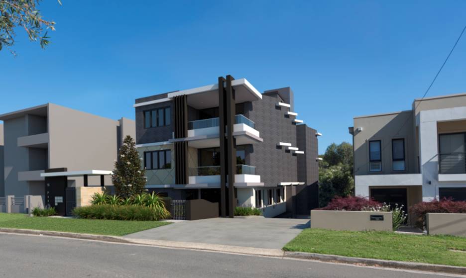
Figure 1:
Photomontage of the proposed development
Site and Locality
2. The application applies to
land known as No. 16 Peake Parade, Peakhurst, and is legally described as Lot
292 in DP 36537.
3. The site has a boundary to
Peake Parade of 15.85m, side boundary lengths of 40.845m and 43.54m, and a rear
boundary length of 10.64m and 6.4m combined, giving a site area of 677.9sqm.
4. The land falls by 4.25m from
the street to the rear boundary.
5. The site is located within an
R3 Medium Density Residential precinct. A number of properties in the locality
have been redeveloped from single dwelling houses to residential flat buildings
and dual occupancies.
Zoning and Permissibility
6. The subject site is zoned R3
Medium Density Residential under the provisions of Hurstville Local
Environmental Plan 2012 (HELP 2012). The proposal is for a residential flat
building which is permissible with consent in the zone.
Submissions
7. The DA was notified to
adjoining properties in accordance with the Hurstville Development Control Plan
No. 1 (Hurstville Development Control Plan No. 1) for a statutory notification
period of 14 days between:
· Round
1: 23 January 2018 – 6 February 2018: Two submissions
· Round
2: 21 June 2018 – 5 July 2018: One submission
· Round
3: 24 August 2018 – 7 September 2018: Two submissions (one a copy of the
submission in the first round)
Reason for
Referral to the Local Planning Panel
8. This application is referred
to the Georges River Local Planning Panel for consideration and determination,
as the proposal relates to a residential flat building subject to the
provisions of State Environmental Planning Policy No. 65 – Design Quality
of Residential Apartment Development. The proposed development also exceeds the
height control development standard by more than 10%.
9. A Clause 4.6 statement has
been submitted with the application seeking a variation to the height control
(Clause 4.3) in accordance with the provisions of the Hurstville Local
Environmental Plan 2012 to justify and support the non-compliance.
Planning and Design Issues
10. The proposal fails to comply with the
building height development standard of 12m that applies to the site under
Hurstville Local Environmental Plan 2012. The lift overrun, communal WC and
awning over the rooftop communal open space area exceed the height limit, with
the top of the lift overrun having a height of 14.47m (20.5% variation). A
variation request to the building height development standard has been
submitted pursuant to clause 4.6 of Hurstville Local Environmental Plan 2012;
however it has been assessed as being not-well founded, as discussed in this
report.
11. The proposal fails to achieve the
required setbacks pursuant to the Apartment Design Guide (ADG) and the design
treatment of the side elevations will result in poor internal amenity for many
of the units.
12. The proposal does not provide
sufficiently dimensioned deep soil zones along any boundaries, which precludes
the planting of canopy trees around the perimeter of the site that would reach
a scale sufficient to ameliorate the scale of the building, provide a
landscaped setting for the building and improve the environmental amenity of
adjoining properties.
13. Insufficient communal open space is
provided, and there is insufficient information provided to enable a proper
assessment of the solar access and natural ventilation available to the
proposed units.
14. The subject site is 15.85m wide and does
not comply with the minimum 24m site width control in the Hurstville
Development Control Plan (DCP), resulting in an unacceptable design outcome for
the site. The justification for the proposed residential flat building on an
under-width lot relies on the site being an isolated lot; this justification is
not accepted by Council Assessment Staff.
Conclusion
15. The application has been assessed having
regard to the Matters for Consideration under Section 4.15 of the Environmental
Planning and Assessment Act, 1979, the provisions of the relevant State
Environmental Planning Policies, Local Environmental Plan and Development
Control Plans. The proposal is an unreasonable planning and urban design
outcome in the context of the site and performs poorly against the design
quality principles of State Environmental Planning Policy No 65. The Clause 4.6
Objection in relation to the building height development standard is considered
to not be well-founded. As a result the application is recommended for refusal.
Report in Full
Description of the Proposal
16. The DA seeks consent for the demolition
of one detached dwelling house and the construction of a three (3) storey
Residential Flat Building containing 6 residential apartments. Car parking is
contained within a semi-basement level containing 11 car parking spaces for
residents and visitors.
17. A mix of apartments is proposed,
consisting of three (3) x two (2) bedroom and three (3) x three (3) bedroom
apartments. One apartment is nominated as adaptable.
18. Further details of the proposal are as
follows:
Semi-basement
- Nine
(9) residential car parking spaces (of which one is an accessible parking
space) and two (2) visitor car parking spaces;
- Residential
storage allocated to individual apartments;
- Bicycle
parking for two (2) bikes;
- Service
areas;
- Egress
stairs; and
- Lift
access to the upper levels.
Ground Floor
- Two
(2) apartments (1 x 2B and 1 x 3B) of which one (1) is adaptable.
- Shared
communal pedestrian access from the street is proposed along the south-western
side boundary.
- Dual
width driveway access from Peake Parade is located in the south-eastern corner
of the site adjacent to No. 14A Peake Parade, with a nil side boundary setback
for the first 6m of the driveway within the site.
- Bin
store area adjacent to the entry foyer (western side).
- The
service and circulation spaces of the building are centrally located, with the
lift being to the eastern side of the building and the circulation stair to the
western side.
First and Second Floors
- Two
(2) apartments (1 x 2B and 1 x 3B)
- The
service and circulation spaces of the building are centrally located, with the
lift being to the eastern side of the building and the circulation stair to the
western side.
Rooftop
- Rooftop
area of communal open space (94.41sqm) with a shading device over the northern
section, common WC, an enclosed kitchen and an enclosed BBQ area.
- Perimeter
landscaping around the communal open space in planter boxes.
19. The proposal involves the removal of five
(5) trees/shrubs from within the site.
The Site and Locality
20. The subject site is known as No. 16 Peake
Parade, Peakhurst and is legally described as Lot 292 in DP36537. The site has
a frontage to Peake Parade of 15.85m and a site area of 677.9sqm. The property
shares a rear boundary with Peake Avenue Reserve, and the site has a fall of
4.25m from the street to the rear.
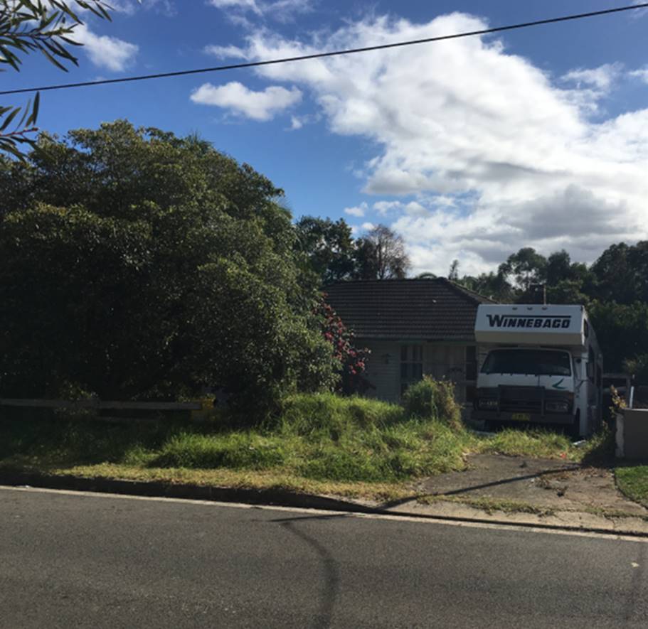
Figure 3:
The site as viewed from Peake Parade
21. The site is currently occupied by a
single storey dwelling house and scattered vegetation, none of which is
significant.
22. The site is located in a residential
neighbourhood characterised by recently constructed residential flat buildings
and dual occupancy developments. The property to the east is occupied by a two
storey attached dual occupancy development (Figure 4). The property to the west
is currently occupied by dwelling houses, however approval has been granted for
a three storey residential flat building on the corner of Peake Parade and
Pearce Avenue (DA2016/0366) (Figure 5).
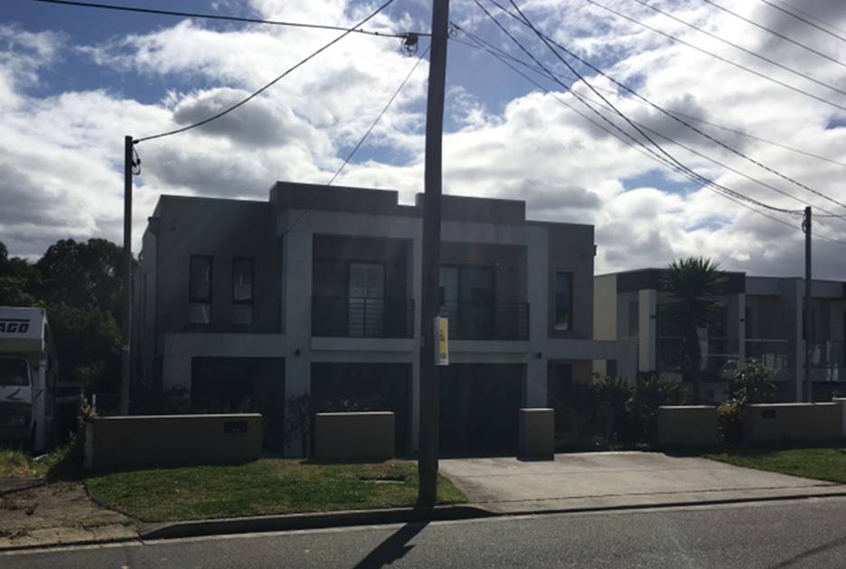
Figure 4: Dual
occupancy at No. 14A and 14B Peake Parade (east of the site)
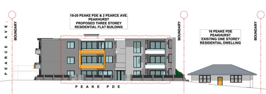
Figure 5:
Approved residential flat building at Nos. 18-20 Peake Parade (west of the
site)
State Environmental Planning Policies (SEPPs)
23. Compliance with the relevant State Environmental
Planning Policies is summarised in the following table and discussed in further
detail below it.
|
State Environmental Planning Policy Title
|
Complies
|
|
Greater
Metropolitan Regional Environmental Plan No 2 – Georges River Catchment
|
Yes
|
|
State
Environmental Planning Policy (Building Sustainability Index: BASIX) 2004
|
Yes
|
|
State
Environmental Planning Policy No 55 – Remediation of Land
|
Yes
|
|
State
Environmental Planning Policy (Infrastructure) 2007
|
Yes
|
|
State Environmental Planning Policy (Vegetation in Non-Rural
Areas) 2017
|
Yes
|
|
State Environmental Planning Policy No 65—Design Quality of
Residential Apartment Development
|
No – Non-compliance with
respect to Design Quality Principles 1 and 2. Refer to State Environmental
Planning Policy No 65 section below.
|
|
Draft
Environment State Environmental Planning Policy
|
Yes
|
|
Draft
Remediation of Land State Environmental Planning Policy
|
Yes
|
Greater Metropolitan Regional Environmental Plan No 2 – Georges
River Catchment
24. The primary relevant aims and objectives
of this plan are:
· to
maintain and improve the water quality and river flows of the Georges River and
its tributaries and ensure that development is managed in a manner that is in
keeping with the national, State, regional and local significance of the
Catchment,
· to
protect and enhance the environmental quality of the Catchment for the benefit
of all users through the management and use of the resources in the Catchment
in an ecologically sustainable manner,
· to ensure
consistency with local environmental plans and also in the delivery of the
principles of ecologically sustainable development in the assessment of
development within the Catchment where there is potential to impact adversely
on groundwater and on the water quality and river flows within the Georges
River or its tributaries,
· to
establish a consistent and coordinated approach to environmental planning and
assessment for land along the Georges River and its tributaries and to promote
integrated catchment management policies and programs in the planning and
management of the Catchment,
25. The stormwater design was referred to
Council’s Engineering Section for review. No objection was raised with
respect to the management and disposal of stormwater subject to the imposition
of deferred commencement conditions (for an easement to drain water from the
site to the open drain in council’s reserve to the north of the site)
if consent was to be granted.
26. In summary, the proposal contravenes the
aims, objectives or purpose of the Regional Plan if approved with appropriate
conditions of consent.
State Environmental Planning Policy (Building Sustainability Index:
BASIX) 2004
27. BASIX Certificate No. 879258M was lodged
with the DA and indicates that the proposal meets the provisions and minimum
requirements of BASIX in terms of water, thermal comfort and Energy efficiency.
State Environmental Planning Policy No 55 - Remediation of Land (State
Environmental Planning Policy 55)
28. State Environmental Planning Policy 55
aims to promote the remediation of contaminated land in order to reduce the
risk of harm to human health or any other aspect of the environment.
29. Clause 7 requires contamination and
remediation to be considered in determining a DA. The consent authority must not
consent to the carrying out of development on land unless it has considered
whether or not the land is contaminated.
30. Though a Preliminary Investigation
Assessment report was not submitted with the DA, a review of historic aerial
photography indicates that the site has been used for
residential purposes since at least 1943. Residential usage is not
typically associated with activities that would result in the contamination of land. On this basis, the site is
likely to be suitable for residential development in its current state for the
development proposed with respect to contamination.
State Environmental Planning Policy (Vegetation in
Non-Rural Areas) 2017
31. The Vegetation State Environmental
Planning Policy aims to protect the biodiversity values of trees and other
vegetation in non-rural areas of the State, and to preserve the amenity of
non-rural areas of the State through the preservation of trees and other
vegetation.
32. The Vegetation State Environment Planning
Policy applies to clearing of:
(a) Native
vegetation above the Biodiversity Offset Scheme (BOS) threshold where a
proponent will require an approval from the Native Vegetation Panel established
under the Local Land Services Amendment Act 2016; and
(b) Vegetation
below the BOS threshold where a proponent will require a permit from Council if
that vegetation is identified in the council’s development control plan
(Development Control Plan).
33. The Vegetation State Environmental
Planning Policy repeals clauses 5.9 and 5.9AA of the Standard Instrument -
Principal Local Environmental Plan with regulation of the clearing of
vegetation (including native vegetation) below the BOS threshold through any
applicable development control plan (Development Control Plan).
34. The proposal involves the removal of five
(5) trees from the site. Council’s Consultant Arborist has reviewed the
proposed tree removal and raised no objection to the removal of the five (5)
trees subject to appropriate replacement tree planting both on site and within
the public domain should the application be supported. The recommended
conditions provided by the arborist require one additional tree to be planted
within deep soil areas of the site in addition to those shown on the submitted
landscape plans, and one street tree to be planted within the road frontage.
35. On this basis, the proposal, should it be
supported, is consistent with relevant provisions of the Vegetation State
Environmental Planning Policy.
Draft Remediation of Land State Environmental Planning Policy
36. The Department of Planning and
Environment has announced a Draft Remediation of Land State Environmental
Planning Policy, which will eventually repeal and replace the current State
Environmental Planning Policy No 55 — Remediation of Land.
37. The main changes proposed include the
expansion of categories of remediation work which requires development consent,
a greater involvement of principal certifying authorities particularly in
relation to remediation works that can be carried out without development
consent, more comprehensive guidelines for Councils and certifiers and the
clarification of the contamination information to be included on Section 149
Planning Certificates.
38. Whilst the proposed State Environmental
Planning Policy will retain the key operational framework of State
Environmental Planning Policy 55, it will adopt a more modern approach to the
management of contaminated land. The Draft State Environmental Planning Policy
will not alter or affect the findings with respect to State Environmental
Planning Policy 55 detailed above.
Draft Environment State Environmental Planning Policy
39. The Draft Environment State Environmental
Planning Policy was exhibited from 31 October 2017 to 31 January 2018. This
consolidated State Environmental Planning Policy proposes to simplify the
planning rules for a number of water catchments, waterways, urban bushland, and
Willandra Lakes World Heritage Property.
40. Changes proposed include consolidating
the following seven existing State Environmental Planning Policies:
· State Environmental Planning Policy No. 19 – Bushland
in Urban Areas
· State Environmental Planning Policy (Sydney Drinking Water
Catchment) 2011
· State Environmental Planning Policy No. 50 – Canal
Estate Development
· Greater Metropolitan Regional Environmental Plan No. 2
– Georges River Catchment
· Sydney Regional Environmental Plan No. 20 – Hawkesbury-Nepean
River (No.2-1997)
· Sydney Regional Environmental Plan (Sydney Harbour
Catchment) 2005
· Willandra Lakes Regional Environmental Plan No. 1 –
World Heritage Property.
41. The proposal is
consistent with the provisions of this Draft Instrument.
State Environmental
Planning Policy No 65 — Design Quality of Residential Apartment Development
42. State Environmental Planning
Policy No 65 – Design Quality of Residential Flat Buildings (State
Environmental Planning Policy 65) was gazetted on 26
July 2002 and applies to the assessment of DAs for residential flat
developments of three or more storeys in height and containing at least four
dwellings. Amendment 3 to State Environmental Planning Policy 65 commenced on 17 July 2015 and implemented various
changes including the introduction of the Apartment Design Guide (ADG) to
replace the Residential Flat Design Code. Given the nature of the development
proposed, State Environmental Planning Policy
65 applies.
43. Clause 28(2) of State
Environmental Planning Policy 65 requires that the
consent authority take into consideration the following as part of the
determination of DAs to which State Environmental Planning Policy 65 applies:
a) the advice (if any) obtained from the design
review panel, and
b) the design quality of the development when
evaluated in accordance with the design quality principles, and
c) the Apartment Design Guide.
44. On 1 March 2018 the proposal
was referred to the Georges River Design Review Panel. The Panel considered the
development against each of the nine (9) Design Quality Principles (refer to
Table 1) and also considered the provisions of the Apartment Design Guide (ADG)
which are summarised and addressed in Table 2 below.
45. As detailed within the table
earlier in this report, the proposal fails to satisfy various Design Quality
Principles and provisions of the ADG, particularly where they relate to context
and neighbourhood character, built form and scale, density and façade
design. The proposal also fails to meet various design criteria of the ADG with
respect to residential amenity of the apartments.
46. The Tables below provide a
comprehensive assessment against the principles, objectives and controls of State
Environmental Planning Policy 65 and the ADG.
Table
1: Application of State Environmental Planning Policy 65
|
Clause
|
Standard
|
Proposal
|
Complies
|
|
3 - Definitions
|
Complies with definition of
“Residential Apartment Development” (RAD) Section 4 (1)
(Application of Policy) of the State Environmental Planning Policy 65 states
that the policy “applies to development for the purpose of a
residential flat building, shop top housing or mixed use development with a
residential accommodation component if:
(a) the development consists of any
of the following:
(i) the erection of a new building,
(ii) the substantial redevelopment
or the substantial refurbishment of an existing building,
(iii) the conversion of an existing
building, and
(b) the building concerned is at
least 3 or more storeys (not including levels below ground level (existing)
or levels that are less than 1.2 metres above ground level (existing) that
provide for car parking), and
(c) the building concerned contains at least 4 or
more dwellings.”
|
The proposal
is for a three storey flat building with basement parking and rooftop
communal open space
|
Yes.
|
|
4 - Application of Policy
|
Development involves the erection
of a new RFB, substantial redevelopment or refurbishment of a RFB or
conversion of an existing building into a RFB. The definition of an RFB in
the State Environmental Planning Policy includes mixed use developments.
|
This application is for the
erection of an RFB which satisfies the State Environmental Planning Policy’s
definition.
|
Yes
|
|
50 – Development Applications
|
Design verification statement
provided by qualified designer
Registered Architect Name and
Registration No.
|
Design Verification Statement
provided by Registered Architect: N Lycenko (Registration No.3010)
|
Yes
|
Table 2: Part 2 Design Quality Principles under the SEPP
|
SEPP 65 – Design Quality of
Residential Flat Buildings
|
DRP
Comment
|
General
comment
|
|
Context and Neighbouring
Character
Good design
responds and contributes to its context. Context is the key natural and
built features of an area, their relationship and the character they
create when combined. It also includes social, economic, health and
environmental conditions.
Responding
to context involves identifying the desirable elements of an area’s
existing or future character. Well-designed buildings respond to
and enhance the qualities and identity of the area including the adjacent
sites, streetscape and neighbourhood.
Consideration
of local context is important for all sites, including sites in established
areas, those undergoing change or identified for change.
|
The site
is in a context which is rapidly evolving and increasing in density. It is an
isolated site located on the low side of the street between a recently
approved RFB containing twenty five (25) units, and a dual occupancy
development. On the opposite side of the road there are a number of recently
completed RFBs extending almost for the full length of the block. In some
cases, such as in the block immediately opposite, the street frontage is
dominated by ramps, stairs, and associated building infrastructure,
compromising the quality of the streetscape.
The site
has a fall of approximately 4m down to the public reserve at the rear. The
applicant advised that access to the reserve is permitted.
To the
rear is an attractive public reserve to which access for the residents is
possible and desirable. It would also be desirable for the proponent to
produce fence forms to the reserve compatible with adjacent properties facing
the reserve.
|
A review of
the proposal has identified that the site is not in fact an isolated site, as
the form of development on the site to the east is substantially below the
density and scale permitted in the zone as it is a dual occupancy
development.
The
proposal fails to comply with a number of ADG controls (detailed later in
this report) and it is considered given the present dimensions of the
property, this allotment unconsolidated is more suited to a dual occupancy
development.
|
|
Built
Form and Scale
Good design
achieves a scale, bulk and height appropriate to the existing or desired
future character of the street and surrounding buildings.
Good
design also achieves an appropriate built form for a site and the
building’s purpose in terms of building alignments, proportions,
building type, articulation and the manipulation of building elements.
Appropriate
built form defines the public domain, contributes to the character
of streetscapes and parks, including their views and vistas, and
provides internal amenity and outlook.
|
The form
is constrained by the narrow site and the existing and approved developments
to the west and east adjoining sites. The height is compliant with the LEP
height control with the exception of minor intrusion by the lift overrun and
communal facilities, which is considered to be acceptable.
The plan
form has been articulated along the side boundaries with splayed walls which
generally appear to resolve privacy issues in relation to the adjoining
properties.
Setback
from the front boundary complies with the planning controls and is marginally
non-compliant to the rear because of the balconies on the north
façade, but this minor non-compliance is also considered to be
acceptable.
|
The
proposal fails to comply with the minimum separation distances for habitable
areas, building height and deep soil area.
It is not
considered that the scale of development is appropriate for the site given
its present width.
|
|
Density
Good design
achieves a high level of amenity for residents and each apartment, resulting
in a density appropriate to the site and its context.
Appropriate
densities are consistent with the area’s existing or projected
population. Appropriate densities can be sustained by existing or proposed
infrastructure, public transport, access to jobs, community facilities and
the environment.
|
Compliant
and acceptable.
|
The Panel
did not raise an issue with the overall bulk, scale and density of the
development; however the site is constrained by its site width which imposes
unreasonable compromises on the amenity within the development and to
adjoining sites.
|
|
Sustainability
Good design
combines positive environmental, social and economic outcomes.
Good
sustainable design includes use of natural cross ventilation and sunlight for
the amenity and liveability of residents and passive thermal design
for ventilation, heating and cooling reducing reliance on technology and
operation costs. Other elements include recycling and reuse of materials and
waste, use of sustainable materials and deep soil zones for groundwater
recharge and vegetation.
|
It is
desirable that the stormwater regime be clearly articulated and not compete
with deep soil areas.
|
The
development fails to provide the required amount of deep soil landscaped
area, and fails to demonstrate compliance with the required solar access and
cross ventilation standards.
|
|
Landscape
Good design recognises that
together landscape and buildings operate as an integrated and sustainable
system, resulting in attractive developments with good amenity. A positive
image and contextual fit of well designed developments is achieved
by contributing to the landscape character of the streetscape
and neighbourhood.
Good
landscape design enhances the development’s environmental performance
by retaining positive natural features which contribute to the local
context, co-ordinating water and soil management, solar access,
micro-climate, tree canopy, habitat values and preserving green
networks.
Good
landscape design optimises useability, privacy and opportunities
for social interaction, equitable
access, respect for neighbours’ amenity and
provides for practical establishment and long term management.
|
· Poor
interface to adjoining site (west) – planting should be provided
· A
functional, secure and engaging play area for children should be provided
· Provide
an all-weather surface to entry point rather than lawn
· Need
to further develop the design of the fence treatment facing the reserve at
the rear. The Applicant should review other treatments so that some
consistency can be achieved.
· Provide
access from communal open space to public reserve at the rear
· The
ground floor communal open space should be designed to meet the play needs of
children
· There
is the opportunity to enclose some area of communal open space, either at
ground level (under the first level balcony) and on rooftop for amenities
· The
planter boxes on the rooftop communal open space could be enlarged by
extending them to the edges of the roof
· Rainwater
storage should be provided for water collection and reuse in irrigation of
soft landscape areas
|
The narrow
width of the site results in limited separation between the site and its
neighbours, and the required basement layout leaves little opportunity for
high quality deep soil landscaping of the perimeter of the site. Accordingly,
the proposal is not able to provide landscaping compatible with that
delivered by comparable surrounding development.
|
|
Amenity
Good design
positively influences internal and external amenity for residents
and neighbours. Achieving good amenity contributes to positive living
environments and resident wellbeing.
Good
amenity combines appropriate room dimensions and shapes, access to sunlight,
natural ventilation, outlook, visual and acoustic privacy, storage, indoor
and outdoor space, efficient layouts and service areas and ease of access for
all age groups and degrees of mobility.
|
Generally
of good standard and accepted.
There is
potential to enclose the area under the balcony on the ground level as a
communal room with seating and WC.
The
communal open space at rooftop should also be provided with an enclosed area.
There is
no bin storage provided in the basement and very limited bin storage provided
adjacent to the front entry with a long and winding ramp to the street.
Clear
glass balustrades on first level balconies should be redesigned to provide
adequate screening.
|
Not
proposed.
The kitchen
and BBQ area are enclosed.
A bin room
has been provided in the semi-basement.
A mix of
solid, glass and semi-translucent balustrades are proposed.
|
|
Safety
Good design
optimises safety and security within the development and the public domain.
It provides for quality public and private spaces that are clearly defined
and fit for the intended purpose.
Opportunities
to maximise passive surveillance of public and communal areas
promote safety.
A positive
relationship between public and private spaces is achieved through clearly
defined secure access points and well lit and visible areas that are easily
maintained and appropriate to the location and purpose.
|
Enabling
access to the reserve at the rear will assist with safety and security of
both the development and the reserve by increasing the level of surveillance.
|
Access to
the reserve is provided via the rear boundary fence/gate.
It is noted
that direct access from private properties into reserves is generally not
supported by Council’s open space section, and to this end, would be
unlikely to be supported. A condition would be imposed to address this in the
event the application was to be approved.
|
|
Housing
Diversity and Social Interaction
Good design
achieves a mix of apartment sizes, providing housing choice for different
demographics, living needs and household budgets.
Well-designed apartment
developments respond to social context by providing housing and facilities to
suit the existing and future social mix.
Good design
involves practical and flexible features, including different types of
communal spaces for a broad range of people and providing opportunities for
social interaction among residents.
|
Acceptable
|
Complies
|
|
Aesthetics
Good design
achieves a built form that has good proportions and a balanced composition of
elements, reflecting the internal layout and structure.
Good design
uses a variety of materials, colours and textures.
The visual
appearance of a well designed apartment development responds to the
existing or future local context, particularly desirable elements and
repetitions of the streetscape.
|
The
colour of brickwork should be reviewed to ensure that it complements existing
and future adjoining properties.
|
The
schedule of colours was amended and a range of grey, white and sandstone
materials and finishes are proposed.
|
47. Having regard to the above, the
Panel considers that the proposal generally satisfies the Design Principles of
the ADG.
48. Clause 28 of State
Environmental Planning Policy 65 requires the consent
authority to take into consideration the provisions of the ADG. The Table below
assesses the proposal against these provisions, with relevant assessment
comments provided where non-compliances are proposed.
Table 3: Part
3 and Part 4 – Consideration of Apartment Design Guide
|
ADG
Compliance Table
|
|
Standard
|
Proposal
|
Complies
|
|
3D – Communal Open Space (COS)
|
|
Provide COS at
least 25% of the site area (411.6sqm)
Located on a
podium or roof if it can’t be located on ground level
At least 50%
direct sunlight to the principal usable part of the COS for at least 2 hours
between 9 am and 3 pm on 21 June (mid-winter)
|
13.7% (93sqm).
COS located on roof level.
Complies for the COS provided,
however the COS provide is substantially less than the COS required.
|
No
Yes
Yes
|
|
Comment on Communal Open
Space
The proposal does not provide the
communal open space specified by the Apartment Design Guide. It is noted that
the narrowness of the site and the scale of the building mean that there is
little opportunity for the provision of compliant and quality areas of communal
open space on the site.
The units in the proposal do not
benefit from larger balconies to compensate for the deficient COS, and the
ground floor is heavily disrupted by the protruding basement and
service/circulation areas, meaning there is no alternative location for
additional open space.
It is considered the failure to
provide compliant deep soil area on the site is unacceptable and is a symptom
of the inappropriateness of a site proposing this form and scale of
development on a site with a narrow width such as this site.
|
|
3E – Deep Soil Zones
|
|
Site area is 650sqm - 1,500sqm = 3m
min dimensions
Min deep soil area of 7% (47sqm)
Provide acceptable stormwater
management and on-structure planting where min. deep soil area not achieved (e.g.
CBD, constrained sites, high density areas or in centres or where there is
100% site coverage or non-residential uses at ground level)
|
No deep soil area proposed achieves
the minimum 3m dimensions.
0% due to minimum dimensions not
being met
[35sqm (5%) if all other deep soil
areas included]
There is no justifiable reason why
the minimum deep soil area of 7% cannot be met on this particular site, as
the land is not heavily constrained, nor is in a high density area, CBD or
centre.
|
No
No (100%)
No
|
|
Comment on Deep Soil Zones
The building fails to provide
sufficient deep soil zones with minimum dimensions of 3m and a minimum total
area of 7% of the site area, as required by the ADG for a site of this size.
The total deep soil area provided is 5% of the site area, proposed in small,
irregular pockets within the site, with these areas not meeting the minimum
dimensions nominated by the ADG.
This precludes the planting of
canopy trees that would improve residential amenity both within the site and
for adjoining properties, ameliorate the scale of the building when viewed
from both the public domain and from adjoining and nearby properties.
Insufficient justification has been
provided to demonstrate why compliance with this ADG design criteria is not
achievable on the site, however the lack of deep soil area appears to be a
result of the extensive area occupied by the semi-basement footprint beneath
relative to the width of the site. Accordingly, the inability to deliver
appropriate landscaping indicates that the development proposed is not
suitable for the subject site.
|
|
3F – Visual Privacy
|
|
Minimum
separation to side and rear boundaries:
Up to 12m (4
storeys):
3m
non-habitable rooms
6m habitable
rooms & balconies
|
Levels G – 2
NE Elevation:
· Min. 3m to
habitable/balcony
SW Elevation:
· Min. 3m to
habitable rooms
|
No (50%)
No (however highlight window
proposed)
|
|
Comment on Visual Privacy
The proposed development fails to
achieve the required separation distances to adjoining properties, and seeks
to use ungainly angled windows to manage privacy impacts.
The inadequate separations will
impose unreasonable impacts on the developments either side of the site, and
accordingly will form part of the reasons for refusal.
It is noted that the failure to
provide separation is a result of the narrow width of the site in its present
form.
|
|
3G – Pedestrian Access and Entries
|
|
Building
entries and pedestrian access connects to and addresses the public domain
Multiple
entries (including communal building entries and individual ground floor
entries) should be provided to activate the street edge
|
One entry provided (western side) with
access from Peake Parade.
One communal entry (western side)
and one entry to Unit G.01 via a terrace.
|
Yes
Yes
|
|
3H – Vehicle Access
|
|
Vehicle access
points are designed and located to achieve safety, minimise conflicts between
pedestrians and vehicles and create high quality streetscapes
|
The driveway has a nil setback from
the south eastern boundary for a length of 6m, insufficient landscaping
between the driveway and the boundary shared with 14A Peake Parade, will be
visually dominant in the streetscape relative to the development.
|
No – see comment below
|
|
Comment on Vehicle Access:
The proposed driveway off Peake
Parade has a nil setback from the south-eastern boundary and occupies 34% of
the site frontage thereby forming a dominant feature with respect to the
streetscape character of the development.
The failure to provide a strip of
landscaping (e.g. 1.5m) to enable a softening of the harshness and sterile
nature of the driveway, and the dominance of the driveway with respect to the
site width both indicate that the proposed driveway design will not deliver a
sufficiently high quality streetscape.
As the driveway is not able to be
reduced for reasons of satisfying Australian Standards of design, this
indicates that the site is not wide enough to accommodate the development as
proposed, and forms part of the refusal reasons.
|
|
3J – Bicycle and Car Parking
|
|
Car parking provided in accordance
with RMS GTTGD
(Applies to sites that are within
800m of a railway station or light rail stop in the Sydney Metropolitan Area)
|
Not applicable – site is more
than 1km from Riverwood Station and therefore the Development Control Plan
(DCP) rates apply to the proposal.
Required:
1 space/1B or 2B = 3 spaces
2 spaces/3B= 6 spaces
1 visitor space/4 units = 2 spaces
Proposed:
9 resident spaces
2 visitor spaces
|
NA
Yes
Yes
|
|
4A – Solar and Daylight
Access
|
|
Living rooms and private open space
receive 2 hours direct sunlight between 9am and 3pm in midwinter for 70% of
apartments
Max. 15% of apartments receive no
direct sunlight between 9am and 3pm in midwinter
|
Inadequate information provided to
confirm compliance – unlikely to achieve solar penetration into living
rooms of street facing units given this is the southern side of the
development.
3 / 6 apartments = 50%
|
No – see comment below
No
|
|
Comment on Solar and
Daylight Access
The shadow diagrams submitted with
the application fail to provide solar access diagrams for the proposed units
and do not show the penetration of direct sunlight into the units. It is
likely that the living rooms of the street facing units will not receive 2
hours of sunlight in winter as required by the ADG, particularly if the site
to the east is developed in a similar manner into the future. On this basis,
compliance with the Solar and Daylight Access design criteria has not been
demonstrated and the proposal is deemed unacceptable.
It is noted that although the ADG
requires provision of separation distances primarily for reasons of privacy
in Part 3, Part 2F (which relates to preparation of building controls) notes
that separation is also important to assist in providing residential amenity
with respect to sunlight and daylight access. Given the proposal is on a site
that is below the required site width, it is relevant to note that the
inability to deliver solar access to the required number of units is a direct
symptom of the inadequate width of the site.
This matter forms part of the
reasons for refusal.
|
|
4B – Natural Ventilation
|
|
At least 60% of apartments are
naturally cross ventilated in the first nine storeys of the building.
Overall depth of a cross-over or
cross-through apartment does not exceed 18m, measured glass line to
glass line
The building
should include dual aspect apartments, cross through apartments and corner
apartments and limit apartment depths
|
Inadequate information provided to
make a proper assessment.
13m max.
Achieved
|
The proposal appears to comply,
however further information is required to confirm this criterion given the
insufficient setbacks.
Yes
Yes
|
|
Comment on natural
ventilation
The SEE submitted with the
application states all units are designed and configured to permit natural
cross ventilation, and the layout of the units appear to comply, however no
ventilation diagrams were provided with the architectural plans to
demonstrate compliance with the control, given the compromised design to
address the inadequate setbacks provided.
This forms part of the reasons for
refusal.
|
|
4C – Ceiling Heights
|
|
Minimum ceiling heights measured
from FFL to finished ceiling level:
Habitable rooms = 2.7m
Non-habitable rooms = 2.4m
|
All rooms have 2.7m internal
ceiling height.
|
Yes
|
|
4D – Apartment Size and Layout
|
|
Minimum internal areas:
1br: 50sqm
2br: 70sqm
3br: 90sqm
(Add 5sqm if second bathroom
proposed)
Each habitable room must have a
window in an external wall with a total minimum glass area of at least 10% of
the floor area of the room.
|
All apartments meet minimum
internal sizes
Calculated accordingly
Each habitable room has a suitably
sized window.
|
Yes
Yes
Yes
|
|
Habitable room depths are limited
to a maximum of 2.5 x the ceiling height
In open plan layouts (where the
living, dining and kitchen are combined) the maximum habitable room depth is
8m from a window
|
All rooms compliant.
Street facing units measure depth
from balcony door to “front” of kitchen (7.4m) while rear facing
units are measured to the rear wall of the kitchen (8m).
|
Yes
Yes
|
|
Master bedrooms have a minimum area
of 10sqm and other bedrooms 9sm (excluding wardrobe space)
Bedrooms have a minimum dimension
of 3m (excluding wardrobe space)
Living rooms or combined
living/dining rooms have a minimum width of:
- 3.6m for studio and 1 bedroom
- 4m for 2 and 3 bedroom apartments
Internal width of cross-over or
cross-through apartments are at least 4m
|
All bedrooms meet minimum internal
sizes (excluding wardrobe space).
All bedrooms meet minimum
dimensions excluding wardrobe space as specified.
All living rooms comply.
All such apartments meet the
minimum width requirement.
|
Yes
Yes
Yes
Yes
|
|
Comment on Apartment Size
and Layout
To overcome the width of the site
being 37% below the required 24m site frontage for RFBs under the Hurstville Development
Control Plan (DCP), and the inability of the proposed building to achieve the
required setbacks to the side boundaries for visual privacy, the design
treatment of the side elevations of the building includes
‘hooded’ windows facing the rear of the site. This results in
poor internal amenity for most bedrooms, and the living and dining rooms of
the street-facing units, in terms of solar access, ventilation and outlook.
This will form part of the reasons
for refusal.
|
|
4E – Private Open Space and Balconies
|
|
Minimum primary balcony sizes:
1br: 8sqm area, 2m depth
2br: 10sqm area, 2m depth
3+br: 12sqm area, 2.4m depth
The minimum balcony depth to be
counted as contributing to the balcony area is 1m
For apartments at ground level or
on a podium or similar structure, a private open space is provided instead of
a balcony. It must have a minimum area of 15sqm and a minimum depth of 3m
|
All 1br units compliant
All 2br units compliant
All 3br units compliant
Calculated accordingly
G.01 complies
|
Yes
Yes
Yes
Yes
Yes
|
|
4F – Common Circulation Areas
|
|
Maximum 8 apartments off a
circulation core on a single level
|
2 units per level
|
Yes
|
|
4G – Storage
|
|
In addition to storage in kitchens,
bathrooms and bedrooms, the following storage is provided:
1br: 6m³
2br: 8m³
3+br: 10m³
At least 50% of storage is located
within the apartment
|
All units comply
All units comply
|
Yes
Yes
|
|
4H – Acoustic Privacy
|
|
Adequate building separation is
provided within the development and from neighbouring buildings/adjacent
uses.
Window and door openings are
generally orientated away from noise sources
Noisy areas within buildings
including building entries and corridors should be located next to or above
each other and quieter areas next to or above quieter areas
Storage, circulation areas and
non-habitable rooms should be located to buffer noise from external sources
|
Refer to 3F – Visual Privacy.
Bedrooms generally oriented away
from the street.
Achieved
Generally achieved where practicable.
|
No
Yes
Yes
Yes
|
|
4J – Noise and Pollution
|
|
To minimise impacts the following
design solutions may be used:
· physical
separation between buildings and the noise or pollution source
· residential uses
are located perpendicular to the noise source and where possible buffered by
other uses
· buildings should
respond to both solar access and noise. Where solar access is away from the
noise source, non-habitable rooms can provide a buffer
· landscape design
reduces the perception of noise and acts as a filter for air pollution
generated by traffic and industry
|
The site is not located in close
proximity to any noise or pollution sources.
|
Yes
|
|
4K – Apartment Mix
|
|
A range of apartment types and
sizes is provided to cater for different household types now and into the
future.
The apartment mix is distributed to
suitable locations within the building.
|
Each floor contains 1 x 2B and 1 x
3B unit.
|
Yes
|
|
4L – Ground Floor Apartments
|
|
Street frontage activity is
maximised where ground floor apartments are located
Design of ground floor apartments
delivers amenity and safety for residents
|
Unit G.01 has direct access from
Peake Parade however the courtyard is almost 1m below the street level on the
southern side of the building, and is located between the driveway and
communal pedestrian access for the building.
Accordingly it is considered this
is a poor design outcome and is not appropriate and this forms part of the
reasons for refusal.
|
No
|
|
4M – Facades
|
|
Facades should be well resolved
with an appropriate scale and proportion to the streetscape and human scale
|
The bulk of the building is too
large for a site having a width of 15.85m, and the inability to achieve
suitable setbacks to the side boundaries further exacerbates the scale of the
building being out of character for the site and locality.
This forms part of the refusal
reasons for the application.
|
No
|
|
4N – Roof Design
|
|
Roof treatments are integrated into
the building design and positively respond to the street. Opportunities to
use roof space for residential accommodation and open space are maximised.
Incorporates sustainability
features
|
Clean, simple roof form, lift
overruns centralised over the building, open space on rooftop achieved.
Acceptable shading to apartment
openings.
|
Yes
Yes
|
|
4O – Landscape Design
|
|
Landscape design is viable and
sustainable, contributes to the streetscape and amenity
|
Insufficient room for canopy trees
along the perimeter of the site.
|
No – see comment below
|
|
Comment on Landscape
Design
As stated under State
Environmental Planning Policy Principle 5 – Landscape, above, the
proposal does not meet the deep soil zone requirements of
the ADG. This provides limited opportunities for significant canopy tree
planting to ameliorate the scale of the building regulate the local
microclimate and contribute to a landscaped setting in the locality.
|
|
4P – Planting on Structures
|
|
Planting on structures –
appropriate soil profiles are provided, plant growth is optimised with
appropriate selection and maintenance, contributes to the quality and amenity
of communal and public open spaces
|
Planter boxes would need to be of
appropriate depth by condition of consent if approved
|
Achievable by a condition of
consent if approved.
|
|
4Q – Universal Design
|
|
Universal design – design of
apartments allow for flexible housing, adaptable designs, accommodate a range
of lifestyle needs. Benchmark of 20% liveable dwellings.
|
No liveable dwellings proposed.
|
No
|
|
4R – Adaptive Reuse
|
|
Adaptive reuse as apartment of
existing buildings- new additions are contemporary and complementary, provide
residential amenity while not precluding future adaptive reuse.
|
N/A – not an adaptive
re-reuse as the building is new.
|
N/A
|
|
4U – Energy Efficiency
|
|
Development incorporates passive
environmental design, passive solar design to optimise heat storage in winter
and reduce heat transfer in summer, natural ventilation minimises need for
mechanical ventilation
|
Appropriate building orientation,
natural ventilation, passive solar design, exceeds BASIX target for energy
efficiency.
|
Yes
|
|
4V – Water Management and Conservation
|
|
Water management and conservation
– potable water use is minimised, stormwater is treated on site before
being discharged, flood management systems are integrated into the site
design
|
Suitable.
|
Yes
|
|
4W – Waste Management
|
|
Waste management – storage
facilities are appropriately designed, domestic waste is minimised by
convenient source separation and recycling
|
Can be addressed through conditions
of consent if approved.
|
Achievable
|
|
4X – Building Maintenance
|
|
Building design provides protection
form weathering
Enables ease of maintenance,
material selection reduces ongoing maintenance cost
|
Suitable.
|
Yes
|
The proposal therefore
is unsatisfactory with regards building separation, solar access, site
landscaping, provision of communal open space, driveway dominance and other
amenity matters.
The majority of
these issues are driven by the narrow width of the site. In the context that
the site fails to achieve an acceptable level of design with regards to the
matters identified in Apartment Design Guide for a site that is not isolated.
Accordingly the design issues outlined above will form part of the reasons for
refusal of the application.
Environmental
Planning Instruments
Hurstville Local Environmental Plan 2012
Zoning
49. The
subject site is zoned R3 Medium Density Residential under the provisions of
the Hurstville Local Environmental Plan 2012 (HLEP2012) (See
zoning map below). The proposed development is for a residential flat building
which is a permissible land use in the zone.
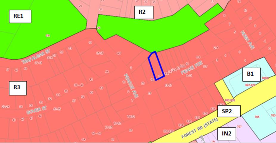
Figure 4: Zoning
map – the site is outlined in red
50. The objectives
of the zone are as follows:
• To provide for the
housing needs of the community within a medium density residential environment.
• To provide a variety
of housing types within a medium density residential environment.
• To enable other land
uses that provide facilities or services to meet the day to day needs of
residents.
• To ensure that a high
level of residential amenity is achieved and maintained.
• To provide for a
range of home business activities, where such activities are not likely to
adversely affect the surrounding residential amenity.
51. The
proposal does not contravene the objectives of the R3 zone as it would provide
for a variety of residential apartments in a medium density residential
environment. However, the proposal’s built form and envelope is not as
envisioned by the New City Plan and is not supported for reasons as detailed
within other relevant parts of this report.
52. The extent
to which the proposal complies with the relevant standards of Hurstville
Local Environmental Plan 2012 (HLEP2012) is outlined in the table below.
Table
4: HLEP2012 Compliance Table
|
Clause
|
Standard
|
Proposed
|
Complies
|
|
2.2 Zone
|
R3
Medium Density Residential
|
The proposal is defined as a
residential flat building which is a permissible use within the zone.
|
Yes
|
|
2.3
Objectives
|
Objectives of the Zone
|
Consistent with zone objectives
|
Yes
|
|
4.3 – Height of Buildings
|
12m as identified on Height of
Buildings Map
|
The building exceeds the 12m height
limit and proposes an overall height at the highest point of 14.47m.
|
No – see discussion below
regarding Clause 4.6 Statement which has been submitted.
|
|
4.4 – Floor Space Ratio
|
1:1 as identified on Floor Space
Ratio Map
|
The proposed FSR is 0.94:1.
|
Yes
|
|
4.5 – Calculation of floor
space ratio and site area
|
FSR and site area calculated in
accordance with Cl.4.5
|
The GFA calculations provided by
the Applicant have been verified and are considered satisfactory.
|
Yes
|
|
6.2 Earthworks
|
To ensure that earthworks do not
have a detrimental impact on environmental functions and processes,
neighbouring uses, cultural or heritage items or features of the surrounding
land
|
Excavation for the semi-basement
parking level is proposed. Suitable conditions of consent could be imposed to
protect neighbouring properties during construction should the application be
approved.
|
Yes
|
Clause 4.6 Exceptions to development standards
Detailed assessment of variation to Clause 4.3 Height of
Buildings
53. The
proposed development seeks a variation to the development standard relating to
height (Clause 4.3). The Local Environmental Plan identifies a maximum height
of 12m for the Site (refer to Figure 5 below) and the proposed development will
exceed the height by 2.47m which comprises of the lift overrun, fire stairs and
the pergola over the rooftop communal open space area. This is a 20.6% variation
above the control. Any variation to the height can only be considered under
Clause 4.6 – Exceptions to Development Standards of the Hurstville Local
Environmental Plan 2012.
54. Clause 4.6(1) outlines the objectives
of the standard which are to “provide an appropriate degree of
flexibility in applying certain development standards to particular development”
and “to achieve better outcomes for and from development by allowing
flexibility in particular circumstances”.
55. Is the
planning control in question a development standard?
The Height of Buildings control under
Clause 4.3 of the Hurstville Local Environment Plan 2012 is a development
standard.
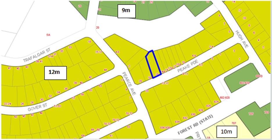
Figure 5: Extract
from the HLEP (Height Map_005) designated as “M” which notes a 12m
height limit
56. Clause
4.6(3) states that:
“Development consent must not be granted for
development that contravenes a development standard unless the consent
authority has considered a written request from the applicant that seeks to
justify the contravention of the development standard by demonstrating:
- that compliance with the development
standard is unreasonable or unnecessary in the circumstances of the case, and
- that there are sufficient environmental
planning grounds to justify contravening the development standard”
57. To support
the non-compliance, the applicant has provided a request for a variation to
Clause 4.3 in accordance with Clause 4.6 of Hurstville Local Environmental Plan
2012. The Clause 4.6 request for variation is assessed as follows:
What are the underlying
objectives of the development standard?
58. The
objectives of Height of Buildings standard under Clause 4.3 of Hurstville Local
Environmental Plan 2012 are:
(a) to ensure
that buildings are compatible with the height, bulk and scale of the existing
and desired future character of the locality,
(b) to minimise visual impact, disruption of views, loss
of privacy and loss of solar access to existing development and to public areas
and public domain, including parks, streets and lanes,
(c) to minimise the adverse impact of development on
heritage items,
(d) to nominate heights that will provide a transition in
built form and land use intensity,
(e) to establish maximum building heights that achieve
appropriate urban form consistent with the major centre status of the
Hurstville City Centre,
(f) to facilitate an appropriate transition between
the existing character of areas or localities that are not undergoing, and are
not likely to undergo, a substantial transformation,
(g) to minimise adverse environmental effects on the use
or enjoyment of adjoining properties and the public domain.
Compliance
is unreasonable or unnecessary in the circumstances of the case (clause
4.6(3)(a))
59. There have
been several Court cases that have established provisions in which to assess
Clause 4.6 statements to ensure they are well founded and address the
provisions of Clause 4.6.
60. In Wehbe
V Pittwater Council (2007) NSW LEC 827 Preston CJ sets out ways of
establishing that compliance with a development standard is unreasonable or
unnecessary. This list is not exhaustive. It states, inter alia:
“An
objection under State Environmental Planning Policy 1 may be well
founded and be consistent with the aims set out in clause 3 of the Policy in a
variety of ways. The most commonly invoked way is to establish that compliance
with the development standard is unreasonable or unnecessary because the
objectives of the development standard are achieved notwithstanding
non-compliance with the standard.”
The judgement goes on to state that:
“The rationale is that development standards are not ends in
themselves but means of achieving ends. The ends are environmental or planning
objectives. Compliance with a development standard is fixed as the usual means
by which the relevant environmental or planning objective is able to be
achieved. However, if the proposed development proffers an alternative means of
achieving the objective strict compliance with the standard would be
unnecessary (it is achieved anyway) and unreasonable (no purpose would be
served).”
Preston CJ in the judgement then expressed the view that there are 5
different ways in which an objection may be well founded and that approval of
the objection may be consistent with the aims of the policy, as follows (with
emphasis placed on number 1 for the purposes of this Clause 4.6 variation):
1. The objectives of the standard are
achieved notwithstanding non-compliance with the standard;
2. The underlying objective or purpose of
the standard is not relevant to the development and therefore compliance is
unnecessary;
3. The underlying object or purpose
would be defeated or thwarted if compliance was required and therefore
compliance is unreasonable;
4. The development standard has been
virtually abandoned or destroyed by the Council's own actions in granting
consents departing from the standard and hence compliance with the standard is
unnecessary and unreasonable;
5. The zoning of the particular land is
unreasonable or inappropriate so that a development standard appropriate for
that zoning is also unreasonable and unnecessary as it applies to the land and
compliance with the standard that would be unreasonable or unnecessary. That
is, the particular parcel of land should not have been included in the
particular zone.”
The statement was prepared in consideration of the recent court cases and
their judgements.
Applicants comment:
“Returning to Clause 4.6(3)(a) in Wehbe V Pittwater Council
(2007) NSW LEC 827 Preston CJ sets out ways of establishing that compliance
with a development standard is unreasonable or unnecessary. It states, inter
alia:
"An objection under State Environmental Planning Policy 1
may be well founded and be consistent with the aims set out in clause 3 of the
Policy in a variety of ways. The most commonly invoked way is to establish that
compliance with the development standard is unreasonable or unnecessary because
the objectives of the development standard are achieved notwithstanding
noncompliance with the standard."
The judgement goes on to state that:
“The rationale is that development standards are not ends in
themselves but means of achieving ends. The ends are environmental or planning
objectives. Compliance with a development standard is fixed as the usual means
by which the relevant environmental or planning objective is able to be
achieved However, if the proposed development proffers an alternative means of
achieving the objective strict compliance with the standard would be
unnecessary (it is achieved anyway) and unreasonable (no purpose would be
served) "
However, in Four2Five v Ashfield Council [2015] NSWLEC 90 the Land and
Environment Court said that whether something was ‘unreasonable or
unnecessary' is now addressed specifically in Clause 4.6(4)(a)(ii), with
separate attention required to the question of whether compliance is
unreasonable or unnecessary, Accordingly, while the objectives of the standard
are achieved despite non-compliance with the standard, this request goes
further. It seeks to demonstrate that requiring strict adherence to the
standard would be unreasonable or unnecessary’ for reasons that are
additional to mere consistency with the development standard.
Preston CJ in the judgement then expressed the view that there are 5
different ways in which an objection may be well founded and that approval of
the objection may be consistent with the aims of the policy, as follows (with
emphasis placed on number 1 for the purposes of this Clause 4.6 variation [our
underline]):
1. The objectives of the standard are
achieved notwithstanding non-compliance with the standard;
2. The underlying objective or purpose
of the standard is not relevant to the development and therefore compliance is
unnecessary;
3. The underlying object of purpose
would be defeated or thwarted if compliance v/as required and therefore
compliance is unreasonable;
4. The development standard has been
virtually abandoned or destroyed by the Council's own actions in granting
consents departing from the standard and hence compliance with the standard is
unnecessary and unreasonable;
5. The zoning of the particular land is
unreasonable or inappropriate so that a development standard appropriate for
that zoning is also unreasonable and unnecessary as it applies to the land and
compliance with the standard that would be unreasonable or unnecessary. That
is, the particular parcel of land should not have been included in the
particular zone
Additionally, in an analogous context, in Botany Bay City Council v
Saab Corp [2011] NSWCA 308 Court of Appeal said that a requirement may be
unreasonable when 'the severity of the burden placed on the applicant is
disproportionate to the consequences attributable to the proposed development'.
In support of this point
• The proposed height
variation will be visually imperceptible when viewed from the adjoining
properties and public domain:
• The proposed
development meets the objectives of the height control and strict compliance
with the height control would undermine or thwart its objectives, or the
zone’s objectives (or both); and
• The burden placed on
future residents (by relocating the communal open space area to ground level
adjacent to private open space) would be disproportionate to any consequences
that may arise from the proposed noncompliance with the height control.
Given that compliance with the zone and development standard
objectives is achieved and that the building complies with the overall height
limit, particularly at the street frontage, insistence on strict compliance
with the building height control is considered to be unreasonable and
unnecessary in the circumstances.
The proposal is compliant with the relevant objectives and will have
no adverse environmental or amenity impacts. The proposal is therefore
justified on environmental planning grounds. For the reasons above, the
proposed building height variation is consistent with the requirements of Cause
4 6(3) of the LEP.”
61. Officer
Comment: The proposed development is seeking approval for a residential
flat building on a site that is 15.85m wide, considerably below the minimum 24m
site width nominated within the Hurstville Development Control Plan (DCP). The
proposal is an overdevelopment of the site and the design does not respond
appropriately to the topography of the land and the slope of the site to the
rear, resulting in the non-compliance with the 12m height limit.
62. The
proposal fails to satisfy the objectives of the development standard as
follows:
(a) to ensure that buildings are compatible with the height,
bulk and scale of the existing and desired future character of the locality,
Officer Comment: The proposal is not
compatible with the height, bulk or scale of the desired future character of
the locality. The adjoining buildings (existing and approved) comply with the
height limit and are a suitable response to their respective sites. The site
fails to achieve the minimum site width required for residential flat
buildings, as such the development proposed is constrained when attempting to
satisfy the provisions of State Environmental Planning Policy 65/ADG results in
a compromised built form providing reduced amenity to the future occupants and
an undesirable built form outcome presenting to the street. The proposal is not
suitable for the site.
(b) to minimise visual impact, disruption of views, loss of
privacy and loss of solar access to existing development and to public areas
and public domain, including parks, streets and lanes
Officer Comment: This objective relates to the
amenity impacts generated by the exceedance in the height control. The
non-compliance will not result in any adverse overlooking, overshadowing (lift
core is centralised so the lift overrun will overshadow the building itself),
view loss or outlook generated by the variation and it will not adversely
affect the public domain.
(c) to minimise the adverse impact of development on
heritage items,
Officer Comment: The site is not located
within proximity of any heritage items so this objective is not considered to
be applicable in this case.
(d) to nominate heights that will provide a
transition in built form and land use intensity,
Officer Comment: Objective (d) is aimed at
establishing a maximum height for buildings so that within a given zone there
is consistency in the scale and built form of the building. It is accepted that
the exceedance at its worst point is centrally located within the roof form
however the design of the building fails to respond appropriately to the slope
of the site to the rear and is an overdevelopment on an undersized (narrow)
allotment, rendering it unsuitable for the proposed development.
The non-compliance
is not considered minor as it relies on the roof level area for its only area
of communal open space as this is the only area for passive recreation for the
development. The building envelope and built form, as proposed, is
non-compliant with the ADG separation distances and therefore the additional
scale and height is not considered to reflect the desired future planning and
design outcome that is sought/envisaged for this precinct.
(e) to establish maximum building heights that achieve
appropriate urban form consistent with the major centre status of the
Hurstville City Centre,
Officer Comment: The site is not located
within the Hurstville City Centre so this objective is not considered to be
applicable in this case.
(f) to facilitate an appropriate transition between the
existing character of areas or localities that are not undergoing, and are not
likely to undergo, a substantial transformation,
Officer Comment: Given the non-compliant width
of the site, the proposed development does not provide an appropriate
transition between the approved residential flat building to the west (which
complies with the height control) and the existing two storey dual occupancy to
the east. A more appropriate development for the site would be a dual occupancy
as a compliant built form could be achieved and the amenity afforded to the future
occupant’s would greatly improve.
(g) to minimise adverse environmental effects on the use
or enjoyment of adjoining properties and the public domain.
Officer Comment: The non-compliance will not
result in any adverse overlooking, overshadowing (lift core is centralised so
the lift overrun will overshadow the building itself), view loss or loss of
outlook generated by the variation and it will not adversely affect the public
domain.
Clause 4.6(3)(b) are there
sufficient environmental planning grounds to justify contravening the standard
63. Having
regard to Clause 4.6(3)(b) and the need to demonstrate that there are
sufficient environmental planning grounds to justify contravening the
development standard, It is considered that the Clause 4.6 Statement lodged
with the application addresses all the information required pursuant to Clause
4.6 and the statement is considered to be well founded and there are sufficient
environmental planning grounds to justify contravening the standard given that
in this case the proposal satisfies the objectives of the height control.
64. Clause
4.6(4) states that:
“Development consent must not be granted for development that
contravenes a development standard unless:
(a) the consent authority is satisfied that:
(i) the applicant’s written request has
adequately addressed the matters required to be demonstrated by subclause (3),
and”
(ii) the proposed development will be in the public interest
because it is consistent with the objectives of the particular standard and the
objectives for development within the zone in which the development is proposed
to be carried out,
65. Applicant’s comment:
“Additionally,
in an analogous context, in Botany Bay City Council v Saab Corp [2011] NSWCA
308 Court of Appeal said that a requirement may be unreasonable when 'the
severity of the burden placed on the applicant is disproportionate to the
consequences attributable to the proposed development'. In support of this
point
• The proposed height variation will be
visually imperceptible when viewed from the adjoining properties and public
domain:
• The proposed development meets the
objectives of the height control and strict compliance with the height control
would undermine or thwart its objectives, or the zone’s objectives (or
both); and
• The burden placed on future residents (by
relocating the communal open space area to ground level adjacent to private
open space) would be disproportionate to any consequences that may arise from
the proposed noncompliance with the height control.
Given that
compliance with the zone and development standard objectives is achieved and
that the building complies with the overall height limit, particularly at the
street frontage, insistence on strict compliance with the building height control
is considered to be unreasonable and unnecessary in the circumstances.
The proposal
is compliant with the relevant objectives and will have no adverse
environmental or amenity impacts The proposal is therefore justified on
environmental planning grounds. For the reasons above, the proposed building
height variation is consistent with the requirements of Cause 4 6(3) of the
LEP.
On this basis, the requirements of Clause 4.6(3) are satisfied.
The proposal
provides a residential development with superior amenity and streetscape
presentation, while also dealing with the complexities of site isolation. This
is achieved by well-planned and functional built form The non-compliance
relates essentially to the provision of communal open space on the roof level.
This will provide significant high quality amenity (views and solar access) to
the future occupants of the building with minimal impact on surrounding
development. There would be no broader environmental planning benefit achieved
in requiring compliance.”
66. Officers comment: The objectives of
the R3 Medium Density Residential zone are:
• To provide for the housing needs of the community within a
medium density residential environment.
• To provide a variety of housing types within a medium
density residential environment.
• To enable other land uses that provide facilities or
services to meet the day to day needs of residents.
• To ensure that a high level of residential amenity is
achieved and maintained.
• To provide for a range of home business activities, where
such activities are not likely to adversely affect the surrounding residential
amenity.
67. The height non-compliance does not undermine
the objectives of the zone. The development on an undersized allotment is the
reason for the poor amenity outcomes and the compromised built form which
results in the development not satisfying the residential amenity objective of
the zone.
68. The proposal however fails to satisfy the
“public interest” test as the exceedance of the control does not
meet the objectives of the zone which include the following:
· To
provide for the housing needs of the community within a medium density
residential environment.
Officer Comment: The redevelopment of this
site would contribute to the housing needs of the community. However it is the
scale, form and density of the development proposed that is unsuitable for the
site. The compromised built form directly results from the narrow width of the
allotment with the built form attempting to ameliorate the non-compliances of
the design having regard to State Environmental Planning Policy 65/ADG
compliance. It is considered the proposal is an overdevelopment of the site,
resulting in adverse impacts on neighbouring properties and the public domain.
· To
provide a variety of housing types within a medium density residential
environment.
Officer Comment: The development incorporates
two and three bedroom apartments.
· To
enable other land uses that provide facilities or services to meet the day to
day needs of residents.
The
development is residential in nature and does not include any additional land
uses. This objective is offering some greater flexibility in the provision of
land uses within this zone and is not a mandatory requirement.
· To ensure
that a high level of residential amenity is achieved and maintained.
Officer Comment: The development fails to
demonstrate compliance with a number of State Environmental Planning Policy
65/ADG controls, including solar access and natural ventilation, resulting in
poor internal amenity for future occupants.
· To
provide for a range of home business activities, where such activities are not
likely to adversely affect the surrounding residential amenity
Officer Comment: This development does not
include any additional business activities or land uses. Again this objective
is not considered to be a mandatory requirement.
69. It is considered that the Clause 4.6
Statement lodged with the application addresses all the information required
pursuant to Clause 4.6. If the development was of a scale, form, density that
was able to be supported, the clause 4.6 is considered acceptable.
70. However, the proposal fails to achieve the
minimum site width required for residential flat buildings. The undersized
allotment therefore fails to comply with the State Environmental Planning
Policy 65/ADG criterion in relation to communal open space, deep soil
provision, building separation, solar access or internal apartment amenity. In
addition, the proposal fails to meet a number of Development Control Plan
controls, including landscaped area, streetscape presentation, built form and
scale.
Whether contravention of the
development standard raises any matter of significance for State or regional
environmental planning (Clause 4.6(5)(a))
71. Contravention of the maximum height development
standard proposed by this application does not raise any matter of significance
for State or regional environmental planning.
The public benefit in
maintaining the development standard (Clause 4.6(5)(b))
72. It
is noted that in Initial Action Pty Ltd v Woollahra Municipal Council [2018]
NSWLEC 118, Preston CJ clarified what items a Clause 4.6 does and does not need
to satisfy. Importantly, there does not need to be a "better"
planning outcome resulting from the non-compliance.
73. Clause
4.6 does not directly or indirectly establish a test that the non-compliant
development should have a neutral or beneficial effect relative to a compliant
development.
74. The
second matter was in cl 4.6(3)(b), where the Commissioner applied the wrong
test in considering this matter by requiring that the development result in a
"better environmental planning outcome for the site" relative to a
compliant development. Clause 4.6 does not directly or indirectly establish
this test. The requirement in cl 4.6(3)(b) is that there are sufficient
environmental planning grounds to justify contravening the development
standard, not that the development that contravenes the development standard
have a better environmental planning outcome than a development that complies with
the development standard.
75. The
proposal generates adverse bulk, scale and streetscape impacts and fails to
satisfy the objectives of the zone and a number of SEPP65/ADG and Development
Control Plan controls.
Development Control Plans
HURSTVILLE DEVELOPMENT CONTROL PLAN NO. 1 (HDCP)
76. The
proposal is subject to the provision of Hurstville Development Control Plan
No.1 Chapter 3 and Chapter 4.1. These provisions are addressed in more detail
below.
|
Development
|
Requirements
|
Proposed
|
Complies
|
|
3.1 Vehicle Access and Parking
|
DS1.5 Refer to AS 2890.1 2004 and
AS2890.2 Part 2 for the design and layout of parking facilities. DS1.6
Council does not encourage, but may
consider stacked parking for parking spaces in a controlled parking situation
which:
a. allows no more than two cars in
the stacked parking arrangement;
b. is likely to maintain a very low
turnover; or
c. is able to function easily
within the management of the site’s future operation
A designated car washing area
(which may also be a designated visitor car space) is required for service
stations and residential developments of four or more dwellings.
|
Turning and manoeuvring into and
out of car spaces and isle widths are in accordance with Australian Standards
The proposal includes 6 car parking
spaces, which are in the form of 3 staked spaces (residents) and five single
spaces (three resident and two visitor spaces).
A car wash bay has not been
provided.
|
Yes
Yes
No – could be conditioned if
the proposal was to be supported as a visitor space can double as a car wash
bay.
|
|
Numerical parking controls
|
Residential Accommodation
Dwelling (1-2 bedrooms):
1 space per dwelling
Dwelling (3 bedrooms and over):
2 spaces per dwelling Visitor
spaces:
1 space per 4 dwellings (or part
thereof)
|
3 x 2B = 3 spaces
3 x 3B = 6 spaces
2 visitors spaces
11 spaces required
11 spaces proposed
|
Yes
|
|
3.3 Access and Mobility
|
In developments containing five or
more dwellings, a minimum of one adaptable dwelling, designed in accordance
with relevant Australian Standards must be provided for every ten dwellings
or part thereof.
Access for all persons through the
principal entrance and access to any common laundry, kitchen, sanitary or
other common facilities in accordance with relevant Australian Standards.
|
Unit G-02 is nominated as an
adaptable apartment.
In general, access through the
building for people with a disability has been catered for and lift access
has been provided to all levels including the roof communal open space.
|
Yes (pre and post development plans
not provided and were not pursued given the application was being recommended
for refusal).
|
|
3.4 Crime Prevention through
Environmental Design
|
Ensures that the way in which the
site, and the buildings within the site, are laid out enhance security and
feelings of safety.
Ensures that private and public
spaces are clearly delineated
Ensures that the design of the
development allows for natural surveillance to and from the street and
between individual dwellings or commercial units within the site
|
The design of the building
generally complies with the objectives and controls.
|
Yes
|
|
3.5 Landscaping
|
Site layout and design, including
buildings, structures and hardstand, ensures the long term retention and
health of existing significant trees and vegetation.
Where significant trees or
vegetation are required to be removed to allow for site development, they are
to be replaced with the same or similar species achieving the same coverage
at maturity.
|
5% of the site is deep soil area
and is located in small, irregular pockets along the site boundaries
resulting in an inability to appropriately landscape the site.
|
No
|
|
3.6 Public Domain
|
Development contributes to the
creation of attractive, comfortable and safe streets that comprise consistent
and high quality paving, street furniture and street tree plantings.
|
The front setback is predominantly
hard surface area with the small pocket of deep soil area unable to support
significant landscaping to soften the built form of the building.
|
No – forms part of reasons
for refusal.
|
|
3.7 Stormwater
|
A development application is
supported by a concept stormwater management plan showing how surface and
roof waters are to be discharged by gravity to the street or easement and the
size of all pipes.
|
Council’s Engineers have
reviewed the proposed drainage and stormwater arrangement and have raised no
objection subject to the imposition of conditions.
|
Yes
|
|
4.1 Residential Flat Buildings
|
|
Site Frontage
Isolation
|
Min street frontage 24m
Where an application for a
residential flat building will result in the creation of an isolated site,
the applicant must show that reasonable efforts have been made to amalgamate
the site. Where this has not been achieved, it must be shown that the isolated
site is capable of accommodating a suitable development in the future.
In order to satisfy this
requirement the applicant must provide:
a. evidence
of offers made to acquire the site to be isolated (e.g. correspondence
including responses to offers) based on at least two independent valuations.
These valuations must be based on the site to be isolated forming part of the
development site.
b. a
schematic design which demonstrates how the isolated site may be developed.
|
Street frontage 15.85m
The Applicant has not provided
documentation relating to offers presented to the neighbours and claims the
site is isolated due to the approval for an RFB to the west and an existing
dual occupancy to the east.
|
No
No – council officers are not
satisfied that the site is isolated. The assessment of the adjoining RFB
DA2016/0366 states that the subject site is not in fact isolated as
consolidation with No. 14A and 14B remains possible in order for the sites to
achieve their highest and best use development potential.
|
|
The site width of the subject
allotment is substantially below the 24m width required under the Development
Control Plan applying to the site.
The site does not meet the minimum
site frontage nominated in the Development Control Plan, the lack of width
leads to issues with the character of the locality (given the inadequate
space provided between buildings), amenity, privacy, a compromised basement
arrangement, a lack of communal open space and a lack of deep soil area for
planting, as such there are no grounds under which a variation to the
frontage required could be supported.
The non-compliance with site
frontage therefore forms part of the reasons of refusal.
In addition, the Interim Georges
River Development Control Plan came into effect in July 2019. The Interim Policy is a public policy that is to
be used as a guide to set a consistent approach for the assessment of
residential development within the LGA. It is a supplementary document,
meaning that current Development Control Plan controls will prevail if they
are considered best practice. The Interim Development Control Plan still
requires a 24m site frontage for residential flat buildings and notes
that the control will not be varied unless the development site is an
isolated site.
|
|
Height
Excavation
Front Setback
Landscaping
Solar Access
Noise
Streetscape
Fencing
Site Facilities
|
In accordance with HLEP 2012 and 3
storeys.
The maximum excavation for any
building’s finished ground floor level facing a public street is 0.5m
below natural ground level.
The minimum setback to a primary or
secondary street is 6m.
Minimum amount of landscaped area
of open space is 20% of the Site area
Min dimension of landscaped open
space is 2m
Development allows for at least 3
hours of sunlight on the windows of main living areas and adjoining principal
private open space of adjacent dwellings between 9.00 am and 3.00 pm on 22
June.
Windows of adjacent dwellings are
separated by a distance of at least 3m
Development creates a high quality
interface between the public and private domain
Provides appropriate levels of privacy,
security and noise attenuation
Development provides space for the
storage of recyclable goods, either in the curtilage of each dwelling or in a
central storage area in larger developments.
|
A variation is requested to the 12m
height control and is not supported (see Clause 4.6 assessment in this
report)
The building is 4 storeys.
Excavation exceeds the minimum
controls but this is an anticipated design response given the site and the
precedent that has been established for new medium density development in the
street and the accommodation of vehicles within a basement.
6m to building façade.
5.2m to balcony edge.
5% of the site is deep soil area
and is located in small, irregular pockets along the site boundaries
resulting in an inability to appropriately landscape the site.
Complies
Complies
The building is generally well
articulated however is an overdevelopment of the site as it is unable to
achieve the required setbacks and deep soil areas due to its width.
The narrow width of the site
imposes a relatively tall and narrow building that will be out of character
with regards the prevailing streetscape.
Front fencing between 1m and 1.8m
is proposed.
Storage is provided within the
units and in the basement.
|
No
No
Acceptable on merit
Yes
Yes
No – forms part of reasons
for refusal
Yes
Yes
Yes
No – forms reasons for
refusal.
Yes
Yes
Yes compliant with ADG provisions
|
|
|
|
|
|
|
Interim Policy – Georges River Development Control Plan 2020
77. Council at its
Environment and Planning Committee Meeting dated Council at its Environment and Planning Committee Meeting dated 24 June
2019 resolved to adopt the Georges River Interim Policy Development Control
Plan which became effective on 22 July 2019.
78. The Interim Policy is
a public policy that is to be used as a guide to set a consistent approach for
the assessment of residential development within the LGA. It is a supplementary
document, meaning that current Development Control Plan controls will prevail
if they are considered best practice. The Interim Policy has no statutory
recognition in the assessment of DAs pursuant to the Environmental Planning and
Assessment Act, 1979 (EP&A Act).
79. An assessment of the
proposal has been carried out against the provisions of the Interim Policy as
set out in the following table:
|
Interim
Policy – Georges River Development Control Plan 2020
|
|
Standard
|
Proposed
|
Complies
|
|
Site
Frontage
|
|
24m
|
Peake Parade – 15.24m
|
No – see Hurstville
Development Control Plan compliance table above for discussion.
|
|
Building
Height
|
|
The relevant
LEP controls relating to building height will prevail over Development
Control Plan controls that relate to height in storeys
|
The proposal has been assessed
against the Hurstville Local Environmental Plan 2012 height standard. The
proposal does not currently comply.
|
No – See Hurstville Local
Environmental Plan 2012 Compliance Table above for further details.
|
|
Private
Open Space
|
|
The ADG
requirements prevail over the Development Control Plan controls for private
open space
|
The proposal is fully compliant
with the ADG’s private open space requirements.
Refer to “4E – Private
Open Space and Balconies” within the ADG Compliance Table above.
|
Yes
|
|
Communal
Open Space
|
|
The ADG
requirements prevail over the Development Control Plan controls for COS under
the Interim Policy
|
No – the proposal is
substantially short of providing the required COS.
|
No – forms part of the reasons
for refusal.
|
|
Parking
|
|
In accordance
with 'A Plan for Growing Sydney' (Department of Planning and
Environment):
· If
located in a strategic centre (i.e. Kogarah CBD and Hurstville CBD)
and within 800m of a Railway, the “Metropolitan Regional Centre
(CBD)” rates apply.
· If
located within 800m of a railway and outside the strategic centres the
“Metropolitan Subregional Centre” rates apply.
· If
located outside of 800m of a Railway, the relevant Development Control Plan
applies.
|
The site is located more than 800m
away from a railway station and is not within a strategic centre.
The proposal has been assessed
against the Development Control Plan controls and is fully compliant. Refer
to the Hurstville Development Control Plan No. 1 compliance table above.
|
N/A
|
|
Solar
Access
|
|
The ADG requirements prevail over
the Development Control Plan controls for solar access under the Development
Control Plan
|
The proposal is deemed to be
non-compliant with the solar access provisions of the ADG.
Refer to “4A – Solar
and Daylight Access” within the ADG Compliance Table above.
|
No – see ADG compliance table
for discussion.
|
Developer Contributions
80. The
proposed development if approved would require the payment of developer contributions under Section 7.12 of the
Environmental Planning and Assessment Act 1979 as the proposal is increasing
the density of the locality by the construction of six new apartments. If the
development was to be approved a condition outlining the required contributions
will be imposed.
Impacts
Natural Environment
81. The
proposed tree removal has been assessed by Council’s Consultant Arborist
as being acceptable subject to appropriate conditions of consent requiring
replacement tree planting both within
the site and in the public domain adjacent to the site. However, the absence of
ADG compliant deep soil zones with minimum 6m dimensions and insufficient
building setbacks precludes the planting of significant canopy trees within the
site itself to ameliorate the scale of the building and reduce its visual
impact.
Accordingly
the application is recommended for refusal.
Built Environment
82. The
proposal exceeds the building height development standard of Hurstville Local
Environmental Plan 2012. A Clause 4.6 Objection has been submitted in support
of the non-compliance.
83. The
exceedance of this standard is
unreasonable and unacceptable in the site’s context and the
neighbourhood’s character. The proposal is inconsistent with various State
Environmental Planning Policy 65 Design Quality Principles (as detailed above)
and does not reflect the desired future planning and design outcome for the
site. The bulk of the building, its inadequate setbacks, deep soil areas and
communal open space area result in an unacceptable outcome for the site and
will set an undesirable precedent.
It is further
noted that the narrow, tall form of the building provides proportions that are
not anticipated by the Development Control Plan that applies to the locality,
and accordingly the proposal is inconsistent with the existing and future
desired character of the precinct and is thus recommended for refusal.
Social Impact
84. No
adverse social impacts have been
identified as part of the assessment. The provision of additional dwellings
would in principle provide for additional housing in close proximity to a local
centre for a cross-section of the community. However, the built form is not an
appropriate outcome for the site.
Economic Impact
85. The
proposed development has no apparent adverse economic impact. There may be a
small positive economic impact as a result of the construction of the
development.
Suitability of the site
86. The site is zoned R3 Medium Density Residential.
The proposal is a permissible land use within the zone, subject to development
consent.
87. The subject site in isolation is not suitable for
the construction of an RFB within a
medium density environment as the site does not meet the minimum site width
control and therefore cannot achieve suitable setbacks to neighbouring
properties.
88. This RFB has not been sensitively designed to
respond to the constraints of the site, in particular the land’s
dimensions, area and context, as evidenced by its various non-compliances with
relevant building envelope controls as detailed previously within this report.
Submissions
and the Public Interest
89. The application
was neighbour notified in accordance with Hurstville Development Control Plan
on three occasions between January 2018 and September 2018, in response to
amended plans submitted by the applicant. Four (4) submissions were received
over the course of the three periods (two duplicate submissions) however the
issues remained the same in each submission.
90. The
issues raised in the submissions are summarised as follows, with a response
provided to each.
91. Non-compliance
with the building height
Concern is raised with
the non-compliance with the building height.
Planner’s
Comment: The proposal does not comply with the maximum building height
standard of the LEP and the request to vary the control is considered
acceptable should the development be supported. However for a number of other
non-compliances with the relevant planning controls, the application is not
supported.
92. Overdevelopment
in the area
Concern was raised with
regard to the number of residential flat buildings in Peake Parade and the
wider locality in general.
Planner’s
Comment: The site is located within a Zone R3 Medium Density
Residential area that has received an uplift with respect to FSR and building
heights under the Hurstville LEP 2012. As such, the area is likely to undergo a
transition over time in the form of additional residential flat buildings.
However, this particular proposal represents a poor outcome for the site as the
site does not meet the minimum 24m site width control and as such cannot
achieve compliance with a number of other controls including setbacks deep
soil. The proposal is recommended for refusal.
93. Noise
Pollution
Concern is
raised that the proposal will increase noise pollution in the area.
Planner’s
Comment: If it were approved, the proposal would be unlikely to create
excessive noise. A condition would be imposed to control the hours of use and
noise emitted from the roof top communal open space.
94. Parking
Impacts
Concern is
raised that the proposal will exacerbate the already crowded street with regard
to cars parked on the street.
Planner’s
Comment: The proposal fully complies with relevant off street car
parking requirements of the Development Control Plan. This does not constitute
a reason for refusal in this instance.
95. Privacy
Impacts
The proposed
development will have adverse privacy impacts on neighbours.
Planner’s
Comment: The proposal fails to meet the required setbacks to the side
boundaries and council considers the privacy of neighbouring properties will be
adversely impacted. The application is recommended for refusal.
96. Overshadowing
Concern is raised
that the proposal will unreasonably overshadow nearby properties.
Planner’s
Comment: The shadow diagrams submitted with the DA have been assessed
as being reliable for the purposes of assessment and the proposal complies with
the Development Control Plan control that requires development to ensure
neighbouring properties will continue to receive 3 hours of sunlight to the
windows of the main living areas and private open space of adjoining dwellings
during midwinter.
Referrals
Council Referrals
Development Engineer
97. Council’s
Development Engineer reviewed the proposal. No objection was raised with
respect to the proposed stormwater drainage design, subject to conditions of
consent being imposed. Deferred commencement conditions were recommended in
relation to the applicant obtaining an easement to drain water into the open
drain in the council reserve at the rear of the subject site.
Traffic Engineer
98. The
DA was referred to Council’s Traffic Engineer. No objection was raised to
the proposal subject to appropriate conditions of consent if approved.
Consultant Arborist
99. Council’s
Consultant Arborist reviewed existing tree conditions and raised no objection
to the removal of the existing trees subject to conditions of consent if
approval is granted. Those conditions require replacement tree planting on site
and within the street to offset the loss of existing trees.
Waste Officer
100. The
DA was referred to Council’s Waste Officer for review. The Waste Officer
advised that the proposal would require 4 x 240L waste bins (2 x waste and 2 x
recycling), all collected twice a week. A bin store area is located adjacent to
the walkway from the street and the common building entry foyer. A garbage
store room is also indicated in the basement. Council’s waste officer
requires a dedicated bin store room to meet certain design and operational
criteria. Conditions of consent could be included should the application be
approved to delete the ground level bin store room and include the design
requirements for the basement bin store room.
Building Surveyor
101. Council’s
Building Surveyor raised no objection subject to conditions of
consent if approval is granted.
External Referrals
Ausgrid
102. The
application was referred to Ausgrid in accordance with Clause 45 of State Environmental
Planning Policy (Infrastructure) 2007. At the time of writing, no response has
been received. Notwithstanding, the DA is recommended for refusal due to
significant built form issues.
CONCLUSION
103. The
proposal has been assessed using the matters for consideration listed in
Section 4.15 of the EP&A Act. The proposal is found to be an unreasonable
overdevelopment of the site, with excessive visual bulk and unmitigated scale,
inadequately proportioned deep soil zones and communal open space areas and
encroachment on required setbacks (from adjoining properties). As such, it
represents an unacceptable planning and design outcome for this site and would
adversely affect both the character of development in the street and the
immediate locality and the residential amenity of the area.
104. The
proposal is inconsistent with various design quality principles of State
Environmental Planning Policy 65 including context and neighbourhood character,
built form and scale, landscape, amenity and aesthetics.
105. The
proposal has been assessed against the provisions of both Hurstville Local
Environmental Plan 2012 and Hurstville Development Control Plan No. 1. The
proposal exceeds the building height development standard of Hurstville Local
Environmental Plan 2012. The Clause 4.6 Objection submitted in support of this
variation is not supported as the development is recommended for refusal.
106. The
proposal also fails to comply with various built form controls of Hurstville
Development Control Plan No. 1 including the site frontage and landscaped area
controls.
107. For
the above reasons, the proposal is recommended for refusal.
DETERMINATION
AND STATEMENT OF REASONS
Statement of
Reasons
108. The
reasons for this recommendation are:
· The proposal
also fails to meet the maximum building height permitted on the site pursuant
to Clause 4.3 (Height of Buildings) of Hurstville Local Environmental Plan 2012
and the Clause 4.6 Objection submitted is not supported.
· The proposal
does not achieve the minimum side and rear setbacks required by the ADG and
would encroach unacceptably on the adjoining properties.
· The proposal
fails to achieve the minimum deep soil and communal open space requirements of
the ADG.
· The
development is also found to be deficient with a number of residential amenity
requirements of the ADG and is deemed to fail to meet the ADG’s solar
access and cross ventilation criteria on the basis that insufficient
information has been received to confirm compliance.
· The proposal
represents an overdevelopment of the site and would establish an undesirable
precedent in the area. Its approval is not in the public interest.
Determination
109. THAT pursuant
to Section 4.16(1) of the Environmental Planning and Assessment Act 1979
(as amended) the Georges River Local Planning Panel refuse development consent
to Development Application DA2017/0627 for demolition of existing
structures, tree removal and construction of a three (3) storey residential
flat building with basement parking at Lot
292 in DP36537 known as 16 Peake
Parade, Peakhurst, for the following reasons:
1. Refusal
Reason – Environmental Planning Instrument - Pursuant to
Section 4.15(1)(a)(i) of the Environmental Planning and Assessment Act 1979,
the proposed development does not comply with the relevant environmental
planning instruments in terms of the following:
(a) The proposal fails to satisfy Part 4 of State
Environmental Planning Policy No 65 – Design Quality of Residential
Apartment Development as it is inconsistent with various design quality
principles of State Environmental Planning Policy No 65 with respect to its
response to the site’s context and neighbourhood character and its built
form and scale, density, landscape and aesthetics, and fails to comply with the
corresponding design criteria of the Apartment Design Guide. The proposal does
not achieve an acceptable built form with insufficient setbacks and separation
to minimise the visual dominance of the building when viewed from both the
public domain and adjoining properties. In addition, the proposal fails to
provide any 6m wide deep soil landscaped area on the site.
(b) The proposal fails to satisfy Part 4 of State
Environmental Planning Policy No 65 – Design Quality of Residential
Apartment Development on the basis that it fails to either achieve or
adequately demonstrate compliance with the design criteria of the Apartment
Design Guide with respect to internal solar access, cross ventilation and the
minimum area of communal open space.
2. Refusal
Reason - Development Control Plan - Pursuant to Section
4.15(1)(a)(iii) of the Environmental Planning and Assessment Act 1979, the
proposed development does not comply with Hurstville Development Control Plan No.
1, Chapter 4.1 Residential Flat Buildings, Section DS2.1 Site Frontage or
Section DS3.1 Isolated Sites. The site has a frontage of 15.8m, which fails to
comply with the minimum 24m required by the Development Control Plan. The site
is not deemed to be an isolated site and no evidence has been provided from the
applicant to indicate attempts have been made to purchase adjoining sites for
amalgamation with the subject site. Together these non-compliances result in
the site being unsuitable for the proposed development and it having
unreasonable adverse impacts on neighbouring properties.
3. Refusal
Reason – Impacts on the Environment - Pursuant to Section
4.15(1)(b) of the Environmental Planning and Assessment Act 1979, the proposed
development is likely to have an adverse impact on the following aspects of the
environment:
(a) Natural environment – The proposal does
not meet the deep soil zones design criteria of the Apartment Design Guide nor
provide sufficient front or side setbacks which precludes the planting of
canopy trees around the perimeter of the site to provide a landscaped setting
for the proposal and ameliorate the scale of the building. Furthermore, no
landscaped boundary setback is provided on the north eastern side of the
vehicle driveway.
(b) Built environment – The proposal does
not respond to the context of the site nor the neighbourhood’s character
on the basis that it exceeds the maximum building height that applies to the
site, encroaches on the minimum required side and rear setbacks expected on the
site, and fails to demonstrate a suitable level of internal amenity for the
proposed apartments.
4. Refusal
Reason – Suitability of Site - Pursuant to Section
4.15(1)(c) of the Environmental Planning and Assessment Act 1979, the site is
not considered suitable for the proposed development for the following reasons:
(a) The site cannot adequately accommodate the
proposed built form without significant adverse impacts on the amenity of
adjacent and nearby properties with respect to built form, visual dominance,
bulk and scale.
5. Refusal
Reason – Public interest - Pursuant to Section 4.15(1)(e)
of the Environmental Planning and Assessment Act 1979, the proposed development
is not considered to be in the public interest and is likely to set an
undesirable precedent within the locality.
ATTACHMENTS
|
Attachment ⇩1
|
02 Basement Plan and Ground Floor Plan - Issue D - 16 Peake
Pde Peakhurst_Redacted - Reduced
|
|
Attachment ⇩2
|
Revised Elevations - Issue D - 16 Peake Pde Peakhurst -
Reduced
|
|
Georges
River Council – Local Planning Panel Thursday, 19
September 2019
|
Page 278
|
REPORT TO GEORGES RIVER COUNCIL
LPP MEETING OF Thursday, 19 September 2019
|
LPP Report No
|
LPP037-19
|
Development Application No
|
DA2018/0513
|
|
Site Address & Ward Locality
|
186-190 Princes Highway and 2-6
Lacey Street, Kogarah Bay
Kogarah Bay Ward
|
|
Proposed Development
|
Demolition of the existing
structures and outbuildings and the construction of a seven (7) storey
Residential Flat Building containing fifty (50) apartments, two (2) levels of
basement parking, the retention and conservation of the existing Heritage
Item (McWilliam House also known as Sunnyside) and associated landscaping and
site works
|
|
Owners
|
Mr.G.W Evans, Ms.R.M.Smith, Mr and
Mrs Vais, Mr.P.A. Andrews and Ms.J.A.Brown, Mr and Mrs Darwiche
|
|
Applicant
|
Truland Developments Pty Ltd
|
|
Planner/Architect
|
PBD Architects – Architects
and Planning Ingenuity – Town Planners
|
|
Date Of Lodgement
|
28/11/2018
|
|
Submissions
|
Fourteen (14) written submissions
|
|
Cost of Works
|
$17,550,000
|
|
Local Planning Panel Criteria
|
New RFB where the provisions of
SEPP 65 are applicable and the height of the proposal exceeds 10% and a
Clause 4.6 Statement has been submitted in support of the non-compliance and
over 10 unique submissions were received and the application involves
demolition works associated with a heritage item.
|
|
List of all relevant s.4.15
matters (formerly s79C(1)(a))
|
State Environmental Planning Policy
No.65 – Design Quality of Residential Apartment Development, State
Environmental Planning Policy (Vegetation in Non-Rural Areas) 2017, State
Environmental Planning Policy (Building Sustainability Index: BASIX) 2004, Greater
Metropolitan Regional Environmental Plan No.2 – Georges River
Catchment, State Environmental Planning Policy No.55 – Remediation of
Land, State Environmental Planning Policy (Infrastructure) 2007, Draft
Evironmental State Environmental Planning Policy, Draft State Environmental
Planning Policy – Remediation of Land, Kogarah Local Envirnmental Plan
2012, Kogarah Development Control Plan 2013
|
|
List all documents submitted
with this report for the Panel’s consideration
|
Statement of Environmental Effects
– Planning Ingenuity
Traffic and parking Assessment
– Varga Traffic Planning
Noise Impact Assessment –
Rodney Stevens Acoustics
BCA Report – AED Group
|
|
Report prepared by
|
Senior Development Assessment
Planner
|
|
Summary of matters for
consideration under Section 4.15
Have all recommendations in
relation to relevant s4.15 matters been summarised in the Executive Summary
of the assessment report?
|
Yes
|
|
Legislative clauses requiring
consent authority satisfaction
Have relevant clauses in all
applicable environmental planning instruments where the consent authority
must be satisfied about a particular matter been listed and relevant
recommendations summarised, in the Executive Summary of the assessment
report?
|
Yes
|
|
Clause 4.6 Exceptions to
development standards
If a written request for a
contravention to a development standard (clause 4.6 of the LEP) has been
received, has it been attached to the assessment report?
|
Yes- Clause 4.6
Statement submitted in respect to non-compliance with the height control.
|
|
Special Infrastructure
Contributions
Does the DA require Special
Infrastructure Contributions conditions (under s7.24)?
|
Not Applicable
|
|
Conditions
Have draft conditions been
provided to the applicant for comment?
|
No, standard
conditions have been attached with some design changes, which can be reviewed
when the report is published.
|
|
Site Plan

Site outlined in blue
|
Executive Summary
Proposal
1. The development
application (DA) seeks consent for the demolition of existing structures across
five (5) sites, lot consolidation and the construction of a seven (7) storey
Residential Flat Building (RFB) comprising of a total of fifty (50) apartments
including two (2) levels of basement car parking catering for a total of
ninety-three (93) car parking spaces. The proposal also includes alterations
and restoration works to the existing Heritage Item to retain a two storey
dwelling and convert the rear of the ground floor spaces into communal areas in
association with the development. The proposal includes extensive landscaping
and site works.
2. The proposal was the
subject of a formal Pre-lodgement Application (PRE2018/0020) for a scheme that
was significantly larger than what has been proposed as part of this DA. The
issues raised in the pre-lodgement advice included the overall height and
scale, setback and visual relationship of the proposed building to the heritage
item and the height of the building and its interface to the residential
properties to the rear located along Wyuna Street. The proposal was modified to
address these issues.
3. The proposed
development works include alterations and renovations to the existing heritage
item by retaining a substantial curtilage around this building to allow for the
visual appearance and integrity of this property to be maintained. The new
building is setback from the item and the design includes a three storey podium
along Princes Highway and the Wyuna Street frontage with upper levels being
stepped back behind this this element.
4. The proposal has
been amended on two occasions, the first on 30 May 2019 to address outstanding
design issues raised by the Design Review Panel (DRP) and address
Council’s Heritage Advisor’s concerns. The recent architectural
amendments are Revision C received by Council 9 August 2019 and addresses
Council Officers concerns regarding the height and scale of the development
when viewed from Wyuna Street and to address a series of internal amenity,
appearance and general functional issues. The most recent amended plans (Issue
C) are relied on in the assessment of this application.
5. The proposed
development, in its amended form, still exceeds the height control but has been
amended to ensure that the non-compliance is related only to the lift core and
roof top terrace area and does not affect any habitable areas. An amended
Clause 4.6 Statement has been submitted which has been assessed in detail later
in this report and is considered to be well founded and in this case can be
supported given the nature and degree of variation that has been applied for.
Also Subclause 5.10 (10) of the Kogarah Local Environmental Plan provides the
opportunity to utilise conservation incentives for new development and works
that will not adversely affect the integrity of a Heritage Item. In this case
the Applicant is not relying on the conservation incentives to justify the
non-compliance; however it is a unique site and a development that is
integrating the Heritage Item and conserving its historic and architectural
importance.
6. It is considered
that the amended plans and details provided to Council are comprehensive and
well considered given the particular site constraints. The Applicant has on
balance addressed all the outstanding issues and the proposed development is
considered to be a reasonable planning and design outcome for this site and
will be consistent with the desired future character for this precinct. Figure
1 below is a photomontage of the proposed development as originally proposed
and viewed from Princes Highway (front elevation).
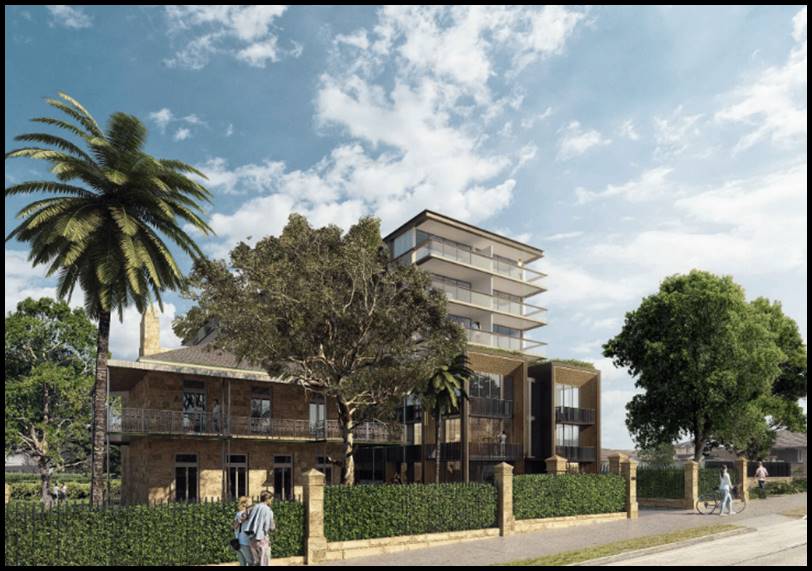
Figure 1: Photomontage of the proposed
development as originally designed and viewed from the Princes Highway frontage
Site
and Locality
7. This
application applies to land known as 2-6 Lacey Street, Kogarah Bay and 186-190
Princes Highway, Beverley Park. The development will consolidate the five (5)
existing sites into one integrated development site.
8. The
site is irregular in shape and has a frontage of approximately 76m to Lacey
Street, 39m frontage to Princes Highway and width of some 31m to Wyuna Street
at the rear. The total combined site area is 3,078sqm. Existing on site are a
series of four (4) older style dwelling houses and an old Victorian style
sandstone cottage that is a designated heritage item (noted as I3 in Schedule 5
of the Kogarah Local Environmental Plan). The heritage home is described as “house
and garden “McWilliam House” and sits on land known as Lots 5
and 6 DP17522 and is also referred to as “Sunnyside”.
9. The
site is located within a precinct that is currently transitioning from lower
scale residential properties to larger, medium density developments. The
subject site like many adjoining the Princes Highway have been upzoned to allow
for a greater intensity of development given their location. The site is
located within a generally residential precinct however the north-eastern side
of Princes Highway (across the road) includes a series of mixed uses and
smaller scale retail and commercial uses. To the south and south-east of the
site the land uses comprise of smaller scale, low density residential dwelling
houses which is an established housing environment not projected to change in
the immediate future.
10. The
site is located within close proximity to amenities such St George Leagues
Club, Carss Park and Kogarah (Netastrata) Oval.
Zoning
and Permissibility
11. The
subject site is zoned R3 Medium
Density Residential under the provisions of the Kogarah Local Environmental Plan 2012 (KLEP2012). The proposed Residential Flat
Building is permissible with consent. The existing heritage property is a
dwelling house which is also permissible with consent in this zone.
Submissions
12. The DA was notified to
neighbours in accordance with the Kogarah Development Control Plan 2013 (KDCP).
Fourteen (14) submissions were received. The issues raised include concerns
regarding additional construction noise, an increase in parking and traffic
congestion, privacy, design, concerns regarding the height, scale and bulk of
the scheme and overlooking issues. A few submissions were concerned about the
relationship of the proposal to the integrity of the heritage item. These
issues are discussed in greater detail later in this report.
13. The
two amended versions of the original scheme were lodged but not renotified as
the changes were improvements in the design and were in accordance with the
provisions of Part A2 (Public Notification), section 2.5 of the KDCP which
stipulates that “Where Council receives amended plans prior to
determination, Council will notify as follows: a) If an application is amended
prior to determination, it will be renotified if, in the opinion of the Council
officer, the amendments are considered to result in significant additional
environmental impacts.” The changes proposed did not create any
additional impacts and sought to improve the visual appearance of the
development and improve the relationship of the new works to the heritage item.
Reason for Referral to the
Local Planning Panel
14. This
application is referred to the Georges River Local Planning Panel for
determination as the proposal relates to a Residential Flat Building and the
provisions of the State Environmental Planning Policy – Design Quality of
Residential Flat Development applies and over ten (10) unique submissions were
received in response to the original application and the statutory
non-compliance exceeds 10% and the works involve demolition associated with a
heritage item.
Planning
and Design Issues
15. Council’s
Heritage Officer reviewed the proposal on two occasions (original scheme and
the final amended design). Concern was raised in respect to the three storey
podium section of the development facing Princes Highway and that this element
needed to be setback further so that the visual prominence of the Heritage Item
and its veranda would be maintained. This required a reduction in the floor
space and subsequent reconfiguration of the front units. Originally the new
development and three storey podium section was aligned with the front veranda
of the heritage item and setback some 12.5m from the street. The proposal was
amended so that this element is now setback further and sits 14.5m from Princes
Highway. The new podium structure is setback behind the veranda of the item so
that the visual significance of this stately home is retained when travelling
up and down Princes Highway. This will open up views to and from the item and
retain the visual and historical integrity of this building.
Council’s Heritage Officer also wanted some updated information regarding
the excavation of the car park along the eastern side and the method of
excavation in order to ensure structural stability of the Heritage home would
be maintained. In response to the design changes the Heritage Impact Statement
was updated.
16. The
latest comments provided by Council’s Heritage Advisor still raises
concerns regarding the siting of the RFB and would like the new building and
the podium pulled back. The proposed development will unquestionably alter
the visual backdrop and setting to the heritage item, with the proposed built
form resulting in a visually prominent structure that is significantly larger
in scale and form compared to the existing built forms of the streetscape. The
proposed oversized two-storey podium at the front of the building projects
forward of the front façade of the heritage item and with the proposed
setback to the tower above, the overall scale of the development competes with
the visual prominence of the heritage item. As previously recommended to the
applicant, the podium level should be revised to incorporate a deeper front
setback, so that no part of any blade wall or balcony projects beyond the front
façade of the building rather than the alignment of the front
verandah”. In relation to the upper levels it is suggested that
“the tower structure should be revised to also incorporate a deeper front
setback, so that it sits (at a minimum) behind the ridgeline of the roof to the
heritage item. The setbacks of the built form when viewed from Princes Highway
and Lacey Street are critical to ensuring the proposed building does not
visually obscure key sight lines to the heritage item, but also to ensure it
retains visual prominence within the streetscape as being clearly distinguished
as sitting further forward towards Princes Highway.”
17. A
condition has been imposed which seeks modification to the front podium design
in accordance with the heritage advice received and for this element (including
the balconies) to align with the front facade. Council Officers believe the
upper levels have been setback to be generally aligned with the ridge of the
Heritage Building and this setback is considered to be satisfactory. Any
further setback would translate the bulk further to the rear which is
undesirable and the mass would be incongruent when viewed from Lacey Street.
18. Originally
the development exceeded the 21m height limit with parts of the habitable areas
encroaching within the height limit. Council expressed concern and stated that
support would not be provided for any habitable spaces exceeding the control.
Only ancillary structures could be considered. The development has been amended
to reduce the height of the building and step its form a little more so that it
is slightly lower at the rear (Wyuna Street) by 1.6m. This will break up the
scale and form to some degree but it also allows for an additional communal
rooftop area for the rear building which will improve its functionality and
overall amenity for these units. The lift overrun and associated ancillary
structures exceed the height control however these are considered to be
acceptable and will not adversely affect the amenity of adjoining properties or
the streetscape. The Applicant has submitted a Clause 4.6 Statement which has
been assessed in detail as part of this report and is considered to be well
founded.
19. Council
Officers also expressed concern regarding the relationship of the rear of the
building along Wyuna Street. It is appreciated that the proposed three (3)
storey podium provides a better human scale relationship to this streetscape
given the southern side of the street is zoned R2 with a maximum height limit
of 9m and comprises mainly of lower scale residential dwelling houses. It was
recommended that the seven-storey component be lower at the rear so that it
steps down and creates a slightly better relationship with the lower scaled
properties to the south.
20. Detailed
Design Review Panel comments have been included later within this report. In
essence the DRP were not satisfied with the pre-lodgement development scheme
and the main issues with the original design lodged with the DA was that the
building setback from Princes Highway was still insufficient to provide
adequate sight lines through to the heritage item. The Panel also wanted to see
a distinct three storey base accentuated along all four elevations of the
building. The recommendations of the DRP have largely been integrated into the
amended designs and the design intent is now considered to be satisfactory.
21. The issues raised by the DRP have been resolved by the
latest set of amended plans as the Panel believed that the site planning and
built form and overall massing of the building is appropriate and a reasonable
planning and design response for the site.
22. The
amended plans have created a larger deep soil area as the basement car park has
been setback further from the western side, Lacey Street. Originally the
basement was setback 1.2m from this side boundary and the amended design has
increased this setback to 2.2m allowing for some more deep soil area. The
majority of the landscaped area and deep soil area has been retained around the
periphery and curtilage of the heritage item which is beneficial and maintains
the original context and setting of this building.
Conclusion
23. The application has been
assessed having regard to the Matter for Consideration under Section 4.15 of
the Environmental Planning and Assessment Act 1979, the provisions of the
relevant State Environmental Planning Policies, Local Environmental Plans and
Development Control Plans. The proposed siting, design scale, form and bulk of
the building is considered to be a reasonable planning and urban design
response for the site.
Report in Full
DESCRIPTION
OF THE PROPOSAL
24. The original development
proposed the demolition of existing structures and the construction of a seven
(7) storey RFB containing fifty (50) apartments and two (2) levels of basement
car parking for ninety-three (93) vehicles including the restoration and readaptation
of the existing heritage item. The final amended plans (Issue C) have altered
the configuration of some apartments and their layout but have retained the
proposed density.
25. In summary the main design
changes that have evolved into the final set of plans include the following
changes;
· The basement level has been setback from the south-western
side from 1.2m to 2.2m.
· Storage spaces have been moved from the north-western to
the north-eastern side to provide for more deep soil areas along the Lacey
Street frontage.
· The new podium level at the front facing Princes Highway
has been setback further from the street frontage to be setback 14.5m from the
front boundary and the front façade and design element is aligned with
the front verandah of the heritage item.
· The first floor layout has been reconfigured for apartments
BG05 and BG06 to allow for a greater front setback.
· Building A has been redesigned so that the main lobby area
which was off Lacey Street has been relocated off Wyuna Street. The internal
layout of some apartments has been altered to reduce the height of the building
along this side.
· As there is no direct formal access from Building A through
to the area of communal open space, the design has introduced a communal area
of open space on the roof for this part of the development accessed via the
lift.
· The overall parapet height of the new building has been
reduced and Building A at the rear is now stepped and 1.6m lower than that part
of the building (Building B) facing Princes Highway.
· The three (3) storey podium along Wyuna Street includes a
small recess where the lobby has been relocated.
· The overall floor space has been reduced from 1.85:1 to
1.80:1.
· The height non-compliance comprises of rooftop ancillary
structures (lift overrun, stairs and WC) with minimal parapet and roof
features. Along the eastern side (central area) there is a small encroachment
of the window glazing on the upper level.
26. The proposal includes the
demolition of four (4) freestanding dwelling houses (No.190 Princes Highway and
No.s 2, 4 and 6 Lacey Street) and their associated ancillary structures.
27. Further details of the proposed
design and layout of the development are as follows;
Basement 2 Plan
- Fifty-five (55) resident car parking spaces.
- Two Lift and stair lobbies
- Sixteen (16) bicycle parking.
- Fire stairs
Basement 1 Plan
- Thirty-eight (38) car parking spaces
comprising of the following;
§ Six (6) accessible spaces with shared zones
§ Eleven (11) visitor spaces (one spaces doubles up as a car wash bay)
§ Twenty-one (21) residents spaces
§ One designated turning bay located along the north-western side.
- One (1) designated Loading Bay
- Six (6) bicycle parking
- Designated storage spaces to most resident
spaces
- Fire access stairs
- Hydrant booster and pump room
- Two (2) lift and stair lobbies
- Two (2) separate bin storage rooms
- WC and associated ancillary services and
plant rooms
Ground Floor Plan
- Alterations and additions to the Heritage
Item (“McWilliams House”) capturing the
following works;
§ Internal works that will create a two storey, four (4) bedroom
apartment.
§ Rear section of the building is converted to communal spaces including
storage, gym, WC and communal kitchen with access to a large communal deck and
entertaining area.
§ Landscaping works around the periphery of the heritage item.
- The new building is divided into two (2)
distinct lobbies, Lobby B (that part of the development facing Princes Highway
and Lacey Street) and Lobby A (the rear part of the building with main
pedestrian access off Wyuna Street.
- Main vehicular access off the rear, Wyuna
Street.
- Building A – comprises of the
following;
§ 2 x 2 bedroom apartments
§ 1 x 1 bedroom apartment
§ 3 x 3 bedroom apartments
- Building B – comprises of the
following;
§ 3 x 3 bedroom apartments
§ 1 x 4 bedroom apartment
§ 1 x 1 bedroom apartment
§ 1 x 2 bedroom apartment
- Substation located along the south-western
corner of the site, adjoining the fire stair access.
- Private courtyards located on the outer edge
of the new building along all street elevations.
Level 1 Plan
- 2 x 2 bedroom apartment to Building B
- 1 x 1 bedroom apartment to Building A
- 1 x 3 bedroom apartment to Building A
- Two (2) lift lobbies
- Balconies to apartments
Level 2 Plan
- 2 x 2 bedroom apartments (Building B)
- 1 x 3 bedroom apartment (Building A)
- 1 x 1 bedroom apartment (Building A)
- Two (2) main lift lobbies
- Balconies to all apartments
Level 3 Plan
- 1 x 1
bedroom apartment (Building B)
- 2 x 2 bedroom
apartments (Building B)
- 1 x 3
bedroom apartment (Building B)
- 3 x 2
bedroom apartments (Building A)
- 1 x 1
bedroom apartment (Building A)
- Both parts
of the building along the north-western and south-eastern have been setback
behind the podium.
- Two (2) main
lift lobbies
Level 4-6 Plan (at each level)
- 1 x 1 bedroom apartment (Building B)
- 2 x 2 bedroom apartments (Building B)
- 1 x 3 bedroom apartment (Building B)
- 2 x 3 bedroom apartments (Building A)
- 1 x 2 bedroom apartment (Building A)
- Two (2) main lift lobbies and stair access
Roof Plan
- Roof top area of communal open space catering
for approximately 100sqm in area located along the southern side of the
building.
28. The proposal will require the
removal of a Jacarandah Tree, a street tree, two (2) palm trees on site and two
trees on the adjoining site at No. 21 Wyuna Street will require removal as they
will be affected by the development. The proposal also intends on consolidating
the development site. Formal permission has been granted by the owners of No.21
Wyuna Street for the removal of these trees and a condition relating to these
works is included.
BACKGROUND
29. On 16 April 2018 the
Applicant’s submitted a Pre-lodgement application (PRE2018/0020) to
Council. The development scheme was analysed and formal comments and a response
provided on 20 July 2018. The letter acknowledged that the Heritage Item
located on the site constrained future development and that the development
potential in terms of achieving the maximum floor space may not be achieved
given the item and its setting will have to be conserved.
30. In summary the following
planning, heritage and urban design issues were raised;
· The development needs to be sensitively designed and sited
so that the proposed development does not impede on the views to and from the
heritage building.
· The height of the new works needs to respect the location
and siting of the existing dwelling houses located to the south which are of a
low scale and are zoned R2 with their development potential limited to a 9m
height limit.
· The height of the new works needs to respect the location
and siting of the existing dwelling houses located to the south which are of a
low scale and are zoned R2 with their development potential limited to a 9m
height limit.
· Front setback and height to Wyuna Street to be consistent
with existing buildings and to harmonise with the character of development in
this residential street.
· Vehicular access off Lacey Street was preferred.
· The Heritage Advisor at this stage could not support the
proposal given its visual dominance and scale which will severely impact on the
significance and integrity of the item.
· Proposed materials, colours and finishes will need to be
reconsidered and be more sympathetic with the item.
· Council will not support any variations above the height
limit if they affect habitable areas.
· The preliminary design was referred to the Design Review
Panel for review. Their comments are addressed later in this report but in
summary they raised concern regarding the varying scale of the proposal, two
storey podium rising to three storey’s then to six and then eight
storey’s. This design approach was not supported by the Panel. They
emphasised the need to ensure the visual catchment of the heritage item is
maintained and its general curtilage. They suggested a series of changes be
implemented.
31. The Applicant has amended the
design to address the DRP and Heritage Advisors comments and the scheme is now
considered to be a suitable design and planning response for this Site.
DESCRIPTION
OF THE SITE AND LOCALITY
32. The subject site comprises of
five (5) allotments with the following legal descriptions;
· 186-188 Princes Highway (legally known as Lot 5 and 6 DP
17522)
33. This property contains the
designated Heritage Item of local significance (McWilliams House) and
associated outbuildings which comprise of a timber gazebo and metal sheds at
the rear (Photo1). The heritage home is a fine example of Victorian
Architecture as it has retained many of its original materials (sandstone) and
features which include intact window and door openings and also the
characteristic element of the wide verandah wrapping around the building.
Alterations to the original home have occurred at the rear in the form of a
single and two storey wing. The heritage status covers the two allotments as
the existing sandstone front fencing and main entry encroach and are located on
No.188. Combined the site area of these two lots is some 1,200sqm.
· No.190 Princes Highway (legally known as Lot 7 DP17522)
34. This property includes a single
storey, detached dark brick dwelling house with a separate garage structure
located off Lacey Street (Photo 7). The site area of this property is 605sqm
and it is generally a regular rectangular shaped allotment. It is characterised
by a series of Pine Trees located along the perimeter of the site.
· No.2 Lacey Street (legally known as Lot 8 DP17618)
35. Existing on site is a single
storey detached dwelling house with a separate carport structure at the rear
with a vehicular driveway located along the south-eastern side of the site. The
site area of this property is approximately 405sqm.
· No.4 Lacey Street (legally known as Lot 9 DP 17618)
36. Similar site characteristics to
No.2 Lacey Street are exemplified. The site area of this property is
approximately 405sqm and existing on site is a single storey detached rendered
cottage with a separate garage structure at the rear. Main access is off Lacey
Street (Photo 5).
· No.6 Lacey Street (legally known as Lot 10 DP 17618)
37. This property has its main
frontage to Wyuna Street with a detached garage located along the northern
side. Existing on site is a single storey, rendered dwelling house. The site is
generally regular in its shape and has a total site area of some 400sqm (Photo
2).
38. Combined, the five (5)
allotments have the following characteristics;
· Frontage width to Princes Highway of 38.785m
· Frontage width to Lacey Street of 75.885m
· Frontage width to Wyuna Street of 31.775m
· Total site area of 3,078sqm
Photo 1: Existing
front view of of the Heritage Item at 186 Princes Highway
Photo 2: Southern
elevation of No.6 Lacey Street
Photo 3: No.21
Wyuna Street to the south-east of the site
Photo 4: Properties
on the opposite (western side) of Lacey Street

Photo 5: No.
2-4 Lacey Street (part of the subject site)
Photo 6: Redevelopment
site (313-323 Princes Highway) on the opposite (northern side) of the subject
site

Photo 7: No.190
Princes Highway
Photo 8: Eastern neighbour No.184 Princes Highway
39. Immediately
to the north of the site, across the road, there are a variety of mixed land
uses along Princes Highway. These properties are zoned B2 which encourages
mixed land uses. Most recently a mixed use development was approved at
No.325-329 Princes Highway (DA2017/0491) (refer to Figure 2 below) located
across the road.
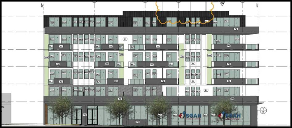
Figure 2: Front elevation of the approved development at
No.325-329 Princes Highway
40. Also
No.313-323 Princes Highway is currently under construction (refer to Photo 6)
and the Land and Environment Court approved a six storey mixed use development
with commercial premises on the ground floor (refer to Figure 3 below) at this
site.

Figure 3: Front
elevation of the approved development at No.313-323 Princes Highway
41. Immediately
to the south-east, south and south-west of the site are a variety of lower
scale residential dwelling houses of a single and two storey scale (refer to
Photo 6). This area is residential in nature and low scale in its character.
42. To
the east, No.184 Princes Highway is a single storey dwelling house with a
vehicular driveway off Princes Highway (refer to Photo 8). No.21 Wyuna Street
is a single storey dwelling house with its main access off Wyuna Street (refer
to Photo 3). Further to the east are similar smaller scale residential
properties which have not been redeveloped despite this block being upzoned.
Currently Council has a development application (DA2018/0516) for the
redevelopment of No.5-11 Wyuna Street for a seven (7) storey RFB. This
application is currently under assessment. Figure 4 below shows the montage of
the proposed front façade when viewed from Wyuna Street.
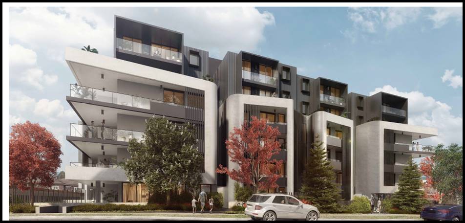
Figure 4: Front
elevation of the proposed development at No.5-11 Wyuna Street, Beverley Park (courtesy
Council records)
43. Council received a
pre-lodgement application (Pre2018/058) for the potential redevelopment of
No.13-21 Wyuna Street in November 2018. The pre-lodgement advice provided to
the Applicant suggested a major redesign was required to achieve a more
sympathetic scale and form at the front of the property. It was suggested that
a maximum four (4) storey podium section of the building be provided to Wyuna
Street with the upper levels be stepped back. This would achieve a better human
scale transition to the lower scaled residential dwelling houses across the
road to the south of the site. Figure 5 below shows the front elevation as
proposed by the pre-lodgement application.
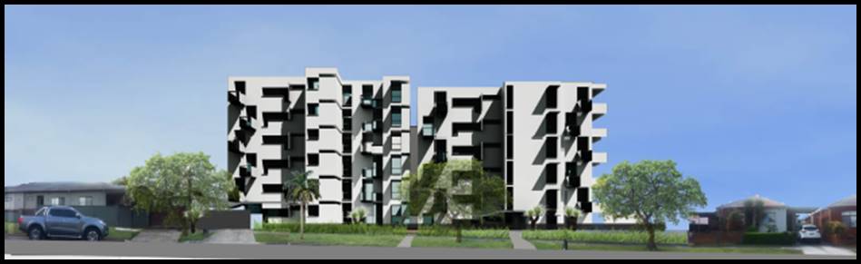
Figure 5: Front
elevation of the proposed development at 5-21 Wyuna Street (Pre2018/058) (courtesy
Council records)
44. Properties immediately to the
west of the site are generally undeveloped and contain single and two-storey
detached dwelling houses. The Land and Environment Court has recently approved
two development applications for new six (6) and seven (7) storey RFB’s
along John Street. Figure 6 and 7 below show the front façade of the
approved developments within this precinct. A new seven (7) storey RFB has also
been approved for No.198-200 Princes Highway (DA2017/0655). The block bounded
by John Street, Princes Highway, Lacey Street and Park Road has experienced
some more developments when compared to this block.
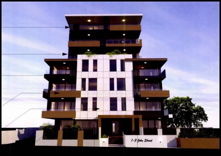
Figure 6: Front elevation of the approved
development at No.1-3 John Street, Beverley Park (DA2017/0218) (courtesy Council
records)
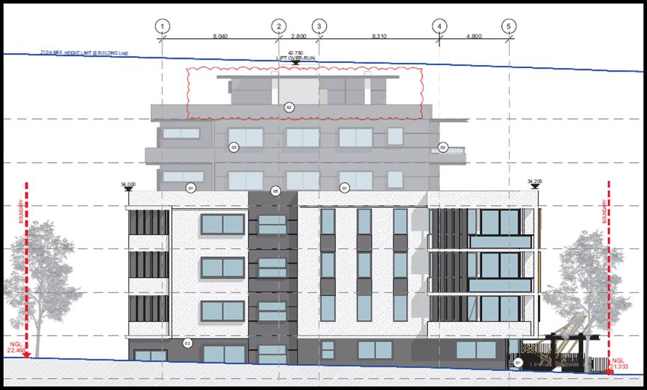
Figure 7: Front elevation of the approved RFB at
No.5-9 John Street, Beverley Park (DA2017/0663)
(courtesy Council records)
45. The site is not located within
close proximity to a major commercial centre; there are local retail and commercial
properties along Princes Highway which will be able to service the development
including the Shell Petrol Station, Red Rooster and other smaller scale
commercial/retail shops and restaurants. It is understood that the development
currently under construction at 313-323 Princes Highway is proposed to include
an Aldi Supermarket.
46. The immediate precinct is
undergoing a process of transition and transformation to larger scale medium
density residential developments and larger scale mixed use developments along
Princes Highway.
State
Environmental Planning Policies
47. Compliance
with the relevant state environmental planning policies is summarised in table
1, and discussed in more detail below.
Table 1: Compliance with State Planning Policies
|
State Environmental Planning
Policy
|
Compliance
|
|
Greater Metropolitan Regional
Environmental Plan No 2 – Georges River Catchment
|
Yes
|
|
State Environmental
Planning Policy (Building Sustainability Index: BASIX) 2004
|
Yes
|
|
State Environmental Planning
Policy No 55 - Remediation of Land
|
Yes
|
|
State
Environmental Planning Policy (Vegetation in Non-Rural Areas) 2017
|
Yes
|
|
State Environmental Planning
Policy (Infrastructure) 2007
|
Yes
|
|
State
Environmental Planning Policy No 65—Design Quality of Residential Apartment Development
|
Yes – there are a non-compliances with the ADG
provisions but these are considered acceptable and are detailed in the body
of this report.
|
Greater Metropolitan Regional
Environmental Plan No.2 – Georges River Catchment
48. The main aims and objectives of
this plan are (not limited to);
· to maintain and improve the water quality and river flows
of the Georges River and its tributaries and ensure that development is managed
in a manner that is in keeping with the national, State, regional and local
significance of the Catchment,
· to protect and enhance the environmental quality of the
Catchment for the benefit of all users through the management and use of the
resources in the Catchment in an ecologically sustainable manner,
· to ensure consistency with local environmental plans and
also in the delivery of the principles of ecologically sustainable development
in the assessment of development within the Catchment where there is potential
to impact adversely on groundwater and on the water quality and river flows
within the Georges River or its tributaries,
· to establish a consistent and coordinated approach to
environmental planning and assessment for land along the Georges River and its
tributaries and to promote integrated catchment management policies and
programs in the planning and management of the Catchment,
49. The
originally proposed stormwater and drainage arrangement was referred to
Council’s Engineers who raised concerns with the proposed design. Their
comments stated;
“After
an engineering review, the submitted drainage plans are not found to be
adequate and are not supported. As a result, the following engineering
issues are to be addressed:
· It is
consistently required to submit the stormwater Web-base calculator summary
sheet for the proposed development’s site. http://www.georgesriver.nsw.gov.au/Development/Planning-Controls/Development-Policies
· It is
required for the concept drainage plan with the OSD system to be prepared in
accordance with the results and the requirements of Council’s stormwater
web-base calculator after generating the site Stormwater Management Report.
· Any
proposed location of an OSD tank shall not be within a habitable space and the
headroom clearance shall be indicated on the plan.
· The
basement tank shall be designed to accommodate a minimum 6.0m3 to accommodate
the seepage.
Unsustainable Connection
into Street System
· The connection
of the proposed site stormwater discharge pipe into Council’s pit in
Lacey Street is not possible and is not feasible. The depth of the pit
was measured on site to be 480mm, meanwhile the plans are assuming the pit
depth (19.30-18.05= 1.25m) which cannot be achieved and the proposed drainage
system cannot drain by gravity. It is required for the invert level of the
street pit to be surveyed by a registered surveyor and the length of the
proposed pipe in the road to be accurate.”
50. Amended
hydraulic plans were submitted to Council in August 2019 and referred to
Council’s Engineers for comment. They are now satisfied with the
stormwater drainage arrangement subject to the imposition of conditions.
State Environmental Planning
Policy (Building Sustainability Index: BASIX) 2004
51. The original BASIX Certificate
was updated to reflect the latest amended plans (Issue C) and is No.974294M_04
dated 2019. The development meets the provisions and minimum requirements of
BASIX in terms of water, thermal comfort and Energy efficiency.
State Environmental Planning
Policy No 55 - Remediation of Land
52. SEPP
55 aims to promote the remediation of contaminated land in order to reduce the
risk of harm to human health or any other aspect of the environment.
53. Clause
7 requires contamination and remediation to be considered in determining a
development application. The consent authority must not consent to the carrying
out of development on land unless it has considered whether or not the land is
contaminated.
54. A review of the site history
indicates that the site has been used for residential purposes for
extended periods of time. A Geotechnical Report was prepared by Morrow
Geotechnical Consultants dated 9 October 2018. The Morrow assessment relied on finding
from four (4) boreholes across the site. The report found that the subsurface
conditions include “generally fine to coarse grained clayey sand or
sand with clay, silt and gravel… and generally fine to course grained
sand with clay and traces of sandstone gravel”.
55. A Preliminary Site
Investigation report was prepared by Dirt Doctors dated 5 November 2018. The
report relies on historical data and photographic observations which indicate
that the sites have been used for residential purposes since 1947 (and earlier
given the development and construction of the Heritage property dating back to
before 1870. The preliminary assessment has not found any evidence of the
properties being used for any other land uses.
56. There are two areas of
potential concern which could give rise to some form of contamination. These
being leaks from car parking areas and potential spills and uncontrolled fill
beneath existing driveways and structures.
57. The report concludes that
“based on the findings of the investigation it is considered that the
risk to human health and environment associated with soil and groundwater
contamination is low to moderate in relation to the proposed development for
the subject site. The subject site is therefore suitable for the proposed
development in its current state and no further investigation is recommended or
required”.
58. The report recommends that if
the application is approved the following measures are to be conducted to
ensure the site is suitable for the redevelopment;
· Site investigation by Dirt Doctors post demolition, to
identify any potential areas of contamination;
· Preparation of a clearance certificate if asbestos is
identified.
59. The report and its recommendations will be conditioned as
part of the consent is granted. A standard condition relating to unexpected
finds is also included as part of the consent.
State Environmental Planning
Policy (Infrastructure) 2007
60. The aim of the Policy is to
facilitate the effective delivery of infrastructure across the State. The
Policy also examines and ensures that the acoustic performance of buildings
adjoining a rail corridor or busy arterial road is acceptable and internal
amenity within apartments is reasonable given the impacts of adjoining
infrastructure development.
61. Clauses 101 (Development with a
frontage to a classified road), 102 (Impact of road noise or vibration on
non-road development) and 103 (Excavation in or immediately adjacent to
corridors) of the SEPP, are relevant to this DA on the basis that the proposal
involves the construction of residential accommodation on land adjacent to the
road corridor of Princes Highway (having an annual average daily traffic volume
exceeding 20,000 vehicles) and is likely to be adversely affected by road noise
and/or vibration.
62. The application was referred to
Roads and Maritime Services (RMS) for comment as Princes Highway is an arterial
road under their jurisdiction and RMS concurrence is required in accordance
with Clause 101 of the Infrastructure SEPP. On 20 December 2018, RMS provided a
formal response and raised no objection to the proposed development subject to
the imposition of standard conditions which are included as part of the consent
if approval is granted.
63. Clause 102 of the SEPP is
relevant and states:
(3) If the development is for the purposes of
residential accommodation, the consent authority must not grant consent to the
development unless it is satisfied that appropriate measures will be taken to
ensure that the following LAeq levels are not exceeded:
(a) in
any bedroom in the residential accommodation—35 dB(A) at any time between
10 pm and 7 am,
(b) anywhere
else in the residential accommodation (other than a garage, kitchen, bathroom
or hallway)—40 dB(A) at any time.
64. An
Acoustic report was submitted with the application prepared by Rodney Stevens
Acoustics, dated 26 October 2018. The report addresses traffic noise impact
from Princes Highway in addition to any potential noise intrusion from the
other neighbouring roads to the east and west on the amenity of the proposed
residential development. The acoustic assessment was based on the results from
one (1) logger located at the corner of Lacey Street and the Pacific Highway.
This intersection is considered to be the noisiest part of the Site. Although
the Infrastructure SEPP stipulates minimum noise standards but only focuses on
bedroom areas. The Draft Guidelines (Development near Rail Corridors and
Busy Roads – Interim Guideline) include noise levels to be achieved
for other habitable areas (living and dining spaces, excluding kitchens,
garages, hallways etc) of 40dB(A) at anytime.
65. The
noise results at the logger were 68dB(A) between 7:00 to 22:00 and 65dB(A) from
22:00 to 7:00. In order to achieve the 35dB(A) requirement for bedrooms and
40dB(A) requirement for other habitable areas, a series of noise attenuation
treatments are required. The acoustic report recommends the following
treatments;
- Bedrooms
to include carpet and underlay
- Living
rooms could have hard floors
- Kitchens
and wet areas could be tiled.
- Glazing
will vary from room to room and Building B which faces Princes Highway will
require double glazing and a higher rating of glazing as the elevations will be
exposed to more noise than Building A which faces Lacey and Wyuna Streets and
is setback from the main noise source (Princes Highway)
- Framing
treatments are also proposed and timber frames are not encouraged as these have
low acoustic performance.
- Mechanical
ventilation will be required to be installed.
- Well
detailed construction and installation will be required.
66. Mechanical
Plant has not been selected or identified on the plans in terms of its type,
form and location. It is likely that mechanical plant servicing the development
will consist of residential condenser units for the air conditioning system and
ventilation fans for the basement car park and garbage exhaust. The proposed
system will need to satisfy Council’s requirements and those stipulated
by the National Construction Code and AS1668.2-2002 (The use of ventilation and
air conditioning).
67. If
the development is approved a condition on the consent will require the
recommendations of the acoustic report to be implemented during the
construction of the building and appropriately certified to be consistent with
the recommendations of the acoustic report after installation and prior to
occupation. Relevant conditions are imposed to ensure this occurs if approval
is granted.
68. When
considering the impact of the development on the Princes Highway, the
generation of traffic onto this roadway is important to consider the general
traffic movements. The development proposes a driveway along the eastern
boundary with driveway access from Wyuna Street. This arrangement removes a
total of three (3) driveway crossovers along Lacey Street making these
redundant and creating a minimum of two (2) on street car parking spaces. In
addition the driveway access to the heritage home off Princes Highway will be
made redundant (but maintained as a main entrance). When considering the
traffic that is generated by the development, a Traffic and Parking Assessment
Report has been prepared by Varga Traffic Planning, dated 5 November 2018. The
assessment determines and considers traffic generation produced by the development
and bases its assessment on the RMS Guidelines for Traffic Generating
Developments. In accordance with Section 3 of the guidelines, the development
is classed as a “high density residential flat building” and based
on the density proposed it will generate 10 vehicular trips per hour (vph)
during the AM peak and 8 vph in the PM peak. When an offset is applied for the
existing dwellings that generate traffic movements, the actual increase is 6
vph in the morning and 4vph in the afternoon. The traffic generation proposed
is considered reasonable and will not have any adverse impacts on adjoining
streets.
69. The
provisions and requirements of the Infrastructure SEPP have been addressed and
satisfied by the proposal.
Draft Remediation of Land SEPP
70. The
Department of Planning and Environment has announced a Draft Remediation of
Land SEPP, which will repeal and replace the current State Environmental
Planning Policy No 55—Remediation of Land.
71. The
main changes proposed include the expansion of categories of remediation work
which requires development consent, a greater involvement of principal
certifying authorities particularly in relation to remediation works that can
be carried out without development consent, more comprehensive guidelines for
Councils and certifiers and the clarification of the contamination information
to be included on Section 149 Planning Certificates.
72. Whilst
the proposed SEPP will retain the key operational framework of SEPP 55, it will
adopt a more modern approach to the management of contaminated land. The Draft
SEPP will not alter or affect the findings in respect to contamination at the
Site as previously discussed.
State Environmental Planning
Policy (Vegetation in Non-Rural Areas) 2017
73. The
Vegetation SEPP regulates clearing of native vegetation on urban land and land
zoned for environmental conservation/management that does not require
development consent.
74. The
Vegetation SEPP applies to clearing of:
(a) Native
vegetation above the Biodiversity Offset Scheme (BOS) threshold where a
proponent will require an approval from the Native Vegetation Panel established
under the Local Land Services Amendment Act 2016; and
(b) Vegetation
below the BOS threshold where a proponent will require a permit from Council if
that vegetation is identified in the council’s development control plan
(DCP).
75. The
Vegetation SEPP repeals clause 5.9 and 5.9AA of the Standard Instrument -
Principal Local Environmental Plan with regulation of the clearing of
vegetation (including native vegetation) below the BOS threshold through any
applicable DCP.
76. An
Arboricultural Impact Appraisal was prepared by Naturally Trees dated 5 October
2018. This report considers the importance of all trees existing on site. There
are a total of some twenty-six (26) trees scattered across the development site
with four (4) trees outside the site boundaries. Many of the trees are exotic,
introduced species and are smaller and not significant from a visual or
environmental perspective. A total of twenty-five (25) trees are proposed to be
removed and five (5) important trees are to be retained. Figure 8 below shows
the trees that are scattered across the site and identifies whether the tree is
to be retained or removed. A detailed schedule within the report assesses each
tree individually.
Figure 8: Shows the location of all trees on site,
those in red are proposed to be removed and those in green are to be retained
and a TPZ included. (courtesy Arborist report by Naturally Trees, 2018)
77. The
species of greatest significance and importance are located adjacent to the
Heritage Item which enhance the garden setting and context of this property.
The following trees adjoining the item that will be retained include;
- Tree
26 Narrow leaved peppermint (Eucalyptus nicholii) which is mature and
established tree which has a height of 18m and is rated of “high”
significance
- Tree
27 Palm Tree (Phoenix sp.) This is an established palm tree reaching a
height of some 9m and is rated of medium significance.
- Tree
28 Weeping Fig Tree (Ficus benjamina) which has an overall height of 8m
and has been rated of medium significance.
- Tree
29 Camphor Laurel Tree (Cinnamomum camphora) which has an overall height
of 15m and is classified as medium significance.
78. These
trees are important and create the visual context and landscape setting that
the heritage item is located within. The formal garden setting includes a
distinct hedge and sandstone fencing. There is a palm tree (Phoenix sp) located
within the front yard of the heritage item that is proposed to be removed. This
tree is rated of low significance and does not contribute highly to the quality
and scenic value of the established garden. It is also located within close
proximity to the Peppermint Tree and could affect the integrity and longevity
of this tree.
79. The
other trees to be removed include a Jacaranda tree which is centrally located
and its integrity will be affected by the footprint of the building. It is
rated of low significance. Along the perimeter of No.190 Princes Highway along
the front and western side of the Site there are a series of fourteen (14) Pine
Trees (Cupressus sp) which are mature and vary in height from 3-9m. The
trees have been planted in a row and are visually characteristic features of
this property when considered in isolation. In totality the Pine Trees are of
low significance and are uncharacteristic landscape elements. The street tree
along Wynua Street a Bottlebrush (Callistemon sp) will require removal
to cater for the new driveway. It is proposed to be replaced with a new street
tree in accordance with Council’s requirements and has been addressed by
way of a condition if consent is imposed. The three (3) other Palm Trees
located within the development site and the Pine tree at the front of No.2
Lacey Street are proposed to be removed as they will be affected by the
building footprint. They are not important trees and will be compensated by
more attractive trees to be planted in a consolidated manner along the Lacey
Street frontage within the development site. Trees No.1 and 2 which are Pines (Cupressus
sp) are located within the boundary of No.21 Wyuna Street. They have been
assessed as having dieback, an infection which affects some 40% of native plant
species. The building footprint will further affect the livelihood of these
trees. The owners of No.21 Wyuna accept and grant permission for the removal of
the trees and provided formal written permission for the removal of these trees
with correspondence dated 16 April 2019.
80. Taylor
Brammer Landscape Architects have prepared a consolidated landscape design for
the proposal. The plan proposes a substantial number of new trees to be planted
around the periphery of the building. There are a total of five (5) new large
trees (Sydney Red Gum and Scribbly Gum) which will achieve heights of between
12m-15m. Three (3) Scribbly gums are proposed at the front adjoining Princes
Highway to assist in screening the building and creating a green tree lined
development.
81. The
Landscape Plan intends or largely retaining the existing garden setting around
the heritage item but enhancing and creating a more formalised and attractive
garden. The existing front fence and associated hedges will be retained and a
new hedge planted along the north-eastern side of the dwelling. Other
landscaping and planting aims to fill in spaces where smaller, formal plants
could be introduced.
82. The
focus of new planting is predominantly centrally within the site and the Lacey
and Wyuna Street frontages. Along Lacey Street the private courtyards will be
softly landscaped with a variety of lawn, paving and planter boxes and there
will be a row of sixteen (16) cabbage palms which reach a mature height of 12m
generally consistent with the three storey podium section along this side. A
total of six (6) Water Gums are proposed on the street. Currently there are no
street trees so the development will improve the streetscape appearance. Along
Wyuna Street three (3) new Sydney Red Gums are proposed along the street and a
further five (5) Cabbage Palms are proposed within the site. Centrally apart
from a series of planter boxes with varying shrubs and ground covers, three (3)
Tupelo Trees are proposed which grow to 11m. The proposed landscape plan is
shown in Figure 9 below and is a well-considered and designed scheme.

Figure 9: The proposed landscape plan showing the
existing trees and new plantings which are focused around the periphery of the
site (courtesy TaylorBrammer, 2018)
Draft Environment SEPP
83. The Draft Environment SEPP
was exhibited from 31 October 2017 to 31 January 2018. This consolidated SEPP
proposes to simplify the planning rules for a number of water catchments,
waterways, urban bushland, and Willandra Lakes World Heritage Property.
84. Changes proposed include consolidating the following seven
existing SEPPs:
· State Environmental Planning Policy No. 19 – Bushland
in Urban Areas
· State Environmental Planning Policy (Sydney Drinking Water
Catchment) 2011
· State Environmental Planning Policy No. 50 – Canal
Estate Development
· Greater Metropolitan Regional Environmental Plan No. 2
– Georges River Catchment
· Sydney Regional Environmental Plan No. 20 –
Hawkesbury-Nepean River (No.2-1997)
· Sydney Regional Environmental Plan (Sydney Harbour Catchment)
2005
· Willandra Lakes Regional Environmental Plan No. 1 –
World Heritage Property.
85. Subject to the
resolution of stormwater/drainage issues and the design, the proposal is not inconsistent with the provisions of this
Draft Instrument.
State
Environmental Planning Policy No 65—Design Quality of Residential Apartment Development
86. State Environmental Planning
Policy No.65 – Design Quality of Residential Flat Buildings (SEPP
65) was gazetted on 26 July 2002 and applies to the assessment of DAs for
residential flat developments of three or more storeys in height and containing
at least four dwellings. Amendment 3 to SEPP 65 commenced on 17 July 2015 and
implemented various changes including the introduction of the Apartment Design
Guide (ADG) to replace the Residential Flat Design Code. Given the nature of
the development proposed, SEPP 65 applies.
87. Clause 28(2) of SEPP65 requires
that the consent authority take into consideration the following as part of the
determination of DAs to which SEPP 65 applies:
a) the advice (if any) obtained from
the design review panel, and
b) the design quality of the
development when evaluated in accordance with the design quality principles,and
c) the Apartment Design Guide.
88. The proposal was referred to
the Georges River Design Review Panel (DRP) on two (2) occasions. The
pre-lodgement application was reviewed by the DRP on 5 July 2018 whereby the
Panel suggested the overall modelling and built form be amended and the
prominence of the Heritage Item be enhanced by the scale and siting of the new
works and a better transition in scale provided to the rear. The panel did not
support an exceedance in the height based on the heritage item being retained.
Comments were also made about the landscaping response and the provision of
planting and greenery to distinguish between the established garden setting and
the new landscaping works. These issues were considered when preparing the Development
Application and the proposal modified. Pre-lodgement comments are included in
italics in Table 3 below.
89. The DRP Panel considered the
development application proposal on 14 February 2019 and the Panel assessed the
development against each of the nine (9) Design Quality Principles and also
considered the provisions within the Apartment Design Guide (ADG). The Panels
comments are summarised and addressed in Table 3 below (in bold). The
recommendation from the meeting was that “The Panel
supports the application subject to the issues raised above being resolved. The
application satisfies the design quality principles contained in SEPP
65.” The plans have been subsequently amended on two occasions to
address the Panels, Heritage Advisor’s and Council’ Officers
concerns.
Table
2: Application of SEPP 65
|
Clause
|
Standard
|
Proposal
|
Complies
|
|
3 - Definitions
|
Complies with definition of “Residential Apartment
Development” (RAD)
|
Complies with definition
|
Yes
|
|
4 - Application of Policy
|
Development involves the erection of a new RFB,
substantial redevelopment or refurbishment of a RFB or conversion of an
existing building into a RFB. The definition of an RFB in the SEPP includes
mixed use developments.
|
Erection of an RFB which satisfies the SEPP’s
definition of this residential land use.
|
Yes
|
|
Design Verification
|
Design verification statement provided by qualified
designer
Registered Architect Name and Registration No.
|
Design Verification Statement provided by Registered
Architect: Paul Buljevic (Registration No.7768)
|
Yes
|
Table 3: Part 2 Design Quality Principles under the SEPP
|
SEPP
65 – Design Quality of Residential Flat Buildings
|
DRP
Comment
|
Planners
comment
|
|
Context and Neighbouring
Character
Good
design responds and contributes to its context. Context is the key natural
and built features of an area, their relationship and the character they
create when combined. It also includes social, economic, health and
environmental conditions.
Responding
to context involves identifying the desirable elements of an area’s
existing or future character. Well designed buildings respond to
and enhance the qualities and identity of the area including the adjacent
sites, streetscape and neighbourhood.
Consideration
of local context is important for all sites, including sites in established
areas, those undergoing change or identified for change.
|
The site is located on the corner of the Princes Highway, Lacey
Street and Wyuna Street. It has a local listed heritage item - ‘The
Sunnyside’ residence and associated gardens. The site has a modest fall
from the rear eastern corner and is a very large land holding of over
3000sqm.
The site is zoned R3 and is adjacent to R2 zoned areas on the
other side of Wyuna Street. Although the site is generous in scale the
significant heritage item has to be carefully considered to provide an
appropriate curtilage. Furthermore the development has to consider the
transition in height and scale between zones.
There are a number of established trees on the site primarily
within the Sunnyside gardens. There are no street trees on Princes Highway or
Lacey Street frontage and there are overhead power lines located on all three
(3) frontages.
It is noted that Council’s Heritage Planner has provided
additional advice to the applicant in regard to the setback and relationship
of the proposed development on the Princes Highway frontage.
|
The
proposal has been amended on two occasions after advice received by the
Panel. On the first occasion the three storey podium element to Princes
Highway has been modified and the “angled” structural wings have
been reduced and the front setback of the building is now located behind the
front verandah of the heritage building. This opens up more views to and from
the home and reinstates its visual prominence to a large degree. The amended
design satisfies the Panel’s and Heritage Advisors request.
Council
Officers raised further concern regarding the transition of the built form
and scale to the rear and requested the upper level which exceeded the height
will need to be reduced and the height is to comply. It was requested that
the building step up to Princes Highway. The Applicant amended the design to
address this issue.
|
|
Built
Form and Scale
Good
design achieves a scale, bulk and height appropriate to the existing or
desired future character of the street and surrounding buildings.
Good
design also achieves an appropriate built form for a site and the
building’s purpose in terms of building alignments, proportions,
building type, articulation and the manipulation of building elements.
Appropriate
built form defines the public domain, contributes to the character
of streetscapes and parks, including their views and vistas, and
provides internal amenity and outlook.
|
The proposal provides for a two (2) storey element at the corner
of Princes Highway and Lacey Street to recognise the scale and presence of
the heritage item, then steps up to three (3) storeys, then six (6) storeys,
then eight (8) storeys creating an unyielding built form. The Panel is of the
view that it is more important to respect the visual curtilage of the
heritage item than to have a two (2) storey element at the north end of the
building. It was suggested that a greater setback from Princes Highway would
achieve better visibility to the heritage item and that the lowest element of
the building should be entirely three (3) storeys. The Panel recommends that
there be a building alignment setback of 9m from the Princes Highway boundary
to provide a line of sight to the front facade of the heritage item from the
footpath at the corner of Princes Highway and Lacey Street.
The design has been adjusted to provide an increased setback from
Princes Highway of 13m from the site boundary, which is satisfactory. The
proposal includes two (2) x three (3) storey townhouses which then transition
into a seven (7) storey building with the upper level setback another 4m. The
Panel believes this setback is insufficient and should be increased to a line
corresponding to the position of the party wall on the south east side
between the terraces and Unit BG04 which is approximately 25m from the front
boundary. This advice is consistent the last sentence of the second paragraph
of the Panel’s previous minutes which has been highlighted below. The
consequence would be a reduction in GFA but not a reduction in the number of
units, simply unit area.
The Panel concurs with the recommendation by James Stephany in a
memo to Council on 4 June 2018 that the building be remodeled to break up the
treatment of the elevations with a distinct base, body and parapet roof line
element. The three (3) storey component as suggested would establish the base
for the northern part of the building. The taller part of the building to the
south has a four (4) storey base element on its north east side which could
be carried around the Wyuna and Lacey Street frontages. The three (3) storey
element adjacent to the heritage item needs to be articulated to complement
with the lightness of the heritage items balconies.
The Panel reiterates its support for James Stephany’s
recommendation above to achieve a distinct three (3) storey base on all four
(4) elevations.
The applicant proposes an exceedance of the height control to
compensate for providing a lower scale building adjacent to the heritage
item. While the Panel applauds the response to the heritage item, exceedance
of the height control would have significant impacts on the adjacent R2 zoned
properties due to a bulk and scale that would be in excess of the permissible
controls. The permissible controls would already be of concern in this
regard. The Panel does not support any argument for exceeding the height
control to maintain the full extent of the permissible FSR.
The applicant’s tabled drawings comparing the impacts of
their envelope height (which exceeds the permissible height of 21m). The
amendments to the building envelope have improved this marginally. Adopting
the recommendations above would further improve this condition. The Panel
accepts the exceedance of height to the south of the building on the proviso
that the amendments to the building envelope at the northern end are adopted
as noted above.
|
The
building has been setback even further than the 13m, up to 14.5m at the front
to open up the view lines through to the heritage property.
The
Panel also wanted a greater setback from the upper levels to the street. The
upper levels have been setback so that Level 4 and above is setback over 25m
from the Princes Highway street frontage.
|
|
Density
Good
design achieves a high level of amenity for residents and each apartment,
resulting in a density appropriate to the site and its context.
Appropriate
densities are consistent with the area’s existing or projected
population. Appropriate densities can be sustained by existing or proposed
infrastructure, public transport, access to jobs, community facilities and
the environment.
|
Refer comments above under ‘Built Form’.
Acceptable based on comments above.
|
The
proposal is well within the maximum GFA and FSR of 1.5:1 that is allowable
for this site.
|
|
Sustainability
Good
design combines positive environmental, social and economic outcomes.
Good
sustainable design includes use of natural cross ventilation and sunlight for
the amenity and liveability of residents and passive thermal design
for ventilation, heating and cooling reducing reliance on technology and
operation costs. Other elements include recycling and reuse of materials and
waste, use of sustainable materials and deep soil zones for groundwater
recharge and vegetation.
|
Not discussed at this time.
Solar access and cross ventilation to units appears to be satisfactory.
Remains satisfactory. However redistributing deep soil would
improve streetscape, microclimate and amenity.
|
Alterations
to the basement design which include relocating the storage spaces from the
western side to the eastern side have increased the amount of deep soil area
from1.2m originally proposed to 2.2m along this side (Lacey Street frontage).
This will allow for better plantings and landscape treatment to be
introduced. As previously mentioned a series of Cabbage Palms are proposed along
this side and a series of street trees will also be introduced which will
improve the visual appearance of the development.
|
|
Landscape
Good
design recognises that together landscape and buildings operate as
an integrated and sustainable system, resulting in attractive developments
with good amenity. A positive image and contextual fit of well
designed developments is achieved by contributing to the landscape
character of the streetscape and neighbourhood.
Good
landscape design enhances the development’s environmental performance
by retaining positive natural features which contribute to the local
context, co-ordinating water and soil management, solar access,
micro-climate, tree canopy, habitat values and preserving green networks.
Good landscape
design optimises useability, privacy and opportunities for social
interaction, equitable
access, respect for neighbours’ amenity and
provides for practical establishment and long term management.
|
The design proposes a retention of the landscape space to the
heritage item which is critical to maintaining the context of this building
as well as providing amenity for the proposed development. The landscape
should consider providing trees as an interface in the space between the
heritage item and proposed units. These trees should setback from the front
corner of the building to maintain sight lines.
This requires further review. While the building has been setback
the landscape has not adequately addressed the condition of the adjacent
landscape to the Heritage Item.
Furthermore the basement configuration has not consolidated deep
soil in the appropriate location – on the Princes Highway frontage and
the Lacey Street frontage. There is potential to redesign the basement to
reduce deep soil in areas that are less significant, such as in the middle
section of the site directly behind the Heritage Item, in order to provide
more deep soil in the Princes Highway 9m setback and along sections of Lacey
Street. The minimum width of 3m should be provided at multiple locations to
provide capacity for tall trees.
Roof top communal open space is also supported. Detailed design
development needs to consider the functionality of this facility including
provision of a WC, effective landscaping, shade and shelter.
Communal open spaces have not been provided on the roof but have
been proposed at ground level behind the heritage building. The applicant is
proposing that the heritage building be occupied by a private dwelling with
the rear wing of the building to accommodate communal facilities including
kitchen, toilets, gym, BBQ area. Whilst this use is commendable, this still
would provide insufficient space for residents. It is recommended that the
setback along the Princes Highway frontage be sensitively designed to
accommodate more space for residents to use. This may be for quiet
activities, such as bench seating, gardens, etc. Private open space should be
carefully integrated to provide appropriate privacy between communal and
private external spaces.
The site benefits significantly from three (3) street frontages.
However the overhead power lines significantly impact on the capacity to
provide appropriate scale trees. The design should include streetscape
upgrades and substantial tree planting within the site boundary adjacent to
the street. This tree planting should be of an appropriate scale (over 10m
high) to mitigate the height of the development and to provide an attractive
landscape edge.
Refer comments above. The current proposals of Palm trees and
Scribbly gums would not be of an appropriate scale or canopy for this built
form and wide street. Alternate tree species should be proposed (tall trees
with wide canopies).
|
Refer
to notes above.
Whilst
the Panel raised concern regarding the installation of Scribbly Gums and
Cabbage Palms as they wanted larger trees however Council’s Landscape
Officer is satisfied with the plant species proposed. The above ground power
lines will severely restrict street trees reaching their full potential and
it is recommended by way of a condition that the services be located below
ground that way the trees will not be obstructed and a better streetscape
outcome will occur.
Rooftop
communal open space has been included in Building A as access to the ground
floor area of communal open space is convoluted. This satisfies the DRPs
comments.
Although
the KDCP does not include controls regulating the removal of
telecommunication lines and placing them below ground a standard condition is
imposed which requires the applicant to consider their relocation. This would
create a substantial improvement in the appearance of the development of the
streetscape and ensure street trees can reach optimal heights without
pruning.
|
|
Amenity
Good
design positively influences internal and external amenity for residents
and neighbours. Achieving good amenity contributes to positive living
environments and resident well-being.
Good
amenity combines appropriate room dimensions and shapes, access to sunlight,
natural ventilation, outlook, visual and acoustic privacy, storage, indoor
and outdoor space, efficient layouts and service areas and ease of access for
all age groups and degrees of mobility.
|
It was noted that some units are lacking in storage. The
application should be accompanied by a table showing compliance with the ADG
requirements for each unit. The Panel notes that a single lift serves 55
units. Although the ADG guidelines require more than one (1) lift for ten
(10) storeys and over serving 40 units, the Panel believes that in practical
terms the number of units is a more critical measure than the number of
storeys. One (1) lift is insufficient in circumstances where it is out of
action and disabled people live in adaptable units above ground floor level.
It is strongly urged that two (2) lifts be provided.
Storage is now provided in all units. There are two (2) lifts in
the amended proposal.
|
Satisfactory
and DRP comments addressed through amended plans.
|
|
Safety
Good
design optimises safety and security within the development and the public
domain. It provides for quality public and private spaces that are clearly
defined and fit for the intended purpose.
Opportunities
to maximise passive surveillance of public and communal areas promote
safety.
A
positive relationship between public and private spaces is achieved through
clearly defined secure access points and well-lit and visible areas that are
easily maintained and appropriate to the location and purpose.
|
Generally satisfactorily.
Bollards should be provided to protect the basement lift lobbies.
Acceptable. The lifts have been
rearranged and do not require bollards.
|
Issues raised by the DRP have been addressed with amended
plans.
|
|
Housing
Diversity and Social Interaction
Good
design achieves a mix of apartment sizes, providing housing choice for
different demographics, living needs and household budgets.
Well-designed apartment
developments respond to social context by providing housing and facilities to
suit the existing and future social mix.
Good
design involves practical and flexible features, including different types of
communal spaces for a broad range of people and providing opportunities for
social interaction among residents.
|
Acceptable
No further comment
|
Satisfactory
|
|
Aesthetics
Good
design achieves a built form that has good proportions and a balanced
composition of elements, reflecting the internal layout and structure. Good
design uses a variety of materials, colours and textures.
The visual
appearance of a well-designed apartment development responds to the
existing or future local context, particularly desirable elements and
repetitions of the streetscape.
|
See comments above
The Panel recommends that the three (3) storey elements should
complement the Heritage Item and its surrounding context. This would suggest
painted render with timber and/or iron balustrades and trim.
|
The
proposed modern detailing respects the proportions of the item and the
proposed materials, finishes and colours are considered to be sympathetic to
the Heritage item and blend in with this building.
|
90. The amended plans have
addressed the DRP comments and the development is considered to be a suitable
and acceptable design response for the Site.
91. Clause 28 of SEPP65 requires
the consent authority to take into consideration the provisions of the
Apartment Design Guide. The Table below assesses the proposal against these
provisions.
Table
4: Part 3 and Part 4 – Compliance with the ADG
|
Clause
|
Standard
|
Proposal
|
Complies
|
|
3D - Communal open space
|
1. Communal open space has a minimum area equal to 25% of
the site.
Minimum 770sqm
-Where it cannot be provided on ground level it should be
provided on a podium or roof
-Where
developments are unable to achieve the design criteria, such as on small
lots, sites within business zones, or in a dense urban area, they should:
• provide communal
spaces elsewhere such as a landscaped roof top terrace or a common room
• provide larger
balconies or increased private open space for apartments
• demonstrate good proximity to public open space
and facilities and/or provide contributions to public open space
2. Developments achieve a minimum of 50% direct
sunlight to the principal usable part of the communal open
space for a minimum of 2 hours between 9 am and 3 pm on 21 June (mid-winter)
|
The Applicants calculation indicates the total area of
communal open space amounts to 1,096sqm (over 35% of the site). There are two
distinct areas of communal open space provided as part of the development.
1. Ground Floor Area. The calculations by
the Applicant amounts to an area of 1029sqm. However their area included in
the calculations spaces which are not “communal open space” in
nature. The areas of private open space along the front of Lacey Street and
Wyuna Street have been included and the gym, kitchen, storage and communal
kitchen have also been included. These areas need to be excluded. Taking this
into account Council’s recalculation has the ground floor area of
communal open space amounting to 710sqm.
2. Roof top which amounts to 67sqm however
the Applicant’s calculation excludes the planter boxes around the
perimeter of this area which technically should be included and as such a
further 20sqm should be included, the roof top area is therefore
approximately 87sqm in area.
The total amount of communal open space is 797sqm which
amounts to 26% of the site complying with the requirement.
The quality of spaces and their design is well considered
and there are large expanses of landscaped area that is functional and
useable within the site i.e. a private area of communal open space at the
rear of the heritage dwelling comprising of a large deck which adjoins a kitchen,
storage area and gym, this area can be used for entertaining purposes. The
front area of private open space off Princes Highway is also a large area for
occupants to enjoy both passively and actively. The rooftop area of open
space is another option for occupants and their visitors which is well
located and private.
Well over 50% of the area of communal open space will
allow for over 2hours of solar access during midwinter.
|
Yes
Yes
|
|
3E – Deep Soil zones
|
1. Deep soil zones are to meet the following minimum
requirements:
Min deep soil area of 7% (215sqm)
Minimum dimension of 6m
|
Applicants calculation = 439.1sqm (14%)
The Applicants calculation relies on three areas of deep
soil and these have been confirmed to be correct. As the site area
exceeds 1,500sqm, the only parts of the site considered to be deep soil areas
need to exceed 6m in width. It should be noted that there are other
substantial areas of deep soil where the width is less than 6m but have not been
included i.e. the central area of the development adjoining the basement to
the east. Although the width of this area is less than 6m it allows for a
generous amount of deep soil and permits substantial planting to occur. There
are also generous pockets of deep soil around the periphery of the site.
|
Yes
|
|
3F- Visual Privacy
|
Separation between windows and balconies is provided to
ensure visual privacy is achieved.
Minimum required separation distances from buildings to
the side and rear boundaries are as follows:
Up to 12m (4 storeys)
Habitable - 6m
Non-habitable – 3m
Up to 25m (5-8 storeys)
Habitable – 9m
Non-habitable – 4.5m
|
Eastern side – Given that the Heritage Item
is being conserved its existing scale and height is being maintained. The
existing side setback will be retained, there is no change. The separation
distances between the heritage item and the new building varies between 8m
and 4.3m as it narrows towards the rear. This is considered acceptable as the
smaller setback is located well behind the sandstone two storey main portion
of the house and is towards the rear where the modified and less important
heritage element being the single storey rear wing is located. Given this is
an integrated development and the rear wing is dedicated as common areas for
use by occupants, the separation distances between the two properties is
considered to be acceptable and the main curtilage of the heritage item on
the site is maintained.
The new building is setback 6m from the boundary of No.21
Wyuna Street for the ground level, Level 1 and 2. The upper levels 4 - 6 are
setback 9m which complies with the nominated separation distances.
Western side – the building is setback a
minimum of 2.8m to the boundary with recessed sections of the building
setback up to 4.4m. This elevation to Lacey Street requires a minimum setback
of 6m. Given the existence of the roadway which in itself has a width of 8m
the minimum separation distances will be easily met to the centre of the road
even if the sites on the western side of Lacey Street are redeveloped in the
future.
The existing physical separation of properties on the
eastern and western side of Lacey Street when taken from each street boundary
is calculated to over 12m in itself so the separation distances suggested by
the ADG will be achieved given the siting of the building.
Some balconies on the upper levels along this elevation
are setback 2.8m however these are secondary, small balconies which address
bedrooms not living spaces and therefore unlikely to be heavily utilised.
|
Yes
No but given the siting of the roadway the combined
separation distances are considered to be extensive.
|
|
3G – Pedestrian Access and entries
|
Building entries and
pedestrian access connects to and addresses the public domain.
Multiple entries (including
communal building entries and individual ground floor entries) should be
provided to activate the street edge
|
Separate front entries to the ground floor apartments off
Lacey and Wyuna Street are provided.
Separate and independent access is also provided for the
new terraces facing Princes Highway. The main, formal entry to the Heritage
House is also being maintained and enhanced.
|
Yes
Yes
|
|
3H-Vehicle Access
|
Vehicle access points are
designed and located to achieve safety, minimise conflicts between
pedestrians and vehicles and create high quality streetscapes
|
The main driveway access to the basement has been provided
off Wyuna Street where the existing driveway is located. The driveway width
is 5.5m but excludes an 800mm wide planter box located along the eastern edge
of the driveway to soften the appearance of this area.
The size and location of the driveway is considered
satisfactory and no conflicts are anticipated.
|
Yes
|
|
3J-Bicycle and carparking
|
For development in the following locations:
- On
sites that are within 800m of a railway station or light rail stop in the
Sydney Metropolitan Area; or
- On
land zoned and sites within 400m of land zoned B3 Commercial Core, B4 Mixed
Use or equivalent in a nominated regional centre
The minimum car parking requirement for residents and
visitors is set out in the Guide to Traffic Generating
Developments, or the car parking requirement prescribed by
the relevant council, whichever is less.
|
The subject site is not within an “accessible
location, pursuant to the ADG and as such compliance with parking provisions
in the KDCP are applicable in this case.
Compliance with the car parking provisions in the KDCP are
discussed later in this report.
|
N/A
|
|
4A- Solar and daylight access
|
Living rooms and private open spaces of at least 70% of
apartments in a building receive a minimum of 2 hours direct sunlight between
9am and 3pm at mid-winter in the Sydney Metropolitan Area
A maximum of 15% of apartments in a building receive no
direct sunlight between 9am and 3pm in midwinter
|
Solar access diagrams have been submitted with the
application breaking down the units and the amount of solar access they
obtain.
The development is generally well orientated with most
apartments having a dual aspect. All units along the eastern side of the
development will obtain more than 2 hours of solar access between 9am and 12pm.
From 12pm to 3pm in midwinter. The units facing Princes Highway will receive
over 2hours of solar access during the day. The solar access diagrams have
been confirmed and are considered compliant.
Forty-two (42) units will have more than two hours of
solar access in midwinter which amounts to 82% of the development. One
apartment receives 1 hour of solar access (BG04) and a total of eight (8)
apartments receive no solar access which amounts to 15% of the development.
The building has been designed so that most apartments are
dual aspect and their main living spaces are orientated to the north and
north-east with bedrooms located towards the west and south-west were
possible.
|
Yes
Yes
|
|
4B- Natural Ventilation
|
At least 60% of apartments are naturally cross ventilated
in the first nine storeys of the building.
Overall depth of a cross-over or cross-through apartment
does not exceed 18m, measured glass line to glass line
The building should include
dual aspect apartments, cross through apartments and corner apartments and
limit apartment depths
|
Most apartments are orientated and designed to have a dual
aspect so cross ventilation will be achieved. A total of 35 apartments (70%)
will be naturally ventilated. This proportion may be affected by the fact
that the apartments facing Princes Highway may need to rely on mechanical
ventilation during the night to satisfy the provisions of the Infrastructure
SEPP and to ensure noise from the roadway is appropriately managed. Where
bedrooms face noises sources they only need to be mechanically ventilated at
night and during the day where they are not in high use, the windows can
remain open and achieve cross ventilation requirements. The ADG recognises
that where there are external factors at play (like noise from roads etc.)
conflicts in achieving all design requirements may not be achieved (cross
ventilation and minimising acoustic impacts).
The development has been designed to comply with the ADG
in that the depth of cross over apartments does not exceed 18m and the design
has sensitively considered the location.
|
Yes
|
|
4C-Ceiling Heights
|
Measured from finished floor level to finished ceiling
level, minimum ceiling heights are:
Habitable rooms = 2.7m
Non-habitable rooms = 2.4m
|
The floor to floor heights at each level are 3.05m which
are below the 3.1m as specified and preferred by the ADG in order to cater
for slabs, servicing and ducting, however, floor to ceiling heights of 2.7m
can be achieved at each level.
|
Yes
|
|
4D-1 Apartment size and layout
|
Apartments are required to have the following
minimum internal areas:
1 bedroom = 50sqm
2 bedroom = 70sqm
3 bedroom = 90sqm
The minimum internal areas include only one bathroom.
Additional bathrooms increase the minimum internal area by 5sqm each
Every habitable room must have a window in an external
wall with a total minimum glass area of not less than 10% of the floor area
of the room. Daylight and air may not be borrowed from other rooms
|
The internal floor areas of each apartment satisfy the
requirements of the ADG.
Given that the building satisfies the minimum separation
distance required window openings are generous and standard sizes which are
greater than 10% of the floor area of the room.
|
Yes
Yes
|
|
4D-2 Apartment size and layout
|
Habitable room depths are limited to a maximum of 2.5 x
the ceiling height
In open plan layouts (where the living, dining and kitchen
are combined) the maximum habitable room depth is 8m from a window
|
The minimum internal ceiling heights will be 2.7m which
creates maximum habitable room depths of 6.75m.
The design relies on an open plan arrangement and the
depths of most of the living/dining/kitchen areas of all apartments have been
designed not to exceed 8m in depth. Some of the central, internalised apartments
are slightly deeper having depths of 8.5m i.e. A101 and B101, however given
their orientation is north-east the internal living spaces will receive ample
solar access.
|
Yes
|
|
|
Master bedrooms have a minimum area of 10sqm and other
bedrooms 9sqm (excluding wardrobe space)
Bedrooms have a minimum dimension of 3m
(excluding wardrobe space)
Living rooms or combined living/dining rooms have a
minimum width of:
-3.6m for studio and 1 bedroom
- 4m for 2 and 3 bedroom apartments
The width of cross-over or cross-through apartments
are at least 4m internally to avoid deep narrow apartment
layouts
|
All master bedrooms have internal areas with a minimum of
10sqm.
Minimum dimension of 3m is achieved
Living spaces have a minimum width of 4m. Most apartments
are wider especially the corner dual aspect apartments.
|
Yes
Yes
Yes
|
|
4E- Private Open space and balconies
|
All apartments are required to have primary balconies as
follows:
-1 bedroom = 8sqm/2m depth
-2 bedroom = 10sqm/2m depth
-3+ bedroom = 12sqm/2.4m
The minimum balcony depth to be counted as contributing to
the balcony area is 1m
For apartments at ground level or on a podium or similar
structure, a private open space is provided instead of a balcony. It must
have a minimum area of 15sqm and a minimum depth of 3m
|
Ground floor apartments have generous sized private open
space courtyards with the following areas;
BG06 – 40sqm
BG05 – 57sqm
BG04 – Main courtyard 16sqm, secondary courtyard
8sqm.
BG03 – Main courtyard 16sqm, secondary courtyard 8sqmm
BG03 – 12sqm (a condition will require this space to
be increased to 15sqm to comply which can be easily achieved)
BG01 – 27sqm
AG01 – 27sqm
AG02 – 23sqm
AG03, AG04, AG05, AG06 – have front courtyards to
Wyuna Street with minimum areas of 16sqm.
1 bedroom units have minimum areas for their balconies of
8sqm
2 bedroom units have minimum balcony areas of 10sqm
3 and 4 bedroom units have minimum balcony or ground floor
courtyards with minimum areas of 12sqm
All balconies have the required minimum depths.
|
Yes – Ground floor courtyard to BG03 currently has
an area of 12sqm on the ground floor. A condition will require this space to
be increased to a minimum area of 15sqm to comply.
All balconies to all units satisfy the minimum sizes and
depths.
|
|
4F- Common circulation areas
|
The maximum number of apartments off a circulation core on
a single level is eight
|
The development has been broken up into two forms Building
A (south) and Building B (north).
The main lobby to Building B is located centrally within
the Lacey Street frontage. This lobby services 2 apartments on the ground,
first, second and third levels and four apartments at each of the upper
levels fourth, fifth and sixth levels.
The main lobby to Building A is located centrally within
the Wyuna Street frontage and provides access to 6 apartments on the
ground floor level, 4 apartments on the first floor level, 2 apartments on
the second floor, 4 apartments off the third floor and 3 apartments and
access lobby on levels 4, 5 and 6.
|
Complies
|
|
4G- Storage
|
In addition to storage in kitchens, bathrooms and
bedrooms, the following storage is provided:
1 bedroom = 6m³
2 bedroom – 8m³
3 bedroom – 10m³
At least 50% of storage is to be located within the
apartment.
|
The basement has been designed to provide for individual
storage spaces for apartments with a volume of 2.5cubic metres to 3 cubic
metres. Every apartment includes additional storage areas above the provision
of wardrobes in bedrooms.
The Applicant has submitted storage plans which designate
the storage spaces and show general compliance with the ADG.
|
Yes
Yes
|
|
4H- Acoustic Privacy
|
Adequate building separation is provided within the
development and from neighbouring buildings/adjacent uses.
Window and door openings are generally orientated away
from noise sources
Noisy areas within buildings including building entries
and corridors should be located next to or above each other and quieter areas
next to or above quieter areas
Storage, circulation areas and non-habitable rooms should
be located to buffer noise from external sources
|
A detailed assessment in respect to the acoustic
compliance of the scheme has been discussed in detail earlier. Some
additional construction methods will need to be implemented to improve
acoustic amenity internally within the apartments. These measures are
standard for developments adjoining a noisy roadway. They relate to specific
materials (glazing, sealing areas, types of finishes, implementing mechanical
ventilation to some habitable areas, flooring finishes etc.).
There are only a few centrally located apartments where
bedrooms adjoin living spaces (such as BG01 and BG02, B101 and B102, A103)
there are only a few of these and given the implementation of acoustic measures
in accordance with the acoustic report it is unlikely that noise will be
unreasonably transmitted between apartments. A condition will require a
construction methodology statement be prepared to ensure that walls are
appropriately insulated and will mitigate these impacts. Otherwise all other
apartments are designed so that key habitable spaces or secondary spaces
(bedrooms) adjoin services and non-habitable spaces.
|
Yes
|
|
4J – Noise and Pollution
|
To minimise impacts the following design solutions may be
used:
•
physical separation between buildings and the noise or pollution source
•
residential uses are located perpendicular to the noise source and where
possible buffered by other uses
•
buildings should respond to both solar access and noise. Where solar access
is away from the noise source, non-habitable rooms can provide a buffer
•
landscape design reduces the perception of noise and acts as a filter for air
pollution generated by traffic and industry
|
The design solutions within the ADG which seeks to
minimise noise and acoustic impacts have been considered through the design
and layout of apartments.
|
Yes
|
|
4K – Apartment Mix
|
A range of apartment types and sizes is provided to cater
for different household types now and into the future
The apartment mix is distributed to suitable locations
within the building
|
The development offers a mix of 1, 2, 3 and 4 bedroom
apartments in the following manner;
10 x 1 bedroom apartments = 20%
22 x 2 bedroom apartments = 43%
17 x 3 bedroom apartments (including the Heritage Item) =
33%
2 x 4 bedroom apartment (including the heritage home) = 4%
|
Yes
|
|
4L – Ground Floor Apartments
|
Street frontage activity is maximised where ground floor
apartments are located.
Design of ground floor apartments delivers amenity and safety
for residents.
|
The proposed design aims to create a three storey podium
level to Princes Highway and to Wyuna Street with the upper levels recessed
further to create a more sympathetic transition to the R2 zone to the south
and to protect and enhance the view lines to and from the heritage item.
Within these podiums, the design creates larger three
storey cross over apartments which provide variety and diversity to the
available new housing stock in the immediate area. These apartments address
Wyuna Street and Princes Highway. They also aim to address Lacey Street with
the main lobby to Building B provided centrally off Lacey Street. The design
encourages activation through the provision of ground floor functional
courtyards, upper level balconies and by the design of the main entrance
lobby.
|
Yes
|
|
4M - Facades
|
Facades should be well resolved with an appropriate scale
and proportion to the streetscape and human scale.
|
Through the evolution of the built form the building has
been amended to create distinct bays and wings to break up the bulk and
dominance of the elevations. Particular concern was initially raised in
respect to the treatment of the eastern elevation, given it will be
dominating and viewed above the heritage item. It was recommended that bays
be broken up and better defined. The fenestration of the building has been
improved and the podium and the part four storey elements of the building
have been more distinctly defined and independently treated so to
differentiate the upper levels.
The reduction in the height of Building A at the rear
creates a step in the built form which improves its treatment when viewed
from the eastern side by breaking up the built form and mass.
The integration of planter boxes, irregular use of
materials i.e. palisade open style balustrade fencing, glass balustrade and
solid elements will further break up the form of the building.
|
Yes
|
|
4N – roof design
|
Roof treatments are integrated into the building design
and positively respond to the street.
Opportunities to use roof space for residential
accommodation and open space are maximised. Incorporates sustainability
features.
|
The roof design is a standard flat roof form which is
consistent with the general character and form of the building.
The roof includes communal open space which complies with
the intention of the ADG.
|
Yes
|
|
4O – Landscape Design
|
Landscape design is viable and sustainable, contributes to
the streetscape and amenity
|
The Landscape Design has been discussed in detail earlier
in this report. The concept is considered to be well designed with an
integrated landscape plan which will improve landscaping across the site and
will improve the visual appearance of the development and general nature of
the streetscapes that the development adjoins as currently there is limited
planting on the street.
|
Yes
|
|
4P- Planting on Structures
|
Planting on structures – appropriate soil profiles
are provided, plant growth is optimised with appropriate selection and
maintenance, contributes to the quality and amenity of communal and public
open spaces
|
The design includes a series of planter boxes on
structures, adjacent to balconies and bedrooms. This should enhance the
elevations by introducing green walls to the built form.
|
Yes
|
|
4Q – Universal Design
|
Universal design – design of apartments allow for
flexible housing, adaptable designs, accommodate a range of lifestyle needs
|
Satisfactory – the design offers a wide variety of
apartment styles and forms many of which can be integrated and amalgamated in
the future.
|
Yes
|
|
4R – Adaptive reuse
|
Adaptive reuse as apartment of existing buildings- new
additions are contemporary and complementary, provide residential amenity
while not precluding future adaptive reuse.
|
Some apartments have been designed so they could be
amalgamated, consolidated or reduced. There is some general adaptability
within the design.
|
Yes acceptable
|
|
4U – Energy Efficiency.
|
Development incorporates passive environmental design, passive
solar design to optimise heat storage in winter and reduce heat transfer in
summer, natural ventilation minimises need for mechanical ventilation
|
A compliant and updated BASIX Certificate accompanies the
application.
|
Yes
|
|
4V – Water management and conservation
|
Water management and conservation – potable water
use is minimised, stormwater is treated on site before being discharged,
flood management systems are integrated into the site design
|
The stormwater and drainage design was amended to address Council’s
Engineering concerns and is now considered to be satisfactory and compliant
subject to conditions.
|
Yes
|
|
4W – Waste Management
|
Waste management – storage facilities are
appropriately designed, domestic waste is minimised by convenient source separation
and recycling
|
The waste management arrangement is satisfactory. The
design relies on two separate garbage areas within the basement. The Waste
Management Plan outlines the disposal of waste during construction and for
the longevity of the development. The design includes a loading bay for an
SUV to be able to access the basement to remove waste on site or
alternatively if an arrangement with a private contractor cannot be arranged
then waste bins will be taken out onto Wyuna Street and/or Lacey Street.
|
Yes
|
|
4X – Building Maintenance
|
Building design provides protection form weathering
Enables ease of maintenance, material selection reduces
ongoing maintenance cost
|
Contextually the proposed materials are considered to be
satisfactory and rely on earthy tones and colours which are reflective of the
general environment and consistent with the character and materiality of the
Heritage Item. Although the colour scheme is suitable and finishes include
timber and sandstone elements reminiscent of the heritage item, large
expanses of the building are to be rendered. This isn’t the best or
ideal solution for future maintenance of the building and face brick finishes
to larger sections would be preferable. The ADG only provides advice in
relation to this matter and does state that “Building facades
should use materials that are long lasting and weather well over time, such
as brickwork, tiles and glass”.
In general cladding that is proposed, window openings and
the balustrade details won’t require significant maintenance, it is the
rendered parts that will require painting over time.
|
Yes
|
Environmental Planning
Instruments
Kogarah
Local Environmental Plan 2012
Zoning
92. The subject site is zoned Zone R3 Medium Density Residential under the
provisions of the Kogarah Local Environmental Plan
2012 (KLEP2012). Refer to zoning map below. The proposed development
is defined as a Residential Flat Building which is a permissible land use in
the zone. The existing heritage item is classified as a dwelling house and will
be renovated and retained as a dwelling. A dwelling house is permissible in the
zone.
93. The objectives
of the zone are as follows:
· To provide for the housing needs of the community within a
medium density residential environment.
· To provide a variety of housing types within a medium
density residential environment.
· To enable other land uses that provide facilities or
services to meet the day to day needs of residents.
94. The
proposal has been designed to satisfy the objectives of the zone.
95. The extent
to which the proposal complies with the relevant standards of Kogarah
Local Environmental Plan 2012 (KLEP2012) is outlined in Table No.5 below.
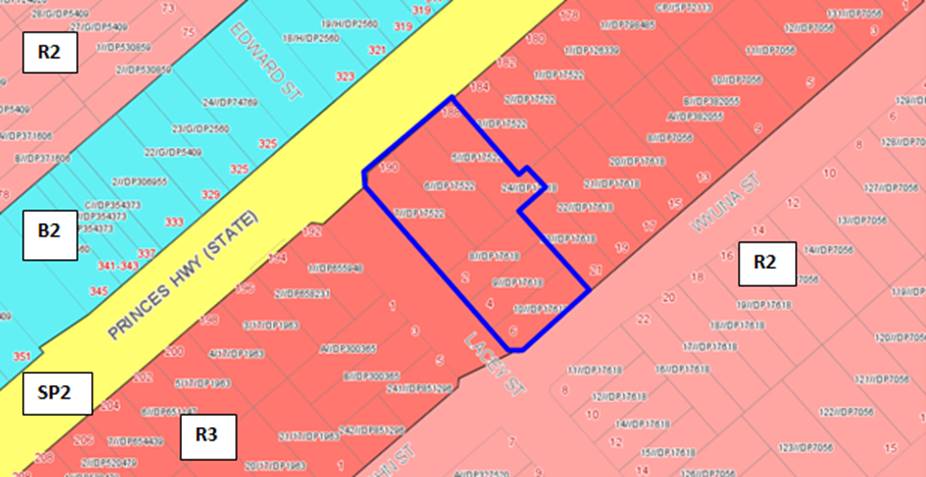
Figure 10: Zoning map extract from the KLEP2012 (Map Extract_007)
Table 5: KLEP2012 Compliance Table
|
Clause
|
Standard
|
Proposed
|
Complies
|
|
2.2 Zone
|
R3 Medium Density
Residential
|
The proposal is defined as a Residential Flat Building
(RFB) which is a permissible use within the zone.
|
Yes
|
|
2.3
Objectives
|
Objectives of the Zone
|
Consistent with zone objectives.
|
Yes
|
|
4.1A Minimum lot sizes for Residential Flat Buildings
|
Clause 4.1A requires a minimum site area of 1,000sqm for
the purpose of RFB’s in the R3 zone.
|
The total Site area is 3,078sqm.
|
Yes
|
|
4.3 – Height of Buildings
|
21m as identified on Height of Buildings Map
|
The building has been amended so that no habitable area
exceeds the 21m height limit. Originally larger parts of the roof and ceilings
encroached. The final modified scheme only has the lift overrun and communal
roof space exceeding the height control.
An amended Clause 4.6 Statement has been submitted and is
addressed in detail later in this report.
|
No
|
|
4.4 – Floor Space Ratio
|
2.0:1 as identified on Floor Space Ratio Map
|
The proposed FSR was originally proposed at 1.85:1. The
latest amended design has reduced the gross floor area of the proposal down
to 1.80:1 which is below the maximum floor space ratio.
|
Yes
|
|
4.5 – Calculation of floor space ratio and site area
|
FSR and site area calculated in accordance with Cl.4.5
|
The original gross floor area (GFA) calculation was
considered to be accurate as it included all areas apart from the stairs,
lift and services. The original GFA amounted to 5,701sqm.
The GFA of the development has been reduced and amended to
5535sqm. The reduction in 166sqm of gross floor area is a result of
Council’s concern regarding the bulk, scale and form of the building
along the southern side and its relationship to the lower scale residential
properties to the south. The upper levels of the building have been
redesigned to be set back further and a new roof terrace included as access
from Building A through to the area of communal open space on the ground
floor is not easily accessible.
|
Yes
|
|
4.6 –
Exceptions to Development Standards
|
The objectives
of this clause are as follows:
(a) - to provide an appropriate degree of
flexibility in applying certain development standards to particular
development,
(b) - to achieve better outcomes for and from
development by allowing flexibility in particular circumstances.
|
The proposal originally exceeded the height control
pursuant to Clause 4.3 of the KLEP and therefore a Clause 4.6 Statement was
submitted to justify the non-compliance with the control.
The Applicant has amended the design to ensure that no
habitable spaces encroach on the height limit however the introduction of a
roof terrace now exceeds the height control for the terrace and the
associated ancillary services (lifts and stairs). An updated Clause 4.6
Statement has been provided to justify the variation and the non-compliance
is considered to be reasonable and is well founded. A detailed discussion in
regards to this issue is provided below.
|
Not required
|
|
5.10 – Heritage Conservation
|
The objectives of
this clause are;
(i) to conserve the environmental heritage of Kogarah,
(ii) to conserve the heritage significance of heritage
items and heritage conservation areas, including associated fabric, settings
and views.
|
No.186-190 Princes Highway is a classified Heritage Item
listed in accordance with Schedule 5 of the KLEP identified as I3
“McWilliam House” house and garden and the property is of local
significance.
The property is also known as “Sunnyside”. The
Application is supported by a Statement of Heritage Impact prepared by
Heritage 21 (dated November 2018) and includes a Heritage Management Document
– Schedule of Conservation Works also prepared by Heritage 21. The
application on 3 occasions has been referred to Council’s Heritage
Advisor for comment. Substantial works are proposed to the heritage item
however the scale, form and overall design of the building is to be retained
and conserved with it adaptively converted to a more functional use. The
amended design is considered to be acceptable from a heritage and
conservation perspective. A detailed assessment of the proposed works is
provided below.
Subclause 5.10 (10) provides concessions and incentives
for certain conservation and development works. The purpose is to encourage
the adaptive reuse or protection/conservation of heritage items to ensure
they are maintained and managed appropriately in perpetuity.
Clause 5.10(10) states that;
The consent authority may grant consent to development for
any purpose of a building that is a heritage item or of the land on which
such a building is erected, or for any purpose on an Aboriginal place of
heritage significance, even though development for that purpose would
otherwise not be allowed by this Plan, if the consent authority is satisfied
that:
(a)
the conservation of the heritage item or Aboriginal place of heritage
significance is facilitated by the granting of consent, and
(b)
the proposed development is in accordance with a heritage management
document that has been approved by the consent authority, and
(c) the
consent to the proposed development would require that all necessary
conservation work identified in the heritage management document is carried
out, and
(d)
the proposed development would not adversely affect the heritage significance
of the heritage item, including its setting, or the heritage significance of
the Aboriginal place of heritage significance, and
(e)
the proposed development would not have any significant adverse effect on the
amenity of the surrounding area.
As the proposal integrates the Heritage Item into the
proposed scheme, and aims to protect and upgrade the item, the use of the
Conservation Incentives could be considered however the Applicant has not
relied on these and is seeking consent for a generally compliant proposal.
|
Yes
|
|
6.1 Acid Sulphate Soils (ASS)
|
The objective
of this clause is to ensure that development does not disturb, expose or
drain acid sulfate soils and cause environmental damage
|
The site is not affected by ASS.
|
Yes
|
|
6.2 Earthworks
|
To ensure that earthworks do not have a detrimental impact
on environmental functions and processes, neighbouring uses, cultural or
heritage items or features of the surrounding land
|
The proposed development includes excavation and
associated earthworks to accommodate two (2) levels of basement car parking.
The location and siting of the basement car park has been
amended and setback further from the western boundary and is setback from the
heritage item in order not to undermine the structural integrity and
stability of the heritage item.
|
Yes subject to
conditions.
|
|
6.5 Airspace Operations
|
The consent
authority must not grant development consent to development that is a
controlled activity within the meaning of Division 4 of Part 12 of the Airports Act 1996 of the Commonwealth unless the
applicant has obtained approval for the controlled activity under regulations
made for the purposes of that Division.
|
The height of the proposed development is below the
Obstacle Limitation Surface (OLS).
|
N/A
|
Heritage Conservation – Clause 5.10
96. No.186-190
Princes Highway is a designated heritage Item in accordance with Schedule 5 of
the KLEP as identified as I3 and as shown on the heritage map provided in
Figure 11 below;
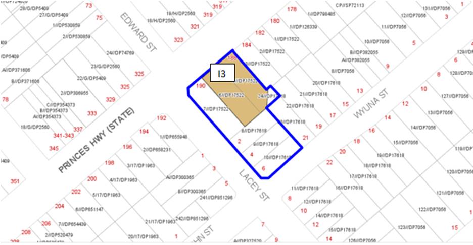
Figure 11: Location and siting of the
heritage item (I3) as depicted on the heritage mapping HER_007 in KLEP.
97. The
objectives of Clause 5.10 are;
(a) to conserve the environmental heritage of
Kogarah,
(b) to conserve the heritage
significance of heritage items and heritage conservation areas, including
associated fabric, settings and views,
(c) to conserve archaeological sites,
(d) to conserve Aboriginal
objects and Aboriginal places of heritage significance.
98. The proposal has been designed
to satisfy the objectives of the Clause. The proposal seeks to conserve and
maintain the existing Heritage Item on the site and skilfully readapt its use
to make it more functional and to integrate the building and its garden as part
of the broader development. The intention is to retain the proportions,
finishes and materials of the building and enhance the traditional
architectural elements and to retain and improve the garden and landscape
setting of the dwelling house which is an integral and important feature of the
item.
99. In accordance with Clause
5.10(4) a Statement of Heritage Impact has been prepared by Heritage 21 dated
November 2018. This report was amended and updated in May 2019 to reflect the
first set of proposed changes which were made to respond to the original issues
raised by Council’s Heritage Advisor. The updated Statement of
Significance supports the proposed works and provides a detailed Heritage
Assessment.
(i)
Significance of the Item and proposed works
100. No.186-190 Princes Highway consists
of a two storey sandstone dwelling with a ground floor rear addition. One of
the key features of the building is the large and traditional veranda (refer to
Figure 12).
Figure 12: Front façade of the local Heritage
item on site known as “Sunnyside” and “McWilliam” House.
101. The property is known as
“McWilliam House” or “Sunnyside” which is one of the
oldest houses in Kogarah. Subdivision in this part of Kogarah known as Beverley
Park began in about 1848 and it seems this property was constructed some time
before 1870. The property is described as a “grand old mansion”. It
was built with a slate roof, French doors opening up to wide verandas which are
enhanced by iron lace railings. A grand cedar staircase led to bedrooms
upstairs. A coach house was attached to the rear of the building. The former
Mayor of Kogarah (a prominent businessman), Patrick Joseph Lacey resided at the
property until about 1906. In summary the following significant events occurred
at the property since that time;
· Maude McWilliam and her family resided at the home until
1923 and during this time the front balcony was extended and glass panels
installed. The garden was extended towards Lacey Street and used for Charity
events a small equestrian centre for children was established and the property
included a tennis court and croquet lawn. The name of the property is also
referred to as “McWilliam House” which is assumed to have derived
from these previous owners.
· From 1923 the impact of the Great Depression required the
subdivision of the property into smaller lots and was sold in 1937 and
converted into two flats.
· WWII resulted in the iron railings of the balconies to be
removed to be used for armaments and replaced with sheets of corrugated fibro.
· In 1943 the property was converted and used by Sherwood
Private School.
· In 1959 the property was sold and converted into
men’s rooming houses with the wide verandas being filled in and rooms
were portioned off accordingly. The property remained as a Boarding House for
over 30years.
· In 1993 McDonalds wanted to convert the property to a
restaurant but the application was rejected due to strong community opposition.
· In 1995 the property was bought by Neil Brown and for the
following decade was tastefully and sympathetically restored both externally
and internally.
· In 2014 the new owner Judith Brown continued the
restoration process and adapted its use into a sewing and tea rooms.
102. The key elements and significance of
the property include the following;
- Prime example of a two-storey
Victorian Federation style.
- Constructed of sandstone
exterior.
- French doors open up onto a wide
detailed veranda.
- The rear non-original single
storey extension adjoins the sandstone wing and is constructed of timber,
plasterboard and face brickwork.
103. The heritage assessment details the
interior of the building and the key external elements. The current form of the
building retains legibility of the original scale and character of the
dwelling. The Statement of Significance on the State Heritage Inventory describes
the property as;
“This substantial 2 storey sandstone residence is
historically significant as it is representative of the establishments which
developed along the main transport routes. With the removal of the infilled
verandas this residence is a rare, good example of a grand Victorian Regency
residence.”
104. The heritage assessment of the
proposal considered the significance of the item in accordance with the Office
of Environment and Heritage Criteria rating the property in terms of its historical,
associative, aesthetic, social, technical/research, rarity and
representativeness level of importance. In respect to the seven identified
characteristics the property is significant and important in respect to each
category. It also exemplifies cultural significance as it is a prominent
residence and is representative of the development of this suburb.
105. In summary the proposed works to the
item include the following;
- Demolition of the non-original
fabric to the rear addition to the item;
- Change of use of one room
(bedroom to communal gymnasium) at the rear of the original wing however the
configuration and size of the space is retained as it exists;
- Partial removal of non-original
existing young landscape and landscape structures;
- Introduction of metal hood
awnings to openings;
- Partial modifications to three
rear awnings and as requested by Council’s Heritage Advisor replacement
of the non-original veranda, reinstatement of three windows, and works to the
non-original ceilings (internally) cornices and flooring and repointing to
mortar joints.
- Convert the original ground and
first floor part of the house to a dwelling or retain this as a dwelling
without any significant changes to the existing walls and rooms.
106. These works are within the wider
scope of works which includes demolishing the adjoining properties and the
construction of a new seven (7) story RFB. The heritage assessment makes the
following conclusion “The impact of the proposed works on these view
lines is assessed as follows:
- The proposed works would
improve the visual relationship between the heritage item from the primary
streetscape of Princes Highway by increasing the setback of the proposed
development from the corner of Princes Highway and Lacey Street;
- The proposed works retain a
legible distance from the heritage-listed item;
- The proposed works would not
affect the non-original yet mature landscape to the Princes Highway frontage;
and
- While the scale and form of
the proposed built forms to the south-west and south-east of the site would
generate an impact on the secondary view lines from Lacey Street and Wyuna
Street, Heritage 21 has found the combination of the surrounding topography,
siting of the item, and the existing built forms already display a limited
visual relationship to the heritage item (refer to Figures 9 to 11). As such,
we assess that the proposed works would have a neutral impact upon the already
obstructed secondary view lines.
In our view, the following aspects of the proposal would
respect the heritage significance of the subject site:
- The proposed works would
continue the legibility of the site by enhancing the significant view line from
Princes Highway and introducing a considerable side and rear setback to the new
development;
- The proposal would not entail
the demolition of any whole element which have been assessed as demonstrating
heritage significance;
- The positive impact the
proposed re-instatement of an earlier, period-appropriate veranda would provide
upon the site’s legibility from the public domain as an early sandstone
building along a main transport route;
- The reinstatement of the early
façade and internal elements of the site, including the original
openings, in order to further reflect the external sympathetic yet authentic
response to the original façade of the subject dwelling and view the
internal changes as a complimentary response to the site’s origins;
- The proposed works would
reintroduce the original rear envelope of the heritage item by demolishing
intrusive non-original elements;
- The proposed works to the
heritage item would be reversible and/or removable;
- The proposed works to the rear
of the heritage item would not be seen from the significant view line of
Princes Highway and as such would not alter the site’s legibility from
this viewpoint;
- The proposed works would
increase the longevity of the heritage item through its ongoing future use
within a large residential development;
- The proposed works are seen as
a contemporary response to the significance of the site, and do not seek to
replicate or dominate the character of the heritage item;
- The existing frontage to
Princes Highway has been increased to align with the setback of the heritage
items form and scale;
- The step back effect of the
bulk from the significant Princes Highway view line are sympathetic to the form
and scale of the heritage item and do not wish to dominate the surrounding
setting from this view point;”
Figure 13: Existing and proposed view analysis of the
existing heritage item and its relationship with the proposed new building.
(ii) Heritage
Officer comments
107. The proposed works were referred to
Council’s Heritage Advisor on a number of occasions. The Applicant
received Heritage advice after submitting the Pre-lodgement Application which
were finalised on 4 June 2018. The design was amended to consider the issues
raised and the Development Application was referred for comment. The Heritage
Officer analysed the plans and made the following comments were made in respect
to works to the heritage item;
“Proposed
works to the heritage item:-
a) The proposed demolition of the non-original
Federation Period rear addition and replacement with a new single-storey
addition would have minimal impact on heritage values and is acceptable.
b) The proposed continued use of the heritage item as
a part dwelling and the adaptation of rear ground floor spaces for communal use
are acceptable given the place has been adapted to a variety of uses throughout
its historical development.
c) The proposed removal of recent intrusive landscape
features in the front and rear garden is supported. As a landscape plan was not
able to be reviewed with this referral, there can be no further comment on
proposed landscape changes and potential impacts on the heritage item.
d) The existing Post War Period verandah is of minimal
heritage value and its demolition is acceptable. However, the proposed
double-storey verandah to the street facing elevation is not supported. The
SoHI notes (page 45) that:
…the
proposed veranda responds to the documented earlier veranda (refer to Figures 4
& 5) and was influenced by Council’s Heritage Advisor’s
comments.
Close
perusal of Figure 4 shows the veranda is original and has five evenly spaced
columns across the facade. On close analysis of Figure 5, it shows a grouped
column set-out and an indented configuration of the street facing veranda which
strongly indicates it to be non-original and possibly the same veranda shown in
Figure 6. From the above analysis, I do not understand the methodology which
informed the design of the proposed veranda. My pre DA advice recommended:
… it
would be appropriate to maintain the current configuration of the verandah.
However, the inappropriate detailing of the existing verandah has a discordant
and adverse impact on the heritage item, and should be rebuilt to an approved
design and to a configuration to match existing.
e) The proposed window hoods do not appear to be a
reconstruction and without credible discussion in the SoHI for the installation
of this element, there is no support.
f) Pre DA advice made no mention of replacing
non-original plasterboard ceilings as scheduled and there is no requirement to
do so.
g) The proposed conservation works as documented on the
Plans and Schedule of Conservation Works is generally supported apart from the
following:
i) All maintenance works are to be
separated from the Schedule and included in a separate document;
ii) All
doors and windows (including all operable sashes) are to be eased, repaired
where damaged or mutilated, and included in the Immediate Conservation
Action sections of the Schedule;
iii) Amend Schedule to note: all stonework
(including chimneys) is to be: repointed where joints are deteriorated or
mortar missing; all cementitious mortar is to be removed and joints repointed;
all damaged, missing and mutilated sandstone is to be repaired in an
approved manner; all salt-damaged sandstone is to be repaired in an
approved manner; mortar for repointing is to be to an approved mix similar to
the original; all non-original ferrous fixings are to be removed and stone repaired;
stonework physically impacted by the removal of services scheduled to be
removed including wiring and AC units etc is to be repaired to match sound
stonework. The above is to be documented in the Schedule.
iv) All damaged or missing slate to the roof is to be
replaced and all loose tiles re-fixed. New slate is to match existing. All flashings
are to be inspected to ensure same are properly seated and weathertight.
Point-up where mortar is missing or deteriorated. The above
is to be documented in the Schedule.
h) Proposed preservation of significant trees and removal of
trees of little significance as noted in the arborist’s report is supported.
Proposed landscape works within the grounds of the heritage item including
preservation of the existing hedge
along the front boundary, proposed paving in the front garden and planting scheme
are supported.

Figure 14: Detailed works proposed to
“Sunnyside” (courtesy PBD Architects, DA200 Rev B, 2019)
108. In respect to the new development
proposed the Heritage Advisor believed that the setting of the heritage item
will be compromised by the new RFB and the scale disparity alone will have an
adverse impact on the heritage item which cannot be compensated for by the
built form, design and scale however it was also acknowledged that the existing
setting has been diminished by the subdivision and residential development
pattern. The advice did acknowledge that “there has been
some improvement to the design of the proposed residential flat building from
the pre DA proposal reviewed with respect to compatibility with the heritage
item. This includes the siting of the proposed building and greater setback
from the Princes Highway boundary which will improve the visual appreciation of
the heritage item in views from the south along the Princes Highway. The scale
disparity of the proposed multi-storey building with the heritage item can be
mitigated by extending the three-storey portion of the building further back…
and There is general support for the proposed conservation works and adaptation
of the heritage item, subject to recommended changes in this advice, and
implementation of heritage-related conditions to come should this development
be approved..” Council’s Heritage Advisor still had concerns
regarding the siting and setback of the proposed RFB, the Schedule of
Conservation Works and maintenance works requires further refinement and
additional conservation works in relation to particular features and elements
of the existing item (windows, doors, stonework, roofs). Subject to further
design changes the application was recommended for approval subject to the
imposition of conditions.
109. In accordance with this initial
advice, the Applicant met with Council Officers and the Heritage Advisor to
discuss the issues and amended the design and documentation dated 8 May 2019
(Revision B). Final amended plans were received dated 10 July 2019 (Revision C)
which addressed additional design concerns raised by Council Officers. The main
design change included setting the new 3 storey podium section of the RFB back
further from the front boundary to expose more of the front façade and
veranda element of the item.
110. Council’s Heritage Officer was
referred the final set of amendments (Revision C) and the key concerns still
reflected the siting of the building and the podium. In summary the following
comments have been made;
111. “The proposed
development will unquestionably alter the visual backdrop and setting to the
heritage item, with the proposed built form resulting in a visually prominent
structure that is significantly larger in scale and form compared to the
existing built forms of the streetscape. The proposed oversized two-storey
podium at the front of the building projects forward of the front façade
of the heritage item and with the proposed setback to the tower above, the
overall scale of the development competes with the visual prominence of the
heritage item. As previously recommended to the applicant, the podium level
should be revised to incorporate a deeper front setback, so that no part of any
blade wall or balcony projects beyond the front façade of the building
rather than the alignment of the front verandah. Similarly, the tower structure
should be revised to also incorporate a deeper front setback, so that it sits
(at a minimum) behind the ridgeline of the roof to the heritage item. The
setbacks of the built form when viewed from Princes Highway and Lacey Street
are critical to ensuring the proposed building does not visually obscure key
sight lines to the heritage item, but also to ensure it retains visual
prominence within the streetscape as being clearly distinguished as sitting
further forward towards Princes Highway.”
112. A condition has been imposed to
ensure the three storey podium structure be redesigned so that this structure
including balconies will be setback and aligned with the front façade of
the Heritage Item as requested by Council’s Heritage Advisor.
113. Further concerns have been raised
regarding maintain the structural integrity of the Item whilst construction is
occurring given the proximity of excavation works.“ The
proposed development involves substantial excavation works within close
proximity to the heritage item and has the very high potential to result in
adverse material affectation to the heritage item through ground subsidence and
vibrational movement from excavation. Detailed engineering plans and
specifications have not been provided for review and comment, whereby the
suitability of the basement level excavation cannot be ascertained in terms of
what impact those works may have on the heritage item. In this regard, a
Structural Engineer’s report is required that provides an assessment of
the existing structural integrity of the heritage item and provides an
engineered solution to ensure the structural integrity of the heritage item
will not be adversely impacted from excavation works. Detailed engineering
plans and specifications are also required showing the proposed treatment of
any shoring, piling or the like”. This has been conditioned
accordingly. In addition standard heritage conditions have been imposed to
ensure compliance with the BCA and archaeological and an archival recording
occurs.
114. As part of Council’s
Historical Markers Program “Sunnyside” has been nominated as a
culturally and historically important site within Kogarah and should be
acknowledged by the provision of a Marker on site. It is considered that the
marker should be included on the front fence of the property (or an alternate
location) which is considered to be a prominent and visible location. This has
been addressed and included as a condition if consent is to be issued.
Exception to Development Standards – Clause 4.6
Detailed
assessment of variation to Clause 4.3 Height of Buildings
115. The
objectives of Clause 4.6 are as follows:
(a) to provide an appropriate degree of flexibility in
applying certain development standards to particular development,
(b) to achieve better outcomes for and from development by
allowing flexibility in particular circumstances.
116. Originally the
proposal exceeded the 21m height limit with habitable spaces and parts of the
ceiling encroaching on the height limit as seen in Figure 15 below. The height
to the roof was RL41.75 and RL42.40 to services on the roof and RL42.90 to the
lift overrun. Council raised concerns with the nature and degree of
non-compliance. Council does not support the non-compliance where it affects
habitable spaces and has been consistent in the application of this standard.
In addition the main area of non-compliance is at the rear (southern side)
where the development adjoins the lower scaled residential area. The Applicant
was requested to reconsider the design and lower the rear of the building so
that the transition and interface to the rear is more sympathetic and in
keeping and it was imperative that the building complied with the height and
stepped down the site.
117. The application
was amended so that no habitable areas or spaces encroach on the height limit
in response to Council’s concerns. Figure 16 below shows the amended
eastern elevation which shows a larger step in the built form at the rear. The
roof level at the rear now sits at RL40.15. There is a minimal change to the
front of the building as it generally complied originally and sits at RL41.65.
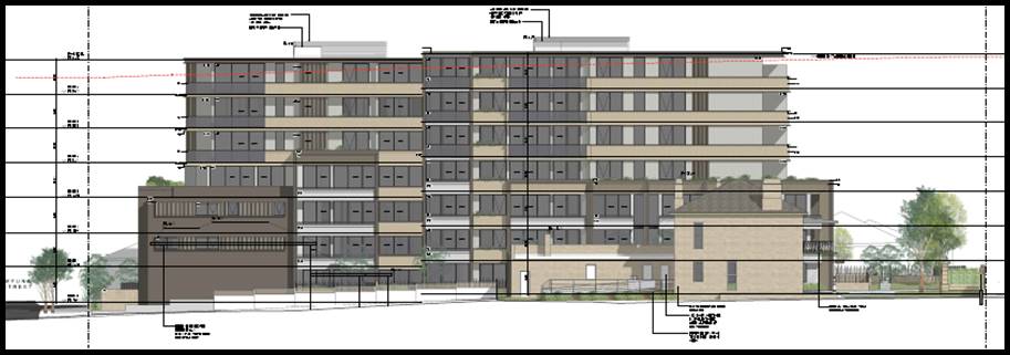
Figure 15: Eastern elevation as originally designed
and proposed (courtesy PBD Architects, 2018)
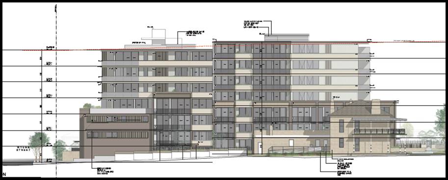 Figure 16:
Eastern elevation amended design (courtesy PBD Architects, 2019)
Figure 16:
Eastern elevation amended design (courtesy PBD Architects, 2019)
118. Despite the
habitable areas and roof level designed to comply with the height limit the
amended design has included a rooftop terrace area and this area and its
services and access (lift overrun) which exceed the height control. In general
Council has accepted that roof terraces and their associated services and
amenities may exceed the height control within reason and if there are no
environmental or amenity impacts and that the design satisfies the provisions
of Clause 4.6 and the objectives of the zone and height control.
119. The proposed
development seeks a variation to the development standard relating to height
(Clause 4.3). The LEP identifies a maximum height of 21m for the Site (refer to
Figure 15 below) and the proposed development will exceed the height by
3.5m which comprises of the stair and lift overrun which reach RL44.35.
This amounts to a 16% variation to the control. This is the worst case and only
affects the lift overrun on the roof at the rear above Building A. The other
structures which exceed the height are the balustrade although this is only
some 699mm (3% variation) and the parapet exceeds the height by some 299mm (1%
variation). There is a small encroachment by a small section of the glazed
element (upper section of the window to the living room to apartment A601).
This is in the central location to the building just before it steps down to
the rear. It also affects a very minor part of the glazing to the living room
to apartment B601 and bedroom No.1 of apartment B602. This variation is very
small and due to the slope of the site not affecting the western elevation.
This non-compliance is largely due to the topography of the site being slightly
lower along this section.
120. Any variation
to a statutory control can only be considered under Clause 4.6 –
Exceptions to Development Standards of the HLEP. An assessment of the proposed
height against the survey plan levels was conducted to indicate the
Applicant’s calculations are generally accurate.
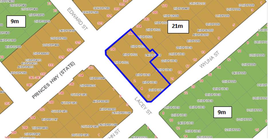
Figure 17: Extract taken from the KLEP 2012 (Map_007) showing the
permissible height.
Is the planning control in
question a development standard?
121. Height
of Buildings control under Clause 4.3 of the KLEP 2012 is a development
standard. The maximum permissible height is 21m (refer to Figure 17 above)
122. In more detail,
Building B that part of the building at facing Princes Highway has a flat roof
but includes a lift overrun and a section of the roof is designated for
ancillary services (i.e. mechanical ventilation etc.) which will be screened
with louvres. The lift overrun reaches RL42.80 and the screen has a height of
RL43.25. The non-compliance at the front section of the building amounts to
1.6m (height of the screen) and this equates to an 8% variation. These elements
are centrally located and substantially setback from Princes Highway. The lift
overrun is located closer to the Lacey Street frontage but it only exceeds the
height by some 1.15m which is considered a small protruding element.
123. Clause
4.6(3) states that:
“Development consent must not be granted for
development that contravenes a development standard unless the consent
authority has considered a written request from the applicant that seeks to
justify the contravention of the development standard by demonstrating:
- that compliance with the
development standard is unreasonable or unnecessary in the circumstances of the
case, and
- that there are sufficient
environmental planning grounds to justify contravening the development standard”
124. To
support the non-compliance, the applicant has provided a request for a
variation to Clause 4.3 in accordance with Clause 4.6 of KLEP and has updated
the Clause 4.6 Statement to reflect the latest amended plans which is dated 24
July 2019. The Clause 4.6 request for variation is assessed as follows:
What are the underlying
objectives of the development standard?
125. The
objectives of Height of Buildings standard under Clause 4.3 of KLEP 2012 are:
(a) to establish the maximum
height for buildings,
(b) to minimise the impact of
overshadowing, visual impact and loss of privacy on adjoining properties and
open space areas,
(c) to provide appropriate scale
and intensity of development through height controls.
Compliance is unreasonable or unnecessary in the
circumstances of the case (clause 4.6(3)(a))
126. There have been several Court
cases that have established provisions to assist in the assessment of Clause
4.6 statements to ensure they are well founded and address the provisions of Clause
4.6. In Wehbe V Pittwater Council (2007) NSW LEC 827 Preston CJ set out
ways of establishing that compliance with a development standard is
unreasonable or unnecessary.
127. Preston CJ in the judgement then
expressed the view that there are 5 different ways in which an objection may be
well founded and that approval of the objection may be consistent with the aims
of the policy, as follows (with emphasis placed on number 1 for the purposes of
this Clause 4.6 variation:
1. The
objectives of the standard are achieved notwithstanding non-compliance with the
standard;
2. The
underlying objective or purpose of the standard is not relevant to the
development and therefore compliance is unnecessary;
3. The
underlying object or purpose would be defeated or thwarted if compliance was
required and therefore compliance is unreasonable;
4. The
development standard has been virtually abandoned or destroyed by the Council's
own actions in granting consents departing from the standard and hence
compliance with the standard is unnecessary and unreasonable;
5. The zoning of
the particular land is unreasonable or inappropriate so that a development
standard appropriate for that zoning is also unreasonable and unnecessary as it
applies to the land and compliance with the standard that would be unreasonable
or unnecessary. That is, the particular parcel of land should not have been
included in the particular zone.
128. The Clause 4.6 Statement was
prepared in consideration of the recent court cases and their judgements.
129. Applicants
comment: “In Wehbe V Pittwater Council (2007) NSW LEC 827
Preston CJ sets out ways of establishing that compliance with a development
standard is unreasonable or unnecessary. This list is not exhaustive. It
states, inter alia:
An objection under SEPP 1 may be well founded and be
consistent with the aims set out in clause 3 of the Policy in a variety of
ways. The most commonly invoked way is to establish that compliance with the
development standard is unreasonable or unnecessary because the objectives of
the development standard are achieved notwithstanding non-compliance with the
standard.
The judgement goes on to state that:
The
rationale is that development standards are not ends in themselves but means of
achieving ends. The ends are environmental or planning objectives. Compliance
with a development standard is fixed as the usual means by which the relevant
environmental or planning objective is able to be achieved. However, if the
proposed development proffers an alternative means of achieving the objective
strict compliance with the standard would be unnecessary (it is achieved
anyway) and unreasonable (no purpose would be served).
Figure 18: 3D Height diagram showing the sections of
the building roof that exceed the height control (courtesy Architects, 2018).
130. Relevantly, in Initial Action Pty
Ltd v Woollahra Municipal Council [2018] NSWLEC 118 (paragraph 16), Preston CJ
makes reference to Wehbe and states:
“…Although that was said in the context of an
objection under State Environmental Planning Policy No 1 – Development
Standards to compliance with a development standard, the discussion is equally
applicable to a written request under cl 4.6 demonstrating that compliance with
a development standard is unreasonable or unnecessary.”
Compliance with the maximum building height development
standard is considered to be unreasonable and unnecessary as the objectives of
that standard are achieved for the reasons set out in Section 7 of this
statement. For the same reasons, the objection is considered to be well-founded
as per the first method underlined above.
Notably, under Clause 4.6(4)(a)(ii) a consent authority
must now be satisfied that the contravention of a development standard will be
in the public interest because it is consistent with the objectives of the
particular standard and the objectives for development within the zone in which
the development is proposed to be carried out.”
Clause 4.6(3)(b) are there
sufficient environmental planning grounds to justify contravening the standard
131. Having regard to Clause 4.6(3)(b) and
the need to demonstrate that there are sufficient environmental planning
grounds to justify contravening the development standard, it is considered that
there is an absence of any negative impacts of the proposed non-compliance on
the environmental quality of the locality and amenity of adjoining properties
in terms of overshadowing, overlooking or view loss.
132. Applicants Comment: “Having
regard to Clause 4.6(3)(b) and the need to demonstrate that there are
sufficient environmental planning grounds to justify contravening the
development standard, it is considered that there is an absence of significant
impacts of the proposed non-compliance on the amenity of future building
occupants, on area character and on neighbouring properties. The non-compliance
is exacerbated by the slope of the site away from Princes Highway and the
building has been stepped towards Wyuna Street to reduce the non-compliance. In
addition, future redevelopment of lots on the opposite site of Lacey Street
will result in even greater separation between the proposed residential flat
building and any future development, resulting in lesser shadow impacts.
133. On “planning grounds” the proposal successfully
retains and integrates the heritage item on the site, and achieves better views
of the heritage item from Princes Highway than a compliant building envelope
would. In accordance with Clause 5.10 (10) of KLEP 2012 Council can arguably
therefore grant consent notwithstanding the height non-compliance. The
development also provides a significant setback for levels 3-6 on the Princes
Highway and Wyuna Street frontages to reduce the impacts of the proposal. The
non-compliance can be largely attributed to the provision of an accessible
rooftop communal open space that will provide significant amenity for future
residents.
134. The
variation to building height does not meaningfully impact on solar access, views
or outlook and the streetscape appearance is not impacted by the variation. As
indicated, the proposal provides for a floor space ratio which complies with
(and is 621m2 less than) the maximum permitted and accordingly, the height
breach is not associated with additional density beyond what is expected by the
controls or planned for the locality.”
Clause 4.6(4)(a)(ii) the proposed development will be in the
public interest because it is consistent with the objectives of the particular
standard and the objectives for development within the zone in which the
development is proposed to be carried out
135. Clause 4.6(4) states that:
“Development consent must not be granted for
development that contravenes a development standard unless:
(a) the
consent authority is satisfied that:
(i) the applicant’s written request has
adequately addressed the matters required to be demonstrated by subclause (3),
and”
(ii) the proposed development will be in the public interest
because it is consistent with the objectives of the particular standard and the
objectives for development within the zone in which the development is proposed
to be carried out,
136. Applicants Comments: The
Height of Buildings Map nominates a maximum height of 21m for the site. It is
requested that an exception to this development standard be granted pursuant to
Clause 4.6 so as to permit a maximum height of 24.531m to the lift overrun of
Lift A.
137. In order
to address the requirements of subclause 4.6(4)(a)(ii), each of the relevant
objectives of Clause 4.3 are addressed in turn below.
138. Objective
(a) – The maximum height has
been established at 21m for the site. The proposed development provides a
residential development and meets the objectives of the R3 Medium Density
Residential zone objectives. The proposed development is in line with the type
of development envisaged for the site. The degree to which the proposal exceeds
the maximum height is relatively minor and importantly the development complies
with and is 621m2 less than the maximum FSR for the site. For these reasons the
proposed height meets Objective (a).
139. Objective (b) relates to minimising shadows on adjoining buildings and
open space areas, visual impact and loss of privacy. A comparative shadow study
has been prepared comparing the proposed building envelope to a complying
building envelope. The diagrams indicate that the proposed building envelope
only generates a minor increase in shadow impacts that will have a negligible
impact on neighbouring amenity (i.e. shadows on roof), and that a compliant
building envelope would in fact have a greater shadow impact on dwellings
across Lacey Street at 9am on the winter solstice. Since the proposal is
significantly setback from Princes Highway it lessens the overshadowing impact.
The visual impact of the proposal is considered to be virtually imperceptible
from that of a compliant building height. The proposal is setback at Levels 4-6
by 4.19m from the levels below on the Wyuna Street frontage, and by 5.05m from
the level below on the Princes Highway frontage. The visual impact of the
development is therefore reduced at key sensitive locations being the heritage
dwelling and the R2 zone interface. No significant loss of privacy of adjoining
residents are anticipated given the compliant side setbacks to the north-east,
and the significant setbacks afforded by the Princes Highway, Lacey Street and
Wyuna Street. The proposed rooftop communal open space is setback from each
elevation, and incorporates edge planters for privacy. The proposal will have
no adverse impacts on nearby open space areas. For these reasons the proposed
height meets Objective (b).
140. Objective
(c) seeks to ensure development
provides a suitable scale and intensity. The non-compliance of the height does
not offend the objective of providing an appropriate scale and intensity of
development at the site. The proposal provides a compliant FSR (1.80:1) that is
significantly (621m2) below the maximum permissible of 2:1 and is therefore
demonstrably within the intensity of development intended for the site. The
built form, bulk and scale is appropriate for the site and the proposed
non-compliance with height will not be perceptible in the streetscape and
character of the locality. In particular, the proposal gives a high level of
respect to the heritage item and refrains from utilising significant
part of the site for apartment floor space. The scale of the building (7
storeys) is consistent with what is generally accepted within a 21m height
limit. The proposed development is therefore consistent with the
objectives for maximum height, despite the numeric non-compliance.
141. The
proposed height non-compliance does not impact upon the achievement of the zone
objectives. The proposed development will provide increased housing supply for
the community within a medium density residential environment. The proposal
also provides a variety of housing types ranging from one bedroom apartments to
four bedroom terraces, within a large variety of configurations. The height
variation does not contravene any objectives for the zone and for that reason
the proposed variation is acceptable.”
142. Officer
Comment: The proposed development has been designed to ensure all habitable
areas are located within the height limit and the only protrusions are in
relation to the roof terrace balustrade, services, stairs and screening which
are generally small in nature. The lift overrun at the rear is the highest
structure that exceeds the height control. The proposal generally satisfies the
objectives of the development standard in the following ways;
(a) to establish the maximum height for
buildings,
143. Officer Comment: The site and its immediately adjoining properties have been
up scaled to allow for medium to larger scaled development. In part this is due
to the location of the sites adjoining a busy roadway as these conditions cater
for larger scaled developments. Figure 15 shows the extent of the immediate
precinct which allows for a maximum height of 21m.
(b) to minimise the impact of overshadowing,
visual impact and loss of privacy on adjoining properties and open space areas,
144. Officer Comment: This objective relates to considering the amenity impacts
associated with the non-compliance. In terms of visual impact the structures
are generally centrally located which reduces their visual appearance from the
immediately adjoining streetscapes, however, the screening that is proposed
along the front of the building takes up a large proportion of the roof and a
condition will require this element to be recessed and setback from the edge of
the roof to further minimise its visual appearance.
145. The objective seeks to
“minimise” the visual impact, it is not requiring it to be
eliminated or totally negated, and as such seeing the structure is not a reason
for refusal, it’s the impact of the visual interference of this structure
that is to be controlled. It can be said that in this case it is a small scale
ancillary structure which will not be highly visible or an intrusive element
given the scale and proportions of the building. In respect to the more
dominant elements like the lift overrun accessing the roof terrace at the rear,
this will be a visible element when viewed from a distance. It will not be
visible from immediately adjoining properties and streetscapes given that it is
centrally located, but will be visible when travelling along the Pacific
Highway from either side. A condition will require that these structures be
painted and treated in a way that makes them visually recessive elements. The
roof top terrace area and much of its balustrade is located within the height
limit so the use of that area is within the height control so that ancillary
services which exceed the height control namely the WC, lift overrun and
staircase will not contribute to any overlooking and the shadowing they create
will be within the confines of the roof space and unfortunately largely
overshadow the rooftop terrace area. There will be no adverse impacts in terms
of overshadowing or overlooking to adjoining properties.
(c) to provide appropriate scale and intensity
of development through height controls.
146. Officer
Comment: New developments of a similar nature have been approved along John
Street and Princes Highway (these developments have been considered and
included earlier in this report) and have established a precedent for
development in the street and immediate precinct. The proposed development is
consistent with the pattern of development that is slowly being established in
the precinct.
147. The proposed
increase in the overall height of the building’s which only relates to
certain sections of the roof form can be catered for in this location given the
siting, orientation and the fact the buildings comply with the anticipated
building envelope which is largely compliant with the ADG and KDCP in terms of
the separation distances, landscaped area requirements, front setback control
etc. The proposed development is considered to satisfy the objectives of the
development standard.
148. Officers
comment: The exceedance in the control generally satisfies the
objectives of the zone for the following reasons;
· To provide for the housing needs of the community within a
medium density residential environment.
149. The
development is providing for the housing needs within a medium density
residential environment with a mix of apartment choices.
· To provide a variety of housing types within a medium
density residential environment.
150. The
development incorporates a diversity of apartment types (offering 1, 2, 3 and
4 bedroom units). The proposal is also adaptively reusing the Heritage
Item for largely residential use with ancillary communal uses at the rear of
this property. The refurbishment and long term conservation of this property is
a benefit of the scheme as its historical, cultural and aesthetic importance
will largely be preserved and maintained.
· To enable other land uses that provide facilities or
services to meet the day to day needs of residents.
151. The
development is residential in nature and does not include any additional land
uses. This objective is offering some greater flexibility in the provision of
land uses within this zone and is not a mandatory requirement. It has been
raised by some in the community through written submissions that the heritage
item should be adapted for a use that can be enjoyed by the community at large
given the significance of the property. Clause 5.10 (10) which encourages the
ongoing use and adaptive reuse of these types of buildings by providing
conservation incentives and permitting non-conforming uses to occupy these
sites subject to the proposal not generating unreasonable environmental
impacts. The Applicant is not taking up the benefit of this clause and has
decided to maintain the residential nature of the building. This Clause can be
enacted at any point in time (unless the LEP is amended) and the opportunity
may be taken up in the future. At this stage it is not viable for the Applicant
to readapt this use to another non-conforming use that may be more functional
and widely utilised by the community. The residential nature of the building is
considered suitable and reflects its original use which was a residence.
152. The area of
non-compliance is not considered to be unreasonable and will not establish an
undesirable precedent. It will not have any adverse effect on the surrounding
locality, which is emerging to be characterised by residential development of
comparable character. The proposal promotes the economic use and development of
the land consistent with its zone and purpose. The Panel is requested to invoke
its powers under Clause 4.6 to permit the variation proposed.
153. The public
benefit of the variation is that it will appropriately facilitate the provision
of medium density housing on a R3 zoned site and provide for a range of housing
stock. It is noted that in Initial Action Pty Ltd v Woollahra Municipal Council
[2018] NSWLEC 118, Preston CJ clarified what items a Clause 4.6 does and does
not need to satisfy. Importantly, there does not need to be a
"better" planning outcome resulting from the non-compliance.
154. The second matter was in cl 4.6(3)(b),
where the Commissioner applied the wrong test in considering this matter by
requiring that the development, which contravened the height development
standard, result in a "better environmental planning outcome for the
site" relative to a development that complies with the height development
standard (in [141] and [142] of the judgment). Clause 4.6 does not directly or
indirectly establish this test. The requirement in cl 4.6(3)(b) is that there
are sufficient environmental planning grounds to justify contravening the
development standard, not that the development that contravenes the development
standard have a better environmental planning outcome than a development that
complies with the development standard.
155. The roof top area and its associated
ancillary structures could be deleted and the building largely compliant
however this space will add value and provide greater functionality for the
development. The ADG encourages the use of rooftop spaces.
156. In this case the proposal seeks to
establish the preferred and appropriate design and built form outcome for this
site with the building complying in large with the height standard. There will
be no adverse amenity or visual impacts generated by the variation and the
proposal satisfies the objectives of the zone and the development standard. In
this case the justification to vary the height control is considered to be a
reasonable and well-founded request.
Clause 4.6(b) the concurrence of the Secretary has been obtained.
157. Concurrence from the Secretary has
been obtained and can be assumed in this case.
158. It is
considered that the Clause 4.6 Statement lodged with the application addresses
all the information required pursuant to Clause 4.6 and the statement is
considered to be well founded as there are sufficient environmental planning
grounds to justify contravening the standard given that in this case the
proposal satisfies the objectives of the zone and development standard (Clause
4.3, building height control).
Development
Control Plans
KOGARAH DEVELOPMENT CONTROL PLAN NO 2013 (KDCP)
159. Apart from
satisfying some of the provisions of the ADG and SEPP 65 the controls within
the KDCP are applicable. Part B, General Controls, Part C2 Medium Density,
controls in Appendix 4 relating to residential development in the R3 zone are
required to be considered in the design of the proposal.
160. Table 6 below
summarises the compliance of the scheme in relation to these controls.
Table 6: KDCP2013 Compliance Table
|
KDCP
2013 Compliance Table
|
|
PART B – GENERAL
CONTROLS
|
|
Required
|
Proposed
|
Complies
|
|
B1
– Heritage and conservation areas
|
|
Objectives
(a) New development, including development on sites adjacent to
heritage items must respect the architectural character of a heritage item
and complement and enhance their significance and setting.
(b) Landscape features are to be retained where they contribute
to the heritage significance of the item
Planning controls
(1) The relevant
requirements of Clause 5.10 of KLEP 2012 are to be addressed for any
development relating to a heritage item.
(2) Where a heritage
management document and/or heritage conservation management plan is required
to be submitted to Council, this is to be prepared by an appropriately
qualified professional.
|
The
proposed development seeks to retain and conserve the Heritage Item onsite
and adaptively reuse the building. The proposed renovations and works to this
building have been comprehensively assessed against the provisions of Clause
5.10 of the KLEP.
The
proposed development and heritage works satisfy the objectives of the DCP as
the development intends on retaining and improving the landscape setting
around the curtilage of the item and aims to create a traditional formal
landscape design to enhance the existing garden.
The
proposal has been assessed and considered by Council’s Heritage Officer
and the proposal is considered to be satisfactory subject to the imposition
of a series of heritage conditions, the works will improve the visual
appearance of the building and its garden setting.
|
Yes
|
|
B2 Tree Management
and Greenweb
|
|
Compliance with provisions of
Clause 5.9 Preservation of Trees or Vegetation of KLEP 2012 must be achieved.
|
The issue of tree retention
and removal has been addressed in detail earlier in this report. In short,
the significant tress and vegetation around the Heritage Item will be
retained as part of its setting and a series of new trees and plantings have
been integrated into the landscape design and will include a series of
compensatory trees around the periphery of the site and along all street
frontages. Council’s Landscape Officer is satisfied with the Landscape
Design and the proposal satisfies the DCP provisions.
|
Yes
|
|
B3 –
Development near busy roads and rail corridors
|
|
Acoustic assessment for noise sensitive development may be
required if located in the vicinity of a rail corridor or busy roads
|
An Acoustic report was
prepared by Rodney Stevens and assessed the development against the
provisions of Clause 102 of the Infrastructure SEPP.
The acoustic report provided a
series of recommendations in the form of implementing construction techniques
and materials that will assist in ameliorating acoustic impacts of the
Princes Highway on the internal areas of the building. A detailed discussion
regarding the acoustic compliance was conducted earlier in this report.
|
No
|
|
B4 Parking and
Traffic
|
|
Residential parking:
10 x 1br units @ 1 space per
unit = 10 spaces required
22 x 2 br units @ 1.5 spaces
per unit = 33 spaces required.
17 x 3 bedroom units @ 2
spaces per unit = 34 spaces required
2 x 4 br units @ 2 spaces per
unit = 4 spaces required earlier in the report we say only 1 x 4
bedroom is provided
Total required resident
parking
= 81 spaces
|
82 resident spaces are
provided
A total of 92 spaces are
required (which including the 11 visitor car spaces) The development provides
for 93 spaces in total which satisfies Council’s requirement.
Basement 1 has 38 spaces and
Basement 2 has a total of 55 spaces.
|
Yes
|
|
Visitor parking:
51 total units @ 1 space per 5
units = 11 (10.2) spaces required
|
11 visitor spaces are provided
with one space doubling up as a car wash bay
|
Yes
|
|
Car wash bay:
1 bay, which can also function
as a visitor space
|
1 car wash bay is provided
which doubles as a visitor space
|
Yes
|
|
Bicycle Parking:
1 space per 3 dwellings = 17
1 space per 10 dwellings for
visitors = 5 spaces
Total = 22 spaces
required
|
5 bicycle parking spaces in
the Basement No.1
14 bicycle parking spaces in
Basement No.2
5 visitor bicycle parking
spaces provided at the front accessed off Lacey Street
Total = 24 spaces provided
|
Yes
The 5 bicycle spaces along
Lacey Street impact on the size of the ground floor courtyard to BG01 and it
is recommended by way of a condition to move these further to the southern
side so that this area of private open space can be slightly larger.
|
|
Loading Bays
|
One loading bay provided
although not required for purely residential developments. This will assist
with waste removal but also with respect to removalists, deliveries etc.
|
Yes
|
|
Car park access and layout to
comply with relevant Australian Standards
|
Ramps, parking, aisle widths
and parking spaces satisfy the provisions of AS2890.
|
Yes
|
|
B5 – Waste
Management and Minimisation
|
|
Submit Waste Management Plan
(WMP)
Provide a dedicated caged area
within the bin room for the storage of discarded bulky items.
|
WMP was prepared by PBD
Architects and dated October 2018. The development includes two designated
waste storage rooms on Basement Level 1.
One room is located adjacent
to Lift A and the other adjoining Lift B.
In each room 6 x 660L bins are
proposed and 17 x 240L recycling bins. The development includes a loading
area which will facilitate an 6.4m long Small Rigid Vehicle (SRV truck) which
can accommodate a garbage truck to access the garbage storage area directly,
however bins can also be collected from the street. On this basis a Private
collection or Council collection is available to this development. A bulky
goods area is designated and adjoins the loading area where larger pieces of
furniture or waste can be stored for removal.
The waste disposal area and
arrangement is considered to be satisfactory and in accordance with
Council’s requirements.
|
Yes
|
|
B6 – Water
Management
|
|
All developments require
consideration of Council’s Water Management Policy
|
The proposed method of
stormwater management is considered satisfactory. Updated stormwater drainage
plans have been submitted to address Council’s initial concerns and are
now compliant with Council’s requirements subject to conditions.
|
Yes
|
|
B7 –
Environmental Management
|
|
Building to be designed to
improve solar efficiency and are to use sustainable building materials and
techniques
|
Design, materials, siting and
orientation generally optimise solar efficiency, with a high proportion of
north-facing window openings. Although there are still openings along the
western side main living areas which are orientated to face east with
secondary spaces to face west i.e. bedrooms. As these are secondary habitable
areas that will not be intensively utilised internal blinds and curtains will
assist in reducing heat loads and minimising heating into these rooms.
The development is
BASIX-compliant and a revised BASIX Certificate was provided to ensure the
amended internal design was compliant.
|
Yes
|
|
PART C2 – MEDIUM DENSITY HOUSING
|
|
1. Site isolation and
amalgamation for medium density development
|
|
Adjoining sites not to be left
isolated.
Site amalgamation requirements
apply for specific sites.
|
The proposal does not cause
any site isolation.
The site is not subject to any
amalgamation requirement.
|
Yes
N/A
|
|
2. Specific precinct
controls – residential flat buildings
|
|
Specific precinct controls
apply to various sites and locations
|
The site is not located in a
specific precinct nominated in the DCP
|
N/A
|
|
Map 7: Kogarah Bay
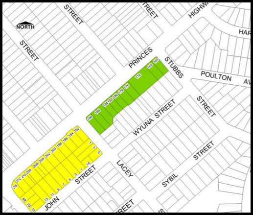
|
|
Area highlighted green in Map
7 above permits RFB’s but with a maximum of 2 storey’s
|
The development exceeds 2
storeys. The proposal does not comply with this provision as the DCP has not
been updated in line with the amendments to the KLEP which permits a 21m
height limit and a 2:1 FSR control.
|
No however the proposal is
compliant with the KLEP controls for height and gross floor area.
|
|
4. Medium site and
density requirements
|
|
20m minimum frontage for
residential flat building
|
38.79m to Princes Highway
75.89m to Lacey Street
31.78m to Wyuna Street
|
Yes
|
|
1.1sqm of site area per square
metre of dwelling
NOTE: The above DCP control is
over-ridden by KLEP 2012 minimum lot size requirement which is 1000sqm.
|
Site Area = 3,078sqm which
complies with the LEP requirement.
|
Yes
|
|
5. Height and
building envelope requirements
|
|
2-storey RFBs have a
“H1” height control of 7.4m; and a “H2” height
control of 9m.
(method for calculating these
heights are discussed in detail in KDCP 2013)
|
No, the development has a maximum height of 21m with some
ancillary structures on the roof exceeding this height.
The proposal generally satisfies the statutory height and
FSR provisions within the KLEP.
The KDCP has not been updated to reflect the LEP changes.
|
No –see comment below
|
|
Comment on Building Height:
There is incongruence between
the KLEP 2012 and the KDCP 2013 building height limits, and the KLEP 2012
heights prevail. The proposal is generally compliant with the maximum LEP
height. Refer to KLEP 2012 discussion on building height.
|
|
6. Building setbacks
|
|
Front setbacks:
Maximum 75% of width of
building to be setback minimum 5m, remainder 25% being setback minimum 7m
|
The site has three road
frontages. The Lacey Street frontage is classified as a side elevation and
the ADG separation distances have been applied to this frontage.
The two key streets where the
front setbacks will apply are to Wyuna Street and Princes Highway.
Princes Highway
There is no change to the
front setback to “Sunnyside” and the building setback exceeds 7m.
The new three storey podium
section of the new development which faces Princes Highway is setback over
12.5m from the front boundary. Council’s Heritage Advisor requests this
element to be setback further and the upper levels to also be recessed
further front Princes Highway.
Wyuna Street
The three-storey podium along
Wyuna Street is setback over 5m with small blade walls encroaching on the
setback but these are considered to be minor elements which will provide some
articulation and enhance privacy between dwellings.
|
Yes
Yes complies with the front
setback requirements along Princes Highway
Partial non-compliance. The
building complies with the 5.5m minimum but doesn’t comply with the 25%
of the frontage being setback 7m. The setback in this case is considered
satisfactory as it is generally in context with the front setbacks of the
existing dwelling houses and will be generally consistent with the front
setback for No.21 Wyuna Street. Wyuna Street is also a secondary frontage
it’s not considered to be the primary street frontage of the site.
|
|
Side/rear setbacks: 3m + one
quarter of the amount that the wall height exceeds 3m.
[3m + (¼ x 12m)] = 6m
required.
|
Given that the site adjoins
three (3) road frontages there is no traditional rear yard area. The heritage
property will retain its rear yard area and create a communal space by
removing the unsympathetic additions along the south-eastern side with the
original ground floor additions (south-western side) being maintained and
adapted to communal uses. The removal of the uncharacteristic addition to
this property will create an attractive courtyard space at ground floor level
and will provide greater separation between the subject site and No.21 Wyuna
Street than what currently exists.
|
No – the proposal fails
to comply with the side and rear setback requirements within the KDCP as
these have been prepared with the expectation of a two storey development on
the subject sites. The provisions have not been updated to align with the
height and FSR changes that have occurred as part of the LEP uplift. With
respect to side setbacks the development generally complies with the SEPP 65
separation distances which are considered to be satisfactory. SEPP 65/ADG
prevails over the DCP provisions for a residential flat building.
|
|
7. Site coverage
|
|
Maximum 45% (1,385sqm)
|
Site coverage amounts to 44%
(1,346sqm)
|
Yes
|
|
8. Open space
|
|
Private open space (POS)
– 35sqm with min. 3m dimension for ground level dwellings and 12sqm
with min. 3m dimension for other dwellings
(This control superseded by
ADG Requirements)
|
Most ground floor courtyards
have minimum areas of 15sqm in accordance with the provisions of SEPP 65/ADG.
Some central courtyards are larger having areas of 23sqm and 27sqm. There are
a few dwellings which have smaller courtyards i.e. 12sqm but this is to a one
bedroom apartment. Again the provisions of SEPP 65 override the DCP
provisions.
|
No (for some ground
floor units) – but generally ground floor courtyards meet the
SEPP65/ADG private open space requirements.
|
|
Common open space –
30sqm per dwelling with min. overall area of 75sqm and min. dimension of 5m.
i.e. 30sqm x 51 units =
1,530sqm
(This control is superseded by
ADG Requirements)
|
Total area of open space that is provided is 1096sqm this
is some 400sqm short of the requirement.
The DCP provision is more onerous than the SEPP65/ADG
provisions. The SEPP65/ADG provisions prevail.
|
No but SEPP 65 compliant.
|
|
Maximum 55% impervious area
amounting to 1,385sqm
|
The development has a total
area of some 3,078sqm
|
No however the development
provides for more than the required amount of deep soil area and communal
open space in accordance with SEPP 65/ADG which prevails.
|
|
9. Vehicular access,
parking and circulation
|
|
Car parking to be provided in
accordance with Part B4
|
Development complies with the
KDCP numerical parking requirements.
|
Yes
|
|
Garages to be accessed from
rear lane where available
|
Access is located off a
secondary roadway, Wyuna Street and is in keeping with a current driveway
access point only widened for the proposed use.
|
Yes
|
|
All residential flat buildings
to provide car wash bay
|
There is no designated car
wash bay however the KDCP allows for a visitor space to double as a car wash
bay.
|
No but a condition is included
in order to satisfy the standard.
|
|
11. Solar access
|
|
Primary open space to achieve
4 hours of direct sunlight between 9am and 3pm at mid-winter
|
The shadow diagrams indicate
that the principle area of open space located along the front of the site
(Princes Highway) will receive in excess of 4 hours of direct sunlight due to
its orientation. The communal open space and deck located to the south of the
heritage property will receive less equating to approximately 3hours of
direct sunlight during the day in midwinter. From 10am until 1pm which is the
prime time of the day. The majority of the rooftop terrace area will receive
a minimum of 4 hours, as this space is only slightly obstructed by the lift
overrun and ancillary structures located to the north.
|
Yes – generally
compliant.
|
|
Where the neighbouring
properties are affected by overshadowing, at least 50% of the neighbouring
existing primary private open space or windows to main living areas must
receive a minimum of 3 hours sunlight between 9am–3pm on the winter
solstice (21 June)
|
From 9am until 12noon the
development will overshadow the front and rear yards of No’s 1, 3 and 5
Lacey Street with the worst affectation at 9am. By 12noon these properties
are unaffected.
From 1pm until 3pm the
development will overshadow the side and rear yard of No.8 and 10 Lacey
Street. From 9am until 1pm this property is unaffected by the building.
|
Yes
|
|
12. Views and view
sharing
|
|
Provide for reasonable sharing
of views
|
The location does not have
significant views. The development generally complies with height
requirements and is reasonable in terms of view sharing.
|
Yes
|
|
13. Adaptable and
accessible housing
|
|
3-10 units – 1 adaptable
unit
11-20 units – 2
adaptable units
21-30 – 3 adaptable
units
30-40 units – 4
adaptable units
|
Five (5) adaptable units are
required as the Heritage House will remain as an existing residential
dwelling so the calculation is based on the 50 new residential apartments
that are proposed.
Five (5) adaptable units are
proposed.
|
Yes
|
Setback to Wyuna Street
161. After reviewing the
original plans the Applicant was requested to reconsider the design and siting
of the building and its relationship to the lower scaled residential dwelling
houses to the south along Wyuna Street. The subject site has a height limit of
21m across the whole of the site. When Council amended the height and FSR
controls for this precinct they did not create or amend any DCP or planning
controls around the siting. The main issue is creating a balanced transition
from a higher scaled development through to the 9m R2 zoned dwellings to the
south.
162. Council’s Housing
strategy 2031 encourages a stepping down of development at the rear to better
relate to lower scale residential properties along the southern side of Wyuna
Street (refer to Figure 19). The development includes a three storey podium
which achieves a height of some 9m in accordance with the intentions of the
Housing Strategy. This is a smaller podium when considering the siting and
design of the approved developments along John Street. These developments have
a four storey podiums to John Street with the upper levels stepped back further
than what is proposed at the subject site.
Figure 19: Extract from Georges River Housing Strategy
163. The pre-lodgement advice made the
following comments “Appropriate front boundary setbacks to Wyuna
Street are essential in order to demonstrate that the proposal is responding
appropriately to the existing rhythm of the street and providing an appropriate
transition between the existing low density residential and the subject site.
The proposal must provide a reasonable level of amenity and solar access
provision to the adjacent low density residential area on the south-eastern
side of Wyuna Street”.
164. The setback of the upper levels of
the building (Levels 4-7) are varied and stepped, being setback over 6m to the
balcony at Level 3 and 8m to the balcony along Levels 4-6. The building wall
for levels 3-6 is setback up to 10m from the street boundary. Setting the upper
levels back any further will compromise the design as the front of the building
has had to be setback substantially to accommodate the views, vistas and
setting of the Heritage Item. The three storey podium will create a human scale
to the development when viewed from Wyuna Street and will create and establish
a better human scale and relationship to adjoining developments.
Interim
Policy – Georges River Development Control Plan 2020
165. Council at its Environment and Planning Committee Meeting
dated 11 June 2019 resolved to adopt the Georges River Interim Policy DCP.
166. The Interim Policy is a
public policy that is to be used as a guide to set a consistent approach for
the assessment of residential development within the LGA. It is a supplementary
document, meaning that current DCP
controls will prevail if they are considered best practice. The Interim Policy
has no statutory recognition in the assessment of DAs pursuant to the
Environmental Planning and Assessment Act, 1979 (EP&A Act).
167. An assessment of the
proposal has been carried out against the provisions of the Interim Policy as
set out in the following table.
Table 7: Interim Policy Compliance Table
|
Interim Policy –
Georges River DCP 2020
|
|
Standard
|
Proposed
|
Complies
|
|
Site Frontage
|
|
20m
|
38.79m to Princes Highway
75.89m to Lacey Street
31.78m to Wyuna Street
|
Yes
|
|
Building Height
|
|
The relevant LEP controls
relating to building height will prevail over DCP controls that relate to
height in storeys
|
The proposal exceeds the height control but is supported
by the provision of a Clause 4.6 Statement. This statement is considered to
be well founded and discussed in detail earlier in this report.
|
Yes
|
|
Private Open Space
|
|
The ADG requirements prevail
over the DCP controls for private open space
|
The proposal is fully compliant with the ADG’s
private open space requirements.
Refer to “4E – Private Open Space and
Balconies” within the ADG Compliance Table above.
|
Yes
|
|
Communal Open Space
|
|
The ADG requirements prevail
over the DCP controls for COS
|
The proposal is not considered to comply with the
requirements of the ADG with respect to COS.
Refer to “3D – Communal Open Space”
within the ADG Compliance Table above.
|
No
|
|
Parking
|
|
In accordance with 'A Plan for
Growing Sydney' (Department of Planning and
Environment):
· If
located in a strategic centre (i.e. Kogarah CBD and Hurstville CBD) and
within 800m of a Railway, the “Metropolitan Regional Centre
(CBD)” rates apply.
· If
located within 800m of a railway and outside the strategic centres the
“Metropolitan Subregional Centre” rates apply.
· If
located outside of 800m of a Railway, the relevant DCP applies.
|
The KDCP parking requirements need to be satisfied as the
site is not located near a railway station or close to a commercial centre in
accordance with the ADG provisions.
|
Proposal satisfies the numerical requirements of the KDCP
|
|
Solar Access
|
|
The ADG requirements prevail over the DCP controls for
solar access
|
The proposal is acceptable on merit with the ADG Solar
Access requirements as detailed within the ADG Compliance Table above.
Refer to “4A – Solar and Daylight Access”
within the ADG Compliance Table.
|
Yes
|
DEVELOPER CONTRIBUTIONS
168. The
proposed development would require payment of developer contributions under
Section 7.12 of the Environmental Planning and Assessment Act 1979 is
applicable. If the development consent is granted a condition outlining the
required contributions will be imposed.
169. The
table below shows the contributions which are applicable for this development.
A condition is imposed if consent is issued that reflects the contributions as
stated.
Figure 18: Section 7.11 Contributions as calculated by
Council for this development and included as a condition of consent.
IMPACTS
Natural Environment
170. The
proposed development will not adversely affect the natural environment. It has
been designed to respect the historically significant site characteristics and
will retain, restore and conserve the Heritage Item and improve its garden
setting. The key trees existing on site will be retained and a substantial
amount of compensatory planting will occur with new larger trees planted around
the periphery of the development site including a series of new street trees.
Built Environment
171. The
proposed development in its amended form is considered to be more respectful
and sensitive to the siting of “Sunnyside” and the immediately
adjoining residential developments. The proposal is a large integrated
development that is including the item rather than isolating it and the
consolidated nature of the proposed works will ensure the long term integrity
and sustainability of this important building as a conservation management plan
which includes a comprehensive maintenance schedule. This dwelling will
be a central element of this larger development.
Social Impact
172. No
adverse social impacts have been identified as part of the
assessment. The proposed development, in principle, will cater for
a cross-section of the community and could assist with providing for additional
housing in the area whilst at the same time retaining and conserving the
existing Heritage Item on site.
Economic Impact
173. The
proposed development will have no adverse economic impact. It is likely there
will be a small positive economic impact as a result of the construction of the
development.
Suitability of the site
174. The site is zoned R3 – Medium
Density Residential. The proposal is a permissible form of development in this
zone and has been designed to fit into the context of the area as it evolves
and as it exists. This immediate precinct is going through a process of change
and transition and the proposal is in line with the intentions of
Council’s recent up-zoning of these sites.
SUBMISSIONS AND THE PUBLIC
INTEREST
175. The application
was neighbour notified in accordance with Kogarah DCP 2013 for an extended
period between 12 December 2018 until 13 February 2019 to cater for the
Christmas and public holiday period. The proposal was also advertised in the
Local Newspaper. Fourteen (14) submissions were received. In summary the
following issues and concerns were raised;
· Noise and inconvenience from
construction activity (increased traffic, limited car parking and pressure on
existing services)
Officer
Comment:
If consent is granted a condition will
require the Developer/Builder to prepare a detailed Construction Management
Plan (CMP) to ensure Construction vehicles and associated building activity and
works are planned and managed appropriately to minimise noise, pollution and
environmental impacts from construction. This is a standard condition and as
much as it is expected that some building and construction activity will cause
a neighbourhood inconvenience, if well managed the impacts are reduced. The
benefit of this development is that it takes up three road frontages. It is
more than likely that the Lacey Street frontage will be more intensively
utilised for construction activity as Princes Highway is access denied for this
purpose.
· Non-compliance with the height limit
Officer
Comment:
The amended design reduces the overall
height of the development apart from the ancillary rooftop structures including
the lift overrun, staircase and WC which exceed the height control. The
introduction of the rooftop terrace is consistent with the character of new
larger scale developments in the area as these spaces are centralised and
reduce any potential for overlooking. View lines were submitted with the
amended application to show that there is no potential for overlooking from this
roof space to the east, south and west.
Council has allowed for exceedances in
the height control for ancillary rooftop structures as these are not habitable
areas and often are centralised and will not create any adverse environmental
impacts to adjoining properties. The hours of usage and the method of usage of
this space is controlled by a condition of consent The exceedance in the height
control is considered to be consistent with the precedent established by new
developments within the immediate vicinity of the site and new developments
i.e. 5-9 John Street and 198-200 Princes Highway (DA2017/0655).
As previously mentioned this site is
unique and captures the Heritage Item which in accordance with Subclause
5.10(10) allows for concessions and incentives for certain land uses and
conservation works. The Applicant has not relied on utilising these planning
provisions and incentives for this scheme and has tried to work with Council in
designing a largely compliant scheme. An exceedance in the floor space or
height could potentially be argued and offset against the provisions of Clause
5.10(10) as the Heritage Item is genuinely being maintained, conserved and
restored as part of this proposal and the new development has had to compromise
its siting, location, scale and setback to accommodate the item and its general
setting. The proposal is now well within the floor space control of 2:1.
· Out of character with the existing
locality and existing smaller scale adjoining developments
Officer
Comment:
Although it is recognised that this
development will be taller than the existing residential developments to the
south which are zoned R2 and have a maximum height of 9m. The development has
been amended a number of times to provide a better and more sympathetic scale
and relationship with the lower scale heritage item on site and also a better
interface at the rear to the lower scale properties located along Wyuna Street.
The provision of a three storey podium facing Wyuna Street with the upper
levels setback a further 2m to the balconies (total setback of 7m from the
street boundary) and 8.5m-9.5m to the building wall has reduced the bulk
presented to the R2 land. Council’s up zoning of this precinct has not
included any real provisions or development controls when considering the
relationship of the smaller scale adjoining properties to the rear as no
transition provisions exist.
· Overshadowing created to properties to
the south
Officer
Comment:
This issue has been addressed in
detail earlier in this report. The proposal complies with the minimum solar
access provisions of the KDCP. The development affects the properties to the
south No.8 and 10 Lacey Street however they are only impacted after 1pm and are
not affected in the morning as shadows are cast to the west.
· Increased traffic generation from the
cumulative impact of larger scale developments.
Officer
Comment:
The application was accompanied by a
Traffic assessment report prepared by Varga Traffic Planning. Traffic
generation caused by the development has been considered in accordance with the
provisions of RMS Guide to Traffic Generating Developments, Section 3 –
Land Use Traffic Generation and based the calculations on a high density
residential flat development. This issue was discussed in greater detail
earlier in this report. In summary the development will generate a potential of
approximately 6vph (vehicles per hour) during the AM (morning) peak and 4vph in
the PM (evening) peak. The report concludes that “the projected
increase in traffic activity, as a consequence of the development proposal, is
minimal and will clearly not have any unacceptable traffic implications in
terms of road network capacity”.
It is recognised the development will
generate some additional pressure on the local road network, however the impact
is not considered to be adverse or detrimental to warrant the refusal of the
application.
· Adverse impact on street parking.
Officer
Comment:
There will be an increase in the
demand for on-street parking however this is public parking and is available
for the community at large. The benefit the development will have is by making
three (3) driveway crossovers along Lacey Street redundant and reinstating 2-3
on-street car parking spaces. This may not totally compensate for the demand,
but it will increase on street carparking nonetheless. The development also has
the benefit of a very long street frontage to Lacey Street.
· Increased and undue pressure on
existing services such as schools and associated local amenities and infrastructure
Officer
Comment:
Council identified the subject sites
to be up-zoned and recognised that given the sites location adjoining a busy
arterial road more density can be accommodated within these sites. Princes
Highway is changing and new larger scale developments are being constructed in
accordance with the updated planning controls. The proposal is in keeping with
the intended scale and form of future development and this proposal has been
sensitively designed to respect the siting, scale and location of the heritage
item. There is no primary evidence to suggest that local amenities such as
schools etc. are at capacity and will not be able to cater for additional/new
residents.
Conditions have been imposed for
utilities to be consulted as part of the Construction certificate preparation.
· New development is too close to the
exiting heritage item “Sunnyside”.
Officer
Comment:
The proposal has been amended a number
of times to create a respectful and the most appropriate transition, setback
and relationship with the Heritage Item. The latest amended plans have been
designed to the satisfaction of the Design Review Panel and Council’s
Heritage Officer.
· Use of Sunnyside as gymnasium is not
appropriate and should be utilised by the community i.e. community or cultural
centre
Officer
Comment:
The rear single storey wing will be
utilised for communal amenities and these will adjoin a new deck and courtyard
space at ground level. The proposed design is a much better use of space at the
rear. The main part of the item will be a residence which is appropriate and
retains the original intent of the building. Conditions are included that will
restrict the use of these spaces so that noise and associated impacts to
adjoining properties are minimised. The communal areas are to used between the
hours of 8am and 10pm seven days a week and a limit of 15 persons are to use
this space at any one time. A detailed plan of management will be required to
be prepared prior to the issuing of the Construction Certificate to establish
general house rules around using these facilities by all future occupants and
their visitors.
It should acknowledged the heritage
item is in private ownership.
· Increase traffic congestion off
Princes Highway – written by resident located off the highway
Officer
Comment:
The application was referred to RMS
for comment and they did not object to the proposed development subject to the
imposition to standard conditions.
· One driveway exit/entry point will
create traffic issues onto Wyuna Street.
Officer
Comment:
The assessment undertaken revealing it
is unlikely that the development will create any adverse impacts on Wyuna
Street as vehicles leaving the site will have many options to disperse i.e.
vehicles can turn right or left and take a number of different routes. The
driveway is wide enough, approximately 6m, to allow for two cars to pass each
other and therefore no queuing along the street should occur due to the
vehicular arrangement proposed.
· Increased overlooking from the rooftop
terrace area
Officer
Comment:
The original design made access from
Building A to the communal area of open space along Princes Highway and at the
rear of Sunnyside quite convoluted and internal access to these spaces could
not be achieved. Occupants from Building A would have to go out on Lacey Street
and have to access the lobby of Building B to obtain access. This is
impractical and the provision of a small rooftop area above Building A would
make communal open space more convenient and accessible for these residents in
this part of the development. The ADG also encourages the use of rooftops for
communal open space in medium to larger scale developments as these spaces
offer another option for passive recreational areas which are private and
minimise impacts if they are small spaces and centrally located.
· Inadequate local services (only 1 bus
services the area).
Officer
Comment:
The fact the site may not be located
in an accessible location is not a reason for refusal of the application.
· Inappropriate bulk and scale of the
development will dominate the lower scale developments along Wyuna Street.
Officer
Comment:
The proposed development is well
within the maximum FSR and gross floor area that is permitted on such a larger
integrated site. The site is constrained given that it includes a Heritage Item
that needs to be sensitively treated and its proportions, scale, form and
materiality is respected.
The issue of transition to the rear
has been discussed and the setback of the upper levels of the building will be
generally consistent with recently approved developments along John Street.
These developments have established a future direction and precedent for
development in the immediate area. The three storey podium element along Wyuna
Street is consistent with the design intent of Council’s Housing Strategy
2031.
· Uncertain as to the use of the space
around “Sunnyside”
Officer
Comment:
The spaces surrounding the heritage
item will be used for open space and communal facilities which are only
restricted to the ground floor rear wing addition which is the traditional
addition and the unsympathetic addition to the north-east will be removed and
replaced with a ground floor deck and ramp to allow for passive recreational
space and improve this rear area. The principle house will be adapted to a
residence which is considered to be an appropriate land use.
· The predictions made in the Traffic
and Parking Assessment report are uncertain and doubtful.
Officer
Comment:
The Traffic Report has been prepared
by a Qualified Traffic Consultant and calculations are based on the RMS Guide
to Traffic Generating developments in respect to traffic generation which are
the standards which are required to be used for this form of development.
Parking numbers are compliant with the KDCP provisions and the car parking
arrangement and design has been considered by Council’s Traffic Engineer
who does not raise any objection to the proposed works and states that the
proposed development is generally compliant with AS2890.
· Against the design quality principles
of the SEPP 65.
Officer Comment:
The development generally complies
with the provisions of the ADG. Table 3 within this report outlines compliance
with the key provisions and controls.
· Poorly designed and will create
overlooking from balconies and internal spaces.
Officer
Comment:
The main areas of concern for
overlooking are to the east, west and south. The separation distances along the
eastern side are compliant having a minimum of 6m and 9m at upper levels. It is
likely adjoining properties to the east will be redeveloped and they will also
include separation distances of a minimum of 6m creating a 12m separation
between buildings. Along the western side Lacey Street assists and increases
separation between properties. Many apartments along this side have their
bedrooms located to face west and as these spaces are not as intensively
utilised as living spaces it is unlikely that they will generate detrimental
amounts of direct overlooking. In addition, new street trees and landscaping
along this edge will reduce the potential for overlooking at lower levels and
will assist in screening these levels. Along the southern side, the building is
setback over 5m and then 8m to 8.5m at the upper levels and combined with the
roadway (Wyuna Street) separation between properties is considered acceptable
exceeding the 12m separation distance.
· Depreciation in property values
Officer Comment:
This is not a matter for
consideration.
· Viewlines through to the Heritage Item
“McWilliam House” will be severely obscured.
Officer
Comment:
The Applicant has worked closely with
Council’s Heritage Consultant to ensure that view lines are opened up and
the proposed three storey podium fronting Princes Highway is setback behind the
veranda of the of “McWilliam House”/”Sunnyside” and
seeks to retain the main view lines when travelling east and west along the
Princes Highway. The upper levels of the residential flat building have been
setback further and sit behind the ridgeline of “McWilliam
House”/”Sunnyside”. Council’s Heritage Officer
considers the application to be acceptable subject to conditions.
· DA deferred until a separate DCP is
prepared for the site and adjoining properties that have been upscaled.
Officer
Comment:
Council is in the process of updating
its Local Environmental Plans and associated planning controls (DCP’s)
however this could take some time and Council has a statutory timeframe in
which to assess applications. Council can only “defer” applications
if they require further information or inadequate details are provided. In this
case the Applicant has worked with Council for over a year to negotiate a
planning and urban design outcome within the current applicable planning
controls that retains, restores and protects the heritage item and its setting.
The new building is sited in a way that generally satisfies SEPP65/ADG and
seeks to minimise environmental concerns for immediately adjoining
developments. It is considered to be a reasonable planning and design outcome.
· Noise from the use of external spaces
including balconies at upper levels.
Officer
Comment:
It is unlikely that there will be
adverse and unreasonable acoustic impacts from upper level balconies. These
spaces are secondary to key habitable areas. They have been sited and located
to comply with separation distances as stipulated in by SEPP65/ADG (6m and 9m
respectively). The fact that the development is bounded by three roadways
provides an additional buffer and setback.
· Heritage significance of
“Sunnyside” will be diminished
Officer
Comment:
The development will improve the
visual appearance and integrity of the item and the preparation of a
Conservation Management and Maintenance Plan will ensure the property is
maintained in perpetuity. Given that the building is part of an integrated
development it contributes to the development and enhances its attractiveness
and uniqueness. The sensitive integration and conservation of the item and its
setting is a benefit to this development. It should improve the historic and
visual importance of the building and the main elements associated with the
building will be retained i.e. existing fencing, detailing, features, planting
and the garden setting will be enhanced and formalised.
Conditions have been recommended to
control the basement excavation to protect the integrity of the item.
REFERRALS
Council Referrals
Development Engineer
176. The application was originally referred to Council’s
Engineering Services for comment. There were concerns raised in respect to the
stormwater and drainage arrangement. The following comments were made;
“After
an engineering review, the submitted drainage plans are not found to be
adequate and are not supported. As a result, the following engineering
issues are to be addressed:
· It is
consistently required to submit the stormwater Web-base calculator summary
sheet for the proposed development’s site. http://www.georgesriver.nsw.gov.au/Development/Planning-Controls/Development-Policies
· It is
required for the concept drainage plan with the OSD system to be prepared in
accordance with the results and the requirements of Council’s stormwater
web-base calculator after generating the site Stormwater Management Report.
· Any
proposed location of an OSD tank shall not be within a habitable space and the
headroom clearance shall be indicated on the plan.
· The
basement tank shall be designed to accommodate a minimum 6.0m3 to accommodate
the seepage.
Unsustainable Connection
into Street System
· The
connection of the proposed site stormwater discharge pipe into Council’s
pit in Lacey Street is not possible and is not feasible. The depth of the pit
was measured on site to be 480mm, meanwhile the plans are assuming the pit
depth (19.30-18.05= 1.25m) which cannot be achieved and the proposed drainage
system cannot drain by gravity. It is required for the invert level of the
street pit to be surveyed by a registered surveyor and the length of the
proposed pipe in the road to be accurate.”
177. Amended
hydraulic plans were submitted to Council in August 2019 and referred back to
Council’s Engineers for comment. They are now satisfied with the
stormwater drainage arrangement subject to the imposition of conditions
requiring sections of the proposal nominating the levels to ensure the
developments drainage proposal works.
Traffic
Engineer
178. The
application was referred to Council’s Traffic Engineer for comment. The
proposed car parking and access arrangements are considered to be compliant
with Council’s controls and are satisfactory. Standard conditions are
included to ensure compliance will be achieved with Australian Standards during
and after construction.
Environmental Health
Officer
179. Council’s
Environmental Health Officer has raised no objection subject to
conditions of consent being attached if approval is granted.
Waste Services
180. The
application was referred to Council’s Waste Manager for comment. No
objection was raised in respect to the proposed waste arrangement subject to
the imposition of standard conditions.
Heritage
Consultant
181. Council’s
heritage consultant has supported much of the proposal, however has requested
elements of the new development be further setback from the alignments of the
frontage of the heritage item on site.
182. In
this regard the amendments to the podium level; fronting Princes Highway have
been conditioned to be recessed further behind the façade of the
heritage dwelling. However the elevated form beyond the podium is not being
requested to be setback further as this would result in an adverse visual
appearance of the development and would result in the development bulk being
relocated to the rear of the site adversely impacting the R2 zoned land on the
opposite side of Wyuna Road.
183. The
requested conditions have been included in the recommended conditions at the
end of this report.
External Referrals
Roads
and Maritime Services
184. The application was referred to RMS in accordance with
Clause 101 and 102 of State Environmental Planning Policy (Infrastructure)
2007. A formal response was provided and concurrence was obtained subject to
the imposition of conditions.
CONCLUSION
185. The
proposal has been assessed using the matters for consideration listed in
Section 4.15 of the Environmental Planning and Assessment Act 1979. The
proposal is considered to be a reasonable intensification of site and the
proposed additional scale, bulk and height is considered to be an acceptable
planning and design outcome for this site and will be consistent with the
desired future character of development in the R3 zoned land in this location
and immediate locality.
186. The
proposal has been assessed against the provisions of the KLEP 2012 and KDCP
2013. The proposal satisfies the key planning controls in the KLEP apart from
exceeding the height limit. A Clause 4.6 Statement has been submitted with the
application justifying the variation in this case.
187. The
proposed development design satisfies the objectives of both the height control
and the zone and the Clause 4.6 Statement is considered to be well founded as
there will not be any direct or adverse environmental impacts generated, the
proposal satisfies the requirements of Clause 4.6 of the KLEP.
DETERMINATION AND STATEMENT OF
REASONS
The reasons for this
recommendation are:
§ The proposed development
complies with the requirements of the relevant environmental planning
instruments and development control plan except in the height of the
development which is considered acceptable having regard to the justification
provided in the report above.
§ In this case the Clause
4.6 Statement is considered to be well founded and the non-compliance with the
height control is reasonable in the circumstances of the case.
§ The proposal has been
designed to generally satisfy the key provisions of the apartment design guide
(ADG) in terms of meeting separation distances, the provision of landscaping
and area of communal open space. The design fails to fully comply and satisfy
the cross ventilation requirements when the openings to habitable areas facing
Princes Highway need to be closed and mechanically ventilated for acoustic
reasons, however this may not occur all day only when these spaces are in use
as most are bedrooms. This non-compliance is acknowledged by the ADG. Despite
this, the development has been designed to comply.
§ The proposed design has
been sensitively considered to be consistent with the anticipated desired
future character for development in this area.
§ The proposal aims to
provide a high-quality building that will establish a positive urban design
outcome, setting the architectural and planning precedent in the area.
§ The proposal is
carefully restoring and preserving the existing Heritage Item and this property
will be maintained for perpetuity as it forms part of this larger development.
An easement on title will require ongoing maintenance works to occur in
accordance with the Conservation Management Plan. By integrating the heritage
item into the development, not isolating it, this gives this item a greater
chance for survival, retention and maintenance, as it forms a very important
role in the built form and overall design intent.
THAT pursuant
to Section 4.16(1) of the Environmental Planning and Assessment Act, 1979, as
amended, the Georges River Local Planning Panel, grants development consent to
Development Application DA2018/0513 for site consolidation, tree removal and
construction of seven (7) storey Residential Flat Building development
comprising fifty (50) residential units, basement car parking for ninety-two
(92) vehicles and conservation works to the Heritage Item known an
“McWilliam House” and “Sunnyside” and associated
landscaping and site works on Lots 5 and 6 DP 17522 and Lots 7 to 10 DP17618
and known as 2-6 Lacey Street, Kogarah Bay and 186 and 190 Princes
Highway, Blakehurst subject to the following conditions of consent:
GENERAL CONDITIONS
1. Approved Plans -
The development will be implemented in accordance with the approved plans and
supporting documentation listed below which have been endorsed by
Council’s approved stamp, except where marked up on the plans and/or
amended by conditions of this consent:
|
Description
|
Reference
No.
|
Date
|
Revision
|
Prepared
by
|
|
Cover Page
|
DA000
|
26/10/2018
|
A
|
PBD
Architects
|
|
Project
Summary
|
DA001
|
10/7/2019
|
C
|
PBD
Architects
|
|
Street
Context Plan
|
DA002
|
26/10/2018
|
A
|
PBD
Architects
|
|
Site Analysis
Plan
|
DA003
|
8/5/2019
|
B
|
PBD Architects
|
|
Demolition
Plan
|
DA004
|
8/5/2019
|
B
|
PBD Architects
|
|
Site Plan
|
DA005
|
10/7/2019
|
C
|
PBD Architects
|
|
Basement No.1
|
DA102
|
10/7/2019
|
C
|
PBD Architects
|
|
Basement No.2
|
DA101
|
10/7/2019
|
C
|
PBD Architects
|
|
Ground Level
Plan
|
DA103
|
10/7/2019
|
C
|
PBD Architects
|
|
Level 1 Plan
|
DA104
|
10/7/2019
|
C
|
PBD Architects
|
|
Level 2 Plan
|
DA105
|
10/7/2019
|
C
|
PBD Architects
|
|
Level 3 Plan
|
DA106
|
10/7/2019
|
C
|
PBD Architects
|
|
Level 4 -6
Plan
|
DA107
|
10/7/2019
|
C
|
PBD Architects
|
|
Roof Plan
|
DA108
|
10/7/2019
|
C
|
PBD Architects
|
|
Heritage
House Elevations
|
DA200
|
10/7/2019
|
C
|
PBD Architects
|
|
North and
South Elevations
|
DA201
|
10/7/2019
|
C
|
PBD Architects
|
|
East and West
Elevations
|
DA201
|
10/7/2019
|
C
|
PBD Architects
|
|
Sections
|
DA301
|
10/7/2019
|
C
|
PBD Architects
|
|
Driveway
Section
|
DA302
|
8/5/2019
|
B
|
PBD Architects
|
|
Storage Diagram
B
|
DA560
|
10/7/2019
|
C
|
PBD Architects
|
|
Storage
Diagram B
|
DA561
|
10/7/2019
|
C
|
PBD Architects
|
|
Communal Open
Space
|
DA530
|
10/7/2019
|
C
|
PBD Architects
|
|
Height Plane
Diagram
|
DA510
|
10/7/2019
|
C
|
PBD Architects
|
|
Material
Schedule
|
DA400
|
10/7/2019
|
C
|
PBD Architects
|
|
Private Open
Space B
|
DA530
|
10/7/2019
|
C
|
PBD Architects
|
|
Deep Soil
Diagram
|
DA580
|
10/7/2019
|
C
|
PBD Architects
|
|
Shadow Impact
Study (June)
|
DA613
|
10/7/2019
|
C
|
PBD Architects
|
|
Shadow
Diagram (December)
|
DA612
|
10/7/2019
|
C
|
PBD Architects
|
|
Landscape
Plans
|
LA00-LA11
|
11/4/2019
|
A
|
Taylor Brammer
|
|
Survey Plan
|
20870
|
20/02/2018
|
00
|
Bee and Lethbridge
|
|
Heritage
Elevations
|
20870
|
26/03/2018
|
00
|
Bee and Lethbridge
|
|
Heritage
Plans
|
20870A
|
20/02/2018
|
00
|
Bee and Lethbridge
|
Section B – Separate Approvals Required by Other Legislation
2. Section
138 Roads Act 1993 and Section 68 Local Government Act 1993 – Unless
otherwise specified by a condition of this consent, this Development Consent
does not give any approval to undertake works on public infrastructure.
Separate approval is required under Section 138 of the Roads Act 1993
and/or Section 68 of the Local Government Act
1993 for any of the following activities carried out in, on
or over a public road (including the footpath) listed below. This approval is
to be obtained from RMS.
An application is required to be lodged and approved prior to
the commencement of any of the following works or activities;
(a) Placing or
storing materials or equipment;
(b) Placing or
storing waste containers or skip bins;
(c) Erecting a
structure or carrying out work
(d) Swinging or
hoisting goods over any part of a public road by means of a lift, crane or the
like;
(e) Pumping
concrete from a public road;
(f) Pumping
water from the site into the public road;
(g) Constructing
a vehicular crossing or footpath;
(h) Establishing
a “works zone”;
(i) Digging
up or disturbing the surface of a public road (e.g. Opening the road for the
purpose of connections to utility providers);
(j) Stormwater
& ancillary works in the road reserve; and
(k) Stormwater
& ancillary to public infrastructure on private land
(l) If any
excavation is to be supported by the use of below ground (cable) anchors that
are constructed under Council’s roadways/footways.
These separate activity approvals must be obtained and
evidence of the approval provided to the Certifying Authority prior to the
issue of the Construction Certificate.
The relevant Application Forms for these activities can be
downloaded from Council’s website www.georgesriver.nsw.gov.au.
For further information, please contact Council’s Customer Service Centre
on (02) 9330 6222.
3. Below
ground anchors - Information to be submitted with S68 Application under LGA
1993 and S138 Application under Roads Act 1993 - In the event that the
excavation associated with the basement carpark is to be supported by the use
of below ground (cable) anchors that are constructed under Council or RMS
roadways/footways, an application must be lodged with Council or RMS under Section
68 of the Local Government Act 1993 and the Roads Act 1993 for
approval, prior to commencement of those works.
The following details must be submitted:
(i) That cable anchors will be stressed
released when the building extends above ground level to the satisfaction of
Council;
(ii) The applicant has indemnified council from all
public liability claims arising from the proposed works, and provide adequate
insurance cover to the satisfaction of Council.
(iii) Documentary evidence of such insurance cover
to the value of $20 million;
(iv) The applicant must register a non-terminating bank
guarantee in favour of Council. An amount will be determined when the
application is lodged;
(v) The guarantee will be released when the cables
are stress released. In this regard it will be necessary for a certificate to
be submitted to Council from a structural engineer at that time verifying that
the cables have been stress released.
(vi) In the event of any works taking place on
Council’s roadways/footways adjoining the property while the anchors are
still stressed, all costs associated with overcoming the difficulties caused by
the presence of the ‘live’ anchors will be borne by the applicant.
4. Vehicular
Crossing – Major Development - The following vehicular crossing and
road frontage works will be required to facilitate access to and from the
proposed development site:
(a) Construct
a 1.2m wide footpath for the full length of the frontage of the site on Princes
Highway, Lacey Street and Wyuna Street in accordance with Council’s
Specifications applying at the time construction approval is sought.
(b) The
thickness and design of the driveway shall be in accordance with
Council’s Specifications applying at the time construction approval is
sought.
(c) Any
existing vehicular crossing and/or laybacks which are redundant must be
removed. The kerb and gutter, any other footpath and turf areas shall be
restored at the expense of the applicant. The work shall be carried out
in accordance with Council’s specification, applying at the time
construction approval is sought.
Constructing
a vehicular crossing and/or footpath requires separate approval under Section
138 of the Roads Act 1993, prior to the commencement of those works.
5. Road
Opening Permit - A Road Opening Permit must be obtained from Council and/or
RMS for every opening of a public road reserve to access services including
sewer, stormwater drains, water mains, gas mains, and telecommunications before
the commencement of work in the road.
Section C - Requirements of other Government Authorities
6. Roads
and Maritime Services (RMS) – RMS has reviewed the submitted
application and provide concurrence under Section 138 of the Roads Act 1993
subject to the following conditions;
i) All buildings and structures, together with any
improvements integral to the future use of the site are wholly within the
freehold property (unlimited in height or depth), along the Princes Highway
boundary.
ii) Detailed
design plans and hydraulic calculations of any changes to the stormwater
drainage system are to be submitted to Roads and Maritime for approval, prior
to the commencement of any works. Please send all documentation
development.sydney@rms.nsw.gov.au A plan checking fee will be payable and
a performance bond may be required before Roads and Maritime approval is
issued.
iii) The
developer is to submit design drawings and documents relating to the excavation
of the site and support structures to Roads and Maritime for assessment, in
accordance with Technical Direction GTD2012/001.
iv) A
construction zone will not be permitted on the Princes Highway.
7. Parking and layout -
The layout of the proposed car parking areas associated with the subject
development (including, driveways, grades, turn paths, sight distance
requirements in relation to landscaping and/or fencing, aisle widths, aisle
lengths, and parking bay dimensions) should be in accordance with AS 2890.1-
2004, AS2890.6-2009 and AS 2890.2 – 2002 for heavy vehicle usage. Parking
Restrictions may be required to maintain the required sight distances at the
driveway.
8. Sydney
Water – Tap in TM - The approved plans must be submitted to a Sydney
Water Tap inTM to determine whether the development application will affect
Sydney Water’s sewer and water mains, stormwater drains and/or easements,
and if further requirements need to be met. The approved plans will be
appropriately endorsed. For details please refer to ‘Plumbing,
building and developing’ section of Sydney Water’s web site at www.sydneywater.com.au then see ‘Building’, or
telephone 13000 TAP IN (1300 082 746). The Certifying Authority must
ensure that a Tap inTM agent has appropriately stamped the plans prior to the
issue of the Construction Certificate.
9. Notice
of Requirements for a Section 73 Certificate - A Notice of Requirements of
what will eventually be required when issuing a Section 73 Compliance
Certificate under the Sydney Water Act 1994 must be obtained from Sydney Water
Corporation.
Application must be made through an authorised Water
Servicing Co-ordinator. Please refer to the ‘Plumbing, building and
developing’ section of the web site www.sydneywater.com.au then refer to
‘Providers’ under ‘Developing’ or telephone 13 20 92
for assistance.
Following application, a ‘Notice of Requirements’
will advise of water and sewer infrastructure to be built and charges to be
paid. Please make early contact with the Co-ordinator, as it can take
some time to build water/sewer pipes and this may impact on other services and
building, driveway or landscape design.
The Notice of requirements must be submitted prior to the
commencement of work. A Section 73 Compliance Certificate will be required at
the completion of development in accordance with further conditions.
10. Electricity
Supply - An application is required to be made to Ausgrid for a network
connection. This may require the network to be extended or its capacity
augmented. Evidence of this application being lodged with Ausgrid is required
to be provided to the Certifying Authority prior to the issue of a Construction
Certificate. For further details, you are advised to contact Ausgrid on 13 13
65 or www.ausgrid.com.au (Business and Commercial Services).
Section D - Prior to issuing the Construction Certificate
11. Fees
to be paid - The fees listed in the table below will be paid in accordance
with the conditions of this consent and Council’s adopted Fees and
Charges applicable at the time of payment (available at www.georgesriver.nsw.gov.au).
Payments will be made prior to the issue of the Construction
Certificate or prior to the commencement of work (if there is no associated
Construction Certificate).
Council will only accept Bank Cheque or Electronic Funds Transfer (EFT)
for transaction values of $500,000 or over. Council will be contacted prior to
payment to determine correct total amount to be paid and bank account details
(if applicable).
A summary of the fees to be paid
are listed below:
|
Fee Type
|
Fee
|
|
GENERAL FEES
|
|
Long Service Levy (to Long Service Corporation) Or,
provide evidence of Payment direct to the Long Service Corporation. See
https://portal.longservice.nsw.gov.au/bci/levy/
|
|
Builders Damage Deposit (footpaths and roadworks)
|
$93,936.00
(calculation based on $1,236.00 per metre of street
frontage, only Lacey Street so 76m)
|
|
Inspection Fee for Refund of Damage Deposit (minimum of
two (2) inspections at $371 per inspection
|
$742.00
|
|
DEVELOPMENT CONTRIBUTIONS
|
|
|
Kogarah Section 94 Development Contributions Plan No.1 -
Roads and Traffic Management - Residential
|
$10,582.92
|
|
Kogarah Section 94 Development Contributions Plan No.5
– Open Space
|
$523,047.83
|
|
Kogarah Section 94 Development Contributions Plan No.9 -
Kogarah Libraries - Books
|
$8793.30
|
|
Kogarah Section 94 Development Contributions Plan No.9
– Kogarah Libraries - Building
|
$12,333.06
|
|
Total S94 Contribution
|
$554,757.11
|
General Fees
The fees and charges above are subject to change and are as set out in
the version of Council's Schedule of Fees and Charges or as required by other
Government Authorities, applicable at the time of payment.
Development Contributions
The Section 7.11 contribution is imposed to
ensure that the development makes adequate provision for the demand it
generates for public amenities and public services within the area.
A Section 7.12 contribution has been levied on
the subject development pursuant to the Georges River Council Section 94A
Contributions Plan.
Indexation
The above contributions will be adjusted at the time of payment to
reflect changes in the cost of delivering public amenities and public services,
in accordance with the indices provided by the relevant Section 94 Development
Contributions Plan.
Timing of Payment
The contribution will be paid and receipted by Council prior to the
release of the Construction Certificate.
Further Information
A copy of all current Development Contributions Plans may be inspected
at Council’s offices or viewed on Council’s website www.georgesriver.nsw.gov.au.
12. Building
services - Prior to the issue of a Construction Certificate the applicant
may be required, under Clause 144 of the Environmental Planning &
Assessment Regulation, 2000 to seek written comment from Fire and Rescue (FR)
NSW about the location of water storage tanks, construction of hydrant/booster
pump and valve rooms, and any Fire Engineered Solution developed to meet the
performance requirements under the Category 2 Fire Safety Provisions.
The applicant is also advised to seek written advice from FR NSW on the
location and construction of the proposed Fire Control Centre Facility and
location and installation of the sites Fire Indicator / mimic Panels.
13. Above
ground power lines – Where practicable, all existing overhead power
lines within or adjacent to the development site shall be relocated underground
to Energy Australia standards and specifications. If not practicable to
relocate the power line underground, arrangements shall be made with Energy
Australia to place the conduit to carry those power lines underground so that
they can be utilised at a later date by Energy Australia. In this regard all
associated costs shall be borne by the applicant.
Written compliance with this condition is required to be
provided prior to the issuing of the Construction Certificate.
14. Damage
Deposit - Major Works - In order to insure against damage to Council
property the following is required:
(a) Pay Council, before the issue of the
Construction Certificate, a damage deposit for the cost of making good any
damage caused to any Council property as a result of the development: $93,936.00
(b) Pay Council, before the issue of the
Construction Certificate, a non-refundable inspection fee (for three
inspections) to enable assessment of any damage and repairs where required: $742.00
per inspection.
(c) Submit to Council, before the commencement
of work, a photographic record of the condition of the Council nature strip,
footpath and driveway crossing, or any area likely to be affected by the
proposal.
At the completion of work Council will inspect the public works, and the
damage deposit will be refunded in full upon completion of work where no damage
occurs. Otherwise the amount will be either forfeited or partly refunded
according to the amount of damage.
15. Design changes - The
following changes are required to be made and shown on the Construction
Certificate plans:
(a) Where
possible the applicant is to redesign the internal layout of apartments within
each floor to minimise the number of bedrooms sharing a common wall with the
living areas of adjoining units. In the event that a redesign of any particular
unit is not practicable then the applicant is to
submit a construction methodology statement demonstrating how noise transfer
from living area to the bedroom/s is to be controlled. Noise separation between
spaces and uses within the development shall comply with the provisions of the
BCA.
(b) The bicycle racks
located at the front of Apartment BG01 along Lacey Street shall be relocated
further south-eastern to adjoin the fire stairs to increase the size of the
courtyard in front of BG01.
(c) The northern
facing blade wall adjoining the balconies of apartments B101, B201, B301, B401,
B501 and B601 shall be amended and the wall opened up to include a standard
solid balustrade or louvred openings similar to the treatment for the northern
wall balconies of units B403, 503, 603 etc.
(d) Planter boxes
with a minimum width of 700mm and depth of 600mm shall be installed at the
front of each of the ground floor courtyards located off Wyuna Street adjoining
the entry stairs.
(e) The roller
door to the basement car parking level shall be installed for security but
shall be recessed and located at the bottom of the ramp to reduce its
visibility. The proposed garage door materials shall be either transparent or
constructed of timber panels to soften the visual appearance of this element.
(f) Fencing
to the central courtyards shall reflect the palisade style fence proposed along
Lacey Street and shall be low scale and be of open style materials.
(g) Door Viewers
(peep holes) shall be installed on all entry doors and within every unit to
allow building occupants to see who is at the door before it is opened.
(h) The acoustic
screen/wall proposed on the roof plant for Building B, along the western side
shall be setback from the parapet and shall be aligned with the eastern wall of
the lift overrun to reduce its visibility. The acoustic screen/wall located on
the roof of both buildings shall be constructed of light coloured materials to
be visually recessive.
(i) The lift
overruns on both buildings shall be rendered and painted a recessive colour to
reduce the visibility of this element.
(j) The
designated ‘Bulky Good’ storeroom in Basement No.1 shall be
increased in size extending to the west to align with the closest column
adjacent to the stairwell. This space shall be appropriately enclosed and
signposted.
(k) The
non-trafficable area identified along the north-eastern side, adjacent to the
balcony to Unit A303 shall be converted to a planter box consistent with the
planters located along the southern side of the building.
(l) The
balustrade to the rooftop terrace area shall be constructed of glass to be a
light and transparent element.
(m) The ground floor
courtyard of apartment BG03 shall be increased to a minimum area of 15sqm.
(n) The fencing to
courtyard areas and private spaces located centrally and internally shall be
low scale having a maximum height of 1.2m with 60% of the fence being
constructed of open style materials, ideally palisade similar to the front
fencing materials proposed.
(o) The balustrades to
all balconies to all upper levels of the building facing Princes highway shall
be constructed of glass.
(p) An updated
Landscape Plan shall be provided to address the changes to the design i.e.
reflect the new entry to Wyuna Street and to reflect any changes required by
the conditions as part of this consent.
Amended plans detailing compliance with the
above specifications shall be submitted to Council and shall be to the
satisfaction of the Manager of Development and Building.
16. Use
of Rooftop open space - A Plan of Management (POM) for use of rooftop open
space must be submitted for approval of Council. The POM must outline the
following:
(i) hours of use of the rooftop deck which shall be
restricted from 8am until 10pm;
(ii) maximum number of users at any one time shall
be specified (for this development a maximum of 20 at any one time is
recommended) given the size of the space;
(iii) Outline provisions to maximise the safety (fire
safety and general safety) for users of this area.
(iv) no amplified music to be played;
(v) identify other measures to ensure that the
amenity and safety of persons within the development and in nearby existing and
future development is maintained.
(vi) Location and type of signage to be installed in the
building to notify residents and visitors in respect to the use of this space.
(vii) The approved POM shall be incorporated into the
Owners Corporation by-laws in any future Strata subdivision and a sign in the
front entry of the building shall be included to ensure the use of this space
is monitored and understood by all occupants.
The POM shall be prepared and shall be to the satisfaction of
Council’s Manager of Building and Development.
17. Heritage – The
development shall comply with the following requirements;
Front setback
i. Prior
to the issue of any Construction Certificate, amended plans shall be submitted
to the satisfaction of Council which incorporate the following design changes:
a) The alignment of the two-storey podium level of the building shall be
set behind the front façade of the heritage item. No part of any blade
or feature wall, balcony or the like, shall extend beyond the front
façade of the heritage item.
Heritage Impact Statement
ii. The
recommendations within the Statement of Heritage Impact prepared by Heritage 21
and dated November 2018 and as amended by the report dated May 2019 shall be
implemented (where applicable) as part of the Construction Certificate plans.
Schedule of Heritage Works
iii. The
recommendations of the Heritage Management Document – Schedule of
Heritage Works prepared by Heritage 21 and dated May 2019 shall be implemented
as part of the Construction Certificate plans (where applicable) and this
document will be included on the title prior to issuing the
Consolidation/Strata Plan.
Building Works to comply with BCA
– Heritage Buildings or Buildings within a conservation area
iv. Any
building works required to ensure compliance with the BCA or new building
standards not specified in the submitted/approved plan must not damage existing
fabric and building features. If such upgrading works will potentially impact
on existing fabric and features, details of the works must be submitted and
approved by Council’s Heritage Advisor prior to issue of a Construction
Certificate.
Structural Engineers Report
v. Prior to the issue of any Construction Certificate, a
Structural Report of the heritage item at 186-188 Princes Highway, Beverley
Park and prepared by a suitably qualified Structural Engineer with demonstrated
experience in dealing with heritage fabric, shall be submitted to the
satisfaction of Council.
The Structural
Report shall provide an assessment of the existing structural integrity and
condition of the heritage item and must also certify that the excavation and
construction associated with the basement level carparking will not result in
any impacts on the structural integrity of the heritage item.
Detailed
engineering drawings and specifications of the basement level carpark and
details of excavation methodology and process shall also be submitted to the
satisfaction of Council.
Archaeology
vi. As required by the National Parks
and Wildlife Service Act 1974 and the Heritage Act 1977, in the
event that Aboriginal cultural heritage or historical cultural fabric or
deposits are encountered/discovered where they are not expected, works must
cease immediately and Council and the Heritage Division of the Office of
Environment and Heritage (OEH) must be notified of the discovery.
In the event that
archaeological resources are encountered, further archaeological work may be
required before works can re-commence, including the statutory requirement
under the Heritage Act 1977 to obtain the necessary approvals/permits
from the Heritage Division of the OEH.
Note: The National
Parks and Wildlife Service Act 1974 and the Heritage Act 1977 impose
substantial penalty infringements and / or imprisonment for the unauthorised
destruction of archaeological resources, regardless of whether or not such
archaeological resources are known to exist on the site.
No painting or rendering of
masonry or stone
vii. No
painting or rendering shall be permitted to masonry or stone surfaces which
have not previously been painted or rendered.
Photographic Archival Recording
viii. Prior to the commencement of any works, including the dismantling
of fabric or demolition, a Photographic Archival Recording shall be undertaken
of ‘McWilliam House’ at 186-188 Princes Highway and submitted to
Council.
Written
confirmation must also be obtained from Council’s Heritage Advisor,
confirming that the Photographic Archival Recording is of an acceptable quality
that satisfies the requirements of this condition.
The
Photographic Archival Recording shall be prepared in accordance with the
guidelines "Archival Recording of Heritage Items Using Film or Digital
Capture" published by the Heritage Division of the Office of
Environment and Heritage.
One complete
copy of the Photographic Archival Recording shall be submitted to Council and
should contain (for digital projects):
• A brief report or introduction
which explains the purposes of the Photographic Archival Recording and gives a
brief description of the subject site, as well as details of the sequence in
which images were taken. The report may also address the limitations of the
photographic record and may make recommendations for future work;
• Plans of the building marked up
to indicate where the photographs were taken and the direction of the
photograph;
• The report should include all
technical details including camera and lenses, image file size and format,
technical metadata associated with the images, and colour information;
• Catalogue sheets, photographic
plan, supplementary maps;
• Colour thumbnail image sheets (e.g. A4
page with six images by six images) showing images and reference numbers. The
thumbnail sheets should be processed with archivally stable inks on archivally
acceptable photographic paper and cross referenced to catalogue sheets;
• One full set of 10.5x14.8cm (A6)
colour prints OR, if a large project, a representative set of selected images
processed with archivally stable inks on archivally acceptable photographic
paper.
• A CD or DVD containing
electronic image files saved as RAW and JPEG files with associated metadata,
and cross-referenced to catalogue sheets.
The report should be presented
on archival quality paper in a suitable archival binder and slipcase, and all
storage of individual components must be in archival quality packaging suitable
for long term storage.
Heritage site induction (‘toolbox talks’)
ix. Prior to the commencement of any works involving
demolition, excavation works or any works associated with the heritage item,
all contractors, tradesmen and the like, shall be given a heritage site
induction (‘toolbox talk’) by a suitably qualified Heritage
Consultant.
The heritage
site induction shall ensure that all contractors, tradesmen and the like, are
made aware that:
(a) The site is identified as a listed item of heritage
significance.
(b) The reasons why the heritage item is of heritage significance
and what fabric is of significance.
(c) All conservation works to the heritage item are to be undertaken in
accordance with the Australia ICOMOS Burra Charter and the Schedule of
Conservation Works (Heritage 21, May 2019) and undertaken by suitably qualified
tradesmen with relevant experience.
(d) There are statutory obligations under the National Parks and
Wildlife Act 1974 and Heritage Act 1977 for all works to cease and
the Council and the Heritage Division of the Department of Premier and Cabinet
notified of any unexpected built archaeological or Aboriginal archaeological
finds during works. Significant penalties apply for failure to notify of any unexpected
archaeological finds.
Heritage Works Methodology
x. All
conservation, restorative and maintenance works to the heritage item, shall be
undertaken in accordance with the specific conditions of this consent and the
heritage works methodology as detailed in ‘Schedule of Conservation
Works – 186-188 Princes Highway Beverley Park’ (prepared by Heritage 21
and dated May 2019).
Works to be undertaken by suitably qualified trades
xi. All conservation, restorative and maintenance works to
the heritage item, shall be undertaken by suitably qualified tradesmen /
specialists, with demonstrated practical experience in dealing with heritage
fabric and good practice heritage methodology.
All such works
shall be undertaken under the supervision of a suitably qualified heritage
specialist who shall provide advice as necessary to ensure the works are
undertaken in accordance with the ‘Schedule of Conservation Works
– 186- 188 Princes Highway Beverley Park’ (prepared by Heritage
21 and dated May 2019).
Excavation works
xii. Excavation works shall not involve
any vibrational movement.
Heritage guidance
xiii. The proposed development and all
construction works shall be under the guidance of a fully qualified Heritage
Consultant who shall sign off all the works in accordance with the conditions
in this determination and to ensure that the recommendations of the Statement
of Heritage Impact and Schedule of Heritage works have been implemented.
Existing structures
xiv. The existing sandstone fence at the front
and the iron gates shall be retained including the ornate letterbox existing on
one of the front columns. The iron gates are to be cleaned and upgraded to
improve the visual appearance of this element. The proposed method/s to improve
this element shall be to the satisfaction of Council’s Heritage Advisor.
18. Storage of materials -
There shall be no storage of any construction materials, equipment, vehicles or
the like on or within the immediate curtilage of the heritage property. The
heritage home and its garden should be appropriately fenced off so that it is
protected during the major works.
19. Parking and Layout –
The development shall comply with the following requirements;
· The layout of the proposed car parking and loading areas
associated with the subject development (including, driveways, grades, turn
paths, sight distance requirements in relation to landscaping and/or fencing,
aisle widths, aisle lengths, and parking bay dimensions) shall be in accordance
with AS 2890.1-2004, AS2890.6-2009 and AS 2890.2-2002 for heavy vehicle usage.
· Bicycle parking associated with the subject development
shall be in accordance with AS 2890.3 (Bicycle Parking Facilities).
· Driveway
access is to comply with figure 3.3-Minimum Sight Lines for Pedestrian Safety
as per AS 2890.1:2004 of the Australian Standard for off-street car parking.
Figure 3.3 specifies the minimum sight lines for pedestrian safety along a
circulation driveway or domestic driveway.
· Any
wall or fence or solid object on either side of the driveway/vehicular crossing
where it meets the Council’s road reserve at the boundary must comply
with sight distance requirements stipulated in the Australian Standards
AS2890.1.
· The
maximum size of truck/service vehicle using the proposed development shall be
restricted to Medium Rigid Vehicle with a maximum length of 7.2 metres.
· All
vehicles shall enter and exit the premises in a forward direction.
· No
deliveries to the premises shall be made direct from a public place or street
inclusive of footpaths, nature strip, roadway.
· All
loading and unloading of vehicles in relation to the use of the premises shall
take place wholly within the dedicated loading/unloading areas, which is wholly
within the site.
20. Traffic
Control Devices - The internal road network, pedestrian facilities and
parking facilities (including visitor parking) shall be designated and line
marked in accordance with Australian Standard - AS1742, Manual of Uniform
Traffic Control Devices.
21. Larger vehicles - The
swept path of the longest vehicle (including garbage trucks, building
maintenance vehicles and removalists) entering and exiting the subject site, as
well as manoeuvrability through the site, shall be in accordance with AUSTROADS.
In this regard, a plan shall be submitted to Council for approval, which shows
that the proposed development complies with this requirement.
22. Lot Consolidation – The individual lots comprising of 2-6 Lacey Street and
186-190 Princes Highway are to be consolidated into a single lot. Written
evidence of registration of the plan of consolidation by NSW Land and Registry
Service is to be submitted to Council prior to the issue of the Construction
Certificate.
23. Materials and finishes - The proposed materials and finishes selected shall be non-reflective and
shall be of the highest quality minimising the need for regular maintenance.
24. Mechanical ventilation – Any proposed
mechanical ventilation system will need to satisfy Council’s requirements
and those stipulated by the National Construction Code and AS1668.2-2002.
25. Low
reflectivity roof - Roofing materials must be low glare and reflectivity.
Details of finished external materials including colours and texture must be
provided to the Certifying Authority.
26. Road
Noise attenuation - The site is affected by noise from the Princes
Highway. The construction certificate plans shall show that the
development has been designed in accordance with the measures of acoustic
attenuation to meet the internal noise levels specified in Clause 102 of State
Environmental Planning Policy (Infrastructure) 2007, as recommended in the
Acoustic Report prepared by Acoustic Vibration and Noise P/L, dated 16 August
2018.
The findings and recommendations of the Acoustic Report prepared by
Rodney Stevens Acoustics and dated 12 April 2019 shall be implemented in the
Construction Certificate plans and documents.
27. Fire
Safety Measures - Prior to the issue of a Construction Certificate a list
of the essential fire safety measures that are to be provided in relation to
the land and any building on the land as a consequence of the building work
must accompany an application for a construction certificate, which is required
to be submitted to either Council or a PCA. Such list must also specify the
minimum standard of performance for each essential fire safety measure included
in the list. The Council or PCA will then issue a Fire Safety Schedule for the
building.
28. Construction
Traffic Management Plan - A Construction Traffic Management Plan detailing:
(a) construction vehicle routes;
(b) anticipated number of trucks per day;
(c) hours of construction activity;
(d) Access arrangements; and
(e) Proposed traffic measures to minimise impacts of construction
vehicles must be submitted for the approval of Council’s Engineers.
Council’s Engineers must specify in writing that they are satisfied with
the Traffic Management Plan prior to the issue of the Construction Certificate.
(f) The traffic management plans shall ensure that vehicles
avoid the heritage item.
The
Construction Traffic Management Plan may require approval from RMS.
29. Waste
room design - The waste room will contain the following to minimise odours,
deter vermin, protect surrounding areas, and make it a user-friendly and safe
area:
· waste
room floor to be sealed;
· waste
room walls and floor surface is flat and even;
· all
walls painted with light colour and washable paint;
· equipment
electric outlets to be installed 1700mm above floor levels;
· The
bin storage rooms will be mechanically exhausted as required by AS 1668.2;
· light
switch installed at height of 1.6m;
· waste
rooms must be well lit (sensor lighting recommended);
· optional
automatic odour and pest control system installed to eliminate all pest
· types
and assist with odour reduction - this process generally takes place at
· building
handover - building management make the decision to install;
· all
personnel doors are hinged and self-closing;
· waste
collection area must hold all bins - bin movements should be with ease of
access;
· Conform
to the Building Code of Australia, Australian Standards and local laws; and
childproofing and public/operator safety shall be assessed and ensured.
· Occupational
Health and Safety issues such as slippery floors in waste rooms and the weight
of the waste and recycling receptacles will need to be monitored.
· Cleaners
will monitor the bin storage area and all spills will be attended to
immediately by cleaners.
This information shall be reflected on construction drawings submitted
to the certifying authority.
30. Dial
before your dig – The applicant shall contact “Dial Before You
Dig on 1100” to obtain a Service Diagram prior to the issuing of the
Construction Certificate. The sequence number obtained from “Dial
Before You Dig” shall be forwarded to the Principal Certifying Authority
(PCA) and Council for their records.
31. Structural
details - Engineer's details prepared by a practising Structural Engineer
being used to construct all reinforced concrete work, structural beams, columns
and other structural members. The details are to be submitted to the Principal
Certifier for approval prior to construction of the specified works.
All
design works associated with development around the heritage item is to be
endorsed by a Geotechnical Engineer to ensure the preservation of the heritage
item.
A copy will be forwarded to Council where Council is not the Principal
Certifier.
32. Access
for Persons with Disabilities - Access for persons with disabilities
must be provided to and within the site, including to all foyer areas, basement
carpark, required communal areas including the sanitary and kitchen facilities
and allocated balconies in accordance with the requirements of the Premises
Standards, the Building Code of Australia and AS 1428.1. Details must be
submitted with the Construction Certificate Application.
In regards to the above, pedestrian access throughout basement levels
shall be highlighted/line marked and sign posted to safeguard egress.
In the event that full compliance cannot be achieved the services of an
accredited access consultant is to be obtained to determine alternative methods
of compliance, such a report must be submitted to and endorsed by the Principal
Certifying Authority prior to issue of the Construction Certificate.
33. Commonwealth
Disability (Access to Premises) Standard - The Commonwealth Disability
(Access to Premises - Buildings) Standards 2010 (the Premises Standards)
applies to all applications (including a Construction Certificate). This
requires any new building, part of a building and the affected part of the
existing building to comply with the Premises Standards, the Building Code of
Australia and AS 1428.
34. Access - The
recommendations of the Access Report prepared by Vista Access Architects
Reference No. 18217 shall be implemented in the Construction Certificate Plans
and Documents.
35. BCA Report - The
recommendations within the BCA Report prepared by AED Group and dated 20 May
2019 shall be incorporated within the Construction Certificate Plans and
Documents.
36. Contamination Report -
The recommendations of the Contamination Report prepared by Dirt Doctors and
dated 5 November 2018 shall be included within the Construction Certificate
Plans and Documents.
37. Traffic –
The recommendations included within the Traffic and parking assessment report
prepared by Varga Traffic Planning and dated 2 May 2019 shall be incorporated
into the Construction Certificate Plans and Documents.
38. Geotechnical
– The recommendations included within the Geotechnical report prepared by
Morrow Consultants and dated 9 October 2018 shall be incorporated into the
Construction Certificate Plans and Documents.
39. Waste Management -
The recommendations included within the Waste Minimisation and Management Plan
prepared by PBD Architects and dated October 2018 shall be included as part of
the Construction Certificate Plans and Documents.
40. Vibration
Damage - To minimise vibration damage and loss of support to the buildings
in close proximity to the development especially the Heritage Item, any
excavation is to be carried out by means of a rock saw and if available, in
accordance with the guidelines of the Geotechnical Engineer’s report.
Alternatively where a hydraulic hammer is to be used within 30 metres of
any building (other than a path or a fence) a report from a qualified
geotechnical engineer detailing the maximum size of hammer to be used is to be
obtained and the recommendations in that report implemented during work on the
site.
The report must be submitted with the Construction Certificate
application.
41. Slip
Resistance - All pedestrian surfaces in areas such as foyers, public
corridors/hallways, stairs and ramps as well as floor surfaces in the wet rooms
in any commercial/retail/residential units will have slip resistance
classifications, as determined using test methods in either wet or dry
conditions, appropriate to their gradient and exposure to wetting. The
classifications of the new pedestrian surface materials, in wet or dry
conditions, will comply with AS/NZS4586:2004 - Slip Resistance Classifications
of New Pedestrian Materials and will be detailed on the plans lodged with the
application for the Construction Certificate.
42. Advice
from Fire and Rescue (FR) NSW - Prior to the issue
of a Construction Certificate the applicant may be required, under Clause 144
of the Environmental Planning & Assessment Regulation, 2000 to seek written
comment from FR NSW about the location of hydrant facilities and any Fire
Engineered Solution developed to meet the performance requirements under the
Category 2 Fire Safety Provisions.
43. Site
Management Plan - A Site Management Plan must be submitted with the
application for a Construction Certificate, and include the following:
(a) location of protective site fencing;
(b) location of site storage
areas/sheds/equipment, not within the curtilage of the heritage item;
(c) location of building materials for
construction, e.g. stockpiles not within the curtilage of the heritage item
(d) provisions for public safety;
(e) dust control measures;
(f) method used to provide site access location
and materials used;
(g) details of methods of disposal of any
materials off site;
(h) method used to provide protective measures
for tree preservation;
(i) provisions for temporary sanitary
facilities;
(j) location and size of waste
containers/skip bins, not within the curtilage of the heritage item;
(k) details of proposed sediment and erosion
control measures;
(l) method used to provide construction
noise and vibration management;
(m) traffic management details during construction.
The site management measures are to be implemented prior to the
commencement of construction works. The site management measures are to be
maintained throughout the works, to maintain reasonable levels of public
health, safety and amenity. A copy of the Site Management Plan will be kept on
site and is to be made available upon request.
44. Driveway
Construction Plan Details engineering plans for the driveway shall be
submitted with the Construction Certificate application for approval that show:
(a) Longitudinal and cross sections,
gradients, access onto the proposed lots, type of construction materials
designed in accordance with Council's Subdivision standards and
AS/NZS2890.1-2004.
(b) Suitable underground provision for the
supply of all relevant services to the proposed lots (proposed position of
pipes and conduits).
(c) The full length of the
driveway designed with a minimum 150mm thick reinforced concrete and minimum of
2.7m wide pavement/kerb face to kerb face width, and a non-slip surface.
45. Car
Wash Bays – Plans and specifications of the car washing system
approved by Sydney Water must be submitted with the application for the
Construction Certificate. One visitor space shall be designated as
a Car wash bay and this space shall be conveniently located in order to serve
this purpose.
All car washing bays will be contained within a roofed and bunded car
wash bay with pre-treatment approved by Sydney Water. The water from the
car wash bay must be graded to a drainage point and connected to sewer.
If alternative water management and disposal options are proposed (i.e.
where water is recycled, minimised or reused on the site), detailed plans and
specifications of the water recycling system must be submitted with the
application for the Construction Certificate for approval by Council’s
Environmental Health Officers.
46. SEPP
65 Design Verification Statement - A design verification statement,
prepared by a qualified designer, must be submitted to the Certifier verifying
that the plans and specifications achieve or improve the design quality of the
development for which development consent was granted, having regard to the
design quality principles set out under Schedule 1 of State Environmental
Planning Policy No 65 -Design Quality of Residential Flat Development.
47. Council
Property Shoring - Prior to the issue of the Construction Certificate,
plans and specifications prepared by a professional engineer specialising in
practising structural engineering will detail how Council’s property will
be supported at all times. Roads and Maritime Service (RMS) approval may also
be required.
Where any shoring is to be supporting, or located on Council’s
property, certified structural engineering drawings detailing; the extent of
the encroachment, the type of shoring and the method of removal, will be
included on the plans. Where the shoring cannot be removed, the plans
will detail that the shoring will be cut to 150mm below footpath level and the
gap between the shoring and any building will be filled with a 5MPa lean
concrete mix.
48. BASIX
Commitments - All energy efficiency measures as detailed in the BASIX
Certificate must be implemented on the plans lodged with the application for
the Construction Certificate in accordance with the BASIX Certificate
No.974294M_02 and dated 20 May 2019.
49. Acoustic
requirements for timber flooring - If timber flooring is installed within
the development, then appropriate insulation between floors shall be
implemented to exceed the minimum sound attenuation.
50. Acoustic
attenuation for apartments adjoining lift core – Where bedrooms:
(a) Within
apartments that adjoin the internal lift core; appropriate noise attenuation
measures are to be applied to prevent transmission of noise in accordance with
the Building Code of Australia (BCA)
51. Landscape
Plans - All landscape works shall be carried out in accordance with the
approved landscape plans and specifications, drawn by Taylor Brammer, reference
numbers – LA 00 – LA 07 and reflect the additional setback as annotated
on the Architectural Plans being 2.2m (Issue C). The landscaping shall be
maintained in accordance with the approved plans in perpetuity, subject to the
following -
a) The Proposed trees – Angophora costata
x 2 upon the landscape plans, be replaced with tree species –
Callistemon viminalis x 2 at 45 litre pot/ bag size
b) The proposed tree and plant species, pot/ bag
size and quantities of plants shall be in accordance with the proposed plant
schedule upon the landscape plan. If plant species, pot/ bag size and
quantities cannot be sourced, Council shall be contacted for alternatives.
c) All sixty four (64) trees proposed by the
approved landscape plan shall comply with NATSPEC Specifying Trees: a guide to
assessment of tree quality (2003), and be planted and maintained in accordance
with Councils standard specification.
d) If any plants and trees are found to be faulty,
damaged, dying or dead within twelve (12) months of planting then they must be
replaced with the same species. If the trees are found dead before they reach a
height where they are protected by Councils Tree Management Controls, they must
be replaced with the same species and pot/bag size.
52. General
Landscape Requirements- the following requirements will need to be
satisfied;
a) The proposed tree and plant species, pot/ bag
size and quantities of plants shall be in accordance with the proposed plant
schedule nominated in the landscape plan. If plant species, pot/ bag size and
quantities cannot be sourced, Council shall be contacted for alternatives.
b) All thirty (30) trees proposed upon the
approved landscape plan shall comply with NATSPEC Specifying Trees: a guide
to assessment of tree quality (2003) and AS2303 – 2018, Tree Stock
for landscape use and be planted and maintained in accordance with Councils
standard specification.
c) If the planted trees and plants are
found to be faulty, damaged, dying or dead within twelve (12) months of
planting then they must be replaced with the same species. If the trees are
found dead before they reach a height where they are protected by Councils Tree
Management Controls, they must be replaced with the same species and pot/bag
size.
d) A certificate of compliance for the
planting of all trees and shrubs proposed for the site. An AQF 5 Horticulturist
shall be engaged and in writing certify that all trees have been planted as per
landscape plan and specifications and forwarded to the PCA – Principal
Certifying Authority.
53. Compliance
with submitted Arborist Report - The recommendations outlined in the
Arborist’s Report titled Arboricultural Impact Appraisal prepared by
Naturally Trees, dated 5th October 2018, must be implemented
throughout the relevant stages of construction. Details of tree
protection measures to be implemented must be detailed and lodged with the
Construction Certificate application for approval and shall be in accordance
with Section 4 - Australian Standard AS 4970-2009: Protection of trees on
development sites.
e) The
tree/s to be retained and protected are listed in the table below.
|
Tree
Species
|
Location of Tree / Tree No.
|
Tree Protection Zone (metres)
Fencing distance from trunk
|
|
T3 –
Callistemon viminalis
|
Councils street
tree within Wyuna Street
|
3.6 metres radially
|
|
T26 –
Eucalyptus nicholii
|
Front yard of
186 – 190 Princes Hwy
|
8.4 metres radially
|
|
T27 –
Phoenix canariensis
|
Front yard of
186 – 190 Princes Hwy
|
2.4 metres radially
|
|
T28 –
Ficus benjamina
|
Side fence of
184 Princes Hwy
|
4.8 metres radially
|
|
T29 –
Cinnamomum camphora
|
Within backyard
of 186 – 190 Princes Hwy
|
12.0 metres radially
|
54. Tree
Protection and Retention - The following trees shall be retained and
protected:
|
Tree
Species
|
Location of Tree / Tree No.
|
Tree Protection Zone (metres)
Fencing distance from trunk
|
|
T3 –
Callistemon viminalis
|
Councils street tree
within Wyuna Street
|
3.6 metres radially
|
|
T26 –
Eucalyptus nicholii
|
Front yard of
186 – 190 Princes Hwy
|
8.4 metres radially
|
|
T27 –
Phoenix canariensis
|
Front yard of
186 – 190 Princes Hwy
|
2.4 metres radially
|
|
T28 –
Ficus benjamina
|
Side fence of
184 Princes Hwy
|
4.8 metres radially
|
|
T29 –
Cinnamomum camphora
|
Within backyard
of 186 – 190 Princes Hwy
|
12.0 metres radially
|
Details of the trees to be
retained must be included on the Construction Certificate plans.
General Tree Protection Measures
(a) All trees to be
retained shall be protected before and maintained during demolition, excavation
and construction of the site.
(b) The tree protection
measures must be in undertaken in accordance AS4970 -2009 Protection of
trees on development sites.
(c) Details of the tree
protection measures to be implemented must be provided with the application for
a Construction Certificate by a suitably qualified Arborist who holds an AQF
Level 5 or above in Arboriculture and who is a current financial member of Arboriculture
Australia – AA and or Institute of Australian Consulting Arboriculturists
– IACA.
(d) The Project
Arborist must be present on-site during the stages of excavation, demolition
and construction when works are being undertaken that could impact on the tree
canopy or root zone within the tree protection zone of each tree.
(e) Unless otherwise
specified in AS 4970-2009 Protection of trees on development sites, a
protective fence consisting of 2.4 x 1.8 metres high, fully supported chainmesh
fence shall be used. The distance of the fence from the base of each tree is to
be in accordance with the TPZ listed in the table above. A layer of organic
mulch 100 millimetres thick shall be placed over the protected area and no soil
or fill should be placed within the protection area.
(f) The Tree
Protection Zone of each tree, to be protected, shall be watered thoroughly and
regularly to minimise the effects of construction works.
(g) No building
products/ materials or services shall be installed within the TPZ of the tree/s
unless approved by Council. This fence shall be kept in place during
demolition, construction and also have a sign displaying ‘Tree Protection
Zone – DO NOT ENTER’ attached to the fence and must also include
the name and contact details of the Project Arborist.
(h) Removal or pruning
of any other tree (that would require consent of Council) on the site is not
approved. All pruning must be undertaken by a qualified Arborist in accordance
with AS4373 -2007 Pruning of Amenity Trees and Amenity Tree Industry,
Code of Practice (SafeWork NSW August 1998).
55. Tree
Removal & Replacement - Permission is granted for the removal of the
following trees:
|
Tree
Species
|
Number of trees
|
Location
|
|
T4 –
Callistemon viminalis
|
X1
|
Councils street
tree within Wyuna St
|
|
T5 –
Syagrus romanzoffiana
|
X1
|
Within 4 Lacey
St front yard
|
|
T1 –
Cupressus Spp
|
No 21 Wyuna front
side fence
|
2.4 metres
radially
|
|
T2 –
Cupressus Spp
|
No 21 Wyuna
front side fence
|
2.4 metres
radially
|
|
T6 –
Cupressus Sp
|
X1
|
Within 2 Lacey
St front yard
|
|
T7/8 –
Syagrus romanzoffiana
|
X2
|
Within backyard
of 2 Lacey St
|
|
T9, 10, 11,
12, 13, 14, 15, 16, 17, 18, 19, 20, 21, 22.
|
X14
|
Within front
fence of 190 Princes Hwy
|
|
T23 –
Viburnum tinus
|
X1
|
Within 186- 188
Princes Hwy, side fence
|
|
T24 - Syagrus
romanzoffiana
|
X1
|
Within 186- 188
Princes Hwy, backyard
|
|
T25 –
Phoenix canariensis - dead
|
X1
|
Within 186- 188
Princes Hwy, front yard
|
|
T30 –
Jacaranda mimosifolia
|
X1
|
Within 186- 188
Princes Hwy, backyard
|
General Tree
Removal Requirements
(a) All tree removals shall be carried out by a minimum certificate
Level 3, Licenced and insured Tree Surgeon/Arborist to ensure that removal is
undertaken in a safe manner and complies with the AS 4373-2007 - Pruning of
Amenity Trees and Tree Works Industry Code of Practice (Work Cover NSW
1.8.98).
(b) The two trees to be removed at No.21 Wyuna Street will need to
be replaced with suitable landscaping that is agreed to with the owners of
No.21 Wyuna Street and all costs associated with the removal and replacement
planting will be borne by the Applicant. Any damages or costs arising from the
removal of the trees will be borne by the Applicant.
(c) No trees are to be removed on the site or neighbouring
properties without the prior written approval of Council.
A copy of the Hurstville City
Council’s Tree Removal and Pruning Guidelines and Kogarah City Council,
Street Tree Management Strategy and Masterplan, can be downloaded from
Council’s website www.georgesriver.nsw.gov.au.
56. Pre-Construction
Dilapidation Report – Private Land - A professional engineer
specialising in structural or geotechnical engineering shall prepare a
Pre-Construction Dilapidation Report detailing the current structural condition
of adjoining premises including but not limited to:
(a) All neighbouring buildings likely to be affected by the excavation as
determined by the consulting engineer.
(b) The Heritage Item located within the site.
The report shall be prepared at
the expense of the applicant and submitted to the satisfaction of the
Certifying Authority prior to the issue of the Construction Certificate.
A copy of the pre-construction
dilapidation report is to be provided to the adjoining properties (subject of
the dilapidation report), a minimum of 5 working days prior to the commencement
of work. Evidence confirming that a copy of the pre-construction dilapidation
report was delivered to the adjoining properties must be provided to the PCA.
Should the owners of properties
(or their agents) refuse access to carry out inspections, after being given
reasonable written notice, this shall be reported to Council to obtain
Council’s agreement to complete the report without access. Reasonable
notice is a request for access in no sooner than 14 days between 8.00am-6.00pm.
57. Drainage
– Prior to the issuing of the Construction Certificate, the following requirements are to be satisfied and amended
plans submitted to address the following details:
· The applicant must submit a longitudinal section of the new
proposed Ø375mm RCP pipe within the road showing: grade, surface levels,
invert levels and public utility services. The plan shall be submitted to
Council’s drainage engineer in the ‘Infrastructure and Asset
Engineering’ unit for approval in writing and to the officers
satisfaction and specifications for the proposed drainage pipe in the road.
· The applicant shall ensure that the all existing surface
and invert levels in the road and for Council’s existing pit, are
surveyed by a registered surveyor and the survey plan is accompanying the above
submission.
The
Plans shall be to the satisfaction of the Manager of Development and Building.
58. Stormwater
System – The submitted stormwater plan has
been assessed as a concept plan only. Final detailed plans of the drainage
system, prepared by a professional engineer specialising in hydraulic
engineering, shall be submitted for approval with the Construction Certificate.
(a) Prior
to the issue of a Construction Certificate, for the proposed connection into
Council’s existing drainage pit in the road, a longitudinal section of
the new proposed Ø375mm RCP pipe in the road showing surface levels,
invert levels, grade and public utility services must have been approved by
Council’s drainage engineer in the ‘Infrastructure and Asset
Engineering’ unit and to his satisfaction and specifications for the
proposed pipe in the road. All existing surface and invert levels of the pit in
the road shall be surveyed by a registered surveyor and accompanying the
submission.
(b) All
stormwater shall drain by gravity to Council's stormwater system in the street
as indicated in the supported drainage plan Dwg (C202), revision (03), dated
19/07/2019; in accordance with the Australian/New Zealand Standard AS/NZS
3500.3: 2015 (as amended).
(c) For the
second proposed connection into the street kerb and gutter and prior to the
commencement of works, the registered surveyor shall ensure to the PCA that the
stormwater discharge pipe across the footpath shall be RHS at an angle and is
laid with minimum disturbance at a minimum 1% grade to the kerb and gutter in
the street and is made in good working condition.
(d) The PCA
shall ensure that the approved drainage design levels are surveyed during
construction by a registered surveyor.
(e) The PCA
shall ensure that a drainage engineer shall supervise the construction of the
OSD stormwater system on site and certify his supervision in writing and state
his satisfaction of the constructed site stormwater system is built as intended
in this consent.
(f) A
longitudinal section of the site stormwater discharge pipe across the footpath
reserve shall be prepared showing the public utility services particularly
those may encroach the above proposed stormwater pipe.
(g) The
RHS galvanised pipe must have a minimum of 50mm of cover along its length
through the road reserve. A detailed section of the connection through
the road reserve is to be prepared and shown on the drainage plan prior to the
commencement of works.
(h) There
shall be no damage to the adjoining driveway crossing. All damages are to be
rectified to its original condition at the cost of the applicant.
(i) The
stormwater drainage plans including pipe sizes, type, grade, length, invert
levels, dimensions and types of drainage pits prepared by a professional
engineer who specialises in Hydraulic Engineering in accordance with the
Australian Institute of Engineers Australian Rainfall and Runoff (1987) and
Council's Stormwater Drainage Guidelines, shall accompany the application for
the Construction Certificate.
59. Stormwater
Systems with Basement - The underground basement car park must pump to and
all other stormwater must drain by gravity to:
i. the drainage system within the site via a
silt trap pit .
The design of the proposed
drainage system must be prepared by a professional engineer who specialises in
hydraulic engineering and be submitted for approval with the Construction Certificate
application.
60. Protection
of basement from inundation of stormwater waters – the following
measures will need to be implemented;
(a) The protection of the underground
basement shall be protected from possible inundation by surface waters from the
street.
Evidence from a professional
engineer who specialises in hydraulic engineering that this design requirement
has been adhered to shall be submitted with the Construction Certificate
application.
61. On
Site Detention – The submitted stormwater plan
has been assessed as a concept plan only. Final detailed plans of the drainage
system, prepared by a professional engineer specialising in hydraulic
engineering, shall be submitted for approval with the Construction Certificate.
An on-site detention (OSD) facility designed by
a professional engineer who specialises in Hydraulic Engineering must be
designed, approved and installed. The design must include the
computations of the inlet and outlet hydrographs and stage/storage
relationships of the proposed OSD using the following design parameters:
(a) peak
flow rates from the site are to be restricted to a permissible site discharge
(PSD) equivalent to the discharge when assuming the site contained a single
dwelling, garage, lawn and garden.
(b) at Annual
Recurrence Intervals of 2 years and 100 years.
(c) The
proposed arrangement of the OSD system shall discharge by gravity using the
minimum allowable size of an orifice plate Ø25mm to the street kerb and
gutter.
(d) Provide
sufficient ventilation to the OSD tank.
(e) Provide
a silt trap in a boundary pit prior to discharge the flow into the kerb and
gutter.
(f) The
design and structural adequacy of the OSD tank system shall be certified by a
practicing drainage engineer to the satisfaction of the PCA.
62. Pump-Out
System Design for Stormwater Disposal – The design of the
pump-out system for storm water disposal will be permitted for drainage of
basement areas only, and must be designed in accordance with the following
criteria:
(a) The
pump stormwater pit shown in the Civil Engineering Plan prepared by WSP is
acceptable to Council. The pump system shall consist of two pumps, connected in
parallel, with each pump being capable of emptying the holding tank at the rate
equal to the rate of inflow for the one-hour duration storm. The holding tank
shall be capable of holding one hour’s runoff from a one-hour duration
storm of the 1 in 100 year storm.
(b) The
pump system shall be regularly maintained and serviced, every six (6) months;
and
(c) The
drainage disposal shall be discharged to the OSD system. Details and
certification of compliance from a professional engineer specialising in civil
engineering shall be provided for approval with the Construction Certificate
application.
63. Erosion
& Sedimentation Control - Erosion and sediment controls must be in
place prior to commencement of any work on the site. These measures
include:
(a) Compliance with the approved Erosion & Sediment
Control Plan
(b) Removal or disturbance of vegetation and top soil
is confined to within 3m of the approved building area (no trees to be removed
without approval)
(c) All clean water runoff is diverted around cleared
or exposed areas
(d) Silt fences, stabilised entry/exit points or other
devices are installed to prevent sediment from entering drainage systems or
waterways
(e) All erosion and sediment controls are fully
maintained for the duration of excavation and construction works
(f) Controls are put into place to prevent
tracking of sediment by vehicles onto adjoining roadway
(g) All disturbed areas are rendered erosion-resistant
by turfing, mulching, paving or similar
(h) Compliance with Managing Urban Stormwater - Soils
and Construction (Blue Book) produced by Landcom 2004.
These measures are to be implemented prior to the commencement of work
(including excavation) and will remain until works are completed and all
exposed surfaces are landscaped/sealed.
Section E
– Prior to Commencement of Work
64. The
site management measures are to be implemented prior to the commencement of
construction works. The site management measures are to be maintained
throughout the works, to maintain reasonable levels of public health, safety
and amenity. A copy of the Site Management Plan will be kept on site and is to
be made available upon request.
65. Site
Safety Fencing - Site fencing will be erected in accordance with SafeWork
Guidelines, to exclude public access to the site throughout the construction
work, except in the case of alterations to an occupied dwelling. The fencing
will be erected before the commencement of any work and maintained throughout
all construction work.
A high risk work license may be required from SafeWork NSW (see www.SafeWork.nsw.gov.au).
66. Dilapidation
Report on Public Land – Prior to the commencement of works
(including excavation), a dilapidation report must be prepared for the Council
infrastructure adjoining the development site.
The report
must include the following:
(a) Photographs
showing the existing condition of the road pavement fronting the site,
(b) Photographs
showing the existing condition of the kerb and gutter fronting the site,
(c) Photographs
showing the existing condition of the footpath pavement fronting the site,
(d) Photographs
showing the existing condition of any retaining walls within the footway or
road, and
(e) The
full name and signature of the structural engineer.
(f) The
Dilapidation Report must be prepared by a qualified structural engineer.
The report must be provided to the PCA and a copy provided to the
Council.
The Dilapidation
Report must be prepared by a professional engineer. The report must be provided
to the PCA and a copy provided to the Council.
The report is to be supplied in
electronic format in Word or PDF. Photographs are to be in colour, digital and
date stamped.
Note: Council will use this
report to determine whether to refund the damage deposit after the completion
of works.
67. Registered
Surveyor's Report - During Development Work - A report will be submitted to
the Certifier at each of the following applicable stages of construction:
(a) Set out before commencing excavation.
(b) Floor slabs or foundation wall, before formwork or
commencing brickwork.
(c) Completion of Foundation Walls - Before any
construction of flooring, detailing the location of the structure relative to
adjacent boundaries and floor levels relative to the datum shown on the
approved plans.
(d) Completion of Floor Slab Formwork - Before pouring
of concrete/walls construction, detailing the location of the structure
relative to adjacent boundaries and floor levels relative to the datum shown on
the approved plans. In multi-storey buildings a further survey will be
provided at each subsequent storey.
(e) Completion of any Roof Framing - Before roof
covered detailing eaves/gutter setback from boundaries.
(f) Completion of all Work - Detailing the
location of the structure (including eaves/gutters) relative to adjacent
boundaries and its height relative to the datum shown on the approved
plans. A final Check Survey will indicate the reduced level of the main
ridge.
Work will not proceed beyond each stage until the Principal Certifier is
satisfied that the height and location of the building is proceeding in accordance
with the approved plans.
68. Utility
Arrangements - Arrangements are to be made with utility authorities in
respect to the services supplied by those authorities to the development. The
cost associated with the provision or adjustment of services within the road
and footway areas is to be at the applicant’s expense.
69. Structural
Engineer’s Details - Supporting Council road/footway - Prior to the
commencement of work in connection with the excavation of the site associated
with the basement carpark, structural engineer’s details relating to the
method of supporting Council’s roadways/footways and the Heritage Item on
site will be submitted to the satisfaction of Council.
70. Notification
Requirements - The following notification requirements apply to this
consent:
(a) The
developer/builder will notify adjoining residents five (5) working days prior
to excavation. Such notification is to be a clearly written note giving
the date works will commence, contact details of the developer/builder and the
appropriate regulatory authority. Notification is to be placed in the letterbox
of every premises (including every residential flat or unit, if any) either
side and immediately at the rear of the site.
(b) Five
(5) working days prior to excavation, the developer/builder is to provide
written notification to Council advising of the commencement date, and details
of the list of residents advised of the works.
71. Notice
of Commencement - The beneficiary of the development consent must give at
least two (2) days’ notice to the Council and the Principal Certifier of
their intention to commence the erection of a building.
72. Notification
of Critical Stage Inspections - No later than two (2) days before the
building work commences, the Principal Certifier must notify:
(a) the consent authority and the Council (if not the
consent authority) of his or her appointment; and
(b) the beneficiary of the development consent of the
critical stage inspections and other inspections that are to be carried out
with respect to the building work.
73. Structural
Engineer’s Details - Supporting excavations and adjoining land -
Prior to the commencement of work in connection with the excavation of the site
associated with the basement car park, structural engineer’s details
relating to the method of supporting the excavation will be submitted.
74. Development
Engineering – Physical connection of Stormwater to site - No work is
permitted to proceed above the ground floor slab level of the building until
there is physical connection of the approved stormwater drainage system from
the land the subject of this consent to Council's drainage network in Lawrence
Road.
Stormwater
drainage connection to Council’s infrastructure shall be carried out to
the satisfaction of the Council’s engineering services unit.
75. Notification
of Critical Stage Inspections - No later than two (2) days before the
building work commences, the Principal Certifier must notify:
(a) the consent authority and the Council (if not the
consent authority) of his or her appointment; and
(b) the beneficiary of the development consent of the
critical stage inspections and other inspections that are to be carried out
with respect to the building work.
Section F – During Construction
76. Hazardous
or Intractable Waste – Removal and Disposal - Hazardous or
intractable waste arising from the excavation or construction process shall be
removed and disposed of in accordance with the requirements of SafeWork NSW and
the NSW Environment Protection Authority and with the provision of:
· Work Health and
Safety Act 2011 (NSW) (as amended);
· Work Health
and Safety Regulation 2011 (as amended);
· Protection
Of the Environment Operations Act 1997 (NSW) (as amended); and
· Protection
of the Environment Operations (Waste) Regulation 2014 (as amended)
77. Site
Contamination – Additional Information - Any
new information that comes to light during construction which has the potential
to alter previous conclusions about site contamination and remediation must be
notified to Council and the accredited certifier immediately.
78. Critical
Stage Inspections - The last critical stage inspection must be undertaken
by the Principal Certifier. The critical stage inspections required to be
carried out vary according to Building Class under the Building Code of Australia
and are listed in Clause 162A of the Environmental Planning and Assessment
Regulation 2000.
79. Site
sign - A clearly legible Site Management Sign is to be erected and
maintained throughout the course of the works. The sign is to be
centrally located on the main street frontage of the site and is to clearly
state in legible lettering the following:
a) The builder's name, builder's telephone
contact number both during work hours and after hours.
b) That no works are to be carried out in
Council's Road Reserve without prior application and approval of a Road Opening
Permit from Council.
c) That a Road Opening Permit issued by Council
must be obtained for any road openings or excavation within Council's Road
Reserve associated with development of the site, including stormwater drainage,
water, sewer, electricity, gas and communication connections. During the
course of the road opening works the Road Opening Permit must be visibly
displayed at the site.
d) That no skip bins or materials are to be
stored on Council's Road Reserve.
e) That the contact number for Council for
permits is 9970 1111.
80. Soil
& Erosion Control Measures - Prior to the commencement of works
(including excavation), a durable site sign, issued by Council in conjunction
with this consent, will be erected in a prominent location on site. The site
sign warns of the penalties which apply to pollution, storing materials on road
or footpath and breaches of the conditions relating to erosion and sediment
controls. The sign will remain in a prominent location on site up until the
completion of all site and building works.
81. Cost
of work to be borne by the applicant – The applicant shall bear the
cost of all works associated with the construction of the development that
occurs on Council property. Care must be taken to protect Council's roads,
including the made footway, kerbs, etc., and, where plant and vehicles enter
the site, the footway shall be protected against damage by deep-sectioned
timber members laid crosswise, held together by hoop iron straps and chamfered
at their ends.
This construction shall be maintained in a state of good repair and
condition throughout the course of construction.
82. Obstruction
of Road or Footpath – The use of the road or footpath for the storage
of any building materials, waste materials, temporary toilets, waste or skip
bins, or any other matter is not permitted unless separately approved by Council
under Section 138 of the Roads Act 1993 and/or under Section 68 of the Local
Government Act 1993. Penalty infringement Notices may be issued for any
offences and severe penalties apply.
83. Hours
of Construction and Building Work - Any work activity or activity
associated with the development consent that requires the use of any tools
(including hand tools) or any power operated plant and machinery must not be
performed, or permitted to be performed, except between the hours of 7.00 am to
5.00 pm, Monday to Saturday inclusive. No work or ancillary activity is
permitted on Sundays, or Public Holidays.
84. Hazardous
or Intractable Waste – Removal and Disposal – Hazardous or
intractable waste arising from the excavation or construction process must be
removed and disposed of in accordance with the requirements of SafeWork NSW and
the NSW Environment Protection Authority and all applicable legislation.
85. Structural
Certificate During Construction – The proposed building must be
constructed in accordance with details designed and certified by the practising
qualified structural engineer and endorsed by the Geotechnical Engineer. All
structural works associated with the foundations, piers, footings and slabs for
the proposed building must be inspected and structurally certified for
compliance by an independent practising geotechnical and structural engineer.
In addition, a Compliance or Structural Certificate, to the effect that the
building works have been carried in accordance with the structural design; will
be submitted to the Principal Certifying Authority at each stage of
Construction.
86. Physical connection of Stormwater to site - No work is permitted to proceed above the ground floor
slab level of the building until there is physical connection of the approved
stormwater drainage system from the land the subject of this consent to
Council's public drainage system.
87. Stormwater
to Kerb - Any stormwater connections to the kerb and gutter are to be in
accordance with Council's 'Specification for Construction by Private
Contractors'.
All roof water and surface water from paved or concreted
areas are to be disposed of in accordance with the Stormwater Plan by means of
a sealed pipeline constructed in accordance with AS/NZS 3500.3:2015. The line
will pass through a silt arrestor pit.
88. Redundant
Driveway - All existing vehicular crossings adjacent to the subject
premises that have become redundant will be removed and the footway and kerb
and gutter reinstated at the developer/applicant’s expense.
89. Damage
within Road Reserve & Council Assets - The owner will bear the cost of
restoring any footpath, roadway and any other Council assets damaged due to
works at, near or associated with the site. This may include works by Public
Utility Authorities in the course of providing services to the site.
90. Public
Utility & Telecommunication Assets - The owner will bear the cost of
any relocation or modification required to any Public Utility Authority assets
including telecommunication lines & cables and restoring any footpath,
roadway and any other Council assets damaged due to works at, near or
associated with the site.
91. Works
Zone - The installation of a "Works Zone" for the site will
require the approval from the Traffic Advisory Committee and/or RMS. As a
result, the applicant will provide a formal request to Council's Traffic
Section with the duration and exact location of the required "Works
Zone" at least 6 weeks prior to its required installation date.
All costs associated with the installation of a “Works Zone” will
be at the applicant’s expense.
92. Waste
Management Facility - All materials removed from the site as a result of
site clearing, site preparation and, or excavation will be disposed of at a
suitable Waste Management Facility. No vegetation, article, building material,
waste or the like will be ignited or burnt.
Copies of all receipts for the disposal, or processing of all such
materials will be submitted to the Principal Certifier and Council, where
Council is not the Principal Certifier.
93. Site
Safety Fencing - Site fencing will be erected in accordance with SafeWork
Guidelines, to exclude public access to the site throughout the excavation and
construction work, except in the case of alterations to an occupied dwelling.
The fencing will be erected before the commencement of any work and maintained
throughout any building work.
Section G – Prior to Issue of Occupation
Certificate
94. Completion
of Landscape Works - All landscape works must be completed before the issue
of the Final Occupation Certificate in accordance with approved landscape plans
and specifications, drawn by Taylor Brammer, reference numbers – LA 00
– LA 07 (Revision A). The landscaping shall be maintained in accordance
with the approved plans in perpetuity, subject to the following -
(a) The Proposed trees – Angophora costata x 2 upon
the landscape plans, be replaced with tree species – Callistemon
viminalis x 2 at 45 litre pot/ bag size.
(b) The proposed tree and plant species, pot/ bag size
and quantities of plants shall be in accordance with the proposed plant
schedule upon the landscape plan. If plant species, pot/ bag size and
quantities cannot be sourced, Council shall be contacted for alternatives.
(c) All sixty four (64) trees proposed upon the approved
landscape plan shall comply with NATSPEC Specifying Trees: a guide to
assessment of tree quality (2003), and be planted and maintained in accordance
with Councils standard specification.
(d) If any plants and trees are found to be faulty,
damaged, dying or dead within twelve (12) months of planting then they must be
replaced with the same species. If the trees are found dead before they reach a
height where they are protected by Councils Tree Management Controls, they must
be replaced with the same species and pot/bag size.
95. Parking
spaces - Parking spaces shall be clearly designated (sign posted and marked
on ground) and line marked prior to the issuing of an Occupation
Certificate. Signage, pavement symbols and line marking shall comply with Australian
Standards, AS1742, Manual of Uniform Traffic Control Devices and NSW
Road Transport (Safety and Traffic Management) Regulations 1999.
96. Restriction
on use of land – A Restriction of Use and positive covenant shall be
placed on the property to ensure the implementation of the Schedule of Management
works as outlined in the Conservation Management Statement is to occur and is
to be tied to the land in perpetuity in accordance with the provisions of
Section 88E of the Conveyancing
Act 1919 over the subject property.
This
Restriction shall ensure that the requirements of the Conservation Management
Plan are tied to the property in perpetuity. The proposed wording of the
restriction will need to be provided to Council’s satisfaction prior to
of the issue of any Occupation Certificate. Documentary evidence of the
registration of this Restriction on title is to be supplied to the PCA with the
application for any Occupation Certificate.
97. Historic
marker – A plaque shall be installed on the property to denote the
historical significance of the heritage item on site. To obtain the plaque and
details of its placement, consultation with Council’s Cultural Services
Section is required. The plaque should be located at the front of the site in a
visible section of the site such as on one of the existing original sandstone
columns on the front fence, on the ground in front of the iron gates or where
considered to be most appropriate. Council will prepare and produce the plaque
and the Applicant will ensure it is erected in accordance with Council’s
requirements.
98. Intensity
of carpark lighting – Prior to occupation, the intensity of lighting
at the entrance to the basement carpark is to be designed to allow for
progressive adjustment of light.
99. Section
73 Compliance Certificate - A Section 73 Compliance Certificate under the
Sydney Water Act 1994 must be submitted to the Principal Certifier prior to the
issue of the Occupation Certificate.
100. Acoustic
Compliance – General Operation of Premises - The
proposed use of the premises and the operation of all plant and equipment shall
not give rise to an ‘offensive noise’ as defined in the Protection
of the Environment Operations Act 1997 (as amended)
and Regulations.
A
suitably qualified person shall certify that the operation of the plant
equipment shall not give rise to sound pressure level at any affected premises
that exceeds the background LA90, 15 min noise level, measured in the absence
of the noise sources under consideration by more than 5dB. The source
noise level shall be assessed as an LAeq, 15 min in accordance with the NSW Environment Protection Authority’s “NSW industrial
Noise Policy.
Certification
must be submitted to the PCA prior to the issue of any Occupation Certificate.
101. Occupation
Certificate - A person must not commence occupation or use of the whole or
any part of a new building unless an Occupation Certificate has been issued in
relation to the building. Only the Principal Certifier appointed for the
building work can issue the Occupation Certificate.
102. SEPP
65 Design Verification Statement - The Principal Certifier will not issue
an Occupation Certificate to authorise a person to commence occupation of the
residential flat development unless the he/she has received a design
verification from a qualified designer, being a statement in which the
qualified designer verifies that the residential flat development achieves the
design quality of the development as shown in the plans and specifications in
respect of which the construction certificate was issued, having regard to the
design quality principles set out in Part 2 of State Environmental Planning
Policy No 65 Design Quality of Residential Flat Development.
103. Restriction
to User and Positive Covenant for On-Site Detention Facility – A Restriction
on Use of the Land and Positive Covenant shall be created and registered on the
title of the property, which places the responsibility for the maintenance of
the on-site stormwater management system on the owners of the land. The
terms of the instrument are to be in accordance with Council’s standard
terms and restrictions which are as follows;
Restrictions
on Use of Land
The
registered proprietor shall not make or permit or suffer the making of any
alterations to any on-site stormwater management system which is, or shall be,
constructed on the lot(s) burdened without the prior consent in writing of
Georges River Council. The expression “on-site stormwater management
system” shall include all ancillary gutters, pipes, drains, walls, kerbs,
pits, grates, tanks, chambers, basins and surfaces designed to manage
stormwater quantity or quality including the temporary detention or permanent
retention of stormwater storages. Any on-site stormwater management system
constructed on the lot(s) burdened is hereafter referred to as “the
system.
Name
of Authority having the power to release, vary or modify the Restriction referred
to is Georges River Council.”
Positive
Covenants
1. The
registered proprietor of the lot(s) hereby burdened will in respect of the
system:
(a) keep
the system clean and free from silt, rubbish and debris
(b) maintain
and repair at the sole expense of the registered proprietors the whole of the
system so that if functions in a safe and efficient manner
(c) permit
the Council or its authorised agents from time to time and upon giving
reasonable notice (but at any time and without notice in the case of an
emergency) to enter and inspect the land for the compliance with the
requirements of this covenant
(d) comply
with the terms of any written notice issued by the Council in respect of the
requirements of this covenant within the time stated in the notice.
2. Pursuant
to Section 88F(3) of the Conveyancing Act 1919 the Council shall have the
following additional powers:
(a) in
the event that the registered proprietor fails to comply with the terms of any
written notice issued by the Council as set out above the Council or its
authorised agents may enter the land with all necessary materials and equipment
and carry out any work which the Council in its discretion considers reasonable
to comply with the said notice referred to in part 1(d) above
(b) the
Council may recover from the registered proprietor in a Court of competent
jurisdiction:
(i.) any
expense reasonably incurred by it in exercising its powers under subparagraph
(i) hereof. Such expense shall include reasonable wages for the Council’s
employees engaged in effecting the work referred to in (i) above, supervising
and administering the said work together with costs, reasonably estimated by
the Council, for the use of materials, machinery, tools and equipment in
conjunction with the said work.
(ii.) legal
costs on an indemnity basis for issue of the said notices and recovery of the
said costs and expenses together with the costs and expenses of registration of
a covenant charge pursuant to section 88F of the Act or providing any
certificate required pursuant to section 88G of the Act or obtaining any
injunction pursuant to section 88H of the Act. Name of Authority having the
power to release vary or modify the Positive Covenant referred to is Georges
River Council.
104. Structural
Certificates - The proposed building must be constructed in accordance with
details designed and certified by a practising qualified structural engineer.
In addition, Compliance or Structural Certificates to the effect that the
building works have been carried out in accordance with the structural design,
must be submitted to the Principal certifying Authority prior to issue of the
Occupation Certificate.
105. Maintenance Schedule – On-site Stormwater
Management. A Maintenance Schedule for
the proposed on-site stormwater management measures is to be prepared and
submitted to Council. The Maintenance Schedule will outline the required
maintenance works, how and when these will be done and who will be carrying out
these maintenance works
106. Requirements
prior to the issue of the Occupation Certificate - The following will be
completed and or submitted to the PCA prior to the issue of the Occupation
Certificate:
(a) All
the stormwater/drainage works will be completed in accordance with the approved
Construction Certificate plans prior to the issue of the Occupation
Certificate.
(b) Work
as Executed Plans prepared by a Chartered Professional Engineer or a Registered
Surveyor when all the site engineering works are complete will be submitted to
the Principal Certifier prior to the issue of the Occupation Certificate.
107. Development
Engineering - Conditions relating to future Strata Subdivision of Buildings - No
approval is expressed or implied for the subdivision of the subject
building(s). For any future Strata subdivision, a separate Development
Application or Complying Development Certificate shall be approved by Council
or an Accredited Certifier.
Prior to the issue of any Strata Certificate of the
subject building(s) the following conditions shall be satisfied:
(a) Unit
Numbering
Apartment type numbers shall be
installed adjacent or to the front door of each unit.
The unit number shall coincide
with the strata plan lot numbering.
(b) Car
Parking Space Marking and Numbering
Each basement car space shall be
line marked with paint and numbered in accordance with the strata plan lot
numbering.
“Visitor Parking" signs
shall be installed adjacent to any and all visitor car spaces prior to the
issue of any Strata Certificate.
(c) Designation
of Visitor Car Spaces on any Strata Plan
Any Visitor car
spaces shall be designated on the final strata plan as "Visitor Parking -
Common Property".
(d) Allocation
of Car Parking Spaces, Storage Areas and Common Property on any Strata Plan.
i. All
car parking spaces shall be created as a part lot of the individual
strata’s unit lot in any Strata Plan of the subject building.
ii. All
storage areas shall be created as a part lot of the individual strata’s
unit lot or a separate Utility Lot (if practical) in any Strata Plan of the
subject building.
iii. The
minimum number of parking spaces required to be allocated as a part lot to each
individual strata’s unit lot shall be in accordance with the car parking
requirements of Council's Development Control Plan and as required by the
relative development consent for the building construction.
iv. No
parking spaces shall be created as an individual strata allotment on any Strata
Plan of the subject building unless these spaces are surplus to the minimum
number of parking spaces required.
If preferred the surplus car spaces shall be permitted to
be created as separate Utility Lots, (instead as a part lot of the individual
strata’s unit lot), in accordance with section 39 of the Strata schemes
(freehold development Act 1973.
The above requirements regarding car parking spaces and
storage areas may only be varied with the conditions of a separate Development
Application Approval for Strata Subdivision of the Building(s).
(e) On
Site Detention Requirements - The location any on-site detention facility
shall be shown on the strata plan and suitably denoted.
(f) Creation
of Positive Covenant – Detention Basin
A Positive
Covenant shall be created over any on-site detention facility by an Instrument
pursuant to Section 88B of the Conveyancing Act 1919, with the covenant
including the following wording:
"It is
the responsibility of the Owner's Corporation to keep the on-site detention
facilities, together with any ancillary pumps, pipes, pits etc, clean at all times
and maintained in an efficient working condition. The on-site detention
facilities shall not be modified in any way without the prior approval of
Georges River Council."
Georges River
Council is to be nominated as the Authority to release, vary or modify this
Covenant.
(g) Creation
of Positive Covenant – Heritage Item
A Positive Covenant shall be created over the Heritage
Item by an Instrument pursuant to Section 88E of the Conveyancing Act 1919,
with the covenant including the following wording (can be altered if more
appropriate wording is formulated):
"It is
the responsibility of the Owner's Corporation to keep the Heritage Item in good
condition and to follow all the recommendations of the Schedule of Conservation
Works prepared by Heritage 21 and dated May 2019 in perpetuity. The Schedule of
Conservation Works shall not be modified in any way without the prior approval
of Georges River Council."
Georges River
Council is to be nominated as the Authority to release, vary or modify this
Covenant.
108. Completion of Major Works - Prior to the issue of the Occupation Certificate, the
following works will be completed at the applicant’s expense to the
satisfaction of Council’s Engineering Services section:
(a) Stormwater
pipes, pits and connections to public stormwater systems within the road
related area;
(b) Driveways and
vehicular crossings within the road related area;
(c) Removal of
redundant driveways and vehicular crossings;
(d) New footpaths
within the road related area;
(e) Relocation of
existing power/light pole where required;
(f) Relocation/provision
of street signs where required;
(g) New or
replacement street trees where required;
(h) New footway
verges, where a grass verge exists, the balance of the area between the
footpath and the kerb or site boundary over the full frontage of the proposed
development will be turfed. The grass verge will be constructed to
contain a uniform minimum 75mm of friable growing medium and have a total cover
of turf predominant within the street.
(i) New or reinstated kerb and
guttering within the road related area; and
(j) New or reinstated road
surface pavement within the road.
Council’s Engineering Services Section
will advise in writing that the works have been completed to their satisfaction
prior to the issue of the Occupation Certificate. [Note: The damage deposit
paid to Council will not be released until the works have been completed to
Council’s satisfaction].
109. Stormwater
Drainage Works - Works As Executed - Prior to the issue of the Occupation
Certificate, storm water drainage works are to be certified by a professional
engineer specialising in hydraulic engineering, with Works-As-Executed drawings
supplied to Council detailing:
(a) Compliance with conditions of development
consent relating to stormwater;
(b) The structural adequacy of the On-Site
Detention system (OSD);
(c) That the works have been constructed in
accordance with the approved design and will provide the detention storage
volume and attenuation in accordance with the submitted calculations;
(d) Pipe invert levels and surface levels to Australian Height Datum;
A Works As Executed plan of Council's Stormwater system extension as
constructed including all levels will be submitted and approved by Council.
Council’s Engineering Services section will advise in writing that
they are satisfied with the Works-As-Executed prior to the issue of an
Occupation Certificate.
110. Fire
Safety Certificate before Occupation or Use - In accordance with Clause 153
of the Environmental Planning and Assessment Regulation 2000, on
completion of building works and prior to the issue of an Occupation
Certificate, the owner will cause the issue of a Final Fire Safety Certificate
in accordance with Clause 170 of the aforesaid Regulation. The Fire Safety
Certificate will be in the form or to the effect of Clause 174 of the
Environmental Planning and Assessment Regulation, 2000. In addition, in
relation to each essential fire or other safety measure implemented in the
building or on the land on which the building is situated, such a Certificate
is to state:
(a) That the measure has been assessed by a person
(chosen by the owner of the building) who is properly qualified to do so.
(b) That as at the date of the assessment the measure
was found to be capable of functioning at a standard not less than that
required by the attached Schedule.
A copy of the certificate is to be given by the applicant to the
Commissioner of Fire & Rescue NSW and a further copy is to be displayed in
a frame and fixed to a wall inside the building's main entrance.
111. Acoustic
Certification - Prior to the issue of any Occupation Certificate, a
suitably qualified acoustic consultant will certify that the operation of the
premises and plant equipment will not give rise to a sound pressure level at
any affected premises that exceeds the relevant acoustic criteria. The
development will at all times comply with these noise levels post occupation.
112. BASIX
Certificate - All energy efficiency measures as detailed in the approved
BASIX Certificate in the plans approved with the Development Consent will be
implemented before issue of any Occupation Certificate. A Compliance
Certificate will be provided to the Principal Certifier regarding the
implementation of all energy efficiency measures as detailed in the approved
BASIX Certificate before any Occupation Certificate is issued.
113. Long
Service Levy - The Long Service Corporation administers a scheme which
provides a portable long service benefit for eligible workers in the building
and construction industry in NSW. All benefits and requirements are determined
by the Building and Construction Industry Long Service Payments Act 1986.
Payment of the required Long Service Levy payment must be
made and proof of payment provided to the Principal Certifier prior to the
issue of an Occupation Certificate.
114. Allocation
of Car Parking Spaces – A total of ninety-three (93) car parking
spaces, and a minimum of twenty-two (22) bicycle parking spaces associated with
the development is to be allocated as follows, sign posted and/or linemarked
accordingly:
· Eighty-two
(82) residential spaces, including six (6) accessible spaces.
· Eleven
(11) dedicated visitor spaces.
o One
(1) of the visitor spaces is to also be a shared as a wash bay.
· Twenty-two
(22) bicycle spaces.
· One
Loading bay marked and signposted accordingly
· The
turning bay shall be signposted and remain free at all times.
115. Electricity
Supply - Evidence will be provided demonstrating that the development has
been connected to the electricity network.
116. Structural
Certificates - The proposed structure will be constructed in accordance
with details designed and certified by the practising qualified structural and
geotechnical engineer. In addition, Compliance or Structural Certificates, to
the effect that the building works have been carried in accordance with the
structural design; will be submitted to the Principal Certifier prior issue of
the Occupation Certificate.
117. Stormwater
& Ancillary Works - Applications under Section 138 of the Roads Act
and/or Section 68 Local Government Act 1993, the applicant must obtain
all necessary approvals. An approval for a new or modified vehicular crossing
will contain the approved access and/or alignment levels which will be required
to construct the crossing and/or footpath. Once approved, all work will be
carried out by a private contractor in accordance with Council’s
specifications prior to the issue of an Occupation Certificate.
The developer must meet all costs of the extension,
relocation or reconstruction of any part of Council’s drainage system
(including design drawings and easements if applicable) required to carry out
the approved development.
The preparation of all engineering drawings (site layout
plans, cross sections, longitudinal sections, elevation views together with a hydraulic
grade analysis) and specifications for the new storm water drainage system to
be arranged by the applicant. The design plans must be lodged and
approved by Council prior to the issue of a Construction Certificate.
NOTE: A minimum of four weeks should be allowed for
assessment.
118. Completion
of Landscape Works – All landscape works must be completed before the
issue of the Final Occupation Certificate in accordance with approved landscape
plans.
119. Allocation
of street addresses – In order to comply with AS/NZS 4819:2011 Rural
and Urban Addressing, the NSW Addressing User Manual (Geographical Names Board
of NSW) and Georges River Council’s requirements, the street address for
the subject development is allocated as follows:
Primary
Address
· 2
Lacey Street Kogarah bay
Unit Addresses
· Refer to the
attached list of unit addresses for the subject development
Details indicating compliance
with this condition must be shown on the plans lodged with any Construction
Certificate for approval.
Additional
comments
Please note
that the allocated unit addresses are different to what was on the plan.
If there are modifications or
changes to the number of units during the DA process, please advise the GIS
team before the final approval. Otherwise, please ensure the list of unit
addresses (TRIM No. D19/135631) is attached to the consent.
Details indicating compliance
with this condition must be shown on the plans lodged with and Construction
Certificate for approval.
120. Works
as Executed and Certification of Stormwater Works – Prior to the
issue of an Occupation Certificate, the PCA must ensure that the stormwater
drainage system has been constructed in accordance with the approved design and
relevant Australian Standards. A works-as-executed drainage plan and
certification must be forwarded to the PCA and Council, from a professional
engineer specialising in hydraulic engineering.
This
Plan and Certification shall confirm that the design and construction of the
stormwater drainage system satisfies the conditions of development consent and
the Construction Certificate stormwater design details approved by the PCA.
The
works-as-executed drainage plan must be prepared by a professional engineer
specialising in hydraulic engineering in conjunction with a Registered Surveyor
and must include the following details:
(a) The
location of any detention basin/s with finished surface levels;
(b) Volume
of storage available in any detention areas;
(c) The
location, diameter, gradient and material (i.e. PVC, RC etc.) of all stormwater
pipes;
(d) The
orifice size/s
121. Vehicular
Crossing and Frontage Work – Major development – The following
road frontage works shall be constructed in accordance with Council's
Specification for Vehicular Crossings and Associated Works together with the
Vehicular Crossing Approval issued by Council’s Engineering Services
Division:
(a) Construct
footpath for the full length of the frontage of the site in accordance with
Council’s Specifications for footpaths.
(b) Construct
the vehicular crossing in accordance with Council’s Specifications for
vehicular crossings.
(c) Construct
a new 150mm high concrete kerb with 450mm wide gutter for the full frontage(s)
of the site in accordance with Council’s Specifications for kerb and
guttering.
(d) Any
existing vehicular crossing and/or laybacks which are redundant must be
removed. The kerb and gutter, any other footpath and turf areas shall be
restored at the expense of the applicant and in accordance with Council’s
Specification for Vehicular Crossings and Associated Works.
The above
works shall be carried out at the expense of the applicant and in accordance
with Council’s Specification for Vehicular Crossings and Associated
Works.
The driveway
and road frontage works are to be completed before the issue of the Occupation
Certificate.
122. Dilapidation
Report on Public Land for Major Development Only – Upon completion of
works, a follow up dilapidation report must be prepared for the items of
Council infrastructure adjoining the development site.
The dilapidation report
must be prepared by a professional engineer specialising in structural
engineering, and include:
(a) Photographs
showing the condition of the road pavement fronting the site
(b) Photographs
showing the condition of the kerb and gutter fronting the site
(c) Photographs
showing the condition of the footway including footpath pavement fronting the
site Photographs showing the condition of retaining walls within the footway or
road
(d) Closed
circuit television/video inspection (in DVD format) of public stormwater
drainage systems fronting, adjoining or within the site, and
(e) The full
name and signature of the professional engineer.
The report
must be provided to the PCA and a copy provided to the Council. The reports are
to be supplied in electronic format in Word or PDF. Photographs are to be in
colour, digital and date stamped.
NOTE: Council
will use this report to determine whether or not to refund the damage deposit.
Council’s
Assets and Infrastructure Division must advise in writing that the works have
been completed to their satisfaction prior to the issue of an Occupation
Certificate.
123. Stormwater
drainage works - Works As Executed – Prior to the issue of the
Occupation Certificate, storm water drainage works are to be certified by a
professional engineer specialising in hydraulic engineering, with
Works-As-Executed drawings supplied to Council detailing:
a. Compliance
with conditions of development consent relating to stormwater;
b. The
structural adequacy of the On-Site Detention system (OSD);
c. That
the works have been constructed in accordance with the approved design and will
provide the detention storage volume and attenuation in accordance with the
submitted calculations; and
d. Pipe
inverts levels and surface levels to Australian Height Datum.
Section H – Operational Conditions (Ongoing)
124. Lighting
- Any outdoor/security lighting must be located, designed, oriented and
shielded in a manner that does not cause disturbance to surrounding premises
and/or passing vehicular traffic. This requirement also applies to external
lighting within the rooftop communal open space area.
125. Activities and Storage of Goods Outside Buildings - There will be no activities including storing or
depositing of any goods or maintenance to any machinery external to the
building with the exception of waste receptacles.
126. Boundary
fencing - Any new boundary fencing erected along the side and rear
boundaries shall not exceed a height of 1.8m unless specified by any other
conditions.
127. Disability Discrimination Act – The applicant is responsible to ensure
compliance with this and other anti-discrimination legislation.
128. Electrical
connection - Any new electrical and telecommunication connections to the
site are to be carried out using underground cabling.
129. Finishes
- Any materials or surfaces addressing the public domain on the ground and
first floor (where accessible by members of the public) shall utilise
graffiti-resistant materials.
130. Safety
- All communal entrances for the building will be capable of being
secured. Entry doors are to be self-closing and signs are to be displayed
requesting that building occupants not wedge doors open.
131. Security
- If any security screens/grilles are installed, they are to be openable from
within the building.
132. Building
identification numbering that presents to public areas (ie the adjoining
road reserve) are to be at least 7cm high and are to be situated 1-1.5m above
ground level on the street frontage. The numbering is to be constructed
from durable materials and shall not be obscured by vegetation.
133. Noise
Control - The use of the premises will not give rise to the transmission of
offensive noise to any place of different occupancy. Offensive noise is defined
in the Protection of the Environment Operations Act 1997.
134. Amenity
of the Neighbourhood - The implementation of this development will not
adversely affect the amenity of the neighbourhood or interfere unreasonably
with the comfort or repose of a person who is outside the premises by reason of
the emission or discharge of noise, fumes, vapour, odour, steam, soot, dust,
waste water, waste products, grit, oil or other harmful products.
135. Maintenance
of Landscaping - All trees and plants forming part of the landscaping will
be maintained. Maintenance includes watering, weeding, removal of rubbish
from tree bases, fertilising, pest and disease control, replacement of dead or
dying plants and any other operations required to maintain healthy trees,
plants and turfed areas.
The maintenance of the landscaping shall be undertaken in perpetuity.
Should any plants or trees die, then they shall be replaced with the same
species (i.e. like for like).
136. Annual
Fire Safety Statement - The owner of the building premises will ensure the
Council is given an annual fire safety statement in relation to each essential
fire safety measure implemented in the building. The annual fire safety
statement will be given:
(a) Within 12 months after the date on which the fire
safety certificate was received.
(b) Subsequent annual fire safety statements are to be
given within 12 months after the last such statement was given.
(c) An annual fire safety statement is to be given in
or to the effect of Clause 181 of the Environmental Planning and Assessment
Regulation 2000.
(d) A copy of the statement is to be given to the
Commissioner of Fire & Rescue NSW, and a further copy is to be prominently
displayed in the building.
137. Responsibility
of Owners Corporation - The Owners Corporation will be responsible for
presenting all approved waste and recycling receptacles for collection, and
returning all receptacles to the waste collection room, as soon as practicable
after they have been serviced.
The Owners Corporation will also be responsible for maintaining all
equipment, systems, facilities and storage areas used in conjunction with the
provision of waste management services in accordance with all applicable
regulatory requirements, relevant health and environmental standards, and to
the satisfaction of Council.
138. Management
of Waste Facilities – The ongoing management of onsite waste
facilities shall be undertaken in accordance with the following requirements:
(a) Occupational Health and Safety issues such as slippery
floors in waste rooms and the weight of the waste and recycling receptacles
will need to be monitored.
(b) Any cleaners will monitor the bin storage area
and all spills will be attended to immediately be cleaners.
139. Waste
- The ongoing operation of recycling and waste management services is to be
undertaken in accordance with the Waste Management Plan.
140. Air
conditioning - Any external plant/air-conditioning system must not exceed a
noise level of 5dBA above the background noise level when measured at the
boundaries of the property. Any proposed air conditioning systems or mechanical
ventilation shall be appropriately screened from view and not located so that
it can be seen from the street.
141. Graffiti
- Any graffiti on the site is to be removed within forty-eight (48) hours.
Section I – Operational
Requirements under the Environmental Planning & Assessment Act 1979
142. Requirement
for a Construction Certificate - The erection of a building must not commence until a Construction Certificate has been issued.
Should Council be appointed as the Principal Certifying Authority, the
Construction Certificate Application must be accompanied by details, with plans
prepared and certified by an appropriately qualified person demonstrating
compliance with the BCA.
In this regard, detailed
construction plans and specifications that demonstrate compliance with the
above requirements of the BCA, must be submitted to the Principal Certifying
Authority with the Construction Certificate Application.
Should there be any non-compliance,
an alternative method of fire protection and structural capacity must be
submitted, with all supporting documents prepared by a suitably qualified
person.
In the event that full compliance
with the BCA cannot be achieved and the services of a fire engineer are
obtained to determine an alternative method of compliance with the BCA, such
report must be submitted to and endorsed by the Principal Certifying Authority
prior to issue of the Construction Certificate.
143. Appointment
of a PCA - The erection of a building must not commence until the applicant has:
(a) appointed a PCA for the building work; and
(b) if relevant, advised the PCA that the work
will be undertaken as an Owner -Builder.
If the work is not going to be undertaken by an Owner - Builder, the
applicant must:
(c) appoint a Principal Contractor to
undertake the building work. If residential building work (within the meaning
of the Home Building Act 1989) is to be undertaken, the Principal Contractor
must be a holder of a contractor licence; and
(d) notify the PCA of the details of any such appointment; and
(e) notify the Principal Contractor of any
critical stage inspections or other inspections that are required to be carried
out in respect of the building work.
An Information Pack is attached for your convenience should you wish to
appoint Georges River Council as the PCA for your development.
144. Notification
Requirements of Principal Certifier - No later than two days before the building work commences, the Principal Certifier must notify:
a) the
consent authority and the Council (if not the consent authority) of his or her
appointment; and
b) the
applicant of the critical stage inspections and other inspections that are to
be carried out with respect to the building work.
145. Notice
of Commencement - The applicant must give at least two days notice to the Council and the Principal Certifier of their intention to
commence the erection of a building.
146. Critical
Stage Inspections - The last critical stage inspection must be undertaken
by the Principal Certifier. The critical stage inspections required to be
carried out vary according to Building Class under the
Building Code of Australia and are listed in Clause 162A of the Environmental
Planning and Assessment Regulation 2000.
147. Occupation
Certificate - A person must not commence occupation or use of the whole or
any part of a new building unless an Occupation Certificate has been issued in
relation to the building or part. Only the
Principal Certifier appointed for the building work can issue the Occupation
Certificate.
Section J Prescribed
Conditions
148. Clause
97A - BASIX Commitments - This Clause requires the fulfilment of all BASIX
Commitments as detailed in the BASIX Certificate to which the development
relates.
149. Clause
98 – Building Code of Australia & Home Building Act 1989 - Requires
all building work to be carried out in accordance with the Building Code of
Australia. In the case of residential building work to which the Home
Building Act 1989 relates, there is a requirement for a contract of insurance
to be in force before any work commences.
150. Clause
98A – Erection of Signs - Requires the erection of signs on site and
outlines the details which are to be included on the sign. The sign must
be displayed in a prominent position on site and include the name and contact
details of the Principal Certifier and the Principal Contractor.
151. Clause
98B – Home Building Act 1989 - If the development involves
residential building work under the Home Building Act 1989, no work is
permitted to commence unless certain details are provided in writing to
Council. The name and licence/permit number of the Principal Contractor or
Owner Builder and the name of the Insurer by which work is insured under Part 6
of the Home Building Act 1989.
152. Clause
98E - Protection & support of adjoining premises - If the development
involves excavation that extends below the level of the base of the footings of
a building on adjoining land, this prescribed condition requires the person who
benefits from the development consent to protect and support the adjoining
premises and where necessary underpin the adjoining premises to prevent any damage.
153. Clause
98E - Site Excavation - Excavation of the site is to extend only to that
area required for building works depicted upon the approved plans. All
excess excavated material shall be removed from the site.
All excavations and backfilling associated with the erection
of a building must be executed safely and in accordance with appropriate
professional standards.
All excavations associated with the erection of a building
must be properly guarded and protected to prevent them from being dangerous to
life or property.
If the soil conditions require it, retaining walls associated
with the erection of a building or other approved methods of preventing
movement of the soil shall be provided and adequate provision shall be made for
drainage.
END CONDITIONS
154. Review of Determination - Section 8.2 of
the Environmental Planning and Assessment Act confers on an applicant who is dissatisfied with the determination of the application
the right to lodge an application with Council for a review of such
determination. Any such review must however be completed within 6 months
from its determination. Should a review be contemplated sufficient time
should be allowed for Council to undertake public notification and other
processes involved in the review of the determination.
Note: Review provisions
do not apply to Complying Development, Designated Development, State Significant Development, Integrated Development or any application determined
by the Sydney South Planning Panel or the Land & Environment Court.
155. Appeal Rights - Part 8 (Reviews and
appeals) of the Environmental Planning and Assessment
Act 1979 confers on an applicant who is dissatisfied
with the determination of the application a right of appeal to the Land and
Environment Court of New South Wales.
156. Lapsing of Consent - This consent will lapse unless the development is physically commenced within 5 years from the Date of Operation of this consent, in accordance with
Section 4.53 of the Environmental Planning and Assessment Act 1979 as amended.
157. Access
to NSW Legislations (Acts, Regulations and Planning Instruments) - NSW
legislation can be accessed free of charge at www.legislation.nsw.gov.au
158. Principal
Certifier - Should the Council be appointed as the Principal Certifier in
determining the Construction Certificate, the building must comply with all the
applicable deemed to satisfy provision of the BCA. However, if an
alternative solution is proposed it must comply with the performance
requirements of the BCA, in which case, the alternative solution, prepared by
an appropriately qualified fire consultant, accredited and having specialist
qualifications in fire engineering, must justifying the non-compliances with a
detailed report, suitable evidence and expert judgement. Council will also
require if deemed necessary, for the alternative solution to undergo an
independent peer review by either the CSIRO or other accredited
organisation. In these circumstances, the applicant must pay all costs
for the independent review.
159. Energy
Efficiency Provisions - Energy Efficiency Provisions - Should
Council be appointed as the Principal Certifier, a report prepared and endorsed
by an Energy Efficiency Engineer or other suitably qualified person must be
submitted, detailing the measures that must be implemented in the building to
comply with Section J of the BCA. The proposed measures and feature of the building
that facilitate the efficient use of energy must be identified and detailed on
the architectural plans. At completion of the building and before the issue of
an Occupation Certificate, a certificate certifying that the building has been
erected to comply with the energy efficiency provisions must be submitted to
the Principal Certifier.
160. Compliance
with Access, Mobility and AS4299 - Adaptable Housing - Should the Council
be appointment as the PCA, the Construction Certificate Application must be
accompanied by detailed working plans and a report or a Certificate of
Compliance from an Accredited Access Consultant certifying that the building
design and access to the adaptable units complies with Council’s DCP and
AS 4299 Adaptable Housing.
161. Noise
- Noise related conditions - Council will generally enforce noise
related conditions in accordance with the Noise Guide for Local Government (http://www.environment.nsw.gov.au/noise/nglg.htm)
and the Industrial Noise Guidelines (http://www.environment.nsw.gov.au/noise/industrial.htm)
publish by the Department of Environment and Conservation. Other state
government authorities also regulate the Protection of the Environment
Operations Act 1997.
Useful links relating to Noise:
(a) Community Justice Centres - free mediation
service provided by the NSW Government (www.cjc.nsw.gov.au).
(b) Department of Environment and Conservation NSW,
Noise Policy Section web page (www.environment.nsw.gov.au/noise).
(c) New South Wales Government Legislation home page
for access to all NSW legislation, including the Protection of the Environment
Operations Act 1997 and the Protection of the Environment Noise Control
Regulation 2000 (www.legislation.nsw.gov.au).
(d) Australian Acoustical Society - professional
society of noise-related professionals (www.acoustics.asn.au/index.php).
(e) Association of Australian Acoustical Consultants
- professional society of noise related professionals (www.aaac.org.au).
(f) Department
of Gaming and Racing - (www.dgr.nsw.gov.au).
162. Acoustical
Engineer Contacts & Reference Material - Further information including
lists of Acoustic Engineers can be obtained from:
(a) Australian Acoustical Society -
professional society of noise-related professionals (www.acoustics.asn.au)
(b) Association of Australian Acoustical
Consultants - professional society of noise related professionals (www.aaac.org.au)
(c) NSW Industrial Noise Policy - Office
of Environment & Heritage (www.environment.nsw.gov.au)
163. Strata Subdivisions
(a) Council will check the consent
conditions on the relevant Strata Subdivision consent. Failure to submit the
required information will delay endorsement of the plan of subdivision.
(b) Council will undertake the required
inspections to satisfy the requirements of the Strata Schemes Development
Regulation 2016 to determine the Strata Certificate.
(c) Strata Plans, Administration Sheets,
88B Instruments and copies must not be folded.
(d) All Strata Plans, Strata Plan
Administration Sheets and 88B Instruments shall be submitted to Council
enclosed in a protective cardboard tube (to prevent damage during transfer).
163. Sydney
Water Section 73 Certificates - The Section 73 Certificate must be a
separate certificate that relates specifically to this development consent. For
example, if the development consent relates to the subdivision of the land, a
Section 73 Certificate for the construction of the building that is subject to
a different development consent will not suffice.
164. Electricity
Supply - This development may need a connection to the Ausgrid network
which may require the network to be extended or its capacity augmented. You are
advised to contact Ausgrid on 13 13 65 or www.ausgrid.com.au (Business and
Commercial Services) for further details and information on lodging your
application to connect to the network.
165. Disability
Discrimination Act - This application has been assessed in accordance with
the Environmental Planning and Assessment Act 1979. No guarantee
is given that the proposal complies with the Disability Discrimination Act
1992. The applicant is responsible to ensure compliance with this and other
anti-discrimination legislation. The Disability Discrimination Act
1992 covers disabilities not catered for in the minimum standards called up
in the Building Code of Australia which refers to AS1428.1-Design for Access
and Mobility.
166. Council
as PCA - Total Conformity with BCA - Accompanying Information - Should
the Council be appointed as the Principal Certifier, the Construction
Certificate Application must be accompanied by the following details, with
plans prepared and certified by an appropriately qualified person demonstrating
compliance with the BCA:
a) Mechanical ventilation to bathroom, laundry
and basement areas not afforded natural ventilation.
b) Fire-fighting services and equipment
including hydrant systems and booster assembly location, sprinkler and valve
room systems, hose reels, portable fire extinguishers, smoke hazard management
systems, sound and warning systems.
c) Emergency lighting and exit signs
throughout, including communal open space areas, lobby/foyer and basement
areas.
d) Construction of all fire doors including
warning and operational signage to required exit and exit door areas.
e) Egress travel distances to exits and the
discharge from fire isolated exits including the swing of exit doors.
f) The spandrel protection of openings
in external walls
g) The protection of paths of travel from a
fire isolated exit when passing within 6m of an opening within the external
wall of the building.
h) Fire compartmentation and fire wall
separation details including all stairway, lift and service shaft areas.
i) The location and construction of an
electricity substation, including the location and smoke separation of
electrical distribution boards.
j) Sound transmission and insulation
details.
k) Window schedule is to include the
protection of openable windows.
In this regard, detailed construction plans and specifications that
demonstrate compliance with the above requirements of the BCA must be submitted
to the Principal Certifier with the Construction Certificate Application.
Should there be any non-compliance, an alternative method of fire protection
and structural capacity must be submitted, with all supporting documents
prepared by a suitably qualified person.
In the event that full compliance with the BCA cannot be achieved and the
services of a fire engineer are obtained to determine an alternative method of
compliance with the BCA, such report must be submitted to and endorsed by the
Principal Certifier prior to issue of the Construction Certificate.
167. Long
Service Levy - The Long Service Corporation administers a scheme which
provides a portable long service benefit for eligible workers in the building
and construction industry in NSW. All benefits and requirements are determined
by the Building and Construction Industry Long Service Payments Act 1986. More
information about the scheme and the levy amount you are required to pay to
satisfy a condition of your consent can be found at http://www.longservice.nsw.gov.au.
The required Long Service Levy payment can be direct to the Long Service
Corporation via their web site https://online.longservice.nsw.gov.au/bci/levy.
Payments can only be processed on-line for the full levy owing and where the
value of work is between $25,000 and $6,000,000. Payments will be accepted for amounts
up to $21,000, using either MasterCard or Visa.
168. Security
deposit administration & compliance fee - Under Section 97 (5) of the Local
Government Act 1993, a security deposit (or part) if repaid to the person
who provided it is to be repaid with any interest accrued on the deposit (or
part) as a consequence of its investment.
Council must cover administration and other costs incurred in the
investment of these monies. The current charge is $50.00 plus 2% of the bond
amount per annum.
The interest rate applied to bonds is set at Council's business banking
facility rate as at 1 July each year. Council will accept a bank
guarantee in lieu of a deposit.
All interest earned on security deposits will be used to offset the
Security Deposit Administration and Compliance fee. Where interest earned on a
deposit is not sufficient to meet the fee, it will be accepted in full
satisfaction of the fee.
169. Site
Safety Fencing - Site fencing must be erected in accordance with SafeWork
Guidelines, to exclude public access to the site throughout the demolition
and/or construction work, except in the case of alterations to an occupied
dwelling. The fencing must be erected before the commencement of any work and
maintained throughout any demolition and construction work.
A demolition licence and/or a high risk work license may be required from
SafeWork NSW (see www.SafeWork.nsw.gov.au).
170. Stormwater
& Ancillary Works - Applications under Section 138 Roads Act and/or Section
68 Local Government Act 1993 - To apply for approval under Section 138 of
the Roads Act 1993:
(i) Complete the Driveway Crossing on Council
Road Reserve Application Form which can be downloaded from Georges River
Council’s Website at www.georgesriver.nsw.gov.au
(ii) In the Application Form, quote the Development
Consent No. (eg. DA2018/0580)
(iii) Lodge the application form, together with the
associated fees at Council’s Customer Service Centre, during business
hours. Refer to Council’s adopted Fees and Charges for the
administrative and inspection charges associated with Vehicular Crossing
applications.
An approval for a new vehicular crossing will contain the approved access
and/or alignment levels which will be required to construct the crossing and/or
footpath. Once approved, all work shall be carried out by a private contractor
in accordance with Council’s specifications prior to the issue of an
Occupation Certificate.
The developer must meet all costs of the extension, relocation or
reconstruction of any part of Council’s drainage system (including design
drawings and easements) required to carry out the approved development.
The preparation of all engineering drawings (site layout plans, cross
sections, longitudinal sections, elevation views together with a hydraulic
grade analysis) and specifications for the new storm water drainage system to
be arranged by the applicant. The design plans must be lodged and
approved by Council prior to the issue of a Construction Certificate.
Note: A minimum of four weeks should be allowed for assessment.
171. Council
as PCA - Compliance with the BCA - Should the Council be appointed as the
Principal Certifying Authority in determining the Construction Certificate, the
building must comply with all the applicable deemed to satisfy provision of the
BCA. However, if an alternative solution is proposed it must comply with
the performance requirements of the BCA, in which case, the alternative
solution, prepared by an appropriately qualified fire consultant, accredited
and having specialist qualifications in fire engineering, must justifying the
non-compliances with a detailed report, suitable evidence and expert judgement.
Council will also require if deemed necessary, for the alternative solution to
undergo an independent peer review by either the CSIRO or other accredited
organisation. In these circumstances, the applicant must pay all costs
for the independent review.
172. Energy
Efficiency Provisions - Should Council be appointed as the Principal
Certifying Authority, a report prepared and endorsed by an Energy Efficiency
Engineer or other suitably qualified person must be submitted, detailing the
measures that must be implemented in the building to comply with Section J of
the BCA. The proposed measures and feature of the building that facilitate the
efficient use of energy must be identified and detailed on the architectural
plans. At completion of the building and before the issue of an Occupation
Certificate, a certificate certifying that the building has been erected to
comply with the energy efficiency provisions must be submitted to the Principal
Certifying Authority.
173. Compliance
with Access, Mobility and AS4299 - Adaptable Housing - Should the Council
be appointment as the PCA, the Construction Certificate Application must be
accompanied by detailed working plans and a report or a Certificate of
Compliance from an Accredited Access Consultant certifying that the building
design and access to the adaptable units complies with Council’s DCP and
AS 4299 Adaptable Housing.
ATTACHMENTS
|
Attachment ⇩1
|
Site Plan_A2-C_2-6 Lacey St, Kogarah Bay & 186-190
Princes Hwy, Beverley Park - Reduced
|
|
Attachment ⇩2
|
East & West Elevation_2-6 Lacey St, Kogarah Bay &
186-190 Princes Hwy, Beverley Park - Reduced
|
|
Attachment ⇩3
|
North & South Elevation_A2-C_2-6 Lacey St, Kogarah Bay
& 186-190 Princes Hwy, Beverley Park - Reduced
|