|
Georges River Council – Local Planning Panel Thursday, 12 December 2019 |
Page 119 |
LPP057-19 5-11A Wyuna Street Beverley Park - DA2018/0516
(Report by Senior Development Assessment Officer)
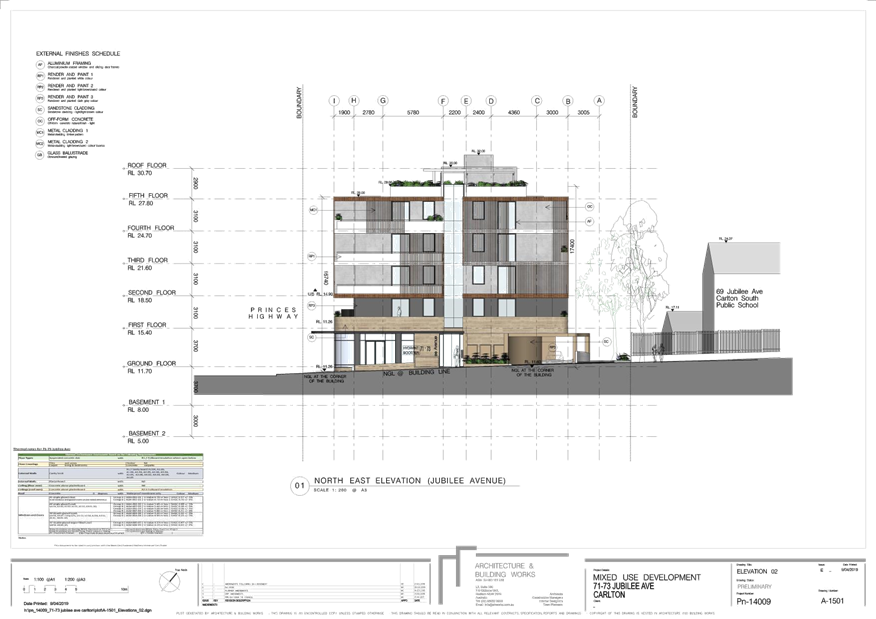
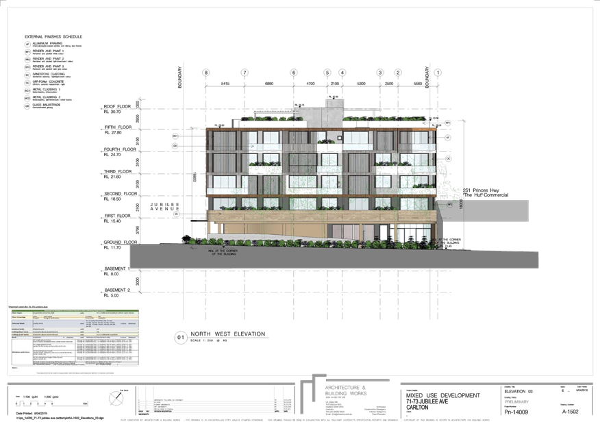
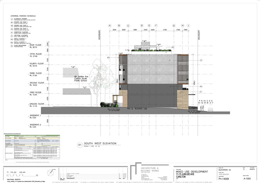
LPP058-19 71-73 Jubilee Avenue Carlton - DA2018/0277
(Report by Senior Development Assessment Officer)
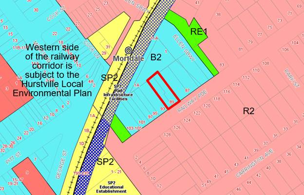
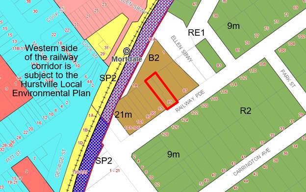
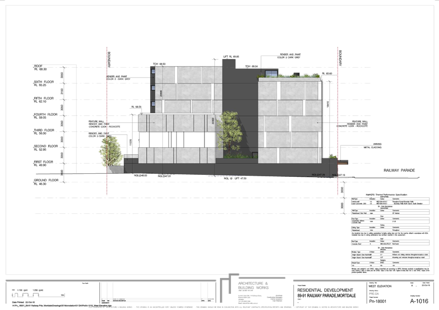
LPP059-19 89-91 Railway Parade Mortdale - DA2018/0439
(Report by Senior Development Assessment Planner)
LPP060-19 38 Hillcrest Avenue Hurstville - REV2019/0012
(Report by Senior Development Assessment Planner)
|
4. Confirmation of Minutes |
REPORT TO GEORGES RIVER COUNCIL
LPP MEETING OF Thursday, 12 December 2019
|
LPP Report No |
LPP057-19 |
Development Application No |
DA2018/0516 |
|
Site Address & Ward Locality |
5-11A Wyuna Street Beverley Park Kogarah Bay Ward |
||
|
Proposed Development |
Site consolidation, tree removal, demolition of existing structures and construction of a six (6) storey residential flat building development comprising sixty four (64) residential units with basement car parking and associated landscaping and site works |
||
|
Owners |
Arthur and Margaret Karas, Tommy and Helen Sau-Han Wong, Salvatore and Sara Geremia, Remo and Fiona Kay Troise and Janelle Lazos |
||
|
Applicant |
Simul Pty Ltd |
||
|
Planner/Architect |
Planner – Planning Ingenuity Architect – PBD Architects |
||
|
Date Of Lodgement |
28/11/2018 |
||
|
Submissions |
33 individual submissions |
||
|
Cost of Works |
$21,404,847.00 |
||
|
Local Planning Panel Criteria |
The application relates to development to which the State Environmental Planning Policy No 65 – Design Quality of Residential Apartment Development applies. |
||
|
List of all relevant s.4.15 matters (formerly s79C(1)(a)) |
State Environmental Planning Policy No.65 – Design Quality of Residential Apartment Development, State Environmental Planning Policy (Vegetation in Non-Rural Areas) 2017, State Environmental Planning Policy (Building Sustainability Index: BASIX) 2004, Greater Metropolitan Regional Environmental Plan No.2 – Georges River Catchment, State Environmental Planning Policy No.55 – Remediation of Land, State Environmental Planning Policy (Infrastructure) 2007, Draft Evironmental State Environmental Planning Policy, Draft State Environmental Planning Policy – Remediation of Land, Kogarah Local Environmental Plan 2012, Kogarah Development Control Plan 2013, Draft Amendment to Section C2 – Medium Density Development of Kogarah DCP 2013 |
||
|
List all documents submitted with this report for the Panel’s consideration |
Statement of Environmental Effects – Planning Ingenuity Traffic and parking Assessment – Teraffic Pty Ltd Noise Impact Assessment – Acoustic, Vibration & Noise Pty Ltd BCA Compliance Capability Report – Certified Building Solutions |
||
|
Report prepared by |
Senior Development Assessment Officer |
||
|
|
Summary of matters for consideration under Section 4.15 Have all recommendations in relation to relevant s4.15 matters been summarised in the Executive Summary of the assessment report? |
Yes |
|
Legislative clauses requiring consent authority satisfaction Have relevant clauses in all applicable environmental planning instruments where the consent authority must be satisfied about a particular matter been listed, and relevant recommendations summarised, in the Executive Summary of the assessment report? |
Yes |
|
Clause 4.6 Exceptions to development standards If a written request for a contravention to a development standard (clause 4.6 of the LEP) has been received, has it been attached to the assessment report? |
Yes- Clause 4.6 Statement submitted in respect to non-compliance with the height control. |
|
Special Infrastructure Contributions Does the DA require Special Infrastructure Contributions conditions (under s7.24)? |
Not Applicable |
|
Conditions Have draft conditions been provided to the applicant for comment? |
No, standard conditions have been attached with design changes and will be available when the report is published. |
|
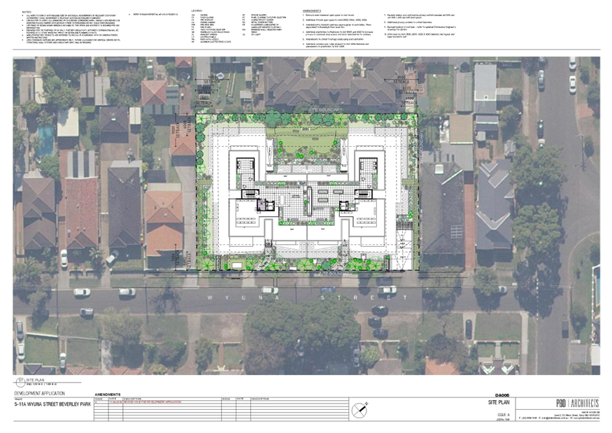
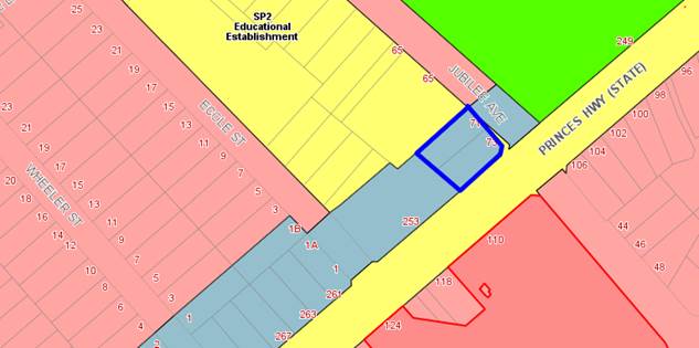
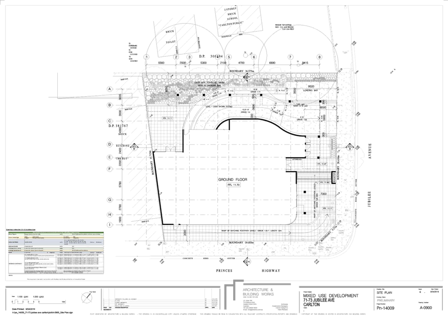
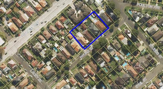
Site Plan
Development site outlined in blue |
Executive Summary
Proposal
1. This development application (DA) seeks consent for the demolition of existing structures across five (5) sites, lot consolidation and the construction of a six (6) storey Residential Flat Building (RFB) comprising of a total of sixty four (64) apartments including two (2) levels of basement car parking catering for a total of 109 car parking spaces.
2. The proposal has two (2) basement car parking levels with one hundred and nine (109) residential car parking spaces and thirteen (13) residential visitor spaces. Vehicle access is provided via a two-way driveway from Wyuna Street along the eastern elevation of the site. (the site is not entirely oriented north/south, this assessment will use the references annotated by the Architect for clarity)
3. The proposal has been amended to address outstanding design issues raised by the Design Review Panel (DRP). The recent architectural amendments also address the Council’s concerns regarding the height and scale of the development and the non- compliant Floor Space Ratio (FSR). The amended plans now provide an additional communal open space area to the roof top.
4. The proposed development in its amended form now complies with the maximum FSR, however still exceeds the height control but has been amended to ensure that the non-compliance is related only to the lift core, fire stairs and roof top terrace and does not affect any habitable areas. An amended Clause 4.6 Statement has been submitted which has been assessed in detail later in this report and is considered to be well founded and in this case is recommended for supported given the nature and degree of variation that has been applied for.
5. Communal open space is provided both at ground level at the rear of the site and on the rooftop (Level 6).
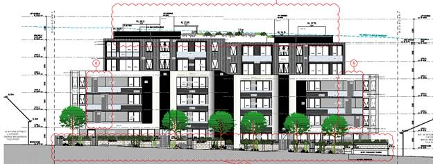
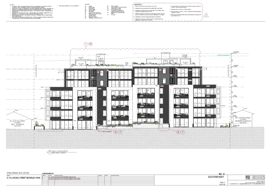
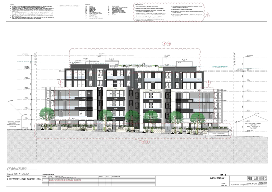
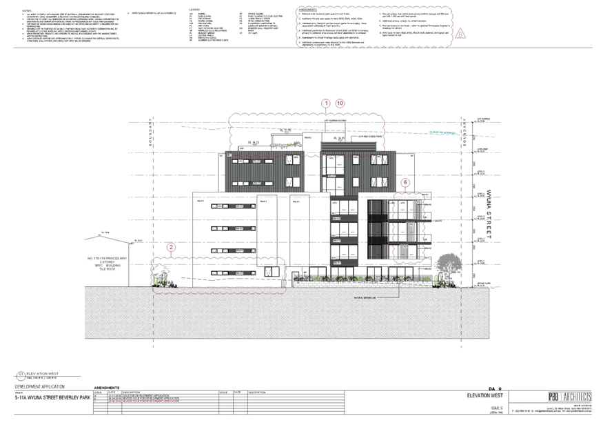
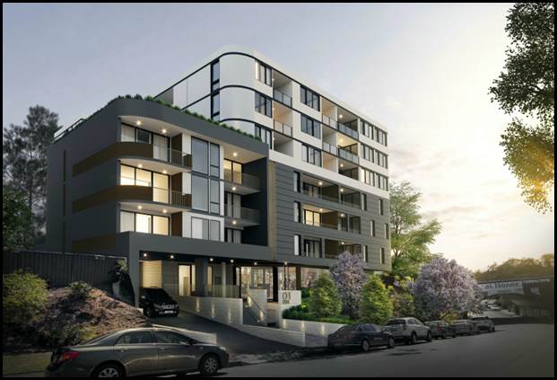
Figure 1: Street elevation of the proposal
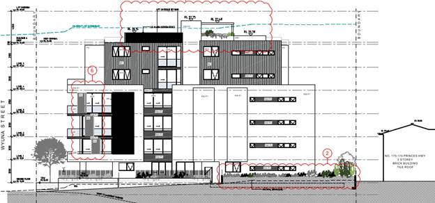
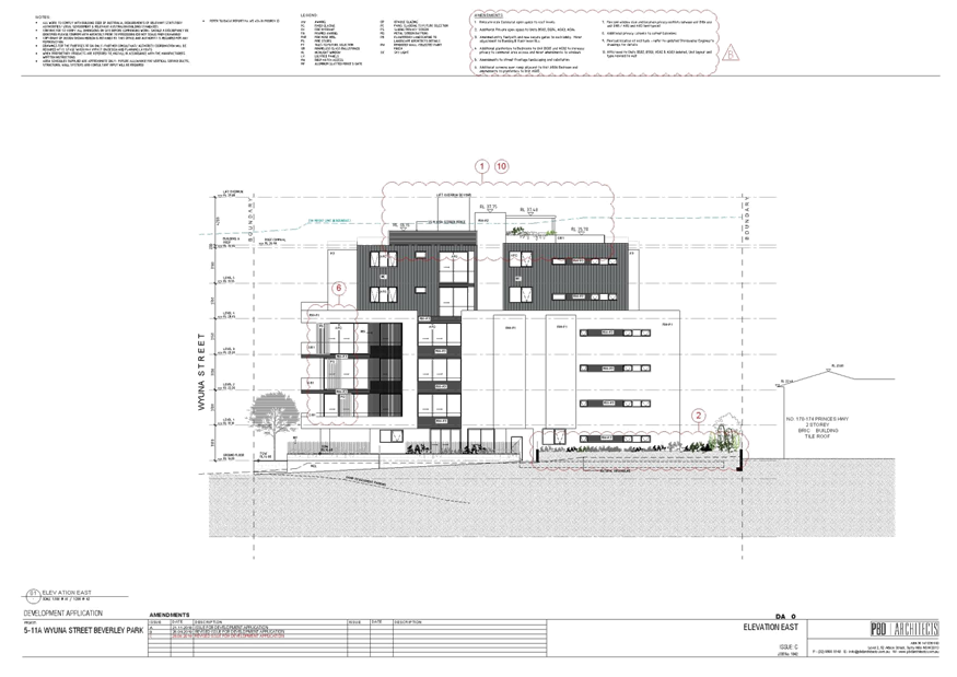
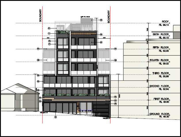
Figure 2: Eastern side elevation of the proposal
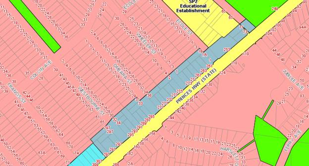
Site and Locality
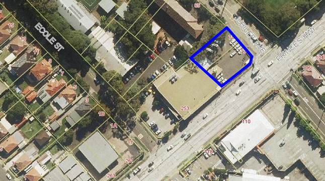
6. The development site is located on the north western side of Wyuna Street, approximately 27m from its intersection with Stubbs Street. It consists of five (5) existing allotments known as 5, 7, 9, 11 and 11A Wyuna Street, Beverley Park. These sites are legally identified as Lots 10, 11 and 12 in DP7056 and Lots A and B in DP382055.
7. The consolidated site is rectangular in shape. It has a total frontage to Wyuna Street of 60.96m and a depth of 42.90m. The total site area is 2,615sqm. The land falls to the street at its north eastern corner. There is a level difference of about 2m between the north-western corner of the site and the south eastern corner.
8. Presently situated on the site are five (5) residential dwellings, consisting of two (2) single storey houses, a two (2) storey house and a single storey dual occupancy, with ancillary such as detached garages, sheds, garden beds and an inground swimming pool.
9. This entire block (surrounded by Princes Highway to the north west, Stubbs Street to the north-east, Lacey Street to the south west and Wyuna Street to the south east) has been “up-zoned” to R3 Medium Density Residential with a maximum height of 21m and a maximum Floor Space Ratio (FSR) of 2:1.
10. The adjacent residential block to the west, bounded by Princes Highway, Lacey Street, John Street and Park Road, has also been up-zoned in the same manner.
11. On the opposite side of Princes Highway to the aforementioned two (2) blocks is the Carlton strip shopping centre zoned B2 Local Centre.
12. Land on the opposite side of Wyuna Street is zoned R2 Low Density Residential and is charactered by single dwelling houses.
Zoning and Permissibility
13. The subject site is zoned R3 Medium Density Residential under the provisions of Kogarah Local Environmental Plan 2012 (KLEP 2012). The proposal involves the construction of a residential flat building which is a permissible use in the zone with development consent.
Submissions
14. The DA was publicly notified to neighbours for a period of fourteen (14) days in accordance with the Kogarah Development Control Plan 2013 (KDCP 2013). A total of twenty five (25) submissions were received raising concerns with parking and traffic congestion, privacy, design, concerns regarding the height, scale and bulk of the scheme and overlooking issues. Amended plans were submitted to Council on 29 August 2019. The amended plans were renotified between 4 September and 18 September 2019. Eight (8) additional submissions were received. A total of thirty three (33) submissions were received as a result of both notification periods. These issues are discussed in greater detail in the body of this report.
Reason for Referral to the Local Planning Panel
15. This application is referred to the Georges River Local Planning Panel for determination as the proposal relates to a Residential Flat Building and the provisions of the State Environmental Planning Policy No 65 – Design Quality of Residential Flat Development apply. It is also referred as over ten (10) unique submissions were received in response to the application.
Planning and Design Issues
16. The proposal is generally an appropriate response to the site when considered against the Design Quality Principles of State Environmental Planning Policy No 65 – Design Quality of Residential Apartment Development. Its bulk and scale is consistent with the desired future character of the area as established by the KLEP 2012 development standards for FSR and height.
17. Originally the development exceeded the 21m height limit with parts of the habitable areas encroaching within the height limit. Council expressed concern and stated that support would not be provided for any habitable spaces exceeding the control. Only ancillary structures could be considered. The Applicant has submitted an amended Clause 4.6 Statement which has been assessed in detail as part of this report and is considered to be well founded. The proposal exceeds the building height development standard of 21m that applies to the site under KLEP 2012, however this is directly related to the provision of a high quality communal open space area on the rooftop to supplement the ground level communal open space at the rear of the site which will improve its functionality and overall amenity for the units. The lift overrun, fire stairs and associated ancillary structures exceed the height control to access this communal area, however these are considered to be acceptable and will not adversely affect the amenity of adjoining properties or the streetscape.
18. The proposal is fully compliant with the maximum FSR development standard that applies to the site under KLEP 2012. The proposal is therefore consistent with the desired future building envelope and density for the site.
19. The proposal involves some minor Apartment Design Guide (ADG) building separation “design criteria” non-compliances on ground level, and levels 1 - 3. These are detailed within the ADG Compliance Table within this report. The variations are acceptable on merit, on the basis that privacy impacts can be mitigated to an appropriate degree and therefore the proposal meets the objectives of the design criteria.
Conclusion
20. The application has been assessed having regard to the Matters for Consideration under Section 4.15 of the Environmental Planning and Assessment Act 1979, the provisions of the relevant State Environmental Planning Policies, Local Environmental Plans and Development Control Plans. The proposal is an appropriate response to the up-zoning of the land in an area that is undergoing a transition to medium density housing including Residential Flat Buildings (RFB). The bulk and scale of the building has satisfactorily been resolved via good articulation, appropriate building setbacks and a mix of materiality and textures. As a result the application is recommended for approval subject to suitable conditions of consent.
Report in Full
Description of the Proposal
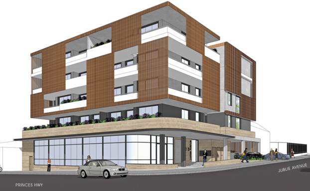
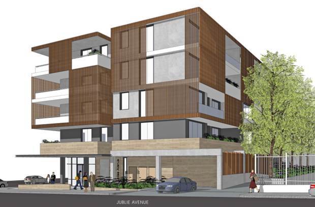
21. The original development proposed the demolition of existing structures and the construction of a seven storey Residential Flat Building (RFB). The amended plans submitted seek consent for the construction of a 6 storey residential flat building (RFB) containing 64 apartments. Though the building is 6 storey’s in height (plus the rooftop communal open space), its 4 storey base is emphasised with levels 5 and 6 being recessive. Refer to Figure 3 below.
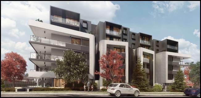
Figure 3: Artist’s 3D rendition of the proposal (Source PBD Architects, 2019)
22. Further details of the proposal are as follows;
Basement 2 (split level comprising Basement 2 and 2A)
- Sixty one (61) residential car parking spaces.
- Two lift and stair lobbies
- Fifty two (52) secure storage areas that will be allocated to individual apartments.
Basement 1 (split level comprising Basement 1 and 1A)
- Forty eight (48) car parking spaces comprising of the following:
· Thirteen (13) visitors car parking spaces (one space doubles up as a car wash bay).
· Thirty five (35) residential car parking spaces (including eight (8) accessible spaces with shared zones)
- Seventeen (17) secure storage lockers.
- One (1) designated Loading Bay.
- Twenty two (22) residential bicycle parking spaces.
- Eight (8) visitors bicycle parking spaces.
- Hydrant booster and pump room.
- Switch room.
- Communication room.
- Two (2) lift and stair lobbies.
- Cleaners WC
- Two separate garbage holding rooms.
- Bulky store room adjacent to garbage holding room.
Ground Floor Plan
- The development is divided into two (2) distinct buildings with separate lobbies and lifts. Building A is located to the eastern part of the site and Building B is located on the western side of the site.
- Twelve 12 residential apartments on the ground floor as follows:
- Building A ground floor comprises the following:
· 3 x 1 bedroom apartments (one of which is an adaptable unit)
· 2 x 2 bedroom apartments (one of which is a liveable unit)
· 1 x 3 bedroom apartment
- Building B ground floor comprises the following:
· 3 x 1 bedroom apartments (one of which is an adaptable unit)
· 2 x 2 bedroom apartments (one of which is a liveable unit)
· 1 x 3 bedroom apartment
- Dual lane vehicular access from Wyuna Street located to the eastern side of the site.
- Landscaped front setback with two (2) communal residential access gates and four (4) apartments with direct private courtyard access.
Levels 1 – 3
- Twelve (12) residential apartments on each level as follows:
- Building A ground floor comprises the following:
· 1 x 1 bedroom apartments (one of which is an adaptable unit)
· 4 x 2 bedroom apartments (one of which is a liveable unit)
· 1 x 3 bedroom apartment.
· One (1) lift lobby and fire stairs.
- Building B ground floor comprises the following:
· 1 x 1 bedroom apartments (one of which is an adaptable unit)
· 4 x 2 bedroom apartments (one of which is a liveable unit)
· 1 x 3 bedroom apartment
· One (1) lift lobby and fire stairs.
Levels 4 – 5
- Eight (8) residential apartments on each level as follows:
- Building A ground floor comprises the following:
· 1 x 1 bedroom apartments
· 2 x 2 bedroom apartments
· 1 x 3 bedroom apartment
· One (1) lift lobby and fire stairs.
- Building B ground floor comprises the following:
· 1 x 1 bedroom apartments
· 2 x 2 bedroom apartments
· 1 x 3 bedroom apartment
· One (1) lift lobby and fire stairs.
- Both parts of the building are setback from the boundaries behind the podium.
Roof Plan
- Communal roof top open space area (all areas of the roof top space are accessible by both building A and B) comprising of the following:
· Approximately 356sqm of communal open space area.
· Multiple seating and outdoor eating areas both covered and uncovered.
· Accessible ramp to provide access to all parts of the roof top.
· Accessible toilet.
· BBQ facilities.
· Internally located communal garden beds.
· Perimeter planting for the majority of the perimeter of the communal open space area.
· Roof top service areas (surrounded by 1.5m high screens) for 48 air conditioning condensers.
23. The building is of a contemporary design with a flat roof and curved corner elements on the front facade. There is a good variety of external finishes such as metal cladding, textured and painted render, metal feature screens and planter box and glass balustrades.
24. The proposal involves the removal of the following seventeen (17) trees from the site, as follows:
· 5 x Mangifera indica
· 1 x Ficus carica
· 4 x Phoenix roebelenii
· 1 x Plumeria rubra
· 1 x Persea americana
· 2 x Yucca Sp
· 3 x Cupressus Sp
25. There are currently street trees located in front of 5, 7 and 9 Wyuna Street. These trees are relatively small in size and scale existing in front of the development site. The proposal will incorporate the planting of six (6) new street trees being a minimum of 45 litre in pot size as shown on the Landscape Plans. A condition of development consent has also been imposed requiring the planting of these trees.
DESCRIPTION OF THE SITE AND LOCALITY
26. The subject site is located on the north western side of Wyuna Street. The site is located about 27m from the intersection of Wyuna Street and Stubbs Street Beverley Park.
27. The subject site consists of five (5) allotments with the following legal descriptions:
· Lot 12 DP7056 (5 Wyuna Street)
· Lot 11 DP7056 (7 Wyuna Street)
· Lot 10 DP7056 (9 Wyuna Street)
· Lot B DP382055 (11 Wyuna Street)
· Lot A DP382055 (11A Wyuna Street)
28. The consolidated site is rectangular in shape. It has a total combined frontage width of 60.96m and a depth measured along both side boundaries of 42.9m. These dimensions yield a total site area of 2,615sqm.
29. The land falls to the street at its south eastern corner. There is a level difference of about 2m between the north western corner of the site and the south eastern corner.
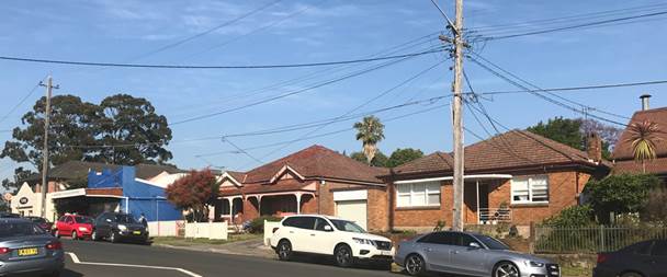
30. 5, 7 and 9 Wyuna Street are currently occupied by one and two storey dwelling houses with driveways and various ancillary outbuildings and a swimming pool. Refer figures 4 to 6 below.
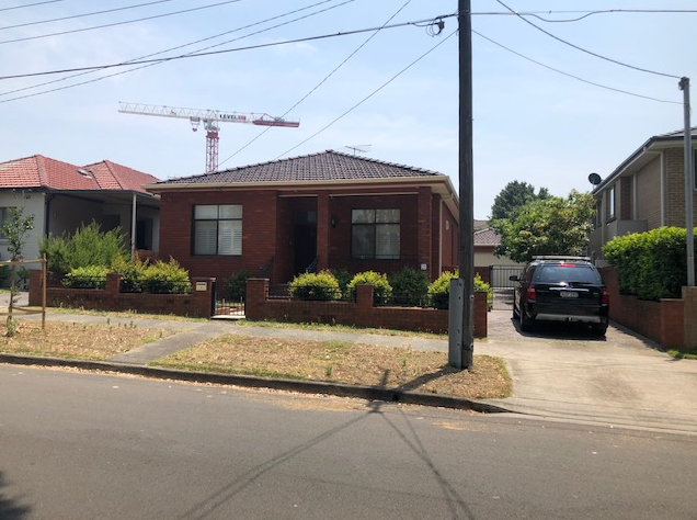
Figure 4: 5 Wyuna Street, Beverley Park
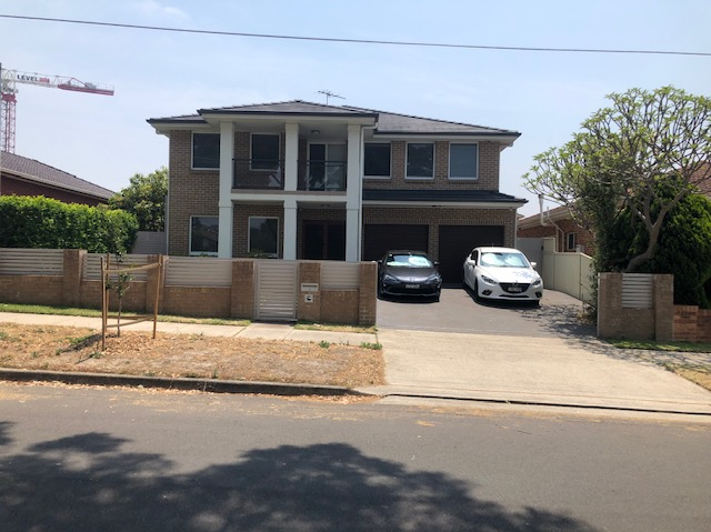
Figure 5: 7 Wyuna Street, Beverley Park
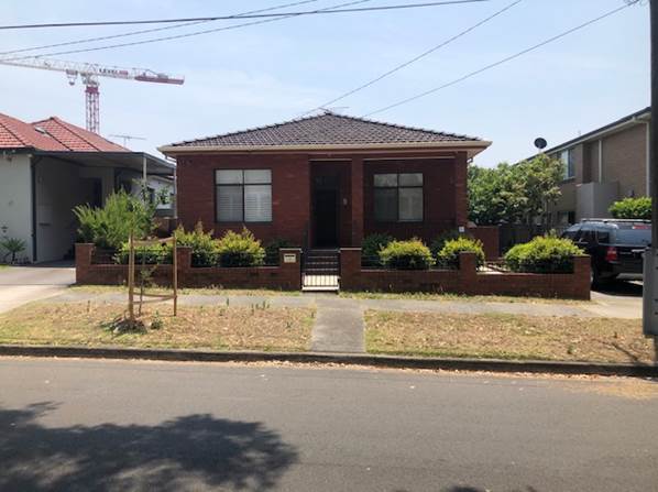
Figure 6: 9 Wyuna Street, Beverley Park
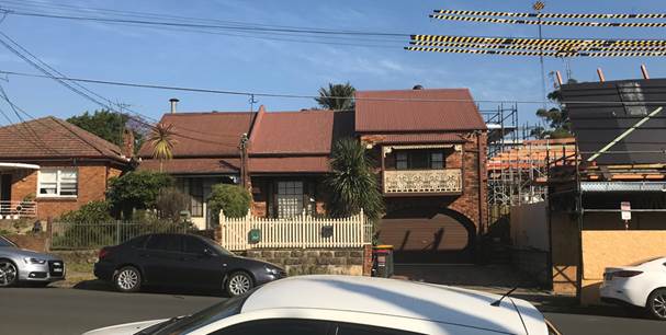
31. 11 and 11A Wyuna Street are currently occupied by an attached dual occupancy single storey brick and tile dwelling house with various attached and detached ancillary structures at the rear.
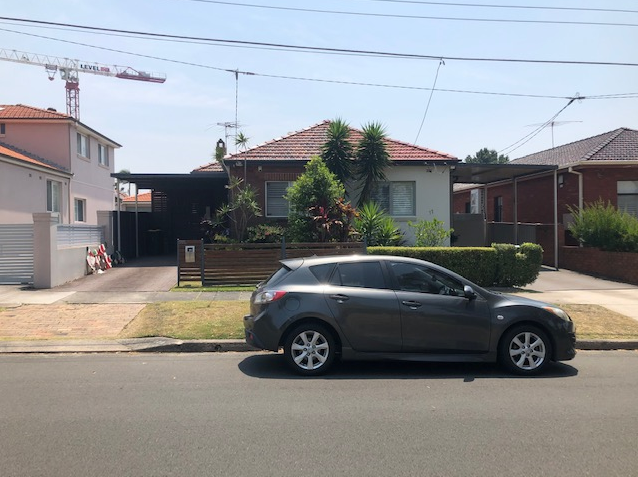
Figure 7: Existing development at 11 and 11A Wyuna Street
32. Immediately adjoining the site to the east at 1 and 3 Wyuna Street are two (2) detached dwelling houses. Land on the opposite (southern side of Wyuna Street is zoned R2 Low Density Residential and is characterised by single dwelling houses. This area is residential in nature and largely low scale in its character.
33. This entire block (surrounded by Princes Highway to the north, Stubbs Street to the east, Lacey Street to the west and the northern side of Wyuna Street) has been “up-zoned” to R3 Medium Density Residential in which residential flat buildings (RFB) are permitted to a maximum height of 21m and a maximum Floor Space Ratio (FSR) of 2:1. The adjacent block to the west, surrounded by Princes Highway, Lacey Street, John Street and Park Road, has also been up-zoned in the same manner.
34. The Georges River Local Planning Panel recently determined by way of refusal a development application for the redevelopment of the site known as 186–190 Princes Highway and 2–6 Lacey Street, Kogarah Bay (DA2018/0513) for a seven (7) storey RFB and the refurbishment of the heritage item that exists on the site. Figure 8 shows the montage of the elevation proposed to Wyuna Street.
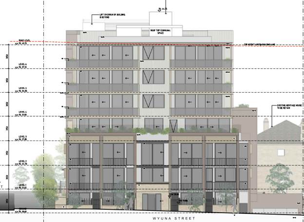
Figure 8: South Elevation of 2- 6 Lacey Street and 186-190 Princes Highway (Source PBD Architects)
35. Adjoining this development to the west is an application currently under review by Council at 13–21 Wyuna Street, Beverley Park (DA2019/0406) for the redevelopment of the site for a six (6) storey RFB. Figure 9 shows the photomontage of the proposed elevation fronting Wyuna Street.
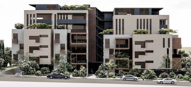
Figure 9: Front elevation of prosed development at 13–21 Wyuna Street (Source Shiro Architects, 2019)
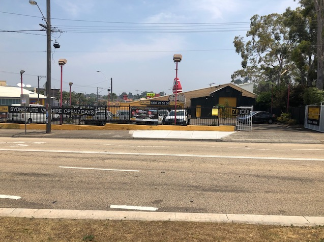
36. On the opposite side of the Princes Highway to the rear of the proposed development is the Carlton strip shopping centre zoned B2 Local Centre.
37. These B2 properties encourage mixed land uses. Most recently a mixed use development was approved at 325-329 Princes Highway (DA2017/0491) (refer to figure 10 below).
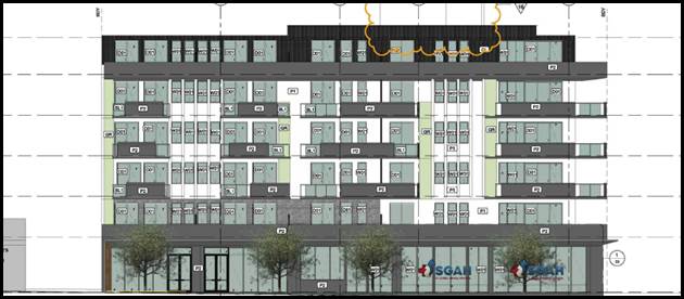
Figure 10: Front elevation of the approved development at No.325-329 Princes Highway
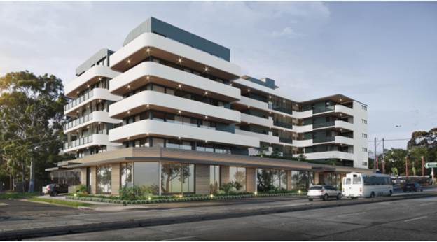
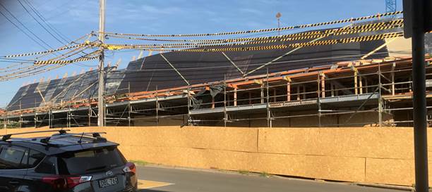
38. Also 313-323 Princes Highway is currently under construction where the Land and Environment Court approved a six storey mixed use development with commercial premises on the ground floor (refer to figure 11 below) at this site.
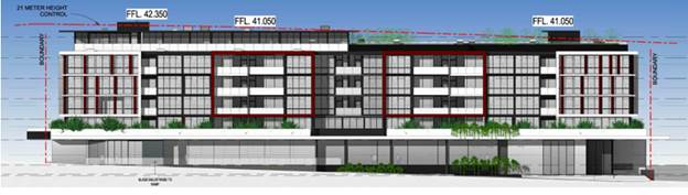
Figure 11: Front elevation of the approved development at 313-323 Princes Highway
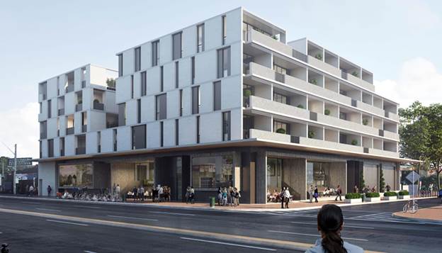
39. Properties immediately to the west of the site are generally undeveloped and contain single and two storey detached dwelling houses. The Land and Environment Court has recently approved two development applications for new six (6) and seven (7) storey RFB’s along John Street. Figure 12 and 13 below show the front façade of the approved developments within this precinct. A new seven (7) storey RFB has also been approved for 198-200 Princes Highway (DA2017/0655). The block bounded by John Street, Princes Highway, Lacey Street and Park Road has progressed further with its renewal when compared with this block, with much of the sites having the benefit of development approvals.
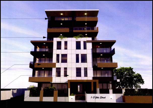
Figure 12: Front elevation of the approved development at 1-3 John Street, Beverley Park (DA2017/0218) (Courtesy Council Records)
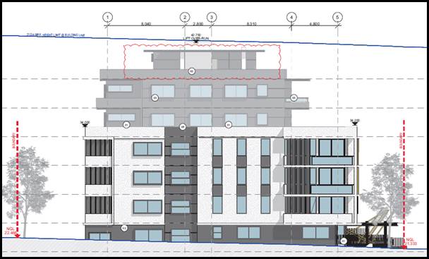
Figure 13: Front elevtaion of the approved RFB at 5–9 John Street, Beverley Park (DA2017/0663) (Courtesy Council Records)
40. The immediate precinct is undergoing a process of transition and transformation to larger scale medium density residential developments and larger scale mixed use developments along Princes Highway.
State Environmental Planning Policies (SEPPs)
41. Compliance with the relevant SEPPs is summarised in the following table and discussed in further detail below it.
Table 1: Compliance with State Planning Policies
|
SEPP Title |
Complies |
|
Greater Metropolitan Regional Environmental Plan No 2 – Georges River Catchment |
Yes |
|
State Environmental Planning Policy (Building Sustainability Index: BASIX) 2004 |
Yes |
|
State Environmental Planning Policy No 55 - Remediation of Land |
Yes |
|
State Environmental Planning Policy (Vegetation in Non-Rural Areas) 2017 |
Yes
|
|
State Environmental Planning Policy (Infrastructure) 2007 |
Yes |
|
State Environmental Planning Policy No 65—Design Quality of Residential Apartment Development |
Yes |
Greater Metropolitan Regional Environmental Plan No 2 – Georges River Catchment
42. The primary relevant aims and objectives of this plan are:
· to maintain and improve the water quality and river flows of the Georges River and its tributaries and ensure that development is managed in a manner that is in keeping with the national, State, regional and local significance of the Catchment,
· to protect and enhance the environmental quality of the Catchment for the benefit of all users through the management and use of the resources in the Catchment in an ecologically sustainable manner,
· to ensure consistency with local environmental plans and also in the delivery of the principles of ecologically sustainable development in the assessment of development within the Catchment where there is potential to impact adversely on groundwater and on the water quality and river flows within the Georges River or its tributaries,
· to establish a consistent and coordinated approach to environmental planning and assessment for land along the Georges River and its tributaries and to promote integrated catchment management policies and programs in the planning and management of the Catchment
43. The DA includes a concept stormwater design prepared by David Romanous of John Romanous and Associates Pty Ltd. All stormwater will be diverted to the street via a sub-ground OSD tank located in the front setback of the building. The application was originally referred to Council’s Engineering Services for comment. There were concerns raised in respect to the stormwater and drainage arrangement. The following comments were made;
“It is not supported to locate an OSD tank under habitable area. It will be conditioned that this part of the OSD underneath the bedroom (4.0m3) is to be deleted and may be compensated as part of the rainwater tank to the discretion of the drainage engineer”
44. Amended hydraulic plans were submitted to Council in July 2019 and referred back to Council’s Engineers for comment, who are satisfied with the stormwater drainage arrangement subject to the imposition of conditions.
45. In summary, the proposal will not contravene the aims, objectives or purpose of the Regional Plan subject to the imposition of those conditions recommended by the Development Engineer.
State Environmental Planning Policy (Building Sustainability Index: BASIX) 2004
46. BASIX Certificate No. 974609M dated 23 November 2018 has been issued for the proposal and demonstrates that it meets the provisions and minimum requirements of BASIX in terms of water, thermal comfort and Energy efficiency. The architectural plans include the commitments that are required to be shown at DA stage. The proposal satisfies the requirements of the BASIX SEPP.
State Environmental Planning Policy No 55 - Remediation of Land (SEPP 55)
47. SEPP 55 aims to promote the remediation of contaminated land in order to reduce the risk of harm to human health or any other aspect of the environment.
48. Clause 7 requires contamination and remediation to be considered in determining a DA. The consent authority must not consent to the carrying out of development on land unless it has considered whether or not the land is contaminated.
49. A review of the site history indicates that the site has been used for residential purposes since at least 1943. Residential usage is not typically associated with activities that would result in the contamination of land.
50. A Preliminary Site Investigation (PSI) Report No E24014.E01 dated 15 October 2018 prepared by eiaustralia was submitted with the application, which concludes:
“A conceptual site model (CSM) was derived for the site which identified potential contaminating sources that may have occurred and evaluated the likelihood for relevant exposure pathways to be complete. EI considers there to be a medium risk for contamination to be present on-site given fill soils of unknown origin, spills from parked vehicles, potential migration of contamination onto site from nearby properties and unknown contamination sources as the main potential sources of contamination.
Taking into account the above considerations and subject to the statement of limitation (Section 8), EI conclude that there is a medium potential for contamination to be present on site. With consideration given to the nature of the proposed land use and potential contamination risks to end users of the site, EI consider that the site can be made suitable for the proposed land use, subject to the implementation of the following recommendations:
· A Hazardous Materials Survey should be completed by a suitably qualified and experienced consultant, before commencement of demolition works, to identify any hazardous materials present within the building structure. All identified hazardous materials must be appropriately managed and to maintain worker health and safety during site construction woks; and
· Due to the presence of buildings and services onsite, EI recommends that a Detailed Site Investigation (DSI) is to be completed, after all existing site structures are demolished, to adequately characterise site soils and ground water, and to provide baseline data for evaluation of any remedial and management requirements that may be necessary to allow the site to be made suitable for the proposed development.”
51. Based on the information provided, a Detailed Site Investigation Report was required.
52. A Detailed Site Investigation Report No E24014.E02_Rev 0 dated 27 November 2019 prepared by eiaustralia was submitted to Council on 27 November 2019 which stated.
“BACKGROUND
EI Australia prepared a PSI for the site, which identified the potential for contamination to be present within soils and groundwater at the site located at 5–11A Wyuna Street, Beverley Park. The site is the location of a proposed residential flat building development.
The PSI concluded that EI considers there to be a medium risk for contamination to be present on-site given fill soils of unknown origin, spills from parked vehicles, potential migration of contamination onto site from nearby properties and unknown contamination sources as the main potential sources of contamination. The PSI recommended the following be undertaken:
· A Hazardous Materials Survey should be completed by a suitably qualified and experienced consultant, before commencement of demolition works, to identify any hazardous materials present within the building structure. All identified hazardous materials must be appropriately managed and to maintain worker health and safety during site construction woks; and
· Due to the presence of buildings and services onsite, EI recommends that a Detailed Site Investigation (DSI) is to be completed, after all existing site structures are demolished, to adequately characterise site soils and ground water, and to provide baseline data for evaluation of any remedial and management requirements that may be necessary to allow the site to be made suitable for the proposed development.”
CONCLUSION
A detailed site investigation report was conducted in order to assess the nature and degree of on-site contamination associated with current and former uses of the property. Based on the findings of this assessment it was concluded that:
· A previous Preliminary Site Investigation (EI PSI, 2018) conducted by EI identified there to be a medium potential for contamination to be present on-site;
· The site was free of statutory notices by the EPA;
· Based on land title history and the findings in the PSI (EI, 2018a), the site appears to have been used for residential land use from at least the 1900s onwards.
· Soil sampling and anaylsis were conducted at eight targeted test bore locations (HA1- HA8) within the accessible areas of the site down to a maximum depth of 0.7 mBGL in natural sand. Sampling regime was considered to be appropriate for preliminary investigation purposes and comprised judgemental and systematic (triangular grid) sampling patterns, with allowance for structural obstacles (e.g. existing residential dwellings);
· The sub surface layers comprised of topsoil materials, comprising dark brown to brown silty sands, underlain by pale grey and yellow sand;
· Standing water level was encountered at depth of 5.07mBGL during GME;
· Results of soil samples collected from soil test boreholes HA1 to HA8 reported concentrations of the screened heavy metals, PAHs, BTEX, TRH, OCP/OPP/PCBs and asbestos to be below the adopted human health and ecological based SILs;
· Results of groundwater samples collected from the groundwater monitor well previously installed BH1M (EI, 2018b) reported concentrations of the PAHs, BTEX, TRHs, VOCs below the adopted GILs. Concentrations of copper (2Ug/L) exceeding the adopted criteria, however concentrations were considered to be representative of background groundwater quality and presents a low human health and environment risk;
· On review of the Conceptual Site Model (CSM) developed as part of this DSI, it was concluded that the model remains valid for the proposed development.
Taking into account the above considerations and subject to the statement of limitation (Section 13), EI consider that the site is suitable for its proposed use, subject to the implementation of recommendations.
Recommendations
It is assumed that during the proposed construction of the two level basement car park which covers the majority of the site area, fill and natural soil/rock will require removal from the site. Therefore, in view of the above findings and in accordance with the NEPM2013 guidelines, it is considered that the site is suitable for the proposed residential development on completion of the following recommendations:
· Prior to site demolition, a suitably qualified and experienced consultant should be engaged to perform a Hazardous Materials Survey on existing site structures to identify potentially hazardous building products that may be released to the environment during demolition works;
· Following demolition and removal of demolition debris, a Hazardous Materials Clearance Certificate should be carried out by a suitably qualified and experience consultant;
· Sampling of soils to be removed from the site (including virgin excavated natural materials or VENM) for waste classification and offsite disposal purposes in accordance with the EPA (2014) Waste Classification Guidelines.
· Any material being imported to the site should be assessed for potential contamination in accordance with NSW EPA guidelines as being suitable for the intended use or be classified as VENM.”
53. Based on the information provided, a contingency condition has been included in the recommended conditions detailing what is required to take place should unexpected contamination be found during demolition, excavation and construction.
The report concludes that the site is suitable for the proposal and the continued residential use of the land. This conclusion is supported by Council’s Environmental Health Section who recommended appropriate conditions of consent relating to any contamination findings during demolition, excavation or construction, and that a Clearance Certificate be obtained prior to the issue of an Occupation Certificate. These conditions are included in the recommendation below.
State Environmental Planning Policy (Infrastructure) 2007
54. The aim of the Infrastructure SEPP is to facilitate the effective delivery of infrastructure across the State. The Infrastructure SEPP also examines and ensures that the acoustic performance of buildings adjoining the rail corridor or busy arterial roads is acceptable and internal amenity within apartments is reasonable given the impacts of adjoining infrastructure.
55. Clause 102 of the SEPP, “Impact of road noise or vibration on non-road development”, is relevant to this DA on the basis that the proposal involves the construction of residential accommodation on land that is generally adjacent to the road corridor of Princes Highway (having an annual average daily traffic volume exceeding 20,000 vehicles) and is likely to be adversely affected by road noise or vibration. As a result, the following provisions of Clause 102 of the SEPP are relevant:
(3) If the development is for the purposes of residential accommodation, the consent authority must not grant consent to the development unless it is satisfied that appropriate measures will be taken to ensure that the following LAeq levels are not exceeded:
(a) in any bedroom in the residential accommodation—35 dB(A) at any time between 10 pm and 7 am,
(b) anywhere else in the residential accommodation (other than a garage, kitchen, bathroom or hallway)—40 dB(A) at any time.
56. An Acoustic Report (Traffic and Environmental Noise Assessment) was submitted with the DA, dated 22 October 2018 and prepared by Acoustic, Vibration, & Noise Pty Ltd. The report addresses the provisions of the Policy with respect to achieving acoustic compliance. The report suggests a series of construction methods and materials (e.g. 6mm laminated glass in all living areas and bedrooms, with full perimeter acoustic seals).
57. Though the Acoustic Report does not explicitly state that compliant internal noise levels on the rear façade oriented towards Princes Highway are achieved only when windows are closed, this is nonetheless a reasonable conclusion to draw. The Apartment Design Guide states under Objective 4J-1 (Noise and Pollution) that achieving various design criteria (such as natural cross ventilation) may not be possible in some situations due to noise and pollution. In accordance with the NSW Department of Planning’s “Development near Busy Roads and Rail Corridors – Interim Guidelines” and relevant ventilation requirements of the BCA, mechanical ventilation would therefore be required for the noise affected apartments and would need to be acoustically designed to ensure that internal target acoustic levels are met and that adjacent properties are not affected by the system. In this instance, mechanically ducted air conditioning is proposed for each apartment (with condensers located on the rooftop within the screened service areas) and reinforced by condition of consent.
58. The DA was also referred to Ausgrid on 4 December 2018 in accordance with Clause 45 of State Environmental Planning Policy (Infrastructure) 2007. No response was received at the time this report was prepared (1 December 2019).
59. The provisions and requirements of the Infrastructure SEPP have been addressed and satisfied by the proposal.
Draft Remediation of Land SEPP
60. The Department of Planning and Environment has announced a Draft Remediation of Land SEPP, which will repeal and replace the current State Environmental Planning Policy No 55 — Remediation of Land.
61. The main changes proposed include the expansion of categories of remediation work which requires development consent, a greater involvement of principal certifying authorities particularly in relation to remediation works that can be carried out without development consent, more comprehensive guidelines for Councils and certifiers and the clarification of the contamination information to be included on Section 149 Planning Certificates.
62. Whilst the proposed SEPP will retain the key operational framework of SEPP 55, it will adopt a more modern approach to the management of contaminated land. The Draft SEPP will not alter or affect the findings in relation to contamination at the site.
63. Based on the Preliminary Site Investigation Report provided, a Detailed Site Investigation Report was required.
64. A Detailed Site Investigation Report No E24014.E02_Rev 0 dated 27 November 2019 prepared by eiaustralia was submitted to Council on 27 November 2019 provided an assessment and recommendations outlined in the SEPP 55 assessment above.
65. Based on the information provided, a contingency condition has been included in the recommended conditions detailing what is required to take place should unexpected contamination be found during demolition, excavation and construction.
The report concludes that the site is suitable for the proposal and the continued residential use of the land. This conclusion is supported by Council’s Environmental Health Section who recommended appropriate conditions of consent relating to any contamination findings during demolition, excavation or construction, and that a Clearance Certificate is to be obtained prior to the issue of an Occupation Certificate. These conditions are included in the recommendation below.
State Environmental Planning Policy (Vegetation in Non-Rural Areas) 2017
66. The Vegetation SEPP aims to protect the biodiversity values of trees and other vegetation in non-rural areas of the State, and to preserve the amenity of non-rural areas of the State through the preservation of trees and other vegetation.
67. The Vegetation SEPP applies to clearing of:
(a) Native vegetation above the Biodiversity Offset Scheme (BOS) threshold where a proponent will require an approval from the Native Vegetation Panel established under the Local Land Services Amendment Act 2016; and
(b) Vegetation below the BOS threshold where a proponent will require a permit from Council if that vegetation is identified in the council’s development control plan (DCP).
68. The Vegetation SEPP repeals clauses 5.9 and 5.9AA of the Standard Instrument - Principal Local Environmental Plan with regulation of the clearing of vegetation (including native vegetation) below the BOS threshold through any applicable DCP.
69. The proposal involves the removal of eighteen (18) trees from the site. Council’s Consultant Arborist has reviewed the proposed tree removal and raised no objection to approval of the trees on the basis that the landscape plan (see figure 14) shows nineteen (19) new trees to be planted on site. Furthermore a condition has been recommended requiring six (6) new street trees (Harpulia pendula) with a minimum pot size of 45 litres are to be planted within the road reserve fronting the subject site. These new trees will satisfactorily offset the loss of the existing trees with quality native replacement plantings.
Figure 14: Landscape plan showing the proposed landscaping. The red circles show the trees proposed to be removed.
70. On this basis, the proposal is consistent with relevant provisions of the Vegetation SEPP.
Draft Environment SEPP
71. The Draft Environment SEPP was exhibited from 31 October 2017 to 31 January 2018. This consolidated SEPP proposes to simplify the planning rules for a number of water catchments, waterways, urban bushland, and Willandra Lakes World Heritage Property.
72. Changes proposed include consolidating the following seven existing SEPPs:
· State Environmental Planning Policy No. 19 – Bushland in Urban Areas
· State Environmental Planning Policy (Sydney Drinking Water Catchment) 2011
· State Environmental Planning Policy No. 50 – Canal Estate Development
· Greater Metropolitan Regional Environmental Plan No. 2 – Georges River Catchment
· Sydney Regional Environmental Plan No. 20 – Hawkesbury-Nepean River (No.2-1997)
· Sydney Regional Environmental Plan (Sydney Harbour Catchment) 2005
· Willandra Lakes Regional Environmental Plan No. 1 – World Heritage Property
73. The proposal is consistent with the provisions of this Draft Instrument.
State Environmental Planning Policy No 65 — Design Quality of Residential Apartment Development
74. State Environmental Planning Policy No.65 – Design Quality of Residential Flat Buildings (SEPP 65) was gazetted on 26 July 2002 and applies to the assessment of DAs for RFBs of three or more storeys in height (excluding car parking levels) and containing at least four dwellings. Amendment 3 to SEPP 65 commenced on 17 July 2015 and implemented various changes including the introduction of the Apartment Design Guide (ADG) to replace the Residential Flat Design Code. Given the nature of the development proposed, SEPP 65 applies.
75. The proposal involves the erection of a new 6 storey RFB (excluding basement car parking) containing 64 apartments and is therefore affected by the SEPP.
76. In determining DAs to which SEPP 65 relates, Clause 28(2) of the SEPP requires that the consent authority take into consideration:
a) the advice (if any) obtained from the design review panel, and
b) the design quality of the development when evaluated in accordance with the design quality principles, and
c) the Apartment Design Guide.
77. The proposal was considered by the Georges River Design Review Panel (DRP) on 14 March 2019. The DRP assessed the merits of the development against each of the nine (9) Design Quality Principles and the provisions of the Apartment Design Guide (ADG). The DRP’s comments are included and addressed within the table below, along with further comment from Council’s Planner.
78. In addition to satisfying the Design Quality Principles, the proposal generally satisfies relevant requirements of the ADG pertaining to design quality and amenity of the apartments. Notwithstanding some minor non-compliances (detailed below) the proposal satisfies the amenity, internal layout and design requirements of the ADG. The Panels comments are summarised and addressed in table 3 below (in bold). The recommendation from the meeting was that the Panel supports the application subject to the issues raised by the Panel being resolved to the satisfaction of Council.
Table 2: Application of SEPP 65
|
Clause |
Standard |
Proposal |
Complies |
|
3 - Definitions |
Complies with definition of “Residential Apartment Development” (RAD) |
Complies with definition |
Yes |
|
4 - Application of Policy |
Development involves the erection of a new RFB, substantial redevelopment or refurbishment of a RFB or conversion of an existing building into a RFB. The definition of an RFB in the SEPP includes mixed use developments. |
The erection of an RFB satisfies the SEPP’s definition of this residential land use. |
Yes |
|
Design Verification |
Design verification statement provided by qualified designer Registered Architect Name and Registration No. |
Design Verification Statement provided by Registered Architect: Paul Buljevic (Registration No.7768) |
Yes |
Table 3: Part 2 Design Quality Principles under the SEPP
|
SEPP 65 – Design Quality of Residential Flat Buildings |
DRP Comment |
Planners comment |
|
Context and Neighbouring Character Good design responds and contributes to its context. Context is the key natural and built features of an area, their relationship and the character they create when combined. It also includes social, economic, health and environmental conditions. Responding to context involves identifying the desirable elements of an area’s existing or future character. Well designed buildings respond to and enhance the qualities and identity of the area including the adjacent sites, streetscape and neighbourhood.
Consideration of local context is important for all sites, including sites in established areas, those undergoing change or identified for change. |
Wyuna Street is located parallel to Princes Highway and is best described as a split zone street with the north western side zoned R3 and the south eastern side zoned R2. The south eastern side of the street is predominantly single storey homes.
There are mature street trees located opposite the site and these are consistent with other street trees in the neighbourhood.
The site slopes diagonally from the rear far western corner RL17.33 to the front eastern corner RL14.77.
The site context requires a built form that sensitively addresses the transition from very low scale to substantial scale unit buildings. However the context analysis provided is inadequate and extremely limited in essential information such as existing and future built form, streetscape, character, |
The proposal is compatible with the context of the site and the neighbourhood character in a transitioning area, which is a composition of existing R2 Low Density Residential development that is in proximity to the site and nearby. The proposal is an appropriate response to the site that is consistent with the desired future character of the locality and will enhance the streetscape. The built form is generally in accordance with the DCP and side setbacks that are generally compliant with the ADG and compliant with the Kogarah Development Control Plan 2013. These will ensure ample separation of the building from both existing and future built form on adjacent sites to the front and rear The proposal’s bulk and scale is an appropriate response to the up-zoning of the site under the New City Plan (KLEP 2012 Amendment No. 2). Its street façade is well articulated with a variety of appropriately sized openings and protruding balconies. All other facades are well modulated with various inset portions and balconies serving to break up the length of the side walls and an interesting variation in materiality on each external wall |
|
Built Form and Scale Good design achieves a scale, bulk and height appropriate to the existing or desired future character of the street and surrounding buildings.
Good design also achieves an appropriate built form for a site and the building’s purpose in terms of building alignments, proportions, building type, articulation and the manipulation of building elements.
Appropriate built form defines the public domain, contributes to the character of streetscapes and parks, including their views and vistas, and provides internal amenity and outlook. |
The Panel supports the articulation of the first four (4) levels with recessed fifth and sixth levels with material differences and setbacks, which are generally compliant with the ADG standards. However there are a number of issues that require attention:
· The Panel does not support the upper duplex levels which breach the LEP height control. · The ground level should better match the levels of the existing street level. The levels above however could be straightened so as to achieve a common datum at roof top level. · The communal open space is problematic and insufficient (the Panel does not agree that the front entry zone is communal open space as currently documented and calculated). · Communal open space with facilities should be provided on the roof top. Access should also be provided between the two (2) lift cores to provide for occasions where one (1) or the other lift is out of service. · It would be preferable if ground floor entries were aligned so as to allow views to the rear garden.
· Redesign of the front built form to simplify and reduce ground level paved open space and maximise tree planting along Wyuna Street.
· Circulation and egress at ground floor should be simplified and planting maximised on side setbacks.”
|
The habitable spaces located on the seventh level have been removed and the building is now a six storey building. A roof top communal open space area has been created. Only lift overruns, fire stairs and the roof top communal open space shade structures breach the maximum height development standard. An amended Clause 4.6 variation has been submitted to reflect this change. The building is stepped to match the ground levels of the street. An accessible ramp has been provided on the roof top to enable access along the entire roof top. The communal open space can be accessed from both lifts.
The applicant has not realigned ground floor entries with the rear garden. This would result in a significant redesign. Landscaping is to be provided around the substation to suitably screen. In addition landscaping in the front setback has been amended to provide Brachycilon Acerifolius, 2 x Eucalyptus Robusta and 2 x Eucalyptus Saligna. The entry pathways are accessible providing access to the main entries. The external paths which were previously provided along the side boundaries around the buildings to provide access to the rear yard communal open space have been reduced. This area has been allocated as private open space for the ground floor units with the provision of additional landscaping and planting. |
|
Density Good design achieves a high level of amenity for residents and each apartment, resulting in a density appropriate to the site and its context. Appropriate densities are consistent with the area’s existing or projected population. Appropriate densities can be sustained by existing or proposed infrastructure, public transport, access to jobs, community facilities and the environment. |
Council requires a revision of the GFA proposed to ensure it complies with density requirements. The Panel would support a minor access FSR if needed to provide for communal roof top facilities Acceptable based on comments above. |
As detailed under Principle 2 above, the amended proposal complies with the FSR development standard of KLEP 2012.The amended proposal is therefore consistent with the desired future density of the locality and the site. |
|
Sustainability Good design combines positive environmental, social and economic outcomes.
Good sustainable design includes use of natural cross ventilation and sunlight for the amenity and liveability of residents and passive thermal design for ventilation, heating and cooling reducing reliance on technology and operation costs. Other elements include recycling and reuse of materials and waste, use of sustainable materials and deep soil zones for groundwater recharge and vegetation. |
The development needs to provide large trees to improve residential amenity and neighbourhood microclimate.
Further consideration is required of the current basement footprint, services and OSD tanks to maximise capacity for trees and provide unimpeded deep soil zones. It is recommended that solar panels be included on the roof top.
Stormwater management systems including WSUD proposals should be developed for the site. |
The landscape plan has been amended to provide large trees including Brachychilon Acerifolius, 2 x Eucalyptus Robusta and 2 x Eucalyptus Saligna in the front setback. The applicant has indicated that the proposal complies with the BASIX requirements without the need for solar panels. |
|
Landscape Good design recognises that together landscape and buildings operate as an integrated and sustainable system, resulting in attractive developments with good amenity. A positive image and contextual fit of well designed developments is achieved by contributing to the landscape character of the streetscape and neighbourhood.
Good landscape design enhances the development’s environmental performance by retaining positive natural features which contribute to the local context, co-ordinating water and soil management, solar access, micro-climate, tree canopy, habitat values and preserving green networks.
Good landscape design optimises useability, privacy and opportunities for social interaction, equitable access, respect for neighbours’ amenity and provides for practical establishment and long term management. |
Wyuna Street is a very important interface between the low and higher density residential neighbourhoods and the landscaping is critical to achieving good streetscape character. The front setback needs to be completely redesigned including the pathway entries, balcony arrangements and gardens to create a cohesive avenue of trees and gardens along the full frontage. Gums to match gum trees on the adjacent frontages should be provided to create an avenue planting
As noted above under ‘Built Form’ the side facing courtyard should be reduced and garden beds increased to maximise screening to adjacent properties
Refer to comments above regarding communal open space
The proposal of new street tree planting in the front verge under the overhead power lines is supported |
Refer to notes above with the provision of additional planting. Six (6) street trees with pot sizes of 45 litres are proposed as part of the landscape plan. The above ground power lines will severely restrict street trees reaching their full potential and it is recommended by way of a condition that the services be located below ground that way the trees will not be obstructed and a better streetscape outcome will occur. Rooftop communal open space has been included which is accessed from both lifts as access to the ground floor area of communal open space is convoluted. This satisfies the DRPs comments. Although the KDCP does not include controls regulating the removal of telecommunication lines and placing them below ground a standard condition is imposed which requires the applicant to consider their relocation. This would create a substantial improvement in the appearance of the development of the streetscape and ensure street trees can reach optimal heights without pruning around services. |
|
Amenity Good design positively influences internal and external amenity for residents and neighbours. Achieving good amenity contributes to positive living environments and resident well-being.
Good amenity combines appropriate room dimensions and shapes, access to sunlight, natural ventilation, outlook, visual and acoustic privacy, storage, indoor and outdoor space, efficient layouts and service areas and ease of access for all age groups and degrees of mobility. |
Generally of good quality. The following detailed issues should be addressed:
· Bedroom 2 in Unit AG06 has very poor amenity looking immediately into the car access ramp. This section of ramp should be capped and landscaped. · Bedrooms to Units AG02 and BG02 have direct privacy conflicts with adjacent communal paths.
· There are privacy conflicts between Bedroom 2 of Unit B05 and Bedroom 1 of Unit B05 (and units above) and Bedroom 2 of Unit A03 and Bedroom 1 of Unit A02 (and units above). These windows need to be redesigned to ensure visual and acoustic privacy. · Unit B02 and A05 are comprised by the location of service chute creating awkward internal circulation. · Provide additional screening to ensure privacy and weather protection to all projecting corner balconies. |
Satisfactory and DRP comments addressed through amended plans. Landscaping over the basement ramp has been extended and screens provided.
A planter box has been provided adjacent to these windows to minimise privacy conflicts. Windows of units have been reduced in size and angled metal screen battens provided to ensure visual privacy.
No changes made to the location of services. Metal screen battens have been provided on projecting corner balconies adjacent to bedrooms to ensure privacy. |
|
Safety Good design optimises safety and security within the development and the public domain. It provides for quality public and private spaces that are clearly defined and fit for the intended purpose. Opportunities to maximise passive surveillance of public and communal areas promote safety. A positive relationship between public and private spaces is achieved through clearly defined secure access points and well-lit and visible areas that are easily maintained and appropriate to the location and purpose. |
Deeply recessed entrance doors present potential safety hazards and should be relocated close to the building frontage |
Issues raised by the DRP have been addressed with amended plans. A metal bar security gate has been added to each pedestrian entry in front of the front building line. |
|
Housing Diversity and Social Interaction Good design achieves a mix of apartment sizes, providing housing choice for different demographics, living needs and household budgets.
Well-designed apartment developments respond to social context by providing housing and facilities to suit the existing and future social mix.
Good design involves practical and flexible features, including different types of communal spaces for a broad range of people and providing opportunities for social interaction among residents. |
Acceptable in relation to housing diversity Location of proposed communal open space is not acceptable due to immediate interface with adjacent units and it is insufficient for the current density. See comments above regarding provision of communal open space at roof top. |
A roof top communal open space has been provided in addition to the ground floor communal open space. |
|
Aesthetics Good design achieves a built form that has good proportions and a balanced composition of elements, reflecting the internal layout and structure. Good design uses a variety of materials, colours and textures.
The visual appearance of a well-designed apartment development responds to the existing or future local context, particularly desirable elements and repetitions of the streetscape. |
The Panel supports the articulation of the first four (4) levels with a recessed fifth and sixth level articulated with different materials and setback. Overall the building should be refined to be less visually assertive, reducing the contrast between dark and light colours and simplifying forms. While the articulation of the ‘base’ into four (4) components is supported, the creation of framed figurative elements appears out of scale with its transitional context. It may be better to treat each of the four (4) elements with a consistency material rather than emphasise larger scale figurative expression |
The proposed colours and materials have been amended incorporating the following: · Fixed metal feature screens amended to bronze pearl. · A warmer tone has been introduced to the stone fencing fronting Wyuna Street. · The metal cladding colour has been amended to colourbond basalt which is a softer grey with a brown undertone. It is considered these colours are compatible with the residential area. |
79. The amended plans have addressed the DRP comments and the development is considered to be a suitable and acceptable design response for the site.
80. Clause 28 of SEPP 65 requires the consent authority to take into consideration the provisions of the Apartment Design Code. The table below assesses the proposal against these provisions.
Table 4: Part 3 and Part 4 – Compliance with the ADG
|
Clause |
Standard |
Proposal |
Complies |
|
3D - Communal open space
|
1. Communal open space has a minimum area equal to 25% of the site. Minimum 654sqm
-Where it cannot be provided on ground level it should be provided on a podium or roof
-Where developments are unable to achieve the design criteria, such as on small lots, sites within business zones, or in a dense urban area, they should: • provide communal spaces elsewhere such as a landscaped roof top terrace or a common room • provide larger balconies or increased private open space for apartments • demonstrate good proximity to public open space and facilities and/or provide contributions to public open space
2. Developments achieve a minimum of 50% direct sunlight to the principal usable part of the communal open space for a minimum of 2 hours between 9 am and 3 pm on 21 June (mid-winter) |
The calculations indicate the total area of communal open space amounts to 666sqm (25.4% of the site). There are two distinct areas of communal open space provided as part of the development.
1. Ground Floor Area. The ground floor communal open space is located at the rear of between the two distinct buildings. The total area of communal open space her is 310sqm.
2. Roof top which amounts to 356sqm.
The total amount of communal open space is 666sqm which amounts to 25.4% of the site, complying with the requirement.
The quality of spaces and their design is well considered and there are large expanses of landscaped area that are functional and useable within the development. The ground floor space provides a secluded area at the rear that allows the occupants to benefit from passive and active communal open space. The rooftop area of open space is another option for occupants and their visitors which is well located and private.
Well over 50% of the area of communal open space will achieve in excess of 2hours of solar access during midwinter. |
Yes
Yes
|
|
3E – Deep Soil zones
|
1. Deep soil zones are to meet the following minimum requirements: Min deep soil area of 7% (183.05sqm) Minimum dimension of 6m
|
Deep Soil Zone (DSZ) calculation = 248.3sqm (9.5%)
As the site area exceeds 1,500sqm, the only parts of the site considered to be deep soil areas need to exceed 6m in width.
The width of the deep soil zone varies between 3.82m and 4.5m.
It should be noted that there are other substantial areas of deep soil where the width is less than 6m but have not been included i.e. the area of the development adjoining the basement to the south east. Although the width of this area is less than 6m it allows for a generous amount of deep soil and permits substantial planting to occur. There are also generous pockets of deep soil around the periphery of the site. |
Yes the amount of deep soil zone complies.
No the minimum 6m dimension has not been provided.
Although the width of the DSZ is less than 6m, the proposed landscaping still caters for suitable species of trees and shrubs that will have adequate clearance around the trees to ensure their long term health. |
|
3F- Visual Privacy |
Separation between windows and balconies is provided to ensure visual privacy is achieved.
Minimum required separation distances from buildings to the side and rear boundaries are as follows:
Up to 12m (4 storeys) Habitable - 6m Non-habitable – 3m
Up to 25m (5-8 storeys) Habitable – 9m Non-habitable – 4.5m |
Eastern and western side boundaries – The building is setback 4.5m from the eastern and western boundaries at ground level and levels 1 – 3. This is considered acceptable as the non-compliance is to the rear units of the building at ground level and levels 1-3. The windows are highlight windows and are located within bedrooms.
At levels 1 – 3 angled walls have also been provided which are located 3.17m from the boundary however these are considered acceptable as they do not have any windows facing the allotment boundary and provide articulation to an otherwise blank wall.
The upper levels (levels 4 and 5) are setback 9m which complies with the nominated separation distances of the ADG.
Northern (rear boundary) – The building is setback a minimum of 6m from the rear boundary at ground level and to Levels 1-3, with the exception of a planter box that is located to provide screening and afford privacy from/to the rear property.
The building at Level 4 is setback 9m from the rear boundary with the exception of a planter box located behind the balcony.
On level 5 the building is setback the required 9m.
The existing physical separation of properties on the eastern side of Wyuna Street, when taken from each street boundary is calculated to over 12m so the separation distances suggested by the ADG will be achieved given the siting of the building. |
No but considered acceptable on merit as the objectives have been achieved.
Yes generally consistent with the ADG requirements with the exception of the planter boxes located to the rear of the balconies. |
|
3G – Pedestrian Access and entries |
Building entries and pedestrian access connects to and addresses the public domain.
Multiple entries (including communal building entries and individual ground floor entries) should be provided to activate the street edge |
Separate front entries to the ground floor apartments AG01, AG06 & BG01, BG06 off Wyuna Street are provided.
Separate egress is also provided through the fire stairs located on the eastern and western elevations which discharge to Wyuna Street. |
Yes
Yes |
|
3H-Vehicle Access |
Vehicle access points are designed and located to achieve safety, minimise conflicts between pedestrians and vehicles and create high quality streetscapes |
The driveway access to the basement has been provided off Wyuna Street where the existing driveway is located. The driveway width is 5.5m.
The size and location of the driveway is considered satisfactory and no conflicts are anticipated. |
Yes |
|
3J-Bicycle and car parking |
For development in the following locations:
- On sites that are within 800m of a railway station or light rail stop in the Sydney Metropolitan Area; or
- On land zoned and sites within 400m of land zoned B3 Commercial Core, B4 Mixed Use or equivalent in a nominated regional centre
The minimum car parking requirement for residents and visitors is set out in the Guide to Traffic Generating Developments, or the car parking requirement prescribed by the relevant council, whichever is less. |
The subject site is not within an “accessible location, pursuant to the ADG and as such compliance with the parking provisions of Part B4 of the KDCP are applicable in this assessment.
Compliance with the car parking provisions in the KDCP are shown in the table below. |
N/A |
|
B4 Parking and Traffic Controls of KDCP 2013 |
Residential parking: 16 x 1bedroom units @ 1 space per unit = 16 spaces required
36 x 2 bedroom units @ 1.5 spaces per unit = 54 spaces required.
12 x 3 bedroom units @ 2 spaces per unit = 24 spaces required
Total required resident parking = 94 spaces |
96 residential car parking spaces, which is compliant.
A total of 107 spaces are required (which including the 13 visitor car spaces) The development provides for 109 spaces in total which satisfies Council’s requirement.
Basement 1 has 48 spaces and Basement 2 has a total of 61 spaces.
|
Yes |
|
|
Visitor parking: 64 total units @ 1 space per 5 units = 13 (12.8) spaces required |
13 visitor spaces are provided with one space doubling up as a car wash bay |
Yes |
|
|
Car wash bay: 1 bay, which can also function as a visitor space |
1 car wash bay is provided which doubles as a visitor space |
Yes |
|
|
Bicycle Parking: 1 space per 3 dwellings = 22
1 space per 10 dwellings for visitors = 8 spaces
Total = 30 spaces required |
22 residential bicycle parking spaces are provided in Basement No 1
8 visitor bicycle parking spaces are also provided in Basement No 1
Total = 30 spaces provided |
Yes |
|
4A- Solar and daylight access |
Living rooms and private open spaces of at least 70% of apartments in a building receive a minimum of 2 hours direct sunlight between 9am and 3pm at mid-winter in the Sydney Metropolitan Area
A maximum of 15% of apartments in a building receive no direct sunlight between 9am and 3pm in midwinter |
75% (48 units) achieve a minimum of 2 hours sunlight in midwinter.
Solar access diagrams have been submitted with the application breaking down the units and the amount of solar access they obtain.
The development is generally well orientated. The solar access diagrams have been confirmed and are considered compliant.
Forty eight (48) units will have more than 2hrs of solar access in midwinter which amounts to 75% of the development. Five (5) apartments (AG03, AG04, A1.06, A2.06, and A3.06) receive 1 hour of solar access
A total of eleven (11) apartments (AG06, BG01, BG02, B1.01, B1.02, B2.01, B2.02, B3.01, B3.02, B4.01, B5.01) receive no solar access which amounts to 17% of the development.
The building has been designed so that most apartments are dual aspect and their main living spaces are orientated to the north and north east with bedrooms located towards the west and south west were possible. |
Yes
No, however considered acceptable on merit, given 75% of units achieve 2hrs of sunlight as per the ADG. Of the 48 units achieving a minimum of 2hrs, 7 units achieve 4hrs and 14 units achieve 3hrs of sunlight.
The proposal acceptable given the lot orientation and unit layout and design. |
|
4B- Natural Ventilation |
At least 60% of apartments are naturally cross ventilated in the first nine storeys of the building.
Overall depth of a cross-over or cross-through apartment does not exceed 18m, measured glass line to glass line
The building should include dual aspect apartments, cross through apartments and corner apartments and limit apartment depths |
65.62% (42 units) are cross ventilated.
The development has been designed to comply with the ADG in that the depth of cross over apartments does not exceed 18m and the design has sensitively considered the location.
The development provides dual aspect apartments, cross through and corner apartments. |
Yes
Yes
Yes |
|
4C-Ceiling Heights |
Measured from finished floor level to finished ceiling level, minimum ceiling heights are:
Habitable rooms = 2.7m
Non-habitable rooms = 2.4m |
The floor to floor heights at each level are 3.1m which are as specified and preferred by the ADG in order to cater for slabs, servicing and ducting, however, floor to ceiling heights of 2.7m can be achieved at each level. |
Yes |
|
4D-1 Apartment size and layout |
Apartments are required to have the following minimum internal areas:
1 bedroom = 50sqm 2 bedroom = 70sqm 3 bedroom = 90sqm
The minimum internal areas include only one bathroom. Additional bathrooms increase the minimum internal area by 5sqm each
Every habitable room must have a window in an external wall with a total minimum glass area of not less than 10% of the floor area of the room. Daylight and air may not be borrowed from other rooms |
The internal floor areas of each apartment satisfy the requirements of the ADG.
1 bedroom = 50-56sqm 2 bedroom = 75-101sqm 3 bedroom = 95-103sqm
Calculated accordingly.
Given that the building satisfies the minimum separation distance required, window openings are generous and standard sizes which are greater than 10% of the floor area of the room. |
Yes
Yes
Yes
|
|
4D-2 Apartment size and layout |
Habitable room depths are limited to a maximum of 2.5 x the ceiling height
In open plan layouts (where the living, dining and kitchen are combined) the maximum habitable room depth is 8m from a window |
The minimum internal ceiling heights will be 2.7m which creates maximum habitable room depths of 6.75m.
The design relies on an open plan arrangement and the depths of most of the living/dining/kitchen areas of all apartments have been designed not to exceed 8m in depth. |
Yes |
|
|
Master bedrooms have a minimum area of 10sqm and other bedrooms 9sqm (excluding wardrobe space)
Bedrooms have a minimum dimension of 3m (excluding wardrobe space)
Living rooms or combined living/dining rooms have a minimum width of: -3.6m for studio and 1 bedroom - 4m for 2 and 3 bedroom apartments
The width of cross-over or cross-through apartments re at least 4m internally to avoid deep narrow apartment layouts |
All master bedrooms have internal areas with a minimum of 10sqm.
A minimum dimension of 3m is achieved.
Living spaces have a minimum width of 4m.
The minimum width of 4m has been achieved. |
Yes
Yes
Yes |
|
4E- Private Open space and balconies |
All apartments are required to have primary balconies as follows: -1 bedroom = 8sqm/2m depth -2 bedroom = 10sqm/2m depth -3+ bedroom = 12sqm/2.4m
The minimum balcony depth to be counted as contributing to the balcony area is 1m
For apartments at ground level or on a podium or similar structure, a private open space is provided instead of a balcony. It must have a minimum area of 15sqm and a minimum depth of 3m |
1 bedroom units have minimum areas for their balconies of 8sqm 2 bedroom units have minimum balcony areas of 10sqm 3 and 4 bedroom units have minimum balcony or ground floor courtyards with minimum areas of 12sqm (except 3 bedroom apartments on levels 1 – 3)
All balconies achieve the required minimum depths.
Ground floor apartments have generous sized private open space courtyards with the following areas; BG01 – 78sqm BG02 – 41sqm BG03 – 129sqm BG04 – 52sqm BG05 – 23sqm BG06 – 44sqm AG01 – 45sqm AG02 – 23sqm AG03 – 52sqm AG04 – 130sqm AG05 – 52sqm AG06 – 38sqm All private open space courtyards provide an area with a minimum depth of 3m. |
Yes With the exception of the 3 bedroom apartments on levels 1-3 which provide a 9sqm north facing balcony and a 5sqm south facing balcony. Although not meeting the numerical requirements of the ADG for a single balcony, the total combined balcony area achieves a private open space area of 14sqm. On merit it is considered acceptable.
Yes
|
|
4F- Common circulation areas |
The maximum number of apartments off a circulation core on a single level is eight |
The development has been broken up into two buildings (centrally attached) which have their own circulation cores for each building. Six (6) apartments are serviced off each circulation core. |
Complies |
|
4G- Storage |
In addition to storage in kitchens, bathrooms and bedrooms, the following storage is provided:
1 bedroom = 6m³ 2 bedroom – 8m³ 3 bedroom – 10m³
At least 50% of storage is to be located within the apartment. |
The basement has been designed to provide for individual storage spaces for apartments. Every apartment includes additional storage areas above the provision of wardrobes in bedrooms.
The applicant has submitted storage plans which designate the storage spaces and show general compliance with the ADG. |
Yes
Yes |
|
4H- Acoustic Privacy |
Adequate building separation is provided within the development and from neighbouring buildings/adjacent uses. Window and door openings are generally orientated away from noise sources
Noisy areas within buildings including building entries and corridors should be located next to or above each other and quieter areas next to or above quieter areas
Storage, circulation areas and non-habitable rooms should be located to buffer noise from external sources |
A detailed assessment in respect to the acoustic compliance of the scheme has been discussed in detail earlier. Some additional construction methods will need to be implemented to improve acoustic amenity internally within the apartments. These measures are standard for developments adjoining a noisy roadway. They relate to specific materials (glazing, sealing areas, types of finishes, implementing mechanical ventilation to some habitable areas, flooring finishes etc.).
Achieved
Generally acceptable
|
Yes
Yes
Yes |
|
4J – Noise and Pollution |
To minimise impacts the following design solutions may be used: • physical separation between buildings and the noise or pollution source • residential uses are located perpendicular to the noise source and where possible buffered by other uses • buildings should respond to both solar access and noise. Where solar access is away from the noise source, non-habitable rooms can provide a buffer • landscape design reduces the perception of noise and acts as a filter for air pollution generated by traffic and industry |
The design solutions within the ADG which seeks to minimise noise and acoustic impacts have been considered through the design and layout of apartments. |
Yes |
|
4K – Apartment Mix |
A range of apartment types and sizes is provided to cater for different household types now and into the future.
The apartment mix is distributed to suitable locations within the building |
The development offers a mix of 1, 2, and 3 bedroom apartments in the following manner;
16 x 1 bedroom apartments = 25% 36 x 2 bedroom apartments = 56% 12 x 3 bedroom apartments = 19% |
Yes |
|
4L – Ground Floor Apartments |
Street frontage activity is maximised where ground floor apartments are located.
Design of ground floor apartments delivers amenity and safety for residents. |
The proposed design aims to create a four storey podium level to Wyuna Street with the upper levels recessed further to create a more sympathetic transition to the R2 zone to the south.
Within these podiums, the design creates larger four storey cross over apartments which provide variety and diversity to the available new housing stock in the immediate area. The design encourages activation through the provision of ground floor functional courtyards, upper level balconies and by the design of the main entrance lobby to each building. |
Yes |
|
4M - Facades |
Facades should be well resolved with an appropriate scale and proportion to the streetscape and human scale. |
The facades of the building are well resolved with an appropriate level of articulation including to the street. The proposal adequately addresses Objective 4M-1 of the ADG, which states “Building Facades provide visual interest along the street while respecting the character of the local area.” There is an appropriate degree of expression of vertical scale and modulation within the facades to respect and respond to the existing and future desired streetscape character. The fenestration of the building has been improved and the podium and the part four storey elements of the building have been more distinctly defined and independently treated so to differentiate the recessed upper levels. |
Yes |
|
4N – roof design |
Roof treatments are integrated into the building design and positively respond to the street.
Opportunities to use roof space for residential accommodation and open space are maximised. Incorporates sustainability features. |
The roof design is a standard flat roof form which is consistent with the general character and form of the building.
The roof includes communal open space which complies with the intention of the ADG. |
Yes |
|
4O – Landscape Design |
Landscape design is viable and sustainable, contributes to the streetscape and amenity |
The Landscape Design has been discussed in detail earlier in this report. The concept is considered to be well designed with an integrated landscape plan which will improve landscaping across the site and will improve the visual appearance of the development and general nature of the streetscapes that the development adjoins as currently there is limited planting on the street. The proposed landscape plan includes the planting of six (6) street trees to Wyuna Street. |
Yes |
|
4P- Planting on Structures |
Planting on structures – appropriate soil profiles are provided, plant growth is optimised with appropriate selection and maintenance, contributes to the quality and amenity of communal and public open spaces |
The design includes a series of planter boxes on structures, adjacent to balconies and bedrooms and the ground floor communal open space. This should enhance the elevations by introducing green walls to the built form. |
Yes |
|
4Q – Universal Design |
Universal design – design of apartments allow for flexible housing, adaptable designs, accommodate a range of lifestyle needs |
Satisfactory – the design offers a wide variety of apartment styles and forms many of which can be integrated and amalgamated in the future where necessary. |
Yes |
|
4R – Adaptive reuse |
Adaptive reuse as apartment of existing buildings - new additions are contemporary and complementary, provide residential amenity while not precluding future adaptive reuse. |
Some apartments have been designed so they could be amalgamated, consolidated or reduced. There is some general adaptability within the design. |
Yes acceptable |
|
4U – Energy Efficiency |
Development incorporates passive environmental design, passive solar design to optimise heat storage in winter and reduce heat transfer in summer, natural ventilation minimises need for mechanical ventilation |
A compliant BASIX Certificate accompanies the application. |
Yes |
|
4V – Water management and conservation |
Water management and conservation – potable water use is minimised, stormwater is treated on site before being discharged, flood management systems are integrated into the site design |
The stormwater and drainage design was amended to address Council’s Engineering concerns and is now considered to be satisfactory and compliant subject to conditions. |
Yes |
|
4W – Waste Management |
Waste management – storage facilities are appropriately designed, domestic waste is minimised by convenient source separation and recycling |
The waste management arrangement is satisfactory. The design relies on two separate garbage areas within the basement. The Waste Management Plan outlines the disposal of waste during construction and for when the development is occupied. Waste bins will be taken out onto Wyuna Street for collection. |
Yes |
|
4X – Building Maintenance |
Building design provides protection form weathering Enables ease of maintenance, material selection reduces ongoing maintenance cost |
Contextually the proposed materials are considered to be satisfactory and rely on earthy tones and colours which are reflective of the general environment. There are large expanses of the building to be rendered, which does required future maintenance of the building. The face brick finishes to larger sections would be preferable. The ADG only provides advice in relation to this matter and does state that “Building facades should use materials that are long lasting and weather well over time, such as brickwork, tiles and glass”.
In general the cladding that is proposed, window openings and the balustrade details won’t require significant maintenance; it is the rendered parts that will require painting over time. |
Yes |
Environmental Planning Instruments
Kogarah Local Environmental Plan 2012 (KLEP 2012)
Zoning
81. The subject site is zoned Zone R3 Medium Density Residential under the provisions of the Kogarah Local Environmental Plan 2012 (KLEP2012). Refer to zoning map below. The proposed development is defined as a Residential Flat Building which is a permissible land use in the zone.
Figure 15: Zoning map extract from the KLEP 2012 (Map Extract _007)
82. The objectives of the zone are as follows:
· To provide for the housing needs of the community within a medium density residential environment.
· To provide a variety of housing types within a medium density residential environment.
· To enable other land uses that provide facilities or services to meet the day to day needs of residents.
83. The proposal satisfies the objectives of the R3 Zone as it will provide for a variety of residential apartments in a medium density residential environment.
84. The extent to which the proposal complies with the relevant standards of Kogarah Local Environmental Plan 2012 (KLEP2012) is outlined in Table 5 below.
Table 5: KLEP2012 Compliance Table
|
Clause |
Standard |
Proposed |
Complies |
|
2.2 Zone |
R3 Medium Density Residential |
The proposal is defined as a Residential Flat Building (RFB) which is a permissible use within the zone. |
Yes |
|
2.3 Objectives |
Objectives of the Zone |
Consistent with zone objectives. |
Yes |
|
4.1A Minimum lot sizes for Residential Flat Buildings |
Clause 4.1A requires a minimum site area of 1,000sqm for the purpose of RFB’s in the R3 zone |
The total site area is 2,615sqm. |
Yes |
|
4.3 – Height of Buildings |
21m as identified on Height of Buildings Map |
The building has been amended so that no habitable area exceeds the 21m height limit. Originally larger parts of the roof and ceilings encroached. The final modified scheme includes only the lift overrun, fire stairs and communal roof space exceeding the height control.
An amended Clause 4.6 Statement has been submitted and is addressed in detail later in this report. |
No |
|
4.4 – Floor Space Ratio |
2:1 as identified on Floor Space Ratio Map |
2:1 |
Yes |
|
4.5 – Calculation of floor space ratio and site area |
FSR and site area calculated in accordance with Cl.4.5 |
The original gross floor area (GFA) calculation was considered to be inaccurate as it did not include the common foyers.
The inclusion of the common areas not previously calculated; along with the removal of the habitable spaces on the seventh floor now result in a compliant FSR. |
Yes |
|
4.6 – Exceptions to Development Standards |
The objectives of this clause are as follows: (a) - to provide an appropriate degree of flexibility in applying certain development standards to particular development, (b) - to achieve better outcomes for and from development by allowing flexibility in particular circumstances.
|
The proposal originally exceeded the height control pursuant to Clause 4.3 of the KLEP and therefore a Clause 4.6 Statement was submitted to justify the non-compliance with the control.
The applicant has amended the design to ensure that no habitable spaces encroach on the height limit however a roof terrace and the associated ancillary services (lifts and stairs) now exceeds the height control. An updated Clause 4.6 Statement has been provided to justify the variation and the non-compliance is considered to be reasonable and is well founded. A detailed discussion in regards to this issue is provided in the “Exception to Development Standards” section. |
An amended Clause 4.6 Statement has been submitted for the height variation. |
|
5.10 – Heritage Conservation |
The objectives of this clause are; (i) to conserve the environmental heritage of Kogarah, (ii) to conserve the heritage significance of heritage items and heritage conservation areas, including associated fabric, settings and views. |
The proposal does not adjoin any environmental heritage item nominated under KLEP 2012.
There is a classified Heritage item located at 186-190 Princes Highway identified as 13 “McWilliam House”, a house and garden and the property is of local significance.
The prosed development given its separation from this building is not expected to adversely affect the heritage item. |
Yes |
|
6.1 Acid Sulphate Soils (ASS) |
The objective of this clause is to ensure that development does not disturb, expose or drain acid sulfate soils and cause environmental damage |
The site is not affected by Acid Sulfate Soils under KLEP 2012.
|
N/A |
|
6.2 Earthworks |
To ensure that earthworks do not have a detrimental impact on environmental functions and processes, neighbouring uses, cultural or heritage items or features of the surrounding land |
The proposed development includes excavation and associated earthworks to accommodate two (2) levels of basement car parking. |
Yes subject to conditions. |
|
6.5 Airspace Operations |
The consent authority must not grant development consent to development that is a controlled activity within the meaning of Division 4 of Part 12 of the Airports Act 1996 of the Commonwealth unless the applicant has obtained approval for the controlled activity under regulations made for the purposes of that Division. |
The height of the proposed development is below the Obstacle Limitation Surface (OLS).
|
N/A |
Exception to Development Standards
Detailed assessment of variation to Clause 4.3 Height of Buildings
85. The objectives of Clause 4.6 are as follows
(a) to provide an appropriate degree of flexibility in applying certain development standards to particular development,
(b) to achieve better outcomes for and from development by allowing flexibility in particular circumstances.
86. The application was amended as the habitable roof space was above the height controls. The revised plans now have no habitable areas or spaces that encroach the LEP height control. Figure 17 below shows the southern elevation which shows a larger step in the built form to the north. The roof level now sits at RL35.35. The roof level now sits below the 21m height limit.
Figure 16: Street elevation as originally designed and proposed (courtesy PBD Architects, 2018)
 Figure 17:
Street elevation amended design (courtesy PBD Architects, 2019)
Figure 17:
Street elevation amended design (courtesy PBD Architects, 2019)
87. Despite the habitable areas and roof level designed to comply with the height limit, the amended design has included a rooftop terrace area, this area, its services and access (lift overrun and fire stairs) exceed the height control. In general Council has accepted that roof terraces and their associated services and amenities may exceed the height control within reason and if there are no environmental or amenity impacts and that the design satisfies the provisions of Clause 4.6 and the objectives of the zone and height control.
88. The proposed development seeks a variation to the development standard relating to height (Clause 4.3). The LEP identifies a maximum height of 21m for the Site (refer to Figure 15 below) and the proposed development will exceed the height by 2.02m which comprises of the stair and lift overrun which reach RL39.55. This amounts to a 9.6% variation to the control. This extent of non-compliance which occurs at the western lift overrun centrally located above Building B. The other structures which exceed the height are the fire stairs and roof awnings.
89. Any variation to a statutory control can only be considered under Clause 4.6 – Exceptions to Development Standards of the KLEP. An assessment of the proposed height against the survey plan levels was conducted to indicate the Applicant’s calculations are generally accurate.
Figure 18: Height of buildings map from KLEP 2012 taken from intramaps showing the permissible height as 21m
90. Clause 4.6(3) states that:
“Development consent must not be granted for development that contravenes a development standard unless the consent authority has considered a written request from the applicant that seeks to justify the contravention of the development standard by demonstrating:
- that compliance with the development standard is unreasonable or unnecessary in the circumstances of the case, and
- that there are sufficient environmental planning grounds to justify contravening the development standard”
91. To support the non-compliance, the applicant has provided a request for a variation to Clause 4.3 in accordance with Clause 4.6 of KLEP and has updated the Clause 4.6 Statement to reflect the latest amended plans which is dated 26 August 2019. The Clause 4.6 request for variation is assessed as follows:
Is the planning control in question a development standard?
92. Height of Buildings control under Clause 4.3 of the KLEP 2012 is a development standard. The maximum permissible height is 21m (refer to Figure 18 above)
What are the underlying objectives of the development standard?
93. The objectives of Height of Buildings standard under Clause 4.3 of KLEP 2012 are:
(a) to establish the maximum height for buildings,
(b) to minimise the impact of overshadowing, visual impact and loss of privacy on adjoining properties and open space areas,
(c) to provide appropriate scale and intensity of development through height controls.
Compliance is unreasonable or unnecessary in the circumstances of the case (clause 4.6(3)(a))
94. There have been several Court cases that have established provisions to assist in the assessment of Clause 4.6 statements to ensure they are well founded and address the provisions of Clause 4.6. In Wehbe V Pittwater Council (2007) NSW LEC 827 Preston CJ set out ways of establishing that compliance with a development standard is unreasonable or unnecessary.
95. Preston CJ in the judgement then expressed the view that there are 5 different ways in which an objection may be well founded and that approval of the objection may be consistent with the aims of the policy, as follows (with emphasis placed on number 1 for the purposes of this Clause 4.6 variation:
1. The objectives of the standard are achieved notwithstanding non-compliance with the standard;
2. The underlying objective or purpose of the standard is not relevant to the development and therefore compliance is unnecessary;
3. The underlying object or purpose would be defeated or thwarted if compliance was required and therefore compliance is unreasonable;
4. The development standard has been virtually abandoned or destroyed by the Council's own actions in granting consents departing from the standard and hence compliance with the standard is unnecessary and unreasonable;
5. The zoning of the particular land is unreasonable or inappropriate so that a development standard appropriate for that zoning is also unreasonable and unnecessary as it applies to the land and compliance with the standard that would be unreasonable or unnecessary. That is, the particular parcel of land should not have been included in the particular zone.
96. The Clause 4.6 Statement was prepared in consideration of the recent court cases and their judgements.
97. Applicants comment: “In Wehbe V Pittwater Council (2007) NSW LEC 827 Preston CJ sets out ways of establishing that compliance with a development standard is unreasonable or unnecessary. This list is not exhaustive. It states, inter alia:
An objection under SEPP 1 may be well founded and be consistent with the aims set out in clause 3 of the Policy in a variety of ways. The most commonly invoked way is to establish that compliance with the development standard is unreasonable or unnecessary because the objectives of the development standard are achieved notwithstanding non-compliance with the standard.
The judgement goes on to state that:
The rationale is that development standards are not ends in themselves but means of achieving ends. The ends are environmental or planning objectives. Compliance with a development standard is fixed as the usual means by which the relevant environmental or planning objective is able to be achieved. However, if the proposed development proffers an alternative means of achieving the objective strict compliance with the standard would be unnecessary (it is achieved anyway) and unreasonable (no purpose would be served).
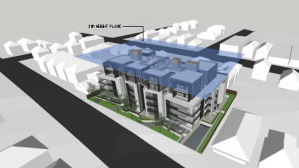
Figure 19: 3D Height diagram showing the sections of the building roof that exceed the height control (courtesy Architects, 2018)
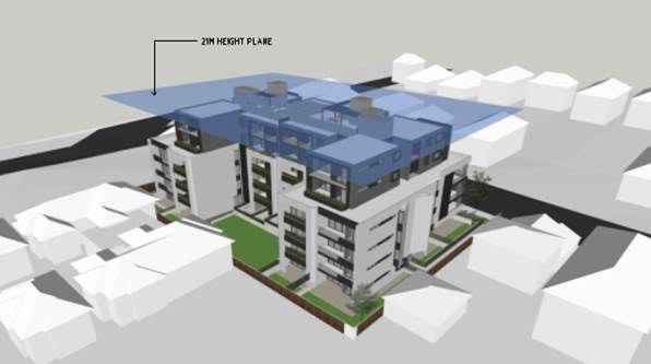
Figure 20: 3D Height diagram showing the sections of the building roof that exceed the height control (courtesy Architects, 2018
98. Relevantly, in Initial Action Pty Ltd v Woollahra Municipal Council [2018] NSWLEC 118 (paragraph 16), Preston CJ makes reference to Wehbe and states:
“…Although that was said in the context of an objection under State Environmental Planning Policy No 1 – Development Standards to compliance with a development standard, the discussion is equally applicable to a written request under cl 4.6 demonstrating that compliance with a development standard is unreasonable or unnecessary.
Compliance with the maximum building height development standard is considered to be unreasonable and unnecessary as the objectives of that standard are achieved for the reasons set out in Section 7 of this statement. For the same reasons, the objection is considered to be well-founded as per the first method underlined above.
Notably, under Clause 4.6(4)(a)(ii) a consent authority must now be satisfied that the contravention of a development standard will be in the public interest because it is consistent with the objectives of the particular standard and the objectives for development within the zone in which the development is proposed to be carried out.”
Clause 4.6(3)(b) are there sufficient environmental planning grounds to justify contravening the standard
99. Having regard to Clause 4.6(3)(b) and the need to demonstrate that there are sufficient environmental planning grounds to justify contravening the development standard, it is considered that there is an absence of any negative impacts of the proposed non-compliance on the environmental quality of the locality and amenity of adjoining properties in terms of overshadowing, overlooking or view loss.
100. Applicants Comment: “Having regard to Clause 4.6(3)(b) and the need to demonstrate that there are sufficient environmental planning grounds to justify contravening the development standard, it is considered that there is an absence of significant impacts of the proposed non-compliance on the amenity of future building occupants, on area character and on neighbouring properties. The non-compliance portions of the development are substantially setback from side boundaries, are not visible from the streetscape, and does not contribute to any significant overshadowing of neighbouring properties. It is also noted that no habitable space breaches the maximum height.
101. On “planning grounds” the proposal provides access to rooftop communal open space for residents without having any material impacts on surrounding development.
102. The variation to building height does not meaningfully impact on solar access, views or outlook and the streetscape appearance is not impacted by the variation. As indicated, the proposal provides for a floor space ratio which complies with the maximum permitted and accordingly, the height breach is not associated with additional density beyond what is expected by the controls or planned for the locality.”
Clause 4.6(4)(a)(ii) the proposed development will be in the public interest because it is consistent with the objectives of the particular standard and the objectives for development within the zone in which the development is proposed to be carried out
103. Clause 4.6(4) states that:
“Development consent must not be granted for development that contravenes a development standard unless:
(a) the consent authority is satisfied that:
(i) the applicant’s written request has adequately addressed the matters required to be demonstrated by subclause (3), and
(ii) the proposed development will be in the public interest because it is consistent with the objectives of the particular standard and the objectives for development within the zone in which the development is proposed to be carried out,”
104. Applicants Comment: “The Height of Buildings Map nominates a maximum height of 21m for the site. It is requested that an exception to this development standard be granted pursuant to Clause 4.6 so as to permit a maximum height of 23.02m to the lift overrun of Lift B.
105. In order to address the requirements of subclause 4.6(4)(a)(ii), each of the relevant objectives of Clause 4.3 are addressed in turn below.
106. Objective (a) – The maximum height has been established at 21m for the site. The proposed development provides a residential development and meets the objectives of the R3 Medium Density Residential zone objectives. The proposed development is in line with the type of development envisaged for the site. The degree to which the proposal exceeds the maximum height is relatively minor and importantly the development complies with the maximum FSR for the site. For these reasons the proposed height meets Objective (a).
107. Objective (b) relates to minimising shadows on adjoining buildings and open space areas, visual impact and loss of privacy. Since the lift overruns and staircase are substantially setback from the levels below, they will not generate any substantial additional shadow impacts beyond those already cast by the levels below. Due to this substantial setback, particularly from the Wyuna Street frontage, the lift overruns and staircase shafts will not have a visual impact on the streetscape or adjoining development. In terms of visual and acoustic privacy, the rooftop communal open space is sufficiently setback from the levels below, and planter boxes are provided along the edge to ensure visual and acoustic privacy. For these reasons the proposed height meets Objective (b).
108. Objective (c) seeks to ensure development provides a suitable scale and intensity. The non-compliance of the height does not offend the objective of providing an appropriate scale and intensity of development at the site. The proposal provides a compliant FSR (2:1) and is therefore demonstrably at the intensity of development intended for the site. The built form, bulk and scale is appropriate for the site and the proposed non-compliance with height will not be visible in the streetscape and character of the locality. It is also noted that a substantial portion of the development is well below the height limit; i.e the height non-compliance is limited to a small portion of the overall bulk of the development. The majority of the development has a height approximately 2.0m-2.5m below the maximum height limit. The proposed development is therefore consistent with the objectives for maximum height, despite the numeric non-compliance.
109. The proposed height non-compliance does not impact upon the achievement of the zone objectives. The proposed development will provide increased housing supply for the community within a medium density residential environment. The proposal also provides a variety of housing types ranging from one bedroom apartments to three bedroom apartments. The height variation does not contravene any objectives for the zone and for that reason the proposed variation is acceptable.”
110. Officer Comment: The proposed development has been designed to ensure all habitable areas are located within the height limit and the only protrusions are in relation to the roof terrace, services, fire stairs which are generally small in nature. The lift overrun is the highest structure that exceeds the height control. The proposal generally satisfies the objectives of the development standard in the following ways;
(a) to establish the maximum height for buildings,
111. Officer Comment: The site and its immediately adjoining properties have been up scaled to allow for medium to larger scaled development. In part this is due to the location of the sites adjoining a busy roadway as these conditions cater for larger scaled developments. Figure 18 shows the extent of the immediate precinct which allows for a maximum height of 21m.
(b) to minimise the impact of overshadowing, visual impact and loss of privacy on adjoining properties and open space areas,
112. Officer Comment: This objective relates to considering the amenity impacts associated with the non-compliance. In terms of visual impact the structures are generally centrally located which reduces their visual appearance from the immediately adjoining streetscapes with the screening for air conditioning condensers is also recessed and setback from the edge of the roof to further minimise its visual appearance.
113. The objective seeks to “minimise” the visual impact, it is not requiring it to be eliminated or totally negated, and as such seeing the structure is not a reason for refusal, it’s the impact of the visual interference of this structure that is to be controlled. It can be said that in this case it is a small scale ancillary structure which will not be highly visible or an intrusive element given the scale and proportions of the building. In respect to the more dominant elements like the lift overrun accessing the roof terrace at the rear, this will be a visible element when viewed from a distance. It will not be visible from immediately adjoining properties and streetscapes given that it is centrally located. The roof top terrace area is located within the height limit so the use of that area is within the height control so that ancillary services which exceed the height control namely the WC, lift overrun and fire stairs will not contribute to any overlooking and the shadowing they create will be within the confines of the roof space and unfortunately overshadow the southern portions of the rooftop terrace area. There will be no adverse impacts in terms of overshadowing or overlooking to adjoining properties.
(c) to provide appropriate scale and intensity of development through height controls.
114. Officer Comment: New developments of a similar nature have been approved along John Street and Princes Highway (these developments have been considered and included earlier in this report) and have established a precedent for development in the street and immediate precinct. The proposed development is consistent with the pattern of development that is slowly being established in the up-zoned precinct.
115. The proposed increase in the overall height of the building’s which only relates to certain sections of the roof form can be catered for in this location given the siting, orientation and the fact the buildings comply with the anticipated building envelope which is largely compliant with the ADG and KDCP in terms of the separation distances, landscaped area requirements, front setback control etc. The proposed development is considered to satisfy the objectives of the development standard.
116. Officers comment: The exceedance in the control generally satisfies the objectives of the zone for the following reasons;
· To provide for the housing needs of the community within a medium density residential environment.
117. The development is providing for the housing needs within a medium density residential environment with a mix of apartment choices and layouts.
· To provide a variety of housing types within a medium density residential environment.
118. The development incorporates a diversity of apartment types (offering 1, 2, and 3 bedroom units, including adaptable and liveable units).
· To enable other land uses that provide facilities or services to meet the day to day needs of residents.
119. The development is residential in nature and does not include any additional land uses. This objective is offering some greater flexibility in the provision of land uses within this zone and is not a mandatory requirement.
120. The area of non-compliance is considered to be reasonable and will not establish an undesirable precedent. It will not have any adverse effect on the surrounding locality, which is emerging to be characterised by residential development of comparable character. The proposal promotes the economic use and development of the land consistent with its zone and purpose. The Panel is requested to invoke its powers under Clause 4.6 to permit the variation proposed.
121. The public benefit of the variation is that it will appropriately facilitate the provision of medium density housing on a R3 zoned site and provide for a range of housing stock. It is noted that in Initial Action Pty Ltd v Woollahra Municipal Council [2018] NSWLEC 118, Preston CJ clarified what items a Clause 4.6 does and does not need to satisfy. Importantly, there does not need to be a "better" planning outcome resulting from the non-compliance.
122. The second matter was in cl 4.6(3)(b), where the Commissioner applied the wrong test in considering this matter by requiring that the development, which contravened the height development standard, result in a "better environmental planning outcome for the site" relative to a development that complies with the height development standard (in [141] and [142] of the judgment). Clause 4.6 does not directly or indirectly establish this test. The requirement in cl 4.6(3)(b) is that there are sufficient environmental planning grounds to justify contravening the development standard, not that the development that contravenes the development standard have a better environmental planning outcome than a development that complies with the development standard.
123. The roof top area and its associated ancillary structures could be deleted and the building largely compliant however this space will add value and provide greater functionality and amenity for the future occupants. The ADG encourages the use of rooftop spaces.
124. In this case the proposal seeks to establish the preferred and appropriate design and built form outcome for this site with the building complying in large with the height standard. There will be no adverse amenity or visual impacts generated by the variation and the proposal satisfies the objectives of the zone and the development standard. In this case the justification to vary the height control is considered to be a reasonable and well-founded request.
Clause 4.6(b) the concurrence of the Secretary has been obtained.
125. Concurrence from the Secretary has been obtained and can be assumed in this case.
126. It is considered that the Clause 4.6 Statement lodged with the application addresses all the information required pursuant to Clause 4.6 and the statement is considered to be well founded as there are sufficient environmental planning grounds to justify contravening the standard given that in this case the proposal satisfies the objectives of the zone and development standard (Clause 4.3, building height control).
Development Control Plans
KOGARAH DEVELOPMENT CONTROL PLAN NO 2013 (KDCP)
127. Apart from satisfying some of the provisions of the ADG and SEPP 65 the controls within the KDCP are applicable. Part B, General Controls, Part C2 Medium Density, controls in Appendix 4 relating to residential development in the R3 zone are required to be considered in the design of the proposal.
128. Table 6 below summarises the compliance of the scheme in relation to these controls.
Table 6: KDCP2013 Compliance Table
|
KDCP 2013 Compliance Table |
||
|
PART B – GENERAL CONTROLS |
||
|
Required |
Proposed |
Complies |
|
B2 Tree Management and Greenweb |
||
|
Compliance with provisions of Clause 5.9 Preservation of Trees or Vegetation of KLEP 2012 must be achieved. |
The issue of tree retention and removal has been addressed in detail earlier in this report. A series of new trees and plantings have been integrated into the landscape design and will include a series of compensatory trees around the periphery of the site and six street trees will be planted along the street frontage. Council’s Landscape Officer is satisfied with the Landscape Design and the proposal satisfies the DCP provisions. |
Yes |
|
B3 – Development near busy roads and rail corridors |
||
|
Acoustic assessment for noise sensitive development may be required if located in the vicinity of a rail corridor or busy roads |
An Acoustic report was prepared by Acoustic, Vibration and Noise Pty Ltd and assessed the development against the provisions of Clause 102 of the Infrastructure SEPP. The acoustic report provided a series of recommendations in the form of implementing construction techniques and materials that will assist in ameliorating acoustic impacts on the internal areas of the building. A detailed discussion regarding the acoustic compliance was conducted earlier in this report. |
Yes |
|
B4 Parking and Traffic |
||
|
Residential parking: 16 x 1 bedroom units @ 1 space per unit = 16 spaces required 36 x 2 bedroom units @ 1.5 spaces per unit = 54 spaces required. 12 x 3 bedroom units @ 2 spaces per unit = 24 spaces required Total required resident parking = 94 spaces |
A total of 107 spaces are required (which include the 13 visitor car spaces). The development provides for 109 spaces in total which satisfies Council’s requirement.
Basement 1 has 48 spaces and Basement 2 has a total of 61 spaces.
|
Yes |
|
Visitor parking: 64 total units @ 1 space per 5 units = 13 (12.8) spaces required |
13 visitor spaces are provided with one space doubling as a car wash bay.
|
Yes
|
|
Car wash bay: 1 bay, which can also function as a visitor space |
1 car wash bay is provided which doubles as a visitor space. |
Yes |
|
Bicycle Parking: 1 space per 3 dwellings = 22 1 space per 10 dwellings for visitors = 8 spaces Total = 30 spaces required |
22 residential bicycle parking spaces are provided in Basement 1
8 visitor bicycle parking spaces are also provided in Basement 1
Total = 30 spaces provided |
Yes
|
|
Loading Bays
|
One loading bay provided although not required for purely residential developments. This will assist with the movement of deliveries for the occupants via vans and utilities. Waste removal for the development is collected curb side. |
Yes |
|
Car park access and layout to comply with relevant Australian Standards |
Ramps, parking, aisle widths and parking spaces satisfy the provisions of AS2890. |
Yes |
|
B5 – Waste Management and Minimisation |
||
|
Submit Waste Management Plan (WMP) Provide a dedicated caged area within the bin room for the storage of discarded bulky items. |
WMP was prepared by PBD Architects and dated October 2018. The development includes two designated waste storage rooms, and bulky good store on Basement Level 1. One room is located adjacent to Lift A and the other adjoining Lift B. There is provision for a total of 11 x 660L bins and 11 x 240L recycling bins within these waste storage areas. Bins will be collected from the street. A bulky goods area is designated and adjoins the loading area where larger pieces of furniture or waste can be stored for removal. The waste disposal area and arrangement is considered to be satisfactory and in accordance with Council’s requirements. |
Yes |
|
B6 – Water Management |
||
|
All developments require consideration of Council’s Water Management Policy |
The proposed method of stormwater management is considered satisfactory. Updated stormwater drainage plans have been submitted to address Council’s initial concerns and are now compliant with Council’s requirements subject to conditions. |
Yes |
|
B7 – Environmental Management |
||
|
Building to be designed to improve solar efficiency and are to use sustainable building materials and techniques |
Design, materials, siting and orientation generally optimise solar efficiency, with a high proportion of north-facing window openings. Glazing is minimised on the southern and western elevations. The development is BASIX-compliant. |
Yes |
|
PART C2 – MEDIUM DENSITY HOUSING |
||
|
1. Site isolation and amalgamation for medium density development |
||
|
Adjoining sites not to be left isolated. Site amalgamation requirements apply for specific sites. |
The proposal does not cause any site isolation. The site is not subject to any amalgamation requirement. |
Yes
N/A |
|
2. Specific precinct controls – residential flat buildings |
||
|
Specific precinct controls apply to various sites and locations |
The site is not located in a specific precinct nominated in the DCP. |
N/A |
|
4. Medium site and density requirements |
||
|
20m minimum frontage for residential flat building |
60.96m to Wyuna Street. |
Yes |
|
1.1sqm of site area per square metre of dwelling NOTE: The above DCP control is over-ridden by KLEP 2012 minimum lot size requirement which is 1000sqm. |
Site Area = 2,615sqm which complies with the LEP requirement. |
Yes |
|
5. Height and building envelope requirements |
||
|
4-storey RFBs have a “H1” height control of 12m; and a “H2” height control of 14m. (method for calculating these heights are discussed in detail in KDCP 2013) |
No, the development has a maximum height of 21m with some ancillary structures on the roof exceeding this height.
The proposal generally satisfies the statutory height and FSR provisions within the KLEP. The KDCP has not been updated to reflect the LEP changes in 2017. |
No – see comment below |
|
Comment on Building Height There is incongruence between the KLEP 2012 and the KDCP 2013 building height limits, and the KLEP 2012 heights prevail. The proposal is generally compliant with the maximum LEP height with the exception of the lift over run, fire stairs and roof top awnings. Refer to KLEP 2012 discussion on building height and the Clause 4.6 assessment. |
||
|
6. Building setbacks |
||
|
Front setbacks: Maximum 75% of width of building to be setback minimum 5m, remainder 25% being setback minimum 7m |
Front setback from Wyuna Street ranges from 2.33 to 4.17m to front courtyards.
The four storey podium along Wyuna Street is setback over 5m with small blade walls encroaching on the setback but these are considered to be minor elements which will provide some articulation and enhance privacy between dwellings.
The building has varying setbacks at the upper ranging from 6.7m – 7m to balconies and 8.06m to 9.1 to the front wall of the building. |
No – see comment below
|
|
Comment on Front Setbacks Partial non-compliance. The building complies with the 5m minimum but does not comply with the 25% of the frontage being setback 7m. The setback in this case is considered satisfactory as it is generally in context with the front setbacks of the existing dwelling houses and will be generally consistent with the front setback for 21 Wyuna Street. It is also noted that the external walls of the building are setback further; it is the balconies which are providing articulation to the building that do not comply. |
||
|
Side/rear setbacks: 3m + one quarter of the amount that the wall height exceeds 3m.
[3m + (¼ x 12m)] = 6m required. |
Varies side setbacks are 4.5m to ground level and levels 1-3
Upper levels are setback 9m. |
No – see comment below |
|
Comment on side/rear setbacks The proposal fails to comply with the side and rear setback requirements within the KDCP as these have been prepared with the expectation of a two storey development on the subject sites. The provisions have not been updated to align with the height and FSR changes that have occurred as part of the LEP uplift. With respect to side setbacks the development generally complies with the SEPP 65 separation distances which are considered to be satisfactory. SEPP 65/ADG prevails over the DCP provisions for a residential flat building. |
||
|
7. Site coverage |
||
|
Maximum 45% (1,176.75sqm) |
Site coverage amounts to 43.47% (1,136.81sqm) |
Yes |
|
8. Open space |
||
|
Courtyards for ground floor units must be 35sqm with min. 3m dimension. Otherwise all dwellings must have a balcony 12sqm with min. 3m dimension. (This control superseded by ADG Requirements) |
Most ground floor courtyards have minimum areas of 23sqm in accordance with the provisions of SEPP 65/ADG. Some courtyards are larger having areas of 129 and 130sqm. There are dwellings which have smaller balconies than 12sqm. Again the provisions of SEPP 65 override the DCP provisions. |
No (for some ground floor units) – but generally ground floor courtyards meet the SEPP65/ADG private open space requirements. |
|
Common open space – 30sqm per dwelling with min. overall area of 75sqm and min. dimension of 5m. i.e. 30sqm x 64 units = 1,920sqm (This control is superseded by ADG Requirements) |
Total area of open space that is provided is 666sqm this is some 1254sqm short of the requirement. The DCP provision is more onerous than the SEPP65/ADG provisions. The SEPP65/ADG provisions prevail. |
No but SEPP 65 compliant. |
|
Maximum 55% impervious area amounting to 1,438.25sqm |
The development has a total area of some 1753.7sqm. |
No however the development provides for more than the required amount of deep soil area and communal open space in accordance with SEPP 65/ADG which prevails. |
|
9. Vehicular access, parking and circulation |
||
|
Car parking to be provided in accordance with Part B4
|
Development complies with the KDCP numerical parking requirements. |
Yes |
|
Residential parking: 16 x 1bedroom units @ 1 space per unit = 16 spaces required 36 x 2 bedroom units @ 1.5 spaces per unit = 54 spaces required 12 x 3 bedroom units @ 2 spaces per unit = 24 spaces required Total required resident parking = 94 spaces |
96 residential car parking spaces, which is compliant.
A total of 107 spaces are required (which including the 13 visitor car spaces) The development provides for 109 spaces in total which satisfies Council’s requirement. Basement 1 has 48 spaces and Basement 2 has a total of 61 spaces. |
Yes |
|
Visitor parking: 64 total units @ 1 space per 5 units = 13 (12.8) spaces required |
13 visitor spaces are provided with one space doubling up as a car wash bay |
Yes |
|
Car wash bay: 1 bay, which can also function as a visitor space |
1 car wash bay is provided which doubles as a visitor space |
Yes |
|
Bicycle Parking: 1 space per 3 dwellings = 22 1 space per 10 dwellings for visitors = 8 spaces Total = 30 spaces required |
22 residential bicycle parking spaces are provided in Basement 1
8 visitor bicycle parking spaces are also provided in Basement 1
Total = 30 spaces provided |
Yes |
|
Garages to be accessed from rear lane where available |
Access is located off Wyuna Street and is in keeping with a current driveway access point only widened for the proposed use. |
Yes |
|
All residential flat buildings to provide car wash bay |
There is no designated car wash bay however the KDCP allows for a visitor space to double as a car wash bay. A visitor car/wash bay has been provided on Basement 1. |
Yes |
|
11. Solar access |
||
|
Where the neighbouring properties are affected by overshadowing, at least 50% of the neighbouring existing primary private open space or windows to main living areas must receive a minimum of 3 hours sunlight between 9am–3pm on the winter solstice (21 June) |
From 9am until 12noon the development will overshadow the front and rear yards of 13, 15 and 17 Wyuna Street with the worst affectation being 9am. By 12noon these properties are unaffected.
From 1pm until 3pm the development will overshadow the front yards of the dwellings on the southern side of Wyuna. From 9am until 1pm these properties are unaffected by the building. |
Yes |
|
12. Views and view sharing |
||
|
Provide for reasonable sharing of views |
The location does not have significant views. The development generally complies with height requirements and is reasonable in terms of view sharing. |
Yes |
|
13. Adaptable and accessible housing |
||
|
51+ units – 6 adaptable units + 10% of additional units beyond 60 (rounded up to the nearest whole number 64 units proposed – 7 adaptable units required |
Sixty Four (64) units are proposed which requires that seven (7) adaptable units are provided.
Seven (7) adaptable units are proposed. |
Yes |
Interim Policy – Georges River Development Control Plan 2020
129. Council at its Environment and Planning Committee Meeting dated 11 June 2019 resolved to adopt the Georges River Interim Policy DCP.
130. The Interim Policy is a public policy that is to be used as a guide to set a consistent approach for the assessment of residential development within the LGA. It is a supplementary document, meaning that current DCP controls will prevail if they are considered best practice. The Interim Policy has no statutory recognition in the assessment of DAs pursuant to the Environmental Planning and Assessment Act, 1979 (EP&A Act).
131. An assessment of the proposal has been carried out against the provisions of the Interim Policy as set out in the following table.
Table 7: Interim Policy Compliance Table
|
Interim Policy – Georges River DCP 2020 |
||
|
Standard |
Proposed |
Complies |
|
Site Frontage |
||
|
20m |
60.96m to Wyuna Street |
Yes |
|
Building Height |
||
|
The relevant LEP controls relating to building height will prevail over DCP controls that relate to height in storeys |
The proposal exceeds the height control but is supported by the provision of a Clause 4.6 Statement. This statement is considered to be well founded and discussed in detail earlier in this report. |
Yes |
|
Private Open Space |
||
|
The ADG requirements prevail over the DCP controls for private open space |
The proposal is fully compliant with the ADG’s private open space requirements. Refer to “4E – Private Open Space and Balconies” within the ADG Compliance Table above. |
Yes |
|
Communal Open Space |
||
|
The ADG requirements prevail over the DCP controls for COS
|
The proposal is considered to comply with the requirements of the ADG with respect to COS.
Refer to “3D – Communal Open Space” within the ADG Compliance Table above. |
Yes
|
|
Parking |
||
|
In accordance with 'A Plan for Growing Sydney' (Department of Planning and Environment): · If located in a strategic centre (ie Kogarah CBD and Hurstville CBD) and within 800m of a Railway, the “Metropolitan Regional Centre (CBD)” rates apply. · If located within 800m of a railway and outside the strategic centres the “Metropolitan Subregional Centre” rates apply. · If located outside of 800m of a Railway, the relevant DCP applies. |
The KDCP parking requirements need to be satisfied as the site is not located near a railway station or close to a commercial centre in accordance with the ADG provisions. |
Proposal satisfies the numerical requirements of the KDCP |
|
Solar Access |
||
|
The ADG requirements prevail over the DCP controls for solar access
|
The proposal is acceptable on merit with the ADG Solar Access requirements as detailed within the ADG Compliance Table above. Refer to “4A – Solar and Daylight Access” within the ADG Compliance Table. |
Yes |
Draft Amendment to Part C2 – Medium Density Development of Kogarah DCP 2013
132. Arising from the significant increase in development activity as a result of the New City Plan (Amendment No 2) to the Kogarah Local Environmental Plan gazetted in May 2017 which permitted greater density (2.5:1 and 2:1) and height (21m), Council immediately proceeded to prepare an amendment to Part C of the Kogarah Development Control Plan for the area generally bounded by the Princes Highway, Stubbs Street/Poulton Avenue and Wyuna Street, Beverley Park, and Park Road and John Street, Kogarah Bay as a first priority and as a second priority, the west side of the Princes Highway from Jubilee Avenue to Park Road which is in part High Density B6 zone and in part High Density B2 zone. The report is to address, but not limited to the following matters:
“(a) i. Site isolation and amalgamation
ii. Vehicular access, parking and circulation
iii. Traffic impact
iv. Landscape character
v. Proposed building envelopes that provide a transition/interface to the land zoned R2 at the rear of these high density zones, which allow for a stepping down to a 9m height limit to the rear of developments that back onto R2 residential zones.
vi. Impact on Heritage Item I3 “Sunnyside” at 186-188 Princes Highway
(b) That prior to the report being presented to Council that a briefing be provided to Councillors.
(c) That the General Manager prepare a report on the outcomes of the traffic assessment that is currently underway for the areas that were up-zoned under the New City Plan (Amendment No 2) to the Kogarah Local Environmental Plan gazetted in May 2017.”
133. Council has engaged Consultants to prepare a new Development Control Plan 2020 which will consolidate and harmonise existing controls and establish appropriate new controls to assist with redevelopment for up zoned sites.
In summary the development of the DCP will involve five (5) stages;
· Stage 1 Community Participation Plan
· Stage 2 General and Industrial
· Stage 3 Residential Precincts
· Stage 4 Business Precincts
· Stage 5 Specific Sites and Localities
134. Stage 3 aims to review and establish controls across different precincts and categories of residential developments (residential flat building’s, multi-dwelling housing, dwelling houses, dual occupancy’s etc). The first task within this stage is to look at medium density development within R3 zoned areas. Nine (9) precincts have been identified for specific attention, as they have been up zoned and the current controls in the Development Control Plans are outdated and not reflective of the scale and form that is permitted under the Local Environmental Plans. The subject site falls within the Kogarah Bay Precinct (No.9) refer to Figure 21 below.
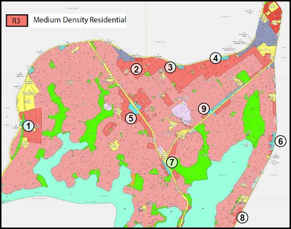
Figure 21: Map highligting the nine (9) R3 precincts within the LGA that are being considered in accordance with the DCP review
135. One of the key identified areas of concern relate to there being no current controls which consider the interface of new larger developments and their treatment and transition to lower scale residential zones, that adjoin these area, predominantly zoned R2 having 9m and 12m height limits.
136. Council on 25 November 2019 adopted a report which will result in an amendment to Part C2 – Medium Density Housing in Kogarah DCP 2013. This amendment will be on public exhibition from 20 January 2019. As such this draft amendment is now a statutory planning document it must be considered in any assessment.
Table 8: Draft Amendment to Part C2 - Medium Density Development of Kogarah DCP 2013 Compliance Table
|
Draft Amendment to Part C2- Medium Density Development of Kogarah DCP 2013 |
||
|
Part 1 Residential Flat Buildings |
||
|
Required |
Proposed |
Complies |
|
1. Minimum site requirements |
||
|
1000sqm minimum lot size 24m minimum frontage |
2615sqm 60.96m |
Yes Yes |
|
2. Site isolation and amalgamation |
||
|
Adjoining sites not to be left isolated.
Site amalgamation requirements apply for specific sites. |
The proposal does not cause any site isolation.
The site is not subject to any amalgamation requirement. |
Yes
N/A |
|
3. Building Setbacks |
||
|
Front setbacks Up to four (4) storeys – 5m Above four (4) storeys – 8m
Ground floor private open space may encroach up to 2m into the 5m front setback leaving a min 3m of landscaped area to the street.
. |
Front setback from Wyuna Street ranges from 2.33m (unit AG06) to 4.17m (Unit BG01) to the private courtyards of the ground floor units. On balance the intent behind this control is achieved.
The four storey podium and upper level along Wyuna Street is setback 6.7m to the balconies and 9.1m to the external wall of units A404 and B401 and 8.06m to the centrally located units A401 and B403.
These are considered to be minor variations to the draft controls and the provide elements that provide some articulation and enhance privacy between dwellings. |
No. The setback in this case is considered satisfactory as it is generally in context with the front setbacks of the existing dwelling houses. It is also envisaged that it will be consistent with the future and desired street setbacks for this side of the street in the up-zoned area. |
|
Private open space and balconies must comply with Part 4E of the ADG. |
Complies |
Yes |
|
Side boundary setbacks Up to four (4) storeys – 6m
Ground floor private open space may encroach up to 3m into the side and rear setbacks leaving a min 3m landscaped buffer
|
The ground floor units on the south western side provide a 4.5m side setback from courtyards with the north eastern side setback from courtyards being between 2.6 and 2.77m. Both these private courtyards have external planter boxes which provide separation and screening between properties
On levels 1-3, a 4.5m setback is provided to the southwest and northeast side boundary at the rear of each building, with a 6m setback provided to the balconies of the front units. The winged walls which are centrally located are setback 3.17m from the side boundary (highlighted).
|
No. The building is setback between 4.5m and 6m to levels 1- 3 with the exception of the angled wall on levels 1 – 3. This winged wall provides articulation to the external wall.
Level 4 is setback 9m from the side boundary.
With respect to side setbacks the development generally meets the objectives of the SEPP 65 separation distances which are considered to be satisfactory. SEPP 65/ADG
|
|
Above four (4) storeys – 9m |
9m setback provided to the south west and north east side boundaries. |
Yes |
|
Rear boundary setbacks Up to four (4) storeys – 6m Ground floor
|
5.5m approximately Centrally located ground floor units are located >15m from rear boundary. |
External wall is located between 7.15m and 8.2m from rear boundary and given the centrally located units behind the communal open space are >15m, on balance this is acceptable. |
|
Up to four (4) storeys – 6m Levels 1-3 |
6m
|
Yes with exception of planter boxes behind balcony. |
|
Above four (4) storeys – 9m |
9m |
Yes |
|
Private open space and balconies must comply with Part 4E of the ADG. |
Complies |
Yes |
|
4. Basement Setbacks |
||
|
3m from site boundaries South West North East |
3.027m 4.5m 1.62m – 3.82m 0.798m |
Yes Yes No No |
|
Basement setback areas are to be deep soil areas as defined in the ADG |
The basement setback areas provided are deep soil. |
Yes |
|
Driveways and crossings are to be located a minimum of 1.5m from a side boundary |
1.78m |
Yes |
|
5. Façade Treatment and Street Corners |
||
|
Building facades to be clearly articulated with high quality materials and finishes.
Modulation and articulation in the building form to be explored.
Large areas of blank, minimally or poorly articulated walls are not acceptable. Façade treatments such as wall cladding and green walls should be considered as alternatives.
Clear glazing balustrades to be avoided where they are visible from the public domain. |
Satisfactory
Satisfactory
Satisfactory
Satisfactory |
Yes
Yes
Yes
Yes |
|
6. Landscaped area and Private Open Space |
||
|
A minimum 10% of the site is to be landscaped area that is not impeded by buildings or structures above or below ground level with a minimum dimension of 2m on two axes. |
Deep Soil zone provided is 9.4%.
Again the provisions of SEPP 65 override the DCP provisions. |
No - However SEPP65/ADG provisions prevail. |
|
Private open space to be adjacent to and visible from the main living area/dining rooms and be accessible |
Provided |
Yes |
|
Private open space and balconies must comply with Part 4E of the ADG |
Complies |
Yes |
|
7. Common Open space |
||
|
Common Open Space to be a minimum of 25% of the site area with a minimum dimension of 5m. |
Communal open space provided is 666sqm (25.4%) with a minimum 5m dimension. |
Yes
|
|
A maximum of 50% of common open space may be provided above ground level. |
Roof top communal open space is 356sqm, which is more than 50% of the total common open space |
No but considered acceptable, the DCP provision is more onerous than the SEPP65/ADG provisions. The SEPP65/ADG provisions prevail. |
|
At least 50% of the required common open space area is to receive 2 hours of direct sunlight between 9am and 3pm on 21 June. |
Complies |
Yes |
|
A minimum of 50% of the total area of common open space provided at ground level is to comprise unpaved landscape area. |
Complies |
Yes |
|
The useable and trafficable area of any rooftop common open space is to be setback a minimum of 2.5m from the edge of the roof of the floor below with landscape planters to prevent overlooking. |
Complies |
Yes |
|
Roof top open space areas should include equitable access. |
Equitable access through a lift and ramps have been provided along with an accessible toilet. |
Yes |
|
Ancillary structures such as lift overruns and staircases should be centralised to reduce their visual dominance. |
Fire stairs and lift over runs are centrally located. |
Yes |
|
8. Solar Access |
||
|
Where the neighbouring properties are affected by overshadowing, at least 50% of the neighbouring existing primary private open space or windows to main living areas must receive a minimum of 3 hours sunlight between 9am–3pm on the winter solstice (21 June) |
From 9am until 12noon the development will overshadow the front and rear yards of 13, 15 and 17 Wyuna Street with the worst affectation at 9am. By 12noon these properties are unaffected.
From 1pm until 3pm the development will overshadow the front yards of the dwellings on the southern side of Wyuna. From 9am until 1pm these properties are unaffected by the building. |
Yes
|
|
9. Vehicular access, parking and circulation |
||
|
Car parking to be provided in accordance with Part B4 unless objective 3J-1 of the ADG applies. |
Development complies with the KDCP numerical parking requirements. |
Yes |
|
Car parking layout and vehicular access complies with AS2890.1-2004 |
Complies. |
Yes |
|
All residential flat buildings to provide car wash bay |
A visitor car wash bay has been provided. The KDCP allows for a visitor space to double as a car wash bay. |
Yes |
|
10. Views and view sharing |
||
|
Provide for reasonable sharing of views |
The location does not have significant views. The development generally complies with height requirements and is reasonable in terms of view sharing. |
Yes |
|
11. Dwelling Mix |
||
|
Dwellings that propose more than 20 dwellings are to provide a mix of dwellings as follows: Studio apartments -15% max 1 bed apartments - 30% max 2 bed apartments – 40% min 3 bed apartments – 15% min |
The proposal includes the following unit mix: 16 x 1 bedroom apartments = 25% 36 x 2 bedroom apartments = 56% 12 x 3 bedroom apartments = 19% |
No The proposal provides a mix of 1, 2 & 3 bedroom apartments. It however does not propose to provide any studio apartments. |
|
12. Adaptable and accessible housing |
||
|
51+ units – 6 adaptable units + 10% of additional units beyond 60 (rounded up to the nearest whole number 64 units proposed – 7 adaptable units required Every adaptable unit needs to have an accessible car space. |
Sixty four (64) units are proposed which requires that seven (7) adaptable units are provided.
Seven (7) adaptable units are proposed with provision for accessible parking. |
Yes
Yes
|
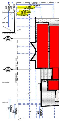
DEVELOPER CONTRIBUTIONS
137. The proposed development would require payment of developer contributions under Section 7.11 of the Environmental Planning and Assessment Act 1979. If the development consent is granted a condition outlining the required contributions will be imposed.
138. The table below shows the contributions which are applicable for this development. A condition is imposed if consent is issued that reflects the contributions as stated.
|
Kogarah Section 94 Contribution Plan No.1 – Road and Traffic Management – Residential |
$12,259.67 |
|
Kogarah Section 94 Contribution Plan No.5 – Open Space |
$620,515.96 |
|
Kogarah Section 94 Contribution Plan No.9 – Kogarah Libraries – Books |
$10,189.72 |
|
Kogarah Section 94 Contribution Plan No.9 – Kogarah Libraries – Building |
$14,291.75 |
|
Total Development Contributions payable |
$657,257.10 |
Figure 18: Section 7.11 Contributions as calculated by Council for this development.
IMPACTS
Natural Environment
139. The proposed development will not adversely affect the natural environment subject to the site being planted with replacement trees as shown on the approved landscape plan. The removal of existing trees has been reviewed by Council’s Consultant Arborist and is deemed acceptable. The landscape plan demonstrates that nineteen (19) trees and shrubs will be planted. A condition of consent will also be imposed requiring the panting of six (6) new street trees to be planted along the frontage of the site.
140. The proposal includes excavation that has been assessed as being reasonable in the context of the site and consistent with the extent of excavation expected in an R3 Medium area that has seen uplift in building height and FSR, ie to permit construction of basement car parking. Excavation impacts will be managed with standard conditions of consent have been imposed to protect the environment with respect to contamination and impact onto adjoining allotments and the public domain.
Built Environment
141. The proposal represents a good planning outcome for the site with respect to its bulk, scale and density, façade articulation and expression and is an appropriate response to the context of the site and its R3 Medium Density Residential zoning.
142. The buildings four (4) storey podium with recessed fifth and sixth levels will also ensure that it has an appropriate relationship with the lower scaled R2-zoned residential properties on the opposite side of Wyuna Street, and will provide a reasonable transition between those R2 zoned dwelling houses and future six (6) and seven (7) storey mixed use development fronting Princes Highway behind the site.
Social Impact
143. No adverse social impacts have been identified as part of the assessment. The proposed development, in principle, will cater for a cross-section of the community and will assist with providing for additional housing in the area. The construction of residential apartments on the site is consistent with the residential zoning of the land.
Economic Impact
144. There is no apparent adverse economic impact that is likely to result within the locality due to the construction of additional apartments. The construction of these apartments was to be reasonably expected as a result of the New City Plan’s gazettal. The impact of new development on nearby property values is not a matter for consideration under Section 4.15 of the Environmental Planning and Assessment Act 1979. It is likely there will be a small positive economic impact as a result of the construction of the development.
Suitability of the site
145. The site is zoned R3 – Medium Density Residential. The proposal is a permissible form of development in this zone and has been designed to fit into the context of the area as it evolves and as it exists. This immediate precinct is going through a process of change and transition and the proposal is in line with the intentions of Council’s recent up-zoning of these sites.
SUBMISSIONS AND THE PUBLIC INTEREST
146. The application was neighbour notified in accordance with Kogarah DCP 2013 for a period of fourteen (14) days between 12 December 2018 until 13 February 2019. Amended plans were notified between 4 and 18 September 2019. A total of thirty three (33) submissions were received as a result of both these notification periods. In summary the following issues and concerns were raised.
· Noise and inconvenience from construction activity (increased traffic, limited car parking and pressure on existing services)
147. Officer Comment: If consent is granted a condition will require the Developer/Builder to prepare a detailed Construction Management Plan (CMP) to ensure Construction vehicles and associated building activity and works are planned and managed appropriately to minimise noise, pollution and environmental impacts from construction. This is a standard condition and as much as it is expected that some building and construction activity will cause a neighbourhood inconvenience, if well managed the impacts are reduced.
There will be an increased number of vehicle movements given the increase in density, this was envisaged by the up-zoning. The development complies with the floor space ratio and the landscaped area requirements of the apartment design guide.
Conditions have been imposed regarding servicing of the site. It is considered the services can be extended to service the development.
· Non-compliance with the height limit
148. Officer Comment: The amended design reduces the overall height of the development apart from the ancillary rooftop structures including the lift overrun, staircase and WC which exceed the height control. The introduction of the rooftop terrace is consistent with the character of new larger scale developments in the area as these spaces are centralised and reduce any potential for overlooking.
Council has allowed for exceedances in the height control for ancillary rooftop structures as these are not habitable areas and often are centralised and will not create any adverse environmental impacts to adjoining properties. The hours of usage and the method of usage of this space is controlled by a condition of consent. The exceedance in the height control is considered to be consistent with the precedent established by new developments within the immediate vicinity of the site and new developments ie 5-9 John Street and 198-200 Princes Highway (DA2017/0655).
· Out of character with the existing locality and existing smaller scale adjoining developments
149. Officer Comment: Although it is recognised that this development will be taller than the existing residential developments to the south which are zoned R2 and have a maximum height of 9m, the development has been amended to provide a better and more sympathetic scale and relationship by removal of the attic level and provision of a centralised roof top communal open space area and also a better interface at the front to the lower scale properties located along Wyuna Street. The provision of a four storey podium facing Wyuna Street with the upper levels setback a further 2m, the recessing of the upper levels provides a more appropriate transition between the two distinct zonings.
The up-zoning of this precinct did not include a transition between the 21m height control and the 9m height control. Draft amendment to Part C2 of Kogarah DCP 2013 was endorsed by Council on 25 November 2019. This amendment will be on public exhibition from 20 January 2020. The proposed development has been assessed against these draft controls and is generally consistent with the intent and objectives of these draft controls.
· Overshadowing created to properties to the south
150. Officer Comment: This issue has been addressed in detail earlier in this report. The proposal complies with the minimum solar access provisions of the KDCP and the ADG. The development affects the properties to the west up until 12pm whilst the properties to the south across the street are only impacted after 1pm and are not affected in the morning as shadows are cast to the west.
· Increased traffic generation from the cumulative impact of larger scale developments
151. Officer Comment: The application was accompanied by a Traffic assessment report prepared by Terraffic Pty Ltd Traffic and Parking Consultants. Traffic generation caused by the development has been considered in accordance with the provisions of RMS Guide to Traffic Generating Developments, Section 3 – Land Use Traffic Generation and based the calculations on a high density residential flat development. This issue was discussed in greater detail earlier in this report. It is recognised the development will generate some additional pressure on the local road network, however the impact is not considered to be adverse or detrimental to warrant the refusal of the application.
· Adverse impact on street parking
152. Officer Comment: There will be an increase in the demand for on-street parking however this is public parking and is available for the community at large. The benefit the development will have is by making four (4) driveway crossovers along Wyuna Street redundant and reinstating 2-3 on-street car parking spaces. This may not totally compensate for the demand, but it will increase on street car parking nonetheless. The development also has the benefit of a very long street frontage to Wyuna Street.
The proposal complies with the number of required car parking, which provides thirteen (13) visitor spaces.
· Increased and undue pressure on existing services such as schools and associated local amenities and infrastructure
153. Officer Comment: Council identified the subject sites to be up-zoned and recognised that given the sites location adjoining a busy arterial road increased density can be accommodated within these sites. The form of development along Princes Highway is changing and new larger scale developments are being constructed in accordance with the updated planning controls. The proposal is in keeping with the intended scale and form of future development. There is no primary evidence to suggest that local amenities such as schools etc. are at capacity and will not be able to cater for additional/new residents. Conditions have been imposed for utilities to be consulted as part of the Construction certificate preparation for the extension of servicing of the development.
· Unsympathetic impact upon existing heritage item “Sunnyside” located at 184 Princes Highway
154. Officer Comment: The proposed development is located within Wyuna Street and does not adjoin the heritage item located on the Princes Highway. Given its separation from the heritage item and that other developments will adjoin this item, they will have to provide a design that is respectful and the most appropriate transition, setback and relationship to the Heritage Item.
· One driveway exit/entry point will create traffic issues onto Wyuna Street
155. Officer Comment: The assessment undertaken revealing it is unlikely that the development will create any adverse impacts on Wyuna Street as vehicles leaving the site will have many options to disperse ie vehicles can turn right or left and take a number of different routes. The driveway is wide enough, approximately 5.5m; to allow for two cars to pass each other and therefore no queuing along the street should occur due to the vehicular arrangement proposed.
· Increased overlooking and noise from the rooftop terrace area
156. Officer Comment: The plans were amended from the original design, removing the non-compliant habitable spaces on the seventh floor and providing a roof top communal open space consistent with the recommendations of the Design Review Panel. The ADG also encourages the use of rooftops for communal open space in medium to larger scale developments as these spaces offer another option for passive recreational areas which are private and minimise impacts if they are small spaces and centrally located. The roof top communal open space area is centrally located to minimise overlooking and assist in maintaining privacy along with perimeter planter boxes to assist in providing screening. A condition of consent has been imposed requiring a Plan of Management restricting the number of occupants using the space and the hours in which it is used to address amenity concerns.
· Inadequate local services
157. Officer Comment: The location of the development enables access to connecting roads, buses along the Princes Highway, local parks and shopping spaces and community facilities.
· Inappropriate bulk and scale of the development will dominate the lower scale developments along Wyuna Street
158. Officer Comment: The proposed development is within the maximum FSR and gross floor area that is permitted on such a larger integrated site.
The issue of transition to the rear has been discussed and the setback of the upper levels of the building will be generally consistent with recently approved developments along John Street. These developments have established a future direction and precedent for development in the immediate area. The four storey podium element along Wyuna Street is consistent with the design intent of Council’s Draft Amendment to Section C2 – Medium Density Development of Kogarah DCP 2013.
· The predictions made in the Traffic and Parking Assessment report are uncertain and doubtful
159. Officer Comment: The Traffic Report has been prepared by a Qualified Traffic Consultant and calculations are based on the RMS Guide to Traffic Generating developments in respect to traffic generation which are the standards which are required to be used for this form of development. Parking numbers are compliant with the KDCP provisions and the car parking arrangement and design has been considered by Council’s Traffic Engineer who does not raise any objection to the proposed works and states that the proposed development is generally compliant with AS2890.
· Against the design quality principles of the SEPP 65
160. Officer Comment: The development generally complies with the provisions of the ADG. Table 3 within this report outlines compliance with the key provisions and controls.
· Poorly designed and will create overlooking from windows and balconies and internal spaces. Eastern side of Wyuna Street
161. Officer Comment: The main areas of concern for overlooking are to the north, east and west. Overlooking and privacy concern has also been raised by properties across the road in Wyuna Street to the south. The separation distances along the northern side (rear boundary) are compliant having a minimum of 6m and 9m at upper levels. The eastern and western side boundaries provide setbacks of approximately 4.5m at the lower levels with a 9m setback provided to the upper levels. The lower levels provide a series of highlight windows and blank walls along with planter boxes and screen planting to provide a level of privacy to be afforded between properties. It is likely adjoining properties to the east and west will be redeveloped and they will also include separation distances of a minimum of 6m creating a 12m separation between buildings. Many apartments along the side elevations have their bedrooms located to face south and as these spaces are not as intensively utilised as living spaces it is unlikely that they will generate detrimental amounts of direct overlooking. In addition, new street trees and landscaping along the side and rear boundaries will reduce the potential for overlooking at lower levels and will assist in screening these levels. Along the southern side, the building is setback between 5m to the external wall and then 8m to 9m to the external wall at the upper levels and combined with the roadway (Wyuna Street) separation between properties is considered acceptable exceeding the 12m separation distance.
· Depreciation in property values
162. Officer Comment: This is not a matter for consideration under the Environmental Planning and Assessment Act 1979.
· DA deferred until a separate DCP is prepared for the site and adjoining properties that have been up-scaled.
163. Officer Comment: Council is in the process of updating its Local Environmental Plans and associated planning controls (DCP’s) and most recently the Draft amendment to Part C2 of Kogarah DCP 2013 was endorsed by Council on 25 November 2019. This amendment will be on public exhibition from 20 January 2020. The proposed development has been assessed against these draft controls and is generally consistent with the intent and objectives of these draft controls. In addition, the Applicant has worked with Council for over a year to negotiate a planning and urban design outcome within the current applicable planning controls at the time of lodgement. The new building is sited in a way that generally satisfies SEPP65/ADG and seeks to minimise environmental concerns for immediately adjoining developments. It is considered to be a reasonable planning and design outcome.
· Noise from the use of external spaces including balconies at upper levels.
164. Officer Comment: It is unlikely that there will be adverse and unreasonable acoustic impacts from upper level balconies. These spaces are secondary to key habitable areas. They have been sited and located to comply with separation distances as stipulated in by SEPP65/ADG (6m and 9m respectively).
· Only one set of fire stairs provided
165. Officer Comment: The development will need to satisfy the provisions of the BCA in relation to fire safety.
· The proposed development is not cheap/affordable housing
166. Officer Comment: The proposed development is for the construction of a residential flat building; it has not been lodged or assessed against the provision of affordable housing.
REFERRALS
Council Referrals
Development Engineer
167. The application was originally referred to Council’s Development Engineers Services for comment. There were concerns raised in respect to the stormwater and drainage arrangement. The following comments were made;
“It is not supported to locate an OSD tank under habitable area. It will be conditioned that this part of the OSD underneath the bedroom (4.0m3) is to be deleted and may be compensated as part of the rainwater tank to the discretion of the drainage engineer”
168. Amended hydraulic plans were submitted to Council in July 2019 and referred back to Council’s Engineers for comment. They are now satisfied with the stormwater drainage arrangement subject to the imposition of conditions.
Traffic Engineer
169. The application was referred to Council’s Traffic Engineer for comment. The proposed car parking and access arrangements are considered to be compliant with Council’s controls and are satisfactory. Standard conditions are included to ensure compliance will be achieved with Australian Standards during and after construction.
Environmental Health Officer
170. Council’s Environmental Health Officer has raised no objection subject to conditions of consent being attached if approval is granted.
Waste Services
171. The application was referred to Council’s Waste Officer for comment. No objection was raised in respect to the proposed waste arrangement subject to the imposition of standard conditions.
External Referrals
Ausgrid
172. The application was referred to Ausgrid in accordance with Clause 45 of State Environmental Planning Policy (Infrastructure) 2007. At the time of writing, no response has been received.
Sydney Airport
173. The application was referred to Sydney Airport. A formal response was provided and concurrence was obtained.
CONCLUSION
174. The proposal has been assessed using the matters for consideration listed in Section 4.15 of the Environmental Planning and Assessment Act 1979. The proposal is considered to be a reasonable intensification of site and the proposed additional scale, bulk and height is considered to be an acceptable planning and design outcome for this site and will be consistent with the desired future character of development in the R3 zoned land in this location and immediate locality.
175. The proposal has been assessed against the provisions of the Kogarah Local Environmental Plan 2012 and Kogarah Development Control Plan 2013. The proposal satisfies the key planning controls in the Kogarah Local Environmental Plan apart from exceeding the height limit. A Clause 4.6 Statement has been submitted with the application justifying the variation in this case.
176. The proposed development design satisfies the objectives of both the height control and the zone and the Clause 4.6 Statement is considered to be well founded as there will not be any direct or adverse environmental impacts generated, the proposal satisfies the requirements of Clause 4.6 of the KLEP.
DETERMINATION AND STATEMENT OF REASONS
177. The reasons for this recommendation are:
· The proposal is an appropriate response to the “up-zoning” of the site (including increased Floor Space Ratio and height limits) afforded by the Kogarah “New City Plan”. The six (6) storey building will provide an effective transition between future six (6) and seven (7) storey development facing the Princes Highway and two (2) storey low density residential on the opposite side of Wyuna Street
· The proposed development complies with the requirements of the relevant environmental planning instruments and development control plan except in the height of the development which is considered acceptable having regard to the justification provided in the report above.
· In this case the Clause 4.6 Statement is considered to be well founded and the non-compliance with the height control is reasonable in the circumstances of the case.
· The proposal generally achieves compliance with the Apartment Design Guide with respect to both internal and external amenity. Building separation requirements in particular are for the most part compliant and where numerically non-compliant, visual privacy impacts will be mitigated by the use of screening and other appropriate measures.
· The proposed design has been sensitively considered to be consistent with the anticipated desired future character for development in this area.
· The proposal has effective façade modulation and wall articulation that will serve to provide visual interest and reduce the bulk of the building.
· The proposal aims to provide a high-quality building that will establish a positive urban design outcome, setting the architectural and planning precedent in the area.
178. THAT pursuant to Section 4.16(1) of the Environmental Planning and Assessment Act, 1979, as amended, the Georges River Local Planning Panel, grants development consent to Development Application DA2018/0516 for site consolidation, tree removal demolition of existing structures and construction of a six (6) storey Residential Flat Building development comprising sixty four (64) residential units with basement car parking and associated landscaping and site works on Lots 10, 11 and 12 DP 7056 and Lots A and B DP 382055 known as 5–11A Wyuna Street, Beverley Park, subject to the following conditions of consent:
GENERAL CONDITIONS
1. Approved Plans - The development will be implemented in accordance with the approved plans and supporting documentation listed below which have been endorsed by Council’s approved stamp, except where marked up on the plans and/or amended by conditions of this consent:
|
Description |
Reference No. |
Date |
Revision |
Prepared by |
|
Site Analysis/Site Plan |
DA002 |
25/8/2019 |
C |
PBD Architects |
|
Site Plan |
DA005 |
25/8/2019 |
C |
PBD Architects |
|
Basement 2 Floor Plan |
DA100 |
26/4/2019 |
B |
PBD Architects |
|
Basement 1 Floor Plan |
DA101 |
26/4/2019 |
B |
PBD Architects |
|
Ground Floor Plan |
DA102 |
25/8/2019 |
C |
PBD Architects |
|
Typical L1-3 Floor Plan |
DA103 |
25/8/2019 |
C |
PBD Architects |
|
L4 Floor Plan |
DA104 |
25/8/2019 |
C |
PBD Architects |
|
L5 Floor Plan |
DA105 |
25/8/2019 |
C |
PBD Architects |
|
Roof Plan |
DA106 |
25/8/2019 |
C |
PBD Architects |
|
Elevation North |
DA201 |
25/8/2019 |
C |
PBD Architects |
|
Elevation South |
DA202 |
25/8/2019 |
C |
PBD Architects |
|
Elevation East |
DA203 |
25/8/2019 |
C |
PBD Architects |
|
Elevation West |
DA204 |
25/8/2019 |
C |
PBD Architects |
|
Sections AA & BB |
DA301 |
26/4/2019 |
B |
PBD Architects |
|
Sections CC & DD |
DA302 |
26/4/2019 |
B |
PBD Architects |
|
Landscape Plans |
L/00, L/01, L/02, L/03, L/04 and L/05 |
22/11/2018 |
D |
ATC A Total Concept |
SEPARATE APPROVALS REQUIRED BY OTHER LEGISLATION
2. Section 138 Roads Act 1993 and Section 68 Local Government Act 1993 – Unless otherwise specified by a condition of this consent, this Development Consent does not give any approval to undertake works on public infrastructure.
Separate approval is required under Section 138 of the Roads Act 1993 and/or Section 68 of the Local Government Act 1993 for any of the following activities carried out in, on or over a public road (including the footpath) listed below. This approval is to be obtained from RMS.
An application is required to be lodged and approved prior to the commencement of any of the following works or activities;
(a) Placing or storing materials or equipment;
(b) Placing or storing waste containers or skip bins;
(c) Erecting a structure or carrying out work
(d) Swinging or hoisting goods over any part of a public road by means of a lift, crane or the like;
(e) Pumping concrete from a public road;
(f) Pumping water from the site into the public road;
(g) Constructing a vehicular crossing or footpath;
(h) Establishing a “works zone”;
(i) Digging up or disturbing the surface of a public road (e.g. Opening the road for the purpose of connections to utility providers);
(j) Stormwater & ancillary works in the road reserve; and
(k) Stormwater & ancillary to public infrastructure on private land
(l) If any excavation is to be supported by the use of below ground (cable) anchors that are constructed under Council’s roadways/footways.
These separate activity approvals must be obtained and evidence of the approval provided to the Certifying Authority prior to the issue of the Construction Certificate.
The relevant Application Forms for these activities can be downloaded from Council’s website www.georgesriver.nsw.gov.au. For further information, please contact Council’s Customer Service Centre on (02) 9330 6400.
3. Below ground anchors - Information to be submitted with S68 Application under LGA 1993 and S138 Application under Roads Act 1993 - In the event that the excavation associated with the basement carpark is to be supported by the use of below ground (cable) anchors that are constructed under Council or RMS roadways/footways, an application must be lodged with Council or RMS under Section 68 of the Local Government Act 1993 and the Roads Act 1993 for approval, prior to commencement of those works.
The following details must be submitted:
(i) That cable anchors will be stressed released when the building extends above ground level to the satisfaction of Council;
(ii) The applicant has indemnified council from all public liability claims arising from the proposed works, and provide adequate insurance cover to the satisfaction of Council.
(iii) Documentary evidence of such insurance cover to the value of $20 million;
(iv) The applicant must register a non-terminating bank guarantee in favour of Council. An amount will be determined when the application is lodged;
(v) The guarantee will be released when the cables are stress released. In this regard it will be necessary for a certificate to be submitted to Council from a structural engineer at that time verifying that the cables have been stress released.
(vi) In the event of any works taking place on Council’s roadways/footways adjoining the property while the anchors are still stressed, all costs associated with overcoming the difficulties caused by the presence of the ‘live’ anchors will be borne by the applicant.
4. Vehicular Crossing – Major Development - The following vehicular crossing and road frontage works will be required to facilitate access to and from the proposed development site:
(a) Construct a 1.2m wide footpath for the full length of the frontage of the site on Wyuna Street in accordance with Council’s Specifications applying at the time construction approval is sought.
(b) The thickness and design of the driveway shall be in accordance with Council’s Specifications applying at the time construction approval is sought.
(c) Any existing vehicular crossing and/or laybacks which are redundant must be removed. The kerb and gutter, any other footpath and turf areas shall be restored at the expense of the applicant. The work shall be carried out in accordance with Council’s specification, applying at the time construction approval is sought.
Constructing a vehicular crossing and/or footpath requires separate approval under Section 138 of the Roads Act 1993, prior to the commencement of those works.
5. Road Opening Permit - A Road Opening Permit must be obtained from Council and/or RMS for every opening of a public road reserve to access services including sewer, stormwater drains, water mains, gas mains, and telecommunications before the commencement of work in the road.
REQUIREMENTS OF CONCURRENCE, INTEGRATED AND OTHER GOVERNMENT AUTHORITIES
6. Sydney Water – Tap in TM - The approved plans must be submitted to a Sydney Water Tap inTM to determine whether the development application will affect Sydney Water’s sewer and water mains, stormwater drains and/or easements, and if further requirements need to be met. The approved plans will be appropriately endorsed. For details please refer to ‘Plumbing, building and developing’ section of Sydney Water’s web site at www.sydneywater.com.au then see ‘Building’, or telephone 13000 TAP IN (1300 082 746). The Certifying Authority must ensure that a Tap inTM agent has appropriately stamped the plans prior to the issue of the Construction Certificate.
7. Notice of Requirements for a Section 73 Certificate - A Notice of Requirements of what will eventually be required when issuing a Section 73 Compliance Certificate under the Sydney Water Act 1994 must be obtained from Sydney Water Corporation.
Application must be made through an authorised Water Servicing Co-ordinator. Please refer to the ‘Plumbing, building and developing’ section of the web site www.sydneywater.com.au then refer to ‘Providers’ under ‘Developing’ or telephone 13 20 92 for assistance.
Following application, a ‘Notice of Requirements’ will advise of water and sewer infrastructure to be built and charges to be paid. Please make early contact with the Co-ordinator, as it can take some time to build water/sewer pipes and this may impact on other services and building, driveway or landscape design.
The Notice of requirements must be submitted prior to the commencement of work. A Section 73 Compliance Certificate will be required at the completion of development in accordance with further conditions.
8. Electricity Supply - An application is required to be made to Ausgrid for a network connection. This may require the network to be extended or its capacity augmented. Evidence of this application being lodged with Ausgrid is required to be provided to the Certifying Authority prior to the issue of a Construction Certificate. For further details, you are advised to contact Ausgrid on 13 13 65 or www.ausgrid.com.au (Business and Commercial Services).
9. Electricity Supply to Development – The electricity supply to the development must be underground.
PRIOR TO THE ISSUE OF A CONSTRUCTION CERTIFICATE
10. Fees to be paid - The fees listed in the table below will be paid in accordance with the conditions of this consent and Council’s adopted Fees and Charges applicable at the time of payment (available at www.georgesriver.nsw.gov.au).
Payments will be made prior to the issue of the Construction Certificate or prior to the commencement of work (if there is no associated Construction Certificate).
Council will only accept Bank Cheque or Electronic Funds Transfer (EFT) for transaction values of $500,000 or over. Council will be contacted prior to payment to determine correct total amount to be paid and bank account details (if applicable).
A summary of the fees to be paid are listed below:
|
Fee Type |
Fee |
|
GENERAL FEES |
|
|
Long Service Levy (to Long Service Corporation) Or, provide evidence of Payment direct to the Long Service Corporation. See https://portal.longservice.nsw.gov.au/bci/levy/ |
|
|
Builders Damage Deposit (footpaths and roadworks) |
$75,346.56 (calculation based on $1,236.00 per metre of street frontage, Wyuna Street so 60.96m) |
|
Inspection Fee for Refund of Damage Deposit (minimum of two (2) inspections at $371 per inspection |
$742.00 |
|
DEVELOPMENT CONTRIBUTIONS |
|
|
Kogarah Section 94 Development Contributions Plan No.1 - Roads and Traffic Management - Residential |
$12,259.67 |
|
Kogarah Section 94 Development Contributions Plan No.5 – Open Space |
$620,515.96 |
|
Kogarah Section 94 Development Contributions Plan No.9 - Kogarah Libraries - Books |
$10,189.72 |
|
Kogarah Section 94 Development Contributions Plan No.9 – Kogarah Libraries - Building |
$14,291.75 |
|
Total S94 Contribution |
$657,257.10 |
General Fees
The fees and charges above are subject to change and are as set out in the version of Council's Schedule of Fees and Charges or as required by other Government Authorities, applicable at the time of payment.
Development Contributions
The Section 7.11 contribution is imposed to ensure that the development makes adequate provision for the demand it generates for public amenities and public services within the area.
Indexation
The above contributions will be adjusted at the time of payment to reflect changes in the cost of delivering public amenities and public services, in accordance with the indices provided by the relevant Section 94 Development Contributions Plan.
Timing of Payment
The contribution will be paid and receipted by Council prior to the release of the Construction Certificate.
Further Information
A copy of all current Development Contributions Plans may be inspected at Council’s offices or viewed on Council’s website www.georgesriver.nsw.gov.au.
11. Public Domain works plan – Prior to issuing the Construction Certificate, a Public Domain Works Plan is to be prepared which shall provide details on how the public domain will be treated and landscaped. The following features are to be shown on the plan (but not limited to these);
- Footpath design and layout including materials
- Design and treatment of Council’s front verge. This shall include the planting of trees in accordance with the Landscape conditions as part of this consent.
- Location of any infrastructure services although electricity lines are recommended to be relocated below ground where possible.
- Type and area of any grass to be replaced.
- New driveway cross-overs
A detailed plan shall be provided and approved by Council’s Manager Development and Building prior to the issuing of the Construction Certificate.
12. Building services - Prior to the issue of a Construction Certificate the applicant may be required, under Clause 144 of the Environmental Planning & Assessment Regulation, 2000 to seek written comment from Fire and Rescue (FR) NSW about the location of water storage tanks, construction of hydrant/booster pump and valve rooms, and any Fire Engineered Solution developed to meet the performance requirements under the Category 2 Fire Safety Provisions.
The applicant is also advised to seek written advice from FR NSW on the location and construction of the proposed Fire Control Centre Facility and location and installation of the sites Fire Indicator / mimic Panels.
13. Above ground power lines – Where practicable, all existing overhead power lines within or adjacent to the development site shall be relocated underground to Energy Australia standards and specifications. If not practicable to relocate the power line underground, arrangements shall be made with Energy Australia to place the conduit to carry those power lines underground so that they can be utilised at a later date by Energy Australia. In this regard all associated costs shall be borne by the applicant.
Written compliance with this condition is required to be provided prior to the issuing of the Construction Certificate.
14. NBN Connection - Prior to the issue of the Subdivision or Construction Certificate in connection with a development, the developer (whether or not a constitutional corporation) is to provide evidence satisfactory to the Certifying Authority that arrangements have been made for:
(i) the installation of fibre-ready facilities to all individual lots and/or premises in a real estate development project so as to enable fibre to be readily connected to any premises that is being or may be constructed on those lots. Demonstrate that the carrier has confirmed in writing that they are satisfied that the fibre ready facilities are fit for purpose; and
(ii) the provision of fixed-line telecommunications infrastructure in the fibre-ready facilities to all individual lots and/or premises in a real estate development project demonstrated through an agreement with a carrier.
(Note real estate development project has the meanings given in section 372Q of the Telecommunications Act).
15. Damage Deposit - Major Works - In order to insure against damage to Council property the following is required:
(a) Pay Council, before the issue of the Construction Certificate, a damage deposit for the cost of making good any damage caused to any Council property as a result of the development: $75,346.56.00
(b) Pay Council, before the issue of the Construction Certificate, a non-refundable inspection fee (for two inspections) to enable assessment of any damage and repairs where required: $742.00.
(c) Submit to Council, before the commencement of work, a photographic record of the condition of the Council nature strip, footpath and driveway crossing, or any area likely to be affected by the proposal.
At the completion of work Council will inspect the public works, and the damage deposit will be refunded in full upon completion of work where no damage occurs. Otherwise the amount will be either forfeited or partly refunded according to the amount of damage.
16. Design changes - The following changes are required to be made and shown on the Construction Certificate plans:
(a) The height of the front fence along Wyuna Street shall not exceed 1.2m and shall be designed so that it is 50% transparent.
Amended plans detailing compliance with the above specifications shall be submitted to Council and shall be to the satisfaction of the Manager of Development and Building.
17. Use of Rooftop Open Space - A Plan of Management (POM) for use of rooftop open space must be submitted for approval of Council prior to the issuing of the Construction Certificate. The POM must outline the following:
(i) hours of use of the rooftop deck which shall be restricted from 8am until 10pm;
(ii) maximum number of users at any one time shall be specified (for this development a maximum of 25 at any one time is recommended) given the size of the space;
(iii) Outline provisions to maximise the safety (fire safety and general safety) for users of this area.
(iv) no amplified music to be played;
(v) identify other measures to ensure that the amenity and safety of persons within the development and in nearby existing and future development is maintained.
(vi) Location and type of signage to be installed in the building to notify residents and visitors in respect to the use of this space.
(vii) The approved POM shall be incorporated into the Owners Corporation by-laws in any future Strata subdivision and a sign in the front entry of the building shall be included to ensure the use of this space is monitored and understood by all occupants.
The POM shall be prepared and shall be to the satisfaction of Council’s Manager of Building and Development
18. Parking and Layout – The development shall comply with the following requirements;
· The layout of the proposed car parking and loading areas associated with the subject development (including, driveways, grades, turn paths, sight distance requirements in relation to landscaping and/or fencing, aisle widths, aisle lengths, and parking bay dimensions) shall be in accordance with AS 2890.1-2004, AS2890.6-2009 and AS 2890.2-2002 for heavy vehicle usage.
· Bicycle parking associated with the subject development shall be in accordance with AS 2890.3 (Bicycle Parking Facilities).
· Driveway access is to comply with figure 3.3-Minimum Sight Lines for Pedestrian Safety as per AS 2890.1:2004 of the Australian Standard for off-street car parking. Figure 3.3 specifies the minimum sight lines for pedestrian safety along a circulation driveway or domestic driveway.
· Any wall or fence or solid object on either side of the driveway/vehicular crossing where it meets the Council’s road reserve at the boundary must comply with sight distance requirements stipulated in the Australian Standards AS2890.1.
· All vehicles shall enter and exit the premises in a forward direction.
19. Parking and layout - The layout of the proposed car parking areas associated with the subject development (including, driveways, grades, turn paths, sight distance requirements in relation to landscaping and/or fencing, aisle widths, aisle lengths, and parking bay dimensions) should be in accordance with AS 2890.1- 2004, AS2890.6-2009 and AS 2890.2 – 2002 for heavy vehicle usage. Parking Restrictions may be required to maintain the required sight distances at the driveway.
20. Materials and finishes - The proposed materials and finishes selected shall be non-reflective and shall be of the highest quality minimising the need for regular maintenance.
21. Construction materials - Any proposed cladding to the building shall be constructed of fire resistant materials which comply with the requirements of the National Construction Code (NCC) 2019 Volume (1) One Building Code of Australia (BCA). Details of the proposed materials and finishes are to be detailed on the construction certificate drawings and shall be to the satisfaction of the PCA.
22. Mechanical ventilation – Any proposed mechanical ventilation system will need to satisfy Council’s requirements and those stipulated by the National Construction Code and AS1668.2-2002 and shall be in accordance with the plans and details lodged with the application and prepared by RMJ Engineering and dated 26 August 2019.
23. Low reflectivity roof - Roofing materials must be low glare and reflectivity. Details of finished external materials including colours and texture must be provided to the Certifying Authority.
24. Fire Safety Measures - Prior to the issue of a Construction Certificate a list of the essential fire safety measures that are to be provided in relation to the land and any building on the land as a consequence of the building work must accompany an application for a construction certificate, which is required to be submitted to either Council or a PCA. Such list must also specify the minimum standard of performance for each essential fire safety measure included in the list. The Council or PCA will then issue a Fire Safety Schedule for the building.
25. Construction Traffic Management Plan - A Construction Traffic Management Plan detailing:
(a) construction vehicle routes;
(b) anticipated number of trucks per day;
(c) hours of construction activity;
(d) Access arrangements; and
(e) Proposed traffic measures to minimise impacts of construction vehicles must be submitted for the approval of Council’s Engineers. Council’s Engineers must specify in writing that they are satisfied with the Traffic Management Plan prior to the issue of the Construction Certificate.
The Construction Traffic Management Plan may require approval from RMS.
26. Geotechnical report - Geotechnical Reports: The applicant must submit a Geotechnical Report, prepared by a professional engineer specialising in geotechnical engineering who holds the relevant Certificate of accreditation as required under the Building Professionals Act 2005 in relation to dilapidation reports, all site works and construction. This is to be submitted before the issue of the Construction Certificate and is to include:
(a) Investigations certifying the stability of the site and specifying the design constraints to be placed on the foundation, any earthworks/stabilization works and any excavations.
(b) Dilapidation Reports on the adjoining properties including, but not limited to (address) and (address) prior to any excavation of site works. The Dilapidation Report is to include assessments on, but not limited to, the dwellings at those addresses and any external paths, grounds etc. This must be submitted to the PCA and the adjoining residents as part of the application for the Construction Certificate. Adjoining residents are to be provided with the report five (5) working days prior to any works on the site.
(c) On-site guidance by a vibration specialist during the early part of excavation.
(d) Measures to minimise vibration damage and loss of support to other buildings. Where possible any excavation into rock is to be carried out with tools such as rock saws which reduce vibration to adjoining buildings and associated structures. Where a hydraulic hammer is to be used within 30 metres of any building (other than a path or a fence) the report shall detail the maximum size of hammer to be used and provide all reasonable recommendations to manage impacts.
(e) Sides of the excavation are to be piered prior to any excavation occurring to reinforce the walls of the excavation to prevent any subsidence to the required setbacks and neighbouring sites.
27. Waste Storage - Residential and Mixed Use Developments - The plans shall include details of the waste storage area. The waste storage area shall not be visible from the street. The waste storage area shall be located within the lot/building in accordance with the approved plans.
The waste storage area shall be large enough to accommodate the required number of bins for the development and located in an area to suitably facilitate servicing on waste collection day.
The path to the bin room is to be at least 1.0 metres wide and kept clear and unobstructed at all times.
Residential Waste
The development will require the provision of the following waste and recycling facilities:
Domestic Waste
· 11 x 660L litre mobile bins per unit/dwelling. Domestic Recycling
· 11 x 240 litre mobile bin per 3 units/dwellings.
a. Green Waste – 1 to 2 x 240 litre mobile bins per unit block.
28. Waste room design - The waste room will contain the following to minimise odours, deter vermin, protect surrounding areas, and make it a user-friendly and safe area:
· waste room floor to be sealed;
· waste room walls and floor surface is flat and even;
· all walls painted with light colour and washable paint;
· equipment electric outlets to be installed 1700mm above floor levels;
· The bin storage rooms will be mechanically exhausted as required by AS 1668.2;
· light switch installed at height of 1.6m;
· waste rooms must be well lit (sensor lighting recommended);
· optional automatic odour and pest control system installed to eliminate all pest
· types and assist with odour reduction - this process generally takes place at
· building handover - building management make the decision to install;
· all personnel doors are hinged and self-closing;
· waste collection area must hold all bins - bin movements should be with ease of access;
· Conform to the Building Code of Australia, Australian Standards and local laws; and childproofing and public/operator safety shall be assessed and ensured.
· Occupational Health and Safety issues such as slippery floors in waste rooms and the weight of the waste and recycling receptacles will need to be monitored.
· Cleaners will monitor the bin storage area and all spills will be attended to immediately by cleaners.
This information shall be reflected on construction drawings submitted to the certifying authority.
29. Dial before your dig – The applicant shall contact “Dial Before You Dig on 1100” to obtain a Service Diagram prior to the issuing of the Construction Certificate. The sequence number obtained from “Dial Before You Dig” shall be forwarded to the Principal Certifying Authority (PCA) and Council for their records.
30. Structural details - Engineer's details prepared by a practising Structural Engineer being used to construct all reinforced concrete work, structural beams, columns and other structural members. The details are to be submitted with the construction certificate to the Certifier for approval prior to construction of the specified works.
A copy will be forwarded to Council where Council is not the Certifying Authority.
31. Access for Persons with Disabilities - Access for persons with disabilities must be provided to and within the site, including to all foyer areas, basement carpark, required communal areas including the sanitary and kitchen facilities and allocated balconies in accordance with the requirements of the Premises Standards, the Building Code of Australia and AS 1428.1. Details must be submitted with the Construction Certificate Application.
In regards to the above, pedestrian access throughout basement levels shall be highlighted/line marked and sign posted to safeguard egress.
In the event that full compliance cannot be achieved the services of an accredited access consultant is to be obtained to determine alternative methods of compliance, such a report must be submitted to and endorsed by the Principal Certifying Authority prior to issue of the Construction Certificate.
32. Commonwealth Disability (Access to Premises) Standard - The Commonwealth Disability (Access to Premises - Buildings) Standards 2010 (the Premises Standards) applies to all applications (including a Construction Certificate). This requires any new building, part of a building and the affected part of the existing building to comply with the Premises Standards, the Building Code of Australia and AS 1428.
33. Access - The recommendations of the Access Report prepared by Vista Access Architects Reference No. 18216 shall be implemented in the Construction Certificate Plans and Documents.
34. BCA Assessment - The recommendations in the Assessment of BCA Compliance Capability prepared by Certified Building Specialists and dated 26 November 2018 shall be incorporated within the Construction Certificate Plans and relevant documents.
35. Contamination Report - The recommendations of the Preliminary Site Investigation prepared by EI Australia dated 15 October 2018 and the Detailed Site Investigation Report dated 27 November 2019 prepared by eiaustralia shall be included within the Construction Certificate Plans and relevant documents.
36. Traffic – The recommendations included within the Traffic and Parking Assessment Report prepared by Terraffic and dated 12 November 2018 shall be incorporated into the Construction Certificate Plans and related documents.
37. Geotechnical – The recommendations included within the Geotechnical report prepared by EI Australia and dated 22 October 2018 shall be incorporated into the Construction Certificate Plans and Documents.
38. Waste Management - The recommendations included within the Waste Minimisation and Management Plan prepared by PBD Architects and dated 12 November 2018 shall be included as part of the Construction Certificate Plans and associated documents.
39. Acoustic Requirements – The recommendations included in the Acoustic Report prepared by Acoustic, Vibration and Noise P/L shall be included as part of the Construction Certificate Plans and associated documents. The Construction Certificate plans shall demonstrate compliance with the Acoustic Assessment submitted to Council, titled “Acoustic Report – Traffic & Environmental Noise – for proposed development at No. 5 – 11A Wyuna Street, Beverley Park. Reference No. 2018-403” prepared by Acoustic, Vibration & Noise Pty Ltd dated 22 October 2018.
This means that a review of glazing design and mechanical plant must be undertaken to ensure that acoustic objectives will be met. Written verification from a suitably qualified acoustic consultant must be submitted to Council validating that the acoustic objectives contained within the aforementioned report will be met, must be submitted to Council for approval. The Construction Certificate will not be issued until Council approves this validation
40. Vibration Damage - To minimise vibration damage and loss of support to the buildings in close proximity to the development any excavation is to be carried out by means of a rock saw and if available, in accordance with the guidelines of the Geotechnical Engineer’s report.
Alternatively where a hydraulic hammer is to be used within 30 metres of any building (other than a path or a fence) a report from a qualified geotechnical engineer detailing the maximum size of hammer to be used is to be obtained and the recommendations in that report implemented during work on the site.
The report must be submitted with the Construction Certificate application.
41. Slip Resistance - All pedestrian surfaces in areas such as foyers, public corridors/hallways, stairs and ramps as well as floor surfaces in the wet rooms in any commercial/retail/residential units will have slip resistance classifications, as determined using test methods in either wet or dry conditions, appropriate to their gradient and exposure to wetting. The classifications of the new pedestrian surface materials, in wet or dry conditions, will comply with AS4586:2013 - Slip Resistance Classifications of New Pedestrian Surface Materials and will be detailed on the plans lodged with the application for the Construction Certificate.
42. Advice from Fire and Rescue (FR) NSW - Prior to the issue of a Construction Certificate the applicant may be required, under Clause 144 of the Environmental Planning & Assessment Regulation, 2000 to seek written comment from FR NSW about the location of hydrant facilities and any Fire Engineered Solution developed to meet the performance requirements under the Category 2 Fire Safety Provisions.
43. Site Management Plan - A Site Management Plan must be submitted with the application for a Construction Certificate, and include the following:
(a) location of protective site fencing;
(b) location of site storage areas/sheds/equipment, not within the curtilage of the heritage item;
(c) location of building materials for construction, e.g. stockpiles not within the curtilage of the heritage item
(d) provisions for public safety;
(e) dust control measures;
(f) method used to provide site access location and materials used;
(g) details of methods of disposal of any materials off site;
(h) method used to provide protective measures for tree preservation;
(i) provisions for temporary sanitary facilities;
(j) location and size of waste containers/skip bins, not within the curtilage of the heritage item;
(k) details of proposed sediment and erosion control measures;
(l) method used to provide construction noise and vibration management;
(m) traffic management details during construction.
The site management measures are to be implemented prior to the commencement of construction works. The site management measures are to be maintained throughout the works, to maintain reasonable levels of public health, safety and amenity. A copy of the Site Management Plan will be kept on site and is to be made available upon request.
44. Driveway Construction Plan Details - Engineering plans for the driveway shall be submitted with the Construction Certificate application for approval that show:
(a) Longitudinal and cross sections, gradients, access onto the proposed lots, type of construction materials designed in accordance with Council's Subdivision standards and AS/NZS2890.1-2004.
(b) Suitable underground provision for the supply of all relevant services to the proposed lots (proposed position of pipes and conduits).
(c) The full length of the driveway designed with a minimum 150mm thick reinforced concrete and minimum of 2.7m wide pavement/kerb face to kerb face width, and a non-slip surface.
45. Car Wash Bay – Plans and specifications of the car washing system approved by Sydney Water must be submitted with the application for the Construction Certificate. One visitor space shall be designated as a Car wash bay and this space shall be conveniently located in order to serve this purpose.
All car washing bays will be contained within a roofed and bunded car wash bay with pre-treatment approved by Sydney Water. The water from the car wash bay must be graded to a drainage point and connected to sewer.
If alternative water management and disposal options are proposed (i.e. where water is recycled, minimised or reused on the site), detailed plans and specifications of the water recycling system must be submitted with the application for the Construction Certificate for approval by Council’s Environmental Health Officers.
46. SEPP 65 Design Verification Statement - A design verification statement, prepared by a qualified designer, must be submitted to the Certifier verifying that the plans and specifications achieve or improve the design quality of the development for which development consent was granted, having regard to the design quality principles set out under Schedule 1 of State Environmental Planning Policy No 65 - Design Quality of Residential Flat Development.
47. Council Property Shoring - Prior to the issue of the Construction Certificate, plans and specifications prepared by a professional engineer specialising in practising structural engineering will detail how Council’s property will be supported at all times.
Where any shoring is to be supporting, or located on Council’s property, certified structural engineering drawings detailing; the extent of the encroachment, the type of shoring and the method of removal, will be included on the plans. Where the shoring cannot be removed, the plans will detail that the shoring will be cut to 150mm below footpath level and the gap between the shoring and any building will be filled with a 5MPa lean concrete mix.
48. BASIX Commitments - All energy efficiency measures as detailed in the BASIX Certificate No.974609M and dated 23 November 2018 must be implemented on the plans lodged with the application for the Construction Certificate.
49. Acoustic requirements for timber flooring - If timber flooring is installed within the development, then appropriate insulation between floors shall be implemented to exceed the minimum sound attenuation.
50. Acoustic attenuation for apartments adjoining lift core – Where bedrooms within apartments that adjoin the internal lift core appropriate noise attenuation measures are to be applied to prevent transmission of noise in accordance with the Building Code of Australia (BCA)
51. Landscape Plans - All landscape works shall be carried out in accordance with the approved landscape plans and specifications, drawn by PBD Architects/ A Total Concept Landscape Architects, reference numbers – L00 - L05. The landscaping shall be maintained in accordance with the approved plans in perpetuity, subject to the following -
a) Six (6) street trees provided by the applicant shall be minimum 45 litre pot/ bag size and denoted upon the landscape plan
b) The proposed plant species, pot/ bag size and quantities of plants shall be in accordance with the proposed plant schedule upon the landscape plan. If plant species, pot/ bag size and quantities cannot be sourced, Council shall be contacted for alternatives.
c) All trees proposed upon the approved landscape plan shall comply with NATSPEC Specifying Trees: a guide to assessment of tree quality (2003), and be planted and maintained in accordance with Councils standard specification, and AS 2303 – 2015/ 18
d) If the trees and plants are found to be faulty, damaged, dying or dead within twelve (12) months of planting then they must be replaced with the same species. If the trees are found dead before they reach a height where they are protected by Councils Tree Management Controls, they must be replaced with the same species and pot/bag size.
e) The Outline Landscape Specification shall be completed and form part of landscape works for their entirety.
52. Compliance with submitted Arborist Report - The recommendations outlined in the Arborist’s Report titled Arboricultural Impact Appraisal and method statement, prepared by Naturally Trees, dated 5 October 2018, must be implemented throughout the relevant stages of construction. Details of tree protection measures to be implemented must be detailed and lodged with the Construction Certificate application for approval and shall be in accordance with Section 4 - Australian Standard AS 4970-2009: Protection of trees on development sites.
53. Tree Protection and Retention - The following trees shall be retained and protected:
|
Tree Species |
Location of Tree / Tree No. |
Tree Protection Zone (metres) fencing distance from trunk |
|
T18 - Syzigium Spp |
Within property at rear of development, close to fence, north |
3.0 metres radially |
Details of the trees to be retained must be included on the Construction Certificate plans.
General Tree Protection Measures
(a) All trees to be retained shall be protected before and maintained during demolition, excavation and construction of the site.
(b) The tree protection measures must be in undertaken in accordance AS4970 -2009 Protection of trees on development sites.
(c) Details of the tree protection measures to be implemented must be provided with the application for a Construction Certificate by a suitably qualified Arborist who holds an AQF Level 5 or above in Arboriculture and who is a current financial member of Arboriculture Australia – AA and or Institute of Australian Consulting Arboriculturists – IACA.
(d) The Project Arborist must be present on-site during the stages of excavation, demolition and construction when works are being undertaken that could impact on the tree canopy or root zone within the tree protection zone of each tree.
(e) Unless otherwise specified in AS 4970-2009 Protection of trees on development sites, a protective fence consisting of 2.4 x 1.8 metres high, fully supported chainmesh fence shall be used. The distance of the fence from the base of each tree is to be in accordance with the TPZ listed in the table above. A layer of organic mulch 100 millimetres thick shall be placed over the protected area and no soil or fill should be placed within the protection area.
(f) The Tree Protection Zone of each tree, to be protected, shall be watered thoroughly and regularly to minimise the effects of construction works.
(g) No building products/ materials or services shall be installed within the TPZ of the tree/s unless approved by Council. This fence shall be kept in place during demolition, construction and also have a sign displaying ‘Tree Protection Zone – DO NOT ENTER’ attached to the fence and must also include the name and contact details of the Project Arborist.
Excavation works near tree to be retained
(h) Excavations around the trees to be retained on site or the adjoining properties shall be supervised by the Project Arborist to ensure that the root system will not adversely be affected.
(i) Where the Tree Protection Zone (TPZ) of trees on site or adjoining sites become compromised by any excavation works, the Project arborist shall be consulted to establish the position of any major roots and determine the necessary measures to protect these roots. The recommendations of the Arborist shall be submitted to Council prior to any further demolition or construction works taking place.
(j) Tree Protection Zone around the trees to be retained are not to have soil level changes, building product / materials stored or services installed in this area. Any structures proposed to be built in this area of the trees are to utilise pier and beam or cantilevered slab construction.
Details satisfying this condition shall be shown on the Construction Certificate plans.
54. Tree Removal & Replacement - Permission is granted for the removal of the following trees:
|
Tree Species |
Number of trees |
Location |
|
T1 – Mangifera indica |
X1 |
Upon the side fence of No 5 |
|
T2 – Ficus carica |
X1 |
Upon the side fence of No 5 |
|
T3, 4, 5, 6 – Phoenix roebelenii |
X4 |
Front of property No 5 |
|
T7 – Plumeria indica |
X1 |
Within front yard of No 7 |
|
T8 – Persea americana |
X1 |
Within side fence of No 9 |
|
T9, 10, 11, 12 – Mangifera indica |
X4 |
Within side fence of No 9 |
|
T13, 14 – Yucca Spp |
X2 |
Front yard of No 11 |
|
T15, 16, 17 – Cupressus Spp |
X3 |
Backyards of No 9 and 11 |
General Tree Removal Requirements
(a) All tree removal shall be carried out by a minimum certificate Level 3, Licenced and insured Tree Surgeon/Arborist to ensure that removal is undertaken in a safe manner and complies with the AS 4373-2007 - Pruning of Amenity Trees and Tree Works Industry Code of Practice (Work Cover NSW 1.8.98).
(b) No trees are to be removed on the site or neighbouring properties without the prior written approval of Council.
55. Street Tree Removal/Replacement by Council – The following trees/plants will be required to be installed;
(a) Six (6) street trees of species Harpulia pendula and pot sizes minimum 45 litre must be provided in the road reserve fronting the site.
(b) Council shall be appointed to plant all trees on public land. All costs associated with the removal of the tree/s and the planting of replacement trees shall be met by the applicant. Fees and charges outlined in the table below are subject to change and are set out in the current version of Council's ‘Schedule of Fees and Charges’, applicable at the time of payment.
A copy of the Hurstville City Council’s Tree Removal and Pruning Guidelines and Kogarah City Council, Street Tree Management Strategy and Masterplan, can be downloaded from Council’s website www.georgesriver.nsw.gov.au.
56. Pre-Construction Dilapidation Report – Private Land - A professional engineer specialising in structural or geotechnical engineering shall prepare a Pre-Construction Dilapidation Report detailing the current structural condition of adjoining premises including but not limited to:
(a) All neighbouring buildings likely to be affected by the excavation as determined by the consulting engineer.
The report shall be prepared at the expense of the applicant and submitted to the satisfaction of the Certifying Authority prior to the issue of the Construction Certificate.
A copy of the pre-construction dilapidation report is to be provided to the adjoining properties (subject of the dilapidation report), a minimum of 5 working days prior to the commencement of work. Evidence confirming that a copy of the pre-construction dilapidation report was delivered to the adjoining properties must be provided to the PCA.
Should the owners of properties (or their agents) refuse access to carry out inspections, after being given reasonable written notice, this shall be reported to Council to obtain Council’s agreement to complete the report without access. Reasonable notice is a request for access in no sooner than 14 days between 8.00am-6.00pm.
57. Stormwater System – The submitted stormwater plans (Stormwater Plans dwg No.1961 S1/5, S3/5 and S5/5 Issue H dated 11/7/2018 prepared by John Romanous and Associates Pty Ltd) have been assessed as a concept plan only. Final detailed plans of the drainage system, prepared by a professional engineer specialising in hydraulic engineering, shall be submitted for approval with the Construction Certificate.
(a) All stormwater shall drain by gravity to Council's kerb and gutter directly in front of the development site in accordance with the Australian/New Zealand Standard AS/NZS 3500.3: 2015 as shown on the approved drainage plan. The control pit in the OSD tank shall be contained a silt trap and the outlet pipe to the kerb shall be RHS galvanised as indicated on the plan.
(b) The PCA shall ensure that the approved drainage design levels are surveyed during construction by a registered surveyor.
(c) The PCA shall ensure that a drainage engineer shall supervise the construction of the OSD stormwater system on site and certify his supervision in writing and state his satisfaction of the constructed site stormwater system is built as intended in this consent.
(d) Stormwater drainage plans including pipe sizes, type, grade, length, invert levels, dimensions and types of drainage pits prepared by a professional engineer who specialises in Hydraulic Engineering in accordance with the Australian Institute of Engineers Australian Rainfall and Runoff (1987) and Council's Stormwater Drainage Guidelines, shall accompany the application for the Construction Certificate.
(e) The design and structural adequacy of the OSD tank system shall be certified by a practicing drainage engineer to the satisfaction of the PCA.
Design details and certifications shall be submitted for approval with the Construction Certificate application.
58. Stormwater Systems with a Basement - The underground basement car park must pump to and all other stormwater must drain by gravity to the drainage system within the site via a silt trap pit.
The design of the proposed drainage system must be prepared by a professional engineer who specialises in hydraulic engineering and be submitted for approval with the Construction Certificate application.
59. Protection of basement from inundation of stormwater waters – The following measures will need to be implemented;
(a) The protection of the underground basement shall be protected from possible inundation by surface waters from the street.
Evidence from a professional engineer who specialises in hydraulic engineering that this design requirement has been adhered to shall be submitted with the Construction Certificate application.
60. On Site Detention – The submitted stormwater plan has been assessed as a concept plan only. Final detailed plans of the drainage system, prepared by a professional engineer specialising in hydraulic engineering, shall be submitted for approval with the Construction Certificate.
An on-site detention (OSD) facility designed by a professional engineer who specialises in Hydraulic Engineering must be designed, approved and installed. The design must include the computations of the inlet and outlet hydrographs and stage/storage relationships of the proposed OSD using the following design parameters:
(a) peak flow rates from the site are to be restricted to a permissible site discharge (PSD) equivalent to the discharge when assuming the site contained a single dwelling, garage, lawn and garden.
(b) at Annual Recurrence Intervals of 2 years and 100 years.
(c) Provide sufficient ventilation to the OSD tank.
(d) The design and structural adequacy of the OSD tank system shall be certified by a practicing drainage engineer to the satisfaction of the PCA.
Refer to Flow Controls in Council's Draft/Adopted Stormwater Drainage Policy.
The OSD facility shall be designed to meet all legislated safety requirements and childproof safety fencing around the facility must be provided where the OSD facility is open or above ground when the design peak storage depth is greater than 300mm. A durable metal plate or similar sign is to be placed at the OSD facility and must bear the words:
"BEWARE: This is an on-site detention basin/tank for rainwater which could overflow during heavy storms."
Full details shall accompany the application for the Construction Certificate.
61. Pump-Out System Design for Stormwater Disposal – The design of the pump-out system for storm water disposal will be permitted for drainage of basement areas only, and must be designed in accordance with the following criteria:
(a) The pump stormwater pit shown in the Civil Engineering Plan prepared by WSP is acceptable to Council. The pump system shall consist of two pumps, connected in parallel, with each pump being capable of emptying the holding tank at the rate equal to the rate of inflow for the one-hour duration storm. The holding tank shall be capable of holding one hour’s runoff from a one-hour duration storm of the 1 in 100 year storm.
(b) The pump system shall be regularly maintained and serviced, every six (6) months; and
(c) The drainage disposal shall be discharged to the OSD system. Details and certification of compliance from a professional engineer specialising in civil engineering shall be provided for approval with the Construction Certificate application.
PRIOR TO COMMENCEMENT OF WORKS
62. Erosion & Sedimentation Control - Erosion and sediment controls must be in place prior to commencement of any work on the site. These measures include:
(a) Compliance with the approved Erosion & Sediment Control Plan
(b) Removal or disturbance of vegetation and top soil is confined to within 3m of the approved building area (no trees to be removed without approval)
(c) All clean water runoff is diverted around cleared or exposed areas
(d) Silt fences, stabilised entry/exit points or other devices are installed to prevent sediment from entering drainage systems or waterways
(e) All erosion and sediment controls are fully maintained for the duration of excavation and construction works
(f) Controls are put into place to prevent tracking of sediment by vehicles onto adjoining roadway
(g) All disturbed areas are rendered erosion-resistant by turfing, mulching, paving or similar
(h) Compliance with Managing Urban Stormwater - Soils and Construction (Blue Book) produced by Landcom 2004.
These measures are to be implemented prior to the commencement of work (including excavation) and will remain until works are completed and all exposed surfaces are landscaped/sealed.
63. Demolition & Asbestos - The demolition work shall comply with the provisions of Australian Standard AS2601:2001 – Demolition of Structures, NSW Work Health & Safety Act 2011 and the NSW Work Health & Safety Regulation 2011. The work plans required by AS2601:2001 shall be accompanied by a written statement by a suitably qualified person that the proposals contained in the work plan comply with the safety requirements of the Standard. The work plans and the safety statement shall be submitted to the PCA prior to the commencement of works.
For demolition work which involves the removal of asbestos, the asbestos removal work must be carried out by a licensed asbestos removalist who is licensed to carry out the work in accordance with the NSW Work Health & Safety Act 2011 and the NSW Work Health & Safety Regulation 2011 unless specified in the Act and/or Regulation that a license is not required.
All demolition work including the removal of asbestos, shall be undertaken in accordance with the Demolition Code of Practice (NSW Work Cover July 2015).
Note: Copies of the Act, Regulation and Code of Practice can be downloaded free of charge from the SafeWork NSW website: www.SafeWork.nsw.gov.au.
64. Demolition Notification Requirements - The following notification requirements apply to this consent:
(a) The developer /builder must notify adjoining residents five (5) working days prior to demolition. Such notification is to be a clearly written note giving the date demolition will commence, contact details of the developer/builder, licensed asbestos demolisher and the appropriate regulatory authority. Notification is to be placed in the letterbox of every premises (including every residential flat or unit, if any) either side and immediately at the rear of the demolition site.
(b) Five (5) working days prior to demolition, the developer/builder is to provide written notification to Council advising of the demolition date, details of the SafeWork licensed asbestos demolisher and the list of residents advised of the demolition.
(c) On demolition sites where buildings to be demolished contain asbestos, a standard commercially manufactured sign containing the words “DANGER ASBESTOS REMOVAL IN PROGRESS” measuring not less than 400mm x 300mm is to be erected in a prominent visible position (from street frontage) on the site. The sign is to be erected prior to demolition work commencing and is to remain in place until such time as all asbestos material has been removed from the site to an approved waste facility.
65. Site Management - The site management measures are to be implemented prior to the commencement of construction works. The site management measures are to be maintained throughout the works, to maintain reasonable levels of public health, safety and amenity. A copy of the Site Management Plan will be kept on site and is to be made available upon request.
66. Site Safety Fencing - Site fencing will be erected in accordance with SafeWork Guidelines, to exclude public access to the site throughout the construction work, except in the case of alterations to an occupied dwelling. The fencing will be erected before the commencement of any work and maintained throughout all construction work.
A high risk work license may be required from SafeWork NSW (see www.SafeWork.nsw.gov.au).
67. Dilapidation Report on Public Land – Prior to the commencement of works (including excavation), a dilapidation report must be prepared for the Council infrastructure adjoining the development site.
The report must include the following:
(a) Photographs showing the existing condition of the road pavement fronting the site,
(b) Photographs showing the existing condition of the kerb and gutter fronting the site,
(c) Photographs showing the existing condition of the footpath pavement fronting the site,
(d) Photographs showing the existing condition of any retaining walls within the footway or road, and
(e) The full name and signature of the structural engineer.
(f) The Dilapidation Report must be prepared by a qualified structural engineer. The report must be provided to the PCA and a copy provided to the Council.
The Dilapidation Report must be prepared by a professional engineer. The report must be provided to the PCA and a copy provided to the Council.
The report is to be supplied in electronic format in Word or PDF. Photographs are to be in colour, digital and date stamped.
Note: Council will use this report to determine whether to refund the damage deposit after the completion of works.
68. Registered Surveyor's Report - During Development Work - A report will be submitted to the Certifier at each of the following applicable stages of construction:
(a) Set out before commencing excavation.
(b) Floor slabs or foundation wall, before formwork or commencing brickwork.
(c) Completion of Foundation Walls - Before any construction of flooring, detailing the location of the structure relative to adjacent boundaries and floor levels relative to the datum shown on the approved plans.
(d) Completion of Floor Slab Formwork - Before pouring of concrete/walls construction, detailing the location of the structure relative to adjacent boundaries and floor levels relative to the datum shown on the approved plans. In multi-storey buildings a further survey will be provided at each subsequent storey.
(e) Completion of any Roof Framing - Before roof covered detailing eaves/gutter setback from boundaries.
(f) Completion of all Work - Detailing the location of the structure (including eaves/gutters) relative to adjacent boundaries and its height relative to the datum shown on the approved plans. A final Check Survey will indicate the reduced level of the main ridge.
Work will not proceed beyond each stage until the Principal Certifier is satisfied that the height and location of the building is proceeding in accordance with the approved plans.
69. Utility Arrangements - Arrangements are to be made with utility authorities in respect to the services supplied by those authorities to the development. The cost associated with the provision or adjustment of services within the road and footway areas is to be at the applicant’s expense.
70. Structural Engineer’s Details - Supporting Council road/footway - Prior to the commencement of work in connection with the excavation of the site associated with the basement carpark, structural engineer’s details relating to the method of supporting Council’s roadways/footways and the Heritage Item on site will be submitted to the satisfaction of Council.
71. Notification Requirements - The following notification requirements apply to this consent:
(a) The developer/builder will notify adjoining residents five (5) working days prior to excavation. Such notification is to be a clearly written note giving the date works will commence, contact details of the developer/builder and the appropriate regulatory authority. Notification is to be placed in the letterbox of every premises (including every residential flat or unit, if any) either side and immediately at the rear of the site.
(b) Five (5) working days prior to excavation, the developer/builder is to provide written notification to Council advising of the commencement date, and details of the list of residents advised of the works.
72. Notice of Commencement - The beneficiary of the development consent must give at least two (2) days’ notice to the Council and the Principal Certifier of their intention to commence the erection of a building.
73. Notification of Critical Stage Inspections - No later than two (2) days before the building work commences, the Principal Certifier must notify:
(a) the consent authority and the Council (if not the consent authority) of his or her appointment; and
(b) the beneficiary of the development consent of the critical stage inspections and other inspections that are to be carried out with respect to the building work.
74. Structural Engineer’s Details - Supporting excavations and adjoining land - Prior to the commencement of work in connection with the excavation of the site associated with the basement car park, structural engineer’s details relating to the method of supporting the excavation will be submitted.
DURING CONSTRUCTION
75. Hazardous or Intractable Waste – Removal and Disposal - Hazardous or intractable waste arising from the excavation or construction process shall be removed and disposed of in accordance with the requirements of SafeWork NSW and the NSW Environment Protection Authority and with the provision of:
· Work Health and Safety Act 2011 (NSW) (as amended);
· Work Health and Safety Regulation 2011 (as amended);
· Protection Of the Environment Operations Act 1997 (NSW) (as amended); and
· Protection of the Environment Operations (Waste) Regulation 2014 (as amended)
76. Site Contamination – During Construction - Any new information that comes to light during construction which has the potential to alter previous conclusions about site contamination and remediation, requires the applicant to notify Council immediately (within 24 hours of discovery) along with the Accredited Certifier and all works on site must cease.
An amended detailed site investigation (DSI) report shall be carried out by a certified contaminated land consultant and be submitted to Council for review
Should the amended DSI report find that the contamination makes the land currently unsuitable for the proposed development and remediation is required, a Remedial Action Plan (RAP) must be prepared by a certified contaminated land consultant and submitted to Council as per required under State Environmental Planning Policy No. 55 – Remediation of Land.
Works on site must not recommence until such time Council has reviewed the amended DSI and RAP (if required) and has accepted the recommendations of these reports in writing to the applicant
Notice of remediation work – written notice must be submitted to Council 30 days prior to the commencement of remediation works, in accordance with clause 16 of the State Environmental Planning Policy No. 55 – Remediation of land.
A validation report prepared by the certified contaminated land consultant verifying that the land is suitable to be used for this development consent must be submitted to Council prior to an Occupation Certificate being issued.
Should the recommendation in the amended DSI report require monitoring of the site, then an Environmental Monitoring Program (EMP) must be submitted to Council prior to an Occupation Certificate being issued.
Council may require a site audit of the DSI, RAP, EMP and or Validation report. A site audit statement and a site audit summary report from an accredited site auditor under the Contaminated Land Management Act 1997, verifying the information contained in the reports must be submitted to Council.
77. Critical Stage Inspections - The last critical stage inspection must be undertaken by the Principal Certifier. The critical stage inspections required to be carried out vary according to Building Class under the Building Code of Australia and are listed in Clause 162A of the Environmental Planning and Assessment Regulation 2000.
78. Site sign - A clearly legible Site Management Sign is to be erected and maintained throughout the course of the works. The sign is to be centrally located on the main street frontage of the site and is to clearly state in legible lettering the following:
a) The builder's name, builder's telephone contact number both during work hours and after hours.
b) That no works are to be carried out in Council's Road Reserve without prior application and approval of a Road Opening Permit from Council.
c) That a Road Opening Permit issued by Council must be obtained for any road openings or excavation within Council's Road Reserve associated with development of the site, including stormwater drainage, water, sewer, electricity, gas and communication connections. During the course of the road opening works the Road Opening Permit must be visibly displayed at the site.
d) That no skip bins or materials are to be stored on Council's Road Reserve.
e) That the contact number for Council for permits is 9970 1111.
79. Soil & Erosion Control Measures - Prior to the commencement of works (including excavation), a durable site sign, issued by Council in conjunction with this consent, will be erected in a prominent location on site. The site sign warns of the penalties which apply to pollution, storing materials on road or footpath and breaches of the conditions relating to erosion and sediment controls. The sign will remain in a prominent location on site up until the completion of all site and building works.
80. Cost of work to be borne by the applicant – The applicant shall bear the cost of all works associated with the construction of the development that occurs on Council property. Care must be taken to protect Council's roads, including the made footway, kerbs, etc., and, where plant and vehicles enter the site, the footway shall be protected against damage by deep-sectioned timber members laid crosswise, held together by hoop iron straps and chamfered at their ends.
This construction shall be maintained in a state of good repair and condition throughout the course of construction.
81. Obstruction of Road or Footpath – The use of the road or footpath for the storage of any building materials, waste materials, temporary toilets, waste or skip bins, or any other matter is not permitted unless separately approved by Council under Section 138 of the Roads Act 1993 and/or under Section 68 of the Local Government Act 1993. Penalty infringement Notices may be issued for any offences and severe penalties apply.
82. Hours of Construction and Building Work - Any work activity or activity associated with the development consent that requires the use of any tools (including hand tools) or any power operated plant and machinery must not be performed, or permitted to be performed, except between the hours of 7.00am to 5.00pm, Monday to Saturday inclusive. No work or ancillary activity is permitted on Sundays, or Public Holidays.
83. Hazardous or Intractable Waste – Removal and Disposal – Hazardous or intractable waste arising from the excavation or construction process must be removed and disposed of in accordance with the requirements of SafeWork NSW and the NSW Environment Protection Authority and all applicable legislation.
84. Structural Certificate During Construction – The proposed building must be constructed in accordance with details designed and certified by the practising qualified structural engineer and endorsed by the Geotechnical Engineer. All structural works associated with the foundations, piers, footings and slabs for the proposed building must be inspected and structurally certified for compliance by an independent practising geotechnical and structural engineer. In addition, a Compliance or Structural Certificate, to the effect that the building works have been carried in accordance with the structural design; will be submitted to the Principal Certifying Authority at each stage of Construction.
85. Stormwater to Kerb - Any stormwater connections to the kerb and gutter are to be in accordance with Council's 'Specification for Construction by Private Contractors'.
All roof water and surface water from paved or concreted areas are to be disposed of in accordance with the Stormwater Plan by means of a sealed pipeline constructed in accordance with AS/NZS 3500.3:2015. The line will pass through a silt arrestor pit.
86. Redundant Driveway - All existing vehicular crossings adjacent to the subject premises that have become redundant will be removed and the footway and kerb and gutter reinstated at the developer/applicant’s expense.
87. Damage within Road Reserve & Council Assets - The owner will bear the cost of restoring any footpath, roadway and any other Council assets damaged due to works at, near or associated with the site. This may include works by Public Utility Authorities in the course of providing services to the site.
88. Public Utility & Telecommunication Assets - The owner will bear the cost of any relocation or modification required to any Public Utility Authority assets including telecommunication lines & cables and restoring any footpath, roadway and any other Council assets damaged due to works at, near or associated with the site.
89. Works Zone - The installation of a "Works Zone" for the site will require the approval from the Traffic Advisory Committee and/or RMS. As a result, the applicant will provide a formal request to Council's Traffic Section with the duration and exact location of the required "Works Zone" at least 6 weeks prior to its required installation date. All costs associated with the installation of a “Works Zone” will be at the applicant’s expense.
90. Waste Management Facility - All materials removed from the site as a result of site clearing, site preparation and, or excavation will be disposed of at a suitable Waste Management Facility. No vegetation, article, building material, waste or the like will be ignited or burnt.
Copies of all receipts for the disposal, or processing of all such materials will be submitted to the Principal Certifier and Council, where Council is not the Principal Certifier.
91. Site Safety Fencing - Site fencing will be erected in accordance with SafeWork Guidelines, to exclude public access to the site throughout the excavation and construction work, except in the case of alterations to an occupied dwelling. The fencing will be erected before the commencement of any work and maintained throughout any building work.
PRIOR TO ISSUE OF THE OCCUPATION CERTIFICATE
92. Section 73 Compliance Certificate – A Section 73 Compliance Certificate under the Sydney Water Act 1994 must be submitted to the Certifier prior to the issue of the Occupation Certificate.
93. Completion of Landscape Works - All landscape works must be completed before the issue of the Final Occupation Certificate in accordance with approved landscape plans and specifications, drawn by PBD Architects/ A Total Concept Landscape Architects, reference numbers – L00 - L05. The landscaping shall be maintained in accordance with the approved plans in perpetuity:
(a) Six (6) street trees provided by the applicant shall be minimum 45 litre pot/ bag size and denoted upon the landscape plan
(b) The proposed plant species, pot/ bag size and quantities of plants shall be in accordance with the proposed plant schedule upon the landscape plan. If plant species, pot/ bag size and quantities cannot be sourced, Council shall be contacted for alternatives.
(c) All trees proposed upon the approved landscape plan shall comply with NATSPEC Specifying Trees: a guide to assessment of tree quality (2003), and be planted and maintained in accordance with Councils standard specification, and AS 2303 – 2015/ 18
(d) If the trees and plants are found to be faulty, damaged, dying or dead within twelve (12) months of planting then they must be replaced with the same species. If the trees are found dead before they reach a height where they are protected by Councils Tree Management Controls, they must be replaced with the same species and pot/bag size.
(e) The Outline Landscape Specification shall be completed and form part of landscape works for their entirety.
94. Consolidation of Site - The site shall be consolidated into one allotment and by a Plan of Consolidation being prepared by a Registered Surveyor. This Plan shall be registered at the NSW Land and Property Information prior to the issue of an occupation certificate.
95. Validation Report - A validation report prepared by the certified contaminated land consultant verifying that the land is suitable to be used for this development consent must be submitted to Council prior to an Occupation Certificate being issued.
Should the recommendation in the amended DSI report require monitoring of the site, then an Environmental Monitoring Program (EMP) must be submitted to Council prior to an Occupation Certificate being issued.
96. Restriction on use of land – A Restriction of Use and positive covenant shall be placed on the property to ensure the implementation of the Schedule of Management works as outlined in the Conservation Management Statement is to occur and is to be tied to the land in perpetuity in accordance with the provisions of Section 88E of the Conveyancing Act 1919 over the subject property.
This Restriction shall ensure that the requirements of the Conservation Management Plan are tied to the property in perpetuity. The proposed wording of the restriction will need to be provided to Council’s satisfaction prior to of the issue of any Occupation Certificate. Documentary evidence of the registration of this Restriction on title is to be supplied to the PCA with the application for any Occupation Certificate.
97. BASIX Certificate - All energy efficiency measures as detailed in the approved BASIX Certificate in the plans approved with the Development Consent must be implemented before issue of any Occupation Certificate.
98. BASIX Compliance Certificate - A Compliance Certificate must be provided to the PCA regarding the implementation of all energy efficiency measures as detailed in the approved BASIX Certificate before any Occupation Certificate is issued.
99. Post Construction Dilapidation report (Private Land) - At the completion of the construction works, a suitably qualified person is to be engaged to prepare a post-construction dilapidation report. This report is to ascertain whether the construction works associated with the subject development created any structural damage to the following adjoining premises:
(a) All adjoining properties identified in the dilapidation condition prior to CC.
The report is to be prepared at the expense of the applicant and submitted to the PCA prior to the issue of the Occupation Certificate. In ascertaining whether adverse structural damaged has occurred to the adjoining premises, the PCA, must compare the post-construction dilapidation report with the pre-construction dilapidation report required by conditions in this consent.
Evidence confirming that a copy of the post-construction dilapidation report was delivered to the adjoining properties subject of the dilapidation report must be provided to the PCA prior to the issue of any Occupation Certificate.
100. Occupation Certificate - A person must not commence occupation or use of the whole or any part of a new building unless an Occupation Certificate has been issued in relation to the building. Only the Principal Certifier appointed for the building work can issue the Occupation Certificate.
101. SEPP 65 Design Verification Statement - The Principal Certifier will not issue an Occupation Certificate to authorise a person to commence occupation of the residential flat development unless the he/she has received a design verification from a qualified designer, being a statement in which the qualified designer verifies that the residential flat development achieves the design quality of the development as shown in the plans and specifications in respect of which the construction certificate was issued, having regard to the design quality principles set out in Part 2 of State Environmental Planning Policy No 65 Design Quality of Residential Flat Development.
102. Requirements prior to the issue of the Occupation Certificate - The following will be completed and or submitted to the PCA prior to the issue of the Occupation Certificate:
(a) All the stormwater/drainage works shall be completed in accordance with the approved Construction Certificate plans prior to the issue of the Occupation Certificate.
(b) The internal driveway construction works, together with the provision for all services (conduits and pipes laid) shall be completed in accordance with the approved Construction Certificate plans prior to the issue of the Occupation Certificate.
(c) Construct any new vehicle crossings required.
(d) Replace all redundant vehicle crossing laybacks with kerb and guttering, and replace redundant concrete with turf.
(e) A Section 73 (Sydney Water) Compliance Certificate for the Subdivision shall be issued and submitted to the PCA prior to the issue of the Occupation Certificate.
(f) Work as Executed Plans prepared by a Chartered Professional Engineer or a Registered Surveyor when all the site engineering works are complete shall be submitted to the PCA prior to the issue of the Occupation Certificate.
103. Vehicular Crossing and Frontage Work – Major development – The following road frontage works shall be constructed in accordance with Council's Specification for Vehicular Crossings and Associated Works together with the Vehicular Crossing Approval issued by Council’s Engineering Services Division:
(a) Construct footpath for the full length of the frontage of the site in accordance with Council’s Specifications for footpaths.
(b) Construct the vehicular crossing in accordance with Council’s Specifications for vehicular crossings.
(c) Construct a new 150mm high concrete kerb with 450mm wide gutter for the full frontage(s) of the site in accordance with Council’s Specifications for kerb and guttering.
(d) Any existing vehicular crossing and/or laybacks which are redundant must be removed. The kerb and gutter, any other footpath and turf areas shall be restored at the expense of the applicant and in accordance with Council’s Specification for Vehicular Crossings and Associated Works.
The above works shall be carried out at the expense of the applicant and in accordance with Council’s Specification for Vehicular Crossings and Associated Works.
The driveway and road frontage works are to be completed before the issue of the Occupation Certificate.
104. Restriction to User and Positive Covenant for On-Site Detention Facility – A Restriction on Use of the Land and Positive Covenant shall be created and registered on the title of the property, which places the responsibility for the maintenance of the on-site stormwater management system on the owners of the land. The terms of the instrument are to be in accordance with Council’s standard terms and restrictions which are as follows;
Restrictions on Use of Land
The registered proprietor shall not make or permit or suffer the making of any alterations to any on-site stormwater management system which is, or shall be, constructed on the lot(s) burdened without the prior consent in writing of Georges River Council. The expression “on-site stormwater management system” shall include all ancillary gutters, pipes, drains, walls, kerbs, pits, grates, tanks, chambers, basins and surfaces designed to manage stormwater quantity or quality including the temporary detention or permanent retention of stormwater storages. Any on-site stormwater management system constructed on the lot(s) burdened is hereafter referred to as “the system.
Name of Authority having the power to release, vary or modify the Restriction referred to is Georges River Council.”
Positive Covenants
1. The registered proprietor of the lot(s) hereby burdened will in respect of the system:
(a) keep the system clean and free from silt, rubbish and debris
(b) maintain and repair at the sole expense of the registered proprietors the whole of the system so that if functions in a safe and efficient manner
(c) permit the Council or its authorised agents from time to time and upon giving reasonable notice (but at any time and without notice in the case of an emergency) to enter and inspect the land for the compliance with the requirements of this covenant
(d) comply with the terms of any written notice issued by the Council in respect of the requirements of this covenant within the time stated in the notice.
2. Pursuant to Section 88F(3) of the Conveyancing Act 1919 the Council shall have the following additional powers:
(a) in the event that the registered proprietor fails to comply with the terms of any written notice issued by the Council as set out above the Council or its authorised agents may enter the land with all necessary materials and equipment and carry out any work which the Council in its discretion considers reasonable to comply with the said notice referred to in part 1(d) above
(b) the Council may recover from the registered proprietor in a Court of competent jurisdiction:
(i.) any expense reasonably incurred by it in exercising its powers under subparagraph (i) hereof. Such expense shall include reasonable wages for the Council’s employees engaged in effecting the work referred to in (i) above, supervising and administering the said work together with costs, reasonably estimated by the Council, for the use of materials, machinery, tools and equipment in conjunction with the said work.
(ii.) legal costs on an indemnity basis for issue of the said notices and recovery of the said costs and expenses together with the costs and expenses of registration of a covenant charge pursuant to section 88F of the Act or providing any certificate required pursuant to section 88G of the Act or obtaining any injunction pursuant to section 88H of the Act. Name of Authority having the power to release vary or modify the Positive Covenant referred to is Georges River Council.
105. Maintenance Schedule – On-site Stormwater Management. A Maintenance Schedule for the proposed on-site stormwater management measures is to be prepared and submitted to Council. The Maintenance Schedule will outline the required maintenance works, how and when these will be done and who will be carrying out these maintenance works prior to the issuing of the Occupation Certificate.
106. Completion of Major Works - Prior to the issue of the Occupation Certificate, the following works will be completed at the applicant’s expense to the satisfaction of Council’s Engineering Services section:
(a) Stormwater pipes, pits and connections to public stormwater systems within the road related area;
(b) Driveways and vehicular crossings within the road related area;
(c) Removal of redundant driveways and vehicular crossings;
(d) New footpaths within the road related area;
(e) Relocation of existing power/light pole where required;
(f) Relocation/provision of street signs where required;
(g) New or replacement street trees where required;
(h) New footway verges, where a grass verge exists, the balance of the area between the footpath and the kerb or site boundary over the full frontage of the proposed development will be turfed. The grass verge will be constructed to contain a uniform minimum 75mm of friable growing medium and have a total cover of turf predominant within the street.
(i) New or reinstated kerb and guttering within the road related area; and
(j) New or reinstated road surface pavement within the road.
Council’s Engineering Services Section will advise in writing that the works have been completed to their satisfaction prior to the issue of the Occupation Certificate. [Note: The damage deposit paid to Council will not be released until the works have been completed to Council’s satisfaction].
107. Stormwater Drainage Works - Works As Executed - Prior to the issue of the Occupation Certificate, storm water drainage works are to be certified by a professional engineer specialising in hydraulic engineering, with Works-As-Executed drawings supplied to Council detailing:
(a) Compliance with conditions of development consent relating to stormwater;
(b) The structural adequacy of the On-Site Detention system (OSD);
(c) That the works have been constructed in accordance with the approved design and will provide the detention storage volume and attenuation in accordance with the submitted calculations;
(d) Pipe invert levels and surface levels to Australian Height Datum;
A Works As Executed plan of Council's Stormwater system extension as constructed including all levels will be submitted and approved by Council.
Council’s Engineering Services section will advise in writing that they are satisfied with the Works-As-Executed prior to the issue of an Occupation Certificate.
108. Fire Safety Certificate before Occupation or Use - In accordance with Clause 153 of the Environmental Planning and Assessment Regulation 2000, on completion of building works and prior to the issue of an Occupation Certificate, the owner will cause the issue of a Final Fire Safety Certificate in accordance with Clause 170 of the aforesaid Regulation. The Fire Safety Certificate will be in the form or to the effect of Clause 174 of the Environmental Planning and Assessment Regulation, 2000. In addition, in relation to each essential fire or other safety measure implemented in the building or on the land on which the building is situated, such a Certificate is to state:
(a) That the measure has been assessed by a person (chosen by the owner of the building) who is properly qualified to do so.
(b) That as at the date of the assessment the measure was found to be capable of functioning at a standard not less than that required by the attached Schedule.
A copy of the certificate is to be given by the applicant to the Commissioner of Fire & Rescue NSW and a further copy is to be displayed in a frame and fixed to a wall inside the building's main entrance.
OPERATIONAL CONDITIONS (ONGOING)
109. Intensity of car park lighting – Prior to occupation, the intensity of lighting at the entrance to the basement carpark is to be designed to allow for progressive adjustment of light.
110. Removal and collection – Bins are to be taken to the kerbside for collection and garbage bins and recycling bins are to be collected on a weekly basis. They are to be collected from the kerbside and removed from the kerbside as soon as possible after collection.
111. Acoustic Compliance – General Operation of Premises - The proposed use of the premises and the operation of all plant and equipment shall not give rise to an ‘offensive noise’ as defined in the Protection of the Environment Operations Act 1997 (as amended) and Regulations.
A suitably qualified person shall certify that the operation of the plant equipment shall not give rise to sound pressure level at any affected premises that exceeds the background LA90, 15 min noise level, measured in the absence of the noise sources under consideration by more than 5dB. The source noise level shall be assessed as an LAeq, 15 min in accordance with the NSW Environment Protection Authority’s “NSW industrial Noise Policy.
Certification must be submitted to the PCA prior to the issue of any Occupation Certificate.
112. Development Engineering - Conditions relating to future Strata Subdivision of Buildings - No approval is expressed or implied for the subdivision of the subject building(s). For any future Strata subdivision, a separate Development Application or Complying Development Certificate shall be approved by Council or an Accredited Certifier.
Prior to the issue of any Strata Certificate of the subject building(s) the following conditions shall be satisfied:
(a) Unit Numbering
Apartment type numbers shall be installed adjacent or to the front door of each unit.
The unit number shall coincide with the strata plan lot numbering.
(b) Car Parking Space Marking and Numbering
Each basement car space shall be line marked with paint and numbered in accordance with the strata plan lot numbering.
“Visitor Parking" signs shall be installed adjacent to any and all visitor car spaces prior to the issue of any Strata Certificate.
(c) Designation of Visitor Car Spaces on any Strata Plan
Any Visitor car spaces shall be designated on the final strata plan as "Visitor Parking - Common Property".
(d) Allocation of Car Parking Spaces, Storage Areas and Common Property on any Strata Plan.
i. All car parking spaces shall be created as a part lot of the individual strata’s unit lot in any Strata Plan of the subject building.
ii. All storage areas shall be created as a part lot of the individual strata’s unit lot or a separate Utility Lot (if practical) in any Strata Plan of the subject building.
iii. The minimum number of parking spaces required to be allocated as a part lot to each individual strata’s unit lot shall be in accordance with the car parking requirements of Council's Development Control Plan and as required by the relative development consent for the building construction.
iv. No parking spaces shall be created as an individual strata allotment on any Strata Plan of the subject building unless these spaces are surplus to the minimum number of parking spaces required.
If preferred the surplus car spaces shall be permitted to be created as separate Utility Lots, (instead as a part lot of the individual strata’s unit lot), in accordance with section 39 of the Strata schemes (freehold development Act 1973.
The above requirements regarding car parking spaces and storage areas may only be varied with the conditions of a separate Development Application Approval for Strata Subdivision of the Building(s).
(e) On Site Detention Requirements - The location any on-site detention facility shall be shown on the strata plan and suitably denoted.
(f) Creation of Positive Covenant – Detention Basin
A Positive Covenant shall be created over any on-site detention facility by an Instrument pursuant to Section 88B of the Conveyancing Act 1919, with the covenant including the following wording:
"It is the responsibility of the Owner's Corporation to keep the on-site detention facilities, together with any ancillary pumps, pipes, pits etc, clean at all times and maintained in an efficient working condition. The on-site detention facilities shall not be modified in any way without the prior approval of Georges River Council."
Georges River Council is to be nominated as the Authority to release, vary or modify this Covenant.
113. Acoustic Certification - Prior to the issue of any Occupation Certificate, a suitably qualified acoustic consultant will certify that the operation of the premises and plant equipment will not give rise to a sound pressure level at any affected premises that exceeds the relevant acoustic criteria. The development will at all times comply with these noise levels post occupation.
114. BASIX Certificate - All energy efficiency measures as detailed in the approved BASIX Certificate in the plans approved with the Development Consent will be implemented before issue of any Occupation Certificate. A Compliance Certificate will be provided to the Principal Certifier regarding the implementation of all energy efficiency measures as detailed in the approved BASIX Certificate before any Occupation Certificate is issued.
115. Allocation of Car Parking Spaces – A total of 109 car parking spaces, and a minimum of thirty (30) bicycle parking spaces associated with the development is to be allocated as follows, sign posted and/or line marked accordingly:
· Ninety six (96) residential spaces, including eight (8) accessible spaces.
· Thirteen (13) dedicated visitor spaces.
o One (1) of the visitor spaces is to also be a shared as a wash bay.
· Twenty two (22) bicycle spaces for residents.
· Eight (8) bicycle spaces for visitors.
· One (1) loading bay marked and signposted accordingly
· The turning bay shall be signposted and remain free at all times.
116. Electricity Supply - Evidence will be provided demonstrating that the development has been connected to the electricity network.
117. Structural Certificates - The proposed structure will be constructed in accordance with details designed and certified by the practising qualified structural and geotechnical engineer. In addition, Compliance or Structural Certificates, to the effect that the building works have been carried in accordance with the structural design; will be submitted to the PCA prior to the issue of the Occupation Certificate.
118. Stormwater & Ancillary Works - Applications under Section 138 of the Roads Act and/or Section 68 Local Government Act 1993, the applicant must obtain all necessary approvals. An approval for a new or modified vehicular crossing will contain the approved access and/or alignment levels which will be required to construct the crossing and/or footpath. Once approved, all work will be carried out by a private contractor in accordance with Council’s specifications prior to the issue of an Occupation Certificate.
The developer must meet all costs of the extension, relocation or reconstruction of any part of Council’s drainage system (including design drawings and easements if applicable) required to carry out the approved development.
The preparation of all engineering drawings (site layout plans, cross sections, longitudinal sections, elevation views together with a hydraulic grade analysis) and specifications for the new storm water drainage system to be arranged by the applicant. The design plans must be lodged and approved by Council prior to the issue of a Construction Certificate.
NOTE: A minimum of four weeks should be allowed for assessment.
119. Maintenance of Landscaping - All trees and plants forming part of the landscaping must be maintained. Maintenance includes watering, weeding, removal of rubbish from tree bases, fertilizing, pest and disease control, replacement of dead or dying plants and any other operations required to maintain healthy trees, plants and turfed areas.
120. Allocation of street addresses – In order to comply with AS/NZS 4819:2011 Rural and Urban Addressing, the NSW Addressing User Manual (Geographical Names Board of NSW) and Georges River Council’s requirements, the street address for the subject development is allocated as follows:
Primary Address
· 5 Wyuna Street, Beverley Park NSW 2217
· 9 Wyuna Street, Beverley Park NSW 2217
Unit Addresses
· Refer to the attached list of unit addresses for the subject development
Details indicating compliance with this condition must be shown on the plans lodged with any Construction Certificate for approval.
Additional comments
Please note that the allocated unit addresses are different to what was on the plan.
If there are modifications or changes to the number of units during the DA process, please advise the GIS team before the final approval. The list is attached to the consent. Unit Address Table is provided at the end of the set of conditions.
Details indicating compliance with this condition must be shown on the plans lodged with and Construction Certificate for approval.
121. Works as Executed and Certification of Stormwater Works – Prior to the issue of an Occupation Certificate, the PCA must ensure that the stormwater drainage system has been constructed in accordance with the approved design and relevant Australian Standards. A works-as-executed drainage plan and certification must be forwarded to the PCA and Council, from a professional engineer specialising in hydraulic engineering.
This Plan and Certification shall confirm that the design and construction of the stormwater drainage system satisfies the conditions of development consent and the Construction Certificate stormwater design details approved by the PCA.
The works-as-executed drainage plan must be prepared by a professional engineer specialising in hydraulic engineering in conjunction with a Registered Surveyor and must include the following details:
(a) The location of any detention basin/s with finished surface levels;
(b) Volume of storage available in any detention areas;
(c) The location, diameter, gradient and material (i.e. PVC, RC etc.) of all stormwater pipes;
(d) The orifice size/s
122. Dilapidation Report on Public Land for Major Development Only – Upon completion of works, a follow up dilapidation report must be prepared for the items of Council infrastructure adjoining the development site.
The dilapidation report must be prepared by a professional engineer specialising in structural engineering, and include:
(a) Photographs showing the condition of the road pavement fronting the site
(b) Photographs showing the condition of the kerb and gutter fronting the site
(c) Photographs showing the condition of the footway including footpath pavement fronting the site Photographs showing the condition of retaining walls within the footway or road
(d) Closed circuit television/video inspection (in DVD format) of public stormwater drainage systems fronting, adjoining or within the site, and
(e) The full name and signature of the professional engineer.
The report must be provided to the PCA and a copy provided to the Council. The reports are to be supplied in electronic format in Word or PDF. Photographs are to be in colour, digital and date stamped.
NOTE: Council will use this report to determine whether or not to refund the damage deposit.
Council’s Assets and Infrastructure Division must advise in writing that the works have been completed to their satisfaction prior to the issue of an Occupation Certificate.
123. Stormwater drainage works - Works As Executed – Prior to the issue of the Occupation Certificate, storm water drainage works are to be certified by a professional engineer specialising in hydraulic engineering, with Works-As-Executed drawings supplied to Council detailing:
a. Compliance with conditions of development consent relating to stormwater;
b. The structural adequacy of the On-Site Detention system (OSD);
c. That the works have been constructed in accordance with the approved design and will provide the detention storage volume and attenuation in accordance with the submitted calculations; and
d. Pipe inverts levels and surface levels to Australian Height Datum.
124. Lighting - Any outdoor/security lighting must be located, designed, oriented and shielded in a manner that does not cause disturbance to surrounding premises and/or passing vehicular traffic. This requirement also applies to external lighting within the rooftop communal open space area.
Any lighting on the site shall be designed so as not to cause a nuisance to other residences in the area or to motorists on nearby roads and to ensure no adverse impact on the amenity of the surrounding area by light overspill or glare.
Flashing, moving or intermittent lights or signs are prohibited.
125. Activities and Storage of Goods Outside Buildings - There will be no activities including storing or depositing of any goods or maintenance to any machinery external to the building with the exception of waste receptacles.
126. Boundary fencing - Any new boundary fencing erected along the side and rear boundaries shall not exceed a height of 1.8m unless specified by any other conditions.
127. Disability Discrimination Act – The applicant is responsible to ensure compliance with this and other anti-discrimination legislation.
128. Electrical connection - Any new electrical and telecommunication connections to the site are to be carried out using underground cabling.
129. Finishes - Any materials or surfaces addressing the public domain on the ground and first floor (where accessible by members of the public) shall utilise graffiti-resistant materials.
130. Safety - All communal entrances for the building will be capable of being secured. Entry doors are to be self-closing and signs are to be displayed requesting that building occupants not wedge doors open.
131. Security - If any security screens/grilles are installed, they are to be openable from within the building.
132. Building identification numbering that presents to public areas (ie the adjoining road reserve) are to be at least 7cm high and are to be situated 1-1.5m above ground level on the street frontage. The numbering is to be constructed from durable materials and shall not be obscured by vegetation.
133. Noise Control - The use of the premises will not give rise to the transmission of offensive noise to any place of different occupancy. Offensive noise is defined in the Protection of the Environment Operations Act 1997 (as amended).
134. Amenity of the Neighbourhood - The implementation of this development will not adversely affect the amenity of the neighbourhood or interfere unreasonably with the comfort or repose of a person who is outside the premises by reason of the emission or discharge of noise, fumes, vapour, odour, steam, soot, dust, waste water, waste products, grit, oil or other harmful products.
135. Maintenance of Landscaping - All trees and plants forming part of the landscaping will be maintained. Maintenance includes watering, weeding, removal of rubbish from tree bases, fertilising, pest and disease control, replacement of dead or dying plants and any other operations required to maintain healthy trees, plants and turfed areas.
The maintenance of the landscaping shall be undertaken in perpetuity. Should any plants or trees die, then they shall be replaced with the same species (ie like for like).
136. Annual Fire Safety Statement - The owner of the building premises will ensure the Council is given an annual fire safety statement in relation to each essential fire safety measure implemented in the building. The annual fire safety statement will be given:
(a) Within 12 months after the date on which the fire safety certificate was received.
(b) Subsequent annual fire safety statements are to be given within 12 months after the last such statement was given.
(c) An annual fire safety statement is to be given in or to the effect of Clause 181 of the Environmental Planning and Assessment Regulation 2000.
(d) A copy of the statement is to be given to the Commissioner of Fire & Rescue NSW, and a further copy is to be prominently displayed in the building.
137. Responsibility of Owners Corporation - The Owners Corporation will be responsible for presenting all approved waste and recycling receptacles for collection, and returning all receptacles to the waste collection room, as soon as practicable after they have been serviced.
The Owners Corporation will also be responsible for maintaining all equipment, systems, facilities and storage areas used in conjunction with the provision of waste management services in accordance with all applicable regulatory requirements, relevant health and environmental standards, and to the satisfaction of Council.
138. Management of Waste Facilities – The ongoing management of onsite waste facilities shall be undertaken in accordance with the following requirements:
(a) Occupational Health and Safety issues such as slippery floors in waste rooms and the weight of the waste and recycling receptacles will need to be monitored.
(b) Any cleaners will monitor the bin storage area and all spills will be attended to immediately be cleaners.
139. Waste - The ongoing operation of recycling and waste management services is to be undertaken in accordance with the Waste Management Plan.
140. Air conditioning - Any external plant/air-conditioning system must not exceed a noise level of 5dBA above the background noise level when measured at the boundaries of the property. Any proposed air conditioning systems or mechanical ventilation shall be appropriately screened from view and not located so that it can be seen from the street.
141. Graffiti - Any graffiti on the site is to be removed within forty eight (48) hours.
OPERATIONAL REQUIREMENTS UNDER THE ENVIRONMENTAL PLANNING & ASSESSMENT ACT 1979
142. Requirement for a Construction Certificate - The erection of a building must not commence until a Construction Certificate has been issued.
Should Council be appointed as the Principal Certifying Authority, the Construction Certificate Application must be accompanied by details, with plans prepared and certified by an appropriately qualified person demonstrating compliance with the BCA.
In this regard, detailed construction plans and specifications that demonstrate compliance with the above requirements of the BCA, must be submitted to the Principal Certifying Authority with the Construction Certificate Application.
Should there be any non-compliance, an alternative method of fire protection and structural capacity must be submitted, with all supporting documents prepared by a suitably qualified person.
In the event that full compliance with the BCA cannot be achieved and the services of a fire engineer are obtained to determine an alternative method of compliance with the BCA, such report must be submitted to and endorsed by the Principal Certifying Authority prior to issue of the Construction Certificate.
143. Appointment of a PCA - The erection of a building must not commence until the applicant has:
(a) appointed a PCA for the building work; and
(b) if relevant, advised the PCA that the work will be undertaken as an Owner -Builder.
If the work is not going to be undertaken by an Owner - Builder, the applicant must:
(c) appoint a Principal Contractor to undertake the building work. If residential building work (within the meaning of the Home Building Act 1989) is to be undertaken, the Principal Contractor must be a holder of a contractor licence; and
(d) notify the PCA of the details of any such appointment; and
(e) notify the Principal Contractor of any critical stage inspections or other inspections that are required to be carried out in respect of the building work.
An Information Pack is attached for your convenience should you wish to appoint Georges River Council as the PCA for your development.
144. Notification Requirements of Principal Certifier - No later than two days before the building work commences, the Principal Certifier must notify:
a) the consent authority and the Council (if not the consent authority) of his or her appointment; and
b) the applicant of the critical stage inspections and other inspections that are to be carried out with respect to the building work.
145. Notice of Commencement - The applicant must give at least two days notice to the Council and the Principal Certifier of their intention to commence the erection of a building.
146. Critical Stage Inspections - The last critical stage inspection must be undertaken by the Principal Certifier. The critical stage inspections required to be carried out vary according to Building Class under the Building Code of Australia and are listed in Clause 162A of the Environmental Planning and Assessment Regulation 2000.
147. Occupation Certificate - A person must not commence occupation or use of the whole or any part of a new building unless an Occupation Certificate has been issued in relation to the building or part. Only the Principal Certifier appointed for the building work can issue the Occupation Certificate.
PRESCRIBED CONDITIONS
148. Clause 97A - BASIX Commitments - This Clause requires the fulfilment of all BASIX Commitments as detailed in the BASIX Certificate to which the development relates.
149. Clause 98 – Building Code of Australia & Home Building Act 1989 - Requires all building work to be carried out in accordance with the Building Code of Australia. In the case of residential building work to which the Home Building Act 1989 relates, there is a requirement for a contract of insurance to be in force before any work commences.
150. Clause 98A – Erection of Signs - Requires the erection of signs on site and outlines the details which are to be included on the sign. The sign must be displayed in a prominent position on site and include the name and contact details of the Principal Certifier and the Principal Contractor.
151. Clause 98B – Home Building Act 1989 - If the development involves residential building work under the Home Building Act 1989, no work is permitted to commence unless certain details are provided in writing to Council. The name and licence/permit number of the Principal Contractor or Owner Builder and the name of the Insurer by which work is insured under Part 6 of the Home Building Act 1989.
152. Clause 98E - Protection & support of adjoining premises - If the development involves excavation that extends below the level of the base of the footings of a building on adjoining land, this prescribed condition requires the person who benefits from the development consent to protect and support the adjoining premises and where necessary underpin the adjoining premises to prevent any damage.
153. Clause 98E - Site Excavation - Excavation of the site is to extend only to that area required for building works depicted upon the approved plans. All excess excavated material shall be removed from the site.
All excavations and backfilling associated with the erection of a building must be executed safely and in accordance with appropriate professional standards.
All excavations associated with the erection of a building must be properly guarded and protected to prevent them from being dangerous to life or property.
If the soil conditions require it, retaining walls associated with the erection of a building or other approved methods of preventing movement of the soil shall be provided and adequate provision shall be made for drainage.
END CONDITIONS
NOTES/ADVICES
154. Review of Determination - Section 8.2 of the Environmental Planning and Assessment Act confers on an applicant who is dissatisfied with the determination of the application the right to lodge an application with Council for a review of such determination. Any such review must however be completed within 6 months from its determination. Should a review be contemplated sufficient time should be allowed for Council to undertake public notification and other processes involved in the review of the determination.
Note: Review provisions do not apply to Complying Development, Designated Development, State Significant Development, Integrated Development or any application determined by the Sydney South Planning Panel or the Land & Environment Court.
155. Appeal Rights - Part 8 (Reviews and appeals) of the Environmental Planning and Assessment Act 1979 confers on an applicant who is dissatisfied with the determination of the application a right of appeal to the Land and Environment Court of New South Wales.
156. Lapsing of Consent - This consent will lapse unless the development is physically commenced within 5 years from the Date of Operation of this consent, in accordance with Section 4.53 of the Environmental Planning and Assessment Act 1979 as amended.
157. Access to NSW Legislations (Acts, Regulations and Planning Instruments) - NSW legislation can be accessed free of charge at www.legislation.nsw.gov.au
158. Principal Certifier - Should the Council be appointed as the Principal Certifier in determining the Construction Certificate, the building must comply with all the applicable deemed to satisfy provision of the BCA. However, if an alternative solution is proposed it must comply with the performance requirements of the BCA, in which case, the alternative solution, prepared by an appropriately qualified fire consultant, accredited and having specialist qualifications in fire engineering, must justifying the non-compliances with a detailed report, suitable evidence and expert judgement. Council will also require if deemed necessary, for the alternative solution to undergo an independent peer review by either the CSIRO or other accredited organisation. In these circumstances, the applicant must pay all costs for the independent review.
159. Land Contamination - Note: A Certified Contaminated Land Consultant is a Certified Environmental Practitioner (Site Contamination) (CENVP(SC)) or certified Professional Soil Scientist Contaminated Site Assessment and Management (CPSS CSAM)
Information relating to certified contaminated land consultant or accredited site auditors can be found in EPA webpage: https://www.epa.nsw.gov.au/your-environment/contaminated-land/
160. Energy Efficiency Provisions - Energy Efficiency Provisions - Should Council be appointed as the Principal Certifier, a report prepared and endorsed by an Energy Efficiency Engineer or other suitably qualified person must be submitted, detailing the measures that must be implemented in the building to comply with Section J of the BCA. The proposed measures and feature of the building that facilitate the efficient use of energy must be identified and detailed on the architectural plans. At completion of the building and before the issue of an Occupation Certificate, a certificate certifying that the building has been erected to comply with the energy efficiency provisions must be submitted to the Principal Certifier.
161. Compliance with Access, Mobility and AS4299 - Adaptable Housing - Should the Council be appointment as the PCA, the Construction Certificate Application must be accompanied by detailed working plans and a report or a Certificate of Compliance from an Accredited Access Consultant certifying that the building design and access to the adaptable units complies with Council’s DCP and AS 4299 Adaptable Housing.
162. Noise - Noise related conditions - Council will generally enforce noise related conditions in accordance with the Noise Guide for Local Government (http://www.environment.nsw.gov.au/noise/nglg.htm) and the Industrial Noise Guidelines (http://www.environment.nsw.gov.au/noise/industrial.htm) publish by the Department of Environment and Conservation. Other state government authorities also regulate the Protection of the Environment Operations Act 1997.
Useful links relating to Noise:
(a) Community Justice Centres - free mediation service provided by the NSW Government (www.cjc.nsw.gov.au).
(b) Department of Environment and Conservation NSW, Noise Policy Section web page (www.environment.nsw.gov.au/noise).
(c) New South Wales Government Legislation home page for access to all NSW legislation, including the Protection of the Environment Operations Act 1997 and the Protection of the Environment Noise Control Regulation 2000 (www.legislation.nsw.gov.au).
(d) Australian Acoustical Society - professional society of noise-related professionals (www.acoustics.asn.au/index.php).
(e) Association of Australian Acoustical Consultants - professional society of noise related professionals (www.aaac.org.au).
(f) Department of Gaming and Racing - (www.dgr.nsw.gov.au).
163. Acoustical Engineer Contacts & Reference Material - Further information including lists of Acoustic Engineers can be obtained from:
(a) Australian Acoustical Society - professional society of noise-related professionals (www.acoustics.asn.au)
(b) Association of Australian Acoustical Consultants - professional society of noise related professionals (www.aaac.org.au)
(c) NSW Industrial Noise Policy - Office of Environment & Heritage (www.environment.nsw.gov.au)
163. Strata Subdivisions
(a) Council will check the consent conditions on the relevant Strata Subdivision consent. Failure to submit the required information will delay endorsement of the plan of subdivision.
(b) Council will undertake the required inspections to satisfy the requirements of the Strata Schemes Development Regulation 2016 to determine the Strata Certificate.
(c) Strata Plans, Administration Sheets, 88B Instruments and copies must not be folded.
(d) All Strata Plans, Strata Plan Administration Sheets and 88B Instruments shall be submitted to Council enclosed in a protective cardboard tube (to prevent damage during transfer).
164. Sydney Water Section 73 Certificates - The Section 73 Certificate must be a separate certificate that relates specifically to this development consent. For example, if the development consent relates to the subdivision of the land, a Section 73 Certificate for the construction of the building that is subject to a different development consent will not suffice.
165. Electricity Supply - This development may need a connection to the Ausgrid network which may require the network to be extended or its capacity augmented. You are advised to contact Ausgrid on 13 13 65 or www.ausgrid.com.au (Business and Commercial Services) for further details and information on lodging your application to connect to the network.
166. Disability Discrimination Act - This application has been assessed in accordance with the Environmental Planning and Assessment Act 1979. No guarantee is given that the proposal complies with the Disability Discrimination Act 1992. The applicant is responsible to ensure compliance with this and other anti-discrimination legislation. The Disability Discrimination Act 1992 covers disabilities not catered for in the minimum standards called up in the Building Code of Australia which refers to AS1428.1-Design for Access and Mobility.
167. Council as PCA - Total Conformity with BCA - Accompanying Information - Should the Council be appointed as the Principal Certifier, the Construction Certificate Application must be accompanied by the following details, with plans prepared and certified by an appropriately qualified person demonstrating compliance with the BCA:
a) Mechanical ventilation to bathroom, laundry and basement areas not afforded natural ventilation.
b) Fire-fighting services and equipment including hydrant systems and booster assembly location, sprinkler and valve room systems, hose reels, portable fire extinguishers, smoke hazard management systems, sound and warning systems.
c) Emergency lighting and exit signs throughout, including communal open space areas, lobby/foyer and basement areas.
d) Construction of all fire doors including warning and operational signage to required exit and exit door areas.
e) Egress travel distances to exits and the discharge from fire isolated exits including the swing of exit doors.
f) The spandrel protection of openings in external walls
g) The protection of paths of travel from a fire isolated exit when passing within 6m of an opening within the external wall of the building.
h) Fire compartmentation and fire wall separation details including all stairway, lift and service shaft areas.
i) The location and construction of an electricity substation, including the location and smoke separation of electrical distribution boards.
j) Sound transmission and insulation details.
k) Window schedule is to include the protection of openable windows.
In this regard, detailed construction plans and specifications that demonstrate compliance with the above requirements of the BCA must be submitted to the Principal Certifier with the Construction Certificate Application. Should there be any non-compliance, an alternative method of fire protection and structural capacity must be submitted, with all supporting documents prepared by a suitably qualified person.
In the event that full compliance with the BCA cannot be achieved and the services of a fire engineer are obtained to determine an alternative method of compliance with the BCA, such report must be submitted to and endorsed by the Principal Certifier prior to issue of the Construction Certificate.
168. Long Service Levy - The Long Service Corporation administers a scheme which provides a portable long service benefit for eligible workers in the building and construction industry in NSW. All benefits and requirements are determined by the Building and Construction Industry Long Service Payments Act 1986. More information about the scheme and the levy amount you are required to pay to satisfy a condition of your consent can be found at http://www.longservice.nsw.gov.au.
The required Long Service Levy payment can be direct to the Long Service Corporation via their web site https://online.longservice.nsw.gov.au/bci/levy. Payments can only be processed on-line for the full levy owing and where the value of work is between $25,000 and $6,000,000. Payments will be accepted for amounts up to $21,000, using either MasterCard or Visa.
169. Security deposit administration & compliance fee - Under Section 97 (5) of the Local Government Act 1993, a security deposit (or part) if repaid to the person who provided it is to be repaid with any interest accrued on the deposit (or part) as a consequence of its investment.
Council must cover administration and other costs incurred in the investment of these monies. The current charge is $50.00 plus 2% of the bond amount per annum.
The interest rate applied to bonds is set at Council's business banking facility rate as at 1 July each year. Council will accept a bank guarantee in lieu of a deposit.
All interest earned on security deposits will be used to offset the Security Deposit Administration and Compliance fee. Where interest earned on a deposit is not sufficient to meet the fee, it will be accepted in full satisfaction of the fee.
170. Site Safety Fencing - Site fencing must be erected in accordance with SafeWork Guidelines, to exclude public access to the site throughout the demolition and/or construction work, except in the case of alterations to an occupied dwelling. The fencing must be erected before the commencement of any work and maintained throughout any demolition and construction work.
A demolition licence and/or a high risk work license may be required from SafeWork NSW (see www.SafeWork.nsw.gov.au).
171. Stormwater & Ancillary Works - Applications under Section 138 Roads Act and/or Section 68 Local Government Act 1993 - To apply for approval under Section 138 of the Roads Act 1993:
(i) Complete the Driveway Crossing on Council Road Reserve Application Form which can be downloaded from Georges River Council’s Website at www.georgesriver.nsw.gov.au
(ii) In the Application Form, quote the Development Consent No. (eg. DA2018/0580)
(iii) Lodge the application form, together with the associated fees at Council’s Customer Service Centre, during business hours. Refer to Council’s adopted Fees and Charges for the administrative and inspection charges associated with Vehicular Crossing applications.
An approval for a new vehicular crossing will contain the approved access and/or alignment levels which will be required to construct the crossing and/or footpath. Once approved, all work shall be carried out by a private contractor in accordance with Council’s specifications prior to the issue of an Occupation Certificate.
The developer must meet all costs of the extension, relocation or reconstruction of any part of Council’s drainage system (including design drawings and easements) required to carry out the approved development.
The preparation of all engineering drawings (site layout plans, cross sections, longitudinal sections, elevation views together with a hydraulic grade analysis) and specifications for the new storm water drainage system to be arranged by the applicant. The design plans must be lodged and approved by Council prior to the issue of a Construction Certificate.
Note: A minimum of four weeks should be allowed for assessment.
172. Council as PCA - Compliance with the BCA - Should the Council be appointed as the Principal Certifying Authority in determining the Construction Certificate, the building must comply with all the applicable deemed to satisfy provision of the BCA. However, if an alternative solution is proposed it must comply with the performance requirements of the BCA, in which case, the alternative solution, prepared by an appropriately qualified fire consultant, accredited and having specialist qualifications in fire engineering, must justifying the non-compliances with a detailed report, suitable evidence and expert judgement. Council will also require if deemed necessary, for the alternative solution to undergo an independent peer review by either the CSIRO or other accredited organisation. In these circumstances, the applicant must pay all costs for the independent review.
173. Energy Efficiency Provisions - Should Council be appointed as the Principal Certifying Authority, a report prepared and endorsed by an Energy Efficiency Engineer or other suitably qualified person must be submitted, detailing the measures that must be implemented in the building to comply with Section J of the BCA. The proposed measures and feature of the building that facilitate the efficient use of energy must be identified and detailed on the architectural plans. At completion of the building and before the issue of an Occupation Certificate, a certificate certifying that the building has been erected to comply with the energy efficiency provisions must be submitted to the Principal Certifying Authority.
174. Compliance with Access, Mobility and AS4299 - Adaptable Housing - Should the Council be appointment as the PCA, the Construction Certificate Application must be accompanied by detailed working plans and a report or a Certificate of Compliance from an Accredited Access Consultant certifying that the building design and access to the adaptable units complies with Council’s DCP and AS 4299 Adaptable Housing.
UNIT ADDRESSES
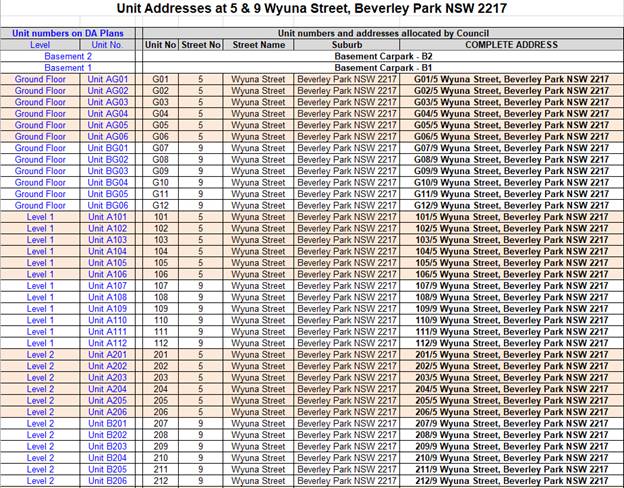
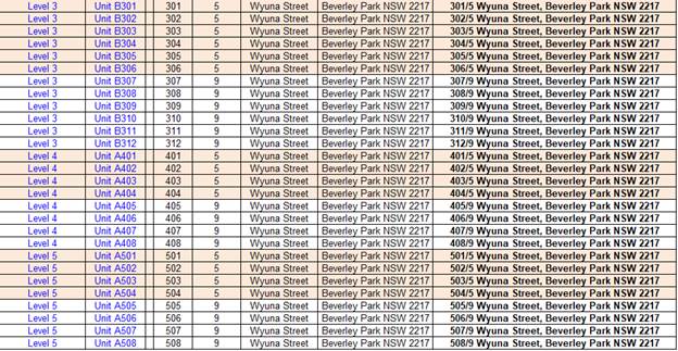
|
Attachment ⇩1 |
Site Plan and Elevations - 5-11A Wyuna St Beverley Park |