|
AGENDA Traffic Committee
Tuesday, 03 December 2019 10.00am
Waratah Room, Ground Floor, Georges River Civic Centre, Corner of MacMahon and Dora Streets
|
|

|
AGENDA Traffic Committee
Tuesday, 03 December 2019 10.00am
Waratah Room, Ground Floor, Georges River Civic Centre, Corner of MacMahon and Dora Streets
|
|
Georges River Council – Traffic Advisory Committee Meeting - Tuesday, 3 December 2019 Page 1
Traffic Advisory Committee Meeting
Tuesday, 03 December 2019
BUSINESS
1. Apologies
2. Confirmation of Minutes of Previous Meeting
3. Matters Arising from Previous Meeting
4. Disclosures of Interest
5. Speakers
Move to Closed session (Webcast stopped)
6. Agenda Item discussion
7. General Business
Move to Open session (Webcast resumed)
8. Move Agenda Recommendations
9. Meeting Closed
Agenda Items
TAC199-19 Cross Street Hurstville - Raised Pedestrian Crossing
(Report by Senior Traffic Engineer)............................................................................ 3
TAC200-19 Carwar Avenue, Carss Park - Temporary Road Closures - Magic of Christmas Event
(Report by Coordinator Traffic & Transport)............................................................... 7
TAC201-19 Carwar Avenue, Carss Park - Temporary Road Closures - Australia Day Event
(Report by Coordinator Traffic & Transport)............................................................ 15
TAC202-19 Wentworth Avenue, Blakehurst - Proposed Temporary Road Closure
(Report by Coordinator Traffic & Transport)............................................................ 23
TAC203-19 Oatley Park - Traffic Issues Update
(Report by Coordinator Traffic & Transport)............................................................ 26
TAC204-19 Oatley Parade, Oatley - Proposed Intersection Treatment
(Report by Coordinator Traffic & Transport)............................................................ 28
TAC205-19 Glen Road, Oatley - Proposed Line Marking
(Report by Traffic Engineer)....................................................................................... 31
TAC206-19 Belmore Road, Peakhurst - Proposed Parking Restriction Signs
(Report by Traffic Engineer)....................................................................................... 34
TAC207-19 Edna Avenue, Penshurst - Proposed "No Parking" Zone
(Report by Traffic Engineer)....................................................................................... 37
TAC208-19 George Street, Penshurst - Proposed Extension of "No Stopping" Zone
(Report by Coordinator Traffic & Transport)............................................................ 40
TAC209-19 Gungah Bay Road, Oatley - Proposed "No Stopping" Zone Extension
(Report by Coordinator Traffic & Transport)............................................................ 43
TAC210-19 Victoria Avenue, Penshurst - Proposed "No Parking" Zone
(Report by Coordinator Traffic & Transport)............................................................ 46
TAC211-19 Garfield Lane, Carlton - Proposed "No Parking" Zone
(Report by Coordinator Traffic & Transport)............................................................ 49
TAC212-19 River Road, Oatley - Proposed "No Parking" Zone
(Report by Coordinator Traffic & Transport)............................................................ 51
TAC213-19 Andover Street, Carlton - Proposed "Bus Zones"
(Report by Coordinator Traffic & Transport)............................................................ 53
TAC214-19 Railway Parade, Mortdale - Proposed "1/2P" Zone
(Report by Coordinator Traffic & Transport)............................................................ 55
Georges River Council – Traffic Advisory Committee Meeting - Tuesday, 3 December 2019 Page 5
Item: TAC199-19 Cross Street Hurstville - Raised Pedestrian Crossing
Author: Senior Traffic Engineer
Directorate: Assets and Infrastructure
Matter Type: Agenda Items
|
(a) That a Raised Pedestrian Crossing in Cross Street near its intersection with Crofts Avenue, Hurstville be approved. (b) That the final detailed design of the Raised Pedestrian Crossing be sent to RMS for review and approval prior to construction. |
Executive Summary
1. This report seeks the Committee’s consideration for the installation of a Raised Pedestrian Crossing in Cross Street near its intersection with Crofts Avenue, Hurstville.
Background
2. As part of the Development Application approval at 6 Cross Street, Hurstville for the expansion of the Illawarra Catholic Club (Club Central), it was conditioned that the developers contribute to upgrading pedestrian facilities in the vicinity of their development.
3. Council’s Traffic section has been approached on numerous occasions by rate payers and visitors of Hurstville to provide a safe location for pedestrians to cross the intersection of Crofts Avenue and Cross Street, at Westfield entrance.
4. The entrance to Westfield at this location is a very popular entrance for pedestrians as it is near Bus Stops, offices and other businesses.
5. Furthermore there are developments in the area that are currently being constructed which would further increase traffic and pedestrians in the area.
6. Accordingly the provision of a designated crossing area outside Westfield’s entrance in Cross Street, Hurstville has become a necessity to prioritise pedestrians’ right of way over vehicles at this location.
7. Site inspection and observations of pedestrian behaviour has revealed that pedestrian’s desired path is directly across the Taxi Zone in Cross Street. Pedestrians have been observed to stop before crossing Cross Street to try and negotiate manoeuvres by cars, taxis, buses and trucks before continuing to cross Cross Street, to gain access to Westfield. During observations, many near misses were observed.
8. Furthermore Traffic and Pedestrian counts were undertaken for three separate hours on the same day and the results were as follows:
9.
|
Time |
Number of Pedestrians |
Number of Vehicles |
|
9.00 am- 10.00 am |
158 |
250 |
|
12.30pm-1.30pm |
362 |
300 |
|
4.00pm-5.00pm |
200 |
280 |
10. As can be seen from the counts above there are a significant amount of pedestrians who cross at this location to gain access to Westfield.
11. While the count does not meet the warrant for vehicles at this point in time, it is anticipated that the traffic generation that is expected from the developments that are currently being constructed will increase traffic in the area over the next few years and the warrants for the vehicles will be met. It is for this reason that the pedestrian crossing is being proposed to be built from a developer’s contribution.
12. The location of the raised pedestrian crossing in Cross Street would result in the relocation of the existing Taxi Zone that currently exists outside Westfield entrance on the southern side of Cross Street.
13. The suggested relocation for the Taxi Zone is to the northern side of Cross Street outside the Illawarra Catholic Club Expansion at 6 Cross Street. This location is approximately 60 metres from the current Taxi Zone location.
14. St George Cabs have been consulted in regards to the relocation of the Taxi Zone and they advised that they have no objection for the Taxi Zone to be relocated.
15. The Chief executive officer of Club Central had no objection to the Taxi Zone being relocated outside of the new development at 6 Cross Street, once construction is completed. However he did raise objection to the building of the raised pedestrian crossing, as he feels the crossing could contribute to traffic congestion in the area as vehicles stop to give way to pedestrians.
16. The activity of taxis at the Taxi Zone was observed over two days, on Thursday the 24th of October and on Tuesday the 29th of October 2019 between 7am and 5pm. It was observed that 35 taxis on the 24th and 36 taxis on the 29th used the Taxi Zone to either pick up or drop off passengers.
17. It was also observed that the Taxi Zone was used as a location for drop off and pick up of passengers by normal vehicles (not taxis). There were other users such as Armed cash transport trucks using the Taxi Zone for more than 30 minutes, as well as other non-taxi related activities at the Taxi Zone.
18. The proposed relocation of the Taxi Zone will be subject to a further report to the Traffic Committee.
19. Attached to this report is a concept design of the Raised Pedestrian Crossing.
20. The final detailed design plans will be provided to RMS for review and approval prior to construction.
Financial Implications
21. Within budget allocation. Developer’s Contribution $100,000
Community Engagement
22. Community engagement was conducted with St George Cabs, Westfield Centre Management and Club Central Chief Executive Officer in regards to the relocation of the Taxi Zone.
· St George Cabs had no objection to the relocation of the Taxi Zone to the northern side of Cross Street outside the proposed new development for Cub Central.
· The Chief executive officer of Club Central had no objection to the Taxi Zone being relocated outside of the new development at 6 Cross Street, once construction is completed. However he did raise objection to the building of the raised pedestrian crossing, as he feels the crossing could contribute to traffic congestion in the area as vehicles stop to give way to pedestrians.
· Westfield raised objection to losing the location of the Taxi Zone as an at-grade vehicle access directly outside of the entrance that is near to the Westfield concierge service. Westfield advised that many elderly and disabled customers utilise their concierge to call in a mobility accessible taxi to pick them up. Westfield also objected to the removal of the shelters for similar reasons.
File Reference
D19/225939
|
Attachment ⇩1 |
Raised Pedestrian Crossing in Cross Street Hurstville |
|
Georges River Council - Traffic Advisory Committee Meeting - Tuesday, 3 December 2019 TAC199-19 Cross Street Hurstville - Raised Pedestrian Crossing [Appendix 1] Raised Pedestrian Crossing in Cross Street Hurstville |
Page 6 |
Georges River Council – Traffic Advisory Committee Meeting - Tuesday, 3 December 2019 Page 8
Item: TAC200-19 Carwar Avenue, Carss Park - Temporary Road Closures - Magic of Christmas Event
Author: Coordinator Traffic & Transport
Directorate: Assets and Infrastructure
Matter Type: Agenda Items
|
That approval be granted for the closure of Allawah Avenue and part road closure of Carwar Avenue, Carss Park, between 1pm and 9pm on Sunday 1 December 2019 for Council’s “Magic of Christmas” event to be held at Carss Bush Park, as shown on plans TCP 1 and TCP 2 attached to the report. |
Executive Summary
1. This report seeks the Committee’s consideration of temporary road closures in Carss Park for Council’s “Magic of Christmas” event.
Background
2. On Sunday 1 December 2019, Council is holding its annual “Magic of Christmas” event in Carss Bush Park. The event involves entertainment for children and a visit from Santa and Mrs Claus. Food and drinks will be available from a variety of market stalls onsite.
Proposal
3. It is proposed that Allawah Avenue and a section of Carwar Avenue, from the intersection with Carlton Crescent, be closed to vehicular traffic, between 1pm and 9pm on Sunday 1 December 2019 to allow for the safe movement of people around Carss Bush Park for those participating in the “Magic of Christmas” event.
4. Parking by gold coin donation will be provided on Carss Park Flats which can be accessed from Carlton Crescent, Carss Park. The volunteers of the State Emergency Service (SES) will be present to assist drivers during their arrival and departure. All money raised as a result of the parking donations will support the volunteer work of Kogarah’s SES.
5. The event would be classified as a Class 3 Event according to the “Guide to Traffic and Transport Management for Special Events”, and as such a Traffic Management Plan (TMP) would not be required to be submitted to the Roads and Maritime Services (RMS) for approval prior to the event. The “Management Plan” attached to the report will be distributed to personnel involved in the event.
Financial Implications
6. Within budget allocation – Council’s Event Budget – approximately $2,000.
Community Engagement
7. Community engagement was conducted including: Residents have been notified by letter box drop of the road closures and event.
File Reference
D19/272073
|
Attachment ⇩1 |
Magic of Christmas 2019 - TCP 1 |
|
Attachment ⇩2 |
Magic of Christmas 2019 - TCP 2 |
|
Attachment ⇩3 |
Traffic Management Plan 2019 |
|
Georges River Council - Traffic Advisory Committee Meeting - Tuesday, 3 December 2019 TAC200-19 Carwar Avenue, Carss Park - Temporary Road Closures - Magic of Christmas Event [Appendix 1] Magic of Christmas 2019 - TCP 1 |
Page 9 |
|
Georges River Council - Traffic Advisory Committee Meeting - Tuesday, 3 December 2019 TAC200-19 Carwar Avenue, Carss Park - Temporary Road Closures - Magic of Christmas Event [Appendix 2] Magic of Christmas 2019 - TCP 2 |
Page 10 |
|
Georges River Council - Traffic Advisory Committee Meeting - Tuesday, 3 December 2019 TAC200-19 Carwar Avenue, Carss Park - Temporary Road Closures - Magic of Christmas Event [Appendix 3] Traffic Management Plan 2019 |
Page 11 |


Item: TAC201-19 Carwar Avenue, Carss Park - Temporary Road Closures - Australia Day Event
Author: Coordinator Traffic & Transport
Directorate: Assets and Infrastructure
Matter Type: Agenda Items
|
That approval be granted for the closure of Allawah Avenue and part road closure of Carwar Avenue, Carss Park, between 7am and 10pm on Sunday 26 January 2020 for Council’s “Australia Day” event to be held at Carss Bush Park, as shown on Plans TCP 1, TCP 2 and TCP 3 attached to the report. |
Executive Summary
1. This report seeks the Committee’s consideration of temporary road closures in Carss Park for Council’s “Australia Day” event.
Background
2. On Sunday 26 January 2020, Council is holding its annual “Australia Day” event at Carss Bush Park. The event involves live music, diverse cultural performances, amusing roving entertainers and market stalls selling clothing, novelties, crafts and foods from many different cultures. The highlight of the event will be at 9pm with a fireworks display over Kogarah Bay.
Proposal
3. It is proposed that Allawah Avenue and a section of Carwar Avenue, from the intersection with Carlton Crescent, be closed to vehicular traffic, between 7am and 10pm on Sunday 26 January 2020 to allow the safe movement around Carss Bush Park for those participating in the “Australia Day” event.
4. Parking by gold coin donation will be provided on Carss Park Flats which can be accessed from Carlton Crescent, Carss Park. State Emergency Service (SES) volunteers will be present to assist drivers during their arrival and departure. All money raised as a result of the parking donations will support the volunteer work of the Kogarah SES. Parkside Drive Reserve will also be used for parking if Carss Park Flats becomes full.
5. The event would be classified as a Class 3 Event, according to the “Guide to Traffic and Transport Management for Special Events”, and as such a Traffic Management Plan (TMP) would not be required to be submitted to the Roads and Maritime Services (RMS) for approval prior to the event. The “Management Plan” attached to the report will be distributed to personnel involved in the event.
6. A hostile vehicle risk assessment has also been conducted for this event.
Financial Implications
7. Within budget allocation - Council’s Event Budget – approximately $2,000.
Community Engagement
8. Community engagement will be conducted including: Residents will be notified by letter box drop of the road closures and event.
File Reference
D19/276473
|
Attachment ⇩1 |
Australia Day 2020 TCP 1 |
|
Attachment ⇩2 |
Australia Day 2020 TCP 2 |
|
Attachment ⇩3 |
Australia Day 2020 TCP 3 |
|
Attachment ⇩4 |
Australia Day 2020- Management Plan |
|
Georges River Council - Traffic Advisory Committee Meeting - Tuesday, 3 December 2019 TAC201-19 Carwar Avenue, Carss Park - Temporary Road Closures - Australia Day Event [Appendix 1] Australia Day 2020 TCP 1 |
Page 17 |
|
Georges River Council - Traffic Advisory Committee Meeting - Tuesday, 3 December 2019 TAC201-19 Carwar Avenue, Carss Park - Temporary Road Closures - Australia Day Event [Appendix 2] Australia Day 2020 TCP 2 |
Page 18 |
|
Georges River Council - Traffic Advisory Committee Meeting - Tuesday, 3 December 2019 TAC201-19 Carwar Avenue, Carss Park - Temporary Road Closures - Australia Day Event [Appendix 3] Australia Day 2020 TCP 3 |
Page 19 |
|
Georges River Council - Traffic Advisory Committee Meeting - Tuesday, 3 December 2019 TAC201-19 Carwar Avenue, Carss Park - Temporary Road Closures - Australia Day Event [Appendix 4] Australia Day 2020- Management Plan |
Page 22 |


Item: TAC202-19 Wentworth Avenue, Blakehurst - Proposed Temporary Road Closure
Author: Coordinator Traffic & Transport
Directorate: Assets and Infrastructure
Matter Type: Agenda Items
|
(a) That the temporary closure of Wentworth Avenue, Blakehurst between Lorna Avenue and Lynwood Street, from 5.30pm to 8.30pm on Sunday 15 December 2019 be approved for the Blakehurst Baptist Church Christmas Walk. (b) The approval of the road closure is subject to a copy of a valid Certificate of Currency indicating a Public Liability Insurance of a minimum $20 Million indemnifying Georges River Council being submitted to Council prior to the closure occurring. (c) That the applicant lodge to Council for approval prior to the closures, Traffic Control Plans designed in accordance with the relevant standards and prepared by RMS accredited personnel. (d) If applicable, the applicant should provide a Risk Assessment and Hostile Vehicle Mitigation Plan created by Class 2A (Security Consultant) if such measures are proposed. |
Executive Summary
1. This report seeks the Committee’s consideration for the temporary closure of Wentworth Avenue, Blakehurst.
Background
2. A request has been received from a representative of Blakehurst Baptist Church to conduct their annual Christmas Walk on Sunday 15 December 2019. This request includes a proposal to temporarily close a section of Wentworth Avenue, between Lorna Avenue and Lynwood Street.
3. It is proposed that Wentworth Avenue be closed to vehicular traffic from Lorna Avenue to Lynwood Street, between 5.30pm and 8.30pm on Sunday 15 December 2019 to allow for the safe movement of people involved in the Church’s Christmas Walk.
4. The event would be classified as a Class 3 Event according to the “Guide to Traffic and Transport Management for Special Events”, and as such a Traffic Management Plan would not be required to be submitted to the Roads and Maritime Services (RMS) for approval prior to the event.
5. The approval of the road closure is subject to a copy of a valid Certificate of Currency indicating a Public Liability Insurance of a minimum $20 Million indemnifying Georges River Council being submitted to Council prior to the closure occurring.
6. That the applicant lodge to Council for approval prior to the closures, Traffic Control Plans designed in accordance with the relevant standards and prepared by RMS accredited personnel.
Financial Implications
7. No budget impact for this report.
Community Engagement
8. Community engagement will be conducted including: All residents in the closed section of Wentworth Avenue will be notified by letterbox drop two weeks prior to the closure occurring. Residents requiring their vehicle during this time will be requested to park in an alternate street until the road is reopened as no vehicles will be permitted access through the closure points during this time.
File Reference
D19/283022
|
Attachment ⇩1 |
L87 - Wentworth Avenue Aerial |
|
Georges River Council - Traffic Advisory Committee Meeting - Tuesday, 3 December 2019 TAC202-19 Wentworth Avenue, Blakehurst - Proposed Temporary Road Closure [Appendix 1] L87 - Wentworth Avenue Aerial |
Page 25 |
Georges River Council – Traffic Advisory Committee Meeting - Tuesday, 3 December 2019 Page 27
Item: TAC203-19 Oatley Park - Traffic Issues Update
Author: Coordinator Traffic & Transport
Directorate: Assets and Infrastructure
Matter Type: Agenda Items
|
That the report on the traffic measures in Oatley Park be received and noted. |
Executive Summary
1. This report provides an update on the traffic measures undertaken in Oatley Park, Oatley.
Background
2. On 14 September 2019 a new Oatley Park Inclusive Adventure Playground opened. Since the opening there have been a number of comments received from the public specifically in relation to the vehicle traffic using the area.
3. Council has recently completed the following traffic measures in Oatley Park to assist in vehicle movements:
· Additional “No Entry” signs have been installed near the Adventure Playground to advise drivers of the correct direction of travel on the shared path.
· Car park directional signs have bene installed advising drivers of additional parking areas within Oatley Park to utilise near the Adventure Playground to ease the parking congestion directly adjacent the park.
· New “One Way” and “20km/h” speed signs have been installed to replace the old faded signs along the shared pathway.
· The faded line marking along the shared pathway has been repainted.
· New signage advising of the shared pathway conditions was installed near the entrance to Oatley Park.
· Two (2) Disabled Parking spaces adjacent to the Adventure Playground designed in accordance with the Australian Standards are currently being constructed. Due to be completed on or prior to 4 December.
4. Due to the curved nature of the shared path, NSW Police Highway Patrol is unable to use radar detection to detect drivers travelling above the 20km/h posted speed limit. However during onsite inspections by NSW Police it was noted that the majority of drivers were adhering to the posted limit.
5. “No Parking” signs were considered for installation along the tree-lined side of the shared pathway opposite the Adventure Playground, however the installation of these signs is not proposed at this stage due to the negative visual impact on the area. Additional measures will be considered if vehicles are observed to continue to park in that area.
Financial Implications
6. No budget impact for this report.
File Reference
D19/280290
Georges River Council – Traffic Advisory Committee Meeting - Tuesday, 3 December 2019 Page 29
Item: TAC204-19 Oatley Parade, Oatley - Proposed Intersection Treatment
Author: Coordinator Traffic & Transport
Directorate: Assets and Infrastructure
Matter Type: Agenda Items
|
That the proposed line marking at the intersection of Oatley Parade and River Road, Oatley as shown on plan TC2040 attached to the report be approved. |
Executive Summary
1. This report seeks the Committee’s consideration of the proposed line marking at the intersection of Oatley Parade and River Road, Oatley.
Background
2. At the 5 February 2019 meeting of the Traffic Advisory Committee, a report was presented for the consideration of a proposed roundabout at the intersection of Oatley Parade and River Road, Oatley.
3. Following extensive discussions, a roundabout was denied by the Committee due to the significant loss of street parking and the following recommendations were adopted:
a. “That additional line marking options be investigated to improve the right turn movement from River Road into Oatley Parade and improve pedestrian safety associated with the left turn movement from Oatley Parade into River Road.
b. That the amended line marking option be brought back to a future traffic committee for review and consideration of treatment options at this intersection.”
4. The alternative to the roundabout design was to modify the existing line marking at the intersection to provide additional delineation markings for drivers and improve the turning movements at the intersection. In particular emphasis is improving the turn movements out of River Road onto Oatley Parade.
Proposal
5. A line marking design plan has been undertaken and is attached to the report. The proposal includes the following treatments:
· Centre line extension in River Road and Oatley Parade
· Turn arrows in River Road
· Give Way line and sign in River Road at Oatley Parade
· Edge lines on the eastern and western side of Oatley Parade
· Chevron markings with rumble bars in Oatley Parade, north and south of River Road.
6. Council received a request for the installation of bike lanes at the intersection of Oatley Parade and River Road. However following design considerations, there is insufficient width that allows both vehicle travel lanes and a bike lane and as a result it is not feasible to incorporate a dedicated bike lane.
7. There is no associated loss of street parking with the line marking proposal.
8. A dedicated bay for vehicles turning right from Oatley Parade into River Road was considered as part of this proposal, however due to the existing pedestrian crossing to the north of the intersection, there is insufficient holding capacity for a turn bay and is therefore not recommended for installation.
Financial Implications
9. Within budget allocation – RMS Traffic Facility Grant – approximately $15,000.
File Reference
D19/278748
|
Attachment ⇩1 |
Plan TC2040 - Oatley Parade, Oatley |
|
Georges River Council - Traffic Advisory Committee Meeting - Tuesday, 3 December 2019 TAC204-19 Oatley Parade, Oatley - Proposed Intersection Treatment [Appendix 1] Plan TC2040 - Oatley Parade, Oatley |
Page 30 |
Georges River Council – Traffic Advisory Committee Meeting - Tuesday, 3 December 2019 Page 32
Item: TAC205-19 Glen Road, Oatley - Proposed Line Marking
Author: Traffic Engineer
Directorate: Assets and Infrastructure
Matter Type: Agenda Items
|
That an 8m BB Centreline be installed on Glen Road, Oatley as shown on plan TC2033 attached to the report. |
Executive Summary
1. This report seeks the Committees consideration for the proposed installation of line marking on Glen Road, Oatley.
Background
2. Council has received a request from a resident to investigate the driving conditions at the bend on Glen Road, Oatley.
3. Currently there is unrestricted parking along Glen Road, the request is to improve safety and visibility at the bend in Glen Road.
4. Upon investigation of this request, Council has found that vehicles travelling on Glen Road, had limited vision of oncoming traffic, especially when vehicles were parked in this location.
Proposal
5. It is therefore proposed to install an 8m BB Centreline at the bend on Glen Road. This will formalise the travel lanes improving visibility and safety in this location.
6. At this stage “No Stopping” signs are not recommended to be installed and the parking will be monitored. Drivers will have to abide by the Road Rules and will not be permitted to park adjacent to the line due to the narrow width of the street.
Financial Implications
7. Within budget allocation – RMS Traffic Facilities Grant – Approximately $1,500.
Community Engagement
8. The residents in the vicinity were notified by letter of the proposed line marking. Submissions on the proposal were requested to be received by Friday 15 November 2019. No objections were received. One resident contacted in support of the proposal.
File Reference
D19/269373
|
Attachment ⇩1 |
TC2033_Glen Road, Oatley |
|
Georges River Council - Traffic Advisory Committee Meeting - Tuesday, 3 December 2019 TAC205-19 Glen Road, Oatley - Proposed Line Marking [Appendix 1] TC2033_Glen Road, Oatley |
Page 33 |
Georges River Council – Traffic Advisory Committee Meeting - Tuesday, 3 December 2019 Page 35
Item: TAC206-19 Belmore Road, Peakhurst - Proposed Parking Restriction Signs
Author: Traffic Engineer
Directorate: Assets and Infrastructure
Matter Type: Agenda Items
|
That parking restriction signs be installed at the intersection of Belmore Road, Evans Street and Samuel Street, Peakhurst, as shown on plan TC2023 attached to the report. |
Executive Summary
1. This report seeks the Committee’s consideration of the proposed installation of parking restrictions signs at the intersection of Belmore Road, Evans Street and Samuel Street, Peakhurst.
Background
2. Council has received a request from a resident to investigate the parking conditions at the roundabout intersection of Belmore Road, Evans Street and Samuel Street, Peakhurst.
3. Currently there is an existing “No Stopping” zone on the southern side of Samuel Street only and unrestricted parking on all other approaches to the intersection.
4. Upon investigation of this request, Council has found that if vehicles park within close proximity of the roundabout, vehicles are forced to move across the existing line marking, creating a hazard. There was also decreased visibility on approach and exit from the roundabout.
Proposal
5. It is therefore proposed to install parking restriction signage on approaches to the roundabout at the intersection of Belmore Road, Evans Street and Samuel Street, Peakhurst. This proposal will improve visibility and safety at the intersection.
Financial Implications
6. Within budget allocation – RMS Traffic Facilities Grant – Approximately $1,000.
Community Engagement
7. The residents in the vicinity were notified by letter of the proposed signage. Submissions on the proposal were requested to be received by Friday 15 November 2019. No objections were received.
File Reference
D19/269706
|
Attachment ⇩1 |
TC2023_Belmore Road No Stopping |
|
Georges River Council - Traffic Advisory Committee Meeting - Tuesday, 3 December 2019 TAC206-19 Belmore Road, Peakhurst - Proposed Parking Restriction Signs [Appendix 1] TC2023_Belmore Road No Stopping |
Page 36 |
Georges River Council – Traffic Advisory Committee Meeting - Tuesday, 3 December 2019 Page 38
Item: TAC207-19 Edna Avenue, Penshurst - Proposed "No Parking" Zone
Author: Traffic Engineer
Directorate: Assets and Infrastructure
Matter Type: Agenda Items
|
(a) That the residents of Edna Avenue be consulted on the proposal to install a “No Parking” zone on the western side of Edna Avenue, Penshurst as shown on plan TC1924 attached to the report. (b) That the results of the resident consultation be presented at a future Traffic Advisory Committee meeting. |
Executive Summary
1. This report seeks the Committees consideration of the proposed “No Parking” zone on Edna Avenue, Penshurst.
Background
2. In March 2019, Council received requests from residents of Edna Avenue, to investigate the current parking conditions in the street.
3. The width of the existing roadway on Edna Avenue is approximately 6.3m. Under Roads and Maritime Services (RMS) requirements, there is insufficient road width to allow two vehicles to park directly opposite each other whilst maintaining a 3m travel lane as required by NSW Road Rule 208 (7).
4. As a result of this situation drivers have been observed to be routinely parking with part of the vehicle on the footpath area. Under the NSW Road Rules, it is not legal for vehicles to park on or across a footpath and they must park wholly within the roadway. When Council is advised that drivers are parking contrary to the Road Rules action is required to be taken.
5. In April 2019 Council consulted with the residents of Edna Avenue for the installation of a proposed “No Parking” zone on the even numbered (eastern) side of Edna Avenue.
6. Following correspondence from residents in the area it was determined by Council, not to proceed with the proposed “No Parking” zone and to explore other options including a shared zone.
7. The matter was subsequently raised at Council’s June 2019 Traffic Advisory Committee meeting to discuss these options.
8. Based on the low pedestrian volumes in Edna Avenue, it was determined that Edna Avenue is not eligible for the implementation of a shared zone under the RMS technical direction. Without the approval of a shared zone, it is not legal for vehicles to park on or across a footpath.
9. Following discussions with RMS no other suitable options to resolve the access issues in Edna Avenue were identified.
10. Council’s Waste Section has confirmed that a small rear load compactor truck that is currently servicing Edna Avenue is reversing into the street and the driving out. The larger side arm truck can collect only a few bins towards the top section of Edna Avenue before it reaches cars parked on the street and then is required to reverse out.
Proposal
11. It is therefore recommended to install a “No Parking” zone on the western side of Edna Avenue. This will prevent cars parking in this location. The proposal will resolve the access issues affecting waste pick-up services, emergency vehicles and will allow for larger vehicles to safely enter the street at all times.
12. The proposal has been amended to the western side of Edna Avenue as this will result in the loss of fewer parking spaces than the eastern side.
13. Residents will be consulted on the proposal and a report with the consultation feedback will be presented to a future Traffic Advisory Committee meeting.
Financial Implications
14. No budget impact for this report.
File Reference
D19/271984
|
Attachment ⇩1 |
TC1924_Edna Ave No Parking |
|
Georges River Council - Traffic Advisory Committee Meeting - Tuesday, 3 December 2019 TAC207-19 Edna Avenue, Penshurst - Proposed "No Parking" Zone [Appendix 1] TC1924_Edna Ave No Parking |
Page 39 |
Georges River Council – Traffic Advisory Committee Meeting - Tuesday, 3 December 2019 Page 41
Item: TAC208-19 George Street, Penshurst - Proposed Extension of "No Stopping" Zone
Author: Coordinator Traffic & Transport
Directorate: Assets and Infrastructure
Matter Type: Agenda Items
|
That the existing 10m “No Stopping” zone on the northern side of George Street, west of Arcadia Street, be extended 8m as shown on plan TC2036 attached to the report. |
Executive Summary
1. This report seeks the Committee’s consideration of the proposed extension of the “No Stopping” zone in George Street, Penshurst.
Background
2. Council has received a request from a local resident to consider options to improve the safety for drivers using the intersection of George Street and Arcadia Street, Penshurst.
3. In October 2018 Council undertook a traffic study in George Street, near Arcadia Street, to ascertain the speed and volume of vehicles using the street near the intersection. The result of the 85th percentile speed was 51km/h (50km/h posted speed limit) and the daily traffic volume was 4,214 vehicles.
4. Council has also reviewed the Roads and Maritime Service’s (RMS) crash database for a 5 year period between January 2014 and December 2018. There have been three (3) cross traffic crashes with one injury within this time.
Proposal
5. Upon investigation of this request, it is proposed to relocate the existing “No Stopping” sign on the northern side of George Street, 8m towards the west to improve the sight distance for drivers exiting Arcadia Street and increase the safety at this intersection.
Financial Implications
6. Within budget allocation – RMS Traffic Facility Grant – approximately $100.
Community Engagement
7. Community engagement was conducted including: A letter and plan of the proposed changes to the “No Stopping” zone were distributed to the nearby residents. The closing date for submissions was 15 November 2019. One objection was received in regards to the loss of parking associated with the extension.
8. Whilst there is a loss of one parking space in George Street as a result of this proposal, there have been a number of crashes over the last 5 years and warrants action to be taken. The extension of the “No Stopping” zone by 8m would increase the sight distance along George Street for drivers exiting Arcadia Street and improve the safety.
File Reference
D19/252107
|
Attachment ⇩1 |
Plan TC2036 - George Street, Penshurst |
|
Georges River Council - Traffic Advisory Committee Meeting - Tuesday, 3 December 2019 TAC208-19 George Street, Penshurst - Proposed Extension of "No Stopping" Zone [Appendix 1] Plan TC2036 - George Street, Penshurst |
Page 42 |
Georges River Council – Traffic Advisory Committee Meeting - Tuesday, 3 December 2019 Page 44
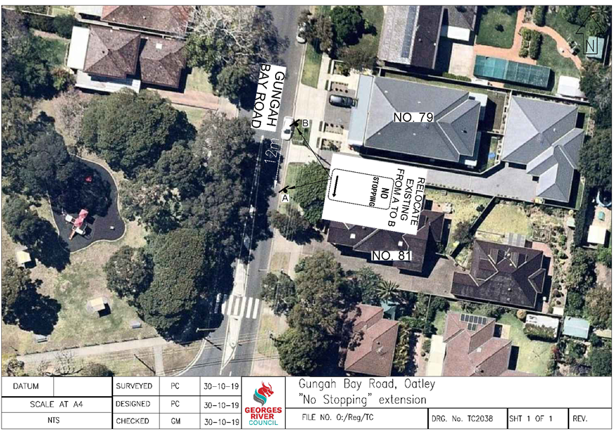
Item: TAC209-19 Gungah Bay Road, Oatley - Proposed "No Stopping" Zone Extension
Author: Coordinator Traffic & Transport
Directorate: Assets and Infrastructure
Matter Type: Agenda Items
|
That the existing “No Stopping” zone on the eastern side of Gungah Bay Road, adjacent to house number 81, be extended 12m as shown on plan TC2038 attached to the report. |
Executive Summary
1. This report seeks the Committee’s consideration of the proposed “No Stopping” zone extension in Gungah Bay Road, Oatley.
Background
2. Council has received a request to investigate the parking restrictions in Gungah Bay Road, adjacent to No. 81.
3. Upon investigation of this request, it has been determined that vehicles parking between the existing “No Stopping” sign and the driveway to No. 79 are in breach of NSW Road Rule 208 (6), which states that drivers must position their vehicle at least 3 metres from any dividing line on the roadway.
4. Council therefore consulted with the residents on a proposal to extend the “No Stopping” zone on the eastern side of the road 5m towards the north.
5. During the consultation period, Council received comments regarding the proposal.
6. The residents requested the extension of the “No Stopping” zone by 12m. This would also prevent vehicles parking in the small area (<3.5m) between the driveways and improving vehicular access to the properties.
Proposal
7. Based on the feedback received, the proposal is to extend the existing “No Stopping” zone on the eastern side of Gungah Bay Road, adjacent to No. 81, 12m towards the north.
Financial Implications
8. Within budget allocation – RMS Traffic Facility Grant – approximately $300.
Community Engagement
9. Community engagement was conducted including: A letter and plan of the revised changes were distributed to the nearby residents. The closing date for submissions was 22 November 2019. No objections to the new proposal were received.
File Reference
D19/276940
|
Attachment ⇩1 |
Plan TC2038 - Gungah Bay Road, Oatley |
|
Georges River Council - Traffic Advisory Committee Meeting - Tuesday, 3 December 2019 TAC209-19 Gungah Bay Road, Oatley - Proposed "No Stopping" Zone Extension [Appendix 1] Plan TC2038 - Gungah Bay Road, Oatley |
Page 45 |
Georges River Council – Traffic Advisory Committee Meeting - Tuesday, 3 December 2019 Page 47
Item: TAC210-19 Victoria Avenue, Penshurst - Proposed "No Parking" Zone
Author: Coordinator Traffic & Transport
Directorate: Assets and Infrastructure
Matter Type: Agenda Items
|
That a 15.5m “No Parking, Motorcycles Excepted” zone be installed on the southern side of Victoria Avenue, adjacent to No.’s 7 and 11, as shown on plan TC2034 attached to the report. |
Executive Summary
1. This report seeks the Committee’s consideration of the proposed “No Parking” zone in Victoria Avenue, Penshurst.
Background
2. Council has received a request from a local resident to investigate the possibility of installing parking restriction signs between the driveways of numbers 7 and 11 Victoria Avenue, Penshurst.
3. Council has been advised that vehicles are parking in the small area between the driveways (3m) and restricting vehicular access. Due to the short distance between the driveways, it does not allow a standard vehicle to park legally.
Proposal
4. Upon investigation of this request, it is proposed to install a 15.5 metre “No Parking, Motorcycles Excepted” zone on the southern side of Victoria Avenue, adjacent to numbers 7 and 11, to prevent cars parking in this location and blocking access into the residential properties.
5. Due to the close proximity of the location to the Penshurst shops and residential properties, there were a number of motorcycles observed in the street using car spaces so it was deemed appropriate to permit motorcycles to park between the driveways.
Financial Implications
6. Within budget allocation – RMS Traffic Facility Grant – approximately $400.
Community Engagement
7. Community engagement was conducted including: A letter and plan of the proposed “No Parking” zone were distributed to the nearby residents. The closing date for submissions was 15 November 2019. No objections were received.
File Reference
D19/275932
|
Attachment ⇩1 |
Plan TC2034 - Victoria Avenue, Penshurst |
|
Georges River Council - Traffic Advisory Committee Meeting - Tuesday, 3 December 2019 TAC210-19 Victoria Avenue, Penshurst - Proposed "No Parking" Zone [Appendix 1] Plan TC2034 - Victoria Avenue, Penshurst |
Page 48 |
Georges River Council – Traffic Advisory Committee Meeting - Tuesday, 3 December 2019 Page 49
Item: TAC211-19 Garfield Lane, Carlton - Proposed "No Parking" Zone
Author: Coordinator Traffic & Transport
Directorate: Assets and Infrastructure
Matter Type: Agenda Items
|
That a 17m “No Parking” zone be installed on the eastern side of Garfield Lane, Carlton as shown on plan TC2037 attached to the report. |
Executive Summary
1. This report seeks the Committee’s consideration of the proposed “No Parking” zone in Garfield Lane, Carlton.
Background
2. Council has received a complaint from a resident regarding difficulties being encountered in entering and exiting their property from Garfield Lane due to parked vehicles.
3. Due to the narrowness of the street and vehicles parking opposite driveways, turning issues are being encountered by residents.
Proposal
4. Upon investigation of this request, it is proposed to install a 17 metre “No Parking” zone on the eastern side of Garfield Lane to prevent cars parking in this location and improving access into the residential driveways.
Financial Implications
5. Within budget allocation – RMS Traffic Facility Grant – approximately $400.
Community Engagement
6. Community engagement was conducted including: A letter and plan of the proposed “No Parking” zone were distributed to the nearby residents. The closing date for submissions was 20 November 2019. No objections were received.
File Reference
D19/276123
|
Attachment ⇩1 |
Plan TC2037 - Garfield Lane, Carlton |
|
Georges River Council - Traffic Advisory Committee Meeting - Tuesday, 3 December 2019 TAC211-19 Garfield Lane, Carlton - Proposed "No Parking" Zone [Appendix 1] Plan TC2037 - Garfield Lane, Carlton |
Page 50 |
Georges River Council – Traffic Advisory Committee Meeting - Tuesday, 3 December 2019 Page 51
Item: TAC212-19 River Road, Oatley - Proposed "No Parking" Zone
Author: Coordinator Traffic & Transport
Directorate: Assets and Infrastructure
Matter Type: Agenda Items
|
That a 15m “No Parking” zone be installed on the western side of River Road, adjacent to house numbers 12 and 14, as shown on plan TC2035 attached to the report. |
Executive Summary
1. This report seeks the Committee’s consideration of the proposed “No Parking” zone in River Road, Oatley.
Background
2. Council has received a request from a local resident to investigate the possibility of installing parking restriction signs near number 14 River Road, Oatley.
3. Council has been advised that vehicles are parking in the small area between the driveways restricting vehicular access. Due to the short distance between the driveways, measuring less than 3m, a standard vehicle is unable to park legally. Vehicles on the southern side of the driveway are also impeding sight distances along River Road.
Proposal
4. Upon investigation of this request, it is proposed to install a 16 metre “No Parking” zone on the western side of River Road, adjacent to numbers 12 and 14, to prevent cars parking in this location and improving access into the residential properties.
Financial Implications
5. Within budget allocation – RMS Traffic Facility Grant – approximately $400.
Community Engagement
6. Community engagement was conducted including: A letter and plan of the proposed “No Parking” zone were distributed to the nearby residents. The closing date for submissions was 15 November 2019. No objections were received.
File Reference
D19/275944
|
Attachment ⇩1 |
Plan TC2035 - River Road, Oatley |
|
Georges River Council - Traffic Advisory Committee Meeting - Tuesday, 3 December 2019 TAC212-19 River Road, Oatley - Proposed "No Parking" Zone [Appendix 1] Plan TC2035 - River Road, Oatley |
Page 52 |
Georges River Council – Traffic Advisory Committee Meeting - Tuesday, 3 December 2019 Page 53
Item: TAC213-19 Andover Street, Carlton - Proposed "Bus Zones"
Author: Coordinator Traffic & Transport
Directorate: Assets and Infrastructure
Matter Type: Agenda Items
|
That a 20m “Bus Zone” be installed on the eastern and western side of Andover Street, near Bembridge Street and Balfour Street, as shown on plan L921 attached to the report. |
Executive Summary
1. This report seeks the Committee’s consideration of the proposed “Bus Zones” in Andover Street, Carlton.
Background
2. Council has received a request to formalise the existing Bus Stops on the eastern and western side of Andover Street, Carlton.
3. Following investigation by Council officers it was observed that vehicles were parking within the designated distance for a Bus Stop and this has resulted in buses being unable to safely stop parallel to the kerb, causing a dangerous situation for drivers and bus commuters.
Proposal
4. As a result, it is proposed to formalise the existing bus stops and install a 20m “Bus Zone” on the eastern and western sides of Andover Street, near Bembridge Street and Balfour Street.
Financial Implications
5. Within budget allocation – RMS Traffic Facility Grant – approximately $300.
Community Engagement
6. Community engagement was conducted including: A letter and plan of the proposed “Bus Zones” were distributed to the nearby residents. The closing date for submissions was 15 November 2019. One phone call of support was received and no objections.
File Reference
D19/275921
|
Attachment ⇩1 |
Plan L921 - Andover Street, Carlton |
|
Georges River Council - Traffic Advisory Committee Meeting - Tuesday, 3 December 2019 TAC213-19 Andover Street, Carlton - Proposed "Bus Zones" [Appendix 1] Plan L921 - Andover Street, Carlton |
Page 54 |
Georges River Council – Traffic Advisory Committee Meeting - Tuesday, 3 December 2019 Page 56
Item: TAC214-19 Railway Parade, Mortdale - Proposed "1/2P" Zone
Author: Coordinator Traffic & Transport
Directorate: Assets and Infrastructure
Matter Type: Agenda Items
|
That the redundant shelter and “Bus Zone” on the southern side of Railway Parade, north of Coleborne Avenue, be removed and converted to a “1/2P, 8.30am – 6pm Mon – Fri, 8.30am – 12.30pm Sat” zone as shown on plan TC2039 attached to the report. |
Executive Summary
1. This report seeks the Committee’s consideration of the proposed timed parking zone in Railway Parade, Mortdale.
Background
2. Council has received a request to investigate the possibility of converting the redundant “Bus Zone” on the southern side of Railway Parade to a timed parking zone.
3. It has been noted that the regular bus service does not operate in this section of Railway Parade and as a result the “Bus Zone” is longer required.
Proposal
4. Upon investigation of this request, it is proposed to convert the 23m “Bus Zone” on the southern side of Railway Parade, to a “1/2P, 8.30am – 6pm Mon – Fri, 8.30am – 12.30pm Sat” zone. This would provide additional street parking that can be utilised by customers of the nearby businesses, residents and their visitors.
5. A “1P” zone was considered in this location, however due to the close proximity to Mortdale Train Station, there is a possibility that drivers holding a Mobility Parking Scheme (MPS) Permit could park unrestricted throughout the day, thereby reducing the vehicle turnover in the street.
Financial Implications
6. Within budget allocation – RMS Traffic Facility Grant – approximately $5,000.
Community Engagement
7. Community engagement was conducted including: A letter and plan of the proposed “1P” zone were distributed to the nearby residents. The closing date for submissions was 20 November 2019. No objections were received.
File Reference
D19/277007
|
Attachment ⇩1 |
Plan TC2039 - Railway Parade, Mortdale |