|
Georges
River Council – Local Planning Panel Thursday, 4 June 2020
|
Page 2
|
|
3. Reports and
LPP Deliberations in Closed Session - 6.30pm
|
LPP024-20 111
Victoria Avenue Mortdale - DA2019/0257
(Report
by Development Assessment Planner)
LPP025-20 36
Chamberlain Street, Narwee - DA2020/0050
(Report
by Senior Development Assessment Planner)
LPP026-20 6
Blakesley Road Carlton - DA2019/0265
(Report
by Development Assessment Planner)
|
4. Confirmation of Minutes
|
REPORT TO
GEORGES RIVER COUNCIL
LPP MEETING OF Thursday, 04 June 2020
|
LPP Report No
|
LPP024-20
|
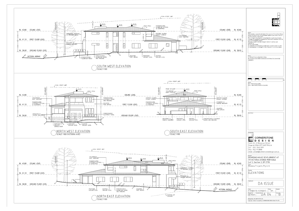
Development Application No
|
DA2019/0257
|
|
Site Address & Ward Locality
|
111 Victoria Avenue Mortdale
Mortdale Ward
|
|
Proposed Development
|
Demolition of existing structures
and construction of a two storey 10 room boarding house over basement parking
for 6 vehicles
|
|
Owners
|
F Mourad Pty Ltd and CPM Property
Management Pty Ltd
|
|
Applicant
|
Cornerstone Design
|
|
Planner/Architect
|
Planner: BMA Urban, Architect:
Cornerstone Design
|
|
Date Of Lodgement
|
27/06/2019
|
|
Submissions
|
Seven (7) individual submissions
|
|
Cost of Works
|
$1,655,186.00
|
|
Local Planning Panel Criteria
|
Development is for the construction
of a boarding house and is required to be determined by the Georges River
Local Planning Panel under Council Delegations
|
|
List of all relevant s.4.15
matters (formerly s79C(1)(a))
|
State Environmental Planning Policy
(Affordable Rental Housing) 2009; State Environmental Planning Policy
(Infrastructure) 2007; State Environmental Planning Policy No 55 -
Remediation Of Land; State Environmental Planning Policy (Building
Sustainability Index: BASIX) 2004;
State Environmental Planning Policy
(Vegetation in Non-Rural Areas) 2017; Greater Metropolitan Regional
Environmental Plan No 2 – Georges River Catchment; Draft Environment
State Environmental Planning Policy; Draft Remediation of Land SEPP; Draft
Georges River Local Environmental Plan 2020;
Hurstville Local Environmental Plan
2012;
Hurstville Development Control Plan No1 (amendment No. 7); Draft Georges
River Local Environmental Plan 2020.
|
|
List all documents submitted
with this report for the Panel’s consideration
|
Architectural Plans; Statement of
Environmental Effects;
Plan of Management of Boarding
House; Arborist Report;
Preliminary Site Investigation
Report; Accessibility Report; Traffic and
Parking Assessment Report; Geotechnical Report:
BCA Compliance Report.
|
|
Report prepared by
|
Development Assessment Planner
|
|
Recommendation
|
That the application be approved in accordance with the
conditions included in this report.
|
|
|
Summary of matters for
consideration under Section 4.15
Have all recommendations in relation
to relevant s4.15 matters been summarised in the Executive Summary of the
assessment report?
|
Yes
|
|
Legislative clauses requiring
consent authority satisfaction
Have relevant clauses in all
applicable environmental planning instruments where the consent authority
must be satisfied about a particular matter been listed and relevant
recommendations summarised, in the Executive Summary of the assessment
report?
|
Yes
|
|
Clause 4.6 Exceptions to
development standards
If a written request for a
contravention to a development standard (clause 4.6 of the LEP) has been
received, has it been attached to the assessment report?
|
Not
Applicable
|
|
Special Infrastructure
Contributions
Does the DA require Special
Infrastructure Contributions conditions (under s7.24)?
|
Not
Applicable
|
|
Conditions
Have draft conditions been provided
to the applicant for comment?
|
Yes
– the applicant has reviewed the conditions
|
|
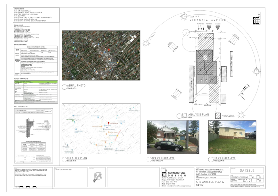
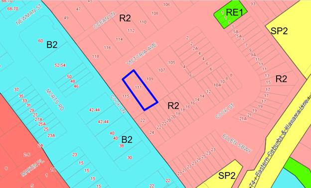
Site Plan
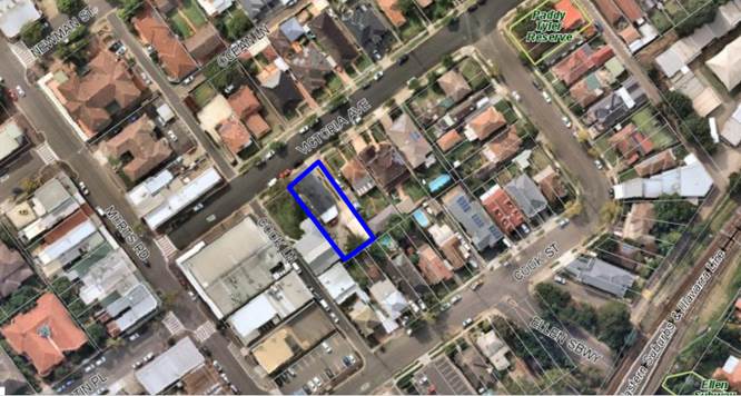
Figure 1: Aerial view of subject site outlined in blue
|
Executive Summary
Proposal
1. Development
consent is sought for the demolition of existing structures and construction of
a two (2) storey boarding house comprising of ten (10) self-contained rooms,
one (1) being the Manager’s Room over a basement car park for six (6)
vehicles.
Site and Locality
2. The
subject site is a rectangular shaped allotment located on the south eastern
side of Victoria Avenue, Mortdale. The site has a frontage of 15.24m and a site
area of 615.8sqm. The local area is characterised by single and two (2)
storey dwelling houses and dual occupancies. The site is in close proximity to
a business zone being the Mortdale Town Centre which contains a range of
business and commercial uses.
Zoning and Permissibility
3. The site is zoned R2 - Low
Density Residential under the provisions of Hurstville Local Environmental Plan
2012 (HLEP 2012). Boarding houses are permitted with consent.
Submissions
4. The
application was notified in accordance with Hurstville Development Control Plan
No 1, seven (7) individual submissions were received objecting to the
application. The issues raised are summarised below:
· Amenity to
neighbours;
· Overdevelopment;
· Car parking;
· Scale of
development;
· Adverse
impact to the local community;
· Devaluation
of properties within the vicinity;
· Crime and
Security;
· Privacy; and
· Solar
amenity and landscaping.
Conclusion
5. Having
regard to the matters for consideration under section 4.15(1) of the
Environmental Planning and Assessment Act 1979 and following a detailed
assessment, the proposed Development Application (DA2019/0257) is recommended
for approval subject to conditions for the reasons contained within this
report.
Report in Full
Proposal
6. Development
consent is sought for the demolition of the existing structures and construction
of a two (2) storey boarding house development comprising ten (10)
self-contained rooms and a basement car park for six (6) vehicles. The ten (10)
self-contained rooms are comprised of one (1) manager’s room, and nine
(9) double lodgers’ rooms; of which two (2) are accessible. The total
capacity is therefore eighteen (18) lodgers plus one (1) boarding house
manager.
7. Further
details of the proposed development are as follows:
DEMOLITION
AND EXCAVATION
· Demolition
of the existing single storey commercial building containing two (2) tenancies
together with a detached garage and carport.
· Excavation
to accommodate the basement car park.
CONSTRUCTION
· Basement
layout:
o Construction of a basement car park for six (6) vehicles
one of which is an accessible space.
o Accommodation for two (2) motorcycle spaces and two (2)
bicycle spaces.
o Garbage room.
o Two (2) egress stairs and lift connecting to upper levels.
o Vehicular access from a new
vehicle crossover located to the north eastern side of the allotment.
· Ground
floor layout:
o Entry foyer providing lift and
stair access.
o Provision of six (6)
self-contained double lodger boarding rooms one (1) nominated as an accessible
room.
o The common room which provides
access to the communal terrace area.
o Common open space area at the
rear.
o Ancillary landscape works.
· First
floor layout:
o Provision of four (4)
self-contained double lodger boarding rooms one (1) nominated as an accessible
room.
o Manager’s room also
being self-contained and associated open space provided via a balcony.
Note:
The rear balconies along the first floor are not sported and a condition
for their removal has been imposed.
o Lift, stairs and storage area.
Note:
Each room is self-contained with a kitchen, bathroom, and a living and sleeping
area.
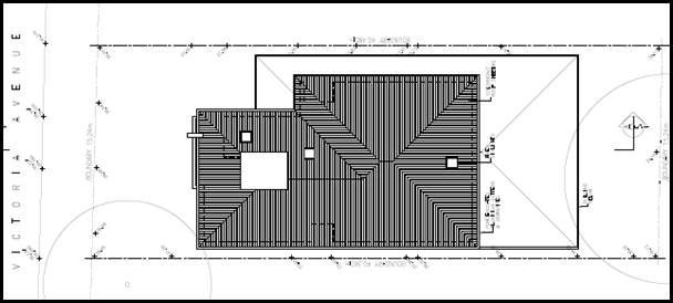
Figure
2: Proposed site plan - 111 Victoria
Avenue Mortdale (Source: Cornerstone
Design 2019)
The Site and Locality
8. The
site is identified as Lot 5, Section 3, DP2778 being 111 Victoria Avenue
Mortdale. The site is situated on the south eastern side of Victoria Avenue
with a street frontage of 15.24m, site lengths of 40.360m (south west) and
40.485m (north east) with an overall site area of 615.8sqm (by DP). The
allotment is regular in shape presenting a slight fall from the rear of the
site towards the street edge along Victoria Avenue.
9. The
site currently accommodates a single storey rendered building occupied by two
retail shops. A detached aluminium clad garage and carport are located to the
rear of the site. The site is void of any significant vegetation.
10. The
subject site is located within a residential area that is predominantly
characterised by detached one and two storey dwellings including
commercial/retail uses interspersed with residential flat buildings as
identified along the north eastern side of Morts Road.
11. Immediately
adjoining the site to the north east is a single storey dwelling with detached
outbuilding and vinyl clad garage located along the common boundary. Adjoining
the site to the south west is a single storey metal/clad community hall.
12. Opposite
the subject site, along the north western side of Victoria Avenue, are a number
of detached houses and shop top housing developments.
13. In
the wider context, the subject site is located approximately 15m from a B2
Local Centre Zone being the Mortdale Town Centre, and approximately 120m from
an R3 Medium Density Residential Zone. The site is approximately 290m from
Mortdale Train Station (being the T4- Eastern Suburbs and Illawarra Train
Line).
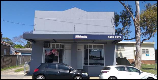
Figure
3: Streetscape view of 111 Victoria
Avenue Mortdale
Background
14. A
development application being DA2019/0207 was lodged for similar works as the
current application, however it was rejected by Council for the following
reasons:
· Swept
path to be provided for car parking space number 6.
· It may be
required that the basement rear facade be increased in depth to accommodate a 3
point turn to accommodate car parking park number 6.
Note: Concern
is however raised that the increased in basement depth may intrude on the Tree
Protection Zone.
· Elevational
shadow diagrams are to be submitted to demonstrate solar amenity compliance in
accordance with the SEPP.
· It is
suggested that hourly interval shadow diagrams be submitted demonstrating solar
amenity compliance to the common room, common area terrace and rear common
space.
· The
ground floor balcony attached to the front facade with access form the
manager’s room is inconsistent with requirements of the SEPP. It is
suggested that a potential redesign be considered addressing the provisions of
the SEPP.
· Concern
is also raised with insufficient natural ventilation to the basement. With this
it raises issues with setbacks to the boundaries against the deemed to satisfy
provisions of the BCA. Please provide a services plan with consideration to
acoustic measures.
15. The
proposal the subject of this application has had regard to the reasons for
rejection.
Compliance and
Assessment
16. The
development site has been inspected and assessed having regarding to Matters
for Consideration under Section 4.15(1) of the Environmental Planning and
Assessment Act 1979.
STATE
ENVIRONMENTAL PLANNING INSTRUMENTS
17. Compliance
with the relevant State Environmental Planning Policies (SEPP) is detailed
below.
STATE
ENVIRONMENTAL PLANNING POLICY (AFFORDABLE RENTAL HOUSING) 2009
18. The application is designed having regard to the provisions of State
Environmental Planning Policy (Affordable Rental Housing) 2009 (ARH SEPP) and
as such the provisions of Division 3 relating to Boarding Houses are applicable
to the application.
Division
3 Boarding Houses
Clause 25 - 28
Development to which this Division applies
19. The subject site is located in the R2 Low Density Residential
Zone, and boarding houses are permissible with consent under the Hurstville
Local Environmental Plan 2012 (HLEP). The site satisfies the provisions
of Clause 27 of the ARH SEPP 2009 which states the following:
‘27 Development
to which Division applies
(1) This Division applies to development, on land to
which this Division applies, for the purposes of boarding houses.
(2) Despite subclause (1), this Division does not
apply to development on land within Zone R2 Low Density Residential or within a
land use zone that is equivalent to that zone in the Sydney region unless the
land is within an accessible area.
(3) Despite subclause (1), this Division does not
apply to development on land within Zone R2 Low Density Residential or within a
land use zone that is equivalent to that zone that is not in the Sydney region
unless all or part of the development is within 400 metres walking distance of
land within Zone B2 Local Centre or Zone B4 Mixed Use or within a land use zone
that is equivalent to any of those zones.’
20. The site is located
in the Sydney region and therefore must be located in an accessible area for the division to apply.
An accessible area is defined by Clause 4 of State Environmental Planning
Policy (Affordable Rental Housing) 2009 as follows:
‘accessible area means land that is within:
(a) 800m walking distance of a public entrance
to a railway station or a wharf from which a Sydney Ferries ferry service
operates, or
(b) 400m walking distance of a public entrance
to a light rail station or, in the case of a light rail station with no
entrance, 400 metres walking distance of a platform of the light rail station,
or
(c) 400m walking distance of a bus stop used by
a regular bus service (within the meaning of the Passenger Transport Act 1990) that has at least one bus per hour servicing the bus stop
between 06.00 and 21.00 each day from Monday to Friday (both days inclusive)
and between 08.00 and 18.00 on each Saturday and Sunday.’
21. By virtue of the definition, the subject site
at 111 Victoria Avenue Mortdale satisfies the requirements
of an accessible area under Clause 4(a), as the site is located within 290m
from the public entrance to a railway station being Mortdale Station.
Clause 29 - Standards that cannot be used to refuse consent
22. Council cannot refuse a
development application for a boarding house under the Affordable Rental
Housing SEPP 2009 for the following reasons if the proposal meets the criterion
below.
|
Clause
29
|
Standards
|
Proposal
|
Complies
|
|
Floor
Space Ratio
- If Residential accommodation is permitted
|
If the density and scale of the
buildings when expressed as a FSR is not more than the existing maximum FSR
for any form of residential accommodation permitted (0.6:1 under HLEP 2012).
|
0.60:1
|
Yes
|
|
Height
|
If the
building height is not more than the maximum height permitted under another
EPI for any building on the land:
Maximum
9m in R2 under the HLEP 2012.
|
8.15m
|
Yes
|
|
Landscape
Area
|
The
landscape treatment of the front setback area is compatible with the
streetscape in which the building is located.
|
The front
setback is appropriately landscaped consistent with the emerging streetscape
character of Victoria Avenue where it serves to provide a suitable balance
between built form and landscaped elements along this frontage.
|
Yes
|
|
Solar
Access
|
Where the
development provides for one or more communal living rooms, if at least one
of those rooms receives minimum of 3 hours direct sunlight between 9am and
3pm in midwinter.
|
The communal room is located at the
rear along the north eastern façade of the building. The shadow
diagrams submitted have demonstrated the communal living room will receive in
excess of 3 hours of sunlight during midwinter.
|
Yes
|
|
Private
Open Space
(other
than the front setback area)
|
If a
minimum of the following is provided:
(i) one area of at least 20sqm with a
minimum dimension of 3m is provided for the use of the lodgers
(ii) if
accommodation is provided on-site for a boarding house manager—one area
of at least 8sqm with a minimum dimension of 2.5m is provided adjacent to
that accommodation
|
20sqm
area is provided in the form of the communal terrace at the rear of the
building with a minimum dimension of 3.0m. The area is accessible to all
residents.
The
Manager’s room is located on the first floor facing Victoria Avenue and
provides a 10sqm balcony with dimensions less than 2.5m.
|
Yes
Acceptable on merit. Please refer to comment (1)
|
|
Comment
(1) - Dimensions of private open space area for manager room
The SEPP
references the minimum dimension of the private open space area for the
manager’s room to be 2.5m with a total area of at least 8sqm. This
criterion is not a development standard as per Clause 30 of the SEPP, but
rather a standard that cannot be used to refuse a development.
Albeit a
non-compliance with the dimensions, and as per Clause 29 (4), “A
consent authority may consent to development to which this Division applies
whether or not the development complies with the standards set out in subclause
(1) or (2).”
The
private open space provided exceeds the 8sqm requirement, however is
irregular in shape therefore not achieving 2.5m in each direction. It is
however considered that the space and the dimensions provided are acceptable
and will provide a usable and function space for the occupant.
The
private open space is considered acceptable on merit.
|
|
Parking
|
(ii) in the case of development not carried out by or on
behalf of a social housing provider—at least 0.5 parking spaces are
provided for each boarding room,
(iii) in the case of any development—not more
than 1 parking space is provided for each person employed in connection with
the development and who is resident on site
|
In this case: 9 lodger rooms x 0.5
car space = 4.5 car spaces required, 5 car spaces have been provided.
1 space is nominated for the
manager (space 6).
|
Yes
|
|
Accommodation
size
|
Each
boarding room has a gross floor area (excluding any area used for the
purposes of private kitchen or bathroom facilities) of at least:
(i) 12sqm
in the case of a boarding room intended to be used by a single lodger, or
(ii) 16sqm
in any other case
|
No single
lodger rooms proposed.
All rooms
are a minimum of 16sqm excluding the kitchen facilities and bathrooms.
|
N/A
Yes
|
Clause 30 - Standards for Boarding Houses
23. A consent authority must not
consent to development for boarding houses unless it is satisfied of each of
the following.
|
Clause
30
|
Standards
|
Proposal
|
Complies
|
|
Communal
living
|
(a) if a boarding house
has 5 or more boarding rooms, at least one communal living room will be
provided
|
9 rooms
proposed - one communal living room provided.
|
Yes
|
|
Size of
boarding rooms
|
(b) no boarding room will
have a gross floor area (excluding any area used for the purposes of private
kitchen or bathroom facilities) of more than 25sqm
|
Rooms
range between 16sqm – 18.06sqm (excluding area of bathrooms and
kitchens).
|
Yes
|
|
Maximum
occupancy
|
(c) no boarding room will
be occupied by more than 2 adult lodgers
|
Maximum 2 adult lodgers per room
proposed
|
Yes
|
|
Kitchen
and bathroom facilities
|
(d) adequate bathroom and
kitchen facilities will be available within the boarding house for the use of
each lodger
|
All rooms
have kitchen and bathroom facilities.
|
Yes
|
|
Boarding
house manager
|
(e) if the boarding house
has capacity to accommodate 20 or more lodgers, a boarding room or on site
dwelling will be provided for a boarding house manager
|
Although
the boarding house has a capacity of less than 20 people, a self nominated
manager’s room has been provided on the first floor.
|
Yes
|
|
Bicycle
and motor cycle space
|
(h) at
least one parking space will be provided for a bicycle, and one will be
provided for a motorcycle, for every 5 boarding rooms.
|
In this case 9 boarding rooms
provided:
1.8 motorcycle and 1.8 bicycle
spaces required. 2 of each have been provided.
|
Yes
|
30AA Boarding houses in Zone R2 Low Density Residential
24. Clause 30AA states that:
A consent
authority must not grant development consent to a boarding house on land within
Zone R2 Low Density Residential or within a land use zone that is equivalent to
that zone unless it is satisfied that the boarding house has no more than 12
boarding rooms.
25. The proposed boarding house is located in an R2
Low Density Residential zone and consists of nine (9) boarding rooms in
addition to one (1) manager’s room.
Clause 30A – Character of local area
26. Clause 30A states that Council cannot grant consent
to a boarding house unless it has taken into
consideration whether the design of the development is compatible with the
character of the local area.
Case law has
held that the test in Clause 30A is “one of compatibility not
sameness” (Gow v Warringah Council [2013] NSWLEC 1093 (15 March 2013)).
Compatibility is widely accepted to mean “capable of existing together in harmony” (Project Venture Developments Pty
Ltd v Pittwater Council [2005] NSWLEC 191.
27. It has also been held
that in assessing ‘compatibility’ both the existing and future
character of the local area needs to be taken into account (Sales Search
Pty Ltd v The Hills Shire Council [2013] NSWLEC 1052 (2 April 2013) and Revelop
Projects Pty Ltd v Parramatta City Council [2013] NSWLEC 1029).
Relationship to the Existing and Future Character of the Local Area
28. In Revelop Projects Pty Ltd v Parramatta City
Council [2013] NSW LEC 1029, Commissioner Morris concluded that the
‘local area’ includes both sides of the street and the
‘visual catchment’ as the minimum area to be considered in
determining compatibility.
29. The ‘local area’ in this case is
taken to include both sides of Victoria Avenue and the immediate surrounding
streets. Within this local area, development is primarily characterised by single and double storey dwelling
houses in addition to shop top housing, with business and commercial premises
located west of the subject site.
30. In Project Venture Developments v
Pittwater Council [2005] NSWLEC 191 the Land and Environment Court
specifically set out a relevant planning principle. Consideration has therefore been given to the two key questions
identified in the Land and Environment Court Planning Principles:
(a) Are the proposal’s physical impacts on surrounding development
acceptable? The physical impacts include constraints on the development
potential of surrounding sites.
31. Comment: It
is acknowledged this development typology is permissible in this zone and the
transition of this location from single storey residential developments to
increased density in the form of large two (2) storey dwelling houses, multi-unit housing and two (2)
commercial development is evident within the visual catchment.
32. The proposal in its
current form is considered to result in a built form that is consistent with
recently constructed two (2) storey developments along Victoria Avenue, in that
it is a (2) two storey boarding house with a pitched roof design constructed on
a single allotment with setbacks, height and gross floor area consistent with
the development in the locality.
33. The proposal adopts
traditional architectural form and materiality. The development includes
pitched roof elements with a colourbond roof and face brickwork which is
consist with surrounding development.
34. The landscape setting
to the street frontage again is not dissimilar to what can be found in the
surrounding area. The provision of basement parking allows for landscaping
areas to be provided throughout the development; as opposed to aboveground
hardstand parking. The proposed building is of a scale, height and overall bulk
that will generally maintain consistency with the established pattern of
development in the streetscape.
35. For the reasons stated above, it is considered that the
proposed development would not result in an unreasonable impact upon
surrounding residential development and would not constrain the development
potential of adjoining sites.
(b)
Is the proposal’s appearance in harmony with the buildings around it and
the character of the street?
36. Comment: The existing streetscape is
characterised by single and two (2) storey detached dwellings, in addition to
shop top housing, and commercial premises located to the west of the subject
site. Pitched tiled roof forms are common and can be found on the majority of
dwellings. This development proposes a pitched roof form that is consistent
with that of the locality.
37. In relation to the side facades, the north
eastern and south western side elevations provide for adequate articulation and
appropriate architectural relief. All widows along the side façades have
been raised and treated to address overlooking impacts accordingly. A condition
of consent has required that the rear first floor balconies be deleted to reduce
any privacy and overlooking impacts.
38. With the absence of a statement of desired
future character in the DCP, the bulk and scale of development is derived by
the applicable development standards contained within the Hurstville Local
Environmental Plan that permit a particular built form. The proposed height and
floor space is consistent with the development on the R2 – Low Density
Zone and the setbacks proposed are consistent with residential development. The
built form is there considered to be of an appropriate scale and character
within the streetscape.
Comparison
Table
39. The character of an area is not only defined by
what is physically existing on the adjoining allotments, but also what is
permitted under the planning controls which apply at the time.
The proposal
adopts a built form commensurate with that of a two storey dwelling
house.
40. Whilst Council does not have prescribed
controls for the built form of boarding houses, as a “best fit” in
consideration of the Character Test, the proposal has been considered against
the provisions Section 4.1 Single Dwelling Houses of Development Control Plan
No 1 – LGA Wide below.
|
Control
|
Single Dwelling
|
Proposal
|
|
Height
Maximum ceiling height
|
9m
7.2m
|
8.15m
6.8m
|
|
Floor Space Ratio
|
0.6:1 (0.55:1 for dwelling house
only)
|
0.6:1
|
|
Landscape (minimum 2m x 2m)
|
20%
|
15% or 95sqm (minimum 2m x 2m)
|
|
Setbacks:
Front
Rear setback:
Ground
First
Side setback:
Ground
First
|
4.5m
3m
6m
900mm
1.2m
|
6.9m
6m
13.5
North East – 1.2m
South West - 1.2m
North East – 2.603m
South West - 1.2m
|
41. As demonstrated by the above table, the
proposed development observes key controls comparable with that of a single two
(2) storey dwelling house resulting in the built form being consistent with the
existing character and not inconsistent with the future character given the
Draft Local Environmental Plan 2020 retains the current zoning, height and
floor space controls.
42. Assessing
‘compatibility’ requires both the existing and future character of
the local area to be taken into account (Sales Search Pty Ltd v The Hills
Shire Council [2013] NSWLEC 1052 and Revelop Projects Pty Ltd
v Parramatta City Council [2013] NSWLEC 1029). It is acknowledged that
there are sites within the Victoria Avenue streetscape that are yet to reach
their development potential. However, given the proposed development has been
designed in accordance to what may be considered an acceptable setback and
separation from neighbouring developments, the design and streetscape
presentation of future development on adjoining sites is likely to resemble
that of the proposed development.
STATE
ENVIRONMENTAL PLANNING POLICY NO 55 – REMEDIATION OF LAND
43. The subject site is zoned residential and,
given the types of uses permissible within the residential zones, it is
considered unlikely that the land is contaminated. A Preliminary Site
Investigation Report prepared by Alliance Geotechnical (reference 8709-ER-1-1
dated 28 March 2019) submitted concluded that the presence of contaminants and
the risk of contamination are low and that the site is suitable for the
proposed development. In addition, based on Council’s records, the
subject site has not been used for any potentially contaminating activities. As
such, it is considered unlikely that the land is contaminated.
STATE ENVIRONMENTAL PLANNING POLICY (BUILDING
SUSTAINABILITY INDEX: BASIX) 2004
44. A BASIX Certificate is required to be lodged
for any residential development application in NSW. BASIX Certificate 1004285M
dated 29 May 2019 prepared by Building and Energy Consultants Australia was
lodged to confirm that the proposed development satisfies the sustainability
requirements.
STATE ENVIRONMENTAL PLANNING POLICY (INFRASTRUCTURE) 2007
45. The aim of the Infrastructure SEPP is to
facilitate the effective delivery of infrastructure across the State. The DA
was referred to Ausgrid in accordance with Clause 45 of State Environmental
Planning Policy (Infrastructure) 2007. Ausgrid advised there are no issues with
the proposal and no conditions recommended
STATE ENVIRONMENTAL PLANNING POLICY (VEGETATION IN NON-RURAL AREAS)
2017
46. The Vegetation SEPP regulates clearing of
native vegetation on urban land and land zoned for environmental
conservation/management that does not require development consent.
47. The Vegetation SEPP applies to clearing of:
(a) Native vegetation above the Biodiversity Offset Scheme
(BOS) threshold where a proponent will require an approval from the Native
Vegetation Panel established under the Local Land Services Amendment Act 2016;
and
(b) Vegetation below the BOS threshold where a proponent will
require a permit from Council if that vegetation is identified in the
council’s development control plan (DCP).
48. The objectives of the SEPP are to protect the
biodiversity values of trees and other vegetation in non-rural areas and
preserve the amenity of non-rural areas through the preservation of trees and
other vegetation. This policy is applicable pursuant to Clause 5(1) of the SEPP
as the site is within both Georges River Council and the R2 Low Density Residential
zone.
49. Pursuant to Clause 8(1) of the SEPP, clearing
does not require authority under the policy as it is a type of clearing that is
authorised under Section 60O of the Local Land Services Act
2013 (specifically, that associated with a development consent issued
under Part 4 of the Environmental Planning and Assessment Act 1979).
50. No trees or significant vegetation are proposed
for removal. All neighbouring trees will be required to be protected during
construction works. The application was referred to Council’s Consulting
Arborist who supported the application subject to specific landscape conditions
and the planting of two trees within Council’s landscape verge adjacent
to the site.
DEEMED STATE
ENVIRONMENTAL PLANNING POLICY – GEORGES RIVER CATCHMENT
51. All stormwater from the proposed development
can be treated in accordance with Council’s Water
Management Policy and would satisfy the relevant provisions of the Deemed
State Environmental Planning Policy - Georges River Catchment.
Draft
Environmental Planning Instruments
DRAFT ENVIRONMENTAL STATE ENVIRONMENTAL PLANNING POLICY
52. The Draft Environment SEPP was
exhibited from 31 October 2017 to 31 January 2018. This consolidated SEPP
proposes to simplify the planning rules for a number of water catchments,
waterways, urban bushland and Willandra Lakes World Heritage Property. Changes
proposed include consolidating the following seven existing SEPPs:
· State Environmental Planning Policy No. 19 – Bushland in Urban
Areas
· State Environmental Planning Policy (Sydney Drinking Water
Catchment) 2011
· State Environmental Planning Policy No. 50 – Canal Estate
Development
· Greater Metropolitan Regional Environmental Plan No. 2 –
Georges River Catchment
· Sydney Regional Environmental Plan No. 20 – Hawkesbury-Nepean
River (No.2-1997)
· Sydney Regional Environmental Plan (Sydney Harbour Catchment) 2005
· Willandra Lakes Regional Environmental Plan No. 1 – World
Heritage Property.
53. The proposal is not
inconsistent with the provisions of this Draft Instrument.
DRAFT
REMEDIATION OF LAND STATE ENVIRONMENTAL PLANNING POLICY
54. The Draft Remediation of Land SEPP was
exhibited from 31 January 2018 to 13 April 2018. The proposed remediation of
land SEPP will:
· Provide a state-wide planning framework for the remediation of land;
· Maintain the objectives and reinforce those aspects of the existing
framework that have worked well;
· Require planning authorities to consider the potential for land to
be contaminated when determining development applications and rezoning land;
· Clearly list the remediation works that require development consent;
· Introduce certification and operational requirements for remediation
works that can be undertaken without development consent.
55. The proposal is not
inconsistent with the provisions of this Draft Instrument.
HURSTVILLE
LOCAL ENVIRONMENTAL PLAN 2012
56. The
extent to which the proposed development complies with the Hurstville Local
Environmental Plan 2012 (HLEP 2012) is detailed and discussed in the table
below.
57. The
allotment is zoned R2 – Low Density Residential Zone, a boarding house is
permissible with consent.
Figure
4: Zoning Map – site outlined
in blue
|
Clause
|
Standard
|
Proposed
|
Complies
|
|
Part 1 Preliminary
|
|
1.2 – Aims of the Plan
|
In accordance with Clause 1.2 (2)
|
The development is consistent with
the aims of the plan.
|
Yes
|
|
1.4 - Definitions
|
Boarding
House:
means
a building that:
(a) is
wholly or partly let in lodgings, and
(b)
provides lodgers with a principal place of residence for 3 months or more,
and
(c)
may have shared facilities, such as a communal living room, bathroom, kitchen
or laundry, and
(d)
has rooms, some or all of which may have private kitchen and bathroom
facilities, that accommodate one or more lodgers, but does not include
backpackers’ accommodation, a group home, hotel or motel accommodation,
seniors housing or a serviced apartment.
|
The proposed development is
consistent with the definition.
|
Yes
|
|
Part 2 Permitted or prohibited
development
|
|
2.3 - Zone objectives and Land Use
Table
|
Meets objectives of R2- Low Density
Residential Zone:
Development must be permissible
with consent and satisfy the below objectives:
· To
provide for the housing needs of the community within a low density
residential environment.
· To
enable other land uses that provide facilities or services to meet the day to
day needs of residents.
· To
encourage development of sites for a range of housing types, where such
development does not compromise the amenity of the surrounding area, or the
natural or cultural heritage of the area.
· To
ensure that a high level of residential amenity is achieved and maintained.
· To
encourage greater visual amenity through maintaining and enhancing
landscaping as a major element in the residential environment.
· To
provide for a range of home business activities where such activities are not
likely to adversely affect the surrounding residential amenity.
|
The proposal satisfies the
objectives of the R2 zone and is permissible with development consent.
|
Yes
|
|
Part 4 Principal development
standards
|
|
4.3 – Height of Buildings
|
9m as identified on Height of
Buildings Map
|
8.15m
|
Yes
|
|
4.4 – Floor Space Ratio
|
0.6:1 as identified on Floor Space
Ratio Map
|
0.60:1 or 367.48sqm
Site area: 615.8sqm.
|
Yes
|
|
Part 5 Miscellaneous provisions
|
|
5.10 – Heritage conservation
|
In accordance with Clause 5.10 (1)
|
The site is not a heritage item and
not located within the vicinity of any heritage items.
The site is not in a heritage
conservation area.
|
Yes
|
|
Part 6 Additional local
provisions
|
|
6.1 – Acid sulfate soils
|
(1) The objective of this clause is to ensure that
development does not disturb, expose or drain acid sulfate soils and cause
environmental damage.
|
Site has not been identified as
located in an area containing Acid Sulfate Soils as per the LEP maps.
|
Yes
|
|
6.7 – Essential Services
|
The following services that are
essential for the development shall be available or that adequate
arrangements must be made available when required:
- Supply
of water, electricity and disposal and management of sewerage
- Stormwater
drainage or on-site conservation
- Suitable
vehicular access
|
- Adequate
facilities for the supply of water and removal of sewage is available to the
site and can be extended to service this development.
- Stormwater
can drain via gravity to the street.
- New
3.6m wide driveway crossing to the site from Victoria Avenue (standard
conditions for the submission of a separate vehicular crossing applications
and driveway design have been imposed)
|
Yes
Yes
Yes
|
DRAFT GEORGES
RIVER LOCAL ENVIRONMENTAL PLAN 2020
58. Consideration is given to the
provisions of Draft Georges River Local Environmental Plan 2020 in the
assessment this application.
59. In this regard, the provisions
have no determining weight as a result of proposed operation of Clause “1.8A
Savings provisions relating to development applications” of the Draft
Plan which provides “If a development application has been made before
the commencement of this Plan in relation to land to which this Plan applies
and the application has not been finally determined before that commencement,
the application must be determined as if this Plan had not commenced.”
DEVELOPMENT
CONTROL PLANS
60. The proposal has been assessed under the relevant sections of
Development Control Plan No 1 (Amendment No 7) (DCP) as follows.
DEVELOPMENT
CONTROL PLAN NO 1 - LGA WIDE – SECTION 3.1 VEHICLE ACCESS, PARKING AND
MANOEUVRING
61. The
DCP requires parking to be required at a rate of one (1) space per three (3)
beds plus one (1) space per two (2) employees. As the development proposes nine
(9) beds in addition to one (1) manager room, 4.3 (rounded to 5) car spaces are
required to be provided.
62. The
proposal provides six (6) car spaces, two (2) motorcycle spaces, and two (2)
bicycle spaces, satisfying the car parking requirements of the DCP.
63. The
design and layout of the parking area is consistent
with the objectives of Section 3.1 of the DCP and the relevant Australian
Standards.
DEVELOPMENT CONTROL PLAN NO 1 – LGA WIDE – SECTION 3.3 ACCESS AND
MOBILITY
64. Section
3.3 requires that one (1) accessible room be provided per five (5) bedrooms or
part thereof. As the proposed development accommodates nine (9) bedrooms, two
(2) accessible rooms are required. The development provides two (2) accessible
rooms accessed via a lift from the public domain and a lift from the basement
level. One (1) accessible car parking spaces has been provided in accordance to
Table 1 DS1.1 of Section 3.3.
DEVELOPMENT
CONTROL PLAN NO 1 – LGA WIDE –
SECTION 3.4 CRIME PREVENTION THROUGH ENVIRONMENTAL DESIGN
65. The proposal has been considered in
accordance with the relevant provisions. The proposal allows opportunities for
passive and casual surveillance to and from the street. The Plan of Management
provided will form part of the development consent conditions if the
application is to be supported and covers acceptable behaviour protocols of
boarders and visitors.
DEVELOPMENT
CONTROL PLAN NO 1 – LGA WIDE –
SECTION 3.5 LANDSCAPING
66. A detailed landscape plan was
submitted with the application and was assessed by Council’s Council’s
Consulting Arborist. Specific conditions of consent
have been imposed requiring specific landscape provisions in addition to the
planting of two (2) street trees.
DEVELOPMENT
CONTROL PLAN NO 1 – LGA WIDE –
SECTION 3.7 STORMWATER
67. The
development can drain to the street via
gravity. Appropriate conditions of consent relating to stormwater and onsite
detention (OSD) have been imposed based on the recommendations of
Council’s stormwater engineer.
DEVELOPMENT CONTROL PLAN NO 1 – LGA WIDE –
SECTION 4.1 – SECTION 4.6 SPECIFIC CONTROLS FOR RESIDENTIAL DEVELOPMENT
68. It is noted that, pursuant to Clause 8 of State
Environmental Planning Policy (Affordable Rental Housing) 2009, the provisions
of the State Environmental Planning Policy prevail to the extent of any
inconsistency with any other planning instrument. Council’s DCP does not
contain any specific controls for boarding house development. The proposal has
been considered against the provisions relating to dwelling houses in order to
establish whether the design of the development is compatible with the
character of the local area.
DEVELOPMENT CONTROL PLAN NO 1 – LGA WIDE - APPENDIX
1 - SECTION 7 WASTE MANAGEMENT
69. A
Waste Management Plan has been submitted with
the application which is acceptable. Should consent be granted, conditions
requiring the provision of appropriate waste facilities for the ongoing use of
the development will be imposed.
DEVELOPMENT CONTROL PLAN NO 1 – LGA WIDE - APPENDIX
1 - SECTION 8 ENERGY EFFICIENCY
70. The
application is accompanied by a BASIX
Certificate which identifies that the development meets the target scores.
71. In terms of overshadowing,
shadow diagrams submitted with the application show that the proposed development will comply with the State Environmental Planning Policy
Affordable Rental Housing 2009 (ARH SEPP) solar access requirements. The ARH
SEPP 2009 requires that the communal room of a boarding house receives minimum of 3 hours direct sunlight between 9.00am and
3.00pm in mid-winter. This control has been
satisfied as the communal room includes windows along the northern facade to
maximise solar access. The shadow diagrams show that most of the shadow cast
will be predominantly in the morning hours when the sun in low on the horizon.
The impacted property; in this case being 113 Victoria Avenue, will receive the
required sunlight from 12.00pm onwards.
DEVELOPMENT CONTROL PLAN NO 1 – LGA WIDE - APPENDIX
1 - SECTION 9 PRESERVATION OF TREES AND
VEGETATION
72. No
trees or significant vegetation are proposed for removal. All neighbouring
trees will be required to be protected during construction works. The
application was referred to Council’s Consulting Arborist who supported
the application subject to specific landscape conditions and the planting of two
(2) trees within Council’s landscape verge within the frontage to the
site.
GEORGES RIVER DEVELOPMENT CONTROL PLAN
2020 (INTERIM POLICY)
73. The Interim Policy is a
supplementary document, meaning that the current Development Control Plan
controls continue to apply if a particular control is not specified in the
Interim Policy, or if it is still considered best practice. All operative
Development Control Plans still legally apply. Whilst the Interim Policy has no
statutory recognition in the assessment of a Development Applications pursuant
to the Environmental Planning and Assessment Act 1979, the policy was used as a
guide as it is an endorsed position of the Council.
74. In relation to the proposed boarding
house, the proposal does not conflict with the controls of the Interim Policy Development
Control Plan.
IMPACTS
Natural
Environment
75. The
proposal does not seek to remove any
significant trees and conditions are recommended for the protection of
neighbouring trees on the adjoining properties. The development provides
sufficient area for landscaping and a condition is also recommended for the
planting of two (2) street trees along Council’s nature strip.
76. The
proposal seeks to drain to the street which is consistent with Council’s
requirements and a requirement for OSD is also recommended as a condition of
consent.
77. The
development will not result in any significant adverse impacts on the natural
environment.
Built Environment
78. The
built form of the proposed development is of a bulk and scale that is
consistent with contemporary dwelling houses in the locality. Further, the pitched
roof design of the proposed boarding house is similar to recently completed
dwelling houses in close proximity to the site. The proposal is complimentary
to the existing character of the streetscape and representative of the low
density residential nature of the area.
79. Shadow
diagrams for the proposed development accompanying the development application
indicate shadow cast by the proposed development at 9am, 12 noon and 3pm on the
winter solstice (21 June) demonstrate that the shadow falls towards the
building adjoining the site to the south west at 9am, with the extent of shadow
only marginally impacting the building by 12noon. By 3pm the extent of shadow
cast falls largely over the rear of the subject site. On this basis, it is
reasonable to suggest that the overshadowing associated with the proposed
development is acceptable.
Social Impact
80. The proposal is not considered to result in any adverse social impact.
The proposal meets the requirements of State Environmental Planning Policy
(Affordable Rental Housing) 2009 and provides an affordable housing option for
the community. A Plan of Management has provide, reviewed and is considered as
acceptable. The Plan of Management is conditioned to be complied with as part
of the development consent.
Economic Impact
81. The proposal is not considered to result in unreasonable material
economic impact given that the boarding house provides affordable housing
opportunities within the locality.
Suitability of the Site
82. The site is zoned R2 – Low Density
Residential, a boarding house not exceeding 12 rooms is a permissible form of
development in this zone. It is considered the proposal will not result in an
adverse impact on the adjoining properties or the streetscape. The proposal is
considered to be a suitable form of development.
SUBMISSIONS, REFERRALS AND THE PUBLIC INTEREST
83. The application was notified to
adjoining residents for a fourteen (14) day period in which to view the plans
and submit any comments on the proposal. Seven (7) individual
submissions were received objecting to the development.
The issues raised are discussed below.
Amenity
to neighbours
84. The proposed boarding house will
result in adverse impact to the amenity of the neighbourhood.
85. Officer Comment: With
reference to the ARH SEPP 2009, a manager for a boarding house is required only
if the house will service for 20 or more lodgers. As the proposed boarding
house includes 9 boarding rooms (18 lodgers), the requirement of a boarding
house manager is not mandated. The applicants however have opted to provide an
onsite manager to oversee the functioning of the boarding house.
86. The presence of the boarding house
manager will ensure that the boarders comply with their lease arrangements to
reduce any adverse impacts on the amenity of adjoining properties and the
neighbourhood. The boarding house will be required to operate in accordance
with the Plan of Management which will be approved as a condition of consent.
Overdevelopment, size and scale of development
87. The proposed development is
considered an overdevelopment, and concerns were raised as to the size and
scale of the development.
88. Officer Comment: As discussed
throughout this report, the proposed development has been designed to largely
comply with the State Environmental Planning Policy (Affordable Rental Housing)
2009 requirements, noting the minor non-compliance with the dimensions of the
private open space for the Site Manager. The Hurstville Local Environmental
Plan 2012 nominates a building height control of 9m for the site and a floor
space ratio control of 0.6:1 for residential development, notwithstanding a
dwelling having an FSR of 0.55:1. The development complies with the
aforementioned development standards and the boarding house criterion with the
ARH SEPP 2009. The setbacks provided are consistent with the dwelling house
criterion of the Hurstville Development Control Plan providing symmetry within
the streetscape. The proposal is a permissible use and has been designed in
accordance with the relevant controls; as a result the proposal is not
considered an overdevelopment of the site, but consistent with the permitted
scale and form of the planning controls.
89. The
built form of the proposed development is of a bulk and scale that is consistent
with contemporary dwelling houses in the locality. Further, the pitched roof
design of the proposed boarding house is
similar to recently completed dwelling houses in close proximity to the site.
The proposal is complimentary to the existing character of the streetscape and
representative of the low density residential nature of the area.
Car parking
90. Insufficient parking and traffic
along the street is already congested.
91. Officer Comment: Clause
29(2)(e)(iia) of State Environmental Planning Policy (Affordable Rental
Housing) 2009 requires that in the case of development not carried out by or on
behalf of a social housing provider that at least 0.5 parking spaces are
provided for each boarding room. Accordingly as 9 boarding rooms are proposed, 5
car spaces have been provided. Clause 29(2)(e)(iii) of SEPP (Affordable Rental
Housing) 2009 further states that in the case of any development – not
more than one (1) parking space is provided for each person employed in
connection with the development and who is a resident on site. The proposal
provides for one (1) on site manager who is provided with a nominated car
space.
92. In addition to providing the required
car parking ratios in relation to the State Environmental Planning Policy, the
development also provides the required car parking required by the Hurstville
Development Control Plan.
Adverse
impact to the local community
93. The proposed development will result
in adverse impact on the local community.
94. Officer Comment: The
boarding house proposes a manager, although not mandated given there are only
18 lodgers. The boarding house manager will ensure the tenants conduct
themselves in accordance with their lease arrangements and the plan of
management.
95. Any noise related issues of the
property or any criminal related issues will be subject to the same legal
enforcement as that of a dwelling house.
96. The Plan of Management will include a
complaints register which will ensure that all adverse issues are recorded and
can be accordingly resolved without unnecessary impact to the community.
97. All lodgers will be subject to a
lease arrangement, which can be terminated at any time if the residents do not
conduct themselves in accordance with the leasing criterion.
98. Privacy
Windows and rear balconies have the potential to overlook
into neighbouring properties.
99. Officer Comment: The
proposal has provided highlight and frosted windows to all living area windows
along the first floor side facades. Although the plans have been amended to
provide privacy screening for the rear balconies, as they are not a requirement
for boarding houses and as they may result in adverse privacy impacts a
condition of consent will be imposed for their removal and replacement with a
window.
Devaluation
of properties within vicinity
100. The proposed development will result in
devaluation of adjoining sites.
101. Officer Comment: Property valuations are
not a matter for consideration under the provisions of the Environmental
Planning and Assessment Act 1979.
Crime
and Security
102. Safety for neighbours, and security issues
arising from future residents of the boarding house.
103. Officer Comment: The manager of
the boarding house will reside on the premises. An ongoing Plan of Management
for the boarding house details the house rules and the roles and
responsibilities of the onsite manager. All lodgers will be subject to a lease
arrangement, which can be terminated at any time if the residents do not
conduct themselves in accordance with the leasing criterion.
Solar
amenity and landscaping
104. Solar amenity and overshadowing due to
landscaping within rear yard.
105. Officer Comment: The development as proposed complies with State Environment
Planning Policy (Affordable Rental Housing) 2009 solar access requirement which
requires that the communal room of a boarding house receives minimum of 3 hours direct sunlight between 9am and 3pm in
mid-winter. This control has been satisfied as
the communal room includes windows along the northern facade to maximise solar
access, in addition the shadow diagrams submitted show that overshadowing to
113 Victoria Avenue located south west of the site will be predominantly in the
morning hours when the sun in low on the horizon. It is noted that the shadow
cast by vegetation and trees cannot be considered within the assessment of
overshadowing and solar access as per Parsonage v Ku-ring-gai [2004] NSWLEC
347; (2004) 139 LGERA 354. The reasoning is that trees and vegetation
(unless vegetation is in the form of a dense hedge forming a fence) still allow
for filtered solar access and ventilation.
Council Referrals
Team Leader - Subdivision and Development (Stormwater and
Subdivision)
106. No objections were raised, and specific
conditions of consent have been recommended and included in the conditions
referenced at the end of this report.
Environmental Health Team
107. No objections were raised, and specific
conditions of consent have been recommended and included in the conditions
referenced at the end of this report.
Development and Building Team (BCA Assessment)
108. No objections were raised, and specific
conditions of consent have been recommended and included in the conditions
referenced at the end of this report.
Environmental Services Team (Waste)
109. No objections were raised, and specific
conditions of consent have been recommended and included in the conditions
referenced at the end of this report.
Traffic Team
110. No objections were raised, and specific
conditions of consent have been recommended and included in the conditions
referenced at the end of this report. The Traffic Team reviewed the submitted
swept path diagrams and were satisfied in relation to access to and from the
basement, and sightlines when leaving the basement.
Consultant Arborist
111. No objections were raised, and specific
conditions of consent have been recommended and included in the conditions
referenced at the end of this report.
External Referrals
Ausgrid
112. The application was referred to Ausgrid as per
Clause 45(2) of the State Environmental Planning Policy (Infrastructure) 2007.
No objection was received and no conditions recommended.
Local Infrastructure Contributions
113. The development is subject to Section 7.12
(former Section 94A Contribution) contribution as the proposed cost of works,
registered with Council exceeds $100,000.00. In accordance with Council’s
Section 94A Plan, Section 7.12 – Fixed Development Consent Levies are
applicable to boarding house developments.
114. In this case the levied charge is $16,551.86,
which is required to be paid in full prior to the release of any Construction
Certificate.
CONCLUSION
115. Development consent is sought for the
demolition of existing structures and construction of a two (2) storey boarding
house development comprising of ten (10) rooms and basement car parking for six
(6) vehicles.
116. The
proposal has been assessed in accordance with Section 4.15 (1) of the
Environmental Planning and Assessment Act, 1979. As discussed throughout this
report, the proposal is considered to be compatible with the character of the
local area and reasonably complies with the boarding
house standards of the State Environment Planning Policy (Affordable
Rental Housing) 2009. The proposal also satisfies the R2 Low Density zone
objectives, in addition to complying with the relevant Local Environmental Plan
and Development Control Plan requirements. The proposed development is
considered to be suitable for the site and its locality and is appropriately
located within an accessible distance from local public transport and
commercial centre.
117. The
proposal will not result in any unreasonable impacts to the amenity of
adjoining properties subject to the conditions
of consent recommended below.
118. The
application is recommended for
approval.
DETERMINATION AND STATEMENT OF REASONS
119. Statement
of Reasons:
· The proposal is an appropriate response to the site and is
consistent with the desired future character of the R2 zone and existing
developments in the locality.
· The proposal is largely compliant with the boarding house
standards and the character test as per the State Environment Planning
Policy (Affordable Rental Housing) 2009.
· The boarding house is located in an accessible location as
per the State Environment Planning Policy (Affordable Rental Housing)
2009.
· The proposal is fully compliant with the maximum height of
building and floor space ratio permitted for the site under the Hurstville
Local Environmental Plan 2012.
· The proposal’s bulk and scale is appropriately
contained within a generally compliant building envelope that is respectful of
the established character of the area in relation to height, street setback,
and side boundary setbacks.
· The proposal has sufficient façade modulation and
wall articulation that will serve to provide visual interest and reduce the
bulk of the building.
Determination
120. THAT
pursuant to Section 4.16(1)(a) of the
Environmental Planning and Assessment Act 1979 (as amended) Georges River Local
Planning Panel grants consent to DA2019/0257 for demolition of existing
structures and construction of a two storey 10 room boarding house over basement
parking for 6 vehicles at Lot 5, Section 3, DP 2778 and known as 111 Victoria
Avenue, Mortdale, subject to the following conditions:
General Conditions
1. Approved Plans -
The development must be implemented in accordance with the approved plans and
supporting documentation listed below which have been endorsed by
Council’s approved stamp, except where marked up on the plans and/or
amended by conditions of this consent:
|
Description
|
Reference No.
|
Date
|
Revision
|
Prepared by
|
|
Site Plan
|
Project CDC 1447 Drawing DA 01
|
20/05/2019
|
A
|
Cornerstone Design
|
|
Basement and Ground Floor Plan
|
Project CDC 1447 Drawing DA 02
|
16/12/2019
|
B
|
Cornerstone Design
|
|
First Floor and Roof Plan
|
Project CDC 1447 Drawing DA 03
|
04/01/2020
|
B
|
Cornerstone Design
|
|
Elevation Plans
|
Project CDC 1447 Drawing DA 04
|
04/01/2020
|
B
|
Cornerstone Design
|
|
Streetscape and Sections Plan
|
Project CDC 1447 Drawing DA 05
|
16/12/2019
|
B
|
Cornerstone Design
|
|
Landscape Plans
|
Drawing 19-3922 LO1 sheet 1 of 1
|
15/01/2020
|
A
|
Zenith Landscape Designs
|
|
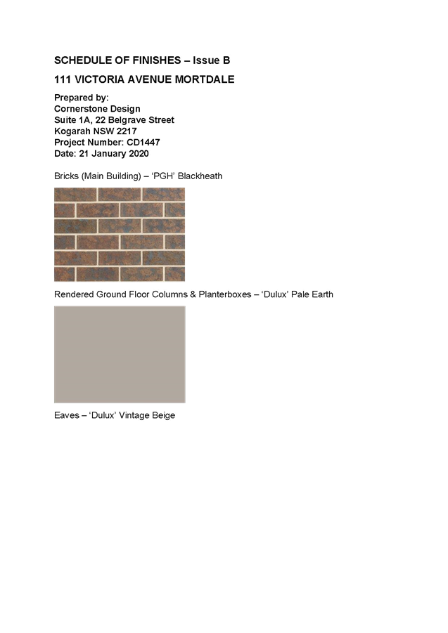
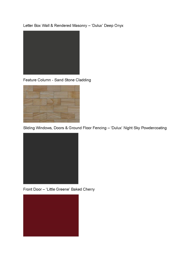
Schedule of Finishes
|
111 Victoria Avenue Mortdale
|
21/01/2020
|
B
|
Cornerstone Design
|
|
BCA Report
|
1475
|
22 January 2020
|
B
|
J2 BCA Consulting
|
|
Arboricultural Impact Assessment Report
|
111 Victoria Avenue Mortdale
|
20 May 2019
|
-
|
Jacksons Nature Works
|
|
Statement of Compliance for Access for people with a Disability
|
219045
|
04/03/2019
|
-
|
Accessible Building Solutions
|
|
Traffic and Parking Impact Assessment Report
|
N1916151A
|
May 2019
|
1a
|
Motion Traffic Engineers
|
|
Operational Plan of Management
|
111 Victoria Avenue Mortdale - Annexure 1 pages 41 to 59 of
Statement of Environmental Effects prepared by BMA Urban dated 30.05.19.
|
29 May 2019
|
-
|
BMA Urban
|
|
Stage 1 Preliminary Site Investigation Report
|
8709-ER-1-1
|
28 March 2019
|
-
|
Alliance Geotechnical
|
Separate Approvals Required Under Other Legislation
2. Building
- Hoarding Application - Prior to demolition of the buildings on the site,
or the commencement of work above ground level, a separate application for the
erection of an ‘A class’ (fence type) or a ‘B class’
(overhead type) hoarding or ‘C type’ scaffold, in accordance with
the requirements of SafeWork NSW, must be erected along that portion of
the footways/roadway where the building is within 3 metres of the street
boundary. An application for this work under Section 68 of the Local Government Act 1993
and the Roads Act 1993 must be submitted for approval to Council.
The following information is to be submitted with a Hoarding Application
under Section 68 of the Local Government Act 1993
and Section 138 of the Roads Act 1993:
a) A
site and location plan of the hoarding with detailed elevation, dimensions,
setbacks, heights, entry and exit points to/from the site, vehicle access
points, location of public utilities, electrical overhead wire protection, site
management plan and builders sheds location.
3. Section 138 Roads Act
1993 and Section 68 Local Government Act 1993 - Unless otherwise specified
by a condition of this consent, this Development Consent does not give any
approval to undertake works on public infrastructure.
Separate approval is required under Section 138 of the Roads Act 1993 and/or Section 68 of the Local Government Act 1993 for any of the
following activities carried out in, on or over a public road (including the
footpath) listed below.
An application is required to be lodged and approved prior to the
commencement of any of the following works or activities;
(a) Placing or storing materials or equipment;
(b) Placing or storing waste containers or skip
bins;
(c) Erecting a structure or carrying out work
(d) Swinging or hoisting goods over any part of a
public road by means of a lift, crane or the like;
(e) Pumping concrete from a public road;
(f) Pumping water from the site into the
public road;
(g) Constructing a vehicular crossing or footpath;
(h) Establishing a “works zone”;
(i) Digging up or disturbing the surface
of a public road (e.g. Opening the road for the purpose of connections to
utility providers);
(j) Stormwater and ancillary works in
the road reserve;
(k) Stormwater and ancillary to public infrastructure
on private land; and
(l) If any excavation is to be supported
by the use of below ground (cable) anchors that are constructed under
Council’s roadways/footways.
These separate activity approvals must be obtained and evidence of the
approval provided to the Certifying Authority prior to the issue of the
Construction Certificate.
The relevant Application Forms for these activities can be downloaded
from Council’s website www.georgesriver.nsw.gov.au.
For further information, please contact Council’s Customer Service Centre
on (02) 9330 6400.
4. Driveway Crossing -
Minor Development - Constructing a driveway crossing and/or footpath
requires a separate approval under Section 138 of the Roads Act 1993
prior to the commencement of those works.
To apply for approval, complete the “Application for Driveway
Crossing and Associated Works on Council Road Reserve” issued under
Section 138 Roads Act.” which can be downloaded from Georges River
Council’s Website at www.georgesriver.nsw.gov.au.
Lodge the application form, together with the associated fees at
Council’s Customer Service Centre, during business hours. Refer to
Section P1 and P2, in Council’s adopted Fees and Charges for the
administrative and inspection charges associated with Driveway Crossing
applications.
An approval for a new or modified driveway crossing will contain the
approved access and/or alignment levels which will be required to construct the
crossing and/or footpath. Once approved, all work shall be carried
out in accordance with Council’s specifications applicable at the time,
prior to the issue of an Occupation Certificate.
The design boundary level is to be received from Council prior to
construction of the internal driveway
5. Road Opening Permit
- A Road Opening Permit must be obtained from Council, in the case of local or
regional roads, or from the RMS, in the case of State roads, for every opening
of a public road reserve to access services including sewer, stormwater drains,
water mains, gas mains, and telecommunications before the commencement of work
in the road.
Requirements of Concurrence, Integrated & Other Government
Authorities
6. Sydney
Water - Tap in TM - The approved plans must be submitted to a
Sydney Water Tap inTM to determine whether the development
application will affect Sydney Water’s sewer and water mains, stormwater
drains and/or easements, and if further requirements need to be met. The
approved plans will be appropriately endorsed. For details please refer
to ‘Plumbing, building and developing’ section of Sydney
Water’s web site at www.sydneywater.com.au then
see ‘Building’, or telephone 13000 TAP IN (1300 082 746). The
Certifying Authority must ensure that a Tap inTM agent has
appropriately stamped the plans prior to the issue of the Construction
Certificate.
7. Notice of Requirements
for a Section 73 Certificate - A Notice of Requirements of what will
eventually be required when issuing a Section 73 Compliance Certificate under
the Sydney Water Act 1994 must be
obtained from Sydney Water Corporation. Application must be made through
an authorised Water Servicing Co-ordinator. Please refer to the
‘Plumbing, building and developing’ section of the web site www.sydneywater.com.au then refer to
‘Providers’ under ‘Developing’ or telephone 13 20 92
for assistance.
Following application, a ‘Notice of Requirements’ will advise
of water and sewer infrastructure to be built and charges to be paid.
Please make early contact with the Co-ordinator, as it can take some time to
build water/sewer pipes and this may impact on other services and building,
driveway or landscape design.
The Notice of requirements must be submitted prior to the commencement of
work. A Section 73 Compliance Certificate will be required at the completion of
development in accordance with further conditions.
Prior to the Issue of a Construction Certificate
8. Site remediation -
The site is to be made suitable for the proposed development in accordance with
the recommendations of the Stage 1 Preliminary Site Investigation Report
prepared by Alliance Geotechnical (reference 8709-ER-1-1 dated 28 March 2019).
9. Low reflectivity roof
- Roofing materials must be low glare and reflectivity. Details of finished
external materials including colours and texture must be provided to the
Certifying Authority.
10. Pre-Construction Dilapidation
Report - Private Land - A professional engineer specialising in structural
or geotechnical engineering shall prepare a Pre-Construction Dilapidation
Report detailing the current structural condition of adjoining premises
including but not limited to:
a) All
neighbouring buildings likely to be affected by the excavation as determined by
the consulting engineer.
The report shall be prepared at the expense of the applicant and
submitted to the satisfaction of the Certifying Authority prior to the issue of
the Construction Certificate.
A copy of the pre-construction dilapidation report is to be provided to
the adjoining properties (subject of the dilapidation report), a minimum of 5
working days prior to the commencement of work. Evidence confirming that a copy
of the pre-construction dilapidation report was delivered to the adjoining
properties must be provided to the PCA.
Should the owners of properties (or their agents) refuse access to carry
out inspections, after being given reasonable written notice, this shall be
reported to Council to obtain Council’s agreement to complete the report
without access. Reasonable notice is a request for access in no sooner than 14
days between 8.00am-6.00pm.
11. On Site Detention - The
submitted stormwater plan has been assessed as a concept plan only. Final detailed
plans of the drainage system, prepared by a professional engineer specialising
in hydraulic engineering, shall be submitted for approval with the Construction
Certificate.
An on-site detention (OSD) facility designed by a professional engineer
who specialises in Hydraulic Engineering is to be constructed with capacity as
shown on the approved plan in this case.
(a) The PCA shall ensure the provision of the OSD
basin located at the front and the rainwater tank (RWT) 5000 litres located at
the rear as a combined system in tis case.
(b) The overland flow pipe from the RWT shall
connect into the OSD basin at the front.
(c) Provide the OSD system with sufficient
ventilation and show on plan.
(d) The maximum discharge from the site to the
street kerb and gutter shall not be greater than 25 l/s.
(e) Provide a silt trap within the site prior to the
discharge of the flow onto the street kerb and gutter.
12. Pump-Out System Design for
Stormwater Disposal - The design of the pump-out system for storm water
disposal will be permitted for drainage of basement areas only, and must be
designed in accordance with the following criteria:
a) The pump system shall consist of two
pumps, connected in parallel, with each pump being capable of emptying the
holding tank at the rate equal to the rate of inflow for the one-hour duration
storm. The holding tank shall be capable of holding one hour’s runoff
from a one-hour duration storm of the 1 in 20 year storm;
b) The pump system shall be regularly
maintained and serviced, every six (6) months; and
c) Any drainage disposal to the street
gutter from a pump system must have a stilling sump provided at the property
line, connected to the street gutter by a suitable gravity line.
Details and certification of compliance from a professional engineer
specialising in civil engineering shall be provided for approval with the
Construction Certificate application.
13. Driveway Construction Plan
Details - Detailed engineering plans for the driveway shall be submitted
with the Construction Certificate application for approval that show:
(a) Longitudinal and cross sections, gradients,
access onto the proposed lots, type of construction materials designed in
accordance with Council's Subdivision standards and AS/NZS2890.1-2004.
(b) Suitable underground provision for the supply of
all relevant services to the proposed lots (proposed position of pipes and
conduits).
(c) A longitudinal driveway sections are to be
prepared by a qualified civil/traffic engineer and be submitted for to and
approved by the Certifying Authority. These profiles are to be at 1:100 scale
along both edges of the proposed driveway, starting from the centreline of the
frontage street carriageway to the proposed garage/parking level. The
civil/traffic engineer shall provide specific written certification on the
plans that:
a. Vehicular access can be obtained
using grades of 25% (1 in 4) maximum and
b. All changes in grade (transitions)
comply with Australian Standard 2890.1 (2004) - “Off-street car
parking” to prevent the scraping of the underside of the vehicles.
14. Council Property Shoring -
Prior to the issue of the Construction Certificate, plans and specifications
prepared by a professional engineer specialising in practising structural
engineering must detail how Council’s property shall be supported at all
times.
Where any shoring is to be supporting, or located on Council’s
property, certified structural engineering drawings detailing; the extent of
the encroachment, the type of shoring and the method of removal, shall be
included on the plans. Where the shoring cannot be removed, the plans
must detail that the shoring will be cut to 150mm below footpath level and the
gap between the shoring and any building shall be filled with a 5MPa lean
concrete mix.
15. Fire Safety Measures - Prior
to the issue of a construction certificate a list of the essential fire safety
measures that are to be provided in relation to the land and any building on
the land as a consequence of the building work must accompany an application
for a construction certificate, which is required to be submitted to either
Council or a PCA. Such list must also specify the minimum standard of
performance for each essential fire safety measure included in the list. The
Council or PCA will then issue a Fire Safety Schedule for the building.
16. Access
for Persons with a Disability - Access for persons with
disabilities must be provided direct to the site, including to the foyer, car
park, required sanitary and kitchen facilities in accordance with the
requirements of the Premises Standards, the Building Code of Australia, AS
1428.1 and the Accessible Building Solutions report (job no: 219045) dated 4
March 2019.
In regards to the above, pedestrian access throughout
basement level shall be highlighted and sign posted to safeguard egress.
17. Geotechnical report -
Geotechnical Reports: The applicant must submit a Geotechnical Report, prepared
by a professional engineer specialising in geotechnical engineering who holds
the relevant Certificate of accreditation as required under the Building
Professionals Act 2005 in relation to dilapidation reports, all site works and
construction. This is to be submitted before the issue of the Construction
Certificate and is to include:
(a) Investigations certifying the stability of the
site and specifying the design constraints to be placed on the foundation, any
earthworks/stabilization works and any excavations.
(b) Dilapidation Reports on the adjoining properties
including, but not limited to (address) and (address) prior to any excavation
of site works. The Dilapidation Report is to include assessments on, but
not limited to, the dwellings at those addresses and any external paths,
grounds etc. This must be submitted to the PCA and the adjoining
residents as part of the application for the Construction Certificate.
Adjoining residents are to be provided with the report five (5) working days
prior to any works on the site.
(c) On-site guidance by a vibration specialist
during the early part of excavation.
(d) Measures to minimise vibration damage and loss
of support to other buildings. Where possible any excavation into rock is to be
carried out with tools such as rock saws which reduce vibration to adjoining
buildings and associated structures. Where a hydraulic hammer is to be used
within 30 metres of any building (other than a path or a fence) the report
shall detail the maximum size of hammer to be used and provide all reasonable
recommendations to manage impacts.
(e) Sides of the excavation are to be piered prior
to any excavation occurring to reinforce the walls of the excavation to prevent
any subsidence to the required setbacks and neighbouring sites.
18. Waste
Room Construction - The Construction Certificate drawing shall show
the waste room containing the following to minimise odours, deter vermin,
protect surrounding areas, and make it a user-friendly and safe area:
(a) waste
room floor to be sealed;
(b) waste
room walls and floor surface is flat and even;
(c) all walls
painted with light colour and washable paint;
(d) equipment
electric outlets to be installed 1700mm above floor levels;
(e) bin
storage rooms will be mechanically exhausted as required by AS 1668.2;
(f) light
switch installed at height of 1.6m;
(g) waste
rooms must be well lit (sensor lighting recommended);
(h) optional
automatic odour and pest control system installed to eliminate all
pests; and
(i) all
personnel doors are hinged and self-closing.
19. Construction Traffic Management
Plan - A Construction Traffic Management Plan detailing:
(a) construction vehicle routes;
(b) anticipated number of trucks
per day;
(c) hours of construction;
(d) Access arrangements; and
(e) Proposed traffic measures to
minimise impacts of construction vehicles
must be submitted for the approval of Council’s
Engineers. Council’s Engineers must specify in writing that they are
satisfied with the Traffic Management Plan prior to the issue of the
Construction Certificate.
20. Slip Resistance
- All pedestrian surfaces in areas such as foyers, public corridors, stairs
and ramps as well as floor surfaces in the wet rooms in any residential units
must have slip resistance classifications, as determined using test methods in
either wet or dry conditions, appropriate to their gradient and exposure to
wetting. The classifications of the new pedestrian surface materials, in
wet or dry conditions, must comply with AS/NZS4586:2004 - Slip Resistance
Classifications of New Pedestrian Materials and must be detailed on the plans
lodged with the application for the Construction Certificate.
21. Fees
to be paid - The fees listed in the table below
must be paid in accordance with the conditions of this consent and
Council’s adopted Fees and Charges applicable at the time of payment
(available at www.georgesriver.nsw.gov.au).
Payments must be made prior to the issue of the
Construction Certificate or prior to the commencement of work (if there is no
associated Construction Certificate).
Council will only accept Bank Cheque or
Electronic Funds Transfer (EFT) for transaction values of $500,000 or over.
Council must be contacted prior to payment to determine correct total amount to
be paid and bank account details (if applicable).
A summary of the fees to be paid are listed
below:
|
Fee Type
|
Fee
|
|
GENERAL FEES
|
|
Long Service Levy (to Long Service Corporation) Or,
provide evidence of Payment direct to the Long Service Corporation. See
https://portal.longservice.nsw.gov.au/bci/levy/
|
|
Builders Damage Deposit
|
$1,900.00
|
|
Inspection Fee for Refund of Damage Deposit
|
$155.00
|
|
Georges River Council Section 94A Development
Contributions Plan 2017
|
$16,551.86
|
General Fees
The fees and charges above are subject to
change and are as set out in the version of Council's Schedule of Fees and
Charges or as required by other Government Authorities, applicable at the time
of payment.
Development Contributions
A Section 7.12 contribution has been levied on
the subject development pursuant to the Georges River Council Section 94A
Contributions Plan 2017.
Indexation
The above contributions will be adjusted at the
time of payment to reflect changes in the cost of delivering public amenities
and public services, in accordance with the indices provided by the relevant
Section 94 Development Contributions Plan.
Timing of Payment
The contribution must be paid and receipted by
Council prior to the release of the Construction Certificate.
Further Information
A copy of the all current Development
Contributions Plans may be inspected or a copy purchased at Council’s
offices (Georges River Civic Centre, MacMahon Street, Hurstville and Kogarah
Library and Service Centre, Kogarah Town Square, Belgrave Street, Kogarah) or
viewed on Council’s website www.georgesriver.nsw.gov.au.
22. Damage Deposit - Minor Works
- In order to insure against damage to Council property the following is
required:
a) Pay Council, before the issue of the
Construction Certificate, a damage deposit for the cost of making good any
damage caused to any Council property as a result of the development: $1,900.00
b) Pay Council, before the issue of the
Construction Certificate, a non-refundable inspection fee to enable assessment
of any damage and repairs where required: $155.00
c) Submit to Council, before the
commencement of work, a photographic record of the condition of the Council
nature strip, footpath and driveway crossing, or any area likely to be affected
by the proposal.
At the completion of work Council will inspect the public works, and the
damage deposit will be refunded in full upon completion of work where no damage
occurs. Otherwise the amount will be either forfeited or partly refunded
according to the amount of damage.
23. Site Management Plan - A Site
Management Plan detailing all weather access control points, sedimentation
controls, fencing, builder’s site sheds office, amenities, materials
storage and unloading arrangements must be submitted with the application for
the Construction Certificate.
24. BASIX Commitments - All
energy efficiency measures as detailed in the BASIX Certificate No. 1004285M
dated 29 May 2019 prepared by Building & Energy Consultants Australia must
be implemented on the plans lodged with the application for the Construction
Certificate.
25. Required
design changes - The following changes are
required to be made and shown on the Construction Certificate plans:
(a) The three (3) rear
balconies located at the rear of the first floor are to be deleted and replaced
with windows. The roof and external treatment to be accordingly adjusted. The
size of the internal rooms is to remain as existing. The windows replacing the
balconies are to have a minimum floor to ceiling height of 1.0m; measured from
the finished internal floor level.
26. Erosion & Sedimentation
Control - Erosion and sediment controls must be provided to ensure:
(a) Compliance with the approved Erosion &
Sediment Control Plan
(b) Removal or disturbance of vegetation and top
soil is confined to within 3m of the approved building area (no trees to be
removed without approval)
(c) All clean water runoff is diverted around
cleared or exposed areas
(d) Silt fences, stabilised entry/exit points or
other devices are installed to prevent sediment from entering drainage systems
or waterways
(e) All erosion and sediment controls are fully
maintained for the duration of demolition, excavation and/or development works
(f) Controls are put into place to prevent
tracking of sediment by vehicles onto adjoining roadway
(g) All disturbed areas are rendered
erosion-resistant by turfing, mulching, paving or similar
(h) Compliance with Managing
Urban Stormwater - Soils and Construction (Blue Book) produced by Landcom 2004.
These measures are to be implemented prior to the commencement of work
(including demolition and excavation) and must remain until works are completed
and all exposed surfaces are landscaped/sealed.
27. Stormwater
System - The submitted stormwater plan has been
assessed as a concept plan only. Final detailed plans of the drainage system,
prepared by a professional engineer specialising in hydraulic engineering,
shall be submitted for approval with the Construction Certificate.
The submitted stormwater plan has been assessed
as a concept plan only. Final detailed plans of the drainage system, prepared
by a professional engineer specialising in hydraulic engineering, shall be
submitted for approval with the Construction Certificate.
(a) All stormwater shall drain by gravity to
Council's kerb and gutter in the street as indicated on the approved plan in
accordance with the Australian/New Zealand Standard AS/NZS 3500.3: 2015 (as
amended).
(b) Prior to the commencement of works, the
registered surveyor shall ensure to the PCA that the stormwater discharge
pipe across the footpath shall be RHS at an angle and is laid with minimum
disturbance at a minimum 1% grade to the kerb and gutter in the street and is
made in good working condition.
(c) A longitudinal section of the site
stormwater discharge pipe across the footpath reserve shall be prepared showing
the public utility services particularly those may encroach the above proposed
stormwater pipe.
(d) The RHS galvanised pipe must have a minimum of
50mm of cover along its length through the road reserve. A detailed
section of the connection through the road reserve is to be prepared and shown
on the drainage plan prior to the commencement of works.
(e) There shall be no damage to the adjoining
driveway crossing. All damages are to be rectified to its original condition at
the cost of the applicant.
(f) The stormwater drainage plans including
pipe sizes, type, grade, length, invert levels, dimensions and types of
drainage pits prepared by a professional engineer who specialises in Hydraulic
Engineering in accordance with the Australian Institute of Engineers Australian
Rainfall and Runoff (1987) and Council's Stormwater Drainage Guidelines, shall
accompany the application for the Construction Certificate.
Stormwater Systems with Basement
(a) The underground basement car park must
pump to and all other stormwater must drain by gravity to:
i. the drainage system
within the site via a silt trap pit.
The design of the proposed drainage system must be prepared by a
professional engineer who specialises in hydraulic engineering and be submitted
for approval with the Construction Certificate application.
Protection of basement from inundation of stormwater waters
(b) The protection of the underground
basement shall be protected from possible inundation by surface waters from the
street.
Evidence from a professional engineer who specialises in
hydraulic engineering that this design requirement has been adhered to shall be
submitted with the Construction Certificate application.
28. Structural details -
Engineer's details prepared by a practising Structural Engineer being used to
construct all reinforced concrete work, structural beams, columns and other
structural members. The details are to be submitted to the Principal Certifying
Authority for approval prior to construction of the specified works. A copy
shall be forwarded to Council where Council is not the PCA.
29. Traffic Management - Compliance
with AS2890 - All driveways, access ramps, vehicular crossings and car
parking spaces shall be designed and constructed in accordance with the current
version of Australian Standards, AS 2890.1 (for car parking facilities) and AS
2890.2 (for commercial vehicle facilities).
30. Waste Management Plan - A
Waste Management Plan incorporating all requirements in respect of the
provision of waste storage facilities, removal of all materials from the site
that are the result of site clearing, extraction, and, or demolition works and
the designated Waste Management Facility shall be submitted to the Certifying Authority
prior to the issue of any Construction Certificate.
31. Landscape Plans - All
landscape works shall be carried out in accordance with the approved landscape
plans. The landscaping shall be maintained in accordance with the approved
plans in perpetuity. All landscape works shall be
carried out in accordance with the approved landscape plans and specifications,
drawn by Zenith Landscape Designs Ref No 19 - 3922 L01, REV A and dated
15/1/20. The landscaping shall be maintained in accordance with the approved
plans in perpetuity, subject to the following -
a) The
proposed tree and plant species, pot/ bag size and quantities of plants shall
be in accordance with the proposed plant schedule upon the landscape plan. If
plant species, pot/ bag size and quantities cannot be sourced, Council shall be
contacted for alternatives.
b) All trees
proposed upon the approved landscape plan shall comply with AS 2303 - 2018, Tree
Stock for Landscape use and NATSPEC Specifying Trees: a guide to
assessment of tree quality (2003), and be planted and maintained in
accordance with Councils standard specification.
c) If the
planted trees and plants are found to be faulty, damaged, dying or dead within
twelve (12) months of planting then they must be replaced with the same
species. If the trees are found dead before they reach a height where they are
protected by Councils Tree Management Controls, they must be replaced with the
same species and pot/bag size.
d) A
certificate of compliance for the planting of all trees and shrubs proposed for
the site. An AQF 5 Horticulturist shall be engaged and in writing certify that
all trees have been planted as per landscape plan and specifications and
forwarded to the PCA - Principal Certifying Authority.
32. Compliance with submitted
Arborist Report - The recommendations outlined in the Arborist’s
Report titled 'Arboriculture Impact Assessment Report - 111 Victoria Avenue
Mortdale' prepared by Jackson Nature Works dated 20 May 2019 must be
implemented throughout the relevant stages of construction. Details of tree
protection measures to be implemented must be detailed and lodged with the
Construction Certificate application for approval and shall be in accordance
with Section 4 - Australian Standard AS 4970-2009: Protection of trees on
development sites.
33. Tree
Protection and Retention - The following trees
shall be retained and protected:
|
Tree Species
|
Location of Tree / Tree No.
|
Tree Protection Zone (metres) Fencing distance from trunk
|
|
Tristaniopsis laurina
|
Councils street tree
|
2.4 metres radially out without blocking the footpath
|
|
Eucalyptus amplifolia
|
Within front yard of 113 Victoria Rd, Adjacent site
|
8.6 metres radially out from the trees trunk
|
|
Araucaria heterophylla
|
Within rear yard of 22 Cook St
|
7.2 metres radially out from its trunk
|
- The
client shall engage a qualified Arborist who holds an AQF Level 5 or above in
Arboriculture and who is a current practicing and financial member of an
Arboricultural Association or Affiliation.
- A
certificate of compliance letter for tree protection measures shall be
completed and forwarded to the PCA - Principal Certifying Authority, before
works, during works and once all building works have been completed, that tree
protection measures have been installed and maintained during the building
process.
Tree Protection Measures
The stormwater plans - “Ground floor
Drainage Plan” Dwg No A9060 - SW03, Rev D, dated 14/1/20 demonstrates the
stormwater piping has been diverted away from the TPZ of the neighbours tree,
to minimise impacts to the tree.
(a) All trees on
Council property, subject site and adjacent sites, to be retained shall be
protected before and maintained during demolition, excavation and construction
of the site.
(b) Although
trees may be on adjacent sites, the tree protection fencing must be placed on
the nominated distances as per table above, out from the trees trunk, within
the subject site to minimise impacts to neighbours trees and kept for the
entirety of the project.
(c) The
tree protection measures must be in undertaken in accordance AS4970 -2009 Protection
of trees on development sites.
(d) Details of
the tree protection measures to be implemented must be provided with the
application for a Construction Certificate by a qualified Arborist who holds an
AQF Level 5 or above in Arboriculture and who is a current practicing and
financial member of an Arboricultural Association or Affiliation.
(e) The engaged
Project Arborist must be present on-site during the stages of excavation,
demolition and construction when works are being undertaken that could impact
on the tree canopy or root zone within the tree protection zone of the Eucalyptus
amplifolia within the neighbour’s property.
(f) In
accordance with AS 4970-2009 Protection of trees on development sites, a
protective fence consisting of 2.4 x 1.8 metres high, fully supported chainmesh
fence shall be used. The distance of the fence from the base of each tree is to
be in accordance with the TPZ listed in the table above. A layer of organic
mulch 100 millimetres thick shall be placed over the protected area and no soil
or fill should be placed within the protection area.
(g) To preserve
the following tree - Tristaniopsis laurina, no work shall commence nor
shall a Construction Certificate be issued (whichever occurs first) until the
trunk/ branches are protected, in accordance with AS4970 -2009, Protection of
trees on development sites, by the wrapping of geo woven fabric around the
trunk 4 / 5 times and the placement of two metre long, lengths of 50mm x 100mm
timber battens vertically arranged around the trunk, with 100mm
spacing’s. The timber battens shall be secured by wire/ hoop straps but
not secured into the tree itself. The trunk/ branch protection shall be
maintained intact until the completion of all works upon the site.
(h) The Tree
Protection Zone of each tree, to be protected, shall be watered thoroughly and
regularly to minimise the effects of construction works.
(i) No
building products/ materials or services shall be installed within the TPZ of
trees Eucalyptus amplifolia and Araucaria heterophylla. This
fence shall be kept in place during demolition, construction and also have a
sign displaying ‘Tree Protection Zone - DO NOT ENTER’ attached to
the fence and must also include the name and contact details of the Project
Arborist.
Excavation works near tree to be retained
(j) Excavations
around the trees to be retained on site or the adjoining properties shall be
supervised by the Project Arborist to ensure that the root system will not
adversely be affected.
(k) Where
the Tree Protection Zone (TPZ) of trees on site or adjoining sites become
compromised by any excavation works, the Project arborist shall be consulted to
establish the position of any major roots and determine the necessary measures
to protect these roots. The recommendations of the Arborist shall be submitted
to Council prior to any further demolition or construction works taking place.
(l) Tree
Protection Zone around the trees to be retained are not to have soil level
changes, building product / materials stored or services installed in this
area. Any structures proposed to be built in this area of the trees are to
utilise pier and beam or cantilevered slab construction.
Pier and Beams -
(m) To preserve both
the Eucalyptus amplifolia and Araucaria heterophylla the footings
of the proposed side, front and rear fencing/ walling, shall be isolated pier
and beam construction within the TPZ as nominated above.
The piers shall be hand dug and located such that no roots of a diameter greater
than 50mm are severed or injured in the process of any site works during the
construction period. The beam shall be located on or above the existing soil
levels.
Removal or pruning of any other tree (that
would require consent of Council) on the site is not approved. All pruning must
be undertaken by a qualified Arborist in accordance with AS4373 -2007 Pruning
of Amenity Trees and Amenity Tree Industry, Code of Practice (SafeWork NSW
August 1998).
34. Street Tree Removal / Replacement by Council -
(a) Two (2)
street trees of species to be determined must be provided in the road reserve
fronting the site.
(b) Council shall
be appointed to plant all trees on public land. All costs associated with the
planting of replacement trees shall be met by the applicant. Fees and charges
outlined in the table below are subject to change and are set out in the
current version of Council's ‘Schedule of Fees and Charges’,
applicable at the time of payment.
(c) The fees
must be paid in accordance with the conditions of this consent. The fee payable
is to ensure that the development makes adequate provision for the demand it
generates for public amenities and public services within the area.
(d) The fees
payable will be adjusted at the time of payment to reflect changes in the cost
of delivering public amenities and public services, in accordance with the
indices provided by the relevant conditions set out in this consent.
|
Fee Type - Tree planting on public land
|
Number of trees
|
Amount per tree
|
|
Administration Fee and tree planting
|
2
|
$452.00
|
|
Cost of tree removal
|
|
n/a
|
|
Cost of Stump Grinding
|
|
n/a
|
|
Summary
|
|
Number of trees removed from site
|
Nil
|
|
Number of trees required as per offset scheme (2:1 ratio)
|
Nil
|
|
Number of trees planted within the site as per
landscape plan
|
X3
|
|
Number of trees to be paid for by the applicant to be
planted by Council elsewhere within the municipality before Occupation
Certificate. Please contact Council for payment.
|
Nil
|
|
Number of trees the applicant shall pay for and Council
to plant upon Councils street verge
|
X2
|
A copy of the Hurstville City Council’s
Tree Removal and Pruning Guidelines and Kogarah City Council, Street Tree
Management Strategy, Masterplan, and Tree Management Policy 2019, can be
downloaded from Council’s website www.georgesriver.nsw.gov.au.
Prior to the Commencement of Work (Including Demolition &
Excavation)
35. Dilapidation Report on Public
Land - Major Development Only - Prior to the commencement of works
(including demolition and excavation), a dilapidation report must be prepared
for the Council infrastructure adjoining the development site, including:
The report must include the following:
a) Photographs showing the existing
condition of the road pavement fronting the site,
b) Photographs showing the existing
condition of the kerb and gutter fronting the site,
c) Photographs showing the existing
condition of the footpath pavement fronting the site,
d) Photographs showing the existing
condition of any retaining walls within the footway or road, and
e) The Dilapidation Report must be
prepared by a qualified structural engineer. The report must be provided
to the PCA and a copy provided to the Council.
The Dilapidation Report must be prepared by a professional engineer. The
report must be provided to the PCA and a copy provided to the Council.
The report is to be supplied in electronic format in Word or PDF.
Photographs are to be in colour, digital and date stamped.
Note: Council will use this report to determine whether to refund the
damage deposit after the completion of works.
36. Demolition & Asbestos -
The demolition work shall comply with the provisions of Australian Standard
AS2601:2001 - Demolition of Structures, NSW Work
Health & Safety Act 2011 and the NSW Work
Health & Safety Regulation 2011. The work plans required
by AS2601:2001 shall be accompanied by a written statement by a suitably
qualified person that the proposals contained in the work plan comply with the
safety requirements of the Standard. The work plans and the safety statement
shall be submitted to the PCA prior to the commencement of works.
For demolition work which involves the removal of asbestos, the asbestos
removal work must be carried out by a licensed asbestos removalist who is
licensed to carry out the work in accordance with the NSW Work Health & Safety Act 2011 and the
NSW Work Health & Safety Regulation 2011
unless specified in the Act and/or Regulation that a license is not required.
All demolition work including the removal of asbestos, shall be
undertaken in accordance with the Demolition
Code of Practice (NSW Work Cover July 2015).
Note: Copies of the Act, Regulation and Code of Practice can be
downloaded free of charge from the SafeWork NSW website: www.SafeWork.nsw.gov.au.
37. Demolition Notification
Requirements - The following notification requirements apply to this
consent:
(a) The developer /builder must
notify adjoining residents five (5) working days prior to demolition.
Such notification is to be a clearly written note giving the date demolition
will commence, contact details of the developer/builder, licensed asbestos
demolisher and the appropriate regulatory authority. Notification is to be
placed in the letterbox of every premises (including every residential flat or
unit, if any) either side and immediately at the rear of the demolition site.
(b) Five (5) working days prior to
demolition, the developer/builder is to provide written notification to Council
advising of the demolition date, details of the SafeWork licensed asbestos
demolisher and the list of residents advised of the demolition.
(c) On demolition sites where
buildings to be demolished contain asbestos, a standard commercially
manufactured sign containing the words “DANGER ASBESTOS REMOVAL IN
PROGRESS” measuring not less than 400mm x 300mm is to be erected in a
prominent visible position (from street frontage) on the site. The sign is to
be erected prior to demolition work commencing and is to remain in place until
such time as all asbestos material has been removed from the site to an
approved waste facility.
38. Demolition work involving
asbestos removal - Work involving bonded asbestos removal work (of an area
of more than 10 square metres) or friable asbestos removal work must be
undertaken by a person who carries on a business of such removal work in accordance
with a licence under clause 458 of the Work
Health and Safety Regulation 2011.
39. Dial before your dig - The
applicant shall contact “Dial Before You Dig on 1100” to obtain a
Service Diagram prior to the issuing of the Construction Certificate. The
sequence number obtained from “Dial Before You Dig” shall be
forwarded to the Principal Certifying Authority (PCA) and Council for their
records.
40. Registered Surveyors Report -
During Development Work - A report must be submitted to the PCA at each of
the following applicable stages of construction:
a) Set out before commencing excavation.
b) Floor slabs or foundation wall,
before formwork or commencing brickwork.
c) Completion of Foundation Walls -
Before any construction of flooring, detailing the location of the structure
relative to adjacent boundaries and floor levels relative to the datum shown on
the approved plans.
d) Completion of Floor Slab Formwork -
Before pouring of concrete/walls construction, detailing the location of the
structure relative to adjacent boundaries and floor levels relative to the
datum shown on the approved plans. In multi-storey buildings a further
survey must be provided at each subsequent storey.
e) Completion of any Roof Framing -
Before roof covered detailing eaves/gutter setback from boundaries.
f) Completion of all Work -
Detailing the location of the structure (including eaves/gutters) relative to
adjacent boundaries and its height relative to the datum shown on the approved
plans. A final Check Survey must indicate the reduced level of the main
ridge.
Work must not proceed beyond each stage until the PCA is satisfied that
the height and location of the building is proceeding in accordance with the
approved plans.
41. Utility Arrangements -
Arrangements are to be made with utility authorities in respect to the services
supplied by those authorities to the development. The cost associated with the
provision or adjustment of services within the road and footway areas is to be
at the applicant’s expense.
During Construction
42. Physical
connection of stormwater to site - No work is
permitted to proceed above the ground floor slab level of the building until
there is physical connection of the approved stormwater drainage system from
the land the subject of this consent to Council's kerb and gutter in Victoria
Avenue.
43. Contamination -
Unexpected Finds - Council and the Principal Certifying Authority (if Council is not the PCA) must be notified as soon as
practicable if any information is discovered during demolition or construction
work that has the potential to alter previous conclusions about site
contamination.
44. Site sign - Soil & Erosion
Control Measures - Prior to the commencement of works (including demolition
and excavation), a durable site sign, issued by Council in conjunction with
this consent, must be erected in a prominent location on site. The site sign
warns of the penalties which apply to pollution, storing materials on road or
footpath and breaches of the conditions relating to erosion and sediment
controls. The sign must remain in a prominent location on site up until the
completion of all site and building works.
45. Hours of construction for
demolition and building work - Any work activity or activity associated
with the development consent that requires the use of any tools (including hand
tools) or any power operated plant and machinery that creates noise on or
adjacent to the site shall not be performed, or permitted to be performed,
except between the hours of 7.00am to 5.00pm, Monday to Saturday inclusive. No
work or ancillary activity is permitted on Sundays, or Public Holidays.
Note: A penalty infringement notice may be issued for any offence.
46. Ground levels and retaining walls
- The ground levels of the site shall not be excavated, raised or filled, or
retaining walls constructed on the allotment boundary, except where indicated
on approved plans or approved by Council.
47. Cost of work to be borne by the
applicant - The applicant shall bear the cost of all works associated with
the construction of the development that occurs on Council property. Care
must be taken to protect Council's roads, including the made footway, kerbs,
etc., and, where plant and vehicles enter the site, the footway shall be
protected against damage by deep-sectioned timber members laid crosswise, held
together by hoop iron straps and chamfered at their ends. This
construction shall be maintained in a state of good repair and condition throughout
the course of construction.
48. Obstruction of Road or Footpath
- The use of the road or footpath for the storage of any building materials,
waste materials, temporary toilets, waste or skip bins, or any other matter is
not permitted unless separately approved by Council under Section 138 of the Roads Act 1993 and/or under Section 68 of the Local Government Act 1993. Penalty
infringement Notices may be issued for any offences and severe penalties apply.
49. Waste Management Facility -
All materials removed from the site as a result of demolition, site clearing,
site preparation and, or excavation shall be disposed of at a suitable Waste
Management Facility. No vegetation, article, building material, waste or the
like shall be ignited or burnt.
Copies of all receipts for the disposal, or processing of all such
materials shall be submitted to the PCA and Council, where Council is not the
Principal Certifying Authority.
Prior to the issue of the Occupation Certificate
50. Section 73 Compliance Certificate
- A Section 73 Compliance Certificate under the Sydney
Water Act 1994 must be submitted to the PCA prior to the issue
of the Occupation/Subdivision Certificate.
51. Restriction to User and Positive
Covenant for On-Site Detention Facility - A Restriction on Use of the Land
and Positive Covenant shall be created and registered on the title of the
property, which places the responsibility for the maintenance of the on-site
stormwater management system on the owners of the land. The terms of the
instrument are to be in accordance with Council’s standard terms and
restrictions which are as follows;
Restrictions on Use of Land
The registered proprietor shall not make or permit or suffer the
making of any alterations to any on-site stormwater management system which is,
or shall be, constructed on the lot(s) burdened without the prior consent in
writing of Georges River Council. The expression “on-site stormwater
management system” shall include all ancillary gutters, pipes, drains,
walls, kerbs, pits, grates, tanks, chambers, basins and surfaces designed to
manage stormwater quantity or quality including the temporary detention or
permanent retention of stormwater storages. Any on-site stormwater management
system constructed on the lot(s) burdened is hereafter referred to as
“the system”.
Name of Authority having the power to release, vary or modify the
Restriction referred to is Georges River Council.
Positive Covenants
1. The registered proprietor of the
lot(s) hereby burdened will in respect of the system:
a) keep the system clean and free
from silt, rubbish and debris
b) maintain and repair at the sole
expense of the registered proprietors the whole of the system so that if
functions in a safe and efficient manner
c) permit the Council or its
authorised agents from time to time and upon giving reasonable notice (but at
any time and without notice in the case of an emergency) to enter and inspect
the land for the compliance with the requirements of this covenant
d) comply with the terms of any
written notice issued by the Council in respect of the requirements of this
covenant within the time stated in the notice.
2. Pursuant to Section 88F(3) of the
Conveyancing Act 1919 the Council shall have the following additional powers:
a) in the event that the registered
proprietor fails to comply with the terms of any written notice issued by the
Council as set out above the Council or its authorised agents may enter the land
with all necessary materials and equipment and carry out any work which the
Council in its discretion considers reasonable to comply with the said notice
referred to in part 1(d) above
b) the Council may recover from the
registered proprietor in a Court of competent jurisdiction:
i. any expense reasonably
incurred by it in exercising its powers under subparagraph (i) hereof. Such
expense shall include reasonable wages for the Council’s employees
engaged in effecting the work referred to in (i) above, supervising and
administering the said work together with costs, reasonably estimated by the
Council, for the use of materials, machinery, tools and equipment in
conjunction with the said work.
ii. legal costs on an indemnity basis
for issue of the said notices and recovery of the said costs and expenses
together with the costs and expenses of registration of a covenant charge
pursuant to section 88F of the Act or providing any certificate required
pursuant to section 88G of the Act or obtaining any injunction pursuant to
section 88H of the Act. Name of Authority having the power to release vary or
modify the Positive Covenant referred to is Georges River Council.
52. Maintenance Schedule - On-site
Stormwater Management - A Maintenance Schedule for the proposed on-site
stormwater management measures is to be prepared and submitted to Council. The
Maintenance Schedule shall outline the required maintenance works, how and when
these will be done and who will be carrying out these maintenance works.
53. Requirements prior to the issue
of the Occupation Certificate - The following shall be completed and or
submitted to the PCA prior to the issue of the Occupation Certificate:
(a) All the stormwater/drainage works shall be
completed in accordance with the approved Construction Certificate plans prior
to the issue of the Occupation Certificate.
(b) The internal driveway construction works,
together with the provision for all services shall be completed in accordance
with the approved Construction Certificate plans prior to the issue of the
Occupation Certificate
(c) Construct any new vehicle crossings
required.
(d) Replace all redundant vehicle crossing laybacks
with kerb and guttering, and replace redundant concrete with turf.
(e) A Section 73 (Sydney Water) Compliance
Certificate for the Subdivision shall be issued and submitted to the PCA prior
to the issue of the Occupation Certificate.
(f) Work as Executed Plans prepared by a
Chartered Professional Engineer or a Registered Surveyor when all the site
engineering works are complete shall be submitted to the PCA prior to the issue
of the Occupation Certificate.
54. Stormwater drainage works - Works
As Executed - Prior to the issue of the Occupation Certificate, stormwater
drainage works are to be certified by a professional engineer specialising in
hydraulic engineering, with Works-As-Executed drawings supplied to Council
detailing:
(a) Compliance with conditions of development
consent relating to stormwater;
(c) That the works have been constructed in
accordance with the approved design and will provide the detention storage
volume and attenuation in accordance with the submitted calculations;
(d) Pipe invert levels and surface levels to
Australian Height Datum;
(e) Contours indicating the direction in which water will
flow over land should the capacity of the pit be exceeded in a storm event
exceeding design limits.
55. Fire Safety Certificate before
Occupation or Use - In accordance with Clause 153 of the Environmental Planning and Assessment Regulation 2000,
on completion of building works and prior to the issue of an Occupation
Certificate, the owner must cause the issue of a Final Fire Safety Certificate
in accordance with Clause 170 of the aforesaid Regulation. The Fire Safety
Certificate must be in the form or to the effect of Clause 174 of the
Environmental Planning and Assessment Regulation, 2000. In addition, in
relation to each essential fire or other safety measure implemented in the
building or on the land on which the building is situated, such a Certificate
is to state:
(a) That the measure has been assessed by a person
(chosen by the owner of the building) who is properly qualified to do so.
(b) That as at the date of the assessment the
measure was found to be capable of functioning at a standard not less than that
required by the attached Schedule.
A copy of the certificate is to be given by the applicant to the
Commissioner of Fire & Rescue NSW and a further copy is to be displayed in
a frame and fixed to a wall inside the building's main entrance.
56. Noise Domestic Air conditioner
and Heat pump water heaters (less than 450mm from boundary) - Prior to the
issue of any Occupation Certificate, a report prepared by a professional
acoustic engineer must be submitted to the PCA to certify that the design and
construction of the air conditioner / heat pump water heaters shall not produce
a sound level exceeding 5 dB(A) above the ambient background level at the
closest neighbouring boundary between the hours of 8:00am and 10:00pm on
Saturdays, Sundays and Public Holidays and between the hours of 7:00am and
10:00pm on any other day. Outside the specified hours, the sound level
output for the running of air conditioner shall not exceed the ambient
background noise level.
57. Post Construction Dilapidation
report - Private Land - At the completion of the construction works, a
suitably qualified person is to be engaged to prepare a post-construction
dilapidation report. This report is to ascertain whether the construction
works associated with the subject development created any structural damage to
the following adjoining premises.
The report is to be prepared at the expense of the applicant and
submitted to the PCA prior to the issue of the Occupation Certificate. In
ascertaining whether adverse structural damaged has occurred to the adjoining
premises, the PCA, must compare the post-construction dilapidation report with
the pre-construction dilapidation report required by conditions in this
consent.
Evidence confirming that a copy of the post-construction dilapidation
report was delivered to the adjoining properties subject of the dilapidation
report must be provided to the PCA prior to the issue of any Occupation
Certificate.
58. Driveways and parking spaces -
Minor Development - Internal driveways and parking spaces are to be
adequately paved with concrete or bitumen, or interlocking pavers to provide a
dust-free surface.
59. BASIX Compliance Certificate
- A Compliance Certificate must be provided to the PCA regarding the
implementation of all energy efficiency measures as detailed in the approved
BASIX Certificate before any Occupation Certificate is issued.
60. Completion
of Landscape Works - All landscape works and tree
planting upon the site must be completed before the issue of the Final
Occupation Certificate and to the satisfaction of Councils Tree Management
Officers. In accordance with approved landscape plans and specifications, drawn
by Zenith Landscape Designs Ref No 19 - 3922 L01, REV A and dated
15/1/20. The landscaping shall be maintained in accordance with the approved
plans in perpetuity, subject to the following -
a) The
proposed tree and plant species, pot/ bag size and quantities of plants shall
be in accordance with the proposed plant schedule upon the landscape plan. If
plant species, pot/ bag size and quantities cannot be sourced, Council shall be
contacted for alternatives.
b) All trees
proposed upon the approved landscape plan shall comply with AS 2303 - 2018, Tree
Stock for Landscape use and NATSPEC Specifying Trees: a guide to
assessment of tree quality (2003), and be planted and maintained in
accordance with Councils standard specification.
c) If
the planted trees and plants are found to be faulty, damaged, dying or dead
within twelve (12) months of planting then they must be replaced with the same
species. If the trees are found dead before they reach a height where they are
protected by Councils Tree Management Controls, they must be replaced with the
same species and pot/bag size.
d) A
certificate of compliance for the planting of all trees and shrubs proposed for
the site. An AQF 5 Horticulturist shall be engaged and in writing certify that
all trees have been planted as per landscape plan and specifications and
forwarded to the PCA - Principal Certifying Authority.
61. Vehicular crossing - Minor
development - The vehicular crossing and/or footpath works shall be
constructed by a private contractor at the expense of the applicant, in
accordance with the ‘Application for Driveway Crossing and Associated
Works on Council Road Reserve’ approval issued by Council’s Assets
and Infrastructure Division.
Any existing vehicular crossing and/or laybacks which are redundant must
be removed. The kerb and gutter, any other footpath and turf areas shall be
restored at the expense of the applicant and in accordance with Council’s
Specification for Vehicular Crossings and Associated Works.
NOTE: No stencilled or coloured concrete may be used outside
the boundary of the property.
The work must be completed before the issue of an Occupation Certificate.
Operational Conditions (Ongoing)
62. Ongoing Waste Management -
Ongoing waste management must be in accordance to the below:
(a) The on-site manager shall be
responsible for presenting all approved waste and recycling receptacles for
collection, and returning all receptacles to the Waste Collection Room, as soon
as practicable after they have been serviced.
(b) The owner/manager shall also be
responsible for maintaining all equipment, systems, facilities and storage
areas used in conjunction with the provision of waste management services in
accordance with all applicable regulatory requirements, relevant health and
environmental standards, and to the satisfaction of Council.
(c) Occupational Health and
Safety issues such as slippery floors in waste rooms and the weight of the
waste and recycling receptacles will need to be monitored.
(d) The on-site Manager will
monitor the bin storage area and all spills will be attended to immediately by
cleaners.
(e) The require number of bins are 3
x 240L red bin, 2 x 240L yellow bin.
All bins must be taken to Victoria Ave kerbside for
collection and removed from kerbside as soon as possible after collection.
Bins can be taken to kerbside for
collection.
(f) The waste room will
contain the following to minimise odours, deter vermin, protect surrounding
areas, and make it a user-friendly and safe area:
· waste collection area must hold all bins - bin movements should be
with ease of access;
· conform to the Building Code of Australia, Australian Standards and
local laws; and childproofing and public/operator safety shall be assessed and
ensured.
· Cleaners will monitor the bin storage area and all spills will be
attended to immediately by cleaners/manager.
63. Noise Control - The use of
the premises must not give rise to the transmission of offensive noise to any
place of different occupancy. Offensive noise is defined in the Protection of the Environment Operations Act 1997
(as amended).
64. Lighting - General Nuisance -
Any lighting on the site shall be designed so as not to cause a nuisance to
other residences in the area or to motorists on nearby roads and to ensure no
adverse impact on the amenity of the surrounding area by light overspill or
glare.
Flashing, moving or intermittent lights or signs are prohibited.
65. Operational Plan of Management - The Operational Plan of Management prepared by BMA Urban
dated 29 May 2019 for the premises shall be strictly enforced by the on-site
Boarding House Manager.
66. Annual Fire Safety Statement
- The owner of the building premises must ensure the Council is given an annual
fire safety statement in relation to each essential fire safety measure
implemented in the building. The annual fire safety statement must be given:
(a) Within 12 months after the date on which the
fire safety certificate was received.
(b) Subsequent annual fire safety statements are to
be given within 12 months after the last such statement was given.
(c) An annual fire safety statement is to be
given in or to the effect of Clause 181 of the Environmental
Planning and Assessment Regulation 2000.
(d) A copy of the statement is to be given to the
Commissioner of Fire & Rescue NSW, and a further copy is to be prominently
displayed in the building.
67. Boarding House Operation -
The following restrictions apply to the approved development:
(a) The boarding house must always be operated and
managed in accordance with the approved Boarding House Plan of Management dated
29 May 2019, prepared by Bernard Moroz of BMA Urban of Pragma Planning.
Statement of Environmental Effect dated 30/05/2019 version 1 Page 41 of 59
(b) The residential accommodation use approved under this
consent constitutes in a ‘Boarding House’ as defined under State
Environmental Planning Policy (Affordable Rental Housing) 2009 and shall not be
used for the purposes of a backpackers’ accommodation, a group home,
hotel or motel accommodation, seniors housing or a serviced apartment as
defined in Hurstville Local Environmental Plan 2012, or the like.
(c) The total number of persons residing in the boarding
house at any one time shall not exceed eighteen (18) lodgers plus one (1)
boarding house manager.
(d) Not more than two (2) lodgers shall occupy each
boarding room, all identified as double rooms.
(e) The lodgers must be subject to an occupancy agreement
for a term of no less than three (3) months.
(f) The use and operation of the premises must
comply with the requirements of Schedule 2 (Standards for Places of Shared
Accommodation) of the Local Government (General) Regulation, 2005 under the
Local Government Act, 1993, the Public Health Act, 2010 and Regulations
thereunder.
(g) The operation of the Boarding House shall be in
accordance with the Boarding Houses Act 2012 at all times. This includes the
registration of the Boarding House, as required by the Act.
(h) Subdivision of the boarding house is not permitted in
accordance with the provisions of the State Environmental Planning Policy
(Affordable Rental Housing) 2009.
(i) The residents and manager of the
boarding house are not eligible to participate in Council’s Resident
Parking Scheme.
(j) One (1) car parking space shall be
nominated and available for the Boarding House Manager.
68. Maintenance of Landscaping -
All trees and plants forming part of the landscaping must be maintained.
Maintenance includes watering, weeding, removal of rubbish from tree bases,
fertilizing, pest and disease control, replacement of dead or dying plants and
any other operations required to maintain healthy trees, plants and turfed
areas.
69. Outdoor Lighting - To avoid
annoyance to the occupants of adjoining premises or glare to motorist on nearby
roads, outdoor lighting must comply with AS 4282-1997: Control of the obtrusive
effects of outdoor lighting.
70. Amenity of the neighbourhood
- The implementation of this development shall not adversely affect the amenity
of the neighbourhood or interfere unreasonably with the comfort or repose of a
person who is outside the premises by reason of the emission or discharge of
noise, fumes, vapour, odour, steam, soot, dust, waste water, waste products,
grit, oil or other harmful products.
Operational Requirements Under the Environmental Planning &
Assessment Act 1979
71. Requirement for a Construction
Certificate - The erection of a building must not commence until a
Construction Certificate has been issued.
72. Appointment of a PCA - The
erection of a building must not commence until the applicant has:
(a) appointed a PCA for the building work; and
(b) if relevant, advised the PCA that the work will
be undertaken as an Owner -Builder.
If the work is not going to be undertaken by an Owner - Builder, the
applicant must:
(a) appoint a Principal Contractor to undertake the
building work. If residential building work (within the meaning of the Home Building Act 1989) is to be undertaken,
the Principal Contractor must be a holder of a contractor licence; and
(b) notify the PCA of the details of any such
appointment; and
(c) notify the Principal Contractor of any
critical stage inspections or other inspections that are required to be carried
out in respect of the building work.
An Information Pack is attached for your convenience should you wish to
appoint Georges River Council as the PCA for your development.
73. Notification Requirements of PCA
- No later than two days before the building work commences, the PCA must
notify:
(a) the consent authority and the Council (if not the
consent authority) of his or her appointment; and
(b) the applicant of the critical stage inspections
and other inspections that are to be carried out with respect to the building
work.
74. Notice of Commencement - The
applicant must give at least two days notice to the Council and the PCA of
their intention to commence the erection of a building.
A Notice of Commencement Form is attached for your convenience.
75. Critical Stage Inspections -
The last critical stage inspection must be undertaken by the PCA. The
critical stage inspections required to be carried out vary according to
Building Class under the Building Code of Australia and are listed in Clause
162A of the Environmental Planning and
Assessment Regulation 2000.
76. Notice to be given prior to
critical stage inspections - The principal contractor for a building site,
or the owner-builder, must notify the PCA at least 48 hours before each
required inspection needs to be carried out.
Where Georges River Council has been appointed as the PCA, 48 hours
notice in writing, or alternatively 24 hours notice by facsimile or telephone,
must be given when specified work requiring inspection has been completed.
77. Occupation Certificate - A
person must not commence occupation or use of the whole or any part of a new
building unless an Occupation Certificate has been issued in relation to the
building or part.
Only the PCA appointed for the building work can issue the Occupation
Certificate.
An Occupation Certificate Application Form is attached for your
convenience.
Prescribed Conditions
78. Clause 97A - BASIX Commitments
- This Clause requires the fulfilment of all BASIX Commitments as detailed in
the BASIX Certificate to which the development relates.
79. Clause 98 - Building Code of
Australia & Home Building Act 1989 - Requires all building work to be
carried out in accordance with the Building Code of Australia. In the
case of residential building work to which the Home Building Act 1989 relates,
there is a requirement for a contract of insurance to be in force before any
work commences.
80. Clause 98A - Erection of Signs
- Requires the erection of signs on site and outlines the details which are to
be included on the sign. The sign must be displayed in a prominent
position on site and include the name and contact details of the PCA and the
Principal Contractor.
81. Clause 98B - Home Building Act
1989 - If the development involves residential building work under the Home Building Act 1989, no work is permitted
to commence unless certain details are provided in writing to Council.
The name and licence/permit number of the Principal Contractor or Owner Builder
and the name of the Insurer by which work is insured under Part 6 of the Home Building Act 1989.
82. Clause 98E - Protection &
support of adjoining premises - If the development involves excavation that
extends below the level of the base of the footings of a building on adjoining
land, this prescribed condition requires the person who benefits from the
development consent to protect and support the adjoining premises and where
necessary underpin the adjoining premises to prevent any damage.
83. Clause 98E - Site Excavation
- Excavation of the site is to extend only to that area required for building
works depicted upon the approved plans. All excess excavated material
shall be removed from the site.
All excavations and backfilling associated with the erection or demolition
of a building must be executed safely and in accordance with appropriate
professional standards.
All excavations associated with the erection or demolition of a building
must be properly guarded and protected to prevent them from being dangerous to
life or property.
If the soil conditions require it, retaining walls associated with the
erection or demolition of a building or other approved methods of preventing
movement of the soil shall be provided and adequate provision shall be made for
drainage.
Advice
84. Review of
Determination - Section 8.2 of the Environmental Planning and Assessment
Act confers on an applicant who is dissatisfied with the determination of the
application the right to lodge an application with Council for a review of such
determination. Any such review must however be completed within 6 months
from its determination. Should a review be contemplated sufficient time
should be allowed for Council to undertake public notification and other
processes involved in the review of the determination.
Note:
Review provisions do not apply to Complying Development, Designated
Development, State Significant Development, Integrated Development or any
application determined by the Sydney South Planning Panel or the Land &
Environment Court.
85. Appeal Rights - Part 8
(Reviews and appeals) of the Environmental Planning and Assessment Act 1979
confers on an applicant who is dissatisfied with the determination of the
application a right of appeal to the Land and Environment Court of New South
Wales.
86. Lapsing of Consent - This
consent will lapse unless the development is physically commenced within 5
years from the Date of Operation of this consent, in accordance with Section
4.53 of the Environmental Planning and Assessment Act 1979 as amended.
87. Compliance with Access, Mobility
and AS4299 - Adaptable Housing - Should the Council be appointment as the
PCA, the Construction Certificate Application must be accompanied by detailed
working plans and a report or a Certificate of Compliance from an Accredited
Access Consultant certifying that the building design and access to the
adaptable units complies with Council’s DCP and AS 4299 Adaptable
Housing.
88. Noise - Noise related
conditions - Council will generally enforce noise related conditions in
accordance with the Noise Guide for Local Government (http://www.environment.nsw.gov.au/noise/nglg.htm)
and the Industrial Noise Guidelines (http://www.environment.nsw.gov.au/noise/industrial.htm)
publish by the Department of Environment and Conservation. Other state
government authorities also regulate the Protection of the Environment
Operations Act 1997.
Useful links relating to Noise:
(a) Community Justice Centres - free mediation
service provided by the NSW Government (www.cjc.nsw.gov.au).
(b) Department of Environment and Conservation NSW,
Noise Policy Section web page (www.environment.nsw.gov.au/noise).
(c) New South Wales Government Legislation
home page for access to all NSW legislation, including the Protection of the
Environment Operations Act 1997 and the Protection of the Environment Noise
Control Regulation 2000 (www.legislation.nsw.gov.au).
(d) Australian Acoustical Society - professional
society of noise-related professionals (www.acoustics.asn.au/index.php).
(e) Association of Australian Acoustical Consultants
- professional society of noise related professionals (www.aaac.org.au).
(f) Department of Gaming and Racing - (www.dgr.nsw.gov.au).
89. Disability Discrimination Act
- This application has been assessed in accordance with the Environmental Planning and Assessment Act 1979.
No guarantee is given that the proposal complies with the Disability Discrimination Act 1992. The
applicant is responsible to ensure compliance with this and other
anti-discrimination legislation. The Disability
Discrimination Act 1992 covers disabilities not catered for in the
minimum standards called up in the Building Code of Australia which refers to
AS1428.1-Design for Access and Mobility.
90. Fire and Rescue
NSW comments- Prior to the issue of a Construction Certificate the
applicant may be required, under Clause 144 of the Environmental Planning &
Assessment Regulation 2000 to seek written comment from FR NSW about any Fire
Engineered Solution developed to meet the performance requirements for external
combustible cladding.
91. Council
as PCA - Total Conformity with BCA - Should the Council be
appointed as the Certifying Authority in determining the Construction
Certificate, the building must comply with all the applicable deemed to satisfy
provision of the BCA. However, if an alternative solution is proposed it
must comply with the performance requirements of the BCA, in which case, the
alternative solution, prepared by an appropriately qualified fire consultant,
accredited and having specialist qualifications in fire engineering, must
justify the non-compliances with a detailed report, suitable evidence and
expert judgement.
In this regard, detailed construction plans and
specifications that demonstrate compliance with the above requirements of the
BCA, must be submitted to the Certifying Authority with the Construction
Certificate Application.
Should there be any non-compliance, an alternative
method of fire protection and structural capacity must be submitted, with all
supporting documents prepared by a suitably qualified person.
In the event that full compliance with the BCA cannot be
achieved and the services of a fire engineer are obtained to determine an
alternative method of compliance with the BCA, such report must be submitted to
and endorsed by the Certifying Authority prior to issue of the Construction
Certificate.
92. Long Service Levy - The Long
Service Corporation administers a scheme which provides a portable long service
benefit for eligible workers in the building and construction industry in NSW.
All benefits and requirements are determined by the Building and Construction
Industry Long Service Payments Act 1986. More information about the scheme and
the levy amount you are required to pay to satisfy a condition of your consent
can be found at http://www.longservice.nsw.gov.au.
The required Long Service Levy payment can be direct to the Long Service
Corporation via their web site https://online.longservice.nsw.gov.au/bci/levy.
Payments can only be processed on-line for the full levy owing and where the
value of work is between $25,000 and $6,000,000. Payments will be accepted for
amounts up to $21,000, using either MasterCard or Visa.
93. Security deposit administration
& compliance fee - Under Section 97 (5) of the Local Government Act 1993, a security deposit
(or part) if repaid to the person who provided it is to be repaid with any
interest accrued on the deposit (or part) as a consequence of its investment.
Council must cover administration and other costs incurred in the
investment of these monies. The current charge is $50.00 plus 2% of the bond
amount per annum.
The interest rate applied to bonds is set at Council's business banking
facility rate as at 1 July each year. Council will accept a bank
guarantee in lieu of a deposit.
All interest earned on security deposits will be used to offset the Security
Deposit Administration and Compliance fee. Where interest earned on a deposit
is not sufficient to meet the fee, it will be accepted in full satisfaction of
the fee.
94. Council as PCA - Deemed to
Satisfy Provisions of BCA - Should the Council be appointed as the PCA in
determining the Construction Certificate, the building must comply with all the
applicable deemed to satisfy provision of the BCA. However, if an
alternative fire solution is proposed it must comply with the performance
requirements of the BCA, in which case, the alternative solution, prepared by
an appropriately qualified fire consultant, accredited and having specialist
qualifications in fire engineering, must justifying the non-compliances with a
detailed report, suitable evidence and expert judgement. Council will also
require if deemed necessary, for the alternative solution to undergo an
independent peer review by either the CSIRO or other accredited
organisation. In these circumstances, the applicant must pay all costs for
the independent review.
95. Site Safety Fencing - Site
fencing must be erected in accordance with SafeWork Guidelines, to exclude
public access to the site throughout the demolition and/or construction work,
except in the case of alterations to an occupied dwelling. The fencing must be
erected before the commencement of any work and maintained throughout any
demolition and construction work.
A demolition licence and/or a high risk work license may be required from
SafeWork NSW (see www.SafeWork.nsw.gov.au).
96. Stormwater & Ancillary Works
- Applications under Section 138 Roads Act and/or Section 68 Local Government
Act 1993 - To apply for approval under Section 138 of the Roads Act 1993
and/or Section 68 Local Government Act 1993:
(a) Complete the Stormwater Drainage Application
Form which can be downloaded from Georges River Council’s website at www.georgesriver.nsw.gov.au.
(b) In the Application Form, quote the Development
Consent No. (eg. DA2018/0***) and reference this condition number (e.g.
Condition 23)
(c) Lodge the application form, together with
the associated fees at Council’s Customer Service Centre, during business
hours. Refer to Council’s adopted Fees and Charges for the
administrative and inspection charges associated with stormwater applications.
The developer must meet all costs of the extension, relocation or
reconstruction of any part of Council’s drainage system (including design
drawings and easements) required to carry out the approved development.
The preparation of all engineering drawings (site layout plans, cross sections,
longitudinal sections, elevation views together with a hydraulic grade
analysis) and specifications for the new stormwater drainage system to be
arranged by the applicant. The design plans must be lodged and approved
by Council prior to the issue of a Construction Certificate.
NOTE: A minimum of four weeks should be allowed for assessment.
ATTACHMENTS
|
Attachment ⇩1
|
Site Plan - 111 Victoria Avenue Mortdale
|
|
Attachment ⇩2
|
Elevation Plans - 111 Victoria Avenue Mortdale
|
|
Attachment ⇩3
|
Schedule of Finishes - 111 Victoria Avenue Mortdale
|
|
Georges River Council – Local Planning
Panel Thursday, 4 June 2020
|
Page 100
|
REPORT TO GEORGES RIVER COUNCIL
LPP MEETING OF Thursday, 04 June 2020
|
LPP Report No
|
LPP025-20
|
Development Application No
|
DA2020/0050
|
|
Site Address & Ward Locality
|
36 Chamberlain Street, Narwee
Mortdale Ward
|
|
Proposed Development
|
Demolition works and construction
of a 60 place child care centre with basement parking for nine (9) vehicles
|
|
Owners
|
Lintel Pty Ltd
|
|
Applicant
|
Commitment Pty Ltd - Katharine
Mayer
|
|
Planner/Architect
|
Architect – Catherine
Munayer; Planner – Lindsay Fletcher
|
|
Date Of Lodgement
|
17/02/2020
|
|
Submissions
|
Three (3)
|
|
Cost of Works
|
$941,141.00
|
|
Local Planning Panel Criteria
|
The application is for the
construction of a centre-based child care centre which is required to be
determined by the Georges River Local Planning Panel via Council delegations
|
|
List of all relevant s.4.15
matters (formerly s79C(1)(a))
|
State Environmental Planning Policy
(Educational Establishments and Child Care Facilities) 2017; State
Environmental Planning Policy (Vegetation in Non-Rural Areas) 2017,
State Environmental Planning Policy
(Building Sustainability Index: BASIX) 2004, Greater Metropolitan Regional
Environmental Plan No.2 – Georges River Catchment, State Environmental
Planning Policy No.55 – Remediation of Land, State Environmental
Planning Policy (Infrastructure) 2007, Draft Environmental State
Environmental Planning Policy, Draft State Environmental Planning Policy
– Remediation of Land,
Hurstville Local Environmental Plan
2012, Hurstville Development Control Plan No. 1 and Draft Georges River Local
Environmental Plan 2020.
|
|
List all documents submitted
with this report for the Panel’s consideration
|
Site Plan and Elevations
|
|
Report prepared by
|
Senior Development Assessment
Planner
|
|
Recommendation
|
That the application be refused for the reasons
referenced at the end of this report.
|
|
|
Summary of matters for consideration
under Section 4.15
Have all recommendations in relation
to relevant s4.15 matters been summarised in the Executive Summary of the
assessment report?
|
Yes
|
|
Legislative clauses requiring
consent authority satisfaction
Have relevant clauses in all
applicable environmental planning instruments where the consent authority
must be satisfied about a particular matter been listed and relevant
recommendations summarised, in the Executive Summary of the assessment
report?
|
Yes
|
|
Clause 4.6 Exceptions to
development standards
If a written request for a
contravention to a development standard (clause 4.6 of the LEP) has been
received, has it been attached to the assessment report?
|
Not
Applicable
|
|
Special Infrastructure
Contributions
Does the DA require Special
Infrastructure Contributions conditions (under s7.24)?
|
Not
Applicable
|
|
Conditions
Have draft conditions been provided
to the applicant for comment?
|
No
– the application is recommended for refusal and the reasons for
refusal can be reviewed when the report is published.
|
|
Site Plan
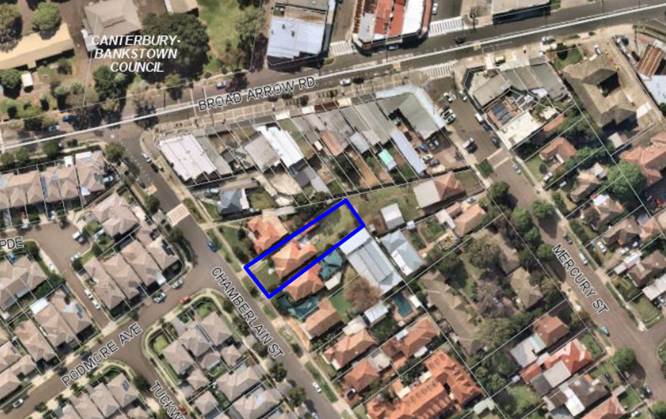
The subject site is
outlined in blue
|
Executive Summary
Proposal
1. The development
application seeks consent for demolition works and construction of centre-based
child care facility on land legally described Lot 47 in DP 10112, known as 36
Chamberlain Street, Narwee.
2. The centre will
cater for 60 children in a two storey building over a semi-basement parking
area for nine (9) vehicles.
Site and Locality
3. The
site is rectangular in shape with a frontage of 15.24m to Chamberlain Street.
The allotment has an area of 789.66sqm. The site is located on the north
eastern side of Chamberlain Street. The allotment has a fall from the street to
the rear of 3.36m.
4. The site is currently
occupied by a single storey dwelling house and a detached single garage.
5. Adjoining the site to
the north west is a two storey dwelling house, and to the south east is a site
containing 3 child care centres with a total of 77 children (approved) (in the
same ownership as the subject site/applicant). To the rear of the site are
dwelling houses, and opposite the site are two storey dwellings that form part
of a large multi-dwelling development being the former Narwee Boys High School
Site.
6. The child care centres
located to the south east of the site are an adaptive reuse of a former
Methodist Church and Minister’s residence which ceased formal worship in
February 1995. This site remains zoned as SP2 – Infrastructure (under
Hurstville Local Environmental Plan 1994 the site was zoned 5A General Special
Uses). The streetscape presentation of this site has always been distinct from
the residential development surrounding given the nature of the use which has
occupied the site. In 1967 an application was lodged with Hurstville Council to
seek to operate a non-denominational childcare centre (32 children 2-5 years
between 9.30am and 3pm Monday to Friday) from 32 Chamberlain Street associated
with the Methodist Church. In 1968 Council received a further application to
construct a Church Hall. As a result the Church and its facilities have been
operating from this site since the 1960’s.
Zoning and Permissibility
7. The site is zoned
R2 Low Density Residential under the Hurstville Local Environmental Plan 2012
(HLEP). The application seeks consent for a 60 place child care centre which is
defined as a “centre-based child care facility” being a
permissible use within the zone with development consent.
Submissions
8. The application
was notified in accordance with the provisions contained within the Hurstville
Development Control Plan. In response, three (3) submissions were received. The
relevant concerns raised within the submissions have been addressed in detail
later in this report.
Conclusion
9. An assessment has
been undertaken in accordance with the applicable assessment criterion as
outlined in this report and the proposal is considered inadequate based upon
the following conclusions:
- In accordance with Council’s DA
checklist, and to ensure a full and proper submission with sufficient detail to
enable a complete assessment the following reports are required to be submitted
for a child care centre application and were not submitted in support of this
proposal:
o A
Preliminary Site Investigation Report in accordance with the child care
guidelines and SEPP 55 to ensure the site is suitable for the highly sensitive
child care use;
o A
Geotechnical Report to confirm that excavation works will not encounter
groundwater (triggering the requirement for an approval from Water NSW) and is
suitable for the level of excavation proposed.
o A Plan
of Management to demonstrate that impacts of the use can be managed in a manner
that will minimize impacts on adjoining uses and the environment more
generally.
o A BCA
Report to demonstrate that the design shown on the architectural plans is able
to be realized with respect to National Construction Code requirements;
o A Social
Impact Assessment to demonstrate the need for the centre in this location.
o Documentation
demonstrating that the outdoor play areas do not require concurrence from the
Department of Education under Clause 22 of State Environmental Planning Policy
(Educational Establishments and Child care Facilities) 2017.
- In addition, the following reports and
plans contain internal inconsistencies and some of the reports were prepared a
considerable time ago that make it unclear as to the proposal for which consent
is sought, or are inadequately prepared:
o Access
Report;
o Acoustic
Report;
o Traffic
Report;
o Landscape
Plan;
o Stormwater
Management; and
o Waste
Management.
In addition,
there are a number of design elements missing from the architectural plans,
including details to demonstrate the design meets the relevant Australian
Standards for food preparation areas. The application is not clear whether
children will bring their own food from home or whether it is provided by the
centre either cooked in house or delivered prepared and ready to serve.
10. The inadequacy of these documents
is outlined in detail in the relevant sections of the report, but cumulatively
they result in a lack of clarity as to what is proposed, and an application
that is insufficiently complete to allow for an appropriate assessment of
impacts to be completed.
11. Council has, on multiple occasions
urged the applicant to withdraw the application (with a full refund of
assessment fees being offered) and seek comprehensive feedback through a
pre-lodgement meeting with Council’s Development Advisory Service, to
assist in revising the application to an assessment ready standard, and
provided detailed advice of the issues with respect to the application. The
applicant has chosen not to withdraw the application and for the assessment and
determination to be made.
12. Based upon the information provided
to date, it is assessed that the proposal will have an adverse and unreasonable
environmental impact in the following regard:
o The centre adjoins three (3) centres
on the adjoining site to the south east, which currently has consent for up to
77 children combined on these sites. Only five (5) parking spaces are currently
provided for these three (3) centres. The proposal currently before Council is
seeking to construct a basement car park to accommodate nine (9) vehicles. The
car park access includes an inadequately wide ramp design for the class of use
proposed, with the basement being deficient by one (1) car parking space.
o The design of the facility is not
consistent with the Childcare Planning Guideline in that:
- the
entry sequences (from both the basement car park and the street) are convoluted
and provide access directly to play spaces and a classroom, there is no
formalised central reception area;
- inadequate
outdoor space is provided;
- access
between the upper floor child care room and the outdoor open space area is not
direct or easy being via a small lift or narrow staircase;
- inadequate
indoor and outdoor storage demonstrated on the plans; and
- inadequate
separation between kitchen facilities and play spaces provided.
o Inadequate landscaping is provided
on the site, with the front setback being dedicated to an impermeable (soft
rubber) area used as the outdoor play space for play room 1 which includes a
shade sail over. To comply with the safety criterion this area is proposed to
be fenced by an 1800mm high fence on the boundary and the side returns, and in
the rear yard. The rear play area 2 which is part on an elevated deck with roof
over and part on the ground level with a shade sail over for classroom 2
and 3 is also impermeable (soft rubber). This area is also fenced and screens
on the balcony level to a height of 1800mm. There are sporadic pockets of
natural vegetation.
o The proposal will have an adverse
acoustic and visual privacy impact on adjacent residential properties with
noise and views from the elevated play space in the rear.
o The waste arrangements involved are
unsuitable for a centre of this size and will result in adverse environmental
impacts due to insufficient storage capacity.
o The food preparation areas are
inappropriate for a centre of this size and it has not been demonstrated that
these comply with the relevant food standards. The application is not clear
whether children will bring their own food from home or whether it is provided
by the centre either cooked in house or delivered prepared and ready to serve.
o The proposed building form is
keeping a consistent floor level throughout the ground floor which, due to the
slope of the site results in the ground floor level at the rear being
excessively elevated. The elevated area is one of the rear primary outdoor play
spaces for the older children. This results in an unreasonable visual and
acoustic impact.
13. As a result of the concerns,
deficiencies and inadequacies of the proposal the application is recommended
for refusal.
Report in Full
Proposal
14. The
application seeks consent for demolition of the existing dwelling and garage
and construction of a centre-based child care facility for 60 children with
semi-basement parking area for nine (9) vehicles. The child mix is 8 x 0-2 year
olds and 52 x 3-6 year olds).
15. The
proposal is described on the architectural plans in further detail as follows
(noting as detailed earlier in this report there are a number of
inconsistencies between plans and reports submitted with the application):
Basement Level
- driveway and ramp access from
Chamberlain Street to a semi-basement level containing nine (9) parking spaces
(4 x staff and 5 x visitor spaces, including one accessible space),
- two (2) bicycle racks,
- area for services and bins,
- a store room, staff WC and
children’s WC accessed from the lower level outdoor play area to the rear
of the basement accessed separately from the basement, and
- lift access to the levels above.
Ground Floor
- outdoor play area in the front
setback,
- two (2) indoor playrooms,
- outdoor play area on the balcony
and stair access to the lower level yard play area,
- store room, office, two cot
rooms, bottle preparation area, kitchenette, craft sink, lockers,
children’s toilets, baby change area and shower and a separate accessible
WC,
- lift and stair access to the
level above, and
- lift access from the basement.
First Floor
- staff room, office, two store
rooms,
- indoor play area and kitchen
preparation area, craft sink, lockers, small laundry facility, children’s
toilet and separate WC,
- lift access to the lower levels.
Site and
Locality
16. The site is
rectangular in shape with a frontage of 15.24m to Chamberlain Street. The
allotment has an area of 789.66sqm. The site is located on the north eastern
side of Chamberlain Street. The allotment has a fall from the street to the
rear of 3.36m.
17. The site is currently occupied by a
single storey dwelling house and a detached single garage.
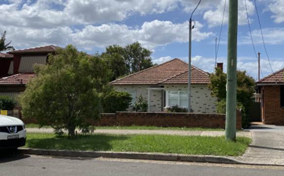
Figure
1 – Existing dwelling on the site
18. Adjoining the site to the north west is a
two storey dwelling house, and to the south east are three (3) child care
centres (under the same ownership as the subject site/applicant). The centre
caters for 77 children (approved) between three buildings on the site, and
provides parking for five (5) cars (two (2) staff and three (3) visitor
spaces). The number of children accommodated on the site has grown in capacity
between the early 1970s and the latest approval in 2004, originally catering
for 37 children in the rear building, to 20 children in each of the buildings
in the front of the site (1996/DA-0230 and 2002/DA-0722 and 2002/DA-0722.1),
currently totalling 77 children.
19. The approved parking on site consists of
three (3) parking spaces along the south eastern site boundary and two spaces
in the drive-through driveway at the front of the site. It is also purported
that visitors also rely on one (1) 15 minute timed on street parking space
within Chamberlain Street in front of the centre.
20. To the rear of the site are dwelling
houses, and opposite the site are two storey dwellings that form part of a
large multi-dwelling development formerly the Narwee Boys High School site.
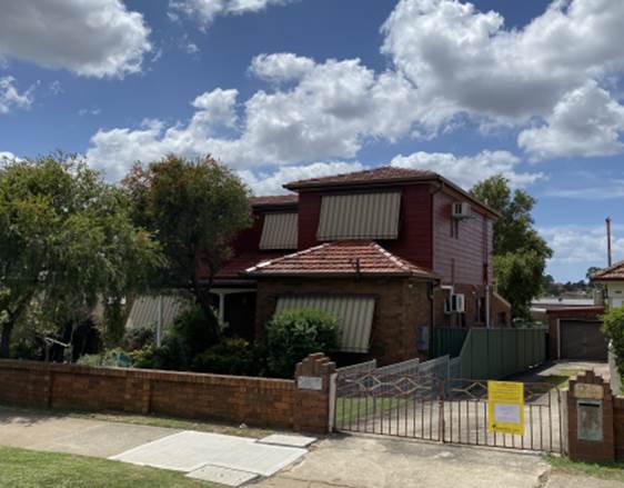
Figure
2 – 38 Chamberlain St (north
west of the site)
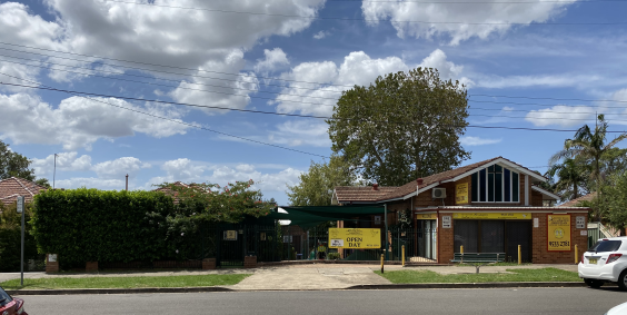
Figure
3 – Child care centre at 32-34
Chamberlain Street (south east of the site)
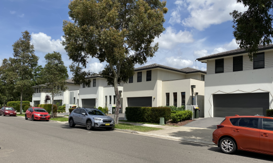
Figure
4 – Residential development
opposite the site
Zoning and
Permissibility
21. The
subject land is zoned R2 – Low Density Residential under the provisions
of the Hurstville Local Environmental Plan 2012 (HLEP 2012). The proposed
development is defined by the HLEP 2012 as a ‘Centre-based child care
facility’ which is a permitted land use in the zone with consent.
Submissions
22. The proposed development was
notified to the immediate and surrounding residents. In response, a total of
three (3) submissions were received by Council, all objecting to the proposed
development. The relevant concerns raised have been addressed in detail later
in this report.
Background
23. The following table provides a
background of the application to date:
|
Date
|
Action
|
|
17 December 2019
|
DA2019/0616 was lodged.
Prior to lodgement, the applicant was advised there were a number of required
documents missing. The applicant was advised to undertake a pre-lodgement if
assistance was required, however it was insisted the application be taken
over the counter. The applicant was advised it was likely the application
would be rejected via Council Officer review process.
|
|
19 December 2019
|
A letter of rejection was
emailed to the applicant following a preliminary review of the application.
The letter identified the following details as being missing, inadequate or
unacceptable and recommended again that the applicant seek a pre-lodgement
with Council’s Development Advisory Service prior to proceeding further
to understand the necessary information and application details that area
required to facilitate the assessment of the application:
- Contamination
Report
- Stormwater
Management Plans
- Architectural
Plans
- Acoustic
Report
- Landscape
Plans
- Waste
Management details
- Parking
design
- Character
- Deep
soil provision and
- Elevation
of the building out of the ground
|
|
January – February
2020
|
Correspondence between
the applicant’s town planner and Council staff requesting the DA be
accepted was received. Advice was provided that the application would need to
be re-lodged, but that the issues identified in the correspondence of 19
December 2019 remained unaddressed.
|
|
17 February 2020
|
DA2020/0050 (the subject
application) was lodged. The material forming part of this application did
not differ from that provided in DA2019/0616, and no pre-lodgement advice had
been sought by the applicant.
|
|
20 March 2020
|
Following a detailed
assessment, the applicant was sent detailed correspondence outlining the
issues with the application and requesting withdrawal of the DA due to
insufficient information, inadequate and inconsistent reports and plans.
Given the breadth of
issues and the amount of time required to address them, the advice was also
provided to the applicant that no additional information would be accepted
pursuant to Clause 55 of the Regulations and 7 days was provided within which
to withdraw the application. The applicant was again urged to make use of
Council’s Development Advisory Service for assistance.
|
|
2 April 2020
|
The applicant’s
town planner called to advise a response was being prepared and most issues
could be dealt with by design changes or conditions of consent. A meeting was
requested, however due to COVID 19 restrictions via the Public Health Orders
a face to face meeting could not be facilitated at this time.
The assessment by Council
Officers confirmed that a substantial amount of work was required to bring
the application up to the required standard for assessment, and it was
advised that it was not considered that the application was sufficiently
complete to enable the proposal to be adequately resolved in a reasonable
timeframe. The applicant was again recommended to seek the assistance of
Council’s Advisory Service.
|
|
17 April 2020
|
The applicant’s
town planner responded advising most issues could be dealt with by updating
reports, plans or Council imposing conditions of consent and they would not
withdraw the application. No information accompanied this letter.
|
|
22 May 2020
|
The applicant was advised
by email that the DA would be referred to the Local Planning Panel for
determination based on the information submitted with the DA.
|
PLANNING
ASSESSMENT
24. The site has been inspected and the
proposed development has been assessed under the provisions of Section 4.15(1)
of the Environmental Planning and Assessment Act 1979.
STATE
ENVIRONMENTAL PLANNING POLICIES
State
Environmental Planning Policy (Educational Establishments and Child Care
Facilities) 2017
25. State Environmental Planning Policy
(Educational Establishments and Child Care Facilities) 2017 (Education and
Child Care SEPP) commenced on 1 September 2017 and aims to facilitate the
effective delivery of educational establishments and early education and care
facilities across the State.
26. The guidelines require centres
provide indoor play areas at a rate of 3.25sqm/child (60 children would require
195sqm) and outdoor play areas at a rate of 7sqm/child (60 children would
require 420sqm).
27. The architectural plans state the
proposal provides the following areas of indoor and outdoor play areas:
a. Indoor play area - 280sqm;
b. Outdoor play area - 447sqm.
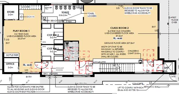
Figure
5: Ground floor indoor play areas
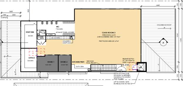
Figure
6: First floor indoor play area
28. The plans submitted with the
application fail to correctly calculate the unencumbered indoor play areas. The
plans have incorrectly included areas that are required to be excluded,
including:
- The
area in front of the kitchen in Class Room 2;
- The
area in front the of the bottle preparation area in Play Room 1; and
- The
area directly adjacent to the entry to the centre in Play Room 1.
The figure of 280sqm
provided on the architectural plans for the indoor play area suggests the
centre is capable of accommodating an increase in children in the future, being
up to 86 children. It is considered that the site is currently unable to
accommodate 60 children (parking does not comply) and approval of incorrectly
calculated indoor spaces would risk future applications for additional children
relying on the indoor spaces indicated in this application.
29. In relation to the outdoor play
areas, the architectural plans do not indicate which areas have been included
or excluded in the nominated figure of 447sqm. The guidelines require pathways,
storage areas, screen planting and other spaces not suitable for children to be
excluded from the calculation.
30. In reviewing the submitted
architectural plans, it appears that the outdoor play is more in the order of
360sqm, which fails to meet the minimum of 440sqm for 60 children, resulting in
a maximum of 51 children permitted.
31. An assessment of the proposal
against the Child Care Planning Guidelines is provided in the following table.
|
Child Care Planning Guideline
Compliance Table
|
|
Controls
|
Proposed
|
Complies
|
|
3.1 Site selection and location
|
|
C1- For
proposed developments in or adjacent to a residential zone consider:
|
|
§ the acoustic and privacy impacts of the
proposed development on the residential properties
|
The proposed upper level
balcony/outdoor play area will have adverse visual and acoustic privacy
impacts on the private open space of the residential neighbours to the rear.
An acoustic barrier is proposed to the northern side of the play space
adjacent to 38 Chamberlain Avenue to a height of 2.1m above the ground floor
balcony finished level which is as required by the Acoustic Report prepared
by EMM dated December 2019.
|
No
|
|
§ the setbacks and siting of buildings within
the residential context
|
The basement ramp is located on a
nil setback to the northern side boundary for a length of 23.485m from the
front boundary and extends to a height of 1.2m or 1.7m above the existing
ground level and 3.9m to the top of the acoustic screen. This façade
for the ground floor element of the building at its highest point will
present as 4.2m in height.
The height to the ridge at the
upper level is 8.9m in height given the skillion roof design.
This results in adverse and
unacceptable bulk and scale impacts for the residential neighbour to the
north west.
The south eastern side of the
development is considerable elevated with the ground floor being 1.3m –
1.6m above the existing site level, and proposes a wall height of 4.6m at its
highest point. It is acknowledged this is the elevation that faces the
adjoining child care facility which is owned by the owners of the application
currently before Council.
The elevated ground floor level of
the development has an unacceptable impact to the residential allotments to
the rear and the north west.
There is also a recent shop top
housing development on the corner of Broadarrow Road and Chamberlain Street
and older style traditional shop top housing further along Broadarrow Road.
|
No
|
|
§ traffic and parking impacts of the proposal on
residential amenity
|
The proposal seeks to rely on
on-street parking in lieu of the proposal being deficient by one (1) space
on-site. No application has been made to the Traffic Committee for the
introduction of timed parking spaces within the site frontage and Council’s
Traffic Engineer has indicated there is no guarantee such an application
would be supported.
Council’s Traffic Engineer
has advised the access to the basement does not meet the relevant Australian
Standards with respect to the traffic generation for the child care centre
requiring a passing bay at the entrance to the child care centre, as per
AS2890.1:2004 3.2.2. The waiting bay at the bottom of the ramp does not
satisfy the criterion.
The application has not
demonstrated that there are compliant sightlines when egressing the basement.
|
No
|
|
C2 - When selecting a site, ensure that:
|
|
§ the location and surrounding uses are
compatible with the proposed development or use
|
The site adjoins three (3) approved
child care centres and residential properties with a visual line of site to
commercial development fronting Broadarrow Road which are compatible uses
when appropriately managed. The application has failed to demonstrate the
proposal will not result in adverse parking and vehicle manoeuvrability,
acoustic and privacy impacts.
|
No
|
|
§ the site is environmentally safe including
risks such as flooding, land slip, bushfires, coastal hazards
|
There are no hazards affecting the
site.
|
Yes
|
|
§ there are no potential environmental
contaminants on the land, in the building or the general proximity, and
whether hazardous materials remediation is needed
|
A Preliminary Site Investigation
report was not submitted with the DA, which forms one (1) of the reasons for
refusal as it cannot be satisfied the site is suitable for this sensitive
use.
Subclause (d) of Regulation 25 of
the Education and Care Services National Regulations requires for this to be
demonstrated and in addition to this SEPP 55 requires an assessment be
carried out in circumstances where a more sensitive use is proposed to occupy
a site. This proposal falls into this category.
|
No
|
|
§ the characteristics of the site are suitable
for the scale and type of development proposed having regard to:
- size of street frontage, lot configuration,
dimensions and overall size
- number of shared boundaries with residential
properties.
- the development will not have adverse
environmental impacts on the surrounding area, particularly in sensitive
environmental or cultural areas.
|
The application fails to
demonstrate the proposal will not have adverse parking and vehicle
manoeuvring, acoustic and privacy impacts together with the number of
non-compliances with State and Local planning controls, the site is
considered unsuitable for a child care centre of this size.
|
No
|
|
§ there are suitable drop off and pick up areas,
and off and on street parking
|
The proposal relies on on-street
parking to compensate for a shortfall of one on-site space, which is not supported.
It is acknowledged there is
currently three (3) on-street timed car parking within the frontage of 32-34
Chamberlain Street. This appears to have been accommodated as the adjoining
child care centres were an adaptive reuse and intensification of a former
Methodist Church which had a previous approval for a 32 place 2-5 year old
child care centre operating 9.30am – 3pm Monday to Friday and
associated minister’s residence which was converted to a child care
centre (SP2 zoning).
This is a purpose built development
and therefore the development needs to be compliant and not using public
spaces for private purposes in a location where on-street parking is limited.
|
No
|
|
§ the type of adjoining road (for example
classified, arterial, local road, cul-de-sac) is appropriate and safe for the
proposed use
|
Chamberlain Street is a local road.
|
Yes
|
|
§ it is not located closely to incompatible social
activities and uses such as restricted premises, injecting rooms, drug
clinics and the like, premises licensed for alcohol or gambling such as
hotels, clubs, cellar door premises and sex services premises.
|
The site is not located close to
any incompatible land uses.
|
Yes
|
|
C3 - A child care facility should be located:
|
|
§ near compatible social uses such as schools
and other educational establishments, parks and other public open space,
community facilities, places of public worship
|
The site is suitably located to
such uses.
|
Yes
|
|
§ near
or within employment areas, town centres, business centres, shops
|
|
§ with access to public transport including rail, buses,
ferries
|
|
§ in areas with pedestrian connectivity to the
local community, businesses, shops, services and the like.
|
|
C4- A child care facility should be located to avoid
risks to children, staff or visitors and adverse environmental conditions
arising from proximity to:
|
|
§ heavy or hazardous industry, waste transfer
depots or landfill sites
§ LPG tanks or service stations
§ water cooling and water warming systems
§ odour (and other air pollutant) generating
uses and sources or sites
§ which, due to prevailing land use zoning, may
in future accommodate noise or odour generating uses
§ extractive industries, intensive agriculture,
agricultural spraying activities
§ any other identified environmental hazard or
risk relevant to the site and/ or existing buildings within the site.
|
The site is not located in close
proximity to any such land uses or activities.
|
Yes
|
|
3.2 Local character, streetscape and the public domain
interface
|
|
C5 - The proposed development should:
|
|
§ contribute to the local area by being designed
in character with the locality and existing streetscape
|
The built form facing the street
resembles the residential context of the locality and the adjacent child care
centre, however the elevated built form above natural ground level has
significant adverse bulk and scale impacts on the adjacent residential
properties to the side and rear of the subject site, and the lack of deep
soil landscaping to all site boundaries’ does not reflect the
landscaped setting of the site.
In addition, the open style pool
fencing, rubber play area and shade sails are inconsistent with the residential
form of the street. The justification by the applicant that there is a play
area and shade sail in the front of the adjacent child care centre does not
justify proposing the same on the subject site. It is to be acknowledged the
adjoining allotment is an adaptive reuse of a former Methodist Church and
Minister’s residence; as a result the space available was constrained
and presented differently and is also zoned differently being an SP2 zone.
This development is a purpose built building as a result it needs to meet the
criterion of being within a residential setting given this site is zoned R2
and will result in the demolition of an exiting dwelling.
Historically since 1967/68 there
was an approval on 32 Chamberlain Street for a 32 place 2-5 year old child
care centre operating between 9.30am and 3pm.
Following the closure of the
Methodist Church in February 1995 both 32 and 34 Chamberlain were sold. An
application for the conversion of 34 Chamberlain Street to a childcare centre
was approved by the Land and Environment Court on 10 April 2006. The Church
building and the minister’s home remain and have been converted
therefore this site is unique as it has always had a differing presentation
to the streetscape than that of a pure residential allotment.
|
No
|
|
§ reflect the predominant form of surrounding
land uses, particularly in low density residential areas
|
|
§ recognise predominant streetscape qualities,
such as building form, scale, materials and colours
|
|
§ include design and architectural treatments that respond
to and integrate with the existing streetscape
|
|
§ use landscaping to positively contribute to
the streetscape and neighbouring amenity
|
Insufficient area is provided as
deep soil to allow for substantial landscaping, and the proposed open style
pool fencing, shade sail and rubber surface of the play area does not
positively contribute to the streetscape.
|
No
|
|
§ integrate car parking into the building and
site landscaping design in residential areas.
|
The semi-basement parking area is
not integrated into the built form and results in an elevated outdoor play
area and ground floor level of the child care centre which has adverse visual
and acoustic impacts on the residential neighbour to the rear.
|
No
|
|
C6 - Create a threshold with a clear transition between
public and private realms, including:
|
|
§ fencing to ensure safety for children entering
and leaving the facility
|
Appropriate fencing is proposed
being swimming pool style fencing. Vegetation of Cascade Lilly Pilly’s
having a mature height of 1600mm are proposed on the inside face of the
fencing.
|
Yes
|
|
§ windows facing from the facility towards the
public domain to provide passive surveillance to the street as a safety
measure and connection between the facility and the community
|
Windows and glass sliding doors are
oriented to the street.
|
Yes
|
|
§ integrating existing and proposed landscaping
with fencing.
|
The proposal does not seek to
retain any existing landscaping and does not propose sufficient areas of deep
soil to accommodate any new substantial landscaping. The proposal includes
open style pool fencing above the low height brick fence at the front of the
site to reach a height of 1.8m.
There are Cascade Lilly
Pilly’s which at maturity will be 1600mm in height planted along the
frontage within the site.
|
No
|
|
C7- On sites with multiple buildings and/or entries,
pedestrian entries and spaces associated with the child care facility should
be differentiated to improve legibility for visitors and children by changes
in materials, plant species and colours.
|
Fencing is proposed between the
pedestrian pathway from Chamberlain Street and the front play area to
restrict access to the area.
A pathway will delineate the entry
to the centre which is from the side elevation.
|
Yes
|
|
C9 - Front fences and walls within the front setback
should be constructed of visually permeable materials and treatments.
Where the site is listed as a heritage item, adjacent to
a heritage item or within a conservation area front fencing should be designed
in accordance with local heritage provisions.
|
The front fence is proposed to be
pool fencing with landscaping within the front play area, being a strip of
Cascade Lilly Pilly’s with a mature height of 1600mm.
Not applicable.
|
Yes
N/A
|
|
C10 - High solid acoustic fencing may be used when
shielding the facility from noise on classified roads. The walls should be
setback from the property boundary with screen landscaping of a similar
height between the wall and the boundary.
|
Not applicable as Chamberlain
Street is a local road.
|
N/A
|
|
3.3 Building orientation, envelope and design
|
|
C11- Orient a development on a site and design the
building layout to:
|
|
§ ensure visual privacy and minimise potential
noise and overlooking impacts on neighbours by:
§ facing doors and windows away from private
open space, living rooms and bedrooms in adjoining residential properties
§ placing play equipment away from common
boundaries with residential properties
§ locating outdoor play areas away from
residential dwellings and other sensitive uses
|
The balcony outdoor play area is
elevated and will have adverse visual and acoustic privacy impacts for the
residential neighbour to the rear and to a lesser extent the dwelling to the
north western side of the site.
|
No
|
|
§ optimise solar access to internal and external
play areas
|
The indoor and outdoor play areas
will receive reasonable levels of solar access as they have north eastern
orientation, albeit it reduced as a result of the covering over the ground
floor balcony play area and the 2.1m high solid acoustic barrier required by
the acoustic report. The extent of solar access to play room 1 is unclear as
the patio roof and shade sail over the outdoor play area will reduce sunlight
into the glass sliding doors. There are no openings in the north western side
of the building providing.
|
Yes
|
|
§ avoid overshadowing of adjoining residential
properties
|
The proposal does not unreasonably
shadow residential properties; there is a shadow impact in the morning to the
dwelling on the north western side of the site.
|
Yes
|
|
§ minimise cut and fill
|
The proposed semi-basement involves
excavation however results in a poor built form which elevates the ground
floor play room and outdoor play areas resulting in visual and privacy
impacts on neighbours.
|
No
|
|
§ ensure buildings along the street frontage
define the street by facing it
|
Complies.
|
Yes
|
|
§ ensure that where a child care facility is
located above ground level, outdoor play areas are protected from wind and
other climatic conditions.
|
The elevated outdoor play area is
roofed for shade however two sides are open to the elements and one (1) side
partially open above the acoustic screen including wind and rain.
|
Yes
|
|
C12- The following matters may be considered to minimise
the impacts of the proposal on local character:
|
|
§ building height should be consistent with
other buildings in the locality
|
The building height complies with
the maximum 9m limit as the height is measured from the existing site level
not the excavated level.
|
Yes
|
|
§ building height should respond to the scale
and character of the street
|
Complies with the numeric control.
|
Yes
|
|
§ setbacks should allow for adequate privacy for
neighbours and children at the proposed child care facility
|
The elevated balcony outdoor play
area will have adverse privacy impacts on residential neighbours. In addition
the children can be seen playing in this area by neighbours, not affording
the children any privacy.
|
No
|
|
§ setbacks should provide adequate access for
building maintenance
|
Adequate setbacks are provides with
the exception of the wall that has a nil setback to the north western
boundary.
|
Yes
|
|
§ setbacks to the street should be consistent
with the existing character.
|
The street setback of the building
complies with the adjoining development. The shade sail is within the front
setback.
|
Yes
|
|
C13 - Where there are no prevailing setback controls
minimum setback to a classified road should be 10m. On other road frontages
where there are existing buildings within 50m, the setback should be the
average of the two closest buildings. Where there are no buildings within
50m, the same setback is required for the predominant adjoining land use.
|
Not applicable.
|
N/A
|
|
C14 - On land in a residential zone, side and rear
boundary setbacks should observe the prevailing setbacks required for a
dwelling house.
|
The basement ramp is located on a
nil setback to the northern side boundary for a length of 23.485m from the
front boundary and extends to a height of 1.2m or 1.7m above the existing
ground level and 3.9m to the top of the acoustic screen. This façade
for the ground floor element of the building at its highest point will
present as 4.2m in height.
The height to the ridge at the
upper level is 8.9m in height given the skillion roof design.
This results in adverse and
unacceptable bulk and scale impacts for the residential neighbour to the
north west.
The south eastern side of the
development is considerable elevated with the ground floor being 1.3m –
1.6m above the existing site level, and proposes a wall height of 4.6m at its
highest point. It is acknowledged this is the elevation that faces the
adjoining child care facility which is owned by the owners of the application
currently before Council.
The elevated ground floor level of
the development has an unacceptable impact to the residential allotments to the
rear and the north west.
|
No
|
|
C15- The built form of the development should contribute
to the character of the local area, including how it:
|
|
§ respects and responds to its physical context
such as adjacent built form, neighbourhood character, streetscape quality and
heritage
|
The built form of the proposal is
elevated at the rear and reads as a three (3) level building which does not
reflect the existing character of the locality as it has not been respectful
of the site topography and results in adverse privacy and visual impacts for
residential neighbours.
The child care centres adjoining
are an adaptive reuse of existing building and are at or close to the ground
levels of the site (see street view below), not elevated as proposed by the
subject application.
|
No
|
|
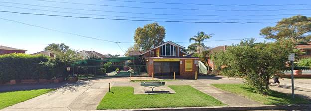
Figure
7: Child care centres adjoining
32-34 Chamberlain Street
|
|
§ contributes to the identity of the place
|
The proposal does not contribute
positively to the identity of the locality due to the adverse impacts of the
built form, lack of landscaping and shortfall in parking spaces.
|
No
|
|
§ retains and reinforces existing built form and
vegetation where significant
|
The existing vegetated front and
rear yard of the site is lost to the proposal and replaced with hard surfaces
to accommodate the outdoor play areas.
|
No
|
|
§ considers heritage within the local
neighbourhood including identified heritage items and conservation areas
|
Not applicable.
|
N/A
|
|
§ responds to its natural environment including
local landscape setting and climate
|
Insufficient area is provided as
deep soil to allow for substantial landscaping and the natural ingress of
water.
|
No
|
|
C16- Entry to the facility should be limited to one
secure point which is:
|
|
§ located to allow ease of access, particularly
for pedestrians
§ directly accessible from the street where
possible
§ directly visible from the street frontage
§ easily monitored through natural or camera
surveillance
§ not accessed through an outdoor play area.
§ in a mixed-use development, clearly defined
and separate from entrances to other uses in the building.
|
Complies subject to appropriate
signage.
|
Yes
|
|
C17- Accessible design can be achieved by:
|
|
§ providing accessibility to and within the
building in accordance with all relevant legislation
§ linking all key areas of the site by level or
ramped pathways that are accessible to prams and wheelchairs, including
between all car parking areas and the main building entry
§ providing a continuous path of travel to and
within the building, including access between the street entry and car
parking and main building entrance. Platform lifts should be avoided where
possible
§ minimising ramping by ensuring building
entries and ground floors are well located relative to the level of the
footpath.
§ NOTE: The National Construction Code, the
Discrimination Disability Act 1992 and the Disability (Access to Premises
– Buildings) Standards 2010 set out the requirements for access to
buildings for people with disabilities.
|
The proposal is capable of meeting
the relevant requirements, however it is noted that due to the elevated
nature of the proposal above natural ground, access between levels within the
centre and between indoor and outdoor areas are via stairs and lifts. Notably
classroom 3 on the first floor has no adjacent outdoor play area and access
to the outdoor play areas are via stairs, lift or ramp.
An access report has accompanied
the application, but is however dated 2018, therefore it is unknown if the
comments directly relate to the plans currently before Council.
|
Yes
|
|
3.4 Landscaping
|
|
C18- Appropriate planting should be provided along the
boundary integrated with fencing. Screen planting should not be included in
calculations of unencumbered outdoor space. Use the existing landscape where
feasible to provide a high quality landscaped area by:
|
|
§ reflecting and reinforcing the local context
§ incorporating natural features of the site,
such as trees, rocky outcrops and vegetation communities into landscaping.
|
Insufficient area is provided as
deep soil to allow for substantial landscaping. The majority of the site is
covered by the car parking area and the rubber outdoor play areas.
|
No
|
|
C19- Incorporate car parking into the landscape design of
the site by:
|
|
§ planting shade trees in large car parking
areas to create a cool outdoor environment and reduce summer heat radiating
into buildings
§ taking into account streetscape, local
character and context when siting car parking areas within the front setback
§ using low level landscaping to soften and
screen parking areas.
|
Not applicable –
semi-basement parking area proposed.
|
N/A
|
|
C21- Minimise direct overlooking of indoor rooms and
outdoor play spaces from public areas through:
|
|
§ appropriate site and building layout
§ suitably locating pathways, windows and doors
§ permanent screening and landscape design
|
An open style pool fence is
proposed over the front boundary above the existing 600mm masonry fence which
will not obscure a view from the street into the play area.
There is a landscaping strip inside
the fencing which is to contain 6 Cascade Lilly Pilly which grow to a height
1.6m as referenced on the landscape plan. When at maturity these shrubs will
screen the play space from the public domain.
|
No
|
|
C22 Minimise direct overlooking of main internal living
areas and private open spaces in adjoining developments through:
|
|
§ appropriate site and building layout
§ suitable location of pathways, windows and
doors
§ landscape design and screening.
|
The elevated balcony will overlook
residential neighbours.
The openings in the north western
side of the building have windows all with sill heights of 1500mm.
|
No
|
|
C23- A new development, or development that includes
alterations to more than 50 per cent of the existing floor area, and is
located adjacent to residential accommodation should:
|
|
§ Provide an acoustic fence along any boundary
where the adjoining property contains a residential use. (An acoustic fence
is one that is a solid, gap free fence).
|
An acoustic wall (colourbond
sandwich panel) is proposed along the northern side of Outdoor Play Area 2
(elevated balcony). While the proposed fencing may reduce noise for the
residential neighbour to the north, it is located between a nil and a 900mm
setback from the side boundary, above the semi-basement wall and extends to a
height between 3m and 4.2m resulting in an adverse visual impact for the
neighbour.
The height to the ridge at the
upper level is 8.9m in height given the skillion roof design.
This results in adverse and
unacceptable bulk and scale impacts for the residential neighbour to the
north west.
The south eastern side of the
development is considerable elevated with the ground floor being 1.3m –
1.6m above the existing site level, and proposes a wall height of 4.6m at its
highest point. It is acknowledged this is the elevation that faces the
adjoining childcare facility which is owned by the owners of the application
currently before Council.
The elevated ground floor level of
the development has an unacceptable impact to the residential allotments to
the rear and the north west.
|
No
|
|
C24- A suitably qualified acoustic professional should
prepare an acoustic report which will cover the following matters:
|
|
§ identify an appropriate noise level for a
child care facility located in residential and other zones
§ determine an appropriate background noise
level for outdoor play areas during times they are proposed to be in use
§ determine the appropriate height of any acoustic fence to
enable the noise criteria
§ to be met.
|
An Acoustic Report has been
submitted with the DA however the report suggests operation of the centre, ie
outdoor play times and limits on the number of children, in addition to the
required acoustic wall on outdoor play area 2, that have not been addressed
in a Plan of Management. With these restrictions and the number of children,
it is unknown how this is to be managed.
The acoustic report prepared
December 2019 by EMM recommended that the elevated outdoor play area be used
for a maximum of 2hrs per day and the acoustic fencing along the north
western side of the elevated play area be 2.1m in height which is annotated
on the plan.
|
Yes
|
|
3.6 Noise and air pollution
|
|
C25 Adopt design solutions to minimise the impacts of
noise, such as:
|
|
§ creating physical separation between buildings
and the noise source
§ orienting the facility perpendicular to the
noise source and where possible buffered by other uses
§ using landscaping to reduce the perception of
noise
§ limiting the number and size of openings
facing noise sources
§ using double or acoustic glazing, acoustic
louvres or enclosed balconies (winter gardens)
§ using materials with mass and/or sound
insulation or absorption properties, such as solid balcony balustrades,
external screens and soffits
§ locating cot rooms, sleeping areas and play
areas away from external noise sources.
|
The plans detail the acoustic fence
is 2100mm as per the acoustic report.
The other recommendation of the
report was that this area only be used for 2hrs a day. This criterion does
not seem to align with the required usage of this area by two (2) classrooms
and fifty two (52) children.
|
N/A
|
|
C26- An acoustic report should identify appropriate noise
levels for sleeping areas and other non-play areas and examine impacts and
noise attenuation measures where a child care facility is proposed in any of
the following locations:
|
The acoustic report details that an
assessment has been undertaken of the impact from road noise on playroom 1
which contains the cot rooms. The assessment detailed no attenuation is
required to the street elevation.
|
N/A
|
|
C27- Locate child care facilities on sites which avoid or
minimise the potential impact of external sources of air pollution such as
major roads and industrial development.
|
The site is not located in close
proximity to any polluting land uses or major roads.
Narwee Train Station (East Hills
line) is located further to the north of the site. The rail corridor does not
impact this use.
|
Yes
|
|
C28- A suitably qualified air quality professional should
prepare an air quality assessment report to demonstrate that proposed child
care facilities close to major roads or industrial developments can meet air
quality standards in accordance with relevant legislation and guidelines.
The air quality assessment report should evaluate design
considerations to minimise air pollution.
|
Not applicable.
|
N/A
|
|
3.7 Hours of operation
|
|
C29- Hours of operation within areas where the
predominant land use is residential should be confined to the core hours of
7.00am to 7.00pm weekdays. The hours of operation of the proposed child care
facility may be extended if it adjoins or is adjacent to non-residential land
uses.
|
The proposed hours of operation are
7am to 6pm weekdays.
|
Yes
|
|
3.8 Traffic, parking and pedestrian circulation
|
|
C31 Off street car parking should be provided at the
rates for child care facilities specified in a Development Control Plan that
applies to the land.
|
The proposal seeks to rely on
on-street parking in lieu of the proposal being deficient by one (1) space
on-site. No application has been made to the Traffic Committee for the
introduction of timed parking spaces within the site frontage and
Council’s Traffic Engineer has indicated there is no guarantee such an
application would be supported.
Council’s Traffic Engineer
has advised the access to the basement does not meet the relevant Australian
Standards with respect to the traffic generation for the childcare centre
requiring a passing bay at the entrance to the Child Care Centre, as per
AS2890.1:2004 3.2.2. The waiting bay at the bottom of the ramp does not
satisfy the criterion.
|
No
|
|
C33- A Traffic and Parking Study should be prepared to
support the proposal to quantify potential impacts on the surrounding land
uses and demonstrate how impacts on amenity will be minimised.
§ the amenity of the surrounding area will not
be affected
§ there will be no impacts on the safe operation
of the surrounding road network
|
Council’s Traffic Engineer
does not support the proposed parking design – refer to comments in the
DCP section of this report.
|
No
|
|
C36- The following design solutions may be incorporated
into a development to help provide a safe pedestrian environment:
|
|
§ separate pedestrian access from the car park
to the facility
|
Lift access is provided from the
parking area however visitors are then required to travel through Classroom 2
to access the bag lockers (no reception area is noted on the architectural
plans). This results in parents and carers unnecessarily accessing play areas
of the centre.
The plans currently show visitors
to the centre must walk through play room 1 (0-2 year olds) to sign in, which
is undesirable and does not appear to be operationally functional.
|
No
|
|
§ pedestrian paths that enable two prams to pass
each other
|
The path of travel for
parents/carers with prams who access the facility from the car park via the
lift is through the indoor play area and the corridors cannot accommodate two
prams passing each other.
The entry pathway from the public
domain does not enable two (2) prams to pass.
|
No
|
|
§ delivery and loading areas located away from
the main pedestrian access to the building and in clearly designated,
separate facilities
|
No delivery or loading areas are
proposed nor can be accommodated on site.
|
No
|
|
§ vehicles can enter and leave the site in a
forward direction.
|
Council’s Traffic Engineer
does not support the proposed shortfall in parking and has advised the
proposed access ramp to the basement level parking area does not comply with
the relevant Australian Standard with respect to the traffic generated by 60
children as no passing bay is provided on the driveway. There is a waiting
bay at the bottom of the ramp internally within the site, this also needs to
be at the top of the ramp which cannot be accommodated in the current design.
|
No
|
|
C38 Car parking design should:
|
|
§ include a child safety fence to separate car
parking areas from the building entrance and play areas
§ provide clearly marked accessible parking as
close as possible to the primary entrance to the building in accordance with
appropriate Australian Standards
|
The car park design does not
provide safe paths of travel for pedestrians to the lift.
The accessible parking space is
located adjacent to the lift in the basement.
|
NA
Yes
|
Deemed State Environmental Planning Policy – Georges River
Catchment
32. The subject land
is located within the Georges River Catchments and as such The Greater
Metropolitan Regional Environmental Plan No 2 - Georges River applies to the
application. Georges River Catchment generally aims to maintain and improve the
water quality and river flows of the Georges River and its tributaries.
33. The proposal has
been reviewed by Council’s Development Engineer who advised that the
submitted drainage plans are inadequate. The applicant was requested to provide
updated drawings addressing the following:
· provide
a longitudinal section for the stormwater pipe crossing the footpath area
showing the concrete paving over the stormwater conduit;
· demonstrate
the method of the stormwater disposal of all the site paving;
· demonstrate
how 80% of the site runoff passes through the on-site detention system; and
· demonstrate
the method of stormwater disposal from the site area indicated as the soft
rubber area.
34. The applicant did
not provide the requested information.
State
Environmental Planning Policy Vegetation 2017
35. The Vegetation
SEPP regulates clearing of native vegetation on urban land and land zoned for
environmental conservation/management that does not require development
consent.
36. The Vegetation SEPP applies to
clearing of:
(a) Native
vegetation above the Biodiversity Offset Scheme (BOS) threshold where a
proponent will require an approval from the Native Vegetation Panel established
under the Local Land Services Amendment Act 2016; and
(b) Vegetation below the BOS threshold where a
proponent will require a permit from Council if that vegetation is identified
in the council’s development control plan (DCP).
37. The Vegetation SEPP repeals clause
5.9 and 5.9AA of the Standard Instrument - Principal Local Environmental Plan
with regulation of the clearing of vegetation (including native vegetation)
below the BOS threshold through any applicable DCP.
38. The proposal does not involve the
removal of any significant vegetation or trees.
State Environmental Planning Policy No 55 - Remediation of land
39. The
subject land has traditionally been utilized for residential uses. The proposed use of the site as a child care centre is more
intensive than the current residential use of the site and is highly sensitive
given the increased risk of children to contaminants and the proposed
concentration of children on the site.
40. In addition, subclause (d) of Regulation 25 of the Education
and Care Services National Regulations requires soil testing which has not been
provided with the application. No documentation has been submitted to
demonstrate that the site in its present state is suitable for the proposed
use, or can be made suitable for its proposed use.The
application was not supported by a preliminary contamination report; this forms
one of the reasons for refusal.
Draft
Environmental Planning Instruments
41. The
Draft Environment
SEPP was exhibited from 31 October 2017 to 31 January 2018. This consolidated
SEPP proposes to simplify the planning rules for a number of water catchments,
waterways, urban bushland and Willandra Lakes World Heritage Property. Changes
proposed include consolidating the following seven existing SEPPs:
· State Environmental Planning Policy No. 19 – Bushland in Urban
Areas;
· State Environmental Planning Policy (Sydney Drinking Water
Catchment) 2011;
· State Environmental Planning Policy No. 50 – Canal Estate
Development;
· Greater Metropolitan Regional Environmental Plan No. 2 –
Georges River Catchment;
· Sydney Regional Environmental Plan No. 20 – Hawkesbury-Nepean
River (No.2-1997);
· Sydney Regional Environmental Plan (Sydney Harbour Catchment) 2005;
· Willandra Lakes Regional Environmental Plan No. 1 – World
Heritage Property;
42. The proposal is not inconsistent
with the provisions of this Draft Instrument.
Draft Remediation
SEPP
43. The draft SEPP was exhibited from
31 January to 13 April 2018. The following are the aims of the SEPP as per
below;
· provide
a state-wide planning framework for the remediation of land;
· maintain
the objectives and reinforce those aspects of the existing framework that have
worked well;
· require
planning authorities to consider the potential for land to be contaminated when
determining development applications and rezoning land;
· clearly
list the remediation works that require development consent; and
· introduce
certification and operational requirements for remediation works that can be
undertaken without development consent.
44. The application is not
supported by a preliminary contamination report and this forms one of the
reasons for refusal.
Hurstville
Local Environmental Plan 2012
Zoning
45. The subject site is zoned R2
– Low Density Residential under the provisions of Hurstville Local
Environmental Plan 2012, a child care centre is a permissible form of
development with consent.
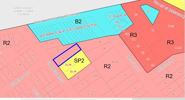
Figure 8:
Zone map - subject site is outlined in blue
46. The extent to which the proposal
complies with the relevant standards of Hurstville Local Environmental Plan
2012 (HLEP 2012) is outlined in the table below.
|
Clause
|
Standard
|
Assessment Under HLEP 2012
|
|
Part 2 –
Permitted/Prohibited Development
|
R2 Low Density
Residential
|
The Application is for an early
childhood education facility. For the purposes of definition the
Applicant seeks approval as a child care centre (CCC) which is permissible in
the zone.
|
|
|
Objectives of the Zone
|
The proposal does not comply with
two objectives of the zone (see discussion following this table).
|
|
4.3 – Height of Buildings
|
9m as identified on Height of
Buildings Map
|
8.9m
|
|
4.4 – Floor Space Ratio
|
0.6:1 as identified on Floor Space
Ratio Map
|
0.6:1.
|
|
4.5 – Calculation of floor space
ratio and site area
|
FSR and site area calculated in
accordance with Cl.4.5
|
FSR has been calculated correctly.
|
|
6.7 – Essential Services
|
The following services that are
essential for the development shall be available or that adequate
arrangements must be made available when required:
* Supply of water, electricity and
disposal and management of sewerage
* Stormwater drainage or on-site
conservation
* Suitable vehicular access
|
Adequate facilities for the supply
of water and for the removal of sewage and drainage are available to this
land.
The method for disposal of
stormwater has not been addressed to the satisfaction of Council’s
Development Engineer. This forms one of the reasons for refusal.
Council’s Traffic Engineer
has identified that the design of the ramp and basement is inadequate for the
level of use proposed. This forms one of the reasons for refusal.
|
Part 2 – Permitted or
Prohibited Development
Objectives of
Zone
47. The proposed
use seeks consent to provide a child care service that must satisfy the
following objectives of the zone, including:
To enable other land uses that provide facilities or
services to meet the day to day needs of residents.
To ensure that a high level of residential amenity is
achieved and maintained.
48. It is
acknowledged that the proposal will provide a service to meet the needs of the
local residents, however the design of the proposal and the inadequacy of
provided information, with respect to parking, noise and visual impact,
together with the cumulative impact of the neighbouring centres, means it has
not been demonstrated that a high level of residential amenity will be
maintained.
Draft Georges River Local
Environmental Plan 2020
49. Consideration
is given to the provisions of Draft Georges River Local Environmental Plan 2020
in the assessment this application.
50. In this regard, the
provisions have no determining weight as a result of proposed operation of
Clause “1.8A Savings provisions relating to development
applications” of the Draft Plan which provides “If a
development application has been made before the commencement of this Plan in
relation to land to which this Plan applies and the application has not been
finally determined before that commencement, the application must be determined
as if this Plan had not commenced.”
Development
Control Plans
Hurstville
Development Control Plan No 1 - LGA Wide
51. The proposal has been considered in
accordance with the applicable subsections and considerations below.
DEVELOPMENT
CONTROL PLAN NO 1 – LGA WIDE – SECTION 3.1 VEHICLE PARKING, ACCESS
AND MANOEUVRING
|
Section
3.1
|
Requirements
|
Proposed
|
Complies
|
|
3.1.4.1 (table) – Child care
centres refers requirements under 5.4.10
|
1 space per 2 staff (8 staff
required) = 4 car spaces
1 space per 10 children (60
children) = 6 car spaces
Total required = 10 car spaces
|
4 proposed
5 proposed
9 spaces proposed
|
Yes
No
No
|
52. The Traffic Report states the
proposed child care centre is an extension of the adjoining child care centres
at 32-34 Chamberlain Street. This directly conflicts with the Statement of
Environmental Effects which says the centre has the same owner but will be
operated independently of the existing centres adjoining the subject site.
53. The proposal has a shortfall of one
(1) parking space within the proposed parking area and suggests the shortfall
can be compensated with timed on street parking, an extension of the three (3)
timed on-street parking spaces in front of the child care centres at 32-34 Chamberlain
Street. The applicant has not made an application to the Traffic Committee for
this and Council’s Traffic Engineer had advised there is no guarantee the
application will be supported.
54. The application has been reviewed
by Council’s Traffic Engineer who provided the following comments:
- On site parking for the child care
centre is deficient by one (1) car parking space. Council’s Traffic
Engineer has advised the child care centre cannot rely on introducing
time-restricted on street parking for their drop off and pick up as approval
from Council’s Traffic Committee is required, an approval for which has
not been sought by the applicant.
- The traffic generation of the
childcare centre for 60 children would result in more than 30 movements per peak
hour. This triggers the need for a passing bay at the entrance to the basement
parking area/top of the driveway, as per AS2890.1:2004 3.2.2, in addition to
the passing bay at the bottom of the driveway to ensure cars can safely wait at
either the top or the bottom of the ramp when another car is passing on the
ramp, this cannot be accommodated in the current design.
- The basement design does not
provide designated and safe pedestrian paths.
55. The failure of
the proposal to meet the relevant standards for ramp design to cater for the
anticipated number of vehicle movements generated by 60 children at the centre,
the shortfall of required parking spaces and reliance on timed on-street
parking (without the necessary approval from Council/Traffic Committee)
together with the fact that the adjacent child care centres, owned by the
applicant of the subject application, only provides parking for 5 cars for a
centre that has consent to accommodate 77 children cumulatively, will adversely
impact parking in Chamberlain Street resulting in an unacceptable cumulative
impact on the locality with respect to parking and traffic.
56. The
non-compliant parking and access design forms one of the reasons for refusal.
DEVELOPMENT
CONTROL PLAN NO 1 – LGA WIDE – SECTION 3.3 ACCESS AND MOBILITY
57. This section of
Development Control Plan No 1 requires the provision of
“access for all persons through the principal entrance and access to
appropriate sanitary facilities in accordance with the BCA and relevant
Australian Standards.”
58. The Application is accompanied by
an Access Review Report prepared by Morris Goding, dated 13 November 2018. It
is unclear which plans form the basis of the Access Report plan numbers have
been referenced, but there is no copy associated with the report as it is dated
2018 the plans submitted with the application are dated 28.09.19.
59. The inconsistency of the report
with the architectural plans forms one of the reasons for refusal.
DEVELOPMENT
CONTROL PLAN NO 1 – LGA WIDE – SECTION 3.4 CRIME PREVENTION THROUGH
ENVIRONMENTAL DESIGN
|
Section 3.4
|
Requirements
|
Proposed
|
Complies
|
|
Fencing
|
Allows natural surveillance to
street
|
Open style fencing and glass doors.
The landscaping will at maturity be 1600mm high obscuring the line of site to
public domain.
|
Yes
|
|
Blind Corners
|
To be avoided
|
The car park design and access from
the car park to the ground level outdoor play area creates blind corners.
|
No
|
|
Communal Areas
|
Provide opportunities for natural
surveillance
|
There are no communal areas proposed
as part of the centre however outdoor areas can be seen from internal areas
through glass doors.
|
Yes
|
|
Entrances
|
Clearly visible and not confusing
|
Lift access is provided from the
parking area however visitors are then required to travel through Classroom 2
to access the bag lockers and play room 1 (no formal delineated reception
area is noted on the architectural plans). This results in parents and carers
unnecessarily accessing play areas of the centre.
The plans currently show visitors
to the centre must walk through play room 1 (0-2 year olds) to sign in, which
is undesirable.
|
No
|
|
Site and Building Layout
|
- Provide
surveillance opportunities
- Building
addresses street
- Offset
windows
|
The provision of a play area in the
front setback cannot be adequately screened from the street to prevent
overlooking from the street without a solid fence being used, which will not
be in keeping with the residential character of the site and would not allow
for surveillance of the street from inside the centre. The proposed
landscaping will reduce surveillance opportunities to the street.
Surveillance from the first floor
to the street is difficult as the sill height is 1200mm.
|
No
|
|
Lighting
|
- Diffused/movement
sensitive lighting provided externally
- Access/egress
points illuminated
- No
light spill towards neighbours
- Hiding
places illuminated
- Lighting
is energy efficient
|
No lighting details were provided
with the application.
|
Cannot be demonstrated
|
|
Landscaping
|
- Avoid
dense medium height shrubs
- Allow
spacing for low growing dense vegetation
- Low
ground cover or high canopy trees around car parks and pathways
|
No planting is proposed in the
front setback that would obscure a view to the street.
Cascade Lilly Pilly’s are
proposed which at maturity grow to 1600mm.
|
Yes
|
|
Building Identification
|
- Clearly
numbered buildings
- Entrances
numbered
- Unit
numbers provided at entry
|
Can be conditioned to satisfy these
requirements, should the application be approved.
|
Yes
|
|
Security
|
Provide an appropriate level of
security
|
No security details were submitted
with the application. A Plan of Management would include such details,
however one was not submitted.
|
No
|
|
Ownership
|
Use of fencing, landscaping, colour
and finishes to imply ownership
|
The signage shown on the street
elevation plan indicates the property is a child care centre. No name has
been provided.
|
No
|
DEVELOPMENT
CONTROL PLAN NO 1 – LGA WIDE – SECTION 3.5 LANDSCAPING
60. No
significant vegetation is proposed for removal.
61. The
Landscape Plan submitted with the DA contains inconsistencies with the
architectural plans including showing a rubber surface
in the outdoor play areas and the Architectural plans indicating lawn in the
rear play area. In addition the submitted Landscape Plan fails to meet the
requirements of Council’s DA checklist.
62. Further
there is insufficient deep soil proposed due to the excavation associated with
the parking area and treatment of the outdoor play areas, which results in
little opportunity for substantial landscaping across the site. This forms one
of the reasons for refusal. In addition, the proposed landscaping in the front
play area adjacent to the pool fencing will obscure surveillance of the street
from the indoor and outdoor play areas.
DEVELOPMENT
CONTROL PLAN NO 1 – LGA WIDE – SECTION 3.7 STORMWATER
63. The
submitted drainage plans are inadequate and there is insufficient information
shown in order to comply with Council's requirement to drain the proposed
development.
64. The following information was requested however was not provided:
- A
longitudinal section for the stormwater pipe crossing the footpath area showing
the concrete paving over the stormwater conduit.
- Details
to demonstrate the method of the stormwater disposal of all the site paving.
- Details
to demonstrate how 80% of the site runoff passes through the on-site detention
system.
- Details
to demonstrate the method of stormwater disposal from the site area indicated
as the soft rubber area.
DEVELOPMENT
CONTROL PLAN NO 1 – LGA WIDE – WASTE MANAGEMENT
65. Insufficient
information was submitted in relation to waste management, including:
- The
expected volumes and types of waste to be generated from use of the site.
- Details
of how this waste is to be stored on site, including provisions for the
separation of waste types, and details of any specialised waste services.
- Details
of how ongoing management of waste will be conducted.
- Details
of the arrangements for the ongoing maintenance and cleaning of the bins.
- Details
on the frequency and times of collection of waste, and the proposed measures to
minimise impacts on neighbouring properties.
- In the
absence of Council being the nominated waste service provider, written evidence
that at least one (1) waste contractor has been consulted regarding waste
collection, and the details of the preferred private waste contractor to
provide the service.
66. Noting
the three (3) bins nominated to be stored in the basement which are inadequate
for a centre of this size, and in light of the above:
- The
location and design of the designated waste storage area/s, capable of
accommodating all waste generated on the premises and allowing for separation
of waste types is required to be nominated.
- The location
of any grease traps.
- Identification
of collection points for the bins, including path of travel for moving bins
from storage area to collection point (if kerbside collection) or vehicular
access path to storage area (if on-property collection). The transfer of bins
to a collection point and their return is the responsibility of a caretaker or
management.
67. The absence of these details means
that it has not been demonstrated that the proposal has been designed with
sufficient care to ensure appropriate management on site, or managed
appropriately in this regard. This forms part of the reasons for refusal.
IMPACTS
Natural
Environment
68. The proposed development fails to
demonstrate that it will not result in any adverse impacts upon the natural
environment. Stormwater and waste management have not been adequately addressed
and insufficient deep soil area results in a poor landscaping outcome and
adverse visual impacts for neighbours.
Built
Environment
69. The proposed development will
result in adverse impacts upon the built environment as a result of the built
form. The proposed semi-basement level results in the balcony outdoor play area
being elevated above the natural ground level which will adversely impact on
the acoustic and visual privacy of residential neighbours, and also results in
a poor built form on the north-western elevation with the external basement
wall and acoustic screening above. In addition, stormwater management has not
been adequately addressed to the satisfaction of Council’s Engineer.
Social Impact
70. The documentation submitted with
the application fails to demonstrate the proposal will not have adverse impacts
on the amenity of neighbouring properties.
Economic Impact
71. There is no apparent adverse
economic impact that is likely to result within the locality in relation to the
proposed child care centre.
Suitability
of the Site
72. The
site is zoned R2 Low Density Residential. The proposal is a permissible form of
development in this zone. However the application fails to demonstrate how the
child care centre can be accommodated on site without adversely impacting the
visual and acoustic privacy of neighbouring properties, provide adequate and
compliant vehicular access and parking, and provide suitably located and
substantial landscaping, adequately drain the site and manage waste storage and
collection.
SUBMISSIONS
AND THE PUBLIC INTEREST
73. The proposal was notified to adjoining
neighbours for a period of fourteen (14) days during which three (3)
submissions objecting to the development were received. The submissions raised
the following issues.
· Traffic
congestion and parking demand.
74. Officer Comment – The
proposal fails to provide adequate parking and vehicle manoeuvrability on site
which forms one (1) of the reasons for refusal of the application.
· Privacy
impacts on yard and upper level windows of rear neighbour.
75. Officer Comment – The
elevated outdoor play area is considered to have an adverse privacy impact on
the residential neighbour to the rear, which forms one of the reasons for
refusal.
· Excessive
size of the building
76. Officer Comment – The
floor space complies with the Local Environmental Plan controls, however the
design has not had regard to the topography of the site and the elevated built
form above natural ground level is considered excessive and to have adverse
visual impacts on residential neighbours, and forms one of the reasons for
refusal of the application.
Council
Referrals
Traffic
Engineer
77. Onsite
parking for the child care centre is deficient by one car parking space.
Council’s Traffic Engineer has advised the child care centre cannot rely
on introducing time restricted on street parking for their drop off and pick up
as approval from the Traffic Committee is required; this has not been sought by
the applicant.
78. The traffic
generation for the child care centre for 60 children would result in more than
30 movements per peak hour. This triggers the need for a passing bay at the
entrance to the basement parking area/top of the driveway, as per AS2890.1:2004
3.2.2, in addition to the passing bay at the bottom of the driveway. This is
not provided and as such safe access and egress to and from the basement has
not been demonstrated and cannot be accommodated in the current design.
79. The basement design does not provide
designated and safe pedestrian paths resulting in inadequate safety for
pedestrians in this space from incoming and exiting vehicles.
80. A Plan of
Management has not been submitted to detail how the tandem staff spaces will be
managed.
Environmental Health
Officer
116. Insufficient
information has been included on the plans to demonstrate compliance with
AS4674-2004 (Food Premises). The Acoustic Report references different
architectural plans to those submitted with the DA as it states there are ten (10)
parking spaces in the semi-basement level when there are nine (9) shown on the
architectural plans submitted with the DA.
In
addition, the Acoustic Report suggests in order for the proposed centre to be
meet the relevant standards with regard to noise levels generated by the
centre, given its location next door to a centre that currently caters for 77
children, outdoor play areas should be staggered between the centres, i.e. no
outdoor play can occur at the same time between centres and the balcony play
area should not be used for more than 2 hours per day as detailed by the
acoustic report. As no Plan of Management has been submitted with this
application, Council is not satisfied at this time this issue can be
satisfactorily resolved.
Consultant Arborist
117. There
are no significant trees proposed for removal or potentially impacted by the
proposal, however the landscape plan submitted with the application is
inconsistent with the architectural plans as it states a rubber will surface
will be laid to the outdoor play area and the architectural plans indicate turf
will be used. The plan does not meet the requirements for a Landscape Plan
pursuant to Council’s lodgement requirements.
Development
Contributions
118. The development is subject of a Section
7.12 contribution (former Section 94A Contribution), under the provisions of
the Georges River Council Section 94A Contributions Plan 2017. The below
information, will form a part of the conditions of consent if the application
was to be supported.
|
Fee Type
|
Fee
|
|
Georges River
Council Section 94A Development Contributions Plan 2017
|
$9,411.41
|
CONCLUSION
119. Development consent is
sought for demolition of existing structures and the construction of an early
childhood education facility for sixty (60) children, car parking for nine (9)
vehicles and site works.
120. The proposal does not
satisfy the zone objectives of the Hurstville Local Environmental Plan 2012 and
results in multiple variations to the Development Control Plan
No 1 - LGA Wide and the Child Care Planning Guidelines 2017 for which it
has not been demonstrated that sufficient grounds for variation exist.
121. The application fails to
demonstrate compliance with State Environmental Planning Policy (Educational
Establishments and Child Care Facilities) 2017 and Childcare Planning
Guidelines, State Environmental Planning Policy 55 (Remediation of Land) and
the Water Management Act, 2000 in not providing required soil testing or
geotechnical reports.
122. Based upon the information
provided to date, it is assessed that the proposal will have an adverse and
unreasonable environmental impact in the following regard:
o The centre adjoins three (3) centres
on the adjoining site to the south east, which current has consent for up to 77
children combined on these sites. Only five (5) parking spaces are currently
provided for these three (3) centres. The proposal currently before Council is
seeking to construct a basement carpark to accommodate nine (9) vehicles. The
carpark access includes an inadequately wide ramp design for the class of use
proposed, with the basement being deficient by one (1) car parking space.
o The design of the facility is not
consistent with the Child Care Planning Guideline in that:
- the
entry sequences (from both the basement car park and the street) are convoluted
and provide access directly into play spaces (with no formalised reception area
noted on the plans);
- inadequate
outdoor space is provided;
- access
between the upper floor childcare room and the outdoor open space area is not
direct or easy being via a small lift or narrow staircase;
- inadequate
indoor and outdoor storage demonstrated on the plans; and
- inadequate
separation between kitchen facilities and play spaces provided.
o Inadequate landscaping is provided
on the site, with the front setback being dedicated to an impermeable (soft
rubber) area used as the outdoor play space for play room 1 which includes a
shade sail over. To comply with the safety criterion this area is proposed to
be fenced by an 1800mm high fence on the boundary and the side returns, and in
the rear yard. The rear play area 2 which is part on an elevated deck with roof
over and part on the ground level with a shade sail over for classroom 2
and 3 is also impermeable (soft rubber). This area is also fenced and screens
on the balcony level to a height of 1800mm. There are sporadic pockets of
natural vegetation.
o The proposal will have an adverse
acoustic and visual privacy impact on adjacent residential properties with
noise and views from the elevated play space in the rear.
o The food preparation areas are
inappropriate for a centre of this size and it has not been demonstrated that
these comply with the relevant food standards. The application is not clear
whether children will bring their own food from home or whether it is provided
by the centre prepared on site or prepared off site and brought in and served.
o The proposed building form is
keeping a consistent floor level throughout the ground floor which, due to the
slope of the site results in the ground floor level at the rear being
excessively elevated. The elevated area is one of the rear primary outdoor play
spaces for the older children. This results in an unreasonable visual and
acoustic impact.
o The waste arrangements are
unsuitable for a centre of this size and will result in adverse environmental
impacts due to insufficient storage capacity and details on how and by whom the
waste will be removed from the site.
o The proposed building form is
excessively elevated and bulky and has an unreasonable visual impact.
123. The application is
recommended for refusal having regard to the following:
· the
inconsistencies between documentation lodged with the application;
· the
potential traffic access and generation and on-site car parking issues
associated with the development;
· the
acoustic impacts likely to result from the child care facility proposal;
· insufficient
areas of deep soil for substantial landscaping; and
· adverse
visual and privacy impacts on residential neighbours.
DETERMINATION
124. THAT
pursuant to Section 80(1)(b) of the Environmental Planning and Assessment
Act, 1979, as amended, the Georges River Local Planning Panel refuse
development consent to Development Application DA2020/0050 for demolition works
and construction of child care facility for 60 children, car parking for nine
(9) vehicles and associated site works on Lot 47 in DP 10112, known as 36
Chamberlain Street, Narwee for the following reasons:
1. Environmental
Planning Instrument - Pursuant to Section 4.15(1)(a)(i) of the
Environmental Planning and Assessment Act 1979, the proposed development fails
to comply with State Environmental Planning Policy (Educational Establishments
and Child Care Facilities) 2017 (Child Care Planning Guidelines) in terms of
the following adverse impacts:
(a) Acoustic and visual privacy impacts on
residential neighbours.
(b) Visual impacts resulting from the built
form of the proposal.
(c) On-street parking pressure due to
a shortfall of parking on site.
(d) Insufficient landscaping across the
site.
(e) Failure to correctly calculate indoor
and outdoor play areas.
(f) A Preliminary Site Investigation
Report was not submitted with the application. Accordingly it has not been
demonstrated that the site is safe in its present condition for the use
proposed.
(g) The application is inconsistent with the
Childcare Planning Guideline in relation to entry into the centre form the
basement and the street, internal layout and design of the centre, and an
unacceptable relationship between indoor and outdoor play areas.
(h) No details on whether children will
bring their own food from home or whether it is provided by the centre either
cooked in house or delivered prepared and ready to serve.
2. Environmental
Planning Instrument - Pursuant to Section 4.15(1)(a)(i) of the
Environmental Planning and Assessment Act 1979, the proposed development does
not comply with the State Environmental Planning Policy No. 55 –
Remediation of Land as a Preliminary Site Investigation Report has not been
submitted with the application. Accordingly it has not been demonstrated that
the site is safe in its present condition for the use proposed.
3. Environmental
Planning Instrument - Pursuant to Section 4.15(1)(a)(i) of the
Environmental Planning and Assessment Act 1979, the proposed development does
not comply with the Water Management Act, 2000 as a Geotechnical Investigation
Report was not submitted with the application. Accordingly it has not been
demonstrated that the proposal will not trigger a referral to, and approval of,
Water NSW.
4. Environmental
Planning Instrument - Pursuant to Section 4.15(1)(a)(i) of the
Environmental Planning and Assessment Act 1979, the proposed development is
inconsistent with the objectives of the R2 Low Density Residential zone of
Hurstville Local Environmental Plan 2012 in terms of the following:
(a) The proposal does not ensure a high
level of residential amenity is maintained due to the adverse acoustic and
visual privacy impacts, the bulk and scale of the elevated built form, lack of
landscaping and adverse visual impacts as a result of the built form of the
proposal.
5. Development
Control Plan - Pursuant to Section 4.15(1)(a)(iii) of the Environmental
Planning and Assessment Act 1979, the proposed development does not comply with
the Chapter 3.1 Vehicle Access, Parking and Manoeuvring of the Hurstville
Development Control Plan No. 1:
(a) The proposal fails to provide sufficient parking
on the site (shortfall of one space) and has not demonstrated compliance with
the relevant Australian Standard with respect to the design of the parking area
or access to and from the parking area.
6. Development
Control Plan - Pursuant to Section 4.15(1)(a)(iii) of the Environmental
Planning and Assessment Act 1979, the proposed development does not comply with
the Chapter 3.5 Landscaping of the Hurstville Development Control Plan No. 1:
(a) The application fails to provide sufficient deep
soil to enable quality landscaping to be provided on the site.
7. Adequacy
of Information - Pursuant to Section 4.15(1)(a)(iii) of the Environmental
Planning and Assessment Act 1979, the following information was not submitted
and is required to undertake a full and proper assessment of the application:
(a) A Preliminary Site Investigation Report in accordance with the childcare guidelines and SEPP 55 to ensure
the site is suitable for the highly sensitive childcare use;
(b) Plan of Management to demonstrate that impacts of the use can be managed in a manner
that will minimize impacts on adjoining uses and the environment more
generally.
(c) A Geotechnical Report to confirm that excavation
works will not encounter groundwater (triggering the requirement for an
approval from Water NSW) and is suitable for the level of excavation proposed.
(d) A Building Code of Australia (National Construction Code)
Report to demonstrate that the design shown on the architectural plans is able
to be realized with respect to National Construction Code requirements;
(e) A Social Impact Assessment to demonstrate the need for the
centre in this location.
8. Consistency
of Information - Pursuant to Section 4.15(1)(b) of the Environmental
Planning and Assessment Act 1979, there are inconsistencies between the
following reports/plans and the architectural plans submitted with the
application:
(a) Statement of Environmental Effects.
(b) Access Report.
(c) Acoustic Report.
(d) Traffic Report.
(e) Landscape Plan.
9. Impacts
on the Environment - Pursuant to Section 4.15(1)(b) of the Environmental
Planning and Assessment Act 1979, the proposed development is likely to have an
adverse impact on the following aspects of the natural environment:
(a) The proposal fails to provide sufficient
areas of deep soil to accommodate substantial landscaping and facilitate the
natural ingress of water.
10. Impacts on
the Environment - Pursuant to Section 4.15(1)(b) of the Environmental
Planning and Assessment Act 1979, the proposed development is likely to have an
adverse impact on the following aspects of the built environment:
(a) The proposed semi-basement level results
in the balcony outdoor play area being elevated above the natural ground which
will adversely impact on the acoustic and visual privacy of residential
neighbours and also results in poor built form presenting to the north-western
elevation with the external basement wall and acoustic screening above.
11. Suitability
of Site - Pursuant to Section 4.15(1)(c) of the Environmental Planning and
Assessment Act 1979, the site is not considered suitable for the proposed development
as:
(a) Safe and compliant vehicular entry and
exit to and from the parking area has not been demonstrated.
(b) The built form is excessively bulky for
the site and results in adverse privacy and visual impacts for residential
neighbours as the development has not followed the site topography.
(c) The information submitted with the
application is inconsistent and contains insufficient detail to make a full and
proper assessment.
12. Public interest
- Pursuant to Section 4.15(1)(e) of the Environmental Planning and
Assessment Act 1979, the proposed development is not considered to be in the
public interest and is likely to set an undesirable precedent within the
locality.
ATTACHMENTS
|
Attachment ⇩1
|
Site Plan and Elevations
|
|
Georges River Council – Local Planning
Panel Thursday, 4 June 2020
|
Page 146
|
REPORT TO GEORGES RIVER COUNCIL
LPP MEETING OF Thursday, 04 June 2020
|
LPP Report No
|
LPP026-20
|
Development Application No
|
DA2019/0265
|
|
Site Address & Ward Locality
|
6 Blakesley Road Carlton
Kogarah Bay Ward
|
|
Proposed Development
|
Use of the premises as a depot for
a civic works company operating between 6am - 7pm Monday to Friday inclusive
and 7am - 4pm Saturday
|
|
Owners
|
Mrs R Saad and Mr H Saad
|
|
Applicant
|
Urbanism Pty Ltd - Mr Wesley
Folitarik
|
|
Planner/Architect
|
Planner: Urbanism Pty Ltd –
Mr Wesley Foltarik (author of Statement of Environmental Effects); Architect:
Machinations
|
|
Date Of Lodgement
|
1/07/2019
|
|
Submissions
|
Three (3) submissions and one (1)
submission containing fourteen (14) signatures
|
|
Cost of Works
|
Nil – development proposes
only the use of the premises, no physical works or signage proposed
|
|
Local Planning Panel Criteria
|
Nature of proposed development
– it is in the public interest that this DA be determined by the Local
Planning Panel under Council Delegations
|
|
List of all relevant s.4.15
matters (formerly s79C(1)(a))
|
Environmental Planning &
Assessment Act 1979; Environmental Planning & Regulation 2000.
State Environmental Planning Policy
No 55 – Remediation of Land; State Environmental Planning Policy
– Infrastructure; State Environmental Planning Policy (Vegetation in
Non-Rural Areas) 2017; Greater Metropolitan Regional Plan No.2 – Georges
River Catchment, Draft State Environmental Planning Policy –
Remediation, Draft Environment State Environmental Planning Policy,
Kogarah Local Environmental Plan
2012; Kogarah Development Control Plan 2013, Draft Georges River Local
Environmental Plan 2020
|
|
List all documents submitted
with this report for the Panel’s consideration
|
Architectural Plans
Statement of Environmental Effects
Acoustic Report
|
|
Report prepared by
|
Development Assessment Planner
|
|
Recommendation
|
That the application be approved in accordance with the
conditions included in the report.
|
|
|
Summary of matters for
consideration under Section 4.15
Have all recommendations in relation
to relevant s4.15 matters been summarised in the Executive Summary of the
assessment report?
|
Yes
|
|
Legislative clauses requiring
consent authority satisfaction
Have relevant clauses in all
applicable environmental planning instruments where the consent authority
must be satisfied about a particular matter been listed and relevant
recommendations summarised, in the Executive Summary of the assessment
report?
|
Yes
|
|
Clause 4.6 Exceptions to
development standards
If a written request for a
contravention to a development standard (clause 4.6 of the LEP) has been
received, has it been attached to the assessment report?
|
Not
Applicable
|
|
Special Infrastructure
Contributions
Does the DA require Special
Infrastructure Contributions conditions (under s7.24)?
|
Not
Applicable
|
|
Conditions
Have draft conditions been provided
to the applicant for comment?
|
No
– however the conditions of consent can be reviewed when the report is
published.
|
|
Aerial Photo
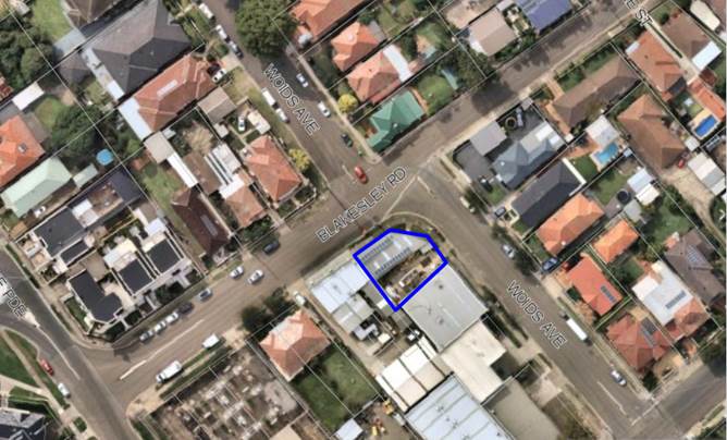
Subject site outlined in
blue
|
Executive Summary
Proposal
1. This
development application (DA) seeks consent for the use of the premises as a
“depot” for the storage of plant, machinery and equipment
associated with a civil works company involved in the maintenance of footpaths,
roads, pavements etc. The property has been used as a depot since some time in
2018 without the required development consent.
2. This
is identified in Council’s Records as a Notice of Intention to Issue a
Noise Control Notice (Record Number: 18/1584). The applicant requested to seek
an exemption from Council; if the proposed works could be identified as an
exempt development, however correspondence was sent December 2018 to Civil
Streetscapes advising that Council's investigations have demonstrated the use
of the Premises accords with the definition of ‘depot’ in the
Kogarah Local Environmental Plan 2012 (KLEP). While depots are permissible in
the IN2 Light Industrial Zone, the use is only permissible with development
consent. And as such, development consent has not been lodged with
Georges River Council or the ormer Kogarah Council and the use of the Premises
would be unlawful without the proper approval in place. Following this
correspondence this Development Application was lodged with Council in July,
2019.
3. The
Statement of Environmental Effects submitted with the DA, details the depot is used for the storage of plant, machinery and
goods which are not used or operated on site, but are loaded and unloaded onto
vehicles at this site for use off site. There is no retail component associated
with this use.
4. The plant, machinery and goods include timber/metal frames,
rigs, safety equipment, drills, plant (stored in the store room), augers,
fences, barricades, witches hats and other machinery attachments (stored in the
enclosed storage yard). None of the materials stored on site are retailed to
the general public from the site or delivered offsite for retail sale. All
materials are used in conjunction with civil works contracts undertaken by the
business operator.
5. The business has five (5) full time employees although none
are based at the site permanently. Employees attend the site to load and unload
vehicles with the necessary equipment and materials for the jobs.
6. Up to four (4) vehicles access the site, the largest of
which is 10.4 tonne. These vehicles are loaded in the morning and unloaded in
the evenings and are stored on site in the both the enclosed storage yard area
and store room. The smallest work vehicles consist of utility vehicles and
vans. At full operation there will be 6-8 work related vehicle trips and 2-4
vehicle movements for private vehicles to and from the site each day. These
will be largely limited to the morning peak and afternoon/evening as staff
arrive load and leave with work vehicles and return again in the evening to
unload and leave in private vehicles.
7. The
DA seeks consent for the following hours of operation associated with the use:
· 6:00am to 7:00pm Monday to Friday
· 7:00am to 4:00pm Saturday
· No work Sundays or Public Holidays
Site and Locality
8. The
subject site is legally identified as Lot A DP377099, with a street address of
6 Blakesley Road, Carlton. The site is irregular in shape and has a total site
area of 305.7sqm with a curved frontage partly fronting Blakesley Road and
partly fronting Woids Avenue of 31.74m.
9. Existing
on the site is a single-storey brick industrial building (located on the north
eastern side of the site), with an open external yard (on the southern side of
the site). As part of the depot use which currently operates by the identified
owner(s). The building is being used for ancillary office/administration
purposes associated with the use, as well as storage of some plant and
equipment. The external yard area is used for storage of plant and equipment as
well as for loading/unloading of the plant/equipment. The site is fully
enclosed by a brick building that is on a zero boundary setback with a roller
door facing Blakesley Road and a masonry fence with metal gates along the Woids
Avenue frontage. There is a retail premises on a zero setback to the west of
the site and 2 storey industrial building to the south also with a zero setback
to the subject site.
10. The
subject site is located on the northern side of the Carlton industrial area,
and properties to the south west and south east (along Blakesley Road and Woids
Avenue) are used for industrial purposes. Directly across the road from the
subject site (to the west, north and east) are residential properties where the
land contains predominantly detached one and two storey dwelling houses.
11. Photos
of the subject site are provided below.
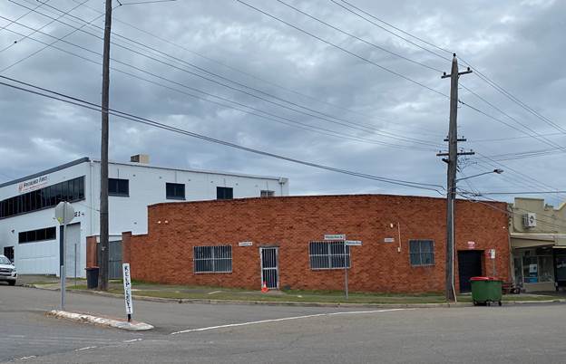
Figure 1: Subject
site, viewed from the north
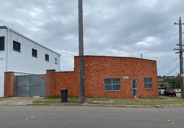
Figure 2: Subject
site, viewed from the east (Woids Avenue)
Zoning and Permissibility
12. The
subject site is zoned IN2 – Light Industrial under the provisions of
Kogarah Local Environmental Plan 2012 (KLEP 2012). The proposed use is defined
as a depot is permissible with consent.
Submissions
13. The
application was notified to neighbours between 9 and 23 July 2019 in accordance
with the Kogarah Development Control Plan 2013 (KDCP2013).
14. A
total of four (4) submissions objection to the proposal were received. Three
(3) individual letters and one (1) submission containing fourteen (14)
signatures were received. The submissions raised the following issues of
concern which are discussed in detail later in this report:
· Insufficient
on-site parking, causing trucks/equipment and employee vehicles to be parked in
the street;
· The stated
(proposed) hours of operation are unacceptable – in particular early
(6am) starts. Site activities are said to occur earlier than the stated start
time of 6am;
· Loading/unloading
in the street instead of on-site;
· Truck
parking and loading/unloading in the street causes reduction in on-street
parking;
· The site is
too small for the intended use;
· The site is
too close to residential properties and causes significant amenity impacts to
those residences (noise, early morning starts, truck movements etc.);
· Heavy
vehicles associated with the development using residential roads.
15. It
is considered that the proposed development is acceptable in this location.
Although a number of issues of concern have been raised in the
neighbours’ submissions, issues have been satisfactorily addressed by the
applicant specifically in relation to noise generation and treatment of the
site to implement noise mitigation measure and the operation to be conducted in
accordance with the Plan of Management associated with the site, which is
discussed in detail later in this report.
Reason
for Referral to the Local Planning Panel
16. This
DA is referred to the Local Planning Panel for determination, as it is in the
public interest due to the nature of the proposed development, being an
industrial use with potential amenity impacts given its close proximity to
residential properties as outlined in Council delegations.
Conclusion
17. The
development has been assessed in accordance with the matters for consideration listed
in Section 4.15 of the Environmental Planning and Assessment Act 1979,
including the provisions of the relevant Acts, Regulations, State Environmental
Planning Policies, Local Environmental Plans and Development Control Plans.
18. It
is considered that the development is satisfactory subject to conditions of
consent, including full compliance with the recommendations of the Acoustic
Report and Plan of Management accompanying the Development Application.
19. Although
the Development Application submission requests hours of operation starting at
6am and concluding at 7pm, this is not considered to be appropriate given that
the site is located immediately adjoining a low-density residential zone
(across Blakesley Road/Woids Avenue). It is recommended that the hours of
operation be limited to: 7:00am to 6:00pm, this is in
accordance with the Development Control Plan Monday to Friday and 7:00am to
4:00pm Saturday. No work Sundays or Public Holidays.
Report in Full
Proposal
20. This
development application (DA) seeks consent for the use of the premises as a
“depot” for the storage of plant, machinery and equipment
associated with a civil works company involved in the maintenance of footpaths,
roads, pavements etc. The property has been used as a depot since some time in
2018 without the required development consent.
21. The
subject site has been used for industrial purposes for over 60 years, with the
current “depot” use operating without consent, which resulted in a
Notice being served on the subject site. Following this Notice this Development
Application was lodged with Council in July 2019.
22. According
to the submitted Statement of Environmental Effects submitted with the DA, the depot is used for the storage of plant, machinery and
goods which are not used or operated on site, but are loaded and unloaded onto
vehicles at this site for use off site.
23. The plant, machinery and goods include materials, such as
timber metals frames, rigs, safety equipment, drills, plant (stored in the
store room) and augers, fences, barricades, witches hats and other machinery
attachments (stored in the enclosed storage yard). None of the materials stored
on site are retailed to the general public from the site or delivered offsite
for retail sale. All materials are used in conjunction with civil works
contracts undertaken by the business operator off site.
24. The business has 5 full time employees although none are
based at the site permanently. Employees attend the site to load and unload
vehicles with necessary equipment and materials for work jobs.
25. Up to four (4) vehicles access the site, the largest of
which is 10.4tonne. These vehicles are loaded in the morning and unloaded in
the evenings are stored on site in the both the enclosed storage yard area and
store room. The smallest work vehicles would be utility vehicles and vans. At
full operation there would be between 6-8 vehicle trips for work vehicles and
2-4 private vehicles to and from the site each day. These are almost entirely
limited to the morning peak and afternoon as staff arrive load and leave with
work vehicles and return again in the evening to unload and leave in private
vehicles.
26. The
DA seeks consent for the following hours of operation associated with the use:
· 6:00am to 7:00pm Monday to Friday
· 7:00am to 4:00pm Saturday
· No work Sundays and Public Holidays
The Site and Locality
27. The
subject site is legally identified as Lot A DP 377099, with a street address of
6 Blakesley Road, Carlton. The site is irregular in shape and has a total site
area of 305.7sqm with a curved frontage partly fronting Blakesley Road and
partly fronting Woids Avenue of 31.74m.
28. Existing
on the site is a single-storey brick industrial building (located on the north
eastern side of the site), with an open external yard (on the southern side of
the site). As part of the depot use which currently operates by the identified
owner(s). The building is being used for ancillary office/administration
purposes associated with the use, as well as storage of some plant and
equipment. The external yard area is used for storage of plant and equipment as
well as for loading/unloading of the plant/equipment. The site is fully
enclosed by a brick building that is on a zero boundary setback with a roller
door facing Blakesley Road and a masonry fence with metal gates along the Woids
Avenue frontage. There is a retail premises on a zero setback to the west of
the site and 2 storey industrial building to the south also with a zero setback
to the subject site.
29. The
subject site is located on the northern side of the Carlton industrial area,
and properties to the south-west and south east (along Blakesley Road and Woids
Avenue) are used for industrial purposes. Directly across the road from the subject
site (to the west, north and east) are residential properties where the land
contains predominantly detached one and two storey dwelling houses.
Background
Subject Site
30. The
subject site has a long history of industrial uses over the past 60 plus years.
Council records indicate that approval was granted on 3 March 1952 for
“the erection of an electrical engineering factory”.
31. According
to Council records and details from neighbour’s complaints and
submissions, the subject site commenced use (without the required approval) as
a depot some time in 2018. A number of complaints regarding the nature of the
use began to be received by Council in July 2018.
32. There
was a range of enforcement actions undertaken by officers in Council’s Compliance
Team, culminating in a Noise Control Notice dated 4 December 2018.
33. It
appears that the proponent may have commenced the use in the belief that the
development was “exempt development” under the provisions of State
Environmental Planning Policy (Exempt and Complying Development Codes) 2008.
However, during the enforcement investigations it was established that the
depot use is not “exempt development” and development consent is
required.
Current
Development Application (DA2019/0265)
34. The
subject DA was lodged on 1 July 2019. Shortly after, the development
application underwent a preliminary review, referral to a number of departments
within Council, and also neighbour notified between 9 and 23 July 2019.
(Further details on the processes of Internal Referral and neighbour
notification are provided later in this report.)
35. On
8 July 2019, following receipt of comments from Council’s Environmental
Health Officer, an Acoustic Report was requested from the applicant to address
the noise impacts of the proposed development.
36. This
Acoustic Report authored by GHD Consulting was received on 16 August 2019 with
advice that the applicant is agreeable to the recommendations of the Acoustic
Report being imposed as conditions of any consent granted for the development.
The Acoustic Report was referred to Council’s Environmental Health
Officer for review and assessment.
37. Council’s
Environmental Health Officer provided comments on 6 September 2019, with a
range of issues of concern relating to the proposed development and requested
further clarification on the nature of the depot usage.
38. A
Plan of Management was submitted by the applicant (dated 14 April 2020) as a
result of the discussions between Council officers and the applicant’s
planning representative. This information was referred to Council’s
Environmental Health Officer and assessed as satisfactory.
Environmental
Planning Instruments
State
Environmental Planning Policies
39. Compliance with the relevant state
environmental planning policies is summarised in the table, and discussed in
more detail below.
|
State
Environmental Planning Policy
|
Complies
|
|
Environmental Planning &
Assessment Regulation 2000
|
Yes
|
|
Greater Metropolitan Regional
Environmental Plan No 2 – Georges River Catchment
|
Yes
|
|
State Environmental Planning Policy
No 55 - Remediation of Land
|
Yes
|
|
State
Environmental Planning Policy (Vegetation in Non-Rural Areas) 2017
|
Yes
|
|
State
Environmental Planning Policy - Infrastructure
|
Yes
|
|
Draft Remediation
of Land SEPP
|
Yes
|
|
Draft State
Environmental Planning Policy (Environment)
|
Yes
|
Environmental
Planning and Assessment Regulation 2000
40. Section 93 of the Environmental Planning and
Assessment Regulation 2000 entitled ‘Fire safety and other
considerations’ applies to a development application for a change of
building use for an existing building where the application does not seek the
rebuilding, alternation, enlargement or extension of a building.
41. In determining the development application, the
consent authority is to take into consideration whether the fire protection and
structural capacity of the building will be appropriate to the building’s
purpose.
42. In this regard, the applicant has submitted
plans and information in relation to fire safety matters, and this has been
referred to Council’s Building Surveyor for assessment. The outcome of
this assessment is that the development is satisfactory and appropriate
conditions of consent have been provided.
State Environmental Planning Policy No 55 – Remediation of
Land
43. SEPP 55 aims to promote the remediation of
contaminated land in order to reduce the risk of harm to human health or any
other aspect of the environment. Clause 7 requires contamination and
remediation to be considered in determining a development application. The
consent authority must not consent to the carrying out of development on land
unless it has considered whether or not the land is contaminated.
44. A review of the site history indicates that the
site has been used for industrial purposes for extended periods of time (at
least 60 years). The current DA involves a change of use of the existing
premises for the purposes of another industrial use (a “depot”).
45. No works are proposed and no disturbance of the
foundation material is sought, this application only involves a change to the
use of the land, with the land continuing to be used for industrial purposes.
It is considered that the subject site is suitable for its intended use.
Greater
Metropolitan Regional Environmental Plan No 2 – Georges River Catchment
46. The main aims and objectives of this plan are:
· to maintain and improve the water quality and river flows
of the Georges River and its tributaries and ensure that development is managed
in a manner that is in keeping with the national, State, regional and local
significance of the Catchment;
· to protect and enhance the environmental quality of the
Catchment for the benefit of all users through the management and use of the
resources in the Catchment in an ecologically sustainable manner;
· to ensure consistency with local environmental plans and
also in the delivery of the principles of ecologically sustainable development
in the assessment of development within the Catchment where there is potential
to impact adversely on groundwater and on the water quality and river flows
within the Georges River or its tributaries;
· to establish a consistent and coordinated approach to
environmental planning and assessment for land along the Georges River and its
tributaries and to promote integrated catchment management policies and
programs in the planning and management of the Catchment.
47. The application is accompanied by concept
stormwater plans prepared by qualified engineers. There is no change to the
existing drainage system.
48. The stormwater plan has been referred to
Council’s Development Engineers. No objection has been raised in
respect to the management and disposal of stormwater and no additional
conditions are required if consent is granted. (the impact of sediment control
carried by stormwater is a separate matter for assessment of the capacity of
the stormwater drainage system)
49. The proposal is therefore considered to be
consistent with the aims, objectives and purpose of the Regional Plan.
State Environmental Planning Policy (Vegetation in Non-Rural Areas)
2017
50. The State Environmental Planning Policy
(Vegetation in Non-Rural Areas) 2017 (‘Vegetation SEPP’) regulates
clearing of native vegetation on urban land and land zoned for environmental
conservation/management that does not require development consent.
51. The Vegetation SEPP applies to clearing of:
a. Native vegetation above the Biodiversity Offset
Scheme (BOS) threshold where a proponent will require an approval from the
Native Vegetation Panel established under the Local Land Services Amendment
Act 2016; and
b. Vegetation below the BOS threshold where a
proponent will require a permit from Council if that vegetation is identified
in the Council’s Development Control Plan (DCP).
52. The Vegetation SEPP repeals clauses 5.9 and
5.9AA of the Standard Instrument - Principal Local Environmental Plan, with the
regulation of the clearing of vegetation (including native vegetation) below
the BOS threshold being through any applicable DCP.
53. No issues arise in terms of the provisions of
the Vegetation SEPP, as there is no significant vegetation on the site or
within the footpath area of Blakesley Road or Woids Avenue fronting the site.
Draft
Remediation of Land SEPP
54. The Department of Planning and Environment has
announced a Draft Remediation of Land SEPP, which will repeal and replace the
current State Environmental Planning Policy No 55—Remediation of Land.
55. The main changes proposed include the expansion
of categories of remediation work which requires development consent, a greater
involvement of principal certifying authorities particularly in relation to
remediation works that can be carried out without development consent, more
comprehensive guidelines for Councils and certifiers and the clarification of
the contamination information to be included on Section 149 Planning
Certificates.
56. Whilst the proposed SEPP will retain the key
operational framework of SEPP 55, it will adopt a more modern approach to the
management of contaminated land.
57. As noted above, a review of the site history
indicates that the site has been used for industrial purposes for extended
periods of time (at least 60 years). The current DA involves a change of use of
the existing premises for the purposes of another industrial use (a
“depot”).
58. Given that the works only involve a change to
the use of the land, no physical works or penetration of the foundations
material, the land will continue to be used for industrial purposes, it is
considered that the subject site is suitable for its intended use.
Draft
Environment SEPP
59. The Draft Environment SEPP was
exhibited from 31 October 2017 to 31 January 2018. This consolidated SEPP
proposes to simplify the planning rules for a number of water catchments,
waterways, urban bushland and Willandra Lakes World Heritage Property. Changes
proposed include consolidating the following seven existing SEPPs:
· State Environmental Planning Policy No. 19 – Bushland in Urban
Areas;
· State Environmental Planning Policy (Sydney Drinking Water
Catchment) 2011;
· State Environmental Planning Policy No. 50 – Canal Estate
Development;
· Greater Metropolitan Regional Environmental Plan No. 2 –
Georges River Catchment;
· Sydney Regional Environmental Plan No. 20 – Hawkesbury-Nepean
River (No.2-1997);
· Sydney Regional Environmental Plan (Sydney Harbour Catchment) 2005;
· Willandra Lakes Regional Environmental Plan No. 1 – World
Heritage Property.
60. The proposal is not
inconsistent with the provisions of this Draft Instrument.
Kogarah Local
Environmental Plan 2012
61. The
subject site is zoned IN2 – Light Industrial, under the provisions of
Kogarah LEP 2012. A depot is a permissible form of development with
Council’s consent within this zone.
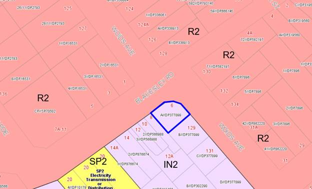
Figure
3: Zoning map – site outlined
in blue
62. The
proposed development is for the change of use to a depot and associated offices
for a civil works, construction and traffic control company which is a
permissible land use in the zone.
63. The
objectives of the IN2 Light Industrial zone are as follows:
· To
provide a wide range of light industrial, warehouse and related land uses.
· To
encourage employment opportunities and to support the viability of centres.
· To
minimise any adverse effect of industry on other land uses.
· To enable
other land uses that provide facilities or services to meet the day to day
needs of workers in the area.
· To
support and protect industrial land for industrial uses.
· To
support and encourage a range of local services that provide for the needs of
the local community.
64. The
proposed development, being a depot is a permitted form of development; it is
considered that the proposed depot use is consistent with the zone objectives.
65. In
addition to consideration in terms of zone objectives, Kogarah LEP 2012
contains a number of clauses requiring consideration with the proposed
development. Such consideration is provided in the table below.
|
Clause
|
Standard
|
Proposed
|
Complies
|
|
Part 1 – Preliminary
|
|
1.2 – Aims of the Plan
|
In accordance with Clause 1.2 (2)
|
The development is considered to be
consistent with the aims of the plan.
|
Yes
|
|
Part 4 - Principal Development
Standards
|
|
4.3 – Height of Buildings
|
10m as identified on Height of
Buildings Map
|
No proposed changes to the existing
height
(existing height 5.5m)
|
Yes
|
|
4.4 – Floor Space Ratio
|
1:1 as identified on Floor Space
Ratio Map
|
No proposed changes to the floor
space of the existing industrial unit
(existing GFA183.5sqm;
site area 305.7sqm; FSR 0.49:1)
|
Yes
|
|
Part 5 - Miscellaneous
Provisions
|
|
5.7 – Development below mean
high water mark
|
(2) Development consent is required
to carry out development on any land below the mean high water mark of any
body of water subject to tidal influence (including the bed of any such
water).
|
The proposal does not involve works
below the Mean High Water Mark.
|
N/A
|
|
5.10 – Heritage conservation
|
In accordance with Clause 5.10 (2)
|
The site is not a heritage item and
not located within the vicinity of any heritage items.
Site is not in a heritage
conservation area.
|
N/A
|
|
5.11 – Bush Fire Hazard
Reduction
|
Bush fire hazard reduction work
authorised by the Rural Fires Act 1997 may be carried out on any land without
development consent.
|
The subject land is not within a
bush fire prone area.
|
N/A
|
|
Part 6 - Additional Local
Provisions
|
|
6.1 – Acid sulfate soils
|
(2) Development consent is required for the carrying out of
works described in the Table to this subclause on land shown on the Acid
Sulfate Soils Map as being of the class specified for those works.
Class 5: Works within 100 metres of adjacent Class 2, 3 or 4 land that is
below 5 metres Australian Height Datum and by which the watertable is likely
to be lowered below 1 metre Australian Height Datum on adjacent Class 2, 3 or
4 land.
|
Subject site is not located in Acid
Sulfate Soils Area.
|
N/A
|
|
6.2 – Earthworks
|
(2) Development consent is required for earthworks
unless—
(a) the earthworks are exempt development under this Plan
or another applicable environmental planning instrument, or
(b) the earthworks are ancillary to development that is
permitted without consent under this Plan or to development for which
development consent has been given.
|
This development does not propose
earthworks.
|
N/A
|
|
6.3
– Flood planning
|
(2) This clause applies to—
(a) land identified as “Flood
planning area” on the Flood Planning Map, and
(b) other land at or below the
flood planning level.
|
The proposed development is not
located in a mapped flood prone area.
|
N/A
|
|
6.4
– Limited development on
foreshore area
|
In accordance with Clause (2) and
(3)
|
The proposed development is not
located in the foreshore area.
|
N/A
|
|
6.7 Essential Services
|
Development
consent must not be grated to development unless services that are essential
for the development are available.
|
Essential services are available to
the site.
|
Yes
|
Draft Georges
River Local Environmental Plan 2020
66. Consideration
is given to the provisions of Draft Georges River Local Environmental Plan 2020
in the assessment this application.
67. In
this regard, the provisions have no determining weight as a result of proposed
operation of Clause “1.8A Savings provisions relating to development
applications” of the Draft Plan which provides “If a
development application has been made before the commencement of this Plan in
relation to land to which this Plan applies and the application has not been
finally determined before that commencement, the application must be determined
as if this Plan had not commenced.”
It is acknowledged the zoning of
the land is not proposed to be altered as under this draft instrument.
Kogarah Development
Control Plan 2013
68. The provisions of Kogarah Development Control
Plan 2013 (KDCP2013) are relevant to the proposed development.
69. The proposal is for the use of the property as
a depot. There are no building works, internal fitout or upgrade works
proposed.
70. The proposal does not change the built form, internal
layout or landscaping. An assessment of the proposed development against the
relevant controls in the KDCP2013 is provided in the table below.
D3- Industrial
Development
|
Control
|
Standard
|
Proposed
|
Complies
|
|
2. Streetscape and Urban Character
Objectives
(a) Ensure that all new development
is compatible with the existing character of the locality in which it is
located.
(b) Ensure elements of development
make a positive contribution to the immediate streetscape.
(c) Promote industrial development
which is both functional and attractive in the context of its local
environment.
|
(1) Elevations of buildings
fronting the street should be broken up by the use of suitable articulation,
fenestration or alternative architectural enhancements.
(2) Showroom display areas,
ancillary offices, staff amenities and other low scale building elements
should be located at the front of the development facing the street and
constructed in appropriate materials to enhance the appearance of the
development, when viewed from the street.
(3) Buildings should be designed so
that entry points and client services are easily identified and visible from
the street.
|
No proposed changes to the existing building. The
application seeks approval for a proposed change of use only. No signage is
sought therefore no changes to the streetscape presentation.
No proposed changes to the existing building. There is no
showroom existing.
No proposed changes to the existing building. There depot
use does not seek to have the public visit. A pedestrian entry door is
clearly visible from the public domain.
|
N/A
N/A
N/A
|
|
3. Site Planning & Layout
Objectives
(a) Ensure that the design and
layout of industrial developments satisfies the operational requirements
while ensuring the safety and convenience of occupants and visitors.
(b) Internal spaces must satisfy
the operational requirements of the particular land use, while ensuring the
complementary configuration of activities on-site, and the safety and
convenience of all occupants.
|
(1) Locate office and staff
recreation areas away from intrusive noise sources such as heavy machinery,
loading docks, industrial equipment and sources of dust, vibration, heat,
fumes, smells or other nuisances.
(2) Site buildings with longer
facades oriented to the north, to maximise the potential for openings to the
office component of new buildings with northerly aspect, while minimising the
length of eastern and western facades wherever possible.
(3) Locate staff amenities and
facilities for easy and convenient access by workers. Amenities include
toilets, wash rooms, kitchenettes, and facilities include outdoor recreation areas,
eating areas, car parking, staff rooms and access paths.
(4) Design outdoor lighting
solutions to provide security for the building and safety for staff, while
minimising the impact of light spillage on the amenity of adjoining land
uses, especially residential.
|
No proposed changes to the existing building or its
internal layout. The current office and staff amenities face towards
Blakesley Road and are within rooms that can be closed off from the storage
and outdoor areas of the site.
In accordance
with the submitted Plan of Management (POM); ‘a second internal
loading bay is accessed by vehicles off Blakesley Road’.
The site provides an existing orientation of a north west
to south east being a corner allotment with an arced frontage. The existing
offices, ramp, store room and lunch room are located on the northern
façade towards Blakesley Road and the Woids Avenue intersection.
In accordance with the submitted
floor plans, the existing amenities are located within the complex; along the
north eastern wall. They are not proposed to be altered or upgraded.
This is not proposed as part of
this application.
|
N/A
N/A
N/A
N/A
|
|
4. Setbacks
Objectives
(a) Ensure that developments are
setback to minimise the visual impact on the streetscape.
(b) Ensure that adequate area is
available to accommodate landscaping, access, parking and manoeuvring of
vehicles.
(c) Setbacks are to provide for
pedestrian accessibility and visual continuity along public roads and landscaped
areas.
(d) Setbacks are to be provided to
ensure sufficient solar access for occupants of adjacent buildings,
particularly residences and recreational areas.
|
(1) Building setbacks adjacent to
public roads are to correspond with the existing predominant building line on
the street frontage(s) providing a continuous streetscape.
(2) Front and side setbacks are
sufficient to enable landscaping to screen large footprint buildings and
improve the interface with the public domain.
(3) Rear setbacks are to include a
deep soil zone component for stormwater infiltration and for the planting of
large trees.
(4) Setbacks on corner blocks are
to enable sufficient sightlines for traffic in accordance with the relevant
Australian Standard.
|
There are no proposed amendments to
the building setbacks given the application for a change of use only. The
existing building has a nil setback to the north, north western and north eastern
boundary.
No proposed changes to the front or
side setbacks.
No proposed changes to the rear
setback.
The proposal (being a corner
allotment) at the time of construction would of needed to comply with the
Australian Standard provisions. In the proposal’s current form the
existing vehicle access remains unaltered.
|
Yes
Yes
Yes
Yes – existing
|
|
5. Building form
Objectives
(a) Ensure that the form, scale,
design and nature of development maintains and enhances the visual quality of
industrial areas.
(b) Ensure that the scale of any
new industrial development is compatible with surrounding development.
(c) Floor space is distributed on
the site to ensure that the height, bulk and scale of development is in
context with the surrounding development.
|
(1) The maximum floor space ratio
is 1:1.
(2) In an industrial building where
ancillary offices or showrooms are proposed, the office or showroom area
shall not exceed 25% of the total floor space of the premises. (Note: This
does not apply to bulky goods premises)
(3) The height limit permitted is
10m from natural ground level.
(4) Any variation to the maximum
height permitted must demonstrate that the proposed building height:
(i) Is necessitated by the
operational requirements (e.g. roof clearance, specialised machinery, plant,
processing equipment, stacking) of the particular industry
(ii) Is compatible with the scale,
bulk and height of surrounding buildings
(iii) Will not generate excessive
overshadowing of adjacent properties
(5) Roof mounted plant rooms, lift
overruns, air conditioning services and other equipment must be effectively
screened from view using roof structures and architectural elements that are
integrated with the host building.
|
There are no amendments to the
existing floor area of the site, the floor space ratio existing is 0.49:1.
There are no amendments proposed to
the existing floor plate. There is no showroom on site and this proposal has
detailed there is not public access required for this business.
There are no amendments to the
existing height of the development on site, the current being has a height of
5.4m.
Remains unaltered and is compliant.
The plans detail there is racking
in place associated with the use. No fit-out works are proposed.
The built form exists and is not
proposed to be altered.
The existing development is single storey
and not proposed to be altered. No additional shadow impacts result.
The building contains solar panels.
No additional plant is proposed to support this use.
|
Yes
Yes
Yes
Yes
Yes
Yes
Yes
Yes
|
|
6. Design and appearance of
developments
Objectives
(a) Promote industrial development
that is both functional and attractive in the context of its local
environment through appropriate design.
(b) The building design, detailing
and finishes are to add visual interest to the building when viewed from
public vantage points, particularly roadways.
(c) Buildings on corner sites
should respond to the corner by providing an architectural corner treatment.
(d) Open storage and work areas
should be suitably designed and sited so as to not detract from the overall
development.
|
(1) Building facades are to be
designed to reflect a contemporary architectural appearance.
(2) Developments are to incorporate
architectural elements to articulate facades and minimise large expanses of
blank walls.
(3) Architectural elements may
include but are not limited to: (i) Designing the base, middle or top of a
building using different materials and colours;
or (ii) Incorporating horizontal or
vertical elements such as recessed walls or banding;
or (iii) Defining the window
openings, fenestration, building entrances and doors;
or (iv) Using roof forms and
parapets to create an interesting skyline;
or (v) Using sun shading devices;
or (vi) Incorporating public art
work;
or (vii) Using variation of unit
designs in a building complex.
(4) Buildings that are visible from
a public road, reserve, railway or adjacent or adjoining residential areas
should be constructed of high quality materials and suitable finishes.
(5) Roofing materials should
consist of non-reflective materials.
(6) No service plumbing pipes,
other than downpipes for the conveyance of roof water, shall be external to
the building or visible to any public place.
(7) The street facade of a
development on a corner allotment must incorporate architectural corner
features to add visual interest to the streetscape.
(8) Where any work or storage of
materials is proposed outside the confines of the building, full details of
those parts of the site to be used and the materials to be stored, are to be
provided with the application.
(9) Approved open work and storage
areas are to be located at the rear of developments and screened from view by
the use of landscaping and screen fencing.
(10) Where the rear of a
development adjoins a residential property, Council may consider the
relocation of this area to a more appropriate location on the site.
(11) Where this is the case,
justification must be provided with the application.
|
The façade is existing and
no change is proposed.
The façade is existing and
no change is proposed.
The façade is existing and
no change is proposed.
The façade is existing and
no change is proposed.
The built form and openings exist,
no changes proposed.
The roof form exists, no changes
proposed.
No sun shades exist or are
proposed.
No public arts work exists or is
proposed.
The development is a stand-alone
building, this is not applicable.
The built form exists being a
masonry finish with a metal roof; no alterations or additional built form is
proposed.
The roofing material exists and
accommodates solar panels.
The stormwater disposal method is
not proposed to be altered as part of this change of use.
The built form exists. The
façade of the development is built to the front allotment boundary and
follows the curved nature of the site.
The application is seeking to store
some materials and plant associated with the use and vehicles within the
outdoor area of the site.
All parts of the development are
obscured from the public domain by either built form or fencing.
The development adjoins industrial
or commercial to all boundaries.
N/A
|
N/A
N/A
N/A
N/A
N/A
N/A
N/A
N/A
N/A
N/A
N/A
N/A
N/A
Yes
Yes
Yes
|
|
7. Landscaping
Objectives
(a) Improve the visual quality and
amenity of industrial development through effective landscape treatment of
individual sites and to achieve a pleasant working environment.
(b) Ensure a high standard of
environmental quality while enhancing the general streetscape.
(c) Landscaping should be designed
appropriately to reduce the bulk, scale and size of industrial buildings and
reduce the impact of at grade car parking areas.
(d) Landscaping is to be emphasised
where a site is visible from a public roadway or place.
(e) Boundaries adjoining
residential development are to be suitably landscaped.
(f) A landscape bond may be
required to ensure that landscaping works are carried out an appropriately
maintained.
|
Controls
(1) A minimum of 10% of the site
area is to comprise of “soft” landscaping including lawns, trees
and shrubs. Car parking, paths and pedestrian walkways are to be excluded
from the 10%.
(2) If an existing site is to be
refurbished, or an application is made for a change of use, an amount of
landscaping, where appropriate, is to be provided to the satisfaction of
Council.
(3) Landscaping having a minimum
width of 2.5 metres is to be provided surrounding car parking areas.
(4) Landscaped areas are to be
provided to areas fronting the street, including secondary streets, where
sites are on a corner, and adjacent to natural areas where industrial
developments abut a reserve or open space.
(5) Fencing is to be integrated as
part of the landscaping theme so as to minimise visual impacts and to provide
associated site security.
(6) Where sites abut a residential
land use or a residential zone, landscaped buffers will be required along the
boundaries to which the residential land use abuts. This buffer is to be a
minimum 3 metres.
(7) To ensure landscaping of
industrial developments is maintained, Council will require the payment of a
landscape bond prior to the release of a Construction Certificate for the
proposed development. The amount payable will be specified on the Development
Consent and shall be held by Council until such time that the maintenance
period has elapsed.
(8) The maintenance period will be
no less than six (6) months and will commence from the date a Council Officer
is satisfied that the landscaping works are completed in accordance with the
approved landscape plan.
|
A small strip of lawn existing
between the façade of the building and Council’s footpath. There
is no soft landscaping behind the fencing or within the allotment the subject
of the application. All greenery is within Council land.
There is no opportunity to provide
additional landscaping on site.
Not applicable to this application.
There is no soft landscaping within
the subject allotment. All greenery to the perimeter of the development is
within Council land.
The fencing exists, no additional
fencing is proposed and no upgrade and amendments are proposed.
The proposal complies with this
control as it is located more than 3m away from a residential zones being on
the opposite side of Blakesley Road and Woids Avenue.
Not applicable to this application
as no landscaping or construction is proposed.
Not applicable to this application.
|
Yes
Yes
N/A
No
Yes
Yes
N/A
N/A
|
|
Vehicle
access and parking
Up to four (4) vehicles access the site, the largest of
which is 10.4 tonne. These vehicles are loaded in the morning and unloaded in
the evenings and are stored on site in the both the enclosed storage yard
area and store room. The smallest work vehicles would be utility vehicles and
vans. At full operation there would be between 6-8 vehicle trips for work
vehicles and 2-4 private vehicles to and from the site each day. These are
almost entirely limited to the morning peak and afternoon as staff arrive,
load and leave with work vehicles and return again in the evening to unload
and leave in private vehicles.
|
|
8. Vehicle access and parking
Objectives
(a) Provide sufficient and
convenient on-site parking for employees, visitors and associated vehicles.
(b) Minimise the adverse impact of
vehicles on the amenity of the development, streetscape and surrounding
neighbourhoods.
(c) Ensure that appropriate on-site
parking is provided for people with a disability and is consistent with the
design requirements of the Building Code of Australia and the relevant
Australian Standards.
(d) Ensure that there is adequate
space on-site for easy, convenient and safe circulation of vehicles.
(e) Car parking areas and loading
areas should be designed to ensure ease of ingress and egress to and from the
site.
(f) Provide safe pedestrian access
through car parking areas without interference of vehicular movement.
(g) Vehicular movements to and from
the site should be designed to reduce potential conflict with street traffic
and pedestrians.
|
Controls
(1) Car parking is to comply with
the requirements of Part B4.
Warehouse or distribution
Centre: 1 space/100m2
gross floor area
(2) Parking areas should be easily
accessible, allowing vehicles to leave the site in a forward discretion and
appropriately signposted.
(3) Loading/unloading areas are
designed to enable heavy vehicles to enter and leave the site in a forward
direction, park within designated loading areas, and not interfere with
visitor and employees vehicles in designated parking spaces.
(4) All loading facilities should
be provided in accordance with the current RMS ‘Guidelines to Traffic
Generating Developments’.
(5) Buildings shall be designed to
allow loading/unloading of vehicles within the building.
(6) Loading docks should be
situated to the side or rear of buildings.
(7) Adequate on-site manoeuvring
shall be provided to enable all delivery vehicles, including large trucks to
enter and leave the site in a forward direction.
(8) Pedestrian access through car
parking areas should be clearly marked, and where possible emphasised by the
use of raised and textured surfaces.
(9) As far as possible, pedestrian
access through car parks should be kept separate from vehicle access ways.
(10) The maximum grade of
manoeuvring areas and all access ways should comply with the relevant
Australian Design Standards.
(11) Where sites front onto main or
arterial roads, driveways should be minimised or located on side or rear road
frontages where available.
|
There are no proposed changes to
the existing car parking orientation of the site; the site currently
accommodates two (2) loading areas. In accordance with the prescribed control
two (2) car parking spaces are required. However there is no specific car parking
delineated on the site as existing. The proposal demonstrates that the use
can be accommodated and the four (4) vehicles to be housed over-night can be
accommodated wholly within the confines of the allotment. See a detailed
discussion below.
Vehicle access exists, with a
loading bay accessed off Blakesley Road and the second access from Woids
Avenue. No change to this arrangement is proposed.
The site is non-compliant with the
current controls and it not being made worse as a result of this application.
A detailed assessment of this is referenced below.
Considering the proposal relates to
a change of use; there are no alterations and additions proposed and
therefore the non-compliance is not being exacerbated. The application has
detailed that the loading and unloading of the vehicles can be accommodated
wholly from within the subject site and no loading from the public domain.
The proposal is considered
acceptable subject to compliance with the requirement of the plan of
management. See the detailed discussion below.
The subject sites does have
separate pedestrian access through its internal configuration via Woids
Avenue and Blakesley Road, there is no defined access through the vehicle
parking areas.
There are no proposed amendments to
the existing driveway grades.
The subject site is not located on
any main or arterial roads; as identified on Council’s Internal
Mapping.
|
No -existing
No but existing
No existing
No existing
Yes
N/A
Yes
Yes
|
|
Car parking and Manoeuvring
It is acknowledged this application
is seeking to use the facilities and space that exists on site. No works are
being proposed to relocate access areas, internal manoeuvring or building
elements.
It is acknowledged that this site
is non-compliant with respect to car parking and loading given its age.
The constrained nature of the site
results in this non-compliance being unable to be resolved without the
demolition and removal of parts of the allotment.
As a result consideration needs to
be given to the current situation, the proposed use and whether this use is
appropriate in this location.
Whilst the use before us is defined
as a depot, it depot component is lower scale in its intensity for vehicle
movement and workers. Given the constraints of the site there limited
opportunities for expansion.
In addition there is the additional
complexity of the site being opposite residential and commercially zoned
land.
Given the permissibility of the use
the applicant was requested to demonstrate the functionality of the site and
its use and how this is to be managed.
The vehicle access from Woids
Avenue has an inability for the 10.4 tonne truck to drive in and leave in a
forward direction. The smaller scale vehicles accessing the site and the
employee vehicles can manoeuvre in the space available and leave the site in
a forward direction.
In this regard the larger vehicle
will have to reverse from the site. It is considered that traffic control
from the staff associated with the business needs to be present as an
operational arrangement to assist in the reversing of the truck from the
site.
The frontage of 6 Blakesley Road is
‘no stopping’ thereby facilitating reasonable sightlines for
vehicles entering Woids Avenue from Woids Avenue and Blakesley Road given the
intersection is a 4 way intersection in the vicinity of this site.
The loading dock accessed via
Blakesley Road cannot facilitate the 10.4 tonne vehicle given the space and
height available. Vans and utes will access this space and need to reverse
from the site. It is considered this can be accommodated and protect the
pedestrian and vehicle safety.
In addition an acoustic report was
requested to address the vehicle noise and the loading and unloading.
Requirements have been recommended to protect the amenity of the locality
during the loading and unloading times of the day. The recommendations of the
acoustic report have been included in the Plan of Management. The range of
hours requested is considered inappropriate in this location and it has been
recommended that the hours be consistent with the Development Control Plan of
7am to 6pm given the residential interface.
In this regard it is considered
that the proposal subject to the Plan of management being amended to include
the traffic control for the Woids Avenue vehicle entry and exit that the site
is acceptable for this use give the low scale number of vehicle movements
envisaged and outlined in the Statement of Environmental Effects and the Plan
of Management for the site.
|
|
9. Signage
Objectives
(a) Provide signage opportunities
for the purpose of business identification, general information and giving
directions.
(b) Ensure that signage is
integrated with the building and its setting.
(c) Signage is considered, designed
and located as an integrated part of the overall development.
|
Controls
(1) The provision of signage is to
comply with the requirements of Part F1.
(2) Advertising in industrial
localities should be integrated into the overall development. In this regard,
details are to be submitted with the Development Application.
(3) Site identification signs,
directional signs and advisory signs are to be integrated into directory
boards.
Note: Some signage is permitted as
Exempt Development under Schedule 2 of KLEP 2012.
|
No signage is proposed.
No signage is proposed.
No signage is proposed.
|
N/A
N/A
N/A
|
|
10. Acoustic Privacy – Road
Noise and Rail Noise
Objectives
(a) Ensure a high level of amenity
by protecting the acoustic and visual privacy of occupants within all built
development.
(b) Ensure buildings are sited and
designed so that acoustic and visual privacy and vibration from outside
sources is controlled to acceptable levels.
(c) Minimise noise transmission
between nearby buildings and adjoining development.
(d) Ensure that new development
incorporates architectural and building elements that contribute to
protecting the acoustic and visual privacy of any adjoining residents.
(e) Ensure buildings are sited and
designed so that traffic and rail noise, vibration and potentially harmful
air quality effects are controlled to acceptable levels
|
(1) Design developments to locate
all noise generating equipment such as mechanical plant rooms, mechanical
equipment, air conditioning units, mechanical ventilation from car parks,
driveway entry shutters, garbage collection areas or similar to protect the
acoustic privacy of workers, residents and neighbours.
(2) Where appropriate individual
buildings and groups of buildings are to be located to act as barriers to the
noise.
(3) Utilise the site and building
layout to maximise the potential for acoustic privacy by providing adequate
building separation within the development and from neighbouring buildings.
This is particularly important where proposed development abuts residential
uses and/or residentially zoned land.
|
The Acoustic Report makes
additional recommendations to reduce the noise impacts of the development. It
states that despite the fact that the above mitigation strategies are
predicted to achieve compliant noise levels, the following behavioural
strategies should be implemented for the benefit of the surrounding amenity.
Provide training to staff to ensure
they are aware of the potential noise impacts of the dropping of metal during
the night hours and to encourage staff to drop metal items from as low as practically
possible.
Metal objects, such as signage, are
to be lifted and not dragged across the concrete floor
No use of speakers.
These matters are identified within
the submitted acoustic report; which will be endorsed via a condition of
consent.
There are no proposed changes to
the built form of the proposed development site. This is a stand along
building.
An Acoustic report prepared by GHD
was submitted, this was reviewed by Council Environmental Health Officer, the
recommendations of the acoustic report were acknowledged, the assessment
concluded that:
‘Without mitigation
strategies it is predicted that the proposed depot marginally exceeds the
noise criteria during the early morning period’. Noise mitigation
strategies have been presented in to ensure noise levels from the use and
operation of the depot is compliant. As a result (the applicant) GHD confirms
that the proposed depot is suitable from an acoustics perspective and
compliant with the relevant noise criteria from the Kogarah DCP and Noise
Policy for Industry (NPI).
These include the following
matters:
· During the
loading and unloading of vehicles within the facility the truck should be
turned off,
· The gate should
remain closed when possible, specifically during the loading and unloading of
materials and equipment from vehicles,
· The
incorporation of either rubber padding or moving blankets whilst loading or
unloading material from vehicles. This reduces metal on metal impacts that
have the potential to create adverse noise impacts.
|
Yes
N/A
Yes
|
|
11. Safety and security
Objectives
(a) Ensure that the siting and
design of buildings and spaces contributes to the actual and perceived
personal and property safety of workers and visitors and decreases the
opportunities for committing crime in an area.
(b) Ensure the development is integrated
with the public domain and contributes to an active pedestrian orientated
environment.
(c) Maximise opportunities for
natural surveillance.
(d) Minimise the potential for
intruders to enter buildings.
(e) Ensure entrances and exits are
clearly visible from the street.
(f) Encourage building designs,
materials and maintenance programs that reduce the opportunities for
vandalism and graffiti.
(g) Industrial development creates
an environment that maximises the safety and security of its staff.
(h) Developments adjoining open
stormwater drains should be adequately secured and designed to reduce the
risk of graffiti.
|
(1) Buildings are to be oriented
towards public streets and, where relevant, internal streets to consolidated
developments.
(2) Frontages and entries overlook
and are clearly visible from the street and provide a sense of address and
visual interest.
(3) Blank walls addressing streets
and other public places are to be avoided.
(4) The use and entrances of
buildings should be easily identified by the general public through:
(i) Using roof forms and parapets
to create an interesting skyline;
or (ii) Using sun shading devices;
or (iii) Incorporating public art
work;
or (iv) Using variation of unit
designs in a building complex.
(5) Office and administration areas
should be located at the front of the building overlooking the street and any
car parking area.
(6) Locate and design car parks so
they can be observed by adjoining uses.
(7) Minimise the number of pedestrian
and vehicular entry and exit points, in close proximity to each other and to
nearby active uses.
(8) Staff car parks should be
separated and secured
(9) Lighting in car parks must
conform to the relevant Australian Standards
(10) Provide surveillance measures
such as security cameras or devices and security guards where possible.
(11) Sensor lights should be
provided.
(12) Where possible, leave the
sides of the car park open, to provide natural lighting and aid surveillance.
(13) Use transparent or open form
materials for walls and doors where possible and use light paint colours on
walls and ceilings.
(14) Where a development shares a
boundary with an open stormwater drain, any building, solid fence or car park
should, wherever practical, be setback a minimum 1.5m from that boundary and
be treated with hedging or climbing vines to screen the development when
viewed from the open stormwater drain.
|
The built form exists and oriented
towards the street.
The built form and openings are
existing, no additional openings are proposed. There are openings that face
both street frontages.
This built form is existing, no
alterations and additions proposed.
The building is existing and the
entry to the building for pedestrians and vehicles is well defined and
legible.
The roofline remains unaltered.
The built form is existing no work
is proposed.
Public art work does not exist and
is not proposed.
The development consists of one
building, no additional built form is proposed.
The office component of the
development is accessed via the pedestrian entry door which existing and
clearly visible from the public domain.
The built form is exists and the
vehicle parking is behind the building and the existing fencing.
The vehicle access locations exist
and are not proposed to be altered by this application. One faces Blakesley
Road and the other Woids Avenue. A Plan of Management (POM) has been prepared
to address the functionality of the development. The submitted POM states
that there will be 6-8 vehicle trips for the business and 2-4 private
vehicles) to and from the site each day. The low frequency and the amount of movements
to and from the subject site results in a development which will be
considered satisfactory in terms of vehicle and pedestrian safety.
The development is existing and
small in scale there is no separation of parking.
The vehicle parking area is existing
within the development behind the building and fencing. This is not relevant
in this assessment.
The development is existing only a
change in use is proposed. The development will operate within the site
boundaries behind the building and fencing this is not a relevant criterion
for this application.
There are no public spaces
accessible in this development, no sensor lights are considered necessary nor
are they proposed.
N/A
The built from is existing and is
not proposed to be altered as part of this change of use.
Not applicable, the site does not
adjoin an open stormwater drain.
|
Yes
Yes
Yes
Yes
Yes
Yes
Yes
Yes
Yes
Yes
Yes
Yes
Yes
Yes
N/A
Yes
N/A
|
|
12. Operational Restrictions
Objectives
(a) Limit retailing in industrial
zones.
(b) Ensure that industrial
development operates in a manner compatible with adjoining land uses,
particularly residential areas.
(c) Ensure noise, air and water
discharges, waste storage and removal, working hours and storage of dangerous
goods and hazardous chemicals will not have a detrimental effect on
environmental amenity.
(d) Encourage waste minimisation
(source separation, reuse and recycling) and ensure efficient storage and
collection of waste and quality design of facilities.
|
Controls 12.1 Retailing in the IN2
(1) Retailing in the IN2 –
Light Industrial zone is to be in accordance with the definition of
industrial retail outlets in KLEP 2012 and is to comply with the requirements
of Clause 5.4(4) of KLEP 2012.
12.2 Hours of operation (1) Where
an industrial site is located adjacent or within 200m to a residential zoned
area or where, in the opinion of Council, truck movements associated with the
industry will intrude on residential streets, hours of operation may be
restricted to 7.00 am - 6.00 pm Mon - Sat.
Note: Where an extension to these
hours is required due to the nature of the activities to be undertaken, a
detailed submission must be lodged with Council demonstrating how
environmental impacts can be minimised to acceptable levels if the extended
hours of operation are allowed.
|
No retailing is proposed from the
site as part of the change in use to a depot.
The proposal seeks the following
hours of operation:
6:00am to 7:00pm Monday to Friday
7:00am to
4:00pm Saturday.
A Plan of
Management was submitted with the DA along with an acoustic report and a
detailed assessment with the submitted Statement of Environmental Effects has
also been provided.
Council’s
EHO’s has also provided a detailed assessment of the proposal to ensure
compliance with Council’s Health Regulations and Compliance controls.
A
condition of consent is to be implemented to ensure compliance with the
prescribed control; which states that the prescribed hours of operations are
to be 7.00 am - 6.00 pm Monday – Friday and 7.00am to 4.00pm
Saturdays. No work Sundays or Public Holidays.
|
Yes
Yes
|
Interim Policy –
Georges River Development Control Plan 2020
71. Council
at its Environment and Planning Committee Meeting dated 24 June 2019 resolved to adopt
the Georges River Interim Development Control Plan (DCP) 2020.
72. The Interim Policy is a public policy that is to
be used as a guide to set a consistent approach for the assessment of
residential development within the LGA. It is a supplementary document, meaning that current DCP controls will prevail
if they are considered best practice. The Interim Policy has no statutory
recognition in the assessment of DAs pursuant to the Environmental Planning and
Assessment Act, 1979.
73. The interim policy only relates to residential
development forms and will not need to be considered in the assessment of this
proposal.
Plan of Management Assessment
74. In
addition to the acoustic report the applicant has provided a Plan of Management
associated with the depot use, which contains a number of recommendations
(additional to those in the GHD Acoustic Report) including:
· Management
of Potential Car Parking Conflicts - To manage the potential for parking
conflict with surrounding residents and businesses, operations will strictly
adhere to guidance provided by Transport for NSW as follows:
“Heavy vehicles (4.5 tonnes or more GVM) or long vehicles (7.5
metres or longer) must not stop on a length of road outside a built up area,
except on the shoulder of the road. In a built up area they must not stop on a
length of road for longer than one hour (buses accepted).”
· All work
vehicles will be stored securely within the premises overnight. Employees will
be encouraged to park their private vehicles within the premises during the
day.
· Operating
procedures will ensure that NO work vehicles will be loaded with plant and
machinery outside the premise.
· Policies and
Training Manuals - the business owner will embed noise mitigation strategies in
written policies and procedures and ensure all staff are trained as to how to
following all procedures and reduce noise generated. These policies and
procedures will be available for inspection at the request of Council officers.
· The policies
and procedures will incorporate the use of trolley jacks and the like to move
objects that are likely to cause metal on metal or concrete noise. A large
moveable hoist will be used to lift and load/unload any large plant and
machinery that may cause noise.
· In addition,
signage will be placed on site to identify the location of noise retardant
matting which will be located on racking in an easy to access position.
75. The
Acoustic Report and Plan of Management have been assessed by Council’s
Environmental Health Officer as satisfactory.
76. This Plan of Management will
be endorsed as a condition of consent; ‘the submitted Plan of
Management (POM) dated 14 April 2020; prepared by Urbanism; must be adhered to
all times; any modifications or amendments to the approved POM must be
submitted to the satisfaction of Council’s Area Planning Manager/Area
Planning Coordinator for approval’.
77. It
is recommended that compliance with the recommendations of the Acoustic Report
and with the Plan of Management, subject to an addition criterion in the plan
of management that a staff member assist in the reversing of vehicles from the
site to provide pedestrian and vehicle safety be imposed as conditions of
consent, as identified above.
Developer Contributions
78. The
proposed development, if approved, would not require the payment of developer contributions under Section 7.11 of the Environmental Planning and Assessment Act
1979 as the proposal is for change of use and does not increase gross floor
area of the site.
79. Further,
Council’s Section 94A Contributions Plan (Section 7.12 contributions),
states that development costs up to and including $100,000 will not be subject
to a contributions levy. This application is not seeking any physical works to
the site; as a result there is no cost of works. This change of use application
to a depot does not attract any Section 7.12 contributions.
Impacts
Natural
Environment
80. The proposal does not involve any building work, or tree
removal. Accordingly, the proposed works will not directly impact the natural
environment.
Built Environment
81. The built
form of the proposed development will also remain unchanged given that the
proposal is for a change of use of an existing building.
Social Impact
82. The development is considered to be acceptable in terms of
social impact. In this regard, the main “social” impacts for this development
are related to amenity impacts on adjoining residential properties (located
opposite on the northern side of Blakesley Road and Woids Avenue).
83. It is generally
considered that these impacts can be suitably managed via conditions of
consent. Subject to compliance with these conditions, it is generally
considered that the development will be satisfactory in terms of social
impacts.
Economic Impact
84. The proposal is considered
to result in positive economic impacts. The depot usage is for storage of plant
and equipment relating to maintenance of public infrastructure (roads,
footpaths etc), and it is considered to be important to facilitate this form of
development to contribute to general economic recovery post-COVID-19.
Suitability of the Site
85. The subject site is not subject to any constraints (such as
flooding, land subsidence or the like) which would render it unsuitable for the
proposed development.
86. The site is zoned IN2 – Light Industrial, which
permits a depot usage for this site. However, the subject site immediately
adjoins (albeit across the road from) a low density residential area.
87. Accordingly, strict conditions of consent will be required
to ensure that the development can operate in a manner which preserves the amenity
of the residential area. Such conditions are as included in the recommendation
below.
88. The subject site
is generally considered to be suitable for the proposed depot use, subject to
conditions to ensure that the amenity of the adjoining residential area is
protected.
SUBMISSIONS, REFERRALS AND THE PUBLIC INTEREST
89. The
proposal was neighbour notified in accordance with Kogarah Development Control
Plan 2013 for a period of 14 days between 9 and 23 July 2019. A total of four
(4) submissions of objection were received – three (3) individual
submissions and one (1) submission containing 14 signatures – in response
to the notification. The issues raised in the submissions are summarised and
discussed below.
Size of development site
90. The
proposed site is only 300sqm which is far too small for a depot.
91. Officer
Comment: A ‘depot’ is a permissible use within the zone.
A depot is defined as "storage (but not sale or hire) of plant,
machinery or other goods (that support the operations of an existing
undertaking) when not required for use”. There is no corresponding
limitation on the size of a site where depots can operation from. The size of
the premises is considered appropriate for the scale of the use proposed. Further, it is considered that the
small size of the site helps to restrict the scale of the development proposed,
which in turn can restrict the impacts arising from the proposed depot use.
On-street
parking and loading
92. Concern
is raised that on-street parking has been an issue in the past, as workers park
and load their trucks in the street, on Blakesley Road.
93. Officer
Comment: Development consent is sought to only permit the loading
and unloading of vehicles within the premises. It is considered that this point
of objection can be resolved by a condition of consent stating that all loading
and unloading shall occur within the subject site, not in public roads
adjoining. The applicant has advised that they are agreeable to such a
condition of consent.
Early morning starts
94. Residents have
advised that 6am start is not acceptable due to amenity impacts arising
from the noise and truck movements occurring at that early hour.
95. Officer
Comment: The Acoustic Report undertaken and submitted with the DA
has determined that “With
the implementation of the noise mitigation strategies (recommended) no
exceedances in the noise criteria have been predicted." The
recommended noise mitigation strategies are contained in the corresponding Plan
of Management and will therefore ensure that noise does not exceed acceptable
levels.
96. Whilst this is
accepted, it is considered to be unavoidable that noise impacts emanating from
external to the site (e.g. vehicle movements on public roads) will impact on
residential amenity. Accordingly, although the DA submission requests
hours of operation starting at 6am, this is not considered to be appropriate
given that the site is located immediately adjoining a low-density residential
area (across Blakesley Road/Woids Ave). It is recommended that the hours of
operation be limited to: 7:00am to 7:00pm Monday to
Friday and 7:00am to 4:00pm Saturday.
97. Given
the relationship of the development to residential allotment the applicant was
requested to provide an acoustic report, this was prepared by GHB Consulting.
The report was to demonstrate how the development can operate in a satisfactory
manner in terms of noise impacts on nearby residential properties. The Acoustic
Report indicates compliance with the relevant noise criteria is only achieved
with the implementation of noise mitigation strategies. In order to achieve
compliance, the following mitigation strategies are to be implemented:
· During the
loading and unloading of vehicles within the facility the truck should be
turned off;
· The gate
should remain closed when possible, specifically during the loading and
unloading of materials and equipment from vehicles;
· The
incorporation of either rubber padding or moving blankets whilst loading or
unloading material from vehicles. This reduces metal on metal impacts that have
the potential to create adverse noise impacts.
Storage of plant/equipment in the
street (Woids Avenue)
98. The submitters
have stated that equipment has been left in Woids Avenue for weeks.
99. Officer
Comment: This is a general claim that cannot be substantiated
towards the proponent. The plant and equipment stored within the premises is
valuable and easily moveable. It important that it remain securely stored and
locked up within the premises when not in use. It is considered that this issue
could also be resolved via a condition of consent to state that there shall be
no plant/equipment or the like stored in public roads, and that all
plant/equipment associated with this development shall be stored within the
property boundaries. The implemented conditions of consent below are identified
as legally binding.
Amenity Impacts
100. Concern is raised
that the site in positioned with close proximity to residential properties, and
the current operation has caused problems with noise and parking concerns.
101. Officer Comment: it
is considered that the proposed use is consistent with the objectives of the
zone as it will minimise any adverse effect of industry on other land uses by
implementing appropriate noise mitigation measures. Furthermore, the use of the
site for a depot does not intensify the use of the site beyond that of any
adjoining industries. The proposed development is not creating additional
demand for on-street car parking beyond that generated by adjoining industries
or dwellings. An addition note can be identified that various on street parking
for staff can be provided; given the frontage of the allotment is a ‘no
stopping’ along the secondary setback of Woids Avenue frontage and most
of the Blakesley Road (primary frontage), Council’s parking identified
signage illustrates that the remainder of the Blakesley Road frontage is timed
parking being 2P 8.30am–6pm Monday to Friday and 8.30am and to 12.30pm
Saturday given the commercial tenancies are operating as local shops.
Loading/unloading of trucks on the
street
102. Concern is raised that trucks
have been loaded on the road creating noise.
103. Officer Comment: Development
consent is sought to only permit the loading and unloading of vehicles and
parking of vehicles within the premises. It is considered that this matter can
be readily resolved via a condition preventing loading/unloading of vehicles on
the public road, and preventing on-street parking of employees’ vehicles,
and the applicant has advised that they would be agreeable to such conditions.
104. The acoustic report
undertaken has determined that “With the implementation of the noise mitigation
strategies (recommended) no exceedances in the noise criteria have been
predicted." The Plan of Management and appropriate conditions
of consent will ensure that noise levels will not exceed relevant criteria.
Hours of Operation
105. Concern is raised that the
increase in hours of operation will create a precedent.
106. Officer Comment: A condition of consent is to be implemented to ensure
compliance with the prescribed control; which states that the prescribed hours
of operations are to be 7.00am - 6.00pm Mon - Sat.
Public Interest
107. Submitters have stated that
approval of this DA is not in the public interest.
108. Officer Comment: As
stated earlier in this report, it is considered that approval of this application
is in the public interest, because the nature of the development would help to
contribute to general economic recovery post COVID-19. A relatively small
number of objections (four (4)) have been received to this development, which
seems to indicate that manner in which the development has been operating to
date has had relatively little impact upon neighbours. The proposed
development will be in the public interest by being consistent with the above
mentioned aims and objectives expressed in LEP. In addition, the proposed
development site has been amended in order to comply with concerns identified
within this report.
109. However, it is recognised
that this type of development and the location of the subject site could give
rise to adverse amenity impacts. Accordingly, it is recommended that the
proposal be approved subject to conditions aimed at minimising those impacts.
REFERRALS
Council Referrals
Building Surveyor
110. The application was
referred to officers in Council’s Building Certification Team for
comment. No objections were raised, subject to the imposition of applicable
conditions aimed at compliance with the National Construction Code (BCA).
Environmental Health Officer
111. The application was
referred to Council’s Environment Health and Regulatory Services for
comment. The Environmental Health Officer initially requested further
information in the form of an Acoustic Report, which was obtained and prepared
by GHD Consulting dated 16 August 2019.
112. The Environmental Health
Officer considered the Acoustic Report and remained concerned about the
proposed development; the assessment is referenced below;
113. The Environmental Health
Section (EHS) has assessed the proposed subject development in accordance with
the Protection of the Environment Operations Act.
The assessment included a review of
the “6 Blakesley Rd, Carlton. Acoustic Assessment – Extension
of Hours” prepared by GHD in August 2019. I also undertook a site
inspection on 8 July 2019 in order to confirm the visual inspection
descriptions contained within this report. The acoustic report scenario deals
with one truck loading in the early hours of the morning, from 6am, the SoEE
states they have at least 3 trucks to be loaded daily. Anecdotal evidence
provided by the community suggests they also have larger trucks and other
plant, such as small excavators. The material loaded onto trucks has the
potential to create metal on metal noises and, although the acoustic report
addresses this, will cause a disturbance to the neighbours – and
currently does.
The acoustic report has measured the
noise created by the proposed activities at the site with and without noise
mitigation strategies, looking at sleep disturbance criteria. It is
interesting to note that, even without noise mitigation strategies; there are
hardly any exceedances of the sleep disturbance criteria. This then begs
the question as to why have there been so many complaints from neighbouring
residents, if the illegal before hours operating practices are so
compliant? Additionally, it is hard to determine whether or not the
acoustic report is painting a true picture of what actually occurs
onsite. Furthermore, the noise mitigation strategies are relatively easy
to employ (no talking, no speakers, engine off, wrap metal in blankets or use
rubber matting) and it begs the question as to why these strategies
haven’t already been employed if they were concerned about their
neighbours. This attitude, then translates into whether or not Council
can trust them to continue to employ the noise reduction strategies mentioned
in the acoustic report – as time progresses, compliance with such
recommendations can wane, especially if business increases and also with staff
changeover.
114. There was further dialogue
between Council Officers and the applicant, which resulted in the submission of
more information from the applicant about the nature of the proposed
development – including a Plan of Management to detail the nature of the
proposed development.
115. The Environmental Health
Officer reviewed this information and has commented that the development is
satisfactory for approval subject to conditions of consent, including those
which require compliance with the Acoustic Report and Plan of Management. It is
noted that the applicant has indicated that they would be agreeable to such
conditions.
External Referrals
Ausgrid
116. The application was referred to Ausgrid for comment in
accordance with Clause 45 of the Infrastructure SEPP. To date no response has
been provided, given the timeframe elapsed concurrence can be assumed.
CONCLUSION
117. The application has
been assessed having regard to the Matters of Consideration under Section 4.15
of the Environmental Planning and Assessment Act 1979, including the provisions
of the relevant Acts, Regulations, State Environmental Planning Policies, Local
Environmental Plans and Development Control Plans.
118. The development is
generally considered to be satisfactory for approval subject to conditions.
119. Although some submissions
of objection have been received from neighbouring residential properties, it is
considered that conditions of consent can resolve the issues of concern that
have been raised.
DETERMINATION AND STATEMENT OF
REASONS
Statement of Reasons
120. The reasons for this
recommendation are:
(a) The proposed development for use
of the subject site as a “depot” is consistent with the objectives
of the Environmental Planning & Assessment Act 1979, which include
at Section 1.3 (c): “to promote the orderly and economic use and
development of land”.
(b) The proposed depot is consistent with the objectives of
the IN2 – Light Industrial zoning of the property.
(c) The issues of concern raised by the neighbouring property
owners can be resolved via conditions of consent.
(d) The proposed development is of a relatively small scale
and impact which would have acceptable environmental impacts.
121. In consideration of the aforementioned reasons, the
proposed development is recommended for approval subject to conditions.
Determination
122. THAT pursuant to Section 4.15(1)(b) of the Environmental
Planning and Assessment Act 1979 (as amended) the Georges River Local Planning
Panel approve development consent to Development Application DA2019/0265 for
the use of the subject site as a depot for a civil works company and known as
Lot A DP 377099, 6 Blakesley Road, Carlton, subject to the following
conditions:
Section A Development Details
1. Approved
Plans - The development must be implemented in accordance with the approved
plans and supporting documentation listed below which have been endorsed by
Council’s approved stamp, except where marked up on the plans and/or
amended by conditions of this consent:
|
Description
|
Reference No.
|
Date
|
Revision
|
Prepared by
|
|
Site Plan
|
A02
|
04/06/2019
|
1
|
Machination
|
|
Ground Floor
|
A03
|
04/06/2019
|
1
|
Machination
|
|
North Elevation and West Elevation
|
A04
|
04/06/2019
|
1
|
Machination
|
|
Plan of Management
|
-
|
14/04/2020
|
-
|
Civil Streetscapes Pty Ltd
|
|
Acoustic Assessment – Ext of Hours
|
-
|
August 2019
|
|
Urbanism/GHD
|
Section B Prior to the
Issue of a Construction Certificate
2. Plan
of Management – The Plan of Management is to be amended to include a
criterion for a member of staff to assist with the reversing of a vehicle from
the site to protect the safety of pedestrian and vehicle safety.
The Plan of Management is to be amended to show
the hours of operation are limited to 7.00am to 6.00pm Monday to Friday and
7.00am to 4.00pm Saturday with no work Sundays or Public Holidays.
3. Fire
Safety Measures - Prior to the issue of a construction certificate a list
of the essential fire safety measures that are to be provided in relation to
the land and any building on the land as a consequence of the building work
must accompany an application for a construction certificate, which is required
to be submitted to either Council or a PCA. Such list must also specify the
minimum standard of performance for each essential fire safety measure included
in the list. The Council or PCA will then issue a Fire Safety Schedule for the
building.
4. Partial
conformity with the BCA – Clause 93 EP& A Regulation 2000 Pursuant
to Clause 93 of the Environmental Planning and Assessment Regulation 2000,
the existing building must be brought into partial conformity with the
Building Code of Australia in respect to the provisions of:
(a) Access
and egress from the building - Section D.
(b) Fire
safety services and equipment - Section E.
In this regard,
detailed construction plans and specifications that demonstrate compliance with
the above requirements of the BCA must be submitted to the Certifying Authority
with the Construction Certificate application for approval. Should there be any
non-compliance, an alternative method of fire protection and structural
capacity must be submitted, with all supporting documents prepared by a
suitably qualified person.
5. Partial
conformity with the BCA – Clause 93 and 94 EP& A Regulation 2000.
- Pursuant to Clause 93 and 94 of the Environmental Planning and Assessment Regulation 2000,
the existing building must be brought into partial conformity with the Building
Code of Australia in respect to the provisions of:
a) Fire
separation between the residential and commercial unit to comply with –
Section C.
b) Egress
from the building to comply with Section D of the BCA.
c) Fire
safety services and equipment - Section E.
d) Provisions
of sanitary facilities to comply with the maximum population size requirements
– Section F.
In this regard,
detailed construction plans and specifications that demonstrate compliance with
the above requirements of the BCA must be submitted to the Principal Certifying
Authority with the Construction Certificate Application. Should there be any
non-compliance, an alternative method of fire protection and structural
capacity must be submitted, with all supporting documents prepared by a
suitably qualified person.
6. Use
of the depot (Environmental Health) - The use of the depot must not
adversely affect the amenity of the neighbourhood or interfere unreasonably
with the comfort or repose of a person who is outside the premises by reason of
the emission of noise, fumes, vapour, odour, steam, soot, dust, waste water,
waste products, grit, oil or other harmful products.
Section C Prior to the
issue of the Occupation Certificate
7. Fire
Safety Certificate before Occupation or Use - In accordance with Clause 153
of the Environmental Planning and Assessment Regulation 2000,
on completion of building works and prior
to the issue of an Occupation Certificate, the owner must cause the
issue of a Final Fire Safety Certificate in accordance with Clause 170 of the
aforesaid Regulation. The Fire Safety
Certificate must be in the form or to the effect of Clause 174 of the Environmental Planning and Assessment Regulation, 2000.
In addition, in relation to each essential
fire or other safety measure implemented in the building or on the land on
which the building is situated, such a Certificate is to state:
(a) That the measure has been assessed by a person
(chosen by the owner of the building) who is properly qualified to do so.
(b) That as at the date of the assessment the
measure was found to be capable of functioning at a standard not less than that
required by the attached Schedule.
A copy of the certificate is to be given by the
applicant to the Commissioner of Fire & Rescue NSW and a further copy is to
be displayed in a frame and fixed to a wall inside the building's main
entrance.
Section D Operational
Conditions (Ongoing)
8. Lighting
- General Nuisance - Any lighting on the site shall be designed so as not
to cause a nuisance to other residences in the area or to motorists on nearby
roads and to ensure no adverse impact on the amenity of the surrounding area by
light overspill or glare.
Flashing, moving or intermittent lights or signs are prohibited.
9. Activities
and storage of goods outside buildings - There shall be no activities
including storing or depositing of any goods or maintenance to any machinery
external to the building with the exception of waste receptacles.
10. Standing of
vehicles on public roads - No motor vehicles awaiting repair or under
repair, or waiting delivery, shall be stored, parked, or otherwise permitted to
stand in a public street. All such vehicles shall be accommodated within the
premises.
11. Loading &
Unloading of vehicles - All loading and unloading of vehicles in relation
to the use of the premises shall take place wholly within a dedicated loading
dock/area.
12. Amenity of the
neighbourhood - The implementation of this development shall not adversely
affect the amenity of the neighbourhood or interfere unreasonably with the
comfort or repose of a person who is outside the premises by reason of the
emission or discharge of noise, fumes, vapour, odour, steam, soot, dust, waste
water, waste products, grit, oil or other harmful products.
13. Noise Control
- The use of the premises must not give rise to the transmission of
offensive noise to any place of different occupancy. Offensive noise is defined
in the Protection of the Environment Operations Act 1997
(as amended).
14. Annual
Fire Safety Statement - The owner of the building premises must ensure the
Council is given an annual fire safety statement in relation to each essential
fire safety measure implemented in the building. The annual fire safety
statement must be given:
(a) Within 12 months after the date on which the
fire safety certificate was received.
(b) Subsequent annual fire safety statements are
to be given within 12 months after the last such statement was given.
(c) An annual fire safety statement is to
be given in or to the effect of Clause 181 of the Environmental Planning and Assessment Regulation 2000.
(d) A copy of the statement is to be given to the
Commissioner of Fire & Rescue NSW, and a further copy is to be prominently
displayed in the building.
15. Industrial
Premises – Spill Clean-up - Sufficient supplies of appropriate
absorbent materials shall be kept on site to recover any liquid spillage.
Liquid spills shall be cleaned up using dry methods, by placing absorbent
material on the spill, and sweeping or shovelling the material into a secure
bin. Absorbent materials used to clean up spills shall be disposed of to an
appropriately licensed waste facility.
16. Plan
of Management (POM) - The
submitted Plan of Management (POM) dated 14 April 2020 and as revised by
condition 2 above; prepared by Urbanism; must be adhered to all times; any modifications
or amendments to the approved POM must be submitted to the satisfaction of
Council’s Planning Manager/Planning Coordinator for approval.
17. Final Acoustic
Report – Verification of Noise report - Within three months from the
issue of an Occupation Certificate, an acoustic assessment is to be carried out
by an appropriately qualified acoustic consultant, in accordance with the EPA's Noise Policy
for Industry and submitted to Council for consideration. This
report should include but not be limited to, details verifying that the noise
control measures as recommended in the “Plan of Management for use of
premises as a depot” prepared by Urbanism dated 14 April 2020 are
effective in attenuating noise to an acceptable noise level and that the use is
not calculated to give rise to ‘offensive noise’ as defined under
the provision of the Protection of the Environment Operation Act 1997
(as amended).
18. Operating Hours
- The business will operate as follows:
a) 7:00am to 6:00pm Monday to
Friday
b) 7:00am to 4:00pm Saturday
c) No work Sundays or Public
Holidays
Note: To be in keeping with Council’s DCP and to ensure
residential amenity
Section E Operational
Requirements Under the Environmental Planning & Assessment Act 1979
19. Occupation
Certificate - A person must not commence occupation or use of the whole or
any part of a new building unless an Occupation Certificate has been issued in
relation to the building or part.
Only the PCA appointed for the building work can issue the Occupation
Certificate.
An Occupation Certificate Application Form is attached for your
convenience.
Section F Prescribed
Conditions
20. Building Code
of Australia & Home Building Act 1989 - Requires all building work to
be carried out in accordance with the Building Code of Australia. In the
case of residential building work to which the Home Building Act 1989 relates,
there is a requirement for a contract of insurance to be in force before any
work commences.
END CONDITIONS
21. Review
of Determination - Section 8.2 of the Environmental Planning and Assessment
Act confers on an applicant who is dissatisfied with
the determination of the application the right to lodge an application with
Council for a review of such determination. Any such review must however
be completed within 6 months from its determination. Should a review be
contemplated sufficient time should be allowed for Council to undertake public
notification and other processes involved in the review of the determination.
Note: Review provisions do not apply to Complying Development,
Designated Development, State Significant Development, Integrated Development
or any application determined by the Sydney South Planning Panel or the Land
& Environment Court.
22. Appeal
Rights - Part 8 (Reviews and appeals) of the Environmental Planning and
Assessment Act 1979 confers on an applicant who is dissatisfied with the
determination of the application a right of appeal to the Land and Environment
Court of New South Wales.
23. Lapsing
of Consent - This consent will lapse unless the development is physically
commenced within 5 years from the Date of Operation of this consent, in
accordance with Section 4.53 of the Environmental Planning and Assessment Act
1979 as amended.
24. Council as PCA
- Compliance with the BCA- Should the Council be appointed as the
Principal Certifying Authority, the Construction Certificate Application must
be accompanied by the following details, with plans
prepared and certified by an appropriately qualified person demonstrating
compliance with the BCA:
a) The fire upgrade works required to comply with
condition CC9.57, Clause 93 of the Environmental Planning and Assessment
Regulation 2000.
b) Fire safety services and equipment
including Hydrant, hose reel, portable fire, extinguishers, emergency lights,
exit signs, smoke hazard management systems, etc.
c) Egress and exit that demonstrate
compliance with the BCA.
d) Fire separation to comply with the
BCA.
e) Compliance with the Health and Amenity
requirements of the BCA.
f) The non-compliances in the
existing building and the works necessary for compliance with the BCA must be
detailed on the construction plans. A report prepared by an accredited building
surveyor may assist the applicant with the preparation of the plans.
g) Mechanical air
handling, ventilation and exhaust system.
h) Energy efficiency report demonstrating
compliance with the BCA.
i) Protection of wall openings
that stand less than 3 metres from the boundary or fire source feature.
25. Energy
Efficiency Provisions - Should Council be appointed as the PCA, a report
prepared and endorsed by an Energy Efficiency Engineer or other suitably
qualified person must be submitted, detailing the measures that must be
implemented in the building to comply with Section J of the BCA. The proposed
measures and feature of the building that facilitate the efficient use of
energy must be identified and detailed on the architectural plans. At
completion of the building and before the issue of an Occupation Certificate, a
certificate certifying that the building has been erected to comply with the
energy efficiency provisions must be submitted to the PCA.
Energy efficiency provisions relate only to new building work or the
installation of new measure. Existing building fabric and measures may not be
upgraded.
26. Long Service
Levy - The Long Service Corporation administers a scheme which provides a
portable long service benefit for eligible workers in the building and
construction industry in NSW. All benefits and requirements are determined by
the Building and Construction Industry Long Service Payments Act 1986. More
information about the scheme and the levy amount you are required to pay to
satisfy a condition of your consent can be found at http://www.longservice.nsw.gov.au.
The required Long Service Levy payment can be direct to the Long Service
Corporation via their web site
https://online.longservice.nsw.gov.au/bci/levy. Payments can only be
processed on-line for the full levy owing and where the value of work is
between $25,000 and $6,000,000. Payments will be accepted for amounts up to
$21,000, using either MasterCard or Visa.
27. Security
deposit administration & compliance fee - Under Section 97 (5) of the
Local Government Act 1993, a security deposit (or part) if repaid to the person
who provided it is to be repaid with any interest accrued on the deposit (or
part) as a consequence of its investment.
Council must cover administration and other costs incurred in the
investment of these monies. The current charge is $50.00 plus 2% of the bond
amount per annum.
The interest rate applied to bonds is set at Council's business banking
facility rate as at 1 July each year. Council will accept a bank
guarantee in lieu of a deposit.
All interest earned on security deposits will be used to offset the
Security Deposit Administration and Compliance fee. Where interest earned on a
deposit is not sufficient to meet the fee, it will be accepted in full
satisfaction of the fee.
28. Stormwater
& Ancillary Works - Applications under Section 138 Roads Act and/or Section
68 Local Government Act 1993 - To apply for approval under Section 138 of
the Roads Act 1993:
(a) Complete the Driveway Crossing on Council Road Reserve Application
Form which can be downloaded from Georges River Council’s Website at
www.georgesriver.nsw.gov.au.
(b) In the Application Form, quote the Development Consent No. (eg.
DA2018/0148) and reference this condition number (e.g. Condition 23)
(c) Lodge the application form, together with the associated fees at
Council’s Customer Service Centre, during business hours. Refer to
Council’s adopted Fees and Charges for the administrative and inspection
charges associated with Vehicular Crossing applications.
An approval for a new or modified vehicular crossing will contain the
approved access and/or alignment levels which will be required to construct the
crossing and/or footpath. Once approved, all work shall be carried out by a
private contractor in accordance with Council’s specifications prior to
the issue of an Occupation Certificate.
The developer must meet all costs of the extension, relocation or
reconstruction of any part of Council’s drainage system (including design
drawings and easements) required to carry out the approved development.
The preparation of all engineering drawings (site layout plans, cross
sections, longitudinal sections, elevation views together with a hydraulic
grade analysis) and specifications for the new storm water drainage system to
be arranged by the applicant. The design plans must be lodged and
approved by Council prior to the issue of a Construction Certificate.
NOTE: A minimum of four weeks should be allowed for assessment.
29. Council as PCA
- Deemed to Satisfy Provisions of BCA - Should the Council be appointed as
the PCA in determining the Construction Certificate, the building must comply
with all the applicable deemed to satisfy provision of the BCA. However,
if an alternative fire solution is proposed it must comply with the performance
requirements of the BCA, in which case, the alternative solution, prepared by
an appropriately qualified fire consultant, accredited and having specialist
qualifications in fire engineering, must justifying the non-compliances with a
detailed report, suitable evidence and expert judgement. Council will also
require if deemed necessary, for the alternative solution to undergo an
independent peer review by either the CSIRO or other accredited
organisation. In these circumstances, the applicant must pay all costs
for the independent review.
30. Site Safety
Fencing - Site fencing must be erected in accordance with SafeWork
Guidelines, to exclude public access to the site throughout the demolition
and/or construction work, except in the case of alterations to an occupied
dwelling. The fencing must be erected before the commencement of any work and
maintained throughout any demolition and construction work.
A demolition licence and/or a high risk work license may be required from
SafeWork NSW (see www.SafeWork.nsw.gov.au).
31. Council as PCA
- Deemed to Satisfy Provisions of BCA - Should the Council be appointed as
the PCA in determining the Construction Certificate, the building must comply
with all the applicable deemed to satisfy provision of the BCA. However,
if an alternative fire solution is proposed it must comply with the performance
requirements of the BCA, in which case, the alternative solution, prepared by
an appropriately qualified fire consultant, accredited and having specialist
qualifications in fire engineering, must justifying the non-compliances with a
detailed report, suitable evidence and expert judgement. Council will also
require if deemed necessary, for the alternative solution to undergo an
independent peer review by either the CSIRO or other accredited
organisation. In these circumstances, the applicant must pay all costs
for the independent review.
ATTACHMENTS
|
Attachment ⇩1
|
Plans - 6 Blakesley Road Carlton
|