AGENDA - LPP
|
Meeting:
|
Georges
River Local Planning Panel (LPP)
|
|
Date:
|
Thursday, 10
December 2020
|
|
Time:
|
4.00pm
|
|
Venue:
|
Council
Chambers, Civic Centre, Hurstville
|
|
Panel
Members:
|
Paul Vergotis
(Chairperson)
John
Brockhoff (Expert Panel Member)
Michael
Leavey (Expert Panel Member)
Annette
Ruhotas (Community Representative)
|
|
1. On
Site Inspections - 1.00pm – 3.30pm
a) 15 Dalcassia Street Hurstville
b) 24 Salisbury Street Penshurst
c) 1-3 Peake Parade Peakhurst
d) 932 Forest Roda Peakhurst
e) 57 Lorraine Street Peakhurst
|
|
Break - 3.30pm
|
|
2. Public Meeting – Consideration of Items 4.00pm – 6.00pm
|
|
Public Meeting Session Closed -
6.00pm
(Break – Light Supper
served to Panel Members)
|
|
Georges River Council – Local Planning Panel
Thursday, 10 December 2020
|
Page 2
|
|
3. Reports and LPP Deliberations in Closed Session - 6.30pm
|
LPP063-20 15
Dalcassia Street Hurstville – DA2020/0261
(Report by Senior Development Assessment Officer)
LPP064-20 57
Lorraine Street Peakhurst – DA2020/0115
(Report by Independent Assessment)
LPP065-20 1-3
Peake Parade Peakhurst – MOD2020/0136
(Report by Senior Development Assessment Planner)
LPP066-20 932
Forest Road Peakhurst – DA2020/0327
(Report by Senior Development Assessment Planner)
LPP067-20 24
Salisbury Street Penshurst – DA2020/0353
(Report by Development Assessment Planner)
|
4. Confirmation
of Minutes
|
REPORT TO GEORGES RIVER COUNCIL
LPP
MEETING OF Thursday,
10 December 2020
|
LPP Report No
|
LPP063-20
|
Development
Application No
|
DA2020/0261
|
|
Site Address
& Ward Locality
|
15 Dalcassia
Street Hurstville
Hurstville Ward
|
|
Proposed
Development
|
Demolition of
existing and construction of boarding house
|
|
Owners
|
Citywide Pty Ltd
|
|
Applicant
|
Cracknell and
Longergan Architects Pty Ltd
|
|
Planner/Architect
|
Architect:
Cracknell and Longergan Architects Pty
Ltd,
Planner: Cracknell and Longeran Architects Pty Ltd
|
|
Date Of
Lodgement
|
30/06/2020
|
|
Submissions
|
Seven (7)
submissions
|
|
Cost of Works
|
$2,300,000.00
|
|
Local Planning
Panel Criteria
|
Council
Delegations for Local Planning Panel Determinations
|
|
List of all
relevant s.4.15 matters (formerly s79C(1)(a))
|
Environmental
Planning and Assessment Act 1979, Environmental Planning and Assessment
Regulation 2000, State Environmental Planning Policy No. 55 –
Remediation of Land, State Environmental Planning Policy - BASIX: 2004, State
Environmental Planning Policy (Affordable Rental Housing) 2009,
State
Environmental Planning Policy (Vegetation in Non-Rural Areas) 2017, Greater
Metropolitan Regional Enviromental Plan No – 2 Georges River Catchment,
State Environmental Planning Policy (Infrastructure) 2007, Draft Environment
State Environmental Planning Policy, Draft Remediation of Land State
Environmental Planning Policy,
Hurstville Local
Environmentl Plan 2021, Draft Georges River Local Environmental Plan 2020,
Hurstville Development Control Plan No 1, Interim Policy Georges River 2020
|
|
List all
documents submitted with this report for the Panel’s consideration
|
Architectural
Plans
|
|
Report prepared
by
|
Senior Development
Assessment Officer
|
|
Recommendation
|
That the application be refused in
accordance with the reasons stated in the report.
|
|
|
Summary of
matters for consideration under Section 4.15
Have all
recommendations in relation to relevant s4.15 matters been summarised in the
Executive Summary of the assessment report?
|
Yes
|
|
Legislative
clauses requiring consent authority satisfaction
Have relevant
clauses in all applicable environmental planning instruments where the
consent authority must be satisfied about a particular matter been listed and
relevant recommendations summarised, in the Executive Summary of the
assessment report?
|
Yes
|
|
Clause 4.6
Exceptions to development standards
If a written
request for a contravention to a development standard (clause 4.6 of the LEP)
has been received, has it been attached to the assessment report?
|
Not Applicable
|
|
Special
Infrastructure Contributions
Does the DA require
Special Infrastructure Contributions conditions (under s7.24)?
|
Not Applicable
|
|
Conditions
Have draft
conditions been provided to the applicant for comment?
|
No, as the application is recommended for refusal. The refusal
reasons can be reviewed when the report is published.
|
|
Site Plan
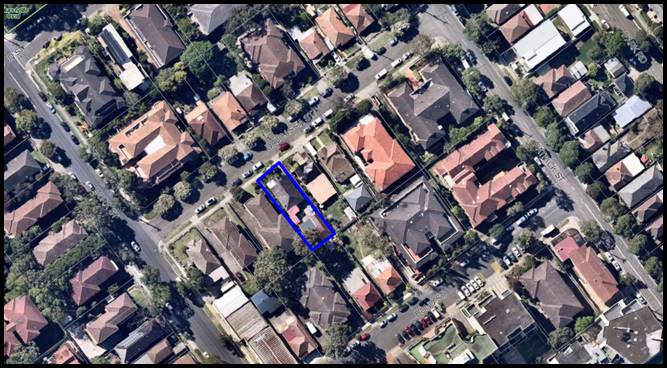
Aerial photograph of subject site (15 Dalcassia
Street, Hurstville) outlined in blue and immediate surrounding area (Source:
Intramaps, GRC 2020)
|
EXECUTIVE SUMMARY
1. Council is in receipt of a development application which seeks
development consent for the demolition of all existing structures and the
construction of a fifteen (15) room boarding house (one being a caretakers
room) on land known as 15 Dalcassia Street, Hurstville.
2. In detail, the proposal is described as follows:
- Demolition of existing dwelling
house and ancillary structures;
- Construction of four (4) storey
boarding house with a basement car park;
- Basement: driveway ramp, five
car (5) spaces, one (1) being accessible, eight (8) bicycle spaces, three (3)
motorcycle spaces, bulky storage, lift, two (2) egress stairs;
- Ground Floor: entry, lift,
central corridor, common room, common open space within front setback, laundry,
drying court, two (2) accessible rooms with courtyards;
- Level 1: lift, central
corridor, five (5) boarding rooms with balconies;
- Level 2: lift, central
corridor, five (5) boarding rooms with balconies;
- Level 3: lift, central
corridor, two (2) boarding rooms with balconies and one (1) caretakers room
with balcony.
3. The site is zoned R3 Medium Density Residential pursuant to the
Hurstville Local Environmental Plan 2012. A “boarding House” is
permitted within consent in the zone. The proposal meets the definition of a boarding
house.
4. The proposal does not satisfy Section 1.3 Objects of the Act of the
Environmental Planning and Assessment Act 1979 whereby the proposal does not
satisfy objective (g) which states “to promote good design and amenity
of the built environment”. In this instance, the proposal seeks a
four (4) storey built form on an allotment with a width of 12.19m which is not
compatible with the site dimensions and immediate context whereby comparable
built forms (density and scale) such as residential flat buildings are located
on wider allotments within the visual catchment. This results in reduced
amenity for future occupants and generates adverse impacts on adjoining
properties.
5. The proposal is not considered to satisfy State Environmental
Planning Policy Affordable Rental Housing (2009) and does not comply with the
minimum number of car parking required, being seven (7). Five (5) car spaces
are proposed on site. Whist the provisions of the SEPP prevails over the
Hurstville Development Control Plan regarding minimum car parking requirements,
it is noted that Council’s controls would require ten (10) car spaces.
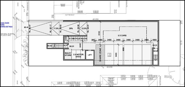
Figure 1: Extract of proposed basement level (Source: Cracknell Lonergan
Architects, 2020).
6. The design proposes a majority of the communal open space (13sqm of
the 20sqm required) within the front setback which is contrary to the SEPP and
inconsistent with the local character of the area.
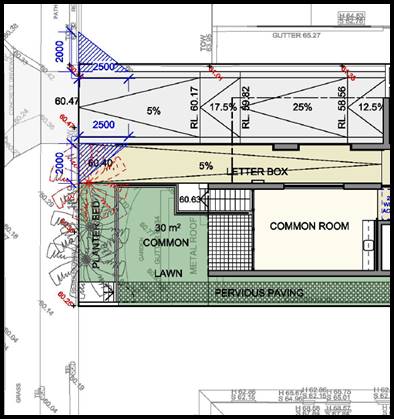
Figure 2: Extract of ground floor indicating the location of the proposed
communal open space within front setback (Source: Cracknell Lonergan
Architects, 2020).
7. The proposal fails to satisfy Clause 30A Character of the area given
the proposed form and proportion of the development results in limited spatial
separation to adjoining properties. The proposal adopts a building typology
with a scale and form of a four (4) storey residential flat building, with a
1.6m side setback for all four (4) levels. The established character of the
locality is residential flat buildings with pitched roofs surrounded by
landscaped areas, with proportionate spatial separation and lot width.
Established dwelling houses are located on allotments of similar widths and
size to that of the subject site. (*Note: the proposed rear setback of the
boarding houses aligns with 17 Dalcassia Street (side) at 6m from the rear
boundary).
Figure 3: Extract of section of subject site in relation to adjoining properties
(Source: Cracknell Lonergan Architects, 2020).
8. Clause 4.3 of the Hurstville Local Environmental Plan 2012
prescribes a height of building control of 12m. A lift overrun has been shown
on the section below, however this has not been shown any of the external
elevations.
Figure 4: Extract of cross section indicating breach of lift
overrun over 12m, no RL for the lift overrun has been provided (Source:
Cracknell Lonergan Architects, 2020).
9. Based on the section and scaled dimensions submitted,
Council’s assessment indicates that the proposal seeks a height of
building in excess of 12m to accommodate the lift overrun at 12.6m.
10. A Clause 4.6 Exception to Development Standard is required to
consider a variation to a Development Standard. A Clause 4.6 Exception to
Development Standard has not been provided in support of this height breach.
Figure 5: Extract roof plan indicating a lift overrun with no
nominated RL (Source: Cracknell Lonergan Architects, 2020).
11. The proposal was reviewed by Council’s Urban Design Consultant
(GM Urban Design and Architecture) who raised concerns in relation to
inadequate side setbacks, visual bulk, and location of the open waste storage
area which is in close proximity the dwelling house at 13 Dalcassia Street,
Hurstville together with the entry and the lack of opportunities to provide for
surveillance.
12. The proposal fails to comply with the following subsections of the
Hurstville Development Control Plan No. 1.
· Section 3.3 – Access and Mobility
· Section 3.9 – Waste Management
· Appendix 1 – Indicative Number of Storeys
13. The proposal results in adverse impacts in relation to occupant and
neighbouring amenity whereby rooms (103, 203 and 302) on levels 1, 2 and 3 have
a poor aspect and outlook as they are generally orientated internally as their
windows which directly face side boundary are frosted.
Figure 6: Extract of part of unit layout on levels 1, 2 and 3 with poor aspect
and outlook (Source: Cracknell Lonergan Architects, 2020).
14. The proposal is not supported by a clause 4.6 Exception to
Development Standard request to vary the height which is exceeded in the area
of the lift overrun.
15. On 30 June 2020 the applicant was requested to reconsider their
application and were given (7) days to respond as they were advised the
proposal was unlikely to be recommended for approval given the proposed built form
on a narrow allotment width. No response was received.
Site and Locality
16. The subject site is legally described as Lot 56 in DP 6510 and is
known as 15 Dalcassia Street, Hurstville.
17. The site has dimension of 12.19m in width and 40.235m in length with
a site area of 490.5sqm. The site slopes from the rear to the front with an
approximate fall of 1.72m.
18. A single storey masonry dwelling is centrally located on site. An
outbuilding comprising an entertainment room, laundry and stacked double garage
are located at the rear.
Zoning and
Permissibility
19. The subject site is zoned R3 Medium Density Residential under the
provisions of Hurstville Local Environmental Plan 2012 (HLEP 2012). The
proposal involves demolition works and the construction of a boarding house
which is a permissible use in the zone with development consent.
Submissions
20. The DA was publicly notified to neighbouring properties between 29
June and 13 July 2020 in accordance with the provisions of the Hurstville
Development Control Plan No. 1 (HDCP). In response, seven (7) submissions were
received raising concerns regarding; amenity, traffic, privacy, overshadowing,
noise, bulk and scale, waste, damage to adjoining properties and devaluation to
properties. These representations have been considered
and addressed accordingly in further detail within this assessment report.
Reason for Referral to the Local Planning Panel
21. The application for the boarding house, via Council Delegations, is
required to be determined by the Georges River Local Planning Panel.
Conclusion
22. The application has been assessed having
regard to the Matters for Consideration under 4.15 of the Environmental
Planning and Assessment Act 1979, the provisions of the relevant State
Environmental Planning Policies, Local Environmental Plans and Development Control
Plans.
23. The proposal being a boarding house is a
permissible use in the zone with consent, however the proposal fails to meet
the requirements of SEPP (Affordable Rental Housing) 2009, Hurstville Local
Environmental Plan 2012 and Hurstville Development Control Plan No.1.
24. The proposal is therefore recommended for refusal and would require
a substantial redesign to satisfactorily address the matters raised within the
report.
REPORT IN FULL
Description of
the Proposal
25. Council is in receipt of a development application which seeks
development consent for the demolition of the existing dwelling and associated
structures and construction of a fifteen (15) room (one being the caretakers
room) boarding house over basement car parking on land known as 15 Dalcassia Street,
Hurstville.
26. In detail, the proposal is described as follows:
- Demolition of existing dwelling
house and ancillary structures;
- Construction of four (4) storey
boarding house with a basement car park;
- Basement: driveway ramp, five
car (5) spaces, one (1) being accessible, eight (8) bicycle spaces, three (3)
motorcycle spaces, bulky storage, lift, two (2) egress stairs;
- Ground Floor: entry, lift,
central corridor, common room, common open space within front setback, laundry,
drying court, two (2) accessible rooms with courtyards;
- Level 1: lift, central
corridor, five (5) boarding rooms with balconies;
- Level 2: lift, central
corridor, five (5) boarding rooms with balconies;
- Level 3: lift, central
corridor, two (2) boarding rooms with balconies and one (1) caretakers room
with balcony.
Description of
the Site and Locality
27. The subject site is legally described as Lot 56 in DP 6510 and is
known as 15 Dalcassia Street, Hurstville.
28. The site is has a width of 12.19m and a length of 40.235m with a
total site area of 490.5sqm. The site slopes from the rear to the front with an
approximate fall of 1.72m.
29. A single storey masonry dwelling is centrally located on site. An
outbuilding comprising an entertainment room, laundry and stacked double garage
are located to the rear.
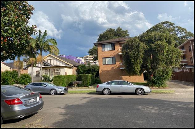
Figure 7: The site (15 Dalcassia Street, Hurstville) as viewed
from Dalcassia Street, Hurstville (Source: GRC, November 2020).
30. The visual catchment along Dalcassia Street, Hurstville comprises
residential flat buildings and dwelling houses which are zoned R3 Medium
Density Residential under the Hurstville Local Environmental Plan 2012.

Figure 8: The site (15 Dalcassia Street, Hurstville) as viewed
from Dalcassia Street, Hurstville (Source: GRC, November 2020).
Zoning and
Permissibility
31. The subject site is zoned R3 Medium Density Residential under the
provisions of Hurstville Local Environmental Plan 2012 (HLEP 2012). The
proposal involves demolition works and the construction of a boarding house
which is a permissible use in the zone with development consent.

Figure 9 Extract of zoning map of
Hurstville Local Environmental Plan 2012 (Source: Intramaps, 2020).
State
Environmental Planning Policies (SEPPs)
32. Compliance with the relevant SEPPs is summarised in the following table and discussed in further detail below.
Table 1: SEPP Considerations
|
SEPP Title
|
Complies
|
|
State
Environmental Planning Policy No 55 - Remediation of Land
|
Yes
|
|
Greater
Metropolitan Regional Environmental Plan No 2 – Georges River Catchment
|
Yes
|
|
State
Environmental Planning Policy (Building Sustainability Index: BASIX) 2004
|
Yes
|
|
State
Environmental Planning Policy (Vegetation in Non-Rural Areas) 2017
|
Yes
|
|
State
Environmental Planning Policy (Infrastructure) 2007
|
Yes
|
|
State
Environmental Planning Policy (Affordable Rental Housing) 2009
|
No
|
State Environmental Planning Policy No 55 - Remediation of Land
33. SEPP 55 aims to promote the remediation of contaminated land in
order to reduce the risk of harm to human health or any other aspect of the
environment.
34. Clause 7 requires contamination and remediation to be considered in
determining a development application. The consent authority must not consent
to the carrying out of development on land unless it has considered whether or
not the land is contaminated.
35. The site has a history of residential uses,
is currently occupied by a dwelling house and as such, site contamination is
not suspected. In this regard, no further assessment is warranted with regard
to site contamination.
Deemed State Environmental Planning Policy – Georges River
Catchment
36. The stormwater from the proposed development can be treated in accordance with Council’s Water
Management Policy and can drain to the street satisfying the relevant
provisions of the Deemed State Environmental Planning Policy – Georges
River Catchment. It is noted that the proposal seeks to drain to the front of the
site to Council’s kerb and gutter. The proposed stormwater disposal has
been reviewed by Council’s Development Engineer. This aspect of the
proposal is acceptable subject to conditions if the application was to be
supported.
State Environmental Planning Policy (Building Sustainability Index:
BASIX) 2004
37. The proposal satisfies the requirements of Statement Environmental
Planning Policy BASIX. A valid BASIX Certificate (1090839M dated 10 June 2020)
was submitted with this application. This development application was lodged
with Council on 30 June 2020. In this regard, the requirements of the SEPP have
been reasonably satisfied.
State Environmental Planning Policy (Vegetation in Non-Rural Areas)
2017
38. The Vegetation SEPP regulates clearing of native vegetation on urban
land and land zoned for environmental conservation/management that does not
require development consent.
39. The Vegetation SEPP applies to clearing of:
a) Native vegetation above the Biodiversity Offset
Scheme (BOS) threshold where a proponent will require an approval from the
Native Vegetation Panel established under the Local Land Services Amendment Act
2016; and
b) Vegetation below the BOS threshold where a
proponent will require a permit from Council if that vegetation is identified
in the council’s development control plan (DCP).
40. The Vegetation SEPP repeals clause 5.9 and 5.9AA of the Standard
Instrument - Principal Local Environmental Plan with regulation of the clearing
of vegetation (including native vegetation) below the BOS threshold through any
applicable DCP.
41. The proposed development does not involve the removal of any
significant trees or vegetation. In this regard, the provisions of this SEPP
are considered to be met.
42. The proposal and accompanying Landscape Plan and arborist report
have been considered by Council’s Consulting Arborist. No concerns
were raised in relation to this aspect of the proposal which sought the removal
of one (1) tree, retention of two (2) trees on site and protection of two (2)
trees on adjoining properties.
State Environmental Planning Policy (Infrastructure) 2007
43. The aim of the Infrastructure SEPP is to facilitate the effective
delivery of infrastructure across the State. The DA was referred to Ausgrid on
30 June 2020 in accordance with Clause 45(2) of State Environmental Planning
Policy (Infrastructure) 2007. In response, Ausgrid advised that there are no
issues with the proposal subject to as minimum clearance distances from
Ausgrid’s Infrastructure.
44. In this regard, the provisions and requirements of the
Infrastructure SEPP have been adequately satisfied.
State Environmental Planning Policy (Affordable Rental Housing) 2009
45. The proposal has been considered in accordance with the objectives
of State Environmental Planning Policy (Affordable Rental Housing) 2009 of
which the following objectives have not been satisfied.
(a) to provide a consistent planning regime for the
provision of affordable rental housing.
(b) to facilitate the effective delivery of new
affordable rental housing by providing incentives by way of expanded zone
permissibility, floor space ratio bonuses and non-discretionary development
standards.
46. The above objectives have not been satisfied as the proposal has not
satisfied the development standards. The proposal is therefore inconsistent
with the planning regime for the provision of affordable rental housing.
47. The proposal seeks consent for a boarding house pursuant to the
provisions of the SEPP, specifically Division 3 – Boarding Houses. An
assessment of the proposal against the relevant provisions of the SEPP is
provided in the following table below.
Table 2: State Environmental Planning
Policy (Affordable Rental Housing) 2009
|
Clause
|
Standards
|
Proposal
|
Complies
|
|
26 – Land to
which Division applies for the purpose of a boarding house with consent
|
· R1 General Residential
· R2 Low Density Residential
· R3 Medium Density Residential
· R4 High Density Residential
· B1 Neighbourhood Centre
· B2 Local Centre
· B4 Mixed Use
|
Site is zoned R3
Medium Density Residential under the Hurstville Local Environmental Plan 2012
|
Yes
|
|
27 –
Development to which Division applies
|
(1) This Division applies to development,
on land to which this Division applies, for the purposes of boarding houses.
(2) Despite subclause (1), clauses 29, 30
and 30A do not apply to development on land within Zone R2 Low Density
Residential or within a land use zone that is equivalent to that zone in the
Sydney region unless the land is within an accessible area.
|
Noted.
The land is within
an accessible area to the entrance Hurstville Railway Station – refer
to comments below.
|
-
Yes – refer
to discussion below.
|
48. An accessible area is defined by Clause 4 of SEPP (ARH) 2009 as
follows:
‘accessible area means land that is within:
(a) 800m walking distance of a
public entrance to a railway station or a wharf from which a Sydney Ferries
ferry service operates, or
(b) 400m walking distance of a public
entrance to a light rail station or, in the case of a light rail station with
no entrance, 400 metres walking distance of a platform of the light rail
station, or
(c) 400m walking distance of a bus
stop used by a regular bus service (within the meaning of the Passenger Transport Act 1990) that has at
least one bus per hour servicing the bus stop between 06.00 and 21.00 each day
from Monday to Friday (both days inclusive) and between 08.00 and 18.00 on each
Saturday and Sunday.’
49. The subject site satisfies the requirements of an accessible area as
defined in (a) above. A map below indicates the walking distance from the
subject site (15 Dalcassia Street Hurstville to Hurstville Railway Station
being 634.4sqm.
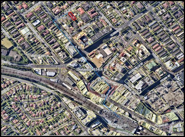
Figure 10: Map showing distance from subject site to Hurstville
Railway Station (Source: Intramaps, 2020).
Table 3: State Environmental Planning
Policy (Affordable Rental Housing) 2009
|
Clause
|
Standard
|
Proposed
|
Complies
|
|
29 - Standards that cannot be used to refuse consent
Council cannot
refuse a development application for a boarding house under the ARHSEPP 2009
on any of the following grounds:
|
|
(1) Floor Space
Ratio
|
(c) if the development is on land within a zone in which
residential flat buildings are permitted and the land does not contain a
heritage item that is identified in an environmental planning instrument or
an interim heritage order or on the State Heritage Register—the
existing maximum floor space ratio for any form of residential accommodation
permitted on the land, plus:
(i) 0.5:1, if the
existing maximum floor space ratio is 2.5:1 or less, or
Site area =
490.5sqm
= maximum FSR =
1.5:1 (735.75sqm)
|
1.1:1
(539.13sqm)
|
Yes
|
|
(2) Height
|
(a) If the building height is not more than the maximum height
permitted under another EPI for any building on the land: Max 12m HLEP2012
|
Parapet 11.42m
(RL72.75)
Insufficient
detail on plans provided by the applicant for the top of the lift overrun
which is higher than the parapet. Based on RL’s and scaled elevations
on the plans Council Officer assessment indicates a height of 12.6m
(RL73.35).
|
No
|
|
Landscaped Area
|
(b) If the landscape treatment of the front
setback area is compatible with the streetscape in which the building is
located
|
The proposed
landscaped front setback area is privatised and enclosed by high fencing;
this is not consistent with the immediate visual catchment which comprises of
lawn areas and low height masonry front fences.
|
Yes
|
|
Solar Access
|
(c) Where the development provides for one or
more communal living rooms, if at least one of those rooms receives a minimum
of 3 hours direct sunlight between 9am and 3pm in mid-winter
|
3 hours of direct
sunlight is achieved to the communal room which contains windows within the
front western elevation.
|
Yes
|
|
Private Open Space
|
(d) if at least the following private open space
areas are provided (other than the front setback area):
(i) one
area of at least 20sqm with a minimum dimension of 3m is provided for the use
of the lodgers,
(ii) if
accommodation is provided non site for a boarding house manager- one area of
at least 8sqm with a minimum dimension of 2.5m is provided adjacent to that
accommodation.
|
7sqm
are provided which complies. Part of the proposed communal open space (13sqm of the minimum 20sqm required) excluding the front terrace is located within the front setback.
Private
open space of 12sqm which meets this criterion is provided in the form of a
balcony.
|
No, refer to
discussion below.
Yes
|
|
Comments on private open space areas
The
proposal provides only 7sqm which does not comply with the SEPP. The proposal
provides the majority of communal private open space for lodgers of the
boarding house located within the front setback forward of the building line.
This is not considered to be appropriate and results in limited privacy and
amenity which is considered to detract of the use of this space providing poor recreation areas for future occupants.
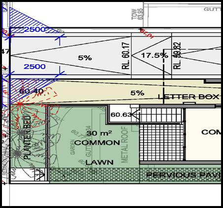
Figure 11 The proposal seeks 13sqm of communal
open space forward of the building line which results in poor amenity and
detracts from the usability of this space (Source: Cracknell Lonergan Architects, 2020).
|
|
(e) Parking
|
(iia) 0.5 spaces per boarding room (14 boarding rooms) x 0.5
= 7 spaces required.
(iii) Not more than 1 parking space is provided for
each person employed in connection with the development and who is resident
on site
|
5 spaces located
within the basement car park.
No boarding room
manager’s car space has been nominated on plans or proposed within the
applicant’s statement of environmental effects.
|
No
No
|
|
(f) Accommodation
size
|
Each
boarding room has a gross floor area (excluding any area used for the
purposes of private kitchen or bathroom facilities) of at least:
(i) 12sqm in the case of a boarding room
intended to be used by a single lodger, or
(ii) 16sqm in any other case
(*Note: 1m in front of kitchen benchtops have been
considered as circulation spaces and have been excluded from the room
calculations).
|
G01
– 25sqm
G02
- 23sqm
102
- 22sqm
102
- 21sqm
103
- 21sqm
104
- 21sqm
105
- 22sqm
201
- 19sqm
202
- 24sqm
203
– 19sqm
204
- 18sqm
205
– 22sqm
301
- 24sqm
302
– 24sqm
303
– 24sqm
All
rooms have been proposed as double rooms with the exception of the
manager’s room. In total the proposal seeks to accommodate twenty eight
(28) lodgers and one (1) boarding house manager.
|
Yes
|
|
Clause 30 – Standards for Boarding Houses
A consent
authority must not consent to development for boarding houses unless it is
satisfied of each of the following:
|
|
Communal living
|
(a) If a boarding house has 5 or more
boarding rooms, at least one communal living room will be provided
|
The proposal seeks
fourteen (14) boarding rooms with one (1) communal living room provided on
the ground floor at the front of the building.
|
Yes
|
|
Size of boarding
rooms
|
(b) No boarding room will have a
gross floor area (excluding any area used for the purposes of private kitchen
or bathroom facilities) of more than 25sqm
|
G01
– 25sqm
G02
- 23sqm
102
- 22sqm
102
- 21sqm
103
- 21sqm
104
- 21sqm
105
- 22sqm
201
- 19sqm
202
- 24sqm
203
– 19sqm
204
- 18sqm
205
– 22sqm
301
- 24sqm
302
– 24sqm
303
– 24sqm
|
Yes
|
|
Maximum occupancy
|
(c) No boarding room will be occupied
by more than 2 adult lodgers
|
All boarding rooms
are to accommodate a maximum of 2 adult lodgers. In total the proposal seeks to accommodate twenty eight
(28) lodgers and one (1) boarding house manager.
|
Yes
|
|
Kitchen and
bathroom facilities
|
(d) Adequate bathroom and kitchen
facilities will be available within the boarding house for the use of each
lodger
|
All boarding rooms
and manager’s room have a kitchen and ensuite facilities. A communal
kitchenette is located within the communal living room.
|
Yes
|
|
Boarding house
manager
|
(e) If the boarding house has
capacity to accommodate 20 or more lodgers, a boarding room or on site
dwelling will be provided for a boarding house manager
|
The proposal seeks
to accommodate a maximum of twenty-eight (28) lodgers. A Manager’s Room
is located at the rear of the third floor.
|
Yes
|
|
Bicycle and motor
cycle spaces
|
(h) At least one parking space will
be provided for a bicycle, and one will be provided for a motorcycle, for
every 5 boarding rooms (15/5 = 3).
|
Three (3) motorcycle
spaces are proposed within the basement, located between the lift and bulky
store area.
|
Yes
|
Clause 30A – Character of local area
50. Clause 30A states that Council cannot grant consent to a boarding
house unless it has taken into consideration
whether the design of the development is compatible with the character of the
local area.
51. Case law has held that the test in Clause
30A is “one of compatibility not sameness” (Gow v Warringah
Council [2013] NSWLEC 1093 (15 March 2013)). Compatibility is widely accepted
to mean “capable of existing together in
harmony” (Project Venture Developments Pty Ltd v Pittwater Council [2005]
NSWLEC 191.
52. It has also been held that in assessing
‘compatibility’ both the existing and future character of the local
area needs to be taken into account (Sales Search Pty
Ltd v The Hills Shire Council [2013] NSWLEC 1052 (2 April 2013) and Revelop
Projects Pty Ltd v Parramatta City Council [2013] NSWLEC 1029).
Relationship to the Existing and Future Character of
the Local Area
53. In Revelop Projects Pty Ltd v Parramatta City Council [2013] NSW LEC
1029, Commissioner Morris concluded that the ‘local area’ includes
both sides of the street and the ‘visual catchment’ as the minimum
area to be considered in determining compatibility.
54. Whilst State Environmental Planning Policy No 65 – Design
Quality of Residential Apartment Development does not apply to boarding houses.
It is noted that a frontage of 24m is required for a residential flat building
within the Hurstville Development Control Plan No. 1 – Section 4.0
Specific Controls for Residential Development - PC2 Site Frontage.
55. For the purposes of comparison regarding building typologies the proposal
seeks the following setbacks:
Table 4: Setback comparison guidance table
|
Setbacks
|
Proposal
(levels G-3)
|
Apartment
Design Guide “guidance” RFB up to 12m
|
|
Front
setback
|
6.9m to
balcony (scaled off plans not dimensioned)
|
6m
average front setback
|
|
Side
setback
|
1.6m
(scaled off plans not dimensioned)
|
6m
habitable
3m
non-habitable
|
|
Side
setback
|
1.6m
(scaled off plans not dimensioned)
|
6m
habitable
3m
non-habitable
|
|
Rear
setback
|
7.7m
(scaled off plans not dimensioned)
|
6m
habitable
3m
non-habitable
|
56. The ‘local area’ in this case is taken to include both
sides of Dalcassia Street, Hurstville which form the immediate visual
catchment.
Table 5: Summary of immediate local area built form allotment width
|
Address
|
Built form
|
Allotment width
|
No of storeys
|
|
23 Dalcassia Street, Hurstville
*corner site
|
Dwelling house
|
14.8m
|
1
|
|
19-21 Dalcassia Street, Hurstville
|
Established
residential flat building
|
18.1m
|
4
|
|
17 Dalcassia
Street, Hurstville
|
Established
residential flat building
|
18.2m
|
3
|
|
15 Dalcassia
Street, Hurstville (Subject site)
|
Established
dwelling house (boarding house proposed)
|
12.19m
|
4
|
|
13 Dalcassia
Street, Hurstville
|
Established
dwelling house
|
11.8m
|
1
|
|
11 Dalcassia
Street, Hurstville
|
Established
dwelling house
|
11.8m
|
1
|
|
7-9 Dalcassia
Street, Hurstville
|
Established
residential flat building
|
24.3m
|
4
|
|
1-5 Dalcassia
Street, Hurstville
*corner site
|
Established
residential flat building
|
35.2m
|
4
|
|
1 Patrick Street,
Hurstville
*corner site
|
Established
residential flat building
|
14.3m
|
3
|
|
4 Dalcassia
Street, Hurstville
|
Established
dwelling house
|
12m
|
1
|
|
6 Dalcassia
Street, Hurstville
|
Established
dwelling house
|
11.5
|
1
|
|
8 Dalcassia
Street, Hurstville
|
Established
dwelling house
|
12m
|
1
|
|
10-12 Dalcassia
Street, Hurstville
|
Established
residential flat building
|
24m
|
4
|
|
14 Dalcassia
Street, Hurstville
|
Established
dwelling house
|
11.6m
|
1
|
|
16 Dalcassia
Street, Hurstville
|
Established
dwelling house
|
11.7m
|
1
|
|
18 Dalcassia
Street, Hurstville
|
Established
dwelling house
|
11.6m
|
1
|
|
20-24 Dalcassia
Street, Hurstville
*corner site
|
Established
residential flat building
|
35.4m
|
4
|
57. Given the above, it is considered all residential flat building
built forms within the visual catchment range from 3 to 4 storeys and are all
on allotments larger than that of the subject site (being 12.19m) being lots
which range from 18.1m – 24m. Further that it is anticipated that built
forms (similar to that proposed) such as residential flat buildings are to have
a minimum allotment width of 24m.
58. In Project Venture Developments v Pittwater Council [2005] NSWLEC
191 the Land and Environment Court specifically set out a relevant planning
principle. Consideration has therefore been given to the two (2) key questions
identified in the Land and Environment Court Planning Principles:
(a) Are the proposal’s physical impacts
on surrounding development acceptable? The physical impacts include constraints
on the development potential of surrounding sites.
59. The building form proposed adopts a similar building typology to
that of a four (4) storey residential flat building with basement parking.
60. The proposed side setbacks of 1.6m for all four (4) storeys along
the side elevations results in adverse overshadowing impact to the southern
adjoining residential flat building at 17 Dalcassia Street, Hurstville. No
elevational shadow diagrams have been provided demonstrating the impact of the
proposal on the adjoining property and if compliance is achieved.
61. Further to the above, the blank side elevations result in a poor
visual outlook from the adjoining neighbouring properties given the minimal side
boundary setback of the proposed development being 1.6m.
(b) Is the proposal’s appearance in harmony with the buildings
around it and the character of the street?
62. The proposal in its current form is considered
to result in a form that is inconsistent with the surrounding development given the development is vertical
in its expression and there is no relief horizontally given the narrowness of
the allotment.
63. The application was referred externally for
urban design comments, which resulted in the following:
64. “The site’s immediate area is
predominately characterised by 3-4 storey residential flat buildings on
larger/consolidated lots. Most lot widths are greater than 18m and traditional
dwelling houses on smaller fine-grain lots are also found in the area. Larger
scale development generate provides setbacks resulting in 6-9m separation
(measured from Nearmap) between building and landscaped areas alongside boundaries.
This forms part of the existing streetscape character of the area.
65. As per the Ground Level Plan (DA 102, Cracknell
& Lonergan Architects, March 2020), the proposal provides approximately
1.5-1.6m setback to side boundaries with no provision of deep soil planting due
to the narrow lot width and the extent of the basement level, which is built to
both side boundaries. HDCP has not provided detailed guidelines for boarding
houses; however, the residential flat buildings are required to provide side
setbacks in accordance with ADG (HDCP 4.1 D.S 6.1) and landscaping are
encouraged alongside boundaries (HDCP 3.5 P.C 5). For developments of similar
scale, residential flat buildings will be required to provide at least 4.5m
setbacks to side boundaries. We acknowledge that the ADG does not apply to
boarding house developments but it is reasonable to expect that the development
responds to key ADG principles to ensure an outcome which is compatible with
future (RFB) developments in the area. If the proposal is to keep consistent
with the desired future character, we consider that an increased side setback
for both sides needed to achieve a better relationship with the neighbouring
development, and incorporate deep soil planting to create a landscape buffer
that responds to the character of the area.
66. The current design provides long continuous
blank wall facades facing both side boundaries, which is a concern resulting in
a visual impact to the neighbouring developments as well as to the streetscape
character. This issue is further exacerbated as no landscape buffers are
proposed to screen the side boundaries. The continuous blank wall element in
its current height and proximity to the side boundary will create an increased
sense of enclosure and a poor outlook for the development at No 17 Dalcassia St
where the adjacent property has living rooms/balconies facing the common
boundary.
67. Given the above the proposal is not considered to be harmonious with
the character of the surrounding area. The proposed design results in a built
form which is not considered compatible due to insufficient side setbacks which
result in a development that fits poorly in the streetscape. The proposal
adopts a four (4) storey built form with a flat roof and generally blank walls
along the side elevations which further adds visual massing. Further that, the
increase in setbacks would result in a full redesign of the proposal given the
lift core, circulation spaces and car parking layout. It is also noted that no elevational solar access diagrams have been provided
demonstrating the extent of impact to the adjoining residential flat building
windows and balconies at 17 Dalcassia Street, Hurstville.
68. The proposed development is not consistent with the existing or
desired future character of the locality with respect to inadequate setbacks
and spatial separation when considered in the context of the immediate visual
catchment. In this regard, the proposal is not
considered to satisfy Clause 30A Character of Local Area of the SEPP.
Environmental Planning Instruments
Hurstville Local Environmental Plan 2012 (HLEP 2012)
Zoning
69. The subject site is zoned R3 Medium Density Residential pursuant to the provisions of the Hurstville
Local Environmental Plan 2012 (HLEP 2012). The proposed development satisfies
the definition of a “boarding house”. A boarding house is a
permissible land use in the R3 Medium Density Residential Zone with consent.
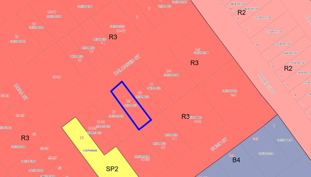
Figure 12 Extract of zoning map of
Hurstville Local Environmental Plan 201 – site outlined in blue (Source:
Intramaps, 2020).
70. The proposal fails to
satisfy the objective of the R3 Medium Density Residential zone as
follows:
• To ensure that a high level of residential
amenity is achieved and maintained.
71. The proposal has not provided adequate, functional and
private communal open space, an accessible room and
accessible access to and within the site, a waste storage area and is deficient
in car parking which result in poor levels of residential amenity for the
future occupants of the development.
72. The proposed built form and setbacks result in
unnecessary adverse overshadowing impacts onto 17 Dalcassia Street, Hurstville
which prevents a high level of residential amenity being achieved and
maintained.
73. The proposal seeks significant excavation to the
side boundaries with a nil boundary setback to accommodate the basement. This
limits opportunities for meaningful and substantial planting along the side
boundaries for the full length of the building which are characteristic of
similar built forms within the immediate vicinity. In a residential zoning
development is not encouraged to be built to the allotment boundaries.
74. Given the above, the proposal
fails to satisfy the objectives of the R3 Medium Density Residential Zone and
results in a poor planning outcome. Furthermore, this also results in an
undesirable precedent for narrow single allotments of which currently are
occupied by established dwelling houses within Dalcassia Street, Hurstville and
the broader precinct.
75. The extent to which the
proposal complies with the relevant standards of Hurstville Local Environmental Plan
2012 (HLEP2012) is outlined in the table below.
Table 6: Hurstville Local Environmental
Plan 2012
|
HLEP 2012
Clause
|
Standard
|
Proposed
|
Complies
|
|
2.2 Zone
|
R2 Low Density
Residential
|
The proposal meets
the definition of boarding house which is a permissible use within the zone.
|
Yes
|
|
2.3
Objectives
|
Objectives of the
Zone
|
As discussed
earlier, the proposal is not consistent with the zone objective being “to
ensure that a high level of residential amenity is achieved and
maintained”.
|
No
|
|
4.3 – Height
of Buildings
|
12m as identified
on Height of Buildings Map
|
Parapet 11.42m
(RL72.75).
Based on the
nominated RL’s and scaling of the elevations Council’s assessment
equates to height of 12.6m being RL73.35.
(Note: There is
no spot level directly below the proposed lift on the survey).
|
No
|
|
Height of
building
Based on the
submitted architectural plans the lift overrun exceed the 12m height control.
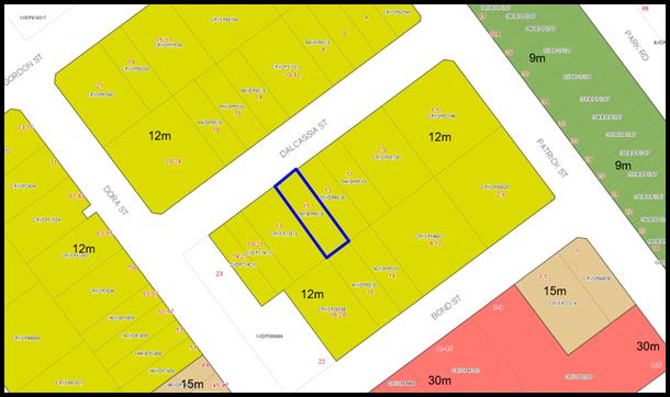
Figure 13 The subject site and immediate surrounding area has
a height limit of 12m Source: Intramaps, 2020).
|
|
4.4 – Floor
Space Ratio
|
1:1 as identified
on Floor Space Ratio Map
Site area =
490.5sqm
It is noted that
SEPP ARH prevails over the HLEP in relation to floor space whereby 1.5:1 is
permitted.
|
1.1:1
(539.13sqm)
|
Yes
|
|
4.5 –
Calculation of floor space ratio and site area
|
FSR and site area
calculated in accordance with Cl.4.5
|
The
FSR and site area has been calculated according to the criterion of this
clause.
|
Yes
|
|
5.10 –
Heritage Conservation
|
The objectives of
this clause are;
(i) to conserve the environmental heritage of Kogarah,
(ii) to conserve the heritage significance of heritage items
and heritage conservation areas, including associated fabric, settings and
views.
|
The proposal does
not directly adjoin or is located within the immediate vicinity of any
environmental heritage item nominated under HLEP 2012.
|
N/A
|
|
6.1 Acid Sulphate
Soils
|
The objective of this clause is to ensure that development
does not disturb, expose or drain acid sulfate soils and cause environmental
damage
|
The site is not
affected by Acid Sulfate Soils under HLEP 2012.
|
N/A
|
|
6.2 Earthworks
|
To ensure that
earthworks do not have a detrimental impact on environmental functions and
processes, neighbouring uses, cultural or heritage items or features of the
surrounding land
|
Earthworks are
proposed to accommodate the boarding house, basement level, driveway and
on-site detention which is a requirement of this development.
|
Yes
|
|
|
|
|
|
Draft State Environmental Planning Policies (SEPPs)
Draft Georges River Local
Environmental Plan 2020
76. Consideration is given to the provisions of Draft Georges River
Local Environmental Plan 2020 in the assessment this application.
77. In this regard, the provisions have no determining weight as a
result of proposed operation of Clause “1.8A Savings provisions
relating to development applications” of the Draft Plan which
provides “If a development application has been made before the
commencement of this Plan in relation to land to which this Plan applies and
the application has not been finally determined before that commencement, the
application must be determined as if this Plan had not commenced.”
78. Comment: The proposal is inconsistent
with the provisions of this Draft Instrument in regard to the height of the
building which exceeds the permitted 12m. As previously stated within this
report, Council’s assessment has indicated that the proposal results in a
lift overrun height of 12.6m whereby no Clause 4.6 Exception to Development
Standard has been provided. As a result this application cannot be lawfully
considered for a favourable determination.
Draft Environment SEPP
79. The Draft
Environment SEPP was exhibited from 31 October 2017 to 31 January 2018. This consolidated SEPP
proposes to simplify the planning rules for a number of water catchments,
waterways, urban bushland, and Willandra Lakes World Heritage Property.
80. Changes proposed include consolidating
the following seven existing SEPPs:
· State Environmental Planning Policy No. 19
– Bushland in Urban Areas
· State Environmental Planning Policy (Sydney
Drinking Water Catchment) 2011
· State Environmental Planning Policy No. 50
– Canal Estate Development
· Greater Metropolitan Regional Environmental Plan
No. 2 – Georges River Catchment
· Sydney Regional Environmental Plan No. 20
– Hawkesbury-Nepean River (No.2-1997)
· Sydney Regional Environmental Plan (Sydney
Harbour Catchment) 2005
· Willandra Lakes Regional Environmental Plan No.
1 – World Heritage Property
81. Comment: The proposal is not
inconsistent with the provisions of this Draft Instrument.
Draft Remediation of Land SEPP
82. The Department of Planning and Environment has announced a Draft
Remediation of Land SEPP, which will repeal and replace the current State Environmental Planning Policy No 55 —
Remediation of Land.
83. The main changes proposed include the expansion of categories of
remediation work which requires development consent, a greater involvement of
principal certifying authorities particularly in relation to remediation works
that can be carried out without
development consent, more comprehensive guidelines for Councils and certifiers
and the clarification of the contamination information to be included on
Section 149 Planning Certificates.
84. Whilst the proposed
SEPP will retain the key operational framework of SEPP 55, it will adopt a more
modern approach to the management of contaminated land. The Draft SEPP will not
alter or affect the findings in relation to contamination at the site.
85. The site has a history of residential uses and as such, site contamination
is not suspected. In this regard, no further assessment is warranted with
regard to site contamination.
86. Comment: The proposal is not
inconsistent with the provisions of this Draft Instrument.
Development Control Plan
Hurstville Development Control Plan No 1 (HDCP)
87. The proposal has been considered in accordance with the relevant
chapters of the HDCP No 1 below.
DEVELOPMENT CONTROL PLAN NO 1 – LGA WIDE – SECTION 3.1
VEHICLE ACCESS, PARKING AND MANOEUVRING
88. The car parking rates set out within the State Environmental
Planning Policy (Affordable Rental Housing) 2009 supersedes the DCP
requirements. Under the SEPPARH seven (7) spaces are required however five (5)
spaces are provided.
89. It is noted in relation to car parking; Council’s DCP controls
for boarding houses prescribe a rate of “1 car space per 3 beds and 1
space per 2 employees”. Given that the proposal seeks to accommodate
twenty eight lodgers (2 per room) and one (1) boarding house manager, based on
fourteen (14) double beds and a double bed for a single boarding house manager.
The car parking rate is based on the number of rooms therefore 14 divided by 3
equals 4.66 rounded up to 5 and 1 for the Manager/Caretaker. As a result 6
spaces are required. Notwithstanding the above, the proposal does not comply
with the requirements of the SEPP in relation to minimum car parking.
DEVELOPMENT CONTROL PLAN NO 1 – LGA WIDE – SECTION 3.3
ACCESS AND MOBILITY
90. The development has been assessed against the key requirements of
Section 3.3 as provided below.
Table 7: Hurstville Development Control
Plan Section 3.3 Access and Mobility
|
Places of
Shared Accommodation
|
Standard
|
Proposal
|
Complies
|
|
Adaptable
dwellings
|
1 accessible room
per 5 guests/tenants bedrooms or part thereof –
(28 tenants /14
bedrooms) = 3 required
|
2 x accessible
rooms (G01 and G02) proposed. The proposal is deficient by one (1)
accessible room.
|
No
|
|
Access
requirements
|
Access in
accordance with AS1428 for all persons through the principal entrance of the
building and to common areas
|
The proposal has
not provided adequate accessible travel pathways along the southern side
which is noted as “pervious paving”.
(Note: No
details provided of pervious paving consists of)
|
No
|
|
Accessible car
space
|
1 parking space
per 10 rooms or part thereof – 1.5 required (rounded up to 2) as
fifteen (15) rooms are proposed.
|
The proposal is
deficient space.
|
No
|
91. The application fails to provide sufficient, accessible parking, is
deficient by one (1) accessible unit and provides inadequate accessible paths
of travel. These aspects form reasons for refusal of the application.
DEVELOPMENT CONTROL PLAN NO 1 – LGA WIDE – SECTION 3.4
CRIME PREVENTION THROUGH ENVIRONMENTAL DESIGN
92. The proposal has been considered in accordance with the relevant
provisions. The proposal incorporates the communal living room with a direct
outlook to Dalcassia Street, Hurstville. Boarding rooms on levels 1 to 3 which
also face Dalcassia Street provide opportunities for passive natural
surveillance. In this regard, the proposal has adequately satisfied the
requirements of this subsection.
DEVELOPMENT CONTROL PLAN NO 1 – LGA WIDE – SECTION 3.5
LANDSCAPING
93. As previously discussed within this report. A landscape plan was
submitted and accompanied by an arborist report which have been reviewed as
part of this proposal by Council’s Consulting Arborist and is considered
acceptable.
DEVELOPMENT CONTROL PLAN NO 1 – LGA WIDE – SECTION 3.7
STORMWATER
94. The proposed drainage arrangement is discharging
by gravity to an outlet in the street via an OSD system
to the kerb and gutter to Dalcassia Street, Hurstville. Council’s Development Engineer supports this aspect
of this proposal.
DEVELOPMENT CONTROL PLAN NO 1 – LGA WIDE – SECTION 4
– SPECIFIC CONTROLS FOR RESIDENTIAL DEVELOPMENT
95. Council’s Development Control Plan does not contain any
specific controls for boarding house developments.
DEVELOPMENT CONTROL PLAN NO 1 – LGA WIDE – APPENDIX 1
– SECTION 7 WASTE MANAGEMENT
96. A Waste Management Plan has been submitted with the application and
the submitted ground floor plan indicates 4 x 240L general waste bins, 2 x 240L
recycling bins and 1 x 240L green waste bins are provided in the bin area shown
on the site plan and the owners are responsible for placing bins on the kerb to
be collected by the Council’s waste collection service.
97. The site plan submitted with this application indicates waste
storage areas located on the ground floor and is not enclosed being adjacent to
the north east side setback which is considered to result in adverse impacts in
relation to odour, in particular to the adjoining dwelling at 13 Dalcassia
Street, Hurstville. Given the above the proposal has not adequately satisfied
the requirement of this section.
DEVELOPMENT CONTROL PLAN NO 1 – LGA WIDE – APPENDIX 1
– SECTION 8 ENERGY EFFICIENCY
98. As previously addressed within this report, a valid BASIX
certificate accompanies this development application which achieves a pass
mark. In this regard, the proposal has satisfied the considerations of this
subsection.
DEVELOPMENT CONTROL PLAN NO 1 – LGA WIDE – APPENDIX 1
– SECTION 9 PRESERVATION OF TREES AND VEGETATION
99. A Landscape Plan was and submitted arborist report reviewed as part
of this proposal and is supported by Council’s Consulting Arborist.
DEVELOPMENT CONTROL PLAN NO 1 – LGA WIDE – APPENDIX 1
– SECTION BUILDING HEIGHTS AND INDICATIVE NUMBER OF STOREYS
100. Council’s
controls provide an indicative conversion for the building height in metres to
a maximum number of storeys for residential zones. The site is zoned R3 Medium
Density Residential which is to form three (3) storeys. The proposal seeks four
(4) storeys. It is also noted that the proposal seeks floor to floor heights of
2,800mm – 3,000mm which may be inadequate for slab thickness and
services. In this regard, the proposal does not satisfy the intention of this
subsection.
INTERIM POLICY GEORGES RIVER DCP 2020
99. The proposed development is
subject to the provisions of the Interim Policy Georges River DCP 2020. Only
the applicable aspects have been assessed with respect to the Interim DCP. All
other aspects have been thoroughly assessed under Hurstville DCP. The aim of an
Interim Policy is to set a consistent approach for the assessment of
residential development within the Georges River Local Government Area, until
such a time as a comprehensive DCP is prepared and implemented. Comments are
made with respect to the proposal satisfying the objectives and controls
contained within the DCP. The proposal is not considered to be inconsistent
with the Interim Policy.
DEVELOPER CONTRIBUTIONS
101. A
boarding house requires payment of developer
contributions under Section 7.12 of the Environmental Planning and Assessment
Act 1979. The proposal is not recommended for support as a result contributions
have not been levied.
IMPACTS
Natural Environment
102. A
landscape plan and arborist report were submitted with the application.
Council’s Consulting Arborist supports the proposal. Council’s
Development Engineer supports the proposal in relation to the disposal of
stormwater. In this regard, the proposal is considered to be satisfactory with
respect to impacts on the natural environment.
Built Environment
103. The
proposal in its current form is considered to result in a poor built form and
internal functionality which results in amenity impacts on adjoining
properties, reduced occupant amenity and adverse traffic and parking impacts.
104. The
design is considered to be poor in terms of the layout, occupant and
neighbouring amenity.
105. The proposal has not provided adequate car parking, communal open space, is
deficient by one (1) accessible unit and has not demonstrated acceptable accessible
access to and within the site, poor location of the waste storage area which
results in poor levels of residential amenity.
106. The proposal seeks significant excavation to the side
boundaries with a nil boundary to accommodate the basement. This limits
opportunities for meaningful and substantial planting along the side boundaries
for the full length of the building which are characteristic of similar built
forms within the immediate vicinity. Building boundary to boundary is not
characteristic of development in a residential zone.
Social Impact
107. The
submitted Plan of Management makes reference to communal open space being
accessible between 7.00am to 10.00pm seven days a week. The late night use is
considered to result in adverse impacts to the immediate properties given its
location.
Economic Impact
108. There
is no apparent adverse economic impact given the residential nature of the
proposal.
Suitability of the site
109. The site is zoned R3 – Medium
Density Residential under the Hurstville Local Environmental Plan 2012. A boarding house is a permissible form of development in this zone however the
proposal fails to meet a number of standards of the State Environmental
Planning Policy (Affordable Rental Housing) 2009, Hurstville Local
Environmental Plan 2012 and Hurstville Development Control Plan No 1. These
non-compliances adversely affect the amenity of the development for future
occupants and adjoining properties. For these reasons, and others discussed
throughout this report, the application is not supported and is recommended for
refusal.
SUBMISSIONS
AND THE PUBLIC INTEREST
110. The application was neighbour notified in accordance with Hurstville
DCP No 1 between 29 June and 13 July 2020. In response,
Seven (7) submissions were received. All concerns raised within the submissions
have been considered. The key issues raised within the submissions have been
addressed below.
Insufficient car parking/traffic impacts to street parking
111. Officer Comment: The proposal is deficient by two (2) car parking spaces which are
considered to detract from the amenity for future occupants. The reduced car
parking results in a greater demand for on street car parking. This is
considered to result in a poor planning outcome.
Poor amenity for future residents
112. Officer Comment: The proposal results in
poor levels of occupant amenity and results in outcome which is inconsistent
with the zone objectives. Furthermore, the proposal does not comply with the Development Standards within SEPP (ARH) 2009. It is
acknowledged this development form is permissible in this zone, however the
application is poorly planned having regard to the constraints of the site.
Overlooking/privacy impacts on neighbour properties
113. Officer Comment: Concerns were raised in relation to overlooking and privacy impacts.
The proposal is considered to result in adverse impacts on the immediately
adjoining northern neighbour due to the proposed design and outlook of the side
balconies located on levels 1 to 3 which are 1.6m from the shared boundary.
Noise impacts on neighbours generated by the use /anti-social
behaviour
114. Officer Comment: Concerns were raised in relation to the noise impacts generated by
the boarders and communal open space. A Plan of Management accompanies this
development application which includes management policies and procedures
regarding behaviour. The proposed communal open space is proposed to be used
between 7.00am to 10.00pm seven days a week which is considered to result in an
adverse impact in relation to the late hours given the residential context
which adjoins residential units at 17 Dalcassia Street, Hurstville. This forms
a reason for refusal.
Side setback/ bulk and scale
115. Officer Comment: Concerns were raised in
relation to the side setbacks of 1.6m for the four (4) storeys which is not
supported as this detracts from the amenity of adjoining properties in relation
to overshadowing, scale and outlook. Concerns were raised in relation to bulk
and scale impacts given the proposed built form in this streetscape context. Council’s
assessment indicates that the proposal results in a built form which is
incompatible and not sympathetic in the immediate local area which is primarily
due to the proposed built form being tall on a narrow allotment of 12.19m and
there is no balance in the vertical/horizontal scale.
Noise impacts from lift
116. Officer comment: The proposed lift is
not considered to result any unreasonable noise impact given the residential
nature of the development. However the application is not supported for other
reasons contained within this report.
Impact of demolition/adjoining structures
117. Officer Comment: Demolition works are
subject to standard conditions and a geotechnical report would be required
prior to the issue of a Construction Certificate however the application is not
recommended for approval for other reasons contained within this report.
Noise impact generated by AC units
118. Officer Comment: No details have been
provided in relation to the location of AC units.
Overshadowing impact
119. Officer Comment: The proposed built form
is considered to result in unacceptable overshadowing impacts which result from
the 1.6m side setbacks. The proposed side setbacks are considered to be
insufficient and result in adverse overshadowing impacts to adjoining
properties.
Density and impact from Covid-19 and associated health risks
120. Officer Comment: The proposal is a
permissible use. The number of persons per boarding room is limited to two (2)
lodgers which complies with the maximum number of lodgers per room under SEPP
(Affordable Rental Housing) 2009.
Increased waste
121. Officer Comment: Concerns were raised in
relation to increased waste demand. The proposal provides an open waste area is
which is not considered to be desirable and is likely to result in adverse
odour impacts given its location. Issues in relation to existing dumping of
waste such as mattresses form a compliance matter and are separate to the
assessment of this application.
Devaluation in property
122. Officer comment: Concerns were raised in
relation to devaluation of property. This is not a matter for consideration
under the provisions of the Environmental Planning an Assessment Act.
REFERRALS
Council Referrals
Consultant Arborist
123. The application was referred to Council’s Consultant Arborist who
has supported the proposal subject to conditions.
Development Engineer
124. The application was referred to Council’s Development
Engineer. The proposal seeks to drain through the inlet in the kerb and gutter
in front of the subject site which is supported subject to conditions of
consent.
Traffic Engineer
125. The
application was referred to Council’s Senior Traffic
Engineer. The proposal has not provided adequate car parking on site and further
that:
“A blanket requirement of 2.3m
minimum headroom applies to all travel paths to and from parking spaces for
people with disabilities, together with additional headroom above such spaces
for unloading roof-mounted wheelchairs as per AS2890.6
Conflict between vehicles leaving the site and
vehicles entering the site along the one-way vehicular crossing has not been
addressed”
126. Comment: Given the above, the proposal
has not provided adequate on site car parking which results in poor amenity and
site functionality and serviceability for future occupants.
Environmental Health Officer
127. Council’s
Environmental Health Officer has reviewed the proposal and did not raise any
concerns regarding the proposal.
Senior Building Surveyor
128. The
application was referred to Council’s Senior Building Surveyor for
comment, who supported the application subject to conditions.
129. Comment: It is noted that no BCA report
or information on services such as boosters has been provided. The requirement
of such services may potentially detract from the front setback and
presentation to the street if required and ultimately change the façade
treatment and serviceability of the development.
Infrastructure
130. The
application was referred to Council’s Infrastructure Engineer for
comment, who supports this aspect of the proposal subject to conditions.
GIS
131. The
application was referred to Council’s GIS section for comment; this
aspect of the proposal was supported subject to conditions.
External Referrals
Ausgrid
132. The application was referred to Ausgrid in accordance with
Clause 45(2) of State Environmental Planning Policy (Infrastructure) 2007. In
response, Ausgrid advised there are no issues with the
proposal subject to as minimum clearance distances from Ausgrid’s
Infrastructure.
Urban Design Referral
133. The
application was referred externally for urban design comments which raised the
following deficiencies with the current design as follows.
134. “GMU has reviewed the DA information provided by Council
relating to the new generation boarding house development located at 15
Dalcassia Street, Hurstville. Please see below urban design comments
summarising the findings of our initial review.
Context and building character
135. The site’s immediate area is predominately characterised by
3-4 storey residential flat buildings on larger/consolidated lots. Most lot
widths are greater than 18m and traditional dwelling houses on smaller
fine-grain lots are also found in the area. Larger scale development generally
provides side setbacks resulting in 6-9m separation (as measured from NearMap)
between buildings as landscaped areas alongside boundaries. This forms part of
the existing streetscape character of the area.
136. As per the Ground Level Plan (DA 102, Cracknell & Lonergan
Architects, March 2020), the proposal provides approximately 1.5-1.6m setback
to side boundaries with no provision of deep soil planting due to the narrow
lot width and the extent of the basement level, which is built to both side
boundaries. HDCP has not provided detailed guidelines for boarding houses;
however, the residential flat buildings are required to provide side setbacks
in accordance with ADG (HDCP 4.1 D.S 6.1) and landscaping are encouraged
alongside boundaries (HDCP 3.5 P.C 5). For developments of similar scale,
residential flat buildings will be required to provide at least 4.5m setbacks
to side boundaries. We acknowledge that the ADG does not apply to boarding
house developments but it is reasonable to expect that the development responds
to key ADG principles to ensure an outcome which is compatible with future
(RFB) developments in the area. If the proposal is to keep consistent with the
desired future character, we consider that an increased side setback for both
sides needed to achieve a better relationship with the neighbouring
development, and incorporate deep soil planting to create a landscape buffer
that responds to the character of the area.
137. The current design provides long continuous blank wall facades
facing both side boundaries, which is a concern resulting in a visual impact to
the neighbouring developments as well as to the streetscape character. This
issue is further exacerbated as no landscape buffers are proposed to screen the
side boundaries. The continuous blank wall element in its current height and
proximity to the side boundary will create an increased sense of enclosure and
a poor outlook for the development at No 17 Dalcassia St where the adjacent
property has living rooms/balconies facing the common boundary.
138. We recommend the proposal be amended to incorporate substantial
vertical indents and higher quality façade design to the northern and
southern elevations to break up the continuous length of the facades, which in
turn, will provide increased opportunity for landscaped areas and allow for
rooms to be reorientated to front the internal open spaces. This would improve
outlook to these rooms and assist in mitigating overlooking and visual privacy
issues including those related to Rooms 103, 203 and 302 which all have
balconies looking over the common boundary which borrows the amenity from the
neighbouring site.
139. The main building envelope appears to comply with the maximum height
control with only a minor part of the lift overrun exceeding the height limit
(DA 301). However, this is achieved through reduced floor to floor heights
(2.88m) which may limit the internal amenity for future occupants. Further
detailed information is required to demonstrate that the proposal can achieve a
minimum floor-to-ceiling height of 2.7m with appropriate thickness proposed for
slabs and finishes to ensure appropriate levels of amenity and daylight to
rooms.
140. According to the photomontage (DA 701 & 702, Cracknell &
Lonergan Architects, March 2020), the proposal has not yet achieved a
well-composed façade design, especially to its western and eastern
elevations. The proposed rhythm of the openings and solid walls, thick frames
and overhangs above the entries and common rooms result in poor built form
proportions and excessive visual bulk which is considered out of character with
the surrounding area. The combination of rectangular shapes and curvy forms
further contribute to an unbalanced façade design to the streetscape, creating
visual clutter. We recommend that the front and rear elevations are simplified
to achieve a more harmonious outcome.
Pedestrian and vehicle access
141. The proposed vehicle ramp is exposed along the side boundary. We
notice this becomes a repetitive pattern established by the other RFB type
developments in the vicinity of the subject site. However, we consider it
presents a poor outcome that should not be set as a precedent for future
development. We recommend encapsulating the vehicle entry and ramp within the
main building envelope if possible to allow increased opportunity for deep soil
landscaping along the side boundaries as well as contribute positively to the
desired residential streetscape character.
142. The proposed residential entry and pathway is adjacent to the
vehicle ramp, which presents a potential safety concern. A clearly separated
pedestrian and vehicle access should be provided. The residential lobby is
deeply inset away from the street boundary by approximately 18m and is not clearly
identified through the façade design.
143. One of the proposed fire exits from the basement level is located
adjacent to the ground level terrace associated with the communal room. It is
not well integrated with the main building design and may provide a potential
area of concealment. The design should be revised to incorporate it into the
main building envelope and in a location that allows a continuous active front
façade to the street boundary.
Communal Spaces
144. The current design presents a safety concern and poor amenity for
the front common space as it appears to be fully visible and accessible from
the street. With regards to accessing the rear lawns, residents have to exit
the building, walk along the side boundary and pass through the windows of the
adjacent apartment, which we consider would be an acoustic concern for the
neighbouring residents.
145. Units G01 and G02 are sunken into the ground by around 1 metre. With
publicly accessible lawns sitting in front, it brings potential acoustic,
privacy and overlooking issue to these units as no privacy-protecting measures
have been provided.
Waste Room
146. The waste room is located on the ground floor behind the basement
entry but directly opposite to the residential lobby. It appears that the waste
room is not fully enclosed with an opening to the side boundary. We are
concerned that it will result in amenity issues for both the future residents
on site and neighbours, i.e. odors and adverse visual impact. It is recommended
to relocate it to the basement level and fully enclosed if possible.
Location of manager’s room
147. The proposed Care Taker’s room is located on the top floor at
the rear of the building. It is far from the main activity zones i.e. communal
living room, main building entry. We recommend to relocate it to the ground
level closer to where the common room and main pedestrian entry are, providing
passive surveillance to these areas.
Conclusion
148. It is GMU’s opinion that the current scheme requires
adjustments to ensure a sympathetic response to the existing and desired future
context. Further amendments are required to address the issues raised above to
achieve a better urban design outcome”
149. Comment: The above concerns have been considered as part of
the assessment of the application regarding; insufficient allotment width,
blank walls along the side elevations, inadequate floor to floor heights,
pedestrian and vehicle safety, poor amenity of communal open space, amenity
issues due to open waste room and location of managers room being disjointed
from main building entry. The extent of the changes required to satisfy the
above have implications to the current layout and would require a full redesign.
CONCLUSION
150. The proposal has been assessed in accordance with Section
4.15 of the Environmental Planning and Assessment Act, 1979. As discussed
within this assessment report, the proposal fails to meet a number of the
minimum standards in State Environmental Planning Policy (Affordable Rental
Housing) 2009. The proposal also fails to meet a number of matters referenced
in the Development Control Plan relating to; accessibility, car parking,
vehicular access to the site and number of storeys, resulting in adverse
amenity impacts. As such, the proposed development in its current form is not
considered to be suitable for the site and the immediate context.
151. The application is recommended for refusal for the reasons
outlined below.
DETERMINATION AND STATEMENT OF REASONS
Statement of Reasons
152. The
reasons for
this recommendation are:
· The proposal fails to demonstrate compliance
with a number of State
Environmental Planning Policy (Affordable Rental Housing) 2009 standards in
relation to car parking, communal open space and local Character
· The proposed development results in poor residential functional
amenity (access, communal open space) on site for future occupants and results
adverse amenity impacts to adjoining properties.
· The proposal does not provide sufficient amenity in terms of; onsite
parking, accessible units, access arrangements, vehicular access, accessible
parking and waste storage with the Hurstville Development
Control Plan No. 1.
· The proposed development will have unacceptable
adverse impacts on the built environment.
· In consideration of the aforementioned reasons,
the proposed development in its current form is not a suitable and planned use
of the site and its approval is not in the public interest.
Determination
153. THAT
pursuant to Section 4.15 of the Environmental Planning and Assessment Act,
1979, the Georges River Local Planning Panel refuse Development Application
DA2020/0261 for demolition of existing structures and construction of 15 room
boarding house (one being a caretakers room), landscaping and site works on Lot
56 DP6510 and known as 15 Dalcassia Street, Hurstville for the following
reasons:
1. Insufficient information – No Clause 4.6
Exception to Development Standard -
(a) No Clause 4.6 Exception to Development
Standards has been provided in support of the lift overrun which breaches the
12m height of building of the Hurstville Local Environmental Plan 2012.
2. State Environmental
Planning Policy (Affordable Rental Housing) 2009 - Pursuant to Section 4.15(1)(a)(i) of
the Environmental Planning and Assessment Act 1979, the proposed development
does not comply with the State Environmental Planning
Policy (Affordable Rental Housing) 2009 in terms of the
following:
(a) Cl. 29(2)(d)(i) – the proposal provides inadequate, poorly
located and insufficient communal open space which detracts from the
functionality, liveability and on-site amenity for future occupants. This also
results in poor amenity impacts to directly adjoining properties given the
proposed late night operation until 10.00pm seven days a week.
(b) Cl. 30(e)(iia) – the proposed development has provided
insufficient on site car parking spaces which detract from the amenity,
functionality and serviceability of the development for future occupants.
(c) Cl.30A
– the proposed development is not consistent with the existing or desired
future character of the locality with respect to inadequate setbacks and
spatial separation within this streetscape context and visual catchment and
provides limited opportunity for meaningful landscaping along the side setbacks
for the full length of the building.
3. Hurstville Local Environmental Plan 2012 - Pursuant
to Section 4.15(1)(a)(i) of the Environmental Planning and Assessment Act 1979,
the proposed development does not satisfy the following objective of the R3 Low
Density Residential Zone of the Hurstville Local Environmental Plan 2012.
o To ensure that a high level of residential
amenity is achieved and maintained.
4. Hurstville Development Control Plan No 1 - Pursuant to Section
4.15(1)(a)(iii) of the Environmental Planning and Assessment Act 1979, the
proposed development does not comply with the following sections of Chapter 3
of the Hurstville Development Control Plan No. 1:
(a) Chapter 3.3 Access and Mobility - The
proposal is deficient one (1) accessible space, and one (1) accessible room,
with the application failing to demonstrate suitable vehicular access and
manoeuvrability within the site.
5. Hurstville Development Control Plan No 1 - Pursuant
to Section 4.15(1)(a)(iii) of the Environmental Planning and Assessment Act
1979, the proposed development does not comply with the following Appendix 1
– Building heights and indicative number of storeys:
(a) The proposal seeks four (4) storeys
whereby three (3) storeys are indicative within the R3 Medium Density
Residential Zone resulting in poor built form scale.
6. Impacts on the Environment - Pursuant to
Section 4.15(1)(b) of the Environmental Planning and Assessment Act 1979, the
proposed development is likely to have an adverse impact on the following
aspects of the built environment:
(a) The
proposal in its current form is incompatible with the existing and desired
future character in relation to the proposed side setbacks and inadequate
spatial separation.
(b) The
development proposes inadequate and poorly located communal open space within
the front setback.
(c) The
Plan of Management is deficient with respect to its content.
7. Suitability of Site - Pursuant to Section 4.15(1)(c) of the
Environmental Planning and Assessment Act 1979, the site is not considered
suitable for the proposed development as:
(a) The
development fails to achieve suitable levels of amenity for future residents
and adjoining allotments as a result of poor layout and functionality.
8. Public interest - Pursuant to Section 4.15(1)(e) of the
Environmental Planning and Assessment Act 1979, the proposed development in its
current form is not considered to be in the public interest and is likely to
set an undesirable precedent within the locality.
9. Insufficient information
(a) No elevational solar access diagrams have been provided
demonstrating the extent of impact to the adjoining residential flat building
windows and balconies at 17 Dalcassia Street, Hurstville and if in fact
compliance can be achieved.
Appeal Rights - Part
8 (Reviews and appeals) of the Environmental Planning and Assessment
Act 1979 confers on an applicant who is dissatisfied
with the determination of the application a right of appeal to the Land and
Environment Court of New South Wales.
Review
of Determination - Section 8.2 of the Environmental
Planning and Assessment Act confers on an applicant who is dissatisfied with
the determination of the application the right to lodge an application with
Council for a review of such determination. Any such review must however
be completed within 6 months from its determination. Should a review be contemplated
sufficient time should be allowed for Council to undertake public notification
and other processes involved in the review of the determination.
Note: Review provisions do not apply to Complying Development,
Designated Development, State Significant Development, Integrated Development
or any application determined by the Sydney South Planning Panel or the Land
& Environment Court.
ATTACHMENTS
|
Attachment ⇩1
|
Site Plan and Elevations - 15 Dalcassia
Street Hurstville
|
|
Georges River Council - Georges River Local Planning Panel (LPP) -
Thursday, 10 December 2020
LPP063-20 15 Dalcassia Street Hurstville
[Appendix 1] Site
Plan and Elevations - 15 Dalcassia Street Hurstville
|
Page 40
|
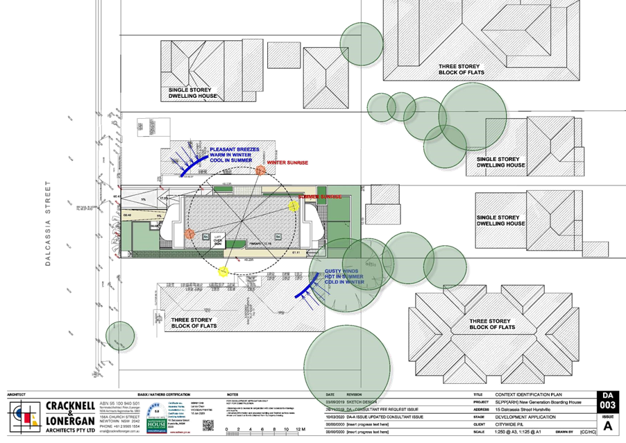
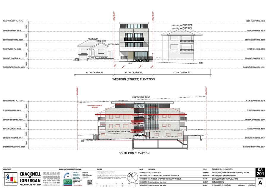

|
Georges River Council – Local
Planning Panel Thursday, 10 December 2020
|
Page 100
|
REPORT TO GEORGES RIVER
COUNCIL
LPP
MEETING OF Thursday,
10 December 2020
|
LPP Report No
|
LPP064-20
|
Development
Application No
|
DA2020/0115
|
|
Site Address
& Ward Locality
|
57 Lorraine Street
Peakhurst
Peakhurst Ward
|
|
Proposed
Development
|
Hurstville Golf
Club - Demolition of the existing clubhouse, construction of a new two (2)
storey clubhouse and use of the strucutre
|
|
Owners
|
Georges River
Council
|
|
Applicant
|
Georges River
Council
|
|
Planner/Architect
|
Webber Architects
|
|
Date Of
Lodgement
|
23/03/2020
|
|
Submissions
|
Two (2)
|
|
Cost of Works
|
$2,586,100.00
|
|
Local Planning
Panel Criteria
|
Development for
which the Land Owner and Applicant is Georges River Council.
|
|
List of all
relevant s.4.15 matters (formerly s79C(1)(a))
|
State
Environmental Planning Policy (Coastal Management) 2018; State Environmental
Planning Policy No.55 – Remediation of Land; State Environmental
Planning Policy (Infrastructure) 2007; State Environmental Planning Policy
(Vegetation in Non-Rural Areas) 2017; Deemed State Environmental Planning
Policy – Georges River Catchment; Hurstville Local Environmental Plan
2012; Hurstville Development Control Plan No.1 – LGA Wide;
Draft Environment
State Environmental Planning Policy 2017; Draft Remediation State
Environmental Planning Policy;
Draft Georges
River Local Environmental Plan 2020; and Draft Georges River Development
Control Plan
|
|
List all
documents submitted with this report for the Panel’s consideration
|
Architectural
Plans
Statement of
Environmental Effects
|
|
Report prepared
by
|
Independent
Assessment
|
EEEEW
|
Recommendation
|
That the application be approved in
accordance with the conditions referenced at the end of this report.
|
|
|
Summary of
matters for consideration under Section 4.15
Have all
recommendations in relation to relevant s4.15 matters been summarised in the
Executive Summary of the assessment report?
|
Yes
|
|
Legislative
clauses requiring consent authority satisfaction
Have relevant
clauses in all applicable environmental planning instruments where the
consent authority must be satisfied about a particular matter been listed and
relevant recommendations summarised, in the Executive Summary of the
assessment report?
|
Yes
|
|
Clause 4.6
Exceptions to development standards
If a written
request for a contravention to a development standard (clause 4.6 of the LEP)
has been received, has it been attached to the assessment report?
|
Not Applicable
|
|
Special
Infrastructure Contributions
Does the DA require
Special Infrastructure Contributions conditions (under s7.24)?
|
Not Applicable
|
|
Conditions
Have draft
conditions been provided to the applicant for comment?
|
Yes – the applicant has reviewed the conditions
|
|
Site Plan

The
development area is outlined in red and the site is outlined in blue (Source:
Metromap)
|
EXECUTIVE SUMMARY
Proposal
1. The proposed
development seeks consent for the demolition of the existing single storey
clubhouse and ancillary structure (i.e. BBQ area, outdoor seating, and practice
nets) and construction of a new part one (1) and part two (2) storey clubhouse
at the Hurstville Golf Club. The proposed clubhouse comprises three (3)
buildings: a single storey pro-shop, a two (2) storey clubroom, and a single
storey golf cart storage area.
2. The clubhouse is
proposed to operate from 5:45am – 7:00pm daily, with the exception of a
few annual events which would operate up to 10.00pm.
3. The application
also proposes the removal of twenty two (22) trees on the site in order to
accommodate the new clubhouse.
Site and Locality
4. The subject site
is legally identified as Lot 1 in DP 176469 (allotment the work is being
undertaken on), Lot 1 DP33385 and Lot 7054 DP1127614 and Lot 3 DP522691 (57A
Lorraine Street) and has a street address of 57 Lorraine Street, Peakhurst.
5. The site has an
area of approximately 39.42 hectares and is irregular in shape. The site is
bounded by Oatley Heights Park and Lime Kiln Bay to the south east, industrial
development on the northern side of Roberts Avenue and low-density residential
development on the western side of Lorraine Street.
6. The locality is
characterised by dwelling houses typically ranging in height from one (1) to
two (2) storeys.
7. The site is
currently occupied by Hurstville Golf Club, which comprises an 18-hole golf
course, a single storey clubhouse, and significant vegetation (including mature
tree plantings).
Zoning and
Permissibility
8. The site is zoned
part RE1 Public Recreation and part W2 Recreational Waterways under the
Hurstville Local Environmental Plan 2012. The proposed works are located on
land zoned RE1 Public Recreation. The proposed clubhouse is ancillary to the
existing golf course, which is categorised as a recreational facility
(outdoor), which are permitted with consent in the zone.
Submissions
9. The development
application was publicly exhibited in accordance with the provisions of the
Hurstville Development Control Plan No.1. The application was notified between
6 April 2020 and 27 April 2020. Two (2) submissions were received in response.
These submissions will be discussed in detail later in this report.
Reason for
Referral to the Local Planning Panel
10. The application is referred to the
Local Planning Panel for consideration and determination as it relates to a
development for which the Land Owner is Georges River Council.
Conclusion
11. The proposed development has been
assessed having regard to the matters for consideration under Section 4.15(1)
of the Environmental Planning and Assessment Act 1979. The proposal is
acceptable and the application is recommended for approval subject to
conditions.
REPORT IN FULL
DESCRIPTION OF
THE PROPOSAL
12. The proposed development seeks
consent for the demolition of the existing single storey clubhouse and
ancillary structure (ie BBQ area, outdoor seating, and practice nets) and
construction of a new part one (1) and part two (2) storey clubhouse at the
Hurstville Golf Club.
13. The application also proposes the
removal of twenty two (22) trees on the site in order to accommodate the new
clubhouse building.
14. The new clubhouse complex
comprises three (3) buildings: a single storey pro-shop, a two (2) storey
clubroom, and a single storey golf cart storage area. The buildings are sited
as separate structures yet are connected by one (1) roof form. The proposed
clubhouse has a larger footprint and extends further towards the north east
than the existing clubhouse on the site.
15. The single storey pro-shop
building comprises an 86sqm pro-shop, a front counter, a workshop, and one (1)
office. An outdoor golf cart staging area is proposed to the rear of the
building at ground floor.
16. The two (2) storey
clubroom/amenities building is proposed to accommodate amenities and changing
room facilities, a meeting room, a plant room, and one (1) office at ground
floor. Proposed uses at first floor level include amenities, storage, a
kitchen, and an indoor clubroom area of approximately 134sqm with internal
seating for approximately 80 persons. A balcony/viewing platform is proposed to
extend from the rear of the indoor seating area (i.e. overlooking the golf
course). The building will be serviced by a lift and stairway that provide
access between the ground and first floors. An outdoor seating and BBQ area is
proposed at ground floor to the rear (i.e. south west) of the
clubroom/amenities building.
17. The single storey golf cart
storage building will provide storage area for 30 golf carts. External
structures, including two (2) 5000L rainwater tanks, a plant room, an enclosed
bin room, and a bin wash bay are proposed adjacent to the building.
18. The external building materials
include linear honed concreate brickwork, vertical metal cladding, white
render, and grey tinted glazing. Photovoltaic panels are proposed to the roof
of the golf cart storage and clubroom/amenities buildings.
19. Internal access paths (ie
sandstone paving) are proposed to lead from the entrance of the site and will
connect the three (3) built forms.
20. The proposed landscaping scheme comprises feature shrub plantings,
and ground covers within the front setback and to the rear (ie south east) of
the proposed building.
21. The
existing golf course operates from 5.45am to 7.00pm daily. The proposed
clubhouse is to operate from 5.45am to 7.00pm daily, with the exception of a
few annual events which will operate up until 10.00pm.
22. Food (ie hot food and
confectionary) and drink, including alcoholic beverages, are currently sold on
the site. No food is prepared on site. No change is
proposed to this existing arrangement.
23. A total of seven (7) staff are
currently employed on the site. No change is proposed to this existing
arrangement.
DESCRIPTION OF THE SITE AND LOCALITY
24. The site is located at 57 Lorraine
Street, Peakhurst and is legally described as Lot 1 in DP 176469 (allotment the
work is being undertaken on), Lot in DP33385 and Lot 7054 in DP1127614
and Lot 3 in DP522691 (57A Lorraine Street). The location of the site is shown
in Figure 1.
Figure 1: Aerial view of site and locality (Source: Metromap)
25. The site has an area of
approximately 39.42 hectares and is irregular in shape. The site has a 640m
frontage to Lorraine Street and a 470m frontage to Roberts Avenue. As shown in
Figure 1, the site of the proposed works is centrally located on the western
boundary of the site on the Lorraine Street frontage.
26. The topography of the site has a
slight fall from the north to the south.
27. The site is located in a
predominately low-density residential locality comprising development of a
variety of architectural styles and form.
28. The site is bounded by Oatley
Heights Park and Lime Kiln Bay to the south east, industrial development to the
north of Roberts Avenue and low-density residential development to the west of
Lorraine Street and to the east along Ballantyne Road.
29. Development on the western side of
Lorraine Street is characterised by dwelling houses typically ranging in height
from one (1) to two (2) storeys (refer to Figure 2).
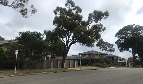 Figure 2: Two (2) storey dwellings at 108 (left) and 106 (right)
Lorraine Street, to the north west of site
Figure 2: Two (2) storey dwellings at 108 (left) and 106 (right)
Lorraine Street, to the north west of site
30. Directly to the west of the site,
at 110A-110B and 110C-110D Lorraine Street are two (2) dual occupancy dwellings
(refer to Figure 3).
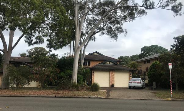 Figure 3: Dual occupancy dwellings at 110A-110B (right) and
110C-110D (left) Lorraine Street, to the west of site
Figure 3: Dual occupancy dwellings at 110A-110B (right) and
110C-110D (left) Lorraine Street, to the west of site
31. The site is currently occupied by
Hurstville Golf Club, which comprises an 18-hole golf course and a single
storey clubhouse. The existing clubhouse includes a pro-shop, amenities and
changing facilities, golf cart storage, and covered outdoor seating. The
existing clubhouse building has no indoor area for members or patrons of the
golf course to congregate. This is limited to the ‘covered’ outdoor
BBQ area to the south of the first tee and the outdoor seating area in front of
the clubhouse building.
32. The existing golf course operates
from 5.45am to 7.00pm daily. Food (ie hot food and confectionary) and drink,
including alcoholic beverages, are currently sold on the site. No food is
prepared on site.
33. The site
benefits from an existing liquor license which permits the sale, supply and
consumption of bottled or canned alcohol from the pro-shop and for events to
the marquee area adjacent to the southern side of the pro-shop between the
hours of 10.00am and 4.00am
the following day. The license restricts the
marquee area to a maximum number of 120 persons and restricts the sale of
alcohol to within the confines of the premises and that no alcohol is sold for
the purposes of consumption outside the perimeter of the subject property.
34. Significant vegetation (including
mature tree plantings) exists on the subject site.
35. A site inspection was undertaken
on 19 October 2020. Photographs of the site and existing development are shown
in Figures 4-6.
 Figure 4: Front (ie western) façade of existing clubhouse
on subject site, viewed from Lorraine Street
Figure 4: Front (ie western) façade of existing clubhouse
on subject site, viewed from Lorraine Street
Figure 5: Southern façade of existing clubhouse (ie
pro-shop) on subject site
 Figure 6: Existing clubhouse and trees on subject site, viewed
towards the south west
Figure 6: Existing clubhouse and trees on subject site, viewed
towards the south west
36. As shown in Figure 7, the facility
is serviced by on-street parking located along the eastern side of Lorraine
Street, adjacent to the clubhouse entrance. 148 perpendicular (ie 90 degree)
parking spaces exist along the golf course frontage, 70 of which are marked.
Figure 7: Southern view of Lorraine Street (NB:
residential dwellings to right of image; 90 degree on-street parking to left of
image)
BACKGROUND
37. Hurstville golf course opened in
1968.
38. DA1995/0466 was approved on 6
October 1995 for the addition of an amenities block and clubhouse at the
site.
39. Approval was granted under DA1995/0467
on 6 October 1995 for the fit-out of the golf pro-shop.
40. DA2008/0089 granted consent for
alterations to the recreational facility at the site on 4 March 2008.
41. DA2013/0163 was approved on 4
September 2013 for an extension to the existing pro-shop for a new meeting room
with awning. However, this does not appear to have been constructed.
42. MOD2015/0018 was approved on 6 May
2015 to modify DA2013/0163 for internal reconfiguration works and the addition
of a water tank at the site.
PLANNING ASSESSMENT
43. The
development has been assessed having regard to Matters for Consideration under
Section 4.15(1) of the Environmental Planning and Assessment Act 1979. Compliance
with the relevant Environmental Planning Instruments is detailed below.
STATE ENVIRONMENTAL PLANNING POLICIES
State
Environmental Planning Policy (Coastal Management) 2018
44. The Coastal Management SEPP
provides management objectives for land use planning within coastal management
areas. Clauses 11 and 15 of the SEPP apply to the subject site as it is
identified within the Coastal Environment Area and the Coastal Use Area.
45. The site of the proposed works is
not located on land identified as Coastal Environment Area or Coastal Use Area.
Notwithstanding, assessment of the proposed development against Clauses 11 and
15 of the SEPP is provided below.
Clause 11
46. Clause 11 of the SEPP states that
development on land in ‘proximity area for coastal wetlands’ or
‘proximity area for littoral rainforest’, must not be granted
development consent unless the consent authority has considered whether the
proposed development is likely to cause an adverse impact on the following:
“(a) The biophysical, hydrological or ecological integrity of
the adjacent coastal wetland or littoral rainforest, or
(b) The quantity and quality of surface and ground water flows
to and from the adjacent coastal wetland or littoral
rainforest.”
47. The proposed development is
consistent with the provisions of Clause 11 as outlined below:
· Minimal excavation works are proposed, thus there is no potential
for significant adverse impact to the biophysical, hydrological, or ecological
environment; and
· The proposal incorporates on-site stormwater collection measures to
manage water flows to and from nearby coastal wetland and littoral rainforest.
Clause 15
48. Clause 15 of the SEPP states that “development
consent must not be granted to development on land within the coastal zone
unless the consent authority is satisfied that the proposed development is not
likely to cause increased risk of coastal hazards on that land or other
land”.
49. Noting that the proposed works are
not located on or near the coastal edge, the risk of coastal hazards or adverse
impact to the marine environment is not likely.
State
Environmental Planning Policy No 55 – Remediation of Land
50. SEPP 55 prescribes a statutory
process associated with the development of land that is contaminated and needs
remediation.
51. The site has historically been
used for the purpose of a recreational facility. The proposal seeks approval
for the construction of a recreational facility and does not involve a change
of use. On this basis, the proposal is consistent with the provision of SEPP
55.
State
Environmental Planning Policy (Infrastructure) 2007
52. The
aim of the Infrastructure SEPP is to facilitate the effective delivery of
infrastructure across the State. The DA was referred to Ausgrid in accordance
with Clause 45 of State Environmental Planning Policy (Infrastructure) 2007. Ausgrid
raised no objection to the proposal, subject to ‘as constructed’
minimum clearance distances from Ausgrid’s Infrastructure.
State
Environmental Planning Policy (Vegetation in Non-Rural Areas) 2017
53. The
Vegetation SEPP seeks to protect the biodiversity
values of trees and other vegetation in non-rural areas of the State and
preserve the amenity of non-rural areas through the preservation of trees and
other vegetation. This is applicable pursuant to Clause
5(1) of the Vegetation SEPP as the site is both within the Georges River Local
Government Area and on land zoned RE1 Public Recreation.
54. The Vegetation SEPP applies to
clearing of:
a) Native vegetation above the Biodiversity Offset
Scheme (BOS) threshold where a proponent will require an approval from the
Native Vegetation Panel established under the Local Land Services Amendment Act
2016; and
b) Vegetation below the BOS threshold where a
proponent will require a permit from Council if that vegetation is identified
in the Council’s development control plan (DCP).
55. Pursuant to Clause 8(1) of the
SEPP, clearing does not require authority under the policy as it is a type of
clearing that is authorised under Section 60O of the Local Land Services Act
2013 (specifically, that associated with a development consent issued
under Part 4 of the Environmental Planning and Assessment Act 1979).
56. The proposed development seeks the
removal of twenty two (22) trees on the site in order to accommodate the new
clubhouse. An extract from the submitted Site Demolition Plan noting existing
trees to be removed is provided at Figure 8.
Figure 8: Extract from Site Demolition Plan noting
exiting trees to be removed (Source: Webber Architects)
57. An Arboricultural Assessment
Report prepared by Truth About Trees dated 2 March 2020 was submitted in
support of the application. The report provides an assessment of trees on the
site to be removed, retained, and protected.
58. Council’s
Consultant Arborist reviewed the submitted Arborist Report and raised no objections
subject to the imposition of conditions, including a requirement for the
planting of forty four (44) replacement trees, which have been endorsed.
Deemed State Environmental Planning Policy –
Georges River Catchment
59. The Greater Metropolitan Regional
Environmental Plan No 2—Georges River Catchment applies to all land
within the Georges River Catchment. The Catchment consists of parts of the
Georges River LGA and includes the subject site.
60. The aims of the plan which are
relevant to the subject application include:
“(a) to maintain and improve the water quality and river
flows of the Georges River and its tributaries and ensure that development is
managed in a manner that is in keeping with the national, State, regional and
local significance of the Catchment,
(b) to protect and enhance the environmental quality of
the Catchment for the benefit of all users through the management and use of
the resources in the Catchment in an ecologically sustainable manner,
(…)
(f) to provide a mechanism that assists in
achieving the water quality objectives and river flow objectives agreed under
the Water Reform Package.”
61. The
proposal involves minor excavation works. All excavated and disturbed soil are
proposed to be stored on the site to prevent soil erosion and are unlikely to
result in any significant adverse impact with regard to soil erosion or
sedimentation.
62. The
proposed development does not encroach on any Vegetated Buffer Areas of the
Georges River or its tributaries.
63. All
stormwater from the proposed development can be treated in accordance with
Council’s Water Management Policy and will satisfy the relevant
provisions of the Deemed State Environmental Planning Policy – Georges
River Catchment.
Integrated
Development
64. The
proposal is not integrated development as defined under Clause 4.46 of the Environmental
Planning and Assessment Act 1979.
LOCAL
ENVIRONMENTAL PLAN
Hurstville Local
Environmental Plan 2012
65. The site is zoned part RE1 Public
Recreation and part W2 Recreational Waterways under the Hurstville Local
Environmental Plan 2012.
66. The proposed works are located on
land zoned RE1 Public Recreation. The existing use of the site for the purposes
of a golf course is categorised as a public recreation facility (outdoor). The
proposed demolition of and construction of a new clubhouse and associated
facilities is ancillary to the existing permitted use of the site.
67. The objectives of the RE1 Public
Recreation zone are as follows:
· To enable land to be used for public open space or recreational
purposes.
· To provide a range of recreational settings and activities and
compatible land uses.
· To protect and enhance the natural environment for recreational
purposes.
The
proposed development is consistent with the stated objectives of the RE1 zone
in that it seeks to improve the function and operations of an existing golf
course. The works will allow the golf club to cater to current and future
membership requirements.
68. The proposal also seeks to upgrade
the amenity of the surrounding landscape, to enable the site to retain a
landscaped setting that is compatible with surrounding residential land uses.
This is achieved through the planting of various
feature shrubs and ground cover within the front setback and to the rear (i.e.
south-east) of the building. The proposed landscaping will facilitate privacy
screening and softening of the front building façade, whilst maintaining
opportunities for passive surveillance.
69. Compliance with applicable
standards of the HLEP 2012 is outlined below.
|
Clause
|
Standard
|
Proposed
|
Complies
|
|
4.3 Height of
Buildings
|
There is no height
of buildings development standard applying to the subject site.
|
8.6m
|
N/A
|
|
4.4 Floor Space
Ratio
|
There is no floor
space ratio development standard applying to the subject site.
|
The proposal
results in a gross floor area (GFA) of 712sqm.
|
N/A
|
|
6.1 - Acid Sulfate
Soils
|
The site is
located within the Class 1, Class 2, and Class 5 acid sulfate soils zones.
|
The location of
proposed works is not contained in any acid sulfate soils zone and the
proposal does not involve excavation greater than 1m in depth.
|
Yes
|
|
6.2 Riparian Land
and Watercourses
|
The site is
identified as containing sensitive riparian/ watercourses land.
|
The site of
proposed works is not located on sensitive riparian/ watercourses land.
Notwithstanding,
the proposal is unlikely to have significant adverse impact on the water
quality, stability of beds and banks, or ecological processes within
watercourses, or on aquatic and riparian habitats. The proposal does not
involve any increase in water extraction from the nearby watercourse.
|
Yes
|
|
6.4 - Foreshore
Scenic Protection Area
|
The site is
identified within a ‘Foreshore Scenic Protection Area’. Clause
6.4(3) provides that development consent must not be granted to development
on land to which this clause applies unless consent authority has considered
how the development would –
|
|
(a) affect
the natural environment, including topography, rock formations, canopy
vegetation or other significant vegetation, and
|
The design of
the proposal aligns with the natural topography of the site. Notwithstanding
the proposed removal of trees, significant vegetation is retained and
replacement planted required on the site and is well integrated with the
built form.
|
Yes
|
|
(b) affect
the visual environment, including the views to and from the Georges River,
foreshore reserves, residential areas and public places, and
|
The proposed
design will not have significant adverse impact to existing views and outlook
of residential properties, given that a wide view of the golf course will be
maintained. The building design is separated into three (3) distinct built
forms connected by a flat roof, providing glimpses through the building
towards the golf course and existing vegetation to the east.
|
Yes
|
|
(c) affect
the environmental heritage of Hurstville, and
|
The site is not
listed as a heritage item or located in a conservation area.
|
Yes
|
|
(d) contribute
to the scenic qualities of the residential areas and the Georges River by
maintaining the dominance of landscape over built form.
|
The site of
proposed works is zoned RE1 Public Recreation with residential development to
the west, on the opposite site of Lorraine Street.
Notwithstanding
the proposed removal of trees, significant landscaping is retained on the
site.
The integration of
the proposed clubhouse buildings with the landscape scheme enhances the
scenic qualities of neighbouring residential development.
|
Yes
|
|
6.7 Essential
Services
|
The following services that are essential for the development shall be
available or made available by adequate arrangements
“(a) the
supply of water,
(b) the
supply of electricity,
(c) the
disposal and management of sewage,
(d) stormwater
drainage or on-site conservation,
(e) suitable
road and vehicular access.”
|
The proposed
development has made adequate arrangements available for the supply of water,
electricity, sewage, stormwater drainage, and vehicular access.
|
Yes
|
DEVELOPMENT
CONTROL PLAN
Hurstville
Development Control Plan No 1 – LGA Wide
70. The Hurstville Development Control
Plan No. 1 (HDCP) applies to all land to which the HLEP 2012 applies, excluding
land identified as the Hurstville City Centre. The proposal has been assessed
under the relevant sections of HDCP No. 1 as follows.
Hurstville Development Control Plan No 1 – LGA Wide –
Section 3.1 – Vehicle Access, Parking and Manoeuvring
71. The DCP does not prescribe any
specific parking rate for a golf course or recreational facility (outdoor).
72. The existing golf course has no
off-street parking, however, is serviced by 148 perpendicular (ie 90 degree)
on-street car parking spaces, including seventy (70) marked spaces and two (2)
accessible parking spaces provided along the Lorraine Street frontage of the
site.
73. A Traffic Impact Study submitted
with the DA notes that no change is proposed to the existing traffic
arrangements on the site and no increase in parking demand is anticipated. The
study concludes that:
“the existing parking supply within the vicinity of the site
provides a suitable number of parking spaces for the golf club with numerous
vacancies available during the peak periods associated with the golf course.
As the golf course and club facilities shall operate in much the
same manner as present, there are no changes to the anticipated to the existing
traffic conditions. Vehicle access to the site from Roberts Avenue will
continue to provide for the servicing of the site.”
74. The application was referred to
Council’s Traffic Engineer. The submitted Traffic Impact Study was
reviewed and no objection was raised with regard to the proposal.
75. This issue is discussed in greater
detail in paragraphs 148-153.
Hurstville Development Control Plan No 1 – LGA Wide –
Section 3.2 – Subdivision
76. No subdivision is proposed.
Hurstville Development Control Plan No 1 – LGA Wide –
Section 3.3 – Access and Mobility
77. The Building Code of Australia
(BCA) Compliance Report submitted with the DA confirms that the proposed
development is capable of complying with the provisions of the BCA and relevant
Australian Standards.
78. The two (2) storey
clubroom/amenities building will be serviced by an accessible lift providing
access between the ground and first floors. Additionally, accessible amenities
are proposed at both ground and first floor levels of the building.
Hurstville Development Control Plan No 1 – LGA Wide –
Section 3.4 – Crime Prevention Through Environmental Design
79. Assessment of the proposal against
the relevant provisions of Section 3.4 of HDCP No.1 is provided in the table
below.
|
Development
Provision
|
Proposal
|
Complies
|
|
Site and
Building Layout
|
|
DS1.1
|
Avoid blank walls
fronting the street.
|
The western (ie
street) elevation includes window openings from the ground floor workshop and
a common stairwell.
|
Complies
|
|
DS1.2
|
Offset windows,
doorways and balconies to allow for natural observation while protecting
privacy.
|
Window openings to
Lorraine Street will provide passive surveillance of the street. The proposed
deck is oriented to the rear of the building to maximise privacy.
|
Complies
|
|
DS1.4
|
Entrances should
be located in prominent positions, be easily recognisable through design
features and directional signage and should allow users to see into the
building before entering.
|
The entrance to the clubhouse is easily recognisable by way of
building identification signage proposed to be affixed above the entrance.
Directional signage is proposed to be affixed adjacent to the entrance
pathway.
|
Complies
|
|
DS1.5
|
Pathways within
and to the development should be direct and all barriers along the pathways
should be permeable including landscaping and fencing.
|
Internal and
external pathways are direct are unobstructed.
|
Complies
|
|
DS1.9
|
Where elevators or
stairwells are provided, open style or transparent materials are encouraged
on doors and/or walls of elevators/stairwells.
|
Large transparent
window openings are proposed to the western elevation of the stairwell to
provide high levels of visibility.
|
Complies
|
|
DS1.10
|
Waiting areas and
entries to elevators/stairwells should be close to areas of active uses, and
should be visible from the building entry.
|
The ground floor
foyer to the lift and stairwell is directly accessible from the primary
pedestrian pathway that leads from the premises’ entrance.
|
Complies
|
|
DS1.11
|
Seating should be
located in areas of active uses
|
Outdoor seating is
proposed at ground level proximate to BBQ facilities and pedestrian pathways.
|
Complies
|
|
DS1.35
|
Seating, play
equipment, BBQ areas etc should be provided to encourage the use of open
spaces.
|
BBQ facilities are
proposed at the rear of the site at ground level.
|
Complies
|
|
DS1.36
|
Seating should be
conveniently located and easily seen.
|
Outdoor seating at
ground level is accessible and visible from the primary pathway that leads
from the premises’ entrance.
|
Complies
|
|
DS1.37
|
Facilities e.g.
toilets and telephones, should be located close to areas of active uses and
access to facilities should be direct and free of obstruction.
|
The proposed
amenities building (i.e. including change room and toilet facilities) is
directly accessible from the main pedestrian pathway and is situated in close
proximity to the pro-shop.
|
Complies
|
|
DS1.38
|
Pathways should be
direct, follow pedestrian desire lines and avoid blind corners.
|
The internal
pathways are direct and avoid blind corners.
|
Complies
|
|
Lighting
|
|
DS2.4
|
Direct lights towards access/egress routes and possible hiding
places to illuminate potential offenders, rather than towards buildings
or resident observation points
|
This issue is
proposed to be addressed by way of a condition.
|
Capable of
compliance
|
|
DS2.5
|
Illuminate
possible places for intruders to hide.
|
This issue is
proposed to be addressed by way of a condition.
|
Capable of
compliance
|
|
DS2.6
|
Lighting should have a wide beam of illumination, which reaches to
the beam of the next light, or the perimeter of the site or area being
traversed, thereby avoiding dark shadows.
|
This issue is
proposed to be addressed by way of a condition.
|
Capable of
compliance
|
|
DS2.7
|
Generally areas
should be lit to enable users to identify a face 15 metres away.
|
This issue is
proposed to be addressed by way of a condition.
|
Capable of
compliance
|
|
DS2.8
|
Avoid light
spillage onto neighbouring properties as this can cause nuisance and reduce
opportunities for natural surveillance.
|
A condition is
proposed to address this issue.
|
Capable of compliance
|
|
DS2.9
|
Use energy
efficient lamps/fittings/switches to save energy
|
A condition is
proposed to address this issue.
|
Capable of
compliance
|
|
Landscaping
|
|
DS2.19
|
Avoid medium
height vegetation with concentrated top to bottom foliage. Plants such as low
hedges and shrubs, creepers, ground covers and high canopied vegetation are
good for natural surveillance.
|
Low shrubs and
ground cover are proposed within the front setback to provide privacy
screening and ‘softening’ of the building façade, whilst
maintaining opportunities for passive surveillance.
|
Complies
|
|
DS2.20
|
Trees with dense
low growth foliage should be spaced or crown raised to avoid a continuous
barrier.
|
Proposed tree
plantings are appropriately spaced.
|
Complies
|
|
DS2.21
|
Use low ground
cover or high canopied trees, clean trunks, to a height of 2m around
children’s play areas, car parks and along pedestrian pathways.
|
Low ‘garden
bed’ planting is proposed along pedestrian pathways.
|
Complies
|
|
DS2.22
|
Avoid vegetation,
which conceals the building entrance from the street.
|
The low shrub and
ground cover vegetation proposed within the front setback does not conceal
the building entrance.
|
Complies
|
|
DS2.24
|
When planting is
provided within 5m of a pedestrian pathway, it should be lower than 1 metre
or thin trunked with high canopy.
|
The proposed
planting along pedestrian pathways comprises medium to tall shrubs, with a
maximum height of approximately 2m.
|
Generally complies
|
|
Fencing
|
|
DS4.1
|
Front fences are
to be predominantly open in design to allow sight through the fences e.g.
picket fences, wrought iron.
|
The proposed front
fencing is composed of vertical battens of an open design and is existing.
|
Complies
|
|
Building
Identification
|
|
DS6.5
|
Location maps and
directional signage should be provided for larger developments.
|
Directional
signage is proposed to be affixed adjacent to the entrance pathway.
|
Complies
|
|
Building
Maintenance
|
|
DS9.3
|
Strong, wear
resistant laminate, impervious glazed ceramics, treated masonry products,
stainless steel materials, anti-graffiti paints and clear over sprays will
reduce the opportunity for vandalism. Flat or porous finishes should be
avoided in areas where graffiti is likely to be a problem.
|
The proposed
building materials include concrete brickwork, metal cladding, and white
render.
|
Generally complies
|
Hurstville
Development Control Plan No 1 – LGA Wide – Section 3.5 –
Landscaping
80. Assessment of the proposal against
the relevant provisions of Section 3.5 of HDCP No.1 is provided in the table
below.
|
Development
Provision
|
Proposal
|
Complies
|
|
DS1.1
|
Where a street or
neighbourhood has an existing desirable landscape character, similar species
are planted on site, except where the species are identified as being
undesirable in accordance with Appendix 1 – Recommended species for
landscaping.
|
The proposed
landscape design incorporates plants species identified as ‘recommended
species’.
|
Complies
|
|
DS3.1
|
Site layout and
design, including buildings, structures and hardstand, ensures the long term
retention and health of existing significant trees and vegetation.
|
The removal of
twenty two (22) trees is required to accommodate the proposed development.
Subject to the imposition of conditions of consent relating to the retention
and protection of trees, the proposal will ensure the long term retention and
health of existing significant trees and vegetation.
|
Generally complies
|
|
DS3.2
|
Where significant
trees or vegetation are required to be removed to allow for site development,
they are to be replaced with the same or similar species achieving the same
coverage at maturity.
|
The removal of twenty two (22) trees is required to accommodate
the proposed development.
Council’s Consultant Arborist has recommended appropriate
conditions of consent requiring the planting of forty-four (44) replacement
trees in accordance with Council’s Policy.
All replacement tree species selection must be as per Appendix 1,
Tree Planting of the Tree Management Policy.
|
Capable of
complying
|
|
DS4.1
|
Landscaping in
front setbacks consists of:
a. an area of
sufficient dimensions to accommodate planting Note: this area must be a
minimum of 2m
b. shade trees
that grow to a height consistent with or greater than that of the building
c. screening
shrubs where required to mitigate the visual impact of blank walls d. low
shrubs and ground covers to ensure complete coverage of planting area
|
Landscaping, including screening shrubs, and ground cover, is
proposed within the 11.73m-12m front setback. The landscaping will facilitate
privacy screening and ‘softening’ of the building façade,
whilst maintaining opportunities for passive surveillance.
Conditions are proposed to be imposed in relation to canopy trees.
|
Complies
|
|
DS10.1
|
Fire resistant
species are planted in areas that are susceptible to bushfire hazard.
|
The submitted
Bushfire Report confirms that the proposed landscape scheme can comply with
the ‘Planning for Bush Fire Protection’ document.
|
Complies
|
|
DS11.1
|
Opportunities for
on-site stormwater infiltration are provided through measures such as:
a. turf and raised
planting beds
b. minimising the
extent of impervious surfaces
|
Raised planter
beds are proposed within the front setback and will provide opportunities for
on-site stormwater infiltration.
|
Complies
|
|
DS11.2
|
Landscaped areas
and suitably drained and ensure the soil and sediment does not exit the site.
|
Soil and sediment
from the proposed front and rear landscaped areas are raised to provide
suitable drainage. Noting the topography of the site, soil and sediment will
fall by gravity and remain contained within the site.
|
Complies
|
|
DS13.1
|
Landscaping is
sited and designed in accordance with the principles of CPTED.
|
The proposed
landscape scheme does not adversely impact on the ability for the principles
of CPTED to be achieved.
|
Complies
|
|
DS13.2
|
Landscaping
enables clear sight lines to be achieved along pathways and minimise opportunities
for concealment.
|
Subject to
appropriate maintenance, the proposed landscaping is not expected to obstruct
any sight lines or facilitate concealment.
|
Complies
|
|
DS13.3
|
Dense screening
vegetation is not provided within front setbacks.
|
The proposed
landscaping in the front setback is scattered and comprises a variety of
screening shrubs, and ground cover.
|
Complies
|
|
DS14.1
|
Landscaping does
not interfere with the effective functioning of overhead, surface level or
underground utilities.
|
Subject to
appropriate maintenance, the proposed landscaping is not expected to
interfere with the functioning of utilities.
|
Complies
|
Hurstville
Development Control Plan No 1 – LGA Wide – Section 3.6 –
Public Domain
81. The development does not propose any
works in the public domain.
Hurstville
Development Control Plan No 1 – LGA Wide – Section 3.7 –
Stormwater
82. The
application was referred to Council’s Development Engineer. Following
consultation with Council’s Development Engineer, a revised set of
stormwater plans (dated 17 June 2020) were issued by the applicant. The revised
plans demonstrate that stormwater will discharge by gravity directly to
Council’s underground stormwater main located within the golf course. No
objection was raised with regard to stormwater and drainage, subject to the
imposition of conditions.
83. The
proposal is exempt from the provision of an on-site detention (OSD) system
under Section 4.4(b) of the Georges River Stormwater Management Policy, which
states that OSD will not be required for “a lot where the site’s
stormwater discharges directly to a bay or stream”. Stormwater
generated by the proposed development will discharge directly to
Council’s drainage system downstream of the Lorraine Street road reserve
and within the golf course.
Hurstville
Development Control Plan No 1 – LGA Wide – Section 5.5 –
Signage
84. Building
identification signage displaying the words ‘Hurstville Golf Club’
is proposed to be affixed to the roof parapet of the western building
façade. Directional signage is also proposed to be affixed to the
external building wall adjacent to the entrance pathway.
85. The
signage is generally consistent with the relevant provisions of Section 5.5.
The signage is considered appropriate to the streetscape and not dominating in
terms of its scale, proportion, or form.
86. The
wall signage does not project above or beyond the wall and does not have any
adverse impact to views, vistas, or skylines.
87. Where in the RE1 Public Recreation zone, only signage identified as
‘exempt development’ in HLEP 2012 is permitted. The proposed
signage is compliant with the signage standards specified under Schedule 2 of
HLEP 2012.
Hurstville
Development Control Plan No 1 – LGA Wide – Appendix 1
Waste Management
88. A
waste management plan has been submitted with the application and is consistent
with the relevant provisions of HDCP No 1. The proposed bin store is externally
accessible via an existing driveway entry, yet is suitably screened from the
street by fencing and landscaping within the front setback.
Energy
Efficiency
89. The proposed building design (ie window orientation and material
selection) provides for natural ventilation and passive heating/cooling. Photovoltaic panels are proposed to the roof of the cart storage and
clubroom/amenities buildings. Furthermore, conditions are proposed to be
imposed addressing energy efficiency.
Preservation of
Trees and Vegetation
90. The
proposed development entails the removal of twenty two (22) trees on the site in
order to accommodate the new clubhouse. Council’s Consultant Arborist
reviewed the submitted Arborist Report and raised no objections subject to the
imposition of conditions, including a requirement for the planning of forty
four (44) replacement trees, which have been endorsed.
Georges River
Development Control Plan 2020 - Interim Policy
91. The Georges River Development
Control Plan 2020 - Interim Policy was introduced in response to a resolution
of Council which cited numerous development control plans that applied across
the LGA and the need for consistency. The Interim Policy is a supplementary
document, meaning that current DCP controls continue to apply if a particular
control is not specified, or if it is still considered best practice.
92. The Interim Policy does not
contain any provisions relevant to the proposed development, and accordingly,
consideration of the policy is not necessary.
DRAFT PLANNING
INSTRUMENTS
Draft Environment
State Environmental Planning Policy 2017
93. In October 2017, the DPIE released
the Explanation of Intended Effect for the Draft Environment State
Environmental Planning Policy 2017 (Environment SEPP). This consolidated SEPP
proposes to simplify the planning controls for a number of water catchments,
including the Georges River Catchment.
94. The Draft SEPP notes that controls
relating to the Catchment are located in several NSW planning instruments.
Duplication with other legislation will be removed and the remaining provisions
under Greater Metropolitan REP No. 2 – Georges River Catchment will be
transferred to the Environment SEPP. These provisions include aims and
objectives, heads of consideration, and prohibitions for certain types of
development.
95. Following completion of public
exhibition on 31 January 2018, the proposed Draft SEPP is currently under
consideration including a review of public and government submissions.
96. The
proposal is consistent with the provisions of this Draft Instrument.
Draft Remediation
of Land State Environmental Planning Policy
97. The Draft Remediation of Land
State Environmental Planning Policy (Remediation SEPP) was exhibited from 31
January 2018 to 13 April 2013.
98. The Draft Remediation SEPP will
repeal and replace the current State Environmental Planning Policy No.55
– Remediation of Land and seeks to:
· Provide a state-wide planning framework for the remediation of land;
· Maintain the objectives and reinforce those aspects of the existing
framework that have worked well;
· Require planning authorities to consider the potential for land to
be contaminated when determining development applications and rezoning land;
· Clearly list the remediation works that require development consent;
and
· Introduce certification and operational requirements for remediation
works that can be undertaken without development consent.
99. The
proposal is consistent with the provisions of the Draft Instrument, and the
issue of contamination has been addressed in relation to SEPP 55.
Draft Georges
River Local Environmental Plan 2020
100. Consideration is given to the provisions of
the Draft Georges River Local Environmental Plan 2020 in the assessment this
application.
101. In this regard, the provisions have no
determining weight as a result of proposed operation of Clause 1.8A
‘Savings provisions relating to development applications’ which
provides that “if a development application has been made before the
commencement of this Plan in relation to land to which this Plan applies and
the application has not been finally determined before that commencement, the application
must be determined as if this Plan had not commenced.”
102. There are no significant changes proposed to
the planning controls pertaining to the subject site under the Draft Georges
River Local Environmental Plan 2020 and the zoning of the property is to remain
as RE1 – Public Recreation.
103. Clause 6.4 prescribes provisions for
stormwater management. Stormwater generated by the proposal will discharge by
gravity directly to Council’s underground stormwater main located within
the golf course. The proposal is exempt from the provision of an on-site
detention system under Section 4.4(b) of the Georges River Stormwater
Management Policy.
Draft Georges
River Development Control Plan 2020
104. The Draft Georges River Development Control
Plan 2020 seeks to consolidate the DCPs applying to land within the Georges
River LGA. The Draft DCP is currently on exhibition from 21 October 2020 to 27
November 2020.
105. Part 1.7 ‘Savings provision’
provides that “If an application has been made before the commencement
of the DCP in relation to land to which the DCP applies, and the application
has not been finally determined before that commencement, the application must
be determined as if the DCP had not commenced. All applications received after
the commencement date of an amendment to the DCP are subject to the DCP as
amended.” Given the draft DCP is yet to be
formally adopted the provisions of the Draft DCP have
no determining weight in the assessment and determination of this DA.
106. Notwithstanding this, an assessment of the
proposal against the relevant provisions of the Draft DCP, not already
considered under HDCP No 1, is provided in the following sections.
Draft DCP
Section 3.4 – Bushfire Prone Land
107. The subject site is located on bushfire prone
land. The submitted Bushfire Report concludes that the proposed development can
comply with the ‘Planning for Bush Fire Protection’ publication,
subject to the imposition of conditions relating to the provision of an inner
protection area (IPA), maintenance of landscaping, and the preparation of an
emergency evacuation plan.
Draft DCP
Section 3.11 – Ecological Sustainable Development
108. The submitted Building Code of Australia
(BCA) Report does not include consideration of the energy efficiency provisions
of the BCA. Notwithstanding, the proposed building design (i.e. window
orientation and material selection) provides for natural ventilation and
passive heating/cooling.
109. Photovoltaic panels are proposed to the roof
of the cart storage and clubroom/amenities buildings.
110. Suitable conditions of consent relating to
water efficient amenities are recommended to be imposed.
Draft DCP
Section 3.13 – Parking Access and Transport
111. The Draft DCP has a requirement for one (1)
space per golf hole; plus one (1) space per 2 employees; plus one (1) space per
5sqm of clubhouse GFA for golf course development.
112. Given the proposed development relates to the
existing Hurstville golf course and there is no increase in the number of golf
holes or the number of staff employed on site, there is only a requirement to
consider the proposed increase in the size of the golf clubhouse over the
existing facility.
113. The existing golf clubhouse/pro-shop/amenities
has a GFA of approximately 193.27sqm.
114. The GFA of the proposed development (ie
pro-shop, clubroom) has a total area of 522sqm. This excludes the storage shed
(190sqm) for the purposes of storing the golf carts as this is not considered
to be strictly part of the clubhouse for the purposes of calculating parking
requirements. On this basis, the proposed club house represents an increase in
GFA on the site over the existing facilities of 328.73sqm, which equates to a
requirement for 66 car spaces.
115. Given the existing golf course and associated
clubhouse is serviced by 148 on-street car parking spaces, including seventy
(70) marked spaces and two (2) accessible parking spaces, along the Lorraine
Street frontage of the site, there is sufficient car parking in the vicinity of
the site to address the car parking requirements of the Draft DCP had they been
strictly applied. This is further supported by the Traffic and Parking Report
submitted with the DA which is discussed in further detail in paragraphs 148 -
153.
Planning
Agreements
116. No planning agreements or draft planning
agreements have been offered or have been entered into.
Matters
prescribed by the Regulations
117. No additional regulations required for the
proposed development.
Local Government
Act 1993
118. Section 35 of the Local Government Act 1993
identifies that Community land is required to be used and managed in accordance
with:
· the plan of management applying to the land
· any law permitting the use of the land for a specified purpose or
otherwise regulating the use of the land
· this Division.
119. The Generic Plan of Management (POM) –
Sportsgrounds was adopted in 2006 and provides the future direction and policy
for the planning, management and development of all sportsgrounds within the
former Hurstville City Council LGA, now part of Georges River Council. The
Hurstville golf course is listed in Schedule 1 of the POM as one of the
sportsgrounds to which the POM applies.
120. The objectives for Sportsgrounds under the
POM are:
1. To provide optimum access to Hurstville’s
sportsgrounds and their facilities for all users and stakeholders.
2. To provide appropriate amenity, aesthetic and
landscaping facilities within all sportsgrounds to maximise benefits for all
users.
3. To manage the environmental elements of
sportsgrounds to preserve biodiversity values and minimise disturbance.
4. To maximise funding opportunities for the development and
improvement of sportsgrounds and facilities.
5. To manage sportsgrounds efficiently and effectively,
and allow for their equitable use for a range of organised and informal
recreational activities that are compatible with management objectives and the
function of sportsgrounds.
6. To manage areas with multiple land categorisation
contained within sportsgrounds according to the requirements of their core
objectives.
7. To adequately maintain facilities, and to encourage
respectful, law-abiding behaviour while using the grounds to maximise public
safety and minimise damage to facilities.
8. To provide and maintain, within budget, high quality
sporting fields and facilities to meet identified community needs.
9. To provide and maintain road network and car parking
facilities that are safe, effective and user friendly.
10. To provide high quality sporting facilities to meet community
needs without impacting negatively on bushland areas.
121. The proposal is considered to meet the
objectives of the POM in that it would deliver high quality sporting facilities
to meet the needs of the community.
122. Section 4 of the POM identifies the following
management issues:
· Access
· Amenity and Landscaping
· Flora and Fauna
· Funding
· Management and Use
· Management of Dual Use Areas
· Safety and Risk Management
· Sports Fields and Facilities
Each
of the above issues has a specific objective.
123. The proposal is considered to be generally
consistent with the specific objective of the above management area, where
relevant, for the following reasons:
· The proposal will provide improved amenity for both the users and
operators of the golf course through a larger and well-designed facility,
within well landscaped grounds and additional tree planting to offset the tree
removal required to enable the development.
· Disturbance has been minimised through the construction on the
location of the existing clubhouse. It is acknowledged that the proposal will
result in the loss of some trees from the site but this will be compensated
through additional tree planting on the site and will not significantly impact
on the broader landscaped character of the site or the wider area;
· The proposal will provide improved high quality facilities, and
· The design maximises safety and minimise risk through design.
124. For the above reasons the proposal is
considered consistent with the applicable POM under Section 35 of the Local
Government Act 1993.
IMPACTS
Loss of
Trees/Flora and Fauna impacts
125. As
identified, the proposed development seeks consent for the removal of 22 trees
from the site. It is noted that the arborist report submitted with the DA
identifies 15 trees to be removed from the site, comprising 5 x Tallowwood, 4
Weeping Bottle Brush, 2 x Cypress, 1 x Swamp She Oak, 1 x Wollybutt, 1 x
Eucalypt and 1 x Forest Red Gum. Eight (8) of these trees are identified by the
arborist as being of low retention value and seven (7) trees are of medium
retention value. However, it is noted that Council’s Consultant Arborist
noted that a further seven (7) fig trees area also proposed to be removed.
126. Council’s
Consultant Arborist raised no objections to the submitted Arborist Report and
has recommended conditions with respect to the retention and protection of
other existing trees on the site. The consultant concludes that the removal of
twenty two (22) trees to accommodate the proposed development, subject to a 2:1
replacement for all trees removed, is considered acceptable and will result in
an increase in the urban canopy.
127. As
part of additional information submitted, the applicant has submitted a Tree
Replacement Plan identifying the proposed location of the replacement tree
planting. The Tree Replacement Plan identifies that replacement trees are to be
planted between the third and fifteenth fairways, which is located
approximately 300m to the east of the clubhouse site on the lower eastern half
of the golf course. Notwithstanding this, a condition is proposed requiring the
planting of some of the replacement canopy trees in the vicinity of the
clubhouse site.
128. Whilst
it is acknowledged that the removal of 22 trees from the site will result in
the loss of some tree canopy in the area of the proposed works, given the scale
of the site, the extent of urban tree canopy the site currently contributes to
the wider area, and the opportunity to provide double the amount of replacement
planting to supplement the tree loss, the extent of impact is considered
reasonable.
129. Subject
to the imposition of recommended conditions, the proposed development is
unlikely to result in unreasonable adverse impact on the natural environment.
Bulk and Scale
Impacts
130. The existing pro-shop/clubhouse on the site
comprises two (2) relatively modest flat roofed buildings with a combined
footprint of approximately 19sqm. One building contains the amenities/change
rooms and one containing the pro-shop. The buildings are approximately 10m in
width to Lorraine Street, as one building is behind the other.
131. The proposal is a part one (1) and part two
(2) storey building on a setback of approximately 12m. The building is broken
into three (3) elements and is generally well articulated. The combined width
of the three (3) building elements, to the street, is approximately 40m,
inclusive of 7m of gaps between buildings. Whilst this represents a significant
increase over the existing building, the proposed built form is of a bulk and
scale that is still considered compatible with the streetscape and not out of
character with the one (1) and two (2) storey residential development along the
western side of Lorraine Street.
Building Materials and Streetscape Impacts
132. The existing pro-shop and clubhouse is a
single storey brown brick building with a flat metal roof with dark green
fascia’s.
133. Development along the western side of
Lorraine Street is a mix of residential architectural styles, materials and
ages. Development is typically a mix of one or two storey detached pitched roof
dwellings with some more recent attached dual occupancy type developments.
Façade materials vary from fibro sheet, horizontal timber and zincalume
type cladding, face brick, rendered and painted, to more recent part brick/part
corrugated metal construction. Facade colours vary from more neutral face brick
tones to pale fibro, clad, painted or rendered facades; however it is noted
that a number of dwellings are white or very pale in colour.
134. The proposed pro-shop and clubhouse
components of the building are proposed to be constructed of linear honed
concrete blockwork and white render with vertical metal cladding roofing fascia
elements. The façade is well articulated and will be generally pale or
light in appearance.
135. The golf cart store is proposed to comprise
of white, rolled corrugated metal cladding installed in a vertical format. The
store is proposed with a single skillion roof falling from south to north. It
is proposed to have a height varying between 3.8m - 5m. A storage shed of this
nature is not uncharacteristic of such buildings on a golf course and subject
to suitable screen and tree planting along the northern and western elevations
is considered acceptable.
136. Whilst the white materials represent a
significant change when compared with the existing golf course building and
will therefore have a higher level of visibility, the colour and materials are
not considered to be detrimental or out of character with the area given the
mix of materials in the residential development along the western side of
Lorraine Street.
Acoustic Impacts
137. A Noise Assessment was submitted with the
proposed development and provides an assessment of the likely noise generated
from the use of the proposed clubroom and associated balcony.
138. It is noted that the Noise Assessment identifies
that the clubroom will be open from 5.30am - 6.30pm for 7 days (with the
exception of a small number of days per year coinciding with major events). The
applicant has since confirmed that the operating hours would be 5.45am - 7.00pm
consistent with existing golf course operations.
139. The Noise Assessment identifies that the
clubroom is a replacement of the current barbeque area and will have the same
usage as currently. The use will be golfers resting post round or utilising
areas for a drink bought from the pro-shop. The Assessment identifies the
clubroom would accommodate approximately 100 persons, will not be a hired out
as a function venue and there will be no use of the facility after 10pm.
140. The Noise Assessment has modelled the noise
from 70 patrons seated inside the club room and 30 on the balcony, with 25% of
patrons talking loudly at any one time. The Noise Assessment modelling
identifies that the noise level generated (34 dB(A) Leq (15 min)) complies with
the Evening (6pm-10pm) criteria of 35 dB(A) Leq (15 min)
for a Suburban Location as specified in the Noise Policy for Industry (NPI)
at the nearest residential receiver being the dwellings on the western side of
Lorraine Street opposite the proposed clubhouse.
141. Notably, the Noise Assessment does not model
any use of the ground floor level or building surrounds of an evening ie at the
same time as the clubroom being used by 100 patrons. In this respect, for the
clubroom to be permitted to be used by 100 patrons after 6pm, the use of the
areas around the pro-shop clubhouse would need to cease to ensure no cumulative
intensification of noise generation. It is recommended that a condition be
imposed to this effect.
142. Based on this and subject to the imposition
of suitable conditions of consent associated with the operations of the
clubhouse, the proposed development is not foreseen to result in any
unreasonable acoustic impacts upon the amenity of neighbouring residential
properties.
143. The proposed operating hours of the clubhouse
are consistent with those of the existing golf course and club house generally
being 5.45am to 7.00pm. The proposed use is for golf course uses only.
144. Conditions of consent are recommended to be
imposed in relation to no third party hire or use of the facility, hours of
operation, no amplified music etc.
Overshadowing
145. The proposal will not overshadow any
adjoining properties.
Visual Privacy
146. The development will not result in any visual
privacy impacts to residential properties adjoining the site to the west. The
proposed east-facing rear deck will be appropriately screened from surrounding
residential properties (ie dwellings fronting Lorraine Street) by the structure
of the building. Window openings are oriented away from Lorraine Street and,
accordingly, adverse privacy impacts are not likely to result from the
proposal. Proposed window openings fronting the street are from the ground
floor workshop and a stairwell.
Loss of Views
147. The proposed design will not result in the loss
of any significant views. Whilst the proposal will alter the outlook from a
number of the residential properties on the western side of Lorraine Street,
immediately opposite the clubhouse, a wide view of the golf course will
generally be maintained. The modulated building design is separated into three
(3) distinct built forms connected by a flat roof. The single storey nature of
the outer building elements will still enable views to the golf course tree
canopy beyond, and the gaps between building elements will enable some glimpses
through towards the golf course and existing vegetation to the east.
Traffic and
Parking
148. As identified earlier in this report, the
existing Hurstville DCP No 1 has no required parking rates for a golf course or
associated clubhouse.
149. The draft Georges River DCP, currently on
exhibition, contains draft minimum parking provisions and whilst such
provisions do not strictly apply to the assessment and determination of the DA,
an assessment against such provisions has been undertaken and it is considered
that the existing supply of on-street parking is sufficient for the proposed
upgraded clubhouse under the draft parking rates.
150. Also as identified earlier in this report,
the application was referred to Council’s Traffic Engineer, who raised no
objection to the proposal in terms of traffic and parking impacts.
151. A Traffic Assessment was submitted with the
DA. The Assessment includes a survey of parking spaces in the vicinity of the
site and occupancy during of a weekday morning.
“Surveys undertaken show the available parking within the
vicinity of the site. On Lorraine Street, adjacent to the golf club, there are
148, 90° angle parking spaces provided (70 of these spaces are marked).
There are also a number of on-street parking opportunities within the area,
along Lorraine Street, Monterra Avenue and Whitegates Avenue.
Surveys demonstrate that during the peak period for the club
(Tuesday mornings) there is an abundance of available parking within the area through
both the 90° angle parking spaces and the on-street parking spaces as shown
in Table 1 and Table 2 above. At the absolute peak period (9.15AM) there were
68 spaces available on Lorraine Street in addition to the existing club
demands. There were a further 17 spaces available on surrounding streets.
As such it is considered that the available parking within the area
along Lorraine Street, Monterra Avenue and Whitegates Avenue is sufficient to
accommodate the current and ongoing demands associated with the golf
club.”
152. In response to a request for additional
parking surveys to be undertaken to confirm the usage of existing on-street
parking at afternoon and evening times, the applicant’s consultant
advised:
“The use of the clubhouse/clubroom is ancillary to the
operation of the golf course and does not generate parking demands in its own
right. The parking beat surveys were therefore undertaken to correspond with
the peak use of the golf course hence in the AM peak allowing for golfers to
take the course early and then continue to stay on site and use the clubhouse
to socialise or to attend the pro-shop early and then move onto the course.
This is consistent with the existing situation along with other golf courses
where peak demands are in the morning and decrease across the day.”
153. Given the proposed clubhouse does not seek to
operate independently of the golf course and is solely for the purpose of the
existing golfers and will not provide any separate dining, bar or restaurant
facilities, and therefore should not generate any additional traffic or parking
demand in its own right, it is considered that the existing parking
arrangements at the site can accommodate the proposal.
Liquor License
154. As identified in paragraph 33, the site benefits
from an existing liquor license which permits the sale, supply and consumption
of bottled or canned alcohol from the pro-shop and for events to the marquee
area adjacent to the southern side of the pro-shop between the hours of 10.00am
and 4.00am the following day. The license restricts the marquee area to a
maximum number of 120 persons and restricts the sale of alcohol to within the
confines of the premises and that no alcohol is sold for the purposes of
consumption outside the perimeter of the subject property.
155. The applicant intends for the new clubhouse
premises to be licensed, which will require an application for an amended
liquor license. Ultimately, the liquor license will be a matter for the Office
of Liquor and Gaming, however any development consent issued for a licensed
premise should ideally be consistent with the respective liquor license and
vice versa. On this basis, plans were requested from the applicant identifying
what areas of the new complex were intended to be licensed.
156. Plans have been submitted identifying the
areas that the applicant intends to have licensed. Extracts of such plans are
provided in Figures 9 to 12. Figures 9 and 10 highlight in yellow the areas
proposed to be licensed for day to day operations, whereas Figures 11 and 12
show outlined in purple the areas proposed be licensed for events. The
applicant intends for the following:
· During typical day to day operations - the pro-shop, and clubroom
building including first floor balcony and ground floor outdoor seating to be
licensed, and
· During events – the whole building complex including cart
storage area to be licensed including outdoor areas to be licensed. This allows
for a wider area for the event management.
Figure 9: Extract from Proposed Licensed Areas Plan
highlighting ground floor area to be licensed on a day to day basis (Source:
Webber Architects)
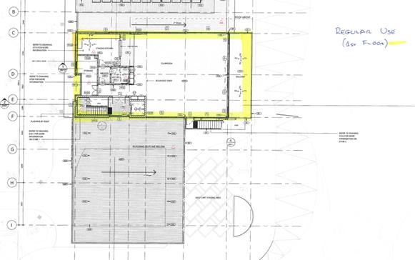
Figure 10: Extract from Proposed Licensed Areas Plan
highlighting first floor area to be licensed on a day to day basis (Source:
Webber Architects)
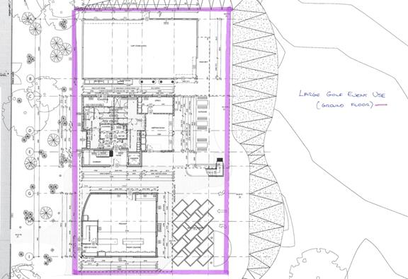
Figure 11: Extract from Proposed Licensed Areas Plan highlighting
ground floor area to be licensed for events (Source: Webber Architects)
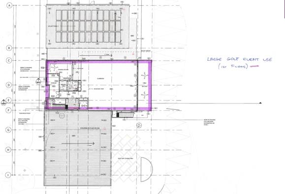
Figure 12: Extract from Proposed Licensed Areas Plan highlighting
first floor area to be licensed for events (Source: Webber Architects)
157. The applicant has advised that typically on a
day to day basis there would be no more than 10-15 people within the licensed
area at any one time, whereas events could typically have 100-120 persons.
158. Should the application be approved, it is
recommended that a conditions of consent be imposed in relation to obtaining an
amended Liquor License, maximum patron numbers, and requiring the preparation
and submission of a Plan of Management for the approval of Council outlining
how the premises are proposed to be managed in relation to the sale of liquor
on the premises.
Hours of Operation
159. As identified in paragraph 21, the existing
golf course operates from 5.45am to 7.00pm daily. Notwithstanding this, it is
noted that there is no evidence of any approved hours of operation on previous
consents.
160. The clubhouse is proposed to operate from
5.45am to 7.00pm daily consistent with the existing golf course operations,
with the exception of a few annual events which will operate up until 10.00pm.
161. The Acoustic Report submitted with the DA
identified that the clubroom would be open in conjunction with the approved
hours of operation of the golf course, with the exception of a small number of
days per year coinciding with major events when it would operate up until
10.00pm. Examples of such events would be the Annual General Meeting and the
Annual Mayor’s Charity Day.
162. Given such events currently occur on the site
without the benefit of an internal clubhouse ie entirely outdoors, subject to
conditions the operation of the first floor clubroom up until 10.00pm for a
handful of events each calendar year is unlikely to impact on the amenity of
the surrounding area.
Social and Economic Impacts
163. The proposed
development is not likely to result in any significant adverse social or
economic impacts.
164. The proposal seeks
to improve the function and aesthetic appearance of an
existing golf course and clubhouse building. The works
will allow the golf club to cater to current and future
membership requirements and are consistent with the
stated objectives of the RE1 Public Recreation zone.
165. The proposed works involve an upgrade to the amenity of the
surrounding landscape and enable the site to retain a landscaped setting that
is compatible with the streetscape and surrounding residential land uses.
Suitability of
the Site
166. The
proposed works are located on land zoned RE1 Public Recreation. The application
seeks consent for an outdoor recreational facility, which is permitted with
consent in the zone.
167. It is considered the proposal will not result in any significant
adverse impacts to neighbouring properties or the streetscape. The proposal is
considered to be a suitable form of development on the site.
Submissions and
the Public Interest
168. In
accordance with the provisions of Council’s Public Notification process,
the application was placed on neighbour notification for a period of twenty one
(21) days between 6 April 2020 and 27 April 2020. Two (2) submissions were
received. A summary of the issues raised is discussed below.
Insufficient detail regarding operational details of
clubroom
169. Comment:
A request for additional information confirmed that the intended use of the
clubhouse is for post-game beverages and one-off club meetings (ie Annual
General Meetings, which comprise of a small number of club officials and
members). The clubhouse is proposed to operate from 5.45am – 7.00pm
daily. Food (ie hot food and confectionary) and drink, including alcoholic
beverages, are currently sold on the site and no change is proposed to this
existing arrangement. A condition has been recommended to restrict the use of
the kitchen for food re-heating purposes only.
Acoustic impact to neighbouring residents
170. Comment:
The proposed development is not foreseen to result in any unreasonable impact
upon the amenity of neighbouring residential properties. The submitted Acoustic
Assessment confirms that noise emissions from the clubroom will be within
acceptable levels. The proposed east-facing rear deck will be appropriately
screened from surrounding residential properties (ie dwellings fronting
Lorraine Street) by the structure of the building. Window openings are oriented
away from Lorraine Street and, accordingly, sound will travel to the east (ie
away from residential properties). Proposed window openings fronting the street
are from the ground floor workshop and a stairwell.
171. Suitable
conditions of consent are recommended to mitigate any adverse acoustic impacts
associated with the operations of the clubhouse. A condition is recommended to
restrict the operating hours of the clubhouse from 5.45am to 7.00pm daily and a
condition is recommended is limit the use of the premises for uses associated
with the golf course only.
Safety and security concerns for neighbouring
residents
172. Comment:
Noting that the proposal does not involve any change to existing clubhouse
operating hours, the development will not directly result in any additional
safety impacts. A condition is recommended is limit the use of the premises for
uses associated with the golf course only.
Impact of tree removal on outlook from neighbouring
properties
173. Comment:
The proposal will not have significant adverse impact to the outlook of
residential properties given that a wide view of the golf course will be
maintained. The building design is separated into three (3) distinct built
forms connected by a flat roof, providing transparency through towards the golf
course and significant existing vegetation to the east. Additionally, feature
shrub planting and subject to condition, canopy trees are proposed within the
front setback to enhance the landscape amenity of the streetscape.
Inappropriate building materials
174. Comment:
The proposed external building materials compliment the architectural and
natural character of the locality.
175. A
condition is proposed to be imposed requiring the submission of an amended
landscape plan which includes the planting of additional trees and shrubs
within the front setback and along the northern side of the golf cart store.
This will provide adequate screening of the storage structure to
‘soften’ the presentation of the building to Lorraine Street and
minimise adverse impacts to the outlook of properties on the western side of
the street.
Insufficient parking survey information
176. Comment:
Given the clubhouse is not proposed to operate independently of the golf course,
and the proposed works will not increase the capacity of the golf course, the
extent of parking survey information is considered sufficient.
Inappropriate bulk and scale
177. Comment:
The bulk and scale of the proposed development is considered to be appropriate
for the site. This issue is addressed in paragraphs 130-131.
178. Having
regard to the above, it is considered that the proposal is in the public
interest.
REFERRALS
Internal
Referrals
Consultant Arborist
179. The
application was referred to Council’s Consultant Arborist. No objection
was raised, subject to the imposition of conditions clarifying trees to be
removed, retained, and protected during site works. In addition, and in
accordance with Georges River Council’s Tree Management Policy, 2019, a
2:1 replacement was recommended which will reinstate and increase urban canopy.
All replacement tree species selection must be as per Appendix 1, Tree Planting
of the Tree Management Policy.
Environmental Health Officer
180. The
application was referred to Council’s Environmental Health Officer. No
objection was raised, subject to the imposition of conditions relating
primarily to acoustic impact control and the use of the kitchen.
Development Engineer
181. The
application was referred to Council’s Development Engineer. No objection
was raised with regard to stormwater and drainage, subject to the imposition of
conditions.
Traffic Engineer
182. The
application was referred to Council’s Traffic Engineer. The submitted
Traffic Impact Study was reviewed and no objection was raised with regard to
the proposal.
Building Surveyor
183. The
application was referred to Council’s Building Surveyor. No objections
were raised, subject to the imposition of conditions.
External Referrals
Ausgrid
184. The
application was referred to Ausgrid in accordance with Clause 45 of State
Environmental Planning Policy (Infrastructure) 2007. Ausgrid raised no
objection to the proposal, subject to ‘as constructed’ minimum
clearance distances from Ausgrid’s Infrastructure.
Local
Infrastructure Contributions
185. Not
applicable.
CONCLUSION
186. The application has been
assessed having regard to the Matters for Consideration under Section 4.15 of
the Environmental Planning and Assessment Act 1979, the provisions of the
relevant State Environmental Planning Policies, Hurstville
Local Environmental Plan 2012 and Hurstville Development Control Plan No. 1.
187. The proposal has been considered on its merits and is considered to
be acceptable for the reasons outlined within this report. The proposal is
reasonable given that it generally
complies with the key development standards and meets the underlying objectives
of these controls.
188. Following
detailed assessment contained within this report, DA2020/0115 is recommended
for approval subject to conditions of consent.
DETERMINATION AND
STATEMENT OF REASONS
Statement of
Reasons
189. The
reasons for this recommendation are:
· The proposal is an appropriate response to the zoning of the site
and generally complies with the requirements of the relevant environmental
planning instruments and development control plan.
· The proposed development is considered to be compatible with the
streetscape and surrounding residential land uses.
· Subject to the implementation of the recommended conditions, the
development will not result unreasonable impact on the natural or built
environment.
· The proposed development seeks to improve the function of an
existing golf course and clubhouse building. The works will allow the golf club
to better cater to current and future patrons and members of the golf course,
which is in the public interest.
Recommendation:
190. That the
Georges River Council Local Planning Panel as the consent authority pursuant to
Section 4.16(1)(a) Environmental Planning and Assessment Act 1979, grant
consent to Development Application No DA2020/0115 for the
demolition of the existing clubhouse and construction of a new two (2) storey
clubhouse on land known as Lot 1 in DP 176469 (allotment
the work is being undertaken on), Lot 1 DP33385 and Lot 7054 DP1127614 and Lot
3 DP522691 (57A Lorraine Street) being the Hurstville Golf Course, 57 Lorraine
Street, Peakhurst, subject to
the following conditions of consent.
Development
Details
1. Approved Plans - The development must be
implemented in accordance with the approved plans and supporting documentation
listed below which have been endorsed by Council’s approved stamp, except
where marked up on the plans and/or amended by conditions of this consent:
|
Description
|
Reference No.
|
Date
|
Revision
|
Prepared by
|
|
Site Plan
|
2696/0201/G
|
28/02/20
|
G
|
Webber Architects
|
|
Site Demolition
Plan
|
2696/0202/F
|
28/02/20
|
F
|
Webber Architects
|
|
Landscape Plan
– Sheet 1 of 2
|
2696/0203/D
|
28/02/20
|
D
|
Webber Architects
|
|
Landscape Plan
– Sheet 2 of 2
|
2696/0204/B
|
28/02/20
|
B
|
Webber Architects
|
|
Shadow Diagrams
– December 21
|
2696/0206/B
|
28/02/20
|
B
|
Webber Architects
|
|
Shadow Diagrams
– June 21
|
2696/0207/B
|
28/02/20
|
B
|
Webber Architects
|
|
Environmental Site
Construction Management Plan
|
2696/0208/A
|
28/02/20
|
A
|
Webber Architects
|
|
Ground Floor Plan
|
2696/0301/G
|
28/02/20
|
G
|
Webber Architects
|
|
First Floor Plan
|
2696/0302/G
|
28/02/20
|
G
|
Webber Architects
|
|
Roof Floor Plan
|
2696/0303/G
|
28/02/20
|
G
|
Webber Architects
|
|
Elevations –
Sheet 1
|
2696/0401/G
|
28/02/20
|
G
|
Webber Architects
|
|
Elevations –
Sheet 2
|
2696/0402/G
|
28/02/20
|
G
|
Webber Architects
|
|
Sections –
Sheet 1
|
2696/0501/D
|
28/02/20
|
D
|
Webber Architects
|
|
3Ds and Materials
|
2696/1001/E
|
28/02/20
|
E
|
Webber Architects
|
|
Tree Replacement
Plan
|
2020_1_TRP-01
|
2/11/2020
|
A
|
Weidlich Golf
Design
|
|
Regular Licensed
Areas Ground Floor Plan
|
2696/0301/G
|
28/02/20
|
G
|
Webber Architects
|
|
Regular Licensed
Areas First Floor Plan
|
2696/0302/G
|
28/02/20
|
G
|
Webber Architects
|
|
Event Licensed
Areas Ground Floor Plan
|
2696/0301/G
|
28/02/20
|
G
|
Webber Architects
|
|
Event Licensed
Areas First Floor Plan
|
2696/0302/G
|
28/02/20
|
G
|
Webber Architects
|
Separate
Approvals Required Under Other Legislation
2. Section 138 Roads Act 1993 and Section 68 Local Government Act 1993 - Unless otherwise specified by
a condition of this consent, this Development Consent does not give any
approval to undertake works on public infrastructure.
Separate approval is
required under Section 138 of the Roads
Act 1993 and/or Section 68 of the Local Government Act 1993 for
any of the following activities carried out in, on or over a public road
(including the footpath) listed below.
An application is
required to be lodged and approved prior to the commencement of any of the
following works or activities;
(a) Placing
or storing materials or equipment;
(b) Placing
or storing waste containers or skip bins;
(c) Erecting
a structure or carrying out work;
(d) Swinging
or hoisting goods over any part of a public road by means of a lift, crane or
the like;
(e) Pumping
concrete from a public road;
(f) Pumping
water from the site into the public road;
(g) Constructing
a vehicular crossing or footpath;
(h) Establishing
a “works zone”;
(i) Digging
up or disturbing the surface of a public road (e.g. Opening the road for the
purpose of connections to utility providers);
(j) Stormwater
& ancillary works in the road reserve;
(k) Stormwater
& ancillary to public infrastructure on private land; and
(l) If
any excavation is to be supported by the use of below ground (cable) anchors
that are constructed under Council’s roadways/footways.
These
separate activity approvals must be obtained and evidence of the approval
provided to the Certifying Authority prior to the issue of the Construction
Certificate.
The
relevant Application Forms for these activities can be downloaded from Council’s
website www.georgesriver.nsw.gov.au. For
further information, please contact Council’s Customer Service Centre on
(02) 9330 6222.
3. Road Opening Permit - A Road Opening Permit must be obtained from Council, in the case of
local or regional roads, or from the RMS, in the case of State roads, for every
opening of a public road reserve to access services including sewer, stormwater
drains, water mains, gas mains, and telecommunications before the commencement
of work in the road.
Requirements of
Concurrence, Integrated & Other Government Authorities
4. Trade Waste Agreements - A Trade Waste Agreement with Sydney Water may be required. Details
of any work required to comply with the agreement must be detailed on the plans
lodged with the Construction Certificate. If no trade waste agreement or grease
trap is required, a letter from Sydney Water to this effect must be submitted
with the application for the Construction Certificate.
5. Sydney Water – Tap in TM - The approved plans must be submitted to a Sydney Water Tap inTM
to determine whether the development application will affect Sydney
Water’s sewer and water mains, stormwater drains and/or easements, and if
further requirements need to be met. The approved plans will be appropriately
endorsed. For details please refer to ‘Plumbing, building and
developing’ section of Sydney Water’s web site at www.sydneywater.com.au then see ‘Building’, or telephone 13000 TAP IN (1300
082 746). The Certifying Authority must ensure that a Tap inTM agent
has appropriately stamped the plans prior to the issue of the Construction
Certificate.
6. Liquor Licence - Application shall be
made to NSW Office of Liquor and Gaming for an amended Liquor Licence under the
Liquor Act 2007, prior to the issue of a construction certificate. Evidence
that the amended Licence has been issued shall be provided to the PCA prior to
the commencement of works.
Note: A use which is reliant on the
obtaining of a Liquor Licence should refrain from progressing until the Licence
is obtained.
Prior to the
issue of a Construction Certificate
7. Fees to be paid - The fees listed in the
table below must be paid in accordance with the conditions of this consent and
Council’s adopted Fees and Charges applicable at the time of payment
(available at www.georgesriver.nsw.gov.au).
Payments
must be made prior to the issue of the Construction Certificate or prior to the
commencement of work (if there is no associated Construction Certificate).
Please
contact council prior to the payment of S94 Contributions to determine whether
the amounts have been indexed from that indicated below in this consent and the
form of payment that will be accepted by Council.
Council will only accept Bank Cheque or
Electronic Funds Transfer (EFT) for transaction values of $500,000 or over.
Council must be contacted prior to payment to determine correct total amount to
be paid and bank account details (if applicable).
A summary of the fees to be paid are
listed below:
|
Fee Type
|
Fee
|
|
GENERAL FEES
|
|
Long Service Levy
(to Long Service Corporation)
Or, provide
evidence of Payment direct to the Long Service Corporation.
See https://portal.longservice.nsw.gov.au/bci/levy/
|
|
Builders Damage Deposit
|
$67,980.00
|
|
Inspection Fee for Refund of Damage Deposit
|
$371.00
|
|
Driveway Design and Inspection Fee (Dwelling)
|
$TBA
|
|
Driveway and Restoration Works Design
Inspection Fee (Multi-unit Development)
|
$TBA
|
General Fees
The fees and charges above are subject to
change and are as set out in the version of Council's Schedule of Fees and
Charges or as required by other Government Authorities, applicable at the time
of payment.
8. Damage Deposit – Major Works - In order to insure against damage to Council property the following
is required:
(a) Pay Council, before the issue of the Construction Certificate, a
damage deposit for the cost of making good any damage caused to any Council
property as a result of the development: $67,980.00
(b) Pay Council, before the issue of the Construction Certificate, a
non-refundable inspection fee to enable assessment of any damage and repairs
where required: $371.00
(c) Submit to Council, before the commencement of work, a dilapidation
report of the condition of the Council nature strip, footpath and driveway
crossing, or any area likely to be affected by the proposal.
At the completion of work Council will
review the dilapidation report and the Works-As-Executed Drawings (if
applicable) and inspect the public works.
The damage deposit will be refunded in
full upon completion of work where no damage occurs and where Council is
satisfied with the completion of works. Alternatively, the damage deposit will
be forfeited or partly refunded based on the damage incurred.
9. Low reflectivity roof - Roofing
materials must be low glare and reflectivity. Details of finished external
materials including colours and texture must be provided to the Certifying
Authority.
10. Lighting Plan – Details of
proposed lighting are to be submitted demonstrating the following:
· Lighting towards access/egress routes and possible hiding places to
illuminate potential offenders and possible places for intruders to hide;
· Lighting should have a wide beam of illumination, which reaches to
the beam of the next light, or the perimeter of the site or area being
traversed, thereby avoiding dark shadows.
11. Installation of Dual Flush Toilets - All
toilets installed within the development must be of water efficient dual-flush
or other water-saving capacity with at least a 4-star rating under the Water
Efficiency and Labelling Scheme (WELS). The details must be submitted for the
approval of the Accredited Certifier, prior to a Construction Certificate being
issued.
12. Installation of Water Efficient Taps -
All taps and shower heads installed must be water efficient with at least a
4-star rating under the Water Efficiency and Labelling Scheme (WELS). The
details are to be submitted for the approval of the Principal Certifier, prior
to any Occupation Certificate being issued.
13. Installation of water efficient urinals -
New urinal suites, urinals and urinal flushing control mechanisms must use
waterless technology. Where it is submitted that this is not feasible, it must
be demonstrated that products have been selected with at least a 4-star rating
under the Water Efficiency and Labelling Scheme (WELS). Systems must include
"smart controls" to reduce unnecessary flushing. Continuous flushing
systems are not approved. Details are to be submitted to and approved by the
Accredited Certifier, prior to a Construction Certificate being issued.
14. Site Management Plan – Major Development - A Site Management Plan must be submitted with the application for
a Construction Certificate, and include the following:
(a) location
of protective site fencing;
(b) location
of site storage areas/sheds/equipment;
(c) location
of building materials for construction, e.g. stockpiles;
(d) provisions
for public safety;
(e) dust
control measures;
(f) method
used to provide site access location and materials used;
(g) details
of methods of disposal of demolition materials;
(h) method
used to provide protective measures for tree preservation;
(i) provisions
for temporary sanitary facilities;
(j) location
and size of waste containers/skip bins;
(k) details
of proposed sediment and erosion control measures;
(l) method
used to provide construction noise and vibration management; and
(m) construction
and demolition traffic management details.
The
site management measures are to be implemented prior to the commencement of any
works including demolition and excavation. The site management measures are to
be maintained throughout the works, to maintain reasonable levels of public
health, safety and amenity. A copy of the Site Management Plan must be kept on
site and is to be made available upon request.
15. Section 79BA Bushfire Risk Assessment Certificate - All bushfire measures as recommended in the Bushfire Risk
Assessment Report prepared by Newcastle Bushfire Consulting and dated 28
January 2020, and in the Bushfire Risk Assessment Certificate approved by
Phillip Couch (Certification No. BPD-PA-16132), must be implemented and the
details of bushfire safety measures must be submitted with the Construction
Certificate application.
16. Bushfire Attack Level - The proposed
development is to fully comply with all requirements applicable to a Bush Fire
Attack Level (BAL) of BAL-LOW. With regard to the construction requirements
both Addendum: Appendix 3 Planning for Bush Fire Protection 2010, and AS3959
-2009 Construction of Buildings in Bush Fire prone areas shall be referenced.
Full details of proposed method of compliance are to be submitted with the Construction
Certificate application.
17. Required design changes - The following changes are required to be made to the
detailed Hydraulic Stormwater plans for inclusion with the Construction
Certificate Application.
|
Drawing Reference
|
Drawing Date
|
Revision
|
Drawing Details
|
Author
|
|
Project No.0720A Dwg. No.H101
|
17/2/2020
|
A
|
Hydraulic Services Ground Floor –
Stormwater Drainage
|
Webb Australia Group (NSW) Pty Ltd
|
|
Project No.0720A Dwg. No.H001
|
17/6/2020
|
02
|
Hydraulic Services Site Plan
|
Webb
Australia Group (NSW) Pty Ltd
|
|
Project No.0720A Dwg.
No.H002
|
17/6/2020
|
01
|
Hydraulic Services Site Stormwater Connection
Plan
|
Webb
Australia Group (NSW) Pty Ltd
|
|
Project No.0720A Dwg. No.H103
|
17/6/2020
|
A
|
Hydraulic Services Roof – Stormwater
Drainage
|
Webb
Australia Group (NSW) Pty Ltd
|
(i) The inclusion of a fully detailed drawing of a silt/litter arrestor
pit with Maximesh RH3030 (or similar) galvanised screen, located downstream of
the last connection to the on-site drainage system and upstream of the proposed
connection to Council’s trunk drainage system located within the
Hurstville Golf Course site.
18. Erosion & Sedimentation Control -
Erosion and sediment controls must be provided to
ensure:
(a) Compliance with the approved Erosion & Sediment Control Plan
(b) Removal
or disturbance of vegetation and top soil is confined to within 3m of the
approved building area (no trees to be removed without approval)
(c) All
clean water run-off is diverted around cleared or exposed areas
(d) Silt
fences, stabilised entry/exit points or other devices are installed to prevent
sediment from entering drainage systems or waterways
(e) All
erosion and sediment controls are fully maintained for the duration of
demolition, excavation and/or development works
(f) Controls
are put into place to prevent tracking of sediment by vehicles onto adjoining
roadway
(g) All
disturbed areas are rendered erosion-resistant by turfing, mulching, paving or
similar
(h) Compliance
with Managing
Urban Stormwater – Soils and Construction (Blue Book) produced by Landcom
2004.
These measures are to be implemented prior to the
commencement of work (including demolition and excavation) and must remain
until works are completed and all exposed surfaces are landscaped/sealed.
19. Stormwater System - The submitted
stormwater plan has been assessed as a concept plan only. Final detailed plans
of the drainage system, prepared by a professional engineer specialising in
hydraulic engineering, shall be submitted for approval with the Construction
Certificate.
(a) All
stormwater shall drain by gravity to the upper level of Council’s
stormwater drainage pipeline located on the Hurstville Golf Course site in
accordance with the Australian/New Zealand Standard AS/NZS 3500.3: 2015 (as
amended).
(b) Stormwater
drainage plans including pipe sizes, type, grade, length, invert levels,
dimensions and types of drainage pits prepared by a professional engineer who
specialises in Hydraulic Engineering in accordance with the Australian
Institute of Engineers Australian Rainfall and Runoff (1987) and Council's
Stormwater Drainage Guidelines, shall accompany the application for the
Construction Certificate.
20. Detailed Stormwater Drainage Design - The submitted stormwater plan has been assessed as a concept plan
only. A detailed drainage design supported by a catchment area plan and
drainage calculations (including a Hydraulic Grade Line Analysis) must be
submitted with the Construction Certificate application.
21. Stormwater Drainage Plan Details - Stormwater
drainage plans including pipe sizes, type, grade, length, invert levels,
dimensions and types of drainage pits prepared by a professional engineering
specialising in hydraulic engineering shall be submitted with the Construction
Certificate application.
These plans shall be prepared in
accordance with the Australian Institute of Engineers Australian Rainfall and
Runoff (1987) and Council's Stormwater Management Policy.
22. Fire Safety Measures - Prior to the
issue of a construction certificate a list of the essential fire safety
measures that are to be provided in relation to the land and any building on
the land as a consequence of the building work must accompany an application
for a construction certificate, which is required to be submitted to either
Council or a PCA. Such list must also specify the minimum standard of
performance for each essential fire safety measure included in the list. The
Council or PCA will then issue a Fire Safety Schedule for the building.
23. Structural details - Engineer's details
prepared by a practising Structural Engineer being used to construct all
reinforced concrete work, structural beams, columns and other structural
members. The details are to be submitted to the Principal Certifying
Authority for approval prior to construction of the specified works.
A copy shall be forwarded to Council
where Council is not the PCA.
24. Access for persons with disabilities - Access for persons with disabilities
must be provided direct to the site, including to all common areas, from
external carpark and required sanitary facilities in accordance with the
Premises Standards, the Building Code of Australia and AS 1428.1.
In the event that
full compliance cannot be achieved the services of an accredited access
consultant is to be obtained to determine alternative methods of compliance,
such a report must be submitted to and endorsed by the Certifying Authority
prior to issue of the Construction Certificate.
25. Slip Resistance - All pedestrian
surfaces in areas such as foyers, public corridors, common areas, stairs and
ramps as well as floor surfaces in the wet rooms must have slip resistance
classifications, as determined using test methods in either wet or dry
conditions, appropriate to their gradient and exposure to wetting. The
classifications of the new pedestrian surface materials, in wet or dry
conditions, must comply with AS/NZS4586:2004 - Slip Resistance Classifications
of New Pedestrian Materials and must be detailed on the plans lodged with the
application for the Construction Certificate.
26. Stormwater Drainage Application - This Development Consent does not give
approval to undertake works on public infrastructure. A separate approval of a
Stormwater Drainage Application is required under Section 68 of the Local
Government Act 1993 to undertake:
(a) Stormwater
& ancillary works to public infrastructure on private land.
The Stormwater Drainage Application
approval must be obtained and evidence of the approval provided to the
Certifying Authority prior to the issue of the Construction Certificate.
The Application Form for this activity
can be downloaded from Council’s website www.georgesriver.nsw.gov.au. For further information, please contact Council’s Customer
Service Centre on (02) 9330 6400.
27. Landscape Plans - A detailed landscape plan, drawn to scale, A3 size and coloured, by
a qualified landscape architect or an AQF Level 5 landscape designer, must be
submitted prior to the issue of the Construction Certificate. The plan must
include:
(a) Location
of existing and proposed structures, services and existing trees to be
retained and /or removed;
(b) Details
of earthworks including mounding and retaining walls, Reduced Levels and
planter boxes;
(c) For
the removal of twenty-two (22) trees upon the site, the applicant shall plant
forty-four (44) trees at minimum 45 litre pot/ bag size, in accordance with
Georges Rivers Tree Management Replacement Policy of 2:1.
(d) A
minimum of 12 of the 44 replacement canopy trees, are to be planted in the
immediate vicinity of the clubhouse, including within the front setback of the
cart store and to the north of the cart store, to replace the loss of canopy
trees from this part of the site. These trees are to be of the following
species and a minimum pot size of 100 litres:
· Smooth Barked Apple Myrtle
· Lemon Scented Gum
· Forest Red Gum
· Brush Box
(e) Three
(3) additional weeping bottle brush species are to be planted between the cart
store and the Lorraine Street frontage to provide additional screening to the
cart store.
(f) Location
of proposed forty-four (44) trees and plants proposed as well as a plant
schedule showing the plant symbol, botanical name/ common name; quantity; pot
size/; and mature height x width.
(g) A
higher proportionate mix of natives than exotics plantings, with all trees
proposed, able to reach a height at maturity of nine (9) metres.
(h) Reference
Georges River Councils, Tree Management Policy, 2019, 2:1 tree replacement.
Council’s Policy requires that for every tree removed from the site, two
(2) trees shall be planted to replace those lost.
(i) Tree
species selection from – Georges River Council’s Tree Management
Policy, April 2019, Appendix 1 – Tree Planting.
(j) Details
of planting specifications, procedures and a maintenance schedule for twelve
(12) months;
(k) Landscape
ratios – pervious to impervious surfaces / deep soil zones
(l) Details
of drainage and watering systems;
(m) Details of
garden edging and turf;
(n) Any
required fencing, retaining walls and other structures not shown on other
approved architectural and engineering plans;
(o) The
contact details and website of the landscape architect or AQF Level 5 landscape
designer, as well as qualifications; and
(p) Associations
and / or Memberships of Affiliation within the landscape industry.
28. Compliance with submitted Arborist Report - The recommendations outlined in the Arborist’s Report titled
Arboricultural Impact Assessment prepared by Tom Hare- Truth About Trees, dated
2 March 2020, must be implemented throughout the relevant stages of
construction. Details of tree protection measures to be implemented must
be detailed and lodged with the Construction Certificate application for
approval and shall be in accordance with Section 4 - Australian Standard AS
4970-2009: Protection of trees on development sites.
29. Tree Protection and Retention
(CC9.87) - The following trees shall be retained
and protected:
|
Tree Species
|
Location of
Tree / Tree No.
|
Tree Protection
Zone (metres) TPZ as per AS4970 - 2009
Fencing
distance from trunk
|
|
T11 - Melaleuca
viminalis
|
Within site
fronting practice nets
|
2.4 metres
|
|
T12 - Melaleuca
viminalis
|
Within site
fronting practice nets
|
4.9 metres
|
|
T13 – Melaleuca
viminalis
|
Within site along
front boundary fence
|
3.8 metres
|
|
T14 – Melaleuca
viminalis
|
Within site along
front boundary fence
|
3.8 metres
|
|
T15 – Melaleuca
viminalis
|
Within site along
front boundary fence
|
4.5 metres
|
|
T16 – Melaleuca
viminalis
|
Within site along
front boundary fence
|
2.2 metres
|
|
T17 – Melaleuca
viminalis
|
Within site along
front boundary fence
|
5.9 metres
|
|
T18 – Melaleuca
viminalis
|
Within site along
front boundary fence
|
2.0 metres
|
|
T19 – Melaleuca
viminalis
|
Within site along
front boundary fence
|
4.0 metres
|
|
T20 – Melaleuca
viminalis
|
Within site along
front boundary fence
|
4.4 metres
|
|
T21 – Melaleuca
viminalis
|
Within site along
front boundary fence
|
3.6 metres
|
|
T22 – Melaleuca
viminalis
|
Within site along
front boundary fence
|
4.2 metres
|
|
T23 – Melaleuca
viminalis
|
Within site close
to existing covered area, BBQ and pergola area
|
5.5 metres
|
|
T24 – Melaleuca
viminalis
|
Within site close
to existing covered area, BBQ and pergola area
|
4.7 metres
|
|
T25 - Melaleuca
viminalis
|
Within site close
to existing covered area, BBQ and pergola area
|
5.4 metres
|
|
T26 - Melaleuca
viminalis
|
Within site close
to existing covered area, BBQ and pergola area
|
3.1 metres
|
|
T27 – Eucalytpus
saligna
|
Within site close
to existing covered area, BBQ and pergola area
|
7.7 metres
|
|
T1112 – Casuarina
cunninghamiana
|
Within site, rear
of 9th Tee
|
5.5 metres
|
|
T1113 – Casuarina
cunninghamiana
|
Within site, rear
of 9th Tee
|
2.2 metres
|
|
T1116 - Melaleuca
viminalis
|
Within site, rear
of 9th Tee, close to boundary fence
|
3.2 metres
|
|
T1207 – Eucalyptus
microcorys
|
Within site close
to existing covered area, BBQ and pergola area
|
5.3 metres
|
|
T1208 - Melaleuca
viminalis
|
Within site close
to existing covered area, BBQ and pergola area
|
2.4 metres
|
|
T1209 - Melaleuca
viminalis
|
Within site close
to existing covered area, BBQ and pergola area
|
4.9 metres
|
|
T1210 - Melaleuca
viminalis
|
Within site close
to existing covered area, BBQ and pergola area
|
4.2 metres
|
|
T73 – Eucalytpus
microcorys
|
Extent of works,
south, along 1st fairway
|
9.0 metres
|
(a) The
client shall engage a qualified Arborist who holds an AQF Level 5 or above in
Arboriculture and who is a current practicing and financial member of an Arboricultural
Association or Affiliation.
(b) A
certificate of compliance letter for tree protection measures shall be
completed and forwarded to the PCA – Principal Certifying Authority, at
three (3) stages being - before works, during works and once all building works
have been completed, that tree protection measures have been installed and
maintained during the building process.
General Tree Protection Measures
(c) The tree protection measures must be in
undertaken in accordance AS4970 -2009 Protection of trees on development
sites.
(d) Details
of the tree protection measures
to be implemented must be provided with the application for a Construction
Certificate by a qualified Arborist who holds an AQF Level 5 or above in
Arboriculture and who is a current practicing and financial member of an
Arboricultural Association or Affiliation.
(e) The
engaged AQF 5 Consulting Project Arborist must be present on-site during the
stages of site set up,
excavation, demolition and construction when works are being undertaken that
could impact on the tree canopy or root zone within the tree protection zone of
each tree.
(f) In
accordance with AS 4970-2009 Protection of trees on development sites, a
protective fence consisting of
2.4 x 1.8 metres high, fully supported chainmesh fence shall be used. The
distance of the fence from the base of each tree is to be in accordance with
the TPZ listed in the table above. A layer of organic mulch 100 millimetres
thick shall be placed over the protected area and no soil or fill should be
placed within the protection area.
(g) The
Tree Protection Zone of each
tree, to be protected, shall be watered thoroughly and regularly to minimise
the effects of construction works.
(h) No
building products/ materials or services shall be installed within the TPZ of
the tree/s unless approved by Council. This fence shall be kept in place during
demolition, construction and
also have a sign displaying ‘Tree Protection Zone – DO NOT
ENTER’ attached to the fence and must also include the name and contact
details of the Project Arborist.
Excavation works near tree to be retained
(i) As per Arborist report, for the protection of trees in the location
of the proposed stormwater piping – Trees 13 to 23, underground boring or
the use of Air Spade type of non destructive excavations shall be utilised.
(j) Excavations
around the trees to be retained on site shall be supervised by the AQF 5
Project Arborist to ensure that the root system will not adversely be affected,
as per recommendations within the Arborist Report.
(k) Where
the Tree Protection Zone (TPZ) of trees on site become compromised by any
excavation works, the AQF 5 Project arborist shall be consulted to establish
the position of any major roots and determine the necessary measures to protect
these roots. The recommendations of the Arborist shall be submitted to Council
prior to any further demolition or construction works taking place.
(l) Tree
Protection Zones around the trees to be retained are not to have soil level
changes, building product / materials stored or services installed in this
area. Any structures proposed to be built in this area of the trees are to
utilise pier and beam or cantilevered slab construction.
(m) Removal or pruning of any other tree (that would require consent of
Council) on the site is not approved. All pruning must be undertaken by a
qualified Arborist in accordance with AS4373 -2007 Pruning of Amenity Trees and
Amenity Tree Industry, Code of Practice (SafeWork NSW August 1998).
30. Tree Removal & Replacement - In
accordance with Georges River Tree Management Policy 2019, a 2:1 Policy is to
be implemented. For every one (1) tree to be removed, two (2) trees shall be
planted on the subject site to compensate for the loss of each tree. If Council
finds that locations within the site cannot be found for the trees viability,
an offset fee shall be forwarded to Council to plant the tree/s elsewhere,
within the municipality.
Permission is granted for the removal of
the following trees:
|
Tree Species
|
Number of trees
|
Location
|
|
T1 – Eucalyptus
scoparia
|
1
|
Front of existing
dwelling, close to Fairway 1
|
|
T3 – Eucalytpus
longifolia
|
1
|
Front of existing
clubhouse
|
|
T4 – Eucalytpus
microcorys
|
1
|
Front of existing
clubhouse
|
|
T5 – Agonis
flexuosa
|
1
|
East side of existing
clubhouse
|
|
T6/ 7 – Melaleuca
viminalis
|
2
|
East side of
existing clubhouse
|
|
T8/9 – Cupressus
macrocarpa
|
2
|
Side of clubhouse
|
|
T10 – Eucalytpus
globulus
|
1
|
Side of clubhouse
|
|
T1117 – Melaleuca
viminalis
|
1
|
Close to boundary
fence, roadway
|
|
T1118 – Eucalytpus
microcorys
|
1
|
Side of clubhouse
|
|
T1119 – Casuarina
glauca
|
1
|
Between 9th
Green and clubhouse
|
|
T1120 – Eucalyptus
microcorys
|
1
|
Side of clubhouse
|
|
T1121 – Eucalytpus
microcorys
|
1
|
Side of clubhouse
|
|
T1122 – Eucalytpus
microcorys
|
1
|
South east side of
clubhouse
|
|
Ficus Spp
|
7
|
Front fence
entrance (4) to Golf Course and close to BBQ and pergola area (3).
|
General Tree Removal Requirements
(a) All
tree removal shall be carried out by a minimum certificate Level 3, Licenced
and insured Tree Surgeon/Arborist to ensure that removal is undertaken in a
safe manner and complies with the AS 4373-2007 - Pruning of Amenity Trees and
Tree Works Industry Code of Practice (Work Cover NSW 1.8.98).
(b) No
trees are to be removed on the site or neighbouring properties without the
prior written approval of Council.
|
Summary
|
|
Number of trees removed from site
|
22
|
|
Number of trees required as per
offset scheme (2:1 ratio)
|
44
|
31. Acoustic Requirements - Compliance
with submitted Acoustic Report - The Construction Certificate plans shall
demonstrate compliance with the Acoustic Report submitted and approved by
Council, titled ‘Noise Assessment Report’ prepared by Spectrum
Acoustics dated February 2020.
32. Food Premises - The following information
shall be provided and shown on the Construction Certificate Plans
(a) Plans and Specifications - Details of the construction and fit out of food premises must be
submitted to Council’s Environmental Health Officer. The plans and
specifications must demonstrate compliance with the:
i. Food
Act 2003 (as
amended)
ii. Food
Regulation 2015 (as amended)
iii. Food
Standards Code as published by Food Standards Australia
iv. New Zealand and
Australian Standard AS4674:2004 Design, Construction and fit out of food
premises (as amended)
v. Sydney Water
– trade Waste Section.
Environmental Health
Officers’ must advise in writing that the plans and specification are
considered satisfactory prior to the issue of any Construction Certificate.
33. Food - Installation of mechanical exhaust system - Should a mechanical exhaust system be
proposed, details to be submitted to Council for assessment prior to any
installation. The plans should show the proposed location and capacity of the
system.
Prior to the
Commencement of Work (Including Demolition and Excavation)
34. Demolition & Asbestos - The
demolition work shall comply with the provisions of Australian Standard
AS2601:2001 – Demolition of Structures, NSW Work Health & Safety Act
2011 and the NSW Work Health & Safety Regulation 2011. The work plans
required by AS2601:2001 shall be accompanied by a written statement by a
suitably qualified person that the proposals contained in the work plan comply
with the safety requirements of the Standard. The work plans and the safety
statement shall be submitted to the PCA prior to the commencement of works.
For demolition work which involves the
removal of asbestos, the asbestos removal work must be carried out by a
licensed asbestos removalist who is licensed to carry out the work in
accordance with the NSW Work Health & Safety Act 2011 and the NSW Work
Health & Safety Regulation 2011 unless specified in the Act and/or
Regulation that a license is not required.
All demolition work including the removal
of asbestos, shall be undertaken in accordance with the Demolition Code of
Practice (NSW Work Cover July 2015).
Note: Copies of the Act, Regulation and
Code of Practice can be downloaded free of charge from the SafeWork NSW
website: www.SafeWork.nsw.gov.au.
35. Demolition Notification Requirements -
The following notification requirements apply to this consent:
(a) The
developer /builder must notify adjoining residents five (5) working days prior
to demolition. Such notification is to be a clearly written note giving the
date demolition will commence, contact details of the developer/builder,
licensed asbestos demolisher and the appropriate regulatory authority.
Notification is to be placed in the letterbox of every premises (including
every residential flat or unit, if any) either side and immediately at the rear
of the demolition site.
(b) Five
(5) working days prior to demolition, the developer/builder is to provide
written notification to Council advising of the demolition date, details of the
SafeWork licensed asbestos demolisher and the list of residents advised of the
demolition.
(c) On
demolition sites where buildings to be demolished contain asbestos, a standard
commercially manufactured sign containing the words “DANGER ASBESTOS
REMOVAL IN PROGRESS” measuring not less than 400mm x 300mm is to be
erected in a prominent visible position (from street frontage) on the site. The
sign is to be erected prior to demolition work commencing and is to remain in
place until such time as all asbestos material has been removed from the site
to an approved waste facility.
36. Dial before your dig - The applicant
shall contact “Dial Before You Dig on 1100” to obtain a Service
Diagram prior to the issuing of the Construction Certificate. The sequence
number obtained from “Dial Before You Dig” shall be forwarded to
the Principal Certifying Authority (PCA) and Council for their records.
37. Existing drainage easement, drainage reserve or stormwater drainage
system benefiting Council - Council drainage easement(s) drainage
reserve(s) or stormwater system either pass through or are adjacent to the
site. No building or other structure must be placed over the drainage easement
or stormwater system or within the zone of influence taken from the invert of
any pipe.
The applicant must determine the exact
location, size and level details of the potentially affected stormwater
drainage systems and without causing any damage to the public system ensure its
protection. The owner, principal contractor or owner builder must not obstruct
or otherwise remove, disconnect or render inoperable the Stormwater Drainage System.
Works such as fences must not obstruct
the natural stormwater flowpath or alter the flowpath in such a way as to
direct or concentrate stormwater on to neighbouring properties.
Where the relocation or reconstruction of
Council’s drainage system is approved then all work carried out on
Council’s assets will revert to the ownership, care, control or
management of Council. Therefore, upon handover to Council, the asset must
comply with Council’s Construction of drainage and associated works
specification.
The applicant must meet all costs
associated with such works.
Note: This condition does not set aside
the need to obtain relevant approvals under the Roads Act 1993 or Local
Government Act 1993 for works within Roads and
other public places.
38. Registered Surveyors Report - During Development Work - A report must be submitted to the PCA at each of
the following applicable stages of construction:
(a) Set out before commencing excavation.
(b) Floor slabs or foundation wall, before formwork or
commencing brickwork.
(c) Completion of Foundation Walls - Before any construction of
flooring, detailing the location of the structure relative to adjacent
boundaries and floor levels relative to the datum shown on the approved plans.
(d) Completion of Floor Slab Formwork - Before pouring of
concrete/walls construction, detailing the location of the structure relative
to adjacent boundaries and floor levels relative to the datum shown on the
approved plans. In multi-storey buildings a further survey must be
provided at each subsequent storey.
(e) Completion of any Roof Framing - Before roof covered
detailing eaves/gutter setback from boundaries.
(f) Completion of all Work - Detailing the location of the
structure (including eaves/gutters) relative to adjacent boundaries and its
height relative to the datum shown on the approved plans. A final Check Survey
must indicate the reduced level of the main ridge.
Work must not proceed beyond each
stage until the PCA is satisfied that the height and location of the building
is proceeding in accordance with the approved plans.
During
Construction
39. Site sign – Soil & Erosion Control Measures - Prior to the commencement of works (including demolition and
excavation), a durable site sign, issued by Council in conjunction with this
consent, must be erected in a prominent location on site. The site sign warns
of the penalties which apply to pollution, storing materials on road or
footpath and breaches of the conditions relating to erosion and sediment
controls. The sign must remain in a prominent location on site up until the
completion of all site and building works.
40. Hours of construction for demolition and building work - Any work activity or activity associated with the development
consent that requires the use of any tools (including hand tools) or any power
operated plant and machinery that creates noise on or adjacent to the site
shall not be performed, or permitted to be performed, except between the hours
of 7.00 am to 5.00 pm, Monday to Saturday inclusive. No work or ancillary
activity is permitted on Sundays, or Public Holidays.
Note: A penalty infringement notice may
be issued for any offence.
41. Structural Certificate during Construction - The proposed building must be constructed in accordance with
details designed and certified by the practising qualified structural engineer.
All structural works associated with the foundations, piers, footings and slabs
for the proposed building must be inspected and structurally certified for
compliance by an independent practising geotechnical and structural engineer.
In addition a Compliance or Structural Certificate, to the effect that the
building works have been carried in accordance with the structural design, must
be submitted to the Certifying Authority at each stage of Construction or prior issue of the Occupation Certificate.
42. Physical connection of Stormwater to site - No work is
permitted to proceed above the ground floor slab level of the building until
there is physical connection of the approved stormwater drainage system from
the land the subject of this consent to Council's trunk stormwater drainage pipeline
located on Hurstville Golf Course in the vicinity of Nos. 122 and 124 Lorraine
Street.
43. Site contamination – Additional information - Any new information that comes to light
during demolition or construction which has the potential to alter previous
conclusions about site contamination and remediation must be notified to
Council and the accredited certifier immediately.
44. Obstruction of Road or Footpath - The
use of the road or footpath for the storage of any building materials, waste materials, temporary toilets, waste or skip bins,
or any other matter is not permitted unless separately approved by Council
under Section 138 of the Roads Act 1993 and/or under Section 68 of the Local
Government Act 1993. Penalty infringement Notices may be issued for any
offences and severe penalties apply.
45. Road Opening Permit - A Road Opening Permit must be obtained from Council for every
opening of a public road reserve to access services including sewer, water
mains, gas mains, connecting of stormwater to the kerb and telecommunication.
This is for any work that
involves excavation through or within a public road, kerb and gutter, and or
the public footway between the road and the property boundary. The permit is to
be lodged prior to the commencement of works. Additional approval is required
from Roads and Maritime Services for works on a State Road.
46. Waste Management Facility - All
materials removed from the site as a result of demolition, site clearing, site preparation and, or excavation shall be
disposed of at a suitable Waste Management Facility. No vegetation, article,
building material, waste or the like shall be ignited or burnt.
Copies of all receipts for the disposal,
or processing of all such materials shall be submitted to the PCA and Council,
where Council is not the Principal Certifying Authority.
Prior to the
issue of the Occupation Certificate
47. Requirements prior to the issue of the Occupation Certificate - The following shall be completed and or submitted
to the PCA prior to the issue of the Occupation Certificate:
(a) All
the stormwater/drainage works shall be completed in accordance with the
approved Construction Certificate plans prior to the issue of the Occupation
Certificate.
(b) The
provision for all services (conduits and pipes laid) shall be completed in
accordance with the approved Construction Certificate plans prior to the issue
of the Occupation Certificate.
(c) Replace
all redundant vehicle crossing laybacks with kerb and guttering, and replace
redundant concrete with turf.
(d) A
Section 73 (Sydney Water) Compliance Certificate for the Subdivision shall be
issued and submitted to the PCA prior to the issue of the Occupation
Certificate.
(e) Work
as Executed Plans prepared by a Chartered Professional Engineer or a Registered
Surveyor when all the site engineering works are complete shall be submitted to
the PCA prior to the issue of the Occupation Certificate.
(f) The
construction of the stormwater drainage connection within the Hurstville Golf
Course site shall be completed in accordance with the conditions and
specifications of the Section 68 Activity Approval.
48. Vehicular crossing & Frontage work – Major development - The following road frontage works shall be
constructed in accordance with the specifications issued under the
‘Application for Driveway Crossing and Associated Works on Council Road
Reserve’ approval issued by Council’s Assets and Infrastructure
Division:
(a) Any
existing vehicular crossing and/or laybacks which are redundant must be
removed. The kerb and gutter, any other footpath and turf areas shall be
restored at the expense of the applicant and in accordance with Council’s
Specification for Driveway Crossings and Associated Works.
The above work shall be carried out in
accordance with Council’s Specification for Driveway Crossings and
Associated Works.
The driveway and road frontage works are
to be completed before the issue of the Occupation Certificate.
49. Completion of Major Works - Prior to the issue of a Final
Occupation Certificate, the following works must be completed at the
applicant’s expense to the satisfaction of Council’s Engineering
Services section:
(a) Stormwater
pipes, pits and connections to Council’s trunk stormwater drainage system
within the Hurstville Golf Course site;
(b) Removal
of redundant driveways and vehicular crossings;
(c) New
or reinstated kerb and guttering within the road related area; and
(d) New
or reinstated road surface pavement within the road.
Council’s
Assets and Infrastructure Section must advise in writing that the works have
been completed to their satisfaction prior to the issue of the Occupation
Certificate. [Note: The damage deposit paid to Council will not be released
until the works have been completed to Council’s satisfaction.
50. Stormwater drainage works – Works As Executed - Prior to
the issue of the Occupation Certificate, storm water drainage works are to be
certified by a professional engineer specialising in hydraulic engineering,
with Works-As-Executed drawings supplied to Council detailing:
(a) Compliance
with conditions of development consent relating to stormwater;
(b) Pipe
invert levels and surface levels to Australian Height Datum.
51. Fire Safety Certificate before Occupation or Use - In accordance with Clause 153 of the Environmental
Planning and Assessment Regulation 2000 on
completion of building works and prior to the issue of an Occupation
Certificate, the owner must cause the issue of a Final Fire Safety Certificate
in accordance with Clause 170 of the aforesaid Regulation. The Fire Safety
Certificate must be in the form or to the effect of Clause 174 of the Environmental
Planning and Assessment Regulation 2000. In
addition, in relation to each essential fire or other safety measure
implemented in the building or on the land on which the building is situated,
such a Certificate is to state:
(a) That
the measure has been assessed by a person (chosen by the owner of the building)
who is properly qualified to do so.
(b) That
as at the date of the assessment the measure was found to be capable of
functioning at a standard not less than that required by the attached Schedule.
[NOTE: ATTACH SCHEDULE]
A copy of the certificate is to be given
by the applicant to the Commissioner of Fire & Rescue NSW and a further
copy is to be displayed in a frame and fixed to a wall inside the building's
main entrance.
52. Acoustic Certification - Prior to
the issue of any Occupation Certificate, a suitably qualified acoustic
consultant shall certify that the operation of the premises and plant equipment
shall not give rise to a sound pressure level at any affected premises that
exceeds the acoustic criteria established by the Acoustic Report required by a
condition of this consent. The development shall at all times comply with these
noise levels post occupation.
53. Efficient lighting - All light bulbs
used are to be Compact Fluoresecent Lamp (CFL) or Light Emitting Diode (LED)
bulbs to ensure energy efficiency and lighting is to be sensor operated.
Lighting is to be downward facing to minimise light spill. This is to be
demonstrated to the satisfaction of the Principal Certifying Authority prior to
the release of any Occupation Certificate.
54. Food Premises – Inspection & Registration - Prior to the issue of any Occupation Certificate or occupation or
use of any food premises:
(a) An inspection of the fit out of the Food Premises must be arranged
with Council's Environmental Health Officer;
(b) A
satisfactory final inspection must have been undertaken by Council's
Environmental Health Officer; and
(c) The
Food Premises must update its business details with Georges River Council as
required under section 100 of the Food
Act 2003.
55. Completion of Landscape Works - All landscape works and the planting of forty-four (44)
replacement trees must be completed before the issue of the Final Occupation
Certificate and to the satisfaction of Councils Tree Management Officers. In
accordance with submitted approved landscape plans and
specifications, as requested and provided before the issue of the Construction
Certificate.
A certificate of compliance for the
planting of all forty four (44) trees and shrubs proposed for the site. An AQF
5 Horticulturist shall be engaged and in writing certify that all trees have
been planted as per landscape plan and specifications and forwarded to the PCA
– Principal Certifying Authority.
56. Tree Protection Measures - A final certificate of compliance
letter, once all building and landscape works have been completed, from the
engaged AQF 5 Consulting Arborist, that tree protection measures have been
installed and maintained for the entirety of the project and report on the
condition of the trees that as part of this Consent, were to be protected and retained.
57. Tree Replacement within subject site -
A minimum of forty four (44) x 45 litre size additional trees, which will
attain a minimum mature height of nine (9) metres, shall be planted within the
property. The tree/s are to conform to AS2303-2018, Tree stock for landscape
use.
Tree species selected shall be from
Georges River Council’s Tree Management Policy, April 2019. Appendix 1
– Tree Planting.
If the replacement trees are found to be
faulty, damaged, dying or dead within twelve (12) months of planting then they
must be replaced with the same species. If the trees are found dead before they
reach a height where they are protected by Councils Tree Management Controls,
they must be replaced with the same species and pot/bag size.
A copy of the Hurstville City
Council’s Tree Removal and Pruning Guidelines and Kogarah City Council,
Street Tree Management Strategy, Masterplan, and Tree Management Policy 2019,
can be downloaded from Council’s website www.georgesriver.nsw.gov.au.
58. Plan of Management - The applicant shall provide a Plan of Management for the operations
of the premises to the satisfaction of Council prior to commencement of use.
The Plan of Management shall be complied with when the premises is in use.
NOTE:
The purpose of this Plan is to establish performance criteria for various
aspects of the operations of the premises having regard to the relevant matters
under the Environmental Planning and Assessment Act 1979 and the Liquor Act
2007.
The
Plan of Management shall address:
(a) Hours
of operation;
(b) Amenity
of neighbourhood;
(c) Noise;
(d) Behaviour
of patrons and responsible service of alcohol;
(e) Deliveries
and waste removal and management;
(f) Maintenance;
(g) Removal
of liquor in open containers;
(h) House
policy;
(i) Staff;
(j) Security
Management Plan;
(k) Capacity
of premises;
(l) Use
of levels and courtyards;
(m) Event
management.
Operational
Conditions (Ongoing)
59. Use of Premises - The use of the premises
is to be associated with the golf course use only and any other use requires
the prior approval of Council. The premises shall not be available for hire or
use by a third party for events and functions without prior consent.
60. Hours of Operation - The approved hours
of operation of the overall clubhouse facility shall be restricted to the
following:
(a) 5.45am to 7.00pm daily;
(b) Notwithstanding
(a) above, the use of the clubroom on the first floor
level of the clubhouse may operate between the hours of 7.00pm and 10.00pm
for a maximum five (5) events per calendar year.
(c) Notwithstanding
(b) above, any use of the premises after 7.00pm is to be confined to the
clubroom on the first floor level of the clubhouse.
61. Clubroom Maximum Number of persons –
The first floor level of the clubhouse ie the clubroom, shall be limited to a
maximum of 100 persons (inclusive of the first floor balcony). After 7.00pm, a
maximum of 30 persons is permitted on the balcony at any one time.
62. Maintenance of Landscaping - All trees
and plants forming part of the landscaping must be maintained.
Maintenance includes watering, weeding, removal of rubbish from tree bases,
fertilizing, pest and disease control, replacement of dead or dying plants and
any other operations required to maintain healthy trees, plants and turfed
areas.
63. External Speakers or amplification – External speakers/noise amplification equipment shall only be used
for the announcement of golfers to the golf tee.
64. No Speakers or Music Outside – Other
than for the announcement of players to the tee, speakers and/or noise
amplification equipment must not be installed and music must not be played in
any of the outdoor areas associated with the premises including the public domain.
Speakers located within the premises must not be placed so as to direct the
playing of music towards the outdoor areas within the boundaries of the
premises.
65. Noise Control - The use of the premises
must not give rise to the transmission of offensive noise to any place of
different occupancy. Offensive noise is defined in the Protection of the
Environment Operations Act 1997 (as amended).
66. Lighting – General Nuisance - Any lighting on the site shall be designed so as not to cause a
nuisance to other residences in the area or to motorists on nearby roads and to
ensure no adverse impact on the amenity of the surrounding area by light
overspill or glare.
Flashing, moving or intermittent lights
or signs are prohibited.
67. Amenity of the neighbourhood - The
implementation of this development shall not adversely affect the amenity of
the neighbourhood or interfere unreasonably with the comfort or repose of a
person who is outside the premises by reason of the emission or discharge of
noise, fumes, vapour, odour, steam, soot, dust, waste water, waste products,
grit, oil or other harmful products.
68. Food premises – Restricted use (Premises that are not cooking)
- There shall be no cooking (reheating is
permitted) in the premises unless a separate development application has been
approved by Council for this purpose.
69. Food premises – maintenance of food premises - The food premises must be maintained in accordance with the Food
Act 2003 (as amended), Food
Regulation 2015 (as amended); the Food Standards
Code as published by Food Standards Australia & New Zealand and Australian
Standard AS 4674-2004: Construction and fit out of food premises (as
amended).
70. Food premises – Garbage Odour - A
waste contractor shall be engaged to remove all waste from the garbage storage
area on a regular basis so that no overflow of rubbish will occur.
Practical measures are also to be taken to ensure that odour emission from the
garbage storage area does not cause offensive odour as defined under the
provision of the Protection of the
Environment Operations Act, 1997 (as amended).
71. Responsibility of Operators– The
operators of the Golf Clubhouse premises shall be responsible for presenting
all approved waste and recycling receptacles for collection, and returning all
receptacles to the Main Waste Collection Room, as soon as practicable after
they have been serviced.
The Operators shall also be responsible
for maintaining all equipment, systems, facilities and storage areas used in
conjunction with the provision of waste management services in accordance with
all applicable regulatory requirements, relevant health and environmental standards,
and to the satisfaction of Council.
72. Licensed Premises – Noise Levels (7.00am to 12midnight) - The LA10 noise level emitted from the
premises, measured between the hours of 7am and 12 midnight, is not to exceed
the background noise level in any octave band frequency (centred on 31.5Hz to 8
kHz inclusive) by more than 5 dB, when measured at the boundary of any
adjoining residence.
73. No of Patrons in Licensed Premises - A
sign shall be displayed in a prominent position in the building specifying the
maximum number of persons 100 permitted in the clubroom.
74. Annual Fire Safety Statement - The owner of the building premises must ensure the Council
is given an annual fire safety statement in relation to each essential fire
safety measure implemented in the building. The annual fire safety statement
must be given:
(a) Within
12 months after the date on which the fire safety certificate was received.
(b) Subsequent
annual fire safety statements are to be given within 12 months after the last
such statement was given.
(c) An
annual fire safety statement is to be given in or to the effect of Clause 181
of the Environmental
Planning and Assessment Regulation 2000.
(d) A
copy of the statement is to be given to the Commissioner of Fire & Rescue
NSW, and a further copy is to be prominently displayed in the building.
Operational
Requirements under the Environmental Planning and Assessment Act 1979
75. Requirement for a Construction Certificate - The erection of a building must not commence until a Construction
Certificate has been issued.
76. Appointment of a PCA - The erection of a
building must not commence until the applicant has:
(a) appointed
a PCA for the building work; and
(b) if
relevant, advised the PCA that the work will be undertaken as an Owner
-Builder.
If work is not going to be undertaken by
an Owner - Builder, applicant must:
(a) appoint a Principal Contractor to undertake the building work. If
residential building work (within the meaning of the Home Building
Act 1989) is to be undertaken, the Principal
Contractor must be a holder of a contractor licence; and
(b) notify
the PCA of the details of any such appointment; and
(c) notify
the Principal Contractor of any critical stage inspections or other inspections
that are required to be carried out in respect of the building work.
An Information Pack is attached for your
convenience should you wish to appoint Georges River Council as the PCA for
your development.
77. Notification of Critical Stage Inspections - No later than two days before the building work commences, the PCA
must notify:
(a) the
consent authority and the Council (if not the consent authority) of his or her
appointment; and
(b) the
applicant of the critical stage inspections and other inspections that are to
be carried out with respect to the building work.
78. Notice of Commencement - The applicant must give at least two
(2) days notice to the Council and the PCA of their
intention to commence the erection of a building.
A Notice of Commencement Form is attached
for your convenience.
79. Critical Stage Inspections - The last
critical stage inspection must be undertaken by the PCA. The critical stage
inspections required to be carried out vary according to Building Class under
the Building Code of Australia and are listed in Clause 162A of the Environmental
Planning and Assessment Regulation 2000.
80. Notice to be given prior to critical stage inspections - The principal contractor for a building site, or the owner-builder,
must notify the PCA at least 48 hours before each required inspection needs to
be carried out.
Where Georges River Council has been
appointed as the PCA, 48 hours notice in writing, or alternatively 24 hours
notice by facsimile or telephone, must be given when specified work requiring
inspection has been completed.
81. Occupation Certificate - A person must
not commence occupation or use of the whole or any part of a new building
unless an Occupation Certificate has been issued in relation to the building or
part.
Only the PCA appointed for the building
work can issue the Occupation Certificate.
An Occupation Certificate Application
Form is attached for your convenience.
Prescribed
Conditions
82. Clause 98 - Building Code of Australia & Home Building Act 1989 - Requires all building work to be carried out in accordance with
the Building Code of Australia.
83. Erection of Signs - Requires the
erection of signs on site and outlines the details which are to be included on
the sign. The sign must be displayed in a prominent position on site and
include the name and contact details of the Principal Contractor and any
Principal Supervisor.
Advices
84. Review of Determination - Section 8.2 of
the Environmental Planning and Assessment Act 1979 confers on an applicant who
is dissatisfied with the determination of the application the right to lodge an
application with Council for a review of such determination. Any such review
must however be completed within 6 months from its determination. Should a
review be contemplated sufficient time should be allowed for Council to
undertake public notification and other processes involved in the review of the
determination.
Note:
Review provisions do not apply to Complying Development, Designated Development,
State Significant Development, Integrated Development or any application
determined by the Sydney South Planning Panel or the Land & Environment
Court.
85. Appeal Rights - Part 8 (Reviews and
appeals) of the Environmental Planning and Assessment Act 1979 confers on an
applicant who is dissatisfied with the determination of the application a right
of appeal to the Land and Environment Court of New South Wales.
86. Lapsing of Consent - This consent will
lapse unless the development is physically commenced within 5 years from the
Date of Operation of this consent, in accordance with Section 4.53 of the Environmental
Planning and Assessment Act 1979 as amended.
87. Access to NSW Legislations (Acts, Regulations and Planning
Instruments) - NSW legislation can be accessed free
of charge at www.legislation.nsw.gov.au
88. Long Service Levy (ADV17.2) - The Long Service Corporation
administers a scheme which provides a portable long service benefit for
eligible workers in the building and construction industry in NSW. All benefits
and requirements are determined by the Building and Construction Industry Long
Service Payments Act 1986. More information about the scheme and the levy
amount you are required to pay to satisfy a condition of your consent can be
found at http://www.longservice.nsw.gov.au.
The required Long Service Levy payment
can be direct to the Long Service Corporation via their web site https://online.longservice.nsw.gov.au/bci/levy.
Payments can only be processed on-line for the full levy owing and where the
value of work is between $25,000 and $6,000,000. Payments will be accepted for
amounts up to $21,000, using either MasterCard or Visa.
89. Disability Discrimination Act - This
application has been assessed in accordance with the Environmental Planning and
Assessment Act 1979. No guarantee is given that the proposal complies with the Disability
Discrimination Act 1992. The applicant is responsible to ensure compliance with
this and other anti-discrimination legislation. The Disability Discrimination
Act 1992 covers disabilities not catered for in the minimum standards called up
in the Building Code of Australia which refers to AS1428.1-Design for Access
and Mobility.
90. Security deposit administration & compliance fee - Under Section 97 (5) of the Local Government Act 1993, a security
deposit (or part) if repaid to the person who provided it is to be repaid with
any interest accrued on the deposit (or part) as a consequence of its
investment.
Council must cover administration and other costs
incurred in the investment of these monies. The current charge is $50.00 plus
2% of the bond amount per annum.
The interest rate applied to bonds is set at Council's
business banking facility rate as at 1 July each year. Council will
accept a bank guarantee in lieu of a deposit.
All interest earned on security deposits will be used to
offset the Security Deposit Administration and Compliance fee. Where interest
earned on a deposit is not sufficient to meet the fee, it will be accepted in
full satisfaction of the fee.
91. Stormwater & Ancillary Works – Applications under Section
138 Roads Act and/or Section 68 Local Government Act 1993 - To apply for approval under Section 138 of
the Roads Act 1993 and/or Section 68 of the Local Government Act 1993:
(a) Complete the ‘Stormwater Drainage Application Form’
which can be downloaded from Georges River Council’s website at www.georgesriver.nsw.gov.au.
(b) In
the Application Form, quote the Development Consent No. (DA2020/0115) and
reference this condition number (Condition XX)
(c) Lodge
the application form, together with the associated fees at Council’s
Customer Service Centre, during business hours. Refer to Council’s
adopted Fees and Charges for the administrative and inspection charges
associated with stormwater applications.
The developer must
meet all costs of the extension, relocation or reconstruction of any part of
Council’s drainage system (including design drawings and easements)
required to carry out the approved development.
The preparation of
all engineering drawings (site layout plans, cross sections, longitudinal
sections, elevation views together with a hydraulic grade analysis) and
specifications for the new storm water drainage system to be arranged by the
applicant. The design plans must be lodged and approved by Council prior
to the issue of a Construction Certificate.
NOTE: A minimum of four weeks should be allowed for assessment.
92. Council as PCA - Deemed to Satisfy Provisions of BCA - Should the Council be appointed as the PCA in determining the
Construction Certificate, the building must comply with all the applicable
deemed to satisfy provision of the BCA. However, if an alternative fire
solution is proposed it must comply with the performance requirements of the
BCA, in which case, the alternative solution, prepared by an appropriately
qualified fire consultant, accredited and having specialist qualifications in
fire engineering, must justifying the non-compliances with a detailed report,
suitable evidence and expert judgement. Council will also require if deemed
necessary, for the alternative solution to undergo an independent peer review
by either the CSIRO or other accredited organisation. In these
circumstances, the applicant must pay all costs for the independent review.
93. Council Appointed as the PCA - Should the Council be appointed as the
Principal Certifier in determining the Construction Certificate, the building
must comply with all the applicable deemed to satisfy provision of the BCA.
However, if an alternative solution is proposed it must comply with the
performance requirements of the BCA, in which case, the alternative solution,
prepared by an appropriately qualified fire consultant, accredited and having
specialist qualifications in fire engineering, must justify the non-compliances
with a detailed report, suitable evidence and expert judgement.
In this regard, detailed construction plans and
specifications that demonstrate compliance with the above requirements of the
BCA and the following below points, must be submitted to the PCA with the
Construction Certificate Application.
· The architect is to provide specifications for each non-combustible
building element including the fire hazard properties of the proposed floor,
wall and ceiling linings.
· The fire separation of classifications complying with specification
C1.1.
· Emergency equipment shall be fire separated from non-emergency
equipment in accordance with clause C2.13.
· Exits must not be blocked at the point of discharge. Suitable
barriers must be provided to prevent exits being blocked. NOTE: all final exit
doors are to open in the direction of egress.
· A stairway detail and section, including the offset landing on the
lower flight (to facilitate an accessible compliant handrail) shall comply with
Parts D2.14, D2.17 and AD1428.1-2009. NOTE: enclosures below the stairway must
comply with the fire requirements of D2.8.
· A fire hydrant booster system shall be installed in accordance with
E1.3.
· All accessible requirements shall comply with the BCA compliance
report provided by BuildCert Consultants (Rev 2), dated 27/02/2020.
· All fire safety measures shall comply with the schedule of measures
detailed in Appendix A of the BCA compliance report provided by BuildCert
Consultants (Rev 2), dated 27/02/2020.
· NOTE: The proposed w.c. floor plan layout, located on the first
floor club/function room level, shall be redesigned as it is not desirable to
have female patrons passing by the male w.c. area.
· Based on the number of sanitary facilities, located on the first
floor club/function room area, the total number of occupants (including staff)
cannot exceed 100 persons. Permanent signage to this effect shall be located
within a prominent location of the club/function room.
94. Energy Efficiency Provisions - Should
Council be appointed as the PCA, a report prepared and endorsed by an Energy
Efficiency Engineer or other suitably qualified person must be submitted,
detailing the measures that must be implemented in the building to comply with
Section J of the BCA. The proposed measures and feature of the building that
facilitate the efficient use of energy must be identified and detailed on the
architectural plans. At completion of the building and before the issue of an
Occupation Certificate, a certificate certifying that the building has been
erected to comply with the energy efficiency provisions must be submitted to
the PCA.
Energy efficiency provisions relate only
to new building work or the installation of new measure. Existing building
fabric and measures may not be upgraded.
95. Site Safety Fencing - Site fencing must
be erected in accordance with SafeWork Guidelines, to exclude public access to
the site throughout the demolition and/or construction work, except in the case
of alterations to an occupied dwelling. The fencing must be erected before the
commencement of any work and maintained throughout any demolition and
construction work.
A demolition licence and/or a high risk work license may
be required from SafeWork NSW (see www.SafeWork.nsw.gov.au).
96. Food Premises - Information on Australian Standards can
be obtained from www.standards.com.au - Guidelines and Food Safety Standards may be obtained by
contacting the Food Standards Australia New Zealand Authority at foodstandards.gov.au
or the NSW Food Authority on 1300 552 406, email: contact@foodauthority.nsw.gov.au or by visiting the website www.foodauthority.nsw.gov.au
Notification of Food Business under
Section 100 of the Food Act 2003 requires the proprietor of a food business to give written notice,
in the approved form, before conducting a food business. Penalties apply for
failure to comply.
97. Noise – Noise related conditions -
Council will generally enforce noise related conditions in accordance with the
Noise Guide for Local Government (http://www.environment.nsw.gov.au/noise/nglg.htm) and the Industrial Noise Guidelines (http://www.environment.nsw.gov.au/noise/industrial.htm) publish by the Department of Environment and Conservation.
Other state government authorities also regulate the Protection of the Environment Operations Act 1997.
Useful links relating to Noise:
Community
Justice Centres—free mediation service provided by the NSW
Government (www.cjc.nsw.gov.au).
Department of Environment and Conservation NSW,
Noise Policy Section web page (www.environment.nsw.gov.au/noise).
New South Wales Government Legislation home page
for access to all NSW legislation, including the Protection of the Environment
Operations Act 1997 and the Protection of the Environment Noise Control
Regulation 2000 (www.legislation.nsw.gov.au).
Australian Acoustical Society—professional
society of noise-related professionals (www.acoustics.asn.au
/index.php).
Association of Australian Acoustical Consultants—professional
society of noise related professionals (www.aaac.org.au).
Department of Gaming and Racing - (www.dgr.nsw.gov.au).
ATTACHMENTS
|
Attachment ⇩1
|
Elevations and Montage - 57 Lorraine Street
Peakhurst
|
|
Attachment ⇩2
|
Site and Landscape Plans - 57 Lorrine
Street Peakhurst
|
|
Georges River Council - Georges River Local Planning Panel (LPP) -
Thursday, 10 December 2020
LPP064-20 57 Lorraine Street Peakhurst
[Appendix 1] Elevations
and Montage - 57 Lorraine Street Peakhurst
|
Page 104
|

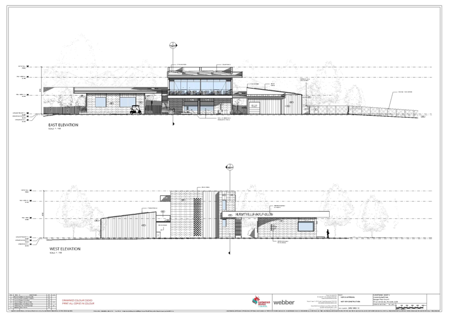
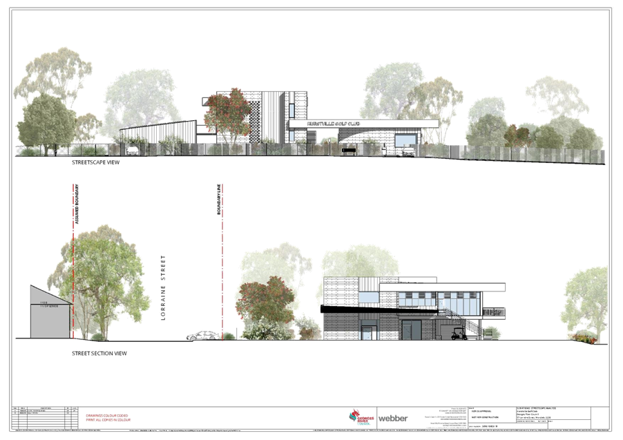
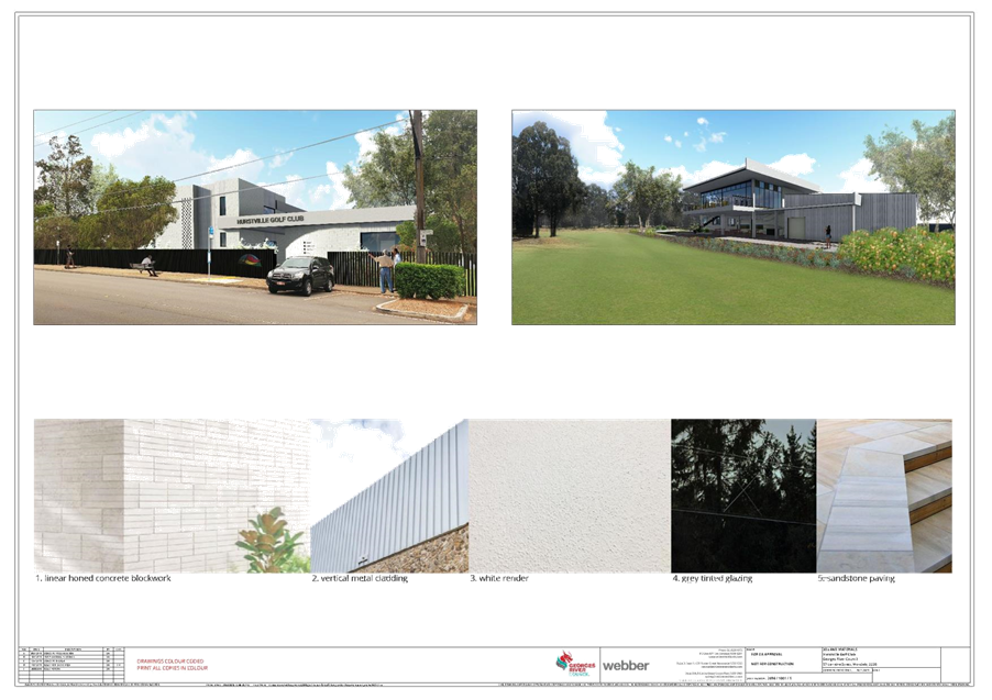
|
Georges River Council - Georges River
Local Planning Panel (LPP) - Thursday, 10 December 2020
LPP064-20 57 Lorraine Street Peakhurst
[Appendix 2] Site
and Landscape Plans - 57 Lorrine Street Peakhurst
|
Page 108
|
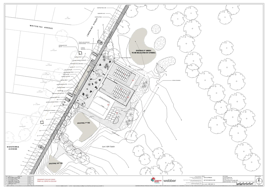
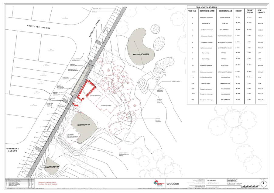

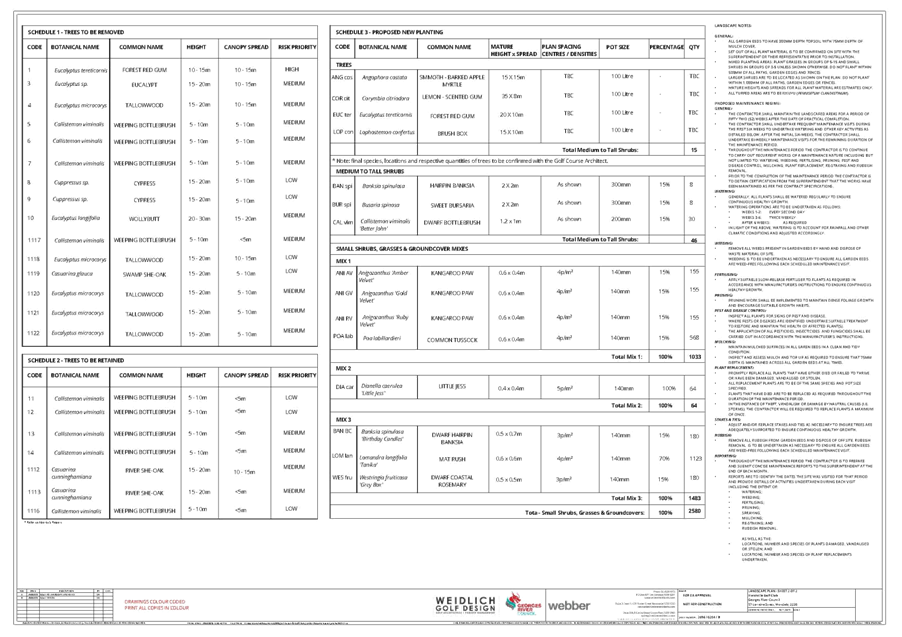
|
Georges River Council – Local
Planning Panel Thursday, 10 December 2020
|
Page 131
|
REPORT TO GEORGES RIVER
COUNCIL
LPP
MEETING OF Thursday,
10 December 2020
|
LPP Report No
|
LPP065-20
|
Development
Application No
|
MOD2020/0136
|
|
Site Address
& Ward Locality
|
1-3 Peake Parade
Peakhurst
Peakhurst Ward
|
|
Proposed
Development
|
Modifications to
an approved residential flat building
|
|
Owners
|
Matthews St Pty
Ltd
|
|
Applicant
|
ZTA Group
|
|
Planner/Architect
|
Planner: Cohesive
Planning / Architect: Arquero
|
|
Date Of
Lodgement
|
20/07/2020
|
|
Submissions
|
No submissions
|
|
Cost of Works
|
Original DA:
$2,150,000
|
|
Local Planning
Panel Criteria
|
The proposed
development seeks consent for a variation to the height standard greater than
10%.
|
|
List of all
relevant s.4.15 matters (formerly s79C(1)(a))
|
State
Environmental Planning Policy No. 65 – Design Quality of Residential
Apartment Development and the Apartment Design Guide, State Environmental
Planning Policy (Vegetation in Non-Rural Areas) 2017, State Environmental
Planning Policy (BASIX) 2004, Greater Metropolitan Regional Environmental
Planning Policy No 2 - Georges River Catchment, State Environmental Planning
Policy No. 55 – Remediation of Land, State Environmental Planning
Policy (Infrastructure) 2007,
Draft Environment
State Environmental Planning Policy, Draft State Environmental Planning
Policy 55 – Remediation of the Land, Hurstville Local Environmental
Plan 2012,
Draft
Georges River Local Environmental Plan 2020, Hurstville Development Control
Plan No. 1
|
|
List all
documents submitted with this report for the Panel’s consideration
|
Architectural
Plans, Statement of Environmental Effects
Varition request
for a breach of a development standard – prepared not dissimilar to a
Clause 4.6 Variation Request.
Approved plans and
consent DA2015/0031.
|
|
Report prepared
by
|
Senior Development
Assessment Planner
|
|
Recommendation
|
That the application be refused in
accordance with the reasons included in this report.
|
|
|
Summary of
matters for consideration under Section 4.15
Have all
recommendations in relation to relevant s4.15 matters been summarised in the
Executive Summary of the assessment report?
|
Yes
|
|
Legislative
clauses requiring consent authority satisfaction
Have relevant
clauses in all applicable environmental planning instruments where the
consent authority must be satisfied about a particular matter been listed and
relevant recommendations summarised, in the Executive Summary of the
assessment report?
|
Yes
|
|
Clause 4.6
Exceptions to development standards
If a written
request for a contravention to a development standard (clause 4.6 of the LEP)
has been received, has it been attached to the assessment report?
|
Yes - Clause 4.3 Height of buildings
|
|
Special
Infrastructure Contributions
Does the DA require
Special Infrastructure Contributions conditions (under s7.24)?
|
Not Applicable
|
|
Conditions
Have draft
conditions been provided to the applicant for comment?
|
No, the recommendation is for refusal
|
|
Site Plan
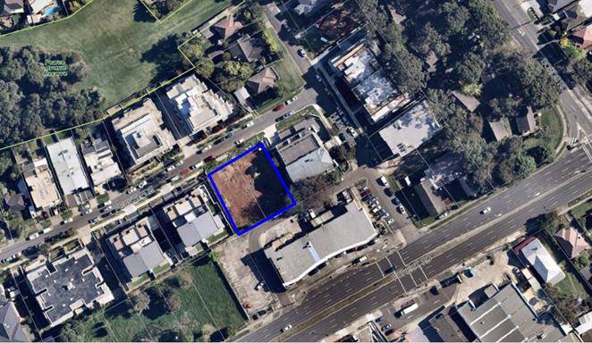
The site is
edged in blue
|
EXECUTIVE SUMMARY
Proposal
1. The Section 4.56
modification application seeks consent for amendments to a Land and Environment
Court approval (case number 2016/221690, orders made on 2 December 2016). The
application is the Modification of Consent No DA2015/0031 for demolition
works, construction of a four storey residential flat building. Modifications
include raising the building and removing the split level design.
2. The
approved building contains fourteen (14) units, comprising three (3) x one (1)
bedroom units and ten (10) x two (2) bedroom units and one (1) x one (1)
bedroom + study unit.
3. The
modifications sought include:
Basement level: minor
design changes in storage and service rooms, change to fire stair arrangement,
lift core location and lobby, increase in floor level from RL39.06 to RL39.87.
Ground floor: lift core
and fire stair redesign, removal of split floor level to a consistent floor
level from RL41.81/RL43.33 to RL43.66.
Level 1: lift core and
fire stair redesign, removal of split floor level to a consistent floor level
from RL44.85/RL46.38 to RL46.71.
Level 2: deletion of
study from Unit 11, lift core and fire stair redesign, removal of split floor
level to a consistent floor level from RL47.91/RL49.43 to RL49.76.
Roof terrace: lift core
and fire stair redesign, increased floor level from RL50.96 to RL52.744,
modification of communal open space area and increase from 107.78sqm to
112.7sqm, and change of roof form from pitch to flat and skillion roof at the
rear.
Site and Locality
4. The
subject site is identified as 1-3 Peake Parade, Peakhurst and is legally
described as Lots 276 and 277 in DP36537.
5. The
sites are located on the south eastern side of Peake Parade, approximately 34m
from the intersection with Hugh Avenue. The sites have a total frontage to
Peake Parade of 32.615m, side boundary lengths of 35m and 35.095m with an
overall site area of 1,081sqm.
6. The
NSW Land and Environment Court granted consent for demolition works and
construction of a four storey residential flat building on the site on 2
December 2016 (DA2015/0031). Demolition of the existing dwellings has been
undertaken and the site is now vacant.
7. The
site is located in a predominantly residential area characterised by recently
constructed residential flat buildings in Peake Parade and Hugh Avenue to the
east and west, dwelling houses and neighbourhood shops on Forest Road to the
south.
8. The site is affected by overland flow. The Overland Flow
Analysis submitted with the application is not representative of current
conditions and the true impact of overland flow on the subject development and
the neighbouring land has not been adequately presented. For these reasons the
application is recommended for refusal.
Zoning and Permissibility
9. The
site is zoned R3 Medium Density Residential under Hurstville Local
Environmental Plan 2012 (HLEP) and the proposed modification being works to the
approved residential flat building is permissible with Council’s consent.
Submissions
10. The
application was neighbour notified between 27 July 2020 and 10 August 2020. No
submissions were received.
Reason for referral to the Local Planning Panel
11. The
proposal is referred to the Local Planning Panel for determination as the
development is subject to SEPP 65 and is a Section 4.56 modification to a Court
approved development. The Georges River Local Planning Panel is the consent
authority via the Ministerial Direction of 23 February 2018.
Conclusion
12. The
application has been assessed having regard to Section 4.56 of the
Environmental Planning and Assessment (EP&A) Act 1979 and the Matters for
Consideration under Section 4.15(1) of the EP&A Act 1979. Following
the assessment of the proposal, it is considered that Modification No.
MOD2020/0136 is worthy of support and is recommended for approval subject to
modified conditions.
REPORT IN FULL
Site and Locality
13. The
subject site is identified as 1-3 Peake Parade, Peakhurst and is legally
described as Lots 276 and 277 in DP36537.
14. The
site is located on the south eastern side of Peake Parade, approximately 34m
from the intersection with Hugh Avenue. The site has a frontage to Peake Parade
of 32.615m, side boundary lengths of 35m and 35.095m with an overall site area
of 1,081sqm.
15. The NSW
Land and Environment Court granted consent for demolition works and
construction of a four storey residential flat building on the site on 2
December 2016 (DA2015/0031). Demolition of the existing dwellings has been
undertaken and the site is now vacant.
16. The
site is located in a predominantly residential area characterised by recently
constructed residential flat buildings in Peake Parade and Hugh Avenue to the
east and west, dwelling houses and neighbourhood shops on Forest Road to the
south.
17. Adjoining the site to the north east on the corner of Peake
Parade and Hugh Avenue, and to the south west at 5-7 Peake Parade, and opposite
the site at 4-6 Peake Parade, are residential flat buildings.
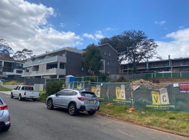
Figure 1: 3 Hugh Avenue (north east of the site)
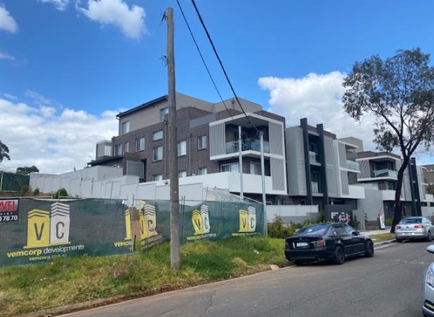
Figure 2: 5-7 Peake Parade (south-west of the site)
18. To the south of the site are neighbourhood shops bound by
Hugh Avenue, Forest Road and Bristow Lane.
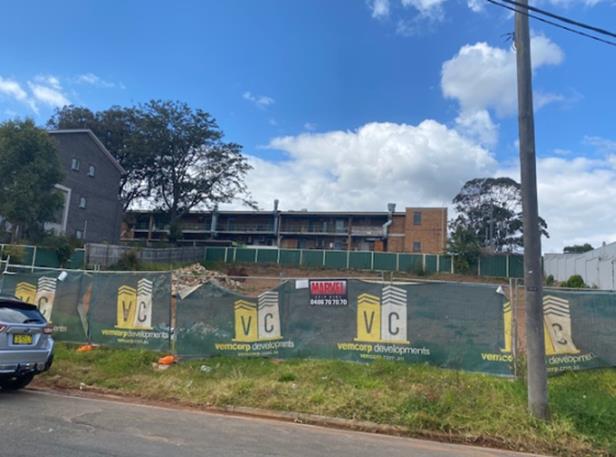
Figure 3: Rear of the shops on Forest Road (south east of the
site)
Background
19. The approved development is for the demolition works
and construction of a four storey residential flat building (DA2015/0031, which was approved (deferred commencement)
by the Land and Environment Court on 2 December 2016 (Case number 2016/221690)).
20. The deferred commencement conditions were satisfied and the
consent became active on 5 November 2018.
21. Demolition works approved as part of DA2015/0031 were
undertaken in late 2019.
22. This modification application was lodged 20 July 2020.
23. This is a modification application lodged pursuant to
Section 4.56 of the Environmental Planning and Assessment Act 1979 (EP&A
Act) and proposes modifications to Development Consent DA2015/0031, which was
approved by the Land and Environment Court on 2 December 2016 (Case number 2016/221690).
24. The modification application is referred to the Local
Planning Panel for determination as the application is a modification under
clause 4.56 of the EP&A Act to a residential flat building under the
provisions of State Environmental Planning Policy 65, whereby the Georges River
Local Planning Panel is the determining authority via the Ministerial Direction
of 23 February 2018.
Proposal
25. The
applicant seeks to modify Development Consent No DA2015/0031in
the following manner:
Basement level: minor
design changes in storage and service rooms, change to fire stair arrangement,
lift core location and lobby, increase in floor level from RL39.06 to RL39.87.
Ground floor: lift core
and fire stair redesign, removal of split floor level to a consistent floor
level from RL41.81/RL43.33 to RL43.66.
Level 1: lift core and
fire stair redesign, removal of split floor level to a consistent floor level
from RL44.85/RL46.38 to RL46.71.
Level 2: deletion of
study from Unit 11, lift core and fire stair redesign, removal of split floor
level to a consistent floor level from RL47.91/RL49.43 to RL49.76.
Roof terrace: lift core
and fire stair redesign, increased floor level from RL50.96 to RL52.744,
modification of communal open space area and increase from 107.78sqm to
112.7sqm, and change of roof form from pitch to flat and skillion roof at the
rear.
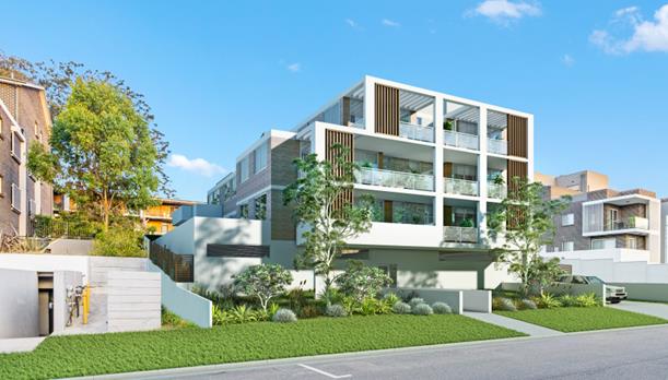
Figure 4: Photomontage from Peake Parade
ASSESSMENT
Section 4.56
Considerations
26. The application has been made pursuant to Section 4.56 of
the Environmental Planning and Assessment Act 1979 to modify Development
Consent DA2015/0031determined on 2 December 2016 by the Land and Environment
Court. A consent authority may, on application being made by the applicant or
any other person entitled to act on a consent granted by the consent authority
and subject to and in accordance with the regulations, modify the consent if
it:
· Is satisfied the proposed development as modified is substantially
the same development for which consent was originally granted?
27. The proposed development as modified represents
substantially the same development for which consent was originally granted
being a residential flat building.
· Has advertised and or notified the application in accordance with
the regulations or a development control plan?
28. The application was neighbour notified in accordance with
the provisions of Hurstville Development Control Plan 2013 and no submissions
were received.
· Has considered any submissions made concerning the proposed
modification?
29. No submissions were received.
Section 4.15 Evaluation
30. In determining a Section 4.56 modifications the provisions
of Section 4.15 of the EP&A Act 1979 (where relevant) need to be considered
as part of the assessment. The following considers the proposal in respect to
these requirements.
State Environmental Planning Policies
31. Compliance with the relevant State Environmental Planning
Policies (SEPPs) are discussed in the table below.
|
State Environmental Planning Policy
|
Complies
|
|
Greater
Metropolitan Regional Environmental Plan No 2 – Georges River Catchment
|
No
– refer to discussion later in this report.
|
|
State
Environmental Planning Policy 55 – Remediation of Land
|
Yes
- no change.
|
|
State
Environmental Planning Policy (Building Sustainability Index: BASIX) 2004
|
An
amended BASIX certificate was provided with the application, dated 16 April
2020.
|
|
State
Environmental Planning Policy (Infrastructure) 2007
|
Yes
- no change.
|
|
State
Environmental Planning Policy No 65 – Design Quality of Residential
Apartment Development
|
Yes
– refer to discussion
|
|
Draft
Environment State Environmental Planning Policy
|
Yes
- no change.
|
|
Draft
Remediation of Land State Environmental Planning Policy
|
Yes
- no change.
|
State Environmental
Planning Policy No 65 – Design Quality of Residential Apartment Development
32. The original DA was approved pursuant to SEPP No. 65
– Design Quality of Residential Flat Development, prior to the
introduction of the Apartment Design Guide (AGD) and current design principles.
33. An assessment of the application against the relevant
Design Principles of SEPP 65 and the Objectives in the ADG is provided below.
The building footprint and relationship to site boundaries remains consistent
with the approved development, and the amended proposal is consistent with the
design principles.
Part 4 Application of Design Principles under
the SEPP
Principle 1: Context and neighbourhood character
34. The overall design of the building is generally unchanged.
The internal layout changes and modification to the floor plate levels and overall
building height is consistent within its context and how the modified built
form will sit within the character of this locality.
Principle 2: Built form and scale
35. The overall design of the building is generally unchanged
and its relationship to other built form in the locality remains unchanged. The
increase in building height will not have a significant visual or amenity
impact on the adjoining allotments or the public domain.
Principle 3: Density
36. The modified design maintains compliance with the maximum
FSR for the site.
Principle 4: Sustainability
37. An updated BASIX certificate in relation to the changes to
the unit layout has been issued and indicates compliance with the BASIX SEPP.
Principle 5: Landscape
38. An updated Landscape Plan has been submitted which poses
suitable landscaping for the site.
Principle 6: Amenity
39. The development provides good amenity for residents,
neighbours and visitors to the site which is consistent with Principle 6. The
modified unit layout of the affected units achieves acceptable levels of
amenity.
Principle 7: Safety
40. The amended design does not affect the safety and security
of the development.
Principle 8: Housing diversity and social interaction
41. The amended design proposes a suitable mix of one (1)
bedroom and two (2) bedroom units.
Principle 9: Aesthetics
42. The amended design includes suitable material and finish
selections and responds well to the existing character of the immediate
locality and the streetscape.
43. In summary, the proposal is considered to be consistent
with the Design Principles of SEPP 65 – Design Quality of Residential
Apartment Development.
STATE ENVIRONMENTAL PLANNING POLICY NO 55 – REMEDIATION OF
LAND
44. SEPP 55 aims to promote the remediation of contaminated land in order to reduce the risk of harm to human health
or any other aspect of the environment. Clause 7 requires contamination and
remediation to be considered in determining a development application. The
consent authority must not consent to the carrying out of development on land
unless it has considered whether or not the land is contaminated.
45. A review of the site history indicates that the site has
been used for residential purposes for extended periods of time, and such uses
and/or development are not typically associated with activities that would
result in the contamination of the site. The proposed works do not include
any change to the use of the land that would result in any concerns with
respect to contamination. There is no indication of previous uses that would
cause contamination. A SEPP 55 assessment was undertaken as part of the
assessment of the parent DA, in this regard there is no indication that the
land is contaminated.
STATE ENVIRONMENTAL PLANNING POLICY (BUILDING SUSTAINABILITY INDEX:
BASIX) 2004
46. The trigger for BASIX Certification is when the estimated
cost of works for residential development (new dwelling(s)/alterations and
additions) is equal to or above $50,000. BASIX Certification
is also triggered when proposing a swimming pool with a volume of 40,000
litres.
47. A BASIX Certificate prepared by AKT Engineering and
Consulting Pty Ltd, dated 16 April 2020, certificate number 1095309M, has been
submitted with the Development Application satisfying the minimum requirements
of SEPP (Building Sustainability Index: BASIX) 2004.
STATE ENVIRONMENTAL PLANNING POLICY (VEGETATION IN NON-RURAL AREAS)
2017
48. The Vegetation SEPP regulates
clearing of native vegetation on urban land and land zoned for environmental
conservation/management that does not require development consent.
49. The Vegetation SEPP applies to clearing of:
(a) Native vegetation above the
Biodiversity Offset Scheme (BOS) threshold where a proponent will require an
approval from the Native Vegetation Panel established under the Local Land
Services Amendment Act 2016; and
(b) Vegetation below the BOS threshold
where a proponent will require a permit from Council if that vegetation is
identified in the council’s development control plan (DCP).
50. The objectives of the SEPP are to protect the biodiversity
values of trees and other vegetation in non-rural areas and
preserve the amenity of non-rural areas through the preservation of trees and
other vegetation. This policy is applicable pursuant to Clause 5(1) of the SEPP
as the site is within both Georges River Council and the R3 Medium Density
Residential zone.
51. The modification does not impact on any trees.
STATE ENVIRONMENTAL PLANNING POLICY (COASTAL MANAGEMENT) 2018
52. SEPP (Coastal
Management) 2018 updates and consolidates three previous SEPPs (SEPP 14 Coastal
Wetlands, SEPP 26 Littoral Rainforests, SEPP 71 Coastal Protection) into one
integrated Policy and is a matter for consideration for the current DA.
53. The Coastal
Management SEPP 2018 aims to: “Promote an integrated and co-ordinated
approach to land use planning in the coastal zone in a manner consistent with
the objects of the Coastal Management Act 2016 including the management
objectives for each coastal management area”.
54. The subject site has not been identified as being located
in a coastal vulnerability area and a coastal environmental area as per NSW
State Environmental Planning Policy (Coastal Management) 2018 - Maps.
GREATER METROPOLITAN REGIONAL ENVIRONMENTAL PLAN NO 2 —
GEORGES RIVER CATCHMENT
55. The main aims and objectives of this plan include but are
not limited to the following:
· To maintain and improve the water quality and
river flows of the Georges River and its tributaries and ensure that
development is managed in a manner that is in keeping with the national, State,
regional and local significance of the Catchment,
· To protect and enhance the environmental quality
of the Catchment for the benefit of all users through the management and use of
the resources in the Catchment in an ecologically sustainable manner,
· To ensure consistency with local environmental
plans and also in the delivery of the principles of ecologically sustainable
development in the assessment of development within the Catchment where there
is potential to impact adversely on groundwater and on the water quality and
river flows within the Georges River or its tributaries,
· To establish a consistent and coordinated
approach to environmental planning and assessment for land along the Georges
River and its tributaries and to promote integrated catchment management
policies and programs in the planning and management of the Catchment.
56. The proposed stormwater drainage system has been assessed
by Council’s Development Engineer and has been found to be
unsatisfactory.
57. A review of the stormwater and overland flow documentation
submitted with the application concludes:
(a) That the Overland Flow Analysis submitted be
rejected as being non-representative of current Pre-, and hence
Post–development scenarios such that the true impact of overland flow on
the subject development and neighbouring property has not been presented.
(b) That in any subsequent Flood Impact Analysis a complete
report is to be presented which clearly demonstrates ‘current-pre-‘,
and post-development scenarios with additional
‘river-stations’/cross-sections that provide the scope of analysis
required to confirm 500mm (min.) freeboard is provided for all habitable areas,
and 300mm (min.) for the basement area, and that the proposed On Site Detention
basin is not vulnerable to the entry of overland flow.
(c) That Basement and Ground Floor Stormwater
Management Plans C07 and C08 dated 24/6/’20 be amended to show the
diameter of the stormwater drainage pipeline between pits SP2 and SP3.
58. It is for these reasons the application is recommended for
refusal.
DRAFT ENVIRONMENTAL PLANNING INSTRUMENTS
Draft Environmental SEPP
59. The Draft Environment SEPP was
exhibited from 31 October 2017 to 31 January 2018. This consolidated SEPP
proposes to simplify the planning rules for a number of water catchments,
waterways, urban bushland and Willandra Lakes World Heritage Property. Changes
proposed include consolidating the following seven existing SEPPs:
· State Environmental Planning Policy No. 19 – Bushland in Urban
Areas;
· State Environmental Planning Policy (Sydney Drinking Water
Catchment) 2011;
· State Environmental Planning Policy No. 50 – Canal Estate Development;
· Greater Metropolitan Regional Environmental Plan No. 2 –
Georges River Catchment;
· Sydney Regional Environmental Plan No. 20 – Hawkesbury-Nepean
River (No.2-1997);
· Sydney Regional Environmental Plan (Sydney Harbour Catchment) 2005;
· Willandra Lakes Regional Environmental Plan No. 1 – World
Heritage Property.
60. The proposal is not
inconsistent with the provisions of this Draft Instrument.
Draft Remediation of Land SEPP
61. The Draft Remediation of Land SEPP was exhibited from 31 January 2018 to 13 April
2018. The proposed remediation of land SEPP will
· Provide a state-wide planning framework for the remediation of land;
· Maintain the objectives and reinforce those aspects of the existing
framework that have worked well;
· Require planning authorities to consider the potential for land to
be contaminated when determining development applications and rezoning land;
· Clearly list the remediation works that require development consent;
· Introduce certification and operational requirements for remediation
works that can be undertaken without development consent.
62. The proposal is not inconsistent
with the provisions of this Draft Instrument. Contamination was assessed as
part of the parent DA.
HURSTVILLE LOCAL
ENVIRONMENTAL PLAN 2012
63. The subject site is zoned R3 Medium Density Residential
under the provisions of the Hurstville Local Environmental Plan 2012. The
proposed development is for modifications to an approved a residential flat
building which are permissible land uses in the zone
64. The extent to which the proposed development complies with
the Hurstville Local Environmental Plan 2012 (HLEP) is detailed and discussed
in the table below.
|
Clause
|
Standard
|
Proposal
|
Complies
|
|
4.3 – Height
of Buildings
|
12m as identified
on Height of Buildings Map
|
13.66m.
|
No
|
|
4.4 – Floor
Space Ratio
|
1:1 as identified
on Floor Space Ratio Map
|
0.91:1
|
Yes
|
|
4.5 –
Calculation of floor space ratio and site area
|
FSR and site area calculated in accordance with Cl4.5
(b
|
The floor space
has been calculated in accordance with Clause 4.5 and the “gross floor
area” definition within the HLEP.
|
Yes
|
|
Clause 4.6
Exceptions to development Standards
|
Clause 4.6
Variation to any of the development standards is required.
|
See detailed
assessment below.
|
See comments below
|
|
6.7 –
Essential Services
|
Development
consent must not be granted to development unless services that are essential
for the development are available
|
Essential services
are currently available to the site and can be extended to service the
development; conditions could be imposed if the application was to be
supported.
|
Yes
|
Clause 4.6 Exceptions to development standards
Assessment of Height variation
65. The height of the development has increased as part of the
modification, resulting in a variation to the maximum height of buildings
control of 12m. The proposed lift overrun reaches a height of 13.66m, a
variation to the standard of 13.8%, and this variation has been assessed below.
66. The approved height of the development is 12m. The increase
in height is a result of the levelling of the floor plates, which were approved
with split levels, and to address the overland flow affection of the site.
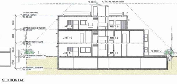
Figure 5: Approved height of building at RL53.55 (12m)

Figure 6: Proposed height of building at RL53.55 (13.66m)
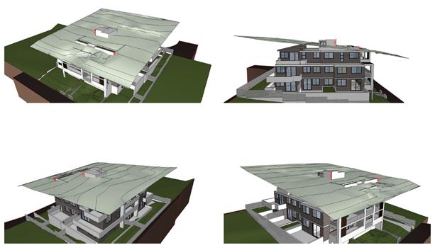
Figure 7: Height plane diagram
67. In
the NSW Land and Environment Court case of Gann & Anor v Sutherland
Shire Council [2008], the Court held that there is power to modify a
development application (via a Section 4.55 application) where the modification
would result in the breach of development standards. The Court took the view
that development standards within an LEP did not operate to prohibit the
granting of consent if they were not complied with (and no objection pursuant
to SEPP No. 1 (now relevant to a Clause 4.6 variation) had been lodged).
Notwithstanding, the Court held that despite a SEPP No. 1 Objection (or Clause
4.6 variation now) not being required, a Section 96 application (this being a
Section 4.56 of the EP&A Act) still requires the consent authority to take
into consideration those matters referred to in Section 4.15. These matters,
where relevant to the application are assessed below.
Objectives of Clause 4.3 – Height of buildings
68. The
objectives of Clause 4.3 are as follows:
(a) to
ensure that buildings are compatible with the height, bulk and scale of the
existing and desired future character of the locality,
(b) to
minimise visual impact, disruption of views, loss of privacy and loss of solar
access to existing development and to public areas and public domain, including
parks, streets and lanes,
(c) to
minimise the adverse impact of development on heritage items,
(d) to
nominate heights that will provide a transition in built form and land use
intensity,
(e) to
establish maximum building heights that achieve appropriate urban form
consistent with the major centre status of the Hurstville City Centre,
(f) to
facilitate an appropriate transition between the existing character of areas or
localities that are not undergoing, and are not likely to undergo, a
substantial transformation,
(g) to
minimise adverse environmental effects on the use or enjoyment of adjoining
properties and the public domain.
69. The
proposal satisfies the objectives of the height of building standard as the
encroachment relates to the lift overrun and a small part of the planter around
the edge of the rooftop communal open space area with the bulk of the building
below the 12m height limit.
70. The
site and surrounding land is zoned R3 (with the exception of the commercial
allotment to the rear) with a height limit of 12m. The proposal is consistent
with the existing and desired future of the locality in terms of scale and
height.
71. In terms
of visual impact the structure is centrally located which reduces its visual
appearance from the immediately adjoining streetscapes. The breach relates to a
small scale ancillary structure which will not be highly visible or an
intrusive element given the scale and proportions of the building. It will not
be readily visible from immediately adjoining properties or the streetscapes
given that it is centrally located within the built form. There will be no
adverse impacts in terms of overshadowing or overlooking to adjoining
properties from the part of the building where the height is exceeded.
72. There
will be no adverse impacts in terms of overshadowing or overlooking to
adjoining properties or the public domain from the encroaching elements as the
roof area does not contain any useable areas.
73. The
exceedance of the control generally satisfies the objectives of the zone for
the following reasons:
· To provide for the housing needs of the community within a medium
density residential environment.
74. The
development is providing for the housing needs within a medium density
residential environment with fourteen (14) residential apartments provided.
· To provide a variety of housing types within a medium density
residential environment.
75. The development
incorporates two (2) adaptable units within the fourteen (14) units proposed.
· To enable other land uses that provide facilities or services to
meet the day to day needs of residents.
76. The
development is residential in nature and does not include any additional land
uses. This objective is offering some greater flexibility in the provision of
land uses within this zone and is not a mandatory requirement.
· To ensure that a high level of residential amenity is achieved
and maintained.
77. The
units achieve a high level of residential amenity through natural ventilation
and solar access. The height non-compliance will not result in unreasonable
impacts on neighbouring properties in relation to privacy, overshadowing,
visual or acoustic impacts.
· To provide for a range of home business activities, where such
activities are not likely to adversely affect the surrounding residential
amenity.
78. The proposal does not
preclude the use of the units for small home businesses.
79. Although
an objection pursuant Clause 4.6 is not required, the reasoning applied in
Wehbe v Pittwater Council [2007] NSW LEC 827, is appropriate to rely upon to
determine that the proposal is well founded despite the departure from Clause
4.3 of Hurstville LEP 2012. In the judgement the Honourable Brian Preston,
Chief Justice of the Land and Environment Court, set out 5 different ways in
which an objection may be well founded and that approval of the objection may
be consistent with the aims of the policy.
80. The
proposal is considered to be consistent with the first of these in that the
objectives of the height standard and the R3 zone objectives are achieved
notwithstanding the numerical variation proposed.
81. Given
that compliance with the zone and development standard objectives is achieved,
insistence on strict compliance with the height standard is considered to be
unreasonable and unnecessary in the circumstances. The proposal is compliant
with the relevant objectives and will create negligible environmental impacts.
The proposal is therefore justified on environmental planning grounds.
82. It is
noted that in Initial Action Pty Ltd v Woollahra Municipal Council [2018]
NSWLEC 118, Preston CJ clarified what items a Clause 4.6 does and does not need
to satisfy. Importantly, there does not need to be a "better"
planning outcome:
86. The second way is in an error because it finds no
basis in cl 4.6. Clause 4.6 does not directly or indirectly establish a test
that the non-compliant development should have a neutral or beneficial effect
relative to a compliant development. This test is also inconsistent with
objective (d) of the height development standard in cl 4.3(1) of minimising the
impacts of new development on adjoining or nearby properties from disruption of
views or visual intrusion. Compliance with the height development standard
might be unreasonable or unnecessary if the non-compliant development achieves
this objective of minimising view loss or visual intrusion. It is not
necessary, contrary to what the Commissioner held, that the non-compliant
development have no view loss or less view loss than a compliant development.
87. The second matter was in cl 4.6(3)(b). I find
that the Commissioner applied the wrong test in considering this matter by requiring
that the development, which contravened the height development standard, result
in a "better environmental planning outcome for the site" relative to
a development that complies with the height development standard (in [141] and
[142] of the judgment). Clause 4.6 does not directly or indirectly establish
this test. The requirement in cl 4.6(3)(b) is that there are sufficient
environmental planning grounds to justify contravening the development
standard, not that the development that contravenes the development standard
have a better environmental planning outcome than a development that complies
with the development standard.
83. The
proposal is considered to achieve a planning purpose of enhancing residential
amenity and housing diversity in the absence of any additional or new adverse
impacts, and the proposed height variation is supported.
DRAFT GEORGES RIVER LOCAL ENVIRONMENTAL PLAN 2020
84. Consideration is given to the provisions of Draft Georges River
Local Environmental Plan 2020 in the assessment this application. In
relation to this development site:
· The
zoning is proposed to change from R3 Medium Density Residential to R4 High
Density Residential.
· The
minimum lot size is proposed to change from 450sqm to 1,000sqm.
85. There is no proposed
change to height or FSR.
86. In
this regard, the provisions have no determining weight as a result of proposed
operation of Clause “1.8A Savings provisions relating to development
applications” of the Draft Plan which provides “If a development
application has been made before the commencement of this Plan in relation to
land to which this Plan applies and the application has not been finally
determined before that commencement, the application must be determined as if
this Plan had not commenced.”
HURSTVILLE DEVELOPMENT CONTROL PLAN NO 1
87. An assessment of the proposed
development against the relevant controls in the HDCP No. 1 is detailed in the
compliance table below.
|
Development
|
Requirements
|
Proposed
|
Complies
|
|
3.0 General
Planning Considerations
|
|
3.1 Vehicle access
and car parking rates
|
Underground
parking areas are to be concentrated under building footprints so as to
maximise deep soil landscaping.
Driveways to
underground car parks are to be designed so as to minimise the visual impact
on the street, and to maximise pedestrian safety.
Pedestrian access
to the development should be separate and clearly defined.
Access ways to
underground car parking areas is to be located away from doors and windows to
habitable rooms wherever possible.
Basement car
parking is preferable in commercial and residential flat buildings.
|
The basement
design allows for a deep soil area along the front, rear and side boundaries.
The deep soil area remains unchanged.
The driveway is
suitably located and remains unchanged by this amendment.
Pedestrian and
vehicular access is separate.
Access to the
basement parking area is via the central lift and stair core.
Basement parking
is proposed.
|
Yes
Yes
Yes
Yes
Yes
|
|
Car Parking Rates
(Table 1 –
business zones)
|
Residential:
a. 1 resident
space for every studio, 1 or 2 bedroom dwelling
14 spaces
required
b. 2 resident
spaces for every 3 or more bedroom dwelling
c. for
developments of 4 dwellings or more, one visitor space per 4 dwellings or
part thereof
3.5 visitor
spaces required
|
1B x 4 units
2B x 10 units
14 spaces proposed
– remains unchanged.
N/A
N/A
3 visitor spaces
proposed – no change proposed.
|
Yes
N/A
N/A
No change to
approved
|
|
3.3 Access and
Mobility
|
In developments
containing five or more dwellings, a minimum of one adaptable dwelling,
designed in accordance with relevant Australian Standards must be provided
for every ten dwellings or part thereof.
Access to required
adaptable dwellings and relevant parking spaces Appropriate access for all
persons through the principal entrance of the building and access to any common
facilities shall be provided.
One accessible
space is dedicated to each adaptable apartment
|
Units 3 and 4 are
accessible.
All parts of the
building are accessible.
Two (2) accessible
spaces are provided.
|
Yes
Yes
Yes
|
|
3.4 Crime
Prevention through Design
|
Ensure that the
way in which the site, and the buildings within the site, are laid out
enhance security and feelings of safety
|
The development
has been considered to cater for CPTD principles in terms of lighting the
location, accessibility and legibility of services and uses.
|
Yes
|
|
3.5 Landscaping
|
Development
contributes to the creation of a distinct, attractive landscape character for
streets and neighbourhoods
|
The development
contributes positively to the streetscape and locality through providing
landscaped areas within the front and rear setbacks which is consistent with
existing development in the area and provides deep soil areas to accommodate
substantial planting.
|
Yes
|
|
3.6 Public Domain
|
Development
contributes to the creation of attractive, comfortable and safe streets that
comprise consistent and high quality paving, street furniture and street tree
plantings.
|
Not applicable to
this location.
|
N/A
|
|
3.7 Stormwater
|
Stormwater
discharge for development sites is not to exceed the 5 year ARI storm event.
An on-site
stormwater detention system is provided that reduces the flow rate of
stormwater discharge. Stormwater quality
The quality of
stormwater leaving development sites is consistent with water quality
standards set by the Environment Protection Authority and ANZECC.
|
Council’s
Development Engineer does not support the proposed stormwater management
system and refusal of the application is recommended.
|
No
|
|
4.1 Residential
Flat Buildings
|
|
Site Frontage
|
Min street
frontage 24m
|
The site has a
street frontage to Peake Parade of 32.6m.
(consolidation of
two (2) lots)
|
Yes – no
change from approved development.
|
|
Height
|
In accordance with
HLEP 2012 and 3 storeys.
|
The maximum height
is 13.66m.
The building is a
part three (3) and part four (4) storey development.
|
No – refer
to discussion earlier.
No – no
change from approved development.
|
|
Excavation
|
The maximum
excavation for any building’s finished ground floor level facing a
public street is 0.5m below natural ground level.
|
The ground floor
level is located above natural ground level. Excavation is proposed for the
basement which is acceptable subject to recommended conditions.
There is a
reduction in excavation as part of this modification of 0.31m.
|
Yes
|
|
Front Setback
|
The minimum
setback to a primary or secondary street is 6m.
|
A minimum 7.5m to
the building façade.
5m to the
balconies.
|
Yes
|
|
Landscaped Area
|
Minimum amount of
landscaped area of open space is 20% of the Site area
Min dimension of
landscaped open space is 2m
|
19% of the site is
deep soil area. All areas used in the calculation exceed 2m in width.
|
Complies with the
ADG control.
|
|
Solar Access
|
Development allows
for at least 3 hours of sunlight on the windows of main living areas and
adjoining principal private open space of adjacent dwellings between 9.00am
and 3.00pm on 21 June.
|
The adjoining
properties will continue to receive more than three (3) hours direct sunlight
on 21 June.
|
Yes
|
|
Noise
|
Windows of
adjacent dwellings are separated by a distance of at least 3m
|
Minimum 3m.
|
Yes – no
change from approved development.
|
|
Streetscape
|
Development
creates a high quality interface between the public and private domain
|
The building
design and landscape scheme creates a high quality interface to the street
frontage.
|
Yes
|
|
Fencing
|
Provides
appropriate levels of privacy, security and noise attenuation
|
Front fencing is
not proposed.
|
N/A
|
|
Site Facilities
|
Development
provides space for the storage of recyclable goods, either in the curtilage
of each dwelling or in a central storage area in larger developments.
|
Compliant with
SEPP 65.
|
Yes – no
change from approved development.
|
|
|
|
|
|
|
GEORGES RIVER DEVELOPMENT CONTROL PLAN 2020
(INTERIM POLICY)
88. The Interim Policy is a supplementary document, meaning
that current DCP controls continue to apply if a particular control is not
specified in the Interim Policy, or if it is still considered best practice.
All operative DCPs still legally apply. Whilst the Interim Policy has no
statutory weight in the assessment of a Development Applications pursuant to
the Environmental Planning and Assessment Act 1979, the policy will be used as
a guide as it is an endorsed position of the Elected Council.
89. The proposed development does alter the level of compliance
of the approved development with the Interim Policy.
Developer Contributions
90. The proposed development is subject to developer
contributions which were levied at the time of the development determination.
The unit mix has not changed as part of this modification.
Planning Agreements
91. There is no planning agreement applicable to the
development.
EP&A Regulation 2000
92. No matters within the Regulation are affected by the
modification. An updated BASIX certificate has been lodged. The BASIX
certificate reference in the conditions of consent has been updated.
IMPACTS
Likely impacts of that development, including environmental impacts on both the natural and built environments, and social and economic impacts in the locality
93. The application fails to provide an accurate current
overland flow analysis and inadequate stormwater management plans as discussed
above.
Suitability of the site for the development
94. The site is zoned R3 – Medium Density Residential.
The proposal is a permissible form of development in this zone. The proposed
built form changes do not affect the suitability of the site for the
development, not impact the development potential of the adjoining allotments,
however the application is not supported on the grounds of incomplete overland
flow analysis and inadequate stormwater management plans.
SUBMISSIONS AND THE PUBLIC INTEREST
95. The application was notified in accordance with the provisions
of Section 4.56 (b)(i) of the Environmental Planning and Assessment Act 1979
with reference to HDCP No. 1 and Section 4.56 (1)(c) of the Environmental
Planning and Assessment Act 1979. No submissions were received.
The Public Interest
96. The proposal is considered to be not inconsistent with the
public interest.
REFERRALS
Council Referrals
97. The application was referred to council’s Consultant
Arborist for comment, who did not raise any objection to the modifications,
subject to conditions of consent.
98. The application was referred to council’s Development
Engineer for comment, who does not support the proposal as discussed above.
CONCLUSION
99. The application has been assessed having regard to the
Section 4.56 and the Matters for Consideration under Section 4.15(1) of the
Environmental Planning and Assessment Act 1979. Following the assessment
of the modifications, it is considered that Modification No. MOD2020/0136 be
refused on the grounds that the overland flow analysis is outdated and the
stormwater management plans are inadequate.
100. The modifications to the approved development are a
suitable response to the site context with regard to planning and design
matters, however the overland flow analysis is outdated and incomplete and the
stormwater management plans are inadequate and refusal of the modification is
recommended.
DETERMINATION AND STATEMENT OF REASONS
Statement of Reasons
101. The reasons for this recommendation are:
· The overland flow analysis is outdated and incomplete, the
stormwater management plans are inadequate;
· The proposed development has unacceptable
adverse impacts on the natural and built environments.
· In consideration of the aforementioned reasons,
the proposed development fails to demonstrate the design will not result in
inundation of the subject site and neighbouring properties and its approval is
not in the public interest.
Determination
THAT pursuant to Section
4.16(1)(b) of the Environmental Planning and Assessment Act 1979 that the
Georges River Local Planning Panel refuse MOD2020/0136 for modifications to
DA2015/0031 at Lots 276 and 277 in DP36537, known as 1-3 Peake Parade, Peakhurst, for the following reasons:
1. Insufficient Information
- Pursuant to Section 4.15(1)(a)(iii) of the Environmental Planning and
Assessment Act 1979, the overland flow analysis is outdated and incomplete,
with the stormwater management plans being inadequate. Current information and
adequate plans are required to undertake a full and proper assessment of the
application.
2. Impacts on the Environment - Pursuant to
Section 4.15(1)(b) of the Environmental Planning and Assessment Act 1979, the
proposed development is likely to have an adverse impact on the built
environment in that the overland
flow analysis is outdated and incomplete resulting in
inundation of the adjoining properties resulting in inadequate stormwater
management plans.
3. Suitability of Site
- Pursuant to Section 4.15(1)(c) of the
Environmental Planning and Assessment Act 1979, the site is not considered
suitable for the proposed development as submitted in that overland flow analysis is outdated and incomplete and the stormwater
management plans are inadequate.
4. Public interest - Pursuant to Section
4.15(1)(e) of the Environmental Planning and Assessment Act 1979, the proposed
development is not considered to be in the public interest and is likely to set
an undesirable precedent within the locality.
ATTACHMENTS
|
Attachment ⇩1
|
Site Plan - 1-3 Peake Pde Peakhurst
|
|
Attachment ⇩2
|
Elevations - 1-3 Peake Pde Peakhurst
|
|
Georges River Council - Georges River Local Planning Panel (LPP) -
Thursday, 10 December 2020
LPP065-20 1-3 Peake Parade Peakhurst
[Appendix 1] Site
Plan - 1-3 Peake Pde Peakhurst
|
Page 132
|
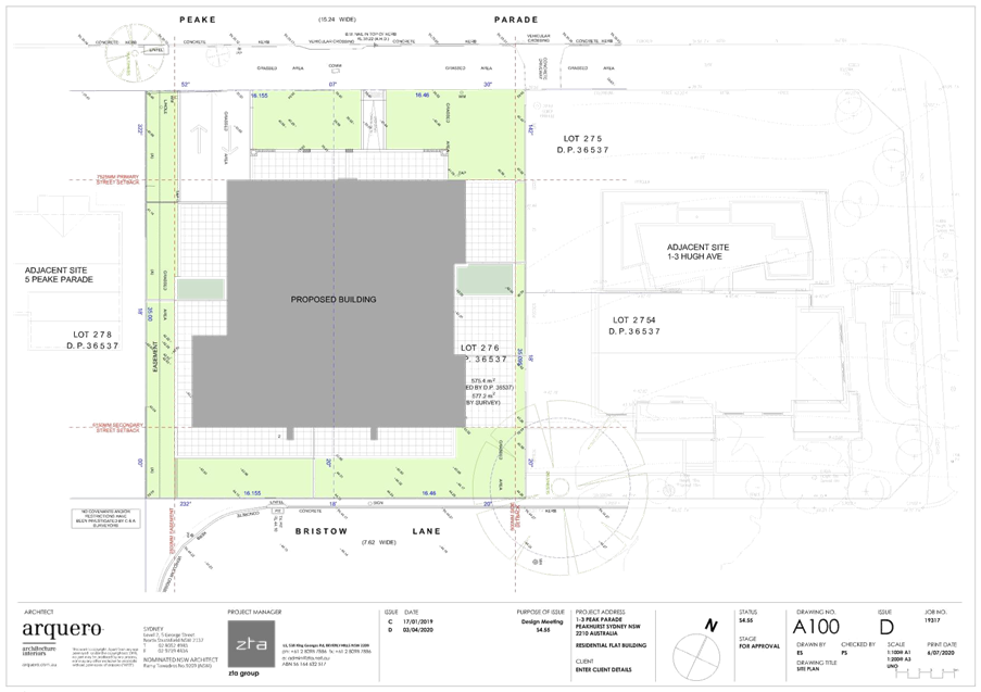
|
Georges River Council - Georges River Local Planning Panel (LPP) -
Thursday, 10 December 2020
LPP065-20 1-3 Peake Parade Peakhurst
[Appendix 2] Elevations
- 1-3 Peake Pde Peakhurst
|
Page 134
|
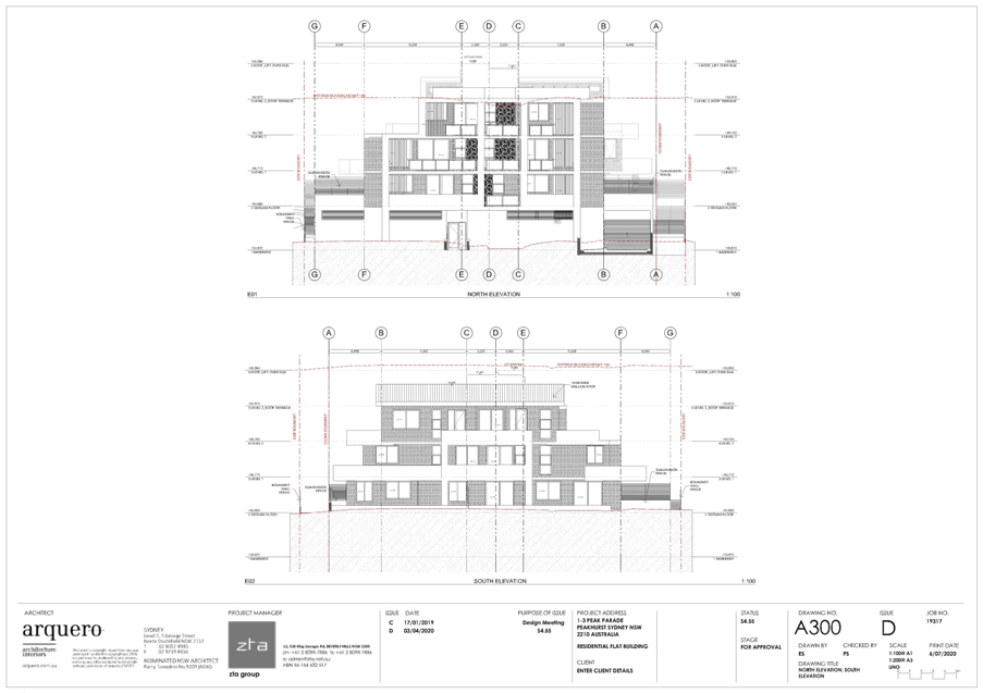
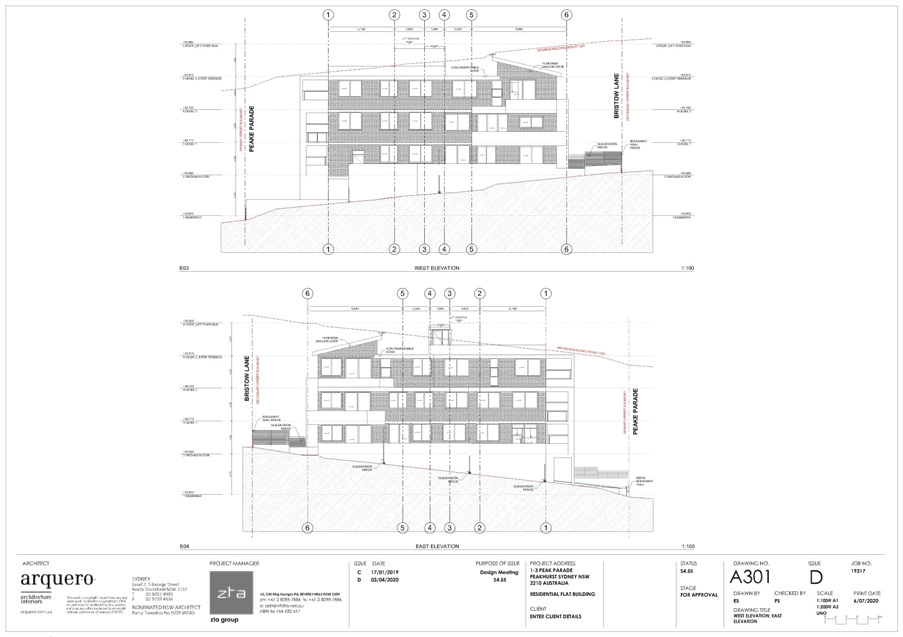
|
Georges River Council – Local
Planning Panel Thursday, 10 December 2020
|
Page 182
|
REPORT TO GEORGES RIVER
COUNCIL
LPP
MEETING OF Thursday,
10 December 2020
|
LPP Report No
|
LPP066-20
|
Development
Application No
|
DA2020/0327
|
|
Site Address
& Ward Locality
|
932 Forest Road
Peakhurst
Peakhurst Ward
|
|
Proposed
Development
|
Demolition works
and construction of a boarding house
|
|
Owners
|
NSW Land and
Housing Corporation
|
|
Applicant
|
NSW Land and
Housing Corporation
|
|
Planner/Architect
|
Urbis / Barry Rush
and Associates
|
|
Date Of
Lodgement
|
25/08/2020
|
|
Submissions
|
Three (3)
|
|
Cost of Works
|
$1,854,000.00
|
|
Local Planning
Panel Criteria
|
The application
seeks consent for a boarding house
|
|
List of all
relevant s.4.15 matters (formerly s79C(1)(a))
|
State
Environmental Planning Policy (Affordable Rental Housing) 2009, State
Environmental Planning Policy (Vegetation in Non-Rural Areas) 2017,
State Environmental Planning Policy
(Building Sustainability Index: BASIX) 2004, Greater Metropolitan Regional
Environmental Plan No.2 – Georges River Catchment, State Environmental
Planning Policy No.55 – Remediation of Land, State Environmental
Planning Policy (Infrastructure) 2007, Draft Environmental State
Environmental Planning Policy, Draft State Environmental Planning Policy
– Remediation of Land, Draft Georges River Local Environmental Plan
2020,
Hurstville Local
Environmental Plan 2012, Hurstville Development Control Plan No. 1.
|
|
List all
documents submitted with this report for the Panel’s consideration
|
Architectural
Plans, Stormwater Plans, Landscape Plan,
Statement of
Environmental Effects, Traffic Report
|
|
Report prepared
by
|
Senior Development
Assessment Planner
|
|
Recommendation
|
That the application be granted a
deferred commencement approval in accordance with the conditions included
in this report.
|
|
|
Summary of
matters for consideration under Section 4.15
Have all
recommendations in relation to relevant s4.15 matters been summarised in the
Executive Summary of the assessment report?
|
Yes
|
|
Legislative
clauses requiring consent authority satisfaction
Have relevant
clauses in all applicable environmental planning instruments where the
consent authority must be satisfied about a particular matter been listed and
relevant recommendations summarised, in the Executive Summary of the
assessment report?
|
Yes
|
|
Clause 4.6
Exceptions to development standards
If a written
request for a contravention to a development standard (clause 4.6 of the LEP)
has been received, has it been attached to the assessment report?
|
Not Applicable
|
|
Special
Infrastructure Contributions
Does the DA require
Special Infrastructure Contributions conditions (under s7.24)?
|
Not Applicable
|
|
Conditions
Have draft
conditions been provided to the applicant for comment?
|
Yes – the applicant has reviewed the conditions
|
|
Site Plan
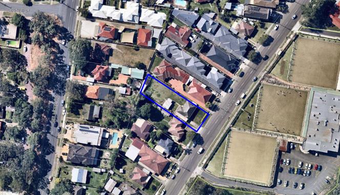
Site outlined
blue
|
EXECUTIVE SUMMARY
Proposal
1. This development application (DA) seeks consent for the demolition
of existing structures and the construction of a boarding house comprising nine
(9) boarding rooms, a communal living room with at-grade car parking for three
(3) vehicles, landscaping and site works, pursuant to State Environmental
Planning Policy (Affordable Rental Housing) 2009.
2. The applicant is the NSW Land and Housing Corporation.
Site and Locality
3. The subject site is located on the western side of Forest Road
approximately halfway between the intersections with Isaac Street to the north
and Belmore Road to the south.
4. The subject site is known as 932 Forest Road, Peakhurst and is
legally described as Lot 22 in DP 35407.
5. The site is an irregular shape having a frontage to Forest Road of
16.155m, side boundary lengths of 54.7m and 58.28m a rear boundary length of
16.545m giving a site area of 912.6sqm.
6. The land is relatively flat and is currently
occupied by a single storey dwelling house and ancillary structures in the rear
yard.
7. The site is located in a low density residential area characterised
by one (1) and two (2) storey dwellings, dual occupancies and townhouses.
Grandviews Bowling Club is located opposite the site.
Zoning and
Permissibility
8. The subject site is zoned R2 Low Density Residential under the
provisions of Hurstville Local Environmental Plan 2012 (HLEP 2012). The
proposal involves the construction of a boarding house which is a permissible
use in the zone with development consent.
9. The proposed development satisfies all relevant objectives contained
within the HLEP and is consistent with the requirements of State Environmental
Planning Policy (Affordable Rental Housing) 2009.
Submissions
10. The DA was publicly notified to neighbours between 31 August 2020
and 14 September 2020 in accordance with the Hurstville Development Control
Plan No 1 (HDCP). A total of three (3) submissions were received raising
concerns with parking and traffic congestion, character of the area, reduced property
values and the social impacts of the proposed use of the building as a boarding
house. These issues are discussed in greater detail in
the body of this report.
Reason for Referral to the Local Planning Panel
11. This application is referred to the Georges River Local Planning
Panel for determination under Council delegations as the proposal relates to a
boarding house.
Conclusion
12. The proposal is an appropriate response to
the zoning of the land and is consistent with the
desired future building envelope and density for the site.
13. The application has been assessed having
regard to the Matters for Consideration under Section 4.15 of
the Environmental Planning and Assessment Act 1979, the provisions of the
relevant State Environmental Planning Policies, Local Environmental Plan and
Development Control Plans.
14. As a result the application is recommended for a deferred
commencement approval subject to suitable conditions of consent.
REPORT IN FULL
DESCRIPTION OF
THE PROPOSAL
15. The application proposes the demolition of existing structures and
the construction of a two (2) storey boarding house containing nine (9)
boarding rooms and at-grade parking for three (3) vehicles, landscaping and
site works.
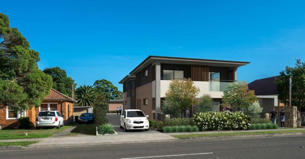
Figure 1: Photomontage of the proposed development
16. Further details of the proposal are as follows:
Ground Floor Plan
- Five (5) boarding rooms: three (3) in the
front building and two (2) in the rear building;
- Communal living room and communal open
space;
- Three (3) car parking spaces including one
(1) accessible space located between the two (2) buildings;
- Two (2) bicycle parking spaces;
- Two (2) motor bike spaces;
- Bin store area;
- Vehicular access from Forest Road located
on the southern side of the site;
- Pedestrian access on the northern side of
the site; and
- Site landscaping.
First Floor
- Four (4) boarding rooms located in the
front building.
DESCRIPTION OF THE SITE AND LOCALITY
17. The subject site is located on the western side of Forest Road approximately
halfway between the intersections with Isaac Street to the north and Belmore
Road to the south.
18. The subject site is known as 932 Forest Road, Peakhurst and is
legally described as Lot 22 in DP 35407.
19. The site is an irregular shape having a frontage to Forest Road of
16.155m, side boundary lengths of 54.7m and 58.28m a rear boundary length of
16.545m giving a site area of 912.6sqm.
20. The land is relatively flat and is currently
occupied by a single storey dwelling house and ancillary structures in the rear
yard.
21. The site is located in a low density residential area characterised
by one and two storey dwellings, dual occupancies and townhouses. Grandviews
Bowling Club is located opposite the site.

Figure 2: The existing dwelling on the site
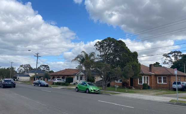
Figure 3: Development to the south west of the site
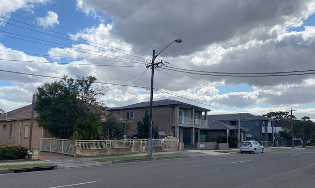
Figure 4: Development to the north east of the site
Figure 5: Grandviews Bowling Club located opposite the site
State Environmental Planning Policies (SEPPs)
22. Compliance with the relevant SEPPs is
summarised in the following table and discussed in further detail below.
Compliance with State Planning Policies
|
SEPP Title
|
Complies
|
|
Greater Metropolitan Regional Environmental Plan No 2 –
Georges River Catchment
|
Yes
|
|
State Environmental Planning Policy (Building Sustainability
Index: BASIX) 2004
|
Yes
|
|
State Environmental Planning Policy No 55 - Remediation of Land
|
Yes
|
|
State Environmental Planning Policy (Vegetation in Non-Rural
Areas) 2017
|
Yes
|
|
State
Environmental Planning Policy (Infrastructure) 2007
|
Yes
|
|
State
Environmental Planning Policy (Affordable Rental Housing) 2009
|
Yes
|
DEEMED STATE ENVIRONMENTAL PLANNING POLICY – GEORGES RIVER
CATCHMENT
23. All stormwater from the proposed development can be treated in accordance
with Council’s Water Management Policy and will satisfy the relevant
provisions of the Deemed State Environmental Planning Policy – Georges
River Catchment.
24. The stormwater will drain to Forest Road via an onsite stormwater
detention system.
STATE ENVIRONMENTAL PLANNING POLICY (BUILDING SUSTAINABILITY INDEX:
BASIX) 2004
25. A BASIX Certificate has been issued for the proposed development and
the commitments required under the certificate have been satisfied.
STATE ENVIRONMENTAL PLANNING POLICY NO 55 - REMEDIATION OF LAND
26. SEPP 55 aims to promote the remediation of contaminated land in
order to reduce the risk of harm to human health or any other aspect of the
environment.
27. Clause 7 requires contamination and remediation to be considered in
determining a development application. The consent authority must not consent
to the carrying out of development on land unless it has considered whether or
not the land is contaminated.
28. The site has a history of residential uses and as such, site
contamination is not suspected. In this regard, no further assessment is
warranted with regard to site contamination.
STATE ENVIRONMENTAL PLANNING POLICY (VEGETATION IN NON-RURAL AREAS)
2017
29. The Vegetation SEPP regulates clearing of native vegetation on urban
land and land zoned for environmental conservation/management that does not
require development consent.
30. The Vegetation SEPP applies to clearing of:
a) Native vegetation above the Biodiversity Offset
Scheme (BOS) threshold where a proponent will require an approval from the
Native Vegetation Panel established under the Local Land Services Amendment Act
2016; and
b) Vegetation below the BOS threshold where a proponent
will require a permit from Council if that vegetation is identified in the
Council’s Development Control Plan (DCP).
31. The Vegetation SEPP repeals clause 5.9 and 5.9AA of the Standard
Instrument - Principal Local Environmental Plan with regulation of the clearing
of vegetation (including native vegetation) below the BOS threshold through any
applicable DCP.
32. The proposed development does not involve the removal of any trees
or significant vegetation. The proposal is supported by Council’s
Consulting Arborist. In this regard, the provisions of this SEPP are considered
to have been met.
STATE ENVIRONMENTAL PLANNING POLICY (INFRASTRUCTURE)
2007
33. The aim of the Infrastructure SEPP is to facilitate the effective
delivery of infrastructure across the State. The DA was referred to Ausgrid on
25 August 2020 in accordance with Clause 45 of State Environmental Planning
Policy (Infrastructure) 2007. Ausgrid raises no concern with the proposal and
do not require any conditions of consent.
34. The provisions and requirements of the Infrastructure SEPP have been
addressed and satisfied by the proposal.
STATE ENVIRONMENTAL PLANNING POLICY (AFFORDABLE
RENTAL HOUSING) 2009
35. State Environmental Planning Policy (Affordable Rental Housing) 2009
aims to provide a consistent planning regime for the provision of affordable
rental housing. The proposal seeks consent for a boarding house pursuant to the
provisions of the SEPP, specifically Division 3 – Boarding Houses. An
assessment of the proposal against the relevant provisions of the SEPP is
provided in the following table.
|
Clause
|
Standards
|
Proposal
|
Complies
|
|
26 – Land
to which Division applies for the purpose of a boarding house with consent
|
· R1 General Residential
· R2 Low Density Residential
· R3 Medium Density Residential
· R4 High Density Residential
· B1 Neighbourhood Centre
· B2 Local Centre
· B4 Mixed Use
|
Site is zoned R2
Low Density Residential
|
Yes
|
|
27 –
Development to which Division applies
|
Not applicable
– the site is in the R2 zone.
|
N/A
|
N/A
|
36. An accessible area is defined by Clause 4 of SEPP (Affordable Rental
Housing) 2009 as follows:
‘accessible area means land that is within:
(a) 800ms walking distance of a
public entrance to a railway station or a wharf from which a Sydney Ferries
ferry service operates, or
(b) 400m walking distance of a public
entrance to a light rail station or, in the case of a light rail station with
no entrance, 400 metres walking distance of a platform of the light rail
station, or
(c) 400m walking distance of a bus stop used by a regular
bus service (within the meaning of the Passenger Transport Act 1990) that has at least one bus per hour servicing
the bus stop between 06.00 and 21.00 each day from Monday to Friday (both days
inclusive) and between 08.00 and 18.00 on each Saturday and Sunday.’
37. By virtue of the definition, the subject site satisfies the
requirements of an accessible area. A map and table outlining bus services
within proximity to the site is provided below.
|
Location of Bus Stop
|
Bus Route
|
Walking Distance
|
Mon – Fri Frequency
|
Saturday Frequency
|
Sunday Frequency
|
|
Club
Grandviews, Forest Road
|
943
Lugarno to Hurstville
|
<400m
|
Complies
|
Complies
|
Complies
|
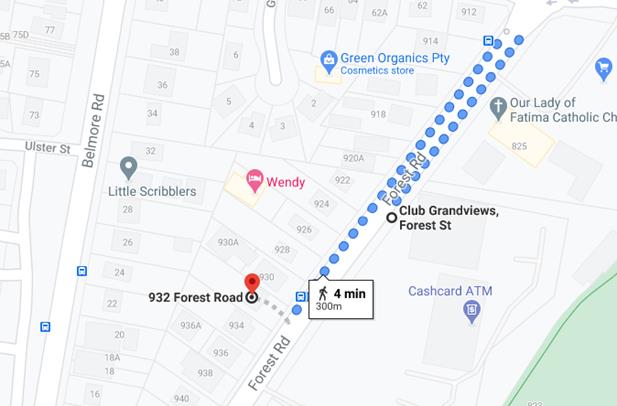
Figure 6: Map showing bus stops within 400m of the subject site
38. An assessment of the proposal against the relevant provisions of the
SEPP (Affordable Rental Housing) 2009 is provided in the following table.
|
29 - Standards that cannot be used to refuse
consent
Council cannot refuse a development application for a boarding
house under the SEPP (Affordable Rental Housing) 2009
on any of the following grounds.
|
|
Floor Space Ratio
|
If the density and
scale of the buildings as a FSR is not more than the existing maximum FSR for
any form of residential accommodation permitted (0.6:1 or 547.56sqm)
|
0.39:1 or 360sqm
|
Yes
|
|
Height
|
If the building
height is not more than the maximum height permitted under another EPI for
any building on the land:
Maximum of 9m
under the HLEP 2012
|
Maximum height is
7m.
|
Yes
|
|
Landscaped Area
|
If
the landscape treatment of the front setback area is compatible with the
streetscape in which the building is located
|
Landscaped front
setback area is consistent with the character of the streetscape.
|
Yes
|
|
Solar Access
|
Where
the development provides for one or more communal living rooms, if at least
one of those rooms receives a minimum of 3 hours direct sunlight between 9am
and 3pm in mid-winter
|
3 hours of direct
sunlight is achieved.
|
Yes
|
|
Private Open Space
|
If
at least the following private open space areas are provided (other than the
front setback area):
(i) one area of at least 20sqm with a minimum
dimension of 3m is provided for the use of the lodgers,
(ii) if accommodation is provided on site for
a boarding house manager—one area of at least 8sqm with a minimum
dimension of 2.5m is provided adjacent to that accommodation.
|
Located adjacent
to the communal room, behind the building line and is 25sqm.
Manager
accommodation is not required.
|
Yes
N/A
|
|
Accommodation size
|
if each boarding room has a gross floor area (excluding any
area used for the purposes of private kitchen or bathroom facilities) of at
least—
(i) 12sqm in the case of a boarding
room intended to be used by a single lodger, or
(ii) 16sqm in any other case.
|
Room 1 –
21.8sqm
Room 2 –
21.8sqm
Room 3 –
21.8sqm
Room 4 - 21.8sqm
Room 5 - 21.8sqm
Room 6 - 21.8sqm
Room 7 - 21.8sqm Room 8 - 25sqm
Room 9 - 24sqm
|
Yes
|
|
Parking
|
0.2 parking spaces
provided for each boarding room (9 x 0.2 = 2 spaces)
Not more than 1
parking space is provided for each person employed in connection with the
development and who is resident on site
|
3 spaces provided
N/A
|
Yes
N/A
|
|
Clause 30 – Standards for Boarding Houses
A consent authority must not consent to development for boarding
houses unless it is satisfied of each of the following:
|
|
Communal living
|
(a)
If a boarding house has 5 or more boarding rooms, at least one communal
living room will be provided
|
One (1) communal
room provided at the rear of the two (2) storey building on the ground floor.
|
Yes
|
|
Size of boarding
rooms
|
(b)
No boarding room will have a gross floor area (excluding any area used for
the purposes of private kitchen or bathroom facilities) of more than 25sqm
|
Room 1 –
21.8sqm
Room 2 –
21.8sqm
Room 3 –
21.8sqm
Room 4 - 21.8sqm
Room 5 - 21.8sqm
Room 6 - 21.8sqm
Room 7 - 21.8sqm Room 8 - 25sqm
Room 9 - 24sqm
|
Yes
|
|
Maximum occupancy
|
(c)
No boarding room will be occupied by more than 2 adult lodgers
|
Each room is to
accommodate one lodger. The Plan of Management submitted with the DA
indicates the occupants will be over 55 year old women in need of secure long
term housing.
|
Yes
|
|
Kitchen and
bathroom facilities
|
(d)
Adequate bathroom and kitchen facilities will be available within the
boarding house for the use of each lodger
|
All rooms have a
kitchen and bathroom facilities which contain a washing machine.
|
Yes
|
|
Boarding house
manager
|
(e)
If the boarding house has capacity to accommodate 20 or more lodgers, a
boarding room or on site dwelling will be provided for a boarding house
manager
|
N/A
|
N/A
|
|
Bicycle and motor
cycle spaces
|
(h)
At least one parking space will be provided for a bicycle, and one will be
provided for a motorcycle, for every 5 boarding rooms (9/5 = 2 spaces)
|
Two (2) motorcycle
spaces and two (2) bicycle storage spaces provided.
|
Yes
|
|
|
|
|
|
|
Character
assessment
39. Under clause 16A of the State Environmental
Planning Policy (Affordable Rental Housing) 2009, a
consent authority must not consent to a development if the design is
incompatible with the character of the local
area. No guidelines were developed to inform how to
apply the compatibility test. A number of court cases have provided some
guidance as to how to assess the “character” of a local area and
what to consider ensuring an affordable housing development is suitable.
40. In considering compatibility with neighbouring character, in
Sterling Projects v The Hills Shire Council [2011] the Commissioner said that “character
is not limited to a consideration of streetscape but includes the wider context
of the site, in particular the characteristics of the properties which adjoin
the site”.
41. In the recent decision of Louden Pty
Ltd v Canterbury-Bankstown Council [2018]
clause 16A played a prominent role in Commissioner Gray’s
judgement. Commissioner Gray stated that all buildings of all typologies
must be incorporated into the assessment of the local area character. This
assessment concurs with Commissioner Roseth SC who in Project
Venture Developments v Pittwater Council [2005] stated
that “compatibility is
thus different from sameness. It is
generally accepted that buildings can exist together in harmony without having
the same density, scale or appearance, though as the difference in these
attributes increases, harmony is harder to achieve.”
Therefore in order to establish a local character in a mixed, diverse area the
plans should reasonably match other structures in the vicinity and should
consider such aspects as building forms, setbacks and scale.
42. The subject site is located within low density residential
environment. The character of the locality comprises of small scale residential
developments in the form of detached dwelling houses, dual occupancies and
townhouse developments.
43. In establishing whether the proposal is in keeping with the
character of the area, the proposed built form is two storeys at the front of
the site and single storey at the rear, not in different to a dwelling house
and secondary dwelling. The proposal retains the location of the existing
driveway and extends it to the proposed parking area, which will not be visible
from the street. This design is characteristic not only of the existing built
form on the site, but a number of dual occupancy and townhouse developments
nearby on Forest Road and Belmore Road.
44. The proposal is considered suitable for the site and the locality
for the reasons discussed in this report and meets the aims of the SEPP
(Affordable Rental Housing) 2009 which include facilitating the delivery of new
affordable rental housing.
45. The proposed development is considered to be consistent with the
character of the locality and the future character envisaged by the planning
controls. The scale and form of the development is consistent with housing
within the immediate and wider context of the site. The development also
satisfies the objectives of the R2 zone which include:
• To
provide for the housing needs of the community within a low density residential
environment.
• To
enable other land uses that provide facilities or services to meet the day to
day needs of residents.
• To
encourage development of sites for a range of housing types, where such
development does not compromise the amenity of the surrounding area, or the
natural or cultural heritage of the area.
• To
ensure that a high level of residential amenity is achieved and maintained.
• To
encourage greater visual amenity through maintaining and enhancing landscaping
as a major element in the residential environment.
• To
provide for a range of home business activities where such activities are not
likely to adversely affect the surrounding residential amenity.
46. The proposal is well located and is within walking distance of
neighbourhood shops in Lugarno and Peakhurst. The site is also opposite
Grandviews Bowling Club which offers entertainment and an eatery. The proposed
built form is considered to be a sympathetic and a desirable response for this
site in terms of its scale and design intent and will be in keeping with the
anticipated development outcome for the locality.
47. The separated single and two (2) storey built form is in keeping
with existing residential developments in the immediate locality. The setback
to Forest Road contains deep soil planting and private open space at ground
level, with small Juliette balconies at the upper level to provide casual
surveillance of the street and a height that complements the predominant built
form of the existing development in the street.
48. The height and scale of the building is in keeping with the predominant
built form of housing on Forest Road and in the wider locality.
49. The character of front fencing in the immediate locality and visual
catchment from the site is mixed. Some properties do not have front fencing,
and for those that do, the designs include low height brick fencing and open
form metal fencing. The Club opposite the site has an open metal fence with
landscaping behind. The proposed front fence of the development consists of a
1.2m high sandstone block fence with metal palisade fencing above, setback 1m
from the front boundary. Landscaping is also proposed on both sides of the
fence. A condition has been recommended that the fence be no higher than 1.2m
to better compliment the existing character in the locality.
50. As such the proposal satisfies the objectives and intent of Clause
16A.
Draft State
Environmental Planning Policies (SEPPs)
Draft Environment
SEPP
51. The Draft
Environment SEPP was exhibited from 31 October 2017 to 31 January 2018. This
consolidated SEPP proposes to simplify the planning rules for a number of water
catchments, waterways, urban bushland, and Willandra Lakes World Heritage
Property.
52. Changes proposed include
consolidating the following seven existing SEPPs:
· State Environmental Planning Policy No. 19
– Bushland in Urban Areas
· State Environmental Planning Policy (Sydney
Drinking Water Catchment) 2011
· State Environmental Planning Policy No. 50
– Canal Estate Development
· Greater Metropolitan Regional Environmental Plan
No. 2 – Georges River Catchment
· Sydney Regional Environmental Plan No. 20
– Hawkesbury-Nepean River (No.2-1997)
· Sydney Regional Environmental Plan (Sydney
Harbour Catchment) 2005
· Willandra Lakes Regional Environmental Plan No.
1 – World Heritage Property
53. The proposal is not inconsistent with the
provisions of this Draft Instrument.
Draft Remediation
of Land SEPP
54. The Department of Planning and Environment has announced a Draft
Remediation of Land SEPP, which will repeal and replace the current State Environmental Planning Policy No 55 —
Remediation of Land.
55. The main changes proposed include the expansion of categories of
remediation work which requires development consent, a greater involvement of
principal certifying authorities particularly in relation to remediation works
that can be carried out without
development consent, more comprehensive guidelines for Councils and certifiers
and the clarification of the contamination information to be included on
Section 149 Planning Certificates.
56. Whilst the proposed
SEPP will retain the key operational framework of SEPP 55, it will adopt a more
modern approach to the management of contaminated land. The Draft SEPP will not
alter or affect the findings in relation to contamination at the site.
57. The site has a history of residential uses and as such, site contamination
is not suspected. In this regard, no further assessment is warranted with
regard to site contamination.
Environmental Planning Instruments
HURSTVILLE LOCAL ENVIRONMENTAL PLAN 2012 (HLEP 2012)
Zoning
58. The subject site is zoned Zone R2 Low Density Residential under the
provisions of the Hurstville Local Environmental Plan 2012 (HLEP2012). Refer to
zoning map below. The proposed development is defined as a boarding house which
is a permissible land use in the zone.
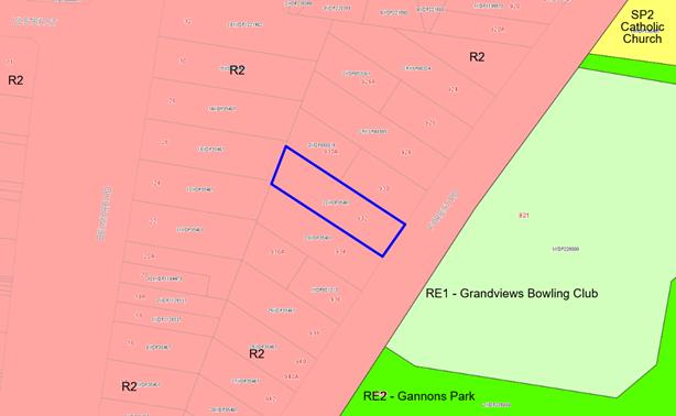
Figure 7: Zoning map subject site outlined in red
59. The objectives of the
zone are as follows:
• To
provide for the housing needs of the community within a low density residential
environment.
• To
enable other land uses that provide facilities or services to meet the day to
day needs of residents.
• To
encourage development of sites for a range of housing types, where such
development does not compromise the amenity of the surrounding area, or the
natural or cultural heritage of the area.
• To
ensure that a high level of residential amenity is achieved and maintained.
• To
encourage greater visual amenity through maintaining and enhancing landscaping
as a major element in the residential environment.
• To
provide for a range of home business activities where such activities are not
likely to adversely affect the surrounding residential amenity.
60. The proposal satisfies the
objectives of the R2 Zone as it will provide for the housing needs of the
community in a low density residential environment.
61. The extent to which the
proposal complies with the relevant standards of Hurstville Local Environmental
Plan 2012 (HLEP2012) is outlined in the table below.
HLEP2012 Compliance Table
|
Clause
|
Standard
|
Proposed
|
Complies
|
|
2.2 Zone
|
R2 Medium Density Residential
|
The proposal is
defined as a boarding house which is a permissible use within the zone.
|
Yes
|
|
2.3
Objectives
|
Objectives of the
Zone
|
Consistent with
zone objectives.
|
Yes
|
|
4.3 – Height
of Buildings
|
9m as identified
on Height of Buildings Map
|
The maximum height
is 7m.
|
Yes
|
|
4.4 – Floor
Space Ratio
|
0.6:1 (or
547.56sqm) as identified on Floor Space Ratio Map
|
0.39:1 or 360sqm.
|
Yes
|
|
4.5 –
Calculation of floor space ratio and site area
|
FSR and site area
calculated in accordance with Cl.4.5
|
The
FSR has been calculated accordingly.
|
Yes
|
|
5.10 –
Heritage Conservation
|
The objectives of
this clause are;
(i) to conserve
the environmental heritage of Kogarah,
(ii) to conserve
the heritage significance of heritage items and heritage conservation areas,
including associated fabric, settings and views.
|
The proposal does
not adjoin any environmental heritage item nominated under HLEP 2012.
|
Yes
|
|
6.1 Acid Sulphate
Soils (ASS)
|
The objective of this clause is to ensure that development
does not disturb, expose or drain acid sulfate soils and cause environmental
damage
|
The site is not
affected by Acid Sulfate Soils under HLEP 2012.
|
N/A
|
|
6.2 Earthworks
|
To ensure that
earthworks do not have a detrimental impact on environmental functions and
processes, neighbouring uses, cultural or heritage items or features of the
surrounding land
|
The proposed
development includes minimal excavation and associated earthworks to
accommodation the foundations of the development.
|
Yes subject to
conditions.
|
Draft Georges River Local
Environmental Plan 2020
62. Consideration is given to the provisions of Draft Georges River Local
Environmental Plan 2020 in the assessment this application.
63. In this
regard, the provisions have no determining weight as a result of proposed
operation of Clause “1.8A Savings provisions relating to development
applications” of the Draft Plan which provides “If a
development application has been made before the commencement of this Plan in
relation to land to which this Plan applies and the application has not been
finally determined before that commencement, the application must be determined
as if this Plan had not commenced.”
Development Control Plan
64. Boarding houses do not have any DCP specific controls for
assessment, as a result the assessment criterion in Chapter 4.4 of the HDCP No
1 for dwelling houses on standard lots for areas of assessment not covered by
the SEPP have been used as a guide for assessment given the predominance
of the surrounding development is dwelling houses and streetscape consistency
is of relevance.
|
Applicable DCP
Controls
|
DCP Provisions
|
Development
Provisions
|
Complies
|
|
Neighbourhood
character
|
DS1.1 The
development application is supported by a Statement of Environmental Effects
that:
a. includes
a satisfactory neighbourhood and site description, including the
identification of the key features of the neighbourhood and site
b. shows
how the siting and design response derives from and responds to the key
features identified in the neighbourhood and site description
c. demonstrates
that the residential development proposal respects the existing or preferred
neighbourhood character and satisfies objectives of the zone in the LEP
|
The proposal is
supported by an SEE and addresses the key features of neighbourhood character
and demonstrates how the siting and design responds to the site.
|
Yes
|
|
Building Height
|
DS2.1. Maximum building height is
in accordance with the LEP
DS2.2. Maximum ceiling height is
7.2m above the existing ground level vertically below that point. Note:
maximum ceiling height is measured at the intersection of the upper most
ceiling with the internal face of any external wall
|
The maximum
building height is 7m.
Maximum 5.8m.
|
Yes
Yes
|
|
Setbacks
|
DS3.1. The minimum front setback to
a primary street is:
a. 5.5m to the main face of the
dwelling or
b. 4.5m to the main face of the
dwelling where located on a corner site and 5.5m to the garage
or
c. within 20% of
the average setback of dwellings on adjoining lots
DS3.4 The minimum
side setback outside the FSPA is 900mm (ground floor) and 1.2m (first floor).
DS3.6. Minimum rear boundary
setbacks are:
a 3m
for any basement and ground floor level solid wall
b. 6m
for first floor level solid walls
c. where
a first floor balcony is proposed at the rear, 6m from the balustrade.
|
5.5m to the wall
of the building (balconies encroach)
N/A
N/A
Min. 3m
Min. 3.38m
N/A
26m
|
Yes
N/A
N/A
Yes
Yes
N/A
Yes
|
|
Facades
|
DS4.1. The dwelling house has a
front door or window to a habitable room facing the primary street frontage.
DS4.2. The dwelling house
incorporates at least two of the following building elements facing any
street frontage:
a. entry feature or portico
b. awnings or other features
over windows
c. eaves and sun shading
d. window planter box
treatment
e. bay windows or similar
features f. wall offsets, balconies, verandas, pergolas or the like
DS4.3. Garage doors are not wider
than 6m
|
Habitable room windows
face the street at both levels.
The proposal
incorporates all these features.
Garaging is not
proposed.
|
Yes
Yes
N/A
|
|
Solar Access
|
DS6.1. Development allows for at
least 3 hours of sunlight on the windows of main living areas and adjoining
principal private open space of adjacent dwellings between 9.00am and 3.00pm
on 21 June.
DS6.2. Development complies with
the Energy Efficiency section in Appendix 1 of this DCP and BASIX
requirements.
DS6.3. Buildings are encouraged to
incorporate window shading devices where necessary to minimise exposure to
direct summer sun. Alternatively, windows may be shaded by the planting of
large trees, including deciduous species.
|
Adjoining
properties will continue to receive greater than 3 hours during mid-winter.
The proposal is
BASIX compliant.
The proposal is
BASIX compliant.
|
Yes
Yes
Yes
|
|
Visual Privacy
|
DS7.1. Windows of proposed dwelling
must be offset from neighbouring windows by 1m, especially windows of
high-use rooms.
DS7.2. Windows for primary living
rooms must be designed so that they maintain privacy of adjoining
site’s principal private open space.
DS7.3. Development applications are
accompanied by a survey plan or site analysis plan (to AHD) of the proposed
dwelling showing the location of adjoining property windows, floors levels,
window sill levels and ridge and gutter line levels.
|
Windows are offset
from adjoining properties and are limited in sill height and number of
windows.
The windows for
primary living areas are to the front or rear of each boarding room.
The application
includes survey plan and architectural plans indicating the adjoining
properties, and window sill levels.
|
Yes
Yes
Yes
|
|
Vehicle access,
parking and manoeuvring
|
Complies with the SEPP –
refer to compliance table
|
|
Landscaped areas
and private open space
|
DS10.1. Where located outside the
FSPA, a minimum of 20% of site area is landscaped open space.
DS10.2. Where located in the FSPA,
a minimum of 25% of the site area is landscaped open space.
DS10.3. The minimum dimension of
landscaped open space is 2m in any direction.
DS10.4. A minimum of 15sqm of the
landscaped open space is provided between the front setback and the street
boundary in the form of a front yard.
DS10.5. An area of Principal
Private Open Space is to be provided which:
a. has a minimum area of 30sqm
b. has a minimum dimension of
5m
c. is located at ground level
and behind the front wall of the dwelling
d. is directly accessible
from a main living area
|
27%
N/A
Deep soil areas
located in the front, side and rear setbacks.
35sqm
N/A – refer
to SEPP
|
Yes
N/A
Yes
Yes
N/A
|
|
Stormwater
|
DS11.1. Diversion of flows from one
drainage sub-catchment to another is not encouraged.
DS11.2. Stormwater drainage is to
occur by:
a. drainage
by gravity to the adjacent road kerb and Council’s drainage system or
DS11.3. Where drainage by gravity
is involved this must not cause ponding/backwater effects on upstream
properties.
DS11.5. On-site retention of roof
run-off using rainwater tanks or detention tanks for storage and re-use are
encouraged. Overflow from storage facilities must be connected to an
appropriate stormwater system as detailed in DS11.2.
DS11.7. Development is not to
concentrate overland flow of stormwater onto an adjoining property.
|
Not proposed.
Council’s
Development Engineers and Drainage Engineers have provided comments and
raised no objection in this regard, subject to the recommended conditions
relating to this development if the proposal was able to be supported.
Complies
Councils
Development Engineers and Drainage Engineers have provided comments and
raised no objection in this regard, subject to the recommended conditions
relating to this development if the proposal was to be supported.
Complies.
|
Yes
Yes
Yes
Yes
Yes
|
|
Balconies
|
DS14.1. Access to balconies and
terraces is direct from a habitable room at the same floor level. Note: a
level difference of one step may be considered for the purpose of rain water
protection.
DS14.2. Balconies and terraces
include fixed planter boxes and / or privacy screens.
DS14.3. Fixed planter boxes are at
least 1m wide.
DS14.4. Privacy screens are between
1.5m and 1.8 m high
DS14.5. Terraces are not visible
from the street.
DS14.6. Roof top terraces are not
provided.
DS14.7. Development applications
for terraces and balconies must provide sight line diagrams that demonstrate
how privacy issues to neighbouring properties are proposed to be addressed.
|
Complies
The first floor
balconies are 1.55m in width and incorporate privacy screens on the sides.
Not required.
>1.8m
Small Juliette
style balconies are proposed overlooking the street.
Not proposed.
Privacy screens
adequately reduce the opportunity for overlooking from first floor balconies.
|
Yes
Yes
Yes
Yes
Yes
Yes
Yes
|
65. The design of the development is not in different to a dwelling
house and secondary dwelling in the rear yard. As such, an assessment of the
proposal against the relevant built form secondary dwelling controls contained
in Chapter 4.6 of the Hurstville DCP No. 1 has been undertaken as a guide
below.
|
Clause
|
Requirement
|
Proposed
|
Complies
|
|
PC3.
Building height:
|
DS3.1
Maximum building height is 1 storey.
DS3.2
The minimum floor to ceiling height is 2.4m.
DS3.3
The maximum floor to ceiling height is 3.6m.
|
Proposed single storey
2.7m
2.7m
|
Yes
Yes
Yes
|
|
PC4.
Setbacks:
|
DS4.1
The minimum setback to side and rear boundaries is 900mm.
DS4.2
The secondary dwelling is setback behind the main building face to a primary
of secondary street.
|
Min. 2.5m to
side boundaries.
Min. 3m to rear
boundary.
Rooms 8 and 9
are setback behind the two (2) storey building.
|
Yes
Yes
|
DEVELOPER CONTRIBUTIONS
66. The proposed development, as it is for the sole purpose of providing
affordable housing, is exempt from the payment of developer contributions under
Sections 7.11 and 7.12 of the Environmental Planning and Assessment Act 1979.
IMPACTS
Natural Environment
67. The proposed
development will not adversely affect the natural environment subject to the
site being planted with replacement trees as shown on the approved landscape
plan, which is supported by Council’s Consultant Arborist subject to
conditions.
Built Environment
68. The proposal
represents a good planning outcome for the site with respect to its bulk, scale
and density, façade articulation and expression and is an appropriate
response to the context of the site and its R2 Low Density Residential zoning.
Social Impact
69. No adverse social impacts have been identified as part of the
assessment. The proposed development, in principle, will cater for a
cross-section of the community and will assist with providing for additional
housing in the area. The construction of a boarding house on the site is
consistent with the residential zoning of the land.
Economic Impact
70. There is no apparent
adverse economic impact that is likely to result within the locality due to the
construction of a boarding house. It is likely there will be a small positive
economic impact as a result of the construction of the development.
Suitability of the site
71. The site is zoned R2 Low
Density Residential. The proposal is a permissible form of development in this
zone and has been designed to reflect the context of the area as it evolves and
exists and is in line with the intentions of Council’s zoning of this
area.
SUBMISSIONS
AND THE PUBLIC INTEREST
72. The application was neighbour notified in accordance with Hurstville
DCP No. 1 between 31 August and 14 September 2020. A total of three (3)
submissions were received as a result of the notification period. In summary
the following issues and concerns were raised.
The development is out of
character for the area
73. Comment: The single and two (2) storey built form is in keeping with existing
residential developments in the immediate locality. The proposal is compliant
with the maximum height and floor space controls and provides suitable setbacks
to the front, side and rear property boundaries.
The development will result
in increased pressure on street parking
74. Comment: The proposal provides an
additional parking space above the number required by SEPP (Affordable Rental
Housing) 2009. The SEPP requires two (2) parking spaces and the proposal
provides three (3) parking spaces.
Impacts on the health and
safety of the community due to proposed use as a boarding house
75. Comment: This matter is not a relevant matter for consideration under the
Environmental Planning and Assessment Act 1979.
The proposal will reduce
property values
76. Comment: Property values are not a
matter for consideration under the Environmental
Planning and Assessment Act 1979.
REFERRALS
Council Referrals
Development Engineer
77. The application was referred to Council’s
Development Engineers for comment. The application is supported subject to a
deferred commencement condition requiring an easement to drain water to Belmore
Road.
78. The proposed stormwater design indicates on site
detention and drainage by gravity to Forest Road. Due to the gutter level
relative to the surface level of water in the OSD tank, and the reduced
capacity of the Forest Road sub-catchment to accommodate storms exceeding the
1:20 year event, flow from the site is to be discharged to the Belmore Road
sub-catchment which will result in more frequent surcharging of the street
drainage system for the range of rare storm events.
Traffic Engineer
79. The application was referred to Council’s Traffic Engineer for comment. The proposed car parking and access
arrangements are considered to be compliant with Council’s controls and
are satisfactory. Standard conditions are included to ensure compliance will be
achieved with Australian Standards during and post construction.
Environmental Health Officer
80. Council’s Environmental Health Officer
has raised no objection to the proposal.
Consulting Arborist
81. Council’s Consulting Arborist has
raised no objection subject to conditions of consent being imposed if approval
is granted.
External Referrals
Ausgrid
82. The application was referred to Ausgrid in
accordance with Clause 45 of State Environmental Planning Policy
(Infrastructure) 2007. No objection was raised by Ausgrid and no conditions
recommended.
CONCLUSION
83. The proposal has been assessed using the matters for consideration
listed in Section 4.15 of the Environmental Planning and Assessment Act 1979.
The proposal is considered to be a reasonable redevelopment of the site and the
proposed scale, bulk and height is considered to be an acceptable planning and
design outcome for this site and will be consistent with the existing and
desired future character of development in the R2 zoned land in this location
and immediate locality.
84. The proposal has been assessed against the provisions of the
relevant State Environmental Planning Policies, Hurstville Local Environmental
Plan 2012 and Hurstville Development Control Plan No. 1. The proposal satisfies
the key planning controls in the Local Environmental Plan.
85. The applicant is the NSW Land and Housing Corporation which are
social housing providers. The recommended conditions of consent have been
provided to the applicant prior to the meeting. At the time of publishing this
report, no comments have been provided by the applicant.
DETERMINATION AND STATEMENT OF REASONS
Statement of Reasons
86. The reasons for this recommendation are:
· The proposal is an appropriate response to the zoning of the site.
· The proposed development complies with the requirements of the
relevant environmental planning instruments.
· The proposed design has been sensitively considered to be consistent
with the existing and desired future character for development in this area.
· The proposal has effective façade modulation and wall
articulation that will serve to provide visual interest and reduce the bulk of
the building.
· The proposal aims to provide a high-quality building that will
establish a positive urban design outcome.
Determination
87. THAT pursuant to Section 4.16(1) of the Environmental Planning and
Assessment Act, 1979, as amended, the Georges River Local Planning Panel,
grants development consent to Development Application DA2020/0327 demolition of existing structures and construction of a
nine (9) room boarding house with associated
landscaping, car parking and site works on Lot 22 in DP35407 known as 932
Forest Road, Peakhurst, subject to the following conditions of consent:
The Development Application described above
has been determined by the granting of a Deferred Commencement Consent subject
to the conditions specified in this notice.
This Development Application is a Deferred
Commencement Consent under Section 4.16(3) of the Environmental Planning and
Assessment Act 1979. Strict compliance is required with all conditions
appearing in Schedule 1 within thirty six (36) months from the Determination Date of this
consent.
Upon confirmation in writing from Georges River Council that the Schedule 1
Conditions have been satisfied, the consent shall commence to operate as a
Development Consent for a period of five (5) years from the Determination Date of this
consent.
Schedule 1
Deferred
Commencement Conditions
A. Deferred
Commencement - Drainage - Pursuant to Section
4.16(3) of the Environmental Planning and Assessment Act 1979, this consent will not operate until such time as the
following requirements are satisfied:
(a) The applicant must acquire an Easement to Drain Water of
1.0 metre (minimum) width. The easement must allow for a piped, gravity fed
system of drainage of stormwater from the subject site with direct, underground
connection to Council's kerb inlet pit in Belmore Road.
Evidence of registration of the
easement to drain water benefitting the subject site and burdening the title of the property(ies) containing the easement is to be provided to Council:
(b) The applicant
must obtain separate Development Consent for all drainage works to be carried
out within the Easement to Drain Water. The written consent of each of the
owners of the property/ies burdened by the Easement will be required for each
development application to carry out the drainage works on the burdened lot/s.
Documentary evidence as requested or the above
information must be submitted within thirty six (36) months of the granting of
this deferred commencement consent. Activation of this Consent cannot
commence until written approval by Council is given advising Section A is
satisfied.
Subject to Schedule 1 above being satisfied the
development is to be carried out subject to the following conditions as
referenced in Schedule 2.
Schedule 2
Development
Details
1. Approved
Plans - The development must be implemented in accordance with the approved
plans and supporting documentation listed below which have been endorsed by
Council’s approved stamp, except where marked up on the plans and/or
amended by conditions of this consent:
|
Description
|
Reference
No.
|
Date
|
Revision
|
Prepared by
|
|
Demolition Plan
|
3 of 13
|
18.5.20
|
-
|
Barry Rush
& Associates
|
|
Site Plan
|
4 of 13
|
18.5.20
|
-
|
Barry Rush & Associates
|
|
Ground Floor
Plan
|
5 of 13
|
18.5.20
|
-
|
Barry Rush & Associates
|
|
First Floor
Plan
|
6 of 13
|
18.5.20
|
-
|
Barry Rush & Associates
|
|
Roof Plan
|
7 of 13
|
18.5.20
|
-
|
Barry Rush & Associates
|
|
Elevations
|
8 of 13
|
18.5.20
|
-
|
Barry Rush & Associates
|
|
Sections
|
9 of 13
|
18.5.20
|
-
|
Barry Rush & Associates
|
|
Finishes
Schedule
|
10 of 13
|
18.5.20
|
-
|
Barry Rush & Associates
|
|
Cut and Fill
Plan
|
11 of 13
|
18.5.20
|
-
|
Barry Rush & Associates
|
|
Plan of
Management
|
|
June 2020
|
|
|
Separate
Approvals Required Under Other Legislation
2. Vehicular Crossing - Major Development - The
following vehicular crossing and road frontage works will be required to
facilitate access to and from the proposed development site:
(a) The thickness and design of
the driveway shall be in accordance with Council’s Specifications
applying at the time construction approval is sought.
(b) Any existing vehicular
crossing and/or laybacks which are redundant must be removed. The kerb and
gutter, any other footpath and turf areas shall be restored at the expense of
the applicant. The work shall be carried out in accordance with
Council’s specification, applying at the time construction approval is
sought.
Constructing a vehicular crossing and/or footpath
requires separate approval under Section 138 of the Roads Act 1993
<http://legislation.nsw.gov.au/>, prior to the commencement of
those works.
3. Section
138 Roads Act 1993 and Section 68 Local Government Act 1993 - Unless
otherwise specified by a condition of this consent, this Development Consent
does not give any approval to undertake works on public infrastructure.
Separate approval is required under Section 138 of the Roads Act 1993 and/or Section 68 of the Local Government Act 1993 for any of the
following activities carried out in, on or over a public road (including the
footpath) listed below.
An application is required to be lodged and approved prior to the
commencement of any of the following works or activities;
(a) Placing or
storing materials or equipment;
(b) Placing or
storing waste containers or skip bins;
(c) Erecting a
structure or carrying out work
(d) Swinging or
hoisting goods over any part of a public road by means of a lift, crane or the
like;
(e) Pumping
concrete from a public road;
(f) Pumping
water from the site into the public road;
(g) Constructing
a vehicular crossing or footpath;
(h) Establishing
a “works zone”;
(i) Digging
up or disturbing the surface of a public road (eg Opening the road for the
purpose of connections to utility providers);
(j) Stormwater
and ancillary works in the road reserve;
(k) Stormwater
and ancillary to public infrastructure on private land; and
(l) If any
excavation is to be supported by the use of below ground (cable) anchors that
are constructed under Council’s roadways/footways.
These separate activity approvals must be obtained and
evidence of the approval provided to the Certifying Authority prior to the
issue of the Construction Certificate.
The relevant Application Forms for these activities can
be downloaded from Council’s website www.georgesriver.nsw.gov.au.
For further information, please contact Council’s Customer Service Centre
on (02) 9330 6400.
4. Road
Opening Permit - A Road Opening Permit must be obtained from Council, in
the case of local or regional roads, or from the RMS, in the case of State
roads, for every opening of a public road reserve to access services including
sewer, stormwater drains, water mains, gas mains, and telecommunications before
the commencement of work in the road.
Requirements
of Concurrence, Integrated & Other Government Authorities
5. Electricity
Supply - An application is required to be made to Ausgrid for a network
connection. This may require the network to be extended or its capacity
augmented. Evidence of this application being lodged with Ausgrid is required
to be provided to the Certifying Authority. For further details, you are
advised to contact Ausgrid on 13 13 65 or www.ausgrid.com.au
(Business and Commercial Services).
6. Connection
to the network will be required prior to Occupation -
Where works within the road reserve are to be carried out by the developer, a
Road Opening Permit must be obtained from Council's Customer Service Centre
before commencement of work.
7. Electricity
Supply to Development - The electricity supply to the Development must be
underground.
8. Sydney
Water - Tap in TM - The approved plans must be submitted to a
Sydney Water Tap inTM to determine whether the development
application will affect Sydney Water’s sewer and water mains, stormwater
drains and/or easements, and if further requirements need to be met. The
approved plans will be appropriately endorsed. For details please refer
to ‘Plumbing, building and developing’ section of Sydney
Water’s web site at www.sydneywater.com.au then
see ‘Building’, or telephone 13000 TAP IN (1300 082 746). The
Certifying Authority must ensure that a Tap inTM agent has
appropriately stamped the plans prior to the commencement of works.
9. Notice
of Requirements for a Section 73 Certificate - A Notice of Requirements of
what will eventually be required when issuing a Section 73 Compliance Certificate
under the Sydney Water Act 1994
<http://legislation.nsw.gov.au/> must be obtained from Sydney
Water Corporation. Application must be made through an authorised Water
Servicing Co-ordinator. Please refer to the ‘Plumbing, building and
developing’ section of the web site www.sydneywater.com.au
<http://www.sydneywater.com.au> then refer to
‘Providers’ under ‘Developing’ or telephone 13 20 92
for assistance.
Following application, a ‘Notice of Requirements’ will
advise of water and sewer infrastructure to be built and charges to be
paid. Please make early contact with the Co-ordinator, as it can take
some time to build water/sewer pipes and this may impact on other services and
building, driveway or landscape design.
The Notice of requirements must be submitted to the Certifying
Authority prior to the commencement of work. A Section 73 Compliance
Certificate will be required at the completion of development in accordance
with further conditions.
Prior
to the Commencement of Works (including Demolition and Excavation)
10. Stormwater System The submitted
stormwater plan has been assessed as a concept plan only. Final detailed plans
of the drainage system, prepared by a professional engineer specialising in hydraulic engineering, shall
be submitted for approval with the Construction Certificate.
(a) All stormwater shall drain by
gravity to the upper level of Council’s kerb inlet pit located in Belmore
Road in accordance with the Australian/New Zealand Standard AS/NZS 3500.3: 2015
(as amended).
(b) All stormwater shall drain by
gravity to the easement to drain water in accordance with the Australian/New
Zealand Standard AS/NZS 3500.3: 2015 (as amended).
(c) Stormwater drainage
plans including pipe sizes, type, grade, length, invert levels, dimensions and
types of drainage pits prepared by a professional engineer who specialises in
Hydraulic Engineering in accordance with the Australian Institute of Engineers
Australian Rainfall and Runoff (1987) and Council's Stormwater Drainage
Guidelines, shall accompany the application for the Construction Certificate.
11. On Site Detention - The final detailed
plans of the drainage system, prepared by a professional engineer specialising in hydraulic engineering, and
in accordance with the deferred commencement approval shall be submitted for
approval with the Construction Certificate.
An onsite detention (OSD) facility designed by a
professional engineer who specialises in Hydraulic engineering must be
designed, approved and installed.
The required OSD storage requirements and permissible
discharge are to be calculated in accordance with Table 3 of Council’s
Stormwater Management Policy.
The OSD facility shall be designed to meet all
legislated safety requirements and child proof safety fencing around the
facility must be provided where the OSD facility is open or above ground when
the design peak storage depth is greater than 300mm. A durable metal plate or
similar sign is to be placed at the OSD facility and must bear the words:
"BEWARE: This is an on-site detention basin/tank
for rainwater which could overflow during heavy storms."
Full details shall accompany the application for the
Construction Certificate.
12. Detailed Stormwater Drainage Design - The
submitted stormwater plan has been assessed as a concept plan only. A detailed
drainage design supported by a catchment area plan and drainage calculations
(including a Hydraulic Grade Line Analysis) must be submitted with the
Construction Certificate application.
13. Driveway Surface Waters - For driveways
on private property sloping to the street and greater than 10 metres in length,
drainage control devices such as humps or grated surface inlet pits shall be
installed at the front boundary in order to control excess stormwater flowing
across Council's footpath.
14. Stormwater Overland Flow - A design
which provides for a depression over the full width and length of the drainage
easement to provide a stormwater escape route shall be submitted. The escape
route shall be designed to have the capacity to carry the difference between a
1 in 100 year recurrence interval flow and half the flow in the pipeline within
the easement. This design is to include any openings in existing or proposed
fencing on the site to accommodate the overland flow.
Evidence from an appropriately qualified person that
this design requirement has been met shall accompany the application for the
Construction Certificate.
15. Support for
Easement Pipes
(a) All
footings within 2.0 metres of the drainage easement shall be designed in such a
manner that they are supported by foundations set at a minimum of 300mm below
pipe invert levels or founded on sound rock.
(b) Alternatively,
the footings of the building or any structure shall be designed not to affect
the zone of influence taken from the invert of any pipe.
(c) The
walls of any dwelling, pool or structure adjoining the easement shall be
designed to withstand all forces should the easement be excavated to existing
pipe invert levels.
(d) No
building or other structure must be placed over the drainage easement or
stormwater system or within the zone of influence taken from the invert of any
pipe.
Evidence from an appropriately qualified person that
this design requirement has been met shall accompany the application for the
Construction Certificate.
16. Stormwater Drainage Plan Details - Stormwater
drainage plans including pipe sizes, type, grade, length, invert levels,
dimensions and types of drainage pits prepared by a professional engineering
specialising in hydraulic engineering shall be submitted with the Construction
Certificate application.
These plans shall be prepared in accordance with the
Australian Institute of Engineers Australian Rainfall and Runoff (1987) and Council's
Stormwater Management Policy.
17. Driveway Construction Plan Details - Detailed engineering plans for the driveway shall be submitted with
the Construction Certificate application for approval that show:
(a) Longitudinal and cross
sections, gradients, designed in accordance with AS/NZS2890.1-2004.
18. Stormwater Drainage Application - This
Development Consent does not give approval to undertake works on public
infrastructure. A separate approval of a Stormwater Drainage Application
is required under Section 138 of the Roads Act 1993 and/or Section 68 of the
Local Government Act 1993 to undertake:
(a) Stormwater &
ancillary works in the road reserve. This includes connections to
council’s stormwater & ancillary to public infrastructure on private
land
The Stormwater Drainage Application
approval must be obtained and evidence of the approval provided to the
Certifying Authority prior to the issue of the Construction Certificate.
The Application Form for this activity
can be downloaded from Council’s website www.georgesriver.nsw.gov.au. For further information, please contact Council’s Customer
Service Centre on (02) 9330 6400.
19. Fire Safety
Measures - A list of the essential fire safety measures that are to be
provided in relation to the land and any building on the land as a consequence
of the building work must be
submitted to the Certifying Authority. Such list must also specify the minimum
standard of performance for each essential fire safety measure included in the
list. The Certifying Authority will then issue a Fire Safety Schedule for the
building.
20. Electrical Infrastructure - Prior to the commencement of work documentary evidence is
to be provided to the Certifying Authority
demonstrating approval has been granted by the energy provider to the
relocation of the electricity power pole to accommodate the proposed driveway.
A plan showing the location of the relocated power pole is to be provided. The
relocation of thus infrastructure is to be at the expense of the developer.
21. Fire and Rescue NSW - Building
- Prior to the commencement of work the applicant may be required, under Clause
144 of the Environmental Planning and Assessment Regulation, 2000, to seek
written comment from FR NSW about the location of water storage tanks,
construction of hydrant/booster pump and valve rooms, and any Fire Engineered
Solution developed to meet the performance requirements under the Category 2
Fire Safety Provisions.
The
applicant is also advised to seek written advice from FR NSW on the location
and construction of the proposed Fire Control Centre Facility and location and
installation of the sites Fire Indicator/mimic Panels (if required).
22. Fees to be paid
- The fees listed in the table below must be paid in
accordance with the conditions of this consent and Council’s adopted Fees
and Charges applicable at the time of payment (available at www.georgesriver.nsw.gov.au).
Payments must be made prior to
occupation.
Council will only accept Bank Cheque
or Electronic Funds Transfer (EFT) for transaction values of $500,000 or over.
Council must be contacted prior to payment to determine correct total amount to
be paid and bank account details (if applicable).
A summary of the fees to be paid are
listed below:
|
Fee Type
|
Fee
|
|
GENERAL FEES
|
|
Long Service Levy (to Long Service
Corporation) Or, provide evidence of Payment direct to the Long Service
Corporation. See https://portal.longservice.nsw.gov.au/bci/levy/
|
|
Builders Damage Deposit
|
$1,900.00
|
|
Inspection Fee for Refund of Damage Deposit
|
$155.00
|
General Fees
The fees and charges above are
subject to change and are as set out in the version of Council's Schedule of
Fees and Charges or as required by other Government Authorities, applicable at
the time of payment.
23. Site Management
Plan - Major Development - A Site Management Plan must be submitted
to the Certifying Authority prior to the commencement of work, and include the
following:
a) location
of protective site fencing;
b) location
of site storage areas/sheds/equipment;
c) location
of building materials for construction, e.g. stockpiles
d) provisions
for public safety;
e) dust
control measures;
f) method
used to provide site access location and materials used;
g) details
of methods of disposal of demolition materials;
h) method
used to provide protective measures for tree preservation;
i) provisions
for temporary sanitary facilities;
j) location
and size of waste containers/skip bins;
k) details
of proposed sediment and erosion control measures;
l) method
used to provide construction noise and vibration management;
m) construction
and demolition traffic management details.
The site management measures are to be implemented prior
to the commencement of any works including demolition and excavation. The site
management measures are to be maintained throughout the works, to maintain
reasonable levels of public health, safety and amenity. A copy of the Site
Management Plan must be kept on site and is to be made available upon request.
24. BASIX
Commitments - All energy efficiency measures as detailed in the BASIX
Certificate No. 1097733M dated 22/5/20 must be implemented on the plans lodged
with the Certifying Authority.
25. Required design
changes - The following changes are required to
be made and shown on the construction plans:
a) A
Give Way to Entering Vehicles sign must be located on the car park side of the
splay corner of the fence to Unit 3.
b) Wheel stops shall be installed adjacent to the pedestrian walkway
and shall comply with the requirements of AS/NZS 2890.1:2004 - Off Street Car
Parking, Section 2.4.5.4, with all costs to be borne by the applicant.
c) The
height of the solid block wall base of the fence between the private open space
of Unit 3 and the parking area shall be a maximum 1.2m.
d) The
front fence shall be no higher than 1.2m at any one point.
e) The
access pathway between the communal facilities and Unit 8 (accessible dwelling)
shall be widened to 1.2m and be constructed to comply with AS1428.
f) In
relation to stormwater:
The following changes are required to be made to the detailed
Stormwater Management Plans for submission with the Application for the
Construction Certificate:
|
Drawing Reference
|
Drawing Date
|
Revision
|
Drawing Detail
|
Author
|
|
Project No. CC200105
Sheet C1
|
1/4/20
|
C
|
Cover Sheet & Notes
|
ACOR
|
|
Project No. CC200105
Sheet C2
|
1/4/20
|
C
|
Stormwater Management Plan – Site Plan – Part 1
|
ACOR
|
|
Project No. CC200105
Sheet C3
|
1/4/20
|
C
|
Stormwater Management Plan – Site Plan – Part 2
|
ACOR
|
|
Project No. CC200105
Sheet C4
|
1/4/20
|
C
|
Stormwater Management Details Sheet No. 1
|
ACOR
|
(i) The
provision of an underground drainage system that conveys all site runoff via an
easement to drain water to Council’s kerb inlet pit in Belmore Road.
(ii) All
outlet pipes from grated trench drains and surface inlet pits are to be 150mm
(min.).
26. Erosion &
Sedimentation Control - Erosion and sediment controls must be provided to ensure:
(a) Compliance
with the approved Erosion & Sediment Control Plan
(b) Removal or
disturbance of vegetation and top soil is confined to within 3m of the approved
building area (no trees to be removed without approval)
(c) All clean
water runoff is diverted around cleared or exposed areas
(d) Silt fences,
stabilised entry/exit points or other devices are installed to prevent sediment
from entering drainage systems or waterways
(e) All erosion
and sediment controls are fully maintained for the duration of demolition,
excavation and/or development works
(f) Controls
are put into place to prevent tracking of sediment by vehicles onto adjoining
roadway
(g) All disturbed
areas are rendered erosion-resistant by turfing, mulching, paving or similar
(h) Compliance
with Managing Urban Stormwater - Soils and Construction (Blue Book) produced
by Landcom 2004.
These measures are to be implemented prior to the
commencement of work (including demolition and excavation) and must remain
until works are completed and all exposed surfaces are landscaped/sealed.
27. Traffic
Management - Compliance with AS2890 - All driveways, access ramps,
vehicular crossings and car parking spaces shall be designed and constructed in
accordance with the current version of
Australian Standards, AS 2890.1 (for car parking facilities) and AS 2890.2 (for
commercial vehicle facilities).
28. Waste
Management Plan - A Waste Management Plan incorporating all requirements in
respect of the provision of waste storage facilities, removal of all materials
from the site that are the result of site
clearing, extraction, and, or demolition works and the designated Waste
Management Facility shall be submitted to the Certifying Authority prior to the
commencement of work.
29. Landscape Plans
- All landscape works shall be carried out in accordance with the approved
landscape plans and specifications, drawn by Ray Fuggle and Associates, Ref No
BGTX2, Rev P1, Sheet 1 of 1 and dated 20/05/20. The landscaping shall be
maintained in accordance with the approved plans in perpetuity, subject to the
following -
a) All eight (8)
trees proposed upon the landscape plan must be a minimum 45 litre pot/ bag size
b) The proposed eight (8) trees and plant species shall be in
accordance with the proposed plant schedule upon the landscape plan. If plant
species and quantities cannot be sourced, Council shall be contacted for
alternatives;
c) All eight (8)
trees proposed upon the approved landscape plan shall comply with AS 2303
– 2018, Tree Stock for Landscape use and NATSPEC Specifying
Trees: a guide to assessment of tree quality (2003), and be planted and
maintained in accordance with Councils standard specification;
d) If the planted trees and plants are found to be faulty, damaged,
dying or dead within twelve (12) months of planting then they must be replaced
with the same species. If the trees are found dead before they reach a height
where they are protected by Councils Tree Management
Controls, they must be replaced with the same species and pot/bag size.
30. Compliance with
submitted Arborist Report - The recommendations outlined in the
Arborist’s Report titled Arboricultural Impact Assessment prepared by
Redgum Horticultural, dated 30 April, 2020, must be implemented throughout the
relevant stages of construction. Details of tree protection measures to
be implemented must be detailed in the Construction drawings and shall be in
accordance with Section 4 - Australian Standard AS 4970-2009: Protection of
trees on development sites.
Milestones within Arborist report – 7.4 must be implemented
for compliance.
The tree/s to be retained and protected are listed in the table
below.
|
Tree Species
|
Location of
Tree / Tree No.
|
Tree Protection
Zone (metres) TPZ as per AS4970 - 2009
Fencing
distance out from trunk
|
|
Melaleuca linarifolia
|
Within front yard
of No 934 Forest Road
|
8.3 metres
radially out from its trunk
|
|
Phoenix canariensis
|
Within rear yard
of No 934 Forest Road
|
5.0 metres
radially out from its trunk
|
31. Tree Protection
and Retention - The following trees shall be retained and protected:
|
Tree Species
|
Location of
Tree / Tree No.
|
Tree Protection
Zone (metres) TPZ as per AS4970 - 2009
Fencing
distance out from trunk
|
|
Melaleuca linarifolia
|
Within front yard
of No 934 Forest Rd
|
8.3 metres
radially out from its trunk
|
|
Phoenix canariensis
|
Within rear yard
of No 934 Forest Rd
|
5.0 metres
radially out from its trunk
|
a) The client shall
engage a qualified Arborist who holds an AQF Level 5 or above in Arboriculture
and who is a current practicing and financial member of an Arboricultural
Association or Affiliation.
b) A certificate of compliance letter from the AQF 5 Arborist and
forwarded to the PCA – Principal Certifying Authority, at three (3)
stages being, before works, during works and once all building works have been
completed, that tree protection measures have been installed and maintained
during the building process.
Tree Protection Measures
c) All trees on
Council property, subject site and adjacent sites, to be retained must be
protected before site set up and maintained during demolition, excavation and
construction of the site.
d) Although trees may
be on adjacent sites, the tree protection fencing must be placed on the
nominated distances as per table above, out from the trees trunk, within the
subject site to minimise impacts to neighbours trees and kept for the entirety
of the project.
e) The tree protection
measures must be in undertaken in accordance AS4970 -2009 Protection of trees
on development sites.
f) Details of
the tree protection measures to be implemented must be provided with the
application for a Construction Certificate by a qualified Arborist who holds an
AQF Level 5 or above in Arboriculture and who is a current practicing and
financial member of an Arboricultural Association or Affiliation.
g) The engaged AQF 5
Consulting Project Arborist must be present on-site during the stages of site
set up, excavation, demolition and construction when works are being undertaken
that could impact on the tree canopy or root zone within the tree protection
zone of each tree.
h) In accordance with AS
4970-2009 Protection of trees on development sites, a protective fence
consisting of 2.4 x 1.8 metres high, fully supported chainmesh fence shall be
used. The distance of the fence out from the base of each tree is to be in
accordance with the TPZ listed in the table above. A layer of organic mulch 100
millimetres thick shall be placed over the protected area and no soil or fill
should be placed within the protection area.
i) The tree
protection fencing must be installed prior to any works and kept in place
during demolition, excavation and construction and also have a sign displaying
‘Tree Protection Zone – DO NOT ENTER’ attached to the fence
and must also include the name and contact details of the Project Arborist.
j) The Tree
Protection Zone of each tree, to be protected, shall be watered thoroughly and
regularly to minimise the effects of construction works.
k) No building
products, preparation of building products, storage of materials, site sheds or
services shall be installed within the TPZ of the trees.
Excavation
works near tree to be retained
l) Excavations
around the trees to be retained on site or the adjoining properties shall be
supervised by the AQF 5 Project Arborist to ensure that the root system will
not adversely be affected.
m) Where the Tree Protection
Zone (TPZ) of trees on site or adjoining sites become compromised by any
excavation works, the AQF 5 Project arborist shall be consulted to establish
the position of any major roots and determine the necessary measures to protect
these roots. The recommendations of the Arborist shall be submitted to Council
prior to any further demolition or construction works taking place.
n) Tree Protection Zones
around the trees to be retained are not to have soil level changes, building product
/ materials stored or services installed in this area. Any structures proposed
to be built in this area of the trees are to utilise pier and beam or
cantilevered slab construction.
o) Removal or pruning of any other tree (that would require consent of
Council) on the site is not approved. All pruning must be undertaken by a
qualified Arborist in accordance with AS4373 -2007 Pruning of Amenity Trees and
Amenity Tree Industry, Code of Practice (SafeWork NSW August 1998).
32. Allocation of
street addresses - In order to comply with AS/NZS 4819:2011 Rural and Urban
Addressing, the NSW Addressing User Manual (Geographical Names Board of NSW)
and Georges River Council’s requirements, the street address for the
subject development is allocated as follows:
Primary Address
932 Forest Road
Peakhurst NSW 2210
Unit Addresses
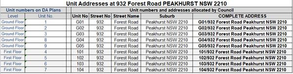
Details indicating compliance with this condition must be shown on
the plans lodged with any Construction Certificate for approval.
Prior
to the Commencement of Work (Including Demolition & Excavation)
33. Demolition
& Asbestos - The demolition work shall comply with the provisions of
Australian Standard AS2601:2001 - Demolition of Structures, NSW Work Health & Safety Act 2011 and the NSW Work Health & Safety Regulation 2011.
The work plans required by AS2601:2001 shall be accompanied by a written
statement by a suitably qualified person that the proposals contained in the
work plan comply with the safety requirements of the Standard. The work plans
and the safety statement shall be submitted to the Certifying Authority prior
to the commencement of works.
For demolition work which involves the removal of asbestos, the
asbestos removal work must be carried out by a licensed asbestos removalist who
is licensed to carry out the work in accordance with the NSW Work Health & Safety Act 2011 and the
NSW Work Health & Safety Regulation 2011
unless specified in the Act and/or Regulation that a license is not required.
All demolition work including the removal of asbestos, shall be
undertaken in accordance with the Demolition
Code of Practice (NSW Work Cover July 2015).
Note: Copies of the Act, Regulation and Code of Practice can be
downloaded free of charge from the SafeWork NSW website: www.SafeWork.nsw.gov.au.
34. Demolition
Notification Requirements - The following notification requirements apply
to this consent:
(a) The developer
/builder must notify adjoining residents five (5) working days prior to
demolition. Such notification is to be a clearly written note giving the
date demolition will commence, contact details of the developer/builder,
licensed asbestos demolisher and the appropriate regulatory authority.
Notification is to be placed in the letterbox of every premises (including
every residential flat or unit, if any) either side and immediately at the rear
of the demolition site.
(b) Five (5)
working days prior to demolition, the developer/builder is to provide written notification
to Council advising of the demolition date, details of the SafeWork licensed
asbestos demolisher and the list of residents advised of the demolition.
(c) On demolition
sites where buildings to be demolished contain asbestos, a standard commercially
manufactured sign containing the words “DANGER ASBESTOS REMOVAL IN
PROGRESS” measuring not less than 400mm x 300mm is to be erected in a
prominent visible position (from street frontage) on the site. The sign is to
be erected prior to demolition work commencing and is to remain in place until
such time as all asbestos material has been removed from the site to an
approved waste facility.
35. Demolition work
involving asbestos removal - Work involving bonded asbestos removal work
(of an area of more than 10 square metres) or friable asbestos removal work
must be undertaken by a person who carries on a business of such removal work
in accordance with a licence under clause 458 of the Work Health and Safety
Regulation 2011.
36. Dial before
your dig - The applicant shall contact “Dial Before You Dig on
1100” to obtain a Service Diagram prior to the commencement of
work. The sequence number obtained from “Dial Before You Dig”
shall be forwarded to the Certifying Authority and Council for their records.
37. Registered
Surveyors Report - During Development Work - A report must be submitted to
the Certifying Authority at each of the following applicable stages of
construction:
a) Set out
before commencing excavation.
b) Floor
slabs or foundation wall, before formwork or commencing brickwork.
c) Completion
of Foundation Walls - Before any construction of flooring, detailing the
location of the structure relative to adjacent boundaries and floor levels
relative to the datum shown on the approved plans.
d) Completion
of Floor Slab Formwork - Before pouring of concrete/walls construction,
detailing the location of the structure relative to adjacent boundaries and
floor levels relative to the datum shown on the approved plans. In
multi-storey buildings a further survey must be provided at each subsequent
storey.
f) Completion
of any Roof Framing - Before roof covered detailing eaves/gutter setback from
boundaries.
g) Completion
of all Work - Detailing the location of the structure (including eaves/gutters)
relative to adjacent boundaries and its height relative to the datum shown on
the approved plans. A final Check Survey must indicate the reduced level
of the main ridge.
Work
must not proceed beyond each stage until the Certifying Authority is satisfied
that the height and location of the building is proceeding in accordance with
the approved plans.
38. Utility
Arrangements - Arrangements are to be made with utility authorities in
respect to the services supplied by those authorities to the development. The cost
associated with the provision or adjustment of services within the road and
footway areas is to be at the applicant’s expense.
During
Construction
39. Contamination of land - Any new
information that comes to light during demolition or construction which has the
potential to alter previous conclusions about site contamination and remediation must be notified to Council and the accredited certifier and all works on site must cease
immediately.
A detailed site contamination investigation shall be carried out by
a certified contaminated land consultant in accordance with the requirements of
the relevant NSW EPA Guidelines approved under the Contaminated Land Management
Act 1997 including the EPA.
Guidelines for Consultants Reporting on contaminated sites and shall
certify the suitability of the site for the proposed development. A copy
of the detailed site contamination report must be submitted to Council for
review.
Should the detailed site contamination report find that
contamination makes the land unsuitable for the proposed development and
remediation is required, a Remedial Action Plan must be submitted to Council as
per required under State Environmental Planning Policy No 55 –
Remediation of Land.
Works associated with the development must not commence until such
time a validation report prepared by the certified contaminated land consultant
verifying that the land is suitable to be used for this development consent is
submitted to Council.
Should the recommendation in the detailed site contamination report
recommend monitoring of the site, then a monitoring program is to be submitted
to Council for assessment and approval prior to any recommencement of works.
40. Physical
connection of Stormwater to site - No work is
permitted to proceed above the ground floor slab level of the building until
there is physical connection of the approved stormwater drainage system from the land the subject of this
consent to Council's kerb inlet pit in Belmore Road.
41. Site sign -
Soil & Erosion Control Measures - Prior to the commencement of works
(including demolition and excavation), a durable site sign, issued by Council
in conjunction with this consent, must be erected in a prominent location on
site. The site sign warns of the penalties which apply to pollution, storing
materials on road or footpath and breaches of the conditions relating to
erosion and sediment controls. The sign must remain in a prominent location on
site up until the completion of all site and building works.
42. Hours of
construction for demolition and building work - Any work activity or
activity associated with the development consent that requires the use of any
tools (including hand tools) or any power operated plant and machinery that
creates noise on or adjacent to the site shall not be performed, or permitted
to be performed, except between the hours of 7.00 am to 5.00 pm, Monday to
Saturday inclusive. No work or ancillary activity is permitted on Sundays, or
Public Holidays.
Note: A penalty infringement notice may
be issued for any offence.
43. Ground levels
and retaining walls - The ground levels of the site shall not be excavated,
raised or filled, or retaining walls constructed on the allotment boundary,
except where indicated on approved plans or approved by Council.
44. Cost of work to
be borne by the applicant - The applicant shall bear the cost of all works
associated with the construction of the development that occurs on Council
property. Care must be taken to protect Council's roads, including the
made footway, kerbs, etc., and, where plant and vehicles enter the site, the
footway shall be protected against damage by deep-sectioned timber members laid
crosswise, held together by hoop iron straps and chamfered at their ends.
This construction shall be maintained in a state of good repair and condition
throughout the course of construction.
45. Obstruction of
Road or Footpath - The use of the road or footpath for the storage of any
building materials, waste materials, temporary toilets, waste or skip bins, or
any other matter is not permitted unless separately approved by Council under
Section 138 of the Roads Act 1993
and/or under Section 68 of the Local Government
Act 1993. Penalty infringement Notices may be issued for any
offences and severe penalties apply.
46. Damage within Road Reserve and Council Assets - The owner shall bear the cost of restoring any footpath, roadway
and any other Council assets damaged due to works at, near or associated with the site. This may
include works by Public Utility Authorities in the course of providing services
to the site.
47. Public Utility and Telecommunication Assets - The owner shall bear the cost of any relocation or modification
required to any Public Utility Authority assets including telecommunication
lines & cables and restoring any footpath, roadway and any other Council
assets damaged due to works at, near or associated with the site.
48. Waste
Management Facility - All materials removed from the site as a result of demolition, site clearing, site preparation
and, or excavation shall be disposed of at a suitable Waste Management
Facility. No vegetation, article, building material, waste or the like shall be
ignited or burnt.
Copies of all receipts for the disposal, or processing of all such
materials shall be submitted to the Certifying Authority.
Prior
to Occupation
49. Section 73
Compliance Certificate - A Section 73 Compliance
Certificate under the Sydney Water Act 1994
<http://legislation.nsw.gov.au/> must be submitted to the
Certifying Authority prior to Occupation.
50. Major
Development - Internal driveways and parking
spaces are to be adequately paved with concrete or bitumen, or interlocking
pavers to provide a dust-free surface. All car parking spaces are to be
line marked in accordance with AS1742, ‘Australian Standard Manual of
Uniform Traffic Control Devices’ and the relevant guidelines published by
the RMS.
51. Restriction to User and Positive Covenant for On-Site Detention
Facility - A Restriction on Use of the Land and
Positive Covenant shall be created and registered on the title of the property,
which places the responsibility for the maintenance of the on-site stormwater
management system on the owners of the land. The terms of the instrument
are to be in accordance with Council’s standard terms and restrictions
which are as follows;
Restrictions on Use of Land
The
registered proprietor shall not make or permit or suffer the making of any
alterations to any on-site stormwater management system which is, or shall be,
constructed on the lot(s) burdened without the prior consent in writing of
Georges River Council. The expression “on-site stormwater management
system” shall include all ancillary gutters, pipes, drains, walls, kerbs,
pits, grates, tanks, chambers, basins and surfaces designed to manage
stormwater quantity or quality including the temporary detention or permanent
retention of stormwater storages. Any on-site stormwater management system
constructed on the lot(s) burdened is hereafter referred to as “the
system.
Name
of Authority having the power to release, vary or modify the Restriction
referred to is Georges River Council.”
Positive Covenants
1.
The registered proprietor of the lot(s) hereby burdened will in respect of the
system:
a) keep the system clean and free from silt, rubbish
and debris
b) maintain and repair at the sole expense of the
registered proprietors the whole of the system so that if functions in a safe
and efficient manner
c) permit the Council or its authorised agents from
time to time and upon giving reasonable notice (but at any time and without
notice in the case of an emergency) to enter and inspect the land for the compliance
with the requirements of this covenant
d) comply with the terms of any written notice issued
by the Council in respect of the requirements of this covenant within the time
stated in the notice.
2. Pursuant to Section 88F(3) of the Conveyancing Act 1919 the
Council shall have the following additional powers:
a) in the event that the registered proprietor fails to comply
with the terms of any written notice issued by the Council as set out above the
Council or its authorised agents may enter the land with all necessary
materials and equipment and carry out any work which the Council in its
discretion considers reasonable to comply with the said notice referred to in
part 1(d) above
b) the Council may recover from the registered proprietor in a
Court of competent jurisdiction:
i. any expense reasonably incurred by it in exercising its powers
under subparagraph (i) hereof. Such expense shall include reasonable wages for
the Council’s employees engaged in effecting the work referred to in (i)
above, supervising and administering the said work together with costs,
reasonably estimated by the Council, for the use of materials, machinery, tools
and equipment in conjunction with the said work.
ii. legal costs on an indemnity basis for issue of the said notices
and recovery of the said costs and expenses together with the costs and
expenses of registration of a covenant charge pursuant to section 88F of the
Act or providing any certificate required pursuant to section 88G of the Act or
obtaining any injunction pursuant to section 88H of the Act. Name of Authority
having the power to release vary or modify the Positive Covenant referred to is
Georges River Council.
52. Maintenance Schedule – On-site Stormwater Management - A Maintenance Schedule for
the proposed on-site stormwater management measures is to be prepared and
submitted to Council. The Maintenance Schedule shall outline the required
maintenance works, how and when these will be done and who will be carrying out
these maintenance works.
53. Works as Executed and Certification of Stormwater works - Prior to the issue of an Occupation Certificate, the PCA must ensure that the stormwater drainage system has been
constructed in
accordance with
the
approved design and
relevant Australian Standards. A works-as-executed drainage
plan and certification must be forwarded to the PCA and Council, from a
professional engineer specialising in hydraulic engineering.
This Plan and Certification shall confirm that the
design and construction of the stormwater drainage system satisfies the
conditions of development consent and the Construction Certificate stormwater
design details approved by the PCA.
The works-as-executed drainage plan must be prepared by
a professional engineer specialising in hydraulic engineering in conjunction
with a Registered Surveyor and must include the following details:
(a) The
location of any detention basin/s with finished surface levels;
(b) Finished
site contours at 0.2 metre intervals
(c) Volume of
storage available in any detention areas;
(d) The
location, diameter, gradient and material (i.e. PVC, RC etc.) of all stormwater
pipes;
(e) The
orifice size/s;
54. Requirements prior to the issue of the Occupation Certificate - The following shall be completed and or submitted to the PCA prior
to the issue of the Occupation Certificate:
(a) All the stormwater/drainage works shall be completed in accordance
with the approved Construction Certificate plans prior to the issue of the
Occupation Certificate.
(b) The internal driveway construction works, together with the
provision for all services (conduits and pipes laid) shall be completed in
accordance with the approved Construction Certificate plans prior to the issue
of the Occupation Certificate.
(c) Construct any new vehicle crossings required.
(d) Replace all redundant vehicle crossing laybacks with kerb and
guttering, and replace redundant concrete with turf.
(e) A Section 73 (Sydney Water) Compliance Certificate for the
Subdivision shall be issued and submitted to the PCA prior to the issue of the
Occupation Certificate.
(f) Work as Executed Plans prepared by a Chartered Professional Engineer
or a Registered Surveyor when all the site engineering works are complete shall
be submitted to the PCA prior to the issue of the Occupation Certificate.
55. Vehicular crossing & Frontage work – Major development - The following road frontage works shall be constructed in accordance
with the specifications issued under the ‘Application for Driveway Crossing
and Associated Works on Council Road Reserve’ approval issued by
Council’s Assets and Infrastructure Division:
(a) Construct the driveway crossing in accordance with Council’s
specifications for vehicular crossings.
(b) Any existing vehicular crossing and/or laybacks which are redundant
must be removed. The kerb and gutter, any other footpath and turf areas shall
be restored at the expense of the applicant and in accordance with
Council’s Specification for Driveway Crossings and Associated Works.
A private contractor shall carry out the above work, at
the expense of the applicant and in accordance with Council’s
Specification for Driveway Crossings and Associated Works.
The driveway and road frontage works are to be completed
before the issue of the Occupation Certificate
.
56. Completion of Major Works - Prior to the issue of a Final Occupation Certificate, the following
works must be completed Stormwater pipes, pits and connections to public
stormwater systems within the
road related area;
(a) Driveways
and vehicular crossings within the road related area;
(b) Removal
of redundant driveways and vehicular crossings;
(c) Relocation/provision
of street signs
(d) New
or replacement street trees;
(e) New
or reinstated kerb and guttering within the road related area; and
Council’s Assets and Infrastructure Section must
advise in writing that the works have been completed to their satisfaction
prior to the issue of the Occupation Certificate. [Note: The damage deposit
paid to Council will not be released until the works have been completed to
Council’s satisfaction.
57. Stormwater drainage works – Works As Executed - Prior to the issue of the Occupation Certificate, stormwater drainage works are to be certified by a professional
engineer specialising in hydraulic engineering, with Works-As-Executed drawings
supplied to Council detailing:
(a) Compliance
with conditions of development consent relating to stormwater;
(b) The
structural adequacy of the On-Site Detention system (OSD);
(c) That
the works have been constructed in accordance with the approved design and will
provide the detention storage volume and attenuation in accordance with the
submitted calculations;
(d) Pipe
invert levels and surface levels to Australian Height Datum;
(e) Contours
indicating the direction in which water will flow over land should the capacity
of the pit be exceeded in a storm event exceeding design limits.
58. Fire Safety
Certificate before Occupation or Use - In accordance with Clause 153 of the
Environmental Planning and Assessment Regulation
2000, on completion of building works and prior to Occupation, the
owner must cause the issue of a Final Fire Safety Certificate in accordance
with Clause 170 of the aforesaid Regulation. The Fire Safety Certificate must
be in the form or to the effect of Clause 174 of the Environmental Planning and
Assessment Regulation, 2000. In addition, in relation to each essential fire or
other safety measure implemented in the building or on the land on which the
building is situated, such a Certificate is to state:
(a) That the
measure has been assessed by a person (chosen by the owner of the building) who
is properly qualified to do so.
(b) That as at
the date of the assessment the measure was found to be capable of functioning
at a standard not less than that required by the attached Schedule.
A copy of the certificate is to be given by the
applicant to the Commissioner of Fire & Rescue NSW and a further copy is to
be displayed in a frame and fixed to a wall inside the building's main
entrance.
59. Slip Resistance
- At completion of work an in-situ (on-site) test, in wet and dry conditions,
must be carried out on the pedestrian floor surfaces used in the foyers, public
corridors/hallways, stairs and ramps as well as the floor surfaces in wet rooms
in any commercial/retail/residential units to ascertain the actual slip
resistance of such surfaces taking into consideration the effects of grout, the
gradients of the surface and changes from one material to another. The
in-situ test must be carried out in accordance with AS/NZS 4663:2002. Proof of
compliance must be submitted with the application for the Occupation
Certificate for approval.
60. BASIX
Certificate - All energy efficiency measures as detailed in the approved
BASIX Certificate in the plans approved with the Development Consent, must be
implemented before Occupation.
61. Electricity
Supply - Evidence shall be provided demonstrating that the development has
been connected to the Ausgrid, if required.
62. BASIX
Compliance Certificate - A Compliance Certificate must be provided to the
Certifying Authority regarding the implementation of all energy efficiency
measures as detailed in the approved BASIX Certificate before Occupation.
63. Completion of
Landscape Works
a) All landscape works and the planting of eight (8) trees must be completed before the issue
of the Final Occupation Certificate and to the satisfaction of Councils Tree
Management Officers. In accordance with approved
landscape plans and specifications, drawn by Ray Fuggle and Associates, dated
20/5/20, Rev P1.
b) A certificate of compliance for the planting of all eight (8) trees
and shrubs proposed for the site. An AQF 5 Horticulturist shall be engaged and
in writing certify that all trees have been planted as per landscape plan and
specifications and forwarded to the PCA – Principal Certifying Authority.
Operational
Conditions (Ongoing)
64. Boarding House Operation - The following
restrictions apply to the approved development:
(a) The
development approved under this consent constitutes a ‘Boarding
House’ as defined under State Environmental Planning Policy (Affordable Rental
Housing) 2009 and
shall not be used for the purposes of permanent residential accommodation nor
hotel, motel, serviced apartments, private hotel, tourist accommodation or the
like.
(b) Not more than one lodger
shall occupy boarding rooms Nos. 1 to 9 (all rooms) which are to contain no
more than one bed.
(c) The total number of
lodgers residing in the boarding house at any one time shall not exceed nine
(9) lodgers.
(d) The lodgers must be
subject to an occupancy agreement for a term of no less than three months.
(e) The boarding house must always
be operated and managed in accordance with the provisions contained within the
Plan of Management dated June 2020.
(f) The use and
operation of the premises must comply with the requirements of Schedule 2
(Standards for Places of Shared Accommodation) of the Local Government (General) Regulation, 2005 under the Local Government Act 1993,
the Public Health Act, 2010
and Regulations thereunder.
(g) The operation of the
Boarding House shall be in accordance with the Boarding Houses Act 2012
at all times. This includes the registration of the Boarding House, as required
by the Act.
Subdivision
of the boarding house is not permitted in accordance with the provisions of the
State Environmental Planning Policy (Affordable Rental
Housing) 2009.
65. Noise Control
- The use of the premises must not give rise to the transmission of offensive
noise to any place of different occupancy. Offensive noise is defined in the Protection of the Environment Operations Act 1997
(as amended).
66. Outdoor Lighting - To avoid annoyance to the occupants of adjoining premises or glare to motorist on nearby roads,
outdoor lighting must comply with AS 4282-2019: Control of the
obtrusive effects of outdoor lighting.
67. Lighting -
General Nuisance - Any lighting on the site shall be designed so as not to
cause a nuisance to other residences in the area or to motorists on nearby
roads and to ensure no adverse impact on the amenity of the surrounding area by
light overspill or glare.
Flashing, moving or intermittent lights or signs are prohibited.
68. Activities and
storage of goods outside buildings - There shall be no activities including
storing or depositing of any goods or maintenance to any machinery external to
the building with the exception of waste receptacles.
69. Entering &
Exiting of vehicles - All vehicles shall enter and exit the premises in a
forward direction.
70. Annual Fire
Safety Statement - The owner of the building premises must ensure the
Council is given an annual fire safety statement in relation to each essential
fire safety measure implemented in the building. The annual fire safety
statement must be given:
(a) Within 12 months after
the date on which the fire safety certificate was received.
(b) Subsequent annual fire
safety statements are to be given within 12 months after the last such
statement was given.
(c) An annual fire safety
statement is to be given in or to the effect of Clause 181 of the Environmental
Planning and Assessment Regulation 2000.
(d) A copy of the statement
is to be given to the Commissioner of Fire & Rescue NSW, and a further copy
is to be prominently displayed in the building.
71. Maintenance of
Landscaping
a) All eight
(8) trees and plants forming part of the landscaping must be
maintained. Maintenance includes watering, weeding, removal
of rubbish from tree bases, fertilising, pest and disease control, replacement
of dead or dying plants and other operations required to maintain
healthy trees, plants and turfed areas.
Tree
Protection Measures
b) A final certificate of compliance letter, once all building and
landscape works have been completed, from the engaged AQF 5 Consulting
Arborist, that tree protection measures have been installed and maintained for
the entirety of the project and report on the condition of the trees that as
part of this Consent, were to be protected and retained.
Tree
plantings within subject site
c) A minimum of
8 x 45 litre size trees, which will attain a minimum mature height of nine (9)
metres, shall be planted within the property. The trees are to conform to
AS2303 – 2018, Tree stock for landscape use.
d) If the
planted eight (8) trees are found to be faulty, damaged, dying or dead within
twelve (12) months of planting then they must be replaced with the same
species. If the trees are found dead before they reach a height where they are
protected by Councils Tree Management Controls, they must be replaced with the
same species and pot/bag size.
e) A copy of
the Hurstville City Council’s Tree Removal and Pruning Guidelines and
Kogarah City Council, Street Tree Management Strategy, Masterplan, and Tree
Management Policy 2019, can be downloaded from Council’s website www.georgesriver.nsw.gov.au.
72. Amenity of the
neighbourhood - The implementation of this development shall not adversely
affect the amenity of the neighbourhood or interfere unreasonably with the
comfort or repose of a person who is outside the premises by reason of the
emission or discharge of noise, fumes, vapour, odour, steam, soot, dust, waste
water, waste products, grit, oil or other harmful products.
Prescribed
Conditions
Not Applicable
END CONDITIONS
NOTES/ADVICES____________________________________________________
73. Review of
Determination - Section 8.2 of the Environmental
Planning and Assessment Act confers on an applicant who is dissatisfied with
the determination of the application the right to lodge an application with
Council for a review of such determination. Any such review must however
be completed within 6 months from its determination. Should a review be
contemplated sufficient time should be allowed for Council to undertake public
notification and other processes involved in the review of the determination.
Note: Review provisions do not apply to Complying Development,
Designated Development, State Significant Development, Integrated Development
or any application determined by the Sydney South Planning Panel or the Land
& Environment Court.
74. Appeal Rights -
Part 8 (Reviews and appeals) of the Environmental Planning and Assessment
Act 1979 confers on an applicant who is dissatisfied with the determination of
the application a right of appeal to the Land and Environment Court of New
South Wales.
75. Lapsing of
Consent - This consent will lapse unless the development is physically
commenced within 5 years from the Date of Operation of this consent, in
accordance with Section 4.53 of the Environmental Planning and Assessment Act
1979 as amended.
76. Access to NSW
Legislations (Acts, Regulations and Planning Instruments) - NSW legislation
can be accessed free of charge at www.legislation.nsw.gov.au
77. Compliance with
Access, Mobility and AS4299 – Adaptable Housing - Should the Council
be appointment as the PCA, the Construction Certificate Application must be
accompanied by detailed working plans and a report or a Certificate of
Compliance from an Accredited Access Consultant certifying that the building
design and access to the adaptable units complies with Council’s DCP and
AS 4299 Adaptable Housing.
78. Council as PCA
- Compliance with the BCA - Should the Council be appointed as the
CERTIFYING AUTHORITY, the Construction Certificate Application must be
accompanied by the following details, with plans prepared and certified by an
appropriately qualified person demonstrating compliance with the BCA:
a) Mechanical air
handling, ventilation and car park exhaust system.
b) Essential fire
services and equipment including hydrant systems, hose reels, sprinklers,
mechanical air handling system, portable fire extinguishers, emergency lights,
exit signs, smoke hazard management and warning systems, etc.
c) Smoke hazard
management system and associated alarm system, stair pressurisation and fire
modelling etc.
d) Emergency lights,
exit signs and warning systems.
e) Energy efficiency
report demonstrating compliance with the BCA.
f) Protection of
wall openings that stand less than 3 metres from the boundary or fire source
feature.
g) Fire Separation and
Construction between Occupancies
h) Sound Transmission
& Insulation between Occupancies
i) A new Fire
Engineered Building Report prepared by an accredited fire engineer, confirming
that the existing alternative solution implemented in the building will not be
rendered ineffective by the proposed building alterations and fit-out works.
j) Floor plan of
the whole of the existing building with sufficient details to enable assessment
for compliance with the BCA.
79. Energy
Efficiency Provisions - Should Council be appointed as the CERTIFYING
AUTHORITY, a report prepared and endorsed by an Energy Efficiency Engineer or
other suitably qualified person must be submitted, detailing the measures that
must be implemented in the building to comply with Section J of the BCA. The
proposed measures and feature of the building that facilitate the efficient use
of energy must be identified and detailed on the architectural plans. At
completion of the building and before the issue of an Occupation Certificate, a
certificate certifying that the building has been erected to comply with the
energy efficiency provisions must be submitted to the Certifying Authority.
Energy efficiency provisions relate only to new building work or the
installation of new measure. Existing building fabric and measures may not be
upgraded.
80. Noise -
Noise related conditions - Council will generally enforce noise related
conditions in accordance with the Noise Guide for Local Government (http://www.environment.nsw.gov.au/noise/nglg.htm)
and the Industrial Noise Guidelines
(http://www.environment.nsw.gov.au/noise/industrial.htm)
publish by the Department of Environment and Conservation. Other state
government authorities also regulate the Protection of the Environment
Operations Act 1997.
Useful links relating to Noise:
(a) Community Justice Centres
- free mediation service provided by the NSW Government (www.cjc.nsw.gov.au).
(b) Department of Environment
and Conservation NSW, Noise Policy Section web page (www.environment.nsw.gov.au/noise).
(c) New South Wales
Government Legislation home page for access to all NSW legislation, including
the Protection of the Environment Operations Act 1997 and the Protection of the
Environment Noise Control Regulation 2000 (www.legislation.nsw.gov.au).
(d) Australian Acoustical
Society - professional society of noise-related professionals (www.acoustics.asn.au/index.php).
(e) Association of Australian
Acoustical Consultants - professional society of noise related professionals (www.aaac.org.au).
(f) Department of
Gaming and Racing - (www.dgr.nsw.gov.au).
81. Sydney Water
Section 73 Certificates - The Section 73 Certificate must be a separate
certificate that relates specifically to this development consent. For example,
if the development consent relates to the subdivision of the land, a Section 73
Certificate for the construction of the building that is subject to a different
development consent will not suffice.
82. Electricity
Supply - This development may need a connection to the Ausgrid network
which may require the network to be extended or its capacity augmented. You are
advised to contact Ausgrid on 13 13 65 or www.ausgrid.com.au (Business and
Commercial Services) for further details and information on lodging your
application to connect to the network.
83. Long Service
Levy - The Long Service Corporation administers a scheme which provides a
portable long service benefit for eligible workers in the building and
construction industry in NSW. All benefits and requirements are determined by
the Building and Construction Industry Long Service Payments Act 1986. More
information about the scheme and the levy amount you are required to pay to
satisfy a condition of your consent can be found at http://www.longservice.nsw.gov.au.
The required Long Service Levy payment can be direct to the Long
Service Corporation via their web site https://online.longservice.nsw.gov.au/bci/levy.
Payments can only be processed on-line for the full levy owing and where the
value of work is between $25,000 and $6,000,000. Payments will be accepted for
amounts up to $21,000, using either MasterCard or Visa.
84. Security
deposit administration & compliance fee - Under Section 97 (5) of the Local Government Act 1993, a security deposit
(or part) if repaid to the person who provided it is to be repaid with any
interest accrued on the deposit (or part) as a consequence of its investment.
Council must cover administration and other costs incurred in the
investment of these monies. The current charge is $50.00 plus 2% of the bond
amount per annum.
The interest rate applied to bonds is set at Council's business
banking facility rate as at 1 July each year. Council will accept a bank
guarantee in lieu of a deposit.
All interest earned on security deposits will be used to offset the
Security Deposit Administration and Compliance fee. Where interest earned on a
deposit is not sufficient to meet the fee, it will be accepted in full
satisfaction of the fee.
85. Stormwater
& Ancillary Works – Applications under Section 138 Roads Act
and/or Section 68 Local Government Act 1993
To apply for approval under Section 138 of the Roads Act 1993
and/or Section 68 Local Government Act 1993:
(a) Complete the
‘Stormwater Drainage Application Form’ which can be downloaded from
Georges River Council’s website at www.georgesriver.nsw.gov.au.
(b) In the
Application Form, quote the Development Consent No. (eg. DA2018/****) and
reference this condition number (e.g. Condition 23)
(c) Lodge the
application form, together with the associated fees at Council’s Customer
Service Centre, during business hours. Refer to Council’s adopted
Fees and Charges for the administrative and inspection charges associated with
stormwater applications.
The developer must meet all costs of the extension,
relocation or reconstruction of any part of Council’s drainage system
(including design drawings and easements) required to carry out the approved
development.
The preparation of all engineering drawings (site layout
plans, cross sections, longitudinal sections, elevation views together with a
hydraulic grade analysis) and specifications for the new storm water drainage
system to be arranged by the applicant. The design plans must be lodged
and approved by Council prior to the issue of a Construction Certificate.
NOTE: A minimum of four
weeks should be allowed for assessment.
86. Council as PCA
- Deemed to Satisfy Provisions of BCA - Should the Council be appointed as
the Certifying Authority in determining the Construction Certificate, the
building must comply with all the applicable deemed to satisfy provision of the
BCA. However, if an alternative fire solution is proposed it must comply
with the performance requirements of the BCA, in which case, the alternative
solution, prepared by an appropriately qualified fire consultant, accredited
and having specialist qualifications in fire engineering, must justifying the
non-compliances with a detailed report, suitable evidence and expert judgement.
Council will also require if deemed necessary, for the alternative solution to
undergo an independent peer review by either the CSIRO or other accredited
organisation. In these circumstances, the applicant must pay all costs
for the independent review.
87. Site Safety
Fencing - Site fencing must be erected in accordance with SafeWork
Guidelines, to exclude public access to the site throughout the demolition
and/or construction work, except in the case of alterations to an occupied
dwelling. The fencing must be erected before the commencement of any work and
maintained throughout any demolition and construction work.
A demolition licence and/or a high risk work license may be required
from SafeWork NSW (see www.SafeWork.nsw.gov.au).
ATTACHMENTS
|
Attachment ⇩1
|
Site Plan and Elevations - 932 Forest Rd
Peakhurst
|
|
Georges River Council - Georges River Local Planning Panel (LPP) -
Thursday, 10 December 2020
LPP066-20 932 Forest Road Peakhurst
[Appendix 1] Site
Plan and Elevations - 932 Forest Rd Peakhurst
|
Page 184
|
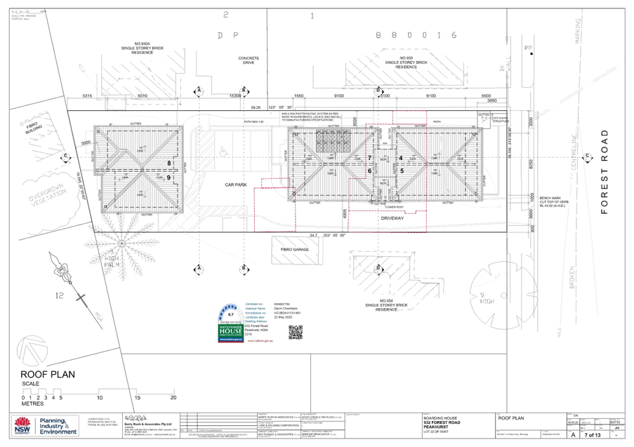

|
Georges River Council – Local
Planning Panel Thursday, 10 December 2020
|
Page 228
|
REPORT TO GEORGES RIVER
COUNCIL
LPP
MEETING OF Thursday,
10 December 2020
|
LPP Report No
|
LPP067-20
|
Development
Application No
|
DA2020/0353
|
|
Site Address
& Ward Locality
|
24 Salisbury
Street Penshurst
Mortdale Ward
|
|
Proposed
Development
|
Demolition of
existing structures, and construction of a two storey attached dual occupancy
with swimming pools, outbuildings and front fence
|
|
Owners
|
Mr Anthony John
Trainor, Mr Robert Colin Trainor, Mr Michael Stuart Trainor, Ms Kathryn Ann
Seller
|
|
Applicant
|
M Cubed Architects
|
|
Planner/Architect
|
M Cubed Architects
|
|
Date Of
Lodgement
|
4/09/2020
|
|
Submissions
|
No submissions
received
|
|
Cost of Works
|
$952,147.00
|
|
Local Planning
Panel Criteria
|
Conflict of
interest as the owner(s) are a relative to a Councillor
|
|
List of all
relevant s.4.15 matters (formerly s79C(1)(a))
|
State
Environmental Planning Policy No 55 - Remediation Of Land; State
Environmental Planning Policy (Building Sustainability Index: BASIX) 2004;
State Environmental Planning Policy (Infrastructure) 2007; State
Environmental Planning Policy (Vegetation in Non-Rural Areas) 2017;
Greater
Metropolitan Regional Environmental Plan No 2 – Georges River
Catchment; Draft Environment State Environmental Planning Policy; Draft
Remediation of Land SEPP; Draft Georges River Local Environmental Plan 2020;
Hurstville Local
Environmental Plan 2012; Hurstville Development Control Plan No 1 - LGA Wide.
|
|
List all
documents submitted with this report for the Panel’s consideration
|
Architectural
plans, Statement of Environmental Effects, BASIX Certificates, Arborist
Report, Survey Plan, Geotechnical Report, Cost Summary Report
|
|
Report prepared
by
|
Development
Assessment Planner
|
|
Recommendation
|
That the application be approved in
accordance with the conditions included in this report.
|
|
|
Summary of
matters for consideration under Section 4.15
Have all
recommendations in relation to relevant s4.15 matters been summarised in the
Executive Summary of the assessment report?
|
Yes
|
|
Legislative
clauses requiring consent authority satisfaction
Have relevant
clauses in all applicable environmental planning instruments where the
consent authority must be satisfied about a particular matter been listed and
relevant recommendations summarised, in the Executive Summary of the
assessment report?
|
Yes
|
|
Clause 4.6
Exceptions to development standards
If a written
request for a contravention to a development standard (clause 4.6 of the LEP)
has been received, has it been attached to the assessment report?
|
Not Applicable
|
|
Special
Infrastructure Contributions
Does the DA require
Special Infrastructure Contributions conditions (under s7.24)?
|
Not Applicable
|
|
Conditions
Have draft
conditions been provided to the applicant for comment?
|
No, the conditions can be reviewed when the report is published
|
|
Site Plan
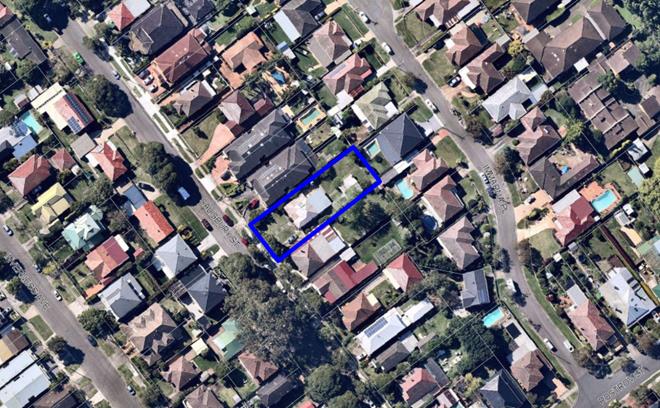
Figure 1: Aerial view of subject site
outlined in blue
|
EXECUTIVE SUMMARY
Proposal
1. The application seeks approval for the demolition of existing
structures and construction of an attached two (2) storey dual occupancy with
two (2) rear swimming pools, two (2) rear outbuildings and front fencing
including landscaping and engineering works at 24 Salisbury Street Penshurst.
Site and Locality
2. The subject site is a rectangular shaped allotment along the north
eastern side of Salisbury Street Penshurst. The site has a primary south western frontage of 17.59m to Salisbury Street, and side boundary lengths
of 51.5m and a site area of 897.9sqm.
3. The site
currently accommodates a single storey weatherboard and metal roofed dwelling,
a detached weatherboard garage at the rear accessed by a driveway along the
south eastern boundary, and a number of trees within the site and along the
Council landscape verge.
Zoning and
Permissibility
4. The site is zoned R2 – Low Density Residential and a
‘dual occupancy’ is listed as permissible with consent. The
proposed demolition works, swimming pools, outbuildings, and front fence are
considered ancillary to a ‘dual occupancy’ which is permitted with
consent.
Submissions
5. The application was notified to surrounding neighbours for a period
of fourteen (14) days between 21 September 2020 and 6 October 2020 in
accordance with the Hurstville Development Control Plan No. 1. No submissions
were received.
Conclusion
6. Having regard to the matters for consideration under section 4.15(1)
of the Environmental Planning and Assessment Act 1979 and following a detailed
assessment, the proposed Development Application (DA2020/0353) is recommended
for approval subject to the conditions referenced at the end of this report.
REPORT IN FULL
Proposal
7. Development
consent is sought for the demolition of existing
structures and construction of an attached two (2) storey dual occupancy with
two (2) swimming pools in the rear, two (2) rear outbuildings and front fence
including landscaping and engineering works at 24 Salisbury Street Penshurst
8. Further details of the proposed development are as follows:
Demolition:
· Demolition of existing structures being the existing weatherboard
house, rear detached weatherboard garage and W/C, onsite paving, internal
driveway and crossing and the removal of six (6) onsite trees.
Construction:
Construction
of an attached two (2) storey dual occupancy, a swimming pool and outbuilding
associated with each dwelling consisting of the following:
· Dwelling 1:
o Ground
floor: single garage, entry porch, lounge room with office space, guest room,
bathroom, dining and family area, kitchen, pantry and laundry room, rear
alfresco and swimming pool with dimensions 3.3m x 5.0m x 1.5m;
o First
floor: Two (2) bedrooms, bathroom, an additional bedroom with
ensuite, one (1) master bedroom with ensuite and walk-in-robe, rear void area
over ground floor living area;
o Detached
outbuilding consisting of a pool cabana, bathroom, and studio room.
· Dwelling 2:
o Ground
floor: single garage, entry porch, lounge room, guest room with ensuite and
lightwell, WC, dining, family, kitchen, pantry and laundry room, courtyard
along south-eastern boundary, rear alfresco and swimming pool with dimensions
2.5m x 7.0m x 1.5m;
o First
floor: Two (2) bedrooms, bathroom, an additional bedroom with
ensuite, one (1) master bedroom with ensuite and walk-in-robe, rear void area
over ground floor living area;
o Detached
outbuilding consisting of a pool cabana, bathroom, and studio room.
Ancillary Development:
· Construction of a 5.0m wide vehicular crossing onto Salisbury Road;
· Ancillary landscape and stormwater works;
· Construction of a 1.0m (maximum height) masonry front fence.
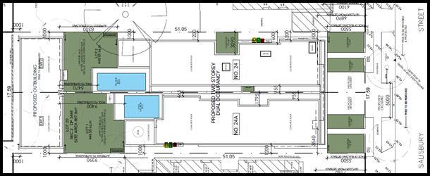
Figure 2: Proposed site plan (Source: M Cubed Architects
2020).
The Site and
Locality
9. The subject site
is formally identified as Lot 20, Section 2 in DP3446
and commonly known as 24 Salisbury Street Penshurst. The
subject site is a rectangular shaped allotment along the north eastern side of Salisbury Street Penshurst. The site has a
primary south western frontage of 17.59m to Salisbury
Street and side boundary lengths of 51.5m and a site
area of 897.9sqm. The site has a gradual fall to the street with a height
difference of approximately 2.0m.
10. Currently
the allotment accommodates a single storey weatherboard and metal roofed
dwelling, a detached weatherboard garage at the rear accessed by a driveway
along the south eastern boundary and a number of trees within the site and
along the Council landscape verge.
11. The
immediate area is dominated by residential uses containing a mix of one (1) and
two (2) storey residential developments. The area is generally residential in
character.
12. In the
wider context, the subject site is located approximately 200m north of Forest
Road and approximately 600m west of Penshurst Park.
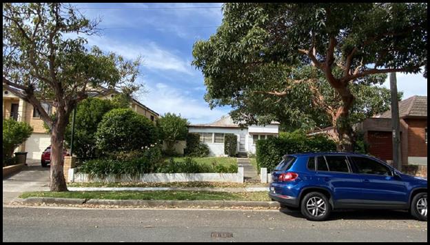
Figure 3: Street view of subject site from the assessing
officer’s inspection.
Background
13. There are no recent relevant
applications pertinent to the subject site.
14. The
current development application has been amended through Council’s
assessment of the application. The initial plans proposed for the removal of
one (1) of the Council street trees (Lophostemon confertus located
south). The proposed tree removal was not supported and amended plans were
submitted showing a reduced driveway width and an increased setback from the
subject tree.
Compliance and Assessment
15. The development site has been
inspected and assessed having regarding to the Matters for Consideration under
Section 4.15(1) of the Environmental Planning and Assessment Act 1979.
STATE ENVIRONMENTAL PLANNING INSTRUMENTS
16. Compliance with the relevant State
Environmental Planning Policies (SEPP) is detailed below.
|
State
Environmental Planning Policy
|
Complies
|
|
State Environmental Planning Policy No 55 - Remediation of Land
|
Yes
|
|
State Environmental Planning Policy (Building Sustainability
Index: BASIX) 2004
|
Yes
|
|
State Environmental Planning Policy (Vegetation in Non-Rural
Areas) 2017
|
Yes
|
|
Greater Metropolitan Regional Environmental Plan No 2 –
Georges River Catchment
|
Yes
|
|
State Environmental Planning Policy (Infrastructure) 2007
|
Yes
|
STATE ENVIRONMENTAL PLANNING POLICY NO 55 – REMEDIATION OF
LAND (SEPP 55)
17. SEPP 55 aims to promote the
remediation of contaminated land in order to reduce the risk of harm to human
health or any other aspect of the environment. Clause 7 requires contamination
and remediation to be considered in determining a development application. The
consent authority must not consent to the carrying out of development on land
unless it has considered whether or not the land is contaminated.
18. A review of the site history
indicates that the site has been used for residential purposes for extended
periods of time, and such uses and/or development are not typically associated
with activities that would result in the contamination of the site. The
proposed works do not include any change to the use of the land that would
result in any concerns with respect to contamination. There is no indication of
previous uses that would cause contamination. In this regard there is no
indication that the land is contaminated. The criterion of SEPP 55 has been
satisfied.
STATE
ENVIRONMENTAL PLANNING POLICY (BUILDING SUSTAINABILITY
INDEX: BASIX) 2004
19. The
trigger for BASIX Certification is when the estimated cost of works for
residential development (new dwelling(s)/alterations and additions) is equal to
or above $50,000. BASIX Certification is also triggered when proposing a
swimming pool with a volume of 40,000 litres or more.
20. Two BASIX
Certificates prepared by M Cubed Design, certificate numbers 1126119S_02 (dated
13 August 2020) and 1126130S (dated 12 August 2020) have been submitted with
the Development Application satisfying the minimum requirements of SEPP
(Building Sustainability Index: BASIX) 2004.
21. The amended architectural plans
did not require that the BASIX Certificates be amended.
STATE
ENVIRONMENTAL PLANNING POLICY (VEGETATION IN NON-RURAL AREAS) 2017
22. The Vegetation SEPP regulates
clearing of native vegetation on urban land and land zoned for environmental
conservation/management that does not require development consent.
23. The Vegetation SEPP applies to
clearing of:
(a) Native
vegetation above the Biodiversity Offset Scheme (BOS) threshold where a
proponent will require an approval from the Native Vegetation Panel established
under the Local Land Services Amendment Act 2016; and
(b) Vegetation
below the BOS threshold where a proponent will require a permit from Council if
that vegetation is identified in the council’s development control plan
(DCP).
24. The objectives of the SEPP are to
protect the biodiversity values of trees and other vegetation in non-rural
areas and preserve the amenity of non-rural areas through the preservation of
trees and other vegetation. This policy is applicable pursuant to Clause 5(1)
of the SEPP as the site is within both Georges River Council and the R2 Low
Density Residential zone.
25. Pursuant to Clause 8(1) of the
SEPP, clearing does not require authority under the policy as it is a type of
clearing that is authorised under Section 60O of the Local Land Services
Act 2013 (specifically, that associated with a development consent issued
under Part 4 of the Environmental Planning and Assessment Act 1979).
26. The proposal requires the removal
of six (6) on-site trees. The removed tree will require to be replaced as per
Council’s Tree Management Policy. The two (2) street trees are required
to be maintained and protected. Standard and specific tree and landscape
conditions have been recommended by Council’s consultant arborist and
have been referenced at the end of this report.
GREATER METROPOLITAN REGIONAL ENVIRONMENTAL PLAN NO 2 - GEORGES RIVER
CATCHMENT
27. The main aims and objectives of
this plan include but are not limited to the following:
· To maintain and improve the water quality and river flows of the
Georges River and its tributaries and ensure that development is managed in a
manner that is in keeping with the national, State, regional and local
significance of the Catchment,
· To protect and enhance the environmental quality of the Catchment
for the benefit of all users through the management and use of the resources in
the Catchment in an ecologically sustainable manner,
· To ensure consistency with local environmental plans and also in the
delivery of the principles of ecologically sustainable development in the
assessment of development within the Catchment where there is potential to
impact adversely on groundwater and on the water quality and river flows within
the Georges River or its tributaries,
· To establish a consistent and coordinated approach to environmental
planning and assessment for land along the Georges River and its tributaries
and to promote integrated catchment management policies and programs in the
planning and management of the Catchment,
28. The proposed stormwater drainage
system has been assessed by Council’s Development Engineer and has been
found to be satisfactory. Specific stormwater conditions have been imposed in
this regard.
Draft Environmental Planning Instruments
DRAFT ENVIRONMENTAL STATE
ENVIRONMENTAL PLANNING POLICY
29. The Draft
Environment SEPP was exhibited from 31 October 2017 to 31 January 2018. This
consolidated SEPP proposes to simplify the planning rules for a number of water
catchments, waterways, urban bushland and Willandra Lakes World Heritage
Property. Changes proposed include consolidating the following seven existing
SEPPs:
· State Environmental Planning Policy No. 19 – Bushland in Urban
Areas;
· State Environmental Planning Policy (Sydney Drinking Water
Catchment) 2011;
· State Environmental Planning Policy No. 50 – Canal Estate
Development;
· Greater Metropolitan Regional Environmental Plan No. 2 –
Georges River Catchment;
· Sydney Regional Environmental Plan No. 20 – Hawkesbury-Nepean
River (No.2-1997);
· Sydney Regional Environmental Plan (Sydney Harbour Catchment) 2005;
· Willandra Lakes Regional Environmental Plan No. 1 – World
Heritage Property.
30. The proposal is not inconsistent
with the provisions of this Draft Instrument.
DRAFT REMEDIATION OF LAND STATE ENVIRONMENTAL PLANNING POLICY
31. The Draft Remediation of Land SEPP was exhibited from 31 January 2018 to 13 April 2018. The proposed
remediation of land SEPP will:
· Provide a state-wide planning framework for the remediation of land;
· Maintain the objectives and reinforce those aspects of the existing
framework that have worked well;
· Require planning authorities to consider the potential for land to
be contaminated when determining development applications and rezoning land;
· Clearly list the remediation works that require development consent;
· Introduce certification and operational requirements for remediation
works that can be undertaken without development consent.
32. The proposal is not inconsistent with the provisions of this Draft Instrument as
there is no evidence this site is contaminated based on previous uses.
HURSTVILLE LOCAL
ENVIRONMENTAL PLAN 2012
33. The extent to which the proposed
development complies with the Hurstville Local Environmental Plan 2012 (HLEP
2012) is detailed and discussed in the table below.
34. The allotment is zoned R2 –
Low Density Residential Zone and ‘dual occupancy’ is a permitted
use with consent. It is noted that the proposed demolition works, and the
construction of swimming pools, outbuildings, and the front fence are
considered ancillary to the primary use of ‘dual occupancy’ and are
also a permitted form of development with consent.
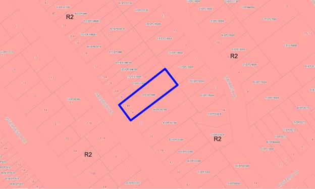
Figure 4: Zoning Map – site outlined in blue
|
Clause
|
Standard
|
Proposed
|
Complies
|
|
Part 1
Preliminary
|
|
1.2 – Aims
of the Plan
|
In accordance with
Clause 1.2 (2).
|
The development is
consistent with the aims of the plan.
|
Yes
|
|
1.4 –
Definitions
|
Dual occupancy means
a dual occupancy (attached) or a dual occupancy (detached).
dual occupancy
(attached) means 2 dwellings on one lot of land that are attached to each
other, but does not include a secondary dwelling.
|
The proposed
development is consistent with the dual occupancy definition.
|
Yes
|
|
Part 2 Permitted or prohibited development
|
|
2.3 – Zone
objectives and Land Use Table
|
Meets objectives
of R2- Low Density Residential Zone:
· To provide
for the housing needs of the community within a low density residential
environment.
· To enable
other land uses that provides facilities or services to meet the day to day
needs of residents.
· To encourage
development of sites for a range of housing types, where such development
does not compromise the amenity of the surrounding area, or the natural or
cultural heritage of the area.
· To ensure
that a high level of residential amenity is achieved and maintained.
· To encourage
greater visual amenity through maintaining and enhancing landscaping as a
major element in the residential environment.
· To provide
for a range of home business activities where such activities are not likely
to adversely affect the surrounding residential amenity.
|
The proposal
satisfies the objectives of the R2 zone and is permissible with development
consent.
|
Yes
|
|
Part 4
Principal development standards
|
|
4.1A – Minimum lot size for dual
occupancies and multi dwelling housing
|
Dual occupancy
– 630sqm if land identified as “G” on lot size map
|
897.9sqm
|
Yes
|
|
4.1B – Exception to minimum sizes for
dual occupancies
|
Subdivision may be
granted if there is a constructed dual occupancy and after the subdivision
there will only be 1 dwelling per lot
|
As there is no
lawfully erected dual occupancy on the land, development consent cannot be
granted for the subdivision of the land pursuant to this clause.
A condition of
consent is to be imposed excluding subdivision from this determination.
|
Yes
|
|
4.3 – Height
of Buildings
|
9m as identified
on Height of Buildings Map
|
Dwelling 1: 7.5m
Dwelling 2: 7.25m
Outbuildings:
Dwelling 1: 3.0m
Dwelling 2: 2.87m
|
Yes
|
|
4.4 – Floor space ratio
|
(2) The maximum floor space ratio for a building on any land is
not to exceed the floor space ratio shown for the land on the Floor Space
Ratio Map.
0.6:1 or 538.74sqm
|
0.59:1 or 531sqm
(includes rear
outbuilding enclosed studio and bathrooms)
|
Yes
|
|
Part 5
Miscellaneous provisions
|
|
5.10 –
Heritage conservation
|
(2) Requirement
for consent Development consent is required for any of the following—
(a)
demolishing or moving any of the following or altering the exterior of any of
the following (including, in the case of a building, making changes to its
detail, fabric, finish or appearance)—
(i) a heritage item,
(ii) an Aboriginal object,
(iii) a building, work, relic or tree within a
heritage conservation area,
|
Site has not been identified
as a heritage item nor located in a heritage conservation area as per the
HLEP 2012 Heritage Map.
|
Yes
|
|
Part 6
Additional local provisions
|
|
6.1 – Acid
sulfate soils
|
(2)
Development consent is required for the carrying out of works described in
the table to this subclause on land shown on the Acid Sulfate Soils Map as
being of the class specified for those works.
|
The site has not
been identified as located in an area containing Acid Sulfate soils as per
HLEP 2012 Acid Sulfate Soils Map.
|
Yes
|
|
6.7 –
Essential services
|
Development
consent must not be granted to development unless the consent authority is
satisfied that any of the following services that are essential for the
development are available or that adequate arrangements have been made to
make them available when required—
(a) the
supply of water, (b) the supply of electricity,
(c) the
disposal and management of sewage,
(d)
stormwater drainage or on-site conservation, (e) suitable road and
vehicular access.
|
All essential
services are available for the subject site.
|
Yes
|
DRAFT GEORGES RIVER LOCAL ENVIRONMENTAL PLAN 2020
35. Consideration
is given to the provisions of Draft Georges River Local Environmental Plan 2020
in the assessment this application.
36. In this regard, the
provisions have no determining weight as a result of proposed operation of
Clause “1.8A Savings provisions relating to development
applications” of the Draft Plan which provides “If a
development application has been made before the commencement of this Plan in
relation to land to which this Plan applies and the application has not been
finally determined before that commencement, the application must be determined
as if this Plan had not commenced.”
DEVELOPMENT CONTROL PLANS
37. The proposal has been assessed under the relevant sections of the
Hurstville Development Control Plan No.1 as follows.
|
DCP Control
|
Standard
|
Proposed
|
Complies
|
|
4.3 Dual
Occupancy
|
|
PC1 – Min. site area and frontage for
dual occupancy:
|
DS1.1. 630sqm for
land located outside of the FSPA
DS1.2. a. 15m for an attached dual occupancy
|
897.9sqm
17.59m
|
Yes
Yes
|
|
PC2 – Building height
|
DS2.1. Max. 6.8m
wall height
DS2.3. Existing
ground level is not excavated more than 600mm in accordance with the Exempt
and Complying provisions for on-site cut and fill for the finished ground
floor level.
|
Dwelling 1 - 6.95m
Dwelling 2 -
6.7m
No more than 600mm of excavation proposed (Excluding the pools)
|
Refer to comment
below
Yes
|
|
PC2 - Building
height
The maximum wall
height for dual occupancies under the Hurstville DCP No.1 is 6.8m pursuant to
control DS2.1. Dwelling 1 has a wall height of 6.95m, which represents a
0.15m departure from the requirement or 2.2% variation.
The subject site
has a crossfall from the south eastern boundary to the north western boundary
which results in a slight variation being observed along the lower side. The
dual occupancy as proposed is well below the 9.0m LEP height limit and
complies with the wall height along the lower side.
It is considered
that the exceeding wall height does not result in an unreasonable environment
impact, with the adjoining neighbour to the north west maintaining the
required 3 hours of direct sunlight between 12:00pm and 3:00pm midwinter.
Despite the numeric non-compliance of the wall height the relevant objectives
of PC2 in HDCP No.1 are achieved.
|
|
PC3 – Setbacks:
Front:
Side:
Rear:
|
DS3.1. 5.5m to the main face of the dwelling
DS3.5. The minimum
side setback outside the FSPA is 900mm (ground floor) and 1.2m (first floor).
DS3.9. A minimum
rear setback of 7m to the ground floor level solid wall must be provided.
DS3.10. A minimum
rear setback of 9m to the first floor level solid wall must be provided.
|
5.5m
Ground floor:
South eastern:
1.0m
North western:
1.0m
First floor:
South eastern:
1.2m
North western:
1.2m
In excess of 7.0m
In excess of 9.0m
|
Yes
Yes
Yes
Yes
Yes
|
|
PC3 – Solar Access
|
DS4.1. Development
allows for at least 3 hours of sunlight on the windows of main living areas
and adjoining principal private open space of adjacent dwellings between
9.00am and 3.00pm on 21 June
|
Proposed
development allows for at least 3 hours of sunlight on the windows of the
main living areas and adjoining principal private open space of adjacent
dwellings between 12:00pm and 3.00pm on 21 June.
|
Yes
|
|
PC5 – Visual Privacy
|
DS5.4. First floor
balconies located at the rear of dwellings must incorporate fin walls or
privacy screens on the side to prevent over-looking
|
No balconies are
proposed.
|
N/A
|
|
PC6 – Noise
|
DS6.1. Noise
generators such as plant and machinery including air conditioning units and
pool pumps are located away from windows or other openings of habitable
rooms, screened to reduce noise or acoustically enclosed.
|
Proposed pool
pumps are located away from adjoining neighbours.
The pool pump
located along the rear of Dwelling 1 will require acoustic treatment or be
setback at least 450mm from the shared boundary. A condition of consent will
be imposed in this regard.
|
Yes
|
|
PC7 – Vehicle access, parking and
manoeuvring
|
DS7.1. Each
dwelling is to provide one (1) garage and one (1) driveway space (unless
otherwise provided for in the building envelope).
DS7.2. Garages are
to be setback a minimum 5.5m from the front property alignment and recessed a
minimum 300mm into the facade of the building.
DS7.4. Driveways
are a minimum width of 3m wide and a maximum of 6m
|
One shared
driveway crossing leads to a single garage per dwelling with a hard stand
forward of the garage.
Dwelling 1: 6.1m
Dwelling 2: 6.1m
Both garages are
setback 600mm from the main building face.
Each internal
driveway is 3.0m wide, with the shared vehicular crossing being 5.0m. Prior
to the release of the subdivision certificate, the driveway leading to
Dwelling 1 will require a right of carriage way to be create to benefit
Dwelling 2 to facilitate lawful access to the garage of Dwelling 2.
|
Yes
Yes
Yes
|
|
PC9 – Streetscape character
|
DS9.1. Dual
occupancies are to address all street frontages.
DS9.4. The design
of the front of the dual occupancy development is to incorporate at least two
of the following design features:
a. entry feature
b. awnings,
louvers, shutters or other features over windows
c. balcony or
window box treatment to any first floor element
d. recessed or
projection of prominent architectural elements to visibly break up the facade
and avoid blank wall appearance
e. open verandahs
f. use of bay
windows or similar features along the façade
g. verandahs,
pergolas or similar features above garage doors
DS9.7. The maximum
roof pitch is 35 degrees.
|
Both occupancies
address Salisbury Street.
Both occupancies
incorporate an entry feature, and recessed and projected architectural
elements.
Flat roof proposed
|
Yes
Yes
Yes
|
|
PC11 – Balconies
|
DS11.1. The
maximum depth for a rear balcony on the first floor is 2m and it incorporates
fin walls or privacy screens to minimise overlooking into the rear yards of
other premises
|
No rear balconies
are proposed.
|
Yes
|
|
PC13 – Front fencing
|
DS13.1. Front
fences:
a. are a maximum
height of 1m.
|
1m
|
Yes
|
|
PC14 – Landscaped areas and private open
space
|
DS14.1. Where
located outside the FSPA, a minimum of 20% of site area is landscaped open
space.
DS14.5. The
minimum dimension of landscaped open space is 2m in any direction.
DS14.3. An area of
Principal Private Open Space is to be provided which:
a. is provided at
ground level
b. has a minimum
dimension of 4m x 5m
c. is not steeper
than 1 in 20
d. is directly
accessible from a main living area
e. may include a
covered patio area
|
Dwelling 1 and
2
21.6% or 194sqm
Yes
Dwelling 1 and
2
At ground level
Dwelling 1
In excess of 4.0m
x 5.0m
Dwelling 2:
In excess of 4.0m
x 5.0m
Dwelling 1 and
2
Not steeper than 1
in 20
Dwelling 1 and
2
Accessed from main
kitchen, dining and family area.
Dwelling 1and 2
Include an
alfresco area
|
Yes
Yes
Yes
Yes
Yes
Yes
Yes
Yes
|
|
PC15 – Stormwater
|
Stormwater
management is in accordance with the provisions contained in Section 4.4
Dwelling Houses on Standard Lots
|
Drainage by
gravity to Salisbury Street kerb and Council’s drainage system. The
application was referred to Council’s Development Engineer and specific
conditions have been imposed.
|
Yes
|
|
PC16 – Site utilities
|
DS16.2. Each
dwelling must provide adequate space for the storage of garbage and recycling
bins (a space of at least 3m by 1m must be provided).
DS16.4. Six (6)
cubic metres per dwelling is set aside exclusively for general storage. This
space may be provided as an extension of a carport or garage, or in the form
of an internal cupboard or attic
|
Space for storage
of bins has been provided for both dwellings.
Storage space for
both dwellings has been provided.
|
Yes
Yes
|
|
PC4 – Significant trees and vegetation
|
DS3.1 Site layout
and design, including buildings, structures and hardstand, ensures the long
term retention and health of existing significant trees and vegetation.
|
The proposed
removal of six (6) onsite trees has been assessed and supported by
Council’s Consultant Arborist. The two (2) street trees will be
retained and protected.
|
Yes
|
|
4.7
Outbuildings
|
|
PC2 – Building height
|
DS2.1. Maximum
height is 3m
|
3.0m
|
Yes
|
|
PC3 –
Setbacks
|
DS3.1. Minimum
setbacks for garages, gyms, cabanas and sheds are 900mm
|
1.0m from the side
and rear boundaries.
|
Yes
|
|
PC5 –
External finishes and claddings
|
DS5.1. External
finishes and claddings have low reflectivity
|
A condition will
be imposed requiring low reflectivity materials to be used.
|
Yes, by condition
|
|
5.6 Swimming
Pools & Spas
|
|
PC1 – Pool
Siting and Noise Control
|
DS1.1. In-ground
swimming pools shall be built so that the top of the swimming pool is as
close to the existing ground level as possible. On sloping sites this will
often mean excavation of the site on the high side to obtain the minimum out
of ground exposure of the swimming pool at the low side
DS1.5. Filling is
not permitted between the swimming pool and the property boundary.
DS1.7. Swimming
pools are to be constructed so that the top of the bond beam is as close to
ground level as possible.
DS1.10. The
swimming pool edge must be at least 1.5 metres from side and rear property
boundaries.
DS1.12. Council
may require mechanical equipment to be suitable acoustically treated so that
noise to adjoining properties is reduced.
DS1.14. Heated
swimming pools must utilise energy for heating from renewable energy sources,
such as solar heating, heat pumps and gas heating. Swimming pool covers
should be used when the swimming pool is not in use
|
The proposed in-ground
pools are located close to the existing ground level.
No filling
proposed between the pools and sire boundaries.
The proposed
in-ground pool of dwelling 2 is located 300mm-400mm below ground level along
its north eastern side mainly due to the cross fall observed.
In excess of 1.5m
from all boundaries (Except common wall).
The pool pump located along the
rear of Dwelling 1 will require acoustic treatment or be setback at least
450mm from the shared boundary. A condition of consent will be imposed in
this regard.
BASIX certificates
have been provided for the proposal.
|
Yes
Yes
Yes
Yes
Yes
Yes
|
|
PC2 –
Landscaping
|
DS2.1. Tree and
shrub planting is to be provided along the adjoining property boundary lines
to achieve a reasonable level of privacy. Refer to Appendix 1 for recommended
species to use.
|
New trees to be planted
as per the submitted landscape plan.
|
Yes
|
GEORGES RIVER DEVELOPMENT
CONTROL PLAN 2020 (INTERIM POLICY)
38. The Interim Policy is a supplementary document, meaning that the
current Development Control Plan controls continue to
apply if a particular control is not specified in the Interim Policy, or if it
is still considered best practice. All operative Development Control Plans
still legally apply. Whilst the Interim Policy has no statutory recognition in
the assessment of a Development Applications pursuant to the Environmental
Planning and Assessment Act 1979, the policy was used as a guide as it is an
endorsed position of the Council.
39. In relation to
the proposed dwelling house, the proposal does not conflict with the controls
of the Interim Policy Development Control Plan.
IMPACTS
Natural Environment
40. The development will not result in any significant adverse impacts on the natural
environment. As the proposal seeks to remove six (6) trees, the proposal was
referred to Council’s Consultant Arborist who supported the application
subject to specific landscape conditions.
Built Environment
41. The built form of the proposed
development is of a bulk and scale that is consistent with contemporary
dwelling houses in the locality. The dwelling proposes a flat roof which is not
inconsistent with recent developments in the locality
42. The
proposed works will result in an architectural style that is compatible with
the character of the area and consistent in scale with the surrounding
development. The materials proposed include painted render, cladding, stone
elements and glazed openings. The design incorporates both attractive and
functional architectural details which maintain outlook to living spaces whilst
maintaining privacy to neighbouring properties.
43. Shadow diagrams for the proposed development indicate shadow cast at
9am, 12 noon and 3pm on the winter solstice (21 June) demonstrate that
neighbouring properties will still receive the required solar access.
Social Impact
44. The
proposed development is of a scale and form that is consistent with modern
development which does not result in a negative social impact.
Economic Impact
45. The
proposal will result in a
short term positive economic stimulus due to the employment opportunities
created by the demolition and construction works.
Suitability of the Site
46. The
site is zoned R2 – Low Density Residential, and dwelling houses are a
permissible form of development. The proposal is considered to be a suitable
form of development in the subject R2 zone.
SUBMISSIONS, REFERRALS AND THE PUBLIC INTEREST
47. The application was notified to adjoining residents between
21 September 2020 and 6 October 2020, no submissions were
received in response to this notification.
REFERRALS
Council Referrals
Consultant Arborist
48. The application has been assessed
and endorsed by Council’s Consultant Arborist and relevant tree and
landscaping conditions have been recommended.
Development Engineering
49. The application has been assessed
and endorsed by Council’s Development Engineer. Stormwater related
conditions of consent have been imposed.
GIS
50. The application has been referred
to Council’s GIS team. Street numbering has been allocated for this
development.
External Referrals
Ausgrid
51. The
application was referred to Ausgrid as per Clause 45(2) of the State
Environmental Planning Policy (Infrastructure) 2007. A response was received stating that no objections raised
and no conditions recommended.
Local Infrastructure
Contributions
52. The
development is subject to Section 7.11 (former Section 94 Contribution)
contribution. In accordance with Council’s Section 94 Plan, Section 7.11
– Contribution towards provision or improvement of amenities or services
is applicable to residential developments.
53. In this case
the levied charge is $20,000.00 which is required to be paid in full prior to
the release of any Construction Certificate.
CONCLUSION
54. Development consent is sought for the demolition of existing
structures, and construction of an attached two (2) storey dual occupancy, two
(2) swimming pools, two (2) outbuildings at the rear, front fencing,
landscaping and engineering works at 24 Salisbury Street Penshurst.
55. The
proposal has been assessed in accordance with Section 4.15 (1) of the
Environmental Planning and Assessment Act, 1979. As discussed throughout this
report, the proposal satisfies the R2 Low Density zone objectives, in addition
to complying with the relevant State Environmental Planning Policies, Local
Environmental Plan and Development Control Plan. The application proposes a
minor variation with regards to the wall height which is considered acceptable
on merit.
56. The
proposal will not result in any unreasonable impact on the amenity of adjoining
properties subject to the conditions of consent recommended below.
57. The application is recommended for approval subject to
conditions.
DETERMINATION AND STATEMENT OF REASONS
Statement of Reasons
58.
· The proposal is an appropriate response to the
site and is consistent with the objectives of the R2 zone and existing
developments in the locality.
· The proposed development generally complies with
the requirements of the relevant environmental planning instruments and the
development control plan.
· The proposed development is well considered and
sensitively designed so that it will not result in any unreasonable impact on
the natural and built environment.
· The building will not unreasonably affect the amenity
of any immediately adjoining properties in terms of unreasonable overlooking,
overshadowing or view loss.
· The proposal is not inconsistent with the
provisions of Draft Georges River Local Environmental Plan 2020.
· The proposed development is a suitable and planned use of the site
and its approval is in the public interest.
Determination
59. THAT pursuant to Section 4.16(1)(a) of the Environmental Planning and Assessment
Act 1979 (as amended) Georges River Local Planning Panel grants consent to
DA2020/0353 for the demolition of existing structures, and construction of an
attached two (2) storey dual occupancy with two (2) swimming pools, two (2)
outbuildings to the rear, front fencing, landscaping and engineering works on
Lot 20, Section 2 in DP3446 and known as 24 Salisbury Street Penshurst, subject
to the following conditions:
Development Conditions
1. Approved Plans
- The development must be implemented in accordance with the approved plans and
supporting documentation listed below which have been endorsed by
Council’s approved stamp, except where marked up on the plans and/or
amended by conditions of this consent:
|
Description
|
Reference
No.
|
Date
|
Prepared by
|
|
Site Plan
|
2/20
|
29 October 2020
|
M Cubed
Architects
|
|
Ground Floor
Plan
|
3/20
|
29 October 2020
|
M Cubed
Architects
|
|
First Floor
Plan
|
4/20
|
29 October 2020
|
M Cubed
Architects
|
|
Roof Plan
|
5/20
|
29 October 2020
|
M Cubed Architects
|
|
South Western
and North Eastern Elevation plan
|
6/20
|
29 October 2020
|
M Cubed
Architects
|
|
DW1 South East
and North Western Elevations plan
|
7/20
|
29 October 2020
|
M Cubed
Architects
|
|
DW2 South East
and North Western Elevations plan
|
8/20
|
29 October 2020
|
M Cubed
Architects
|
|
Section Plan
|
9/20
|
29 October 2020
|
M Cubed
Architects
|
|
Pool Plans
|
10/20
|
29 October 2020
|
M Cubed
Architects
|
|
Excavation Plan
|
11/20
|
29 October 2020
|
M Cubed
Architects
|
|
Outbuilding
floor and roof plan
|
12/20
|
29 October 2020
|
M Cubed Architects
|
|
Outbuilding
Elevation and Section Plan
|
13/20
|
29 October 2020
|
M Cubed
Architects
|
|
Landscape Plans
|
Job 200257
sheets 1, 2 and 3
|
26 August 2020
|
Dapple Designs
|
|
Schedule of
Colours and Finishes
|
24 Salisbury
Street Penshurst
|
-
|
M Cubed
Architects
|
Separate
Approvals Required Under Other Legislation
2. Section 138
Roads Act 1993 and Section 68 Local Government Act 1993 - Unless otherwise
specified by a condition of this consent, this Development Consent does not
give any approval to undertake works on public infrastructure.
Separate approval is required under Section 138 of the Roads Act 1993 and/or Section 68 of the Local Government Act 1993 for any of the
following activities carried out in, on or over a public road (including the
footpath) listed below.
An application is required to be lodged and approved prior to the
commencement of any of the following works or activities;
(a) Placing or storing materials or
equipment;
(b) Placing or storing waste containers or
skip bins;
(c) Erecting a structure or carrying out
work
(d) Swinging or hoisting
goods over any part of a public road by means of a lift, crane or the like;
(e) Pumping concrete from a public road;
(f) Pumping water from the site into
the public road;
(g) Constructing a vehicular crossing or
footpath;
(h) Establishing a “works zone”;
(i) Digging up or
disturbing the surface of a public road (eg Opening the road for the purpose of
connections to utility providers);
(j) Stormwater and ancillary works in
the road reserve;
(k) Stormwater and ancillary to public
infrastructure on private land; and
(l) If any excavation
is to be supported by the use of below ground (cable) anchors that are
constructed under Council’s roadways/footways.
These separate activity approvals must be obtained and
evidence of the approval provided to the Certifying Authority prior to the
issue of the Construction Certificate.
The relevant Application Forms for these activities can
be downloaded from Council’s website www.georgesriver.nsw.gov.au.
For further information, please contact Council’s Customer Service Centre
on (02) 9330 6400.
3. Driveway
Crossing - Minor Development - Constructing a driveway crossing and/or
footpath requires a separate approval under Section 138 of the Roads Act
1993 prior to the commencement of those works.
To apply for approval, complete the “Application for Driveway
Crossing and Associated Works on Council Road Reserve” issued under
Section 138 Roads Act.” which can be downloaded from Georges River
Council’s Website at www.georgesriver.nsw.gov.au.
Lodge the application form, together with the associated fees at
Council’s Customer Service Centre, during business hours. Refer to
Section P1 and P2, in Council’s adopted Fees and Charges for the
administrative and inspection charges associated with Driveway Crossing
applications.
An approval for a new or modified driveway crossing will contain the
approved access and/or alignment levels which will be required to construct the
crossing and/or footpath. Once approved, all work shall be carried
out in accordance with Council’s specifications applicable at the time, prior
to the issue of an Occupation Certificate.
The design boundary level is to be received from Council prior to
construction of the internal driveway
4. Road Opening
Permit - A Road Opening Permit must be obtained from Council, in the case
of local or regional roads, or from the RMS, in the case of State roads, for
every opening of a public road reserve to access services including sewer,
stormwater drains, water mains, gas mains, and telecommunications before the
commencement of work in the road.
Requirements
of Concurrence, Integrated & Other Government Authorities
5. Sydney Water -
Tap in TM - The approved plans must be submitted to a Sydney
Water Tap inTM to determine whether the development application will
affect Sydney Water’s sewer and water mains, stormwater drains and/or
easements, and if further requirements need to be met. The approved plans
will be appropriately endorsed. For details please refer to
‘Plumbing, building and developing’ section of Sydney Water’s
web site at www.sydneywater.com.au then
see ‘Building’, or telephone 13000 TAP IN (1300 082 746). The
Certifying Authority must ensure that a Tap inTM agent has
appropriately stamped the plans prior to the issue of the Construction
Certificate.
·
6. Notice of
Requirements for a Section 73 Certificate - A Notice of Requirements of
what will eventually be required when issuing a Section 73 Compliance
Certificate under the Sydney Water Act 1994
<http://legislation.nsw.gov.au/> must be obtained from Sydney
Water Corporation. Application must be made through an authorised Water
Servicing Co-ordinator. Please refer to the ‘Plumbing, building and
developing’ section of the web site www.sydneywater.com.au
<http://www.sydneywater.com.au> then refer to
‘Providers’ under ‘Developing’ or telephone 13 20 92
for assistance.
Following application, a ‘Notice of Requirements’ will
advise of water and sewer infrastructure to be built and charges to be paid.
Please make early contact with the Co-ordinator, as it can take some time to
build water/sewer pipes and this may impact on other services and building,
driveway or landscape design.
The Notice of requirements must be submitted prior to the
commencement of work. A Section 73 Compliance Certificate will be required at
the completion of development in accordance with further conditions.
Prior
to the Issue of a Construction Certificate
7. Low
reflectivity roof - Roofing materials must be low glare and reflectivity.
Details of finished external materials including colours and texture must be
provided to the Certifying Authority.
8. Stormwater
System - Silt Arrestor- A Silt Arrestor Pit must be located inside the
property just upstream of the point of discharge from the site for both
dwellings. This pit must have minimum dimensions of 450mm x 450mm and shall
have a 150mm deep sump and galvanised mesh screen permanently fixed over the
outlet pipe or pipes. A minimum of 4 x 30mm diameter seepage holes shall be
provided in the pit base. For drainage into the surrounding soil, the pit base
shall be constructed on a layer of 200mm thick aggregate base wrapped in
geotextile fabric. All non-plastic drainage pits must be benched and
streamlined.
9. Stormwater System
- Gravity to the Kerb and Gutter- All stormwater shall drain by gravity to
Council's kerb and gutter directly in front of the development site in
accordance with the Australian/New Zealand Standard AS/NZS 3500.3: 2015 (as
amended).
10. Pre-Construction Dilapidation
Report - Private Land - A professional engineer specialising in structural
or geotechnical engineering shall prepare a Pre-Construction Dilapidation
Report detailing the current structural condition of adjoining premises
including but not limited to:
(a) All adjoining and neighbouring
buildings likely to be affected by the excavation as determined by the
consulting engineer.
The
report shall be prepared at the expense of the applicant and submitted to the
satisfaction of the Certifying Authority prior to the issue of the Construction
Certificate.
A
copy of the pre-construction dilapidation report is to be provided to the
adjoining properties (subject of the dilapidation report), a minimum of 5
working days prior to the commencement of work. Evidence confirming that a copy
of the pre-construction dilapidation report was delivered to the adjoining
properties must be provided to the PCA.
Should
the owners of properties (or their agents) refuse access to carry out
inspections, after being given reasonable written notice, this shall be
reported to Council to obtain Council’s agreement to complete the report
without access. Reasonable notice is a request for access in no sooner than 14
days between 8.00am-6.00pm.
11. Geotechnical report - The applicant
must submit a Geotechnical Report, prepared by a professional and suitably
qualified engineer specialising in geotechnical engineering who holds the
relevant accreditation (if applicable) in relation to dilapidation reports, all
site works and construction. This is to be submitted before the issue of the
Construction Certificate and is to include:
(a) Investigations certifying
the stability of the site and specifying the design constraints to be placed on
the foundation, any earthworks/stabilization works and any excavations.
(b) Dilapidation Reports on
the adjoining properties including, but not limited to (address) and (address)
prior to any excavation of site works. The Dilapidation Report is to
include assessments on, but not limited to, the dwellings at those addresses
and any external paths, grounds etc. This must be submitted to the PCA
and the adjoining residents as part of the application for the Construction
Certificate. Adjoining residents are to be provided with the report five
(5) working days prior to any works on the site.
(c) On-site guidance by a
vibration specialist during the early part of excavation.
(d) Measures to minimise
vibration damage and loss of support to other buildings. Where possible any excavation
into rock is to be carried out with tools such as rock saws which reduce
vibration to adjoining buildings and associated structures. Where a hydraulic
hammer is to be used within 30 metres of any building (other than a path or a
fence) the report shall detail the maximum size of hammer to be used and
provide all reasonable recommendations to manage impacts.
(e) Sides of the excavation
are to be piered prior to any excavation occurring to reinforce the walls of
the excavation to prevent any subsidence to the required setbacks and
neighbouring sites.
12. Vehicular
Access Grades- The applicant must
submit a profile (longitudinal section) demonstrating access clearance by the
B85 Design Vehicle (85% percentile vehicle in accordance with AS2890.1 2004)”
for the entry.
This profile (scale 1:20) is to show levels and grades
from road centreline to the proposed internal garage floor level including but
not limited to levels of, road centreline, changes of grade on road surface,
lip of gutter, invert of gutter, back of vehicular crossing(gutter layback),
front of path, back of path and boundary. The profiles provided are to also
include the natural surface of the land as well as the proposed design
including cut and fill dimensions.
Additional profiles are to be provided on either side of
driveway when longitudinal grade of road exceeds 8%.
The profile will be used to assess suitability of
proposed internal driveway levels and does not represent final footpath or road
levels. The levels on Councils road related area including boundary level will
be verified following the submission of an “Application for Driveway
Crossing and Associated Works on Council Road Reserve” issued under
Section 138 Roads Act.
13. On-site
Stormwater Detention (OSD) - The submitted Concept Stormwater and OSD Plan
prepared by Elite Australia Engineering with job reference number 20034
revision C dated 09/11/2020 has been assessed as a concept plan only. Final
detailed plans of the drainage system, prepared by a professional engineer
specialising in hydraulic engineering, shall be submitted for approval with the
Construction Certificate.
The following amendments must be made to
the Approved Concept Stormwater Plans:
a) The OSD volume for the
site must be increased to minimum 22.6 cubic metres (each tank being a minimum
11.3 cubic metres).
b) The rainwater tanks for
each dwelling must be maintained to be a minimum of 2500L each.
c) The discharge grates
for the OSD tanks must be outside of the garages and have minimum dimensions of
600mm x 900mm.
d) Sealed access pit lids
must be provided within the garages at the opposite corner of the OSD tanks
from the discharge grate to facilitate maintenance access.
e) All gutters, downpipes,
and stormwater line upstream of the OSD tanks must be sized to cater for the
1%AEP event.
An OSD facility designed by a professional engineer who
specialises in Hydraulic engineering must be designed, approved and installed.
The required OSD storage requirements and permissible
discharge are to be calculated in accordance with Table 3 of Council’s
Stormwater Management Policy.
A minimum 22.6 cubic metre OSD volume (11.3 cubic metres
per dwelling) with a maximum design discharge of 13.65 litres per second (6.85
litres per second per dwelling) is to be provided in accordance with the
Stormwater Concept Plan and Council’s Stormwater Management Policy.
The OSD facility shall be designed to meet all
legislated safety requirements and child proof safety fencing around the
facility must be provided where the OSD facility is open or above ground when
the design peak storage depth is greater than 300mm. A durable metal plate or
similar sign is to be placed at the OSD facility and must bear the words:
"BEWARE: This is an on-site detention basin/tank
for rainwater which could overflow during heavy storms."
Full details shall accompany the application for the
Construction Certificate.
14. Fees to be
Paid - The fees listed in the table below must be paid in accordance with
the conditions of this consent and Council’s adopted Fees and Charges
applicable at the time of payment (available at www.georgesriver.nsw.gov.au).
Payments must be made prior to the
issue of the Construction Certificate or prior to the commencement of work (if
there is no associated Construction Certificate).
Please contact Council prior to the payment of Section
7.11 Contributions to determine whether the amounts have been indexed from that
indicated below in this consent and the form of payment that will be accepted
by Council.
Council will only accept Bank Cheque
or Electronic Funds Transfer (EFT) for transaction values of $500,000 or over.
Council must be contacted prior to payment to determine correct total amount to
be paid and bank account details (if applicable).
A summary of the fees to be paid are
listed below:
|
Fee Type
|
Fee
|
|
GENERAL FEES
|
|
Long Service Levy (to Long Service
Corporation) Or, provide evidence of Payment direct to the Long Service
Corporation. See https://portal.longservice.nsw.gov.au/bci/levy/
|
|
Builders Damage Deposit
|
$1,900.00
|
|
Inspection Fee for Refund of Damage Deposit
|
$155.00
|
|
DEVELOPMENT CONTRIBUTIONS
|
|
Hurstville Section 94 Development
Contributions Plan 2012 - Residential (Community Facilities)
|
$2,478.00
|
|
Hurstville Section 94 Development Contributions
Plan 2012 - Residential (Open Space, Recreation, Public Domain)
|
$17,522.00
|
|
Total S7.11 Contributions
|
$20,000.00
|
General Fees
The fees and charges above are
subject to change and are as set out in the version of Council's Schedule of
Fees and Charges or as required by other Government Authorities, applicable at
the time of payment.
Development Contributions
The Section 7.11 contribution is imposed to ensure that
the development makes adequate provision for the demand it generates for public
amenities and public services within the area.
Indexation
The above contributions will be
adjusted at the time of payment to reflect changes in the cost of delivering
public amenities and public services, in accordance with the indices provided
by the relevant Section 94 Development Contributions Plan.
Timing of Payment
The contribution must be paid and
receipted by Council prior to the release of the
Construction Certificate.
Further Information
A copy of the all current
Development Contributions Plans may be inspected or a copy purchased at
Council’s offices (Georges River Civic Centre, MacMahon Street,
Hurstville and Kogarah Library and Service Centre, Kogarah Town Square,
Belgrave Street, Kogarah) or viewed on Council’s website www.georgesriver.nsw.gov.au.
15. Damage Deposit - Minor Works
- In order to insure against damage to Council property the following is
required:
(a) Pay Council, before the
issue of the Construction Certificate, a damage deposit for the cost of making
good any damage caused to any Council property as a result of the development: $1,900.00
(b) Pay Council, before the
issue of the Construction Certificate, a non-refundable inspection fee to
enable assessment of any damage and repairs where required: $155.00
(c) Submit to Council, before
the commencement of work, a photographic record of the condition of the Council
nature strip, footpath and driveway crossing, or any area likely to be affected
by the proposal.
At the completion of work Council will inspect the
public works, and the damage deposit will be refunded in full upon completion
of work where no damage occurs. Otherwise the amount will be either forfeited
or partly refunded according to the amount of damage.
16. Site Management Plan - A
Site Management Plan detailing all weather access control points, sedimentation
controls, fencing, builder’s site sheds office, amenities, materials
storage and unloading arrangements must be submitted with the application for
the Construction Certificate.
17. Required
Design Changes - The following changes are required
to be made and shown on the Construction Certificate plans:
(a) Pool pump of Dwelling 1 is to setback at least 450mm
from the shared common wall or be acoustically treated so as to not produce a sound level exceeding 5 dB(A) above the ambient
background level at the closest neighbouring boundary (being the adjoining
Dwelling 2) between the hours of 8:00am and 10:00pm on Saturdays, Sundays
and Public Holidays and between the hours of 7:00am and 10:00pm on any other
day.
If
the pool pump is to be setback as per the above, it can be relocated to any
other part of the rear yard as long as it is setback 450mm from all boundaries
(including shared boundary with Dwelling 2).
18. BASIX Commitments - All
energy efficiency measures as detailed in the BASIX Certificates No.
1126119S_02 (dated 13 August 2020) and 1126130S (dated 12 August 2020) must be implemented
on the plans lodged with the application for the Construction Certificate.
19. Erosion & Sedimentation
Control - Erosion and sediment controls must be provided to ensure:
(a) Compliance with the
approved Erosion & Sediment Control Plan
(b) Removal or disturbance of
vegetation and top soil is confined to within 3m of the approved building area
(no trees to be removed without approval)
(c) All clean water runoff is
diverted around cleared or exposed areas
(d) Silt fences, stabilised
entry/exit points or other devices are installed to prevent sediment from
entering drainage systems or waterways
(e) All erosion and sediment
controls are fully maintained for the duration of demolition, excavation and/or
development works
(f) Controls are put into
place to prevent tracking of sediment by vehicles onto adjoining roadway
(g) All disturbed areas are
rendered erosion-resistant by turfing, mulching, paving or similar
(h) Compliance with Managing Urban Stormwater - Soils and Construction (Blue
Book) produced by Landcom 2004.
These measures are to be implemented prior to the
commencement of work (including demolition and excavation) and must remain
until works are completed and all exposed surfaces are landscaped/sealed.
20. Stormwater System - The
submitted stormwater plan has been assessed as a concept plan only. Final
detailed plans of the drainage system, prepared by a professional engineer
specialising in hydraulic engineering, shall be submitted for approval with the
Construction Certificate.
(a) All stormwater shall be drained
in accordance with the Australian/New Zealand Standard AS/NZS 3500.3: 2015 (as
amended).
(b) Stormwater drainage plans
including pipe sizes, type, grade, length, invert levels, dimensions and types
of drainage pits prepared by a professional engineer who specialises in
Hydraulic Engineering in accordance with the Australian Institute of Engineers
Australian Rainfall and Runoff (1987) and Council's Stormwater Drainage
Guidelines, shall accompany the application for the Construction Certificate.
21. Compliance with Swimming Pool Act 1992 -
The alterations and additions to the dwelling house
and/or the construction of the new dwelling house subject of this consent must
not generate any non-compliances with the Swimming Pools Act 1992, Swimming
Pool Regulation 2008, Building Code of Australia and/or AS 1926.1-2007 -
Swimming Pool Safety. Details of compliance to be illustrated on the
plans lodged with the application for the Construction Certificate.
22. Stormwater Drainage Plan
Details - Stormwater drainage plans including pipe sizes, type, grade,
length, invert levels, dimensions and types of drainage pits prepared by a
professional engineering specialising in hydraulic engineering shall be
submitted with the Construction Certificate application.
These plans shall be prepared in accordance with
the Australian Institute of Engineers Australian Rainfall and Runoff (1987) and
Council's Hurstville Development Control Plan 1 which includes Appendix 2.
23. Structural details -
Engineer's details prepared by a practising Structural Engineer being used to
construct all reinforced concrete work, structural beams, columns and other
structural members. The details are to be submitted to the Principal Certifying
Authority for approval prior to construction of the specified works.
A copy shall be forwarded to Council where Council is not the PCA.
24. Swimming Pools - Use and
Maintenance - The following apply to the construction, use and maintenance
of swimming pools and spas:
(a) no ground level may be
raised or filled except where shown specifically on the approved plans;
(b) all pool/spa waste water
is to be discharged to the sewer according to the requirements of Sydney Water;
(c) the swimming pool must
not be used for commercial or professional purposes;
(d) drain paved areas to the
landscaped areas or a suitable lawful drainage system; and
(e) arrange any external
pool/spa lighting to minimise glare nuisance to adjoining owners.
25. Traffic Management - Compliance
with AS2890 - All driveways, access ramps, vehicular crossings and car
parking spaces shall be designed and constructed in accordance with the current
version of Australian Standards, AS 2890.1 (for car parking facilities) and AS
2890.2 (for commercial vehicle facilities).
26. Waste Management Plan - A
Waste Management Plan incorporating all requirements in respect of the
provision of waste storage facilities, removal of all materials from the site
that are the result of site clearing, extraction, and, or demolition works and
the designated Waste Management Facility shall be submitted to the Certifying
Authority prior to the issue of any Construction Certificate.
27. Landscape Plan - All
landscape works shall be carried out in accordance with the approved landscape
plans and specifications, drawn by Dapple Designs, Ref
No
LP01, SHEETS 1 - 3 and dated 26/08/20. The landscaping shall be maintained in
accordance with the approved plans in perpetuity, subject to the following
–
(a) In accordance with Georges River
Tree Management Policy 2019, a 2:1 Policy is to be implemented. For every one
(1) tree to be removed, two (2) trees shall be planted on the subject site to
compensate for the loss of each tree.
(b) The two (2) Council street
trees must be retained and protected.
(c) For the removal of six (6)
trees over 3m in height, an additional twelve (12) trees must be planted with,
six (6) in each dwellings site, be of Australian native Spp and be selected
from Georges River Councils, Tree Management Plan, Appendix 1 - Tree Planting.
The tree/s shall be a minimum 45 litre pot/ bag size and be able to reach a
height at maturity of nine (9) metres.
(d) All twelve (12) trees
proposed forming part of this consent, shall comply with AS 2303 - 2018, Tree
Stock for Landscape use and NATSPEC Specifying Trees: a guide to assessment of
tree quality (2003), and be planted and maintained in accordance with Councils
standard specification;
(e) If the planted twelve (12)
trees and plants are found to be faulty, damaged, dying or dead within twelve
(12) months of planting then they must be replaced with the same species. If
the trees are found dead before they reach a height where they are protected by
Councils Tree Management Controls, they must be replaced with the same species
and pot/bag size;
28. Tree Protection and Retention - The
following trees shall be retained and protected.
The revised plans by M Cubed Architects must be
used for the purposes of the new driveway entrance configuration;
- Site
Plan, dated 29 October (2/20)
- Ground
Drainage Plan, Dwg No SW01, Rev C, Dated 9/11/20
|
Tree Species
|
Location of Tree / Tree No.
|
Tree Protection Zone (metres) TPZ as per
AS4970 -2009
|
|
Lophostemon confertus
|
Council’s street tree - south
|
7 metres radially out from its trunk.
|
|
Lophostemon confertus
|
Council’s street tree - north
|
4.5 metres radially out from its trunk
|
|
Liquidambar styraciflua
|
Neighbours tree, rear yard of 22 Salisbury St
|
7.3 metres
|
|
Murraya paniculata
|
Within front yard of 26 Salisbury St
|
3.0 metres radially out from its trunk
|
|
Syzygium Spp
|
Within front yard of 26 Salisbury St
|
2.0 metres radially out from its trunk
|
(a) The
client must engage a qualified Arborist who holds an AQF Level 5 or above in
Arboriculture and who is a current practicing and financial member of an
Arboricultural Association or Affiliation, with a letter of engagement
forwarded to the nominated PCA.
(b) A
certificate of compliance letter from the AQF 5 Arborist must be forwarded to
the PCA - Principal Certifying Authority, at three (3) stages being, before
works, during works and once all building works have been completed, that tree
protection measures have been installed and being maintained during the building
process.
Tree Protection Measures
(c) The
proposed driveway excavations close to Councils street tree must be under the
guidance of the engaged AQF 5 Arborist to oversee excavations no closer than
two (2) metres from Councils street tree.
(d) All
excavations within the TPZ of Councils street trees for the purposes of the
driveway must be conducted using ‘Air spade” or Hydro Vac”
type of non-destructive excavations. No machinery excavator/ bucket type of
machinery is permitted.
(e) The
excavations for the purposes of building, footings and stormwater piping within
the TPZ of 7.3 metres of the neighbours Liquidambar styraciflua must be
completed by non-destructive methods of excavation such as “Air
spade” or “Hydro Vac” with findings and photographs tabled by
the engaged AQF 5 Arborist and forwarded to the nominated PCA, to verify that
the impacts by this proposal will not jeopardise the viability or ongoing
retention of the neighbours tree, if compliant prior to the issue of an
Occupation Certificate.
(f) All
trees on Council property, subject site and adjacent sites, to be retained must
be protected before site set up and maintained during demolition, excavation
and construction of the site.
(g) The
excavations for the purposes of stormwater exiting the site for No 24 and
within the TPZ of Councils street trees must be completed by non-destructive
methods of excavation such as “Air spade” or “Hydro
Vac” with findings and photographs tabled by the engaged AQF 5 Arborist
and forwarded to the nominated PCA, to verify that the impacts by the
stormwater installations will not jeopardise the viability or ongoing retention
of the neighbours tree, if compliant prior to the issue of an Occupation
Certificate.
(h) Although
trees may be on adjacent sites, the tree protection fencing must be placed on
the nominated distances as per table above, out from the trees trunk, within
the subject site to minimise impacts to neighbours trees and kept for the
entirety of the project.
(i) The
tree protection measures must be in undertaken in accordance AS4970 -2009
Protection of trees on development sites.
(j) Details
of the tree protection measures to be implemented must be provided with the
application for a Construction Certificate by a qualified Arborist who holds an
AQF Level 5 or above in Arboriculture and who is a current practicing and
financial member of an Arboricultural Association or Affiliation.
(k) The
engaged AQF 5 Consulting Project Arborist must be present on-site during the
stages of site set up, excavation, demolition and construction when works are
being undertaken that could impact on the tree canopy or root zone within the
tree protection zone of each tree.
(l) In
accordance with AS 4970-2009 Protection of trees on development sites, a
protective fence consisting of 2.4 x 1.8 metres high, fully supported chainmesh
fence shall be used. The distance of the fence out from the base of each tree
is to be in accordance with the TPZ listed in the table above. A layer of
organic mulch 100 millimetres thick shall be placed over the protected area and
no soil or fill should be placed within the protection area.
(m) The
tree protection fencing must be kept in place during demolition, excavation and
construction and also have a sign displaying ‘Tree Protection Zone - DO
NOT ENTER’ attached to the fence and must also include the name and
contact details of the Project Arborist.
(n) To
preserve the Councils street tree and protection from machinery, no work shall
commence until the Tree Protection Zone has been protected with 100mm of
organic mulch laid, timber sleepers at 200mm x 100mm laid over the top and
secured with metal framing bands as per AS4970-2009, clause 4.5.3 Ground
protection under the guidance of the engaged AQF 5 Arborist.
(o) The
Tree Protection Zone of each tree, to be protected, shall be watered thoroughly
and regularly to minimise the effects of construction works.
(p) No
building products, preparation of building products, storage of materials,
stockpiling, site sheds or services shall be installed within the TPZ of the
trees to be retained.
Excavation works near tree to be
retained
(q) Excavations
around the trees to be retained on site, adjoining properties, and Councils
trees shall be supervised by the AQF 5 Project Arborist to ensure that the root
system will not adversely be affected, for compliance.
(r) Where
the Tree Protection Zone (TPZ) of trees on site or adjoining sites become
compromised by any excavation works, the AQF 5 Project arborist shall be
consulted to establish the position of any major roots and determine the
necessary measures to protect these roots. The recommendations of the Arborist
shall be submitted to Council prior to any further demolition or
construction works taking place.
(s) Tree
Protection Zones around the trees to be retained are not to have soil level
changes, building product / materials stored or services installed in this
area. Any structures proposed to be built in this area of the trees are to
utilise pier and beam or cantilevered slab construction.
29. Tree Removal & Replacement - Tree
removal - In accordance with Georges River Tree
Management Policy 2019, a 2:1 Policy is to be implemented. For every one (1)
tree to be removed, two (2) trees shall be planted on the subject site to
compensate for the loss of each tree, with exempt Species replacement being
1:1.
Permission is granted for the removal of the
following trees:
|
Tree Species
|
Number of trees
|
Location
|
|
Cupaniopsis anacardioides
|
X1
|
Rear yard of site
|
|
Magnolia grandiflora
|
X1
|
Rear yard of site
|
|
Prunus Spp
|
X2
|
Side of dwelling, north
|
|
Camellia japonica
|
X1
|
Within site, front north west
corner
|
|
Lagerstroemia indica
|
X1
|
Within site, front side fence
|
General Tree Removal
Requirements
(a) All
tree removal shall be carried out by a minimum certificate Level 3, Licenced
and insured Tree Surgeon/Arborist to ensure that removal is undertaken in a
safe manner and complies with the AS 4373-2007 - Pruning of Amenity Trees and
Tree Works Industry Code of Practice (Work Cover NSW 1.8.98).
(b) No
trees are to be removed on the site or neighbouring properties without the
prior written approval of Council.
|
Summary
|
|
Number of trees removed from site
|
X6
|
|
Number of trees required as per
offset scheme (2:1 ratio)
|
X12
|
|
Number of trees that must be
planted within the site and signed off by the engaged AQF 5 Horticulturist.
|
X12
|
30. Allocation
of street addresses - In order to comply with
AS/NZS 4819:2011 Rural and Urban Addressing & the NSW Addressing User
Manual (Geographical Names Board of NSW) and Georges River Council’s
requirements, the street addresses for the subject development must be
allocated as follows:
|
Description on DA plan
|
Location within development
|
Proposed street address to comply with AS/NZS 4819:2011 and
NSW Addressing Manual
|
|
Proposed DW1
|
North western lot
|
24A Salisbury Street, Penshurst NSW 2222
|
|
Proposed DW2
|
South eastern lot
|
24 Salisbury Street, Penshurst NSW 2222
|
Details indicating compliance with this condition must
be shown on the plans lodged with any Construction Certificate for approval.
Prior
to the Commencement of Work (Including Demolition & Excavation)
31. Demolition & Asbestos -
The demolition work shall comply with the provisions of Australian Standard
AS2601:2001 - Demolition of Structures, NSW Work
Health & Safety Act 2011 and the NSW Work
Health & Safety Regulation 2011. The work plans required
by AS2601:2001 shall be accompanied by a written statement by a suitably
qualified person that the proposals contained in the work plan comply with the
safety requirements of the Standard. The work plans and the safety statement
shall be submitted to the PCA prior to the commencement of works.
For demolition work which involves the removal of asbestos, the
asbestos removal work must be carried out by a licensed asbestos removalist who
is licensed to carry out the work in accordance with the NSW Work Health & Safety Act 2011 and the
NSW Work Health & Safety Regulation 2011
unless specified in the Act and/or Regulation that a license is not required.
All demolition work including the removal of asbestos, shall be
undertaken in accordance with the Demolition
Code of Practice (NSW Work Cover July 2015).
Note: Copies of the Act, Regulation and Code of Practice can be
downloaded free of charge from the SafeWork NSW website: www.SafeWork.nsw.gov.au.
32. Demolition Notification
Requirements - The following notification requirements apply to this
consent:
(a) The developer /builder
must notify adjoining residents five (5) working days prior to
demolition. Such notification is to be a clearly written note giving the
date demolition will commence, contact details of the developer/builder,
licensed asbestos demolisher and the appropriate regulatory authority.
Notification is to be placed in the letterbox of every premises (including
every residential flat or unit, if any) either side and immediately at the rear
of the demolition site.
(b) Five (5) working days
prior to demolition, the developer/builder is to provide written notification
to Council advising of the demolition date, details of the SafeWork licensed
asbestos demolisher and the list of residents advised of the demolition.
(c) On demolition sites where
buildings to be demolished contain asbestos, a standard commercially
manufactured sign containing the words “DANGER ASBESTOS REMOVAL IN
PROGRESS” measuring not less than 400mm x 300mm is to be erected in a
prominent visible position (from street frontage) on the site. The sign is to
be erected prior to demolition work commencing and is to remain in place until
such time as all asbestos material has been removed from the site to an
approved waste facility.
33. Demolition work involving
asbestos removal - Work involving bonded asbestos removal work (of an area
of more than 10 square metres) or friable asbestos removal work must be
undertaken by a person who carries on a business of such removal work in
accordance with a licence under clause 458 of the Work
Health and Safety Regulation 2011.
34. Dial before your dig - The
applicant shall contact “Dial Before You Dig on 1100” to obtain a
Service Diagram prior to the issuing of the Construction Certificate. The
sequence number obtained from “Dial Before You Dig” shall be
forwarded to the Principal Certifying Authority (PCA) and Council for their
records.
35. Registered Surveyors Report -
During Development Work - A report must be submitted to the PCA at each of
the following applicable stages of construction:
(a) Set out before commencing
excavation.
(b) Floor slabs or foundation
wall, before formwork or commencing brickwork.
(c) Completion of Foundation
Walls - Before any construction of flooring, detailing the location of the structure
relative to adjacent boundaries and floor levels relative to the datum shown on
the approved plans.
(d) Completion of Floor Slab
Formwork - Before pouring of concrete/walls construction, detailing the
location of the structure relative to adjacent boundaries and floor levels
relative to the datum shown on the approved plans. In multi-storey
buildings a further survey must be provided at each subsequent storey.
(e) Completion of any Pool
Formwork - Before concreting of pool shell, detailing the location of the pool
relative to the adjacent boundaries and its height relative to the datum shown
on the approved plans.
(f) Completion of any
Roof Framing - Before roof covered detailing eaves/gutter setback from
boundaries.
(g) Completion of all Work -
Detailing the location of the structure (including eaves/gutters) relative to
adjacent boundaries and its height relative to the datum shown on the approved
plans. A final Check Survey must indicate the reduced level of the main
ridge.
Work must not proceed beyond each stage until the PCA is
satisfied that the height and location of the building is proceeding in
accordance with the approved plans.
36. Utility Arrangements -
Arrangements are to be made with utility authorities in respect to the services
supplied by those authorities to the development. The cost associated with the
provision or adjustment of services within the road and footway areas is to be
at the applicant’s expense.
During
Construction
37. Site sign - Soil & Erosion
Control Measures - Prior to the commencement of works (including demolition
and excavation), a durable site sign, issued by Council in conjunction with
this consent, must be erected in a prominent location on site. The site sign
warns of the penalties which apply to pollution, storing materials on road or
footpath and breaches of the conditions relating to erosion and sediment
controls. The sign must remain in a prominent location on site up until the
completion of all site and building works.
38. Hours of construction for
demolition and building work - Any work activity or activity associated
with the development consent that requires the use of any tools (including hand
tools) or any power operated plant and machinery that creates noise on or
adjacent to the site shall not be performed, or permitted to be performed,
except between the hours of 7.00 am to 5.00 pm, Monday to Saturday inclusive.
No work or ancillary activity is permitted on Sundays, or Public Holidays.
Note: A penalty infringement notice may be issued for any offence.
39. Swimming Pools - Filling with
water - The pool/spa shall not filled until the safety fences have been
completed in accordance with the approved plans and specifications and
inspected by the PCA.
40. Ground levels and retaining
walls - The ground levels of the site shall not be excavated, raised or
filled, or retaining walls constructed on the allotment boundary, except where
indicated on approved plans or approved by Council.
41. Cost of work to be borne by the
applicant - The applicant shall bear the cost of all works associated with
the construction of the development that occurs on Council property. Care
must be taken to protect Council's roads, including the made footway, kerbs,
etc., and, where plant and vehicles enter the site, the footway shall be
protected against damage by deep-sectioned timber members laid crosswise, held
together by hoop iron straps and chamfered at their ends. This
construction shall be maintained in a state of good repair and condition throughout
the course of construction.
42. Obstruction of Road or Footpath
- The use of the road or footpath for the storage of any building materials,
waste materials, temporary toilets, waste or skip bins, or any other matter is
not permitted unless separately approved by Council under Section 138 of the Roads Act 1993 and/or under Section 68 of the Local Government Act 1993. Penalty
infringement Notices may be issued for any offences and severe penalties apply.
43. Waste Management Facility -
All materials removed from the site as a result of demolition, site clearing,
site preparation and, or excavation shall be disposed of at a suitable Waste
Management Facility. No vegetation, article, building material, waste or the
like shall be ignited or burnt.
Copies of all receipts for the disposal, or processing of all such
materials shall be submitted to the PCA and Council, where Council is not the
Principal Certifying Authority.
44. Tree Removal on Private Land
- The trees identified as ‘to be removed/pruned’ on the approved
plans or by conditions of this consent shall be removed in accordance with
AS4373-2007 and the Amenity Tree Industry Code of Practice (SafeWork NSW,
August 1998).
45. Excavation works near tree to
be retained - Excavation around the tree/s to be retained on site or the
adjoining properties shall be supervised by the Project Arborist to ensure that
the root system will not be adversely affected.
Where the Tree Protection Zone of trees on site or adjoining sites
become compromised by any excavation works, the Project Arborist shall be
consulted to establish the position of any major roots and determine the
necessary measures to protect these roots. The recommendations of the Arborist
shall be submitted to Council prior to any further demolition or construction
works taking place.
Prior
to the issue of the Occupation Certificate
46. Restriction to User and
Positive Covenant for On-Site Detention Facility - A Restriction on Use of
the Land and Positive Covenant shall be created and registered on the title of
the property, which places the responsibility for the maintenance of the
on-site stormwater management system on the owners of the land. The terms
of the instrument are to be in accordance with Council’s standard terms
and restrictions which are as follows;
Restrictions on Use of Land
The registered proprietor shall not make or permit or
suffer the making of any alterations to any on-site stormwater management
system which is, or shall be, constructed on the lot(s) burdened without the
prior consent in writing of Georges River Council. The expression
“on-site stormwater management system” shall include all ancillary
gutters, pipes, drains, walls, kerbs, pits, grates, tanks, chambers, basins and
surfaces designed to manage stormwater quantity or quality including the
temporary detention or permanent retention of stormwater storages. Any on-site
stormwater management system constructed on the lot(s) burdened is hereafter
referred to as “the system”.
Name of Authority having the power to release, vary or
modify the Restriction referred to is Georges River Council.
Positive Covenants
1. The registered proprietor of the lot(s) hereby
burdened will in respect of the system:
a) keep
the system clean and free from silt, rubbish and debris
b) maintain
and repair at the sole expense of the registered proprietors the whole of the
system so that if functions in a safe and efficient manner
c) permit the Council or its authorised agents from
time to time and upon giving reasonable notice (but at any time and without
notice in the case of an emergency) to enter and inspect the land for the
compliance with the requirements of this covenant
d) comply
with the terms of any written notice issued by the Council in respect of the
requirements of this covenant within the time stated in the notice.
2. Pursuant to Section 88F(3) of
the Conveyancing Act 1919 the Council shall have the following additional
powers:
a) in
the event that the registered proprietor fails to comply with the terms of any
written notice issued by the Council as set out above the Council or its
authorised agents may enter the land with all necessary materials and equipment
and carry out any work which the Council in its discretion considers reasonable
to comply with the said notice referred to in part 1(d) above
b) the
Council may recover from the registered proprietor in a Court of competent
jurisdiction:
ii. any expense reasonably
incurred by it in exercising its powers under subparagraph (i) hereof. Such
expense shall include reasonable wages for the Council’s employees
engaged in effecting the work referred to in (i) above, supervising and
administering the said work together with costs, reasonably estimated by the
Council, for the use of materials, machinery, tools and equipment in
conjunction with the said work.
iii. legal costs on an indemnity
basis for issue of the said notices and recovery of the said costs and expenses
together with the costs and expenses of registration of a covenant charge
pursuant to section 88F of the Act or providing any certificate required
pursuant to section 88G of the Act or obtaining any injunction pursuant to
section 88H of the Act. Name of Authority having the power to release vary or
modify the Positive Covenant referred to is Georges River Council.
47. Maintenance Schedule - On-site
Stormwater Management - A Maintenance Schedule for the proposed on-site
stormwater management measures is to be prepared and submitted to Council. The
Maintenance Schedule shall outline the required maintenance works, how and when
these will be done and who will be carrying out these maintenance works.
48. Section 73 Compliance
Certificate - A Section 73 Compliance Certificate under the Sydney Water Act 1994 <http://legislation.nsw.gov.au/>
must be submitted to the PCA prior to the issue of the
Occupation/Subdivision Certificate.
49. Requirements prior to the issue
of the Occupation Certificate - Driveways Works - The following shall be
completed and or submitted to the PCA prior to the issue of the Occupation
Certificate:
(a) Construction if new vehicle
crossings as required by this consent.
(b) Replacement of all redundant
vehicle crossing laybacks with kerb and guttering, and replacement of redundant
concrete with turf.
50. Requirements prior to the issue
of the Occupation Certificate - Stormwater and Onsite Detention Works- The
following shall be completed and or submitted to the PCA prior to the issue of
the Occupation Certificate:
(a) All the stormwater/drainage works shall be
completed in accordance with the approved Construction Certificate plans prior
to the issue of the Occupation Certificate.
(b) Work as Executed Plans prepared by a Chartered
Professional Engineer or a Registered Surveyor when all the site engineering
works are complete shall be submitted to the PCA prior to the issue of the
Occupation Certificate.
51. Stormwater drainage works -
Works As Executed - Prior to the issue of the Occupation Certificate, storm
water drainage works are to be certified by a professional engineer
specialising in hydraulic engineering, with Works-As-Executed drawings supplied
to Council detailing:
(a) Compliance with conditions of
development consent relating to stormwater;
(b) The structural adequacy of the
On-Site Detention system (OSD);
(c) That the works have been
constructed in accordance with the approved design and will provide the
detention storage volume and attenuation in accordance with the submitted
calculations;
(d) Pipe invert levels and surface
levels to Australian Height Datum;
(e) Contours indicating the
direction in which water will flow over land should the capacity of the pit be
exceeded in a storm event exceeding design limits.
Council must advise in writing that they are satisfied
with the Works-As-Executed prior to the issue of an Occupation Certificate.
52. BASIX Compliance Certificate
- A Compliance Certificate must be provided to the PCA regarding the
implementation of all energy efficiency measures as detailed in the approved
BASIX Certificate before any Occupation Certificate is issued.
53. Completion of Landscape Works
- All landscape works and the planting of twelve (12)
trees must be completed before the issue of the Final Occupation Certificate
and to the satisfaction of Councils Tree Management Officers. A certificate of
compliance for the planting of all twelve (12) trees and shrubs proposed for
the site. An AQF 5 Horticulturist shall be engaged and in writing certify that
all trees have been planted as per landscape plan and specifications and
forwarded to the Principal Certifying Authority (PCA).
Tree
Protection Measures
(a) A
final certificate of compliance letter, once all building and landscape works
have been completed, from the engaged AQF 5 Consulting Arborist, that tree
protection measures have been installed and maintained for the entirety of the
project and report on the condition of the trees that as part of this Consent,
were to be protected and retained.
(b) The
excavations within the TPZ of 7.3 metres of the neighbours Liquidambar
styraciflua must be completed by non-destructive methods of excavation such
as “Air spade” or “Hydro Vac” with findings and
photographs tabled by the engaged AQF 5 Arborist and forwarded to the nominated
PCA, to verify and sign off for compliance prior to Occupation Certificate,
that the impacts by this proposal will not jeopardise the viability or ongoing
retention of the neighbours tree.
Tree Replacement within subject
site
(c) A
minimum of 12 x 45 litre size trees, which will attain a minimum mature height
of nine (9) metres, shall be planted within the property. The trees are to
conform to AS2303 - 2018, Tree stock for landscape use.
(d) Tree
species selected shall be from Georges River Councils Tree Management Policy,
April 2019, Appendix 1 - Tree Planting.
(e) If
the replacement trees are found to be faulty, damaged, dying or dead within
twelve (12) months of planting then they must be replaced with the same
species. If the trees are found dead before they reach a height where they are
protected by Councils Tree Management Controls, they must be replaced with the
same species and pot/bag size.
(f) A
copy of the Hurstville City Council’s Tree Removal and Pruning Guidelines
and Kogarah City Council, Street Tree Management Strategy, Masterplan, and Tree
Management Policy 2019, can be downloaded from Council’s website www.georgesriver.nsw.gov.au..
54. Vehicular crossing - Minor
development - The vehicular crossing and/or footpath works shall be
constructed by a private contractor at the expense of the applicant, in
accordance with the ‘Application for Driveway Crossing and Associated
Works on Council Road Reserve’ approval issued by Council’s Assets
and Infrastructure Division.
Any existing vehicular crossing and/or laybacks which are redundant
must be removed. The kerb and gutter, any other footpath and turf areas shall
be restored at the expense of the applicant and in accordance with
Council’s Specification for Vehicular Crossings and Associated Works.
NOTE: No stencilled or coloured
concrete may be used outside the boundary of the property.
The work must be completed before the issue of an Occupation
Certificate.
55. Notice to Council - Allocation
of street addresses - Prior to the issue of any Occupation Certificate,
‘as-built’ drawings detailing the installed and allocated
street/unit address and numbering must be submitted to the satisfaction of
Council.
Operational
Conditions (Ongoing)
56. Noise Control - The use of
the premises must not give rise to the transmission of offensive noise to any
place of different occupancy. Offensive noise is defined in the Protection of the Environment Operations Act 1997
(as amended).
57. Swimming Pools - Resuscitation
Notice - An expired air resuscitation warning notice complying with the Swimming Pools Act 1992 must be affixed in a
prominent position adjacent to the pool.
58. Private Swimming Pools &
Spas - Pump Noise - The swimming pool/spa pump and associated equipment must
be located so that the noise emitted does not exceed 5dB(A) above the
background level. If this cannot be achieved, a ventilated and sound-proofed
enclosure must enclose the pump to achieve the required noise levels.
Swimming pool is to be installed with a timer that
limits the recirculation and filtration systems operation such that it does not
emit noise that can be heard within a habitable room in any other residential
premises (regardless of whether any door or window to that room is open):
(a) before 8 am or after 8 pm
on any Sunday or public holiday, or
(b) before 7 am or after 8 pm
on any other day.
59. Maintenance of Landscaping
- All twelve (12) trees and plants forming part of the landscaping must be maintained. Maintenance includes
watering, weeding, removal of rubbish from tree bases, fertilising, pest and
disease control, replacement of dead or dying plants and other
operations required to maintain healthy trees, plants and turfed areas.
60. Outdoor Lighting - To avoid
annoyance to the occupants of adjoining premises or glare to motorist on nearby
roads, outdoor lighting must comply with AS 4282-1997: Control of the obtrusive
effects of outdoor lighting.
61. Amenity of the neighbourhood
- The implementation of this development shall not adversely affect the amenity
of the neighbourhood or interfere unreasonably with the comfort or repose of a
person who is outside the premises by reason of the emission or discharge of
noise, fumes, vapour, odour, steam, soot, dust, waste water, waste products,
grit, oil or other harmful products.
Operational
Requirements Under the Environmental Planning & Assessment Act 1979
62. Requirement for a Construction
Certificate - The erection of a building must not commence until a
Construction Certificate has been issued.
63. Appointment of a PCA - The
erection of a building must not commence until the applicant has:
(a) appointed a PCA for the
building work; and
(b) if relevant, advised the
PCA that the work will be undertaken as an Owner -Builder.
If the work is not going to be undertaken by an Owner -
Builder, the applicant must:
(a) appoint a Principal
Contractor to undertake the building work. If residential building work (within
the meaning of the Home Building Act 1989)
is to be undertaken, the Principal Contractor must be a holder of a contractor
licence; and
(b) notify the PCA of the
details of any such appointment; and
(c) notify the Principal
Contractor of any critical stage inspections or other inspections that are
required to be carried out in respect of the building work.
An Information Pack is attached for your convenience
should you wish to appoint Georges River Council as the PCA for your
development.
64. Notification Requirements of
PCA - No later than two days before the building work commences, the PCA
must notify:
(a) the consent authority and
the Council (if not the consent authority) of his or her appointment; and
(b) the applicant of the
critical stage inspections and other inspections that are to be carried out
with respect to the building work.
65. Notice of Commencement -
The applicant must give at least two days notice to the Council and the PCA of
their intention to commence the erection of a building. A Notice of
Commencement Form is attached for your convenience.
66. Critical Stage Inspections
- The last critical stage inspection must be undertaken by the PCA. The
critical stage inspections required to be carried out vary according to
Building Class under the Building Code of Australia and are listed in Clause
162A of the Environmental Planning and
Assessment Regulation 2000.
67. Notice to be given prior to
critical stage inspections - The principal contractor for a building site,
or the owner-builder, must notify the PCA at least 48 hours before each
required inspection needs to be carried out.
Where Georges River Council has been appointed as the PCA, 48 hours
notice in writing, or alternatively 24 hours notice by facsimile or telephone,
must be given when specified work requiring inspection has been completed.
68. Occupation Certificate - A
person must not commence occupation or use of the whole or any part of a new
building unless an Occupation Certificate has been issued in relation to the
building or part.
Only the PCA appointed for the building work can issue
the Occupation Certificate.
An Occupation Certificate Application Form is attached
for your convenience.
Prescribed
Conditions
69. Clause 97A - BASIX Commitments
- This Clause requires the fulfilment of all BASIX Commitments as detailed in
the BASIX Certificate to which the development relates.
70. Clause 98 - Building Code of
Australia & Home Building Act 1989 - Requires all building work to be
carried out in accordance with the Building Code of Australia. In the
case of residential building work to which the Home Building Act 1989 relates,
there is a requirement for a contract of insurance to be in force before any
work commences.
71. Clause 98A - Erection of Signs
- Requires the erection of signs on site and outlines the details which are to
be included on the sign. The sign must be displayed in a prominent
position on site and include the name and contact details of the PCA and the
Principal Contractor.
72. Clause 98B - Home Building Act
1989 - If the development involves residential building work under the Home Building Act 1989, no work is permitted
to commence unless certain details are provided in writing to Council.
The name and licence/permit number of the Principal Contractor or Owner Builder
and the name of the Insurer by which work is insured under Part 6 of the Home Building Act 1989.
73. Clause 98E - Protection &
support of adjoining premises - If the development involves excavation that
extends below the level of the base of the footings of a building on adjoining
land, this prescribed condition requires the person who benefits from the
development consent to protect and support the adjoining premises and where
necessary underpin the adjoining premises to prevent any damage.
74. Clause 98E - Site Excavation
- Excavation of the site is to extend only to that area required for building
works depicted upon the approved plans. All excess excavated material
shall be removed from the site.
All excavations and backfilling associated with the
erection or demolition of a building must be executed safely and in accordance
with appropriate professional standards.
All excavations associated with the erection or
demolition of a building must be properly guarded and protected to prevent them
from being dangerous to life or property.
If the soil conditions require it, retaining walls
associated with the erection or demolition of a building or other approved
methods of preventing movement of the soil shall be provided and adequate
provision shall be made for drainage.
Advice
75. Review of Determination - Section 8.2 of
the Environmental Planning and Assessment Act confers on an applicant who is
dissatisfied with the determination of the application the right to lodge an
application with Council for a review of such determination. Any such
review must however be completed within 6 months from its determination.
Should a review be contemplated sufficient time should be allowed for Council
to undertake public notification and other processes involved in the review of
the determination.
Note: Review provisions do not apply to
Complying Development, Designated Development, State Significant Development,
Integrated Development or any application determined by the Sydney South
Planning Panel or the Land & Environment Court.
76. Appeal Rights - Part 8
(Reviews and appeals) of the Environmental Planning and Assessment Act 1979
confers on an applicant who is dissatisfied with the determination of the
application a right of appeal to the Land and Environment Court of New South
Wales.
77. Lapsing of Consent - This
consent will lapse unless the development is physically commenced within 5
years from the Date of Operation of this consent, in accordance with Section
4.53 of the Environmental Planning and Assessment Act 1979 as amended.
78. Torrens Title Subdivision of a
Dual Occupancy Development - A separate development application is required
to be lodged with Council for the Torrens Title Subdivision of a Dual
Occupancy. Development consent for Torrens Title Subdivision cannot be
granted until after the final Occupation Certificate has been issued for the
Dual Occupancy Development.
79. Long Service Levy - The
Long Service Corporation administers a scheme which provides a portable long
service benefit for eligible workers in the building and construction industry
in NSW. All benefits and requirements are determined by the Building and
Construction Industry Long Service Payments Act 1986. More information about
the scheme and the levy amount you are required to pay to satisfy a condition
of your consent can be found at http://www.longservice.nsw.gov.au.
The required Long Service Levy payment can be direct to
the Long Service Corporation via their web site https://online.longservice.nsw.gov.au/bci/levy.
Payments can only be processed on-line for the full levy owing and where the
value of work is between $25,000 and $6,000,000. Payments will be accepted for amounts
up to $21,000, using either MasterCard or Visa.
80. Security deposit administration
& compliance fee - Under Section 97 (5) of the Local Government Act 1993, a security deposit
(or part) if repaid to the person who provided it is to be repaid with any
interest accrued on the deposit (or part) as a consequence of its investment.
Council must cover administration and other costs incurred in the
investment of these monies. The current charge is $50.00 plus 2% of the bond
amount per annum.
The interest rate applied to bonds is set at Council's business
banking facility rate as at 1 July each year. Council will accept a bank
guarantee in lieu of a deposit.
All interest earned on security deposits will be used to offset the
Security Deposit Administration and Compliance fee. Where interest earned on a
deposit is not sufficient to meet the fee, it will be accepted in full
satisfaction of the fee.
81. Register your Swimming Pool
- All swimming pools in NSW are required to be registered. Fines apply for
pools that are not registered. To register please visit: www.swimmingpoolregister.nsw.gov.au.
82. Stormwater & Ancillary
Works - Applications under Section 138 Roads Act and/or Section 68 Local
Government Act 1993 - To apply for approval under Section 138 of the Roads
Act 1993 and/or Section 68 Local Government Act 1993:
(a) Complete the Stormwater
Drainage Application Form which can be downloaded from Georges River
Council’s website at www.georgesriver.nsw.gov.au.
(b) In the Application Form,
quote the Development Consent No. (eg. DA2020/0***) and reference this
condition number (e.g. Condition 23)
(c) Lodge the application
form, together with the associated fees at Council’s Customer Service
Centre, during business hours. Refer to Council’s adopted Fees and
Charges for the administrative and inspection charges associated with
stormwater applications.
The developer must meet all costs of the extension,
relocation or reconstruction of any part of Council’s drainage system
(including design drawings and easements) required to carry out the approved
development.
The preparation of all engineering drawings (site layout
plans, cross sections, longitudinal sections, elevation views together with a
hydraulic grade analysis) and specifications for the new stormwater drainage
system to be arranged by the applicant. The design plans must be lodged
and approved by Council prior to the issue of a Construction Certificate.
NOTE: A minimum of four weeks should be allowed for
assessment.
83. Council as PCA - Deemed to
Satisfy Provisions of BCA - Should the Council be appointed as the PCA in
determining the Construction Certificate, the building must comply with all the
applicable deemed to satisfy provision of the BCA. However, if an
alternative fire solution is proposed it must comply with the performance
requirements of the BCA, in which case, the alternative solution, prepared by
an appropriately qualified fire consultant, accredited and having specialist
qualifications in fire engineering, must justifying the non-compliances with a
detailed report, suitable evidence and expert judgement. Council will also
require if deemed necessary, for the alternative solution to undergo an
independent peer review by either the CSIRO or other accredited
organisation. In these circumstances, the applicant must pay all costs
for the independent review.
84. Site Safety Fencing - Site
fencing must be erected in accordance with SafeWork Guidelines, to exclude
public access to the site throughout the demolition and/or construction work,
except in the case of alterations to an occupied dwelling. The fencing must be
erected before the commencement of any work and maintained throughout any
demolition and construction work.
A demolition licence and/or a high risk work license may be required
from SafeWork NSW (see www.SafeWork.nsw.gov.au).
ATTACHMENTS
|
Attachment ⇩1
|
Site Plan - 24 Salisbury Street Penshurst
|
|
Attachment ⇩2
|
Elevation Plans - 24 Salisbury Street
Penshurst
|
|
Attachment ⇩3
|
Schedule of Colours and Finishes - 24
Salisbury Street Penshurst
|
|
Georges River Council - Georges River Local Planning Panel (LPP) -
Thursday, 10 December 2020
LPP067-20 24 Salisbury Street Penshurst
[Appendix 1] Site
Plan - 24 Salisbury Street Penshurst
|
Page 229
|
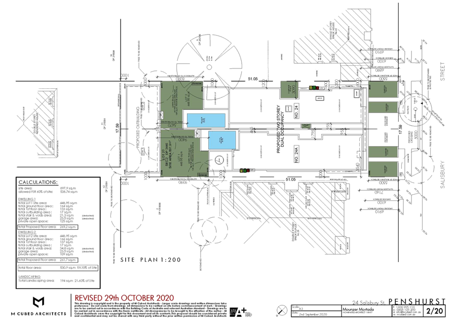
|
Georges River Council - Georges River Local Planning Panel (LPP) -
Thursday, 10 December 2020
LPP067-20 24 Salisbury Street Penshurst
[Appendix 2] Elevation
Plans - 24 Salisbury Street Penshurst
|
Page 230
|
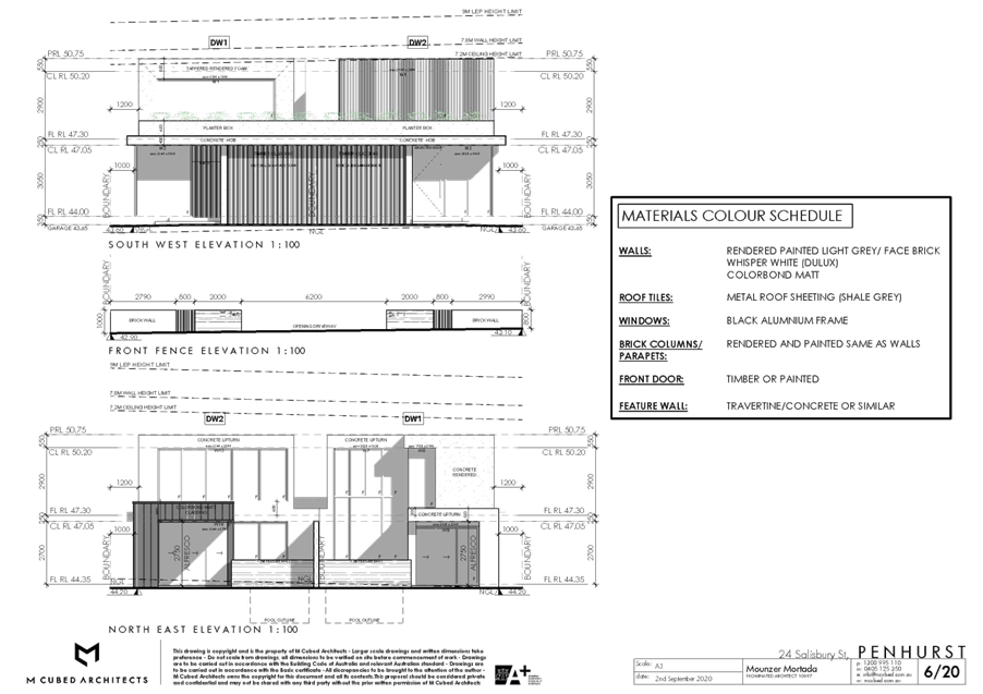


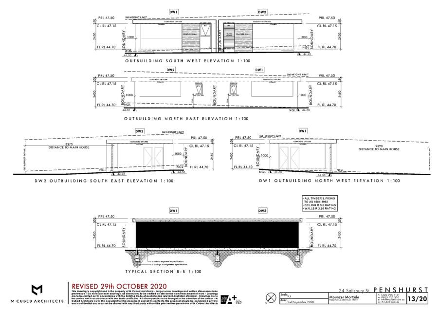
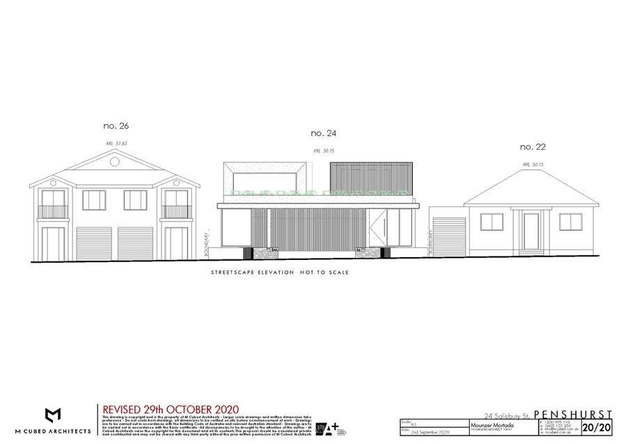
|
Georges River Council - Georges River
Local Planning Panel (LPP) - Thursday, 10 December 2020
LPP067-20 24 Salisbury Street Penshurst
[Appendix 3] Schedule
of Colours and Finishes - 24 Salisbury Street Penshurst
|
Page 235
|