|
AGENDA Environment and Planning Committee
Tuesday 15 June 2021 7.00pm
BLENDED MEETING
Dragon Room (Level 1, Georges River Civic Centre, Hurstville) and Skype Online Meeting
|
|
|
AGENDA Environment and Planning Committee
Tuesday 15 June 2021 7.00pm
BLENDED MEETING
Dragon Room (Level 1, Georges River Civic Centre, Hurstville) and Skype Online Meeting
|
|
Georges River Council - Environment and Planning - Tuesday, 15 June 2021 Page 1
OATH OF OFFICE OR AFFIRMATION OF OFFICE
All Georges River Councillors are reminded of their Oath of Office or Affirmation of Office made at the time of their swearing into the role of Councillor.
All Councillors are to undertake the duties of the office of Councillor in the best interests of the people of the Georges River Council area and are to act faithfully and impartially carry out the functions, powers, authorities and discretions vested in them under the Local Government Act 1993 or any other Act to the best of their ability and judgement.
DISCLOSURES OF INTEREST
All Georges River Councillors are reminded of their obligation to declare any conflict of interest (perceived or otherwise) in a matter being considered by Council or at any meeting of Council.
Environment and Planning
1. OPENING
2. ACKNOWLEDGEMENT OF COUNTRY
3. APOLOGIES / LEAVE OF ABSENCE
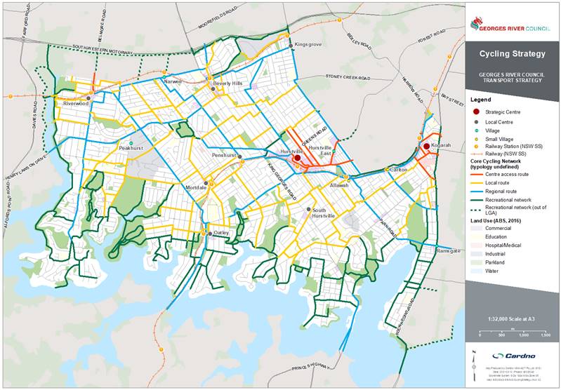
4. NOTICE OF WEBCASTING
5. DISCLOSURES OF INTEREST
6. PUBLIC FORUM
7. CONFIRMATION OF MINUTES OF PREVIOUS MEETINGS
ENV021-21 Confirmation of the minutes of the previous meeting held on 10 May 2021
(Report by Executive Services Officer)................................. 4
8. COMMITTEE REPORTS
ENV022-21 Update on the Georges River Local Strategic Planning Statement 2040 Implementation Plan
(Report by Coordinator Strategic Planning and Independent Assessment)..................................................... 8
ENV023-21 Draft Georges River Transport Strategy 2021 (Cardno) - Adoption for Public Exhibition
(Report by Senior Strategic Planner).................................. 55
ENV024-21 Georges River Foreshore Scenic Character Study (Ethos Urban)
(Report by Strategic Planner/Urban Designer).................. 79
ENV025-21 Georges River Biodiversity Study (Total Earth Care) and Osprey Nesting Habitat
(Report by Coordinator Environmental, Sustainability and Waste)................................................................................. 203
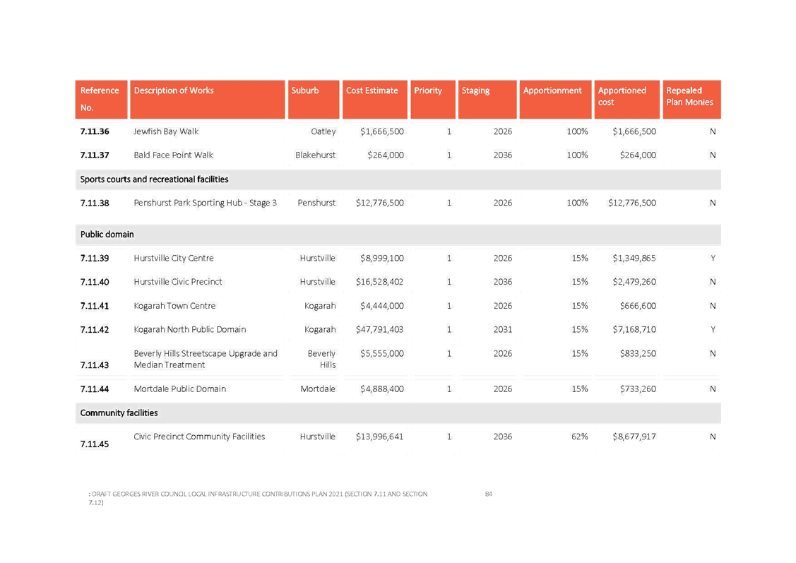
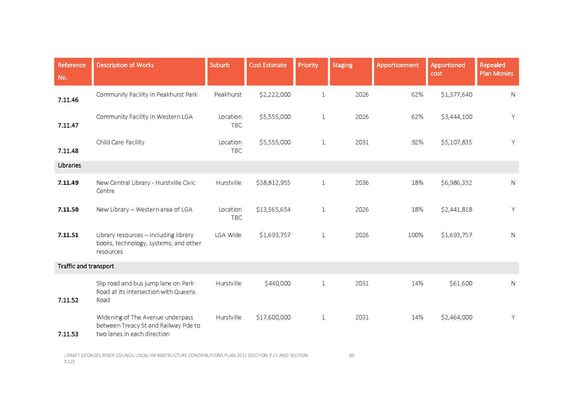
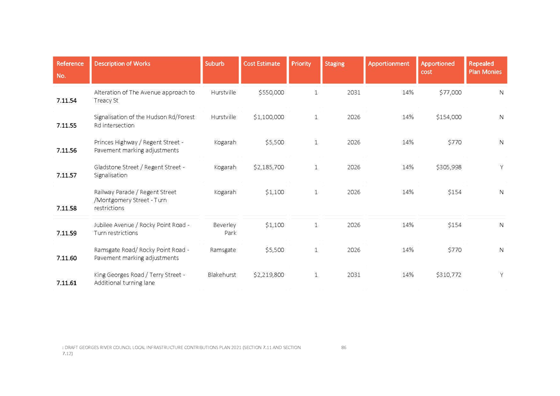
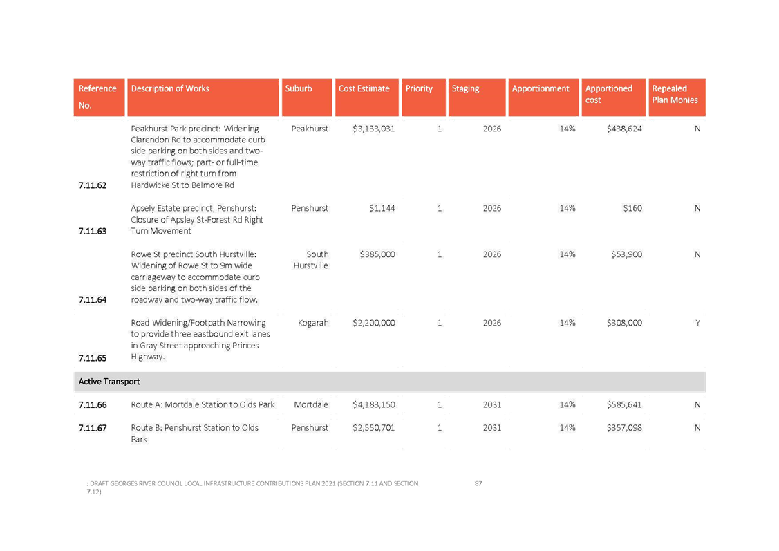
ENV026-21 Draft Georges River Council Local Infrastructure Contributions Plan 2021 - Section 7.11 and Section 7.12 (Adoption for Public Exhibition)
(Report by Senior Development Contributions Planner) 210
ENV027-21 Draft Mortdale Local Centre Masterplan 2021 (Adoption for Public Exhibition)
(Report by Senior Strategic Planner)............................... 327
ENV028-21 Amendment to the Voluntary Planning Agreement for East Quarter Stage 3 - Deed of Variation
(Report by Executive Strategic Planner).......................... 353
9. CONFIDENTIAL (CLOSED SESSION)
ENV035A-21 Georges River Local Planning Panel Second Term - Appointment of Panel Members
(Report by Manager Development and Building) ........... 360
CONFIRMATION OF MINUTES OF PREVIOUS MEETINGS
Item: ENV021-21 Confirmation of the minutes of the previous meeting held on 10 May 2021
Author: Executive Services Officer
Directorate: Office of the General Manager
Matter Type: Previous Minutes
|
That the Minutes of the Environment and Planning Committee Meeting held on 10 May 2021 be confirmed. |
|
Attachment 1 |
UNCONFIRMED Minutes - Environment and Planning Committee - 10 May 2021 |
|
Georges River Council - Environment and Planning - Tuesday, 15 June 2021 ENV021-21 Confirmation of the Minutes of the Previous Meeting held on 10 May 2021 [Appendix 1] UNCONFIRMED Minutes - Environment and Planning Committee - 10 May 2021 |
Page 1 |
Georges River Council – Environment and Planning - Tuesday, 15 June 2021 Page 1
Item: ENV022-21 Update on the Georges River Local Strategic Planning Statement 2040 Implementation Plan
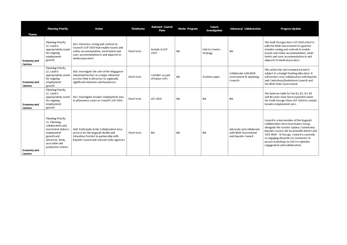
Author: Coordinator Strategic Planning
Directorate: Environment and Planning
Matter Type: Committee Reports
|
That Council note the progress against the actions in the Georges River Local Strategic Planning Statement (LSPS) 2040. |
Executive Summary
1. At its meeting on 28 October 2019, Council adopted the Georges River Local Strategic Planning Statement (LSPS) 2040 and associated Implementation Plan.
2. Council received support from the Greater Sydney Commission for the LSPS 2040 on 4 March 2020.
3. The LSPS 2040 will guide land use planning and the delivery of significant infrastructure for our local government area (LGA) over the next 20 years. The LSPS 2040 creates a land use vision for the future that recognises the character of our suburbs. It builds on our community’s social, environmental and economic values and strengths.
4. The Implementation Plan nominates the 111 actions Council will take over the next 20 years to achieve our desired future.
5. These actions are assigned to responsible Directorates and have been incorporated into Council’s delivery programs and operational plans.
6. To monitor the Council’s progress on achieving this long term vision, its progress is to be measured and reported publicly during each Council term against a series of measures and targets nominated in each of the LSPS’ five themes.
7. This Report provides an update on the progress against the 111 actions in the LSPS 2040.
Background
8. In March 2018, the State Government introduced legislation requiring councils to prepare a LSPS which sets out:
· the 20 year vision for land use in the local area;
· the special characteristics which contribute to local identity;
· shared community values to be maintained and enhanced; and
· how growth and change will be managed into the future.
9. Council developed the LSPS 2040 in consultation with the community through a two staged community engagement program in 2019 to determine the priorities for our LGA.
10. At its meeting on 28 October 2019, Council adopted the LSPS 2040 and associated Implementation Plan.
11. The LSPS is a 20-year land use planning strategy for our LGA that plans for how the LGA will respond to the community’s needs in 20 years’ time.
12. The LSPS will be the primary resource to express the desired land use future for the LGA and will guide and indicate what significant changes are planned for the Georges River Local Environmental Plan (GRLEP) 2020 and Georges River Development Control Plan (GRDCP) 2020 and beyond.
13. The LSPS is a ‘linking’ document between the Greater Sydney Commission’s South District Plan and Council’s new LEP(s).
14. The LSPS outlines a series of priorities and actions that give effect to the directions for councils in the South District Plan. This includes actions Council will take over the next 20 years to achieve our desired future which includes housing and the environment.
15. The actions in the LSPS are summarised in the accompanying Implementation Plan.
16. These actions are assigned to responsible Directorates and have been incorporated into Council’s delivery programs and operational plans.
17. To monitor our progress on achieving this long term vision, Council’s progress is to be measured and reported publicly during each Council term against a series of measures and targets nominated in each of the LSPS’ five themes.
18. Implementation of the LSPS will be staged over a 20 year period via different mechanisms which include:
· LEPs (the first from 2020);
· A Comprehensive Georges River DCP;
· A Community Participation Plan;
· Contributions Plans;
· A land acquisition program;
· Council works programs; and
· Council advocacy.
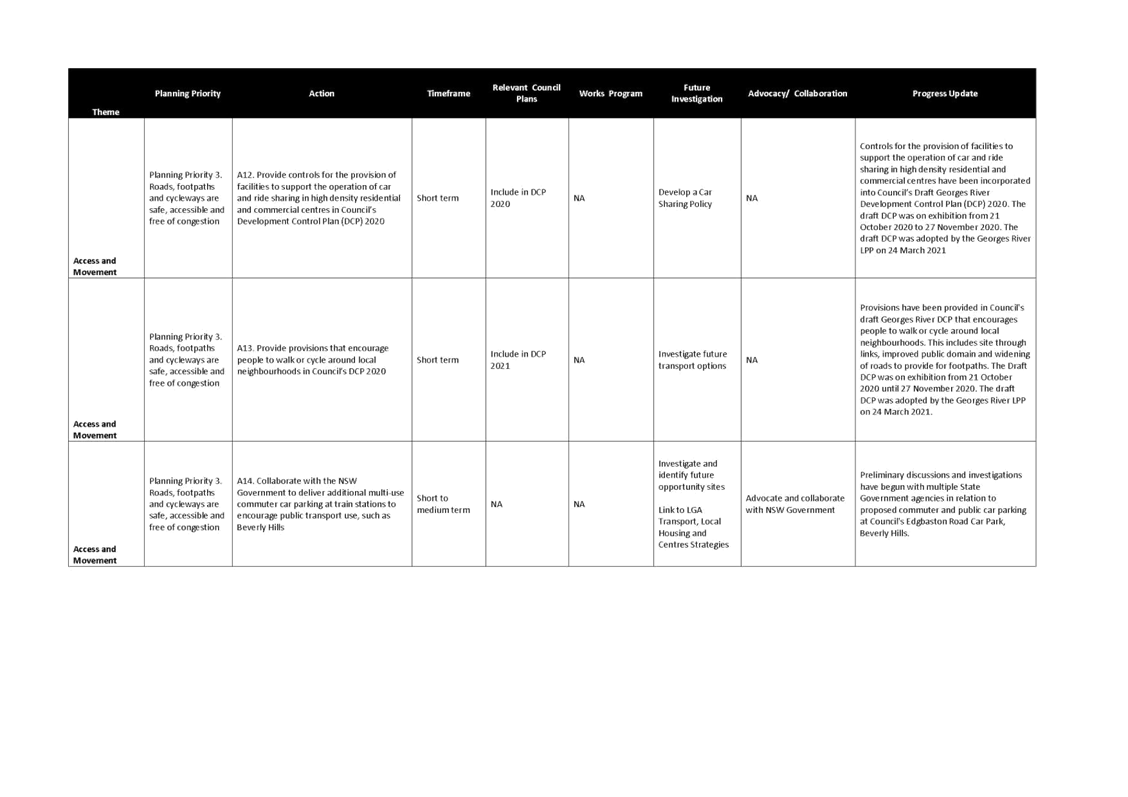
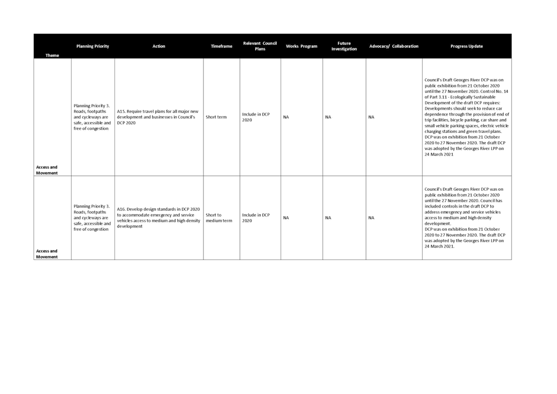
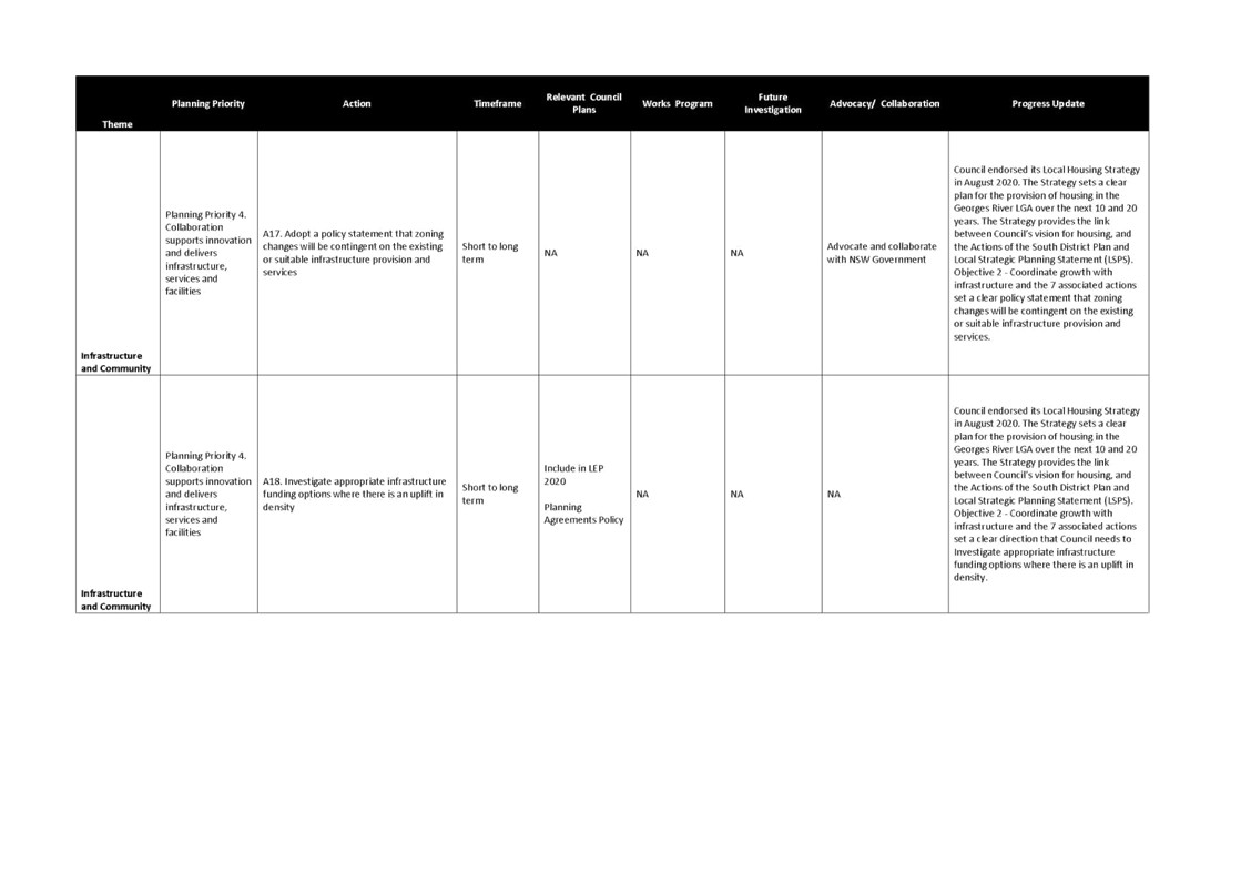
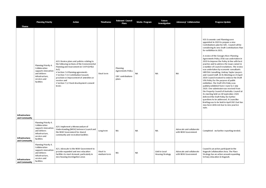
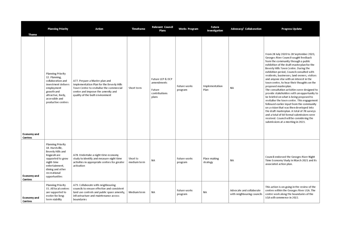
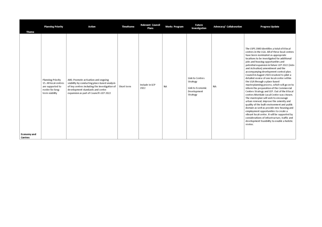
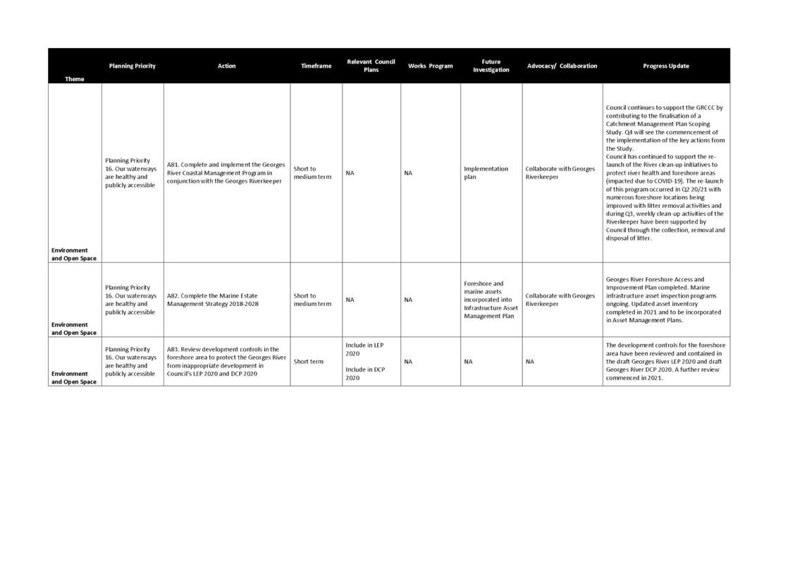
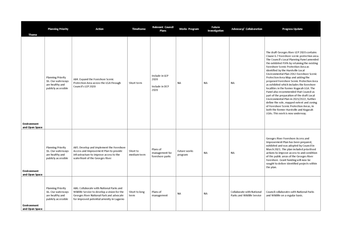
PROGRESS AGAINST ACTIONS
19. The LSPS presents a 2040 vision for land use in the Georges River LGA expressed and explored through five interrelated themes:
· Access and movement – is about how we move within and to and from the LGA, such as public transport, cars, walking and cycling;
· Infrastructure and community – is about providing infrastructure and community facilities in the LGA to meet the needs of the current and future population, such as utilities, libraries and schools. It is also about ensuring the community is involved in planning our future;
· Housing and neighbourhoods – is about accommodating the housing needs of our residents, such as providing a range of housing types to suit households of different sizes, life stages and incomes. It is also about ensuring that the housing provided is of good design and complements the character of our suburbs;
· Economy and centres – is about supporting local jobs, ensuring the viability of our centres and providing services in our centres that meet the needs of the local population; and
· Environment and open space – is about protecting and enhancing our natural environment, including waterways, tree canopy and bushland. It is also about ensuring our residents have access to quality and useable open space, introducing environmentally sustainable practices, and responding appropriately to hazards and risks, such as bush fires and flooding.
20. Under each theme there are planning priorities and key actions to deliver the desired future.
21. Each action is assigned to a responsible Directorate and an update on the progress of each action is reported quarterly through Council’s quarterly reporting system.
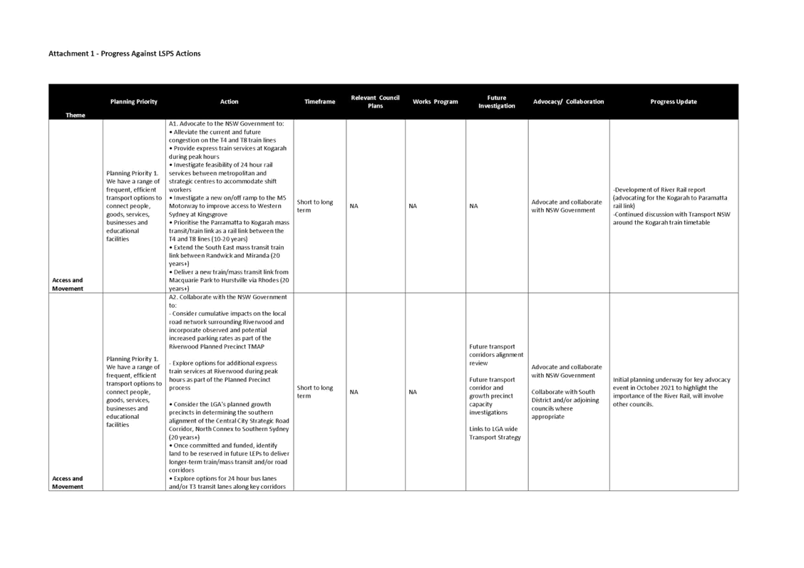
22. Attachment 1 – Progress against LSPS Actions provides a list of all the actions in the LSPS, along with an update on the progress against these actions.
23. Due to the number of actions, this report provides an overview of some of the key actions by theme with the following status – main achievements, actions in progress and actions to be commenced.
Main achievements
24. Council has completed a number of actions in the LSPS through the endorsement of and completion of several projects and plans. Some of these projects and plans are highlighted below under the relevant theme.
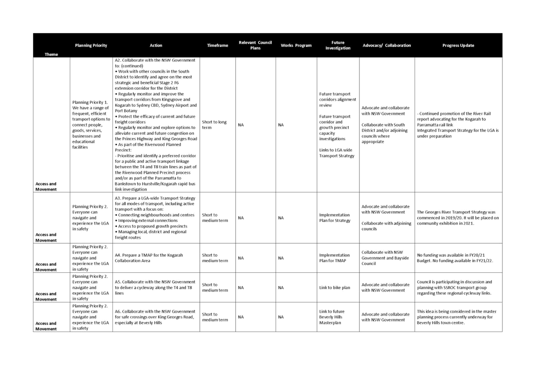
Theme 1 – Access and Movement
25. Council has developed the River Rail document which advocates for the immediate investment in the River Rail, a proposed 24 kilometre rail link connecting the people of Georges River to Parramatta via Bankstown. The rail connection from Kogarah to Parramatta via Bankstown will support the urban intensification required to catalyse increased productivity, jobs growth and economic and social welfare.
26. In August 2020, Council signed a Memorandum of Understanding (MOU) with School Infrastructure (NSW Department of Education) for the shared use of community and recreational facilities across the LGA. Creating opportunities to increase shared use and more flexible use of new and existing facilities (both private and Council owned) can promote greater connectivity between our residents.
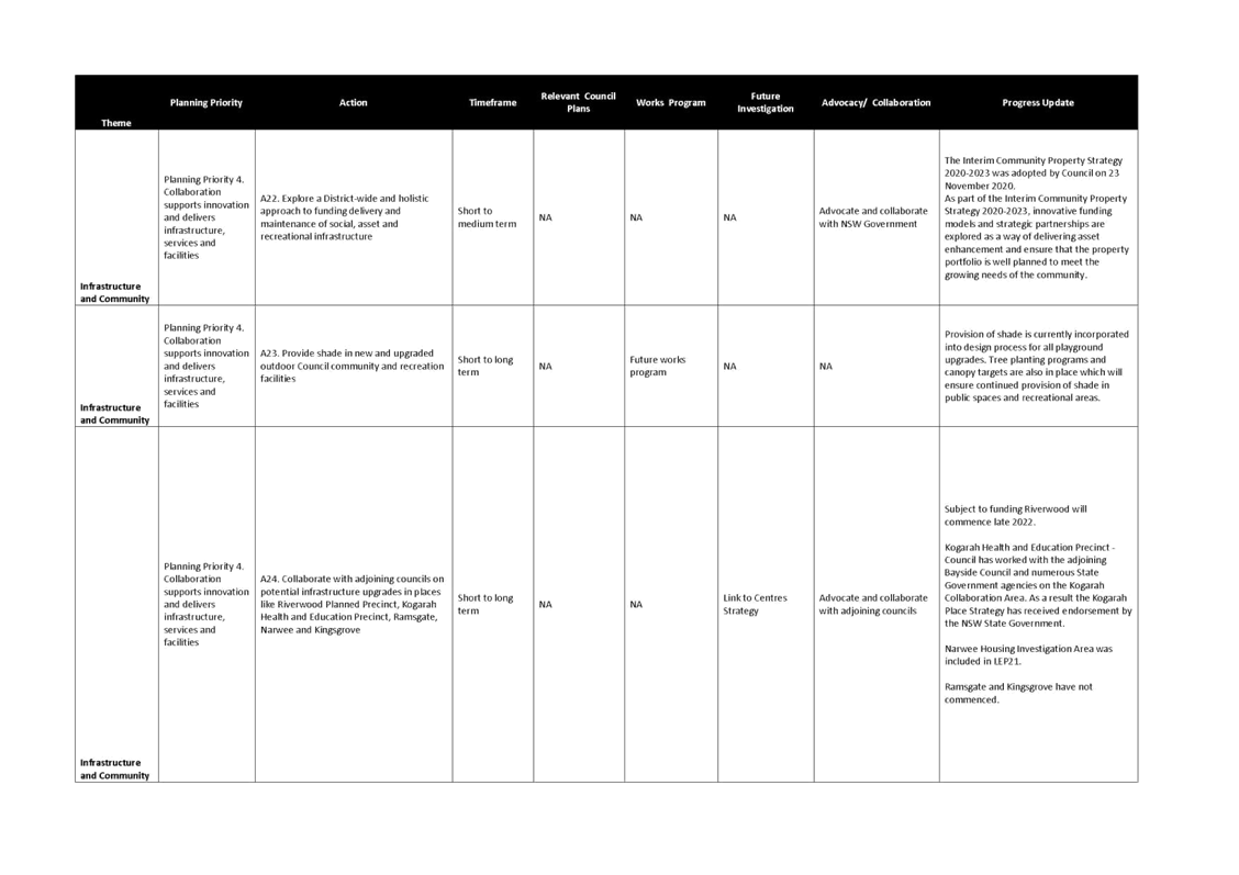
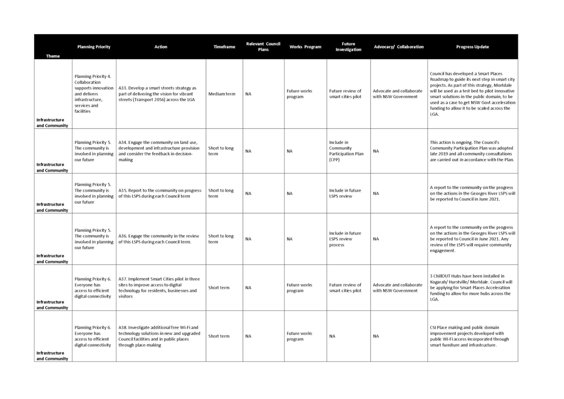
Theme 2 – Infrastructure and Community
27. Kogarah is identified as a Collaboration Area, Strategic Centre and Health and Education Precinct in the Greater Sydney Region Plan, owing to its significant cluster of health and education activities. Council has worked with the adjoining Bayside Council and numerous State Government agencies on the Kogarah Collaboration Area. As a result, the Kogarah Collaboration Area Place Strategy has received endorsement by the NSW State Government.
28. The Kogarah Collaboration Area Place Strategy focuses on leveraging the area’s existing assets, networks and activity through a place-based framework. The Strategy highlights several opportunities for the Collaboration Area, including the cluster of health, education, financial and sporting offerings, emerging research and innovation through the health and education precinct and anticipated future mass transit connections. Challenges that have been identified include the reduced frequency of the train services, a deficiency of open space and urban tree canopy cover, increased high density development and a lack of short-medium term accommodation.
29. To deliver on the vision and shared objectives, Council with the Greater Sydney Commission has established a precinct governance structure and group to deliver the actions which include a partnership between Georges River and Bayside Council and with key anchor institutions in the Collaboration Area.
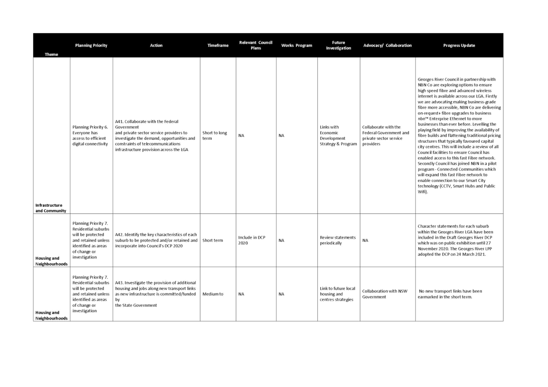
30. Council has also installed new infrastructure in the LGA for the community to enjoy, including three ChillOUT Hubs with smart drinking fountains, free Wi-Fi, device charging and smart bins in Kogarah, Hurstville and Mortdale centres.
Theme 3 – Housing and Neighbourhoods
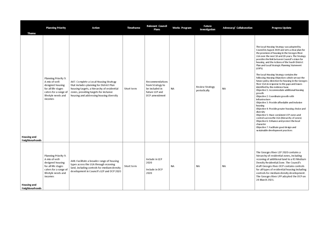
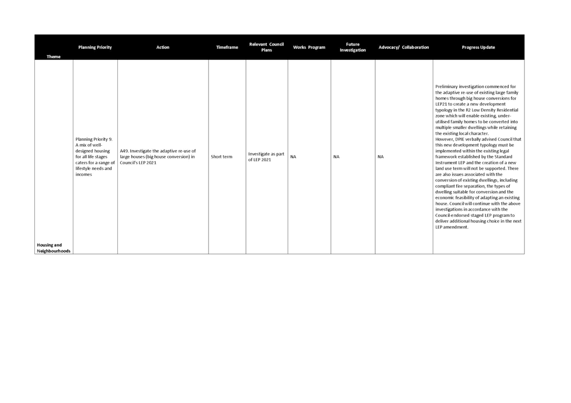
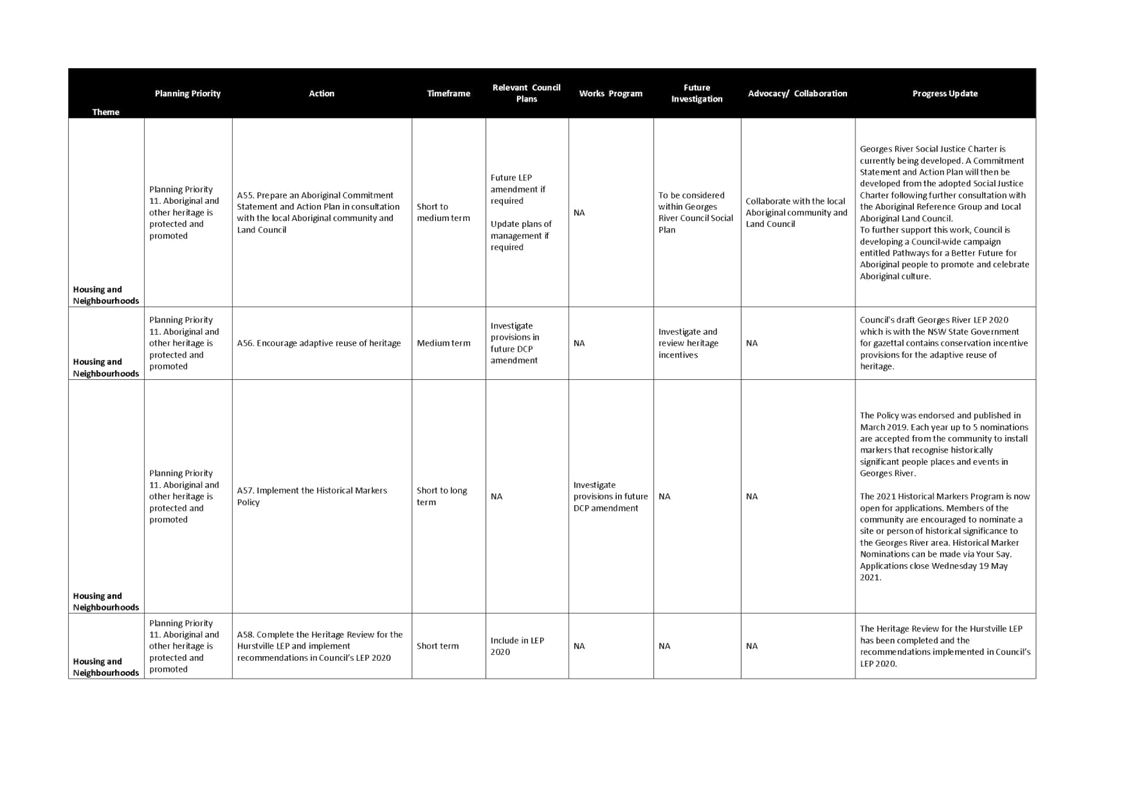
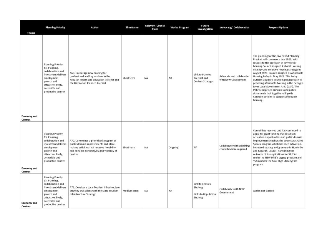
31. In August 2020, Council adopted the Local Housing Strategy which sets a clear plan for the provision of housing in the LGA over the next 10 and 20 years. It identifies the housing demand, gaps and issues, and establishes housing objectives to manage future growth.
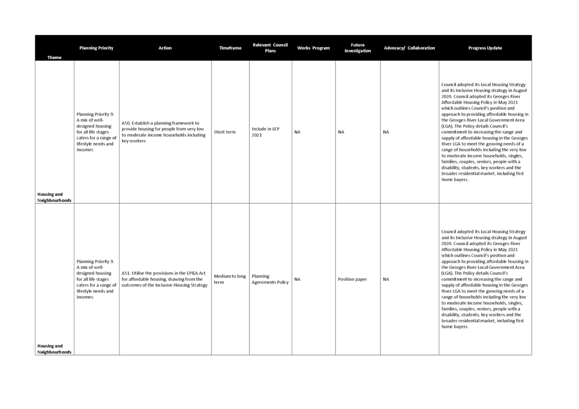
32. Council has prepared the Georges River Affordable Housing Policy which outlines Council’s position and approach to providing affordable housing in the Georges River LGA. The Policy details Council’s commitment to increasing the range and supply of affordable housing in the LGA to meet the growing needs of a range of households including the very low to moderate income households, singles, families, couples, seniors, people with a disability, students, key workers and the broader residential market, including first home buyers. The Policy was placed on exhibition in March and April 2021. The Policy was adopted by Council in May 2021.
33. In March 2019, Council endorsed the Historical Markers Policy. The Historical Markers Program has been developed in response to requests from the community to recognise places of historical and cultural importance. Each year up to five nominations are accepted from the community to install markers that recognise historically significant people, places and events in Georges River.
Theme 4 – Economy and Centres
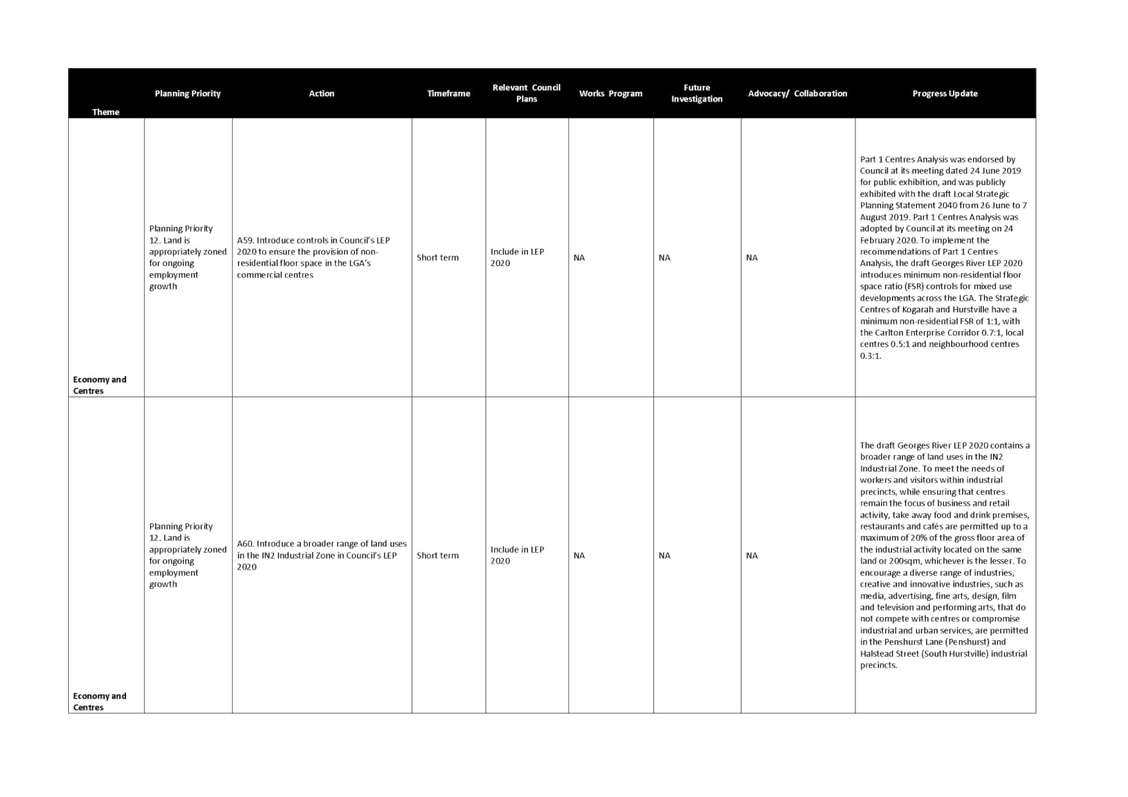
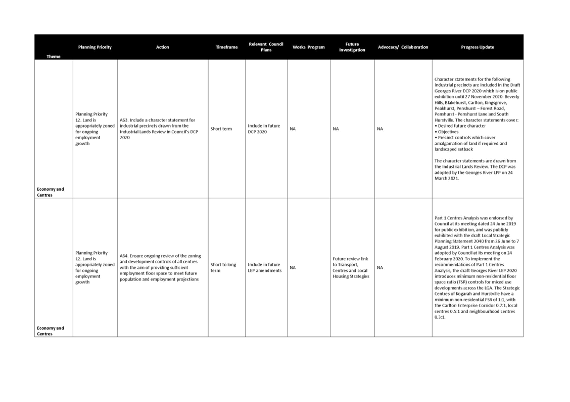
34. Council is currently preparing a Commercial Centres Strategy in two parts. On 24 February 2020, Council endorsed Part 1 Centres Analysis which harmonises permitted land uses and introduces land uses to encourage employment in response to emerging economic trends. It investigates the appropriate mix required between employment and residential floor space in mixed use developments. To implement the recommendations of Part 1 Centres Analysis, the draft GRLEP 2020 introduces minimum non-residential floor space ratio (FSR) controls for mixed use developments across the LGA. The Strategic Centres of Kogarah and Hurstville have a minimum non-residential FSR of 1:1, with the Carlton Enterprise Corridor 0.7:1, local centres 0.5:1 and neighbourhood centres 0.3:1.
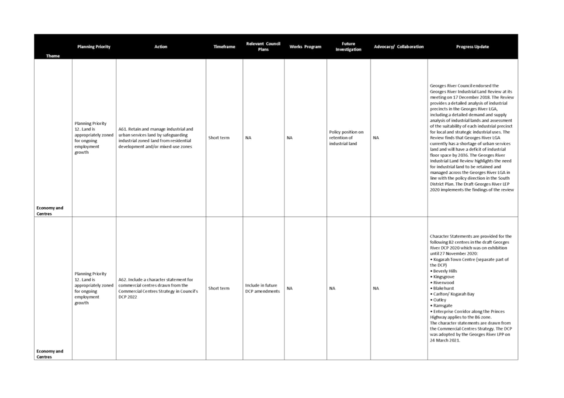
35. On 17 December 2018, Council endorsed the Georges River Industrial Land Review. The Review provides a detailed analysis of industrial precincts in the Georges River LGA, including a detailed demand and supply analysis of industrial lands and assessment of the suitability of each industrial precinct for local and strategic industrial uses. The Review finds that the Georges River LGA currently has a shortage of urban services land and will have a deficit of industrial floor space by 2036. The Georges River Industrial Land Review highlights the need for industrial land to be retained and managed across the Georges River LGA in line with the policy direction in the South District Plan. The draft GRLEP 2020 implements the findings of this review.
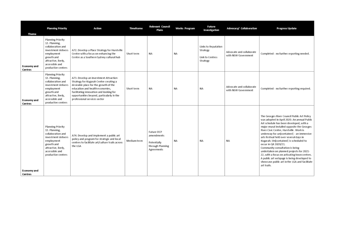
36. In 2019, Council endorsed the Hurstville 'Heart of the City' Place Strategy and Kogarah Investment Attraction Strategy which guide the expansion of investment and employment the Hurstville City Centre and the Kogarah Town Centre, respectively.
37. In April 2020, Council endorsed the Georges River Council Public Art Policy. The Policy has developed an annual Public Art schedule, with a major mural installed opposite the Georges River Civic Centre. Work is underway for ‘un[contained]’, an immersive arts festival held over several days in Kogarah. ‘Un[contained]’ is scheduled to occur by the end of the 2020/2021 financial year. Community consultation is being undertaken on planned projects for 2020-21 with a focus on activating town centres. A public art webpage is also being developed to showcase public art in the LGA and facilitate art trails.
38. Council has been successful in securing grant funding from the NSW Department of Planning, Industry and Environment’s (DPIE’s) Streets as Shared Spaces program. The program provides funding for councils to support the delivery of short-term improvements to local streets and public spaces through pop-ups and pilots that encourage social distancing and improve the attractiveness of our neighbourhoods. $50,000 has been awarded to Council to improve pedestrian amenity in Kogarah through traffic calming measures, public art, lighting and street furniture. This project is expected to be delivered by the end of September 2021. $350,000 in funding has been awarded for projects within Hurstville to create a more pedestrian-friendly environment. It is expected that these improvements will be delivered in the next 12 months.
39. In March 2021, Council endorsed the Night Time Economy Study which focuses on Hurstville, Kogarah and Mortdale centres. The Study examines the size and character of the existing night time economy in Georges River while investigating opportunities and initiatives to enhance activation over the next four years.
Theme 5 – Environment and Open Space
40. In March 2021, Council endorsed the Georges River Foreshore Access and Improvement Plan. The Plan identifies foreshore locations along the 18.5km of publicly owned foreshore; currently managed by Council suitable for recreation, access and environmental improvement projects. The primary purpose is to enable public land along the Georges River to be strategically managed for an optimal balance of environmental health and ecological resilience, and enhanced access, use and enjoyment by the community. The next step is to implement the prioritised environmental and access improvement projects identified within the Plan.
41. On 7 August 2020, the updated Georges River Bush Fire Prone Land Map was certified by the Rural Fire Service. The Map identifies bush fire risk areas to inform developments in these areas.
Other achievements
Draft Georges River Local Environmental Plan (GRLEP) 2020
42. Council has prepared the draft GRLEP 2020 which harmonises the existing Kogarah and Hurstville LEPs so that a single, consistent approach is applied to planning and development across the LGA. New controls have also been introduced to give effect to the Planning Priorities and Actions of the South District Plan and LSPS.
43. A number of actions in the LSPS have been implemented through the GRLEP 2020, including introducing design excellence controls, implementing the heritage review recommendations, permitting a broader range of employment uses, reviewing the foreshore controls, introducing environmental sustainability controls and providing new areas for open space.
44. The GRLEP 2020 is currently with the DPIE for gazettal.
Draft Georges River Development Control Plan (GRDCP) 2020
45. To accompany the GRLEP 2020, Council has prepared the draft Georges River Development Control Plan (GRDCP) 2020 which aims to harmonise controls in the Hurstville and Kogarah DCPs to create a DCP for the whole LGA.
46. A number of actions in the LSPS have been implemented through the GRDCP 2020, including controls to support walking, cycling and car sharing; design excellence controls; character statements to guide the development of areas to achieve their desired future character; reviewing the foreshore controls; and introducing environmental sustainability controls, such as green roofs.
47. The GRDCP 2020 will become effective upon the gazettal of the GRLEP 2020.
ACTIONS IN PROGRESS
48. There are some actions in the LSPS that are ongoing or are longer term projects which are being progressed. An overview of the key projects are outlined as follows:
Theme 1 – Access and Movement
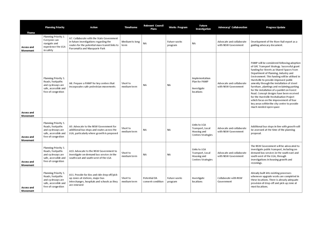
49. Council commenced the Georges River Transport Strategy in 2019/2020. The Transport Strategy will address all modes of transport including public transport, private vehicles, freight movements, active transport (walking and cycling) and non-government transport services. It will be placed on public exhibition in the second half of 2021.
50. Preliminary discussions and investigations have begun with multiple State Government agencies in relation to the proposed commuter and public car parking at Council's Edgbaston Road Car Park in Beverly Hills.
Theme 2 – Infrastructure and Community
51. SGS Economics and Planning were appointed in 2019 to prepare a new Development Contributions Plan for the Georges River LGA incorporating the Hurstville Section 94 Development Contributions Plan 2012 and the separate Kogarah Section 94 Plans.
52. A comprehensive review of the Georges River Voluntary Planning Agreements (VPA) Policy 2016 is being undertaken to strengthen the Policy in line with best practice. A draft Policy was placed on exhibition in 2020. However, a new Practice Note relating to Planning Agreements was issued by the DPIE on 12 February 2021. The new Practice Note clarifies the DPIE’s position on value capture and emphasises that VPAs should not be used for the primary purpose of value capture and that planning agreements are to be assessed against an “acceptability test”. Council must consider the Practice Note when negotiating or entering into a planning agreement. Accordingly, the new Practice Note has implications for the current review of Council’s VPA Policy requiring a new review of the draft VPA Policy.
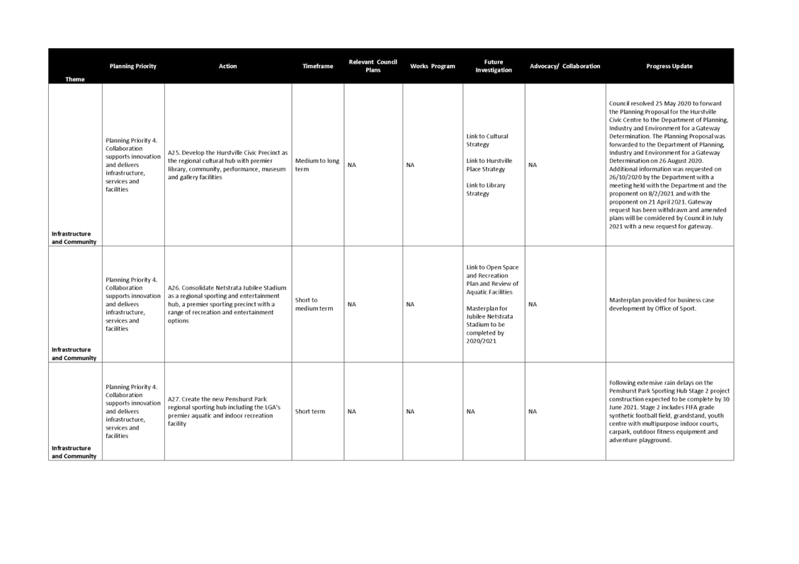
53. Construction work on the Penshurst Park Sporting Hub has continued to progress with Stage 2 of the project being undertaken, which includes a synthetic sports field, grandstand, youth centre with multipurpose indoor courts, carpark, outdoor fitness equipment and adventure playground. Following extensive rain delays, Stage 2 is expected to be completed by 30 June 2021.
Theme 3 – Housing and Neighbourhoods
54. Council is preparing the draft Georges River Council Social Justice Charter to address disadvantage and achieve positive outcomes. The Aboriginal Reference Group has been consulted in the development of the draft Charter. A Commitment Statement and Action Plan will then be developed from the adopted Social Justice Charter following further consultation with the Aboriginal Reference Group and Local Aboriginal Land Council. To further support this work, Council is developing a Council-wide campaign entitled ‘Pathways for a Better Future for Aboriginal people’ to promote and celebrate Aboriginal culture.
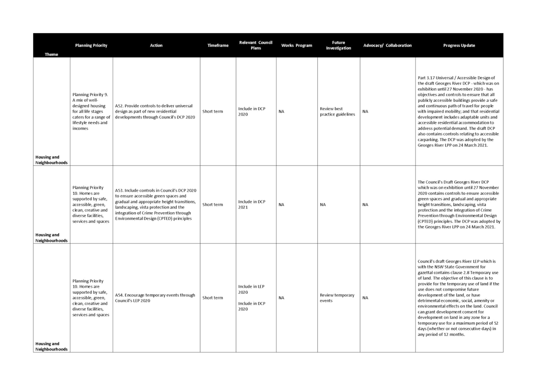
55. The draft Georges River LEP 2020 contains Clause 6.7 Foreshore scenic protection area. The Council's Local Planning Panel amended the exhibited Foreshore Scenic Protection Area by retaining the existing Foreshore Scenic Protection Area as identified by the Hurstville Local Environmental Plan 2012 Foreshore Scenic Protection Area Map and adding the proposed Foreshore Scenic Protection Area as exhibited which includes the foreshore localities in the former Kogarah LGA. The Panel also recommended that Council as part of the preparation of the draft Local Environmental Plan in 2021/2022, further define the role, mapped extent and zoning of Foreshore Scenic Protection Areas, in both the former Hurstville and Kogarah LGAs. This work is now underway.
Theme 4 – Economy and Centres
56. Council is working with the community to explore opportunities to make the Beverly Hills Town Centre a better place to live, work and visit. Through the preparation of the Beverly Hills Masterplan, there is an opportunity to enhance the vibrancy and liveability of the Centre and its immediate surroundings, and improve the quality, accessibility and amenity of the public spaces. The Masterplan is split into two phases. Phase 1; which was completed in March 2019 involved the development of a vision for the future of the Centre through community engagement and an analysis of the opportunities and constraints to development in the study area. Phase 2 involved the preparation of a Masterplan that will recommend a future development strategy for the area. Phase 2 was placed on exhibition in 2020 and a report on the submissions will be presented to Council in mid 2021.
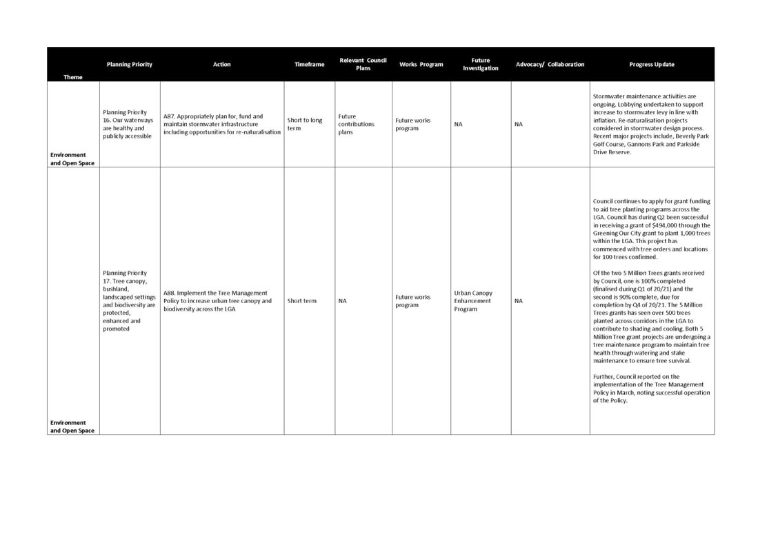
Theme 5 – Environment and Open Space
57. Council has received two grants from the DPIE as part of the 5 Million Trees Program. The grants will fund Council’s planting of more than 500 trees, in addition to Council’s business-as-usual street tree planting program which plants approximately 200 trees per year. The funding of $215,000 will increase tree canopy within the LGA, contributing to the current tree planting program and meeting Council’s previously endorsed target to achieve tree canopy cover of 40% by the year 2038 and thereby increase carbon sequestration.
58. Council is currently completing a Floodplain Risk Management Plan for Hurstville, Mortdale and Peakhurst Catchments. The key objective of the Plan is to reduce the impact of flooding and flood liability on individual owners and occupiers of flood prone properties. The Plan also aims to reduce potential private and public losses resulting from floods, utilising ecologically positive flood mitigation measures.
59. The Salt Pan Creek Open Space Corridor links Bankstown to the Georges River and is surrounded by the suburbs of Lugarno, Peakhurst, Riverwood, Punchbowl, Bankstown, Padstow and Padstow Heights. It is an important open space corridor for the region, with important ecological communities, mangroves, wetlands, recreational facilities and walking and cycling trails on both sides of the creek. On 17 June 2020, Council engaged a consultant to prepare the Salt Pan Creek Green Grid Corridor Spatial Framework which will serve as a masterplan for access, environmental and community infrastructure improvement works within the corridor. The project aims to strengthen the connection between Bankstown CBD and Salt Pan Creek, improve trails and recreational opportunities surrounding adjacent development uplift, improve bridge crossings and connections to urban centres including Bankstown, Punchbowl, Riverwood, Padstow, Peakhurst and Lugarno.
actions TO BE Commenced
60. There are limited actions in the LSPS that have not commenced, which is to be expected as the LSPS is only a recent document, having only been endorsed last year and containing actions that are short term (0-5 years), medium term (6-10 years) and long term (11+ years). An overview of new projects are listed as follows:
Theme 1 – Access and Movement
61. The preparation of a Transport Management and Accessibility Plan (TMAP) for the Kogarah Collaboration Area has been delayed due to no funding being available in the 2020/2021 and 2021/2022 financial years.
62. The preparation of a Pedestrian Access and Mobility Plan (PAMP) for key centres that incorporates safe pedestrian movements has also not commenced due to funding constraints but will be considered following the adoption of the Georges River Transport Strategy.
Theme 4 – Economy and Centres
63. Cross collaboration with Bayside and Canterbury/Bankstown Councils and the NSW State Government is required to investigate the role of the Kingsgrove Industrial Precinct as a major industrial precinct that is attractive to regionally significant industries and businesses.
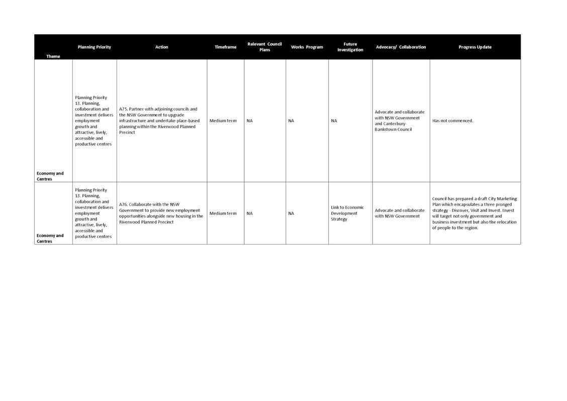
64. The State Government has identified Riverwood as a Planned Precinct (i.e. an area for housing and employment growth). Council has been progressing the masterplans for Beverly Hills and Mortdale Local Centres. The masterplan for Riverwood is likely to commence in late 2021/early 2022.
65. Council is yet to develop a Local Tourism Infrastructure Strategy that aligns with the State Tourism Infrastructure Strategy.
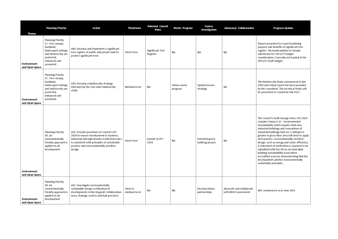
66. Funding is required to develop and implement a significant tree register for public and private land to protect significant trees.
67. Council will investigate environmentally sustainable design certification of developments in the Kogarah Collaboration Area, strategic centres and hub precincts.
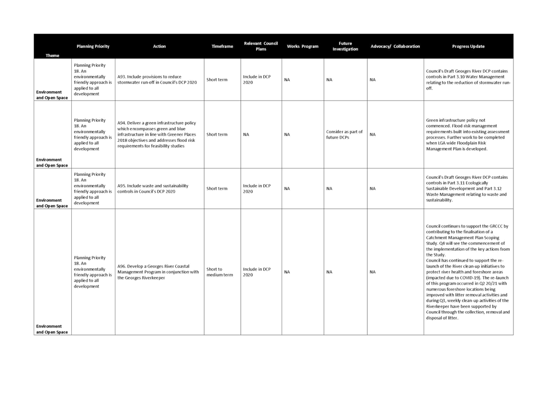
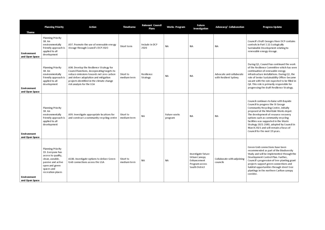
68. In relation to delivering a green infrastructure policy which encompasses green and blue infrastructure in line with the NSW government’s Greener Places 2018 objectives and addressing flood risk requirements for feasibility studies, a green infrastructure policy will need to be commenced. Flood risk management requirements have been built into existing development assessment processes; but further work will be undertaken when the LGA wide Floodplain Risk Management Plan is developed.
NEXT STEPS
69. Council officers will continue to complete actions within the LSPS and report to Council on the progress within each Council term.
Financial Implications
70. The commencement of some actions in the LSPS is reliant on successful budget bids to undertake the projects.
Risk Implications
71. Enterprise risk/s identified and management process applied.
Community Engagement
73. The LSPS 2040 is available on Council’s website.
74. Council will continue to report publicly on the progress of the actions in the LSPS within each Council term.
File Reference
18/2196
|
Attachment ⇩1 |
Progress against LSPS Actions |
|
Georges River Council - Environment and Planning - Tuesday, 15 June 2021 ENV022-21 Update on the Georges River Local Strategic Planning Statement 2040 Implementation Plan [Appendix 1] Progress against LSPS Actions |
Page 1 |

Item: ENV023-21 Draft Georges River Transport Strategy 2021 (Cardno) - Adoption for Public Exhibition
Author: Senior Strategic Planner
Directorate: Environment and Planning
Matter Type: Committee Reports
|
(a) That Council endorses the draft Georges River Transport Strategy 2021 and Strategic Context Report (Attachments 1 and 2) for public exhibition for no less than 28 days in accordance with the Community Engagement Plan outlined in the body of the report. (b) That Council delegate authority to the General Manager to make minor modifications to any numerical, typographical, interpretation and formatting errors, if required, prior to the exhibition. (c) That a further report be presented to Council following the exhibition including a summary of submissions and recommendations to finalise the Georges River Transport Strategy. |
Executive Summary
1. Cardno consultants in conjunction with Council have prepared a draft Georges River Transport Strategy (the ‘draft Transport Strategy’) over the period December 2019 to April 2021.
2. The draft Transport Strategy provides policy and directives for Council to enhance existing transport networks and plan for increased demand. The draft Strategy aligns with existing state and local strategies and plans.
3. The draft Transport Strategy consists of two reports, the Strategic Context Report and the Transport Strategy Report. The Strategic Context Report outlines the existing demography, travel demand and behaviour; and land use. This Report provides a basis for the strategies and actions for future transport networks and services in the Georges River Local Government Area contained in the Transport Strategy Report. A copy of the draft Georges River Transport Strategy in two parts is included in Attachments 1 and 2.
4. The Draft Transport Strategy includes the following component strategies:
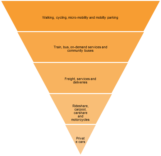
b) Active transport strategy - refers to non-motorised forms of transport involving physical activity, like walking and cycling;
c) Public transport strategy – refers to movement of people in larger groups managed on organised schedules and routes, e.g. buses, trains and ferries;
d) Road network and freight strategy – refers to planning for road network that is used by a variety of vehicles including buses, trucks, delivery vehicles, freight vehicles, private cars, taxis/ride share, bicycles, wheelchairs and electric powered devices;
e) Car parking strategy – incorporates Council’s Car Parking Strategy and Position Paper and provides recommendations to enhance it further by 2025; and
f) Centres transport strategy – recognises that Council can accommodate more population in specific centres connected to transport and services.
5. Each component Strategy has a number of associated actions. These strategies and the associated actions will help Georges River achieve its transport vision and objectives.
6. This report seeks Council’s endorsement to publicly exhibit the draft Georges River Transport Strategy.
Background
7. At its meeting on 27 November 2017, Council resolved to commence the preparation of a new city-wide Transport Strategy for the Georges River Local Government Area (LGA). Council also resolved to require that the Transport Strategy address all modes of transport including public transport, private vehicles, freight movements, active transport (walking and cycling), car sharing services and non-government transport services.
8. Following the allocation of funding in the 2019/20 budget, in November 2019 Council engaged Cardno to prepare the Georges River Council Transport Strategy.
9. The purpose of the Transport Strategy is to provide policy and directives for Georges River Council to enhance existing transport network and plan for increased demand within the LGA. The Strategy aligns with existing state and local strategies and plans.
CONSULTATION TO DATE
10. Councillor Workshops
Two Councillor workshops were held in 2020 during the preparation of the Draft Transport Strategy and feedback has informed the preparation of the draft Strategy.
11. Stakeholder Consultation
Initial round of stakeholder consultation was undertaken with key stakeholders in form of webinars as part of Tasks 1 and 2 – Where are we now and Where do we want to be? Three stakeholder webinars were held in May 2020 with government agencies, community groups and Council staff
12. Bicycle User Groups Consultation
In response to Councillor feedback, Bicycle User Group (BUG) was consulted via a survey on the draft core cycling network to provide Council a framework for improving the bike network. The issues raised by BUG have informed the strategic cycling network and are addressed in Actions BK1 to BK6 of the Draft Strategy.
CONSULTATION TO DATE
13. Vision of the draft Transport Strategy
The vision is: Georges River Council has a sustainable transport network that safely connects people to jobs, services and great places.
14. Aims of the draft Transport Strategy
The aims of the draft Transport Strategy include:
· Integrating transport planning and land-use planning;
· Identification of transport vision and objectives in alignment with state, regional and local planning;
· Addressing the challenges of the existing transport network within Georges River LGA in the context of Sydney;
· Addressing the growth and the needs of community, businesses and visitors;
· Informing and supporting the Council’s strategic plans; and
· Identification of the actions for improvement of infrastructure, services, policy and behaviour.
15. Structure of the draft Transport Strategy
The draft Transport Strategy comprises two reports. The Strategic Context Report (refer to Attachment 2) covers the questions Where are we now? i.e., the existing demography, travel demand and behaviour within the LGA. The Transport Strategy Report (Attachment 1) covers the questions Where do we want to be? How do we get there? Have we got it right?
After public exhibition, feedback will be assessed and where relevant, will be used to update the two reports.
16. Contents of the draft Transport Strategy
The following two tables outline the content of the two reports that constitute the draft Strategy:
17. Draft Strategic Context Report
The contents of this Report are provided below:
|
Section
|
Content |
|
Acronyms and terms |
This section provides descriptions of the acronyms and technical terms within the Report.
|
|
1 Introduction |
|
|
1.1 Aims of the Transport Strategy 1.2 Study area 1.3 Data sources |
This section provides an introduction to the Strategy including various stages in the preparation of the Transport Strategy, aims, study area and data sources for the Strategy.
|
|
2 People |
|
|
2.1 Population 2.2 Households 2.3 Residential density 2.4 Resident workforce 2.5 Employment in Georges River 2.6 Forecast growth and trends
|
This section outlines the existing demography, residential density, details about the residential workforce, growth forecast and trends.
Georges River demonstrated an 8.1 per cent population growth over the period between 2006 and 2016. The average household size is 2.84, which is higher than the Greater Sydney average of 2.72. Households, with two or more family members, accounted for more than three quarters of households.
Approximately 10 per cent (4.4 square kilometres) of our land has a residential density of over the Sydney average in 2016, which was 58.4 persons per hectare (ABS Census, 2016). There were 43,243 full-time workers living in Georges River in the 2016 ABS Census, and 22,916 part-time workers. The number of full-time workers grew by 12 per cent over the preceding 10-year period, while part-time workers grew by 41 per cent.
There were 49,742 jobs located in Georges River in 2016 as per TfNSW’s Travel Zone Projections data. The most common employment type by industry in Georges River is the health care and social assistance industry, followed by the retail trade industry.
The Georges River population is forecast to grow by around 84,000 people to 237,396 over the next 40 years as per the TfNSW’s travel zone projections. This equates to 55 per cent growth and an addition of 2,100 people per year.
|
|
3 Existing strategies and plans |
|
|
3.1 Land use and community plans 3.2 Transport strategies and plans 3.3 Future state government transport projects and proposals 3.4 Emerging trends in transport |
This section covers the Strategy’s alignment with Council’s community, transport and land use plans, as well as with the NSW State Government’s land use plans and transport strategies.
It also summarises the future state government’s transport projects/proposals including the More Trains, More Services program, Parramatta to Bankstown to Hurstville/Kogarah rapid bus link and Bus priority access program for centres.
This section covers key emerging initiatives in transport infrastructure and services that may be relevant to Georges River, including on demand public transport, E-bikes and smart shuttles.
|
|
4 Land use |
|
|
4.1 Centres 4.2 Future land uses |
This section covers the existing general landuse in the LGA and Centres and that envisaged in the future, e.g., in the Hurstville City Centre, Kogarah Collaboration Area, Riverwood Precinct Investigation Area and Green Gris Priority Corridor – Salt Pan Creek.
|
|
5 Transport networks and services |
|
|
5.1 Road network 5.2 Pedestrian network 5.3 Public transport networks 5.4 Parking 5.5 Freight network
|
This section details the existing transport networks including road, rail, bus, active transport and freight network provisions available within the LGA. |
|
6 Travel demand and behaviour |
|
|
6.1 Mode share 6.2 Trips 6.3 Traffic demand 6.4 Reported crash history
|
The Household Traffic Survey 2017/18 (HTS) indicates that of all trips throughout a typical weekday, vehicle driver and vehicle passenger were the most common mode types, accounting for 69 per cent of all trips in Georges River.
The HTS reveals that the most common type of trip occurring in Georges River on an average weekday was for social and recreational purposes, accounting for 24 per cent of all trips.
The traffic volume measured on Stoney Creek Road was slightly reduced over the three-year period (4 per cent decrease), and the volumes on King Georges Road and the Princes Highway slightly increased (2.8 per cent and 9.2 per cent respectively); as per the traffic counters installed on these road stretches.
Between the period of 1 January 2014 and 31 December 2018, a total of 2,140 crashes (reported only) occurred within Georges River.
|
|
7 Key findings and next steps |
|
|
The strategic context review has identified a number of challenges and upcoming opportunities for Georges River Council. These include:
Growth: Over the next 40 years, the Georges River will have 84,000 more people and 31,000 more jobs. This future growth needs to be supported by infrastructure, including maximising the efficiency and use of existing assets to ensure that provisions are available prior to expected growth.
Masterplanning: Masterplanning within Georges River should extend to all strategic and local centres, to develop and achieve a strategic vision that aligns with the aspirations of the community. Having centres with goods, services, healthcare, education and employment co-located, reduces the need to travel long distances and increases the opportunity for sustainable modes to be used including walking, cycling, bus and train.
Safety: Crash clusters in the Georges River road network are focused on key intersections of major roads and within centres. Investigations for improvements through road design, operations and road space allocation can contribute to a much safer road environment.
Technology: As technology advances, the transport network will experience a change from shifting travel choices, vehicle types and payment options. Emerging trends that are likely to affect the transport network include the vehicle sharing economy, Mobility as a Service (MaaS), alternative delivery vehicles, smart infrastructure, connected and automated vehicles and electric vehicles.
|
|
18. Draft Transport Strategy Report
The contents of this Report are provided below:
|
Section |
Content
|
|
Acronyms and terms |
This section provides descriptions of the acronyms and technical terms within the Report.
|
|
Executive summary |
This section summarises the key points of the draft Transport Strategy. These include: · the aims of the Strategy, · a summary of the draft Strategy’s alignment with various State and Local Government strategies and plans, · potential land use within the LGA, · analysis of the current networks, travel demand and behaviours to inform future transport networks and strategies, · strengths, weaknesses, opportunities and threats that inform the Strategy, · vision, themes and objectives that guide the Strategy, and · the component strategies and actions that constitute the draft Strategy, including: o Integrated land use, transport planning and travel demand management strategy o Active transport strategy o Public transport strategy o Road network and freight strategy o Enhancement recommendations for Council’s Car Parking Strategy and Position Paper o Centres transport strategy
Note: These strategies are summarised in Section 5 of this table. |
|
1 Introduction |
|
|
1.1 Aims of the Transport Strategy 1.2 Study area |
This section provides a background to the draft Transport Strategy, including its aims and an introduction to the study area. The aims of the Transport Strategy include: · Integrating transport planning and land-use planning; · Identification of transport vision and objectives in alignment with state, regional and local planning; · Addressing the challenges of the existing transport network within Georges River LGA in the context of Sydney; · Addressing the growth and the needs of community, businesses and visitors; · Informing and supporting the Council’s strategic plans; and · Identification of the actions for improvement of infrastructure, services, policy and behaviour. |
|
2 Consultation summary |
Consultation for the Transport Strategy is conducted over three stages.
|
|
2.1 Where do we want to be? 2.2 How do we get there? 2.3 Have we got it right? |
The consultation under 2.1 and 2.2 occurred in form of webinars with government agencies, interest groups including the Bicycle User Group, Council staff and Councillors. Point 2.3 includes the public exhibition of the draft Strategy that is anticipated to occur after the endorsement of this Report by the Environment and Planning Committee and Council. This section will be used to inform the need for: · changes to any strategies and plans; · additional/ removal of actions; and · prioritisation of actions. |
|
3 Strengths, Weaknesses, Opportunities and Threats |
This section includes key strengths, weaknesses, opportunities and threats identified through the strategic context review and initial stakeholder consultation.
Key strengths include: · Central location within the Eastern Harbour City, with close proximity to Sydney Airport, Sydney CBD and Port Botany. · Most residents are within 30 minute public transport catchments of strategic centres. · High local employment and knowledge based jobs. · Access to two railway lines. · M5 motorway/ Princes Highway.
Key weaknesses include: · Limited connected cycleways. · Some peak public transport services are at capacity. · Timetabling of public transport outside of weekday commuter AM and PM peak periods. · Bus connectivity to rail and locations away from the rail network. · Pressure on and deficiency of open spaces.
Key opportunities include: · Proposed major transport infrastructure projects from the NSW State Government linking to Parramatta, Macquarie Park, Randwick and Miranda. · Revitalisation of Riverwood to provide an opportunity for a transport interchange to link the T4 and T8 rail lines and other growth precincts in the LGA. · Principal Bicycle Network and the Sydney Green Grid. · Work with health and education industry partners to encourage the use of active and public transport to access work. · Autonomous vehicles and other emerging technologies to improve transport options and sustainability.
Key threats include: · Growing population. · Housing affordability is decreasing. · Large amount of low-density housing. · Transport accounts for a large percentage of greenhouse gas emissions. · Continued reliance on private vehicles. |
|
4 Transport vision, themes and objectives |
|
|
4.1 Vision, themes and objectives 4.2 Performance measures and targets |
The transport vision and objectives guide the development of the transport strategy and ultimately: · Align with existing strategies and plans including Council’s Community Strategic Plan; · Align with the outcomes of Future Transport 2056 and the South District Plan planning priorities; · Address the specific strengths, weaknesses, opportunities and threats for Georges River; and · Focus on integrating land use with the transport network. |
|
5 Transport strategies and actions |
|
|
5.1 Action summary 5.2 Integrated land use and transport planning and travel demand management strategy 5.3 Active transport strategy 5.4 Public transport strategy 5.5 Road network and freight strategy 5.6 Car parking strategy 5.7 Centres transport strategy |
This section presents the component strategies that constitute the draft Transport Strategy and the actions under each. The strategies are:
· Integrated land use, transport planning and travel demand management strategy – Relates to achieving sustainability in transport, emphasising on movement of people and goods; and maximising accessibility; · Active transport strategy - refers to non-motorised forms of transport involving physical activity, like walking and cycling; · Public transport strategy – refers to movement of people in larger groups managed on organised schedules and routes, e.g. buses, trains and ferries; · Road network and freight strategy – refers to planning for road network that is used by a variety of vehicles including buses, trucks, delivery vehicles, freight vehicles, private cars, taxis/ride share, bicycles, wheelchairs and electric powered devices; · Car parking strategy – incorporates Council’s Car Parking Strategy and Position Paper and provides recommendations to enhance it further by 2025; and · Centres transport strategy – recognises that Council can accommodate more population in certain centres connected to transport and services.
The actions under each strategy have been developed through consultation, land use and transport analytics to improve the transport network for Georges River’s current and future residents, workers and visitors. |
|
6 Implementation 7 Monitoring |
The Implementation and Monitoring sections of the draft Transport Strategy will be completed following community consultation. |
|
Appendices |
|
|
Appendix A Stakeholder Consultation Summary Report (TBC following exhibition period) |
The Stakeholder Consultation Summary Report will be completed following community consultation. |
19. A summary of the component strategies in the draft Transport Strategy along with the corresponding actions under each are provided below. A consolidated list of actions is attached at Attachment 3.
Integrated land use and transport planning and travel demand management strategy
20. Land use and transport network when planned together creates high functioning communities. Particular emphasis needs to be placed on walking, cycling and public transport opportunities, as these offer the most sustainable options for residents, visitors and employees. Future growth within Georges River needs to be supported by infrastructure, including maximising the efficiency and use of existing assets to ensure that provisions are available prior to expected growth. Efficient and reliable public transport interchanges are important for higher density populations, and improved connectivity to these nodes will promote a shift towards more sustainable modes, reducing reliance on private vehicles.
21. As technology advances, the transport network will experience a change from shifting travel choices, vehicle types and payment options. Emerging trends that are likely to affect the transport network include the vehicle sharing economy, Mobility as a Service (MaaS), alternative delivery vehicles, smart infrastructure, connected and automated vehicles and electric vehicles. Car share schemes are an emerging trend that support higher density residential populations and reduce the need to own a private vehicle. It is important that Georges River be supportive for trials of new technology and be prepared for changing user requirements. The table below outlines the actions under this strategy.
Planning and travel demand management strategy actions
|
Land use |
|
|
LU1 |
Plan for higher land use densities around public transport interchanges. |
|
LU2 |
In masterplanning of its centres, Council consider the actions of the Transport Strategy and work with TfNSW to identify future mass transit station locations and to ensure that land around stations is retained for transport related development. |
|
LU3 |
Review transport infrastructure funding opportunities for non-residential development. |
|
LU4 |
Prioritise new residential and commercial development away from existing and any proposed freight corridors and industrial land uses to protect them. (Connected to Fr1) |
|
LU5 |
Develop an internal GIS map-based portal for Council staff to provide oversight of integrated planning and capital works, infrastructure and asset management systems; that is regularly updated as decisions are made and links to relevant planning frameworks. |
|
|
|
|
|
Travel demand management |
|
TDM1 |
Mandate Travel Plans for major employers in Georges River such as hospitals, education campuses and Council so as to identify and communicate sustainable travel choices for staff. |
|
TDM2 |
Develop a Car Share Policy that supports the uptake of car share in Georges River LGA. |
|
|
Sustainable transport |
|
STI |
Support, encourage and develop sustainable transport initiatives that reduce reliance on private vehicles, e.g. Mobility as a Service (MaaS) system, electric buses. |
Active Transport Strategy
22. Active transport generally refers to non-motorised forms of transport involving physical activity. Active transport covers walking (including by wheelchair or other mobility devices), cycling and other micromobility options such as scooters and skateboards. Electric powered micromobility devices are grouped with active transport as there is cross over with the types of infrastructure they can share.
23. A strategic pedestrian network (Figure 1) has been identified which forms the basis of a Pedestrian Access Mobility Plan (PAMP).
24. A strategic cycling network (refer to Figure 2) has also been identified which provides the basis for a future Bike Plan for the LGA. The strategic cycling network connects key attractors in Georges River, via more appropriate streets. The cycling network avoids roads like King Georges Road, the Princes Highway and other roads with higher vehicle volumes and speeds.
25. Both of these networks provide Council with a starting point to focus investment and to ensure equity of service and provision across the LGA. These strategic networks do not preclude the provision of improved pedestrian and cycling in locations where this is not nominated. Improvements can be implemented within other projects such as intersection improvements, centres masterplanning and general footpath upgrades, shared path and kerb ramp maintenance and renewal programs; where layouts and pedestrian and cycling movements can be examined at a centre and Council-level.
Figure 1: Strategic pedestrian network
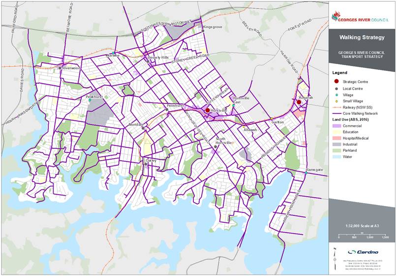
Figure 2: Strategic cycling network
Active transport strategy actions
|
Active transport |
|
|
AT1 |
Work with TfNSW to provide Sydney Green Grid links through Georges River which link into neighbouring local government areas. |
|
AT2 |
Review street trees and canopy cover to improve shade and reduce the urban heat island effect. (This includes supporting/ improving the Green Grid and linking transport to centres, schools and open space). |
|
AT3 |
Prioritise footpath, shared path and cycleway upgrades in the 800-metre catchment of schools. |
|
AT4 |
Implement the strategic walking, cycling and public transport networks to improve public transport and improve pedestrian and cycling facilities within Georges River and along Southern Sydney Corridor, including connection between the T4 and T8 train lines. |
|
AT5 |
Advocate for the completion of the Illawarra Rail Line corridor active transport route. |
|
Pedestrian |
|
|
Ped1 |
Adopt consistent footpath standards for Georges River, specifically adopting wider footpaths along higher demand areas / routes within centres to support walking, cycling and accessibility. |
|
Ped2 |
Implement the strategic pedestrian network that will provide a fully connected and accessible pedestrian network throughout Georges River. |
|
Ped3 |
Provide separation / space/ landscaped buffer between footpaths and vehicle travel lanes along freight routes using on-street parking or landscaping and/ or investigate opportunities for speed limit reductions. |
|
Ped4 |
Investigate locations for potential pedestrian priority treatments, including High Pedestrian Activity Areas, Shared Zones and 40 km/h or lower speed limit zones. |
|
Ped5 |
Identify opportunities for redevelopment sites to provide through site links and adequate pedestrian space on footpaths and for waiting at intersections. |
|
Pedestrian crossings |
|
|
PX1 |
Prioritise additional pedestrian crossings along arterial roads with lengths of 450 metres or greater without a crossing, 200 metres in residential / industrial areas, and every 100 metres in centres (off state roads) where desire lines exist. |
|
PX2 |
Identify intersections where additional pedestrian crossing legs could be provided subject to the location having a pedestrian desire line. Advocate to TfNSW for upgrades. |
|
PX3 |
Investigate the feasibility of longer crossing times at signalised intersections used by vulnerable community members (young, older, parents and disabled people). |
|
PX4 |
Advocate for pedestrian head start crossing movement at all signalised intersections. |
|
|
|
|
Bike |
|
|
Bk1 |
Implement the strategic bicycle network for a safe, connected network throughout Georges River integrating with neighbouring local government areas and regional links. |
|
Bk2 |
Collaborate with TfNSW to develop and implement the Principal Bicycle Network links within Georges River. |
|
Bk3 |
Advocate to TfNSW for additional cycle parking (including rails and bike sheds) at train stations, particularly at Kogarah and Hurstville stations. |
|
Bk4 |
Provide bicycle parking in the public domain at all centres. Target at least 5% of the quantum of Council on and off-street parking located at car parks and/ or distributed around centres, i.e. integrated with sign poles and/ or bicycle parking areas in off-street car parks located in a conspicuous location. |
|
Bk5 |
New business/ commercial/ industrial developments to provide 5% bike parking based on the total number of car parking spaces provided. Developments should have 1 change room and shower facilities per 10 spaces with a minimum of 1. |
|
Bk6 |
New residential development should have at least 1 secure multi-purpose space that can function as bike parking per dwelling and at least 5% visitor bicycle parking provided in a conspicuous location. |
Public Transport Strategy
26. The NSW State Government is responsible for the planning, maintenance and operation of the public transport networks. The Georges River Public Transport Strategy provides a clear position of Council to TfNSW of the local needs and desires of the LGA fits into the broader public transport network.
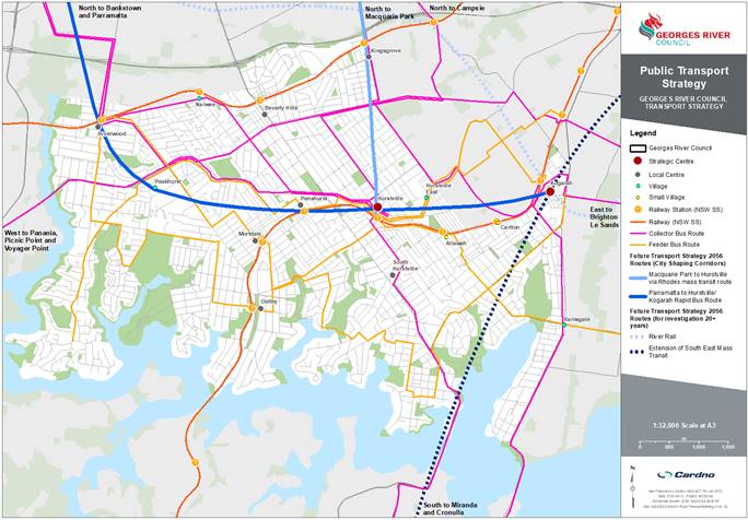
27. Georges River has a well-developed public transport network, with access to the two rail lines, T4 Eastern Suburbs and Illawarra Line and the T8 Airport and South Line, and a comprehensive bus network. Service frequency and interchange however is not maximised, and this can be a major deterrent for people choosing to use public transport in Georges River.
28. Georges River contains two key strategic centres within the wider Sydney context, Hurstville and the Kogarah health and education precinct. These strategic centres offer large employment opportunities as well as services, retail and social destinations, and as such, need to be supported by well-connected and efficient public transport options. Interchanges need to be efficient, buses should be supported by infrastructure to reduce congestion or delays, bus stops must be compliant with the Disability Discrimination Act and real time information displays should be investigated. Hurstville’s emerging night time economy must be supported by reliable public transport services outside of traditional peak periods and extend also to weekend periods.
29. FT56 (Future Transport Strategy 2056) outlines the concept of the 30-minute city, where most residents can access key employment, health and education land uses within 30 minutes by public or active transport. Currently, there is a discrepancy within the LGA of suburbs that can fulfil this 30-minute city target, including the suburbs of Lugarno, Peakhurst, Riverwood, Mortdale, Oatley, Kyle Bay and Blakehurst; which fall outside of the catchment at different times of the day. These areas should be targeted with permanent, community or on-demand bus services to promote the shift away from dependence on private vehicles.
30. Journey to Work data from 2016 indicated that a large number of residents in Georges River (37 per cent) also work in the LGA. There could be local benefits by strengthening the public transport opportunities connecting to key employment areas within the LGA, including Hurstville, South Hurstville, Kogarah, Oatley, Peakhurst industrial area, Riverwood, and Kingsgrove industrial area.
31. Major transport projects outlined by FT56 that would greatly impact public transport opportunities over the next 20 years in Georges River are:
· Parramatta to Bankstown to Hurstville/ Kogarah Rapid Bus Link (for investigation 0 – 10 years); and
· Parramatta to Kogarah Mass Transit/ Train Link (for investigation 10 – 20 years) (Refer Attachment 2).
32. The Georges River strategic public transport network is shown in Figure 3.
Figure 3: Strategic public transport network
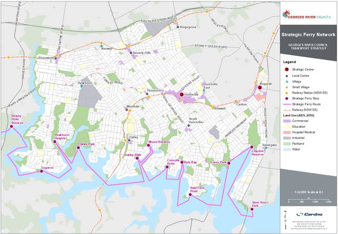
33. Stakeholder consultation indicated a desire to leverage and provide access to the natural and scenic values of Georges River with a ferry service. The potential ferry network includes an east-west route with stops located at open parkland and recreational areas.
34. The strategic ferry network is shown in Figure 4 and Public Transport Strategy.
Figure 4: Strategic ferry network
Public transport strategy actions
|
|
Public transport |
|
PT1 |
Work with TfNSW to deliver Future Transport Strategy 2056 with consideration of Georges River local transport needs, including: · Parramatta to Bankstown to Hurstville/ Kogarah Rapid Bus Link; · Parramatta to Kogarah Mass Transit/ Train Link; · Train/ Mass Transit Link Macquarie Park to Hurstville via Rhodes; and · Extension of South East Mass Transit/ Train Link to Miranda. |
|
PT2 |
Advocate to TfNSW to improve the connectivity and frequency of bus and rail services to, from and within Georges River, particularly in areas of Georges River that do not have 30-minute access to a strategic centre. |
|
PT3 |
Work with TfNSW to provide full Disability Discrimination Act compliant accessibility for public transport; particularly buses, for people with mobility and linguistic challenges. |
|
PT4 |
Investigate where more accessible car parking spaces at public transport interchanges should be provided. |
|
PT5 |
Advocate to TfNSW for first and last mile on-demand transport services where patronage levels do not justify a timetabled service provision. |
|
|
Rail |
|
Rail 1 |
Support TfNSW to improve rail services and infrastructure. i.e. More trains more services and Future Transport Strategy 2056 initiatives like Parramatta to Kogarah and Hurstville to Macquarie Park. |
|
|
Bus |
|
Bu1 |
Work with TfNSW to improve the existing bus network to rationalise routes and improve service quality and frequency on existing routes. |
|
Bu2 |
Support TfNSW in the implementation of Future Transport Strategy 2056 including reviewing and investigating bus routes with the view to improve connectivity, efficiency and accessibility. |
|
Bu3 |
Advocate for and provide input to the NSW Government's proposed strategic bus network, including dedicated bus priority infrastructure for improved efficiency and reliability. (Concept network arrangement in this strategy) |
|
Bu4 |
Support TfNSW to implement bus priority infrastructure such as bus jump start lanes along key bus routes. |
|
Bu5 |
Advocate to TfNSW for bus performance studies on key routes to identify priority measures in areas of congestion. |
|
Bu6 |
Advocate for increased public transport capacity on routes and in periods of high demand, e.g. Queens Road. |
|
Bu7 |
Advocate for improved public transport accessibility, e.g., services later at night, and/ or on-demand buses to support localities with low demand. |
|
Bu8 |
Investigate the need for any additional community bus services within Georges River, including inclusive access - this should focus on larger buses to accommodate bigger groups to reduce costs. |
|
Bus stop |
|
|
BS1 |
Undertake Disability Discrimination Act compliance audit of relevant bus stops, and prioritise upgrades based on patronage, community consultation and access to nearby destinations. |
|
BS2 |
Improve accessible footpath connections at bus stops within Georges River. |
|
BS3 |
Investigate funding opportunities (TfNSW and third-party providers) for new Disability Discrimination Act compliant bus shelters, including tendering to outdoor advertising companies while retaining functionality for buses, safety, and customer experience. |
|
BS4 |
Advocate for real time information displays at key bus stops. I.e. Hurstville and Kogarah. |
|
Ferry/ boat |
|
|
Fy1 |
Investigate the feasibility of a Georges River ferry route or scenic/ recreational tour route; utilising Georges River for water-based transport connections, including ferries and water taxis. |
Road network and freight strategy
35. Roads form a fundamental part of the transport network and serve a wide range of purposes for residents, workers and visitors, including travel to work, shops, sports ground and delivery of goods. They facilitate a variety of vehicle movements including buses, trucks, delivery vehicles, freight vehicles, private cars, taxis/ride share, bicycles, wheelchairs and electric powered devices. This varied usage of the road network requires ongoing consideration to mitigate the negative impacts of the road usage including traffic congestion, pollution, noise, increased trip times and increased parking demand in centres.
36. It is critical to identify opportunities for people to use other modes or choose to travel at more appropriate times to keep traffic demand within the limit of the road network. A focus on separating vehicle movements from other road users by time and space, and supporting appropriate vehicle sizes, and route restrictions can help create an efficient, multi-use road network that benefits all users. These changes would help to reduce the negative impacts of road usage.
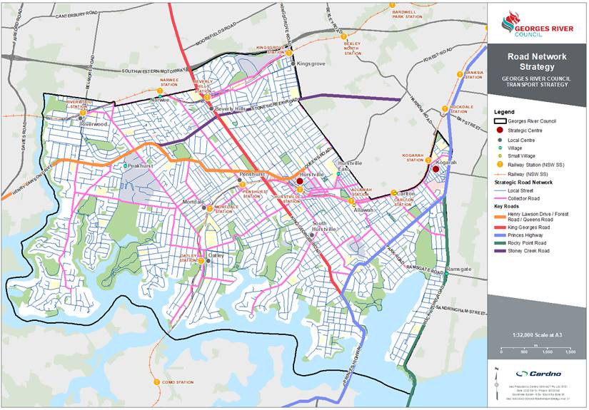
37. The strategic road network identifies key roads that will generally accommodate higher volumes of motorised vehicles including buses, trucks and private vehicles. It is likely that the significance of the strategic road network and motorised vehicles is likely to remain at a similar level for the foreseeable future.
38. The Georges River strategic road network is shown in Figure 5.
Figure 5: Strategic road network
39. Local streets connect residents to their homes, schools, recreational areas and local centres. They are generally quieter neighbourhood streets suitable for walking and cycling with minimal through traffic movements.
40. The proposed modal hierarchy for local streets in Georges River prioritises the movement of people over the movement of private vehicles, in a safe, efficient and accessible way. It is presented in Figure 6. This level of prioritisation may not be applicable in all scenarios but should be considered in future street and development planning. Freight activities are limited to deliveries and services on local streets.
Figure 6: Georges River modal hierarchy
Key roads
41. Main streets and main roads form the key roads in the network. Each key road is comprised of segments of varying movement and place values, depending on the associated land uses and road functions, which is a common challenge for integrated transport planning.
42. Listed below are key road specific opportunities identified for further investigation in TfNSW’s Road Network Plans and other Georges River Council supported documents:
· Princes Highway
· King Georges Road
· Henry Lawson Drive
· Forest Road/ Croydon Road/ Queens Road
· Rocky Point Road
· Stoney Creek Road
43. Council will need to work with TfNSW to improve key intersections as identified in Council’s Traffic Reports like the Traffic Modelling Report for Kogarah Local Environmental Plan Rezoning (Refer Action Rd1).
Freight and deliveries
44. Thriving communities rely on deliveries and services. Good urban planning enables freight and delivery tasks to operate without greatly affecting the movement of people and remaining inconspicuous in the transport network.
45. Georges River centres and industrial precincts generally have the largest freight and servicing needs.
46. Road freight activity in Georges River is typically carried out by through movements accessing Port Botany, Sydney Airport, Botany industrial lands and the Cooks River intermodal Terminal. Although there are no major freight destinations within the LGA, King Georges Road and the Princes Highway provide key north-east and north-west movements.
47. The table below shows the Road network and freight strategy actions.
Road network and freight strategy actions
|
|
Roads |
|
Rd1 |
Work with TfNSW to improve key intersections, as identified in the Traffic Modelling Report for Kogarah Local Environmental Plan Rezoning. |
|
Rd2 |
Use the Movement and Place framework as a tool in planning improvements of places and road network. |
|
Rd3 |
Support opportunities to trial technology that meets transport objectives in Georges River e.g. autonomous vehicles or electric buses. |
|
Rd4 |
Advocate for the fast-tracking M6 Stage 2 motorway for through traffic to bypass Georges River. |
|
|
Road safety |
|
RS1 |
Continue to work with TfNSW to improve safety at crash cluster locations. Advocate TfNSW to investigate opportunities to improve safety at state road crash clusters. |
|
RS2 |
Advocate to TfNSW for reduced speed limits (where feasible) in high pedestrian and cyclist areas to 30 km/h. (Note 30 km/h limits supports safer vehicle/ bicycle mixed use road space) |
|
RS3 |
Ensure provisions for pedestrians and bicycles are provided as part of construction activities impacting the transport network in addition to the requirements of TfNSW Traffic control at work sites Technical Manual. |
|
RS4 |
Identify any gaps in street lighting and improve the coverage of street lighting on roads throughout Georges River. |
|
|
Freight and servicing |
|
Fr1 |
Protect existing freight corridors from adjacent land uses that will reduce the effectiveness of the corridor. (Related to LU5) |
|
Fr2 |
Support initiatives and technology advances that achieve objectives for first and last mile deliveries in strategic and local centres. (Related to PT6/ PT5 - amended) |
|
Fr3 |
Plan for freight access, site servicing and movement in centre masterplanning. |
Car Parking strategy
48. Parking is a key transport necessity that supports access to centres, homes, jobs, goods and services. An oversupply of parking can result in continued higher driver mode share, occupying land that could be used to transport higher numbers of people, and is related to increased congestion.
49. When planning for increased development and urban renewal, it is important to consider the effects on the parking demand and supply. Parking demand is generated from land use activity, park and ride for public transport services, and residential vehicle ownership. The efficiency of parking supply is influenced by its location, accessibility and restriction management. It is controlled by public parking infrastructure, and Council’s DCPs.
50. Council has a Car Parking Strategy (the Strategy) adopted in April 2020 which provides a review and recommendations on the existing public car parking available in commercial centres across the LGA, and an accompanying Position Paper adopted in April 2020 which provides the Council’s position on the strategies and recommendations in the Strategy. The documents are outlined in Section 3.2.2.3 of the Strategic Context Report.
51. The Strategy accompanied by the Position Paper is generally sufficient for an interim period. It is recommended that the car parking strategy be updated by 2025.
52. Council determined new car parking rates which are now set for an interim period outlined in Section 3.2.2.3 of the Strategic Context Report. These are generally appropriate. For Medical Centre land use, it is recommended parking rates be determined through a site-specific parking study in locations where overspill cannot be easily accommodated.
Centres Transport Strategy
53. Centres are important as they provide access to jobs, education, health services and opportunities to travel. Georges River Council Commercial Centres Strategy (‘CSP’) recognises that the best opportunities to embrace population growth in Georges River is to plan for higher density population development in centres connected to transport and services. This ensures that the character of the quieter streets or suburbs is protected from development and the additional residents are connected to jobs and services by active and public transport.
54. The chosen centres for analysis in more detail are shown in Figure 7. The centres were selected due to their significant locations attached to train stations, as these are the locations most likely to receive employment or residential growth.
Figure 7: Centres strategy
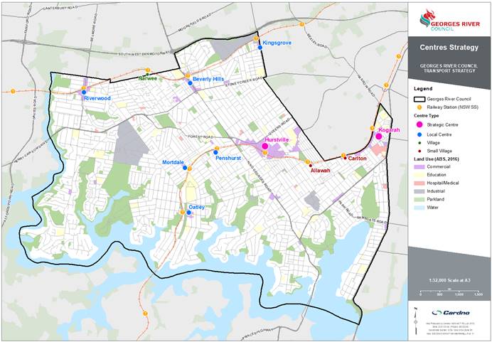
Strategic centres
55. Strategic centres are regionally significant commercial hubs that provide access to major employment, health and education land uses. They are nominated by the Greater Sydney Commission in the Greater Sydney Region Plan and the District Plans and are important Sydney Metropolitan destinations.
56. Strategic centres are supported by high quality public transport interchanges, with services connecting between metropolitan, strategic and local centres. The proposed strategic active and public transport networks are designed to provide greater access to strategic centres.
57. General strategic centre actions are consistent with actions from preceding sections and are provided below. The strategic centres discussed in further details within Georges River are Hurstville and Kogarah.
Strategic centre general actions
|
Strategic centres |
|
|
AT5 |
Implement the strategic walking, cycling and public transport networks to improve active transport connections within Georges River, including connection between the T4 and T8 train lines. |
|
AT6 |
Advocate for the completion of the Illawarra Rail Line corridor active transport route. |
|
Bk3 |
Advocate to TfNSW for additional cycle parking (including rails and bike sheds) at train stations, particularly at Kogarah and Hurstville stations. |
|
PT1 |
Work with TfNSW to
deliver Future Transport Strategy 2056 with consideration of Georges River
local transport needs, including: |
|
CP1 |
Implement actions from the Georges River Car Parking Strategy to improve the provision and use of parking. |
Kogarah - Strategic Centre
58. The vision for Kogarah is to establish a connected, safe and high performing local transport network that efficiently connects people to the significant health and education land uses in the centre.
59. TfNSW presents strategic plans for public transport infrastructure connecting to Kogarah that would greatly increase accessibility of metropolitan and strategic centres in Sydney, including:
· Parramatta to Bankstown to Hurstville/ Kogarah rapid bus link (for investigation 0 to 10 years);
· Parramatta to Kogarah Mass Transit/ Train Link (for investigation 10 to 20 years); and
· The extension of South East Mass Transit/ Train Link to Miranda (for investigation 20+ years).
60. General strategic centre actions are provided in Section 5.7.2, and centre specific actions for the Kogarah strategic centre are presented below.
Centre specific actions – Kogarah
|
Kogarah specific actions |
|
|
Kog1 |
Provide an active transport link along the Muddy Creek Canal. |
|
Kog2 |
Improve laneways in the Kogarah centre for walking and cycling. |
|
Kog3 |
Investigate the installation of ground sensors in 1/2P and 1P spaces as a trial. |
|
Kog4 |
Introduce additional car sharing zones adjacent to the station. |
|
Kog5 |
Review pricing strategy for the Town Square Car Park, considering the opportunities for employee parking. |
|
Kog6 |
Promote the Derby Street car park for daily employee parking. |
|
Kog7 |
Introduce on-street paid parking in key locations within the centre. |
|
Kog8 |
Establish Kiss & Ride zones, particularly near schools in the Kogarah education precinct. |
|
Kog9 |
Negotiate with businesses in Kogarah and the Leagues Club to provide all day parking. If demand warrant, a shuttle bus service could be provided between the Leagues Club and Kogarah town centre. |
Hurstville - Strategic Centre
61. The Hurstville strategic centre is a significant retail destination in Sydney’s South District. The centre supports a growing population through high accessibility to public transport.
62. The desire for Hurstville to improve its night time economy is presented in the LSPS as well as the need to link the T4 Eastern Suburbs and Illawarra line with the T8 Airport and South train line to improve connectivity within the LGA.
63. Hurstville’s significance is supported by the commitment to investigate FT56 public transport projects over the next 20 years to improve regional connectivity between the centre and key employment areas. These projects are:
· Train/ mass transit link between Macquarie Park and Hurstville via Rhodes; and
· Parramatta to Hurstville/ Kogarah rapid bus route.
64. The Illawarra rail line corridor has been identified as a key corridor for an active transport link for both the Sydney Green Grid and the Principal Bike Network.
65. General strategic centre actions are provided in Section 5.7.2, and centre specific actions for the Hurstville strategic centre are below.
Centre specific actions – Hurstville
|
Hurstville specific actions |
|
|
Hur1 |
Implement recommendations from the 2018 Hurstville City Centre TMAP. |
|
Hur2 |
Investigate expansion of bus and train services to cater for the growing night time economy. |
|
Hur3 |
Investigate ways to encourage longer stay parking to be consolidated to the periphery of the centre. |
|
Hur4 |
Investigate paid all-day parking at Gloucester Road, Park Road and Woniora Road. |
|
Hur5 |
Prepare integrated signage plans and use real time data to inform drivers of parking availabilities. |
|
Hur6 |
Introduce additional car sharing zones adjacent to the station. |
Local centres
66. Local centres are important community areas that support day to day access to goods and services, close to where people live. The Greater Sydney Commission identifies local centres as targets for housing and employment development, especially in centres that have a large supermarket. They provide residents with public transport services and are also supported by large walking and cycling catchments.
67. It is important to consider the effects on parking demand. Residential development in a local centre with access to high quality public transport generally results in lower private vehicle ownership, whereas residential development away from a local centre and away from high quality public transport results in increased parking demand at the centre and the public transport hub.
68. The local centres discussed in further detail within Georges River are Penshurst, Mortdale, Riverwood, Beverly Hills, Kingsgrove (Kingsgrove Road) and Oatley. General actions for local centres are provided below.
Local centre general actions
|
Local centres |
|
|
LU3 |
Undertake Master Planning for all key centres referencing the transport vision, objectives and actions of the Transport Strategy. |
|
AT5 |
Implement the strategic walking, cycling and public transport networks to improve active transport connections within Georges River, including connection between the T4 and T8 train lines. |
|
AT6 |
Advocate for the completion of the Illawarra Rail Line corridor active transport route. |
|
Bk4 |
Provide bicycle parking in the public domain in all centres. Target at least 5% of the quantum of Council on and off-street parking located at car parks and/ or distributed around centres, i.e. integrated with sign poles and/ or bicycle parking areas in off-street car parks located in a conspicuous location. |
Villages and small villages
69. Villages and small villages support local residents, providing a small amount of retail floor space including a small convenience store or supermarket. They are supported by feeder bus routes and have less frequent train services, connecting residents to other local and strategic centres. They provide short term parking and loading zones supporting local retail, as well as accessible car parking spaces. Bike parking needs to be supported in villages and small villages.
70. The village discussed in further detail is Narwee, and the small villages discussed are Allawah and Carlton. General actions for villages and small villages are provided below.
Village and small village general actions
|
|
Villages and small villages |
|
AT5 |
Implement the strategic walking, cycling and public transport networks to improve active transport connections within Georges River, including connection between the T4 and T8 train lines. |
|
AT6 |
Advocate for the completion of the Illawarra Rail Line corridor active transport route. |
|
Bk4 |
Provide bicycle parking in the public domain in all centres. Target at least 5% of the quantum of Council on and off-street parking located at car parks and/ or distributed around centres, i.e. integrated with sign poles and/ or bicycle parking areas in off-street car parks located in a conspicuous location. |
Community Engagement
71. It is recommended that the draft Strategy be made available for public comment for a period of no less than 28 days and that the following Community Engagement Plan be endorsed for the purposes of the exhibition of the draft Georges River Transport Strategy.
72. A report will then be presented to Council on the feedback received during the exhibition phase.
Community Engagement Plan
|
Stakeholders |
Proposed Action |
|
General Consultation |
· Information to be included on Council’s Your Say webpage · Information to be placed at Council’s Customer Services Centres and in local libraries · 2 x advertisements to be placed in the local newspaper (1st and 3rd week of the exhibition) – the Ads will also advise of the Drop-in Sessions which will be available during the exhibition period · Council’s Strategic Planning staff will be available during office hours to answer telephone and face to face enquiries |
|
Stakeholder Consultation Webinars |
· Webinars (between 2 and 3) will be organised at different times of the week to reach out to the maximum number of stakeholders. At this stage, it is anticipated that they will be held on Tuesday, between 10am and 11.30am, Thursday from 6pm – 7.30pm and Saturday between 10am – 11.30am · More information on the webinars and the draft Strategy will be uploaded on the project’s Your Say page |
|
St George Business Chamber and Economic Development Advisory Committee |
Notification of the exhibition |
|
Government agencies including TfNSW, adjoining Councils and interest groups including Bicycle User Groups and Council staff |
Notification of the exhibition and organise webinars with: · Government Agencies · Interest Groups, including Bicycle User Groups · Council Staff |
|
Media |
· Media Release to be sent to the local paper prior to the commencement of the exhibition advising of the exhibition of the draft Strategy |
NEXT STEPS
73. It is recommended that the draft Strategy (Attachments 1 and 2) be placed on public exhibition in July 2021 in accordance with the Community Engagement Plan to encourage stakeholders to have an opportunity to provide comment and feedback. Prior to finalisation of the Strategy, further assessment will be undertaken to ensure all issues raised have been considered in the draft Strategy.
74. Once the engagement phase has been completed, a further report will be presented to Council. This report will provide an overview of the issues raised during the exhibition phase and may result in further refining of the Strategy, specifically the Consultation, Implementation and Monitoring sections.
FINANCIAL IMPLICATIONS
75. The preparation of the draft Transport Strategy was within budget allocation.
Risk Implications
76. No risks identified.
Community Engagement
77. Community engagement will be conducted in accordance with the Engagement Strategy included in this report.
File Reference
D21/135079, 19/1329
|
Attachment 1 |
Draft Georges River Transport Strategy - June 2021 - published in separate document |
|
Attachment 2 |
Georges River Strategic Context Report - June 2021 - published in separate document |
|
Attachment 3 |
Consolidated List of Actions - published in separate document |
Georges River Council - Environment and Planning - Tuesday, 15 June 2021 Page 1
Item: ENV024-21 Georges River Foreshore Scenic Character Study (Ethos Urban)
Author: Strategic Planner/Urban Designer
Directorate: Environment and Planning
Matter Type: Committee Reports
|
That Council notes the findings and recommendations of the technical study prepared by Ethos Urban, the Georges River Foreshore Scenic Character Study that will inform the preparation of future amendments to the Georges River Local Environmental Plan, the Georges River Development Control Plan and other relevant planning policies. |
Executive Summary
1. The purpose of this report is for Council to note the findings of the Georges River Foreshore Scenic Character Study (“the Study”) as a technical study which will inform the preparation of future amendments to the Georges River Local Environmental Plan, the Georges River Development Control Plan and other relevant planning policies.
2. The Study has been prepared to further investigate the role, mapped extent and zoning of the Foreshore Scenic Protection Area (“FSPA”) by building upon the existing evidence base provided by the Foreshore Strategic Directions Paper (“the Paper”). This is achieved through further clarifying the character typologies present in the visual catchment to and from the Georges River.
3. In light of the Study’s findings, recommendations for a set of planning controls to protect the LGA’s biodiversity are currently being developed by Ethos Urban in collaboration with Total Earth Care.
4. Concurrently, Ethos Urban is also preparing the Local Character Statements in accordance with DPIE’s Local Character and Place Guideline (February 2019) to enable the insertion of local character overlays into the local planning framework.
5. Both projects are currently underway as independent but complementary projects to the Study. These will be completed later this year and will be the subject of a separate Council report.
Background
Foreshore Strategic Directions Paper
6. In 2018, Ethos Urban was commissioned by Council to prepare the Foreshore Strategic Directions Paper (“the Paper”) for the purpose of evaluating the policy framework established by the Hurstville and Kogarah Local Environmental Plans and identifying key issues, emerging directions and key principles that will form the foundation for the preparation of the new foreshore planning controls in the Georges River Local Environmental Plan (“LEP”) and accompanying Development Control Plan (“DCP”).
7. As part of this Paper, a visual character assessment was undertaken of the foreshore localities to the ridgelines (as viewed from the water) and waterways along the land and water interface.
8. As a result, the study area is categorised into distinct character areas (refer Figure 1 below) to allow for the designation of a rating system in terms of the overall character value and the area’s sensitivity to change such as tree clearing, larger scale development, altered geology through cut and fill, and the replacement of incongruous development with contemporary styles.
Figure 1 – Foreshore Character Typologies identified by the Paper
9. The common characteristics and attributes of the character areas that are considered as having a High or Very High sensitivity rating are high levels of tree coverage, steep or undulating terrain with distinctive ridgelines, all with minimal visible built form.
10. Character typologies with High or Very High sensitivity ratings generally have an interface with the Georges River and are predominantly located along the waterfront and towards the west of the study area.
11. Character areas to the east of Georges River are largely assessed as having a lower sensitivity rating. This is due to the flatter topography, lower vegetation coverage as a result of contemporary developments and the dominant built form character.
12. The character analysis conducted by the Paper was used to inform the preparation of the Georges River LEP.
Georges River Local Environmental Plan 2020
13. The amended Planning Proposal for the Georges River Local Environmental Plan 2020 (“LEP 2020”) was endorsed by the Georges River Local Planning Panel (“LPP”) at its meeting dated 25 and 26 June 2020 and was submitted to the Department of Planning, Industry and Environment (“DPIE”) for final legal drafting on 30 June 2020.
14. The draft LEP 2020 had originally proposed to reduce the extent of the existing Foreshore Scenic Protection Area (“FSPA”) in the former Hurstville LGA to exclude areas with lower sensitivities to change as identified by the Paper. The original reduction (refer Figure 2 below) was endorsed by DPIE through its Gateway Determination.
15. The removal of these properties from the existing FSPA would have enabled increased development potential (i.e. eligible for dual occupancies) for 742 sites. This proposal was endorsed by the DPIE through the Gateway Determination.
Figure 2 – Map of proposed FSPA endorsed by Gateway Determination
16. The Planning Proposal for the draft LEP 2020 was publicly exhibited from 1 April to 31 May 2020 (inclusive) and a total of 1,153 community submissions were received. The content of the submissions were categorised into 14 topic areas.
17. A total of 510 submissions were received in relation to the FSPA with over 400 submissions objecting to the removal of properties within the FSPA due to impacts associated with overdevelopment as result of the increased dual occupancy development potential and the loss of vegetation and biodiversity through overdevelopment.
18. To address the concerns raised by the submissions in relation to the FSPA, the LPP made the following amendments to the draft LEP 2020:
· Increase the minimum landscaped area requirements for dual occupancies (non-FSPA) to 25% and dual occupancies (FSPA) to 30% and to ensure new developments are accompanied by increased planting and vegetation;
· Insert a new local provision to protect trees in the R2 and R3 zones; and
· Retain the existing extent of the FSPA in the Hurstville LEP while expanding the FSPA to the former Kogarah LGA in accordance with the as-exhibited version. Refer Figure 3 below for the final FSPA extent proposed by the draft LEP 2020.
Figure 3 – Map of FSPA submitted for finalisation as part of LEP 2020
19. However, further investigation was requested by the LPP in its recommendation.
20. The subject of this report, the Foreshore Scenic Character Study, has been prepared for the purpose of investigating the mapped extent and zoning of the FSPA in accordance with the resolution made by the LPP.
Biodiversity Study
21. Separate but concurrent to this Study, Council has commissioned Total Earth Care to conduct a LGA-wide Biodiversity Study which assesses the diversity of flora (plant) and fauna (animal) present, analyses historical changes and recommends key opportunities to protect and conserve biodiversity.
22. The Biodiversity Study has now been prepared and is subject of a separate report to this meeting.
23. This Study acknowledges the complementary nature of the Biodiversity Study and relies on the Biodiversity Study to inform considerations relating to environmental and vegetation protection.
24. Accordingly, an additional component to the Biodiversity Study is currently being carried out as a collaboration project between Ethos Urban and Total Earth Care for the purpose of developing draft planning controls that can be included in the Georges River LEP and DCP. This component will be completed later this year and will be the subject of a separate Council report.
Funding source
25. On 7 September 2018, Council received funding from the NSW Government of $2,500,000 for an accelerated review of Council’s existing LEPs and the preparation of a new LEP that aligns with the priorities outlined in the South District Plan. The grant funding also enabled Council to prepare the Local Housing Strategy and Inclusive Housing Strategy to inform the new LEP and a local strategic planning statement for the LGA.
26. The draft LEP 2020 was prepared and submitted to DPIE for final legal drafting by 30 June 2020 in accordance with the conditions of the grant funding. However, approximately $750,000 of the grant funding remained unspent by Council.
27. DPIE advised that the surplus grant funding would be made available to Council to enable the expedited preparation of a planning proposal to address the LGA’s shortfall in housing delivery.
28. Another Planning Proposal, known as LEP21 was prepared and submitted to DPIE for final legal drafting by 31 March 2021. Capacity for an additional 300 dwellings is created by LEP21 in order to meet the Greater Sydney Commission’s 6-10 year housing target (3,450 - 4,250 additional dwellings) for the period from 2021/22 to 2025/26.
29. In addition to the preparation of this Planning Proposal, the LEP grant funding has also enabled the preparation of a number of key strategic studies and plans which will be used to inform future amendments to the Georges River LEP subject to Council’s endorsement.
30. The Foreshore Scenic Character Study and Biodiversity Study have both been prepared using the LEP grant funding.
PURPOSE OF STUDY
31. The purpose of preparing the Foreshore Scenic Character Study (“the Study”) is to further investigate the role, mapped extent and zoning of the FSPA in accordance with the resolution made by the LPP during the finalisation of the draft LEP 2020.
32. The Study builds upon the existing evidence base provided by the Paper to further clarify the character typologies present in the visual catchment to and from the Georges River.
33. In recognition of the substantial body of work undertaken as part of the Paper, the intent of this project is to further develop and refine the methodologies and key directions utilised by the Paper as opposed to starting afresh.
34. The Study is a technical and evidence-based document which will assist Council in developing and reviewing local planning measures, including future amendments to the Georges River LEP and accompanying DCP.
35. A copy of the Georges River Foreshore Scenic Character Study is provided in Attachment 1.
STUDY AREA
36. The Study Area of the project is consistent with the study area previously utilised by the Paper.
37. The Study Area is inclusive of approximately 40km of shoreline along the Georges River and the following suburbs:
· Blakehurst
· Connells Point
· Hurstville Grove
· Kogarah Bay
· Kyle Bay
· Lugarno
· Oatley
· Peakhurst
· Peakhurst Heights
· Riverwood
· Sans Souci
38. There is also a secondary study area which has been identified using 3D visibility mapping to satisfy the LPP’s requirement to identify all land visible to and from the Georges River.
39. The 3D mapping has been prepared using LiDAR data and enables structures, buildings, vegetation and landform to be captured at a high level of accuracy (to within 0.5m). The visibility has been mapped from 1.65m above the surface of the land to correspond with the average human eye height.
40. Based on this mapping, the secondary study area includes all land that are theoretically visible from the Georges River (refer Figure 4 below), inclusive of land located at the top of ridgelines such as the Hurstville City Centre and the Kogarah Town Centre.
Figure 4 – Visibility Mapping from the Georges River
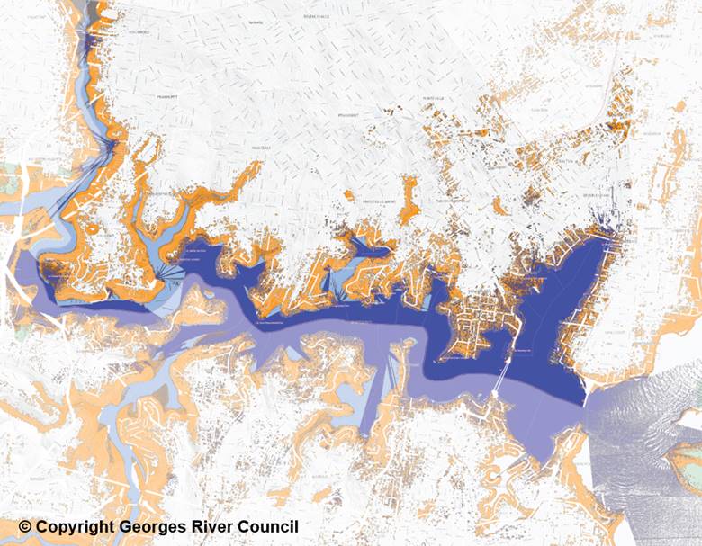
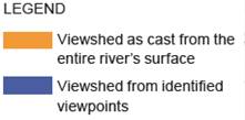
41. However, the inland areas are excluded from the formal Study Area despite their theoretical visibility from the Georges River. This is due to the unlikelihood of development in these areas having a significant impact on the scenic character values of the foreshore when factors such as decreased visibility with distance are taken into consideration.
STRUCTURE OF THE STUDY
42. The Study is comprised of 4 parts:
· Part A: Introduction – this Part outlines the purpose of the project, defines the Study Area, examines the existing planning policy framework, provides background information relating to the Foreshore Strategic Directions Paper and establishes the methodology undertaken for this project.
· Part B: The Scenic Character Foreshore Protection Area – this Part defines the role and purpose of the FSPA examines the scenic character present within the LGA.
· Part C: Local Character – this Part identifies and analyses the local character typologies present within the Study Area. A precinct profile has been provided for each character typology. Each precinct profile is comprised of the following components:
o Description
o Character Attributes
o Positives and Opportunities
o Threats and Risks
o Sensitivity Rating
o Significance Rating
· Part D: Towards an Integrated Local Planning Policy Response – this Part synthesises the findings of the Parts B and C into local planning policy recommendations.
43. The Study is supported by a Site Survey Matrix (refer Attachment 2) which details the observations of the following attributes for each local character typology:
o Built form
o Setbacks and siting of buildings
o Fencing
o Geology
o Topography
o Vegetation
o Street layout
o Interface between the public and private domains
o Views to and from the Georges River
METHODOLOGY
44. To fulfil the objectives of this project, a methodology has been developed and applied by Ethos Urban in the preparation of this Study. This process has been guided by the aim of defining the role of the FSPA and specifically the objectives of defining what is considered to be ‘foreshore’ and ‘scenic’.
45. The preparation of the methodology draws from an extensive body of knowledge including government-issued guidelines, existing literature, journal publications from professional chartered bodies and NSW case law. All of the FSPA-related submissions received as part of the public exhibition of the draft LEP 2020 have also been reviewed by Ethos Urban.
46. A number of considerations pertaining to ‘views’ and ‘local character’ have resulted from this research. Subsequently, the Study has been conducted by Ethos Urban in accordance with the following methodology which is comprised of 3 components.
47. The first component focuses on the FSPA and includes the following tasks:
· Define and clarify the role of the FSPA in the local planning framework;
· Identify what is the ‘foreshore’ in the context of the FSPA;
· Understand the ‘scenic character’ of the Georges River foreshore by undertaking site surveys of every street within the Study Area; and
· Review the extent of the FSPA to reflect visibility and scenic character.
48. The second component focuses on local character by analysing the results of the site surveys. It includes the following tasks:
· Assess the existing attributes nominated in Paragraph 43 above;
· Identify and map out the location of the various character typologies in accordance with the observed attributes;
· Prepare Local Character Area Profiles for each character typology to provide descriptions of key characteristics;
· Identify threats and risks such as tree clearing, reduction of building setbacks and incongruous contemporary developments;
· Assess the sensitivity of each character typology based on the threats identified; and
· Assign ratings of sensitivity and significance to the character typologies.
49. It should be noted that the character typologies have been mapped in accordance with the prevailing attributes. There will always be exceptions and outliers to the common local character. The exact locations of these ‘out of character’ developments have not been identified by this Study.
50. The third component synthesises the findings of the 2 components above and provides recommendations for amending the Georges River LEP to more effectively protect and enhance the LGA’s scenic and local character.
KEY FINDINGS
Character Typologies
51. Based on the site surveys of every street within the Study Area, a more comprehensive and detailed assessment has been undertaken to review the character typologies presented by the Paper (refer Figure 1 above).
52. As a result, the following 15 character typologies have been identified as shown in Figure 5 below:
Residential
· Garden Suburban – Traditional
· Garden Suburban – Naturalistic
· Garden Suburban – Medium Density
· Bush Suburban
· Garden Court
· Emerging Contemporary
· Rivers Edge – Naturalistic
· Rivers Edge – Semi-Naturalistic
· Rivers Edge – Contemporary
Commercial
· High Street
· High Street Mix
· Neighbourhood Centre
· Neighbourhood Convenience
Open Space
· Naturalistic
· Semi-Naturalistic
Figure 5 – Character Typologies identified by the Study
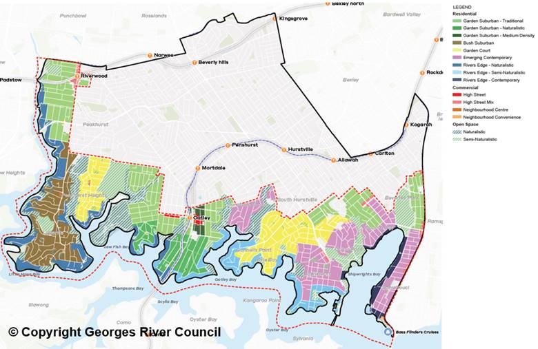
53. An individual precinct profile has been provided by the Study for each of the above character typologies.
Foreshore Scenic Protection Area
54. In accordance with the LPP resolution, the Study investigates the role, mapped extent and zoning of the FSPA.
Role of the FSPA
55. The Study identifies that the role of the FSPA is to protect the scenic character of the Georges River, including its foreshore. There are a number of areas in the LGA that exhibit scenic character, which is particularly sensitive to threats such as tree clearing and larger scale development.
56. On this basis, having a dedicated local provision in the form of a FSPA clause within the LEP is warranted.
57. With consideration of its role, the wording of the existing FSPA clause within the Hurstville Local Environmental Plan 2012 (“HLEP 2012”) is preferred as it targets the focus of the clause on addressing scenic character attributes.
58. In comparison, the FSPA clause proposed by the draft LEP 2020 introduces additional requirements relating to the protection of biodiversity. Providing additional emphasis on environmental values is considered to dilute the focus of the clause and runs the risk of implementation challenges.
59. Detailed provisions relating to biodiversity should be removed from the FSPA clause. However, environmental values are nonetheless critical.
60. On this basis, a new biodiversity overlay should be created to apply to the whole LGA and not just the areas in the foreshore.
61. Nonetheless, references to trees and vegetation that contribute to the scenic character are recommended to be retained in the FSPA clause.
Extent of the FSPA
62. The Study concludes that the extent of the FSPA should correlate to the areas that satisfy both the visibility and scenic character criteria.
63. Visibility is comprised of two aspects:
· It is visible from the river and/or its foreshores; and
· Due to factors such as distance and zoning, there is a threat of inappropriate development being highly visible from the river and/or its foreshores.
64. The scenic character criteria refer to land that has a naturalistic character; in particular through a dominance of visual dominance of natural elements over built elements.
65. The common elements contributing to scenic character are water, the land and water interface, land rising upwards from the land and water interface and the sky.
66. Within this overall pattern, scenic character is different in the eastern and western parts of the foreshore as generally delineated by Tom Uglys Bridge.
67. The western part of the foreshore comprises an undulating landform, a complex coastline of headlands, peninsulas and bays, extensive tree canopy including at the land and water interface and visual dominance of natural (including curated) elements over human elements. In general, this can be considered a naturalistic foreshore.
68. A naturalistic foreshore is considered to closely correlate with scenic character, and overall is more vulnerable to the risks posed by the nature of many types of new development.
69. The eastern part of the foreshore comprises a more level landform, a simpler, largely modified coastline, substantially less tree canopy overall and in particular at the land and water interface, built structures including jetties, pontoons, revetment walls, swimming pools and other structures between the land and water interface and built form, and a more dense, larger scale and newer built form.
70. Overall, this can be considered an urban foreshore and have a higher capacity to accommodate change. While of value, an urban foreshore is not considered to closely correlate with scenic character.
71. It is important to note that despite this overall pattern, how scenic character manifests on the ground is complex, and includes a level of variance. For example, there is the large, open and green space of Carss Park within the broader urban foreshore character east of Tom Uglys Bridge. Within the naturalistic foreshore in Lugarno and Oatley, there are pockets where much of the escarpment is occupied by buildings.
72. The Study identifies that the extent of the FSPA proposed by the draft LEP 2020 does not align with the two determinative factors of visibility and scenic character, and subsequently recommends a reduction to the extent of the FSPA as follows:
· Removal of areas further away from the river that do not satisfying the visibility criterion; and
· Removal of areas around the Kogarah Bay foreshore that do not exhibit scenic character.
73. In summary, the proposed FSPA is comprised of the following character typologies:
· Rivers Edge – Naturalistic
· Rivers Edge – Semi-Naturalistic
· Naturalistic
· Semi-Naturalistic (note: only includes parks and reserve located along the river)
74. A comparison of the proposed FSPA extent (shaded in blue) is provided against the draft LEP 2020 (outlined in orange) in Figure 6 below.
Figure 6 – Comparison of Proposed FSPA and draft LEP 2020 FSPA
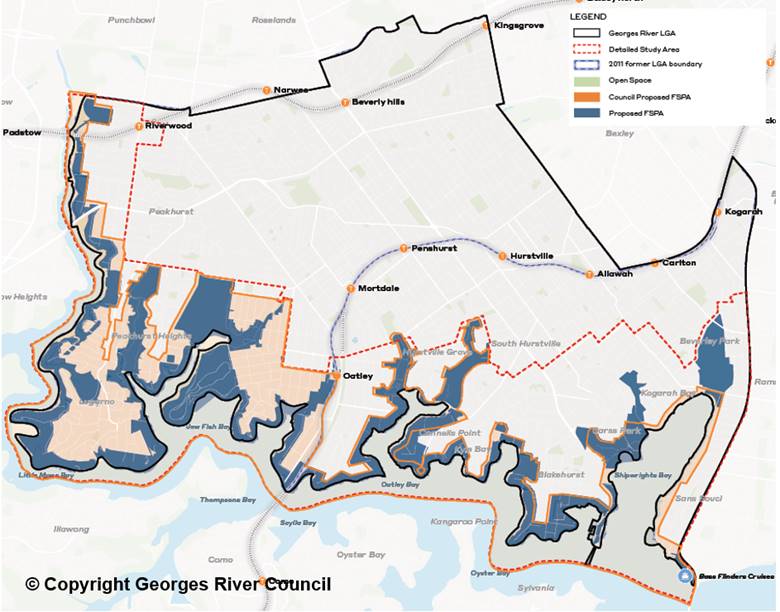
75. It should be noted that a significant portion of residential zoned land are deemed to possess significant local character that warrant greater protection in local planning policies. On this basis, a new local character overlay should be created.
Zoning of the FSPA
76. Within the draft LEP 2020, the majority of privately owned land in the FSPA is zoned R2 Low Density Residential. This zone limits permissible development to uses such as dwelling house and dual occupancies and other uses that provide for the day to day needs of residents such as centre-based child care facilities. It also allows for jetties.
77. The Study considers potential alternative zones available under the Standard Instrument which can be applied to give better effect to the objectives of the FSPA, most notably the E4 Environmental Living zone.
78. While the objectives of the E4 zone are aligned with the protection of scenic character, it is considered to unreasonably restrict land use permissibility. The only permissible residential use is dwelling houses. Due to it also being a closed zone, dual occupancies and jetties are prohibited.
79. Through this comparison, the Study determines that the current zoning pattern is the most appropriate to achieve a balance between protecting the scenic character of the FSPA and enabling reasonable, appropriate development to occur.
80. In particular, the objectives of the R2 zone within the draft LEP 2020 require development ‘to promote a high standard of urban design and built form within a landscaped setting that enhances the local character of the suburb and achieves a high level of residential amenity.’ This is considered to clearly and succinctly articulate a key outcome sought for the FSPA.
Local character overlay
81. Scenic character is related to, but different from local character. Scenic character is more focussed on visible aspects with regional significance while local character is broad, being drawn from a range of attributes such as built form, setbacks and siting of buildings.
82. Furthermore, while every area has a local character, it may not be scenic. For example, a coherent industrial area can also be a local character area, but is not necessarily of scenic character.
83. The DPIE’s Local Character and Place Guideline (February 2019) defines local character as what makes a neighbourhood distinctive and is the identity of a place. It differentiates one area apart from another.
84. As noted above, the Study identifies that some local character areas within the Study Area warrant consideration of greater protection in local planning policy through a local character overlay.
85. In summary, the proposed local character overlay is comprised of the following character typologies:
· Garden Suburban – Naturalistic
· Bush Suburban
· Rivers Edge – Contemporary
86. A comparison of the proposed local character overlay (shaded in pink) is provided against the extent of the FSPA proposed by the draft LEP 2020 (outlined in orange) in Figure 7 below.
Figure 7 – Comparison of Local Character Overlay and draft LEP 2020 FSPA
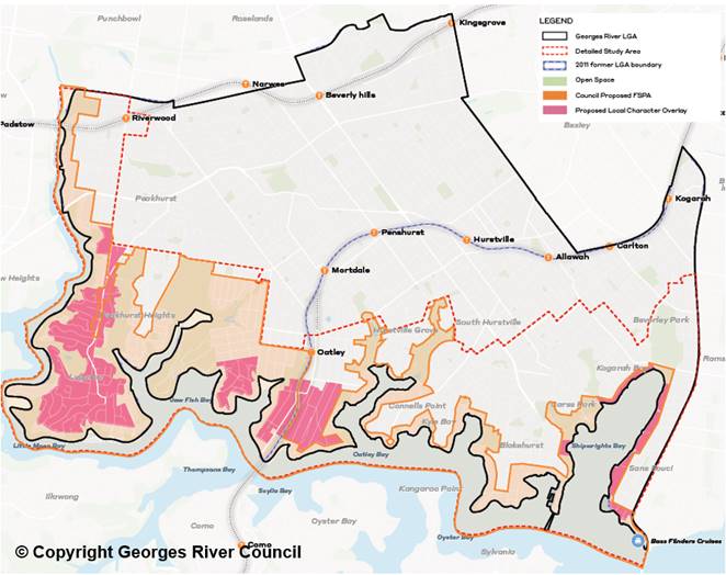
87. Similar to the FSPA local provision, the local character overlay will comprise of a map and a clause within the Georges River LEP.
88. DPIE has developed a local character overlay and draft local character clause that will allow councils to insert a reference to local character in their LEP via a Local Character Statement and map.
89. DPIE’s local character clause is still a draft, however, DPIE states that councils should use the character assessment toolkit in the Local Character and Place Guideline to identify local character areas.
90. Given that the scope of the Study is to identify the most appropriate provisions to better protect and enhance existing character values, further work is required to develop the range of documentation required by DPIE to enable the introduction of the local character overlay into the Georges River LEP.
91. Furthermore, the existing DCP controls will be reviewed to support the local character overlay in the LEP. This work is currently underway as an independent but complementary project to the Study and is expected to be completed later this year.
Biodiversity overlay
92. As outlined above, the Study suggests the removal of detailed provisions relating to biodiversity from the FSPA clause to ensure the focus remains on scenic character and values.
93. Instead, a new standalone biodiversity clause is recommended to be developed and applied to the whole LGA. This is supported by recommendations of the Biodiversity Study, in particular the following action:
Develop and implement initiatives for private landholders to improve vegetation condition and extend the tree canopy on private land, especially adjacent to important green corridors.
94. An additional component to the Biodiversity Study is currently being carried out as a collaboration between Ethos Urban and Total Earth Care for the purpose of developing draft planning controls that can be included in the Georges River LEP and accompanying DCP to protect the LGA’s biodiversity.
95. This component will be completed later this year and will be the subject of a separate Council report.
Other provisions
96. Under the draft LEP 2020, new developments within the FSPA are required to comply with additional requirements with respect to dual occupancy lot size, subdivision lot size, landscaped area and design excellence.
97. The Study considers these additional requirements to be broadly acceptable for areas located within the proposed FSPA and the new local character overlay.
98. However, the Study does not recommend design excellence requirements to be applied to the new local character areas in its current form due to the potential duplication of controls. The design excellence clause proposed by the draft LEP 2020 focuses on context responsive design, which is already a prerequisite consideration within the preparation of Local Character Statements for the local character overlay.
99. Subsequently, the Study recommends the partial application of the design excellence provision to the local character overlay areas or the use of the draft LEP 2020 considerations as the basis to inform the preparation of the Local Character Statements. This is currently being reviewed as part of the local character work being prepared by Ethos Urban.
100. Table 1 below provides a comparison of the Study’s recommended application of these additional requirements. It should be noted that the comparison is only provided for dwelling house and dual occupancy developments in the R2 Low Density Residential zone as this is the predominate zone within the Study Area.
Table 1 – Comparison of Requirements relating to FSPA and Local Character
|
Requirement in draft LEP 2020 |
Areas within FSPA proposed by the Study |
Areas within Local Character Overlay |
Areas outside of FSPA and Local Character Overlay |
|
Subdivision lot size |
700sqm |
700sqm |
450sqm |
|
Dual occupancy lot size |
1,000sqm |
1,000sqm |
650sqm |
|
Landscaped area for dwelling houses |
25% of site area |
25% of site area |
20% of site area |
|
Landscaped area for dual occupancies |
30% of site area |
30% of site area |
25% of site area |
|
Design excellence |
Applicable |
Not recommended in its current form |
Not applicable |
Financial Implications
101. As noted above, the Foreshore Scenic Character Study and Biodiversity Study have both been prepared using the LEP grant funding.
Risk Implications
102. No risks identified.
ComMunity Engagement
103. Due to the technical nature of the Study and its findings, public exhibition is not required.
NEXT STEPS
104. Recommendations for a set of planning controls is currently being developed by Ethos Urban in collaboration with Total Earth Care.
105. Concurrently, Ethos Urban is also preparing the Local Character Statements in accordance with DPIE’s Local Character and Place Guideline to enable the insertion of local character overlays into the local planning framework.
106. Both projects are currently underway as independent but complementary projects to the Study and the Biodiversity Study. These will be completed later this year will be the subject of a separate Council report.
107. The outcomes of the Study, the Biodiversity Study and the biodiversity and local character overlays will inform a future amendment to the Georges River LEP and the accompanying DCP.
File Reference
D21/68636
|
Attachment ⇩1 |
210603 FINAL Georges River Foreshore Scenic Character Study |
|
Attachment ⇩2 |
E&P 10 May 2021 Attachment 2 - Site Survey Matrix |
|
Georges River Council - Environment and Planning - Tuesday, 15 June 2021 ENV024-21 Georges River Foreshore Scenic Character Study (Ethos Urban) [Appendix 1] 210603 FINAL Georges River Foreshore Scenic Character Study |
Page 1 |
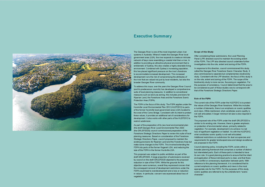
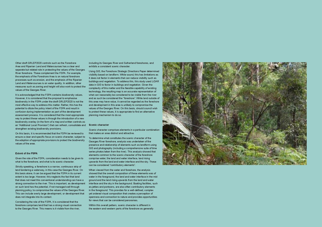
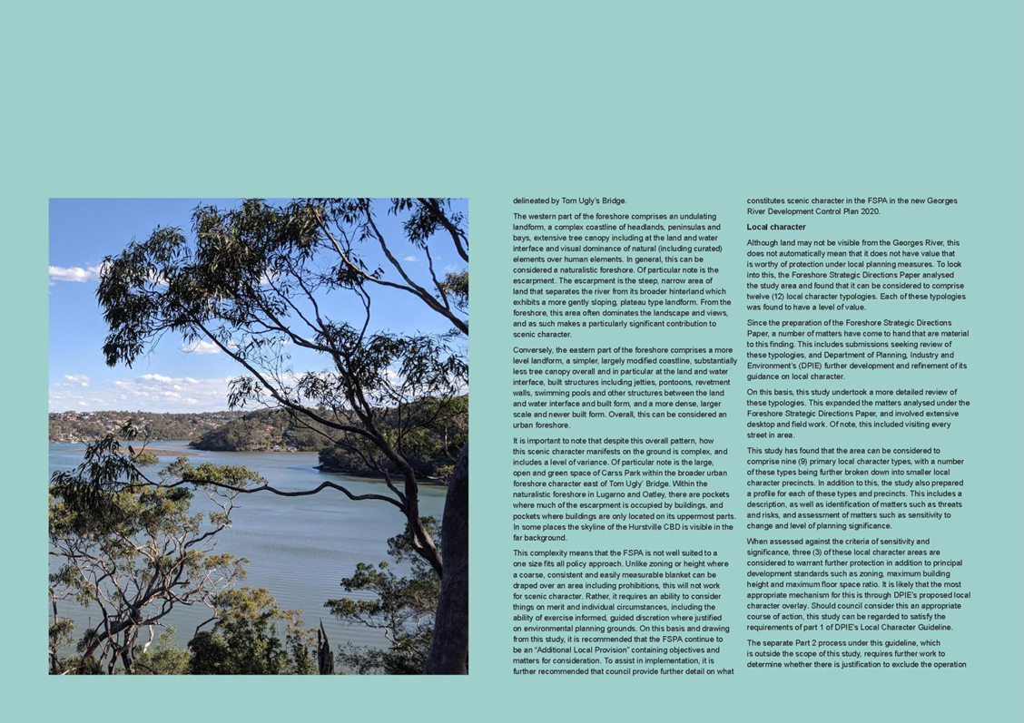

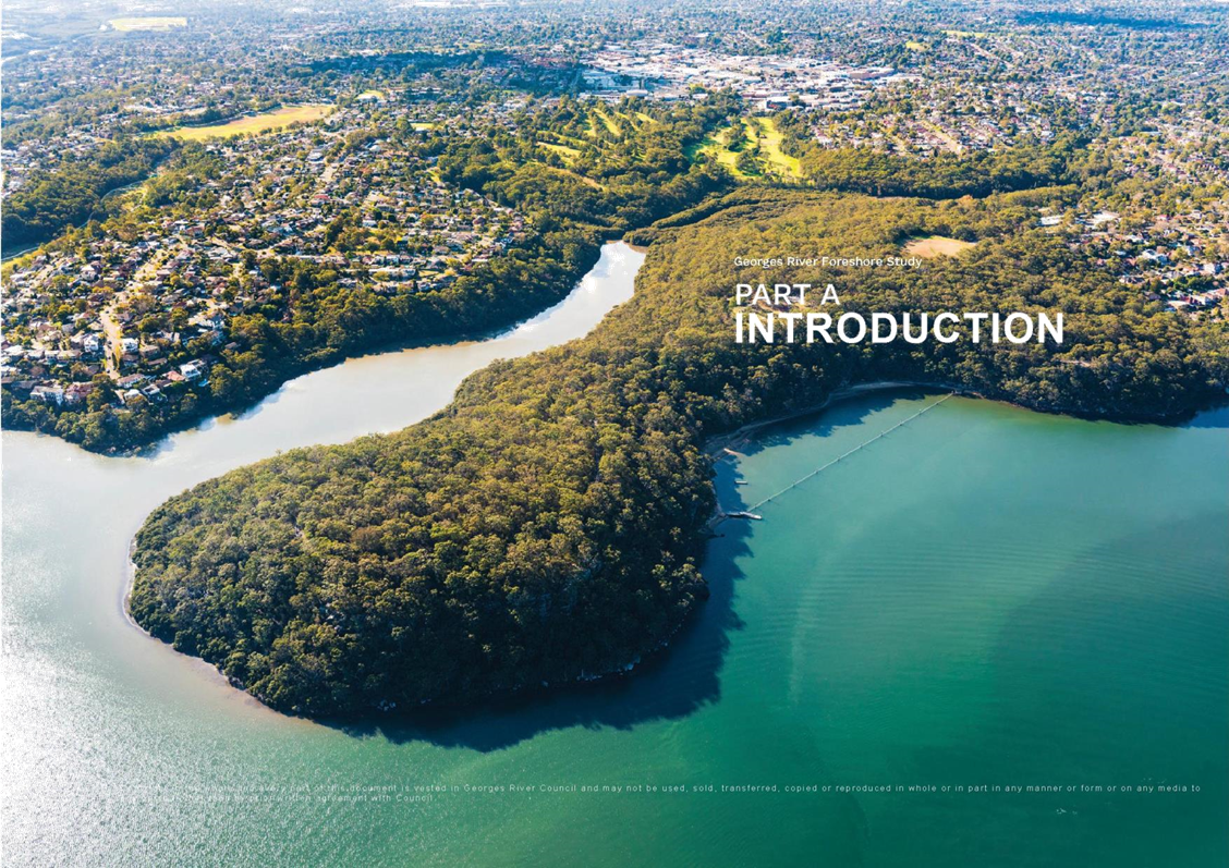
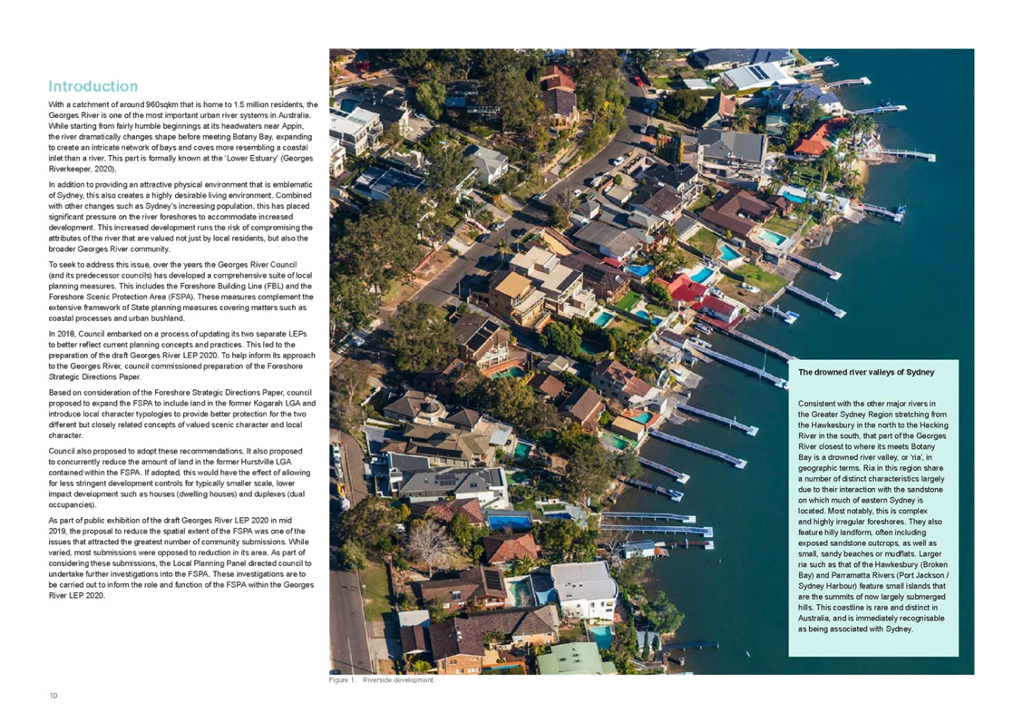
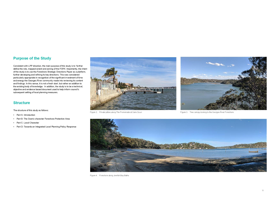
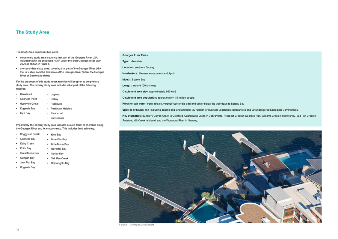
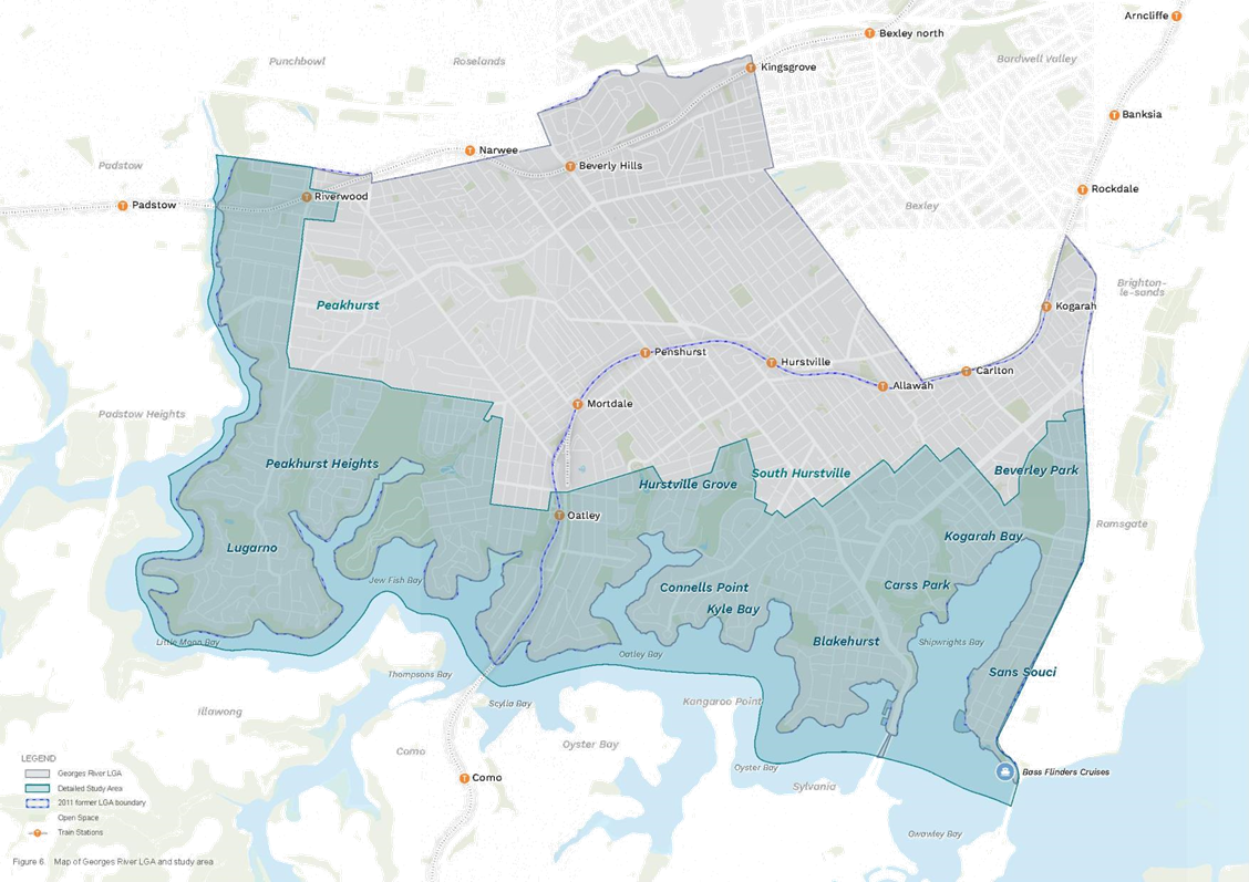
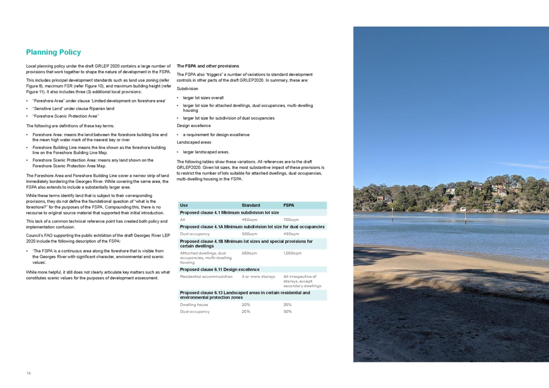
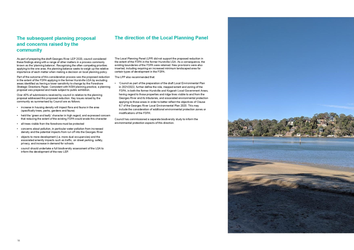
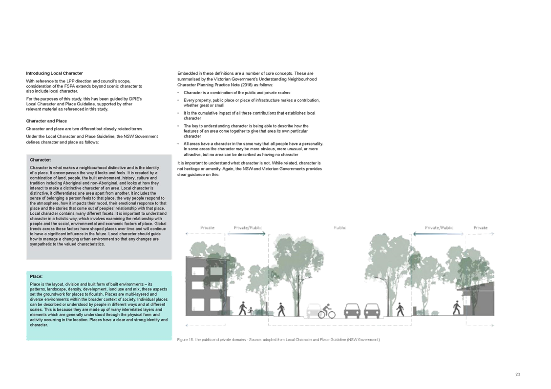

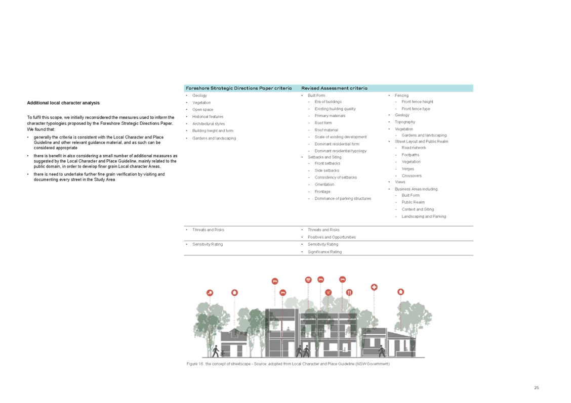
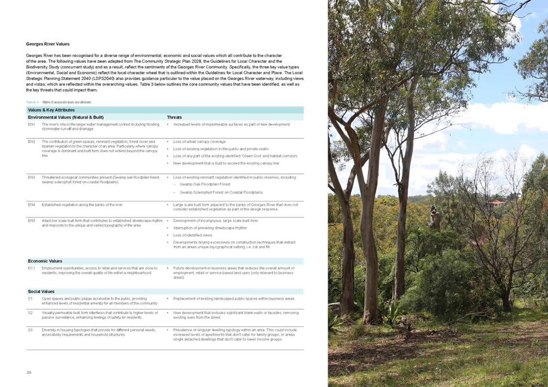
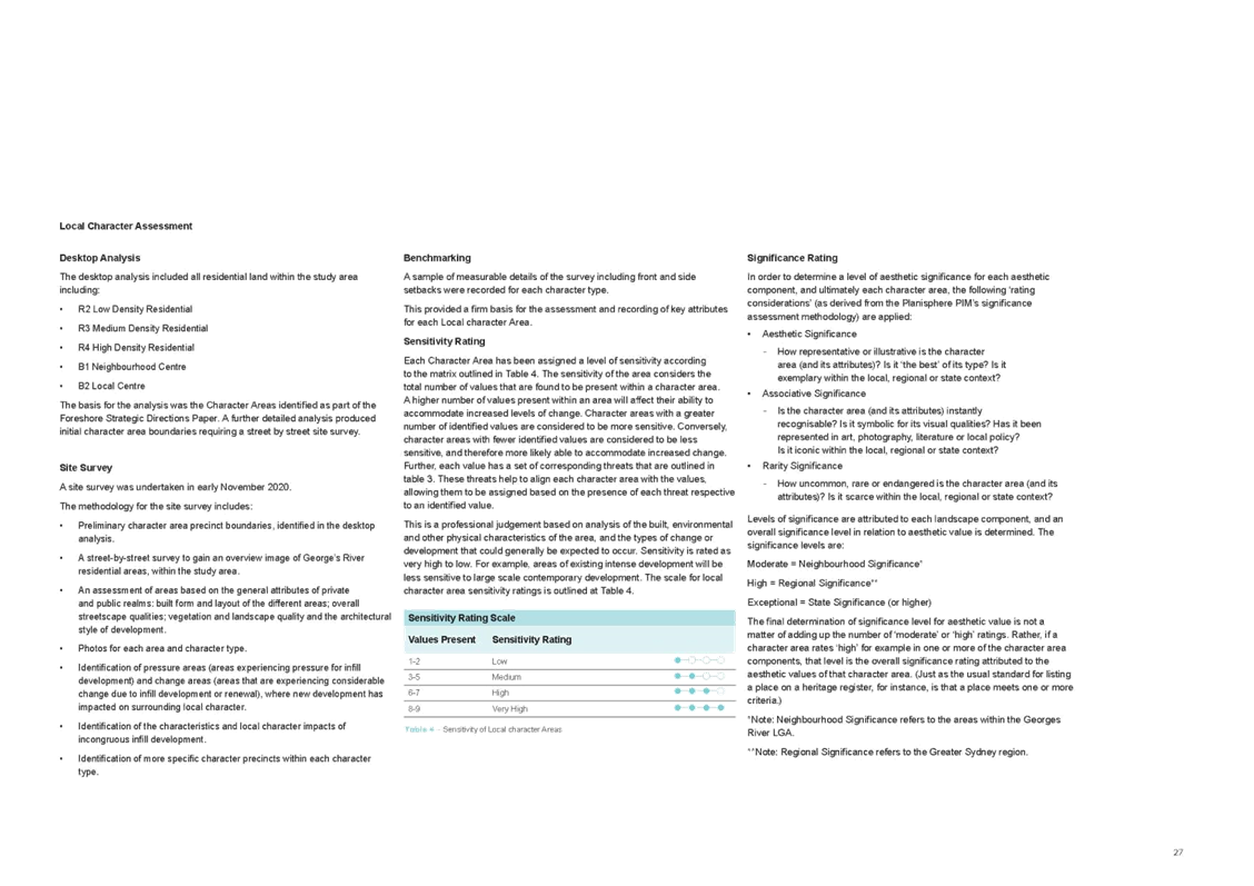
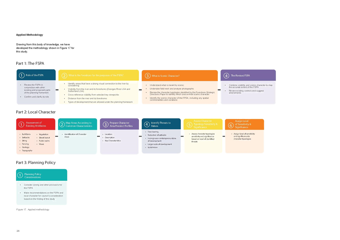
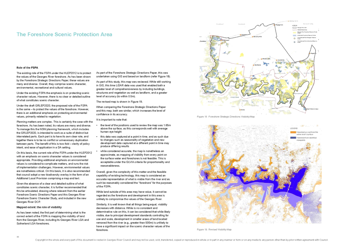
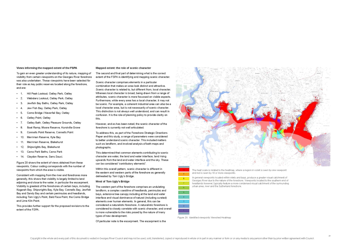
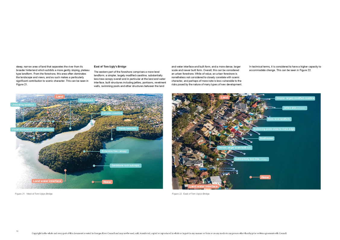
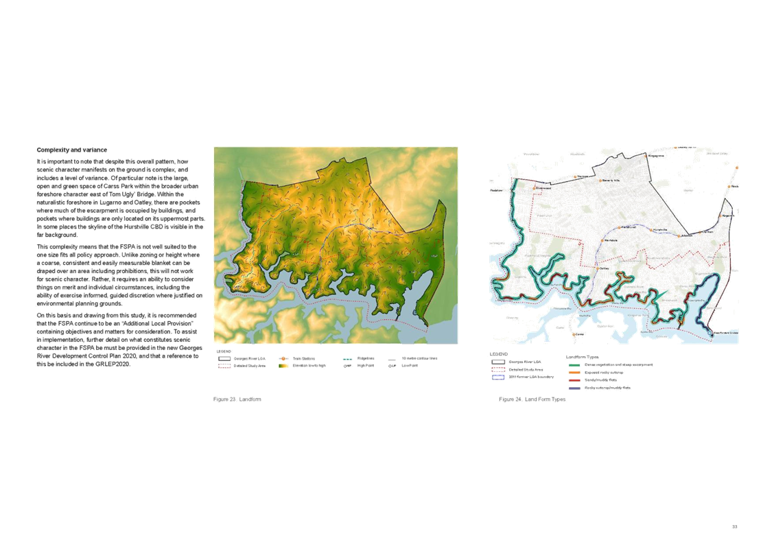
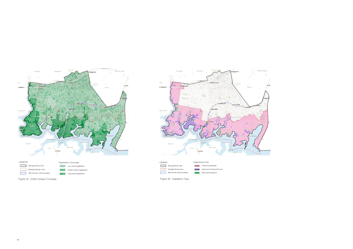
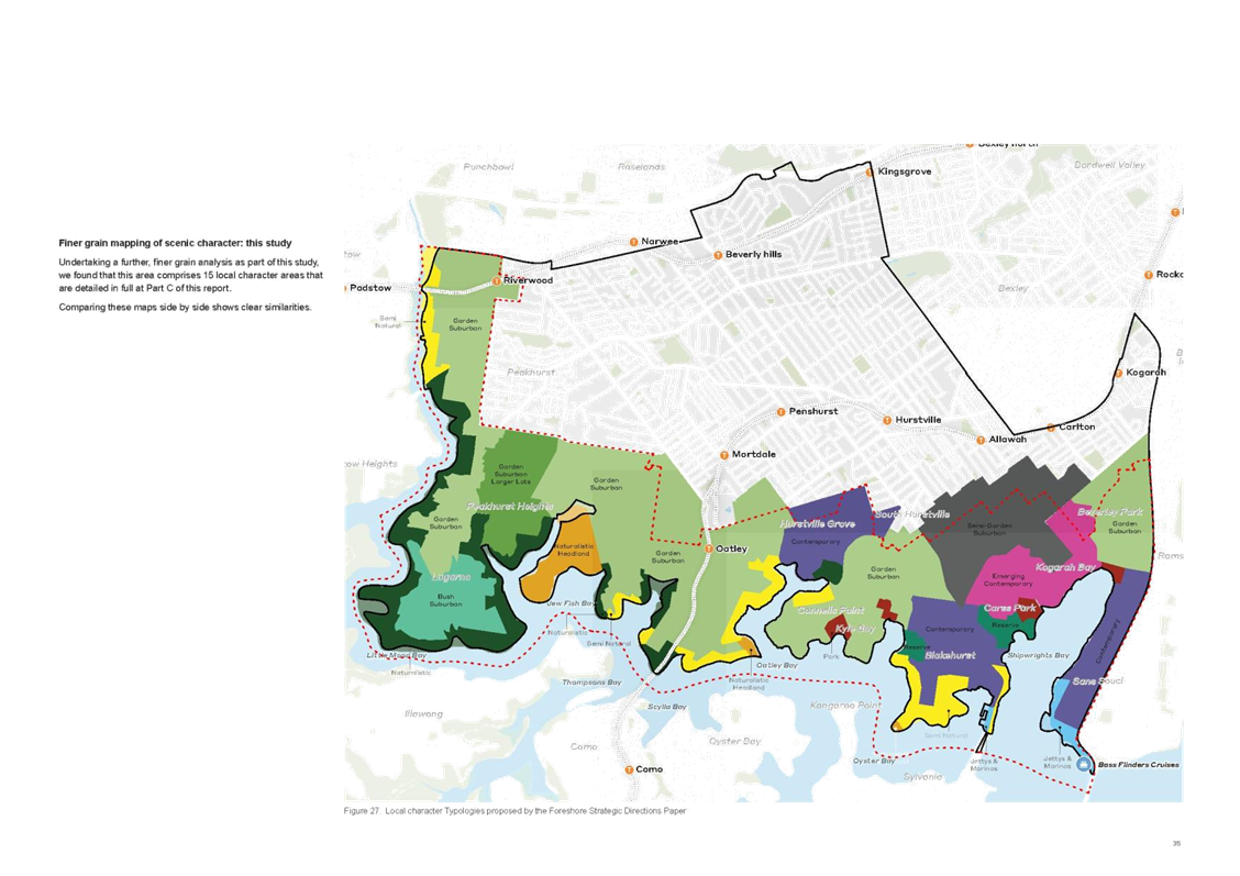
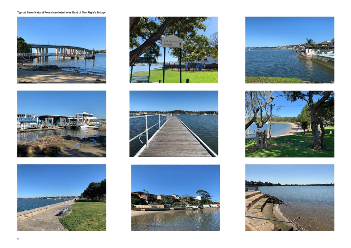
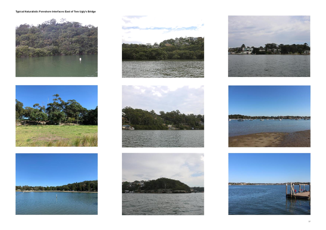
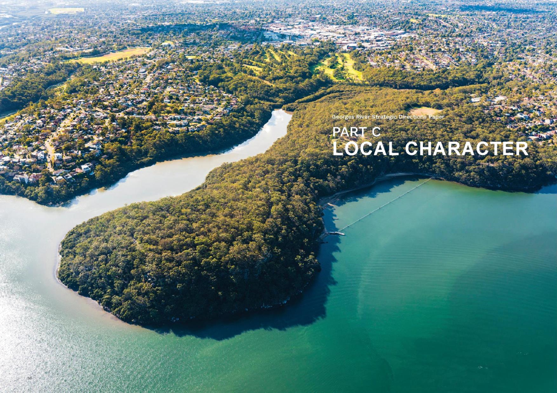
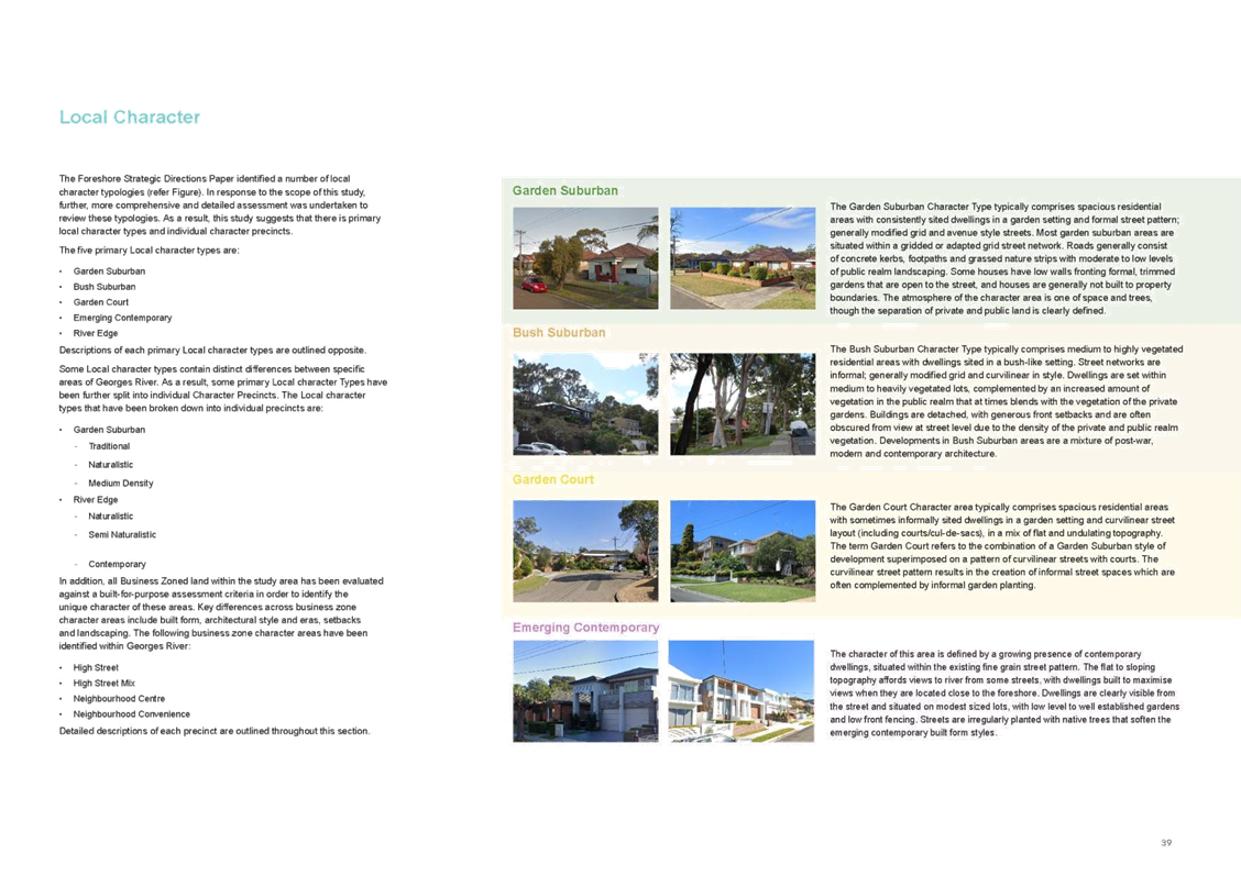
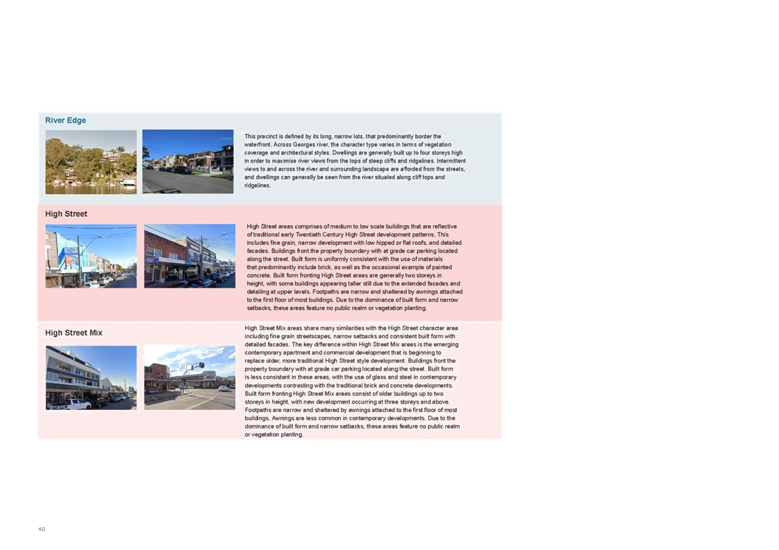
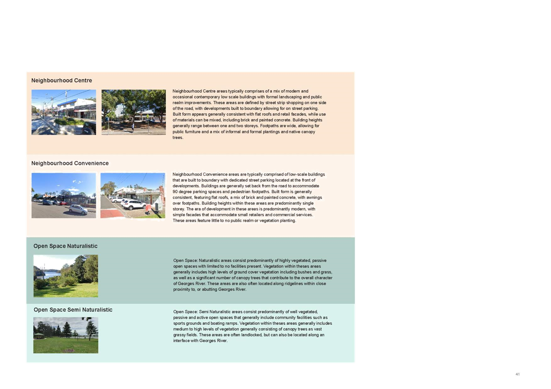
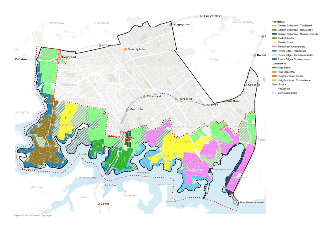
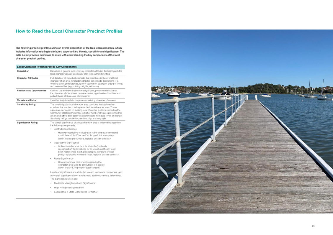
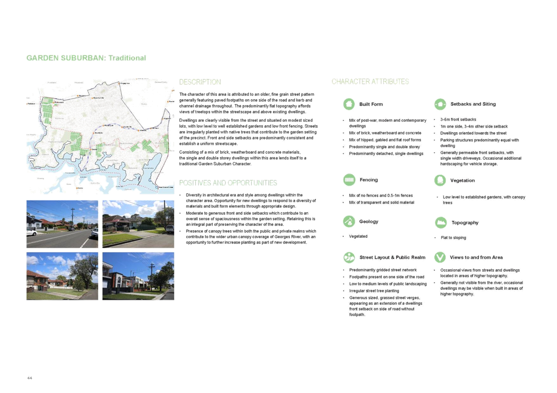
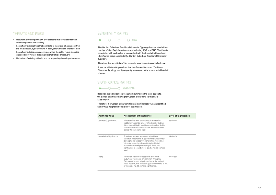
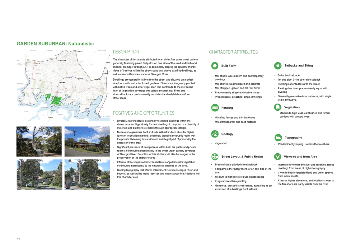
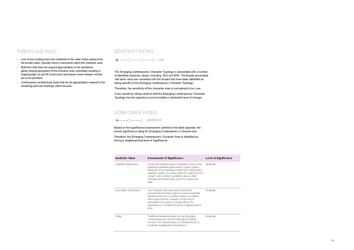
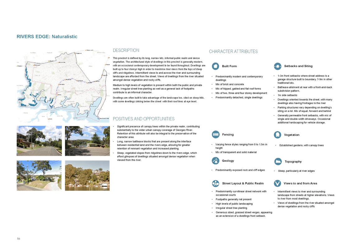
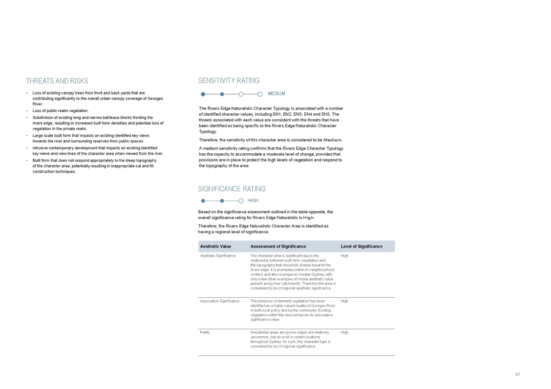
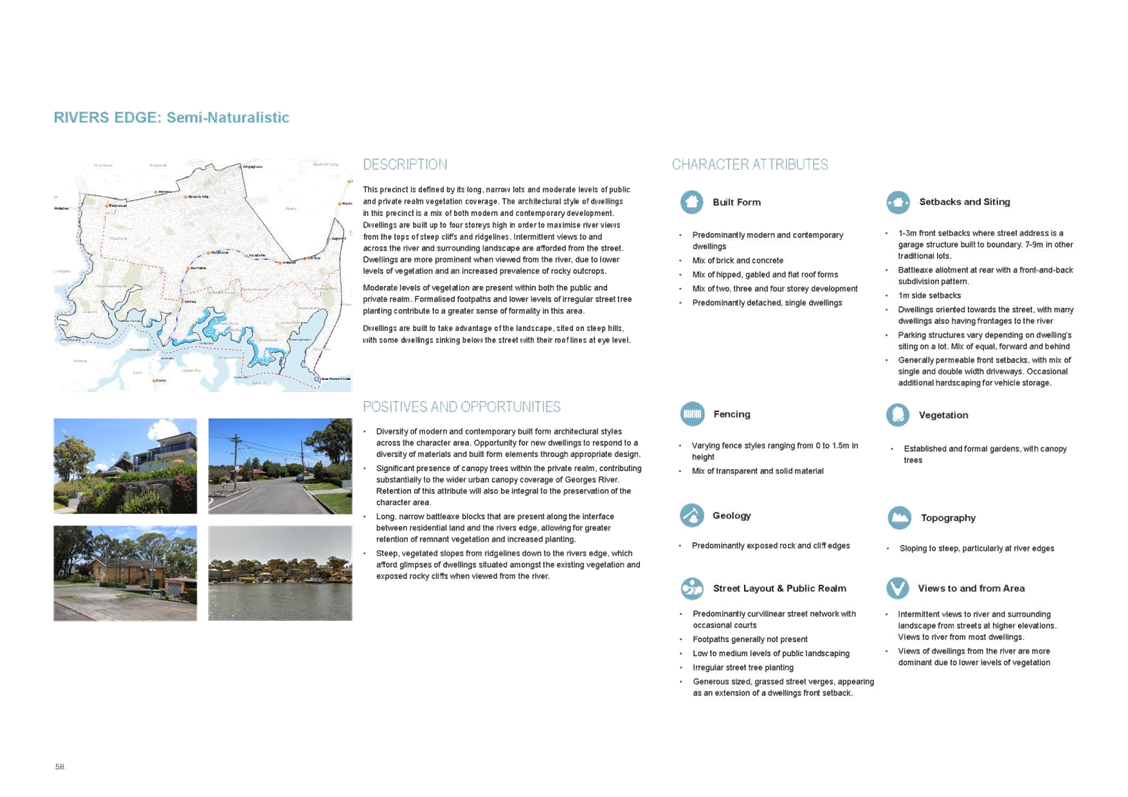

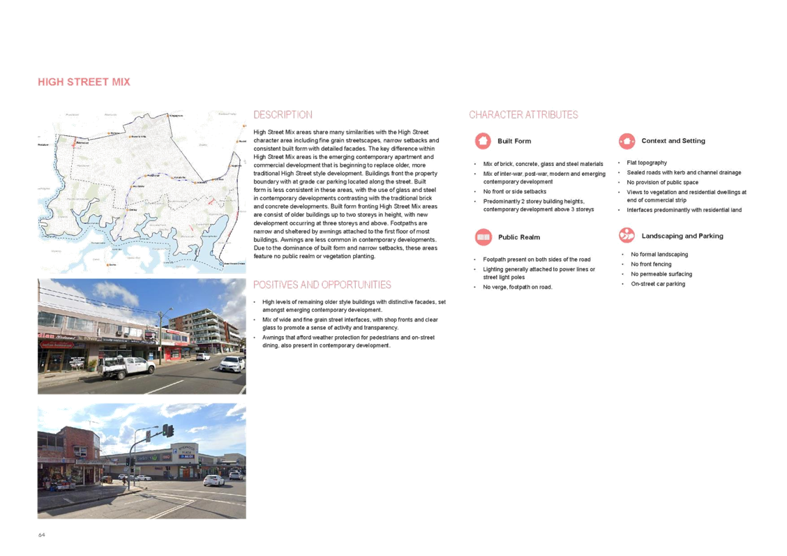
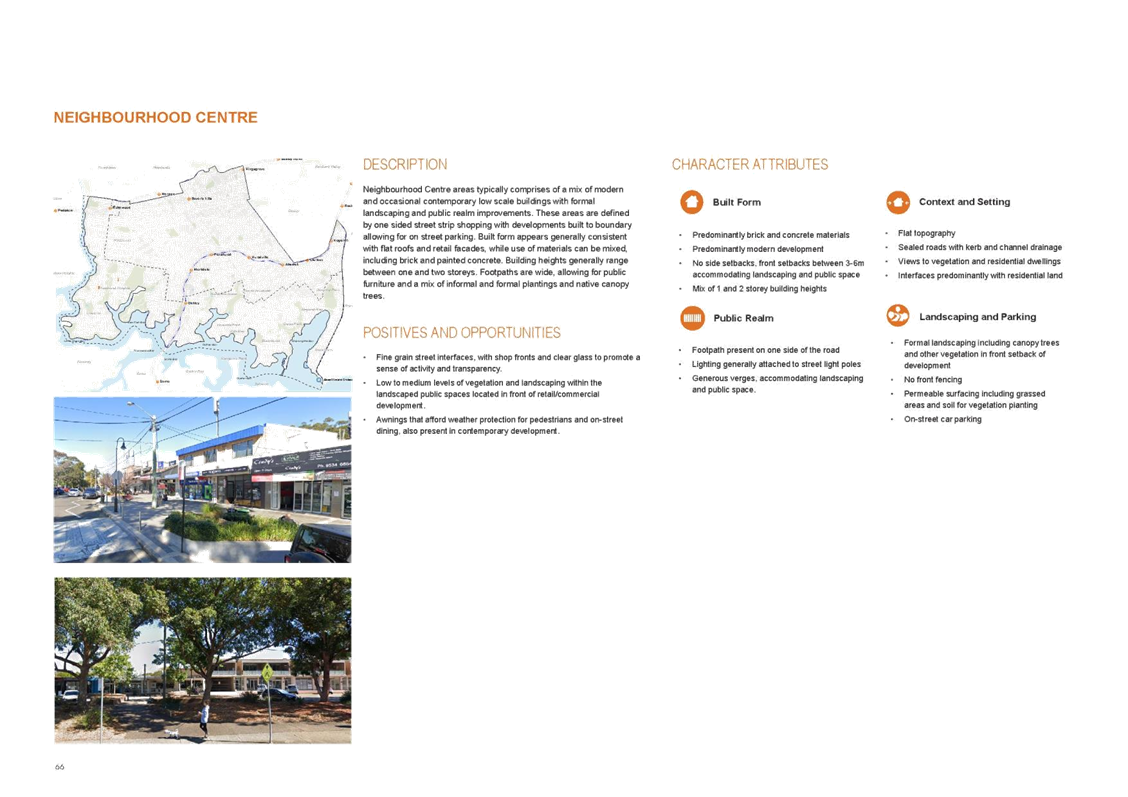
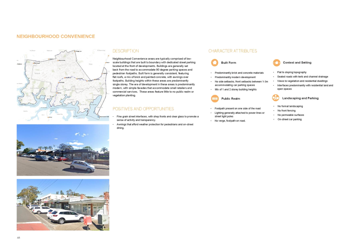
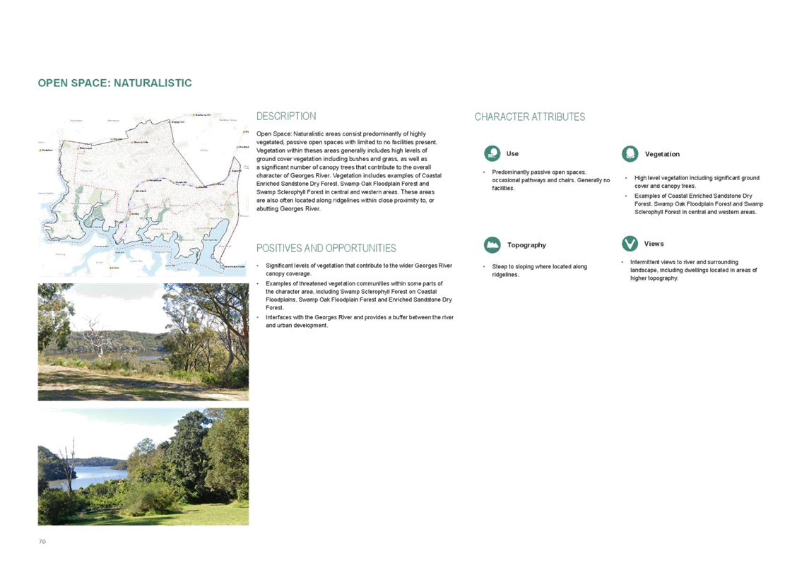
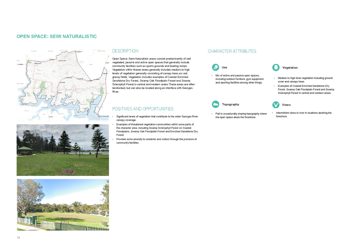
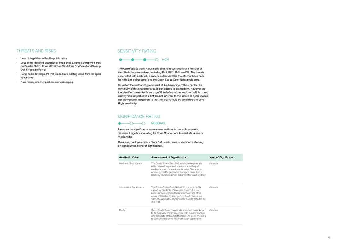
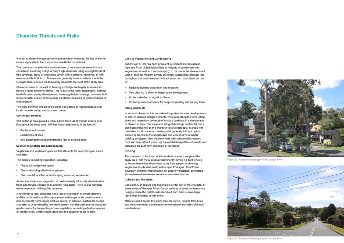
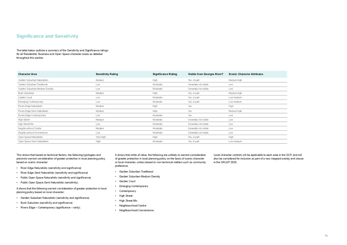
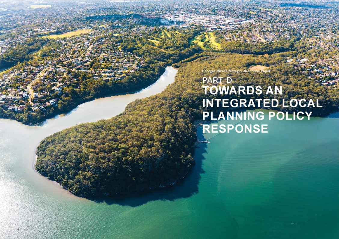
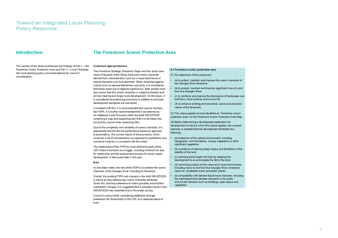
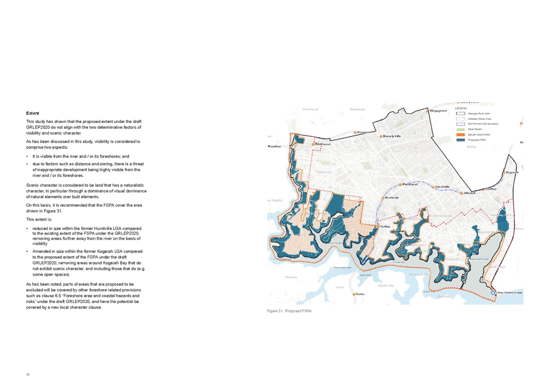
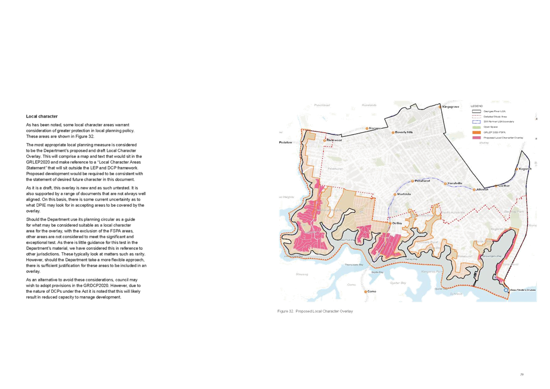
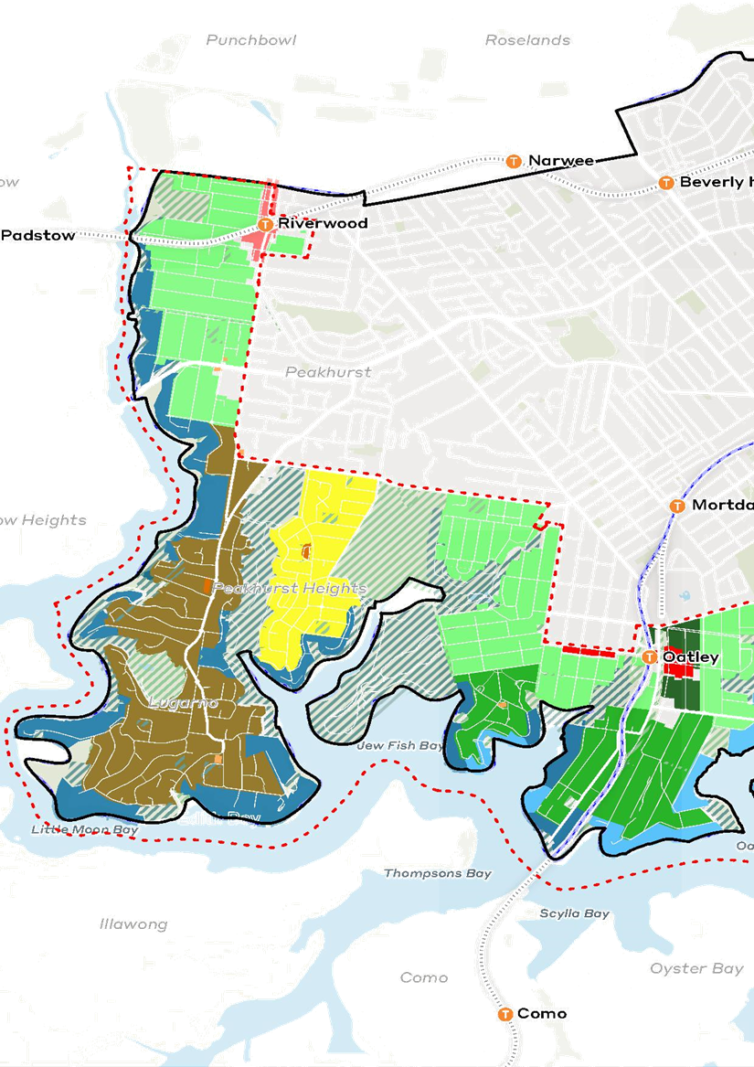
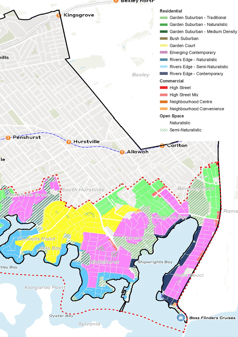
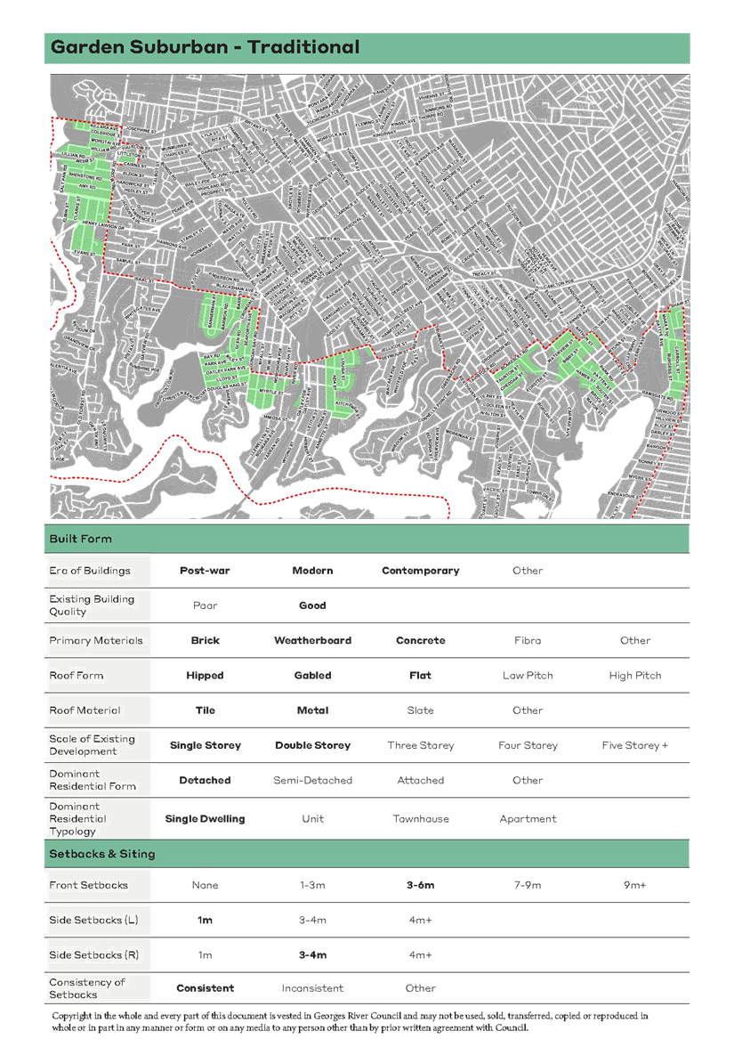
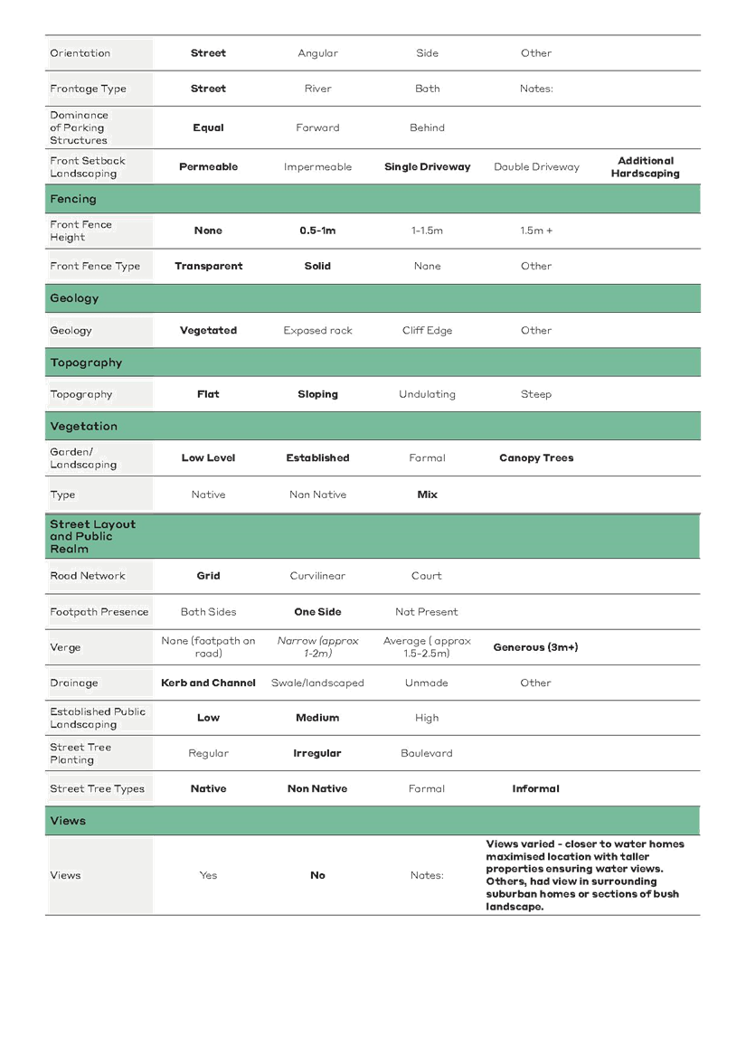
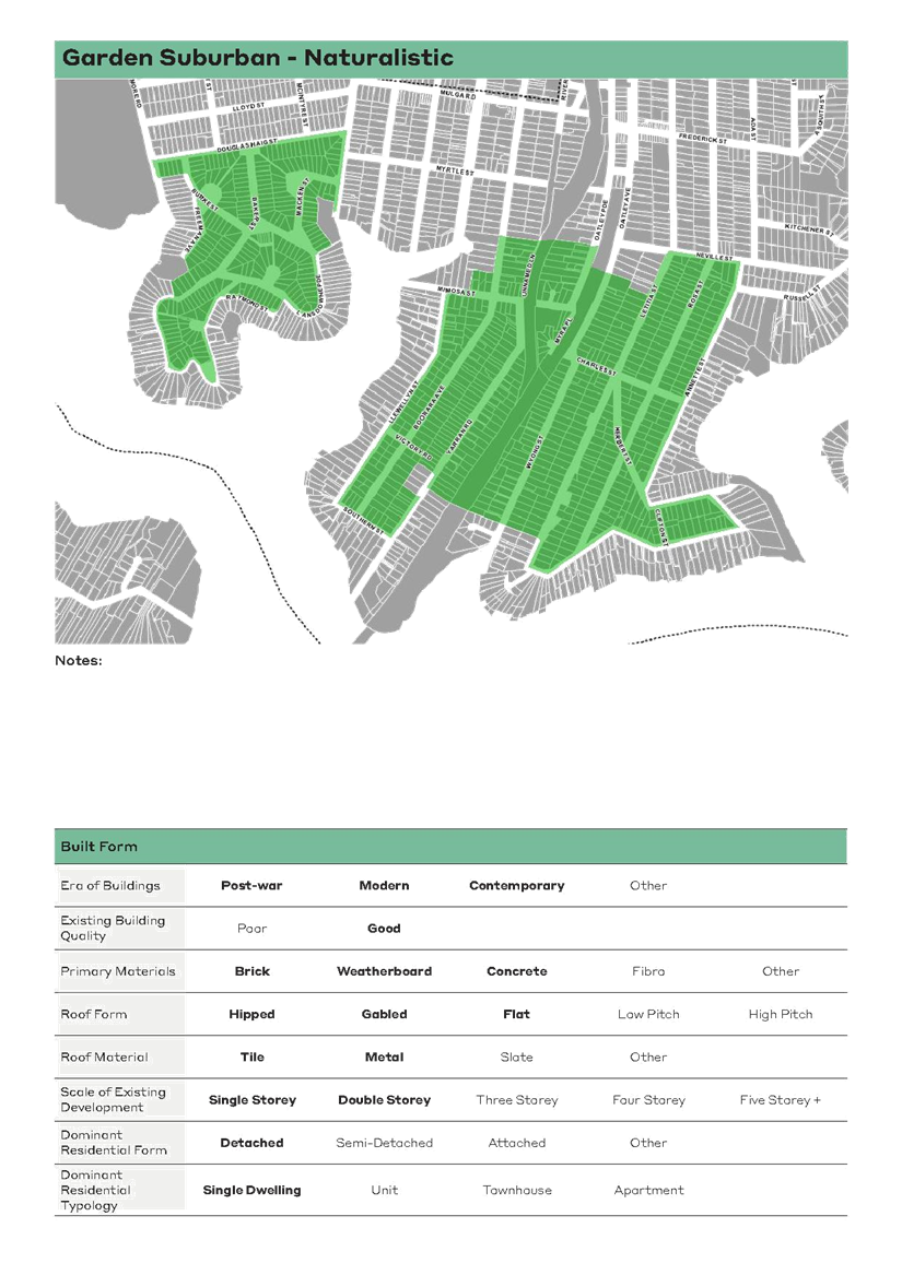
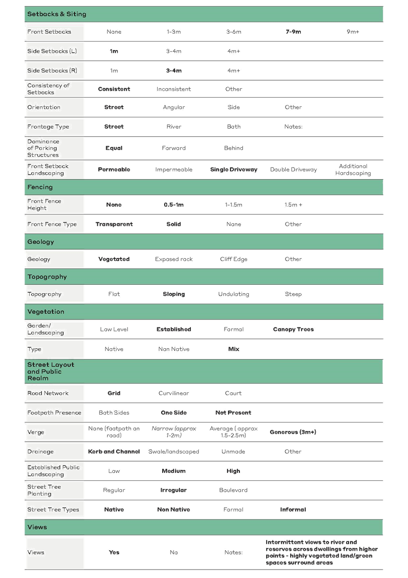
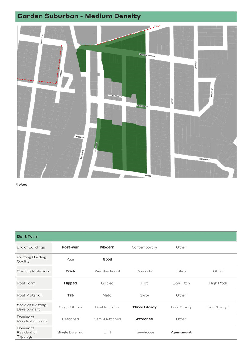
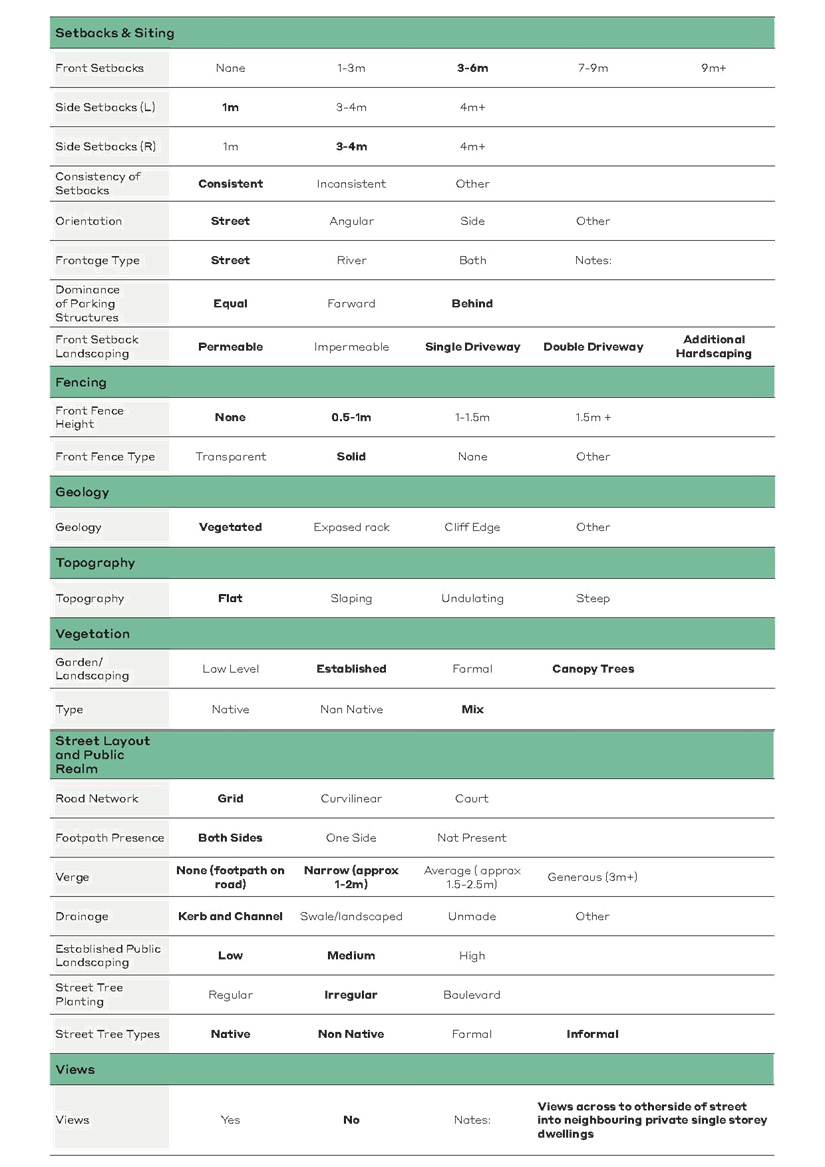
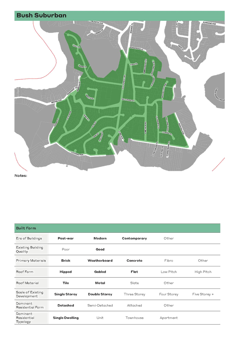
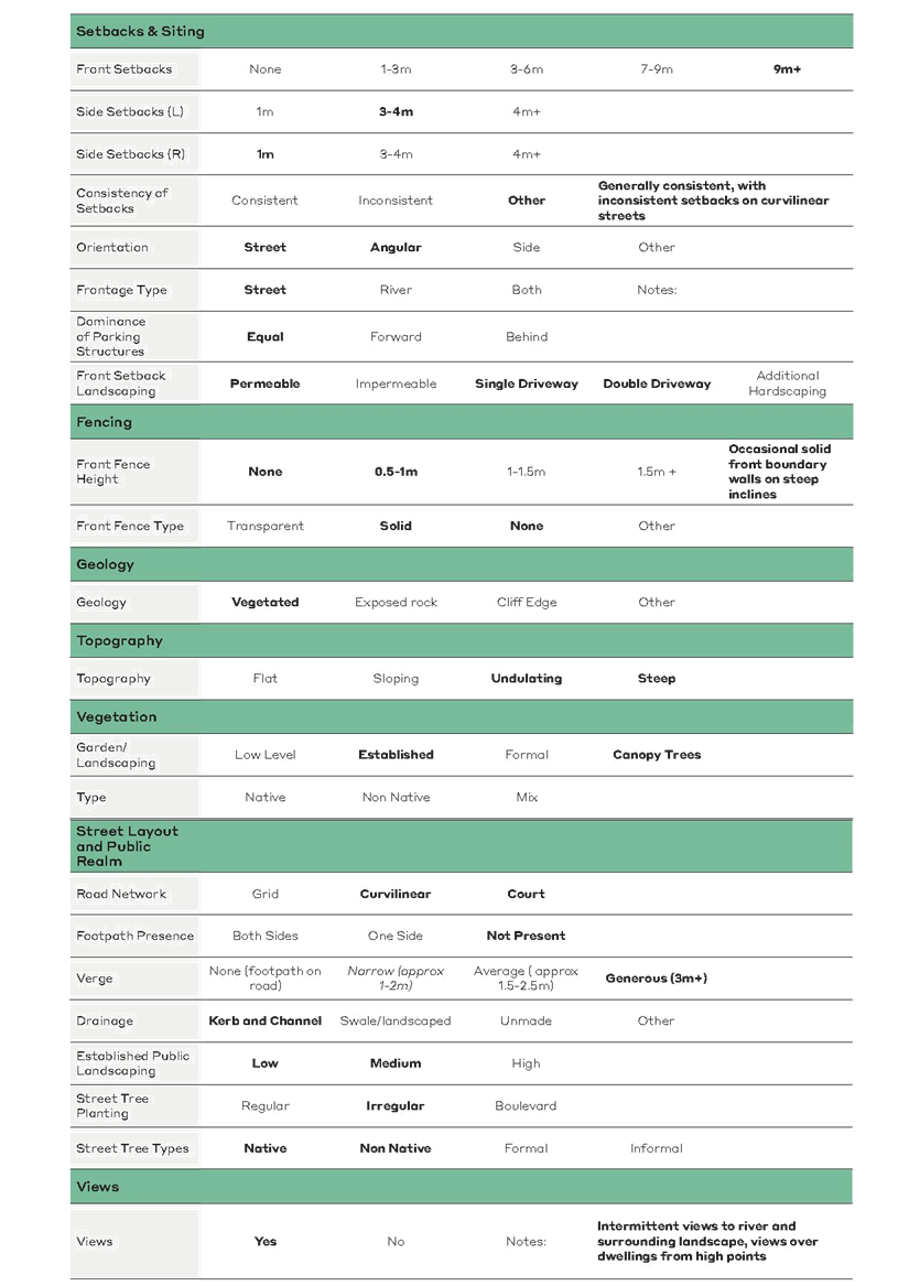

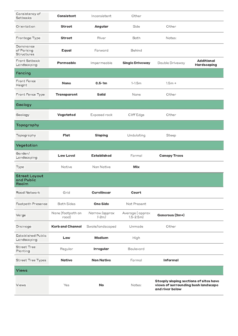
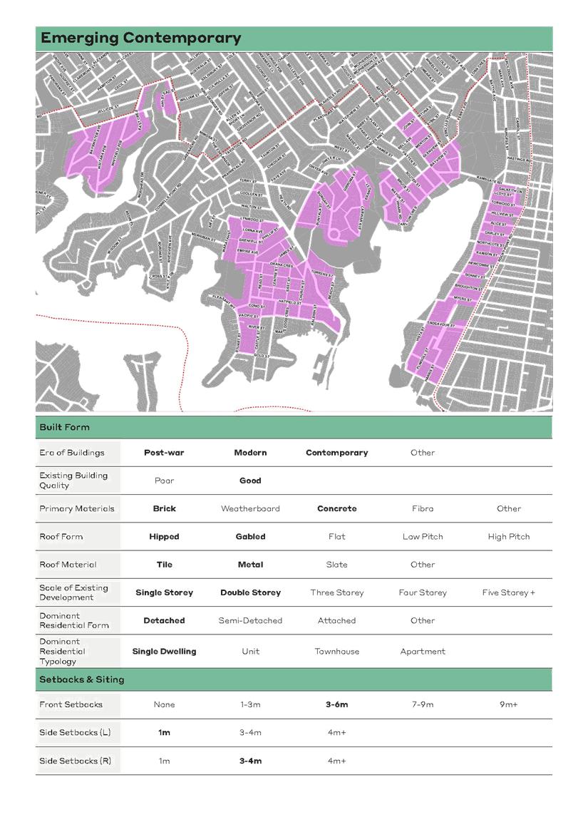
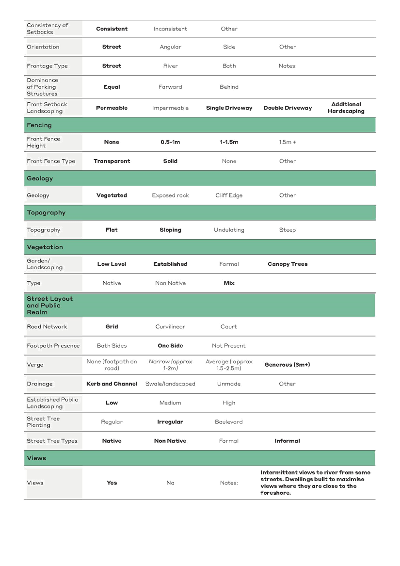
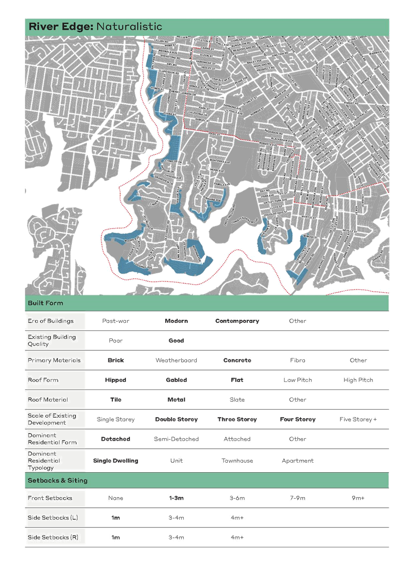
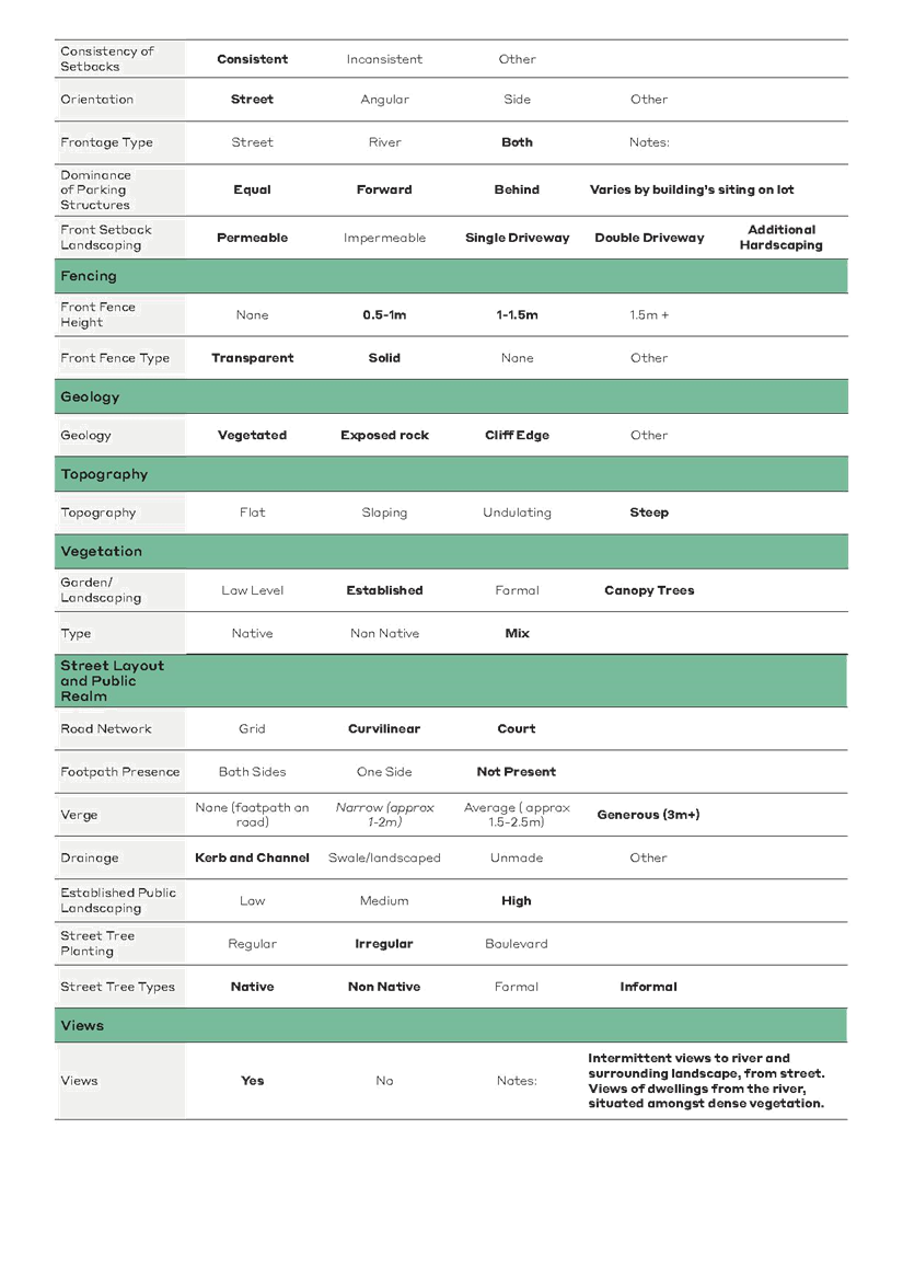
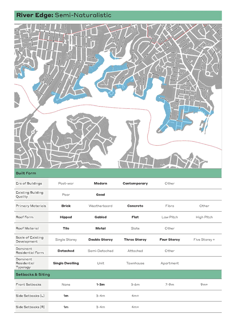
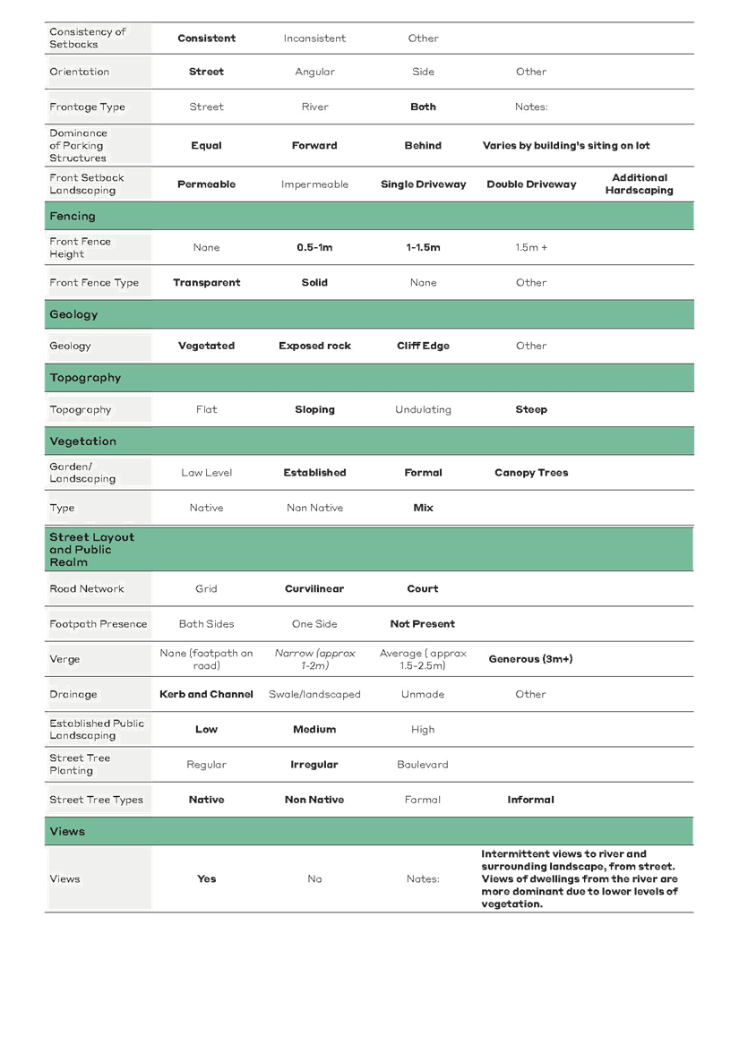
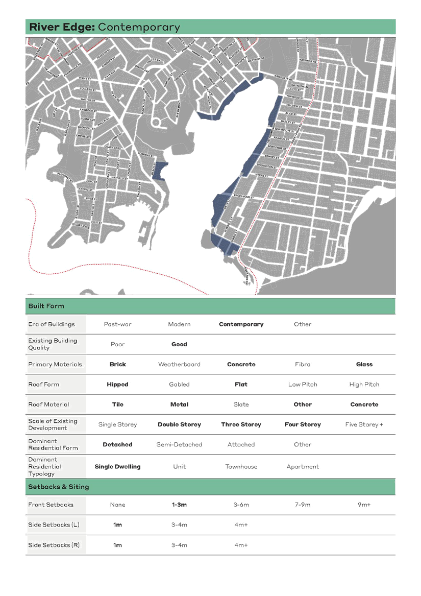
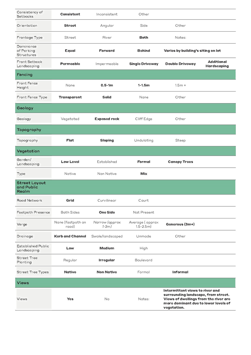
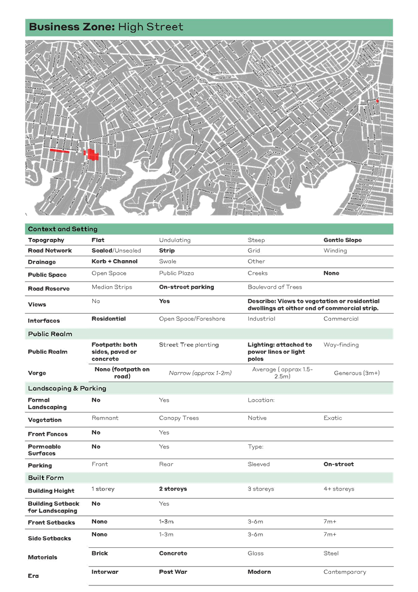
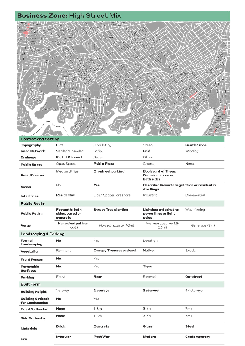
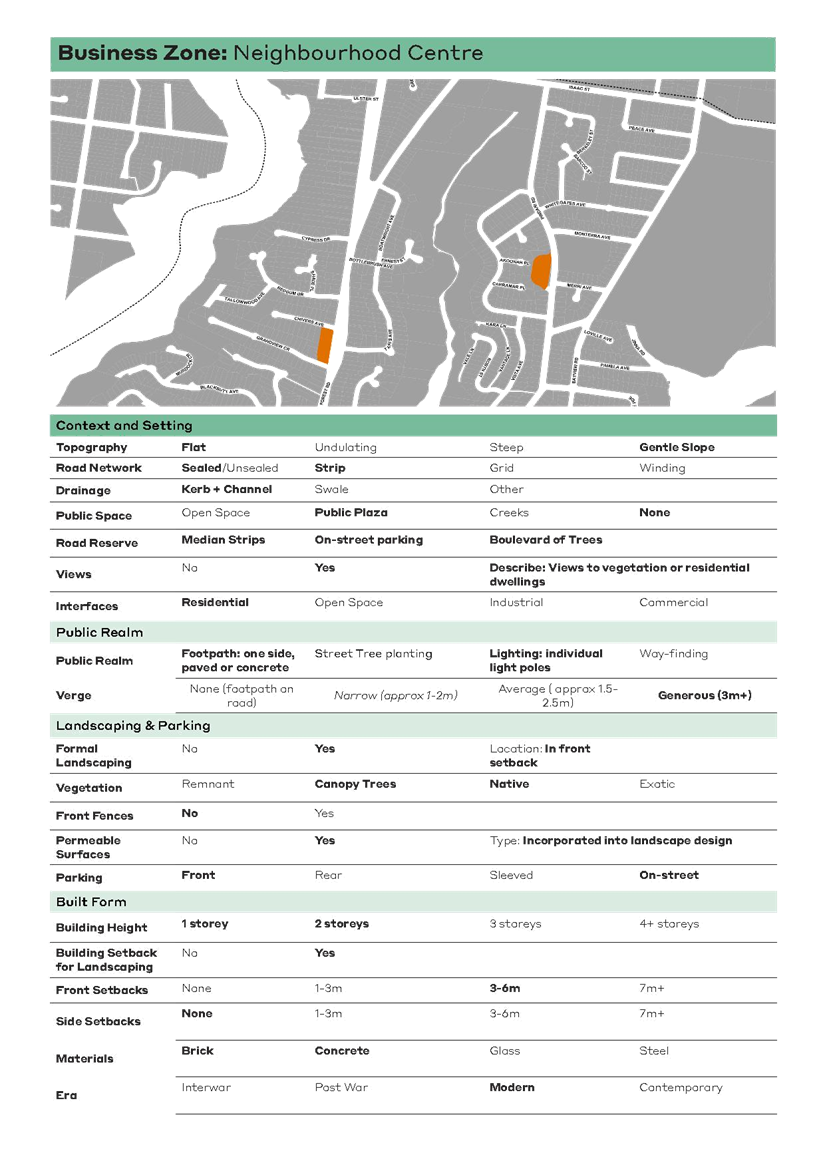
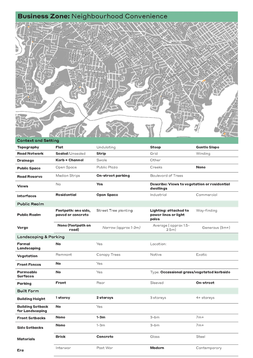
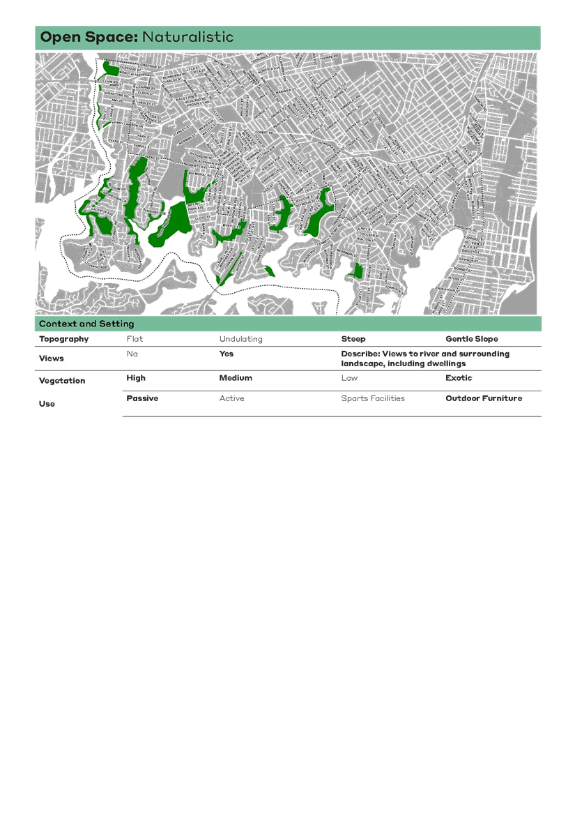
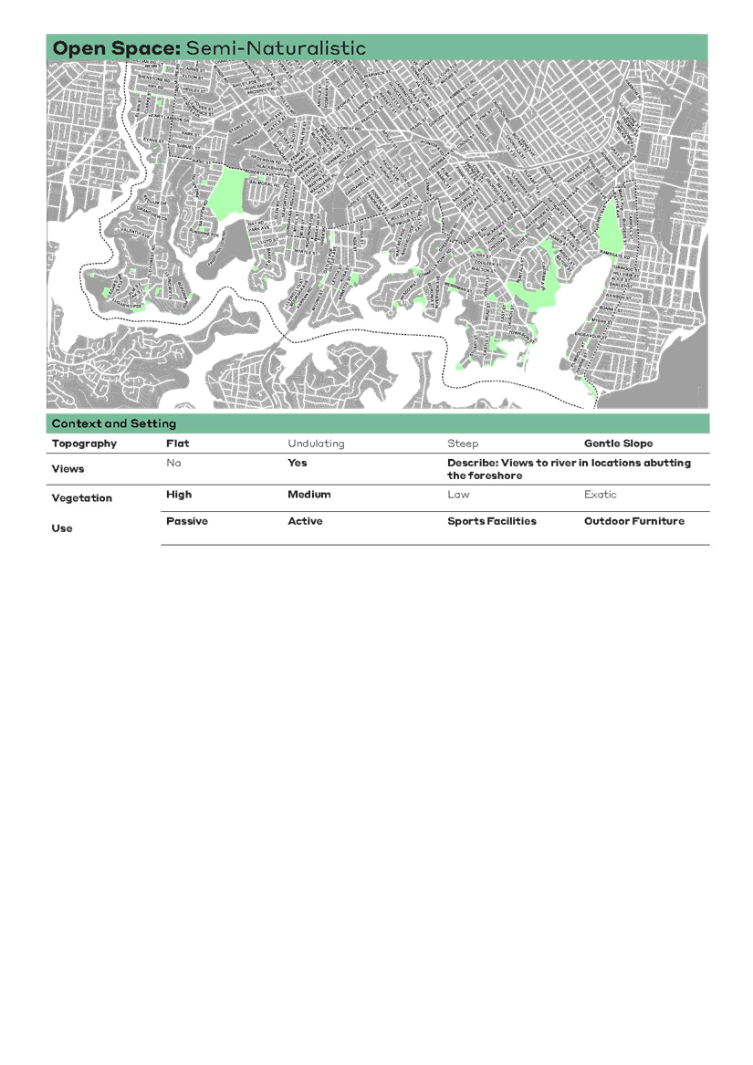
Item: ENV025-21 Georges River Biodiversity Study (Total Earth Care) and Osprey Nesting Habitat
Author: Coordinator Environmental, Sustainability and Waste and Strategic Planner/Urban Designer
Directorate: Environment and Planning
Matter Type: Committee Reports
|
(a) That Council notes the findings and recommendations of the technical study prepared by Total Earth Care Pty Ltd, the Georges River Biodiversity Study 2020-21, that will inform the preparation of the Georges River Biodiversity Strategy, amendments to the Georges River Local Environmental Plan, the Georges River Development Control Plan and other relevant environmental strategies. (b) That the information regarding Eastern Osprey be noted. |
Executive Summary
1. The purpose of this report is twofold. Firstly, for Council to note the findings of the Georges River Biodiversity Study 2020-21 (the Study) as a technical study for Council. Secondly, to advise Council of the discussions held and the research into the status of Eastern Osprey (Pandion cristatus) within the Georges River Local Government Area (LGA) and to provide recommendations to potentially enhance Osprey habitat within the LGA.
2. The purpose of the Biodiversity Study is to provide a holistic and LGA-wide assessment of the current biodiversity values, conditions, locations and opportunities. The Study will inform the preparation of the Georges River Biodiversity Strategy, amendments to the Georges River Local Environmental Plan, Development Control Plan and other relevant environmental strategies.
3. The Study has been funded by a combination of grant funding from the Australian Government for a Study of Biodiversity and Threatened Habitats in the federal Cook Electorate and the NSW Government as part of the Accelerated LEP Program.
4. In response to the findings of the Study, an additional component is currently being carried out in collaboration with Ethos Urban to develop draft planning controls that can be included in the Georges River Local Environmental Plan (LEP) and Georges River Development Control Plan (DCP). This component will be completed later this year and will be the subject of a separate Council report.
Background
5. Council’s “Georges River 2050 Vision” aspires for “A leafy, green place where biodiversity thrives” and an idealistic vision of 2050 where “Enhanced natural assets are focused on the river and catchments, reduced reliance on natural resources and minimised environmental impact”.
6. Theme 5: ‘Environment and Open Space’ of Council’s Local Strategic Planning Statement (LSPS 2040) describes that the LGA’s biodiversity corridors are well connected and our bushland and biodiversity are diverse and healthy.
7. In line with Theme 5, one key action of the LSPS 2040 is developing a biodiversity strategy informed by an up-to-date biodiversity study.
8. To begin this process, Council obtained a grant from the Australian Government under the Communities Environment Program (CEP) for a Study of Biodiversity and Threatened Habitats in the federal electorate of Cook. This funding was limited in its geographic area and as such a broader Biodiversity Study was required to encompass the entire LGA to enable consistency and to address concerns of the community during the public exhibition of the draft Georges River LEP 2020 and its proposed Foreshore Scenic Protection Area.
9. The remaining portion of funding for this Study has been secured from the NSW Government’s Accelerated LEP Program.
Overview
10. The purpose of the Study is to identify the key biodiversity values within the LGA by assessing the diversity of flora (plant) and fauna (animal) present, analysing historical changes and identifying key opportunities to protect and conserve biodiversity.
11. The Biodiversity Study is reported in two volumes:
· Volume 1 comprises an overview of the biodiversity values in the LGA. It provides the project background, aims, strategic and legislative context, methods, synthesis of results and further recommendations (refer Attachment 1).
· Volume 2 provides detailed results of the surveyed sites including comprehensive inventories, conservation significance and site-specific recommendations (refer Attachment 2).
12. The desktop assessment reviewed numerous existing data sources and literature to develop a comprehensive understanding of existing and historical biodiversity values in the LGA.
13. Additionally, various community and stakeholder consultation activities provided further information and data which supported the outcomes of the desktop assessment and field surveys.
14. In determining a consistent and reputable methodology upon which to assess biodiversity, Total Earth Care used the NSW Biodiversity Assessment Method (BAM) (DPIE 2020a) as it is the current standard for comprehensive biodiversity assessment in NSW.
15. The BAM is used as part of the Biodiversity Offsets Scheme (BOS). The BOS is a legislated framework that is required when addressing impacts on terrestrial biodiversity from development and clearing. It also ensures that land used to offset impacts is secured in the long term. The BAM provides a consistent method to assess impacts on biodiversity values from a proposed development (including major projects), clearing or biodiversity certification as well as improvements in biodiversity values from management actions undertaken at a stewardship site.
Community Engagement
16. Community and stakeholder engagement were undertaken throughout the project. It is through this active engagement that Total Earth Care was able to obtain identifications of various species, vegetation communities and environmental risks of local importance.
17. The general public and 18 key stakeholders and community groups were engaged through various activities and platforms including:
· Your Say project page
· Social media posts
· Advertisement in The Leader newspaper
· Questionnaire on sightings of native plants and animals in the LGA
· Interactive biodiversity map where observations can be added
· Webinar held on Thursday 26 November 2020 providing an overview of the project and open discussion with key community and stakeholder groups
· Regular updates on the progress of field surveys supported by photographs and short commentaries.
18. The following key community and stakeholder groups were invited to share their knowledge regarding biodiversity values, notable species, and hotspot areas:
· Youth Advisory Committee
· Aboriginal Advisory Committee
· Oatley Flora and Fauna
· Climate Citizens Lobby
· Lugarno Progress Association
· St George District Residents Association
· South Hurstville Residents Association
· Beverly Hills Owners Association
· Kogarah Residents Association
· Penshurst Action Group
· Bushcare groups
· Georges River Environmental Alliance
· Cooks River Alliance
· Georges Riverkeeper
· Streamwatch and Landcare
· DPIE’s Environment, Energy and Science division
· National Parks and Wildlife Service
· Powerful Owl Project.
19. The community and stakeholder consultation provided anecdotal records during the study of three threatened fauna species, listed as follows:
· Glossy Black Cockatoo (Calyptorhynchus lathami);
· Black Bittern (Ixobrychus flavicollis); and
· Bar-tailed Godwit (Limosa lapponica).
20. In addition, Total Earth Care hosted a volunteer fieldwork day on 3 February 2021 where members from the Oatley Flora and Fauna Conservation Society (OFF) were invited to assist with the survey efforts at Oatley Park. Activities included surveys of vegetation, habitat and nocturnal spotlighting and call playback.
21. Due to the technical nature of the Biodiversity Study and its findings, public exhibition is not required. The Study is a technical document that will be used to inform policies, planning controls and operational procedures.
Key Findings of the Biodiversity Study
22. The key findings of the Biodiversity Study have been summarised as follows, according to fauna and flora species.
Fauna
23. Total Earth Care used standardised ecological survey methodology to survey 27 parks and reserves covering 336 hectares and 29km of street biodiversity corridors.
24. Eight threatened fauna species were recorded, including two species previously unrecorded in the LGA. Species are listed as follows with underlines denoting species previously unrecorded:
i. Grey-headed flying fox (Pteropus poliocephalus);
ii. Powerful Owl (Ninox strenua);
iii. White-Bellied Sea Eagle (Haliaeetus leucogaster);
iv. Eastern Coastal Free-tailed Bat (Micronomus norfolkensis)*;
v. Little Bent-winged Bat (Miniopterus australis)*;
vi. Large Bent-winged Bat (Miniopterus orianae oceanensis)*;
vii. Southern Myotis (Myotis macropus)*; and the
viii. Greater Broad-nosed Bat (Scoteanax rueppellii)*.
* Recorded by ultrasonic echolocation detection (Anabat device)
25. The abundance and diversity of honeyeaters (Family: Meliphagidae), other than the Noisy Miners (Manorina melanocephala), was low.
26. The abundance and diversity of small scrub-dependant birds (i.e. wrens, thornbills, and robins) were low. This may be influenced by the limited shrub-layer in the dominate vegetation communities (i.e. Coastal Enriched Sandstone Dry Forest) and/ or the pressure from Noisy Miners (Manorina melanocephala).
27. The abundance and diversity of shorebird species (i.e. snipes, curlews) was lower than expected.
28. Few predatory bird species (i.e. raptors and owls) were recorded, as such it is likely there are few roosting in the LGA. However, they may utilise the area as foraging habitat.
29. Indications of the presence of gliders (likely the Sugar Glider (Petaurus brevicep) were recorded at several sites. There are previously only two records (in 2014 and 2018) of the species in the LGA.
Flora
30. The survey recorded one threatened flora species and one threatened flora population, being the Magenta Lilly Pilly (Syzygium paniculatum) and Gosford Wattle (Acacia prominens), respectively and a number of Threatened Ecological Communities, being: Coastal Saltmarsh, Freshwater Wetlands; Littoral Rainforest; Swamp Oak Floodplain Forest; Swamp Sclerophyll Forest on Coastal Floodplains; and Sydney Turpentine Ironbark Forest.
31. The Study found that the Coastal Enriched Sandstone Dry Forest is the most prevalent native vegetation community in the LGA. Flora details are further outlined as follows:
· Most of the vegetation remaining in the LGA is on sandstone geology around the foreshore areas. There is little shale influenced vegetation remaining as areas with this geology are mostly developed urban areas on the plateaus of headlands and the northern section of the LGA. As such, the few patches of shale influenced communities remaining are of conservations significance (i.e. Coastal Shale-Sandstone Forest at Oatley Point Reserve and Sydney Turpentine Ironbark Forest at Myles Dunphy Reserve, Quarry Reserve and Black Forest Reserve).
· All patches of Estuarine Swamp Oak Forest were highly impacted by weeds with dominance of Tradescantia fluminensis (Wandering Jew) and/or Asparagus spp. (Asparagus fern) in the understory. The larger patches of vegetation are typically in better condition. This is likely due to having higher resilience and less pressures (i.e. weed invasion, predation by exotic fauna, edge effects).
· The extent of most mangrove communities has expanded in the past 50 years. This is likely due to sedimentation from development and climate change impacts.
· Numerous individuals of the endangered population Acacia prominens (Gosford Wattle) were recorded. Due to the locations of many of these plants, it is likely many have been planted.
· The retention of vegetation, particularly mature trees (i.e. with large canopies and hollows), in street corridors and on private property is important in supporting connectivity between larger patches.
32. Overall, there is generally greater biodiversity in the south western suburbs of the LGA and less in the northern more urbanised suburbs. This is predominantly due to historical urbanisation and fewer bushland areas in the north.
Biodiversity Study Opportunities and Recommendations
33. There are a number of threats to biodiversity, with the two primary threats being weeds and pests. The Study indicates that several invasive weeds (i.e. Alternanthera philoxeroides (Alligator Weed)) were recorded and foxes (Vulpes vulpes) were observed at many sites and are likely to be present in most vegetated areas across the study area. All cats (Felis catus) that were observed were not wearing bells and it is to be noted that cats whilst only observed at 10 of the 207 sites surveys are likely to utilise most of the sites.
34. Various recommendations for protecting, maintaining, and enhancing biodiversity within the LGA have been outlined within the Biodiversity Study. Recommendations have been classified as being of high, moderate, or low.
Next Steps
35. Informed by the findings of the Biodiversity Study, recommendations for a set of planning controls to protect the LGA’s biodiversity are currently being developed by Ethos Urban in collaboration with Total Earth Care and Council staff.
36. The collaboration between Total Earth Care and Ethos Urban will enable a holistic approach in developing a set of planning controls to ensure new developments respond appropriately to the presence of biodiversity. This component will be completed later this year and will be the subject of a separate Council report.
Eastern Osprey
37. At its meeting on 22 February 2021, Council resolved:
That the General Manager provide a report to Council that addresses:
(i) the outcomes of an investigation into the current availability of nesting habitat for Ospreys within the Georges River Council local government area;
(ii) the actions and activities undertaken by our neighbouring Councils, Canterbury Bankstown, Sutherland and other coastal councils to enhance Osprey nesting habitat with the possibility of developing a regional approach;
(iii) the actions and activities undertaken by the NSW National Parks and Wildlife Service and the NSW Roads and Maritime Service;
(iv) the findings of the draft Biodiversity Study; and
(v) possible sources of funding (such as grants) that are available for the installation of strategic artificial nesting platforms and nesting habitats.
38. The Eastern Osprey is listed as Vulnerable in New South Wales, with habitat loss listed as a threat to their population by the NSW Government, specifically “Disturbance to or removal of large trees near the coast that have been or could be used as nest sites.”
39. Ospreys make their nests high in the crowns of trees, or in some cases where tall tree habitat is not available, on artificial structures. In recent years, a breeding pair of Osprey have been recorded nesting on a disused crane close to Little Moon Bay in the Sutherland Shire.
40. In 2018, Sutherland Shire Council in collaboration with Greater Sydney Local Land Services (GSLLS) and Roads and Maritime Services (RMS) completed construction of an artificial shorebird platform in Woolooware Bay as part of a broader public access project.
41. Discussion with Greater Sydney Local Land Services and Sutherland Shire Council officers in June 2020 and again in April 2021 has revealed that the platform is experiencing success, with threatened shorebirds such as Pied Oystercatchers using the platform alongside abundant species such as seagulls and pelicans. As the platform is designed for shorebirds and not raptors, no Ospreys have been recorded there.
42. Central Coast Council installed a purpose-built platform when the species was found nesting at a Council depot, stadium and sewage treatment plant. In this instance a purpose-built platform was the most immediate way in which to support the species at operational sites. Central Coast Council support Osprey through continued environmental education and waterway management programs.
43. In March 2021, the City of Canterbury-Bankstown Council provided information on its investigation of artificial nesting platform viability. Having been in contact with Griffith University’s School of Environment and Science, Canterbury-Bankstown Council was recommended to implement artificial breeding platforms in the LGA away from urban areas, due to the prevalence of conflict with urban birds and humans and the confirmed presence of Osprey within the Canterbury-Bankstown LGA.
44. However, City of Canterbury-Bankstown has not yet made a commitment to constructing artificial platforms, pending further research into the following:
· Prevalence of interspecies competition at nesting sites, particularly from urban birds such as ravens; and
· Benefit to constructing artificial breeding sites further upstream of Georges River to minimise urban impacts.
45. Council also contacted Roads and Maritime Services (RMS) Botany Bay and Port Hacking Maritime Command and National Parks and Wildlife Services (NPWS) relating to Osprey and their habitat. Their responses are respectively summarised as follows:
· The NPWS Ranger for Georges River National Park indicated that there are at least two breeding pairs currently utilising the Georges River river-bank area for nesting in unsuitable sites. NPWS Head Office is currently investigating methods to influence Ospreys to nest in safer sites.
· RMS indicated that it has had no sightings of Eastern Osprey in Botany Bay or the lower Georges River.
46. The NPWS, as published on its website, enable the NSW Government’s Saving our Species program which represents the biggest conservation commitment in NSW. Overall, the program supports the control of threats to biodiversity such as weed eradication and feral animal control. The project also fosters reintroduction of species through breeding programs where required.
47. NPWS also undertakes a variety of ongoing biodiversity research towards native vegetation mapping and classification projects to continually monitor and record biodiversity throughout the State. The NPWS confirmed with Council in April 2021 that it is considering ways in which Osprey can be encouraged to nest in safer and more appropriate sites (when compared with the crane near Little Moon Bay). The timeframe for the outcome of this work is not known.
48. Currently there are no sources of grant funding available for Osprey and raptor habitat enhancement projects. Council will continue to monitor grant funding sources, including the NSW Department of Planning, Industry and Environment’s ongoing Environmental Restoration and Rehabilitation grant program.
49. However, given there were no observed Eastern Osprey within the Georges River LGA within the Biodiversity Study, it is unlikely Council will obtain grant funding over municipalities with observed or known Osprey.
50. Council will continue to remain in contact with neighbouring councils and NSW agencies and progress future regional collaborations to support Osprey within southern Sydney if possible, through grant funding and if deemed suitable by NSW agencies.
51. To enhance Osprey and native raptor habitat in the LGA, priority will be given to the planting of native canopy trees on Council land within proximity to the Georges River during routine and grant funding planting programs.
Financial Implications
52. No budget impact for this report.
Risk Implications
53. No risks identified.
Community Engagement
54. Community engagement was conducted as outlined within this report. Due to the technical nature of the Study and its findings, public exhibition is not required
File Reference
SF21/24, D21/82283
|
Attachment 1 |
Environment - Biodiversity Study Volume 1 - Final Version - PUBLIC ACCESS VERSION - Stage 4 Deliverable - Total Earth Care - published in separate document |
|
Attachment 2 |
Environment - Biodiversity Study - Volume 2 - Final PUBLIC ACCESS VERSION - Georges River Council Total Earth Care - June 2021 - published in separate document |
Georges River Council - Environment and Planning - Tuesday, 15 June 2021 Page 1
Item: ENV026-21 Draft Georges River Council Local Infrastructure Contributions Plan 2021 - Section 7.11 and Section 7.12 (Adoption for Public Exhibition)
Author: Senior Development Contributions Planner
Directorate: Environment and Planning
Matter Type: Committee Reports
|
(a) That Council endorse the draft Georges River Council Local Infrastructure Contributions Plan 2021 – Section 7.11 and Section 7.12 for public exhibition for a minimum of 28 days in accordance with Clause 28 of the Environmental Planning and Assessment Regulation 2000. (b) That Council delegate authority to the General Manager to make minor modifications to any numerical, typographical, interpretation and formatting errors, if required, prior to the exhibition of the draft Georges River Council Local Infrastructure Contributions Plan 2021 – Section 7.11 and Section 7.12, including minor modifications to align with Council’s strategic documents. (c) That a future report on the exhibition and submissions received be provided to Council. |
Executive Summary
1. Council resolved on 1 May 2017 to prepare a new contributions plan for the Georges River Council local government area, which incorporates the existing Hurstville Section 94 Development Contributions Plan 2012 and the separate Kogarah Section 94 Plans.
2. Council engaged SGS Economics and Consulting in December 2018 to review Council’s existing development contribution plans and prepare an LGA wide contributions plan, this being the draft Georges River Council Local Infrastructure Contributions Plan 2021 (Section 7.11 and Section 7.12) (Attachment 1).
3. Council resolved under on 25 November 2019 that the new contributions plan be prepared in accordance with the principles of option 4A.
4. Option 4A is a mixed section 7.11 and section 7.12 contributions plan, which requires S7.11 contributions on all residential development that increases population, as well as all non-residential development within the strategic centres of Kogarah and Hurstville. Section 7.12 contributions will be levied on non-residential development outside of the strategic centres.
5. Council also resolved on 25 November 2019 that certain developments would be exempt or investigated for a discount. Council in May 2020 noted that the exemptions and discounts in the draft plan would apply to developments such as affordable housing, public infrastructure works undertaken by a public authority, and discounts on secondary dwellings.
6. The draft Georges River Local Infrastructure Contributions Plan 2021 (the draft Plan) is a 15-year contributions plan. It is prepared in anticipation of an additional 22,552 residents as well as 10,508 workers between 2021 and 2036.
7. The adoption of this plan will repeal the 7 existing contributions plans in the LGA.
8. The Section 7.11 (Appendix B of Attachment 1) and Section 7.12 works schedules (Appendix C of Attachment 1) include $421,900,159 worth of works. Of this, $230,039,337 is apportioned to new development while $191,860,822 is to be covered by Council funding.
9. The share of infrastructure provision to be funded by Council could be provided by several different funding sources, such as:
· existing development contributions funds
· funds to be collected under current DA consents
· grant funding
· joint venture developments for specific sites
· general revenue
10. The contribution rates in the draft plan for residential and non-residential development are in summary:
· The maximum rate of $20,000 per 2-bed or 3-bed dwelling
· $13,643 per 1 bed/studio apartment
· $10,019 per seniors living apartment
· Discounted rate of $6,822 for 1 bed secondary dwellings
· Discounted rate of $10,096 for 2 bed secondary dwellings
· $2,155 to be paid per additional worker, based on the increased GFA in each development
11. The draft Plan has been reviewed by the solicitor, Lindsay Taylor Lawyers (LTL) and has been updated to reflect those comments. The key areas of advice related to the administrative section of the plans, as well as extensive advice on the management of funds collected under plans that are repealed and the relationship to the works schedules.
12. This report recommends that Council endorse the Draft Plan to be placed on community consultation for a minimum period of 28 days.
Existing Section 7.11 and Section 12 Development Contributions Plans
13. Council has seven existing development contributions plans. These apply across a variety of different development types and areas, shown in Table 1 below. The current plans’ approach does not provide a consistent approach across the LGA to development contributions, with the current plans varying both the development types to which contributions apply as well as the structure of the plans, with Hurstville Plan a city-wide plan and Kogarah incorporating precincts into its plans.
14. As a result of the different management of these plans, considerable administration work is required to manage the plans from the Environment and Planning Directorate, as well as the Information Management Technologies and Finance teams.
Table 1 – Current Contributions Plans in the Georges River Council LGA
|
Contributions Plan |
Where it applies |
Development it applies to |
|
Kogarah Section 94 Development Contributions Plan No. 1 |
All former Kogarah LGA except Town Centre |
All residential and commercial in some precincts |
|
Kogarah Section 94 Development Contributions Plan No. 5 – Open Space |
All former Kogarah except Town Centre and Ramsgate |
All residential |
|
Kogarah Section 94 Development Contributions Plan No. 8 – Kogarah Town Centre |
Kogarah Town Centre |
All residential and commercial |
|
Kogarah Section 94 Development Contributions Plan No. 9 – Kogarah Libraries |
All former Kogarah |
All residential |
|
Ramsgate Commercial Centre Development Contributions Plan 2006 |
Ramsgate Local Centre |
All residential and commercial |
|
Hurstville Section 94 Development Contributions Plan 2012 |
All former Hurstville |
Dual occupancies, multi-dwelling housing, RFBs, and residential part of mixed use. Commercial in Hurstville City Centre |
|
Georges River Council Section 94A Development Contributions Plan 2017 |
All of GRC |
Applies to any development where above plans do not apply |
New Section 7.11 and Section 7.12 Development Contributions Plan
Resolution to Prepare A New Plan
15. Council resolved on 1 May 2017 to prepare a new contributions plan for the Georges River Council local government area, which incorporates the existing Hurstville Section 94 Development Contributions Plan 2012 and the separate Kogarah Section 94 Plans.
16. Council engaged SGS Economics and Consulting (SGS) in December 2018 to review Council’s existing development contribution plans and prepare an LGA wide contributions plan. As part of the proposal, SGS have engaged GLN Planning to provide expert advice and peer review the Draft Plan.
17. At key stages of the drafting of the plan, SGS has briefed Council on the progress of the plan and requested input from Council on key policy components in the plan.
Outline of the Draft Plan
18. The plan has been prepared in accordance with the relevant legislation as well as the practice notes issued by the Department of Planning, Industry and Environment. The plan applies to the whole of the Georges River LGA and is based on the forecast growth in population and employment from 2021 until 2036 as a result of development in the Georges River LGA.
Methodology
19. Council resolved under on 25 November 2019 that the new contributions plan be prepared in accordance with the principles of option 4A.
20. Option 4A is a mixed section 7.11 and section 7.12 contributions plan, which requires S7.11 contributions on all residential development that increases population, as well as all non-residential development within the strategic centres of Kogarah and Hurstville. Section 7.12 contributions will be levied on non-residential development outside of the strategic centres.
Development Requiring Contributions Under the Draft Plan
21. A range of types of development which will be included in the Draft Plan and what type of contribution will apply to that type of development is detailed below.
Contributions applicable on various development types under the Plan
|
Development type |
Contribution type that applies |
|
Residential developments |
|
|
Residential subdivision |
Section 7.11 contribution |
|
Residential flat buildings |
Section 7.11 contribution |
|
Shop top housing |
Section 7.11 contribution |
|
Dual occupancies, multi-dwelling housing |
Section 7.11 contribution |
|
Dwelling houses, attached dwellings on land that was not the subject of a s7.11 contribution on the initial subdivision |
Section 7.11 contribution |
|
Secondary dwellings |
Section 7.11 contribution with a 50 per cent discount |
|
Alterations and additions for dwelling houses, attached dwellings, secondary dwellings |
Section 7.12 levy |
|
Boarding houses (including student accommodation), group homes, hostels |
Section 7.11 contribution on a per-person basis with no discount |
|
Seniors living (self-contained units) |
Section 7.11 contribution |
|
Seniors living (integrated residential care facilities) |
Section 7.12 levy |
|
Non- residential developments |
|
|
Non-residential development within Kogarah Town Centre and Hurstville City Centre, excluding educational facilities and tourist and visitor accommodation |
Section 7.11 contribution |
|
Non-residential development in areas other than Kogarah Town Centre and Hurstville City Centre |
Section 7.12 levy |
|
Change from one non-residential use to another with or without fit-out |
Section 7.12 levy |
|
Educational facilities (when not built by a public authority) |
Section 7.12 levy |
|
Tourist and visitor accommodation |
Section 7.12 levy |
|
Parking-deficient non-residential development in commercial centres |
Section 7.11 contribution |
Exemptions
22. The table below outlines the development that will be exempt from the draft Plan.
Development exempt or discounted from contributions under the draft Plan
|
Development Type |
Exemptions/Discounts |
|
Seniors housing undertaken by a social or affordable housing provider |
ü (statutory exemption by ministerial direction) |
|
Social or affordable housing undertaken by a community housing provider |
ü |
|
Secondary Dwellings |
50% discount on s7.11 rate |
|
Public infrastructure undertaken by a public authority (including Council) |
ü |
|
Adaptive reuse of heritage items |
ü (only for the component which involves adaptive reuse) |
|
Development undertaken by or on behalf of a registered charity or not-for-profit organisation |
ü (where the applicant can demonstrate that no increase in demand is generated) |
|
Specific works related to: • Energy and water efficiency measures • Enabling disabled access to a development |
ü (statutory exemption from s7.12 contributions, removed from total cost estimate for the development) |
Population Increase and the Demand for Infrastructure
23. Georges River Council is expected to have significant worker and resident population growth over the 15-year life of this plan. A large proportion of this growth is forecast to occur in the strategic centres of Hurstville and Kogarah. This growth creates a demand for either new facilities or embellishment of existing facilities.
24. The total residential population in the LGA is expected to grow from 162,794 in 2021 to 185,346 in 2036, an additional of 22,552 persons over this period.
25. The total worker population employed in the LGA is expected to grow from 52,794 in 2021 to 63,292 workers by 2036, being an additional 10,508 workers employed in the LGA over this period.
Forecast change in population and employment (2021-2036) for major centres and remainder of LGA
|
Area |
2021 |
2026 |
2031 |
2036 |
Total Change 2021-2036 |
Change (%) |
|
Hurstville City Centre (residents) |
11,241 |
13,179 |
14,693 |
16,176 |
4,935 |
43.9% |
|
Hurstville City Centre (workers) |
11,429 |
12,254 |
12,953 |
13,729 |
2,300 |
20.1% |
|
Kogarah (residents) |
8,162 |
9,124 |
10,029 |
10,901 |
2,739 |
33.6% |
|
Kogarah (workers) |
11,892 |
12,903 |
13,796 |
14,871 |
2,979 |
25.1% |
|
Remainder (residents) |
143,391 |
148,221 |
153,211 |
158,269 |
14,878 |
10.4% |
|
Remainder (workers) |
29,463 |
31,295 |
32,781 |
34,692 |
5,229 |
17.7% |
|
Total (residents) |
162,794 |
170,524 |
177,933 |
185,346 |
22,552 |
13.9% |
|
Total (workers) |
52,784 |
56,452 |
59,530 |
63,292 |
10,508 |
19.9% |
26. The table below shows the assumptions within the plan of the demand generated for different facilities by the worker population increase when compared to the residential population increase. Worker growth is given a demand factor to provide an assumption for the demand generated for each infrastructure category. This value is then calculated as ‘equivalent residents – worker growth’.
27. The demand for both workers and residents is combined to show the total equivalent growth, which is used when calculating the total demand for each infrastructure category.
Assumptions used to calculate demand for infrastructure by residents and workers
|
Infrastructure type |
Residential growth 2021-2036 |
Worker growth 2021-2036 |
Equivalent resident factor |
Equivalent residents -worker growth |
Total equivalent resident growth 2021- 2036 |
|
Open space facilities |
22,552 |
10,508 |
0.2 |
2,102 |
24,654 |
|
Recreation facilities |
22,552 |
10,508 |
0.2 |
2,102 |
24,654 |
|
Libraries |
22,552 |
10,508 |
0.2 |
2,102 |
24,654 |
|
Childcare facilities |
22,552 |
10,508 |
0.6 |
6,305 |
28,857 |
|
Public domain |
22,552 |
10,508 |
1 |
10,508 |
33,060 |
|
Traffic and transport facilities |
22,552 |
10,508 |
1 |
10,508 |
33,060 |
Identification of Infrastructure Needs & Development of the Schedule of Works
28. In identifying infrastructure needs for the proposed resident and worker population, SGS have considered the many Council strategies that have been developed to guide service and facility provision in the future. A full list of strategies considered is contained in Appendix G of Attachment 1.
29. To include projects on the section 7.11 works schedule, a demonstration of the nexus between the increased population and the facilities being created is required. This includes apportioning the costs of each facility to the new population or the existing population as demonstrated in Council strategies.
30. Apportionment in the draft plan is based on the assumption that the service level for each infrastructure category will be maintained for the new population. That is, if the works in each schedule match the existing provision rates, then the works will be apportioned at 100% to new development. For any increase above this level, the existing population (Council funding) would be required to pay a portion of the costs.
31. The Works Schedules of the draft plan have been prepared according to the following principles:
· Works not yet delivered under existing plans that are still a priority for Council.
· Works identified in Council’s strategic documents.
· Works required by additional population where 100% apportionment to development contributions can be achieved.
32. The estimated cost of each project in the draft plan has been determined using two methods:
· Council staff estimate based on delivery of other recent infrastructure
· Using project values identified in strategic documents, indexed to today’s date
33. In accordance with Council’s public art policy, 1% of the value of each project that is $1m or higher has been added to the project value to ensure that Council can deliver this component of each project.
34. Consistent with IPART’s April 2014 Benchmark Costs for Local Infrastructure report, 10% has been added to the costs of each project to represent Council’s costs in project management for the delivery of the works schedules.
Infrastructure Categories & Apportionment of Costs to New Development
35. The key categories of infrastructure that will be provided under this plan are:
· open space acquisitions
· open space embellishment
· community facilities, including recreation facilities, libraries, community centres, and childcare facilities
· public domain works
· traffic and transport works, including road and intersection upgrades as well as active transport links
· car parking and works related to reducing car parking demand
36. A brief discussion follows on each of the categories, including demand analysis and apportionment of costs for each category to new development.
Open Space Acquisitions
37. The amount of open space currently provided in the Georges River LGA is 2.34Ha per 1000 people, short of the benchmark of 2.7Ha per 1000 people. There is also a shortfall of active open space provision of 7.6Ha for the existing population. With additional population growth, the existing rates of provision will drop, and the shortfalls will increase unless more open space can be provided.
38. To maintain the current rate of 2.34Ha per 1000 people for the incoming population, Council would need to provide an additional 57.6Ha of open space by 2036. The restriction on the value of contributions to $20,000 per dwelling means that this amount of land acquisition is unaffordable under section 7.11 contributions.
39. As a result, the strategy within the plan is to focus on strategic areas for acquisitions based on the principles of no net loss, improved access and connectivity, innovation, and collaboration.
40. The works in this category are split between lands identified as Land Reserved for Acquisition for Open Space in the draft Georges River Council Local Environmental Plan 2021 and an acquisitions category in unspecified locations.
41. The focus areas for acquisition are:
· around higher density developments
· in areas that can provide additional access to existing open space
· in areas that are currently deficient in open space
42. This infrastructure category also includes an allowance for the embellishment of open space acquired under this plan. The total funding in this category is $96,069,916.
Open Space Embellishment
43. As discussed in the acquisitions section above, the required amount of additional open space cannot be funded by section 7.11 contributions. Council can instead direct funding towards embellishment of existing open space assets to service the demand. As such, this infrastructure category is also 100% apportioned to new development.
44. Works in this infrastructure category range from implementing masterplans of key open space assets such as Olds Park and Hurstville Oval, to upgrades of smaller playgrounds. The amount of $80,260,088 of funding will go towards embellishment of existing open space under this Plan, based on works listed in the Georges River Council Open Space and Recreation Strategy 2018, the Georges River Council Foreshore Access and Improvement Strategy, various open space masterplans as well as carryover works identified in previous contributions plans.
Community Facilities
45. Community facilities provided under this plan include community centres, childcare facilities, indoor recreation facilities, and entertainment facilities at Hurstville Civic Centre. Works have been included from Council’s strategic documents, including:
· Open Space, Community Facilities and Recreation Strategy 2018
· Create Georges River, Cultural Strategy 2020
46. These facilities all have a different demand that will be generated by the incoming population, and so each of the categories has a different apportionment of funding to new development, shown below.
Apportionment of community facilities works to existing and future population
|
Facility |
Apportionment |
|
Recreation facilities (indoor and outdoor courts) |
100% |
|
Community and Civic Facilities |
62% |
|
Childcare Facilities |
100% |
Libraries
47. This plan will fund two key library works identified in the Georges River Council Libraries Strategy 2030. These are a new central library as part of the Hurstville Civic precinct development and a new library located in the western area of the LGA. As the provision of these two facilities will increase the existing rate of provision of library floor space per capita, these projects are apportioned at 18% to new development.
48. The plan also requires contributions towards the provision of additional library resources, in line with the expected population growth. These contributions will be apportioned at 100% as they only represent the new population’s need for resources.
Public Domain Upgrades
49. Public Domain upgrades are utilised by both the existing and future populations, and so is apportioned to the relative worker and resident population increase of 15%. Projects included are identified in the Kogarah Collaboration Area Strategy, the Hurstville Place Strategy, the Kogarah North Precinct Public Domain Plan, as well as masterplanned centres of Mortdale and Beverly Hills.
Traffic and Transport Works
50. Similarly to public domain works, traffic and transport works provide benefit to both the existing and future populations and as such are apportioned at the rate of the worker and resident population increase of 14%. The works are identified in the Hurstville City Centre Transport Management and Accessibility Plan, the Traffic Modelling Report – Kogarah Local Environmental Plan Rezoning, Traffic Impact Assessment for up-zoned areas under the GRCLEP2021, and carryover works from previous development contributions plans.
Car Parking
51. Clause 4.4 of the draft plan indicates that Council will consider allowing non-residential development that does not provide on-site car parking in line with the DCP requirements to pay a contribution in lieu of the require spaces.
52. The contribution has been costed at the rate of providing a multi-storey car space on Council owned land. The contributions collected, as well as being used to increase the parking provision where appropriate, may also be used to provide alternatives to car transport such as active transport links, shared car spaces in centres and improved pedestrianisation of centres.
Administration Costs
53. In accordance with the IPART April 2014 report into benchmarking costs for development contributions plans, 1.5% of the total value of contributions will be levied as administration costs. These funds can be allocated to developing a new plan, future updates required to the plan, as well as the cost of administering the financial and regulatory components of the plan.
Total Costs of Works Schedule
54. The Section 7.11 and Section 7.12 works schedules include $421,900,159 worth of works, split into the categories shown below. Of this, $230,039,337 is apportioned to development while $191,860,822 is apportioned to Council funding.
Value of works contained in s7.11 and s7.12 works schedules, with apportionment.
|
Infrastructure types |
Total project costs |
Apportioned costs |
Funding liabilities to Council |
|
Section 7.11 Works |
|||
|
Open Space |
$176,690,004 |
$147,509,391 |
$29,180,613 |
|
Open Space Upgrades |
$80,620,088 |
$57,250,579 |
$23,369,509 |
|
Open Space Acquisition |
$96,069,916 |
$90,258,812 |
$5,811,104 |
|
Community and Recreational Facilities |
$94,177,508 |
$42,505,899 |
$51,671,609 |
|
Recreation facilities (indoor and outdoor courts) |
$12,776,500 |
$12,776,500 |
$0 |
|
Libraries (capital works) |
$52,378,610 |
$9,428,150 |
$42,950,460 |
|
Libraries (resources) |
$1,693,757 |
$1,693,757 |
$0 |
|
Community Centres |
$21,773,641 |
$13,499,657 |
$8,273,984 |
|
Childcare facilities |
$5,555,000 |
$5,107,835 |
$447,165 |
|
Public Domain |
$88,206,305 |
$13,230,946 |
$74,975,359 |
|
Transport |
$41,899,118 |
$5,865,877 |
$36,033,241 |
|
Roads and intersections |
$26,816,875 |
$3,754,363 |
$23,062,512 |
|
Pedestrian, active transport and traffic calming |
$15,082,243 |
$2,111,514 |
$12,970,729 |
|
Sub-Total |
$400,972,935 |
$209,112,113 |
$191,860,822 |
|
Admin (1.5% of total costs) |
$3,127,224 |
$3,127,224 |
$0 |
|
Section 7.12 Works |
|||
|
Open Space |
$2,600,000 |
$2,600,000 |
$0 |
|
Community Facilities |
$3,100,000 |
$3,100,000 |
$0 |
|
Public Domain |
$2,400,000 |
$2,400,000 |
$0 |
|
Transport |
$9,700,000 |
$9,700,000 |
$0 |
|
Sub-Total |
$17,800,000 |
$17,800,000 |
$0 |
|
Total costs |
$421,900,159 |
$230,039,337 |
$191,860,822 |
55. The Environmental Planning and Assessment (Local Infrastructure Contributions) Direction 2012 sets a maximum amount of monetary contribution per dwelling under section 7.11. This direction limits creates a gap between the value of works in the section 7.11 works schedule that are apportioned to new development and the amount that will be collected from that development.
56. An additional shortfall is created in levying s7.12 outside of the strategic centres for non-residential development, as contributions for any worker population growth outside of Kogarah and Hurstville will be foregone. The shortfall from these two sources is $20,439,249.
57. The total funding gap that will need to be made up by Council and other funding sources is due to both the $20,000 cap and due to apportionment to the existing population. This is shown below.
Council funding required from draft Plan
|
Infrastructure Group |
Shortfall due to cap at $20,000 |
Shortfall due to apportionment |
Total |
|
Open space |
$12,643,861 |
$29,180,613 |
$41,824,474 |
|
Community and recreational facilities |
$3,466,049 |
$51,671,609 |
$55,137,658 |
|
Transport |
$1,201,985 |
$36,033,241 |
$37,235,226 |
|
Public Domain |
$2,531,223 |
$74,975,359 |
$77,506,582 |
|
Administration |
$596,131 |
$0 |
$596,131 |
|
Total |
$20,439,249 |
$191,860,822 |
$212,300,071 |
Strategy for Council Funding under the Draft Plan
58. The works schedules in the draft plan will have funding required by Council to provide the share of infrastructure cost for the existing population. While there is a significant amount of Council funding, there are several sources of funding which will be used to address this shortfall.
59. The largest source of funds to fund Council’s share is the existing and future potential contributions funds levied under the existing seven contributions plans. The existing $55,361,749.96 in contributions funds currently held by Council, together with the projected $23,500,000 to be collected from existing DA consents that are not yet activated represent the existing population’s share of infrastructure funding and can therefore be applied to funding the works schedules.
60. Several key projects in the contributions plans have potential to be delivered as a joint venture, particularly in the Civic Centre Precinct. These projects represent approximately $50,000,000 of funding required to fund the existing population’s share.
61. Council also has funds that will be received as part of various planning agreements which may be used towards funding the projects with low apportionment to the future population, particularly for public domain and traffic works within the Hurstville City Centre.
62. State and Federal grants are also potentially available for many of the projects within the works schedules and can be used to fund the existing population’s share of infrastructure costs. Council has been relatively successful in securing grants to deliver works in the past.
Management of existing contribution funds (received and to be received) under existing 7.11 and 7.12 Contributions Plans
General Approach
63. In managing the funds collected and to be received under existing contributions plans that will be repealed; and in order to ensure best practice, the following strategy has been applied in the New Plan:
· That until such time as the New Plan is in place the funds are applied to complete any unfinished projects in the repealed Plans;
· That the funds are applied to the same or similar purpose facilities under the New Plan in the area for which contributions were originally collected; and
· That the funds are applied to the same or similar purpose facilities (infrastructure category) under the New Plan where the projects are apportioned to existing and future developments.
64. This approach has considered both the contribution funds currently held by Council and estimated contribution income to be received in the future under the repealed plans. These funds have been allocated in the work schedules in the New Plan.
Forecast Financial Balances
65. The forecast balance for the s7.11 and s7.12 development contributions reserves as at 30 June 2021 is $55,361,749.96.
66. These balances take into account existing project commitments for 2020/2021 and the 2021/2022 Budget items.
Contributions levied on consents but not yet due
67. It is estimated that approximately $23,500,000 will be received by Council over the next 5 years under Development Consents that have been and will be issued under the existing s7.11 and s7.12 Contributions Plans.
68. This is based on the information from Council’s section 7.11 and section 7.12 registers, which show approximately $58,500,000 yet to fall due from consents already issued. An estimate of 40% of the development progressing has been adopted for the purposes of applying funding to the works schedule, resulting in $23,500,000.
69. Based on historical data in the area, approximately 65% of developments approved with contributions proceed to construction and thus payment of contributions. However, these funds are being allocated to projects that represent the existing population’s share of the works schedule, and therefore those projects do not receive funding under the Draft Plan. Given the unknown short- and medium-term impacts of COVID on the affected development consents proceeding to construction, and as there may be no other funding source identified for the delivery of these projects, the lower estimate has been adopted.
Forecast Development Contribution Reserves and projected income under plans to be repealed.
|
Purpose |
Projected Closing Balance as at 30 Jun 2021 |
Projected income |
Total Funds to be allocated to works schedules |
|
S94 Kogarah Plan 1 - Roads & Traffic Management |
$487,347.82 |
$76,970.06 |
$564,317.88 |
|
Repealed S94 Kogarah Plan 3 - Car Parking Hurstville Town Centre |
$316,833.13 |
$0.00 |
$316,833.13 |
|
Repealed S94 Kogarah Plan 4 - Streetscape Hurstville Town Centre |
$613,062.63 |
$0.00 |
$613,062.63 |
|
S94 Kogarah Plan 5 - Open Space Acquisition |
$6,766,851.93 |
$0.00 |
$6,766,851.93 |
|
S94 Kogarah Plan 5 - Open space Embellishment |
$8,540,923.57 |
$5,052,911.92 |
$13,593,835.49 |
|
Repealed S94 Kogarah Plan 6 - Hurstville South Area |
$758,362.55 |
$0.00 |
$758,362.55 |
|
S94 Kogarah Plan 8 - Town Centre Streetscape & Public Domain |
$10,970,308.55 |
$6,678,644.60 |
$17,648,953.15 |
|
S94 Kogarah Plan 8 - Town Centre Local Open Space |
$5,464,638.96 |
$0.00 |
$5,464,638.96 |
|
S94 Kogarah Plan 8 - Town Centre Traffic Facilities |
$2,235,838.33 |
$135,838.46 |
$2,371,676.79 |
|
S94 Kogarah Plan 8 - Kogarah Town Centre Car Parking |
$92,844.62 |
$0.00 |
$92,844.62 |
|
S94 Kogarah Plan 8 - Town Centre Community Facilities |
$327,929.42 |
$119,236.46 |
$447,165.87 |
|
S94 Kogarah Plan 8 - Town Centre Stormwater |
$17,993.57 |
$0.00 |
$17,993.57 |
|
S94 Kogarah Plan 9 - Kogarah Libraries Buildings |
$0.00 |
$230,472.19 |
$230,472.19 |
|
S94 Kogarah Plan 9 - Libraries Books |
$408,584.64 |
$164,325.38 |
$572,910.02 |
|
S94 Kogarah - Ramsgate Commercial Centre |
$1,516,957.83 |
$0.00 |
$1,516,957.83 |
|
|
|
|
|
|
Subtotal |
$38,518,477.54 |
$12,458,399.07 |
$50,976,876.61 |
|
Repealed Hurstville S94 Plan 1 -Traffic Facilities |
$318,851.09 |
$0.00 |
$318,851.09 |
|
Repealed Hurstville S94 Plan 1 - Car Parking Riverwood |
$406,516.09 |
$0.00 |
$406,516.09 |
|
Repealed Hurstville S94 Plan 2 - Open Space |
$0.00 |
$0.00 |
$0.00 |
|
Repealed Hurstville S94 Plan 3 - Drainage Georges River |
$9,635.58 |
$0.00 |
$9,635.58 |
|
Repealed Hurstville S94 Plan 3 - Drainage Wolli Creek |
$136,343.82 |
$0.00 |
$136,343.82 |
|
Repealed Hurstville S94 Plan 4 - Community Facilities |
$0.00 |
$0.00 |
$0.00 |
|
Repealed Hurstville S94 Plan 5 - Management |
$0.00 |
$0.00 |
$0.00 |
|
Repealed Hurstville S94 Plan 6 - Library - Infrastructure |
$3,315,323.38 |
$0.00 |
$3,315,323.38 |
|
Repealed Hurstville S94 Plan 6 – Library Book Stock |
$0.00 |
$0.00 |
$0.00 |
|
Repealed Hurstville S94 Plan 7 - Urban Spaces |
$3,312.59 |
$0.00 |
$3,312.59 |
|
Repealed Hurstville S94 Plan - Peakhurst |
$9,943.46 |
$0.00 |
$9,943.46 |
|
|
|
|
|
|
Subtotal |
$4,199,926.01 |
$0.00 |
$4,199,926.01 |
|
S94 Hurstville Plan 2012 - Community Facilities |
$3,935,454.68 |
$1,081,032.49 |
$5,016,487.17 |
|
S94 Hurstville Plan 2012 - Open Space, Recreation & Public Domain |
$3,722,372.00 |
$7,729,065.16 |
$11,451,437.15 |
|
S94 Hurstville Plan 2012 - Non-Residential Develop in CBD |
$2,565,339.39 |
$791,896.27 |
$3,357,235.66 |
|
S94 Hurstville Plan 2012 - Car Parking Penshurst |
$265,729.04 |
$123,298.00 |
$389,027.04 |
|
S94 Hurstville Plan 2012 - Car Parking Hurstville |
$184,378.55 |
$56,670.00 |
$241,048.55 |
|
|
|
|
|
|
Subtotal |
$10,673,273.66 |
$9,781,961.92 |
$20,455,235.57 |
|
|
|
|
|
|
Georges River Council Section 94A Plan |
$1,970,072.74 |
$1,252,059.08 |
$3,222,131.82 |
|
Subtotal |
$1,970,072.74 |
$1,252,059.08 |
$3,222,131.82 |
|
|
|
|
|
|
Total |
$55,361,749.96 |
$23,492,420.06 |
$78,854,170.02 |
Management of the unspent contribution funds (repeal of existing plans)
70. The total projected unspent contributions that have been received and anticipated to be received under the existing contributions plans is approximately $79,000,000. This balance accounts for all expenditure, commitments and 2021/22 Budget Bids.
71. Based on the legal advice received and a review of the projects in the existing and draft plans, a transitional provision will be included in the New Plan for the how the unspent repealed funds will be applied and managed.
Contribution Rates (Income)
72. Due to factors such as the rate of development, state government policy on timing of payments and maximum contribution rates per dwelling, the total collections under the plan will not align with the apportioned cost of infrastructure to development under the plan.
73. Residential contributions under the plan are based on the net increase of residents assumed in each application, and will be calculated according to the table below.
74. Non-residential contributions in the strategic centres of Kogarah and Hurstville are based on the net increase of workers in each application. These will be calculated per additional worker as seen below. A schedule of land uses which shows the assumptions for workers anticipated in each floor area is contained in Section 4.5 of Attachment 1.
Residential Section 7.11 contribution rates in the draft contributions plan
|
Broad category |
Per equivalent resident |
Per 1 bed secondary dwelling |
Per 2 bed secondary dwelling |
Per seniors living (self-contained units) |
Per bedsit, studio or 1 bed dwelling |
Per 2 bed dwelling |
Per 3 or more bed dwelling / per residential lot |
|
Open space facilities |
$5,983 |
$4,847 |
$7,174 |
$7,120 |
$9,694 |
$14,212 |
$14,212 |
|
Community and recreational facilities |
$1,751 |
$1,420 |
$2,100 |
$2,084 |
$2,839 |
$4,160 |
$4,160 |
|
Traffic and Transport facilities |
$178 |
$154 |
$228 |
$226 |
$308 |
$452 |
$452 |
|
Public domain |
$400 |
$324 |
$480 |
$476 |
$648 |
$951 |
$951 |
|
Plan administration |
$95 |
$77 |
$114 |
$113 |
$154 |
$226 |
$226 |
|
Total |
$8,408 |
$6,822 |
$10,096 |
$10,019 |
$13,643 |
$20,000 |
$20,000 |
Non-residential Section 7.11 contribution rates in the draft contributions plan
|
Broad category |
Per worker |
Per deficient car space in a non-residential development |
|
Open space facilities |
$1,196 |
- |
|
Community and recreational facilities |
$286 |
- |
|
Traffic and Transport facilities |
$178 |
- |
|
Public domain |
$400 |
- |
|
Car Parking and related facilities |
- |
$32,946 |
|
Plan administration |
$95 |
- |
|
Total |
$2,155 |
$32,946 |
Estimated Section 7.11 and Section 7.12 contribution funds
collected from the draft Plan (2021-2036)
|
Infrastructure Group |
Estimated collections |
|
Open space |
$133,367,881 |
|
Community and recreational facilities |
$39,487,015 |
|
Transport |
$5,083,891 |
|
Public Domain |
$10,699,723 |
|
Administration |
$2,531,093 |
|
Sub-Total Section 7.11 |
$191,169,603 |
|
Section 7.12 |
$15,000,000 |
|
Total |
$206,169,603 |
Note: Section 7.12 contributions have been estimated based on information in Council’s s7.12 register of developments levied and paid.
Other Administrative Matters in the draft Plan
75. The administrative section of the plan contains several clauses relating to how contributions income and expenditure are managed within Council.
Pooling
76. Pooling of contributions is the process of aggregating contributions for different projects or infrastructure types and applying them progressively to facilitate the provision of the works at an earlier stage than would otherwise be possible under the works schedule.
77. The Environmental Planning and Assessment (Local Infrastructure Contributions – Pooling of Contributions) Direction 2020 provides that all NSW Councils are taken to have allowed the pooling of contributions, regardless of whether their plan allows this. This direction has no expiry date.
78. The intent of the pooling clause is to ensure that, should pooling of contributions be necessary to deliver a particular piece of infrastructure ahead of time, this would not negatively impact the ability of the plan to deliver the remaining works. Indicative timescales have been placed on each project in the schedules, though it is to be noted that Council’s priorities may shift over time as development may occur in a different way than is currently anticipated.
Timing of Payments
79. The timing of payments clause relates to the time at which any contributions related to a development are payable to Council. The Environmental Planning and Assessment (Local Infrastructure Contributions – Timing of Payments) Direction 2020, which expires on 25 March 2022, currently allows for contributions to be paid prior to the issue of any occupation certificate to which the development relates.
80. Prior to the direction being in force, the Development Contributions Plans – Section 94 (now s7.11) Practice Note 2005 indicates that contributions can be required prior to the issue of a construction certificate to which the development relates. Given that the direction is due to expire prior to the adoption of this plan, a clause has been included in the draft Plan to clarify timing of payments.
81. Council has received legal advice regarding the staging of contributions to be paid at the time of issue of multiple construction certificates associated with one development application. In summary, this advice permits Council to grant consent to developments with conditions requiring contributions to be paid at the time of the issue of multiple construction certificates relating to different buildings for large applications.
Deferred and staged Payments
82. Deferred payment of contributions relates to provisions in the Plan that allows for payment of development contributions either in whole or in stages later than what would otherwise be required by the Plan. The relevant clauses also include considerations for Council to consider when assessing whether will accept such an arrangement, as well as detailing the manner of security that Council will accept against the deferred or staged amount of contributions.
83. Advice received indicates that these arrangements are rarely in both parties’ interest and require extensive administration by Council staff. Further, deferred and staged payments can cause delays in the provision of the infrastructure in the Plan. As such, provisions for deferred and staged payments have not been included in the draft Plan.
Savings and transition provisions
84. Savings and transition provisions provide direction on the use of the draft Plan for calculating contributions on applications that are either under assessment or yet to be received. Given that the draft Plan represents the infrastructure cost of the population projections from the current date through to 2036, which would include any applications already held by Council, it is recommended that no savings or transition provision be included so that the draft Plan can be applied to all undetermined development applications or complying development certificates.
Refund Policy
85. Potential for refunds on development contributions may occur where a modified development reduces the amount of contributions payable, or contributions are paid and then a development consent is surrendered. It is not required that a refund policy be included in a development contributions plan.
86. Advice received indicates that requests for refunds of contributions paid on a consent where the applicant has derived a benefit from the consent (i.e. started work), have generally not been supported by the Land and Environment Court.
87. Further, inclusion of a refund policy is at the discretion of Council, and not necessary. Consistent with this advice, no refund policy has been included in this plan.
88. Financial implications of the plan have been discussed within the body of the report.
Risk Implications
89. Council’s existing contributions plans carry a degree of risk due to their age, complexity and varied approach.
90. Taking steps to adopt a draft Council-wide plan will mitigate these risks.
Community Engagement
91. Community engagement will be conducted including:
· Exhibition of physical documents for a minimum of 28 days at Council service centres and Hurstville Library.
· Advertisement of exhibition of documents in the local paper.
· Exhibition on Council’s Your Say website for a minimum of 28 days.
File Reference
D21/82942
18/2872
|
Attachment ⇩1 |
Draft Georges River Local Infrastructure Contributions Plan |
|
Georges River Council - Environment and Planning - Tuesday, 15 June 2021 ENV026-21 Draft Georges River Council Local Infrastructure Contributions Plan 2021 - Section 7.11 and Section 7.12 (Adoption for Public Exhibition) [Appendix 1] Draft Georges River Local Infrastructure Contributions Plan |
Page 1 |
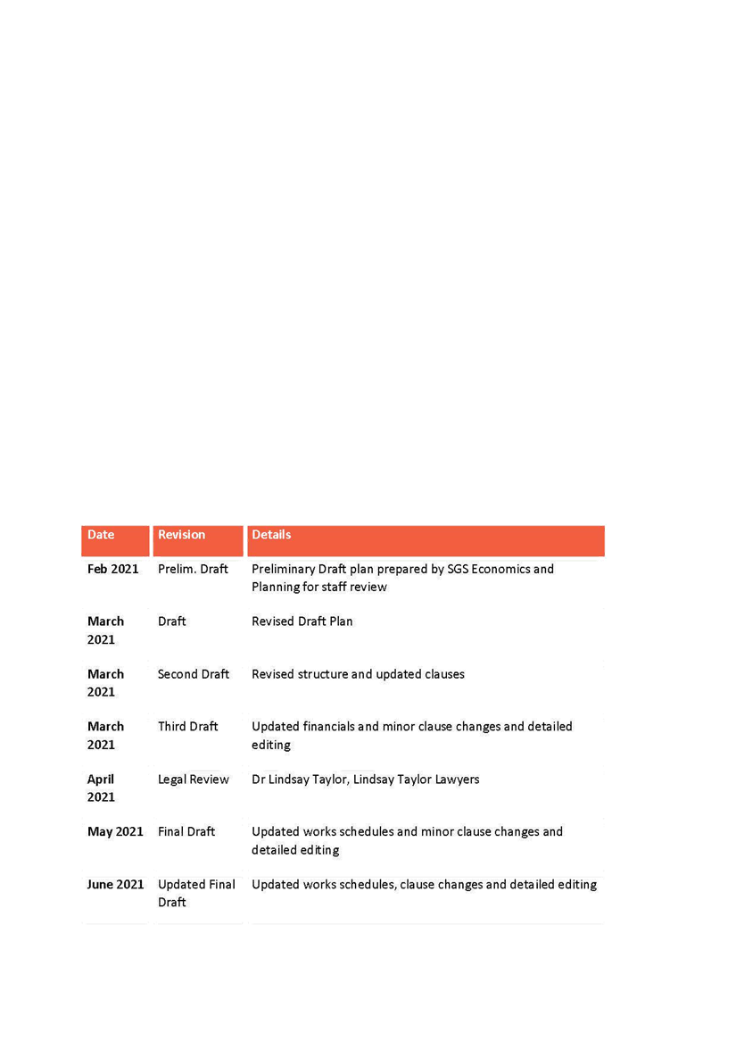
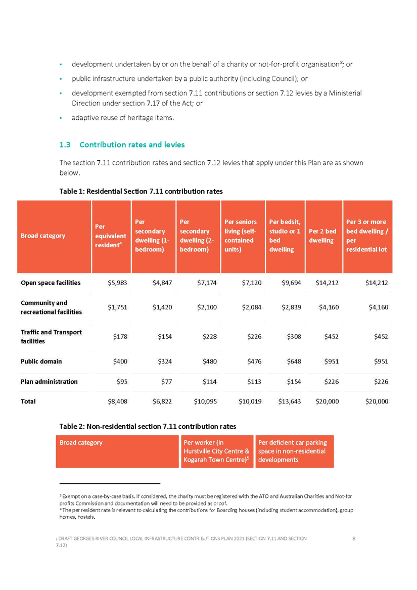
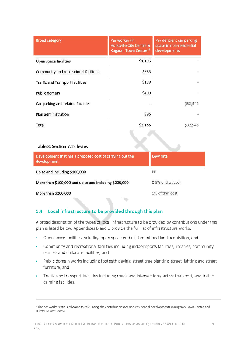
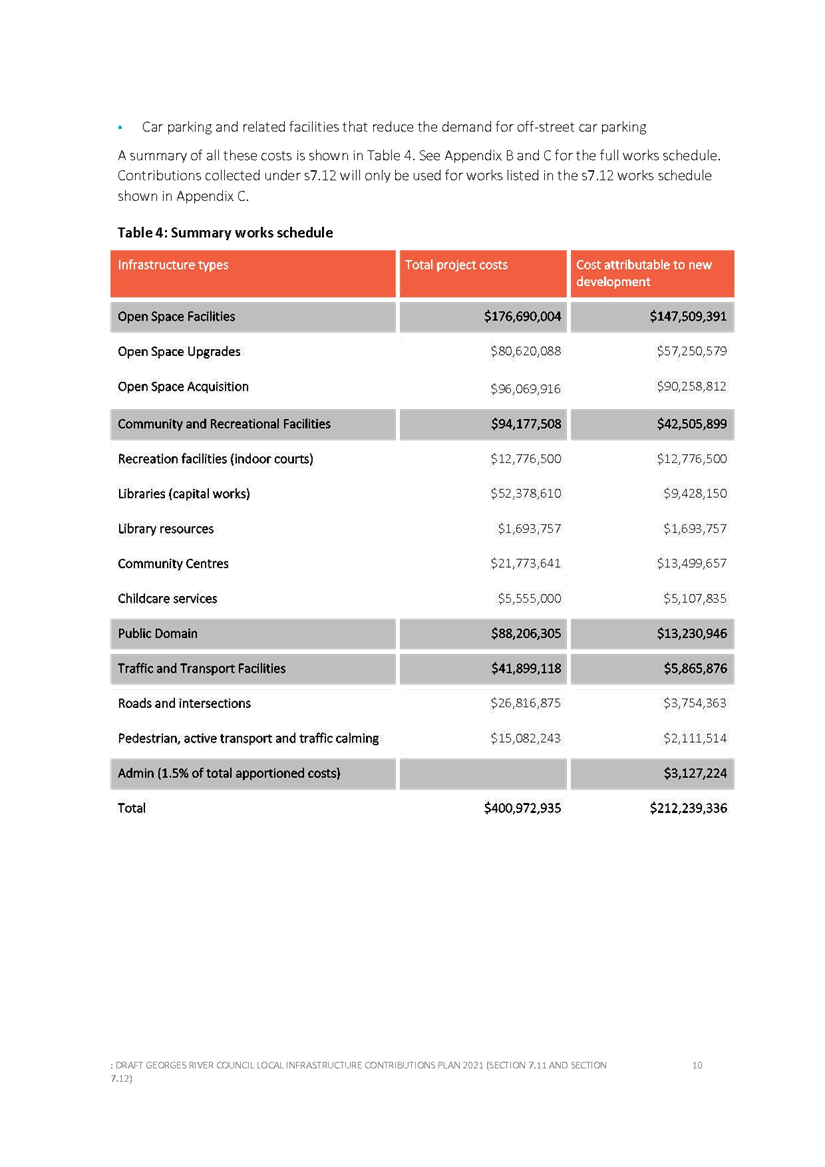
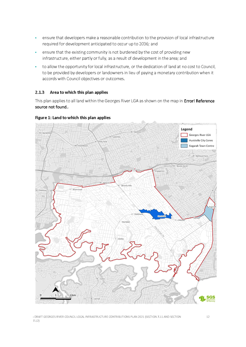
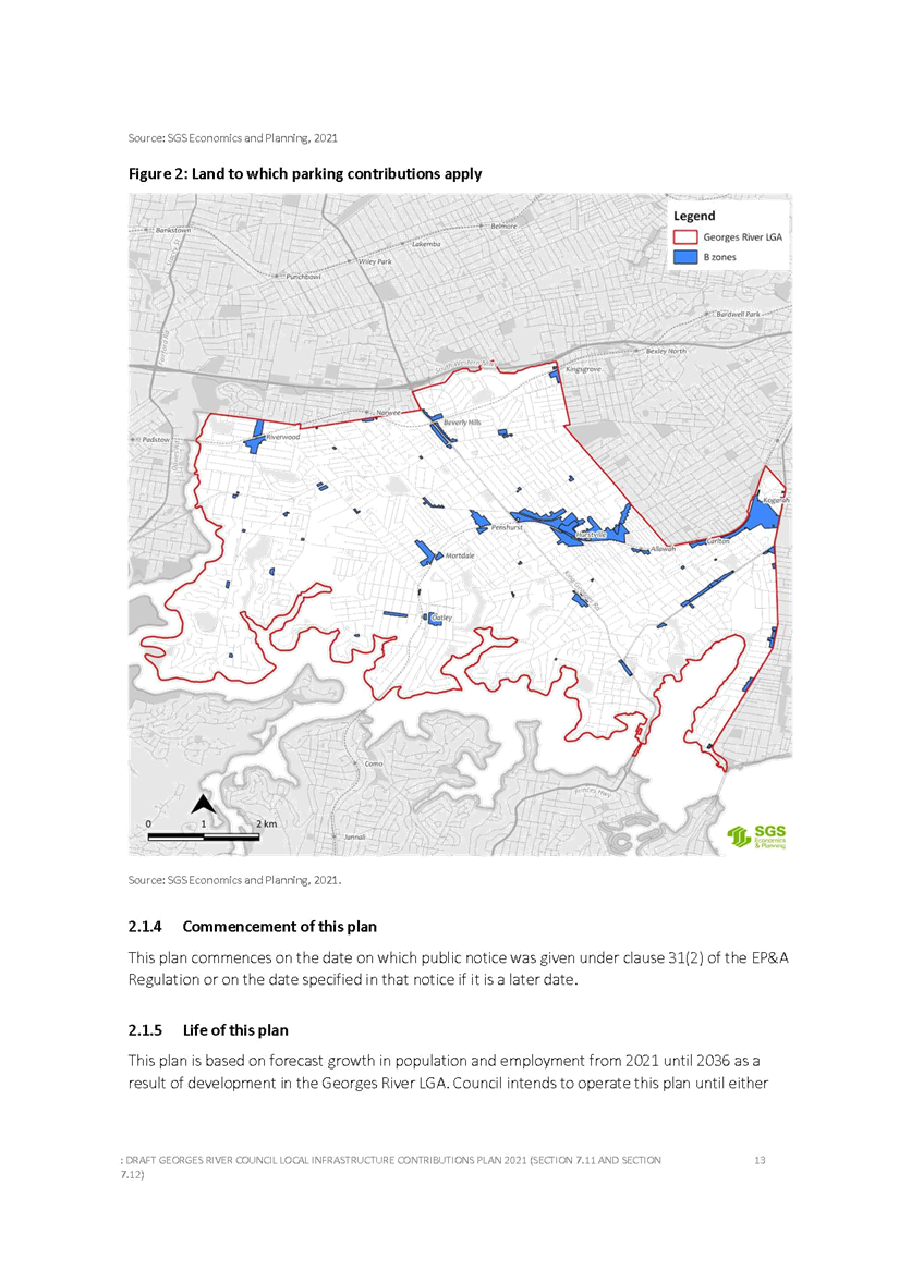
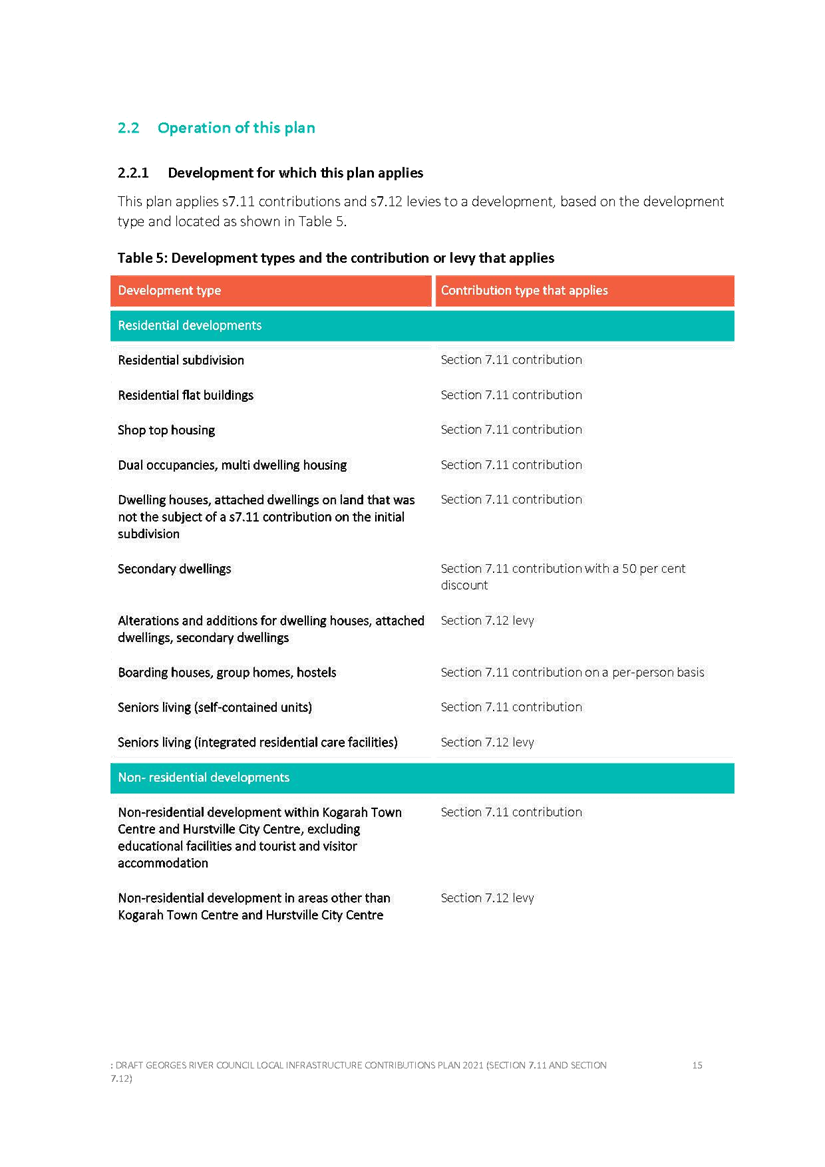
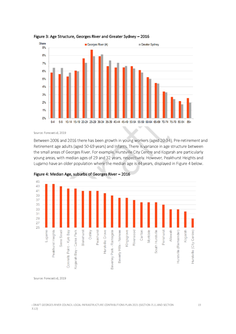
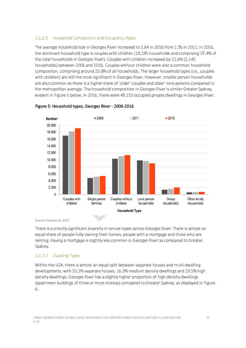
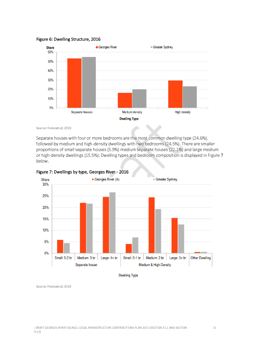
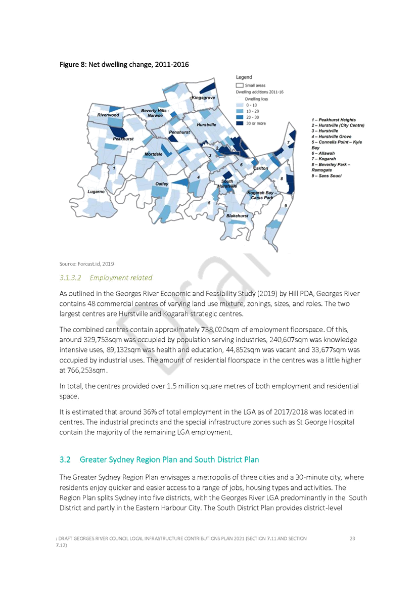
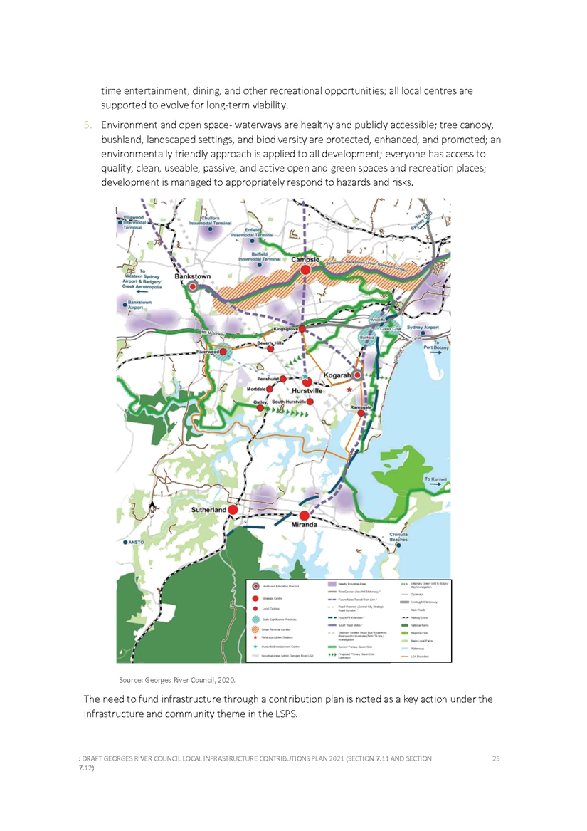
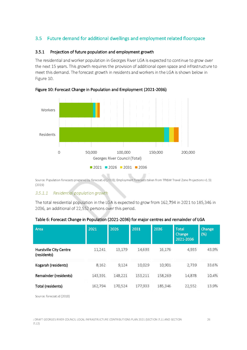
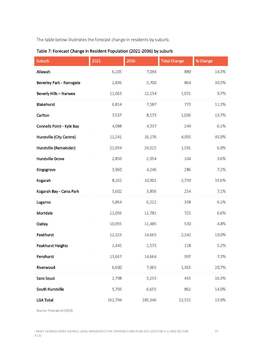
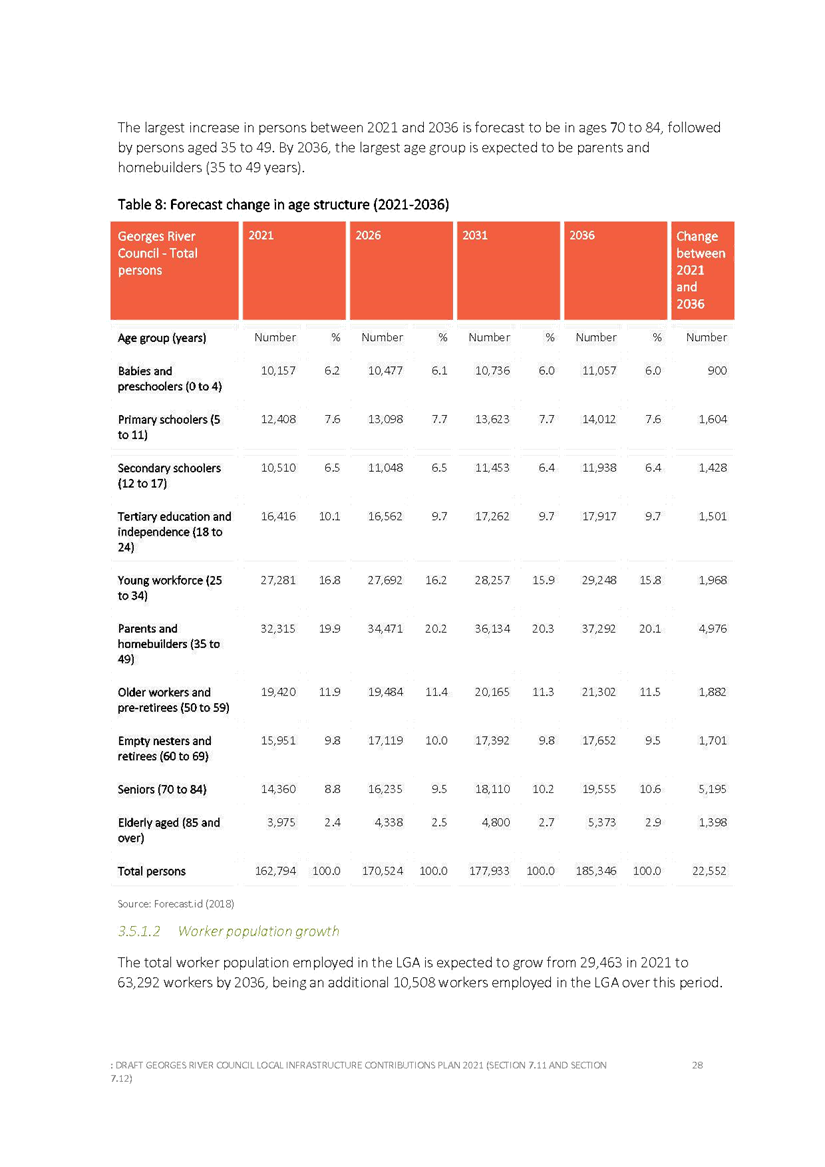
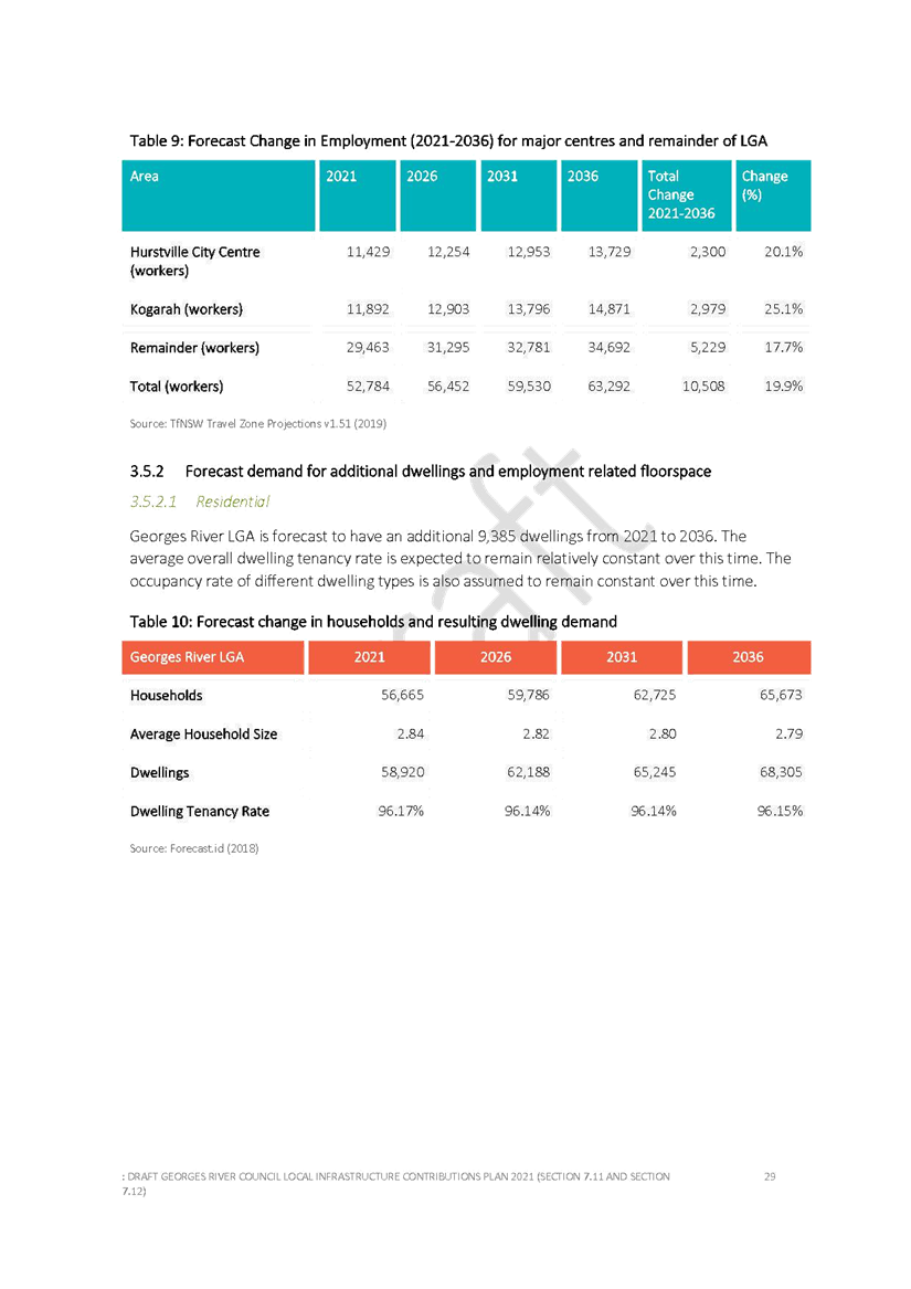
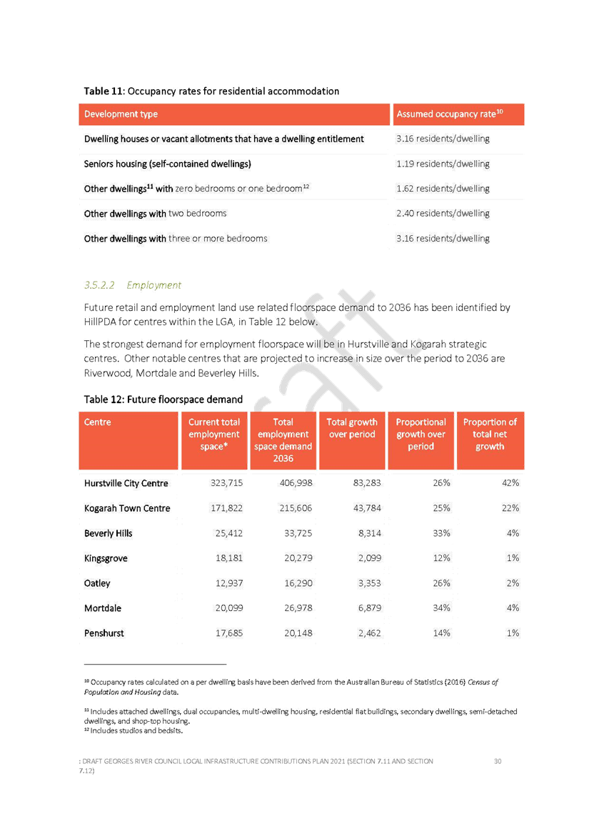
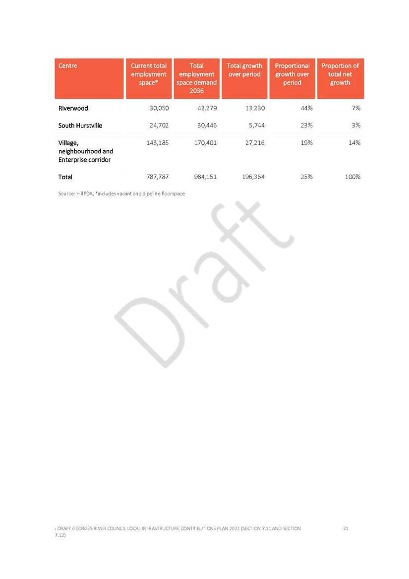
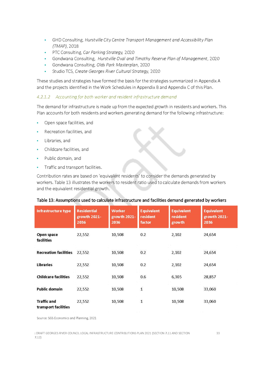
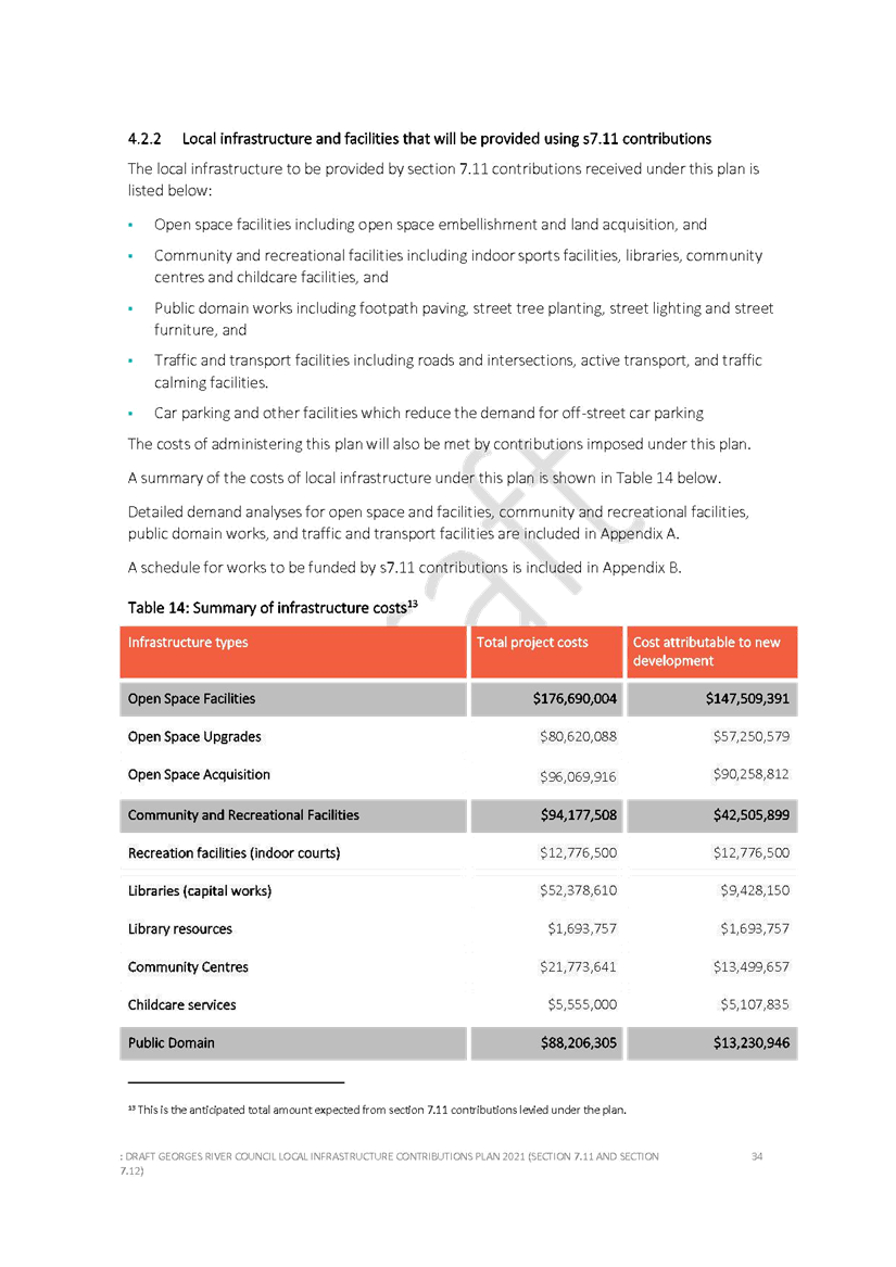
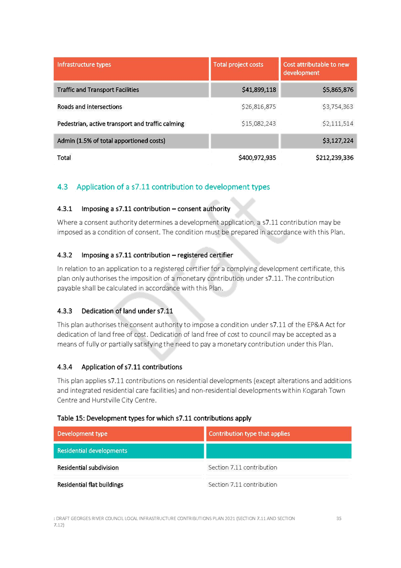
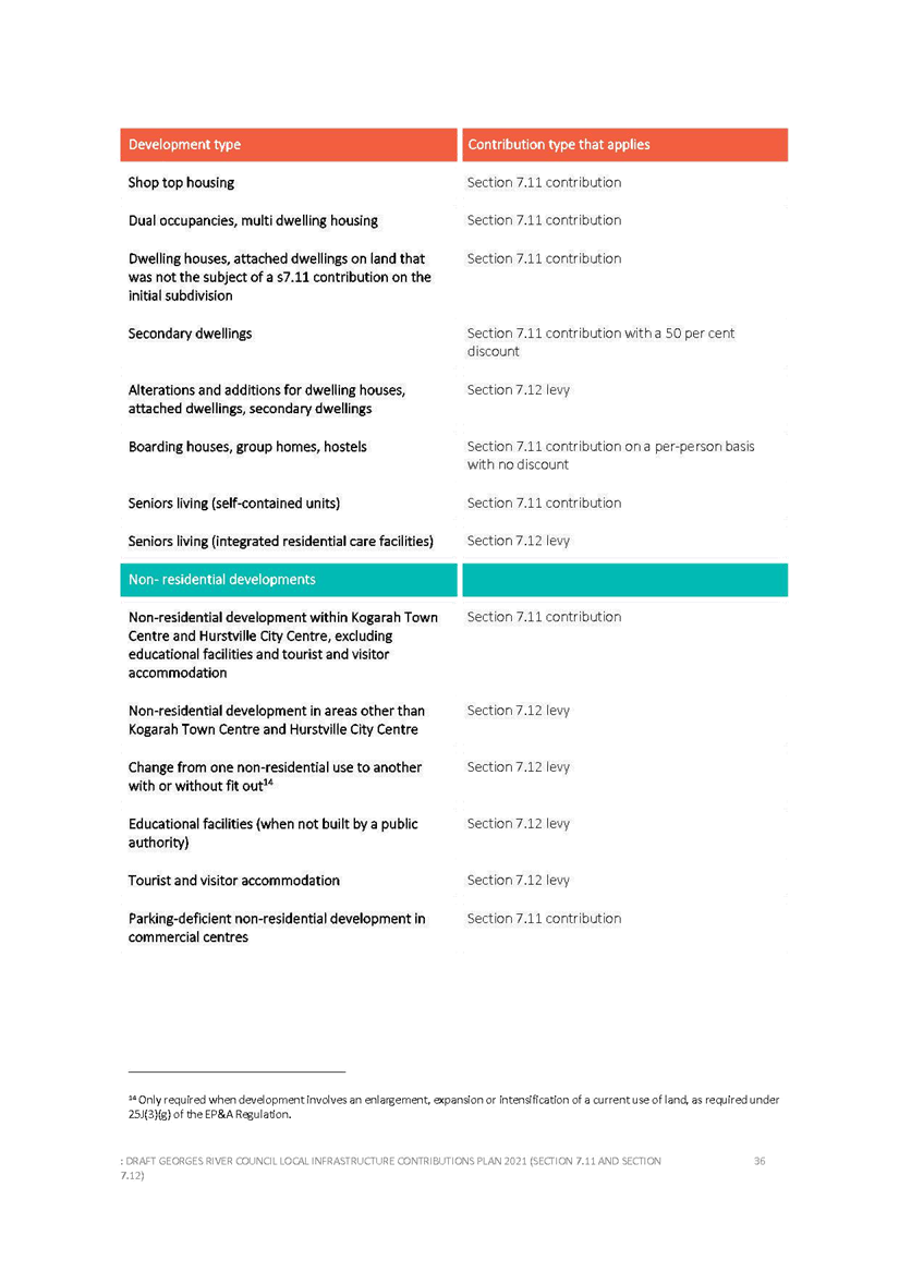
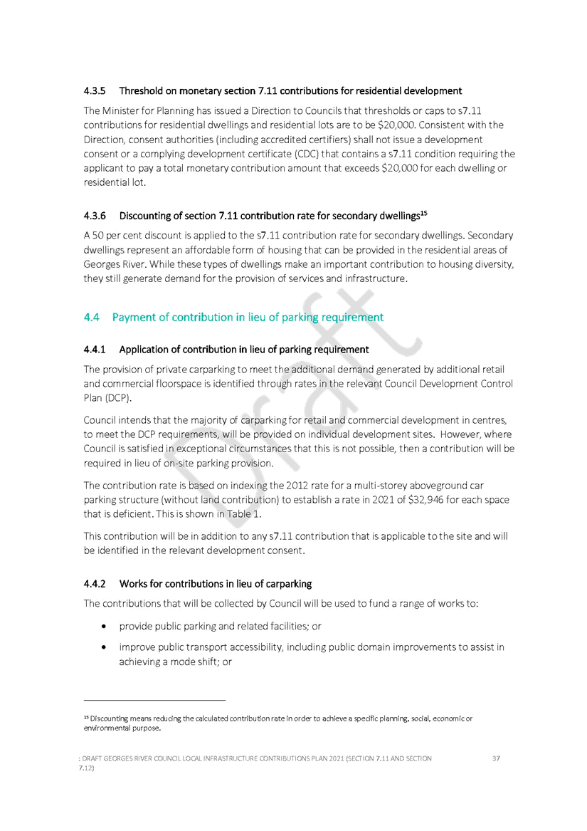
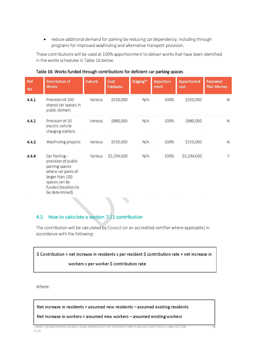
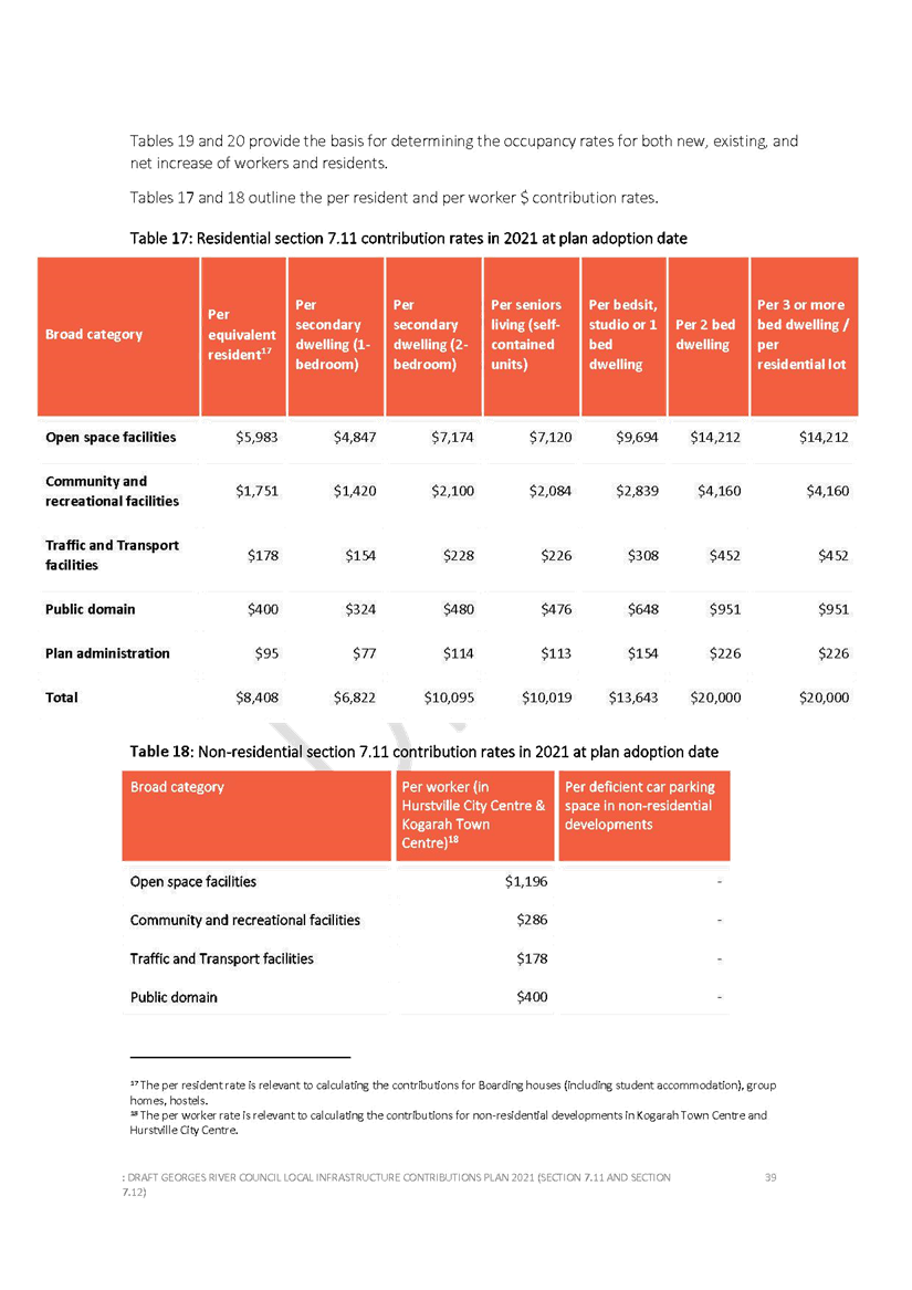
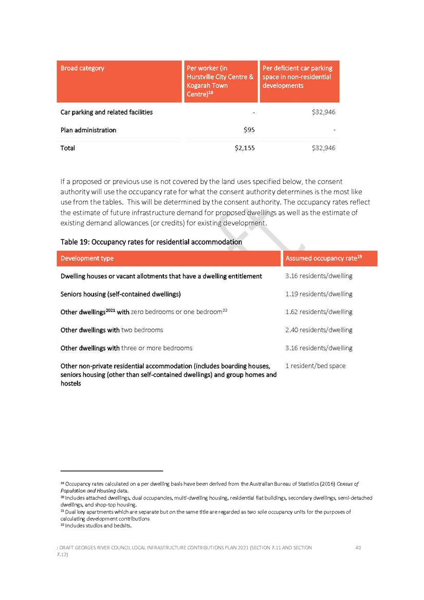
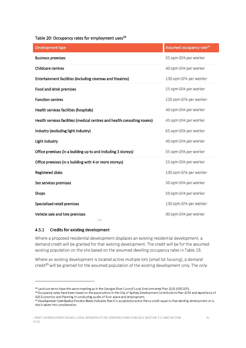
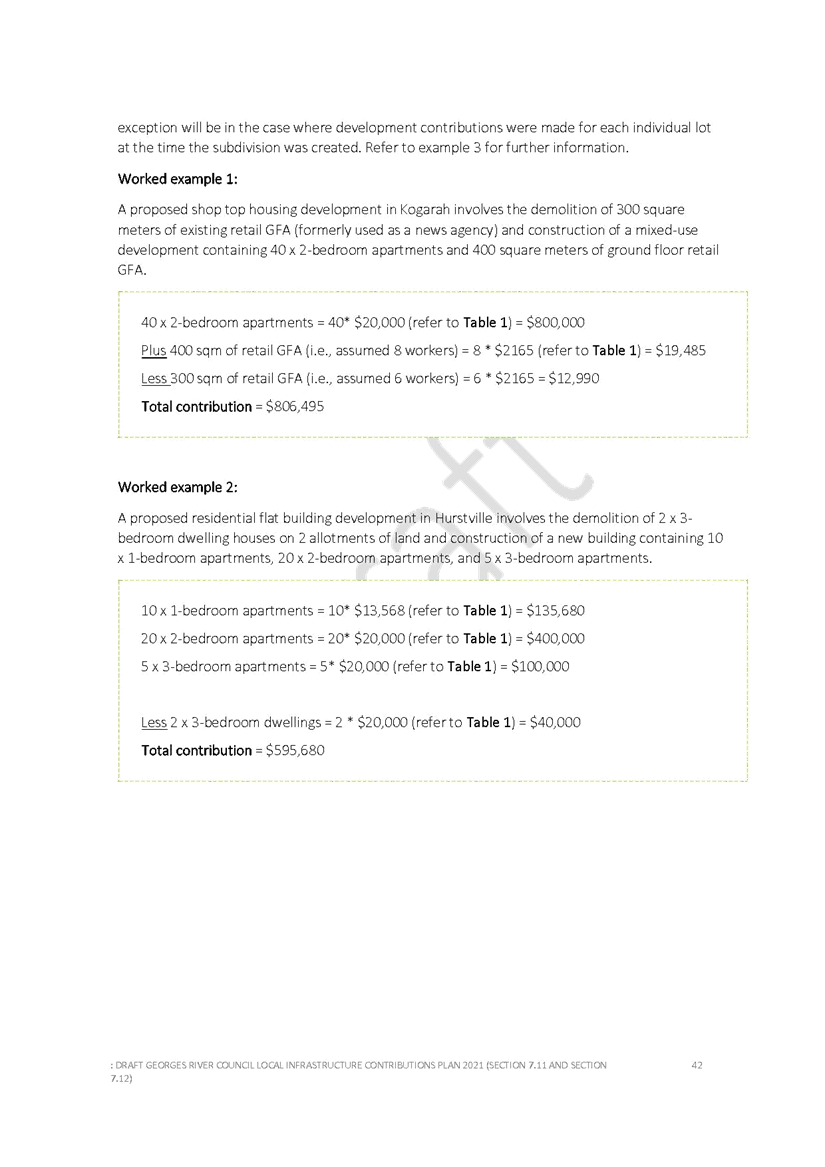
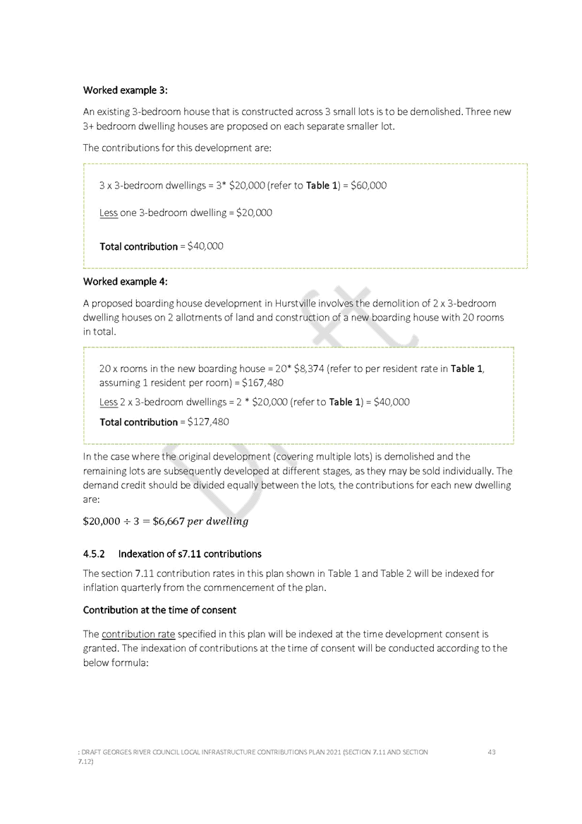
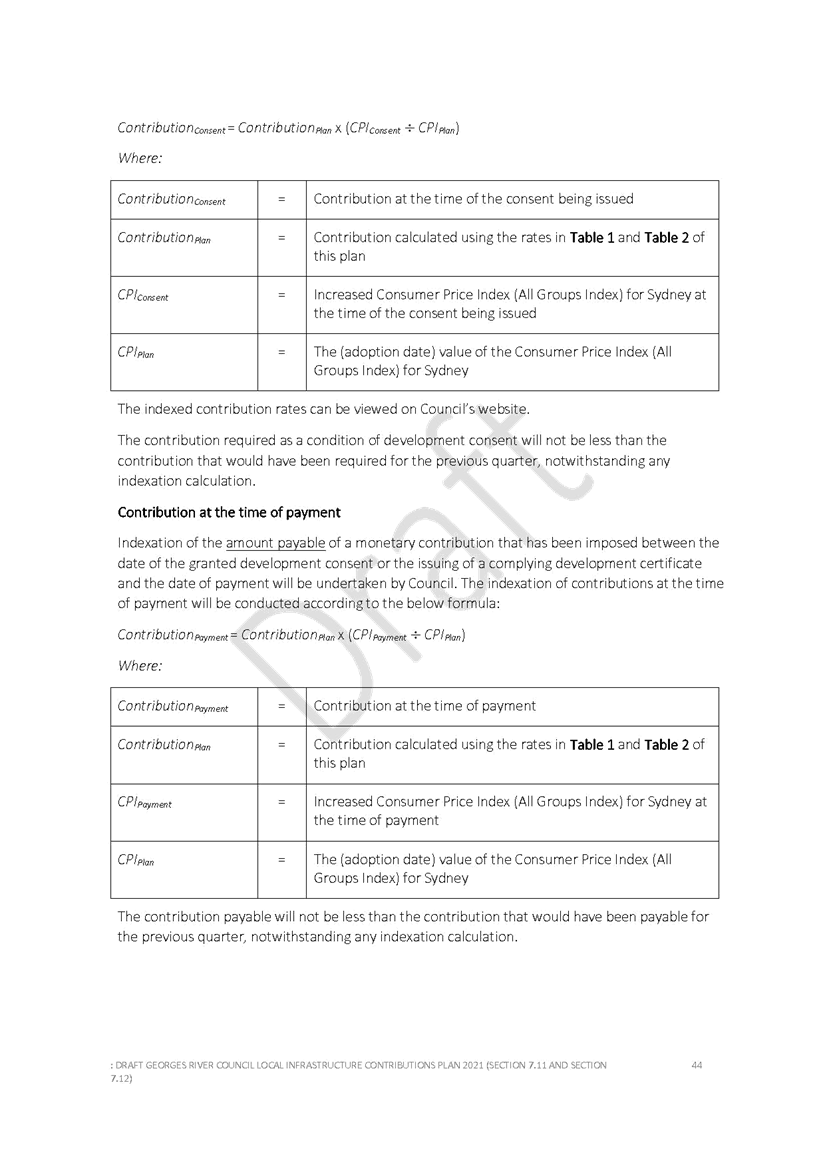
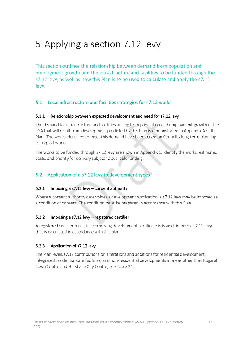
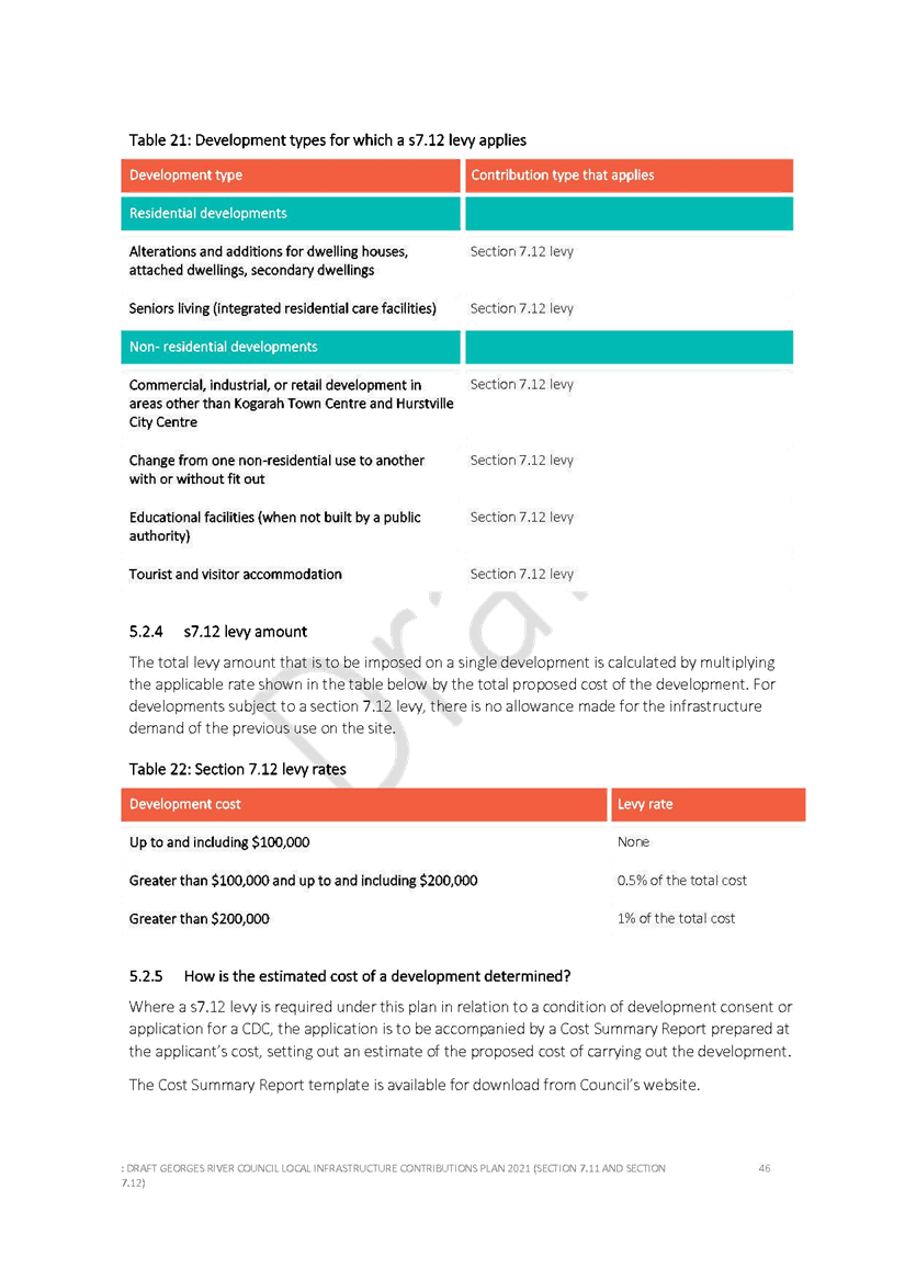
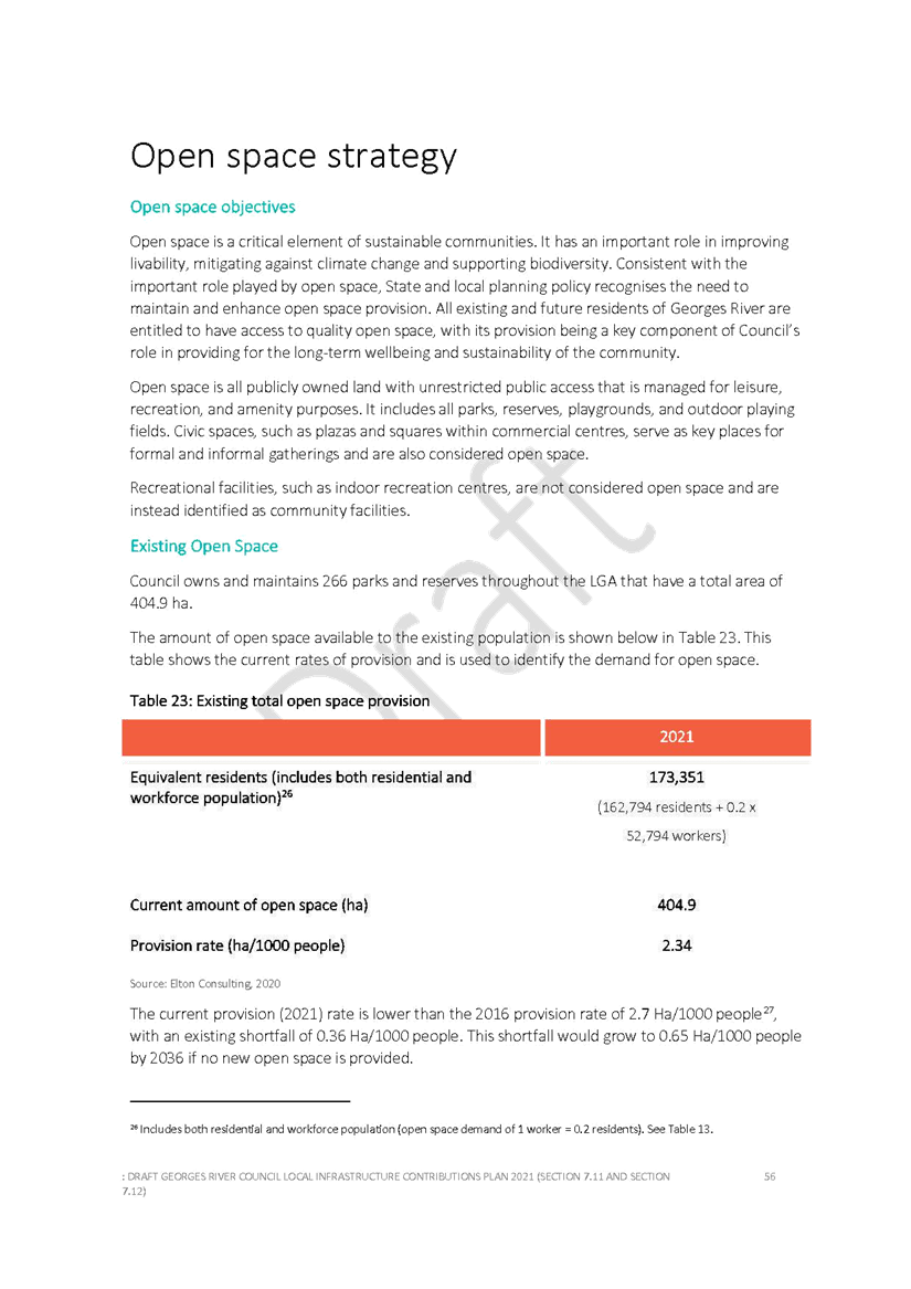
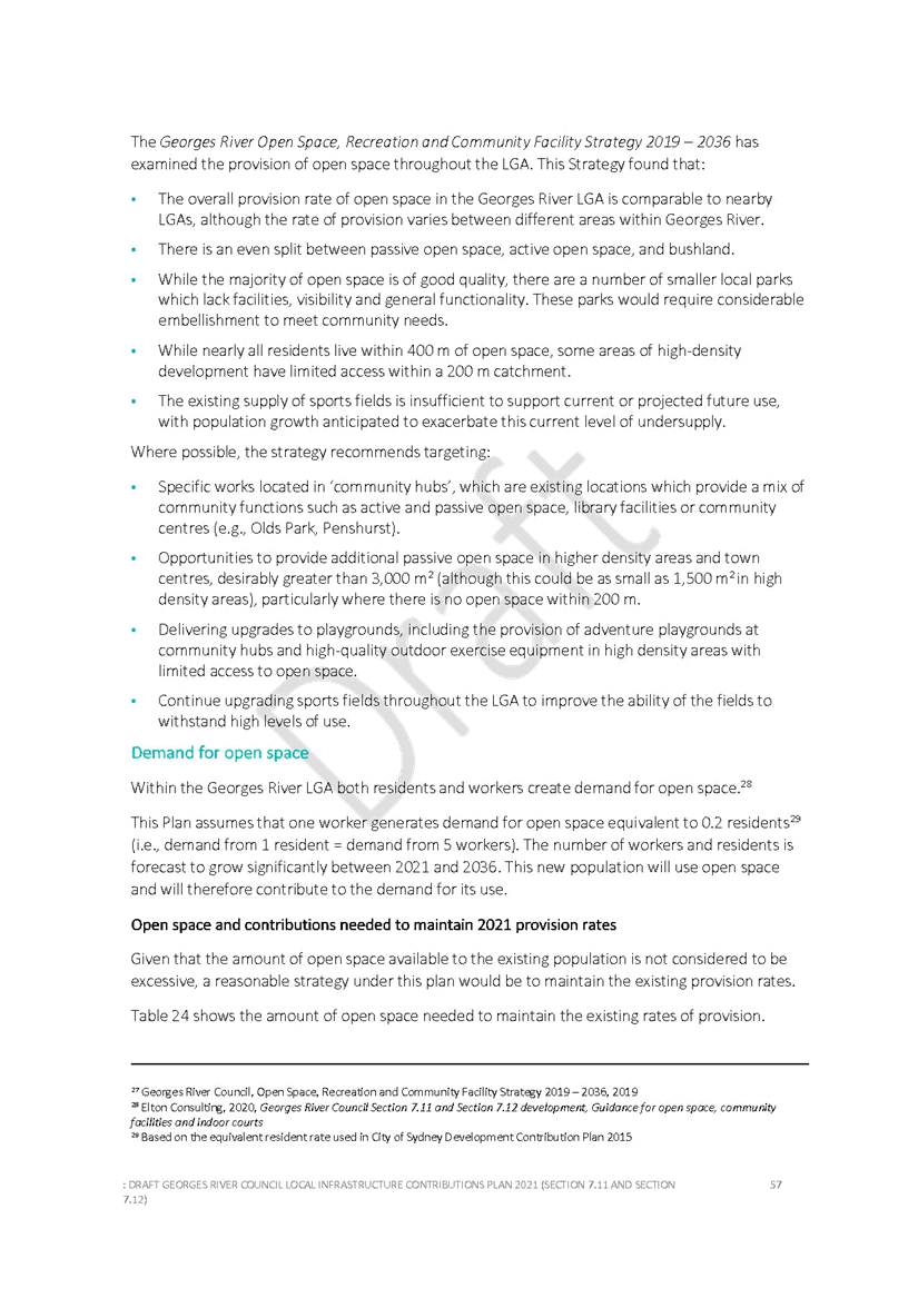
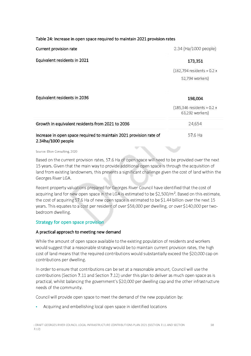
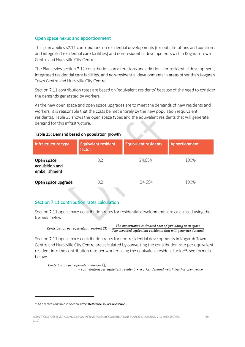
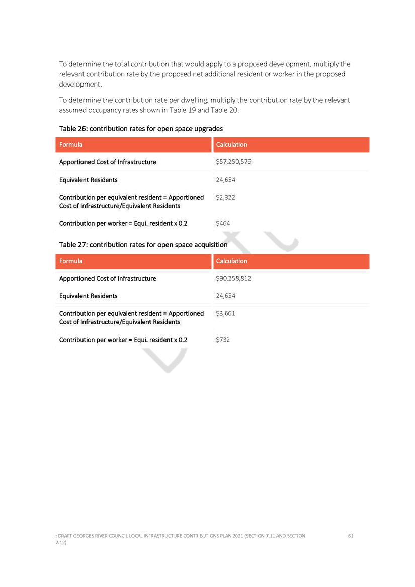
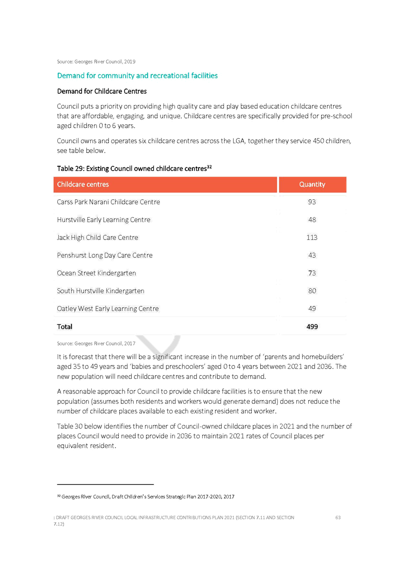
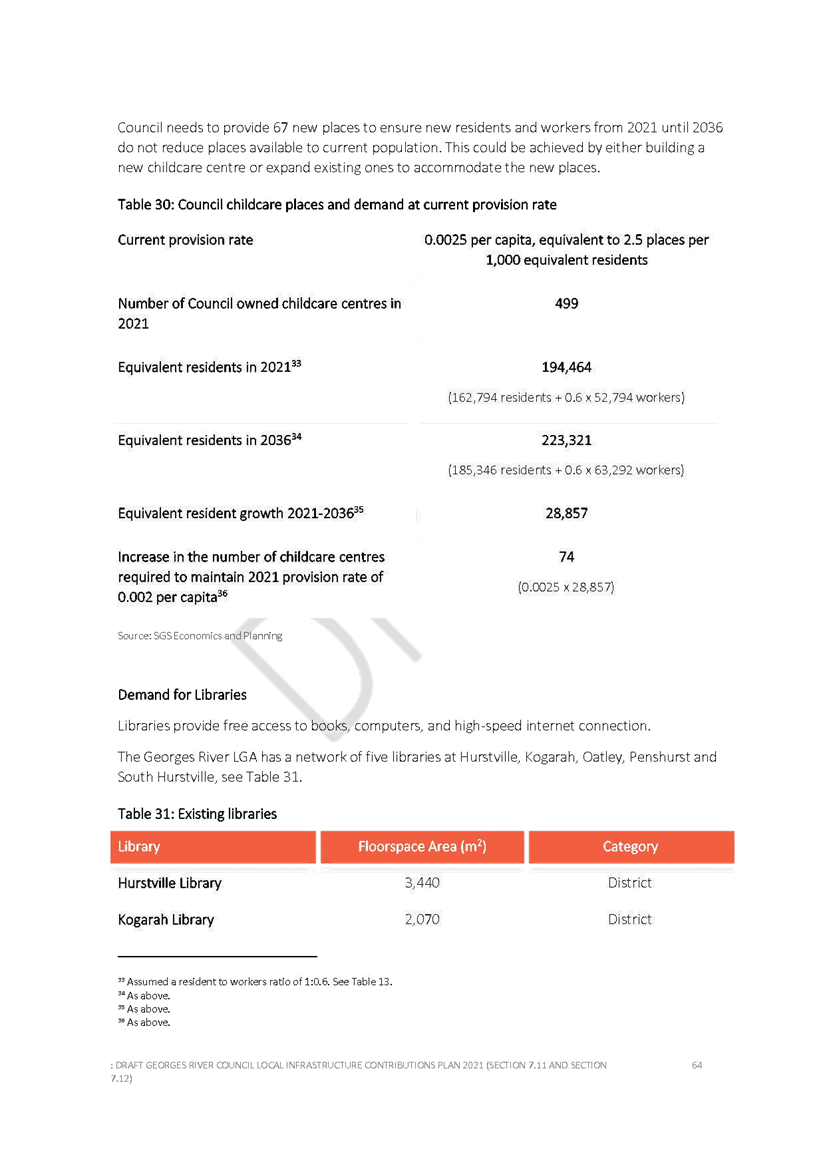
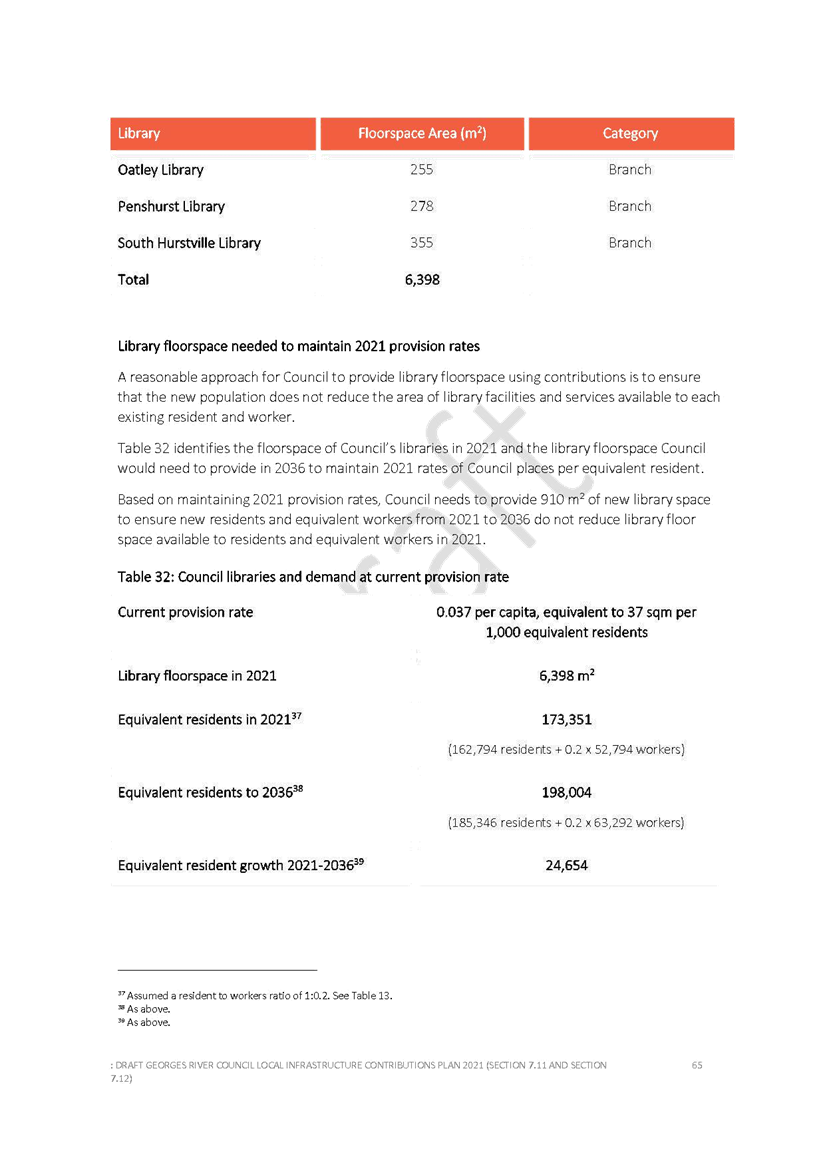
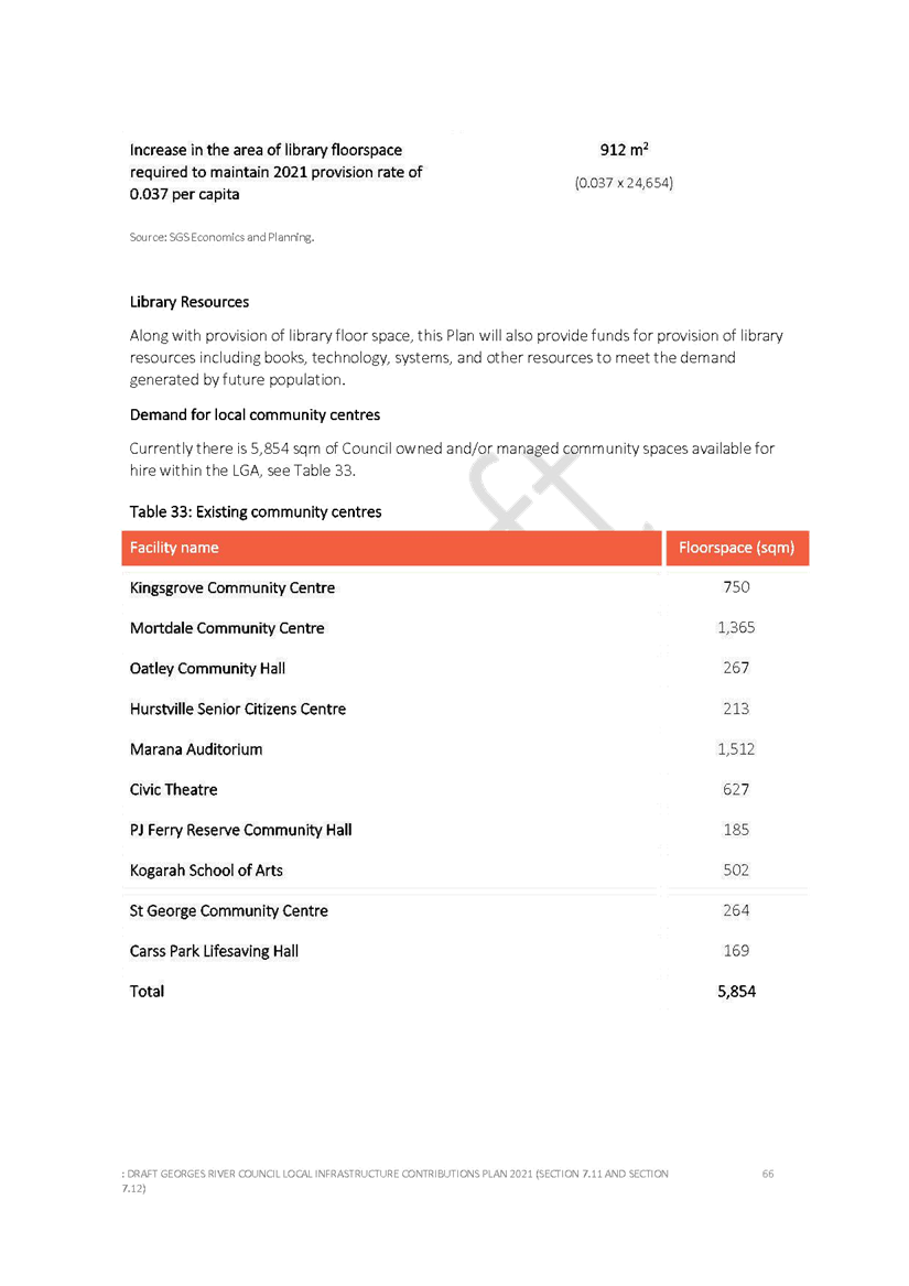
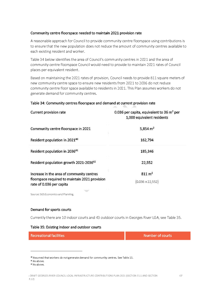
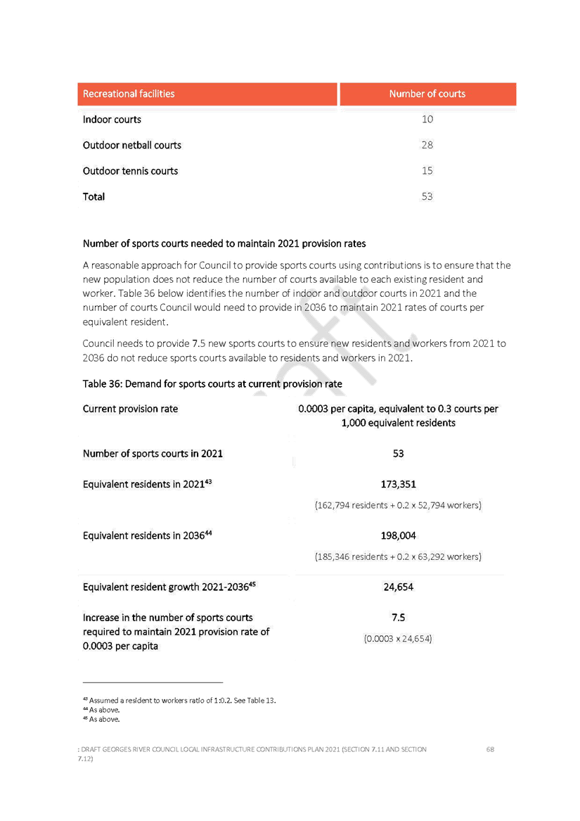
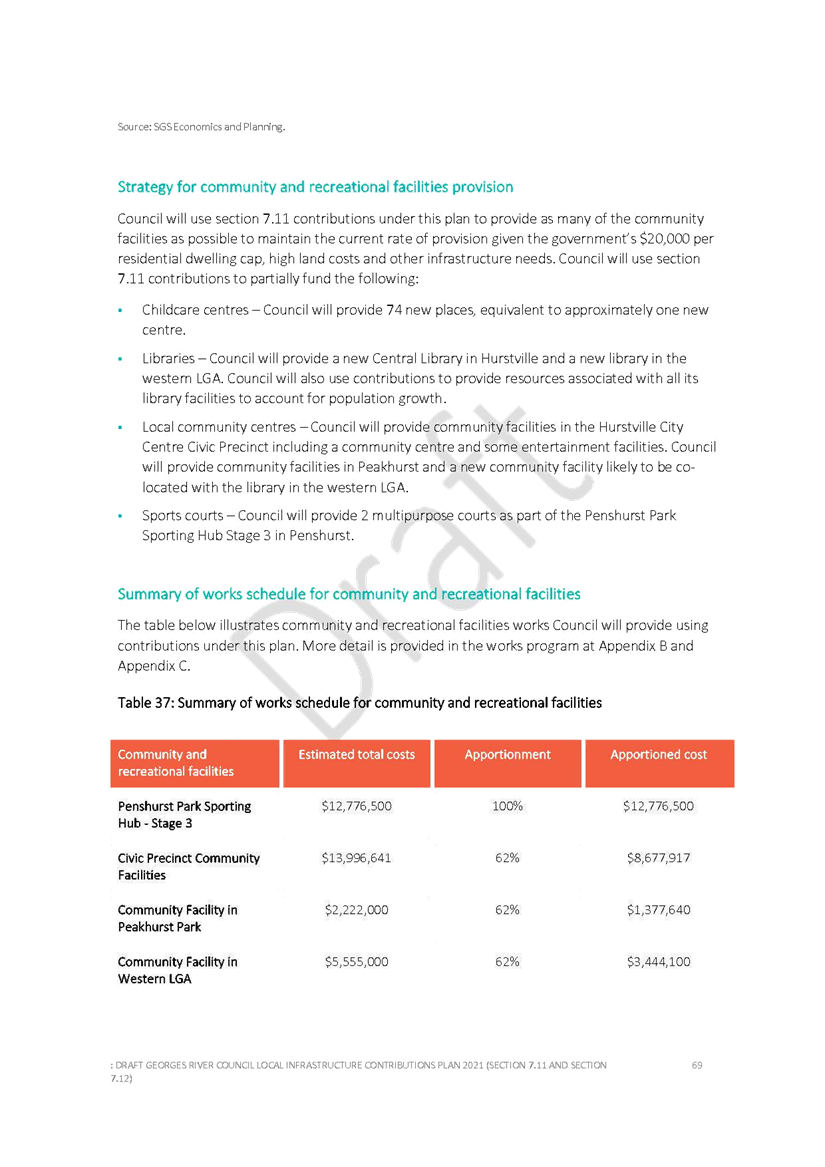
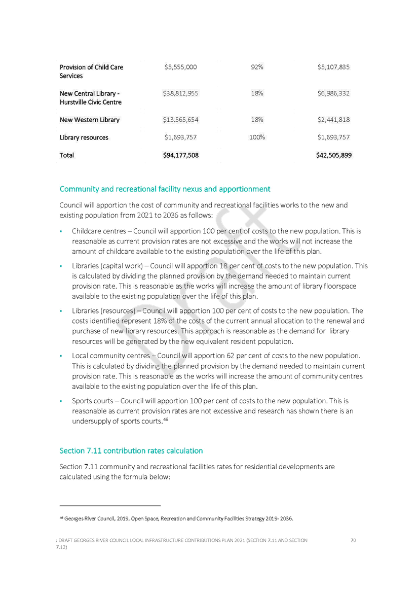
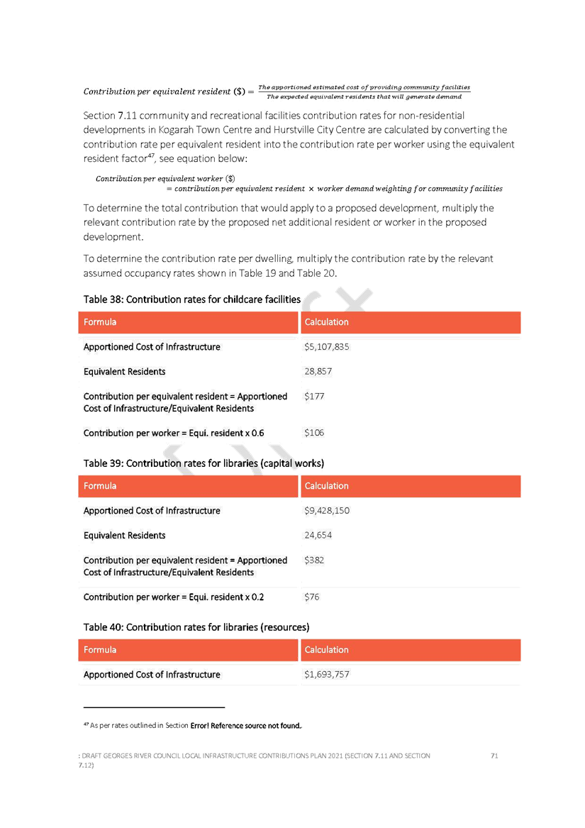
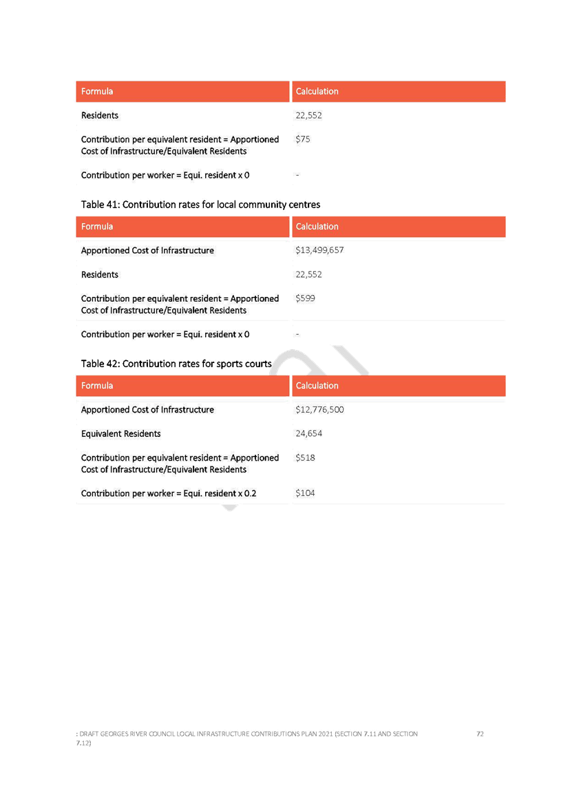
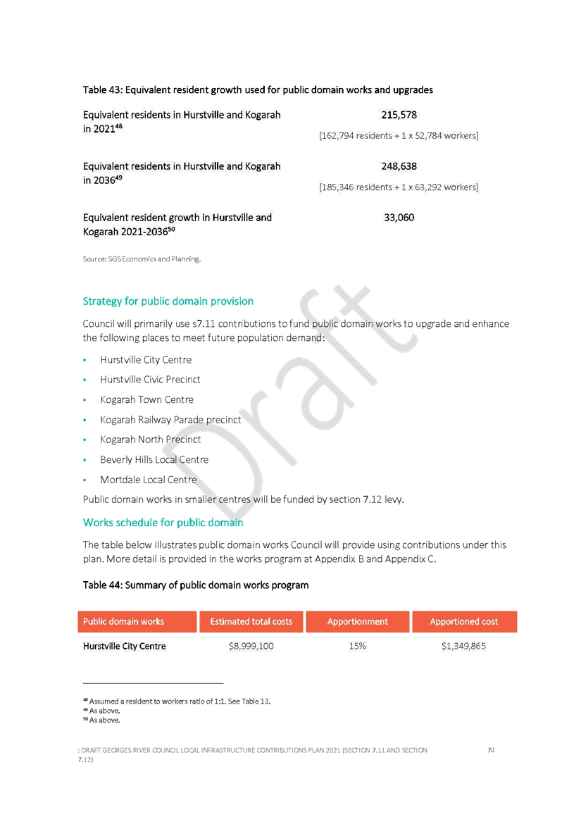
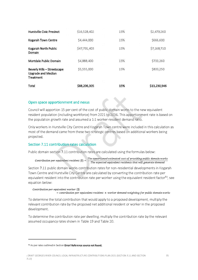
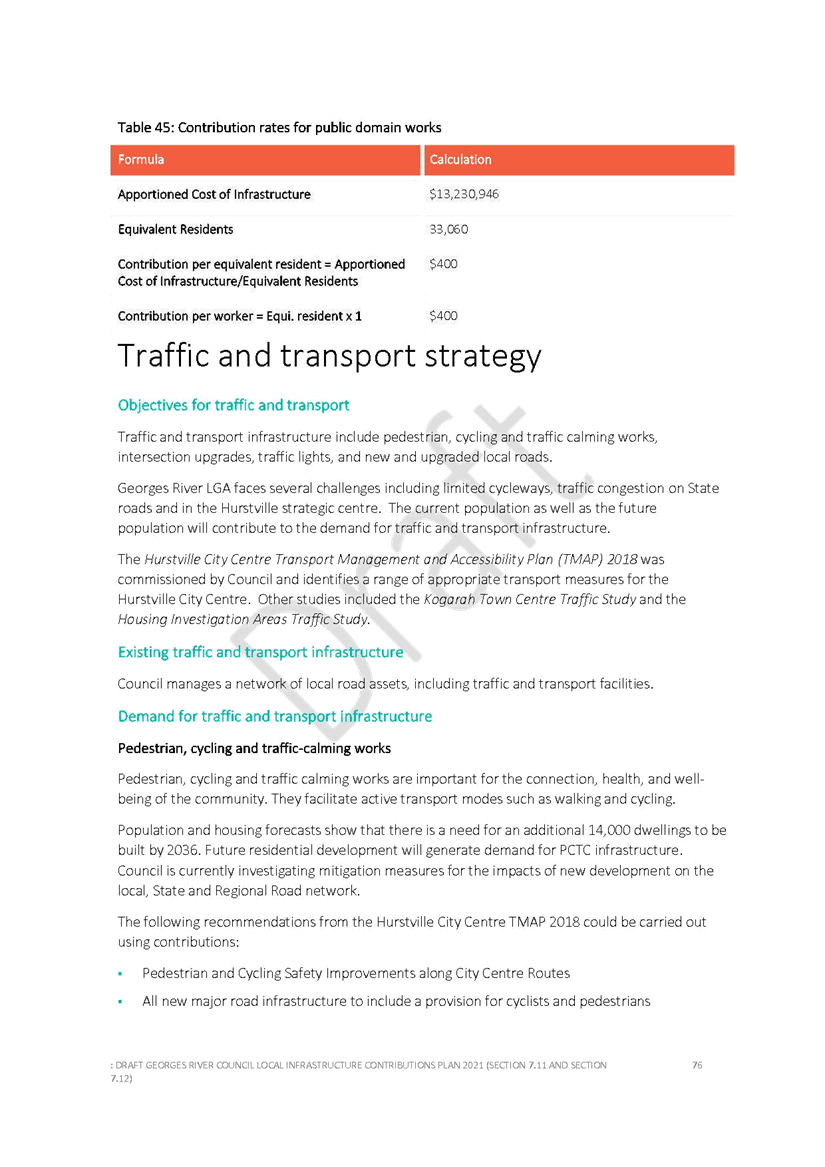
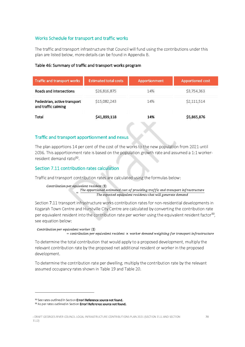
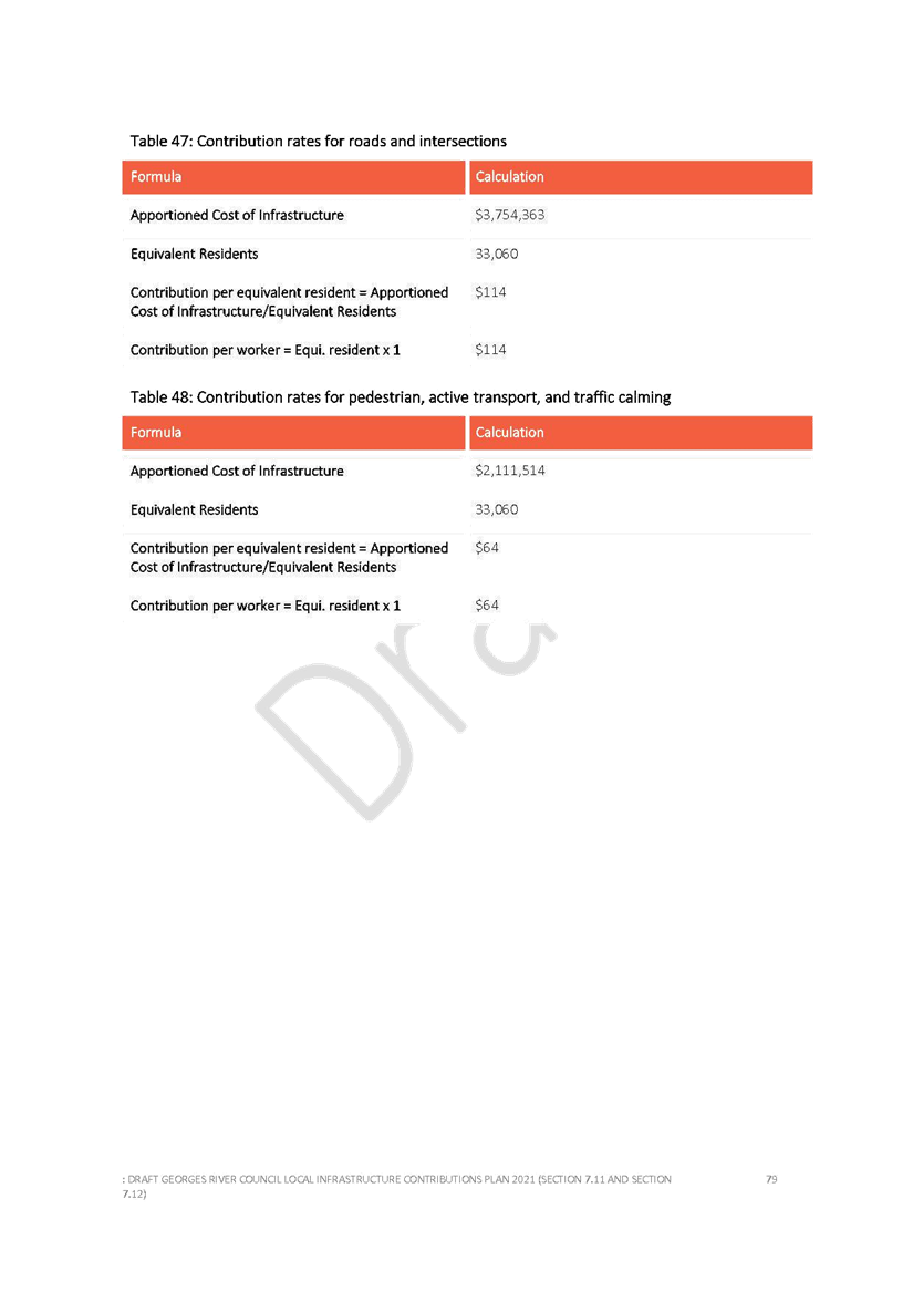
Item: ENV027-21 Draft Mortdale Local Centre Masterplan 2021 (Adoption for Public Exhibition)
Author: Senior Strategic Planner
Directorate: Environment and Planning
Matter Type: Committee Reports
|
(a) That Council endorse the draft Mortdale Local Centre Masterplan 2021, as included in Attachment 1 to the report, for the purposes of public exhibition. (b) That the draft Mortdale Local Centre Masterplan 2021 and supporting documents be publicly exhibited for a minimum period of 28 days in accordance with the community engagement plan outlined in the report. (c) That a further report be prepared and submitted to Council at the conclusion of the exhibition period to allow consideration of any submissions received and any resulting amendments to the Masterplan. |
Executive Summary
1. A draft Masterplan has been prepared for Mortdale Local Centre and is now completed for community consultation. The plan was prepared for Council by urban design consultancy Conybeare Morrison International (CM+) and a team that addressed the areas of engagement, land economics, transport, public domain and quantity surveying. The draft Masterplan is Attachment 1 to this report.
2. The draft masterplan seeks to encourage future urban renewal in the Mortdale Local Centre and improve the amenity of the centre with enhanced built environment and public domain. The draft plan provides new housing and employment opportunities to support a vibrant local centre. It is supported by considerations of infrastructure, traffic and development feasibility to enable a holistic review.
3. The draft masterplan has been developed to achieve the following key objectives to:
· Provide for growth that reinforces and supports the structure of Mortdale.
· Provide for greater housing choice in the local centre.
· Provide for employment opportunities in the local centre that support existing businesses and allow new businesses to be created.
· Improve transitions between the local centre business area and surrounding residential areas.
4. Four key design strategies have been developed to inform the masterplan. These strategies include:
1) Expand B2 zone to meet the 2036 employment target and non-residential FSR target.
2) Introduce transition zones to balance the density and height around Mortdale Local Centre, as well as providing more housing choice and diversity.
3) Provide opportunity to improve the public space network through a range of public spaces / facilities for community, including road closure plazas, town square, new park, library and community hub.
4) Provide opportunity to improve public domain including active transport upgrades, green links upgrades, potential through site links, laneway upgrades and road closure plazas.
5. The draft Masterplan outlines implementation options for consideration including amendments to rezoning and planning controls, improvements to housing diversity, future infrastructure requirements, as well as significant public realm and place-making initiatives to facilitate incremental urban renewal and revitalisation within the study area.
6. Bonus development incentives including greater height and density are proposed to support land consolidation and the delivery for affordable housing within the B2 Local Centre zone.
7. The draft masterplan will provide 35,850m2 non-residential GFA which meets the 2036 employment GFA target established by the Commercial Centre Strategy. An additional 969 dwellings are anticipated for uplift areas within the core study area, which means a total dwelling number of 2,227 dwellings for Mortdale Local Centre.
8. The feasibility analysis suggests the proposed draft Masterplan could facilitate a mix of incremental and comprehensive development. The latter is expected in the expanded B2 Local Centre zone north-east of Morts Road (where land is proposed to be rezoned from R2 -Low Density Residential to B2 -Local Centre) as the lower opportunity cost of land coupled with the proposed planning controls will likely be sufficient to see a strong uptake of development opportunities.
9. The draft Masterplan is anticipated to result in an uplift in development activity compared to no change to current planning controls. Modelling results show this would result in positive economic impacts to the Georges River LGA.
10. This report seeks Council’s endorsement to proceed with public exhibition of the draft Masterplan. It is proposed to undertake the exhibition in July 2021 for a period of 28 days. Community engagement includes digital webinars and other forms of digital engagement as outlined in this report.
11. Following consideration of submissions, it is anticipated that the Masterplan will be finalised and a preferred implementation strategy prepared for the Final Masterplan to then be reported back to Council for endorsement.
Background
12. On 24 August 2020, Council resolved to prepare a masterplan for the Mortdale Local Centre. The review of built form controls will be a key aspect of part 2 of the Commercial Centres Strategy, alongside considerations of the role and function of each commercial centre in the LGA.
13. The Centres Strategy Part 1 provides a rezoning criteria guideline and introduces non-residential Floor Space Ratio (FSR) to meet projected 2036 demand. In particular, it outlines that Mortdale Local Centre (within the Morts Road - B2 Local Centre zone), will require a minimum non-residential FSR of 0.98:1 to meet the 2036 demand. The draft masterplan focuses on delivering the non-residential floorspace shortfall identified in the Commercial Centres Strategy - Part 1 Centres Analysis.
14. The outcomes of the masterplan will inform stage 3 - future LEP 2023 (Jobs and Activation), as well as providing guidance for the assessment of proponent-led planning proposals in the area.
15. The Georges River Local Strategic Planning Statement 2040 (LSPS) identifies 8 centres as appropriate locations to be investigated for additional jobs and housing opportunities and potential expansion. All 8 local centres were assessed as potential candidates for the masterplan project. Mortdale Centre was selected due to:
· There are no maximum heights (no height limits) under the existing HLEP 2012;
· Development controls require review in light of the KLEP 2012 controls which were increased in May 2017 as part of the New City Plan amendment;
· Opportunity to investigate uplift in the surrounding low density residential areas between Mortdale and Penshurst, which have been identified as future housing investigation areas by the LSPS 2040;
· Council has committed funding for streetscape improvements including smart city infrastructure ;
· Presence of proponent-led planning proposal at the periphery of the centre which seeks significant uplift in controls.
16. Since November 2020, there have been three Councillor workshops during the preparation of the draft Mortdale Masterplan.
STUDY AREA
17. The study area is focused around the existing B2 – Local Centre zoned land within Mortdale Centre and the surrounding residential area. To assess the study area from both strategic and local levels, two boundaries have been established, one forms a broader area, the other defines the area in close proximity to Mortdale Station, the Core Study Area.
18. In determining the broader study area boundary, the following principles were used:
· Focusing within 800m radius of Mortdale Station
· Aligning with suburb boundary
· Utilising main roads
· Considering zone change
· Incorporating LSPS 2040 future housing investigation areas
19. The broader study area is generally within 800m radius (about 10-minute walk) of Mortdale Station, including the two future housing investigation areas identified in the LSPS 2040. The broader study area represents a wide range of land uses in Mortdale and covers the current Mortdale Local Centre and the future housing growth areas. Establishing the broader study area is critical in understanding the Mortdale Local Centre's role, its relationships with the surrounding suburbs and the LSPS future housing investigation areas.
20. The Core Study Area is defined by the 400m radius of Mortdale Station (about 5-minute walk) and the surrounding main roads. The core study area covers the land on both sides of the railway line and is bounded by St Catherine Street to the northwest, The Strand to the southwest, Princes Street and Grove Avenue to the southeast and Queens Lane to its northeast. The land in this area enjoys easy access to public transport, amenities, shops and educational facilities.
The study area
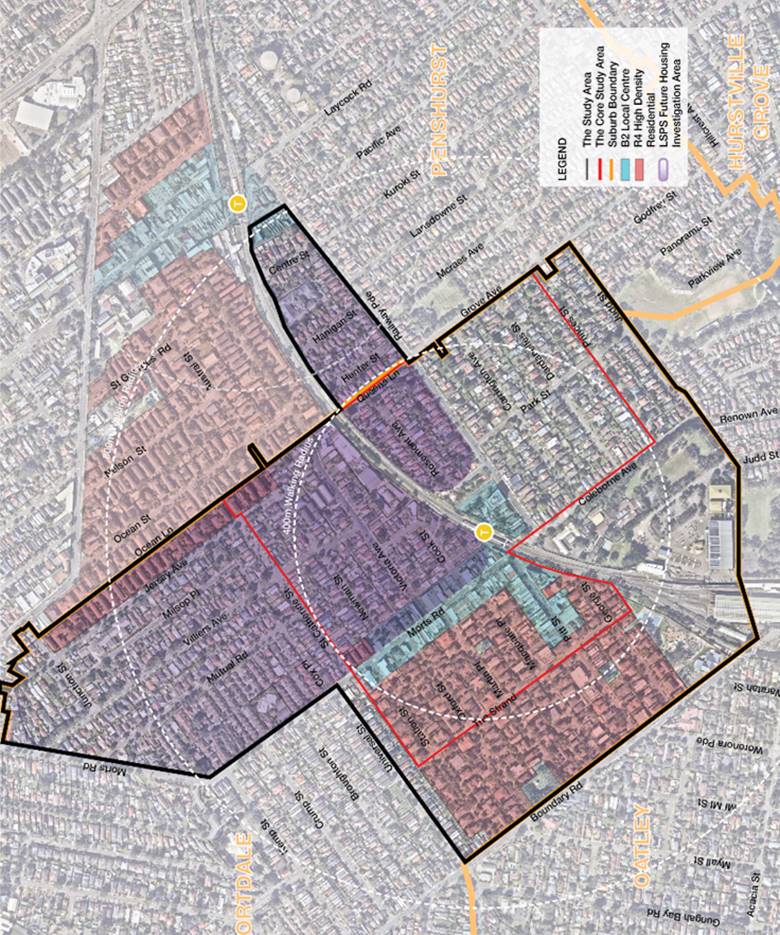
draft masterplan
Methodology, Staging and Timing
21. In November 2020, Council engaged CM+ and their consultant team to prepare the draft Masterplan for Mortdale Centre over a seven-month timeframe.
22. The following five stages outline the overall approach proposed in delivering the masterplan:
· Stage 1 – Review and Analysis of Study Area, Planning Controls and Existing Studies
· Stage 2 – Develop a Draft Vision for the Mortdale Local Centre
· Stage 3 – Develop a Draft Masterplan (current stage)
· Stage 4 – Exhibition of the Draft Masterplan (next stage)
· Stage 5 - Review Submissions and Finalise the Masterplan (future stage)
23. The development of the masterplan has been undertaken using the following methodology:
· Conduct preliminary community engagement activities.
· Conduct Urban Design Analysis, traffic and transport study, and financial feasibility study to identify constraints and opportunities.
· Establish the Urban Design Vision and Principles for the precinct.
· Develop masterplan options based on the Urban Design Vision and Principles with the input from the Consultant Team.
· Develop and document the draft masterplan option, based on the feedback from the Consultant Team, Council and Councillor workshops.
Stage 1 - Urban Design Analysis
24. The Urban Design Analysis assesses the existing conditions of the study area, identifies the constraints and opportunities and establishes the future vision and Urban Design principles to guide the development of the masterplan for the area.
25. The study identifies the constraints and opportunities that have emerged from the Urban Design analysis. These have been considered in the development of the masterplan for the study area. The study also reviews other comparable centres, including Beverly Hills, Oatley, Kingsgrove and Rockdale, to understand height and FSR distributions in these centres.
26. The following constraints have emerged from the urban design analysis:
· Some of the land parcels are prone to flood. The required finished ground floor level which will potentially affect the streetscape.
· The railway corridor forms a barrier subdividing Mortdale into two parts.
· Limited cross railway line access and poor pedestrian amenity erode the area's accessibility and weaken the principle of a more balanced on both sides of the railway corridor.
· The traffic along Boundary Road and the railway corridor generate noise to the study area.
· Heritage items will be challenging to sequence development.
· Sensitive interfaces with schools, open spaces, heritage items and the Heritage Conservation Area.
· Block with long frontages in the north part of the study area affects the area's permeability and walkability.
· High parking occupancy and limited loading areas in the core of the local centre.
27. The following opportunities have been identified from the Urban Design analysis:
· Provide a high quality urban precinct close to Mortdale Station, which incorporates higher height and density and high quality public domain.
· Protect and reinforce the local business and employment.
· Improve pedestrian amenity and footpath condition along the major shopping streets and the adjacent residential streets.
· Strengthen the function and legibility of the local centre primary spines of Morts Road, Pitt Street, Coleborne Ave and Railway Parade.
· Enhance local centre permeability.
· Upgrade Ellen Subway to improve its appearance and area's connectivity across the railway line.
· Enhance local permeability by strengthening the existing links and providing new links.
· Improve local amenity - potential opportunities to provide additional local open spaces in suitable locations to service future growth and needs.
· Improve Mortdale's regional legibility - Create a 'green links’ to in the existing and potential new open spaces in the study area with the adjoining regional parks / recreational facilities and Georges River foreshore.
· Protect existing mature trees and improve the precinct's tree coverage
· Maintain the regional views to Hurstville CBD along Railway Parade and promote view sharing among the buildings.
· Redevelopment potential on land parcels that are less constrained.
· Realise high quality architecture and public domain in Mortdale.
· Promote sustainability and smart city initiatives.
· Promote active transport (walking and cycling) within and around the area.
· Mitigate the acoustic impacts of the major roads and railway corridor through building design and landscaping.
· Mitigate flood impacts by utilising the suitable measures.
Constraints
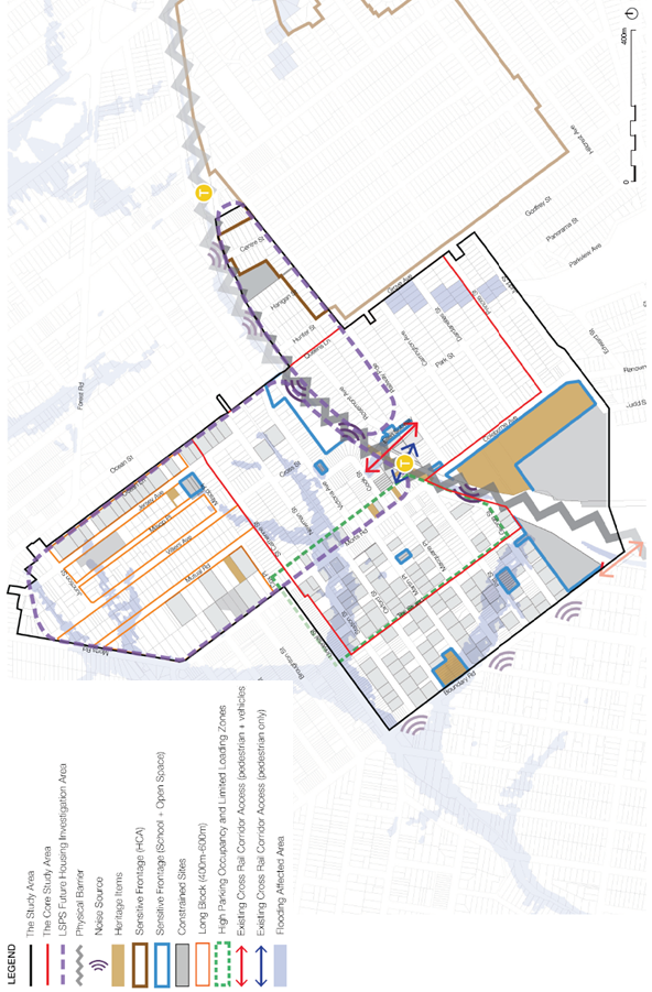
Opportunities
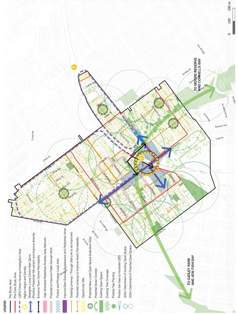
Stage 2 – Develop a Vision and Key Principles
28. The urban design vision and key principles have been developed based on the work undertaken in Urban Design Analysis in Stage 1.
Vision
Mortdale Local Centre and the surrounding area will be a vibrant community with a contemporary yet fine grained village centre, well served by active transport and public transit that capitalises on its proximity to natural features through a network of green links and usable parks.
Mortdale will be home for a diverse population, in a variety of housing types integrated to local open spaces, green streets and pedestrian connections. It will provide a mix of retail, social and business activities that define its social life and supports community wellbeing.
Local parks will be connected into a legible network of green spaces that provide links to the regional green network reinforcing Mortdale’s prominence within the geography of this part of Sydney.
Key Principles
Twelve key principles have been identified to guide the development of the masterplan. These principles include:
a) Manage growth and development in Mortdale Local Centre by promoting appropriate development outcomes that foster rejuvenation of the centre while generating new living and working opportunities.
b) Achieve a more balanced approach in development of the Mortdale Local Centre, which is on both sides of the station.
c) Locate height and density close to the station and transition down in scale towards the periphery of the centre.
d) Provide appropriate built form and scale responses to sensitive frontages, including heritage items, Heritage Conservation Areas, educational facilities and open spaces.
e) Advocate design excellence, sustainability, housing diversity and affordability.
f) Maintain the fine-grained human scale character in Mortdale Local Centre as new development opportunities are realised.
g) Improve public domain amenity appearance and safety across the area, in particular in the Mortdale Local Centre.
h) Improve Mortdale’s accessibility and permeability through active transport initiatives for walking and cycling.
i) Maximise the potential of existing open spaces, and improve the tree canopy in open spaces and across the public domain areas.
j) Create a green network that provides for both local amenity and connections to the regional green grid network.
k) Drive sustainability initiatives across the area including water sensitive urban design initiatives, plant species selection, public domain material selections, and encouragement of active transport.
l) Reinforce the legibility of Mortdale Local Centre as new development occurs.
Stage 3 – Develop a Draft Masterplan
Design Strategy and yield testing
29. Based on the vision and principles, four key design strategies have been developed to inform the masterplan options. These strategies include:
1) Expand B2 zone to meet the 2036 employment target and non-residential FSR target
2) Introduce transition zones to balance the density and height around Mortdale Local Centre, as well as providing more housing choice and diversity
3) Provide opportunity to improve the public space network through a range of public spaces / facilities for community, including road closure plazas, town square, new park, library and community hub
4) Provide opportunity to improve public domain - Public domain upgrades will be provided where development controls have changed, including active transport upgrades, green links upgrades, potential through site links (subject to developers), laneway upgrades and road closure plazas.
30. Driven by the above four design strategies, a range of design options and yield testing was explored in relation to the urban structure and density of the study area.
Draft Masterplan
31. The draft masterplan has been developed to achieve the following key objectives to:
· Provide for incremental growth that reinforces and supports the structure of Mortdale.
· Provide for greater housing choice in the local centre.
· Provide for employment opportunities in the local centre that support existing businesses and allow new businesses to be created.
· Improve transitions between the local centre business area and surrounding residential areas.
32. The resulting structure plan for the draft masterplan provides a concentrated commercial core next to the station with expanded B2 Local Centre zone core along Morts Road, Pitt Street and Cook Street. (Refer to Structure Plan and Draft Masterplan).
33. The expanded and rationalised B2 Local Centre zone, north of the station and associated increases in building scale and height allow adequate space to meet employment opportunity targets and provides balance to the centre on both sides of Mortdale Station. (Refer to Land uses).
34. The existing B2 Local Centre zone south of the station contains FSR and HOB controls that are currently feasible for redevelopment and minimal change is proposed. It is noted that a number of sites in this precinct have Development Assessment approval or have been recently developed.
35. New residential zones around the B2 Local Centre zone provide for appropriate transitions in building scale and provide greater housing variety for Mortdale. These areas focus on the development potential within the 400m walking distance catchment (5-minute walk) of Mortdale Station. North of the station, a R4 High Density Residential zone is proposed on blocks adjoining the expanded B2 Local Centre zone. R3 Medium Density Residential zone blocks transition down between the R4 High Density Residential zone and existing R2 Low Density Residential zone. (Refer to Structure Plan and Proposed Land Uses).
36. Directly opposite the existing B2 Local Centre zone to the south of the station, R3 Medium Density Residential zone is proposed to allow for transition of height and scale to the adjoining R2 Low Density Residential zone. Refer to the aerial view of indicative building envelopes in the study area.
37. The draft masterplan is considered to deliver:
· Better legibility to the local centre to create a heart for Mortdale
· Reducing the impact of change to areas to the south of the station by concentrating the change to the north of the station
· Providing better opportunities to create a connected network of active streets and lanes within the local centre
· Providing greater flexibility to create public amenity in the form of new open space within the redevelopment area
· Incorporating Council owned land into the heart of the precinct
· Providing a critical mass of development in one place
· Providing opportunity to more easily integrate any affordable housing bonus into the built form.
38. The draft masterplan will provide 35,850m2 non-residential GFA which meets the 2036 employment GFA target established by the Commercial Centre Strategy. An additional 969 dwellings are anticipated for uplift areas within the core study area, which means a total dwelling number of 2,227 dwellings for Mortdale Local Centre.
Yield range for draft masterplan
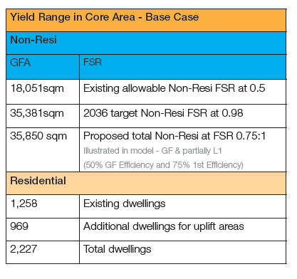
39. The new built form strategy is supported by a complementary public domain improvement across the areas of change that builds on the work previously developed for Morts Road through the Mortdale Shopping Centre Streetscape Upgrade Plan. Taken together, the public domain improvement plan and the new built form strategy will provide a fine grained, walkable and lively renewal of Mortdale to occur incrementally over the next decades. The public domain plan is discussed further in this report.
Draft Masterplan – Structure Plan
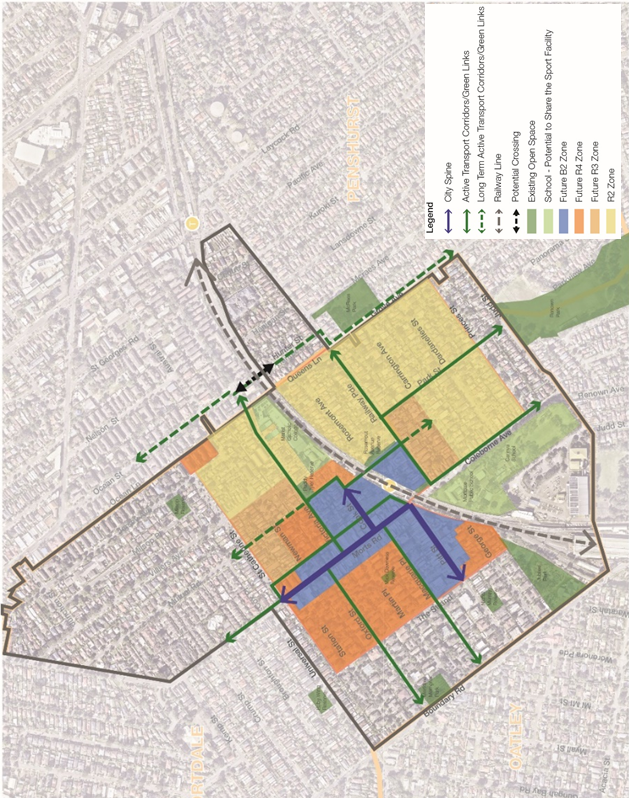
Draft masterplan
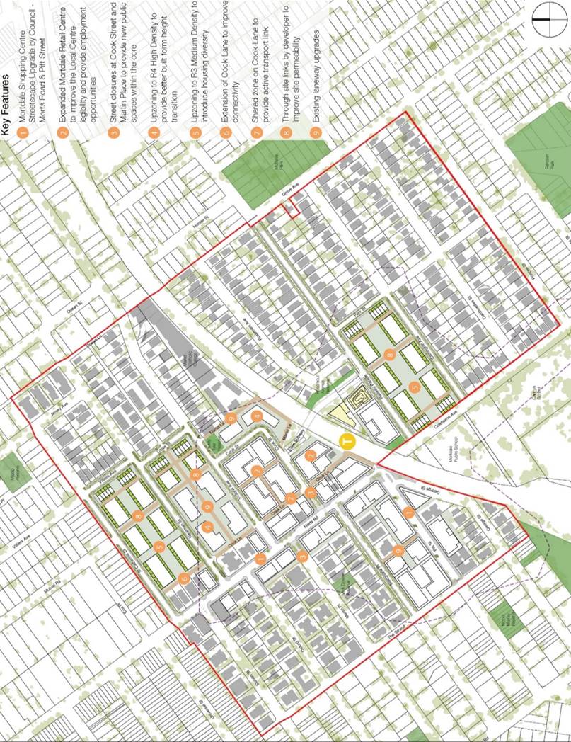
Proposed land uses
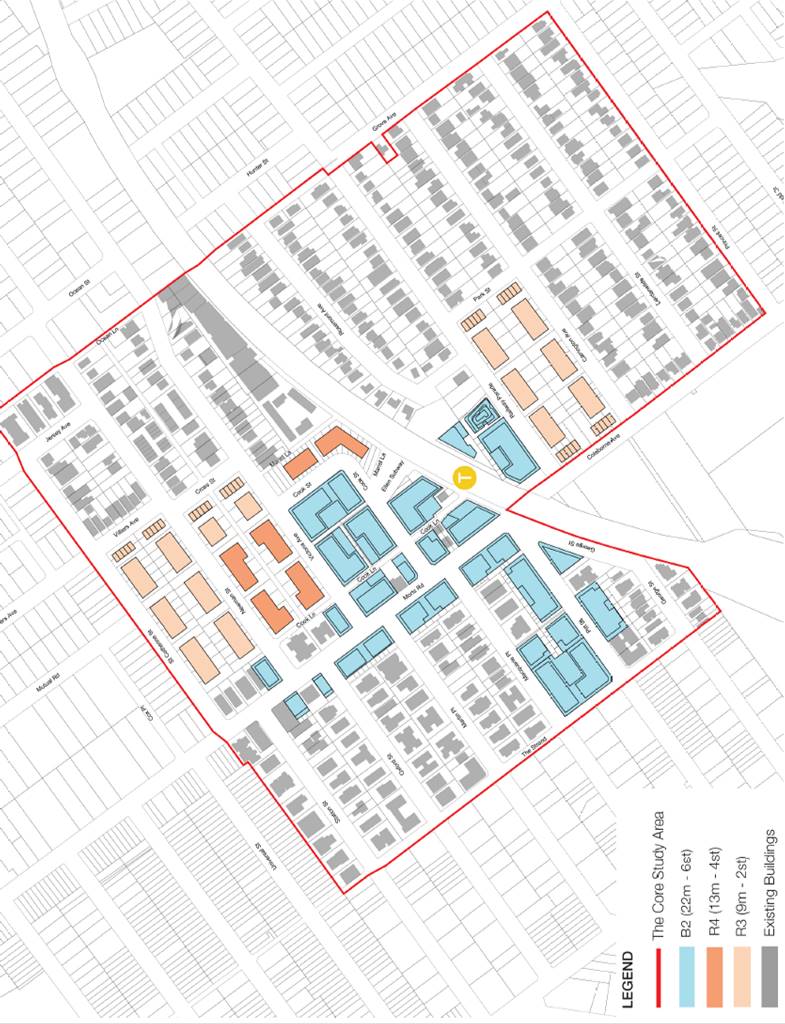
Aerial view – looking northeast
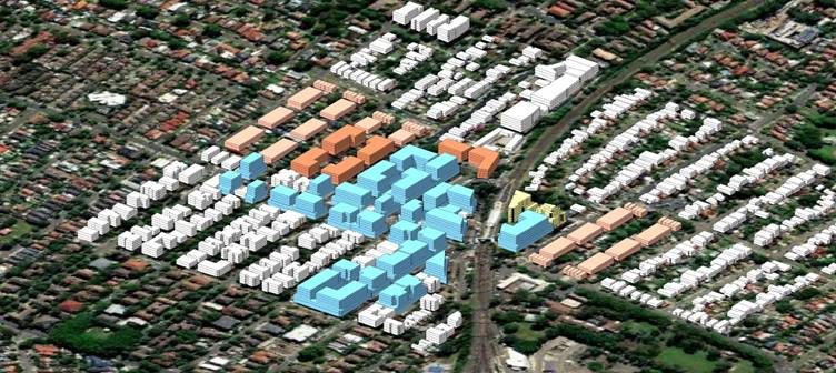
(Note: Building envelope is shown as indicative. It does not include building articulation, nor does it reflect topography.)
implementation – bUILT FORM CONTROLS
40. The following amendments to the zoning of land within the Mortdale Local Centre Core Area are proposed.
1) Mortdale RSL Club + Lots at south side of Macquarie Place – Land currently zoned R4 High Density Residential is proposed to be rezoned B2 Local Centre for consistency in zoning for the Mortdale Local Centre retail/commercial area. The Mortdale RSL Club site is currently in retail/commercial use.
2) 13 Pitt Street – The site is close to the Morts Road and Pitt Road intersection and is surrounded by B2 Local Centre zones. The land currently zoned R4 High Density Residential is proposed to be rezoned to B2 Local Centre for consistency in zoning. Mortdale Shopping Centre Streetscape Upgrade includes this parcel's frontage.
3) Cook Street Commercial Area – An expansion of the B2 zone is proposed to the east of the current footprint. This will include land currently zoned R2 Low Density Residential between Victoria Avenue and Railway line to be rezoned B2 Local Centre. This rezoning provides for the local centre with opportunities to realise the 2036 employment target.
4) R4 High Density Residential – Two residential areas, adjacent to the expanded B2 zone, currently zoned R2 Low Density Residential are proposed to be rezoned to R4 High Density Residential to provide for appropriate transition between the new B2 zone and surrounding residential areas. These are within the LSPS 2040 future housing investigation areas and will provide opportunities for the local centre to meet the 2036 residential target.
5) R3 Medium Density Residential – Two residential areas, one in the north, another in the south of the Core Study Area currently zoned R2 Low Density Residential are proposed to be rezoned R3 Medium Density Residential to facilitate built form height transition and the opportunities to increase housing choice in the local centre.
Proposed Floor Space Ratio (FSR)
41. New FSR controls have been identified to provide increased housing choice and employment opportunities for the centre into the future. An increased density is proposed in the Mortdale Local Centre B2 core area of 2.5:1, this density will be moderated with the introduction of a building height control over the entire B2 zone. An exceptional B2 zone at the corner of Station Street and Morts Road has a lower FSR of 1.5:1 provide building mass and height transition to the adjacent R2 zone.
42. The new density allows for incremental change to occur over time in the local centre as residential prices continue to rise in Sydney. To protect employment and commercial/retail activity in the local centre, a non-residential FSR of 0.75:1 has been identified within the B2 zone as a minimum for any site. This will ensure that sufficient supply is available to meet the non-residential GFA target in 2036, identified in Commercial Centres Strategy Part 1 Centres Analysis. In the B2 zone, a bonus provision of 0.5:1 FSR has also been identified that is linked to the provision of Affordable Housing. Affordable Housing incentives are discussed in further detail in this report.
Proposed FSR
|
Zone |
Proposed FSR Base Case |
|
B2 – Local Centre |
2.5:1 (0.75:1 - Non-residential FSR) |
|
B2 – Local Centre (the corner lot of Station St and Morts Rd) |
1.5:1 |
|
R4 – High Density Residential |
1.0:1 |
|
R3 – Medium Density Residential |
0.7:1 |
|
R2 – Low Density Residential |
0.55:1 |
43. The existing FSR control (1.0:1) of R4 zone has been applied to the proposed R4 zones to the east of the Morts Road. To facilitate the opportunities to introduce housing diversity in the local centre, an FSR of 0.7:1 has been identified to the proposed R3 zone. The proposed FSR controls match the existing FSR standardisation in the draft GRLEP 2021.
Proposed Building Height (HOB)
44. New height controls have been identified to provide more certainty for development and encourage better transitions to surrounding areas. A height cap is proposed for the B2 – Local Centre zone with moderate increases in some upzoned residential areas. Taller buildings are limited to the B2 Local Centre zones.
45. The existing height limit of B2 zone at the south of the railway line is 21m. To foster better compliance with the Apartment Design Guide - State Environmental Planning Policy No.65 (ADG) and accommodate two levels of non-residential GFA on the ground and first floor, this height has been increased 1m to 22m and applied to the proposed B2 zone across the precinct. Refer to Proposed Building Height map. An exceptional B2 zone at the corner of Station Street and Morts Road has a height limit of 15m to provide height transition to the adjacent R2 zone.
Proposed Building Height
|
Zone |
Proposed HOB Base Case |
|
B2 – Local Centre |
22m |
|
B2 – Local Centre (the corner lot of Station St and Morts Rd) |
15m |
|
R4 – High Density Residential |
13m |
|
R3 – Medium Density Residential |
9m |
|
R2 – Low Density Residential |
9m |
46. This height plan will reinforce the local centre spine along Morts Rd, Pitt St, Cook St and Railway Parade and the legibility of its urban structure. The height zones ensure that appropriate transitions are provided and discourage non-complying height proposals in surrounding low built form areas. The areas of increased height are within the LSPS 2040 future housing investigation areas footprints and the 400m walking catchment from the station. The proposed building height controls match the existing FSR standardisation in the draft GRLEP 2021.
Affordable Housing Bonus Incentives
47. The draft Masterplan proposes bonus development incentives, including greater building height and density to encourage the delivery of Affordable Housing in the Mortdale Local Centre.
Affordable Housing Bonus – FSR and HOB
|
Zone |
Proposed FSR |
Proposed HOB |
|
B2 – Local Centre |
3.0:1 (0.5:1 bonus 1.75:1 residential base 0.75:1 non-residential) |
28m (22m base 6m bonus) |
|
B2 – Local Centre (the corner lot of Station St and Morts Rd) |
N/A
|
|
|
R4 – High Density Residential |
||
|
R3 – Medium Density Residential |
||
|
R2 – Low Density Residential |
||
48. The bonus incentives would apply to B2 zoned land close to the train station and be required to comply with the following:
· a minimum site area of 1,000sqm to encourage land consolidation
· additional setback of 3m for bonus built form over the base case
· delivery of affordable housing in accordance with the proposed Affordable Housing Contributions Scheme.
49. CM+ explored the design implications of the proposed affordable housing bonus on the draft masterplan. The proposed FSR bonus of 0.5:1 requires the built form envelope to allow up to 8 storeys which is an additional 2 storeys over the base case of 6 storeys in order to achieve compliance with the ADG.
Economic and Development Feasibility Analysis
50. Atlas consultants have provided development feasibility and economic advice to assist in the preparation of this draft Masterplan. The viability of the draft masterplan is assessed by:
· Establishing existing property values across the study area
· Determining the tipping points needed to incentivise development
· Testing the implications of
o Non-residential FSR of 0.75:1
o Affordable housing contribution rates
51. Generic feasibility testing of four broad scenarios includes:
1. Increase in density for existing B2 sites
2. Existing R2 sites rezoned for expanded B2 sites
3. Existing R2 sites rezoned to R4 High Density Residential
4. Existing R2 sites rezoned to R3 Medium Density
52. Feasibility testing of the proposed upzonings and increased FSRs in the draft masterplan suggests that in most scenarios incremental development (e.g. additional storey/s, part demolition and development) could be more likely to occur under the proposed planning controls than comprehensive development. Significantly higher FSRs (around 3.5:1) are required to achieve a comprehensive redevelopment of the centre.
53. The principal challenge for revitalisation of established centres is valuable existing uses and fragmented lot and ownership patterns. The fine grain nature of lots such as those in the Mortdale Local Centre makes it challenging and expensive to consolidate development sites.
54. Existing B2 zoned properties in the local centre are highly valuable, (e.g. popular hotel/pub, collection of fine grain retail shops), by implication they bring economic value to a centre and their continued presence is desirable. These properties require higher FSRs to ‘displace’ the existing uses and for comprehensive redevelopment to occur. The displacement of these valuable uses could damage the desirability of a centre. This is directly observable in a well-functioning, desirable centre such as Mortdale.
55. The feasibility analysis suggests the proposed draft Masterplan could facilitate a mix of incremental and comprehensive development. The latter is expected in the expanded B2 Local Centre zone north-east of Morts Road (where land is proposed to be rezoned from R2 -Low Density Residential to B2 -Local Centre) as the lower opportunity cost of land coupled with the proposed planning controls will likely be sufficient to see a strong uptake of development opportunities.
56. The draft Masterplan is anticipated to result in an uplift in development activity compared to no change to current planning controls. Modelling results show this would result in positive economic impacts to the Georges River LGA.
public domain plan
57. The masterplan's vision for public space includes an integrated and connected network of comfortable and amenable public space that prioritises community and environment, and celebrates public life. The public domain plan aims to elevate the importance of public space in the future of the Mortdale local centre.
58. High quality public spaces and streets are essential for improving the quality of urban life for people living and working in Mortdale. The revitalisation of the current public domain, its streets and open spaces, will play an increasingly significant role in shaping the future evolution of the local centre’s identity and amenity.
59. Seven public domain improvement strategies are identified in the development of the public domain plan:
i. Public domain upgrades will be limited to areas where development controls have changed.
ii. Active transport upgrades will be limited to the overall study area and coordinated with draft Georges River Council Transport Strategy. Some potential improvements are suggested.
iii. Green link upgrades are limited to the core study area.
iv. An indicative ‘potential crossing’ a pedestrian bridge over railway line is indicated as an aspirational outcome beyond the overall study area.
v. Through site links are to be provided and maintained by the developers as these are 'rights of way' and not deeded to Council.
vi. An area for a potential town square and new park has been identified for future consideration subject to developer contributions.
vii. Some street closure plazas, within current street Right of Ways (ROWs) have been proposed along Morts Road for consideration as future steps in the upgrade of that area.
60. Based on the above principles, the following scope is proposed to revitalise the local centre and the wider Mortdale area:
a) Targeted street upgrades in coordination with the wider Urban Design Strategy.
b) Optimisation of the existing vehicle carriageway widths to allow for the widening of footpaths and prioritisation of pedestrians and cyclists.
c) Introduction of a separated cycleway that provides an east-west connection along Macquarie Street, Cook Street, Ellen Underpass and Railway Parade.
d) ‘Green Links’ along key streets (Oxford Street, Victoria Avenue, Cook Street and Park Street), with street upgrades including new shared path linkages and the opportunity for introducing water sensitive urban design (WSUD) treatments.
e) Landscaping such as mass planting, WSUD, and additional street tree planting in between existing areas of vegetation.
f) Proposed street closures at Cook Street and Martin Place to provide new public spaces within the local centre core.
g) Proposed existing laneway upgrade between Cook Lane and Cross Street to include new paving and trees.
h) Proposed new laneway linking Cook Lane to St Catherine Street with new paving and trees.
i) Proposed shared path to run along Cook Lane, adjacent to Morts Road.
61. The public domain plan also identifies the future upgrade opportunities for the existing service lanes including Ocean Lane and Marist Lane. Future through site links, which will be provided by developer are also identified to improve the area’s permeability and amenity.
traffic and transport study
62. A high level traffic and transport study has been conducted by SCT Consulting to inform the preparation of the masterplan and understand the implications of the proposed changes. The study reviews the relevant strategic and local level documents and the current transport conditions. The existing issues identified includes:
· High parking occupancy in the core Mortdale Local Centre area
· Limited loading zones in the core Mortdale Local Centre area
· Pedestrian and vehicle crash clusters along Morts Road and Railway Parade
· Pedestrians incorrectly using speed humps as crossings along Pitt Street.
63. The study identifies that most of the existing issues can be improved by the current works being undertaken in the Mortdale Shopping Centre Streetscape Upgrade Plan.
64. The study reviews AM peak hour transport mode capacity against the draft masterplan. Three potential transport measures to support growth are assessed, including active transport, public transport, and general traffic and transport measures. The study identifies that the draft masterplan will:
· Generate additional 297 car trips – likely minimal impacts to surrounding road network.
· Generate additional 140 train trips – likely minimal impacts to rail network and Mortdale Station capacity.
· Generate additional 94 bus trips – can be accommodated by existing bus services and future increased service frequency, if warranted.
65. The traffic and transport study considers the current network is able to accommodate the anticipated maximum peak hour movement for vehicles, train and buses.
66. The study assesses the draft masterplan and also investigates potential transport measures to support growth through active transport, public transport and general traffic and transport measures and concludes that:
· The draft masterplan proposes increased residential and commercial density in the Mortdale Local Centre.
· There is a strong focus on improving public domain and reinforcing active transport links, such as cycleways and pedestrian pathways throughout the local centre and into the surrounding areas.
· The forecast trips generated by these developments are not expected to have significant impacts on the surrounding road and public transport networks.
· Expansion of the commercial centre is likely to generate additional demand for parking and servicing. The existing parking and loading bay facilities are limited. Off-peak loading bay provisions could be considered to support business growth in the area. Similarly extending timed on-street parking near the local centre would provide additional parking capacity for business patrons.
· Active transport measures, public transport measures and safety improvements are proposed to support the future growth and public domain improvements outlined in the draft masterplan.
Affordable Housing Contributions Scheme
67. Atlas Economics Consulting have prepared a draft Affordable Housing Contributions Scheme (AHCS) tied to the Mortdale Masterplan. The draft AHCS has been prepared in accordance with the requirements of Section 7.32(1)(c) of the Environmental Planning and Assessment Act and State Environmental Planning Policy 70 – Affordable Housing (Revised Schemes).
68. The draft AHCS forms part of the broader Georges River Inclusive Housing Strategy and Delivery Program, which was adopted by Council on 24 August 2020. The Strategy outlines the framework for encouraging and delivering a greater mix of housing, including affordable rental housing, in the Georges River municipality.
Action 2.1.1 of the Delivery Program states:
a. Prepare an Affordable Housing Contributions Scheme (AHCS)
b. An affordable housing contributions scheme would be prepared to comply with the Department of Planning, Industry and Environment’s Guideline
c. Inclusion of the scheme into Council’s LEP 2022 is subject review by DPIE and public exhibition.
69. The draft AHCS is also supported by the Georges River Affordable Housing Policy, which outlines Council’s position and approach to the provision of affordable housing in the Georges River. The policy comprises principles and policy statements that together will guide Council’s actions to support affordable housing.
70. The draft AHCS follows DPIE’s Guideline for Developing an Affordable Housing Contribution Scheme, which requires Council to:
· investigate the affordable housing need in the LGA
· identify the areas to which an affordable housing contribution scheme will apply
· determine a viable affordable housing contribution rate
· prepare affordable housing contribution schemes
· amend the LEP through the planning proposal process to reference the affordable housing contribution schemes.
71. The draft AHCS sets out how, where, and at what rate development contributions can be collected by Council for affordable housing within the LGA. Affordable housing contributions are in addition to other contributions including local infrastructure contributions (s7.11 or s7.12) and special infrastructure contributions (Subdivision 4 of the Act).
72. The draft AHCS provides developers certainty and clarity about how the affordable housing contributions will be determined, and the contribution rates that will be applied in a condition of consent. The AHCS also provides the community with transparency about where affordable housing is planned for in the LGA.
73. The draft AHCS proposes to apply to land within the Mortdale Masterplan Core Study Area which is subject to an increase in development density. The draft AHCS can be expanded to other areas as master planning of centres and Housing Investigation Areas occur.
74. The draft AHCS will be administered and managed in accordance with the following principles:
a) Affordable housing should be provided and managed in the Mortdale locality so that a socially diverse residential population representative of all income groups is created and maintained.
b) Affordable housing that is provided is to be made available to a mix on households on very low, low to moderate incomes.
c) Affordable housing that is provided is to be rented to eligible households at an appropriate rate of gross household income.
d) Dwellings provided for affordable housing are to be managed so as to maintain their continued use for affordable housing.
e) Land provided for affordable housing is to be used for the purpose of the provision of affordable housing.
f) Affordable housing is to consist of dwellings constructed to a standard which, in the opinion of Georges River Council, is consistent with other dwellings in the Georges River LGA.
75. The draft Mortdale Masterplan proposes a Base and Bonus density control. The affordable housing contributions required under the draft AHCS are linked to these Base and Bonus controls.
· Base Controls: 1% of total gross floor area that is to be used for residential uses.
· Bonus Controls (only applicable in B2 Local Centre): 3% of total gross floor area that is to be used for residential uses.
76. The above rates are premised on viability testing carried out in Schedule 2 of the draft AHCS. The higher affordable contribution rate of 3% would only apply where a proponent seeks to access the Bonus Controls under the Masterplan. Otherwise, the Base Controls and lower affordable housing contribution rate of 1% would apply.
77. The proposed affordable housing contribution rates will be phased-in to allow active developments to be completed and provide developers with the ability to factor in the cost of affordable housing. This avoids ‘shocking’ the market and allows the market to adjust to a modest levy then to a greater levy after a 2-year period of adjustment. Additionally, before full implementation of both contribution rates, a review would be carried out to examine the market response before implementation of a final rate.
Proposed Implementation program
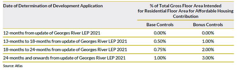
78. There are three methods by which a contribution requirement may be satisfied:
i. In-kind contribution of completed dwellings (refer section 3.1.1 of the draft ACHS);
ii. Monetary contribution (refer section 3.1.2); or
iii. In-kind contribution of land for affordable housing (refer section 3.1.3).
79. The draft ACHS proposes to exclude the following development from affordable housing contributions:
· Exempt development
· Refurbishment or repair of a building that results in additional residential floorspace less than 200sqm GFA
· Development for non-residential floorspace
· Development of affordable housing or social housing
· Development of community facilities, public roads or public utility undertakings.
80. The draft AHCS will be exhibited as part of the exhibition of the draft Masterplan, however the scheme is required to be reviewed by DPIE and will be formally exhibited as part of any future planning proposal to amend the LEP.
COUNCIL OWNED LAND
81. The draft masterplan proposes changes to zone, floor space ratio and height of buildings to Council owned land. The table below provides a summary of changes that apply to Council owned land within the study area. Council owned land with no proposed changes to development controls have been omitted (e.g. parks and roads):
Summary of proposed changes to Council owned land
|
Site |
Property Address |
Proposed Zoning |
Proposed FSR (Affordable Housing bonus) |
Proposed HOB (Affordable Housing bonus) |
|
Site No.1 |
25 Cook St, Mortdale |
R2 to B2 |
0.55:1 to 2.5:1 (3.0:1) |
9m to 22m (28m) |
|
Site No.2 |
27 Cook St, Mortdale |
R2 to B2 |
0.55:1 to 2.5:1 (3.0:1) |
9m to 22m (28m) |
|
Site No.3 |
29 Cook St, Mortdale |
SP2 to B2 |
No controls to 2.5:1(3.0:1) |
No controls to 22m (28m) |
|
Site No.4 |
30 Morts Rd, Mortdale |
B2 to B2 (no change) |
1.5:1 to 2.5:1(3.0:1) |
No controls to 22m (28m) |
82. It is acknowledged that some of the sites were acquired for car parking facilities. Any future redevelopment of these sites would be required to provide public parking within the new development.
COMMUNITY ENGAGEMENT
Preliminary community engagement
83. Preliminary community engagement for Mortdale Masterplan was conducted from 15 January 2021 to 16 February 2021. This initial community engagement aimed to provide Council and the study team with a greater understanding of the role and function of the Mortdale Local Centre and encourage the community to contribute their ideas and aspirations toward the creation of a vision for the future of the Mortdale Local Centre. This preliminary engagement ran parallel to the preparation of the masterplan, and the draft masterplan does not provide a full response to all the submissions received during this period.
84. Overall, there were 690 visits to the Mortdale Local Centre Masterplan webpage of the Your Say site representing a total of 109 individuals. There were a total of 33 submissions in addition to those on Your Say including emails, letter and proforma letter submissions.
85. The responses can be summarised and categorised into twelve themes, including:
· Housing Types
· Shopping/Restaurants
· Services/improvements
· Parks
· Mall / outdoor seating
· Streetscape and Open Spaces
· Carpark/parking
· Traffic
· Transport mode - Cycling
· Transport mode - Pedestrian
· Transport mode - Taxi Stand
· In support of RSL
86. There were some comments focusing on more broad issues i.e. housing affordability, diversity and streetscape amenity etc., and others commenting more specifically on building heights, bicycle lane provisions, trading hours and local road closures. Greater detail is provided in Annexure 1 - Report on Community Engagement prepared by engagement consultants PlanCom.
Public Exhibition
87. The proposed engagement program for the public exhibition will allow for robust community input and an opportunity for the masterplan team to adequately respond to submissions.
88. The proposed engagement activities for the public exhibition of the draft masterplan are outlined in the table below:
|
Community Engagement |
Proposed Action |
|
Online and digital
|
· Council’s website · Social media (Facebook page) · Council’s ‘Your Say’ Mortdale masterplan page · Webinar sessions for stakeholders/community · One-on-one meetings with stakeholders via digital meeting platform · One-on-one meetings in person at Council offices if no COVID-19 restrictions apply during the exhibition period. |
|
Letters
|
· Landowners within the study area · Residents within the study area · Local business owners · Schools · State and Federal MPs · Transport for NSW · Other relevant Government agencies and authorities. |
|
Public notice
|
Public notice to be placed in the local newspaper and the NSW Government’s Planning Portal, notifying the exhibition of the draft Masterplan. |
|
Exhibition material |
A hard copy of the exhibition material will be made available for viewing in the Hurstville Customer Service Centre, Hurstville Library and Penshurst Library. |
|
Telephone Consultation |
Council’s Strategic Planning staff will be available during office hours to answer telephone enquiries. |
89. The community engagement plan includes online and digital engagement delivery due to the continued safety concerns of face-to-face engagement during the COVID-19 pandemic.
90. Webinar sessions have proven to be successful in engaging high levels of community participation in similar consultations held in the last 12 months. Webinars enable stakeholders to join, view the plans, hear discussion from the planning team and ask questions directly.
91. All submissions received during the exhibition period will be reviewed, summarised and presented to Council for consideration.
NEXT STEPS
92. If endorsed by Council, the draft Masterplan will be placed on public exhibition for 28 days.
93. Following consideration of submissions, it is anticipated that the Masterplan and implementation strategy be refined accordingly. A further report will be prepared and submitted to Council for endorsement.
Financial Implications
94. Within budget allocation. Funding for the Mortdale Masterplan projected is provided through DPIE grant funding.
Risk Implications
95. There is a risk of not proceeding with exhibition of the Mortdale Masterplan, as it could result in:
a. no development or renewal within Mortdale Centre which may result in future lack of non-residential floorspace; or
b. Ad-hoc planning proposals being submitted which may not align with the future vision for Mortdale Centre with limited ability to deliver required infrastructure and public benefits.
File Reference
20/1801
|
Attachment 1 |
Draft Mortdale Local Centre Masterplan 2021 (Urban Design Report) - published in separate document |
|
Attachment 2 |
Mortdale Masterplan - Appendix 1 Community Engagement Report - published in separate document |
|
Attachment 3 |
Mortdale Masterplan - Appendix 2 - Economic and Development Feasibility Analysis - published in separate document |
|
Attachment 4 |
Mortdale Masterplan - Appendix 3 - Draft Mortdale Affordable Housing Contributions Scheme - published in separate document |
|
Attachment 5 |
Mortdale Masterplan - Appendix 4 - Traffic & Transport Report - published in separate document |
|
Attachment 6 |
Mortdale Masterplan - Appendix 5 - QS Report - published in separate document |
Georges River Council - Environment and Planning - Tuesday, 15 June 2021 Page 1
Item: ENV028-21 Amendment to the Voluntary Planning Agreement for East Quarter Stage 3 - Deed of Variation
Author: Executive Strategic Planner
Directorate: Environment and Planning
Matter Type: Committee Reports
|
(a) That Council endorse the First Deed of Variation to the Voluntary Planning Agreement for East Quarter Stage 3 between Council and Hville Pty Ltd (Developer) to amend the Voluntary Planning Agreement executed on 15 June 2017 in respect of the Road Works and Landscaping Works, summarised as follows: i. that the Developer pays Council a monetary contribution of $1,591,253 for the construction of the traffic signals and associated road works at the intersection of Forest Road and Durham Street (Road Works) in lieu of the Developer constructing the Road Works; ii. that Council construct the Road Works in accordance with the approved detailed design plans; iii. that the Developer pays Council a monetary contribution of $46,000 for the construction of the landscaping works along the Forest Road/Durham Street frontage (Landscaping Works) in lieu of the Developer constructing the works; iv. that Council construct the Landscaping Works, to a design and specification agreed between Council and the Developer. v. that the contributions for the Road Works and Landscaping works be paid within 48 hours of the Developer receiving notice of the execution of the Deed of Variation. (b) That Council endorse the First Deed of Variation for public notification in accordance with section 7.5 of the Environmental Planning and Assessment Act. (c) That Council delegate authority to the General Manager to: i. Authorise any minor changes to the First Deed of Variation following public exhibition, provided that those changes do not diminish the value or nature of the public benefits to be delivered as identified in (a) above; and ii. Subsequently enter into the First Deed of Variation to the Voluntary Planning Agreement for East Quarter Stage 3 on behalf of Council. |
Executive Summary
1. The existing Voluntary Planning Agreement (VPA) for East Quarter Stage 3 (refer to Attachment 1) was executed on 15 June 2017 and requires the Developer to provide the following contributions and works:
a. Road Works - Developer to construct and complete the signalisation of intersection of Forest Road and Durham Street, Hurstville to a maximum cost of $1.76million. Should the construction cost exceed $1.76million Council is to meet the additional cost to complete the works. (These works are currently outstanding).
b. Landscaping Works - Developer to carry out and complete landscaping works along the frontage of Stage 3 of East Quarter on Durham Street/Forest Road to a design and specification approved by the Council to the value of $46,000. (The contribution is currently outstanding).
c. Monetary contributions – Developer to pay a total contribution of $1,096,000 to Council for public domain works on Kempt Field. (The contribution has been paid to Council).
d. Contribution to Hurstville Public School – Developer to pay the Council a contribution of $131,000 to be provided to the school. (The contribution has been paid and transferred to the school).
e. Public access easement – Developer to register a public access easement through Stage 3 of East Quarter connecting Stage 2 with Kempt Field. (This easement has yet to be approved and registered).
2. The VPA is registered on the title of the land and the Developer has provided a bank guarantee in the amount of $1,937,000 for the outstanding obligations under the VPA.
3. In relation to the Road Works, the Developer has prepared the detailed design plans for the works and obtained the necessary approvals from Council, RMS and Ausgrid.
4. Under the current provisions of the VPA, Council will not have full control over the construction of the Road Works and will be liable for all and any costs that exceed $1.76 million.
5. Given that Council has experience in the construction of road works and based on the review of the detailed design plans and developers cost reports, it is preferrable that Council construct the Road Works and officers therefore approached the developer to effect that outcome.
6. The Developer has agreed to Council constructing the Road Works.
7. Based on legal advice, in order for Council to construct the Road Works and for the Developer to pay Council the monetary contribution of $1,591,253 (i.e. the balance of the funds remaining) in lieu of the Developer constructing the works, an amendment to the VPA is required.
8. In addition to Council constructing the Road Works, it is also proposed that Council construct the Landscaping Works along the frontage of Stage 3 along Durham Street/Forest Road. These works have a total value of $46,000 under the VPA and are in addition to any landscaping works required under the Development Consent for Stage 3.
9. The proposed Deed of Variation to amend the existing executed VPA (refer to Attachment 2) has been prepared by Council’s solicitors. The Developer has worked with Council and has agreed to the proposed amendments to the VPA and signed the Deed.
10. This report recommends that the Council endorse the First Deed of Variation to amend the VPA for public notification and delegate authority to the General Manager to enter into the Deed of Variation on behalf of Council.
Existing Voluntary Planning Agreement
11. The existing VPA for East Quarter Stage 3 between Council, Hville FCP Pty Ltd and East Quarter Hurstville Pty Ltd was executed on 15 June 2017 in relation to Planning Proposal 2014/0002 and DA 2016/0218 for Stage 3 of East Quarter.
12. The VPA provides for a range of contributions and works, some of which were transferred from the earlier Hurstville Council VPA for East Quarter Stages 1, 2 and 3 (executed on 7 September 2011), that related to Stage 3.
13. Table 1 below identifies the Developers obligations under the VPA and the current status of provision.
Table 1: Summary of Developer’s obligations under existing VPA
|
Contribution/Works |
Value
|
Timing |
Current Status |
|
Road Works - Developer to construct and complete the signalisation of the intersection of Forest Road and Durham Street, Hurstville. Should the construction cost exceed $1.76million Council is to meet the additional cost to complete the works (clause 9). |
$1.76 million (maximum construction & contingency cost). |
Before the earlier of issuing of the first Occupation Certificate for the Development, or By 30 September 2019. |
Detailed design plans prepared by Developer and approved by Council. Proposed Deed of Variation amends VPA to require the Developer to pay contribution to Council so that Council constructs the Road Works. |
|
Kempt Field - monetary contribution for public domain works (clause 11) |
$1million |
To be paid by 30 September 2017 |
VPA contribution paid. |
|
Contributions from former Hurstville Council Stage 3 VPA (clause 10 and Schedule 2) |
|||
|
Landscaping Works - Developer is to carry out and complete landscaping works along the frontage of Stage 3 of East Quarter on Durham Street/Forest Road to a design and specification approved by the Council. |
$46,000 |
Prior to issue of the Occupation Certification |
Yet to be paid. Proposed Deed of Variation amends VPA to require Developer to pay contribution to Council so that Council carries out the Landscaping Works. |
|
Kempt Field - Developer to pay contribution to Council. |
$96,000 |
Prior to 30 September 2017. |
VPA contribution paid. |
|
Hurstville Public School - Developer to pay to the Council a contribution to be provided to the School |
$131,000 |
Prior to issue of the Occupation Certification. |
VPA contribution paid to Council February 2021 and Council transferred contribution to the school in March 2021. |
|
Public access easement – Developer to register and create a public access easement through Stage 3 of East Quarter connecting Stage 2 with Kempt Field.
|
N/A |
No later than on the registration of the first Plan of Subdivision |
Easement yet to registered. Developer has recently lodged the DA for the subdivision of Stage 3 that shows the easement. |
Bank Guarantee / Security
14. The VPA requires the Developer to provide security for the VPA obligations. Council currently holds a bank guarantee in the amount of $1,937,000 for the Developers outstanding obligations under the VPA. This amount comprises the values for the Road Works, Landscaping Works and School Contribution.
15. Should the Deed of Variation to the VPA be executed and the Developer pays the monetary contributions for the Road Works and Landscaping Works, the bank guarantee will be released and returned to the bank.
VPA Registered on Title
16. The VPA is registered on the title of the land for Stage 3. Should the Deed of Variation to amend the VPA be endorsed by Council and subsequently executed, the Deed of Variation to the VPA will be registered on the title.
Proposed Amendments to the VPA – Deed of Variation
Road Works
17. The VPA (clauses 9.1 to 9.13) currently requires the Developer to construct and complete the Road Works to a maximum construction and contingency cost of $1.76 million. This includes preparing the detailed design plans, obtaining Council’s and authorities approvals and a quantity surveyors cost report.
18. Clause 9.9 of the VPA provides that if the cost of the Road Works exceeds $1.76 million, Council will be liable to pay for any and all costs incurred over this amount.
19. To date there have been a number of delays in the delivery of the project within the times specified in the VPA. The Developer has prepared the detailed design plans for the works and has obtained the necessary approvals for the designs from Council as well as RMS and Ausgrid. The Developers cost plan based on the detailed design plans estimates the construction costs to be approximately $2.3million. The Developers costs to date for the preparation of the detailed design plans for the Road Works totals $168,747.
20. Council’s engineers have reviewed the detailed design plans and the cost plan for the works and consider that the works can be delivered within the $1,591,253 of VPA funds remaining for the project.
21. As Council has experience in delivering capital projects, it is preferred that Council constructs the Road Words in lieu of the Developer. Council would then have full control of the project and the associated contracts, and management of the project costs. If the Developer constructs the Road Works, Council will have little control over the project and construction costs and would be liable to cover any costs that exceed the total VPA cost of $1.76million.
22. Council obtained legal advice as to the mechanism via which Council could carry out the Road Works. Based on the current wording, the VPA only permits Council to carry out the Road Works if the Developer has breached its obligations.
23. To enable Council to construct the Road Works and for the Developer to pay Council the balance of the VPA contribution, the parties need to agree to amend the VPA. This agreement is in the form of a Deed of Variation to the VPA which amends clause 9.
24. Council’s solicitors have prepared the First Deed of Variation in consultation with the Developer. The Developer has agreed to and signed the ‘First Deed of Variation to the Planning Agreement for East Quarter Stage 3’ (refer to Attachment 2).
25. In summary the First Deed of Variation provides for the following amendments to the VPA for the Road Works:
· the Developer pays Council a monetary contribution of $1,591,253 for the construction of the Road Works in lieu of the Developer constructing the works;
· the value of the monetary contribution is based on the VPA estimated construction and contingency cost of $1.76 million inclusive of GST less the Developer costs of $168,747 incurred to date in preparing the detailed design plans for the Road Works;
· that the contribution is paid by the Developer within 48 hours of the Developer receiving notice that the Deed of Variation has been executed;
· that the Developer provides by way of a deed, the benefit of all guarantees and warranties that the Developers contractors or subcontractors have given to the Developer in respect of the materials;
· that Council constructs the Road Works in accordance with the approved detailed design plans; and
· that Council will use all reasonable endeavours to commence the Road Works after all approvals have been obtained and complete the works as soon as practicable after commencement of the Road Works.
Landscaping Works
26. The existing VPA requires that the Developer carry out and complete landscaping works to the Forest Road frontage of the Land that are additional to any landscaping works required under the Development Consent, to a design and specification approved by the Council.
27. As per the Road Works, it is Council’s preference that the Developer pays Council the monetary contribution for these works and that Council undertakes the works to a design and specification agreed to between Council and the Developer.
28. In summary the Deed of Variation provides for the following amendments to the VPA for the Landscaping Works:
· the Developer pays Council a monetary contribution of $46,000, for the construction of the Landscaping Works in lieu of the Developer constructing the works;
· the value of the monetary contribution is, as stated in the executed VPA, to be indexed from the date the VPA took effect to the date of provision in accordance with the CPI;
· that the contribution is paid by the Developer within 48 hours of the Developer receiving notice that the Deed of Variation has been executed;
· that Council construct the Landscaping Works, that are additional to any landscaping works required under the Development Consent to the Development, to a design and specification agreed to between Council and the Developer; and
· that Council will use all reasonable endeavours to undertake the works following the completion of the landscaping works required to be provided by the Developer under the Development Consent to the Development.
Parties to the Deed
29. The parties to the First Deed of Variation are Council and Hville FCP Pty Ltd, who are now the landowner and developer of the land. The original landowner, East Quarter Hurstville Pty Ltd has been removed from the Deed as they are no longer the landowner and a party to the Deed.
Assessment of proposed VPA amendments
30. The proposed amendments to the VPA have been prepared and negotiated in accordance with Councils Policy on Planning Agreements 2016 and the Departments new Practice Note on Planning Agreement (February 2021). The proposed amendments have been assessed against the ‘Acceptability Test’ set out in the Practice Note as discussed in the following paragraphs.
31. It is noted that the proposed amendments to the VPA do not change the works to be provided under the VPA. The proposed amendments enable the Developer to pay Council the monetary contribution for the Road Works and Landscaping Works in lieu of the Developer constructing the works. Council will then construct and deliver the works.
32. The ‘Acceptability Test’ requires that planning agreements:
a) Are directed towards legitimate planning purposes, which can be identified in the statutory planning controls and other adopted planning strategies and policies applying to the development:
The Road Works and Landscape Works are required to address the additional demand generated by the Development and are in accordance with the traffic studies and public domain strategies undertaken for the Hurstville City Centre.
b) Provide for the delivery of infrastructure or public benefits not wholly unrelated to the development:
The Road Works and Landscaping works are directly related to the development and address the additional demand generated by the development.
c) Produce outcomes that meet the general values and expectation of the public and protect the overall public interest.
The amendments to the VPA will enable Council to construct and deliver the Road Works and Landscaping Works to the standards set by Council and other government agencies and will ensure that the projects are delivered within the overall project budget.
d) Provide for a reasonable means of achieving the desired outcomes and securing the benefits.
Council currently holds a bank guarantee in the amount of $1,937,000 for the Developers outstanding obligations under the VPA for the Road Works, Landscaping Works and School Contribution. The VPA is also registered on the title of Stage 3.
e) Protect the community against adverse planning outcomes.
The proposed amendments to the VPA will enable the Road Works and Landscaping Works to be delivered and project managed by Council within the costs provided for in the VPA.
Financial Implications
33. As Council initiated the amendments to the VPA, the Council’s legal costs associated with amending the VPA are to be met by Council. The Developer has incurred their own legal Council’s in reviewing the proposed amendments.
34. Should the Deed of Variation be executed, the contributions for the Road Works and Landscaping Works will be paid to Council and then held as a restricted asset under the VPA and allocated for the construction of the works.
Risk Implications
35. The proposed amendments to the VPA enables Council to fully manage the construction of the Road Works and Landscaping Works and removes the risk of Council incurring any of the Developers construction costs that exceed the $1.76 million for the Road Works.
36. With Council constructing the works, there will always remain the potential for unforeseen variables during the construction process that could incur additional costs. These will be managed and monitored as for all Council projects.
Community Engagement
37. Section 7.5 of the Environmental Planning and Assessment Act requires public notice of all proposed planning agreements and agreements to amend a planning agreement, for a period of not less than 28 days.
38. If Council endorse the First Deed of Variation, public notification of the relevant documentation will be placed on public notification with the documents to be available on Council’s website and Council’s offices.
File Reference
16/1210
|
Attachment 1 |
Executed Planning Agreement for East Quarter Stage 3 - executed 15 June 2017 - published in separate document |
|
Attachment 2 |
Proposed First Deed of Variation - Planning Agreement for East Quarter Stage 3 - published in separate document |
Georges River Council - Environment and Planning - Tuesday, 15 June 2021 Page 1
CONFIDENTIAL ITEMS (CLOSED MEETING)
Council's Code of Meeting Practice allows members of the public present to indicate whether they wish to make representations to the meeting, before it is closed to the public, as to whether that part of the meeting dealing with any or all of the matters listed should or should not be considered in closed session.
|
That in accordance with the provisions of Part 1 of Chapter 4 of the Local Government Act 1993, the following matters be considered in closed Meeting at which the press and public are excluded. ENV035A-21 Georges River Local Planning Panel Second Term - Appointment of Panel Members (Report by Manager Development and Building) THAT in accordance with the provisions of Part 1 of Chapter 4 of the Local Government Act 1993, the matters dealt with in this report be considered in closed Council Meeting at which the press and public are excluded. In accordance with Section 10A(2) (a) it is considered the matter deals with personnel matters concerning particular individuals (other than Councillors). THAT in accordance with Section 10D it is considered that if the matter were discussed in an open Council Meeting, it would on balance, be contrary to the public interest as it deals with personnel matters concerning particular individuals (other than Councillors).
That in accordance with the provisions of Section 11(2) of the Act, the reports and correspondence relating to these matters be withheld from the press and public.
|