|
AGENDA Environment and Planning Committee
Monday, 12 July 2021 7.00pm
Skype Online Meeting
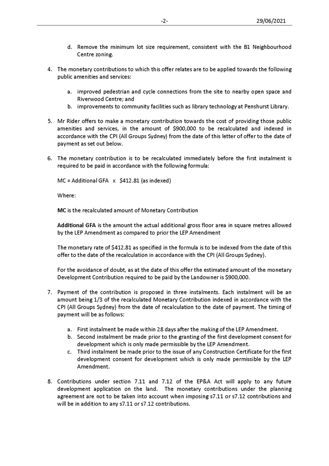
|
|
|
AGENDA Environment and Planning Committee
Monday, 12 July 2021 7.00pm
Skype Online Meeting
|
|
Georges River Council – Environment and Planning - Monday, 12 July 2021 Page 4
OATH OF OFFICE OR AFFIRMATION OF OFFICE
All Georges River Councillors are reminded of their Oath of Office or Affirmation of Office made at the time of their swearing into the role of Councillor.
All Councillors are to undertake the duties of the office of Councillor in the best interests of the people of the Georges River Council area and are to act faithfully and impartially carry out the functions, powers, authorities and discretions vested in them under the Local Government Act 1993 or any other Act to the best of their ability and judgement.
DISCLOSURES OF INTEREST
All Georges River Councillors are reminded of their obligation to declare any conflict of interest (perceived or otherwise) in a matter being considered by Council or at any meeting of Council.
Environment and Planning
1. OPENING
2. ACKNOWLEDGEMENT OF COUNTRY
3. APOLOGIES / LEAVE OF ABSENCE
4. NOTICE OF WEBCASTING
5. DISCLOSURES OF INTEREST
6. PUBLIC FORUM
7. CONFIRMATION OF MINUTES OF PREVIOUS MEETING
ENV029-21 Confirmation of the minutes of the Environment and Planning Committee meeting held on 15 June 2021
(Report by Executive Services Officer)....................................................................... 4
8. COMMITTEE REPORTS
ENV030-21 Adoption of the Beverly Hills Town Centre Master Plan 2021
(Report by Senior Strategic Planner)....................................................................... 14
ENV031-21 Public Exhibition of Draft Plan of Management and Master Plan for Moore Reserve 2021
(Report by Strategic Planner).................................................................................... 44
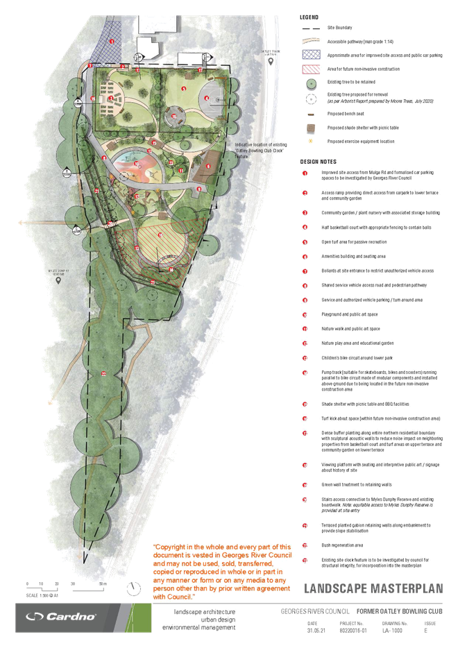
ENV032-21 Adoption of Former Oatley Bowling Club Plan of Management and Master Plan 2021
(Report by Strategic Planner).................................................................................... 56
ENV033-21 Establishment of Small Waste Items Recycling Station Program
(Report by Manager Environment Health & Regulatory Services)..................... 90
ENV034-21 PP2016/0002 - Amended Planning Proposal for the Hurstville Civic Precinct
(Report by Senior Strategic Planner)....................................................................... 94
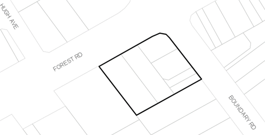
ENV035-21 PP2019/0003 - Planning Proposal for 143-149 Boundary Road and 689-691 Forest Road, Peakhurst
(Report by Strategic Planner).................................................................................. 111
ENV036-21 Voluntary Planning Agreement Offer for 143-149 Boundary Road and 689 Forest Road, Peakhurst
(Report by Executive Strategic Planner)............................................................... 144
CONFIRMATION OF MINUTES OF PREVIOUS MEETINGS
Item: ENV029-21 Confirmation of the minutes of the Environment and Planning Committee meeting held on 15 June 2021
Author: Executive Services Officer
Directorate: Office of the General Manager
Matter Type: Previous Minutes
|
That the Minutes of the Environment and Planning Committee Meeting held on 15 June 2021 be confirmed.
|
|
Attachment 1 |
Minutes of the Environment and Planning Committee - 15/06/2021 |
Georges River Council – Environment and Planning - Monday, 12 July 2021 Page 6
|
MINUTES Environment and Planning Committee
Tuesday, 15 June 2021 7.00pm
Dragon Room (Level 1, Georges River Civic Centre, Hurstville) and Skype Online Meeting
|
|
COUNCIL MEMBERS
Councillor Con Hindi (Chairperson), Councillor Vince Badalati, Councillor Nick Katris, Councillor Kathryn Landsberry and Councillor Leesha Payor.
COUNCIL STAFF
Director Environment and Planning - Meryl Bishop, Manager Strategic Planning - Catherine McMahon, Manager Development and Building - Ryan Cole, Manager Environment, Health & Regulatory Services - Andrew Spooner, Senior Development Contributions Planner - John Hair, Executive Strategic Planner - Nerida Shores, Acting Coordinator Strategic Planning - Harkirat Singh, Senior Strategic Planner - Rebecca Lau, Strategic Planner/Urban Designer - Anne Qin, Coordinator, Environmental Sustainability and Waste - Elyse Ballesty, Manager Office of the General Manager - Roxanne Thornton and Executive Services Officer - Neil Treadwell.
EXTERNAL CONSULTANT
Luke Nicholls, Principal and Planner - SGS Economics and Planning (ENV026-21 Draft Georges River Council Local Infrastructure Contributions Plan 2021 - Section 7.11 and Section 7.12 (Adoption for Public Exhibition)) (remote connection).
OPENING
Councillor Hindi, opened the meeting at 7.04pm.
ACKNOWLEDGEMENT OF COUNTRY
Councillor Hindi acknowledged the traditional custodians of the land, the Biddegal people of the Eora Nation.
There were no apologies or requests for leave of absence.
NOTICE OF WEBCASTING
The Chairperson, Councillor Hindi, advised staff and the public that the meeting is being recorded for minute-taking purposes and is also webcast live on Council’s website, in accordance with Section 4 of Council’s Code of Meeting Practice. This recording will be made available on Council’s website.
Councillor Katris declared a Significant Non-Pecuniary interest in Item ENV024-21 Georges River Foreshore Scenic Character Study (Ethos Urban) for the reason that he notes that the study now delves into specific individual Foreshore Areas which also includes Blakehurst where he lives and is a part owner of a residence and the Study now proposes details on possible zoning changes and character analysis. As this is a Significant Non-Pecuniary disclosure, Councillor Katris will not participate in the discussion and voting on this item.
Councillor Hindi made a verbal disclosure of a Non-Significant Non-Pecuniary Interest in Item ENV024-21 Georges River Foreshore Scenic Character Study (Ethos Urban) for the reason that he lives in the study area. Although this is a Non-Significant Non-Pecuniary disclosure, Councillor Hindi advised that he will not participate in the discussion and voting on this item.
Councillor Payor declared a Significant Non-Pecuniary Interest in Item ENV024-21 Georges River Foreshore Scenic Character Study (Ethos Urban) for the reason that she has an interest in a property included in the Foreshore Scenic Character Study. As this is a Significant Non-Pecuniary disclosure, Councillor Payor will not participate in the discussion and voting on this item.
The General Manager, Gail Connolly declared a Pecuniary Interest in item ENV024-21 Georges River Foreshore Scenic Character Study (Ethos Urban) for the reason that her principal place of residence is located within the study area.
PUBLIC FORUM
|
Speaker |
Report No. |
Report Title |
|
Peter Mahoney |
ENV024-21 |
Georges River Foreshore Scenic Character Study (Ethos Urban) |
CONFIRMATION OF MINUTES OF PREVIOUS MEETINGS
|
ENV021-21 Confirmation of the minutes of the previous meeting held on 10 May 2021 (Report by Executive Services Officer) |
|
RECOMMENDATION: Councillor Landsberry and Councillor Katris That the Minutes of the Environment and Planning Committee Meeting held on 10 May 2021 be confirmed. Record of Voting: For the Motion: Unanimous |
COMMITTEE REPORTS
|
ENV022-21 Update on the Georges River Local Strategic Planning Statement 2040 Implementation Plan (Report by Coordinator Strategic Planning and Independent Assessment) |
|
Recommendation: Councillor Katris and Councillor Hindi (a) That Council note the progress against the actions in the Georges River Local Strategic Planning Statement (LSPS) 2040. (b) Council congratulate Council staff and in particular the Manager, Strategic Planning – Ms Catherine McMahon, on making major inroads in satisfying many of the actions stipulated in the strategy. Record of Voting: For the Motion: Unanimous |
ENV023-21 Draft Georges River Transport Strategy 2021 (Cardno) - Adoption for Public Exhibition (Report by Senior Strategic Planner) |
|
Recommendation: Councillor Katris and Councillor Landsberry (a) That Council endorses the draft Georges River Transport Strategy 2021 and Strategic Context Report (Attachments 1 and 2) for public exhibition for no less than 28 days in accordance with the Community Engagement Plan outlined in the body of the report. (b) That Council delegate authority to the General Manager to make minor modifications to any numerical, typographical, interpretation and formatting errors, if required, prior to the exhibition. (c) That a further report be presented to Council following the exhibition including a summary of submissions and recommendations to finalise the Georges River Transport Strategy. Record of Voting: For the Motion: Unanimous |
|
ENV024-21 Georges River Foreshore Scenic Character Study (Ethos Urban) (Report by Strategic Planner/Urban Designer) |
|
Note: Councillor Hindi made a verbal disclosure of a Non-Significant Non-Pecuniary interest in this Item. Councillor Hindi did not participate in the discussion and voting on this item. Note: Councillor Katris declared a Significant Non-Pecuniary interest in this Item. Councillor Katris did not participate in the discussion and voting on this item. Note: Councillor Payor declared a Significant Non-Pecuniary interest in this Item. Councillor Payor did not participate in the discussion and voting on this item. Recommendation: Councillor Hindi and Councillor Katris Due to the lack of a quorum, this matter is referred to the next Ordinary Council meeting, scheduled to be held on 28 June 2021. Record of Voting: For the Motion: Unanimous |
|
ENV025-21 Georges River Biodiversity Study (Total Earth Care) and Osprey Nesting Habitat (Report by Coordinator Environmental, Sustainability and Waste) |
|
Recommendation: Councillor Katris and Councillor Landsberry (a) That Council notes the findings and recommendations of the technical study prepared by Total Earth Care Pty Ltd, the Georges River Biodiversity Study 2020-21, that will inform the preparation of the Georges River Biodiversity Strategy, amendments to the Georges River Local Environmental Plan, the Georges River Development Control Plan and other relevant environmental strategies. (b) That the information regarding Eastern Osprey be noted. Record of Voting: For the Motion: Unanimous |
Note: Mr Luke Nicholls, Principal and Planner from SGS Economics and Planning, joined the meeting (by remote connection) at 7.23pm.
|
ENV026-21 Draft Georges River Council Local Infrastructure Contributions Plan 2021 - Section 7.11 and Section 7.12 (Adoption for Public Exhibition) (Report by Senior Development Contributions Planner) |
|
Recommendation: Councillor Hindi and Councillor Katris (a) That Council endorse the draft Georges River Council Local Infrastructure Contributions Plan 2021 – Section 7.11 and Section 7.12 for public exhibition for a minimum of 28 days in accordance with Clause 28 of the Environmental Planning and Assessment Regulation 2000. (b) That the draft plan is amended to ensure that it is clear that the demolition of a dwelling house and replacement with a new dwelling house is charged a 7.12 contribution. (c) That Council delegate authority to the General Manager to make minor modifications to any numerical, typographical, interpretation and formatting errors, if required, prior to the exhibition of the draft Georges River Council Local Infrastructure Contributions Plan 2021 – Section 7.11 and Section 7.12, including minor modifications to align with Council’s strategic documents. (d) That a future report on the exhibition and submissions received be provided to Council. Record of Voting: For the Motion: Unanimous |
Note: Mr Luke Nicholls, Principal and Planner from SGS Economics and Planning, left the meeting at 7.25pm.
|
ENV027-21 Draft Mortdale Local Centre Masterplan 2021 (Adoption for Public Exhibition) (Report by Senior Strategic Planner) |
|
Recommendation: Councillor Badalati and Councillor Hindi (a) That Council endorse the draft Mortdale Local Centre Masterplan 2021, as included in Attachment 1 to the report, for the purposes of public exhibition. (b) That the draft Mortdale Local Centre Masterplan 2021 and supporting documents be publicly exhibited for a minimum period of 28 days in accordance with the community engagement plan outlined in the report. (c) That a further report be prepared and submitted to Council at the conclusion of the exhibition period to allow consideration of any submissions received and any resulting amendments to the Masterplan. Record of Voting: For the Motion: Unanimous |
|
ENV028-21 Amendment to the Voluntary Planning Agreement for East Quarter Stage 3 - Deed of Variation (Report by Executive Strategic Planner) |
|
Recommendation: Councillor Katris and Councillor Hindi (a) That Council endorse the First Deed of Variation to the Voluntary Planning Agreement for East Quarter Stage 3 between Council and Hville Pty Ltd (Developer) to amend the Voluntary Planning Agreement executed on 15 June 2017 in respect of the Road Works and Landscaping Works, summarised as follows: i. that the Developer pays Council a monetary contribution of $1,591,253 for the construction of the traffic signals and associated road works at the intersection of Forest Road and Durham Street (Road Works) in lieu of the Developer constructing the Road Works; ii. that Council construct the Road Works in accordance with the approved detailed design plans; iii. that the Developer pays Council a monetary contribution of $46,000 for the construction of the landscaping works along the Forest Road/Durham Street frontage (Landscaping Works) in lieu of the Developer constructing the works; iv. that Council construct the Landscaping Works, to a design and specification agreed between Council and the Developer. v. that the contributions for the Road Works and Landscaping works be paid within 48 hours of the Developer receiving notice of the execution of the Deed of Variation. (b) That Council endorse the First Deed of Variation for public notification in accordance with section 7.5 of the Environmental Planning and Assessment Act. (c) That Council delegate authority to the General Manager to: i. Authorise any minor changes to the First Deed of Variation following public exhibition, provided that those changes do not diminish the value or nature of the public benefits to be delivered as identified in (a) above; and ii. Subsequently enter into the First Deed of Variation to the Voluntary Planning Agreement for East Quarter Stage 3 on behalf of Council. Record of Voting: For the Motion: Unanimous |
PROCEDURAL MOTION
MOVE TO CLOSED SESSION)
|
At this stage of the meeting, time being 8.10pm, the Chair, Councillor Hindi, advised that the meeting would move into Closed Session in accordance with Section 10A of the Local Government Act 1993. Accordingly, members of the press and public are excluded from the Closed Session and access to the correspondence relating to the item considered during the course of the Closed Session will be withheld. This action was taken to allow discussion of the following item:
ENV035A-21 Georges River Local Planning Panel Second Term - Appointment of Panel Members (Report by Manager Development and Building) That in accordance with the provisions of Part 1 of Chapter 4 of the Local Government Act 1993, the matters dealt with in this report be considered in closed Council Meeting at which the press and public are excluded. In accordance with Section 10A(2) (a) it is considered the matter deals with personnel matters concerning particular individuals (other than Councillors). That in accordance with Section 10D it is considered that if the matter were discussed in an open Council Meeting, it would on balance, be contrary to the public interest as it deals with personnel matters concerning particular individuals (other than Councillors). The Chair, Councillor Hindi asked the Director Environment and Planning, Meryl Bishop if any representations had been received from the public that the item should not be discussed in Closed Session. The Director replied that no representations had been received in relation to the item in Closed Session. Councillor Hindi asked if there were any members of the public gallery who would like to speak on the reasons Council proposes to consider the items in closed session. There were none. |
MOTION: Councillor Badalati and Councillor Katris That in accordance with Section 10A Clause 2 of the Local Government Act 1993, Council enter into Closed Session to discuss item ENV035A-21 Georges River Local Planning Panel Second Term - Appointment of Panel Members. Record of Voting: For the Motion: Unanimous |
Note: The Committee meeting moved to Closed Confidential Session at 8.12pm.
CLOSED SESSION (CONFIDENTIAL ITEM)
CONSIDERATION OF CONFIDENTIAL RECOMMENDATIONS
|
ENV035A-21 Georges River Local Planning Panel Second Term - Appointment of Panel Members (Report by Manager Development and Building) |
|
Note: This matter was considered in seriatim. Recommendation: Councillor Badalati and Councillor Hindi (a) That Council endorse the appointment of 14 independent persons as expert panel members from the pool of experts approved by the Minister. (b) That Council confirm the appointment of all five existing Community Representatives (Cameron Jones, Erin Sellers, George Vardas, Annette Ruhotas and Fiona Prodromou) until 28 February 2024 unless a vacancy occurs. (c) In the event a vacancy occurs the Manager Development and Building is authorised to commence a recruitment process to be reported and considered by Council at a future meeting. (d) That Council endorse that each member is to be appointed in accordance with the terms and conditions identified by the Minister for Planning and the NSW Department of Planning and Environment. (e) That Council endorse that each member is to be appointed in accordance with the payment schedule outlined as follows: • Chairperson: $3,500 per meeting plus GST and $285 per hour for business undertaken outside of meetings • Expert: $2,500 plus GST per meeting and $214 per hour for business undertaken outside of meetings • Community Representative: $1,000 plus GST and $71 per hour for business undertaken outside of meetings Record of Voting: For the Motion: Unanimous
Recommendation: Councillor Badalati and Councillor Hindi (f) That the endorsement and approval of the independent chairperson and alternates be deferred to Council. Record of Voting: For the Motion: Unanimous |
PROCEDURAL MOTION
RETURN TO OPEN SESSION
|
MOTION: Councillor Badalati and Councillor Landsberry That the meeting revert to Open Session, time being 8.51pm. Record of Voting: For the Motion: Unanimous |
OPEN SESSION
CONSIDERATION OF RECOMMENDATIONS FROM CLOSED SESSION
|
RECOMMENDATION: Councillor Badalati and Councillor Katris That the recommendations from the Closed Session in relation to item ENV035A-21 Georges River Local Planning Panel Second Term - Appointment of Panel Members be received and noted as recommendations of the Committee without any alteration or amendment thereto. Record of Voting: For the Motion: Unanimous |
CONCLUSION
The Meeting was closed at 8.54pm.
|
Chairperson |
|
Georges River Council – Environment and Planning - Monday, 12 July 2021 Page 1
Item: ENV030-21 Adoption of the Beverly Hills Town Centre Master Plan 2021
Author: Senior Strategic Planner
Directorate: Environment and Planning
Matter Type: Committee Reports
|
(a) That Council adopt the Beverly Hills Town Centre Master Plan dated July 2021 as amended and submits the amended Beverly Hills Draft Master Plan to the Department of Planning and Environment for endorsement as a strategic study. (b) That Council authorise the General Manager to make any minor adjustments necessary to the Beverly Hills Master Plan resulting from the outcomes of the Hazard Analysis Report of the high pressure gas pipeline. (c) That a further report be submitted to Council on the costings of the identified public domain works including community, open space and other infrastructure needs contained in the Beverly Hills Master Plan. (d) That all persons who made a submission to the draft Master Plan, and all landowners within the study area, be notified of the adoption of the Master Plan. |
Executive Summary
1. The draft Beverly Hills Master Plan has been prepared to guide the revitalisation of the Beverly Hills local centre and its surrounds. The purpose of the draft Master Plan is to establish a vision for Beverly Hills and to provide an urban design framework for the public and private domain to enhance the centre and its immediate surrounds, and improve the quality, accessibility and amenity of the public domain.
2. The purpose of this report is to provide Council with the outcomes of the public exhibition for the draft Beverly Hills Master Plan. This report considers whether amendments to the draft Master Plan should be made in response to the submissions received from public authorities and the community. It recommends that Council endorse the draft Beverly Hills Master Plan as amended as detailed within Attachment 1 to the report.
3. On 25 May 2020, Council considered a report on the exhibition of the draft Beverly Hills Town Centre Master Plan and resolved to endorse it for the purposes of public exhibition.
4. The draft Master Plan was placed on public exhibition from 28 July 2020 to 28 September 2020 (inclusive) for a total of 60 days. The public exhibition of the draft Master Plan was conducted in accordance with the Council resolution of 25 May 2020, Council’s Community Engagement Strategy and the endorsed community engagement plan.
5. A total of 78 survey submissions, 61 community submissions and 4 public authority and infrastructure provider submissions were received. All submissions have been reviewed and summarised. Public authority and infrastructure provider submissions are provided in Attachment 2. The summary of each community submission and Council’s response to key themes are provided in Attachment 3 and Attachment 4.
6. No objection to the draft Master Plan was raised by public authorities. Submissions detailed requirements relating to the design, assessment and implementation of the Master Plan and future development. Council will continue to actively engage with these agencies as the Master Plan progresses to planning proposal stage. A summary of the comments received from APA (Pipeline) Group, Civil Aviation Safety Authority, Sydney Water and TfNSW and Council’s response are provided in Attachment 2.
7. Only one agency submission requested specific amendments to the draft Master Plan. The following amendments are proposed in response to the submission from APA group, the operator of the high pressure gas pipeline which is located within the study area:
· Amend the draft Master Plan to identify the location of the gas pipeline easement within the study area
· Amend the draft implementation plan to include reference to the gas pipeline easement when considering site planning and land uses within the study area.
8. In summary, the content of the community submissions related to four main issues:
· Objections to acquisitions proposed in the draft Master Plan
· Development, Scale, Layout and Connectivity
· Objections to traffic and parking
· Requests for changes to proposed controls on specific sites within the study area.
9. Council has considered alternative approaches to acquisition for the delivery of public benefits and the most appropriate outcome is to proceed with the as-exhibited approach. This approach proposes to acquire identified land parcels that prioritise the delivery of key public domain infrastructure and catalyse private investment. Further details are provided under the heading “Acquisition / Amalgamation incentives” in this report.
10. Submissions expressed concern for overdevelopment of Beverly Hills and the desire to avoid the scale of Hurstville City Centre. Overall while there was a mix of opinions on scale and density, there is general support for principles for development, scale and layout outlined in the draft Master Plan. Further details are provided under the heading “Development, Scale, Layout and Connectivity” in this report.
11. Traffic pressures resulting from additional development were of concern to 44% of all submissions. The availability of car parking was another key issue. A Parking and Traffic Assessment report has been prepared for the draft Master Plan and is provided in Attachment 5. These findings are reflected in the amended draft Master Plan. Further details are provided under the heading “Traffic, Parking and Infrastructure” in this report.
12. Eight submissions by landowners requested changes to exhibited planning controls including land use, floor space ratio and building heights and DCP controls. Where submissions were considered to have urban design and planning merit, additional modelling/testing was undertaken by the consultant urban design and planning team. The consideration of these submissions and any proposed amendments resulting from these submissions is detailed under the heading “Requests for changes to exhibited planning controls” in this report.
13. The following amendments are proposed to the draft Master Plan:
(a) Remove the proposed driveway/ public laneway from Edgbaston Road Carpark to Melvin Street from the draft Master Plan
(b) Identify Nos.48-56 Tooronga Terrace properties as a site for ‘future housing investigation’ on the draft Master Plan.
(c) Amend the bonus provisions for Key Site 3:
· Key Site 3: Additional building height of 3.1m for sites at No.526 King Georges Road, No. 17 Norfolk Avenue and No 544 King Georges Road.
(d) Include Nos.152-166 Stoney Creek Road as a new Key Site (Key Site 5). The following bonus incentives are proposed:
· Additional building height of 3.1 m for sites Nos 152-166 Stoney Creek Road
· Additional floor space ratio of 0.5:1 measured according to the site area within the boundary of Nos 152-166 Stoney Creek Road.
These bonus incentives are contingent upon meeting the following criteria:
· Minimum site area of 1500sqm;
· Dedication of land to provide a plaza space in an accessible high amenity location OR public car parking provision in addition to the minimum requirements for the development (car parking may be provided anywhere on land bounded by King Georges Road, Beresford Avenue, Lee Avenue and Stoney Creek Road); and
· Meeting necessary design excellence standards (subject to implementation via the draft GRLEP2021).
(e) Amend the Setback Types diagram to extend Setback Type 4 -Prominent corners (6-8 storeys) Mixed Use and Setback Type 5 – Prominent corners (4 storeys) Residential to wrap further around the corner of blocks.
(f) Amend diagrams for Setback Type 4 and Type 5 to include additional design considerations to prevent the occurrence of blank walks within any site or between neighbouring properties.
14. This report recommends consideration of minimum non-residential FSR of 0.75:1 in the implementation of the draft Master Plan to ensure the centre has capacity to meet the 2036 projections for employment floorspace demand in the Commercial Centres Strategy.
15. The report also recommends that the information on preliminary costings for public domain works including community, open space and other infrastructure needs based on the endorsed draft Beverly Hills Master Plan be reported to a future Council meeting.
Background
16. Council resolved to endorse Phase 1 of the Beverly Hills draft Master Plan on 23 April 2019. In July 2019, Council engaged consultants CityPlan Services and their project team (LFA Pacific, Turf, KJA and Associates, Hill PDA and PTC) to undertake Phase 2 preparation of the Master Plan including a public domain plan and implementation strategy.
17. On 25 May 2020, Council considered a report on the exhibition of the draft Beverly Hills Town Centre Master Plan and resolved:
(a) That Council endorse the draft Beverly Hills Master Plan, as included in Attachment 1 to the report, for the purposes of public exhibition.
(b) That the draft Beverly Hills Master Plan be publicly exhibited for a minimum period of 60 days in accordance with the community engagement plan outlined in the report – with the formal exhibition commencing on the re-opening of the Georges River Council Libraries.
(c) That a further report be prepared and submitted to Council at the conclusion of the exhibition period to allow consideration of any submissions received and any resulting amendments to the Master Plan.
18. The draft Master Plan establishes 5 “big ideas” concepts for the town centre:
(i) Renewing the revitalising ‘The Strip’ (land zoned B2 along King Georges Road), by encouraging mixed use development and shop top housing, including an expansion of the B2 zone and the creation of a new ‘East Street’.
(ii) New opportunities for people to live close to public transport and services with the introduction of medium to high density residential redevelopment along the new East Street between the Town centre and Lee Avenue.
(iii) A New Civic Square for Beverly Hills on the corner of King Georges Road and Frederick Street, including a plaza space that is integrated with a community facility.
(iv) New and improved connections to get from place to place including creation of ‘East Street’ and the widening of ‘West Lane’.
(v) New and improved pocket parks including a new neighbourhood park on the corner of Norfolk Avenue and Lee Avenue.
19. The draft Master Plan outlines implementation options for consideration including amendments to rezoning and planning controls, improvements to housing diversity, future infrastructure requirements, as well as significant public realm and place-making initiatives to facilitate urban renewal and revitalisation within the study area. Four key sites are identified for the delivery of strategic public domain elements and community infrastructure. (Refer to Figure 1 for the exhibited key sites mapping below).
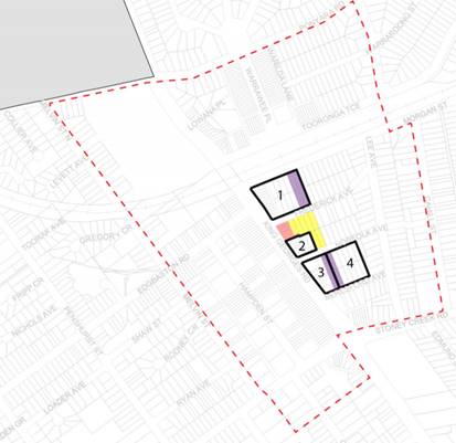
Figure 1. Draft Master Plan - Key sites mapping
20. Bonus development incentives, including greater height and density are proposed to support land consolidation and the delivery of identified public benefits and community infrastructure including the new Civic Plaza and East Street, a community facility and public domain improvements. This includes setting out an approach and priorities for establishing the necessary land dedications to Council for new public infrastructure.
21. There have been six Councillor workshops on the draft Master Plan for Beverly Hills as outlined in the following table.
|
Briefing date
|
Agenda |
|
19 March 2018 |
Project outline for Beverly Hills Master Plan |
|
18 February 2019 |
Phase 1 - outcomes and vision for Beverly Hills Town Centre following community engagement and urban design review |
|
16 September 2019 |
Phase 2 - Preliminary draft Master Plan |
|
18 November 2019 |
Refined draft Master Plan (following community workshop) including: · Land use zoning changes · Public domain plan · Building form and scale (FSR and HOB) · Implementation options |
|
3 February 2020 |
· Comparative zoning and FSR examples · Assumptions in the 3D model |
|
16 November 2020 |
· Consultation outcomes from the public exhibition · Approaches to delivery of public benefits for implementation of the Master Plan |
EXHIBITION OF DRAFT MASTER PLAN
22. The draft Master Plan was placed on public exhibition from 28 July 2020 to 28 September 2020 (inclusive) for a total of 60 days. The public exhibition of the draft Master Plan was conducted in accordance with the Council resolution of 25 May 2020, Council’s Community Engagement Strategy and the endorsed community engagement plan.
23. The community engagement program comprised of the following activities:
· Plans, maps and fact sheets were published on Council’s Your Say project page.
· Plans, maps and fact sheets were made available for viewing at Council’s customer service centres and three libraries during the exhibition period.
· Online submission form
· Survey requesting feedback on the proposed changes
· Two community information webinars: Thursday 20 August and Saturday 22 August 2020
o The webinars were published on the Your Say website after the session
o The two sessions had a combined total attendance of 101 people.
· Advertising in the St George and Sutherland Shire Leader on 29 July, and an article published in the Leader online on 5 August.
· Article in Council’s e-newsletter sent on 31 July.
· Social media (Facebook posts)
· A broader letterbox drop to properties within and adjacent to the study area – 4,450 properties
· Direct consultation with a number of property owner groups (online)
· Council planning officers were available to answer questions about the Master Plan and questions specific to resident’s properties throughout the consultation period.
24. Targeted letters were also sent out to the following stakeholders as they are directly affected by the changes proposed by the draft Master Plan:
· Property owners located within the study area –2,279 properties
· Residents within the study area – 911 properties
25. The engagement activities carried out by Council during the public exhibition period is outlined in further detail in the Community Engagement Summary Report provided in Attachment 6.
OUTCOMES OF PUBLIC EXHIBITION – PUBLIC AUTHORITY AND INFRASTRUCTURE PROVIDER SUBMISSIONS
26. The following public authorities were notified of the draft Master Plan during the public exhibition period:
· APA Group (Pipeline Operator)
· Canterbury Bankstown Council
· Civil Aviation Safety Authority (CASA)
· Sydney Water
· Transport for NSW (TfNSW)
27. APA Group, CASA, Sydney Water and TfNSW did not object to the draft Master Plan for Beverly Hills. Council did not receive a response from Canterbury Bankstown Council.
28. APA, Sydney Water and TfNSW requested further information as the draft Master Plan proceeds. A summary of the comments received from APA Group, CASA, Sydney Water and TfNSW and Council’s response are provided in Attachment 2.
29. Submissions detailed requirements relating to the design, assessment and implementation of the Master Plan and future development. Council will continue to actively engage with these agencies as the Master Plan progresses to planning proposal stage.
30. APA Group (Pipeline Operator) has requested that the draft Master Plan be amended to include reference to the high-pressure gas pipeline easement. The draft Master Plan will be amended to include:
· the location of the pipeline easement on the draft Master Plan diagram; and
· a provision that gas pipeline infrastructure be considered in site planning and land uses in the DCP recommendations contained within the implementation section of the draft Master Plan.
OUTCOMES OF PUBLIC EXHIBITION – COMMUNITY SUBMISSIONS
Survey Results
31. During the submission period, 78 survey responses were received on the Your Say Website. Half of the survey responses came from residents within the study area. 40% came from residents in other suburbs within the LGA. 10% were from business owners within the study area.
32. The survey asked about the five ‘big ideas’ within the Master Plan. Respondents were asked whether they support the idea and sought further feedback about each idea. The questions, results and a summary of feedback are reported in the Community Engagement Summary Report (provided in Attachment 6). The majority of respondents were supportive (47%) of the draft Master Plan. Respondents had an opportunity to leave feedback in the context of each question, a summary of that feedback is included below:
Question 1: Are you supportive or not supportive of the plans to revitalise the commercial strip along King Georges Road, which includes incentives to amalgamate properties and improve commercial street frontages?
Comments were largely supportive and reflected the need to ‘clean up’ or ‘modernise’ the commercial strip along King Georges Road. Supportive and unsupportive respondents echoed the need to ensure sufficient car parking is provided to support an increased commercial presence in the area.
Question 2: Are you supportive or not
supportive of the plans to change housing types in the Beverly Hills Town
Centre which includes new residential flats, town houses and terrace houses?
Respondents mostly objected to changes in residential housing types. As
with commercial presence, supportive and unsupportive respondents reinforced
the need for sufficient parking to support increased residential density.
Question 3: Are you supportive or not supportive of the plan to create a New East Street parallel to King Georges Rd which will improve access to new homes and create new commercial opportunities for the area?
Respondents were relatively evenly split on ‘new east street’. Neutral comments mentioned concern about the appropriateness of the street layout and sufficient space for parking, traffic, seating and trees.
Question 4: Are you supportive or not supportive of the plan to create a new town square on part of the Ray White / car park site, which will include open public space surrounded by new retail/café commercial sites?
Respondents were mostly supportive of the new town square. There were consistent comments about activation of the town square being important to its success as a community asset.
Question 5: Are you supportive or not supportive of the plan to create and improve parks in Beverly Hills Town Centre area?
Respondents were mostly supportive of a new park with some concerns about compulsory acquisition to create new park.
Submissions
33. 61 unique submissions were received and considered including:
· Submissions from residents, property owners, businesses and town planning consultants working on behalf of property owners
· 1 submission from an NSW Member of Parliament; and
· 1 petition with 10 household signatures.
34. Submissions have been reviewed and summarised. The summary of each submission and Council’s response are provided in Attachment 4. Due to the volume of submission received, all submissions have been categorised into groups based on key topic areas.
35. The majority of the submissions objected to the Master Plan. A detailed breakdown of the reasons for support or objections is detailed in the Community Engagement Summary Report (Attachment 6).
36. In summary, the content of the community submissions:
· Objections to acquisitions proposed in the draft Master Plan
· Development, Scale, Layout and Connectivity
· Objections to traffic and parking
· Requests for changes to proposed controls on specific sites within the study area.
37. Detail on each topic area is discussed in the following sections.
Acquisition / Amalgamation incentives
38. Submissions objecting to acquisitions were directly affected landowners relating to compulsory acquisition of land for new open space or road. Concerns relate to the fear of displacement and the financial equitability/ fairness of being identified for acquisition. Submissions expressed a preference for incentivising developer-led amalgamation rather than compulsory acquisition. Landowners have expressed concern that compulsory acquisition will lead to financial disadvantage and/or lower valuation compared to developer led amalgamation incentives.
39. Factors influencing potential displacement under the draft implementation plan:
· Compulsory acquisition – land owners feel disempowered with no choice other than to have land acquired by Council.
· Amalgamation incentives – land owners have a choice to remain where they are or sell to a developer.
· Zoning uplift – land owners have the choice to remain where they are, redevelop or sell to a developer.
Displacement pressure exists in all three scenarios.
40. Factors contributing to equitability concerns under draft implementation plan:
· No height or FSR controls on land that is identified for delivery of ‘East Street’ and open space. Landowners are concerned that this negates the property value.
· Compulsory acquisition is perceived as disadvantage in relation to competitive developer-led amalgamation.
41. The following alternative approaches to the delivery of public benefits were considered at a Councillor Workshop on 16 November 2020:
· An implementation approach with a greater focus on incentives to encourage developer led amalgamation. This may require additional height and FSR bonuses on some residential sites and may still require a combination of compulsory acquisition and amalgamation incentives. This approach may exacerbate concerns about overdevelopment.
· An implementation approach with amalgamation incentives only (i.e. no Council-led acquisition) – this may require larger amalgamation sites that will be more difficult for developers to assemble and potentially risk feasibility and delivery of key public benefits.
42. Following the consideration of the above alternative approaches, Council selected to proceed with the acquisition/ amalgamation approach as proposed in the draft Master Plan. This approach recognises the strategic importance of these sites in the implementation program and provides certainty of public domain delivery through the identification of sites on the Land Reservation Acquisition Map in the LEP and provides a balanced acquisition/ amalgamation approach. Early investment in the public realm is intended to have a catalytic effect on private investment. Funding for land purchases and embellishment of the public domain may be supported by cost capture via a local infrastructure development contribution plan.
43. It is recommended that the concerns of affected residents be addressed with further detailed one-on-one consultation to explain the timing and acquisition process, and to provide Council with an understanding of each property owners unique circumstances (e.g. long time and/or elderly residents who don’t want to be displaced). Any necessary land acquisition will be undertaken in accordance with the Land Acquisition (Just Terms Compensation) Act 1991 and will include consultation and engagement to ensure the affected land owners are kept informed in relation to expected timeframes, processes and property implications.
44. No amendments are proposed to the draft Master Plan as a result of these submissions.
Development, Scale, Layout and Connectivity
45. Submissions expressed concern for overdevelopment of Beverly Hills and the desire to avoid the scale of Hurstville City Centre. Overall while there was a mix of opinions on scale and density, there is general support for principles for development, scale and layout outlined in the draft Master Plan.
46. Several submissions received from landowners raised concerns about the ability of key sites to achieve the consolidation patterns proposed in the draft plan. Some indicated that the bonus incentives were not sufficient to achieve the required site amalgamation patterns and the delivery of public benefits such as a new road. Further feasibility testing of the draft Master Plan was requested.
47. Feasibility testing for each site is not within the scope of this Master Plan. The scale of draft Master Plan has been carefully considered in relation to the location, the Centre’s hierarchy within the LGA, the community’s expectations as well as creating opportunities to incentivise redevelopment within the centre. The suggested scale of development in landowner submissions proposed floor space ratios of up to 5.0:1 with heights of up to 45m (15 storeys). While this scale of development may incentivise faster delivery of redevelopment and delivery of public benefits, this scale is considered more appropriate for strategic centres of Kogarah and Hurstville and does not reflect the community’s expectations for this centre. Beverly Hills is a local centre within the hierarchy of centres with in the LGA and this is reflected in the scale of the draft Master Plan.
48. No amendments are proposed to the draft Master Plan as a result of general submissions. Individual submissions requesting increases in height and density are detailed in the following section titled ‘Requests for changes to exhibited planning controls’.
Traffic, Parking and Infrastructure
49. Traffic pressures resulting from additional development were of concern to 44% of all submissions. The availability of car parking was another key issue.
50. The Parking and Traffic Assessment report provided in Attachment 5 identifies the pre-existing capacity issues with three intersections along King Georges Road currently operating at capacity. While any increase in traffic will contribute to the situation, intersections to the east and west will continue to operate with spare capacity. TfNSW have proposed upgrades that will assist in relieving capacity issues associated with pinch points along King Georges Road. It is expected that as development occurs, Council in consultation with TfNSW will continue to monitor intersection capacity as future development occurs. Any necessary intersection upgrades can be facilitated by development contributions.
51. The recommendations of the Parking and Traffic Assessment report have been reflected in the amended draft Master Plan.
52. Currently the existing B2 – Local Business zoned land within Beverly Hills Centre provides very little on-site parking and relies on public car parks and street parking. Any redevelopment of land would be required by the draft Georges River Development Control Plan 2021 to provide the necessary car parking spaces associated within the new development. Additionally, the draft Master Plan provides bonus height and floorspace incentives for Key Site 1 to provide additional public car parking spaces, in addition to the minimum car spaces that are required as part of the development. The number of public car parking spaces provided would be subject to a future parking demand analysis.
53. As a result of submissions, the draft Master Plan has been amended to include an additional key site (key site 5 – this is discussed further under the section titled “Proposed Amendments to draft Master Plan”). Key Site 5 includes bonus development incentives to provide additional public car parking spaces, similar to Key Site 1 these would be in addition to required car parking and subject to future demand analysis. The addition of Key Site 5 is discussed in the section below titled “Corner of Stoney Creek Road and King Georges Road (Nos 152-166 Stoney Creek Road)”.
Requests for changes to exhibited planning controls
54. Several submissions by landowners requested changes to exhibited planning controls including land use, floor space ratio and building heights and DCP controls. Where submissions were considered to have urban design and planning merit, additional modelling/testing was undertaken by the consultant urban design and planning team. This information is detailed below:
Nos.46-48 Melvin St
55. This submission was made on behalf of the landowners of Nos.46-48 Melvin Street. The subject site consists of a villa development with approximately 4,800sqm in area and is located next to the Council owned public carpark at Edgbaston Road (see aerial image of site below).
56. The submission seeks an increase in building height and floor space and to remove the requirement for a new road/laneway from Edgbaston Road car park to Melvin Street due to potential noise and amenity impacts and would result in inhibiting the development potential of land. Table 1 below provides a summary of the exhibited controls and the requested controls.
Table 1 Summary of exhibited and requested controls for 46-48 Melvin St
|
Planning Controls |
Draft GRLEP2020 |
Exhibited Draft Beverly Hills Master Plan |
Submission from landowners |
|
Land use zone |
R4 High Density Residential |
R4 High Density Residential |
No change requested |
|
Building height (HOB) |
12m |
15m (4 storeys) front portion facing Melvin St 21m (6 storeys) behind |
25m |
|
Floor Space Ratio (FSR) |
1:1 |
2:1 |
2.5:1 |
|
Additional requirements |
N/A |
New road access from Melvin St to Edgbaston Road carpark |
Remove requirement for new road |
57. The exhibited draft Master Plan proposed a new road to access the carpark from Melvin Street and was recommended by Council’s engineers to assist the traffic flow at the intersection of King Georges Road and Edgbaston Road. (See diagram below for except from exhibited draft Master Plan).
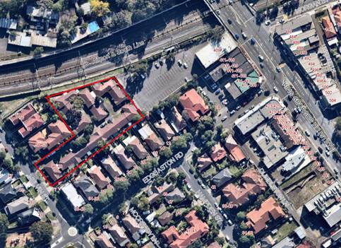
Figure 2. Aerial of subject site (outlined in red) adjoins the Council car park on Edgbaston Road

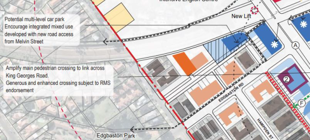
Figure 3. Excerpt from exhibited draft Master Plan. The proposed road is highlighted in yellow.
58. The consultant team reviewed the submission and undertook additional testing in response to the issues raised. They provide the following comments:
· The modelling provided in the submission suitably demonstrates the proposed public road on the south border would reduce the site’s ability to achieve the exhibited FSR of 2.0:1.
· Urban design testing demonstrates that the exhibited FSR of 2.0:1 can be achieved on this site with the removal of the requirement for a new road. This would require a mix of three storey townhouses fronting Melvin Street and a six-storey residential flat building to the railway line, abutting the proposed car park. (Refer to Figure 4 for testing diagram below).
· It is noted that the floorplate options provided in the submission do not reflect SEPP65 standards for minimum building depth and separation distances. The submission proposal has not demonstrated sufficient merit to justify any additional height or FSR on this site.
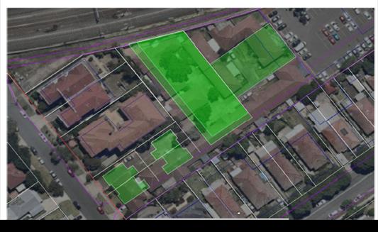
Figure 4. Modelling undertaken by LFA
59. The through connection to Melvin Street is considered desirable for access to any proposed multi-storey carpark but is not strictly required, as access already exists via Edgbaston Road and therefore it is considered reasonable for it to be deleted from the Master Plan. The proposal has not adequately demonstrated the need for additional building height for floorspace for this site and no changes are supported to the exhibited FSR or HOB.
60. It is recommended that the draft Master Plan be amended to remove the proposed new road/laneway from Edgbaston Road Carpark to Melvin Street.
Nos. 10-12 Edgbaston Road (including Council carpark)
61. This submission was made on behalf of the landowners of Nos.10-12 Edgbaston Road. The submission provides a scheme that includes Nos.8-12 Edgbaston Road, which consists of a single dwelling and an attached dual occupancy, and Council’s public carpark (see Figure 5 below for aerial of subject site). Nos. 8-12 are currently zoned R3 – Medium Density Residential and proposed under GRLEP2020 and the draft Master Plan to be rezoned to R4 – High Density Residential. The carpark site is currently zoned SP2- Infrastructure and proposed under the draft Master Plan to be rezoned to B2 – Local Centre.

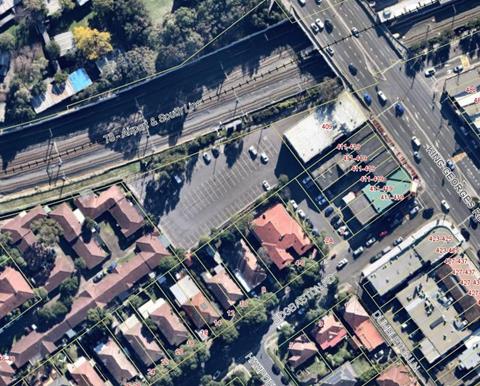
Figure 5. Aerial of subject site of this submission from Nos. 10-12 Edgbaston Road
62. The submission seeks an increase in proposed FSR and building height and provides a concept scheme containing a mixed used development with public benefits including: public car parking spaces, a community facility and open space. (Refer to Figure 6 for concept image) Table 2 below provides a summary of the exhibited controls and the requested controls.
Table 2. Summary of exhibited and requested controls
for 10-12 Edgbaston Road scheme
|
Planning Controls |
Draft GRLEP2020 |
Exhibited Draft Beverly Hills Master Plan |
Submission from landowners |
|
Building height (HOB) B2 zoned land (carpark) R4 zoned land |
N/A for SP2 12m |
21m (6 storeys) 15m (4 storeys) |
45.5m (15 storeys) 17m (5 storeys) |
|
Floor Space Ratio (FSR) B2 zoned land (carpark) R4 zoned land |
N/A for SP2 1:1 |
3.0:1 1.5:1 |
3.5:1 1.9:1 |
|
Additional requirement |
|
|
Proposed height and FSR listed above are identified as a bonus for delivery of public benefit. |
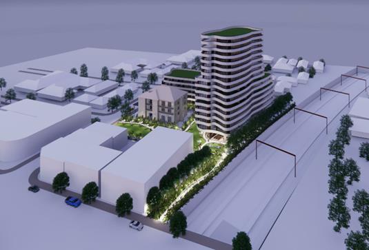
Figure 6. Extract from Submission – 3D
impression of concept scheme for
Nos.10-12 Edgbaston Road (Level 31)
63. The consultant team reviewed the submission and undertook additional testing in response to the issues raised. They provide the following comments:
a. The concept scheme assumes amalgamation to include Council owned land (via an unsolicited proposal).
b. There is a concurrent NSW Government led commuter car park planned for the site. Council is currently in discussion with Transport for NSW on this matter.
c. This scale and height of this scheme is considered excessive and incongruous with the centre’s hierarchy, and the intended vision of the draft Master Plan for the Centre.
64. Council’s officers agree with the consultant team’s comments that this proposal is considerably out of scale of the vision of the draft Master Plan and relies on the assumption that the scheme includes Council’s carpark. Subsequently, no amendments are proposed to the draft Master Plan in in response to this submission.
Nos.48-56 Tooronga Terrace
65. This submission was made on behalf of the landowners of Nos.48-56 Tooronga Terrace. The subject site consists of 5 single dwellings with an approximately area over 2,000sqm. The site is zoned R2 Low Density Residential and is located to the north of the railway line close to the existing B2 – Local Centre zoned land and is surrounded by public roads. (Refer to Figure 7 Aerial image of site below).
66. The submission seeks an upzoning of the site to R4 High Density Residential zone or B2 Local Centre zone and a scale and form of development consistent with the exhibited controls on the opposite side of the railway corridor along Morgan Street. Table 3 below provides a summary of the exhibited controls and the requested controls.
Table 3. Summary of exhibited and requested controls for Nos.48-56 Tooronga Terrace
|
Planning Controls |
Draft GRLEP2020 |
Exhibited Draft Beverly Hills Master Plan |
Submission from landowners |
|
Land use zone (LZN) |
R2 – Low Density Residential |
R2 – Low Density Residential (no change proposed) |
R4 - High Density Residential OR B2 - Local Centre |
|
Building height (HOB) |
9m |
9m |
15m (4 storeys)
|
|
Floor Space Ratio (FSR) |
0.55:1 |
0.55:1 (no change proposed) |
1.5:1 |

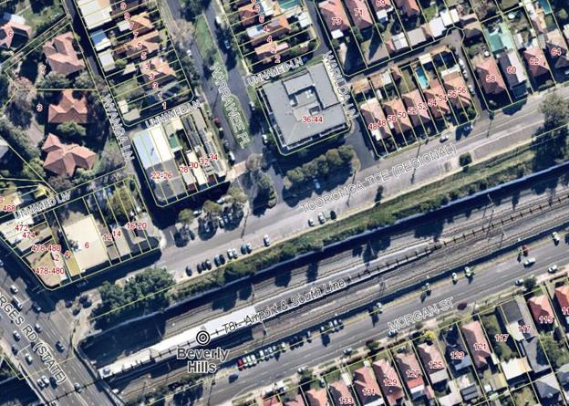
Figure 7. Aerial of subject site of submission from Nos.48-56 Tooronga Terrace
67. The exhibited draft Master Plan did not propose any changes to the subject land or the adjoining B2 site which contains a two storey mixed use development with an FSR of 1.5:1.
68. The consultant team reviewed the submission provides the following comments:
· The site is located within walking distance to the train station and is uniquely surrounded on all sides by public roads, suggesting there may be merit in future consideration of this site for higher density residential uses.
· However, any future change for these sites would need to consider the character of the broader locality and would require more specific and detailed analysis. This may be explored through a separate landowner-led planning proposal process.
· Therefore, it is recommended that this site be identified as a housing investigation area, as per approach for the nearby LAHC site and peripheral sites on Melvin Street near the corner of Broadarrow Road.
69. Following consideration of this submission, it is recommended to amend the draft Master Plan to identify Nos.48-56 Tooronga Terrace properties as a site for ‘future housing investigation’ on the draft Master Plan.
Nos.135-141 Morgan Street and Nos.26-32 Frederick Avenue (Part Key Site No.1)
70. This submission was made on behalf of the landowners of Nos.135-141 Morgan Street and Nos.26-32 Frederick Avenue. The subject site consists of 8 single dwellings currently zoned R2 Low Density residential and proposed to be zoned B2 Local Centre under the draft Master Plan. (See Figure 8 for aerial image of site below). The site forms part of Key Site 1.

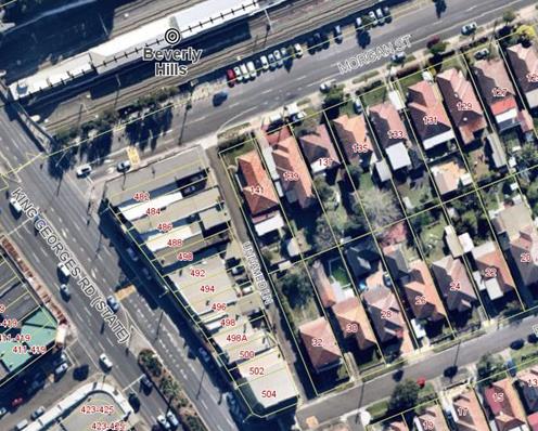
Figure 8. Aerial image of subject site in this submission
71. The submission seeks an increase in proposed building height and amendments to the criteria for Key Site 1. The submission provides a concept scheme containing a mixed used development with supermarket and public car parking spaces (refer to Figure 9 for concept scheme image). Table 4 below provides a summary of the exhibited controls and the requested controls.
Table 4. Summary of exhibited and requested controls
for Nos.135-141 Morgan Street and Nos.26-32 Frederick Avenue scheme
|
Planning Controls |
Draft GRLEP2020 |
Exhibited Draft Beverly Hills Master Plan |
Submission from landowners |
|
Building height (HOB)
|
9m |
21m (6 storeys)
|
45.5m (15 storeys)
|
|
Floor Space Ratio (FSR) (Includes bonus FSR)
|
0.55:1 |
4.0:1
|
4.0:1
|
|
Additional requirements Key site 1 Public benefits tied to bonus HOB and FSR
|
N/A |
Minimum site area 8,500sqm Supermarket, public parking and new East Street |
Minimum site aera 4,100sqm Supermarket and public parking |
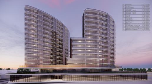
Figure 9. Extract from Submission – 3D
impression of concept scheme for
Nos.135-141 Morgan Street and Nos.26-32 Frederick Avenue (Think Planners)
72. The consultant team reviewed the submission provides the following comments:
· The proposed scale of 15 storey/ 45.5m proposal is considered excessive and incongruous with the centre’s hierarchy, and the intended vision of the draft Master Plan for the Centre.
· The scheme relies on the existing laneway for vehicle access and does not deliver all the intended public benefits of Key Site 1. Specifically, it does not include the amalgamation of sites on King Georges Road and the dedication of a new East Street.
73. Council’s officers agree with the consultant team’s comments that this proposal is considerably out of scale of the vision of the draft Master Plan and seeks the bonus incentives of Key Site 1 but does not deliver the intended public benefits associated with the incentives. Subsequently, no amendments are proposed to the draft Master Plan in in response to this submission.
No. 15 Norfolk Avenue, 18 Norfolk Avenue, 11 Frederick Avenue, 13 Frederick Avenue, 19 Frederick Avenue, 21 Frederick Avenue
74. This submission was made on behalf of the landowners of 6 properties consisting of single dwellings within the study area being No. 15 Norfolk Avenue, 18 Norfolk Avenue, 11 Frederick Avenue, 13 Frederick Avenue, 19 Frederick Avenue and 21 Frederick Avenue. (Refer to Figure 10 for aerial image below). The subject properties are affected by proposed open space or proposed road identified in the draft Master Plan.
![]()
![]()

![]()
![]()
![]()
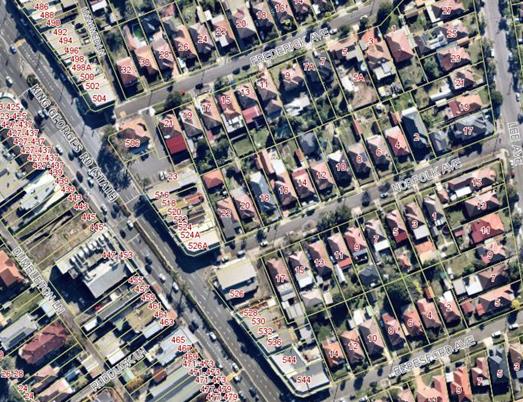
Figure 10. Aerial of properties subject to this submission
75. This submission raises several concerns with the draft Master Plan including the equity of identifying land for acquisition and the feasibility of the delivery of proposed public infrastructure; the potential impacts of undergrounding the existing drainage channel on future developments in the block between Frederick and Norfolk Avenues; and specifically concerns regarding the location of the proposed town square and the need for the new ‘East Street’.
76. The submission presents an alternative scheme (see Figures 11 to13 below) that proposes:
· the town square be located opposite the railway line on Morgan Street
· narrower disjointed lanes created informally through redevelopment by providing outdoor dining areas within development sites
· to focus activity on the existing streets in the centre i.e. Morgan Street and Frederick, Norfolk and Beresford Avenues.
· increased height and density to be given to the areas closer to the railway station.
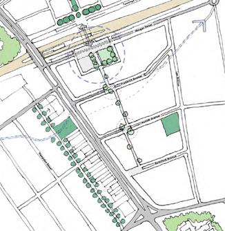
Figure 11. Extract of proposed public domain opportunities from submission (Ingham Planning)
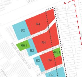
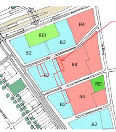
Figure 12. Proposed new land use zone: Left - draft Master Plan, Right - Alternative scheme from submission (Ingham Planning)
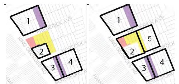
Figure 13. Proposed site amalgamation: Left – draft Master Plan, Right – Alternative scheme from submission (Ingham Planning)
77. The consultant team reviewed the submission and provided the following comments:
· The proposed expansion of the B2 zone is considered too excessive in scale.
· The width and location of ‘East Street’ is considered necessary to create a complementary spine to King Georges Road to allow for street parking, access to businesses. Place making benefits would be lost with a disjointed smaller lane.
· It is considered strategic to focus the civic plaza in a central location where Council already owns land.
· The proposed solution does not negate the need for land acquisition. It shifts the focus to another location so land acquisition would still be required under the alternative approach.
78. It is considered that the alternative scheme does not resolve the main concern raised in the submission, which was to provide an equitable solution for acquisition of land for community and road. No amendments are proposed in response to this submission.
No.526 King Georges Road and 15-17 Norfolk Avenue (part of key site 3)
79. This submission was made on behalf of the landowners of No 526 King Georges Road and 15-17 Norfolk Avenue. The subject site consists of the former post office site (currently a real estate agency) and two single dwellings and is identified as part of Key Site 3 within the draft Master Plan. (Refer to Figure 14 for aerial image of site below).
80. No.526 King Georges Road is zoned B2 Local Centre. The adjoining lots at 15-17 Norfolk Avenue are zoned R2 Low Density Residential and identified for ‘private sector delivery’ of portion of new road (‘East Street’).
81. The submission seeks an increase in building height and amendments to the setback controls applied to this site. Specifically, the proposed building heights and FSR for Key Site No.3 are not sufficient to make redevelopment with dedication of land viable and attractive.

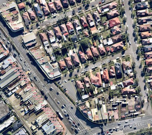
Figure 14. Aerial image of subject site Nos. 526 King Georges Road and 15-17 Norfolk Avenue.
82. The submission demonstrates through site massing, that the proposed maximum FSR 3.5:1 in the exhibited draft plan cannot be achieved in the 7-storey height limit and that a minimum of 8 storeys is required. Their preferred design option is for a 14 storey slender towers with 6 storey podium to provide further incentive for the delivery of the land dedication. The submission provides recommendations on setbacks which are discussed under the section titled ‘Setback Types’. Table 5 below provides a summary of the exhibited controls and the requested controls.
Table 5 Summary of exhibited and requested controls
for Nos. 526 King Georges Road and 15-17 Norfolk Avenue
|
Planning Controls |
Draft GRLEP2020 |
Exhibited Draft Beverly Hills Master Plan |
Submission from landowners |
|
Land use zone (LZN) 526 King Georges Rd 15-17 Norfolk Ave |
B2 R2 |
B2 B2 |
No change requested |
|
Building height (HOB) 526 King Georges Rd 17 Norfolk Ave 15 Norfolk Ave |
15m 9m 9m |
24.1m (7 storeys) 24.1m (7 storeys) No height (road) |
27.2m (8 storeys) OR 45m (14 storeys with design excellence)
|
|
Floor Space Ratio (FSR) 526 King Georges Rd 15-17 Norfolk Ave |
2.0:1 0.55:1 |
3.5:1 (maximum bonus FSR for key site 3) |
3.5:1 (maximum bonus FSR for key site 3) |
83. The consultant team reviewed the submission and provided the following comments:
· The modelling demonstrates the exhibited building height could not accommodate the exhibited bonus FSR on their site (Key Site 3).
· Further urban design testing confirms that the submission is correct in that 8 storeys would be required to achieve a 3.5:1 FSR.
· Urban designers have recommended to include both corners of Key Site 3 – being the corner of Norfolk Avenue and King Georges Road and the corner of Beresford Avenue and King Georges Road being No.544 King Georges Road.
84. Council officers agree with the consultant team’s comments. The proposed increase in scale from 7 to 8 storeys for this site may result in minor additional overshadowing of development sites to the south. The additional height on both corners of key site 3 may result in better design outcomes for the block as well as further incentivise the delivery of key infrastructure. Following consideration of this submission, it is recommended to amend the draft Master Plan to provide bonus height incentive of 3.1m (one storey) for the corners of Key Site 3 being No.526 King Georges Road, No.17 Norfolk Avenue and No.544 King Georges Road.
Corner of Stoney Creek Road and King Georges Road (Nos 152-166 Stoney Creek Road)
85. This submission was made on behalf of the landowners of Nos.160-178 Stoney Creek Road. The subject site consists of the corner of King Georges Road and Stoney Creek Road being Nos. 152-166 Stoney Creek Road (identified on the Figure 15 in blue outline). There is an active Development Consent Nos.160-178 Stoney Creek Road for the demolition of existing commercial buildings, site consolidation, site remediation, construction of a part three to part five storey mixed used development comprising of residential and retail uses include a supermarket on the ground floor (identified on Figure 15X in red dashed outline).
86. This submission suggests the site at the corner of Stoney Creek and King Georges Roads should be considered a gateway with potential to accommodate greater height to reinforce the corner and would result in a more coherent streetscape. The submission demonstrates through modelling, that a proposed building height of 10 storeys would be unlikely to have adverse shadowing impacts due to the existing separation to buildings to the south across the width of Stoney Creek Road. Table 6 below provides a summary of the exhibited controls and the requested controls.


Figure 15. Subject site No.152-166 Stoney Creek Road (outlined in blue). The land with red dashed outline has a current Development Consent for mixed used development with supermarket.
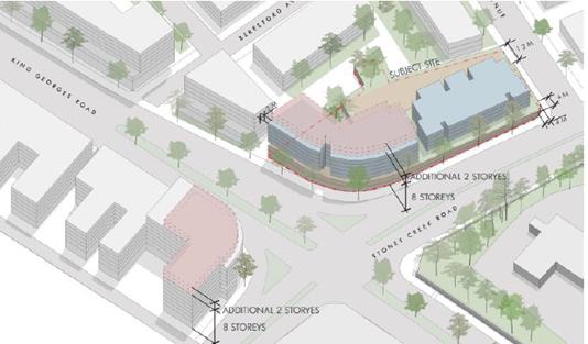
Figure 16. Submission extract from Axonometric View of subject site (Candalepas Associates)
Table 6 Summary of exhibited and requested controls for
Nos 152-166 Stoney Creek Road
|
Planning Controls |
Draft GRLEP2020 |
Exhibited Draft Beverly Hills Master Plan |
Submission from landowners |
|
Land use zone (LZN) |
B2
|
B2
|
No change requested |
|
Building height (HOB)
|
15m |
28m (8 storeys) |
34.2m (10 storeys) |
|
Floor Space Ratio (FSR) |
2.0:1 |
3.0:1 |
Additional FSR
|
87. The submission also seeks an amendment to the setback types map to extend Type 4 setback around the corner, for consistency with the western side of King Georges Road and for development practicability. This request is considered in the following section titled ‘Setback Types’.
88. The consultant team reviewed the submission and provided the following comments:
· This submission demonstrates the site should be considered a ‘gateway site’ with additional height and FSR sought.
· The proposal is considered to have design and planning merit to be included as a key site.
· Consistent with all key sites, the bonus FSR and HOB incentives are contingent on providing public benefit.
89. To incentivise amalgamation of this corner site and the delivery of public benefits, the following bonus incentives are suggested to apply to the Key Site 5:
|
Planning Controls |
Amended Master Plan |
|
Minimum site area |
1,500sqm (approximate area of consolidation of subject site of 8 allotments |
|
Building height (HOB) Bonus 6.2m |
28m (8 storeys) 31.1m (9 storeys) |
|
Floor Space Ratio (FSR)
|
3.0:1 mapped 3.5:1 (includes bonus 0.5:1) |
|
Public Benefit |
· Dedication of land to provide a plaza space in an accessible high amenity location; OR · Provide public car parking in addition to the minimum requirements for the development (car parking may be provided anywhere on land bounded by King Georges Road, Beresford Avenue, Lee Avenue and Stoney Creek Road). Number of parking spaces is subject to needs analysis; and · Meeting necessary design excellence standards (subject to implementation via under draft GRLEP2021). |
90. Council officers agree with the consultants’ comments and consider the additional height and density on this site is acceptable, as it results in minimal adverse impacts on adjoining sites and potentially delivers additional public benefit. Following consideration of this submission, it is recommended to amend the draft Master Plan to identify Nos.152-166 Stoney Creek Road as Key Site 5 and include bonus incentive provisions as detailed in the table above. Refer to figure16 below for proposed key sites map in amended draft Master Plan.
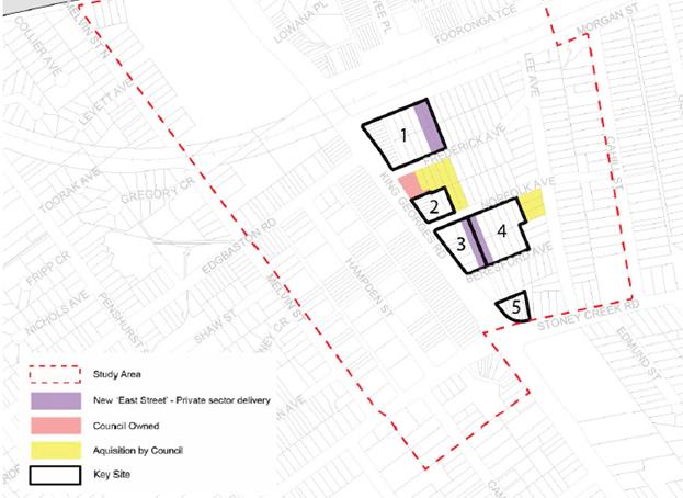
Figure 16. Extract from amended draft Master Plan Figure 58. Proposed land acquisition and key sites mapping indicating new Key Site 5.
Beverly Hills Land Owners Association
91. This submission was made on behalf of a group of landowners within the B2 local centre zone with properties mostly located on western side of King Georges Road. The submission submits an alternative urban design scheme and land economics review (see alternative scheme in Figure 17 below). The submission raises the following concerns with the draft Master Plan:
a. Lacks sufficient incentives for amalgamation.
b. Questions the efficacy of yields proposed based on the feasibility study Believes the feasibility should be re-tested under 'new covid-19 reality'.
c. The land economics review prepared on their behalf by Atlas Economic Consultants indicates higher yields are needed for a feasible plan.
d. Suggests B2 zone with FSR range of 3.6:1 – 6:1 and R4 zone with FSR range of 2:1 – 2.5:1.
e. Scheme proposes 12 storeys in HOB for B2 and range of 6-8 storeys for R4 zone.
f. Requests of peer review of the urban plan, with attention to the consolidation pattern to support the Gateway process at Planning Proposal stage.
Figure 17. Extract from submission of alternative urban design scheme (Olsson)
92. The consultant team reviewed the submission and provides the following comments:
· Irrespective of the suitability of the methodology applied by Atlas or HillPDA in the land economic review, the suggested FSR range is incongruous with the centre’s hierarchy.
· FSRs for B2 suggested are more consistent with a major strategic centre, like Hurstville or Kogarah. This would require a major increase in building height is inconsistent with community expectations.
93. Council officers agree with the consultant team’s comments. The alternative scheme proposed does not delivery significant public benefits and proposes FSR and HOB that are consistent with our strategic centres. It is considered that a peer review of the draft Master Plan and land economic study are unnecessary at this stage of the draft Master Plan. These may be considered by Council as the Master Plan progresses to a planning proposal. No amendments are proposed in response to this submission.
Setback Types
94. Several submissions requested the setback types diagram be amended to extend Setback Type 4 around corners to improve development practicability. The setback diagram is designed to provide some flexibility as it is intended to be principles oriented. For greater clarity, the corresponding diagrams for Setback Type 4 and 5 have been amended to strengthen controls relating to articulation and transition between setback types. The following amendments are proposed:
· Amend the setback types diagram to extend Setback Type 4 -Prominent corners (6-8 storeys) Mixed Use and Setback Type 5 – Prominent corners (4 storeys) Residential to wrap further around the corner of blocks. Refer to Figure 18 below of amended setback diagram.
· Amend diagrams for Setback Type 4 and Type 5 to include additional design considerations to prevent the occurrence of blank walks within any site or between neighbouring properties.
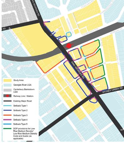
Figure 18. Amended setback types diagram in draft Master Plan
OTHER CONSIDERATIONS POST-EXHIBITION
95. Following the exhibition of the draft Master Plan, the following issues have emerged which require Council’s consideration.
Minimum non-residential Floor Space Ratio
96. Draft Georges River LEP 2021 includes a minimum non-residential FSR of 0.5:1 for B2 zoned land within Beverly Hills Centre. The Commercial Centres Strategy (CCS) indicates that B2 zoned land within Beverly Hills Centre has a current non-residential FSR of 0.7:1 and requires 0.82:1 to meet the required 2036 demand for future employment floor space. Table 1 below provides a yield analysis of potential non-residential FSR rates on uplifted areas within the study area.
Table 1. Yield analysis for draft Master Plan
|
Yield range in study area – Base Case (no bonuses) |
|
|
Non -residential Gross Floor Area (full uptake) |
|
|
24,554sqm |
Existing allowable non-resi FSR at 0.5:1 (under draft GRLEP2021) |
|
33,761sqm |
2036 target non-residential FSR |
|
36,831sqm |
Proposed total non-residential at FSR 0.75:1 |
|
40,269 sqm |
CCS recommended non-residential FSR 0.82:1 |
|
64,493 sqm |
GFA potential under plan (equivalent FSR 1.3:1 assumes 2 levels of non-residential may occur on smaller sites but unlikely to occur on all sites) |
97. It is recommended that Council consider a future LEP requirement for non-residential FSR of 0.75:1 in Beverly Hills. This requirement would stem the loss of non-residential floorspace as sites are redeveloped under the Master Plan and ensure Beverly Hills has capacity to meet the 2036 projections for employment floorspace demand in the Commercial Centres Strategy.
98. The modelling for the draft Master Plan was undertaken on the assumption that a non-residential FSR of 0.82:1 would be required under the draft LEP. However, this requirement was not implicitly stated within the implementation section of the draft Master Plan. As this was not in the exhibited draft Master Plan, this requirement would need to be exhibited with any planning proposal for the implementation of the Master Plan.
Hazard Analysis
99. Early consultation on the draft Master Plan with Department of Planning, Infrastructure and Environment (DPIE) resulted in a recommendation to prepare a Hazard Analysis for the Master Plan prior to preparing a Planning Proposal. The Hazard Analysis will assess the risk profile of the draft Master Plan with the high pressure gas pipeline which is located within the study area, and provide recommendations to reduce risk, which could impact on the implementation of the draft Master Plan. This work is currently underway. Once completed, this report requests that Council authorise the General Manager to make minor adjustments to the Beverly Hills Master Plan resulting from the outcomes of the Hazard Analysis Report of the high pressure gas pipeline.
Summary of proposed AMENDMENTS TO DRAFT MASTER PLAN
100. The following amendments are proposed as a result of the public exhibition of the draft Master Plan for Beverly Hills centre.
(a) Remove the proposed driveway/ public laneway from Edgbaston Road Carpark to Melvin Street from the draft Master Plan.
(b) Identify Nos.48-56 Tooronga Terrace properties as a site for ‘future housing investigation’ on the draft Master Plan.
Amend the bonus provisions for Key Site 3:
· Key Site 3: additional building height of 3.1m for sites at 526 King Georges Road, 17 Norfolk Avenue and 544 King Georges Road.
(c) Include Nos.152-166 Stoney Creek Road as a new Key Site (Key Site 5) with the following bonus incentives:
· Additional building height of 3.1m for sites Nos.152-166 Stoney Creek Road
· Additional floor space ratio of 0.5:1 measured according to the site area within the boundary of Nos.152-166 Stoney Creek Road
· These bonus incentives are contingent upon meeting the following criteria:
· Minimum site area of 1500sqm
· Dedication of land to provide a plaza space in an accessible high amenity location OR public car parking provision in addition to the minimum requirements for the development (car parking may be provided anywhere on land bounded by King Georges Road, Beresford Avenue, Lee Avenue and Stoney Creek Road); and
· Meeting necessary design excellence standards (subject to implementation via under draft GRLEP2021).
(d) Amend the setback types diagram to extend Setback Type 4 -Prominent corners (6-8 storeys) Mixed Use and Setback Type 5 – Prominent corners (4 storeys) Residential to wrap further around the corner of blocks.
(e) Amend diagrams for Setback Type 4 and Type 5 to include additional design considerations to prevent the occurrence of blank walks within any site or between neighbouring properties.
Financial Implications
101. The draft Master Plan has been prepared and exhibited within budget allocation.
102. The implementation of the draft Beverly Hills Master Plan requires additional work including the preparation of a Planning Proposal, design and testing for associated planning controls, potential valuations of land identified for acquisition and the preparation of a Developer Contributions Plan. This work requires an additional budget allocation.
103. The Hazard Analysis report which is underway is funded by the NSW Government.
Risk Implications
104. The outcomes of the Hazard Analysis may have implications for the implementation of the draft Master Plan including the preparation of a planning proposal, associated development controls and development contributions plan.
105. If Council does not endorse the Beverly Hills Master Plan, then the following risks will arise:
a. No urban renewal within Beverly Hills; or
b. Ad-hoc planning proposals being submitted which may not align with the future vision for Beverly Hills and Council will have limited ability to deliver required infrastructure and public benefits.
106. Modelling indicates if the draft Master Plan is developed to its full potential (over 20-30 year timeframe) it would result in approximately 1,500 additional dwellings, and capacity to meet the 2036 projections for employment floor space demand in the Commercial Centres Strategy.
107.
NEXT STEPS
108. It is recommended that Council endorse the amended draft Master Plan and submit it to Department of Planning, Industry and Environment (DPIE) for endorsement as a strategic study. If endorsed by DPIE, any proponent led Planning Proposals for sites within the study area would be assessed against the draft Master Plan. A centre wide Planning Proposal is not proposed at this stage and will be considered as part of a future LEP.
109. All persons who made a submission to the draft Master Plan will be advised of the Council’s decision.
110. All landowners within the study area will be advised of Council’s decision.
File Reference
SF17/640
|
Attachment 1 |
Beverly Hills Town Centre Master Plan July 2021 - published in separate document |
|
Attachment 2 |
Summary Table of Agency Submissions - Beverly Hills Master Plan - published in separate document |
|
Attachment 3 |
Summary Table of Community Submissions - Beverly Hills Master Plan - published in separate document |
|
Attachment 4 |
Council response to submissions through Themes - Beverly Hills Master Plan - published in separate document |
|
Attachment 5 |
Parking and Traffic Assessment - Beverly Hills Master Plan (Phase 2) - published in separate document |
|
Attachment 6 |
Summary of Engagement Report - Draft Beverly Hills Master Plan - published in separate document |
Georges River Council – Environment and Planning - Monday, 12 July 2021 Page 1
Item: ENV031-21 Public Exhibition of Draft Plan of Management and Master Plan for Moore Reserve 2021
Author: Strategic Planner
Directorate: Environment and Planning
Matter Type: Committee Reports
|
(a) That Council endorse the draft Moore Reserve Plan of Management and Master Plan for public exhibition for a period of no less than 28 days in accordance with section 38 of the Local Government Act 1993. (b) That Council notify the draft Plan of Management and Master Plan to the Minister (NSW Department of Planning, Industry and Environment), as land owner of part of the land under section 39 of the Local Government Act 1993 to obtain owner’s consent prior to public exhibition. (c) That Council seek written consent from the Minister (NSW Department of Planning, Industry and Environment) to adopt the draft Plan of Management, in accordance with section 3.23(6) of the Crown Land Management Act 2016. (d) That Council endorse the proposed changes to the land categorisation and hold a public hearing under section 40A of the Local Government Act 1993. |
Executive Summary
1. A draft Plan of Management (Attachment 1) and Master Plan (Attachment 2) have been prepared for Moore Reserve by Gondwana consultants.
2. Extensive engagement was undertaken to raise awareness of the preparation of the draft Plan of Management and Master Plan and to develop a vision for the Reserve with opportunities for input by the community, Council staff and Councillors.
3. The draft Plan of Management acts as an agreement between Council and the community and identifies how Moore Reserve will be used, improved and managed in the future. It identifies Council’s goals and vision, establishes direction for planning and resource management allowing Council to set priorities when preparing works programs.
4. This report recommends that the draft Plan of Management and Master Plan be placed on public exhibition for a minimum of 28 days in order to receive feedback from the local community in accordance with the requirements of the Local Government Act 1993.
5. This report also recommends that prior to the draft Plan of Management and Master Plan being placed on public exhibition, that it be referred to NSW Department of Planning, Industry and Environment (DPIE), as representative landowner of Crown Reserve No. R89308 (Lot 7047 DP 1127644) for the purposes of endorsing the plan of management and Master Plan for exhibition. A further two lots (Lot 61 DP 700911 and Lot 3 DP 526583) are owned by DPIE with Georges River Council having management responsibility for both land parcels.
6. In accordance with the provisions of the Local Government Act 1993, this report also seeks that Council hold a public hearing for altering the land categorisation of the Reserve.
Background
7. Moore Reserve is located between Oatley and Hurstville Grove, on the Oatley Bay foreshore. The park is substantially landlocked by adjacent residential areas, with a carpark entry from Morshead Drive and pedestrian entry at Seymour Reserve (east), via an underpass from Renown Reserve (north), and from Louisa, Frederick, Ada and Kitchener Streets. The Oatley boat ramp forms part of the reserve. Figure 1 below shows a location plan of the Reserve.
Figure 1: Location plan
8. The subject land at Moore Reserve, Oatley, covers a total area of approximately 14.2 hectares and is made up of 70 individual parcels of land. The majority of these land parcels (67) are community land that is owned and managed by Georges River Council. However, a large part of the centre of the Reserve comprises a Crown Reserve (No. R89308 Lot 7047 DP 1127644) for which Georges River Council is appointed Council manager under the Crown Land Management Act 2016.
9. The Reserve also includes two parcels of land owned by other government agencies/authorities. Lot 61 DP 700911 and Lot 3 DP 526583 are owned by the DPIE with Georges River Council having management responsibility for both land parcels.
10. The land at Moore Reserve is zoned RE1 Public Recreation under Kogarah Local Environmental Plan 2012. Permitted uses include: Aquaculture; Boat launching ramps; Car parks; Centre-based child care facilities; Community facilities; Emergency services facilities; Environmental facilities; Flood mitigation works; Information and education facilities; Jetties; Kiosks; Markets; Recreation areas; Recreation facilities (indoor); Recreation facilities (major); Recreation facilities (outdoor); Registered clubs; Respite day care centres; Restaurants or cafes; Roads; Signage; Water recreation structures.
11. The RE1 Public Recreation zone for Moore Reserve is maintained in the draft Georges River Local Environmental Plan 2020.
12. In 2019, Council engaged Gondwana Consulting to prepare a draft Plan of Management and Master Plan for Moore Reserve.
13. The following engagement measures were undertaken to raise awareness of the Draft Plan’s preparation and opportunities for input:
· “Your Say” webpage, phone and/or email contact with known stakeholders or user groups;
· Social media via Georges River Council Facebook page;
· Online survey form;
· Information Sheet and Feedback Form;
· Direct letterboxing to all properties opposite or adjoining the Reserve and random selection of properties within 300m radius;
· Two on-site ‘drop in’ information and input kiosks on 27 February 2020 (39 attendees) and 29 February 2020 (78 attendees); and
· Meetings/input from key GRC staff including Parks and Waterways, Environmental Health, Infrastructure and Strategic Planning.
14. Respondents (168) nominated the following areas or facilities as those they most frequently used:
· Off-leash dog areas (25%);
· Paths and tracks (22.6%);
· The Seymour Reserve playground (16.7%);
· The picnic/barbeque facilities and exercise equipment (both 8.3%);
· The boat ramp and adjacent facilities (5.4%); and
· The artificial wetland (4.8%).
15. Respondents (424) identified the following issues or challenges:
· Poor condition of, or lack of facilities (28%);
· Maintenance problems (20.8%);
· Better project/manage natural areas and biodiversity values (13.2%);
· Usage conflicts or issues, primarily dog related (10.6%); and
· Poor state of paths and walking tracks (8.11%).
16. A detailed analysis of the input and feedback received has informed the preparation of the draft Plan of Management and draft Master Plan.
Councillor Briefing 4 May 2020
17. The outcomes of the public engagement phase were briefed to the Councillors on 4 May 2020. Three draft Master Plan options were presented for Councillor consideration (based on the public engagement).
18. Key Council staff were consulted and invited to comment on the three Master Plan options.
Councillor Briefing 20 November 2020
19. The preferred Master Plan option was briefed to the Councillors on 20 November 2020.
20. The briefing primarily focused on options for the proposed dog park. Issues that were considered include:
· In addition to a dedicated fenced off-leash dog park, install perimeter plantings and/or low mesh fence within open grassed area (used by all park users) to separate off leash dogs from adjacent paths and allow off leash use (24 hours, 7 days during weekdays) and between 8:00pm and 9:00am on weekends and public holidays (as per current arrangements).
· Having two off-leash fenced dog park (for smaller dogs and larger dogs) due to conflicts between users.
· Pros and cons of each adaptive management response.
21. A suggestion that the existing fenced off-leash dog park be extended to allow greater access for dogs to run and play freely without a leash was also raised. The remainder of the open grassed area will be available to all users including on-leash dogs (on-leash at all times). The substantial increase in the proposed size of the fenced dog park may improve park user conflict/ complaints by having a large dog zone with upgraded facilities (additional seating, shade, water points, waste bins, and internal perimeter path) to ensure off-leash dogs are kept within the designated fenced area at all times, and not off-leash in other areas of the Reserve.
Councillor Briefing held 7 June 2021
22. The draft Master Plan (Attachment 2) was briefed to the Councillors on 7 June 2021.
DRAFT PLAN OF MANAGEMENT AND MASTER PLAN
23. A draft Plan of Management (Attachment 1) and Master Plan (Attachment 2) have been prepared for Moore Reserve by Gondwana consultants.
24. The Plan of Management has been prepared under the provisions of the Local Government Act 1993 and provides statutory requirements, clear guidelines and the designation of areas, to enhance the use of open space and minimise any conflict between user groups. The key objective of the Plan of Management is to provide a clear strategic direction for future management and use of the Reserve.
25. Given the size of the of Reserve, the draft Master Plan has proposed three zones i.e. northern, central and southern zones. This is illustrated in the draft Master Plan below.
26. Key elements of the Master Plan are:
Northern zone
· Upgrade Seymore Reserve with shade and seating.
· A single unit all-abilities toilet in Seymore Reserve.
· Formalise and upgrade (as required) walking track.
· Manage artificial wetland for dual functions of water quality improvement and fauna habitat.
Central zone
· Expansion of the existing fenced off-leash dog park to slightly more than double its current size, and the provision of additional facilities within the space for dogs/ dog owners.
· New entry and walking track.
· Shared loop path upgrade.
· A range of landscape and amenity plantings.
· Stormwater management improvements.
Southern zone
· New walking track and entry.
· Redevelopment (expansion and reconfiguration) of the Reserve’s carpark off Morshead Drive, resulting in an increase of up to 20% of its current footprint.
· Expansion of the current picnic area by up to approximately 35% of its current extent.
· Additional picnic facilities.
· A new low-key playground (for infants and school age children) and an adjacent junior bicycle track.
· A new toilet block, with all abilities access.
· Installation of a site (surface hardened and serviced with utilities) for possible use as a ‘pop-up’ café/kiosk.
· Realignment and sealing of several sections of the existing sealed shared loop path, and the construction of a new section of the shared loop path.
· New exercise equipment hub.
· Possible short overwater boardwalk (shared path) looping out over the Oatley Bay foreshore.
· Stormwater improvements (ephemeral creekline, detention basin and vegetated swale).
27. Key features of the Master Plan also include; expanding and enhancing the connectivity of native vegetation throughout the Reserve; reinforcing the biodiversity/ habitat corridor; and expanding the area of Estaurine Swam Oak Forest endangered ecological community, using species representative of coastal enriched sandstone dry forest.

Draft Master Plan
28. The draft Plan of Management is structured in seven sections as outlined below:
a. Introduction and Background: describes plans of management; why and how they are prepared; and what land is included in the Moore Reserve Plan of Management.
b. Description of Moore Reserve: provides an introduction of the Reserve; its assets; facilities; usage and condition.
c. Planning and Management Context: describes the legislative requirements of a plan of management and the planning context.
d. Basis for Management: identifies and evaluates the role of Moore Reserve, its values, issues and opportunities. This section also identifies the appropriate community land categories to apply to the area, management zones, and also the broad objectives and directions for the Reserve’s management.
e. Permitted Park Purposes, Intensity of Use and Development, and Master Plan: describes the purpose and uses to be permitted within Moore Reserve, the intensity such uses, guidance in relation to unforeseen uses and activities, and the scale/intensity of development. The concept Master Plan is provided in this section.
f. Management Actions: identifies a management framework and action plan, based on specific management actions and guidelines or policies, to protect and enhance the Reserve’s values, enjoyment and efficient management.
g. Implementation plan: addresses factors around implementation of key management actions, and a review schedule of the Plan.
NATIVE TITLE
29. Native Title is a requirement for Council Crown land managers to obtain written advice from a qualified native title manager that the Plan of Management covers Crown Land that is not ‘excluded land’.
30. Excluded land is defined in the Crown Lands Act 2016 to include:
a) land subject to an approved determination of native title (as defined in the Native Title Act1993 of the Commonwealth) that has determined that:
i. all native title rights and interests in relation to the land have been extinguished, or
ii. there are no native title rights and interests in relation to the land,
b) land where all native title rights and interests in relation to the land have been surrendered under an indigenous land use agreement (as defined in the Native Title Act1993 of the Commonwealth) registered under that Act,
c) an area of land to which section 24FA protection (as defined in the Native Title Act 1993 of the Commonwealth) applies,
d) land where all native title rights and interests in relation to the land have been compulsorily acquired,
e) land for which a native title certificate is in effect
31. Attachment 3 is the written Native Title advice for Moore Reserve (Lot 7047 DP 1127644 being Reserve No. 89308). The advice in summary states that the draft Plan of Management complies with the applicable provisions of the Native Title Act 1993.
CROWN LAND
32. The Crown Land Management Act 2016 (CLM Act) commenced on 1 July 2018. The CLM Act introduces significant changes to the management of Crown Land by councils. Councils are now required to manage dedicated or reserved Crown Land as if it were public land under the Local Government Act 1993.
33. With the legislation changes to the Crown Land, Council is required to submit the draft Plan of Management to NSW Department of Planning Industry and Environment, as representative owner of part of the land under section 39 of the Local Government Act 1993.
LAND CATEGORISATION
34. Section 36(4) of the Local Government Act 1993 requires that community land be categorised according to the five categories of sportsground, park, area of cultural significance, natural area or general community use. The natural area category is further divided into five sub-categories – bushland, wetland, escarpment, watercourse or foreshore. This applies to Council owned community land portions that make up over nearly two-thirds of Moore Reserve.
35. The Crown Land Management Act 2016 provides that this same requirement for categorisation now also applies to Crown reserves under the control of a ‘Council manager’.
36. The existing Moore Reserve PoM (1999) categorises the Reserve as: Park; General Community use; Natural Area (bushland); Natural Area (wetland); Natural Area (watercourse); and Natural Area (foreshore). The Crown Reserve (No. 89308), that makes up the central portion of the Reserve, is mostly categorised as Park in the existing PoM, but also partly as Natural Area (wetland), General Community use and Natural Area (foreshore).
37. The categorisation of a Crown Reserve can be altered through the plan of management process, in accordance with the applicable provisions of the Crown Land Management Act 2016 and Local Government Act 1993.
38. Considering the values and attributes, uses, type and level of development, character, management and intended future character and uses of the various parts of Moore Reserve, the categorisation remains the same, however the realignment of the categories is proposed to be altered.
39. The figure below shows the proposed land categorisation of Moore Reserve.
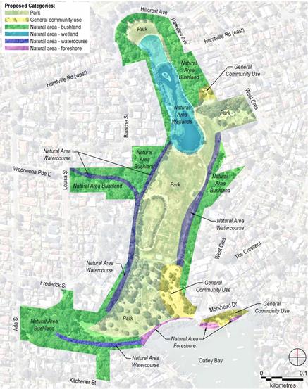
40. A requirement of the Local Government Act 1993 is that all community land must be assigned to one or more land categories whereby the land categorisation defines how Council will manage each parcel of land.
41. The core management objectives for the nominated land categories are identified in Table 12 of the draft Plan of Management (Attachment 1). Table 12 presents a variety of objectives, comprising both principles and management directions. The objectives cover matters such as conserving biodiversity and ecological values, park management, maintaining the foreshore functions, and promoting recreational, cultural and social activities.
42. This report seeks Council to endorse the changes to the land categorisation and hold a public hearing consistent with section 40A of the Local Government Act 1993.
LAND CONTAMINATION
43. The draft Plan of Management for Moore Reserve outlines the site’s history as a landfill site and waste facility and provides detailed information on previous site management and contamination studies to address legacy environmental issues.
44. Council is aware that the majority of the site was a landfill/tip between 1935 to 1977 for spoil and municipal waste – similar to other parks in our LGA located along the Georges River foreshore.
45. Council commissioned GHD to undertake an independent review of all previous studies to allow Council and the NSW Environment Protection Authority (EPA) to review the classification of Moore Reserve and assess whether further work and/or ongoing regulation under the Contamination Land Management Act 1997 are required. The assessment also endeavoured to address data gaps identified by the Environmental Monitoring Report in 2006 (also conducted by GHD).
46. Key findings of the Preliminary Assessment Report (dated 8 June 2021) are:
· Overall, the surface gas conditions and surface water concentrations have improved or remain consistent with monitoring data in the 2006 GHD Environmental Monitoring Report;
· No visible landfill waste was identified during the site inspection;
· The monitoring well network for groundwater and landfill gas is no longer serviceable;
· Current sub-surface gas and leachate/groundwater conditions are unknown;
· Reinstatement of monitoring wells for future gas and groundwater monitoring is likely to be required; and
· Assessment of the existing capping layer in the areas of any proposed construction is likely to be required.
47. Managing landfill legacy issues is categorised as a high priority in the Biodiversity, Catchment and Natural Landscape Actions of the draft Plan of Management.
FINANCIAL IMPLICATIONS
48. Within budget allocation.
RISK IMPLICATIONS
49. No risks identified.
Community Engagement
50. Extensive preliminary engagement was undertaken with the community and stakeholders to raise awareness of the Draft Plan’s preparation and provide opportunities for input.
51. The draft Moore Reserve Plan of Management and Master Plan will be placed on public exhibition for a period of no less than 28 days in accordance with section 38 of the Local Government Act 1993.
52. The public notice will be for a period of not less than 42 days after the date on which the draft plan and Master Plan is placed on public exhibition during which submissions may be made to the Council.
53. A public hearing for the draft Plan of Management and Master Plan will be held as the proposed plan will alter the land categorisation in accordance with the provisions of section 40A of the Local Government Act 1993.
File Reference
SF21/3016
|
Attachment 1 |
Draft Moore Reserve Plan of Management (June 2021) - published in separate document |
|
Attachment ⇩2 |
Draft Moore Reserve Master Plan - Map of Zones (June 2021) |
|
Attachment ⇩3 |
Native Title Advice - Moore Reserve |
|
Georges River Council - Environment and Planning - Monday, 12 July 2021 ENV031-21 Public Exhibition of Draft Plan of Management and Master Plan for Moore Reserve 2021 [Appendix 2] Draft Moore Reserve Master Plan - Map of Zones (June 2021) |
Page 1 |
|
Georges River Council - Environment and Planning - Monday, 12 July 2021 ENV031-21 Public Exhibition of Draft Plan of Management and Master Plan for Moore Reserve 2021 [Appendix 3] Native Title Advice - Moore Reserve |
Page 1 |
Georges River Council – Environment and Planning - Monday, 12 July 2021 Page 1
Item: ENV032-21 Adoption of Former Oatley Bowling Club Plan of Management and Master Plan 2021
Author: Strategic Planner
Directorate: Environment and Planning
Matter Type: Committee Reports
|
(a) That Council, pursuant to section 40(2)(b) of the NSW Local Government Act 1993, confirms that the amendments to the Former Oatley Bowling Club and Closed Road Plan of Management do not require re-exhibition of the draft Plans. (b) That Council adopt the Former Oatley Bowling Club and Closed Road Plan of Management and Master Plan as amended in accordance with section 40 of the Local Government Act 1993. (c) That Council authorise the General Manager to make minor editorial modifications in the finalisation of the Former Oatley Bowling Club and Closed Road Plan of Management and Master Plan. (d) That all persons who provided a submission during the public exhibition of the Former Oatley Bowling Club and Closed Road Plan of Management and Master Plan be notified of Council’s decision. |
Executive Summary
1. Council endorsed the draft Plan of Management and draft Master Plan for the Former Oatley Bowling Club and Closed Road for public exhibition at its meeting on 14 December 2020. The Draft Plan of Management and Master Plan were publicly exhibited from 3 March to 31 March 2021.
2. On 20 April 2021, a public hearing was independently chaired by a consultant from Cardno. The public hearing report supports the re-categorisation of the Former Oatley Bowling Club to “park”.
3. The draft Plan of Management and draft Master Plan has been amended following consideration of the issues raised in the submissions. The amendments do not require any re-exhibition of the draft Plans.
4. The report recommends that the Former Oatley Bowling Club and Closed Road Plan of Management and Master Plan be adopted and finalised in accordance with the requirements of section 40 of the LG Act.
Background
5. The former Oatley Bowling Club site is located on two parcels of land dedicated as public reserve - Lots 100 and 106 DP1252069. Total land size of the reserve is 1.5 hectares.
6. The former Oatley Bowling Club ceased operations in 2006 and in 2011 the disused clubhouse was demolished. The site currently contains former bowling greens, associated retaining walling, other areas of relatively flat, cleared land and some substantial individual and stands of trees. The site is extensively contaminated with asbestos.
7. The subject land is classified as community land and is zoned RE1 Public Recreation under Hurstville LEP 2012. The RE1 Zone is maintained in the draft Georges River LEP 2020. Permitted uses include: Building identification signs; Business identification signs; Centre-based child care facilities; Community facilities; Information and educational facilities; Kiosks; Markets; Recreation areas; Recreation facilities (indoor); Recreation facilities (outdoor); Respite day care centres; Restaurants or cafes.
8. Between 2006-2016, the former Hurstville City Council investigated options for the future use of the former Oatley Bowling Club site.
9. On 22 September 2010 the former Hurstville Council resolved:
“That Council acting as land owner, submits as soon as possible, an application to rezone to Residential and reclassify to Operational Land the former Oatley Bowling Club site for the purpose of making seniors housing permissible with development consent on the site and enabling the Council to lease the site to a lessee for use for the purpose of seniors housing subject to development consent and all other necessary approvals being obtain.”
10. Council subsequently resolved on 17 December 2018:
(a) To not proceed with the Planning Proposal to re-zone and reclassify the former Oatley Bowling Club site for seniors housing (nursing home) and community facilities.
(b) Council resolved to commence the preparation of a new Master Plan for the former Oatley Bowling Club site and a site specific Plan of Management.
(c) Council resolved that the General Manager immediately take all necessary steps to commence the de-contamination of the site (removal of asbestos) to enable its remediation for the purpose of facilitating public access and recreation.
11. As a result of this resolution, a development application (DA2020/0152) was submitted and subsequently approved on 20 October 2020 for remediation works. These works include a Remediation Action Plan for Category 1 Remediation work at Lot 100 DP 1252069.
12. Remediation work is required to ensure the site is safe and structurally sound to enable future development. After remediation works have been undertaken, zones that identify ‘active’ and ‘passive’ areas across the site will apply. ‘Active’ areas will allow for future excavation and construction, while ‘passive’ areas will be for non-invasive works only.
13. Currently two Plans of Management apply to the site. Generic Plans of Management – Natural Areas applies to Lot 100 DP 1252069 and Myles Dunphy Reserve and Wetland Plan of Management applies to Lot 106 DP 1252069.
14. In October 2019, Council engaged the consultants Cardno to prepare the draft Plan of Management and draft Master Plan for the Former Oatley Bowling Club with the primary objectives including:
1. To work with the community to develop a vision for the site for recreation and open space purposes.
2. To prepare a Master Plan based on the vision to guide and direct the future of the site for recreation and open space purposes by providing recreation/community opportunities for a range of park users, improve the landscape and ensure the site is accessible and responds to the needs and values of the community.
3. To correctly categorise the site in accordance with the provisions of Division 2 (Use and management of community land) of the Local Government Act 1993.
4. To prepare a new Plan of Management for the site in accordance with the Local Government Act 1993.
15. The draft Master Plan was subject of preliminary Community Consultation with a public workshop held on 7 March 2020, in which participants were invited to review a series of draft design principles and potential scenarios for the development of the site.
16. The draft Master Plan was the subject of a briefing to Councillors on 4 May 2020.
17. The results of the workshop and Councillor briefing were reported to Council on 14 December 2020 where Council endorsed the draft Plan of Management and draft Master Plan for public exhibition.
Public Exhibition
18. The draft Plan of Management and draft Master Plan for Former Oatley Bowling Club were on public exhibition from 3 March to 31 March 2021 with submissions received until 14 April 2021.
19. The draft Plan of Management and draft Master Plan for Former Oatley Bowling Club were available for viewing on Council’s ‘Your Say’ page and hard copies were also available for viewing at Council’s customer service centres and Hurstville Library and Clive James Library, Kogarah.
20. Council hosted a webinar on 16 March 2021 to provide the public with an opportunity to ask questions and have their say about the draft Plan of Management and draft Master Plan.
Submissions Received
21. There were fifty-five (55) submissions received during the public exhibition as summarised below. A detailed summary of each submission and response to the comments made is provided in Attachment 1.
22. The following table provides a summary of the key issues raised in the submissions and the response in the draft Plan of Management and Master Plan.
Summary of Key Issues raised
|
Key Issues raised
|
Summary of Key Issues raised |
|
Looks fantastic and excited about the improvements to the park including pump track, community garden and natural areas. Support the active recreation areas and pump track (multiple submissions) |
Noted. |
|
Needs additional parking spaces |
Council is currently preparing a concept plan for the entrance and parking for the park. |
|
Concerns regarding overdevelopment of the site |
Proposed recreational uses aim to cater for a range of age groups and users appropriate to the size and layout of the site. This approach is also consistent with the grant funds. Active uses have been balanced through the inclusion of separate passive areas to avoid any potential for conflict with recreational uses and the adjoining reserve. |
|
Ensure safety and security, including the introduction of lighting at night time for the park |
The park has been designed in accordance with Safer by Design Principles. Council will manage the park and implement appropriate security lighting at night to discourage vandalism and anti-social behaviour, having regard to potential impacts on nearby fauna. |
|
Need to increase the provision of recreational activities for older children and teenagers in the park |
The basketball area, pump track and the passive recreation areas in the park have been incorporated to cater for older children and teenagers. |
|
Future management of community garden within the park |
The community garden is intended to be used by anyone within the community. Management will be facilitated by Council. |
|
Tree removal and replacement with native species. |
Planting will be undertaken in accordance with the draft Landscape Master Plan which includes native species compatible with the site and location. |
Amendments to Draft Plan of Management and Master Plan
23. As a result of community feedback, minor changes have been included in the Draft Plan of Management and Master Plan.
24. The Oatley Bowling Club and Closed Road Plan of Management has been amended to:
· Provide details of public exhibition, key issues raised and response to submissions made during the public exhibition.
· Include the public hearing details and report (Refer to Appendix E of the Plan of Management).
· Remove Appendix C - Remediation Action Plan
· Include a number of minor modifications to correct typographical, grammatical and formatting errors to improve presentation, clarity and readability.
25. The Former Oatley Bowling Club Master Plan has been amended to include:
· A notation that Council will prepare a concept plan for the park entrance and parking for the park.
· The possible reuse of the existing site clock feature (subject to investigation by Council for structural integrity).
26. The amendments are not of significance to warrant any re-exhibition of the draft Plans.
Categorisation of Community Land
27. The Local Government Act 1993 (LG Act) governs the preparation of plans of management – setting out how a plan is to be prepared and what they are required to contain.
28. A central requirement of the LG Act is that all Community land, owned and managed by a Council, must be assigned to one or more land “categories”, and that this “categorisation” is set out clearly in the plan of management covering the land in question. Land categorisation defines how Council will manage certain areas of land. Each category has an associated set of objectives and broad directions for the management of land. Consequently, any area of land can only be assigned to a single category, to avoid overlapping or conflicting objectives.
Guidelines for the Categorisation of Community Land
29. The applicable categories for the site are “Natural Area – Bushland” and “Park”.
30. Sections 36E to 36N of Division 2 of the Local Government Act, 1993 set out objectives for each category and subcategory of community land. The core objectives outline the approach to management of the land covered by a particular category. The core objectives for Natural Areas and Parks are outlined below:
Natural Areas (Section 36E)
The core objectives for management of community land categorised as a natural area are;
a) to conserve biodiversity and maintain ecosystem function in respect of the land, or the feature or habitat in respect of which the land is categorised as a natural area, and
b) to maintain the land, or that feature or habitat, in its natural state and setting, and
c) to provide for the restoration and regeneration of the land, and
d) to provide for community use of and access to the land in such a manner as will minimise and mitigate any disturbance caused by human intrusion, and
e) to assist in and facilitate the implementation of any provisions restricting the use and management of the land that are set out in a recovery plan or threat abatement plan prepared under the Threatened Species Conservation Act 1995 or the Fisheries Management Act 1994.
31. Natural Areas are required to be further categorised as bushland, wetland, escarpment, watercourse or foreshore based on the dominant character of the natural area.
Bushland (Section 36J)
The core objectives for management of community land categorised as bushland are—
a) to ensure the ongoing ecological viability of the land by protecting the ecological biodiversity and habitat values of the land, the flora and fauna (including invertebrates, fungi and micro-organisms) of the land and other ecological values of the land, and
b) to protect the aesthetic, heritage, recreational, educational and scientific values of the land, and
c) to promote the management of the land in a manner that protects and enhances the values and quality of the land and facilitates public enjoyment of the land, and to implement measures directed to minimising or mitigating any disturbance caused by human intrusion, and
d) to restore degraded bushland, and
e) to protect existing landforms such as natural drainage lines, watercourses and foreshores, and
f) to retain bushland in parcels of a size and configuration that will enable the existing plant and animal communities to survive in the long term, and
g) to protect bushland as a natural stabiliser of the soil surface.
Park (Section 36G)
The core objectives for management of community land categorised as a park are—
a) to encourage, promote and facilitate recreational, cultural, social and educational pastimes and activities, and
b) to provide for passive recreational activities or pastimes and for the casual playing of games, and
c) to improve the land in such a way as to promote and facilitate its use to achieve the other core objectives for its management.
Public Hearing
32. Currently Lots 100 and 106 are categorised as a ‘Natural Area – Bushland’ under their respective Generic Plan of Management and Myles Dunphy Reserve Plan of Management. The draft Plan of Management proposes to recategorise that part of the site occupied by the former Oatley Bowling Club (Lot 100 in DP1252069) from ‘Natural Area – Bushland’ to ‘Park’. Lot 106 DP 1252069 is proposed to retain its current categorisation of ‘Natural Area – Bushland’.
33. The spatial extent of the proposed categorisation of land for Former Oatley Bowling Club and Closed Road is shown below.
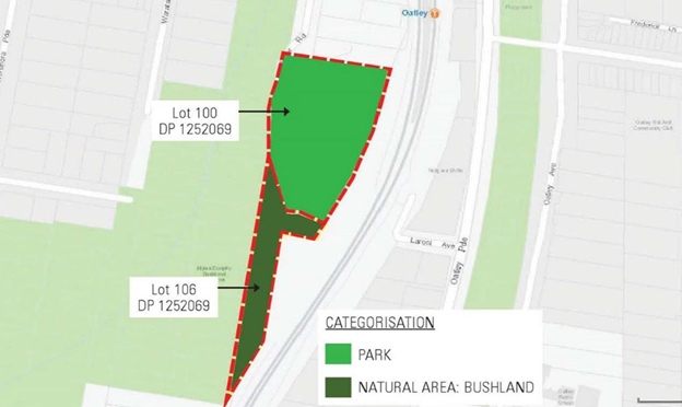
Proposed Categorisation
|
Land Parcel |
Previous Categorisation |
Proposed Category in the new Plan of Management |
|
Lot 100 DP 1252069 |
Natural Area - Bushland |
Park |
|
Lot 106 DP 1252069 |
Natural Area - Bushland |
Natural Area - Bushland |
34. Under Section 40A of the LG Act Council was required to hold a public hearing into the proposed re-categorisation of the Former Oatley Bowling Club (Lot 100 DP 1252069), which is currently categorised ‘Natural Area – Bushland’ under the Generic Plan of Management - Natural Area.
35. The public hearing was held on 19 April 2021. Six community members attended the public hearing and ten submissions were received as questions during the public hearing and a further four submissions were received by Council via email following the public hearing.
36. The following table provides a summary of the key issues raised in the submissions.
Summary of key issues raised in the Public Hearing
|
Summary of key issues raised by submissions
|
Summary of key issues raised in the Public Hearing |
|
The site should be retained as a natural area and established as bushland. The site provides an important corridor for wildlife habitat.
Other sites within the local government area already have the same additions which are proposed for this natural area. The need for more facilities is questioned, as opposed to the retention of a passive space. |
The current Plan of Management for Myles Dunphy Reserve (prepared by the former Hurstville Council) does not apply to the former Oatley Bowling Club site as it was determined that the site could no longer be classified as land representative of a Natural Area. The site was cleared and developed as a bowling club and greens and therefore did not possess the necessary natural features to permit a Natural Area categorisation.
Furthermore, the overwhelming feedback from the community during the consultation phase of the current draft PoM and Landscape Master Plan, found that the vast majority of respondents supported the recategorisation of land to a ‘Park’ to allow a variety of passive and active recreational activities and community amenities for all ages to be provided at the site.
|
|
Bushland category for lot 106 is not in the best interest of the community. |
Retaining Lot 106 as Natural Area – Bushland category responds to the adjacent natural area of bushland. This land is not suitable to be categorised as a Park and will be retained as bushland.
|
|
Does categorisation change the management of the land? |
The ‘Park’ component of the site will no longer be managed as a ‘Natural Area Bushland’. The core objectives under the Act for the management of community land categorised as a ‘Park’ are: a) to encourage, promote and facilitate recreational, cultural, social and educational pastimes and activities, and b) to provide for passive recreational activities or pastimes and for the casual playing of games, and c) to improve the land in such a way as to promote and facilitate its use to achieve the other core objectives for its management.
|
|
What is the maximum/greatest level of development that would be acceptable under natural areas – bushland? |
The core objectives of the Natural Areas category aim to conserve and maintain land in its natural (unmodified) state. Community use and access to natural land should not cause disturbance or intrusion. As such the level of future development permitted within that category would be minimal to allow management objectives to be met.
|
|
Why is there a need to change the categorisation? |
The draft Plan of Management proposes to recategorise part of the site from Natural Area Bushland to Park to allow the recreational uses, community garden and amenities proposed under the draft Landscape Master Plan.
|
|
Could commercial activities on the site if it is categorised as park?
|
The draft Plan of Management and draft Landscape Master Plan do not propose any commercial activities at the site.
|
|
Is commercial leasing permitted under a Park category? |
Any future commercial activities would require prior approval by Council and consideration of the adopted Plan of Management.
|
|
Could the proposed community garden at the site be commercially leased |
The community garden is not proposed to be managed under a commercial lease arrangement at this time. However, in all circumstances management will be coordinated by Council.
|
|
What can ‘Natural Areas’ be sub categorised under the Act? |
Natural sub categories under the Act are limited to: · bushland, · wetland, · escarpment. · watercourse. · foreshore OR a category prescribed by the regulations.
The Local Government (General) Regulations do not provide any additional categories.
|
|
Suggest the inclusion of the Mortdale men’s shed on the old bowling site; supports the idea of a community garden; recommends inclusion of a coffee stall; and considers the play area is not necessary given Jubilee Park proximity.
|
The submission is noted but is not supported as the draft Landscape Master Plan does not include any built structure or premises that could accommodate the men’s shed or a coffee stall. |
|
There are too many proposed activities in the Master Plan. |
The submission is noted. The proposed recreational uses aim to cater for a range of age groups and users appropriate to the size and layout of the site. Active uses have been balanced through the inclusion of separate passive areas within the park.
|
37. The public hearing report supports the re-categorisation of the Former Oatley Bowling Club site to ‘Park’. A copy of the public hearing report is attached (Attachment 2).
Financial Implications
38. Preparation of the POM and Masterplan was within budget allocation.
Risk Implications
39. No risks identified.
Community Engagement
40. The draft Plan of Management and Master Plan were placed on community consultation from 3 March to 31 March 2021 with submissions received to 14 April 2021. As part of the community consultation the following was undertaken:
a) Inclusion on Council’s Your Say web page;
b) Letters to adjoining landowners; and,
c) Letters to community members that attended the visioning workshop,
d) Online webinar held on 16 March 2021.
Next Steps
41. If Council resolves to adopt the Former Oatley Bowling Club and Closed Road Plan of Management and Master Plan as amended the next steps will be as follows:
a) The Plan of Management and Master Plan will be placed on Council’s website; and
b) Submitters will be advised of the adoption of the Plan of Management and Master Plan.
c) A notice of Council’s decision will be published on its website within 28 days after the decision is made.
File Reference
19/101
|
Attachment ⇩1 |
Summary of Public Submissions Received |
|
Attachment 2 |
Public Hearing Report - Former Oatley Bowling Club May 2021 - published in separate document |
|
Attachment 3 |
Former Oatley Bowling Club Plan of Management June 2021 - published in separate document |
|
Attachment ⇩4 |
Former Oatley Bowling Club Landscape Master Plan 2021 |
|
Georges River Council - Environment and Planning - Monday, 12 July 2021 ENV032-21 Adoption of Former Oatley Bowling Club Plan of Management and Master Plan 2021 [Appendix 1] Summary of Public Submissions Received |
Page 1 |
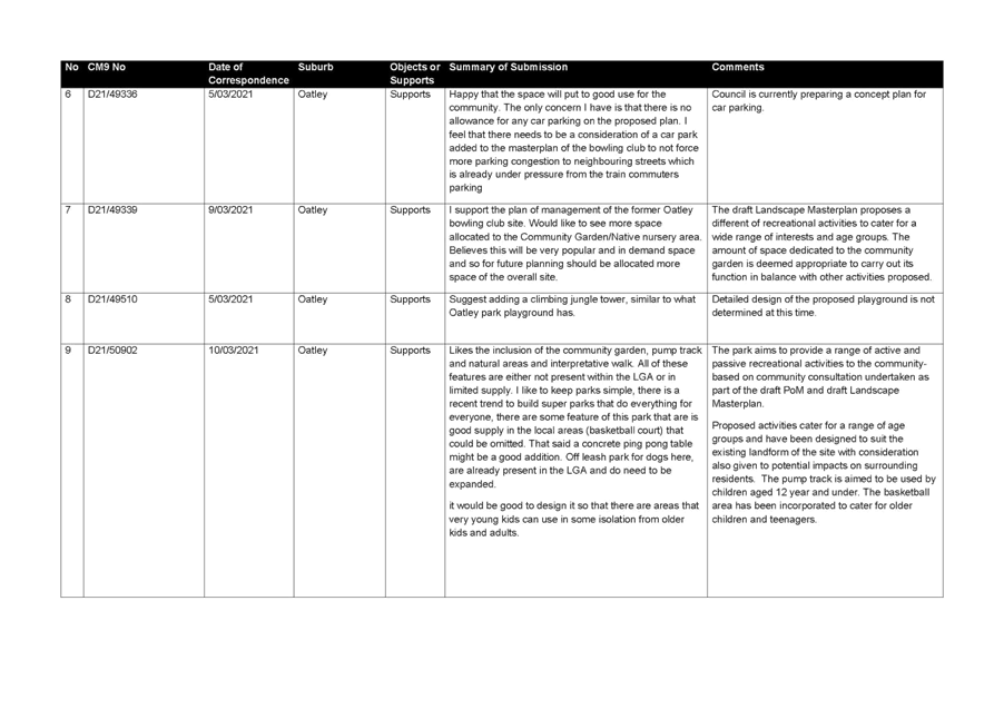
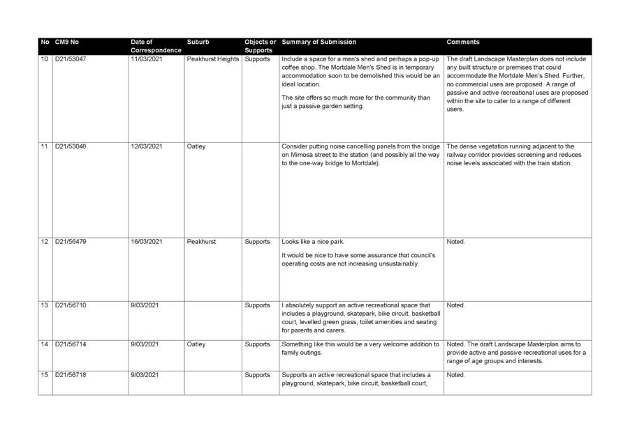
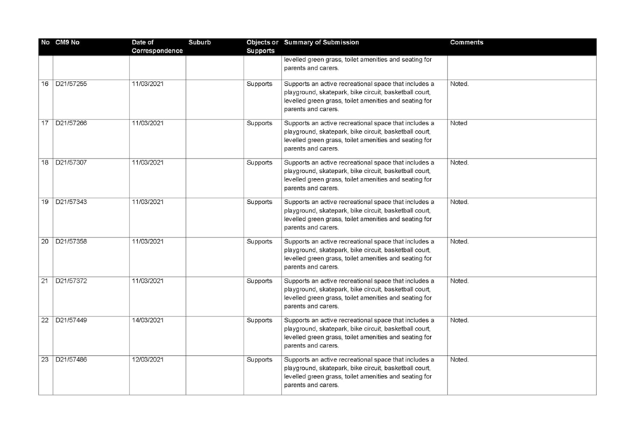
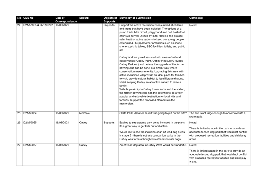
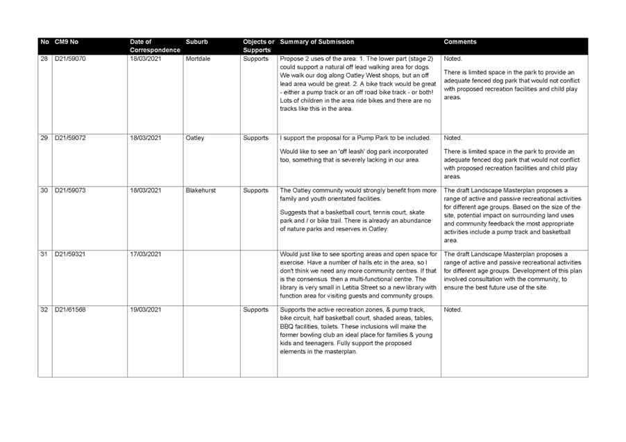
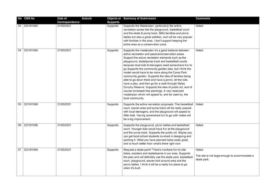
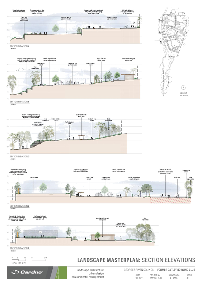
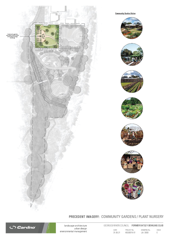
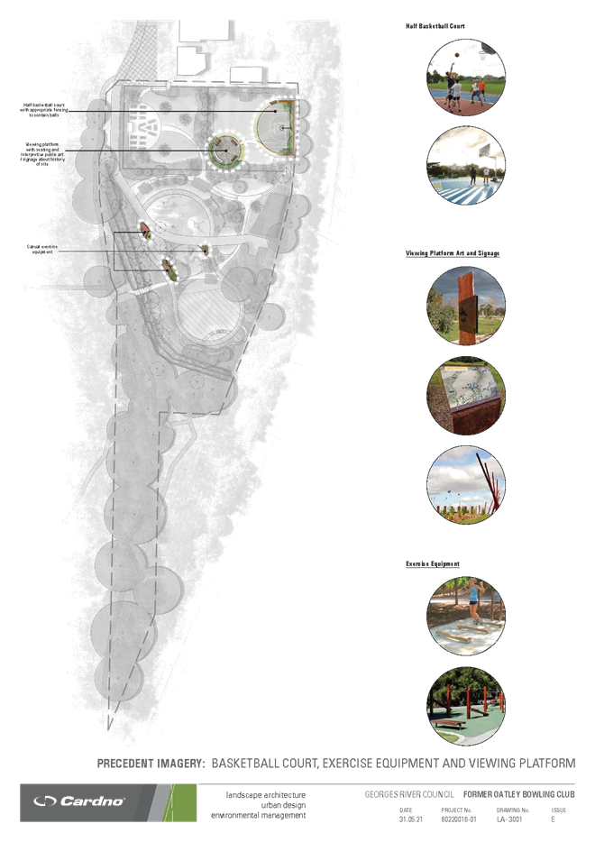
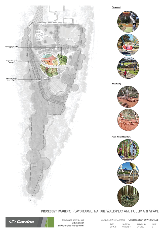
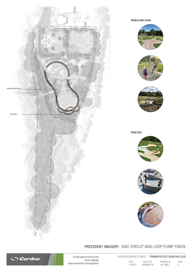
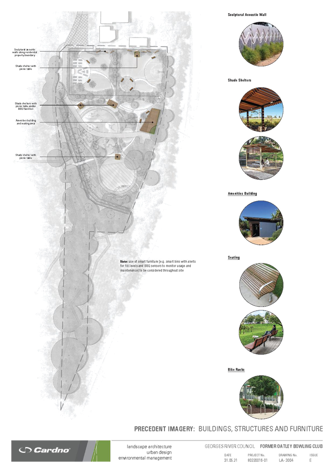
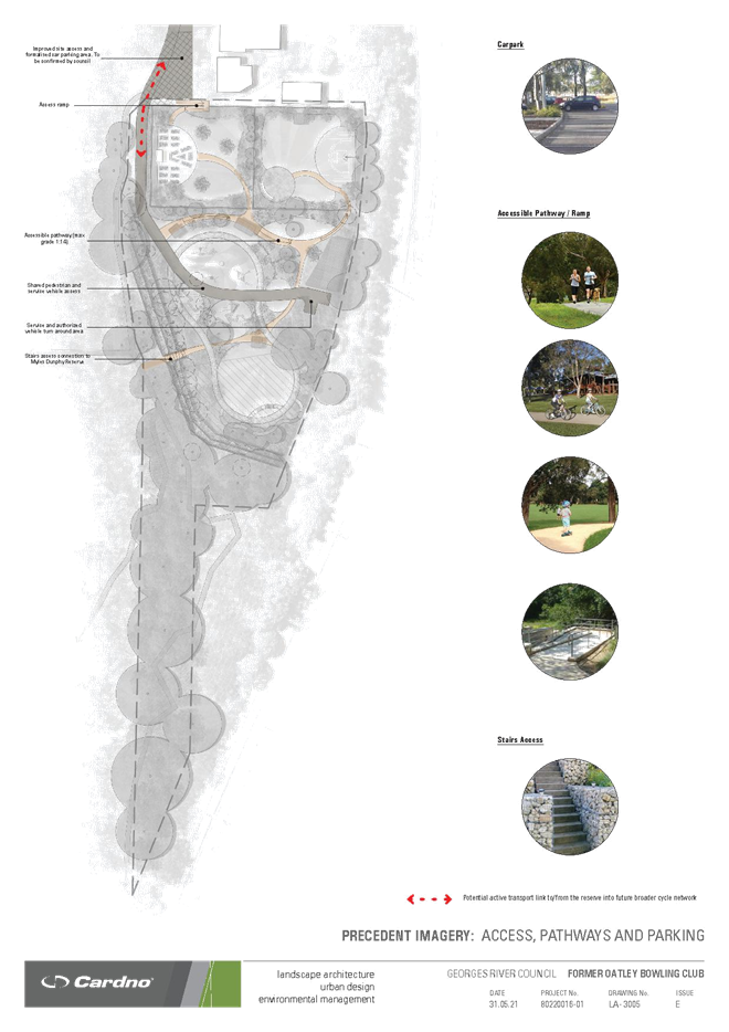
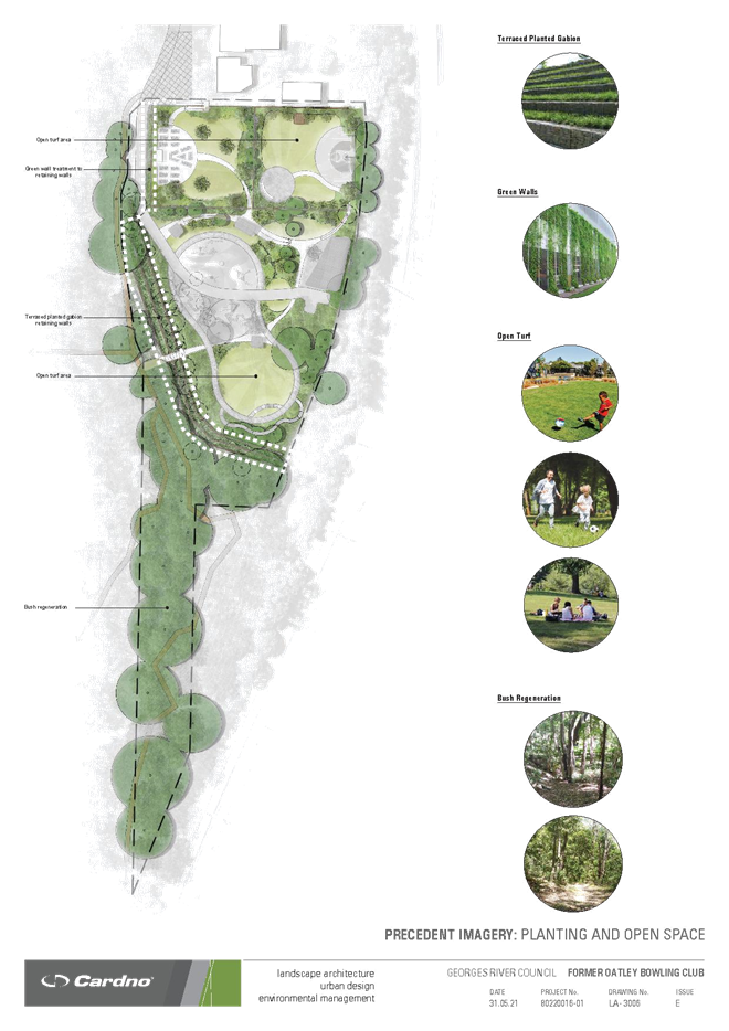
Item: ENV033-21 Establishment of Small Waste Items Recycling Station Program
Author: Manager Environment Health & Regulatory Services
Directorate: Environment and Planning
Matter Type: Committee Reports
|
(a) That Council note the outcomes of the trial of the small waste items recycling station in the Georges River Customer Service Centre. (b) That Council endorse the establishment of the Small Waste Items Recycling Station Program within suitable Council facilities for the collection of CDs/DVDs, household batteries and mobile phones. |
1. Council at its meeting on 27 July 2020, resolved:
(a) That a recycling station for small waste items be trialled for a six-month period at the Georges River Customer Service Centre.
(b) That a further report be provided to Council at the conclusion of the six-month trial which outlines the results of the recycling station trial.
2. This report provides results of the six-month trial which saw the collection and recycling of CDs/DVDs, household batteries and mobile phones at the Georges River Customer Service Centre.
3. The trial resulted in the collection of 125.2 kilograms of items, processed for recycling and diverted from landfill.
4. Overall, the trial of the small-scale recycling station has proven to be successful and the program is therefore recommended to become a permanent recycling service available at Council facilities.
5. Expansion of the program is recommended in two stages:
· Stage 1 involves recycling stations being implemented at Hurstville Library and Clive James Library by 31st December 2021
· Stage 2, pending the success of stage 1 implementation, may involve further expansion at other Council and/or community facilities such as Council-operated childcare centres.
6. By continuing to make community recycling services available in the community, Council is ensuring the delivery of key actions within the Waste Strategy 2021-2040, specifically: Objective 1.2 – Minimise environmental impact of waste management and disposal by investigating the potential to establish community recycling options such as regular drop off events and smaller permanent drop off options to improve the recycling of hazardous waste.
Report
7. Council at its meeting on 27 July 2020, resolved:
(a) That a recycling station for small waste items be trialled for a six-month period at the Georges River Customer Service Centre.
(b) That a further report be provided to Council at the conclusion of the six-month trial which outlines the results of the recycling station trial.
8. To assist in the development of the trial the following definitions of primary terms referred to within the resolution are as follows:
· Small waste items: often hazardous waste including mobile phones, household batteries, printing cartridges and CDs.
· Recycling station: an integrated facility at a designated location whereby multiple small waste items can be dropped off by community members for recycling.
9. The provision of small waste items recycling was trialled for a 6-month period, commencing on 1 December 2020 and currently remains operating. A photo of the recycling station operating from the Georges River Customer Service Centre is included in Figure 1 below.
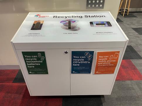
Figure 1: Small scale recycling station at the Georges River Customer Service Centre
10. To ensure neat and organised collection of a range of separated small waste items, it is best-practice to provide clear instruction and signage for the collection of certain materials for recycling. Council developed custom signage to assist the community in using the recycling station and undertook regular waste education activities to continually promote the small-scale recycling station trial to the community.
11. Prior to installing the recycling station, Council assessed quotations provided by suitably qualified specialist problem waste contractors who could undertake collection and processing of the small-scale recycling items. The engagement of the suppliers to date has been successful, with the required collection and resource recovery service being performed to enable the success of the trial. Suppliers may vary from time to time as Council ensures maximum resource recovery and responsible processing of the collected waste items by the relevant contractors.
12. During the trial items have been collected and processed for recycling, as outlined within Table 1.
Table 1: Small Scale Recycling Trial Results
|
Volume Collected during the Trial to 31 May 2021 (kilograms) |
Total Cost to Collect and Recycle Materials ex GST ($) |
Resource Recovery Rate (%) |
|
|
CDs/DVDs |
165 |
$484.00 |
71% |
|
Household batteries |
78 |
$195.00 |
71% |
|
Mobile phones |
5.2 |
$0.00 |
95% |
|
Trial Total |
248.2 |
$679.00 |
- |
13. Further, Council has received positive feedback and support from the community who have indicated their support for the program.
14. Given the availability of suppliers to provide the collection and recovery services, the positive support from the community and given the separation of the small items contributes to Council’s aims to reduce waste to landfill and increase recycling, it is recommended that the trial continue and be expanded to other Council sites as outlined below.
15. Council officers will collaborate to progress the implementation of the recycling stations throughout eligible facilities. This expansion will be delivered under a staged approach.
16. Stage 1 of the implementation is proposed during the 2021/22 financial year via the launch of recycling stations at the following libraries:
· Hurstville Library
· Clive James Library
17. It is expected Stage 1 will be implemented by 31 December 2021.
18. Stage 2, pending the success of stage 1, may involve further expansion at other Council and/or community facilities (such as Branch libraries and Mortdale Community Centre), dependent on any site-specific space constraints, expected patronage and utilisation of the stations compared with the results obtained during Stage 1. Consideration of further expansion under Stage 2 will be completed by 30 June 2022.
19. The locations and facilities hosting a small-scale recycling station may change from time to time, based on facility support and/or community needs/patronage. The locations of small-scale recycling stations will be assessed and determined by the Environmental Sustainability and Waste team, in partnership with relevant facility managers.
20. As services are expanded, the location(s) of small-scale recycling stations will be promoted to the community and facility users in order to maximise recycling and reduce waste to landfill. Council will continue to make details of the small-scale recycling services available through its website, social media platforms and other widespread communications platforms.
21. Council’s Waste Strategy 2021-2040 encourages delivery of community recycling services to maximise resource recovery and reduce waste to landfill. Council is improving amenity and environmental management within the Local Government Area by enhancing access to the small-scale recycling stations and meeting Objective 1.2 of the Waste Strategy 2021-2040: Minimise environmental impact of waste management and disposal, by investigating establishing community recycling drop-off events/options to minimise illegal dumping and improve recycling of hazardous waste.
Financial Implications
22. The capital cost to purchase one recycling station, including delivery, is $2,324 (ex GST).
23. The cost for collection and processing of the CDs/DVDs, household batteries and mobile phones varies between contractors and as such, may vary from time to time. Additionally, the costs to process the materials collected depends on the volume of materials collected. Approximate annual operating costs for the collection and processing of materials based on the trial data can be calculated at $680 (ex GST).
24. Therefore, the approximate costs for each recycling station are as follows:
· Year one: $3,000 (ex GST)
· Year two and each year thereafter: $680 (ex GST).
25. The cost of installing the two additional stations and the ongoing annual cost to operate the three stations (total of $2,000) will be funded from the Domestic Waste Reserve.
Risk Implications
26. Operational risk/s identified and management process applied.
Community Engagement
27. Community engagement to promote the recycling station was conducted including:
- Regular engagement and promotion through Council’s social media channels.
- Continued promotion of the A-Z Recycling Guide on Council’s website to encourage community awareness and support of the recycling stations.
- Promotion in Council’s e-newsletter (community distribution).
- Promotion on Council’s digital posters in the Council Customer service centre foyer, Hurstville Plaza and Libraries (Hurstville Library and Clive James Library in Kogarah).
- Promotion in Council’s annual waste services guide and calendar.
28. Community promotion of the small-scale recycling service will continue through a range of channels to encourage resource recovery and reduce waste to landfill, and to continually encourage community use of the services.
File Reference
SF21/24, D21/150355
Georges River Council – Environment and Planning - Monday, 12 July 2021 Page 1
Item: ENV034-21 PP2016/0002 - Amended Planning Proposal for the Hurstville Civic Precinct
Author: Senior Strategic Planner, Manager Strategic Planning and Independent Assessment
Directorate: Environment and Planning
Matter Type: Committee Reports
|
a. Amend the HLEP 2012 Land Zoning Map - Sheet LZN_008A to remove the ‘Deferred Matter’ and rezone the site to B4 Mixed Use; b. Amend the HLEP 2012 Height of Buildings Map - Sheet HOB_008A to set: i. a maximum height of 20 metres under the height designation of ‘Q1’ at the south western portion of the site; ii. a maximum height of 30 metres under the height designation of ‘U’ at the south western corner of the site; and iii. a maximum height of 60 metres under the height designation of ‘AA’ at the north eastern portion and south eastern corner of the site. c. Amend the HLEP 2012 Maximum Floor Space Ratio Map - Sheet FSR_008A to set: i. a maximum FSR of 3:1 under the FSR designation of ‘V’ at the south western portion of the site; ii. a maximum FSR of 7:1 under the FSR designation of ‘AB’ at the central/ north eastern portion of the site; and iii. a maximum FSR of 5:1 under the FSR designation of ‘Z’ at the north eastern portion of the site. d. Amend Schedule 4 of HLEP 2012 to reclassify Lot 13 in DP 6510 and Lot 14 in DP 6510 (i.e. former Baptist Church and adjoining land, known as 4-6 Dora Street) from ‘community’ to ‘operational’ land. e. Amend HLEP Active Street Frontages Map - Sheet ASF_008A by deleting the red line identifying 4-6 Dora Street (Lot 13 in DP 6510 and Lot 14 in DP 6510) as having active street frontage. f. Amend HLEP 2012 by including the heritage item (Item I157) listed in Schedule 2 of the HLEP 1994 within Schedule 5 (Environmental heritage) of HLEP 2012 and amend Heritage Map - Sheet HER_008A to identify the same Item on the map. g. Amend HLEP 2012 by inserting a development standard under Part 6 Additional Local Provision as follows:
6.10 Hurstville Civic Precinct (1) The objective of this clause is to facilitate the provision of community facilities and public benefits on the Hurstville Civic Precinct site. (2) This clause applies to land bounded by Queens Road, Park Road, MacMahon Street and Dora Street. (3) Development consent must not be granted on land to which this clause applies unless the consent authority is satisfied that the development will include: (a) Residential land uses to a maximum of 55% of the total permissible GFA; and (b) Community uses and facilities to a minimum of 25% of the total permissible GFA; and (c) Public open space at ground level to a minimum of 50% of the total site area inclusive of a civic plaza that receives an average of 50% direct sunlight between 11 am and 2pm midwinter; and (d) Car parking for general public use that is additional to the requirements for all land uses. (4) For the purposes of this clause, community facilities for Hurstville Civic Precinct site means Council administrative and civic offices; multipurpose auditorium, library, museum, art gallery, community centre, associated uses such as cafés; a range of recreation, relaxation or study areas; and any other use that Council may consider appropriate to meet the needs of the community. (b) That Georges River Council forward the Planning Proposal (PP 2016/0002) to the delegate of the Minister for Planning requesting a Gateway Determination under Section 3.34 of the Environmental Planning and Assessment Act 1979 (EP&A Act). (c) That should a Gateway Determination be issued by Department of Planning, Industry and Environment to permit exhibition of the Planning Proposal, a public hearing take place in accordance with the provisions of the NSW Local Government Act 1993 and the DPIE’s Practice Note PN 16-001 Classification and Reclassification of Public Land through a Local Environmental Plan. (d) That the Planning Proposal be placed on formal public exhibition in accordance with the conditions of any Gateway Determination issued by the Department of Planning, Industry and Environment. (e) That prior to the public exhibition of the Planning Proposal as part of any successful Gateway determination, the following documents are prepared by the Proponent in order that they form part of the public exhibition: a. A Civic Precinct Public Amenities and Facilities Strategy. b. A Civic Precinct Public Domain Plan Strategy. c. A Conservation Management Plan (CMP) prepared for the Hurstville City Museum and Gallery; and d. A revised Traffic Impact Assessment. (f) That Council resolve to prepare an amendment to the Hurstville DCP No. 2 (which applies to land within the Hurstville City Centre) and exhibit the amendment along with the Planning Proposal in accordance with the provisions of the Environmental Planning and Assessment Act 1979 and its Regulation. (g) That prior to the exhibition of the amendment to the Hurstville DCP No. 2 the DCP prepared by the Proponent be amended by the Proponent to address the recommendations in this report and the recommendations of the Council Report dated 25 May 2020. |
Executive Summary
1. This report provides an assessment of an amended Planning Proposal request (for PP 2016/0002) submitted by Georges River Council in June 2021 for the changes to the Hurstville Local Environmental Plan (HLEP) 2012 for Council owned land bound by Queens Road, Dora Street, MacMahon Street and Park Road, Hurstville (subject site – known as the Hurstville Civic Precinct). A copy of the amended request is contained in Attachment 1 to this report.
2. In summary, the amended Planning Proposal seeks to amend the Hurstville Local Environmental Plan 2012 to address the ‘Deferred Matter’ status of the site and to achieve the necessary land classification, land use zoning, building height and floor space ratio to enable the future redevelopment of the existing Hurstville Civic Precinct in a manner that is commensurate with the amended Civic Precinct Masterplan Concept Design Report dated 25 May 2021 prepared for the site. Refer to Attachment 3 for the amended concept design.
3. The Planning Proposal as amended remains consistent with the stated Objectives and Intended Outcomes as detailed within the previous Planning Proposal considered and endorsed by Council on 25 May 2020 (refer to Item CCL029-20).
4. The proposed amendments relate to attaining an improved solar access outcome to properties to the south of the site in Dora Street. This has been achieved through the redistribution of building height at the southern end of the site. That is, the previous 48m building height control across the southern end of the site has been reconfigured to a 20m 30m and 60m control along the southern end of the site.
5. When developed in accordance with the revised proposed building heights, the site will facilitate significantly greater solar access to residential apartments in the mixed use building at 9 Dora Street when compared to the current proposed 48m control.
6. It is recommended that the Council support the amended Planning Proposal and forward it to the delegate of the Minister for Planning and Public Spaces requesting a Gateway Determination under Section 3.34 of the Environmental Planning and Assessment Act 1979.
7. This report also seeks Council’s endorsement for the exhibition of the Planning Proposal and the accompanying DCP Amendment.
8. Prior to the exhibition of the DCP Amendment the Proponent will be required to update its Site Specific DCP to address the recommendations in this report and the recommendations of the Council Report dated 25 May 2020.
9. Given Council is the owner of the site, Council engaged an independent town planning consultant (SJB Planning) to undertake the assessment of the Planning Proposal.
BACKGROUND
10. The Planning Proposal was previously reported to Council on 25 May 2020. Council resolved at that meeting to endorse the Planning Proposal subject to the recommendations of the Council Report (refer to Item CCL029-20 of the Council Business paper dated 25 May 2020) requiring amendments to the Planning Proposal prior to it being forwarded for a Gateway Determination.
11. Those amendments were undertaken and the Planning Proposal was forwarded to the Department of Planning, Industry and Environment (‘DPIE’) with a request for a Gateway Determination in August 2020.
12. In assessing the Planning Proposal, the DPIE sought clarification and additional information relating to the solar access impacts.
13. Upon receipt of further information, the DPIE indicated that Council should consider revising the Planning Proposal to improve solar access provision to neighbouring development at the southern side of Dora Street by considering options to redistribute the building height of Building D (at the southern end of the site) to the corner of Queens Road and Dora Street.
14. Due to the expected timeframes involved in further solar access testing and revision of the Planning Proposal, the DPIE suggested that the Council withdraw the Gateway request to enable resubmission of an amended Planning Proposal at a later date.
15. On 19 February 2021 Council withdrew the Gateway Request.
16. The proponent subsequently provided detailed solar analysis which showed the following in regard to the design of built form along the southern boundary of the site:
a. The mixed use building to the south of the Hurstville Civic Precinct site at 9 Dora Street currently receives solar access to 68% of apartments at the winter solstice between the hours of 9am and 3pm.
b. This would reduce to 3% under the heights in the endorsed Planning Proposal (i.e. whereby the building height is a maximum height of 48 metres at the south western portion of the site).
c. The DPIE’s suggested relocation of building height to a single tower with podium in the south west corner would result in solar access to approximately 20% of apartments at 9 Dora Street at the winter solstice between the hours of 9am and 3pm.
d. A two tower option (over a lower level podium) prepared as an alternative, where by thinner towers are positioned in the south east corner and south west corner of the site, would result in solar access to approximately 50% of apartments at 9 Dora Street at the winter solstice between the hours of 9am and 3pm.
17. In regard to solar access to the new Civic Plaza, it is noted that the solar access analysis demonstrates that the reconfigured building heights will affect sunlight to the Plaza. However, the solar analysis presented indicates that the Plaza will be able to achieve solar access to a minimum 50% of the Plaza area on average between 11am and 2pm on the winter solstice.
18. Whilst this varies from the previous draft requirement of a minimum 50% for 2 hours between 12 noon and 2pm, it is nonetheless considered acceptable and appropriate as it will result in the Civic Plaza having sunlight for a longer period in the middle of the day at the winter solstice, when people (i.e. office workers and visitors) are more likely to use the Plaza and benefit from the sunlight.
19. As an outcome of the solar analysis the applicant was requested to formally amend the Planning Proposal to ensure a greater level of solar access provision to neighbouring development of the southern side at Dora Street.
THE AMENDED PLANNING PROPOSAL
20. The proponent submitted the final amended Planning Proposal package in June 2021. The key amendments proposed to the Planning Proposal are:
· Adoption of the ‘two tower’ approach requiring a change to the height of buildings at the south western end of the site as demonstrated in the Maps below in Figures 1 and 2; and
· A change in the wording of proposed Clause 6.10 of HLEP 2012 subsections (c) and (d) relating to the minimum amount of sunlight to be received to the Civic Plaza and the deletion of a reference to DCP requirements for car parking.
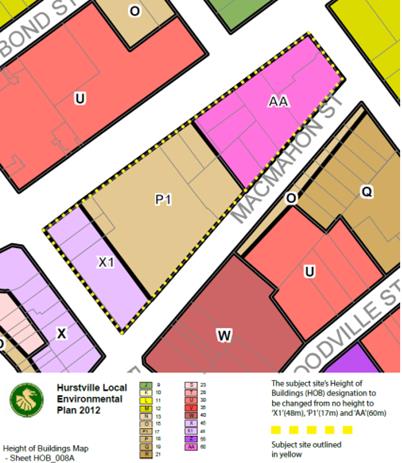
Figure 1: Maximum Height of Buildings Map as previously proposed
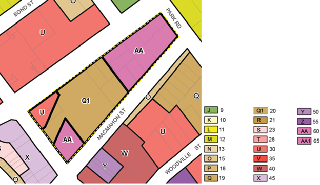
Figure 2: Maximum Height of Buildings Map as now proposed
21. The proponent has also taken the opportunity to revise the Planning Proposal in response to changes to s9.1 Ministerial Directions (relating to contamination land) and refinement of the strategic justification within the Planning Proposal having regard to the Georges River LSPS 2040. Other housekeeping revisions have been made to the Planning Proposal. These revisions to the wording of the Planning Proposal have not resulted in any further proposed amendments to the HLEP 2012 itself.
22. The amended Planning Proposal (in Attachment 1) is supported with an updated Concept Design Report (in Attachment 3) and an updated draft site-specific Development Control Plan (in Attachment 2).
23. The updated Concept Design Report includes further detailed analysis of the built forms along the south western edge of the site and describes in detail the solar access impacts for adjacent properties including but not limited to 9 Dora Street.
24. Council is advised that the DCP lodged by the proponent (and dated 25 May 2021) will need to be updated in light of both the recommendations of the Council Report dated 25 May 2020 and this report prior to it being placed on exhibition.
25. The applicant’s response is considered appropriate and the proposed amendments to the Planning Proposal and the accompanying DCP have been included as recommendations within this report. A detailed discussion of the solar impacts is covered in Paragraphs 31 to 52 of this report.
26. The Planning Proposal remains consistent with the proposal as endorsed by Council on 25 May 2020 other than for a change in proposed building heights to the south western end of the site and amendments to proposed Clause 6.10 subsections (c) and (d).
27. The proposed revision to proposed Clause 6.10 is shown below, with the changes identified in red.
6.10 Hurstville Civic Precinct
(1) The objective of this clause is to facilitate the provision of community facilities and public benefits on the Hurstville Civic Precinct site.
(2) This clause applies to land bounded by Queens Road, Park Road, MacMahon Street and Dora Street.
(3) Development consent must not be granted on land to which this clause applies unless the consent authority is satisfied that the development will include:
(a) Residential land uses to a maximum of 55% of the total permissible GFA; and
(b) Community uses and facilities to a minimum of 25% of the total permissible GFA; and
(c) Public open space at ground
level to a minimum of 50% of the total site area, inclusive
of a civic plaza that receives a
minimum an average of 50% direct sunlight between 12 11 noon
am and 2pm midwinter;
and
(d) Car parking for general public use that is additional to the requirements for all land uses.
(d) Car parking for all land uses
in accordance with the requirements
of the relevant Development Control Plan plus additional car parking
for general public use.
(4) For the purposes of this clause, community facilities for Hurstville Civic Precinct site means Council administrative and civic offices; multipurpose auditorium, library, museum, art gallery, community centre, associated uses such as cafés; a range of recreation, relaxation or study areas; and any other use that Council may consider appropriate to meet the needs of the community.
28. The proposed amended maps are illustrated in Figures 3, 4 and 5 below:
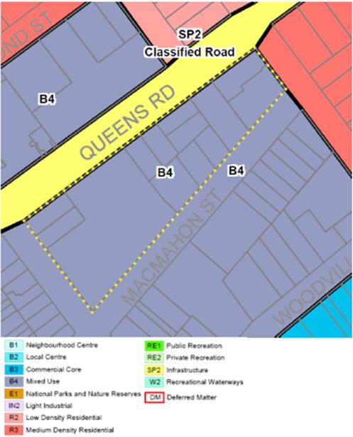
Figure 3: Extract of proposed Hurstville Local Environmental Plan 2012 Land Zoning Map - Sheet LZN_008A to remove the ‘Deferred Matter’ and rezone the site to B4 Mixed Use.
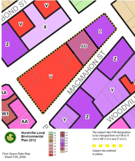
Figure 4: Extract of proposed Hurstville Local Environmental Plan 2012 Maximum Floor Space Ratio Map - Sheet FSR_008A
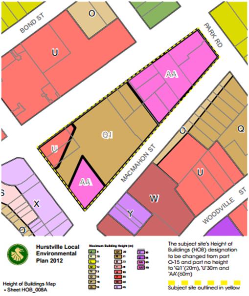
Figure 5: Extract of proposed Hurstville Local Environmental
Plan 2012 Height of
Buildings Map - Sheet HOB_008A
ASSESSMENT OF THE PLANNING PROPOSAL
Strategic Planning Context and Framework
29. The proposed revisions to the Planning Proposal effectively related to the reconfiguration of building height at the south western end of the site and do not alter the intended outcomes, the objectives or the justification for the proposal.
30. As such the detailed assessment undertaken in Part 5 of the Council Report dated 11 May 2020 remains valid and pertinent to the amended Planning Proposal, particularly as it relates to the proposal’s consistency with the relevant and applicable strategic planning framework and statutory considerations.
Urban Design Analysis
31. The key aspects of the proposed revision to the Planning Proposal relate to the outcomes of the redistributed building height at the site upon adjacent development and the proposed public open space in the Civic Plaza.
32. The proponent provided detailed solar access models and drawings to demonstrate that the previously proposed 48m height control along the southern edge of the site (adjacent to Dora Street) could potentially result in a situation where the solar access to the residential apartments in the mixed use development at 9 Dora Street could be reduced to 3% from its current 68%.
33. Upon request to consider solutions to reduce this impact, a reduction of height through the middle of the southern boundary (i.e. a reduction from the proposed 48m height limit) and placement of height at the south west and south east corners of the site was undertaken that would allow significantly greater solar access to residential apartments at 9 Dora Street.
34. This approach effectively created a void in the built form through the centre of the site at the southern end as can be seen in the Sun Eye Diagram submitted with the amended Concept Design Report – refer to Figure 6.
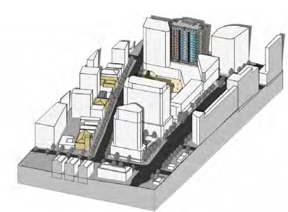
Figure 6: Extract from 10am drawing in the Sun Eye Diagrams in Section 4.9 of the Concept Design Report.
35. The solar analysis is outlined in the amended Planning Proposal under Section 3.3 (refer to Attachment 1) and in detail within the updated Concept Design Report (refer to Attachment 3) under section 4.9 (Controls - Sun Study, Winter Solstice June 21).
36. The analysis demonstrates that at the winter solstice between the hours of 9am and 3pm, the building at 9 Dora Street:
a. currently receives solar access to 68% of apartments,
b. This would reduce to 3% under the endorsed Planning Proposal (i.e. whereby the building height is 48m at the south western portion of the site).
c. The proposed “two tower” option results in 50% of the apartments at 9 Dora Street receiving 2 hours sunlight
37. The two tower option effectively redistributes or breaks the existing proposed 48m building volume, which runs along the south western boundary, into three components.
38. The three components are a 20m podium across the south western edge with two towers above, one in each corner (i.e. Building D1 and D2).
39. Figures 7 and 8 below are extracts from the amended Concept Design Report and show the proposed redistributed building height with D1 in the south eastern corner at 60m in maximum height and building D2 in the south west corner at a maximum height of 30m.
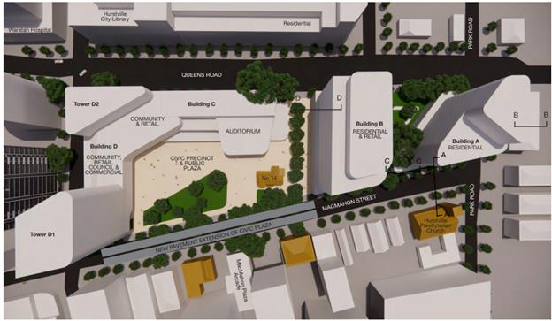
Figure 7: Extract from Section 4 “Masterplan” of the amended Hurstville Civic Masterplan Concept Design Report prepared by DWP.
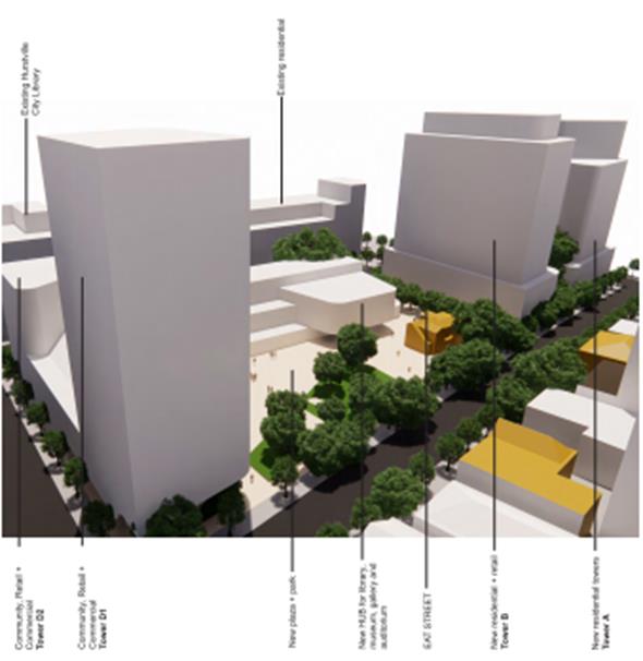
Figure 8: Extract from Section 4 “Masterplan” of the amended Hurstville Civic Masterplan Concept Design Report prepared by DWP
40. The Concept Design Report (in Section 4.9) indicates that this scenario will not require any change to the proposed FSR controls across the site, such that the same amount of gross floor area can be captured within the reconfigured building envelopes.
41. The analysis also indicates that the change in height as proposed will not have a significant adverse impact upon other nearby properties in regard to solar access as summarised from the Planning Proposal and Concept Design Report and are summarised below:
a. 15 Dora Street - New Mixed Use Shop Top Housing Building
There is a minor overshadowing effect on the Dora Street façade, which by 10am is minimal and 11am has no effect.
b. 33 MacMahon Street - Strata Commercial Building
This building will continue to receive good solar access between 9:00am and 12:00pm at the winter solstice.
c. 34 MacMahon Street - Council owned commercial building
This building is disadvantaged by is setback behind the building line of 9 Dora Street. However, it receives direct sun between 11:00am and 12;30pm and the small public space in front of the building receives sunlight between 11:00am and 1:30pm, noting that the new civic plaza will offset any effects of solar access to this space.
d. 350 Forest Road - Ritz Hotel Building
Reasonable solar access between 9:15 am and 10:15am. Partial solar access between 12:00noon and 1:30pm. Then reasonable solar access to the main part of the building between 1:00pm and 3:00pm.
42. The above analysis is demonstrated in the solar access analysis in Section 4.9 of the revised Concept Design Report.
43. Notwithstanding that the concept as proposed will reduce the solar access to 9 Dora Street by approximately 25% from its existing situation; the outcome represents a significant improvement to the outcome that would otherwise be achieved under the currently endorsed Planning Proposal.
44. Under the circumstances the outcome is considered reasonable and appropriate. The site will deliver significant public benefit and holds a strategic, central position within an existing and emerging high-rise CBD.
45. It is noted that reconfiguring the proposed height of buildings at the south western end of the site raised several other key issues including the retention of solar access to the proposed new Civic Plaza and the retention of a visual connection to the Civic Plaza from the main pedestrian routes towards the south (i.e. the direction of the station). These have also been addressed by the proponent within the amended Planning Proposal (refer to Attachment 1).
46. Specifically, the amended Draft DCP (Attachment 2) under the provisions relating to Building D sets out the requirement for:
“a direct visual link and pedestrian connection into the Civic Plaza from the Dora Street/ MacMahon Street/ Barratt Street intersection that is publicly accessible in perpetuity. This may occur through setting back of the lower levels of Building D from MacMahon Street to provide a generously elevated undercroft.”
47. In regard to solar access to the new Civic Plaza, it is noted that the solar access analysis demonstrates that the reconfigured building heights will affect sunlight to the Plaza. However, the solar analysis indicates that the Plaza will be able to achieve solar access to a minimum 50% of the Plaza area on average between 11am and 2pm on the winter solstice.
48. Whilst this varies from the previous draft requirement of a minimum 50% for 2 hours between 12 noon and 2pm, it is nonetheless considered acceptable and appropriate as it will result in the Civic Plaza having sunlight for a longer period in the middle of the day at the winter solstice, when people (i.e. office workers and visitors) are more likely to use the Plaza and benefit from the sunlight.
49. The amended Planning Proposal seeks to amend the local provision relating to solar access over the plaza to allow an average of 50% direct sunlight between 11 noon am and 2pm in midwinter. This is from a minimum of 50% direct sunlight between 12 noon and 2pm in mid winter. The draft provision will now read:
Development consent must not be granted on land to which this clause applies unless the consent authority is satisfied that the development will include:
(c) Public open space at ground level to a minimum of 50% of the total site area, inclusive of a civic plaza that receives an average of 50% direct sunlight between 11 am and 2pm midwinter;
50. In terms of other urban design outcomes and considerations, it is noted that the amended draft DCP submitted with the amended Planning Proposal has expanded the “Design Excellence” provisions under section 3.2 of the draft DCP.
51. The expanded DCP controls include a requirement for a Competitive Design Process for development within the Hurstville Civic Precinct, addressing a recommendation of the 25 May 2020 Council Report.
52. Combined with the proposed LEP provisions (which will ensure the community facilities are provided through a provision in Clause 6.10 which nominates specific areas for each community facility), the DCP controls will ensure a high level of design scrutiny and assessment for any future development within the Hurstville Civic Precinct.
Parking
53. The proposed amendments to the Planning Proposal also include a minor change to proposed Clause 6.10 subsection (d).
54. The change is in response to a DPIE concern which outlined that an Additional Local Provision in the LEP should not refer to a DCP provision. As such, the reference to the “requirements of the DCP” have been removed from this sub-clause, while noting that the clause still requires future development of the site to provide car parking for general public use which will be additional to the parking requirements for all land uses proposed at the site.
Endorsement of the amendment to the Hurstville Development Control Plan No. 2
55. An amendment to the Hurstville Development Control Plan No. 2 (which applies to land within the Hurstville City Centre) will need to be prepared and be placed on exhibition concurrently with the Planning Proposal. The DCP Amendment will be based on the Proponent’s Site Specific DCP dated 25 May 2021.
56. However this report recommends amendments to the Site Specific DCP that has been prepared by the Proponent prior to it being placed on public exhibition as part of any successful Gateway determination.
57. The DCP should be amended to be consistent with the recommendations outlined in the 25 May 2020 Council Report relating to provisions for active street frontages, deep soil, sustainability targets, requirement for a Public Art Strategy and limiting trip generation through the provision of public and active transport facilities on site and enacting travel demand management measures. All of these matters have not been addressed fully within the Proponent’s Site Specific DCP dated 25 May 2021.
Other matters
58. As previously recommended in the Council Report dated 25 May 2020, the following documents will also be required to be prepared by the proponent so that they form part of the public exhibition:
a. A precinct wide Public Domain Plan Strategy.
b. A Conservation Management Plan (CMP) prepared for the Hurstville City Museum and Gallery, including exteriors, interiors and gardens.
c. A revised Traffic Impact Assessment
COMMUNITY CONSULTATION
59. Should the amended Planning Proposal be supported it will be forwarded to the delegate of the Greater Sydney Commission requesting a Gateway Determination.
60. If a Gateway Determination (Approval) is issued, and subject to its conditions, it is anticipated that the Planning Proposal will be exhibited for a period of 28 days in accordance with the provisions of the Environmental Planning and Assessment Act 1979 and Regulation 2000 and any requirements of the Gateway Determination.
NEXT STEPS
61. The anticipated project timeline for completion of the Planning Proposal is shown in the Table 1 – Next Steps below:
|
Task |
Anticipated Timeframe |
|
Report to
Environment and Planning |
July 2021 |
|
Report to Council on Planning Proposal |
July 2021 |
|
Forward Planning Proposal to the DPIE for Gateway Determination |
July 2021 |
|
Anticipated
commencement date (date of |
September 2021 |
|
Timeframe
for government agency |
October to November 2021 |
|
Commencement
and completion dates for |
October to November 2021 |
|
Dates for public hearing |
October to November 2021 |
|
Timeframe for consideration of submissions |
January – February 2022 |
|
Report to
Council on community consultation |
March 2022 |
|
Submission to the DPE to finalise the LEP |
March 2022 |
|
Anticipated date for notification |
May 2022 |
Table 1 - Next Steps
62. It is noted that the project timeline will be assessed by the DPIE and may be amended by the Gateway Determination.
FINANCIAL IMPLICATIONS
63. Within budget allocation.
RISK IMPLICATIONS
64. Operational risk/s identified and management process applied.
FILE REFERENCE
PP2016/0002
|
Attachment 1 |
Amended Hurstvile Civic Precinct Planning Proposal - 210607 - published in separate document |
|
Attachment 2 |
Amended Draft Site Specific Development Control Plan - 210525 - published in separate document |
|
Attachment 3 |
Amended Civic Precinct Masterplan Concept Design Report - 210525 - published in separate document |
Georges River Council – Environment and Planning - Monday, 12 July 2021 Page 3
Item: ENV035-21 PP2019/0003 - Planning Proposal for 143-149 Boundary Road and 689-691 Forest Road, Peakhurst
Author: Strategic Planner
Directorate: Environment and Planning
Matter Type: Committee Reports
|
(a) That Council endorse the Planning Proposal (PP2019/0003) to amend Hurstville Local Environmental Plan 2012 (or if gazetted the Georges River Local Environmental Plan), in relation to 143-149 Boundary Road and 689-691 Forest Road, to: i. Amend the Land Zoning (LZN) Map to rezone the Site from R2 – Low Density Residential to B1 – Neighbourhood Centre ii. Amend the Height of Buildings (HOB) Map to increase the height from 9m to part 12m and part 15m iii. Amend the Floor Space Ratio (FSR) Map to increase the maximum FSR from 0.6:1 to part 1.5:1 and part 1.7:1 iv. Amend the Minimum Lot Size (LSZ) Map to no minimum lot size. (b) That Council endorse the Planning Proposal to be forwarded to the Minister for Planning and Public Places for a Gateway Determination under Section 3.34 of the Environmental Planning and Assessment Act 1979. (c) That the Planning Proposal be placed on public exhibition in accordance with the conditions of any Gateway Determination issued by the Department of Planning, Industry and Environment. (d) That an amendment to the Hurstville Development Control Plan No. 1 (“HDCP No.1”), or the Georges River DCP if effective, be prepared at the proponent’s cost, to run concurrently with an amendment to the Hurstville LEP 2012 (if Gateway approval is given by the Department of Planning, Industry and Environment), to reflect site specific provisions for any future development of the site. |
Executive Summary
1. Knight Frank Town Planning submitted a Planning Proposal request (PP2019/0003) on 1 August 2019 that seeks to amend the Hurstville Local Environmental Plan 2012 (HLEP 2012) in relation to 143, 145, 147 & 149 Boundary Road, 689 and 691 Forest Road, Peakhurst.
4. The amended Planning Proposal (refer to Attachment 1) seeks an amendment to the HLEP 2012 for the extension of the Peakhurst neighbourhood centre on the corner of Boundary Road and Forest Road, Peakhurst.
5. The Planning Proposal seeks to:
· Amend the Land Zoning (LZN) Map to rezone the Site from R2 – Low Density Residential to B1 – Neighbourhood Centre
· Amend the Height of Buildings (HOB) Map to increase the height from 9m to part 12m and part 15m
· Amend the Floor Space Ratio (FSR) Map to increase the maximum FSR from 0.6:1 to part 1.5:1 and part 1.7:1
· Amend the Minimum Lot Size (LSZ) Map to no minimum lot size
7. The Planning Proposal was considered by the Georges River Local Planning Panel (‘LPP’) at its meeting dated 3 June 2021. The LPP recommended:
That the Georges River Local Planning Panel recommends that Council endorse the forwarding of Planning Proposal PP2019/0003 to the NSW Department of Planning, Industry and Environment (DPIE) to request a Gateway Determination under Section 3.33 of the EP&A Act 1979 for an amendment to the Hurstville Local Environmental Plan (LEP) 2012 (or Georges River LEP 2021, if gazetted),
· Rezoning from R2 – Low Density Residential to B1 – Neighbourhood Centre;
· Increasing the maximum building height from 9m to part 12m and part 15m;
· Increasing the maximum FSR from 0.6:1 to part 1.5:1 and part 1.7:1; and
· Removing the minimum lot size requirement consistent with the proposed commercial zoning.
· That the Local Planning Panel recommends to Council that further consideration be given to aligning the proposed FSR and heights on the site to assist with future site design and development assessment.
That the LPP recommends to Council that the Planning Proposal be forwarded to the Minister for Planning and Public Places for a Gateway Determination under Section 3.34 of the Environmental Planning and Assessment Act 1979.
That the Georges River LPP recommends to Council that a site-specific amendment to the current Development Control Plan be prepared to reflect site specific provisions for any future development of the site.
8. In respect of the above LPP recommendation, ‘further consideration be given to aligning the proposed FSR and heights on the site to assist with future site design and development assessment’, the applicant has advised Council that the proposed FSR and heights reflect the desired built form illustrated in the Urban Design Report (Attachment 2). The corner site is proposed to have a greater height due to its location and topography.
9. Further justification in relation to aligning the proposed heights and FSR is provided in points 33 to 36 of this report. The applicant would prefer to not align the proposed FSR and heights and to continue with the proposal as illustrated in Table 5 of this report and this justification is acceptable to Council.
10. This report recommends that Council endorse this Planning Proposal to be forwarded to the Minister for Planning and Public Places for a Gateway Determination under Section 3.34 of the Environmental Planning and Assessment Act 1979.
Background
11. Knight Frank Town Planning submitted a Planning Proposal request (PP2019/0003) on 1 August 2019 that seeks to amend the Hurstville Local Environmental Plan 2012 (HLEP 2012) in relation to 143, 145, 147 & 149 Boundary Road, 689 and 691 Forest Road, Peakhurst.
12. Table 1 of this report provides a chronology of the events leading up to this report on the revised Planning Proposal.
Table 1 – History of Planning Proposal request
|
Date |
Action |
|
07 September 2018 |
Pre-Planning Proposal lodged with Council. |
|
19 September 2018 |
Meeting with applicant and Council staff to discuss the draft Planning Proposal. A preliminary concept scheme was presented, featuring: · B1 – Neighbourhood Centre · 1.5:1 FSR · 12m Height |
|
23 October 2018 |
Council provided advice on Pre-Planning Proposal: · Include 691 Forest Road, School of Arts Site · Preparation of Georges River Commercial Centres Strategy and Local Planning Statement |
|
6 December 2018 |
Applicant submitted Positioning Paper recommending Council consider the following: · B1 – Neighbourhood Centre · 18m Building Height · 1.7:1 FSR · Recognise the potential public benefit that could result from an upgraded School of Arts and community facility |
|
June 2019 |
Applicant lodged submission to LSPS |
|
01 August 2019 |
Applicant lodged a Planning Proposal request with Council |
|
05 September 2019 |
Council provided advice on additional information options available: 1. Defer the Planning Proposal request until the Potential Centres Growth LEP 2022 – Jobs and Activation has been prepared. 2. Withdraw the Planning Proposal request and a partial refund will be provided. 3. No change to the Planning Proposal request – Council will not support the Planning Proposal in its current form. |
|
11 September 2019 |
Council adopted criteria when considering the expansion of commercial centres |
|
14 February 2020 |
Revised Planning Proposal request submitted which is the subject of this report. |
13. The Planning Proposal seeks to;
· Amend the Land Zoning (LZN) Map to rezone the Site from R2 – Low Density Residential to B1 – Neighbourhood Centre
· Amend the Height of Buildings (HOB) Map to increase the height from 9m to part 12m and part 15m
· Amend the Floor Space Ratio (FSR) Map to increase the maximum FSR from 0.6:1 to part 1.5:1 and part 1.7:1
· Amend the Minimum Lot Size (LSZ) Map to no minimum lot size
14. The Planning Proposal is accompanied by an offer to enter into a Voluntary Planning Agreement (VPA offer) relating to all lots except 691 Forest Road, Peakhurst. Council has held discussions with the applicant in relation to public benefits to address the additional demand generated by the development. The VPA offer provides for a monetary contribution of $900,000 to Council towards improved pedestrian and cycleway connections from the site to nearby open space and the Riverwood commercial centre as well as improved community facilities such as library technology at Penshurst Library. A separate report on the letter of offer is provided in this Business Paper.
SITE DESCRIPTION
Overview of the Site
15. The land subject to the Planning Proposal consists of six adjoining lots, located in the Georges River Local Government Area (LGA). The land comprises the ‘School of Arts site’, occupied by the Peakhurst School of Arts building, and residential land which currently contains three single storey residential buildings.
16. The subject land is regular (rectangular) in shape, with a wide splay on the corner of Boundary and Forest Roads. It consists of two distinct parcels of ownership. The two sites are referred to as the School of Arts site and the Corner site, with a total land area of 2,998sqm.
17. The legal description, address, and area of the six lots are shown in Figure 1 and Table 2.
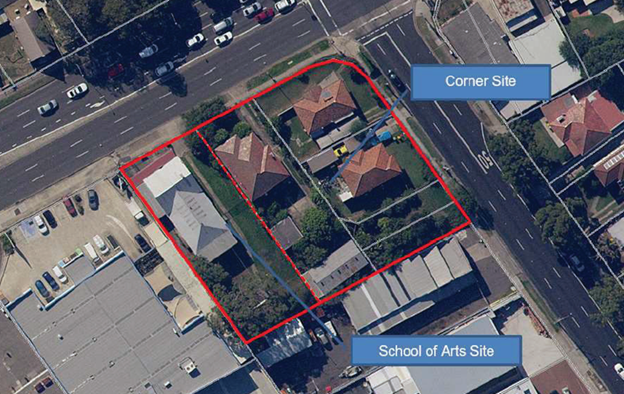
Figure 1 – Land parcels of the site
Table 2 – Address, legal description and site area
|
Lot and DP |
Area |
|
|
Corner Site |
||
|
143 Boundary Road |
Lot D DP 389507 |
152 m2 |
|
145 Boundary Road |
Lot 12 DP 575452 |
155 m2 |
|
147 Boundary Road |
Lot 11 DP 572452 |
467 m2 |
|
149 Boundary Road |
Lot A DP 389507 |
443 m2 |
|
689 Forest Road |
Lot 1 DP 11501 |
766 m2 |
|
School of Arts Site |
||
|
691 Forest Road |
Lot 1 DP 932423 |
1,015 m2 |
18. The land is immediately adjacent to the Peakhurst Neighbourhood Centre, located to the west of the site along Forest Road and the Peakhurst Industrial Precinct to the south. The land is otherwise bounded by two main roads, Boundary Road and Forest Road, to the north and east and a light industrial zone to the south along Boundary Road.
19. The land is currently occupied by the Peakhurst School of Arts building and three single storey dwellings. Two residential lots are vacant.
Surrounding Development
20. The surrounding area provides a mix of uses and typologies of commercial/retail, light industrial and residential development. Refer to Table 3 and Figures 2 to 13.
Table 3 – Surrounding development
|
Surrounding Development |
|
|
North |
· Commercial development (business and retail) – including furniture store, café/takeaways, dental, hairdressers, and other small business and retail uses. · Church (Place of Public Worship) (Figures 2 to 5) |
|
West |
· School of Arts public hall (Community facility) · Commercial development (business and retail) – including hardware (Mitre 10), supermarket (IGA) cake shop, liquor store and short-stay accommodation (Peakhurst inn) · Indoor recreation uses (Figures 6 to 8) |
|
South |
· Light industrial and building supply uses – including tools and parts supplies, service/repair centres, home furnishings and imaging/printer services. (Figures 9 and 10) |
|
East |
· Religious Centre (Place of Public Worship) · Aged care facility · Low density residential development (3 dwelling houses) (Figures 11 to 13) |
Figure 2 – Commercial development 802-820 Forest Road, Peakhurst (North)
Figure 3 – Commercial development 802-820 Forest Road, Peakhurst (North)
Figure 4 – Church 800 Forest Road, Peakhurst (North)
Figure 5 – Commercial development 792-796 Forest Road, Peakhurst (North)
Figure 6 – Commercial development 695-697 Forest Road, Peakhurst (West)
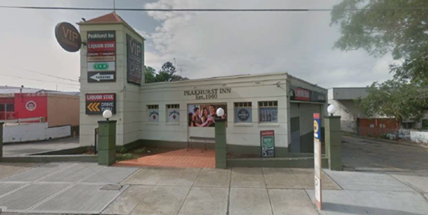
Figure 7 – Commercial development 705 Forest Road, Peakhurst (West)
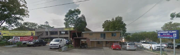
Figure 8 – Commercial development 707 Forest Road, Peakhurst (West)
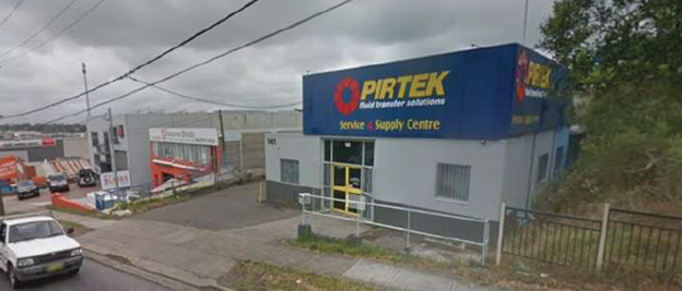
Figure 9 – Commercial development 141 Boundary Road, Peakhurst (South)
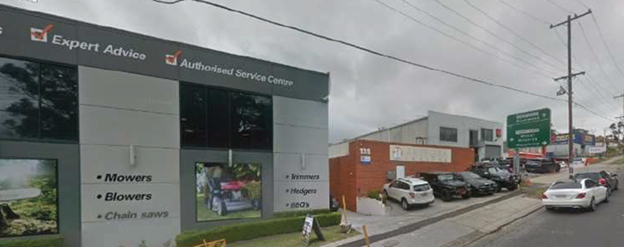
Figure 10 – View from 133 Boundary Road, Peakhurst (South)
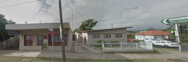
Figure 11 – Place of Worship 687 Forest Road, Peakhurst (East)
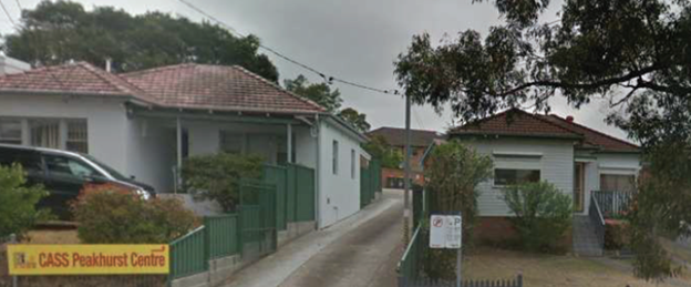
Figure 12 – Dwellings 182-184 Boundary Road, Peakhurst (East)
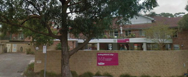
Figure 13 – Place of Worship 168 Boundary Road, Peakhurst (East)
PLANNING STRATEGIES, POLICIES AND CONTROLS
Existing Planning Controls
21. The site is currently zoned R2 – Low Density Residential under the HLEP 2012 (refer to Figure 14 below).
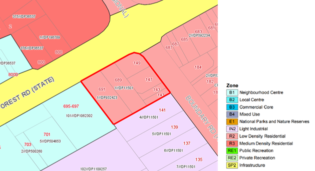
Figure 14 - Zoning
22. The site has a maximum building height of 9m under the HLEP 2012 (refer to Figure 15 below).
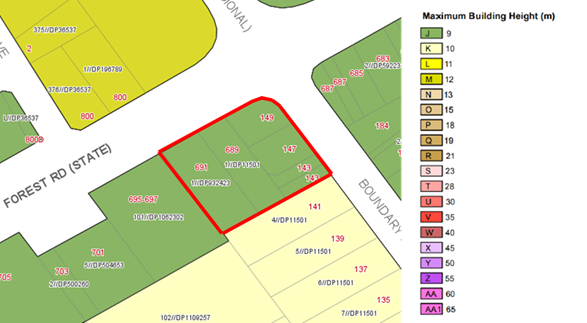
Figure 15 – Height of Buildings
23. The site has a maximum floor space ratio of 0.6:1 under the HLEP 2012 (refer to Figure 16 below).
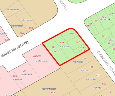
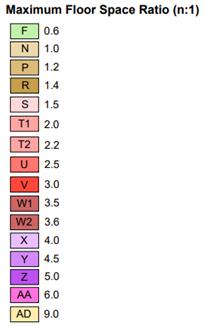
Figure 16- Floor Space Ratio
24. The site has a minimum lot size of 450 sqm under the HLEP 2012 (refer to Figure 17 below).
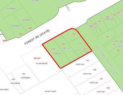
Figure 17 – Minimum Lot Size
25. The site does not contain any heritage item or heritage conservation area. There is a heritage item to the north of Forest Road (Church). (Refer to Figure 18 below).
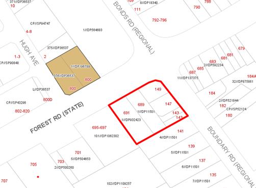
![]()
Figure 18 - Heritage
26. The draft Georges River LEP 2021 (GRLEP 2021) has been referred to the Department of Planning, Infrastructure and Environment for finalisation on 30 June 2020. The zoning, height and FSR for the Site under the HLEP 2012, draft GRLEP 2021 and the proposed Planning Proposal are shown in Table 4.
Table 4 – Comparison of Hurstville LEP 2012, draft GRLEP 2021 controls and planning proposal controls
|
Properties |
Planning Controls |
Hurstville LEP 2012 |
Draft Georges River LEP 2021 |
Planning Proposal Request |
|
Corner Site: · 143 Boundary Road · 145 Boundary Road · 147 Boundary Road · 149 Boundary Road · 689 Forest Road |
Zoning |
R2 Low Density Residential |
R2 Low Density Residential |
B1 – Neighbourhood Centre |
|
Building Height |
9m |
9m |
12m & 15m |
|
|
Floor Space Ratio |
0.6:1 |
0.55:1 |
1.7:1 |
|
|
Minimum Lot Size |
450m2 |
450m2 |
No min Lot Size |
|
|
School of Arts Site: 691 Forest Road |
Zoning |
R2 Low Density Residential |
R2 Low Density Residential |
B1 – Neighbourhood Centre |
|
Building Height |
9m |
9m |
12m |
|
|
Floor Space Ratio |
0.6:1 |
0.55:1 |
1.5:1* |
|
|
Minimum Lot Size |
450m2 |
450m2 |
No min Lot Size |
*Minimum non-residential FSR 0.3:1
APPLICANT’S PLANNING PROPOSAL REQUEST
Background
27. A Planning Proposal request (PP2019/0003) for 143, 145, 147 & 149 Boundary Road, 689 and 691 Forest Road, Peakhurst was lodged in August 2019 and was amended on one occasion.
28. Table 1 above provides a summary of the key events and amendments received leading up to the revised Planning Proposal which is the subject of this report.
Summary of Planning Proposal
29. Knight Frank Town Planning submitted a Planning Proposal request (PP2019/0003) on 1 August 2019 that seeks to amend the HLEP 2012 (or if gazetted the GRLEP 2021) in relation to 143, 145, 147 and 149 Boundary Road, 689 and 691 Forest Road, Peakhurst.
30. A revised Planning Proposal request was submitted 14 February 2020 and included the following amended documents which form the basis of the Planning Proposal being considered in this report:
I. Planning Proposal Report (refer to Attachment 1)
II. Urban Design Report (refer to Attachment 2)
III. Economic Impact Assessment
IV. Traffic Impact Assessment
31. The Planning Proposal seeks to amend the HLEP 2012 as demonstrated in Table 5:
Table 5 – Proposed amendments to HLEP 2012
|
Amendment |
Map |
|
Amend the Land Zoning (LZN) Map to rezone the Site to B1 – Neighbourhood Centre.
|
|
|
Amend the Maximum Building Height (HOB) Map to increase the height to part 12m and part 15m.
|
|
|
Amend the Floor Space Ratio (FSR) Map to increase the maximum FSR to part 1.5:1 and part 1.7:1.
|
|
|
Amend the Minimum Lot Size (LSZ) to no minimum lot size.
|
|
32. In respect of the LPP recommendation of the 3 June 2021 with regard to the alignment of the heights and FSR, the applicant has advised Council that the proposed FSR and heights were to reflect the desired built form illustrated in the Urban Design Report (Attachment 2) and they would like to continue to Gateway with no changes as the proposed proposal illustrated in Table 5 for the reasons below.
33. The proposed FSR has resulted from urban design testing of the proposed scheme, as per the following extract of the Urban design report:
The nominated FSR controls are based on the high-level testing of the proposed building envelopes. The testing uses the best practice efficiency rates and indicates that an FSR of 1.7:1 can be accommodated on the site (143-149 Forest Street, Peakhurst). The School of Arts site (691 Forest Street, Peakhurst), if it was to be redeveloped, can achieve 1.5:1 FSR to facilitate the future expansion of the facility. The proposed FSR on the site reflects a more general approach compared with the proposed height reflecting the consolidated site configuration and the FSR/GFA testing.
34. These controls will enable the delivery of a public plaza area and communal rooftop open space. Therefore a reduced FSR would require a revised built form that would not result in the same urban design outcome or public benefits.
35. The proposal includes a variety of building height, with the corner part of the site being proposed to have a greater height due to its location and topography.
36. It is also important to note that HOB controls define physical building envelopes, which do not always coincide with property boundaries; whereas FSR controls govern the density across a consolidated site.
37. A Site-Specific Development Control Plan (DCP) will be prepared to provide certainty that the built form outcome reflects urban design considerations for any future development of the site including the provision of public access, built form, boundary setbacks, deep soil areas, tree retention, vehicular access and any other relevant issues. The DCP is to be prepared at the proponent’s cost.
38. The Design Concept prepared by Conybeare Morrison illustrates the likely development outcomes consistent with the proposed amended controls. The key features of the concept design comprise:
· A mixed use development is proposed including ground level retail/commercial uses with shop top housing up to four storeys along the Boundary Road frontage
· Car parking in basement levels
· A neighbourhood plaza on the Forest Road frontage
· Communal Open Space at podium level for residents
· Upper levels to be developed for residential apartments, with an indicative yield of 22 dwellings based on a mix of studios, 1-bed, 2-bed and 3-bed housing development
· Retention of the School of Arts original brick front building, and the construction of a new community facility up to 3 storeys including underground parking at the rear of the site.
39. Figures 19 to 23 illustrate the concept design of the Planning Proposal.
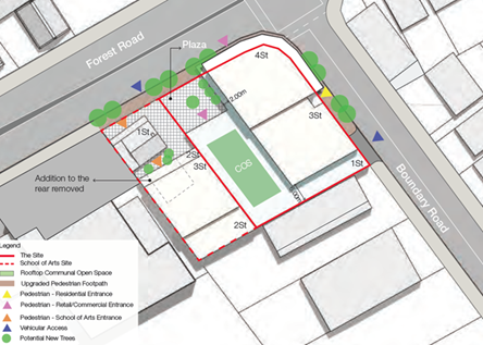
Figure 19 – Design Concept
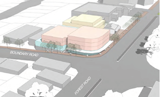
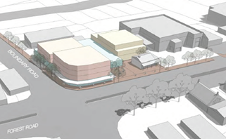
Figure 20 – Looking south west Figure 21 – Looking south
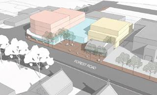
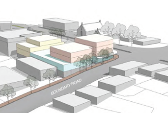
Figure 22 – Looking south east Figure 23 – Looking north west
ASSESSMENT OF THE PLANNING PROPOSAL
Strategic Planning Context
40. Consideration of the Planning Proposal request in relation to the Greater Sydney Region Plan (A Metropolis of Three Cites) and the South District Plan is provided below:
Greater Sydney Region Plan - A Metropolis of Three Cites
41. The Greater Sydney Region Plan was finalised and released by the Greater Sydney Commission in March 2018 and establishes the aspirations for the region over the next 40 years. The Region Plan is framed around 10 directions relating to infrastructure and collaboration, liveability, productivity and sustainability.
42. The applicant has provided their assessment of the Planning Proposal against the relevant Objectives of the Region Plan as below and is acceptable to Council:
43. Direction - A city supported by infrastructure
Objective 1: Infrastructure supports the three cities
The site is in an accessible location with good public transport access (bus) and adjacent to an existing local centre. An increased density at this location is consistent with supporting centres within a walkable distance to public transport. The planning proposal will improve the services and housing activity of the Peakhurst ‘neighbourhood centre’, delivering a 30 minute city.
44. Direction – A collaborative city
Objective 5: Benefits of growth realised by collaboration
The proponent of the planning proposal aims to collaborate with Council on the future planning of the area to deliver community benefits required for this area such as increased public open space, local services, jobs and housing.
45. Direction – A city for people
Objective 6: Services and infrastructure meet communities’ changing needs
Objective 7: Communities are healthy, resilient and socially connected
Objective 8: Greater Sydney’s communities are culturally rich with diverse neighbourhoods
Objective 9: Greater Sydney celebrates the arts and supports creative industries and innovation
The Planning Proposal will provide an increase of floor space available for providing services and uses to meet community needs.
The planning proposal will result in improvements to social infrastructure by providing a new public plaza that will encourage social interactions and connections and provide an improved local character. Ground floor non-residential uses will support street activation and engagement with the public realm.
The planning proposal will increase walkable access to a local centre by facilitating an increase of jobs and housing in proximity to the centre. This will promote a healthy and connected community.
The inclusion of the School of Arts site, provides the opportunity for the owner of this landholding to deliver an improved community facility. This would encourage a creative and connected community and greater social opportunities.
In summary, a moderate expansion of the Peakhurst neighbourhood centre will support the local community and workers through an expansion of uses and new services that are lacking in the area.
46. Direction – Housing the city
Objective 10: Greater housing supply
Objective 11: Housing is more diverse and affordable
A rezoning of the subject site will enable an increase of housing supply in a strategic location adjoining existing services. The planning proposal will enable approximately 22 residential units (depending on the final mix of unit types which would be subject to development approval). The scheme as proposed estimates the following unit mix:
· Studio: 1 unit
· 1 Bedroom: 8 units
· 2 Bedroom: 11 units
· 3 Bedroom: 2 units
The site, within walking distance to an existing centre and public transport, is suitable for providing an increased density of residential development.
The proposal would provide for an increase in services by enabling additional retail or business units.
47. Direction – A city of great places
Objective 12: Great places that bring people together
The planning proposal will deliver a ‘great place’ and improvements to the local centre, through an improved public domain, increased access to public open space, expansion of community facilities and improved amenity for employees and the local community.
Located on the corner of Peakhurst and Boundary Roads, this strategic location of the site provides an opportunity to create an improved gateway to the neighbourhood centre, creating a sense of arrival.
48. Direction – A well-connected city
Objective 14: A Metropolis of Three Cities – integrated land use and transport creates walkable and 30-minute cities
The planning proposal will provide potential for approximately 28 jobs and 36 indirect full time equivalent (FTE) jobs during operation as a result of the proposal. During construction 45 jobs and 130 additional indirect job opportunities will be provided for as a result of the planning proposal. In addition, it will provide for approximately 22 residential units within a walkable distance of new and existing local communities, services and public transport infrastructure. This is consistent with delivering a 30-minute city.
49. Direction – Jobs and skills for the city
Objective 22: Investment and business activity in centres
The subject site is in the vicinity of the Peakhurst neighbourhood centre, which provides a range of services including supermarket (IGA) and small business and retail uses. It is noted that the centre is lacking in health services such as a medical centre and pharmacy.
Providing increased housing and services at this location is entirely consistent with the role of a local centre. A mix of land uses through the co-location of residential with local centre services such as a medical centre and pharmacy is consistent with Objective 14 and promotes a walkable centre.
The planning proposal would support local businesses and complement and extend the facilities available within the centre, helping to consolidate the role of the centre.
50. Direction – A city in its landscape
Objective 30: Urban tree canopy over is increased
Objective 31: Public open space is accessible, protected and enhanced
Improvements to the public domain and open space are proposed through street tree planting, an upgraded pedestrian pavement, and a new public plaza.
51. Direction – An efficient city
Objective 33: A low-carbon city contributes to net-zero emissions by 2050 and mitigates climate change
The proposed development will be designed to provide a built form that responds to sustainability measures.
The proposal will increase housing and jobs in a location served by public transport and within a walkable distance to a neighbourhood centre, minimising the need for private vehicles and encouraging green travel options.
South District Plan
52. The South District Plan was finalised and released by the Greater Sydney Commission in March 2018. The District Plan is a guide for implementing the Region Plan at the district level and proposes a 20-year vision by setting out aspirations and proposals for the South District.
53. The Planning Proposal is considered to be consistent with the following Planning Priorities of the South District Plan as detailed in Table 6:
Table 6 – Consistency of the planning proposal with South District Plan
|
Directions |
Planning Priorities relevant to the Planning Proposal |
|
A city supported by Infrastructure |
Planning Priority S1 - Planning for a city supported by infrastructure |
|
A collaborative city |
Planning Priority S2 - Working through collaboration |
|
A city for people |
Planning Priority S3 - Providing services and social infrastructure to meet people’s changing needs Planning Priority S4 - Fostering healthy, creative, culturally rich and socially connected communities |
|
Housing the city |
Planning Priority S5 - Providing housing supply, choice and affordability with access to jobs, services and public transport |
|
A city of great places |
Planning Priority S6 - Creating and renewing great places and local centres, and respecting the District’s heritage |
|
Jobs and Skills for the city |
Planning Priority S9 - Growing investment, business opportunities and jobs in strategic centres Planning Priority S10 - Retaining and managing industrial and urban services land |
|
A well connected city |
Planning Priority S12 - Delivering integrated land use and transport planning and a 30-minute city |
|
A city in its landscape |
Planning Priority S15 - Increasing urban tree canopy cover and delivering Green Grid connections Planning Priority S16 - Delivering high quality open space |
54. Peakhurst is identified as a Local Centre in the South District Plan and is consistent with the role of a Local Centre, aiming to provide an increase of employment floor space for providing of goods and services, as well as additional housing to enable more people to live in walking distance of the local centre.
55. The South District Plan acknowledges the need for additional housing close to local centres and the need for centres to grow and evolve over time. The planning proposal is consistent with the following principles with regard to place-based planning for creating and renewing great local centres outlined in the South District Plan:
· provide public realm and open space focus
· deliver transit-oriented development and co-locate facilities and social infrastructure
· provide, increase or improve local infrastructure and open space
· improve walking, cycling and public transport connections, including through the Greater Sydney Green Grid
· protect or expand retail and/or commercial floor space
· protect and expand employment opportunities
· integrate and support arts and creative enterprise and expression
· support the night-time economy
· augment or provide community facilities and services, arts and cultural facilities
· conserve and interpret heritage values
· increase residential development in, or within a walkable distance of, the centre
· provide parking that is adaptable to future uses and takes account of access to public transport, walking and cycling connections.
Council’s Local Strategic Plans
56. Consideration of the planning proposal request in relation to Council’s local strategic plans is provided below.
Georges River Local Strategic Planning Statement
57. The Local Strategic Planning Statement (LSPS) 2040 outlines the 20-year vision for land use planning in the LGA. Underpinned by the five interrelated themes, the LSPS 2040 will assist in implementing actions in the Regional and District Plans, and Council’s own priorities in its Community Strategic Plan:
· Access and movement
· Infrastructure and community
· Housing and neighbourhoods
· Economy and centres
· Environment and open space
58. The LSPS states that Georges River has 48 local and neighbourhood centres of different sizes, character and function. Peakhurst is an identified Village as shown in Figure 24 below. It has also been identified as part of ‘Centre Expansion Investigation (Jobs and/or housing)’.
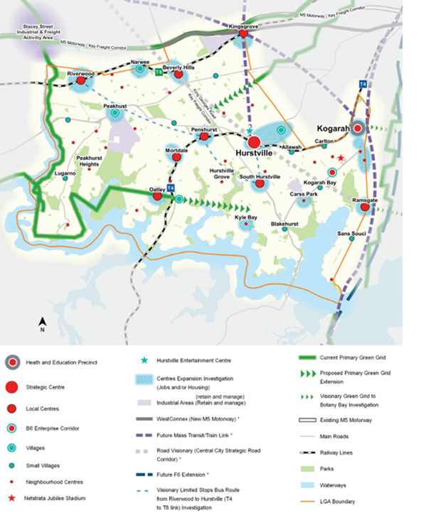
Figure 24 – Economy and Centres Structure Plan
59. The planning proposal to extend the Peakhurst B1 Neighbourhood Centre zone is aligned with the planning priority P12 Land is appropriately zoned for ongoing employment growth of the LSPS. It is proposing approximately 1,500sqm additional employment floor space, an estimated 30 additional local jobs and additional housing types and sizes, within a Centre that has been identified for expansion.
Georges River Commercial Centres Strategy
60. The Georges River Commercial Centres Strategy (CCS Part 1) is being developed in two stages; Part 1 and Part 2. Part 1 informed the preparation of draft Georges River LEP 2021 and Part 2 will look at the roles and functions of all 48 commercial centres. It will provide centre-specific objectives, building controls and guidelines, and explores the potential expansion of appropriate centres.
61. The primary purpose of Part 1 was to inform the preparation of GRLEP 2021 and its accompanying development control plan. It conducted a stocktake of all 48 commercial centres in the Georges River LGA through a holistic approach with the intention of harmonising the existing planning frameworks that govern the future development of these centres
62. Part 1 also looked at the inconsistencies and deficiencies of the current planning framework. It sought to harmonise the permissible land uses and introduce land uses that promote employment in response to the emerging economic trends and drivers, and investigate the appropriate mix required between employment and residential floor space in mixed use developments.
63. In the CCS Part 1, Peakhurst is identified as a Village as shown in Figure 25 and is zoned B1 – Neighbourhood Centre under the HLEP 2012 and the Draft GRELP 2021. The B1 – Neighbourhood Centre zones supports a local resident and worker population and is considered suitable for a greater share of increase in employment floorspace. Active street frontage provisions are proposed to be included into the DCP to enhance the centres connectivity and vibrancy.
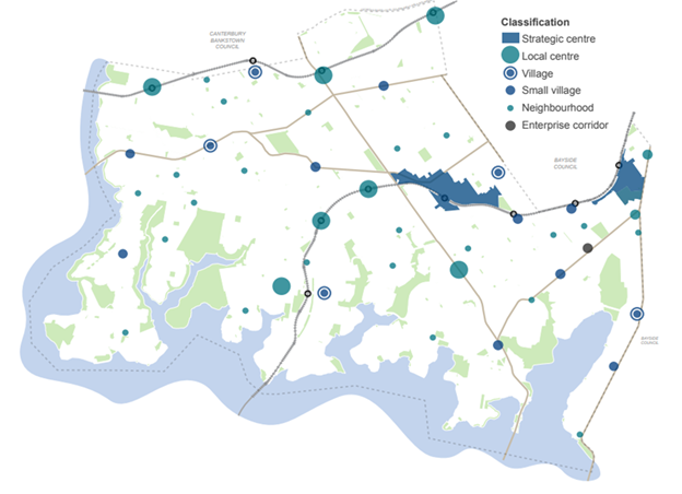
Figure 25- Existing Centres Hierarchy
64. The strategy recommends minimum non-residential FSRs required to meet 2036 demand. The draft GRLEP 2021 proposes a minimum non-residential FSR of 0.3:1 for the Peakhurst Village, in line with the recommendation of CCS – Part 1.
65. Until the Commercial Centres Strategy Part 2 has been prepared, Council has developed a guideline in the interim to ensure that any applicant-initiated Planning Proposal requests are supported by evidence findings, strategic and site-specific merit and great urban design outcomes. Expansion of the nominated centres may be considered if the subject site meets specific rezoning criteria.
66. The criteria for considering expansions of centres are provided below in Table 7, along with the applicant’s assessment and Councils comments.
Table 7 – Rezoning Criteria
|
Criteria for Considering Expansion of Centres |
Councils Assessment |
|
Not an ad hoc out-of-centre rezoning |
The Planning Proposal seeks to extend an existing centre to a logical end at Boundary Road. The Planning Proposal is consistent with Local Planning Priority P12 of the LSPS which states: Land is appropriately zoned for ongoing employment growth. Figure 8 – Structure Plan – economy and centres of the LSPS identifies the Peakhurst Local Centre for expansion investigation – jobs and housing. |
|
Is immediately adjacent and within the same street block of an existing centre with the following categorisation in the retail hierarchy of centres: · Strategic centre · Local centre · Village · Small village |
The Planning Proposal will be an extension to the existing Peakhurst Neighbourhood centre on Forest Road, Peakhurst. The site is immediately adjacent to and within the same street block of the Peakhurst Neighbourhood Centre. |
|
Meeting an economic demand for additional employment floor space that cannot be provided within the existing centre |
The CCS Part 1 and the draft GRLEP 2021 specify a minimum non-residential FSR of 0.3:1 The planning proposal provides 1,455m2 non-residential floorspace which is more than 0.3:1. There is unmet demand in the LGA’s small centres which was identified by Hill PDA strategic Economic Study and the Centres Strategy identifies a need for additional non-residential floorspace in Peakhurst There is little capacity within the existing B1 zoned land for additional floor space and the proponent’s Economic Assessment confirms that the proposal would meet the demands of current and future local population growth within the catchment with little or no impact on other centres The current B1 zoned land within the centre is 1 ha in area, compared with Narwee and Hurstville East Village Centres, that are 1.7 ha each. |
|
Addressing a demonstrated shortfall / retail gap, particularly in the local food and grocery network that cannot be located within the existing centre assessment against the criteria. |
The Planning Proposal would provide for an estimated additional retail/commercial floorspace of 1,455m2. The proponent’s Economic Assessment identified a gap in medical centre services. There is no pharmacy in the existing centre and limited restaurant / café selection (currently only 3). There is also no food specialty retail – bakery, deli, butcher, etc. and there is limited office space – no real estate, financial, ATM |
|
Does not negatively impact the economic viability and performance of the existing centre |
The LSPS identifies Peakhurst Neighbourhood Centre as a Potential centre for growth. The extension of existing centre would encourage a wider range of uses to be accommodated. A greater diversity of uses improves overall viability of the centre. |
|
Delivers a greater net community benefit compared to the existing use on the subject site |
The planning proposal proposes to: · Provide additional retail and commercial space, and will provide customers with local services and employment in Peakhurst Centre · Increase the capacity for community facility expansion and flexibility for greater use of School of Arts site |
|
Presents a significant opportunity to provide much-needed, community-oriented benefits including but not limited to: · At-grade public gathering spaces · Multi-use and flexible community facilities · Through-site links · Public view corridors and vistas · Public car parking · Improved traffic and road network conditions · Facilitates arts and creative industries · offers the opportunity to provide better linkages between fragmented parcels of employment uses within the existing centre · Offers the opportunity for an innovative adaptive re-use of an historic building or · creates a built form that presents an appropriate transition and interface between the existing centre boundary and the surrounding heritage fabric |
The Planning Proposal provides a publicly accessible plaza on Forest Road. This will introduce tree planting and street furniture, which is recognised as a significant improvement to the quality of the Centre’s public domain. The proposal provides the following much needed public benefits in this location: 1. Open public gathering space that could be further extended across the front of the School of Arts site 2. Improvement of 90m of roadside and footpath space around key intersections, including removal of 3 driveway cross overs 3. Café and food premises which support and compliment the increased use of the adjacent School of Arts facility for arts and creative activities 4. Built form with corner emphasis and definition of the centre, and open curtilage area improving the visibility of the School of Arts building The roadside/footpath improvements need a thorough analysis in light of the proposed TfNSW works at the intersection of Forest and Boundary Road. Refer to the discussion on Traffic and Transport in this report. |
|
Enables a significantly improved transition and integration between the existing centre’s development potential at the centre boundary and adjoining lower density areas |
Significant improvement to the current situation involving a small low density residential pocket bound by the centre and light industrial area, by a rational extension of the centre to Boundary Road. |
|
Enhances the existing centre’s identity in line with the desired future character |
Proposed renewal will enhance the centre’s identity and corner emphasis will define the centre. |
|
Demonstrates that there is no potential for a precedent to be set |
Involves a small isolated low density residential pocket and a logical end at Boundary Road. |
|
Provides strategic merit in expanding the existing centre that aligns with the policy direction of Commercial Centre Part 1 Strategy and the Greater Sydney Region Plan and South District Plan |
The subject site is within a 5 minute walk of a local centre, that is served by number of bus routes. The proposal provides additional housing and employment opportunities within a 5 minute walk of the centre. It is consistent with the South District Plan which identify Peakhurst as a ‘Local Centre’ that should ‘provide essential access to day to day goods and services’ and provide ‘additional residential development within a 5-minute (400m) walk’. |
|
Satisfies the strategic merit test and site specific merit test in accordance with NSW DPE Planning Circular PS 16-004. |
The Planning Proposal satisfies both the strategic and site specific merit test, as it is consistent with the direction provided in the Strategic Planning documents. The Planning Proposal would provide an opportunity for new types of businesses to be established within the Peakhurst centre, complementing the existing retail and business mix. The proposal provides additional residential dwellings in an accessible location which is in close proximity to public transport and other amenities and services. |
State and Regional Statutory Framework
67. The Planning Proposal is consistent with the following relevant State Environmental Planning Policies (SEPPs)
State Environmental Planning Proposal No. 55 – Remediation of Land
68. SEPP 55 aims to promote the remediation of contaminated land for the purpose of reducing risk and harm to human health or any other aspects of the environment.
69. The Planning Proposal does not contain provisions that will contradict or hinder the application of this SEPP. The applicant has advised that the site’s historical use was for residential purposes and the proposed use will comprise of retail / commercial with residential uses above.
State Environmental Planning Policy No. 65 – Design Quality of Residential Apartment Development
70. The proposed development will be subject to the provisions of SEPP 65, which aims to improve the quality of residential apartment design in NSW.
State Environmental Planning Policy (BASIX) 2004
71. This SEPP will be addressed at the Development Application phase
S9.1 Ministerial Directions
72. Ministerial Directions under Section 9.1 of the Environmental Planning and Assessment Act 1979 set out a range of matters to be considered when preparing an amendment to a Local Environmental Plan.
73. The Planning Proposal is consistent with all relevant Ministerial Directions as provided by in Table 8 below.
Table 8 – Ministerial Directions
|
S9.1 Direction |
Assessment
|
|
1.1 Business and Industrial Zones |
The planning proposal gives effect to the objectives of this direction and will provide an increase in employment space and services in an extension of an established neighbourhood centre. This will support the viability of the centre by providing investment and an increase of uses that will attract additional people to the centre. The proposal adequately provides for non-residential FSR on the lower levels, with residential above. |
|
3.1 Residential Zones |
While it is not proposed to rezone the site to a residential zoning, the planning proposal will enable a greater provision of housing in an existing urban area. Through the provision of B1 Neighbourhood centre zoning, the Planning Proposal encourages a variety and choice of housing types to provide for existing and future housing needs, above lower level of retail and commercial uses. |
|
3.4 Integrating Land Use and Transport |
The planning proposal will provide a higher density of jobs in close proximity to services and public transport. Bus stops will provide access to multiple regular services every 30 minutes and higher frequency 20 minute peak services. The subject land is adjacent to the existing Peakhurst Village Neighbourhood Centre zone and is proposed to be an extension of this centre that will consolidate its role, including a higher density of residential development within a walkable catchment. The Planning proposal will enable retail and residential development in close proximity to services and public transport. |
|
7.1 Greater Sydney Region Plan – A Metropolis of three Cities |
The Planning Proposal is consistent with the relevant Directions and Objectives of Greater Sydney Region Plan as demonstrated in this report. |
Site Specific Assessment
Urban Design Analysis
74. The subject site is located at the corner of Forest Road and Boundary Road and forms a link between the Peakhurst (Forest Road) Centre and the Peakhurst Industrial Precinct.
75. The existing context is characterised by low-scale developments of one to two storeys. This is attributed to the existing maximum building height of 9m applied to the adjoining B1- Neighbourhood Centre and R2 Low Density Residential zoned areas and 10m height for the IN2 Light Industrial zone.
76. However, the draft Georges River LEP 2021 seeks to increase the maximum building height in the adjoining IN2 Light Industrial zone to a combination of 12m and 16m. Accordingly, it is reasonable to forecast a shift in the general character and scale of developments in the local context.
77. The subject site occupies a visually prominent position at the corner of Forest Road and Boundary Road and benefits from exposure to high volumes of passing trade. The proposed four storey built form appropriately anchors the corner to delineate the new boundary of the Centre and reinforces its legibility.
78. A stepping envelope is adopted by the proposed design in response to the sloping topography of Boundary Road (refer Figure 26 below). A gradual transition is provided from the existing low-scale character to the proposed higher density corner development.
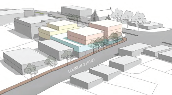
Figure 26 – Proposed development
79. To complement the built form of the existing School of Arts cottage, a modest built form of two to three storeys is proposed at its rear. The proposal’s building envelope is compatible with the existing two storey built form of the Centre.
80. The shadows cast from the proposed envelopes will have no impact on the solar access of existing residential dwellings located on Boundary Road and fall mainly on the Industrial Precinct to the south of the subject site.
81. In light of the above, the proposed building heights of 12m on the School of Arts site and 15m at the corner of Forest and Boundary Roads demonstrate an appropriate built form response to its urban context.
82. The proposed density is also considered to be suitable as the increased FSR of part 1.5:1 and part 1.7:1 is consistent with the 1.5:1 FSR applied to the adjoining B1-Neighbourhood Centre.
83. Despite the existing presence of retail premises within the Centre, the poor pedestrian amenity along Forest Road has led to the reliance on vehicles for access and an absence of pedestrian activity.
84. The Planning Proposal provides an opportunity for an active streetscape to be created through the provision of a publicly accessible plaza on Forest Road.
85. The proposal to introduce tree planting and street furniture through the new plaza is recognised as a significant improvement to the quality of the Centre’s public domain. The potential for the plaza to attract additional foot traffic and retain passing trade will greatly improve the Centre’s vibrancy and viability.
Economic Analysis
86. The Economic Impact Assessment submitted by the applicant includes an estimate of non-residential floor space of 1,445 m2 and 130 jobs on the subject site.
87. The Planning Proposal will provide approx. 1,445m2 of non-residential floor space which meets the required 0.3:1 FSR to comply with the Draft GRLEP 2021.
88. The proposal will provide a range of positive economic benefits for the local area as follows:
· The proposed development would provide an opportunity for new types of businesses to be established within the Peakhurst centre, complementing the existing retail and business mix and consolidating its role as a Village centre within the centres hierarchy.
· Retail effects on other businesses within the centre are likely to be positive as a result of additional customer visitation. The increase in retail floorspace would have little or no effect on the role or performance of other centres in the region.
· Importantly, the inclusion of a medical centre would fill a gap in the provision of such services, especially having regard to the advantageous position within an employment precinct and on a major travel route.
Traffic and Transport
89. The concept scheme demonstrates one vehicle access point for the proposal located at the southern end of the Site on Boundary Road. All car parking and services will be located within the ground floor and basement levels.
90. The Traffic Impact Assessment report prepared by Ason Group accompanying the Planning Proposal, dated August 2019 outlines the following key conclusions:
· The subject site is located in close proximity of a number of bus routes, which will encourage new residents to use alternative transport modes (other than private vehicles) to travel to and from the proposed developments.
· The traffic generation of the proposed development represent an increase of less than 1% in traffic at the signalised intersection of Forest Road / Boundary Road when compared to the future 2036 base line scenario.
· SIDRA analysis of the Forest Road / Boundary Road signalised intersection indicates that the additional trips generated by the proposed development would result in moderate increases to Degree of Saturation (DoS) and Average Vehicle Delay (AVD) of the intersection. However, the Level of Service remains unchanged.
· Regarding the proposed access, it is expected that the Planning Proposal will rationalise all existing 5 access crossovers on Forest Road and Boundary Road into a single access crossover to be located at the southern end of Boundary Road. This location represents the furthest allowable distance from the existing signalised intersection.
· Detailed design of the access and car parking layouts will be subject to a detailed assessment at the development application stage.
Transport for NSW Proposal
91. In September/ October 2020, Transport for NSW (TfNSW) have proposed intersection improvements on Forest Road, Bonds Road and Boundary Road, Peakhurst. The proposed changes aim to improve intersection efficiency, safety and reduce the likelihood of the right turning vehicles impeding the movement of through traffic.
92. The proposal includes:
· installing new dedicated right turn lanes on Boundary Road and Bonds Road approaching Forest Road
· upgrading left turn on Forest Road into Bonds Road to improve visibility
· relocating Bus Stop ID 2210234 on Bonds Road by 10 metres to improve visibility
· removing 2 parking spaces on Boundary Road to allow sufficient lane length for traffic merging into one lane
· adjusting utilities, street lighting, drainage, signage and road marking
· adjusting driveways and footpaths.
93. No private land will be required to be obtained to complete the proposed intersection improvements on Forest Road, Bonds Road and Boundary Road, Peakhurst.
94. The timing for the finalisation of the TFNSW works is 2021-2022.
95. The proposed works will affect the vehicular access/egress of the proposed development. Vehicular access to the subject site from Boundary Road will be restricted to ‘left in and left out’.
96. The Planning Proposal was lodged prior to the release of the TfNSW proposal and was referred to TfNSW for comment. No advice has been received and will be referred again to TfNSW as a condition of Gateway.
VOLUNTARY PLANNING AGREEMENT
97. An offer to enter into a Voluntary Planning Agreement (VPA offer) has been submitted in conjunction with the Planning Proposal. The VPA offer relates to all lots in the Planning Proposal except 691 Forest Road, Peakhurst (i.e. the School of Arts site).
98. The VPA offer provides for a monetary contribution of $900,000 to Council towards the following public benefits:
i. improved pedestrian and cycle connections from the site to nearby open space and commercial centre,
ii. improvements to community facilities such as library technology at Penshurst Library.
99. The public benefits are in addition to the s7.11 and s7.12 contributions that would apply to the proposed development and the VPA offer provides provision for security in the form of a bank guarantee and registration of the VPA on the title of the land.
100. The letter of offer has been assessed in accordance with the Environmental Planning & Assessment Act & Regulation, Council’s Planning Agreement Policy and the Departments new Practice Note on Planning Agreements (February 2021). Council staff have held discussions with the applicant in relation to public benefits.
101. The public benefits are identified in Council’s strategic and infrastructure strategies and will address the additional demand and impacts generated by the proposed development under the Planning Proposal.
102. The VPA offer is being reported to the Environment and Planning Committee and Council in conjunction with the Planning Proposal.
SUMMARY OF ASSESSMENT / CONCLUSION
103. In summary, the Planning Proposal seeks to amend the HLEP 2012 or GRLEP 2021 in relation to 143, 145, 147 and 149 Boundary Road, 689 and 691 Forest Road, Peakhurst by:
· Amending the Land Zoning (LZN) Map to rezone the Site to B1 – Neighbourhood Centre
· Amending the Height of Buildings (HOB) Map to increase the height to part 12m and part 15m
· Amending the Floor Space Ratio (FSR) Map to increase the maximum FSR to part 1.5:1 and part 1.7:1
· Amending the Minimum Lot Size (LSZ) Map to no minimum lot size
104. It is recommended that Council endorse the Planning Proposal for the following reasons:
a) The Planning Proposal demonstrates an appropriate urban design response to its context. The proposed four storeys built form appropriately anchors the corner to delineate the new boundary of the Centre and reinforces its legibility;
b) The proposed building envelope demonstrates an appropriate urban design outcome through the appropriate transition to adjacent developments. The proposed building heights of 12m on the School of Arts site and 15m at the corner of Forest and Boundary Roads demonstrate an appropriate built form response to its urban context;
c) The proposed density is considered to be consistent with the existing B1 Neighbourhood Centre adjacent to the development;
d) The proposal is a rational extension of the existing B1 Neighbourhood Centre to Boundary Road and the subject site occupies a visually prominent position at the corner of Forest Road and Boundary Road and benefits from exposure to high volumes of passing trade;
e) The Planning Proposal provides an opportunity for an active streetscape to be created through the provision of a publicly accessible plaza on Forest Road. The proposal to introduce tree planting and street furniture is recognised as a significant improvement to the quality of the Centre’s public domain. The potential for the plaza to attract additional foot traffic and retain passing trade will greatly improve the Centre’s vibrancy and viability; and
f) The proposal provides additional residential dwellings in an accessible location which is in close proximity to public transport and other amenities and services.
COMMUNITY CONSULATION
105. Should the Planning Proposal be supported, it will be forwarded to the delegate of the Minister for Planning and Public Places, requesting a Gateway Determination in accordance with S3.34 of the Environmental Planning and Assessment Act, 1979.
106. If a Gateway Determination (Approval) is issued, and subject to its conditions, it is anticipated that the Planning Proposal will be exhibited for a period of 28 days in accordance with the provisions of the Environmental Planning and Assessment Act, 1979 and Regulation, 2000 and any requirements of the Gateway Determination.
107. Exhibition material, including explanatory information, land to which the Planning Proposal applies, description of the objectives and intended outcomes, copy of the Planning Proposal and relevant maps will be available for viewing during the exhibition period on Council’s website and hard copies available at Council offices and libraries.
108. Notification of the public exhibition will be through:
· Newspaper advertisement in The Leader
· Exhibition notice on Council’s ‘Your Say’ page
· Notices in Council offices and libraries
· Letters to State and Commonwealth Government agencies identified in the Gateway Determination (if required)
· Letters to adjoining landowners (in accordance with Council’s Notification Procedures
109. The anticipated project timeline for completion of the Planning Proposal is shown below:
|
Task |
Anticipated Timeframe |
|
Report to Georges River LPP on Planning Proposal |
3 June 2021 |
|
Report to Environment and Planning Committee on Planning Proposal |
12 July 2021 (this report) |
|
Report to Council on Planning Proposal |
26 July 2021 |
|
Anticipated commencement date (date of Gateway Determination) |
August 2021 |
|
Timeframe for government agency consultation |
October/November 2021 |
|
Exhibition of the Planning Proposal |
October/November 2021 |
|
Reporting to Council on community consultation and finalisation |
December 2021 |
|
Submission to the Department to finalise the LEP |
February 2022 |
|
Anticipated date for notification |
April/May 2022 |
110. It is noted that the project timeline will be assessed by the DPIE and may be amended by the Gateway Determination.
NEXT STEPS
111. The minutes of the Environment and Planning Committee meeting will subsequently be considered at a future Georges River Council meeting (“the relevant planning authority”). If the Planning Proposal is endorsed by Council, it will be forwarded to the delegate of the Minister of Planning and Public Spaces for a Gateway Determination under Section 3.34 of the Environmental Planning and Assessment Act 1979.
112. If Council resolves not to support the Planning Proposal, the applicant has the opportunity to request a pre-Gateway Review by the NSW Planning Panels under the delegation of the Greater Sydney Commission. An applicant has 40 days from the date of notification of Council’s decision to request a review.
Financial Implications
113. No budget impact for this report.
Risk Implications
114. No risks identified.
File Reference
PP2019/003
|
Attachment 1 |
Revised Peakhurst Centre Extension Planning Proposal - KFTP - 140220 - published in separate document |
|
Attachment 2 |
Revised Peakhurst Urban Design Report_CM+_210120 - published in separate document |
Georges River Council – Environment and Planning - Monday, 12 July 2021 Page 3
Item: ENV036-21 Voluntary Planning Agreement Offer for 143-149 Boundary Road and 689 Forest Road, Peakhurst
Author: Executive Strategic Planner
Directorate: Environment and Planning
Matter Type: Committee Reports
|
(a) That Council accept and endorse the letter of offer dated 29 June 2021 from Mr John Ronald Rider (Landowner) to enter into a Voluntary Planning Agreement (VPA offer) (Attachment 1) in association with the Planning Proposal PP2019/0003 for 143-149 Boundary Road and 689-691 Forest Road, Peakhurst which seeks to amend the zoning and planning controls for the land under Hurstville Local Environmental Plan 2012 (or if gazetted the Georges River Local Environmental Plan). The key terms of the VPA offer are as follows: a. the VPA offer relates to sites at 143-149 Boundary Road and 689 Forest Road, Peakhurst; b. the Landowner will pay a monetary contribution of $900,000 to Council towards: i. improved pedestrian and cycle connections from the site to nearby open space and Riverwood commercial centre ii. improvements to the library facilities at Penshurst Library; c. the contribution amount will recalculated and indexed from the date of the VPA offer to the date of payment and the contribution will be paid in three instalments; d. the public benefits are over and above the usual section 7.11, 7.12 and 7.24 contributions applicable to the development; e. an unconditional bank guarantee will be provided as security for the monetary contributions and the VPA will be registered on the title of the land; f. the Landowner agrees to pay Council’s reasonable costs of preparing, negotiating, executing, registering, and stamping the VPA; and g. the Landowner agrees to include such other clauses from Council’s VPA template in Council’s Planning Agreement Policy as relevant to this offer. (b) That Council delegate authority to the General Manager to prepare and finalise the specific terms of the Voluntary Planning Agreement to reflect the terms of the VPA offer and to subsequently exhibit the VPA, in conjunction with the Planning Proposal, in accordance with the Environmental Planning and Assessment Act 1979. (c) That Council delegate authority to General Manager to: a. Authorise any minor changes to the Voluntary Planning Agreement following public exhibition, provided that those changes do not diminish the value or nature of the public benefits to be delivered as identified in (a) above; and b. Subsequently enter into the Voluntary Planning Agreement on behalf of Council. |
Executive Summary
1. A letter of offer to enter into a Voluntary Planning Agreement (VPA offer) dated 29 June 2021 was submitted from Mr John Ronald Rider (Landowner) in association with the Planning Proposal PP2019/0003 for 143-149 Boundary Road and 689-691 Forest Road Boundary Road, Peakhurst.
2. The Planning Proposal seeks to amend Hurstville Local Environmental Plan 2012. A separate report on the Planning Proposal is presented to Council for determination.
3. The letter of offer has been assessed in accordance with Council’s Planning Agreements Policy, Environmental Planning and Assessment Act and Regulation and the Practice Note on Planning Agreements (issued February 2021). Council’s solicitors have also reviewed the letter of offer.
4. Council’s strategic planning and infrastructure strategies have informed the public benefits identified in the VPA offer. The public benefits will address the additional demand generated by the proposal.
5. This report recommends that the Council delegate authority to the General Manager to prepare and finalise the specific terms of the VPA to reflect the VPA offer and to subsequently exhibit the VPA in accordance with the Environmental Planning and Assessment Act.
Background
Planning Proposal
6. The Planning Proposal PP2019/0003 for sites at 143-149 Boundary Road and 689-691 Forest Road, Peakhurst (see Figure 1) seeks to amend Hurstville Local Environmental Plan 2012 as follows:
a. amend the land use zoning from R2 Low Density Residential to B1 Neighbourhood Centre;
b. increase the Height of Buildings from 9 metres to part 12metres and part 15metres;
c. increase the Floor Space Ratio from 0.6:1 to part 1.5:1 and part 1.7:1; and
d. amend the Minimum Lot Size to no minimum.
7. The intention of the Planning Proposal is to enable the extension of the Peakhurst Centre eastward to the corner of Boundary Road and Peakhurst Road into the B1 Neighbourhood Centre zone.
8. The Planning Proposal covers six lots, comprising the ‘School of Arts site’ (691 Forest Road), occupied by the Peakhurst School of Arts building, and a pocket of residential land which currently contains three single storey residential buildings (143-149 Boundary Road and 689 Forest Road). The subject land has a total area of 2,998sqm.
9. The School of Arts has been advised in writing of the Planning Proposal and will be consulted further during the consultation phase.
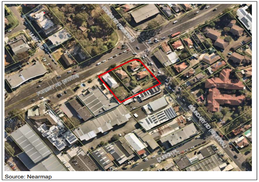
Figure 1: Site Location – 143-149 Boundary Road and 689-691 Forest Road, Peakhurst
10. The key features of the proposal comprise potential for:
a. a mixed use development including ground level retail / commercial uses with shop top housing up to 4 storeys along the Boundary Road frontage;
b. upper level of residential with an estimated 22 residential apartments based on a mix of studios, 1 bed, 2 bed and 3 bed housing development;
c. basement carparking, a plaza area fronting onto Forest Road and communal open space at podium level for residents; and
d. retention of the School of Arts original brick front building and potential for an expanded community facility or mixed community/commercial development that would complement the existing School of Arts building.
11. The Planning Proposal was presented to the Local Planning Panel on 3 June 2021. The Panel recommended:
“That the Georges River Local Planning Panel recommends that Council endorse the forwarding of Planning Proposal PP2019/0003 to the NSW Department of Planning, Industry and Environment (DPIE) to request a Gateway Determination under Section 3.33 of the Environmental Planning and Assessment Act 1979 for an amendment to the Hurstville Local Environmental Plan (LEP) 2012 (or Georges River LEP 2021, if gazetted),
· Rezoning from R2 – Low Density Residential to B1 – Neighbourhood Centre;
· Increasing the maximum building height from 9m to part 12m and part 15m;
· Increasing the maximum FSR from 0.6:1 to part 1.5:1 and part 1.7:1; and
· Removing the minimum lot size requirement consistent with the proposed commercial zoning.
· That the Local Planning Panel recommends to Council that further consideration be given to aligning the proposed FSR and heights on the site to assist with future site design and development assessment.
That the LPP recommends to Council that the Planning Proposal be forwarded to the Minister for Planning and Public Places for a Gateway Determination under Section 3.34 of the Environmental Planning and Assessment Act 1979.
That the Georges River LPP recommends to Council that a site-specific amendment to the current Development Control Plan be prepared to reflect site specific provisions for any future development of the site”.
12. A separate report on the Planning Proposal is presented to Council in this Business Paper.
Offer to Enter into a Voluntary Planning Agreement
13. The Planning Proposal was accompanied by an offer from the Landowner to provide public benefits under a VPA relating to 143, 145, 147 and 149 Boundary Road and 689 Forest Road, Peakhurst, excluding 691 Forest Road, Peakhurst (the School of Arts site).
14. The initial offer proposed a range of public benefits including a new public plaza on the Forest Road frontage within the development site, public domain improvements (including upgrading the footpath and the planting of street trees along Forest Road and Boundary Street), and dedication of a minimum 5% of the overall residential yield to affordable housing (this would equate to approximately 1-2 units).
15. These initial public benefits identified were not supported by Council officers on the basis that the proposed public domain improvements on the footpaths are normally conditions of any future development consent and whilst the creation of a new public plaza is supported in principle in relation to the overall urban design of the proposal, the dedication and embellishment of the plaza is not supported as a public benefit as part of a VPA offer. The affordable housing cannot be considered until Council has an affordable housing scheme and LEP that allow acceptance and management of affordable housing.
16. In accordance with Council’s Planning Agreement Policy and the Department’s Practice Note on Planning Agreements (February 2021) Council staff held discussions with the applicant in relation to public benefits to address the additional demand generated by the development.
17. A letter of offer to enter into a VPA was submitted by Mr Rider on 29 June 2021 (Attachment 1). The offer provides the following:
i. the VPA offer relates to 143, 145, 147 and 149 Boundary Road and 689 Forest Road, Peakhurst;
ii. the Landowner offers to make a monetary contribution of $900,000 to Council towards:
a) improved pedestrian and cycle connections from the site to nearby open space and Riverwood commercial centre
Note: A pathway connection connecting Hugh Avenue/Forest Road (opposite the site) with Peakhurst Park and then onto the Riverwood commercial centre.
b) improvements to community facilities such as library technology at Penshurst Library (such as a self serve 24/7 library service);
iii. the contribution amount is to be recalculated and indexed by the CPI from the date of the letter of offer to the date of payment. The offer includes a formula for the recalculation of the contribution amount before the first instalment to ensure it reflects the additional gross floor area allowed by the LEP amendment;
iv. the payment of the contribution is proposed in three instalments. Each instalment will be an amount being 1/3 of the recalculated contribution as indexed. The timing of payment will be as follows:
a) first instalment be made within 28 days after the making of the LEP Amendment.
b) second instalment be made prior to the granting of the first development consent for development which is only made permissible by the LEP Amendment.
c) third instalment be made prior to the issue of any Construction Certificate for the first development consent for development which is only made permissible by the LEP Amendment.
v. the contributions under section 7.11 and 7.12 of the EP&A Act will apply to any future development application on the land. The monetary contributions under the VPA are not to be taken into account when imposing s7.11 or s7.12 contributions and will be in addition to any s7.11 or s7.12 contributions;
vi. an unconditional bank guarantee will be provided as security for the monetary contribution of $900,000. The offer proposes that the bank guarantee be replaced within 28 days after payment of each instalment with a new bank guarantee to reflect the contribution amount outstanding at that time;
vii. the VPA will be registered on the title of the land;
viii. the Landowner agrees to pay Council’s reasonable costs of preparing, negotiating, executing, registering, and stamping the agreement and agrees to include in the agreement a provision to that effect as set out in Council’s VPA template in Council’s Planning Agreement Policy;
ix. the Landowner agrees to include such other clauses from Council’s VPA template in Council’s Planning Agreement Policy as relevant to this offer.
Assessment of the Offer
18. The letter of offer has been assessed in accordance with Council’s Planning Agreement Policy and the Department’s Practice Note on Planning Agreements (issued February 2021) and the Environmental Planning and Assessment Act and Regulation.
19. The Practice Note states that VPAs “should adhere to the following fundamental principles” to ensure transparency, fairness and flexibility of planning decisions. These principles have governed the negotiations and assessment of the VPA offer.
· Planning authorities should always consider a development proposal on its merits, not on the basis of a planning agreement – the Planning Proposal has been assessed on its merits and separately to the VPA offer.
· Planning agreements must be underpinned by proper strategic land use and infrastructure planning carried out on a regular basis and must address expected growth and the associated infrastructure demand – as outlined below Council’s strategic and infrastructure strategies have been considered in addressing the impacts and demand generated by the proposed development.
· Strategic planning should ensure that development is supported by the infrastructure needed to meet the needs of the growing population - Council’s strategic and infrastructure strategies identify the facilities and services that will be required to meet the needs of the growing populations. The public benefits proposed under the VPA in addition to the facilities and services identified in Council’s s7.11 and s7.12 contributions plans will ensure that the demand generated by the development is addressed.
· A consent authority cannot refuse to grant development consent on the grounds that a planning agreement has not been entered into in relation to the proposed development or that the developer has not offered to enter into such an agreement - the Planning Proposal has been assessed on its merits and separately to the VPA offer.
· Planning agreements should not be used as a means of general revenue raising or to overcome revenue shortfalls – the VPA will address the additional demand generated by the proposed changes and development.
· Planning agreements must not include public benefits wholly unrelated to the particular development – the public benefits are located in close proximity to the site providing access to local open space and improved community facilities.
· Value capture should not be the primary purpose of a planning agreement – as outlined below value capture has not been used as the primary purpose of the VPA.
Acceptability Test
20. The Practice Note states that VPAs should be assessed against the acceptability test which is a generally applicable test for determining the acceptability of a VPA.
|
Acceptability Test (Practice Note on Planning Agreements - February 2021)
|
Assessment |
|
Are directed towards legitimate planning purposes, which can be identified in the statutory planning controls and other adopted planning strategies and policies applying to development. |
The VPA is directed towards legitimate planning purposes, which are identified in the statutory planning controls and other adopted planning strategies and policies applying to the development. As outlined below the public benefits have been identified in Council’s strategic and infrastructure strategies to address future demand and will directly address the demands generated by the development. |
|
Provide for the delivery of infrastructure or public benefits not wholly unrelated to the development. |
The VPA offer provides for the delivery of infrastructure and public benefits not wholly unrelated to the development. The shared pathway connection is in close proximity to the site and will provide a direct connection from the development to local open space and the Riverwood commercial centre. Improvements to the Penhurst Library such as upgrading the facility and the provision of library technology is also in close proximity to the development and offers the opportunity to augment the facility and extend access to library services. |
|
Produce outcomes that meet the general values and expectations of the public and protect the overall public interest. |
The VPA will produce outcomes that meet the general values and expectations of the public and protect the overall public interest. The public benefits under the VPA, in addition to the s7.11 contributions, will ensure that the level of service for the provision of community facilities and services is maintained and addresses the demands generated by the new population. S7.11 and s.12 development contributions plans levy contributions for community facilities and services to mitigate against the impacts of development. These plans are based on projections made from planning controls in place at the time the plans are published. VPAs provide for public benefits where the developer seeks an increase over and above the current development standards contained in a Local Environmental Plan. This Planning Proposal seeks to vary the development standards in Hurstville LEP 2012. In accordance with Council’s Planning Agreements Policy, the Developer has made an offer to enter into a VPA to provide a monetary contribution for public benefits that address the additional demand generated by the development. These public benefits are in addition to the s7.11 and s7.12 contributions that would apply to the development. As such the VPA can be reasonably viewed to be meeting the general values and expectations of the public. |
|
Provide for a reasonable means of achieving the desired outcomes and securing the benefits. |
The VPA will provide for a reasonable means of achieving the desired outcomes and securing the public benefits. The monetary contribution for the shared pathway connection and improvements to the library and its services will enable Council to provide these projects. |
|
Protect the community against adverse planning decisions. |
The VPA will protect the community against adverse planning decisions by ensuring the delivery of public benefits that address the demands of the development. |
21. The public benefits identified in the VPA offer reflect Council’s strategic planning and infrastructure strategies, as follows:
a. Improved pedestrian and cycleway connections between the development with local open space and the Riverwood commercial centre:
Council’s Open Space, Recreation and Community Facilities Strategy 2019-2036 and draft Cycleway Strategy identify the need for both local and regional shared pathways. The provision of pedestrian and cycleway connections are important in connecting residents and workers with key destinations within the local community such as parks, sporting facilities and local shopping centres.
A key pathway connection is proposed in close proximity to the proposed development connecting Hugh Avenue/Forest Road with Peakhurst Park and then onto the Riverwood commercial centre.
This local route comprises four sections, commencing at Hugh Avenue (opposite the site) travelling through Pearce Avenue Reserve to Peakhurst Park. This is a key link that will provide connectivity to the nearest large open space area. This link then continues through Peakhurst Park from Pearce Avenue to Headley Street and then extends along Hedley Street to Jacques Avenue connecting along Belmore Road to the Riverwood commercial centre. The total cost estimate for this project is $705,750.
b. Improvements to community facilities such as library technology at Penshurst Library
Council’s Libraries 2030 – Library Strategy identifies strategies for enhancing Council’s existing libraries and the provision of new libraries to ensure the community’s needs are met. Key strategies relate to the improvement of library facilities and enhancing library technology and programs within the existing libraries such as Penshurst is vital in order to address future demand.
The upgrading and improvement of library spaces creates opportunities to improve service delivery to our community.
The implementation of new self-service 24/7 technology will offer the opportunity to augment and extend access to new user groups, for whom work and other commitments mean current opening hours are not convenient.
The estimated cost for providing the improvement to the facility and/or providing the technology is $200,000.
22. The initial assessment of the VPA offer was undertaken prior to the new Practice Note on Planning Agreements being issued by the Department in February 2021. The Practice Notes states that “in general the use of planning agreements for the primary purpose of value capture is not supported…” and that planning agreement should not be used explicitly for value capture in connection with the making of planning decisions”
23. In accordance with Council’s Planning Agreements Policy prior to the Practice Note, Council engaged Hill PDA to undertake a land value uplift assessment associated with the planning proposal to assist in informing the value of the VPA offer. The applicant also provided documentation to assist in this review. The Hill PDA review recommended a VPA contribution of $900,000.
24. The review undertaken by Hill PDA and the Applicants consultants were used to assist in guiding and ensuring a fair and reasonable contribution value for the VPA public benefits.
25. The terms set out in the VPA offer reflect Council’s Planning Agreements Policy and the offer states that the “Landowner agrees to include such other clauses from Council’s VPA template in Council’s Planning Agreement Policy as relevant to this offer into the VPA”.
26. Council’s solicitors have also reviewed and supports the letter of offer.
Next Steps
27. Should Council endorse and accept the VPA offer and subject to the Planning Proposal being supported, the following steps will need to occur:
a. The General Manager prepare and finalise the VPA with the Landowner to reflect the VPA offer. Council’s solicitor will prepare the VPA and Explanatory Note,
b. Once the VPA is finalised and signed by the Landowner, the Planning Proposal will be submitted to the Department for a Gateway Determination,
c. The VPA will be publicly notified, in conjunction with the Planning Proposal (subject to the Gateway Determination being issued) for a minimum of 28 days in accordance with the EP&A Act and Regulation,
d. Following public notification, should no submissions be received objecting the draft amended VPA, the General Manager be delegated authority to authorise minor changes to the VPA, provided that those changes do not diminish the value or nature of the public benefits to be delivered, and to subsequently enter into the VPA on behalf of Council.
Financial Implications
28. No budget impact for this report.
29. Council’s Planning Agreement Policy states that Council will generally require a VPA to make provision for payment by the developer of Council’s costs of negotiating, preparing and executing the planning agreement, as well as monitoring enforcing and administering the agreement.
30. The letter of offer states that the Landowner agrees to pay Council’s reasonable costs of preparing, negotiating, executing, registering, and stamping the VPA.
Risk Implications
31. Enterprise risk/s identified and management process applied.
32. The VPA offer includes provisions for an unconditional bank guarantee to be provided for the monetary contributions and registration of the VPA on the title of the land.
33. Council’s solicitors have reviewed the letter of offer and will prepare the VPA documentation on behalf of Council.
Community Engagement
34. The VPA and Explanatory Note will be placed on public notification if Council endorse and accept the VPA offer and the Planning Proposal receives a Gateway Determination.
35. The VPA will be on public notification for not less than 28 days before the agreement is entered into, in accordance with the Environmental Planning and Assessment Act 1979 and Environmental Planning and Assessment Regulation 2000.
File Reference
20/838
|
Attachment ⇩1 |
Letter of offer to enter into a VPA - 143,145,147,149 Boundary Road and 689 Forest Road, Peakhurst dated 29 June 2021 |
|
Georges River Council - Environment and Planning - Monday, 12 July 2021 ENV036-21 Voluntary Planning Agreement Offer for 143-149 Boundary Road and 689 Forest Road, Peakhurst [Appendix 1] Letter of offer to enter into a VPA - 143,145,147,149 Boundary Road and 689 Forest Road, Peakhurst dated 29 June 2021 |
Page 1 |