|
AGENDA Georges River Local Traffic Advisory Committee
Tuesday, 06 July 2021 To be held remotely due to COVID-19 restrictions
|
|
|
AGENDA Georges River Local Traffic Advisory Committee
Tuesday, 06 July 2021 To be held remotely due to COVID-19 restrictions
|
|
Georges River Council – Georges River Local Traffic Advisory Committee Meeting - Tuesday, 6 July 2021 Page 1
Georges River Local Traffic Advisory Committee Meeting
1. Confirmation of Minutes of Previous meeting
MINUTES: Georges River Local Traffic Advisory Committee Meeting - 01 June 2021
2. Committee Reports
TAC097-21 Oatley Parade, Oatley - Proposed Pedestrian Refuge Upgrade
(Report by Coordinator Traffic & Transport).......................... 2
TAC098-21 Rickard Road, South Hurstville - Proposed Line Marking
(Report by Coordinator Traffic & Transport).......................... 5
TAC099-21 South Street, Kogarah - Proposed Line Marking
(Report by Coordinator Traffic & Transport).......................... 8
TAC100-21 Belmore Road, Riverwood - Proposed "15 Minute" Parking
(Report by Coordinator Traffic & Transport)........................ 10
TAC101-21 Penshurst Street, Beverly Hills - Proposed 'Bus Zone'
(Report by Traffic Engineer)............................................... 12
TAC102-21 Botany Street, Hurstville - Proposed 'Bus Zone' modifications
(Report by Traffic Engineer)............................................... 15
TAC103-21 Gardinia Street, Peakhurst - Proposed 'Bus Zone' extension
(Report by Traffic Engineer)............................................... 18
TAC104-21 Park Road, Hurstville- Proposed 'Works Zone'
(Report by Traffic Engineer)............................................... 21
TAC105-21 Francis Street, Carlton - Proposed 'Mail Zone'
(Report by Traffic Engineer)............................................... 24
TAC106-21 Lily Lane, Hurstville - Proposed 'No Stopping' zone
(Report by Traffic Engineer)............................................... 27
TAC107-21 Southern Street, Oatley - Proposed 'No Parking' zone
(Report by Traffic Engineer)............................................... 30
TAC108-21 Austral Street, Penshurst - Proposed "No Parking" zone
(Report by Coordinator Traffic & Transport)........................ 33
Georges River Council – Georges River Local Traffic Advisory Committee Meeting - Tuesday, 6 July 2021 Page 1
Confirmation of Minutes of Previous Minutes
|
That the Minutes of the Georges River Local Traffic Advisory Committee Meeting held on 01 June 2021 be adopted. |
Georges River Council – Georges River Local Traffic Advisory Committee Meeting - Tuesday, 6 July 2021 Page 3
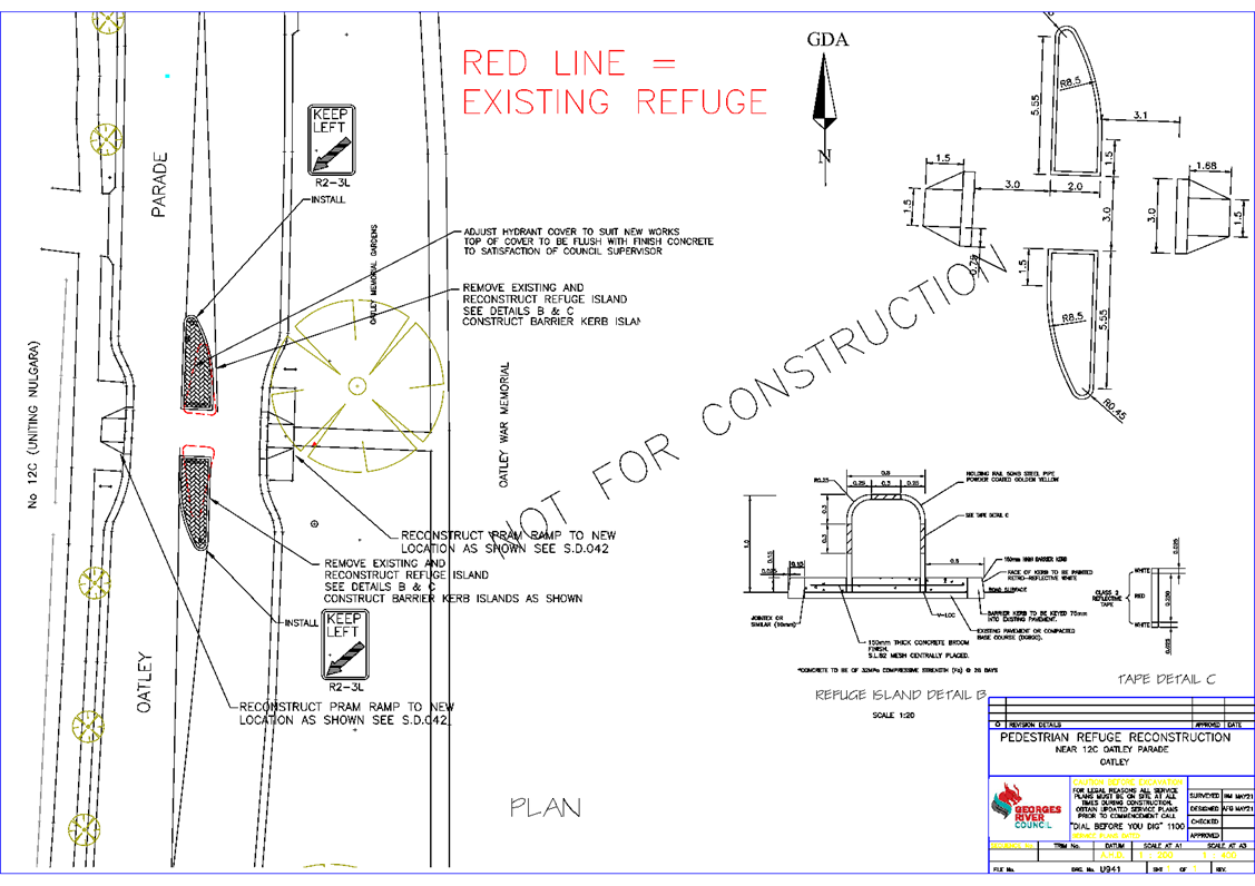
Item: TAC097-21 Oatley Parade, Oatley - Proposed Pedestrian Refuge Upgrade
Author: Coordinator Traffic & Transport
Directorate: Assets and Infrastructure
Matter Type: Committee Reports
|
That the existing pedestrian refuge on Oatley Parade, adjacent to No. 12C, be upgraded to TfNSW requirements and Australian Standards, as shown on plan U941 attached to the report.
|
EXECUTIVE SUMMARY
1. This report seeks the Committee’s consideration of the proposed pedestrian refuge upgrade on Oatley Parade, Oatley.
BACKGROUND
2. Council has received a request from Mark Coure MP, Member for Oatley, on behalf of residents at Uniting Nulgara Village located at 12C Oatley Parade, to convert the existing pedestrian refuge to a crossing.
3. For a crossing to be considered, Transport for NSW (TfNSW) require vehicle and pedestrian warrants to be met in accordance with their design documents.
4. TfNSW warrants for a pedestrian crossing are as follows:
“In each of three separate one hour periods in a typical day:
· The product of the measured pedestrian flow (P) per hour and the measured vehicle traffic flow (V) is equal or greater than 60,000 and;
· The measured flows, P and V are equal or greater than 30 and 500 respectively;
· The measured flows apply for three periods of one hour in any day.”
5. As a result of this request, Council undertook a pedestrian and vehicle count at the refuge on 11 May 2021 in the AM peak from 8am to 9am.
6. During this one hour period there were 17 pedestrians and 318 vehicles counted. As the warrants were not achieved in the AM period, no further counts were required.
7. It is noted that the existing refuge is not constructed to current TfNSW requirements as it was built prior to 1998.
PROPOSAL
8. It is therefore proposed to reconstruct the existing refuge to TfNSW requirements and Australian Standards to improve the safety for pedestrians crossing Oatley Parade.
9. As there is an existing refuge in this location, “No Stopping” zones are already in place and there are no changes to parking restrictions required.
FINANCIAL IMPLICATIONS
10. Council was successful in gaining Federal Government Funding in the amount of $40,000 to cover the upgrade works to be carried out in the 2021/22 financial year.
FILE REFERENCE
D21/134400
|
Attachment ⇩1 |
Plan U941 - Oatley Parade, Oatley |
|
Georges River Council - Georges River Local Traffic Advisory Committee Meeting - Tuesday, 6 July 2021 TAC097-21 Oatley Parade, Oatley - Proposed Pedestrian Refuge Upgrade [Appendix 1] Plan U941 - Oatley Parade, Oatley |
Page 4 |
Georges River Council – Georges River Local Traffic Advisory Committee Meeting - Tuesday, 6 July 2021 Page 6
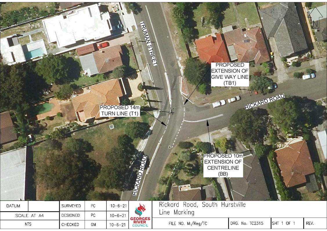
Item: TAC098-21 Rickard Road, South Hurstville - Proposed Line Marking
Author: Coordinator Traffic & Transport
Directorate: Assets and Infrastructure
Matter Type: Committee Reports
|
That line marking be undertaken at the intersection of Rickard Road and Truman Street, South Hurstville as shown on plan TC2315 attached to the report.
|
EXECUTIVE SUMMARY
1. This report seeks the Committee’s consideration of proposed line marking at the intersection of Rickard Road and Truman Street, South Hurstville.
BACKGROUND
2. Council has been advised by local residents of a number of crashes occurring at the intersection of Rickard Road and Truman Street, South Hurstville.
3. In September 2017 a report was presented at the Local Traffic Advisory Committee meeting where the members approved the installation of 25km/h speed advisory signs in Truman Street and Rickard Road with supplementary reverse curve signs. These signs were to assist in influencing driver behaviour in this area and slow people through the intersection.
4. Based on continued comments from residents, in February 2021 Council undertook traffic studies at 3 locations near the intersection. The results of these studies are shown in the table below:
|
LOCATION |
AADT |
85th PERCENTILE SPEED |
|
Rickard Road, south of Truman Street |
3,758 vehicles |
50km/h |
|
Truman Street, north of Rickard Road |
4,341 vehicles |
47km/h |
|
Rickard Road, east of Truman Street |
737 vehicles |
51km/h |
5. As can be seen in the results table above, the main travel movement is in a north-south direction through the intersection.
6. The TfNSW crash database was reviewed for the period July 2015 to September 2020 which is the most up to date data available. During this period there was 1 crash recorded that occurred in September 2017. However, Council has been notified of a number of crashes occurring since January 2021.
7. As Rickard Road continues to the east of the intersection, drivers travelling north on Rickard Road are veering to the right to continue on Rickard Road. Some of these vehicles are failing to give-way to vehicles heading south on Truman Street through the intersection. The crashes occurring in 2021 have been a result of vehicles being ‘T-boned’ for not giving way to through traffic.
8. Council Engineers are currently undertaking a design to determine if a roundabout would be feasible at the intersection.
PROPOSAL
9. It is therefore proposed to paint delineation line marking at the intersection of Rickard Road and Truman Street to advise drivers turning right into Rickard Road that they are required to give-way to vehicles travelling south on Truman Street.
FINANCIAL IMPLICATIONS
10. Within budget allocation – TfNSW Traffic Facility Grant – approximately $1,000.
FILE REFERENCE
D21/134734
|
Attachment ⇩1 |
Plan TC2315 - Rickard Road, South Hurstville |
|
Georges River Council - Georges River Local Traffic Advisory Committee Meeting - Tuesday, 6 July 2021 TAC098-21 Rickard Road, South Hurstville - Proposed Line Marking [Appendix 1] Plan TC2315 - Rickard Road, South Hurstville |
Page 7 |
Georges River Council – Georges River Local Traffic Advisory Committee Meeting - Tuesday, 6 July 2021 Page 8
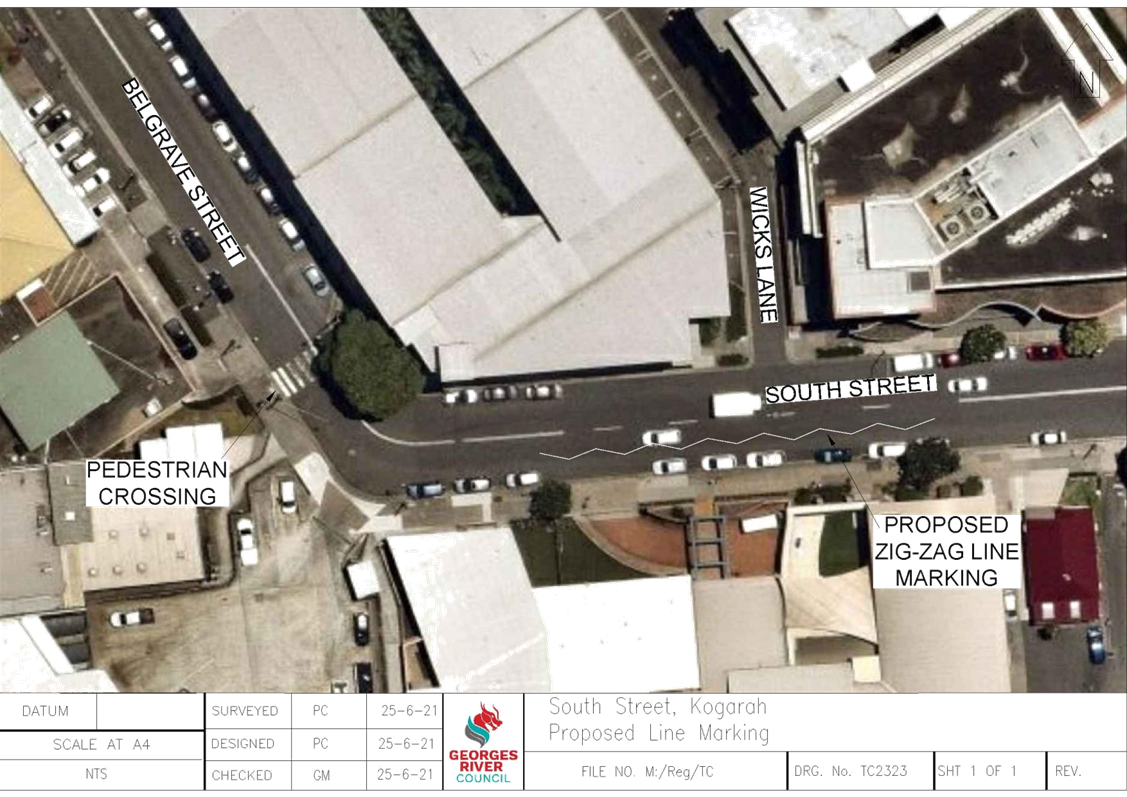
Item: TAC099-21 South Street, Kogarah - Proposed Line Marking
Author: Coordinator Traffic & Transport
Directorate: Assets and Infrastructure
Matter Type: Committee Reports
|
That a 50m zig-zag line be painted on the southern side of South Street, Kogarah on approach to the pedestrian crossing, as shown on plan TC2323 attached to the report.
|
EXECUTIVE SUMMARY
1. This report seeks the Committee’s consideration of the proposed line marking in South Street, Kogarah
BACKGROUND
2. Council has received a request to investigate the safety at the existing pedestrian crossing at the intersection of South Street and Belgrave Street, Kogarah.
3. This crossing is adjacent to St George Hospital and secure parking station and is located near a bend in the road.
4. Due to the bend, there is limited sight distance for drivers travelling westbound on South Street on approach to the crossing.
PROPOSAL
5. In accordance with the TfNSW “Delineation – Section 7 Transverse Lines Pedestrian Facilities” document, the use of zig-zag markings may be provided at existing crossings where the sight distance is inadequate.
6. It is therefore proposed to paint a 50m zig-zag line on the southern side of South Street, in accordance with the TfNSW document, to warn drivers of the upcoming crossing.
FINANCIAL IMPLICATIONS
7. Within budget allocation – TfNSW Traffic Facility Grant – approximately $1,000.
FILE REFERENCE
D21/150026
|
Attachment ⇩1 |
Plan TC2323 - South Street, Kogarah |
|
Georges River Council - Georges River Local Traffic Advisory Committee Meeting - Tuesday, 6 July 2021 TAC099-21 South Street, Kogarah - Proposed Line Marking [Appendix 1] Plan TC2323 - South Street, Kogarah |
Page 9 |
Georges River Council – Georges River Local Traffic Advisory Committee Meeting - Tuesday, 6 July 2021 Page 10
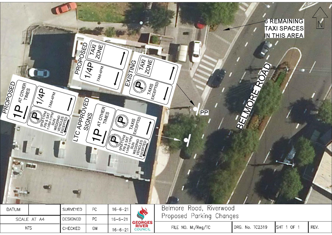
Item: TAC100-21 Belmore Road, Riverwood - Proposed "15 Minute" Parking
Author: Coordinator Traffic & Transport
Directorate: Assets and Infrastructure
Matter Type: Committee Reports
|
That the existing 6m “No Parking, Taxis Excepted” zone on the western side of Belmore Road, Riverwood be converted to “1/4P, 7am – 4pm” as shown on plan TC2319 attached to the report.
|
EXECUTIVE SUMMARY
1. This report seeks the Committee’s consideration of the proposed “15 Minute” parking zone in Belmore Road, Riverwood.
BACKGROUND
2. Council has received a request from the owner of the café on the western side of Belmore Road to consider the modification to the parking restriction signs on the street.
3. Currently there is a 6m “No Parking, Taxis Excepted” zone on the western side of Belmore Road and as a result it is illegal for drivers to park here and leave the vehicle to attend the nearby shops.
PROPOSAL
4. It is therefore proposed to convert the 6m “No Parking, Taxis Excepted” zone on the western side of Belmore Road to “1/4P, 7am – 4pm”. This would allow drivers to leave their vehicle and attend the nearby businesses.
5. There is a “Taxi Zone” to the north of this area that allows parking for 6 taxis near the station.
FINANCIAL IMPLICATIONS
6. Within budget allocation – TfNSW Traffic Facility Grant – approximately $100.
COMMUNITY ENGAGEMENT
7. The proposal has been sent to the owner of the café and no objections were received.
FILE REFERENCE
D21/143667
|
Attachment ⇩1 |
Plan TC2319 - Belmore Road, Riverwood |
|
Georges River Council - Georges River Local Traffic Advisory Committee Meeting - Tuesday, 6 July 2021 TAC100-21 Belmore Road, Riverwood - Proposed "15 Minute" Parking [Appendix 1] Plan TC2319 - Belmore Road, Riverwood |
Page 11 |
Georges River Council – Georges River Local Traffic Advisory Committee Meeting - Tuesday, 6 July 2021 Page 13
Item: TAC101-21 Penshurst Street, Beverly Hills - Proposed 'Bus Zone'
Author: Traffic Engineer
Directorate: Assets and Infrastructure
Matter Type: Committee Reports
|
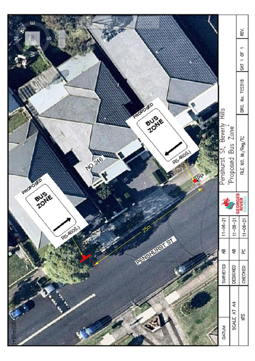
That a 25m ‘Bus Zone’ be installed on the northern side of Penshurst Street, Beverly Hills adjacent to No. 246, as shown on plan TC2318 attached to the report.
|
EXECUTIVE SUMMARY
1. This report seeks the Committee’s consideration to formalise the existing Bus Stop (220942) in Penshurst Street, Beverly Hills.
BACKGROUND
2. Council received a request from Punchbowl Bus Company to formalise the Bus Stop along Penshurst Street, Beverly Hills.
3. As part of the Disability Discrimination Act, Georges River Council is committed to ensure that all Bus Stops in the Local Government Area comply with the ‘Disability Standards’ by 2022.
4. The ‘Disability Standards for Accessible Public Transport’ requires that all Bus Stops be converted into ‘Bus Zones’, formalising existing NSW Road Rule 195.
5. Formalising the Bus Stop with ‘Bus Zone’ signage would enable buses to pull in and out of the Bus Stop without being hindered by parked cars and allow for easier movement.
PROPOSAL
6. Upon investigation, it is proposed to formalise the existing Bus Stop (220942) on the northern side of Penshurst Street, adjacent to No. 246, to a 25m ‘Bus Zone’.
FINANCIAL IMPLICATIONS
7. Within budget allocation – TfNSW Traffic Facility Grant – Approximately $600.
COMMUNITY ENGAGEMENT
8. The residents in this vicinity have been notified by letter of the proposed installation of the ‘Bus Zone’. The closing date for submissions was 18 June 2021. No objections were received.
FILE REFERENCE
D21/141070
|
Attachment ⇩1 |
TC2318-Penshurst St., BH- Proposed 'Bus Zone'-converted |
|
Georges River Council - Georges River Local Traffic Advisory Committee Meeting - Tuesday, 6 July 2021 TAC101-21 Penshurst Street, Beverly Hills - Proposed 'Bus Zone' [Appendix 1] TC2318-Penshurst St., BH- Proposed 'Bus Zone'-converted |
Page 14 |
Georges River Council – Georges River Local Traffic Advisory Committee Meeting - Tuesday, 6 July 2021 Page 16
Item: TAC102-21 Botany Street, Hurstville - Proposed 'Bus Zone' modifications
Author: Traffic Engineer
Directorate: Assets and Infrastructure
Matter Type: Committee Reports
|
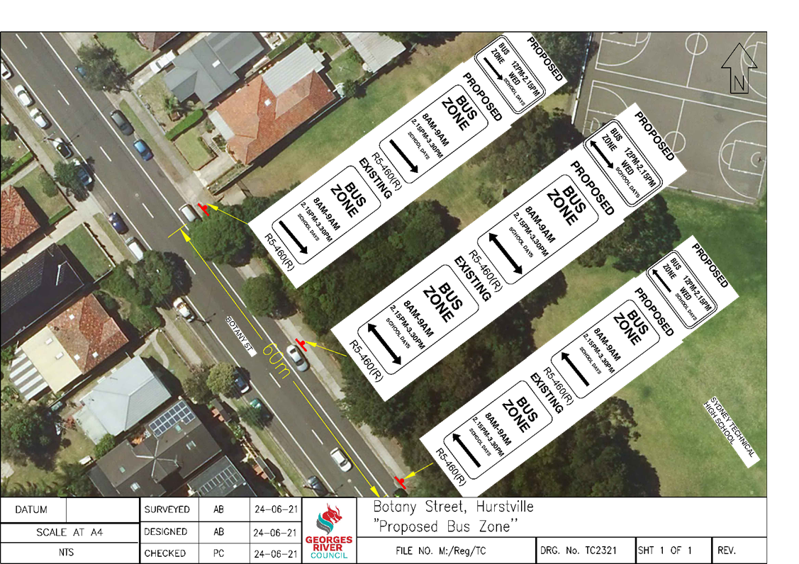
That a 60m ‘Bus Zone, 12pm - 2:15pm Wed School Days’ be installed on the eastern side of Botany Street, Hurstville adjacent to Sydney Technical High School, as shown on plan TC2321 attached to the report. |
EXECUTIVE SUMMARY
1. This report seeks the Committee’s consideration of the proposed ‘Bus Zone’ outside Sydney Technical High School in Botany Street, Hurstville.
BACKGROUND
2. Council has received a request from the Business Manager of Sydney Technical High School requesting that Council install a ‘Bus Zone’ to accommodate school buses on Wednesday between 12pm and 3:30pm.
3. Currently in Botany Street outside Sydney Technical High School there is a 60m ‘Bus Zone, 8am – 9am, 2:15pm – 3:30pm, School Days’ zone.
4. A site inspection revealed that vehicles were parking in this zone between 9am and 2.15pm on Wednesdays, forcing the buses to park further down the street to pick up and drop off students.
PROPOSAL
5. Accordingly, it is recommended that a 60m ‘Bus Zone, 12pm - 2:15pm Wed School Days’ be installed on the eastern side of Botany Street, Hurstville adjacent to Sydney Technical High School.
FINANCIAL IMPLICATIONS
6. Within budget allocation – TfNSW Traffic Facility Grant – Approximately $600.
COMMUNITY ENGAGEMENT
7. The Business Manager of Sydney Technical High School has been informed of the proposed ‘Bus Zone’. No negative feedback was received.
FILE REFERENCE
D21/141076
|
Attachment ⇩1 |
TC2321-'Botany Street, Hurstville'- Proposed 'Bus Zone converted 1' |
|
Georges River Council - Georges River Local Traffic Advisory Committee Meeting - Tuesday, 6 July 2021 TAC102-21 Botany Street, Hurstville - Proposed 'Bus Zone' modifications [Appendix 1] TC2321-'Botany Street, Hurstville'- Proposed 'Bus Zone converted 1' |
Page 17 |
Georges River Council – Georges River Local Traffic Advisory Committee Meeting - Tuesday, 6 July 2021 Page 19
Item: TAC103-21 Gardinia Street, Peakhurst - Proposed 'Bus Zone' extension
Author: Traffic Engineer
Directorate: Assets and Infrastructure
Matter Type: Committee Reports
|
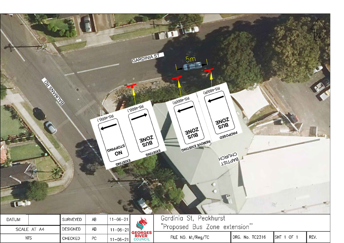
That the existing 15m ‘Bus Zone’ on the southern side of Gardinia Street, adjacent to Narwee Baptist Church, be extended 5m east as shown on plan TC2316 attached to the report.
|
EXECUTIVE SUMMARY
1. This report seeks the Committee’s consideration of the proposed extension of the existing ‘Bus Zone’ on the southern side of Gardinia Street, Peakhurst.
BACKGROUND
2. A request has been received from Punchbowl Bus Company to consider the extension of the existing ‘Bus Zone’ at Stop ID 220986 on the southern side of Gardinia Street.
3. This is due to vehicles parking directly adjacent to the existing ‘Bus Zone’ preventing buses from safely pulling up to, and away from, the kerb to pick-up and drop-off passengers.
PROPOSAL
4. Following an investigation, it was found that the existing ‘Bus Zone’ was only 15m long and if vehicles parked east of the zone, it prevented buses from pulling up to and away from the kerb safely.
5. It is therefore proposed to extend the existing ‘Bus Zone’ by another 5m to prevent vehicles parking in this location. This will allow for buses to stop parallel to the kerb, improving safety for drivers and bus commuters.
FINANCIAL IMPLICATIONS
6. Within budget allocation – TfNSW Traffic Facility Grant – Approximately $200.
COMMUNITY ENGAGEMENT
7. The church has been notified of the proposed 5m extension of the existing ‘Bus Zone’ on the southern side of Gardinia Street, Peakhurst. No objections were received.
FILE REFERENCE
D21/141079
|
Attachment ⇩1 |
TC2316-Gardinia St, Narwee- Proposed 'Bus Zone' extension |
|
Georges River Council - Georges River Local Traffic Advisory Committee Meeting - Tuesday, 6 July 2021 TAC103-21 Gardinia Street, Peakhurst - Proposed 'Bus Zone' extension [Appendix 1] TC2316-Gardinia St, Narwee- Proposed 'Bus Zone' extension |
Page 20 |
Georges River Council – Georges River Local Traffic Advisory Committee Meeting - Tuesday, 6 July 2021 Page 22
Item: TAC104-21 Park Road, Hurstville- Proposed 'Works Zone'
Author: Traffic Engineer
Directorate: Assets and Infrastructure
Matter Type: Committee Reports
|
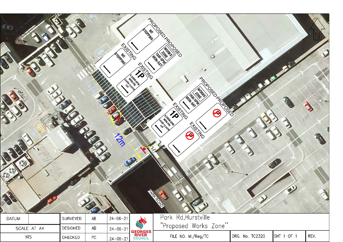
(a) That the 12m ‘1P, 8.30am - 6pm Mon - Fri, 8.30am - 12.30pm Sat’ zone on the northern side of Park Road, Hurstville be converted to a ‘Works Zone, 7am – 5pm, Mon – Sat’, for a duration of 12 weeks commencing in July 2021, as shown on the plan TC2320 attached to the report. (b) That the parking be returned to its current status at the completion of the ‘Works Zone’ period.
|
EXECUTIVE SUMMARY
1. This report seeks the Committee’s consideration of the proposed ‘Works Zone’ in Park Road, Hurstville.
BACKGROUND
2. The builder of the development of Westfield Car Park in Park Road, Hurstville has lodged a request for a ‘Works Zone’ to be placed adjacent to the premises. The requested period of the ‘Works Zone’ is 12 weeks.
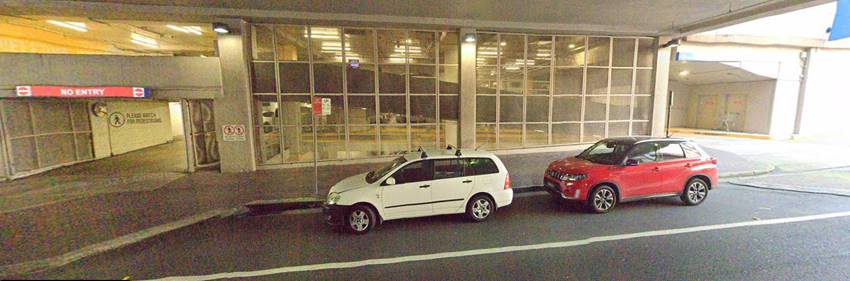
3. The ‘Works Zone’ will provide an area adjacent to the site where vehicles associated with the works can park.
4. Currently there is an existing ‘1P, 8.30am – 6pm, Mon – Fri, 8.30am-12.30pm Sat’ zone in this location as shown in the photo below on Park Road:
FINANCIAL IMPLICATIONS
5. No budget impact for this report.
FILE REFERENCE
D21/145138
|
Attachment ⇩1 |
TC2320-Park Rd, Hurstville- Proposed 'Works Zone' |
|
Georges River Council - Georges River Local Traffic Advisory Committee Meeting - Tuesday, 6 July 2021 TAC104-21 Park Road, Hurstville- Proposed 'Works Zone' [Appendix 1] TC2320-Park Rd, Hurstville- Proposed 'Works Zone' |
Page 23 |
Georges River Council – Georges River Local Traffic Advisory Committee Meeting - Tuesday, 6 July 2021 Page 25
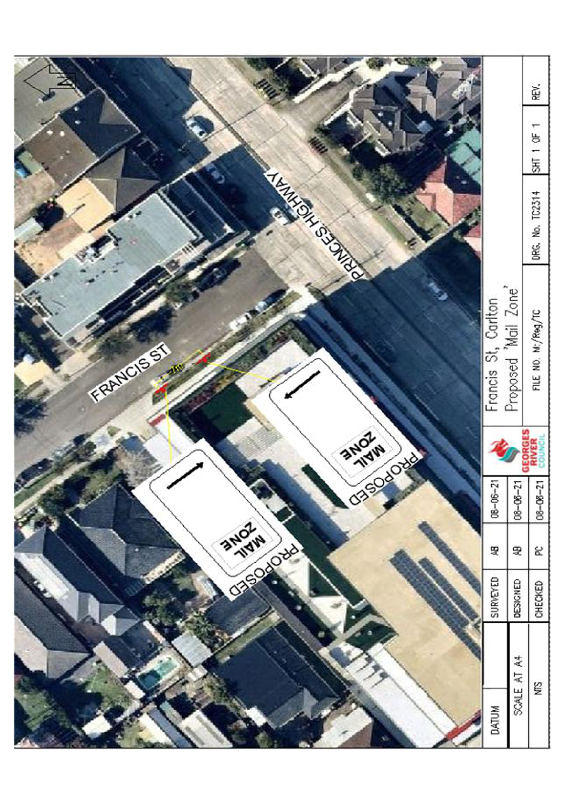
Item: TAC105-21 Francis Street, Carlton - Proposed 'Mail Zone'
Author: Traffic Engineer
Directorate: Assets and Infrastructure
Matter Type: Committee Reports
|
That a 7m ‘Mail Zone’ be installed on the southern side of Francis Street, Carlton adjacent to No. 313 Princes Highway, as shown on plan TC2314 attached to the report.
|
EXECUTIVE SUMMARY
1. This report seeks the Committee’s consideration for the installation of a ‘Mail Zone’ on the southern side of Francis Street, Carlton.
BACKGROUND
2. A request has been received from Australia Post to investigate the possibility of installing a ‘Mail Zone’ to allow access for Australia Post vehicles to utilise the mailbox and post office at this location.
3. Due to the high number of vehicles parked in this area, Australia Post vehicles are finding it difficult to park for delivery and collection of mail.
PROPOSAL
4. Upon investigation it was found that the proposed ‘’Mail Zone’’ would allow Australia Post vehicles to park near the mailbox and Post Office.
5. It is therefore proposed to install a 7m ‘Mail Zone’ adjacent to No. 313 Princes Highway, Carlton.
FINANCIAL IMPLICATIONS
6. Within budget allocation – Transport for NSW Traffic Facility Grant – Approximately $500.
COMMUNITY ENGAGEMENT
7. The businesses and Australia Post have been notified of the proposed changes and no objections were received.
FILE REFERENCE
D21/141078
|
Attachment ⇩1 |
TC2314-Francis St,Carlton- Proposed 'Mail Zone' |
|
Georges River Council - Georges River Local Traffic Advisory Committee Meeting - Tuesday, 6 July 2021 TAC105-21 Francis Street, Carlton - Proposed 'Mail Zone' [Appendix 1] TC2314-Francis St,Carlton- Proposed 'Mail Zone' |
Page 26 |
Georges River Council – Georges River Local Traffic Advisory Committee Meeting - Tuesday, 6 July 2021 Page 28
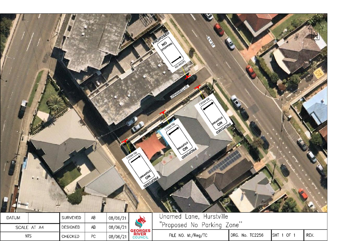
Item: TAC106-21 Lily Lane, Hurstville - Proposed 'No Stopping' zone
Author: Traffic Engineer
Directorate: Assets and Infrastructure
Matter Type: Committee Reports
|
That a 40m ‘No Stopping’ zone be installed on the southern side of Lily Lane adjacent to Mind Champs Early Learning Centre and a 10m statutory ‘No Stopping’ zone be installed on the northern side of Lily Lane, Hurstville as shown on plan TC2256 attached to the report.
|
EXECUTIVE SUMMARY
1. This report seeks the Committee’s consideration for the installation of the ‘No Stopping’ zones in Lily Lane, Hurstville.
BACKGROUND
2. Council received a request from a resident to inspect the existing parking conditions in Lily Lane adjacent to Mind Champs Early Learning Centre.
3. Currently, parents utilise this area as a pickup and drop off zone as there are no signs to restrict parking.
4. Following an investigation, vehicles were observed to be parked along this section of Lily Lane. This creates a significant hazard for vehicles travelling along Lily Lane and creates issues for residents accessing the driveway.
PROPOSAL
5. The installation of the ‘No Stopping’ zone would improve the traffic flow along this lane and further improve the sight distance for residents exiting their driveway as vehicles would not be parked on the lane improving safety for all road users.
FINANCIAL IMPLICATIONS
6. Within budget allocation – TfNSW Traffic Facilities Grant – Approximately $1,200.
COMMUNITY ENGAGEMENT
7. The residents in the vicinity and the learning centre were notified by letter of the proposed parking restrictions. Submissions on the proposal were requested to be received by Friday 18 June 2021. No objections were received
FILE REFERENCE
D21/141082
|
Attachment ⇩1 |
TC2256- Unnamed Lane, Hurstville- Proposed No Parking Zone |
|
Georges River Council - Georges River Local Traffic Advisory Committee Meeting - Tuesday, 6 July 2021 TAC106-21 Lily Lane, Hurstville - Proposed 'No Stopping' zone [Appendix 1] TC2256- Unnamed Lane, Hurstville- Proposed No Parking Zone |
Page 29 |
Georges River Council – Georges River Local Traffic Advisory Committee Meeting - Tuesday, 6 July 2021 Page 31
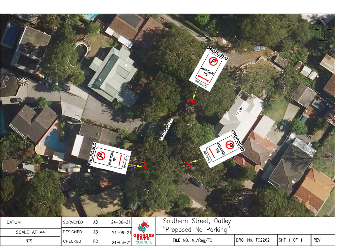
Item: TAC107-21 Southern Street, Oatley - Proposed 'No Parking' zone
Author: Traffic Engineer
Directorate: Assets and Infrastructure
Matter Type: Committee Reports
|
That a 70m ‘No Parking, 6am – 10am, Tue’ be installed at the cul-de-sac of Southern Street, Oatley, as shown on plan TC2262 attached to the report.
|
EXECUTIVE SUMMARY
1. This report seeks the committee’s consideration for the proposed installation of a ‘No Parking’ zone at the cul-de-sac of Southern Street, Oatley.
BACKGROUND
2. Representation was received by Council’s Waste Field Officer to consider implementing signage to prevent vehicles parking at the cul-de-sac of Southern Street during waste collection day.
PROPOSAL
3. Following investigation, it was found that vehicles were parking at the cul-de-sac of Southern Street. This restricts the garbage truck movement to completely utilise the turning circle.
4. Therefore, it is proposed to install a 70m ‘No Parking, 6am – 10am, Tue’ zone to indicate that vehicles cannot park in this location during this time and improve garbage truck access during waste collection day.
FINANCIAL IMPLICATIONS
5. Within budget allocation – Transport for NSW Traffic Facility Grant – Approximately $600.
COMMUNITY ENGAGEMENT
6. Residents in this vicinity have been notified by letter of the proposed ‘No Parking’ zone in the cul-de-sac. The closing date for submission was 18 June 2021.
7. The initial plan proposed a 50m ‘No Parking’ zone at the cul-de-sac. However, due to comments received in consultation, it was converted to a 70m zone to allow for trucks to access the bend safely. This has been amended in the plan TC2262 attached to the report.
FILE REFERENCE
D21/147575
|
Attachment ⇩1 |
TC2262-Southern St, Oatley- 'No Parking' zone 1 |
|
Georges River Council - Georges River Local Traffic Advisory Committee Meeting - Tuesday, 6 July 2021 TAC107-21 Southern Street, Oatley - Proposed 'No Parking' zone [Appendix 1] TC2262-Southern St, Oatley- 'No Parking' zone 1 |
Page 32 |
Georges River Council – Georges River Local Traffic Advisory Committee Meeting - Tuesday, 6 July 2021 Page 34
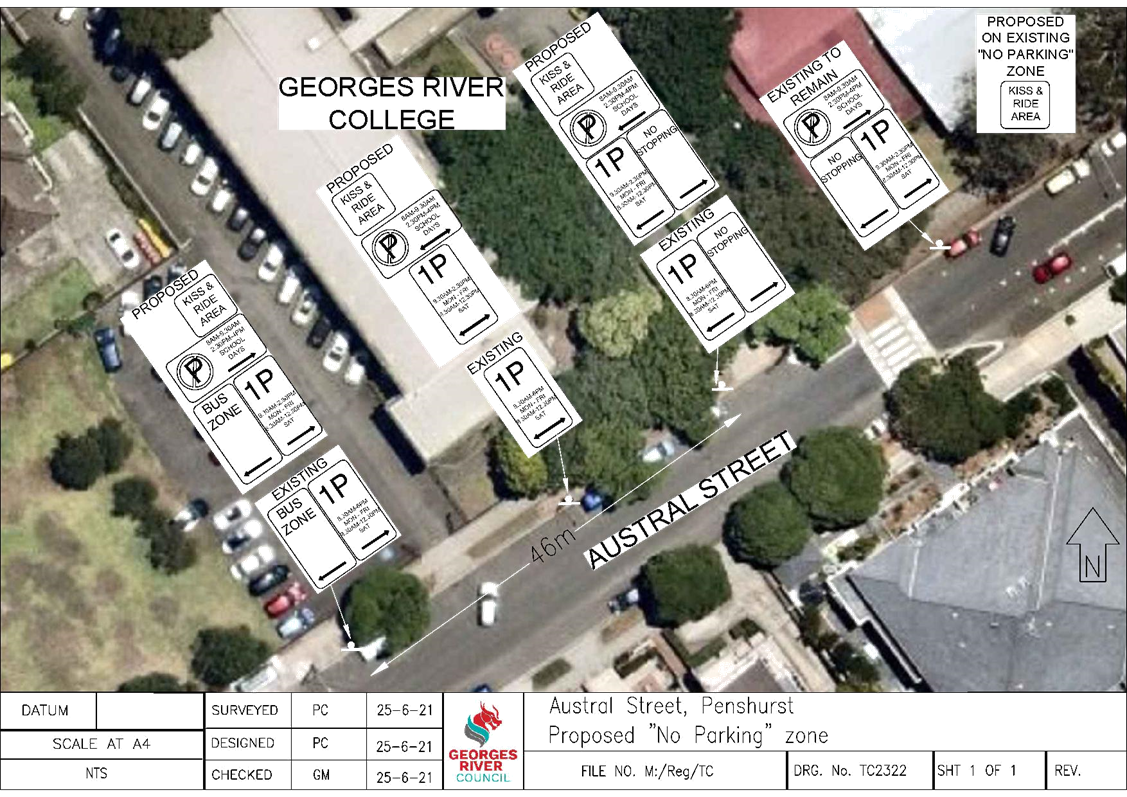
Item: TAC108-21 Austral Street, Penshurst - Proposed "No Parking" zone
Author: Coordinator Traffic & Transport
Directorate: Assets and Infrastructure
Matter Type: Committee Reports
|
That the existing 46m “1P, 8.30am – 6pm Mon – Fri, 8.30am – 12.30pm Sat” zone on the northern side of Austral Street, adjacent to Georges River College, be converted to “No Parking, 8am – 9.30am, 2.30pm – 4pm School Days”, “Kiss & Ride Area” and “1P, 9.30am – 2.30pm Mon – Fri, 8.30am – 12.30pm Sat”, as shown on plan TC2322 attached to the report.
|
EXECUTIVE SUMMARY
1. This report seeks the Committee’s consideration of the proposed “No Parking” zone in Austral Street, Penshurst.
BACKGROUND
2. Council has been requested by a parent of a student at Georges River College to install timed parking on the southern side of Austral Street to assist with dropping off and picking up of students.
3. The southern side of Austral Street is currently unrestricted parking as it is directly adjacent to residential unit blocks. If timed parking were to be installed, residents would not be eligible for a permit and would be required to move their vehicle in accordance with the restrictions.
4. Converting this area to timed parking would also encourage more students to cross the road and potentially increase the potential for an accident to occur. For these reasons, timed parking on the south side is not supported.
5. However, upon investigation, it was noted that there is an existing 36m “No Parking, 8am – 9.30am, 2.30pm – 4pm School Days” and “1P, 9.30am – 2.30pm Mon – Fri, 8.30am – 12.30pm Sat” zone on the northern side of Austral Street, east of the pedestrian crossing. This allows approximately 6 cars to use this area to pick up and drop off during morning and afternoon peak.
6. As the school fronts both Penshurst Street and Forest Road, Austral Street is the only frontage that parents can legally use to park as the other streets are signposted as “No Stopping” to assist with traffic flow.
PROPOSAL
7. To maintain consistency of the parking signs adjacent to the school, it is proposed to convert the 46m “1P, 8.30am – 6pm Mon – Fri, 8.30am – 12.30pm Sat” zone on the northern side of Austral Street, to “No Parking, 8am – 9.30am, 2.30pm – 4pm School Days”, “Kiss & Ride Area” and “1P, 9.30am – 2.30pm Mon – Fri, 8.30am – 12.30pm Sat”. This would allow for an additional 8 vehicles to drop off and pick up in the peak.
FINANCIAL IMPLICATIONS
8. Within budget allocation – TfNSW Traffic Facility Grant – approximately $1,000.
COMMUNITY ENGAGEMENT
9. The Principal of Georges River College was consulted on the proposal and is in support of the changes.
FILE REFERENCE
D21/150036
|
Attachment ⇩1 |
Plan TC2322 - Austral Street, Penshurst |